CHAPTER 1 INTRODUCTION
|
|
|
- Chastity Gardner
- 5 years ago
- Views:
Transcription

1
2 TABLE OF CONTENTS Adopted November, 2012 CHAPTER 1 INTRODUCTION COMPREHENSIVE LAND USE PLAN PURPOSE RELATIONSHIP TO OTHER TOWN PLANNING DOCUMENTS MOORESVILLE TODAY MOORESVILLE IN A VISION FOR THE FUTURE COMPREHENSIVE LAND USE PLAN STUDY AREA COMPREHENSIVE LAND USE PLANNING PROCESS PLAN STRATEGY AND FORMAT CHAPTER 2 MOORESVILLE TODAY INTRODUCTION POPULATION TRENDS DEMOGRAPHICS... CHAPTER 3 LAND USE PLAN INTRODUCTION PLANNING CONCEPTS LAND USE PLAN GENERAL PRINCIPLES GENERAL LAND USE PLAN PLANNING AREAS MIXED-USE AND NONRESIDENTIAL ELEMENTS EMPLOYMENT CENTERS ACTIVITY CENTERS MIXED-USE ACTIVITY CENTERS CHAPTER 4 TRANSPORTATION BACKGROUND TRANSPORTATION AND LAND USE COMPREHENSIVE TRANSPORTATION PLAN VISION, GOALS AND OBJECTIVES ROADWAYS PEDESTRIAN AND BICYCLE TRANSIT FREIGHT i
3 4.9 AIR TRAVEL CHAPTER 5 NATURAL RESOURCES INTRODUCTION SURFACE WATER QUALITY GROUNDWATER QUALITY WATERSHED PROTECTION DISTRICTS WETLANDS STEEP SLOPES, STREAMS AND STREAM BUFFERS LAKE NORMAN LAKE DAVIDSON TREE CANOPY OPEN SPACE AIR QUALITY SOILS FARMLAND PRESERVATION CHAPTER 6 HOUSING AND NEIGHBORHOODS BACKGROUND AGE OF HOUSING AGE OF HOUSING STATISTICS... Error! Bookmark not defined. 6.4 HOUSING MARKET TRENDS HOUSING CHOICE WORKFORCE HOUSING CHAPTER 7 COMMUNITY SERVICES BACKGROUND PUBLIC UTILITIES PUBLIC SAFETY HEALTH CARE PARKS AND RECREATION FACILITIES EDUCATION FACILITIES LIBRARIES CHAPTER 8 ECONOMIC DEVELOPMENT BACKGROUND REGIONAL APPROACH ii
4 8.3 ECONOMIC SECTORS EMPLOYMENT... Error! Bookmark not defined. 8.5 DOWNTOWN INDUSTRIAL PARKS BUSINESS PARKS RETAIL AND COMMERCIAL DEVELOPMENT REDEVELOPMENT EFFORTS... Error! Bookmark not defined WORKFORCE CHAPTER 9 HISTORIC AND CULTURAL RESOURCES HISTORY MOUNT MOURNE SCENIC AREAS AND CORRIDORS PRESERVATION RESOURCES ARTS AND CULTURAL RESOURCES CHAPTER 10 COMMUNITY DESIGN INTRODUCTION RESIDENTIAL ELEMENTS DOWNTOWN REGIONAL ACTIVITY CENTER CORRIDORS - MIXED USE EMPLOYMENT CENTERS INDUSTRIAL PLANNING AREAS ACTIVITY CENTERS GATEWAYS AND ENTRANCE CORRIDORS SCENIC CORRIDORS APPENDIX Land Use Plan Existing Land Use Patterns 11.3 Scenario Planning. iii
5 ACKNOWLEDGEMENTS Town of Board of Commissioners Miles Atkins, Mayor Eddie Dingler, Commissioner Ward I Thurman Houston, Commissioner, Ward II Mac Herring, Commissioner, Ward III Lisa Qualls, Commissioner, Ward IV Bobby Compton, Commissioner at Large Rhett Duesenbury, Commissioner at Large Town of Planning Board David Nail, Chair John Robertson, Vice Chair Joseph Yanicak Danny Martin Rosalind Campbell Mark Brady Steve McGlothlin Town of Development Services Department Craig Culberson Allison Kraft Tim Brown Maureen Gable Neil Burke Mandy Edwards Renee Brown Jackie Thompson Town Manager Erskine Smith, Town Manager iv
6 1.1 COMPREHENSIVE LAND USE PLAN PURPOSE CHAPTER 1 INTRODUCTION The (Plan) is an official public document adopted by the Town of Board of Commissioners on November 5, 2007 and as subsequently amended on November 6, The Plan is a long-term guide for decisions related to growth and development and will guide decisions for public investments in public utilities, facilities and services. The Plan is comprehensive because it covers a broad range of elements related to growth and development. The Plan is general because recommendations are broad, rather than narrowly defining specific land use decisions. The Plan is long-range because it outlines a vision of what the Town should be in twenty or more years and sets out a framework for how that vision can be implemented. The majority of the Plan policies focus on the next twenty years. These policies can be amended as new information is available, or to address a specific change in circumstances without straying from the basic goals of the Plan. The Plan is not a static document and should be updated on a regular basis. Although the Plan is adopted as an official public document, it is not a development ordinance. The Plan sets the framework and basis for the Town s Zoning Ordinance and Comprehensive Transportation Plan to ensure the Town s goals are implemented through the regulatory process. The Plan consists of policies and recommendations to guide regulatory decisions regarding the public and private use of land within the Town's planning jurisdiction, and Includes maps showing the appropriate location of the planning areas. The plan gives special attention to the protection of areas of environmental concern. Introduction 1-1
7 1.2 RELATIONSHIP TO OTHER TOWN PLANNING DOCUMENTS In 1957, the Town of published a vision plan for downtown, The Plan. A contemporary comprehensive plan was adopted in 1990 and provided the framework for subsequent plans. The Land Use Plan update was adopted July 19, The serves as the framework for other plans and ordinances relating to the management of growth and development in the Town. It is not a stand-alone document, but is supported by related documents and ordinances such as, Floodplain Ordinance Small Area Plan Zoning Ordinance Building Code Parks and Greenways Master Plan, 2003 Comprehensive Pedestrian Plan Comprehensive Transportation Plan, 2007 has adopted small area and corridor plans which include in part the Mount Mourne Plan, the Cascade Master Plan, and the Downtown Master Plan, Cornelius Road Small Area Plan, Brawley School Road Small Area Plan, US 21 Small Area Plan, and the NC 3 Corridor Plan. Small area plans, upon adoption, are incorporated by reference into the. Since these adopted small area plans provide greater planning policy detail for their respective planning horizons, these planning policies in general, supersede those of this policy document and should become the basis for supporting regulatory decisions. These adopted small area plans are available for reference at the Development Services Department. 1-2
8 In addition to area plans, the Town also prepares specific comprehensive plans for essential Town services such as municipal utilities, parks, and emergency services. These plans, prepared by various Town agencies, establish detailed service level guidelines. The standards contained in each of these service plans are also an essential part of the Town's overall planning policy. 1.3 MOORESVILLE TODAY has experienced unprecedented growth and change since From 2000 to 2011, grew at an annual rate of 4.7%, experiencing an overall growth rate of 66% for the planning horizon. During this same period, s textile-oriented economy and industrial base diversified to the vibrant economy characteristic of this urbanizing community. is located in southern Iredell County in the Piedmont region of North Carolina and is a strong part of the Charlotte Metropolitan Region. The Town prides itself on its rich motorsports heritage, and has developed its own vibrant, diversified economy and industrial base. 's strategic location (illustrated in Map 1.1) has been an important catalyst for growth. The Town's proximity to Charlotte and Lake Norman continues to attract new residents within easy access to major employment centers. s westward growth to Lake Norman has positioned the I-77 corridor to bisect the two zip codes and In addition to I-77, is located within 15 miles of I-85 and I-40. is less than 30 minutes to the Charlotte Douglas International Airport. Originally incorporated as a rail town, the Norfolk-Southern O Line, a part of the 3,600 mile North Carolina rail network, offers heavy freight service to local industry. s five- hour proximity to two ports, Port of Morehead City and Port of Wilmington, as well as the Charlotte Inland Terminal, located 30 minutes from, has also positioned as a destination for industrial and economic growth as well. Regional transportation corridors including NC 1-3

9 Highway 150 provide east and west access to Lake Norman. NC Highway 3 connects Interstate I-85 and Interstate I-77 with the North Carolina Research Center in Kannapolis and the regional employment center anchored by the Lowe s Home Improvements, Incorporated and Lake Norman Regional Hospital. Location Sustained rapid growth, while a core strength, has also challenged s ability to maintain and enhance the high quality of life enjoyed by its citizens; attract young professionals, provide a well-educated workforce, and maintain and enhance its core strengths as evident in its location, persistent growth rate, infrastructure, and excellent economic climate and assets. The has been prepared to address the complex issues and concerns facing the Town today and to prepare for the future. The Plan defines a land use strategy that balances conservation with 1-4
10 residential, industrial, commercial and mixed-use development. The Plan encourages the location of new development in growth centers that take advantage of existing or projected infrastructure. 1.4 MOORESVILLE IN A VISION FOR THE FUTURE If the policies and recommendations of the Plan are upheld and implemented, the following description might apply to the Town in In the year 2030, is growing, dynamic and sustainable community that is future-focused with a strong economy and a balanced and growing population that values and enjoys a high quality of life in a safe and attractive environment. Transportation s transportation system is an integrated multi-modal, user-friendly network of well-designed streets that support auto, transit, and pedestrian and bicycle traffic. s transportation system will include a network of landscaped urban boulevards bordered by sidewalks, comfortable for bikers, and linked to greenways. Major arterials and thoroughfares carry traffic on well-designed roadways through, into and out of Town with carefully minimized impact to surrounding neighborhoods or urban areas. Local transit will connect higher-density nodes of development. Natural Resources s attractive natural environment, ease of access to Lake Norman and Lake Davidson, and well-maintained networks of open space make it a highly desirable place to live, work and play. s clean air, water, and greatly expanded tree cover will be assets that are recognized and supported by the whole community. 1-5
11 Housing and Neighborhoods s neighborhoods are vibrant places for people of all ages, lifestyles and income to live, work and play. s neighborhoods will be more than just places to live; they will be the nucleus for civic life. Their local village centers serve as a vibrant and accessible focus for business, community services and activities, including higher-density housing clusters. will offer a diversity of housing choices, including not only a range of housing prices but also of housing types-- single family houses, condominiums, multi-family high and low-rise rental units, town homes and patio homes-- providing opportunities to find suitable housing in the neighborhood of their choice for people at all stages of their lives from just out of school, to families, to empty nesters. Community Facilities and Services will have an equitable system of community facilities and services that effectively meet community needs. A framework of public utilities and communications infrastructure will set the stage for sustainable economic growth and quality development. will have a system of community parks and recreation facilities connected by a greenway network including walking and biking trails. s schools will be known for their enhanced education programs that ensure all children receive a quality education for entry into the workplace or participation in higher education. Strong diverse economy is a regional center boasting a creative, diverse, sustainable economy. New economic opportunities will be regionally marketed and developed. The marketing efforts of the South Iredell Chamber of Commerce will successfully attract businesses in the five industry categories and niche markets: business and financial services; technology manufacturing; automotive; clean air technologies; retail & tourism. 1-6
12 s labor force will be highly qualified with opportunities for ongoing career development with programs linking industry, colleges, and high schools. Renovation and redevelopment in s downtown will maintain the historic character, successfully integrating new highrise residential condominiums behind well-maintained Main Street buildings. New retail, entertainment and commercial businesses will fill the first and second floors of the restored historic buildings. Underutilized industrial sites will be targeted for intensive economic development and reuse. Historic and Cultural Resources will enhance the community s cultural resources and preserve its historic heritage. Cultural and entertainment attractions will have grown in quantity and quality attracting young workers to live near the downtown. Downtown will include an even greater variety of unique restaurants, clubs and night spots to complement the cultural venues that have been added. Community Design A unifying theme to implement s vision of a sustainable and livable community is that of community design increasing the attractiveness of s gateways and streetscapes, neighborhood and housing developments, commercial centers, and new economic development and institutional growth. Design principles and guidelines will encourage desired models for new development by investors and landowners that encourage compatibility with existing neighborhoods. New communities will have village centers that provide appropriately scaled commercial, retail and entertainment services. New and old communities will be linked by a network of streets, paths and greenways encouraging a greater sense of community and reducing congestion on thoroughfares. 1-7
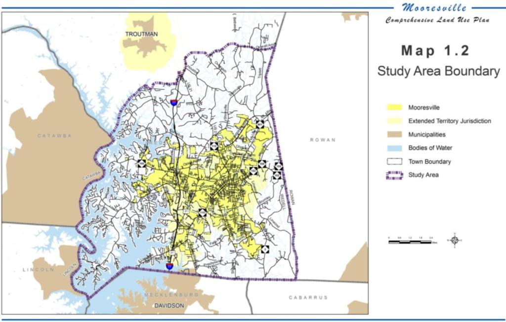
13 New public facilities and buildings will be designed for quality appearance and multiple functions. Streets will have minimal pavement, emphasize an increased tree canopy, and include complete streets, bicycle, and pedestrian systems. Impacts of new development will be carefully mitigated. 1.5 COMPREHENSIVE LAND USE PLAN STUDY AREA The Land Use Plan Study Area (Map 1.2) includes: The area inside s existing Corporate Limits The area inside s Extra-Territorial Planning Jurisdiction (ETJ), which is an area outside of s official town limits where Iredell County has granted zoning authority to control development, in anticipation of future town limits expansion. The area outside of s official town limits and the ETJ that is currently under Iredell County s development control, but represents areas that can reasonably provide urban services. 1-8
14 1-9
15
16 1.6 COMPREHENSIVE LAND USE PLANNING PROCESS In 2006, the Town initiated three planning projects - the Comprehensive Land Use Plan, the Comprehensive Transportation Plan and the Zoning Ordinance. The three parallel planning efforts were coordinated through the Planning Department Public Engagement Public engagement for the land use plan began early and continued throughout the process. Recognizing the relationship between land use and transportation, the and Comprehensive Transportation Plan teams held two joint public workshops providing participants the opportunity to share their ideas for the future and discuss plan concepts as they were being developed by the Citizens Advisory Committee and Town Staff Citizens Advisory Committee A Citizens Advisory Committee (CAC) of citizen volunteers and technical staff guided the planning process. The CAC met on a regular basis to direct the development of the Plan. The CAC identified needs, reviewed drafts and provided in put on Plan policies and recommendations Adoption The Plan was adopted by the Town Board of Commissioners on November 5, 2007 and subsequently amended on November 6, PLAN STRATEGY AND FORMAT The Plan is intended to provide a vision of the Town and a framework for future decision making. The Plan is based on very broad goals that are not meant to be changed. It sets the strategy for managing growth and development but does not forecast when it will be achieved. Introduction 1-11
17 The Town's ultimate development pattern will be based on the Town's longterm commitment to maintaining distinct neighborhood, employment and regional activity areas with denser clusters of mixed-use development in the growth areas where utilities will be available to serve urban development. The eastern area, within the WS-II Watershed Protection Areas will remain predominantly rural, although some areas may develop in compact clusters preserving open space. The Town expects development to occur in several phases, the first phase is already underway. It will cover the southern portion of the planning area (south of NC Highway 150) with residential neighborhoods, neighborhood and village nodes, regional employment centers and regional activity centers interconnected by a network of streets. The second phase will occur as utilities are extended to the north and east of Downtown. Improvements to the road network and construction of a highway interchange at Interstate I-77 and Cornelius Road in accordance with the adopted Cornelius Road Small Area Plan will be incentives to attract business and industry to locate in the employment and industrial planning areas. A third phase is expected to occur in the next years in the form of redevelopment in nodes of higher density land uses along major thoroughfares. These nodes will be true urban centers with a mix of uses, designed for pedestrians, served by public transit and very compact in form. The first nodes will probably occur at the planned commuter rail transit stop in southern Iredell County and as infill in existing mature neighborhoods. The changes that have occurred began slowly in the late 1980's but the pace of development has increased dramatically in the 1990's. Although the historically fast-paced development of the past two decades has been tempered by economic slowdown experienced both regionally and nationwide since 2006, development is slowly escalating in part due to the same strategic advantages that have historically made and 1-12
18 South Iredell a leader in the regional development. Development will be driven by the market, and the ability of the Town to extend public utilities and improve highway access and road network serving the area to the north Long Range Planning The long-range plan is the subject of most of this document. Although the Plan includes a generalized Land Use Map, the more detailed maps and policies will be developed through small area plans. The effectiveness of the Plan will depend on a regular process of review and updates Short Range Planning The Town will concentrate the majority of capital investments and improvements where development is encouraged; therefore, the next stage in community planning process is to develop small area plans for distinct planning areas Plan Format The Plan policies are divided into eight major chapters. Land Use Transportation Natural Resources Neighborhoods and Housing Community Services Economic Development Historic and Cultural Resources Community Design Chapter 4. Transportation summarizes the issues and recommendations from the Comprehensive Transportation Plan. The figures in Chapter 4. were developed for the Comprehensive Transportation Plan. Copies of the Comprehensive Transportation Plan are available at the Town Planning Development Services Department. 1-13
19
20 CHAPTER 2 MOORESVILLE TODAY 2.1 INTRODUCTION In 2010, the North Carolina State Data Center ranked 27th, in population. Town population and land area has increased steadily since Population growth has been mainly due to the annexation of urbanized areas. Since 1980, the Town s population has grown from 8,575 residents to an official 2010 population of 29,577, according to the U.S. Census Bureau. 2.2 POPULATION TRENDS The Town s current jurisdictional boundaries in South Iredell are anticipated to change significantly during this planning horizon, the Town of, Town of Troutman and Iredell County commissioned Warren & Associates to conduct a demographic and employment study for South Iredell. This study became the basis for demographic trend analysis for the planning horizon 2007 Plan as originally adopted. The South Iredell Chamber of Commerce, commissioned Warren and Associates to conduct similar population demographic, housing, and economic trend analysis for a fiveyear forecast beginning in This more recent study, although spanning a much shorter forecasting period than the original trend analysis forecast, accounts for the significant economic slowdown experienced both regionally and nationwide since 2006, and project more slowly escalating trends than were originally forecast in the originally adopted plan. The trend analysis of the originally adopted 2007 plan can be found in Appendix for comparison. Today 2-1
 2.")
21 Study Area The amended Study Area is defined as the and Zip Codes. Figure 2.1 denotes the areas encompassed by the Zip Code coverage as compared to the planning horizon of the Plan. Figure and Zip Code coverage area as compared to the planning horizon of the Plan. (Warren and Associates 2012) 2.3 Demographics is defined as having Zip Codes and 28117, whose area is governed by Iredell County and the Town of. The Town of has an estimated population of 30,697 in 2011 with a total population of Iredell County 159,437. combined with both Zip Codes, and is estimated to have 69,259 residents in 2011 with 27,405 new residents between 2001 and 2011 with a 65.5% growth rate. The study area contained an estimated 69,259 residents in 2011, reflecting a growth rate of 65.5% for the eleven-year period, with a Compound Annual Growth Rate (CAGR) of 4.7%. Of this area, the Zip Code area grew 2-2 Today
22 from 22,257 residents in 2000 to 33,500 residents in 2011, a 48.7% increase in population for the period. By comparison, the Zip Code area population increased from 19,327 residents in 2000 to35,759 residents in 2011, in increase of 85.02% with a CAGR of 5.8%. Tables 2.2 denote population changes within the and Zip Code coverage areas. The largest age group or cohort currently within the Zip Code is the age cohort, which currently comprises 16% of the population within this area. Baby boomers aged 55-64; however, experienced the highest growth rate for this Zip Code at 685% for the elevenyear period. By comparison, residents ranging from years in age are the largest cohort in the Zip Code area. That population segment grew at a rate of 18% for the same period and is reflective of housing within the Zip Code area. School-aged residents ranging from 10 to 19 years iun age experienced a growth rate of 171.5% for the period. These figures indicate an inflow of families with school-aged children seeking higher quality public education as well as active seniors seeking leisure and recreational opportunities. The Zip Code age cohort growth rate is reflective of apartment availability within this area as well as employment opportunities for this cohort. Trend Forecasts The study area is expected to increase in population from 2011 to 2016 to 74,469, and increase of 7.5% with a CACR of 1.5%. This trend is significantly lower than the 4.7% CACR for the Study Area from 2000 to 2010 and is indicative of national and regional recessionary trends of and a slowed economic recovery and continued low mobility rates. Between 2011 and 2016, the Zip Code area is expected to increase in population by 2,715 residents or a CAGR of 1.6% for the five-year period. By contrast, the Zip Code area is expected to increase in population at a CAGR of 1.4%, reflecting a decline in the developable residential properties along Today 2-3

23 Lake Norman. Population distribution is influenced by differences in housing stock within the two Zip Code areas, multi-family concentration, and the location of lower-priced single family housing within the Zip Code. Population Forecasts for Study Area Change Source:ESRI, Warren & Associates Population Change by Age in Study Area, Source: ESRI, Warren & Associates Households Household growth from 2000 to 2011 within the Zip Code area increased from 8,614 to 12,543, an increase of 45.6%. The Zip Code area experienced an increase of 80.8% from 7,419 households to 13, Today

24 households for the same eleven-year period to surpass the Zip Code area in population over the last decade. From 2000 to 2011 household incomes also experienced considerable growth for the study area. The surge in income growth for the Zip Code area is consistent with the area s dramatic population growth for the period. Household Incomes in Study Area, Source: ESRI, Warren & Associates Household Forecast The overall Study Area is expected to increase by 1,849 households by 2016 or a projected growth rate of 7.1%. of this figure, the Zip Code area is expected to increase by 976 households with a CAGR of 1.5%. By comparison, the Zip Code area is expected to increase at a CAGR of 1.3%. Today 2-5

25 Household Forecasts in Study Area, Source: ESRI, Warren & Associates Housing The Study Area contained an estimated 29,458 housing units in 2011, which represents an increase of 62.3% from 181,148 units in 2000, or a CAGR of 4.5% for the ten-year period. Housing units grew in the Zip Code Area by 45.6% from 9,267 units to 13,496 units. By comparison, housing unts within the 2811 Zip Code area grew during the same period from 8,881 units in 2000 to15, 961 in 2010, a rate of 79.7% or a CAGR of 5.5%. Within the Study Area, 67.1% were owner-occupied, 19.4% were tenant-occupied, and 11.5% were vacant residential units. Housing Trends Approximately 2,089 housing units are forecasted to be constructed within the Study Area from 2011 to This trend projection represents an increase of 7.1% or a CAGR of 1.4% for the five-year period. Of this total, approximately 65%, or 1,358 new units, are projected to be single family detached residential. Approximately 10% of this total, or 209 units, is projected to be for-sale attached residential units. The remaining 25% or 522 new units are expected to be rental apartments. Annual delivery for the period is projected to be approximately 250 to 310 units. 2-6 Today


26 Housing Unit Forecast, Study Area, Source: ESRI, Warren & Associates Housing Unit Delivery Forecast, Source: ESRI, Warren & Associates Education in The Town of is served by two school systems: the Graded School District and the Iredell-Statesville School System. Pine Lake Preparatory, a charter school serving grades K-to-12, is also located within the study area. Approximately 27.4% of the Study Area population had an undergraduate degree or greater. Economic Base is located in the most southern part of Iredell County and currently a part of the 16-county Charlotte Metropolitan Region. The Charlotte Region currently has an estimated population of 2.6 million people Today 2-7
27 providing with a robust, highly skilled, and trained workforce. Business North Carolina magazine has names s population as the 6 th fastest growing town in the State of North Carolina In 2011, was designated as the Best Small Town for Business in America. has been named the No. 1 Micropolitan area for the past 6 out of 8 years by Site Selection magazine. Twenty-eight new and expanded corporate facility projects in 2011 helped secure this most recent top honor. - Lake Norman's core industry stems from its rich racing heritage which now comprises over 120 NASCAR and motorsports-related teams and suppliers as well as advanced manufacturing technology. The economic base has expanded to create a hub of existing industries and businesses relating to Motorsports, Defense, Finance, and Tourism. As part of the greater Charlotte Region, four existing industry clusters; Energy, Defense, Health and Finance are found in. The Charlotte Region has identified only one other potential growth cluster; Emerging Growth Manufacturing. has an existing hub of industries relating to the existing clusters conveniently located in and around our 6 industrial parks; South Fork Business Center, Timber Road Industrial Park, South Iredell Business Park, Lakeside Business Park and Industrial Park. The Town has currently designated two employment centers for future growth i-77 & Langtree Road and i-77 Cornelius Road. There is an estimated 700 developable acres within the two centers combined. has a highly skilled and trained workforce deriving from its rich racing heritage. has 0.45 at-place jobs per resident which is slightly above the Charlotte Region area average of Today
28 The Town is projected to show slow-to-moderate economic recovery until Manufacturing should remain the largest sector in 2015 with 9,199 jobs followed closely by Public Administration//Government at 8,906 jobs. No employment industries are expected to decline in the five years. Today 2-9
29
30 CHAPTER 3 LAND USE PLAN 3.1 INTRODUCTION For many years, the rail line and cotton mills shaped the Town s development patterns. The compact downtown built adjacent to the train depot was the hub of commerce for the town and surrounding area. The mill buildings were located to the north and south of downtown, with residential neighborhoods surrounding the downtown and employment areas. Until the early 1970's, development followed a grid pattern of streets, with residences, retail, office and institutions within the same neighborhood. The next band of development begins to separate residential and commercial uses, with neighborhoods defined by curvilinear streets and commercial centers located along major streets. By the late 1970s, the focus of new residential development began to shift to areas outside the traditional town center. Although downtown remained the government and financial center for the community, businesses soon began to relocate to rapidly developing suburban business parks and commercial centers. Beginning in the 1980s, the Lake Norman area (west of I-77 and south of NC 150) began to experience surging residential growth. Commercial and retail centers followed the residential growth, creating a regional retail and employment center first along the NC Highway 150 corridor east of I-77 and then west from Exit 36 as utilities were extended across the interstate. Today, residential growth is occurring both east and west of I-77. Commercial growth is occurring along the NC 150 corridor, west of I-77 in close proximity to Lake Norman. This pattern is expected to shift Land Use Plan 3-11
31 predominately to the east as available land for development west of I-77 approaches build out. 3.2 PLANNING CONCEPTS Smart Growth Though supportive of growth, communities are questioning the economic costs of supporting sprawling low-density development patterns. Sprawling development causes a mismatch between where people live and work, resulting in more vehicle trips creating congestion and adding air pollution to the entire region. Low-density sprawl and its impacts is a highly-debated topic among planners, economists, sociologists, transportation planners, public officials, and academics in many fields. Critics of suburban sprawl maintain that this growth pattern over the past 50 years has detrimentally impacted American society by escalating the costs associated with providing public utility, transit and transportation infrastructure, consuming land and environmental resources, and generating excessive public expenditures in infrastructure construction, operation, and maintenance. Advocates contend that suburban sprawl exemplifies the American Dream, of large single family homes and lots, safe communities and desirable school systems in metropolitan locations remote from the problems and congestion of urban populations. Over 25 years of extensive study has found that lowdensity, 1 sprawling development is costly, inefficient, and inequitable. Smart Growth initiatives recognize the relationship between development and quality of life. This growth management approach leverages new growth to improve the community. Generally, Smart Growth practices are community focused, transit and pedestrian oriented, and have a greater mix of housing, commercial and retail uses in close proximity to each other. Initiatives strive to preserve open space and environmental amenities. 1 Low density residential development is defined as 1-3 dwelling units per acre Land Use Plan
32 has been a regional leader in championing a smarter way of accommodating growth. The Town s adopted small area and comprehensive planning initiatives as policy documents, seek to direct and manage this growth to create a foundation for a prosperous and livable community. The Master Plan incorporates the Smart Growth principles of encouraging a compact development pattern with a mix of land uses that create walkable neighborhoods, supports a range of housing opportunities and choices and fosters distinctive, attractive communities with a strong sense of place concentrated near potential transit, employment centers and supporting services. The compact development pattern makes efficient and cost effective use of investments in public utilities and infrastructure improvements and supports the goal of extending the Charlotte Area Transportation System commuter rail to the area The Transect The Transect, originally a term used to describe environmental ecosystems, is a new model for planning and coding the New Urbanism. Developed by Andres Duany and Duany Plater-Zyberk & Company (DPZ), it is a categorization system that organizes all elements of the urban environment on a scale from rural to urban. It follows a continuum from natural environment to urban center, with discrete categories established for specific urban forms of development that vary by their level of intensity and urban character. These categories become the basis for organizing components of the built environment: densities/ intensities, street patterns, land use and other physical elements. The used the Transect concept to organize the study area into five discrete urban categories using the diagram below: rural, lakeside living, neighborhood residential, town residential and urban center. Land Use Plan 3-13
33 The plan above illustrates how the transect classifies elements from rural to urban, in a left-to-right sequence LAND USE PLAN The 2030 Land Use Plan builds on many of the recommendations from the previous plan, focusing on achieving a balanced, sustainable land development pattern that will accommodate planned growth, efficiently utilize public infrastructure and protect rural and environmental resources. The Land Development Plan includes recommendations for the entire Study Area including: The area inside s existing Corporate Limits The area inside s Extra-Territorial Planning Jurisdiction (ETJ), which is an area outside of s official town limits where Iredell County has granted zoning authority to control development, in anticipation of future town limits expansion. The area outside of s official town limits and the ETJ that is currently under Iredell County s development control, but represents areas that can reasonably provide urban services. The Land Use Plan is an enforceable policy document in all areas within s Corporate Limits and the Town s Extra-Territorial Jurisdiction. The Plan s treatment of the areas outside of s control will be used to 3-14 Land Use Plan
34 guide s policies with regard to requests for municipal services and annexation. 3.4 GENERAL PRINCIPLES The Plan makes a clear distinction between the character of the developed area, conservation area and the rural area. Within the developed area, a policy overlay for centers and corridors focuses on specific areas where more intense development is encouraged to take advantage of public investments in utilities and transportation facilities. The emphasis of the Plan is on defining the form, function, scale and mix of uses in each of the areas, as well as providing general criteria for locating and siting these land use elements or their components. General Principles: Existing road systems must be used more efficiently; Higher density mixed-use redevelopment and infill development must be concentrated on corridors such as the NC 150 corridor, where infrastructure exists; Nodes located at the intersections of the interstate highway and major arterials provide easily accessible locations for large commercial, office and employment developments; All large commercial, office and employment developments should be designed to support future transit; Development must be located in those areas where infrastructure exists or can easily be provided; Past development has left scattered undeveloped sites in developed areas. The development of these vacant sites offers opportunities for increasing density without changing the character of the area; Land Use Plan 3-15
35 Concentrations of more dense urban development village and neighborhood centers present an opportunity to provide a better transportation system for the community. Higher residential and employment densities are necessary to support transit. Studies recommend a density of 7 to 20 dwellings per acre to sustain significant transit use. Employment densities of 25 to 50 jobs per acre clustered close to the commuter rail transit station proposed to serve southern Iredell County located along the proposed extension of Langtree Road to NC 115 (Mount Mourne Station) are recommended to support frequent, high capacity transit. 3.5 GENERAL LAND USE PLAN The Land Use Plan graphically (Map 3.2 Land Use) represents the desired pattern of land use for the Study Area and serves as the basis for delineating zoning districts and establishing community design guidelines. The general planning areas include: TR Town Residential NR Neighborhood Residential RR Rural Residential PC Peninsula Conservation D-TC Downtown - Town Center RC Regional Activity Center CMU Corridor Mixed Use EC-O Employment Center Office EC-F Employment Center Flex/Light Industrial I Industrial 3-16 Land Use Plan

36 Land Use Plan 3-17
37

38 Map 3.3 Activity Centers identifies the general area for compact mixed-use development nodes. The three categories are: VC NC BC Village Center Neighborhood Center Business Center Land Use Plan 3-19

39 3-20 Land Use Plan
40 3.6 PLANNING AREAS RESIDENTIAL ELEMENTS Residential neighborhoods come in many different densities and configurations. The four residential planning areas are general guidelines for the character of residential development that should be the principle land use in these areas. Neighborhoods consist of not only homes, but also parks, streets, shops, schools, places of worship, community centers and services. The collection of neighborhoods creates the community. Neighborhood Residential, Town Residential are urban neighborhoods. Urban neighborhoods have a diverse range of building types, thoroughfares and public open spaces. Residential communities should include a diversity of housing types and price ranges. Urban neighborhoods should have interconnected streets, with pedestrian and bicycle facilities. Centrally located open space can be a community gathering or recreation areas or well-designed conservation areas. Within larger planned neighborhoods, smaller villages may have a different building scale and siting, but share common unifying elements such as street lighting, signage and landscaping palate. Neighborhood centers and village centers will be strategically located in these planning areas to provide needed services and public facilities. The scale of the use will determine where it should be located. Generally, public or private facilities that are designed to serve one or more neighborhoods should be located where they can be conveniently accessed by their service area. Larger facilities and those that need a larger service area should be located along major roads or thoroughfares with pedestrian connections to the surrounding areas. Land Use Plan 3-21
41 3.6.2 TR - Town Residential The Town Residential planning area includes the traditional neighborhoods located in close proximity to Downtown. This is one of the most diverse areas of the Town. The neighborhoods include single and two family homes, with small commercial and office areas, multi-family residential developments, public and private institutions. It has the greatest concentration of homes built before This area will support a compact form of urban development and creative redevelopment at appropriate locations. TR - General Development Characteristics Average Residential Density 4.0 d.u.a Mix of Land Uses Residential 50% Commercial 3% Office 3% NR - Neighborhood Residential The Neighborhood Residential Planning area will support the majority of the residential development over the next 20 years. The Neighborhood Residential Planning Area will be developed as a series of interconnected neighborhoods with the highest density housing located in close proximity to services or in village and neighborhood centers. Concentrated areas of more dense urban development or urban villages a half-mile in diameter should be located along major corridors, supporting the potential for bus transit linking villages, downtown and employment centers. Residential development should include a range of housing choices, with workforce housing located near transit corridors Land Use Plan
42 The density of residential development will be determined by the proximity to an activity center or employment center. Further from these activity nodes, density should decease to a suburban or rural scale. Public investments in utilities, road and community facilities should be focused in this planning area. Residential development in this area will reduce sprawl and focus development in areas where there are adequate public facilities and services such as public utilities, road, school, and fire and police protection. NR - General Development Characteristics Average Residential Density 4.0 d.u.a Mix of Land Uses Residential 45% Commercial 3% Office 1% RR - Rural Residential The goal of the Rural Residential land use and design strategy is to retain the rural areas as an essential asset of the community. Future development in the rural areas should be clustered to protect groundwater resources, preserve open space and reduce potential congestion on rural roads. This area supports a wide array of rural enterprises, as well as small retail and service establishments, home-based businesses, and some light industry. Rural residential areas are low-density areas. Lots for single family homes typically range from 1/2 to 5 acres and development relies on well and private septic systems. The rural residential planning areas are within the Yadkin Creek/Back Creek and Yadkin Creek/Coddle Creek WS-II Watershed Protection Areas. Neighborhoods in the Rural Residential Area may be developed in a cluster design to preserve rural and forested land. In a Land Use Plan 3-23
43 cluster development, a significant portion of the site remains undeveloped, preserving natural areas. To protect the rural and scenic qualities of Coddle Creek Road (NC 3), the Comprehensive Transportation Plan recommends a strategy that would permit development of a four-lane boulevard from the Iredell/Cabarrus/Mecklenburg County line to Rocky River Road. As the road approaches downtown, it should be limited to a cross section featuring a two-lane road with a boulevard aimed at preserving and protecting corridor view sheds as prescribed in the NC 3 Corridor Plan. Rural commercial, industrial, employment, and institutional activities should preserve the rural character. Businesses should meet established performance criteria, including traffic capacity limits and site design standards. RR - General Development Characteristics Average Residential Density 1.0 d.u.a Mix of Land Uses Residential 20% Commercial 1% Office 0% Industrial 2% Open Space 77% PC - Peninsula Conservation The Peninsula Conservation area is intended to continue the established land use pattern of the lake front communities such as The Pointe, The Farms, Isle of Pines, the Harbor at the Point, and Mallard Head. The geography of Lake Norman has created a series of peninsulas constrained by the Lake and access to the regional roadway network is limited to a single connector street. This planning area is located in the Catawba River/Lake Norman WS Land Use Plan
44 IV Critical Area. These environmental constraints affect how the area can be developed, where streets can be constructed and maintained and where connections between streets can be made. The widening of Brawley School Road to establish a four-lane median-divided cross section in accordance with the adopted Comprehensive Transportation Plan with direct interstate access is significantly improved long standing mobility issues associated with the Brawley peninsula. The majority of land in the Peninsula Conservation planning area has been subdivided; there are few remaining large tracts of land available for development. A neighborhood center on Brawley School Road has been established near the intersection of Brawley School and Blume Road to assist in reducing local trip generation through the delivery of community-oriented services. PC- General Development Characteristics Average Residential Density 2.0 d.u.a Mix of Land Uses Residential 25% Commercial 1% Office 0% Industrial 0% Open Space 74% 3.7 MIXED-USE AND NONRESIDENTIAL ELEMENTS Activity centers are locations for destination employment and retail businesses. Non-residential uses are the principal use in these areas. The planning areas are located along major transportation corridors served by public utilities D - TC Town Center Dating from the 1850 s, historic downtown retains many of the original buildings along Main and Broad Streets. Small shops, restaurants Land Use Plan 3-25
45 and business services are the primary business uses. Public buildings include the new Town Hall, Fire Station, Library, Post Office and the Charles Mack Citizen Center. Over the past several years, the Town has made major investments in street, sidewalk, and lighting improvements supporting private investments to revitalize Main Street. As the original mixed-use corridor, downtown's strategic location and core infrastructure make this the prime location for adaptive reuse, renovation and infill development. Renovation of buildings along Main Street should retain the historic character of the street. New uses, such as restaurants, retail, office and second floor residential will contribute to the vibrancy of the Town Center. Infill development in the rear of buildings and along Church Street should be vertically integrated mixed-use developments with structured parking. D- TC - General Development Characteristics Average Residential Density 8.0 d.u.a General Land Use Pattern mixed use Maximum Building Height 4-6 stories Mix of Land Uses Residential 25% Commercial 30% Office 5% Industrial 5% Open Space 35% RC - Regional Activity Center The Regional Activity Center contains the shopping, services, recreation, employment and institutional uses supported by or serving the region. Uses in the regional activity center include regional retail, restaurants, hotels, and entertainment uses. A community college or other post-secondary education institution may be located in the center. The Regional Activity 3-26 Land Use Plan
46 Center is supported by high-density housing and office uses located in vertically integrated buildings within the centers or in the adjacent Mixed Use Corridors. Regional activity centers are not intended to provide large concentrations of office, R&D or industrial development. Location: Regional Activity Center: River Highway west of Interstate I-77 and Plaza Road east of Interstate I-77 to U.S. Highway 21. RC - General Development Characteristics Maximum Residential Density 18 d.u.a General Land Use Pattern Commercial Maximum Building Height 2-3 stories Mix of Land Uses Residential 5% Commercial 45% Office 20% Industrial 0% Open Space 30% CMU - Corridor Mixed Use Corridor Mixed-Use planning areas connect neighborhoods with employment centers, institutions and major thoroughfares. The corridors are commercial in character, with small shopping centers, automobiles services, offices, retail stores, restaurants and commercial uses that may not be appropriate for an activity center due to levels of noise and requirements for outdoor space. The corridors create a transition/ buffer between land uses. The corridor will be developed as a series of mixed-use structures, typically 2 to 4 stories in height with retail, office and residential uses. Locations: Mixed Use Corridors: Land Use Plan 3-27
47 River Highway (NC 150) from NC Highway 150 bridge at Lake Norman to Regional Activity Center Plaza Drive (NC 150) from Regional Activity Center east to Wiggins Road Main Street north of downtown US Highway 21 north and south of Cornelius Road US Highway 21 south of the Regional Activity Center in the vicinity of Medical Park Drive and I-77 Exit 33; Interstate I-77, Exit 33 - US Highway 21; Williamson Road; Alcove Road CMU - General Development Characteristics Maximum Residential Density 8 d.u.a General Land Use Pattern Commercial Maximum Building Height 2-3 stories Mix of Land Uses Residential 5% Commercial 40% Office 20% Flex/Industrial 5% Open Space 30% 3.8 EMPLOYMENT CENTERS Employment Centers (office, flex/office/r&d and light industrial) are planned concentrations of office, office campus and industrial development with an interconnected internal road network and shared open spaces. The individual buildings are sited so they relate to one another and are of compatible design and materials. Institutional uses such as a university/graduate center, technical school or training center may be located in the employment centers. The centers should be designed to accommodate future regional or local transit. A minimum density of 25 jobs per gross acre located near a transit station is required to support frequent, high capacity transit service, with a ratio of 50 jobs to one acre as preferred target Land Use Plan
48 3.8.1 EC - Employment Center - Office Employment Center Office is a regional employment center primarily for office use. This area is designed to accommodate a large corporate campus, clusters of office condominiums or mid-size corporate offices with a limited amount of commercial space to supply goods and services located in the area. Hotels, conference centers, restaurants and long-term stay hotel/condominiums could be located on the edges of the center. An Employment Center should be easily accessible by road and transit. Buildings of two to four stories or greater are required to achieve sufficient density to support transit. A network of interconnecting roads, with sidewalks and bikeways would provide alternatives for employees to walk to lunch or services. Travel from adjacent residential neighborhoods or activity centers should be possible without requiring travel along a major thoroughfare. Locations: Employment Center Office I-77, Exit 31 and Langtree Road and proposed extension to NC 115 Exit 33 at US 21 and Williamson Road interchange Brawley School Road Interchange (Exit 35 to be completed in 2013) East of I-77 between Mazeppa Road and northern edge of Regional Activity Center EC- O General Development Characteristics Maximum Residential Density 8 d.u.a General Land Use Pattern Employment Maximum Building Height 4-6 stories Mix of Land Uses Residential 5% Commercial 5% Office 40% Industrial 0% Open Space 50% Land Use Plan 3-29
49 3.8.2 EC - F Employment Center Flex Office/R&D, Light Industrial The Flex Office/R&D, Light Industrial Employment Center is intended for light manufacturing and assembly, research and development, warehousing, and building trade showrooms and offices. The road network should be designed to accommodate surface freight and heavy trucks with sufficient turning areas for large commercial vehicles. A limited amount of commercial space for goods and services required by the firms located in the center should be accessible from the internal vehicle and pedestrian network. As existing Employment Center locations along the Mazeppa Road corridor, Talbert Business Park, and Lakeside Park approach build-out, the establishment of new, strategically located employment center locations will be vital in ensuring the economic vitality of the town. The types of uses located in this employment center are not necessarily compatible with residential neighborhoods. A sufficient buffer or transition between the employment center and residential neighborhoods should be provided to minimize the impact of noise, light and traffic. Locations: Employment Center - Flex Office/R&D, Light Industrial: Lakeside Business Park/Crosslake Business Park Talbert Business Park East of I-77 between Mazeppa Road and Talbert Business Park Mazeppa Road (south side) between I-77 and US 21 Cornelius Road corridor east of the proposed I-77 Interchange to US 21 South of Langtree Road to Bridges Farm Road and Norfolk Southern Railroad 3-30 Land Use Plan
50 EC- F General Development Characteristics Maximum Residential Density 8 d.u.a General Land Use Pattern Employment Maximum Building Height 2-4 stories Mix of Land Uses Residential 5% Commercial 5% Office 10% Flex/Industrial 30% Open Space 50% I- Industrial The Industrial planning area encompasses areas zoned for industrial use, as well as some new areas adjacent to the existing industrial parks. The purpose of the Industrial area is to insure appropriate and adequate areas for industrial businesses. Concentrations of industrial uses should be located in well-planned centers or parks, or as infill and redevelopment of existing industrial areas. Commercial and large-scale retail uses should not be located in this planning area. The sites for the existing industrial parks on the Mazeppa Road corridor were chosen because of the availability of rail, direct access to the Statesville Regional Airport and close proximity to US 21, NC 115 and I-77. As industry changes, fewer business require rail sidings, but do require access to the major surface transportation corridors. The industrial area is an important asset to. It will be important to maintain the desirability of these sites by improving connections to the major highways. The extension of Cornelius Road to connect the existing industrial parks with I-77 is an important infrastructure investment that will support the current and future needs of the industrial businesses. Land Use Plan 3-31
51 Locations: Industrial planning areas Business Park South Iredell Industrial Park Triplett Business Park Barley Park Timber Ridge Industrial Park Deerfield Business Park Cornelius Road corridor west of the proposed I-77 interchange Mazeppa Road corridor east of NC 115 I - General Development Characteristics Maximum Residential Density n/a General Land Use Pattern Industrial Maximum Building Height 1-2 stories Mix of Land Uses Residential 0% Commercial 5% Office 10% Flex/Industrial 45% Open Space 40% 3.9 ACTIVITY CENTERS MIXED-USE ACTIVITY CENTERS Activity Centers are central nodes or focus areas that provide goods, services, office and institutional facilities. The three types of activity centers (village, neighborhood, and business) are similar in spatial arrangement and function, but vary in terms of scale and intensity. Activity Centers are typically located along a major transportation corridor and are physically and aesthetically unified areas designed to function as a whole rather than as a series of unconnected, unrelated developments. It is not anticipated that larger Activity Centers will be built as a single development or that all of the components of the Activity Center will be built at the same time. The 3-32 Land Use Plan
52 intent is that uses and characteristics that define Activity Centers will ultimately work together as an integrated community Village Center The Village Center is approximately one-mile in diameter, with the highest intensity of uses located in the core. The Village Center central node contains the shopping, services, centrally located open space, office, civic and institutional uses located in close proximity to one another supporting the surrounding neighborhoods. The Village Center is characterized as a dense vertically mixed-use community with two-to-four story buildings that include dense multi-family buildings, town houses, and live-work units in the central ring (1/4 mile) with residential density decreasing outward from the center. The principle commercial establishments will likely be a large grocery store, drug store, and restaurants. Neighborhood recreational facilities should be located within a ½-mile distance from the center. The Village Center should include a network of pedestrian and bicycle facilities. Locations: Village Centers Node defined by Williamson Road/ Brawley School Road and Morrison Plantation Mt Mourne Station Statesville Avenue/Plaza Drive Perth Road and River Highway Shepherd s Corner on US Highway 21, Charlotte Highway and NC Highway 115 intersection Neighborhood Center The Neighborhood Center is approximately ½ mile in diameter. The central node contains retail, services, recreation and institutional facilities located in close proximity to one another. The principle commercial establishment will likely be a neighborhood grocery store together with smaller retailers. The Land Use Plan 3-33
53 Neighborhood Center provides the essential facilities for the neighborhood in one convenient location. Surrounding neighborhoods should be able to access the center by a short walk. Depending on the location, Neighborhood Centers will vary in size and mix of uses, but will retain the principle characteristics of a compact development form, that is physically and aesthetically unified through design features. Locations: Neighborhood Centers Brawley School Road and Stutts Road Iredell/Coddle Creek adjacent to Harris Village Intersection of Shearers and Rocky River Road NC 3 and Johnson Dairy Road Mazeppa and Triplett Road Intersection of NC 801 (Mt. Ulla Highway) and NC Business Center A Business Center is strategically located to serve larger employment areas. The principle commercial establishments will likely be hotels, conference centers, restaurants, cafes, print/copy shop, dry cleaner, and other services targeted to supporting employment. Business Centers will vary in scale and intensity depending on the location, service area and availability of adequate roads and public utilities. Locations: Business Centers Gateway Center, at Interstate I-77, exit 33 Langtree Center, at Interstate I-77, exit 32 US Highway 21/NC Highway 115 and relocated Mazeppa Road intersection. Intersection of proposed East/West Connector and NC 115. Brawley School Road at Exit 35 Vicinity (Completion in 2013) 3-34 Land Use Plan
54 POLICY APPROACH The begins with the premise that will continue to experience strong residential and non-residential growth. The Plan recommends a development pattern that will make efficient use of the land, efficiently utilize public services, protect the natural environment, and supports the continued growth of as a thriving place to live and work. The plan seeks to focus a large share of the commercial and employment development in nodes easily served by major thoroughfares and linked to the larger community by an integrated transportation network. The highest density urban scale development should occur in village centers and downtown. Development and revitalization of communities should promote a sense of place and break down the barriers created by development of small subdivisions not connected to the larger community. Large shared public spaces should be strategically located to benefit all segments of the community. Public facilities, such as parks, schools, and libraries, should be strategically located to create visual and physical connections between communities. In 2007, the Towns of and Troutman approved a five-year annexation agreement (illustrated in Map 3.4) that establishes a boundary for extension of public utilities for each municipality. To effectively achieve the Plan goals for a compact development pattern that supports prudent fiscal responsibility, reduces sprawl and the accompanying public infrastructure costs, and protects environmentally sensitive areas, the Town should actively seek zoning authority for all of the land within 's future service area. Land Use Plan 3-35
55 GENERAL POLICIES LU P1. Growth Areas. Activity Centers, Employment Centers, Industrial and Mixed-Use Corridors, Town Residential and Neighborhood Residential planning areas are designated growth areas. LU P2. New residential, institutional, commercial, employment and industrial development should occur in the designated growth areas. LU P3. LU P4. LU P5. Sensitive environmental areas should be protected to the greatest extent possible. Investments in public infrastructure, such as roads, utilities and government services, should be focused in the designated growth areas. Employment and industrial areas should be protected from encroachment by retail and residential development. RECOMMENDATIONS HC R1. Aggressively pursue zoning authority to control development in the Study Area. HC R2. HC R3. Continue to explore transit options to link neighborhoods with employment centers, and neighboring communities. Rezone land located in the industrial and employment center planning areas to incentivize development Land Use Plan
56 4.1 BACKGROUND CHAPTER 4 TRANSPORTATION The Comprehensive Transportation Plan is an innovative plan that recognizes the inherent relationship between land use and transportation. The plan was developed concurrently with the Comprehensive Land Use Plan. is transitioning from a dispersed pattern of low density development to a more compact pattern that includes an integration of land uses in mixed-use nodes and activity centers. The Land Use Plan encourages a diverse development pattern of urban and suburban neighborhoods, supported by employment and activity centers, with compact mixed-use development nodes located along corridors. The Comprehensive Transportation Plan recommends an integrated transportation network that supports the development pattern envisioned in the. While the transportation system works as an integrated network, elements may not be evenly distributed throughout the system. For instance, the regional center, employment centers and activity nodes are locations that will support future local bus service and regional transit. In the neighborhood residential areas, the automobile is the predominate mode of transportation, although it may be supplemented by limited bus service. In the rural areas the transportation system consists almost entirely of a road network. Non-motorized transportation options will play a greater role in implementing the Land Use Plan recommendations. The Comprehensive Bicycle Plan and the Parks and Greenways Comprehensive Master Plan recommendations provide the framework for the development Transportation 4-37
57 of an integrated network of sidewalks, bike paths, and greenways to encourage alternative modes of transportation. 4.2 TRANSPORTATION AND LAND USE Elements of transportation including roads and pedestrian, bicycle, and transit facilities - influence how land is developed in terms of density and even types of use. If low-density 2 residential development is spread out, residents must rely almost entirely on automobiles to get from one location to another. Denser urban centers that combine complementary land uses near each other enable greater choice in transportation. By encouraging a development pattern, that promotes greater density and diversity in planned nodes linked by an efficient transportation system, the commuting distances between complementary land uses can be shortened, and traffic dispersed through a network of interconnected streets. The incorporates the guiding principles for compact development. The Plan focuses development in compact mixeduse nodes with interconnected residential neighborhoods and encourages the location of higher intensity employment and commercial uses in activity centers along major thoroughfares. COMPREHENSIVE TRANSPORTATION PLAN The Comprehensive Transportation Plan supports the Comprehensive Land Use Plan development pattern, by providing detailed recommendations for future public and private investments in transportation programs, facilities and services. The Comprehensive Transportation Plan consists of four elements: Roadway, Bicycle and Pedestrian, Transit and Air. Each element 2 Low-density development = 1 to 3 dwelling units per acre 4-38 Transportation
58 provides strategic policy recommendations on the types and locations of transportation facilities and services. 4.3 VISION, GOALS AND OBJECTIVES The vision, goals and objectives for the plan were developed through extensive public involvement that included public meetings, a Citizens' Advisory Committee, and community survey Goals and Objectives Address Congestion The existing and expected future traffic congestion must be reviewed and considered as the plan is developed and recommendations are identified. Land Use/Transportation Integration. Land Use First, Transportation Second) Land use and transportation should be integrated in the plan by completing a detailed look at land use first and then transportation. Multimodal Automobiles, bike, transit, pedestrian, and freight elements all need to be addressed. Support Economic Development Economic development should be supported by addressing existing aviation, multimodal and congestion challenges. Environmental Constraints, Good Stewards Environmental constraints must be considered and projects should be recommended that are cognizant of sensitive areas Feasible Solution/ Prioritize Recommendations (Financial Constraints) Feasible recommendations need to be offered in this plan that are prioritized based on fiscal responsibilities Think Regionally, Act Locally This plan needs to address regional challenges with local solutions wherever possible Collaborative Approach/Intergovernmental Coordination In order to build a cohesive vision that can be implemented and supported by local Transportation 4-39
59 decision-makers, this plan needs to involve appropriate levels of government Power to Enforce Context Based Solution The context of issues specific to needs to be considered in order to provide solutions based on the community vision Implementation The recommendations from this plan must be able to be implemented Evacuation (e.g. Nuclear, Hurricane) This plan should consider the possible problems that would be associated with a mass evacuation effort Education through an informative document Finally, members of the community reviewing this plan should be educated and informed about the planning process and implementation recommendations relating to all modes of transportation for the short- and long-term horizons 4.4 ROADWAYS The principal mode of transportation in the Study Area is the motor vehicle. The area is served by Interstate I-77 and a network of arterial, collector and local streets. 's rapid growth has resulted in peak hour congestion along many roadway corridors. Several roadways are heavily congested including sections of Brawley School Road, US Highway 21, NC Highway 150 and Interstate I-77. The Comprehensive Transportation Plan recommends improvements to the major corridors that serve the identified growth areas. The proposed East- West Connector will serve the Neighborhood Residential Planning Area improving access to both the employment center and NC Highway 3/Coddle Creek. The extension of Cornelius Road to Mazeppa Road at NC 115 will serve the Industrial and the Employment Center - Flex/Industrial planning areas providing safer and more efficient access for freight and vehicular traffic. These improvements will provide an alternative route for 4-40 Transportation
60 traffic from the Talbert Center Industrial Park and provide access for future expansion of the park to the north. Expanding the transportation system with an increased number of collector streets will enhance travel between local streets and arterials, and improve accessibility to higher intensity residential areas and activity centers. 4.5 PEDESTRIAN AND BICYCLE The recommends a compact, pedestrian oriented form of development that requires an integrated network of pedestrian and bicycle facilities. Connected sidewalks, attractive and safe walking environments, and designated bikeways are required to encourage people to leave their cars at home. The Comprehensive Pedestrian Plan (CPP) identifies several new greenways and multi-use paths throughout the area for pedestrian and bicycle use. The adopted CPP has identified an interconnected network of seven greenways and four multi-use trails within the Town limits. These facilities will be linked through an interconnected network of signed bicycle and pedestrian routes. The Town s subdivision ordinance requires that new subdivisions provide a continuous pedestrian network. However, like most other growing communities, gaps exist throughout the sidewalk network that need to be filled. The Town of Comprehensive Pedestrian Plan has identified several pedestrian development zones where improvements would enable residents to walk and bike to attractions within their neighborhoods. The zones have been developed to include housing, shopping, businesses, and schools, and the recommendations were intended to improve connectivity between all land uses. Transportation 4-41
61 Bicycle does not have an extensive network of bicycle facilities and routes at this time. The existing sidewalk network, low volume streets, and the fledgling greenway network provide opportunities for bicycle trips. Although no facilities are designated in the rural areas, experienced cyclists routinely use the rural road network for bicycling. Current bicycle plans within the area include the Lake Norman Bicycle Route which is a regional route adopted and implemented by the North Carolina Department of Transportation and the Centralina Council of Governments. The route provide a network of on-road and off-road bicycle trails throughout the study area for a variety of recreational uses. The Town, in conjunction with the North Carolina Department of Transportation, has also completed the Comprehensive Bicycle Plan in In 2011, Iredell County, in partnership with the Town of, completed and adopted a Master Greenway Plan for Iredell County, which includes provisions for an greenway and bicycle trail network linking and southern Iredell County to an extensive regional network that is part of the not-for-profit Carolina Thread Trail regional initiative. 4.6 TRANSIT As the Town s population continues to increase, it is important to look beyond the passenger vehicle when planning future transportation services. While the private vehicle will remain the predominant means of transportation for the majority of citizens, the need for quality alternative modes of transportation will increase with community growth. At the present time, transit in consists of available for-hire taxi services, and a ridesharing public transportation system provided by Iredell 4-42 Transportation
62 County. A fixed-route, commuter express bus service from to downtown Charlotte should be re-established if feasible. Several studies (including the 2025 Integrated Transit/Land-Use Plan, the 2025 Corridor System Plan, and a Major Investment Study (MIS) conducted by both CATS and the City of Charlotte) outline strategies to construct commuter rail between downtown Charlotte and several outlying communities, including. The North Corridor rail line is intended to provide an alternative to the congested Interstate I-77 corridor for commuters from the northern section of Mecklenburg County to uptown Charlotte. Funding for the project has not been secured. 4.7 FREIGHT Freight movements serving industries occur along the existing Norfolk Southern rail line runs north/south, connecting to the national rail system. 4.8 AIR TRAVEL Three airports are located within proximity to the Town of. Charlotte Douglas International Airport is located approximately 33 miles southwest of and services travel throughout the world. The Concord Regional Airport is located 28 miles southeast of and Statesville Municipal Airport is located 17 miles northwest of. The two regional airports are used extensively by the area racing industry. Transportation 4-43
63
64 CHAPTER 5 NATURAL RESOURCES 5.1 INTRODUCTION s natural environment contributes to the overall high quality of life for residents. While natural resources are abundant, they are also fragile and must be protected. Local action and regional cooperation are crucial in achieving the goals of protecting and enhancing the water and air quality, protecting view sheds, and developing a comprehensive network of greenways. With approximately 53% of the land in the planning area within various water supply watershed protection districts, has the opportunity to leverage strict limits on land coverage to encourage new development to take full advantage of natural features and conserve large areas of open space. 5.2 SURFACE WATER QUALITY Surface water is an important natural asset. Much of the water that flows through the planning area runs into the Catawba and the Yadkin-Dee Pee River Basin. The Coddle Creek watershed is mostly in Cabarrus County but includes part of southeastern Iredell County, including portions of the planning area. Surface water contamination from point sources such as discharges of sewage and industrial waste has been substantially reduced since enactment of the Clean Water Act in The overwhelming majority of water contamination today results from diffuse nonpoint sources from agricultural land, urban development, forest harvesting and the atmosphere. Non-point pollution varies from season to season and makes it difficult to quantify the sources. Agricultural activity is one of the primary contributors to nutrient pollution, adding nitrogen and phosphorus contaminants into the Natural Resources 5-1

65 protected watershed basin. Urban development results in increased run off volume from streets, parking lots, and other impervious surfaces. Storm water runoff from urban areas carries a variety of contaminants into nearby surface waters. The National Pollutant Discharge Elimination System (NPDES) was designed by the Environmental Protection Agency (EPA) as part of the Clean Water Act to prevent polluted storm water from entering the nation s waterways. The Phase II Storm Water rules, as well as rules of the North Carolina Environmental Management Commission, compel certain urbanized areas to adopt minimum storm water controls. In 2008, will be required to establish regulations to control storm water runoff and discharge in compliance with the Phase II regulations. 5.3 GROUNDWATER QUALITY Groundwater is the primary source of drinking water for a large portion of the planning area lacking municipal utilities. A wide range of pollutants that affect groundwater quality are associated with urban areas. These materials also find their way into groundwater polluting wells and springs. Factors such as poorly sited septic systems, high water tables, lack of septic tank maintenance, agricultural wastes, improper disposal of household hazardous waste and leaking underground storage tanks are threats to groundwater quality. 5-2 Natural Resources
66 In areas where wells are the major source of drinking water, on-site, in-soil sewage disposal methods are the dominant types of wastewater treatment. Effluent from improperly maintained systems is a threat to groundwater and the drinking water it supplies. 5.4 WATERSHED PROTECTION DISTRICTS In the North Carolina Environmental Management Commission required local governments to establish land use controls upstream from intakes that supply water for drinking water purposes. s adopted water supply watershed regulations require limits to impervious coverage, buffering of stream corridors and lake shorelines within these areas. Within the planning area, and Iredell County are charged with protecting the following watershed areas (Map 5.1 Watershed Boundaries): WS-IV WS-IV WS-II WS-II Protected Area; Lake Norman Area Critical Area: Catawba Lake Norman Balance of Watershed: Yadkin-Back Creek Balance of Watershed: Yadkin-Coddle Creek Natural Resources 5-3
67
68 The basic limitations on intensity of development for the various watershed areas are as follows: WS-IV Protected Area. Single family residential uses two dwelling units per acre. Other uses 24% built upon area with a maximum of 70% if high impervious option is used. WS-IV Critical Area. Single family residential uses two dwelling units per acre. Other uses - 24% built upon area with a maximum of 50% if high impervious option is used. WS-II Balance of Watershed. Single family residential uses one dwelling unit per acre. Other uses 12% built upon area if the low density option is used, If the high density option is used, 30% built upon area. The Watershed Protection Ordinance also includes the 10/70 provision - 10% of the protected area or balance of watershed can be developed to an intensity of up to 70% built upon area for non-residential development in the WS-II watershed area. Water supply watershed standards are intended to lessen the pollutants entering the raw water supply for drinking water by limiting the intensity of development of the watershed and accompanying impervious surfaces that allow pollutants to quickly enter the water supply in storm water run-off. In WS-IV Watershed (Lake Norman/ Catawba), as an option to the lot size and built-up limitations, the regulations permit higher intensity development where specific storm water retention ponds are used to control storm water runoff. Natural Resources 5-5
69 5.5 WETLANDS Wetland areas are a valuable natural resource. They serve as groundwater recharge areas, improve water quality by storing nutrients, reduce sediment loads (volume of suspended material in water), reduce erosion and provide food and habitat for fish and wildlife. Development involving wetlands is regulated by state and federal regulations. 5.6 STEEP SLOPES, STREAMS AND STREAM BUFFERS Stream buffers and stream valley slopes serve as protection zones and reduce sediment, nitrogen, phosphorus and other run off pollutants by acting as a filter, thus minimizing stream damage. (Map 5.2 Environmental Constraints). The effectiveness of buffers to protect stream water quality is influenced by their width, the type of vegetation within the buffer and maintenance of the buffer. The natural vegetation in stream valleys often serve as wildlife habitats. Development activities in the Watershed Protection Districts are required to provide vegetated buffers along perennial streams. 5-6 Natural Resources

70 5.7 LAKE NORMAN In 1963, Duke Power created Lake Norman, the largest manmade body of fresh water in North Caroline when it built Lake Norman the Cowans Ford Dam on the Catawba River. Lake Norman is an "inland sea" with 525 miles of shoreline and a surface area of more than 32,475 acres. Full pond elevation at Lake Norman is 760 feet. Lake Norman is used to power the Cowans Ford Hydroelectric Station and as a coolant for the Marshall Steam Station and McGuire Nuclear Station. The lake provides a dependable supply of water to the entire Charlotte Metropolitan Area including Lincoln County, Davidson,, Charlotte-Mecklenburg and Huntersville, North Carolina. Buffers are required from the 760 contour line of Lake Norman. For low impervious development a 50 foot riparian buffer is required of which the first 30 feet is undisturbed area, and the second 20 feet must be vegetated. For high impervious development a 100 foot riparian buffer is required of which the first 50 feet is undisturbed area and the second 50 feet must be vegetated. The buffer either supplements or retains the natural undisturbed area of land adjacent to the lake that serves as water quality filter for storm water runoff. Undisturbed means that trees and vegetation cannot be removed from the designated buffer area. Natural Resources 5-7
71 5.8 LAKE DAVIDSON Lake Davidson was created upon the construction of the Interstate 77 causeway which created an impoundment between the Catawba River (Lake Norman) and impounded the drainage between NC Highway 115 and Interstate 77. Lake Davidson does not enjoy the cleansing effect of the Catawba River running through it, carrying sediment and pollutants downstream. The Lake Davidson drainage basin is located in the WS-IV Lake Norman Critical Area, which allows a maximum of 50% of the surrounding land to be impervious. The Mount Mourne & South Iredell Master Plan includes several recommendations to offset the negative effects of development including providing a 100 foot or greater vegetated shoreline buffer and restricting the size, speed and number of watercraft on the Lake. Phase II Storm Water regulations will require implementation of enhanced erosion control methods during construction, and capture of storm water in detention ponds or other means to prevent discharge into the Lake. 5.9 TREE CANOPY Tree canopy improves air quality by converting carbon dioxide into oxygen. Maintaining and increasing the community s tree canopy will have a beneficial impact on air quality, storm water control, noise levels, temperatures and visual appearance. A 2005 report by the American Forests, a nonprofit citizens conservation organization provided an analysis of the change in land cover between 1984 and 2003 for and Iredell County. 5-8 Natural Resources
72 Data from 2005 Land Cover Report Iredell County Open Space* 4,399 3, , ,568 Trees 3,518 1, , ,939 Urban 1,531 5,032 24,974 56,578 Water Area ,145 11,409 Total Acres 9,482 acres 379,481 acres *Open Space: fields, scattered trees The report indicates a significant loss of tree cover in, from 3,518 forested acres in 1984 to 1,351 forested acres in 2003, a decrease of approximately 61% over a ten year period. The loss of tree cover will continue unless the Town intervenes with a tree planting, re-vegetation and conservation / preservation program. has charged the Environmental Protection Commission to advise the Board of Commissioners regarding these issues. The Commission is responsible for preserving significant tree canopy and vegetation and advocates planting and preservation of trees. The Town has also adopted a tree preservation ordinance to protect the established tree canopy OPEN SPACE The presence of open space is an essential element determining the character and quality of the community. The open space functions include the preservation of watersheds, farmland preservation, protection of stream corridors, wildlife habitats, recreational open space and greenbelts. Recreational open space consists of greenways and natural areas in public or private ownership. The Parks and Greenways Comprehensive Master Plan found that the majority of open space in was comprised of privately held agricultural and watershed land. Natural Resources 5-9
73 5.11 AIR QUALITY Air quality is an issue of concern for the region. Results of recent modeling indicate the planning area will reach non-attainment status by The region will be at a maintenance level that requires continued participation in the Lake Norman Rural Planning Organization (LNRPO) transportation conformity demonstration. The North Carolina Department of Environment and Natural Resources, Division of Air Quality establishes the implementation strategies to control emissions and ensuring that the region s transportation and air quality planning activities contribute to the air quality goals defined in the State air quality plan. The primary significance for the Town and Southern Iredell County will be the requirement to demonstrate efforts to work toward reducing the number of single occupancy vehicle trips by promoting transit, and encouraging denser development that promotes more walkability with sidewalks and trails. The Town will also be required to look very carefully at developments that would create new point sources for particular pollutants, as defined by the National Ambient Air Quality Standards (NAAQS). NAAQS are the pollutant limits set by the United States Environmental Protection Agency (EPA); they define the allowable concentration of pollution in the air for six different pollutants carbon monoxide, lead, nitrogen dioxide, particulate matter, ozone and sulfur dioxide SOILS The soil is generally loamy, a mixture of sand and clay which varies in its proportions from one section of the county to another depending on the indigenous mineral structure. To be agriculturally productive, the Iredell soil must be chemically supplemented. The county is, however, naturally welldrained and watered by its numerous creeks Natural Resources


74 5.13 FARMLAND PRESERVATION In July 2001 Iredell County adopted the Voluntary Farmland Preservation Ordinance and created the Farmland Preservation Advisory Board to administer the ordinance. The purpose of the County s Farmland Preservation ordinance is to preserve and protect farming as an economic and employment resource, and protect farmland from encroachment from growth pressure, secondly, to offer benefits such as protection from nuisance lawsuits and the requirement for a public hearing before a condemnation can occur. During the year, the Farmland Preservation Board developed a Purchase of Development Rights Program for the County. The Iredell County Board of Commissioners in 2005 adopted the resolution for the Purchase of Development Rights (PDR) Program. POLICY APPROACH While natural resources are abundant, they are also fragile and must be protected. Local action and regional cooperation are crucial to achieving the goals of protecting and enhancing environmental quality, conserving open space, and developing a comprehensive network of greenways and pedestrian facilities throughout the region. Trees and other vegetation represent both an environmental resource and an important landscape feature in the quality of life in the Town. Preserving, maintaining, and increasing the Town s tree canopy will have a beneficial impact on air quality, storm water control, and visual appearance. To increase awareness of the importance of trees to the overall environmental health of the community, has Natural Resources 5-11
75 received the Tree City, USA designation from the National Arbor Day Foundation. POLICIES HN P1. Water Quality. will continue to require new HN P2. HN P3. HN P4. HN P5. developments in the water and wastewater service areas to connect to public services. Water Quality. will establish regulations to control storm water runoff and discharge in compliance with the NPDES Phase II regulations. Steep Slopes, Streams and Stream Buffers. Significant stands of trees, stream bed areas, and other valuable topographic features shall be preserved within the required open space areas where practical. Steep Slopes, Streams and Stream Buffers. Areas noted in the Town of Parks and Greenways Comprehensive Master Plan as open space shall be preserved and dedicated where practical and feasible and may be left unimproved in accordance with the Plan. Tree Canopy. will preserve, maintain, and increase its tree canopy to aid in preserving ecological balance by contributing to the preservation of wildlife habitat, the promotion of natural diversity, air quality, groundwater recharge, energy conservation, and storm water runoff, while reducing noise, glare, and heat. HN P6. Environmental quality. will establish requirements to protect the environment and ensure quality air and water for all citizens. RECOMMENDATIONS NR R1. Water Quality. Adopt more stringent regulations requiring stream buffers for perennial and intermittent streams. These ordinances would be modeled after those in place in Mecklenburg County Natural Resources
76 NR R2. Watershed Protection. For development activities throughout the watershed, buffers should be required along all perennial waters with a minimum for 30 feet for low-density development and a minimum of 100 feet for high-density development. The first 30 feet of the buffer next to the stream should be maintained in its naturally vegetated or undisturbed state. NR R3. Tree Canopy. Evaluate current tree preservation ordinance standards for preservation and planting of native trees based on zoning districts and density. Identify tree receiving areas as an alternative for projects where it is not economically feasibility to retain the desired tree coverage on a development site. NR R4. Tree Canopy. Encourage the use of native species for plantings in new developments and parklands. NR R5. Tree Canopy. Implement an urban tree planting program for Town thoroughfares. NR R6. Tree Canopy. Conduct assessment of existing tree canopy, track preservation, maintenance, and additions, and revaluate every five years. NR R7. Maintain recognition as a "Tree City, USA". To qualify for and maintain the Tree City USA, designation, must meet the standards established by The National Arbor Day Foundation and the a viable tree management plan and program. NR R8. Open Space. Encourage preservation of open space and farm land through partnership with land trusts and conservancies. Work with conservation organizations to identify critical open space or sensitive environmental properties and pursue the purchase or dedication of conservation easements. NR R9. Air Quality. Consider use of clean-burning fuels or hybrids for government owned vehicles. Natural Resources 5-13
77


78 CHAPTER 6 HOUSING AND NEIGHBORHOODS 6.1 BACKGROUND The Town of began in 1873 as a small railroad town, with a main street paralleling the rail line and a single cross street. Over the next 20 years, the Town grew from 40 to 1,533 residents, adding streets and homes and expanding the Town boundaries. In the early 1900's the fledgling textile industry grew from one building on North Church Street adding new buildings on South Main Street and North Main Street. As the textile mills expanded, mill villages were built to house workers and their families. The mill villages were predominately single-family neighborhoods, with centrally located community parks, churches and schools. Residents were able to walk to shops and services located within the community. By the late 1950 s the focus of new residential development began to shift to areas outside the city center. The community remained largely rural in character with single-family homes built on larger lots by individual builders. The early 1980s saw the arrival of subdivisions. Served by public water and sewer, these were homogeneous single-family neighborhoods, many designed with curvilinear streets. Housing and Neighborhoods 6-1

79 Beginning in 1990, planned neighborhoods became the predominant form of development. The mid to late '90's saw the arrival of larger master planned neighborhoods such as the Point on Lake Norman, Curtis Pond and Morrison Plantation. Morrison Plantation is the first mixed-use neighborhood with a range of housing choices, retail and community facilities. 6.2 AGE OF HOUSING The Study Area contained an estimated 29,458 housing units in 2011, which represents an increase of 62.3% from 181,148 units in 2000 or a CAGR of 4.5% for the ten-year period. Housing units grew in the Zip Code Area by 45.6% from 9,267 units to 13,496 units. By comparison, housing units within the 2811 Zip Code area grew during the same period from 8,881 units in 2000 to15, 961 in 2010, a rate of 79.7% or a CAGR of 5.5%. Within the Study Area, 67.1% were owner-occupied, 19.4% were tenant-occupied, and 11.5% were vacant residential units. The majority of older homes are located in the traditional neighborhoods adjacent to downtown. 6.3 HOUSING MARKET TRENDS Current research predicts a profound change in the housing market driven by the dramatic change in homebuyer preferences and age-driven population changes. By 2025, the traditional population pyramid is projected to change to a population 'pillar', because each age group will be roughly the same size. 3 3 Issues Papers on Demographic Trends Important to Housing. Prepared for the U. S. Department of Housing and Urban Development, Office of Policy Development and Research, February Housing and Neighborhoods

80 Two of the trends that will directly influence the housing market are the age of householders and household size. The number of people turning 65 will rise dramatically over the next 20 years. In the same time period, there will be more households in every age bracket without children in them, people living alone or people living with others to whom they are not related. In 1960, the average household size was 3.1 persons, by 2000, the average household contained 2.6 people (down from 3.6 as recently as 1970). What will this mean for the housing market? In the 1950s and 1960s, the housing market responded to buyer demand by developing single-family homes with private yards. Suburbs sprang up all around the country as families sought a piece of the American Dream homeownership away from the congestion of the city. As the market changes, new types of neighborhoods with greater diversity in housing styles, sizes, price ranges and amenities will be required to meet the demand for a broader range of housing choices. The planned rail service from Charlotte to Mount Mourne in southern Iredell County has increased interest in higher density transit oriented development near the proposed transit stations MOORESVILLE S HOUSING MARKET The changing housing market will affect how s neighborhoods are developed. New neighborhoods will have a mix of commercial and residential uses, with a range of housing types, styles and density. Public parks, community recreation, and social facilities will contribute to the neighborhood character. Housing and Neighborhoods 6-3

81 6.4 HOUSING CHOICE has traditionally been known as a community of single-family moderately priced homes, with upscale homes on the Lake Norman peninsulas. While single-family detached homes are still the predominant styles of housing, there is a wider range of choices including townhouses, patio homes, condominiums and apartments. Lake Norman properties command some of the highest prices in the region, with more reasonably priced homes east of I-77. Several communities offer singlefamily housing in several price ranges, and townhouses with shared community and recreational facilities. 6.5 WORKFORCE HOUSING Workforce housing has become a concern of not only housing advocates but also policy makers and employers. Data from the American Housing Survey confirms that increasing numbers of working families have been joining the ranks of households with 'critical housing needs', paying at least half their income for housing or living in substandard conditions. The term 'workforce housing' is typically defined as housing that costs no more than 30 percent of gross household income. These costs can be either The data revealed that families with critical housing needs were as likely to live in the suburbs as in the city, and more than half (53 percent) owned rather than rented their homes. The vast majority of occupations rent or homeownership (principal, interest, taxes and insurance). represented in this population were in the service industries such as firefighters, police, teachers and retail workers. 6-4 Housing and Neighborhoods
82 Rising costs in home ownership have now placed housing at the center of employers discussions about attracting and retaining a stable and skilled workforce. Chambers of commerce around the country recognize that the lack of affordable housing for workers is a significant business concern for many employers who are unable to recruit and retain entry-level and moderate-wage workers because of their inability to purchase or rent housing near their places of employment. As continues to attract new businesses and industries, it will be important to consider the availability of affordable workforce housing as part of the economic development infrastructure needed to sustain a healthy economy. Most of s workforce housing stock is found in existing, established or traditional neighborhoods within a mile radius of the Town Center. Many of these established neighborhoods are declining. Much of this stock is experiencing significant structural deterioration due to agina and lack of routine maintenance. Although the Town of in conjunction, with community-based not-for-profit organizations and initiatives, have worked to develop new workforce housing stock in both scattered and concentrated locations within, rehabilitate existing housing and owner-occupied stock, and facilitate emergency repairs, these initiatives, although worthwhile, has limited impact. These efforts, although noteworthy, do not have the financial resources to adequately address increasing need within these established neighborhoods. POLICY APPROACH s neighborhoods are the basic building blocks of the community. For many years, the Town developed within well-defined boundaries with a balance of housing types, sizes, prices and densities. Beginning in the 1980 s and continuing to today, the area has rapidly changed to a suburban community, with neighborhoods that have little interconnectivity by roads or pedestrian systems. Housing and Neighborhoods 6-5

83 should establish a policy that each neighborhood should have a sustainable balance of housing types, sizes, prices and densities to meet the needs of current and future residents at all stages of their lives. Neighborhoods should function as villages, with higher density development concentrated around centrally located open space with housing density decreasing with distance. Neighborhood streets and streetscapes should encourage pedestrian activity and bicycle use. Neighborhood scaled commercial centers should be conveniently located and accessible by neighborhood streets and sidewalks. Many of s older in-town neighborhoods were built without sidewalks, street-lights, and community facilities prior to these infrastructures being considered to be important neighborhood elements. To ensure that all of s neighborhoods continue to be desirable places to live, the Town should consider investment in public improvements traditionally found in urban neighborhoods. Sidewalks, lighting, pocket parks, and street signage unique to town neighborhoods are all investments that will add to the town s urbanizing character. Appropriately scaled infill development should be encouraged to take advantage of existing public infrastructure. The Mill Village adjacent to the Mills project is an intact neighborhood with historic value. The traditional street grid pattern lined by single-family homes with mature landscaping is an important asset to the Town. The character of the Mill Village should be protected by encouraging housing maintenance, and requiring new infill development to maintain the character of the street. Renovations should restrict large 6-6 Housing and Neighborhoods
84 additions to the rear of the property, reducing the impact of additional height from street view. The addition of curbs and sidewalks, where feasible, would improve the appearance and walkability of the neighborhood. Underutilized commercial centers or warehouses on NC 150/ Plaza Drive are prime locations for redevelopment as high-density mixed use developments with attached residential housing. The sites are located on a major thoroughfare, close to employment centers and services and could be easily serviced by a local transit system. The developments could have a combination of workforce housing and market rate housing. POLICY HN P1. Housing choice. will have a balanced, sustainable range of housing choices in all price ranges and design options that encourage social and economic diversity throughout the community. HN P2. Neighborhoods as villages. Neighborhoods will function as villages, offering opportunities to live, work, shop, play and interact in a neighborhood setting. Neighborhood-oriented commercial activity will be encouraged in well-defined village centers. HN P3. Neighborhood Centers. Small, neighborhood-scale centers will be strategically located along thoroughfares to provide needed retail uses and services. Commercial sprawl will be discouraged. HN P4. Downtown neighborhood. Downtown will be developed as s premier urban village with a mix of high-density residential, commercial, retail uses and live/work space. HN P5. Affordable housing. Affordable, decent housing will be available in all parts of the Town. Sustainable neighborhoods require a competitive mix of affordable and market-rate housing opportunities. Housing and Neighborhoods 6-7
85 RECOMMENDATIONS Village Centers HC R1. HC R2. HC R3. Encourage the development of higher-density mixed-use village centers. Identify existing or emerging village center locations. Develop a strategy for improving existing village centers, re-developing underutilized centers, and creating new centers in key locations adjacent to residential neighborhoods. Strengthen site development, landscaping and signage requirements in village centers. Implement a Neighborhood Conservation Overlay District to protect the character of the Cascade and Mill Villages and historic residential neighborhoods. Small Area Plans HC R4. Develop small area plans for Village Centers that address land use, transportation, and public facilities and services. Neighborhood Appearance HC R5. Increase infrastructure funding to improve and enhance existing neighborhood streets, sidewalks and street tree infrastructure. HC R6. Adopt design and performance standards for neighborhoods streets, sidewalks and tree canopies. Housing Strategy HC R7. Adopt a policy for evaluating new residential development proposals to ensure compatibility with surrounding neighborhoods 6-8 Housing and Neighborhoods
86 and support of the Town s goals of a balanced, sustainable housing supply. HC R8. HC R9. Adopt zoning and design guidelines that encourage a housing choice in neighborhoods outside of the village center. Promote the revitalization of the underutilized commercial and warehouse space on NC 150/Plaza Road as high-density mixed-use centers. Workforce Housing HC R1. HC R2. Conduct a survey of current housing stock to evaluate the availability of housing for rental or homeownership that would be affordable for minimum wage or entry level workers. Develop tools for increasing the supply of workforce housing, revitalizing existing stock and rehabilitating existing owner-occupied stock, as well as facilitating and sustaining an emergency repair program. Housing and Neighborhoods 6-9
87
88 CHAPTER 7 COMMUNITY SERVICES 7.1 BACKGROUND The availability and location of public utilities and public services will play an important role in directing the rate and location of future growth in the Town. Public utilities will be required to achieve the Town's vision of focusing higher intensity land uses along corridors and in nodes and centers, and encouraging a traditional neighborhood development pattern with a mix of residential and commercial uses, and common open space. 7.2 PUBLIC UTILITIES Iredell County does not operate a public water or wastewater system. Development is typically served by conventional well and septic facilities. Generally, new developments request annexation into the Town to receive water and sewer service. In 2005, the Town adopted a 20-year Service Area Boundaries Planning Study identifying planned expansion for water and wastewater utilities and infrastructure. The service area boundaries correspond to planning area of the. The plan requires capital investment in the expansion of both the water and wastewater plants to meet the projected future demand. In the next 5 years utilities are expected to be extended to the areas where development pressure is the greatest. Public utilities are expected to serve the entire planning area in the next 20 years Municipal Water Service The Town of provides water services within the service area boundaries. The Water Treatment Plant draws water from Lake Norman. The Town operates one 6 MGD (million gallons per day) Water Treatment Plant in conjunction with a second 12 MGD plant, with expansion capability to 24 MGD, completed in Both facilities are located on US 21. Community Services 7-11
89 7.2.2 Municipal Wastewater Collection Service The Rocky River Wastewater Treatment Plan has a current capacity of 7.5 MGD. The existing plant discharges to the Rocky River. State regulations will require to discharge to the Catawba River Private Water and Wastewater Services There are several areas within the study area that are served by private water and wastewater services. Decentralized ground absorption systems are also an alternative for wastewater treatment. Several communities and facilities in the Study Area have installed ground absorption systems Solid Waste Solid waste management is an important issue with increased population growth, stringent environmental controls and public demand for more efficient and user-friendly collection systems. The Town of Sanitation Department is responsible for all residential and commercial solid waste. Presently, provides curbside pick-up of recyclables, and recyclables can be brought to the Iredell County Transfer Station in. Iredell County operates the landfill for the County and incorporated areas. The transfer station collects solid waste for the town and transfers it to the Iredell County landfill. The county does not provide curbside pickup of solid waste in the unincorporated areas, but does have a network of household waste and recycling centers throughout the county along with private service providers. POLICY APPROACH PUBLIC SERVICES Town of Utilities It is a generally accepted principle that the provision of municipal water and wastewater services can influence the location, density and timing of development. A goal of the is to encourage an urban form of development, which can be more economically serviced 7-12 Housing and Neighborhoods
90 by public utilities and services. The Plan identifies key areas where new development, infill and redevelopment are encouraged. An urban form of development is discouraged in the Peninsula Conservation and Rural Planning Areas. Over the next twenty years, the majority of the Study Area will have access to water and wastewater service. At some point in the future, one of the challenges that the Town must address will be annexation of developed properties served by well and septic that are located in service areas. As these areas become more densely developed groundwater supply for private wells may decrease, and septic systems may become more susceptible to failure. Solid Waste Curbside recycling and resource recovery programs are progressive, longrange approaches to managing solid waste and increasing the life of the Iredell County landfill. should evaluate and implement additional programs that encourage cost-effective methods of recycling plastics, paper glass, and yard waste. POLICIES HN P1. Public Services., as a regional service provider, will maintain, upgrade and extend water and sewer service to meet public needs in accordance with the adopted utility plan. HN P2. Solid Waste. should evaluate programs that encourage sustain and expand cost-effective methods of recycling. RECOMMENDATIONS CS R1. Public Services. Continue to invest in the expansion of water and waste water services to the area within the adopted service area boundaries. Housing and Neighborhoods 7-13

91 7.3 PUBLIC SAFETY Public safety services are provided by the Town of and Iredell County. Fire protection services for areas outside of 's jurisdictional boundaries are provided by volunteer fire companies. The location of the facilities is illustrated on Map 7.1 Public Safety Law Enforcement Two law enforcement agencies serve the Study Area. The Iredell County Sheriff Department provides law enforcement services throughout the county. There are several specialized units including the Interstate Criminal Enforcement (ICE), the Aggressive Criminal Enforcement Unit (ACE Team) and the Sheriff s Emergency Response Tactics Team (S.E.R.T.). A specialized Community Oriented Policing team (C.O.P.S.) is assigned to the southwest quadrant of the County Housing and Neighborhoods

92 Iredell County operates the county detention center, a facility capable of housing a maximum of 230 inmates awaiting trial or serving a less than 90 day sentence. The Police Department operates out of centralized offices on West Iredell Avenue. The department provides law enforcement services within the Town limits. The Patrol Division is responsible for investigation of citizen complaints, traffic safety and law enforcement. Community policing activities are the main emphasis for the patrol division. The Investigative Division is responsible for the review and investigation of crimes. Lake Norman is patrolled by 6 law enforcement agencies with the NC Wildlife Resources Commission as the primary law enforcement on the Lake. The Commission is the primary investigating agency for boating accidents Fire Protection and Rescue Services Fire and rescue services in the Study Area are provided by the Town of, Iredell County and four volunteer fire companies. (Map 7.1 Public Safety) Each department is interconnected through a central communication system allowing countywide fire protection services. The Fire Department includes five stations with a full time staff of over 80 employees. In 2008, The N.C. Department of Insurance reduced Fire Department's insurance classification rating from a 5 to a 3, on a scale from 1 to 10, with 1 being the best. The insurance rate reduction applies only to property owners of businesses with no sprinkler systems on the premises. Housing and Neighborhoods 7-15

93 The volunteer fire departments provide fire protection services for areas outside of the Town Corporate Limits. There are four volunteer fire departments located in the Study Area: Lake Norman Volunteer, Mt. Mourne, South Iredell and Shepherd s Volunteer Fire Departments. The Town of augments the Shepherd s Volunteer Fire Department service by locating the Engine 4 Fire Company at the Shepherd s station. Iredell County and Fire Marshall s enforce local fire codes, conduct fire prevention and safety education and investigate suspicious fires at the request of the local fire department Emergency Center Iredell County operates a countywide Emergency System from a central communications center. The Center is responsible for dispatching emergency services countywide. Iredell County oversees the central communications center Emergency Medical Services Iredell County operates the Emergency Medical Services department serving the entire county, including the incorporated areas. The EMS Department operates nine fully equipped ambulances with two EMS professional on each ambulance and three Quick Response Vehicles staffed with one paramedic. The EMS base, located on Center Avenue provides coverage for the Study Area. The base is staffed 24 hours a day with 2 EMS Advance Life Support crews. There are 2 ambulance units and one Quick Response Vehicle assigned to the Station. The Perth Road base 7-16 Housing and Neighborhoods
94 houses one EMS advanced life support unit and covers the western part of town. POLICY APPROACH PUBLIC SAFETY Studies indicate that the perception of a safe environment is one of the critical factors to a community s success in attracting residents, visitors and businesses. The Town should continue the approach of community policing as an effective and responsive approach to law enforcement. Annually the Town of Fire and Rescue Department evaluates their ability to provide fire protection services to the newly annexed areas. As new areas are annexed consideration must be given to the location of new stations or the acquisition of existing volunteer fire stations. The current strategic plan shows 15 stations based on possible annexations. Volunteer fire companies provide fire protection services outside of the town boundaries. As these areas become denser and it becomes more difficult to recruit and retain a sufficient number of trained volunteers. The recent partnership between the Town of and the Shepherd s Fire Department is a response to this need. POLICIES HN P3. Public Safety. will have an effective and responsive approach to providing public safety services. RECOMMENDATIONS CS R2. Public Safety. Study approaches to providing public safety services that ensure their location and operation provide the most equitable, effective and efficient services to the community. 7.4 HEALTH CARE Lake Norman Regional Medical Center is a 117-bed hospital and medical campus with a comprehensive range of health care services ranging from neurosurgery to oncology and home health care. The Center is located on Housing and Neighborhoods 7-17
95 Fairview Road at exit 33 on I-77. Originally known as Lowrance Hospital, the four-story hospital opened in 1930, and expanded twice more in the 1950s and 1970s. The hospital was purchased in 1986 by Health Management Associates. A few years later, a new $41 million replacement hospital and medical campus was built at the current site. The area is also served by Presbyterian Hospital in Huntersville, and Davis Regional Medical Center and Iredell Memorial Hospital in Statesville. The Iredell County Health Clinic serves the uninsured population in the County. The Clinic has multidisciplinary team which promotes healthy lifestyles for children and adults through education and clinical services. POLICY APPROACH HEALTH CARE A healthy community is one that is continually creating and improving the physical and social environments, and expanding the community resources that enhance the accessibility of quality health care for all of its residents. POLICIES HN P4. Health Care. will support a range of health services to meet the needs of the community. 7.5 PARKS AND RECREATION FACILITIES Parks and recreational opportunities play a large role in the perceived quality of life of the community. Within the Study Area, recreation opportunities are provided by the Town, the and Iredell County School Systems, Iredell County Parks and Recreation, State and Federal Parks, the YMCA and private recreation facilities. The location of the facilities is illustrated on Map 7.2 Parks and Public Facilities. The 2003 Parks and Greenways Comprehensive Master Plan assessed the current and future park and recreation needs for the Town through the year Minimum standards for recreational facilities were developed for in accordance with guidelines established by the 7-18 Housing and Neighborhoods
96 National Recreation and Parks Association and the North Carolina Department of Health and Natural Resources. Park Acreage Standard Regional Parks - 1,000 acre park District Parks acre park Community Parks acre park Neighborhood Parks acre park Acres per 1,000 population 10 acre/1,000 5 acre/1, acre/1,000 2 acre/1,000 Mini parks acre park.5 acres/ 1,000 Based on the acreage standards established by the plan, by 2015 the Town of there should be 4 community parks, 7 neighborhood parks, 16 mini-parks and 16 miles of greenways. The evaluation assumed a District Park, that would serve the Town of, would be constructed by the County. In addition to park facilities, the plan recommended facility improvements that should be considered. The study noted the need for additional adult and youth baseball, football, and soccer fields; basketball, tennis and volleyball courts; picnic shelters; playground activities; hiking and interpretative trails; urban bikeways; swimming pools and a multi-purpose community center Town of Parks and Recreation Department PARKS AND RECREATION FACILITIES The availability of parks and recreational opportunities plays a large role in the perceived quality of life in the community. Within the Study Area recreation opportunities are provided by the Town, the and Iredell County School Systems, Iredell County Parks and Recreation, State and Federal Parks, the YMCA and private recreation facilities. The location of the facilities is illustrated on Map 7.2 Parks and Public Facilities. Housing and Neighborhoods 7-19

97 The 2008 Parks and Greenways Comprehensive Master Plan assessed the current and future park and recreation needs for the Town through the year Minimum standards for recreational facilities were developed for in accordance with guidelines established by the National Recreation and Parks Association and the North Carolina Department of Health and Natural Resources. Park Acreage Standard Regional Parks - 1,000 acre park District Parks acre park Community Parks acre park Neighborhood Parks acre park Acres per 1,000 population 10 acre/1,000 5 acre/1, acre/1,000 2 acre/1,000 Mini parks acre park.5 acres/ 1, Housing and Neighborhoods
98 Based on the acreage standards established by the plan,, there should be 5 community parks, 11 neighborhood parks, 15 mini-parks and 22 miles of greenways within the Town of by The evaluation assumed a District Park that would serve the Town of would be constructed by the County. In addition to park facilities, the plan recommended facility improvements that should be considered. The study noted the need for additional adult and youth baseball, football, and soccer fields; basketball, tennis and volleyball courts; picnic shelters; playground activities; hiking and interpretative trails; urban bikeways; swimming pools and a multi-purpose community center Town of Parks and Recreation Department The Town of operates an extensive active recreation program with 9 parks, 15 tennis courts, 8 basketball courts, 13 lighted ball fields, 3 gyms for basketball and volleyball and 6 lighted soccer fields. The department offers group sports activities for youth and adults. Youth sports include baseball (T-Ball to Colt leagues), softball, basketball, flag football, wrestling and volleyball. Adult leagues include softball, baseball, kickball, basketball and volleyball. The War Memorial building houses various civic groups and community classes. Summer programs for youth, as well as special programs for adults are held at the War Memorial Center and Winnie L. Hooper Community Center. The new 22,000 square foot Charles Mack Citizens Center, located on Main Street in Downtown, has space for various community activities. The Center has a 235 seat auditorium and senior pool. Charles Mack Citizens Cent er Housing and Neighborhoods 7-21
99 Town Owned and Operated Park Facilities COMMUNITY PARKS Liberty Park/ War Memorial Recreation Center Bellingham Park Mazeppa Cornelius Road NEIGHBORHOOD PARKS Magla Park Willow Valley Park North Main Park Edgemoor Park POCKET PARKS Academy Park Stevenson Park Lee Street Park Meadows/ Reed Creek Park Nesbit Park SPECIAL FACILITIES Moor Park - ball field Golf Course Penske Park Depot Winnie Hooper Recreation Center Charles Mack Citizen Center Talbert Recreation Center Selma Burke Center The adopted Mt. Mourne Small Area Plan recommends the development of a public park on Lake Davidson which will include a continuous jogging, walking and biking trail along the water s edge School Recreation Facilities The Town has a joint-use agreement with the Graded School District for use of the school sites for active recreation. Graded School District Recreation Facilities East Intermediate School Middle School Intermediate School Rocky River Elementary School Senior High School 7-22 Housing and Neighborhoods
100 7.5.4 Iredell County Parks Stumpy Creek Park and Boat Landing, located on 83 acres off Perth Road, includes recreation fields, a playground, picnic shelters, a walking track and a nine-hole disc golf course and boat landing. The park is maintained and operated by Iredell County Parks and Recreation. The 2008 Parks and Greenways Comprehensive Master Plan identified the need for a county developed district park located in the north or northwest of the study area that would serve town and county residents. The County presently under serves this area of Iredell County State Owned and Operated Public Facilities The Lake Norman State Park located southwest of Troutman, has 33 individual campsites and 2 group campsites. There is a boat ramp and fishing is permitted. The park has its own 33 acre lake which is a small impoundment of Hicks Creek before it flows into Lake Norman. The park is maintained and operated by the North Carolina Department of Environment and Natural Resources, Division of Parks and Recreation Boat Launches In the Study Area there are five public boat access areas to Lake Norman. Stumpy Creek Access Area McCrary Creek Access Area Pinnacle Access Area Hager Creek Access Area Lake Norman State Park Community Recreation Facilities Lowe s YMCA in is a community recreation facility located in Morrison Plantation. The facility includes an indoor water park, fully gymnasium and exercise facility, after school and camp programs. Housing and Neighborhoods 7-23
101 POLICY APPROACH PARKS AND RECREATION The Parks and Greenways Comprehensive Master Plan adopted in 2003 is a guide to provide parks, recreation and open space for the community. In establishing guidelines for future needs, there was a general consensus that is a young, active community with a strong demand for recreation activities. The recommendations of the plan suggest that the minimum standards for recreational facilities for the town should meet and exceed state and national standards. Implementation of the plan recommendations will require a joint effort of the various government agencies and the private sector. The plan encourages to collaborate with Iredell County to supplement the recreation and park facilities that are offered throughout the county. The Graded School District supplies a significant component of the Parks and Recreation program by supplying existing school sites for active recreation. Land developers should be responsible for dedication of open space for active recreation and for natural area preservation and greenway development. The plan recommends development of new parks, and includes recommendations for facility improvements such as additional ball fields and courts. In addition to development of new facilities, many of the existing facilities need renovation, such as the War Memorial and the Winnie Hooper Center. POLICIES HN P5. Parks and Recreation Facilities. will develop, maintain, and manage parks and recreation facilities that enhance the community s quality of life. RECOMMENDATIONS CS R3. Parks and Recreation. Increase funding for implementation of the 2003 Parks and Greenway Comprehensive Master Plan 7-24 Housing and Neighborhoods
102 by acquisition, donations and dedication of land for parks and greenways. 7.6 EDUCATION FACILITIES The Town of is served by two public school systems: the Graded School District and Iredell-Statesville School System, representing a total of 40 schools and an enrollment of approximately 19,500 students. All Iredell schools are accredited by the North Carolina Department of Public Education and the Southern Association of Colleges and Schools. Schools in both systems have earned high honors from the North Carolina Department of Instruction. School locations are indicated on Map 7.3 Schools Graded School District The Graded School District has been in operation since 1905 and is funded in part by a special school tax. The boundary lines of the Graded School District were set when the district was established Housing and Neighborhoods 7-25
103 and cannot change without State legislation. The school district boundary does not coincide with the Town of Corporate limits. The student population for 2012 is 5,624 students, an increase from 3,878 students in Average SAT scores from 2011 were 989 for the Graded School District compared to the North Carolina average of 1001 and the national average of The Graded School District has the state's second highest graduation rate at 91% and ranked third in the state in the overall student performance composite as measured by end-of-grade and end-of-course tests. The Graded School District is also in the fifth year of its Digital Conversion Initiative in which all students in grades 4-12 are issued a laptop computer. Graded School District Elementary Schools Park View Elementary Grades Pre-K 3rd South Elementary Grades Pre-K 3rd Rocky River Elementary Grades Pre-K-3rd Intermediate Schools East Grades 4th 6 th Intermediate Grades 4th 6 th Intermediate Middle School Middle Grades 7 th 8 th High Schools High Grades 9 th 12 th School N. F. Woods Advanced Grades 9 th 12 th Technology & Arts Iredell County Public Schools The Iredell-Statesville School System serves the education needs of residents located outside of the Graded School District, which does not run concurrently with the town limits. Iredell County school system has eight schools in the study area; one high school, two middle schools and five elementary schools Housing and Neighborhoods
104 Iredell County Public Schools Elementary Schools Lake Norman Grades K 5 th Elementary Lakeshore Elementary Grades PK 5 th Mount Mourne Grades PK 5 th Elementary Shepherd Elementary Grades PK 5 th Woodlawn Heights Grades PK 5 th Elementary Middle Schools Brawley Road Middle Grades 6 th 8 th Lakeshore Middle Grades 6 th 8 th High School Lake Norman High Grades 9 th 12 th Construction projects are planned and underway to significantly expand the capacity and number of county schools. Construction Projects Phase I Brawley Middle School Expand to 900 students; add Sixth Grade Academy (13 classrooms) Lake Norman High Expand to 1800 students, add Freshman Academy (20 School classrooms) Construction Projects Phase II Mount Mourne Build a new elementary school on Presbyterian Road to Elementary accommodate 880 students. Shepherd Elementary Expand to 800 students. Add 21 classrooms and 4 resource rooms. Planned Projects Lake Norman Elementary Expand to 800 students; add 4 classrooms Private Schools There are four private schools in the Study Area. Christian Academy Harbor Christian Academy Woodlawn School Pine Lake Charter School Grades K 12 th Grades K 2nd Grades 2 nd 10 th Grades K - 12 th Housing and Neighborhoods 7-27
105 7.6.3 Higher Education Mitchell Community College (MCC) is a comprehensive, open admissions community college located in Statesville offering associate degree programs leading to a baccalaureate and professional degrees, diploma and certificate programs. MCC has a satellite campus located on Academy Street in. POLICY APPROACH EDUCATION FACILITIES The perceived quality of education is important to attracting and retaining young families and is vital to the economic vitality of South Iredell County and the Study Area. POLICIES HN P6. HN P7. Education. s school system will be known for its quality education and prepares students for the workplace or with the skills and knowledge need to succeed in higher education. Higher Education. will support the location of a facility of higher education in the study area. RECOMMENDATIONS CS R4. Education. Work with Iredell County School Board to cooperatively plan and project school site locations within the study area. 7.7 LIBRARIES Public Library The Public Library is located on south Main Street. Built in 1938, the library undertook a major expansion project in 2003 adding approximately 25,000 square feet to the facility Housing and Neighborhoods
106 POLICY APPROACH LIBRARY FACILITIES As the community continues to grow, plans should be considered for development of a branch library west of I-77 in an easily accessible location. POLICIES HN P8. Libraries. will support its libraries as a fundamental part of its lifelong learning system. The library should function as a place for community gathering, business research and educational activities. RECOMMENDATIONS CS R5. Libraries. Continue to fund improvements to provide greater accessibility, and access to technology. CS R6. Libraries. Consider the development of a branch library west if I-77. Housing and Neighborhoods 7-29
107
108 CHAPTER 8 ECONOMIC DEVELOPMENT 8.1 BACKGROUND is the hub of a growing regional economy. While the Town and Iredell County have separate political identities, they work cooperatively in the /south Iredell region on economic development. The Town of has an estimated population of 30,697 within its Corporate Limits in 2011 as compared to the Iredell County population of 159,437. From an economic standpoint, is considered to be the combined with both Zip Codes, and 28115, which is estimated to have a population of 69,259 residents in In 2006, the population of represented approximately 50% of the /South Iredell region combined population 51,000. Growth has come from several factors including the expanding Charlotte metropolitan area, which is continuing to grow northward, families and individuals attracted to the region because of its high quality of life, and companies that relocate to the region because of its pro-business atmosphere. This growth has provided an extremely dynamic workforce for the community s economy. s location, excellent quality of life, and a robust economy make it a desirable place for business. The area is easily accessible by several major roadways, including Interstate 77, and has ready access to the Concord and Statesville regional airports and the Charlotte Douglas International Airport. offers excellent housing stock for executives and upper level managers as well as a wide range of housing choices for all lifestyles and income levels. The area has a large, growing labor force and a strong K-12 education system. Economic Development 8-31
109 8.2 REGIONAL APPROACH The -South Iredell Chamber of Commerce (Chamber) is a regional organization responsible for marketing the community to prospective companies. In 2005, the Chamber commissioned Angelou Economics to conduct and an economic study to evaluate the Town and the surrounding South Iredell region s performance in areas that are most critical to business and industry growth. The analysis provided a framework for development of a strategic plan to position the community for healthy economic growth. The study identified five target industries that enhance and support existing industries in the region: business and financial, technology manufacturing, automotive, clean energy technologies, and retail and tourism ECONOMIC DEVELOPMENT STRATEGIC PLAN The study looked at the existing industries in the region, identified specific new industries that should become the focus of s marketing efforts, and offered recommendations to guide local community development activities. The Angelou Economic study identified five industry targets and their niche targets. INDUSTRY TARGETS Target 1: Target 2: Target 3: Target 4: Target 5: Business & Financial Services Technology Manufacturing Automotive Clean Energy Technologies Retail & Tourism NICHE TARGETS Financial back-office services Integrated Services Center IT Services/ Software Advanced electronics: Optoelectronics & Photonics Medical manufacturing Advanced polymers Motorsports Automotive OEM & top tier suppliers Automotive R&D facility Hydrogen fuel Lithium ion batteries Boutique stores & specialty shops Tourism & Hospitality Destination retail / shopping 8-32 Economic Development
110 Included in the recommendations for attracting businesses in the target industries were challenges that should be addressed to keep the area competitive. Challenges include: Land available for development is quickly being purchased and developed for residential use. Rising land prices make the area less attractive to large footprint industrial development. Surrounding areas have more available rural land available at a lower price. These challenges point toward the need to shift the course of economic development away from businesses that require traditional large industrial tracts and toward businesses that need higher density commercial/office and flex industrial facilities. 8.3 ECONOMIC SECTORS The region has weathered the downturn in the Apparel and Textile industry, and successfully diversified its economy to attract growing industries. Two major accomplishments have been the attraction and expansion of the Motorsports industry, and attracting the regional headquarters of the Lowe s Companies. Today, is home to over 120 NASCAR and motorsports-related teams and suppliers. Significant economic development announcements included Lowe's Companies, Inc.'s $100 million Phase 1 and $117 million Phase II of their 165 acre corporate campus that will be home to approximately 12,000 employees at build out; Cardinal PG's new glass plant with an investment of $75 million; NGK Ceramics' expansion totaling $66 million in the past three years; Langtree at the Lake is an $800 million dollar investment; Economic Development 8-33
111 Ingersoll-Rand's expansion totaling $12.5 million. 8.4 DOWNTOWN The character of downtown has changed over the years. Downtown was once the employment, financial and trade center of the community. Today, downtown is just one of several retail and employment areas in the Town. Many of downtown s traditional anchor stores and services have moved to plazas and malls that have developed along major thoroughfares. Dating from the 1870 s, downtown retains many of the original buildings along Main and Broad Streets. In 1980, Downtown was placed on the National Register of Historic Places. Small shops, restaurants and business services are the primary business uses. Public buildings include the new Town Hall, Fire Station, Library, Post Office and the Charles Mack Community Center. Over the past several years, the Town has made major investments in street, sidewalk, and lighting improvements supporting private investments to revitalize the Main Street. 8.5 INDUSTRIAL PARKS The / South Iredell region has a number of industrial and business parks, locations are illustrated on Map 8.1 Economic Development. The Business Park, a 500-acre industrial park northeast of downtown between Mazeppa and NC 115 along the Norfolk-Southern Rail line, is a fully serviced industrial campus with rail access. South Iredell Industrial Park located on Mazeppa Road was developed in the early to mid 80s, and is approximately 250 acres. With the exception of one lot, the park is fully built out. There are four parks zoned for light industrial and general business Economic Development

112 The 200-acre Triplett Business Park is located adjacent to the Business Park. Barley Park, a 40-acre park is located on Mazeppa Road and is zoned light industrial. It is home to smaller scale industrial uses. Deerfield Business Park is a new industrial park located next to I-77 and the new highway interchange. The park is zoned to support light industrial uses. The Timber Road Industrial Park consists of 37 acres of land is zoned for general industry. 8.6 BUSINESS PARKS The industrial/business parks are primarily flex/warehouse developments. Talbert Pointe Business Park is a 260-acre, business park fronting I-77. The park is zoned for light industrial use. Approximately150- acres remain for future development. Sites range in size from one to 10 acres. Lakeside Business Park is a 245-acre business park zoned general industrial and business. Approximately 25 acres remain undeveloped. NASCAR Technical Institute, Talbert Pointe Business Park Crosslake Business Park is located adjacent to the Lakeside Business Park. Corporate Campus Lowe s Companies, Inc, the world s second largest home improvement retailer, new corporate campus is located in. In 20011, the 165-acre campus was home to over 3,500 employees. At build out, the campus is projected to support approximately 12,000 employees. Economic Development 8-35

113 8.7 RETAIL AND COMMERCIAL DEVELOPMENT The retail and commercial areas are located primarily on NC150/ River Highway, from NC115 to Lake Norman, Williamson and Town Center Roads. There are two regional centers that are easily accessible from I-77. These have attracted large retail uses and a wide range of hotels, restaurants, and entertainment venues. Smaller neighborhood or community oriented commercial centers have been developed at Morrison Plantation and I-77 Exit 33. Retail, commercial and office development has seen significant growth. New retail/hotel/ entertainment sites have been identified along I-77 from the county line to Exit 36. The highest concentration of office development and supporting retail is emerging in the Mount Mourne area. Langtree at the Lake is one of the largest mixed-use projects to be located at Exit 31 on Interstate 77. The development is proposed for three of the four quadrants of the future interstate exit and adjacent to the Lowe s Companies campus. The project will include apartments, business and financial services, hotels, conference centers and specialty shops. 8.8 WORKFORCE The types of industry hopes to attract to the area require an educated workforce. The high growth jobs of the future will depend on increased skill levels and access to training. Nearly all of the fastest growing occupations will be in the technology and healthcare industries. Mitchell Community College (MCC) is a comprehensive, open-admissions community college located in Statesville offering associate degree 8-36 Economic Development
114 programs leading to baccalaureate and professional degrees, diploma and certificate programs. MCC currently has a satellite campus in ; however, there is a need for local four-year academic institution. The success of the region in attracting and retaining residents for local jobs will depend on the availability of higher education institutions offering a range of programs for undergraduate and graduate education. POLICY APPROACH The strategic plan recommends a comprehensive approach to enhance the area s economic competitiveness. must create a climate that grows existing businesses, attracts new businesses, cultivates entrepreneurship, creates a world-class workforce, maintains and enhances an excellent quality of life. Public investment alone is not sufficient to attract and sustain economic growth. Public/private sector investments should be targeted to specific geographic areas and economic clusters to maximize their impact. Areas targeted should have the potential for significant job creation, leveraging existing industries, or enhancing community quality of life and access to services. The ability to attract and grow these industries will be dependent on the quality of the product the community has to offer. must invest in the critical amenities of entertainment, environment and recreation to provide a high quality of life. must diversify the supply of housing that offers choices for people of all ages and interests. The Town must also be a community that values education and lifelong learning. The Angelou Economics study identified land availability for commercial, industrial and office/commercial sites as an issue. Based on projections for Economic Development 8-37
115 employment growth, the area will need to reserve almost 300 acres of land for employment uses. The comprehensive land development plan identifies areas that are well suited for a major corporate campus and office employment center, flexspace, research and development employment centers, and industrial center. The plan encourages the development of mixed-use commercial/residential centers in areas near employment centers. has several older shopping centers and strip commercial areas, particularly east of I-77 on the NC 150 corridor. Underutilized shopping centers and commercial sites can be converted to more appropriate uses. By redeveloping these sites as either mixed-use developments or adding new buildings along the street edge and placing the parking into the newly created interior areas, these sites can accommodate a range of mixed-uses. Applying the concepts of the Village Center and Corridor Mixed Use planning areas can be an incentive to convert these underutilized sites to dynamic business centers. Downtown s historic character is an important asset and has the potential to become a dynamic activity center. Through a combination of sensitive renovation of existing buildings and sensitive high-density infill, the downtown will be a lively and exciting place for people to live, work and play and will become a significant economic engine and tourism destination. As more and more communities become known as tech friendly, downtown has the potential to be a Wi-Fi zone that attracts small technology businesses to locate along Main Street and infill mixed use developments Economic Development
116 POLICIES ED P1. Economic base. will have a sustainable, diverse economic base that supports target industries in business and financial services, automotive, clean energy technologies, and retail and tourism. ED P2. Regional economic development. will participate in ED P3. ED P4. and actively promote regional economic development efforts. Regional transportation. will participate in County and regional transportation initiatives that enhance and expand the regional airport, rail service, highway improvements and rail/transit service to strengthen the region as an economic hub. Downtown. Downtown will continue to serve as the community s traditional downtown area with opportunities for downtown living, office space, retail, service, restaurant, entertainment, cultural and civic uses. ED P5. Tourism. will promote tourism for the Town and the ED P6. region. Business and Industrial development. Local policies and incentives and state economic incentives will strengthen the business and industries in the employment and industrial centers. ED P7. Industrial development. will create a suitable ED P8. ED P9. environment for identified industrial sites. Incentives will be provided for redevelopment of underutilized and vacant industrial sites will be Commercial development. will encourage commercial development in appropriate areas to serve the needs of residents and visitors. Commercial development. will establish incentives for redevelopment of vacant big box sites. ED P10. Workforce. will have a highly qualified and educated workforce to meet the demands of business and industry. Economic Development 8-39
117 ED P11. Transit. Commuter rail and other forms of transit will be considered as integral component for workforce access to employment centers. RECOMMENDATIONS Economic Base ED R1. Pursue an aggressive strategy to attract businesses in the target industry clusters. Business Locations ED R2. ED R3. Protect land identified for industrial uses through either acquisition or zoning overlays. Acquire land in the primary target areas to increase the inventory of available sites in designated employment centers as a business location incentive. Redevelopment Incentives ED R4. ED R5. ED R6. Downtown ED R7. Develop an incentive package to encourage redevelopment of older shopping centers and strip commercial sites. Identify underutilized industrial sites and promote redevelopment as part of the regional economic development strategy. Initiate small-area plans for mixed-use (residential, commercial, light industrial) redevelopment of underutilized or vacant industrial / strip commercial sites. Continue to support efforts to attract niche retail, restaurants and entertainment establishments to locate in downtown. ED R8. Support initiatives to encourage mixed-use developments containing offices, residential and commercial/retail support services in the rear blocks adjacent to Main Street Economic Development
118 Tourism ED R9. Partner with the South Iredell Chamber of Comerce, the Travel and Tourism Commission to promote tourism, marketing and special events for tourists and residents. AREA SPECIFIC RECOMMENDATIONS Mt. Mourne Planning Area I-77 and NC Highway 115 north of Lowe s Corporate Campus ED R10. The area encompassing Exit 33, the future transit station, Lake Norman Regional Medical Center and the proposed Mt. Mourne Village Center should permit the continuing expansion and densification of the existing employment center, high-density residential and mixed-use development. ED R11. The area just south of the Lowe s Corporate Campus including the new Langtree interchange, the Lake Davidson shoreline and the largely undeveloped areas around the Transco peninsula and Bridges Farm road should be developed as the gateway to the major employment center with corporate offices, institutional or flexoffice uses. Cornelius and Mazeppa Road Corridors ED R12. The construction of an interchange at Cornelius Road and I-77; and construction of a connector road joining Cornelius Road with Mazeppa Road is a high priority to improve the accessibility to the two industrial parks and expand industrial development. The proposed interchange should serve to access existing and proposed employment centers. Typical high traffic volume commercial development near the interchange should be restricted. These commercial uses (gas, food) should be located on Cornelius Road, close to the HWY 21 intersection providing services Economic Development 8-41
119 to the industrial and business parks and maintaining a buffer for the existing residential neighborhoods just west of I-77. NC 150 Business Corridor I-77 Exit 36 & Route 150/115 from Lake Norman to NC Highway 21. As the regional retail and service corridor, auto-oriented retail and service uses should be located in this planning area. ED R13. The retail centers on NC 150 on the east side of I-77 are opportunities for redevelopment. Both centers include large footprint retail uses with sprawling areas of parking with little definition or landscaping. Because of their location near employment centers and along a major thoroughfare, these sites will support a mix of retail and high-density residential uses. Business/ Light Industrial Parks I-77 Exit 36; Talbert and Lakeside Business Parks. ED R14. Lakeside Business Park (southwest quadrant) and Talbert Business Park (northeast quadrant) are designated as major employment centers. Vacant parcels should be developed as light-industrial or flex-space. ED R15. The area between the Talbert Business Park and Cornelius Road should be developed as business and flex-space, provided Talbert Road is extended to Cornelius Road to provide improved highway connections. Redevelopment Projects ED R16. The vacant industrial buildings on Plaza Road (NC Route 150) should be redeveloped to support high density residential and mixed-uses. ED R17. Continue to support the redevelopment of Mills as a high-density residential/ mixed-use project Economic Development

120 9.1 HISTORY CHAPTER 9 HISTORIC AND CULTURAL RESOURCES Over the years, has grown from a small train stop on the route north from Charlotte to the 27th largest city in North Carolina with a population, according to 2010 US Census Bureau data. In 1856, The Atlanta Tennessee and Ohio Railroad completed the track from Charlotte to Statesville. The Company wanted a location somewhere in South Iredell County to build a depot and side track to handle the large shipments of cotton coming from the area. The Company held a rally at Shepherd s Crossroad that included a passenger train with officials, speakers and a band. Pictures of a glorious future for the planned town were promoted but the land owners were not interested. Following the unsuccessful effort to establish a depot at Shepherd s Crossroads, John Franklin Moore offered to set up a train depot and cotton-weighing platform on land he Depot owned in South Iredell. Moore offered land for the depot as well as lots for sale to anyone interested in building in the town. The place was named Moore's Siding in honor of John Moore and his generous gift. Within a few years, the country was on the brink of a civil war. The struggling new community felt the effects of the Civil War as men left to fight and commerce came to a halt. In 1863, General Lee s Army of the Confederacy was sent to remove the railroad tracks to help complete the line between Community Design 9-1
121 Greensboro and Danville, Virginia. which restored commerce to the town. Ten years later, the track was rebuilt Returning veterans saw the community as an opportunity to settle and rebuild their lives. As the community grew, a one-room school house was built that also served as a place of worship and a meeting place for the community leaders. It was in this room in 1872 that J. R. McNeely, son-in-law of John Moore, Isaac Harris, Robert McPherson, John V. Melchor and Joseph A. Templeton met and applied for a charter for the town. In 1873, the North Carolina Legislature passed an act incorporating the Depot, a town of about 40 or 50 inhabitants, for a mile in every direction. When granting the request, the North Carolina Legislature appointed these men as s first Commissioners. When the town was incorporated it had three dwellings, the depot, and four commercial establishments. The new Commissioners ordered the depot be the center of Town, and a street laid off 70 feet wide North of the depot, and 70 feet wide South of the depot towards Charlotte to be constituted and known as the Public Road. This became s Main Street. The Board designated that the wagon trail that is now Center Avenue be known as the Main Cross Street. By 1892, the Town had grown to include new streets, homes and businesses. In 1893, a group of local men came before the Town Commissioners and asked for assistance to start a cotton mill. As an incentive to get the project along, the Town Commissioners passed an ordinance exempting the Cotton Mills from taxation for a period of ten years. In 1899, the Town Commissioners granted franchises to operate a telephone company. In 1900, the Telephone Company bought out the initial investors and operated the local system. By 1904, had Historic and Cultural Resources

122 phones. In the 1940 s the system was changed to dial. By 1965, there were 5,255 telephones in use in the Telephone Company. s first newspaper, the Enterprise, was started in The paper served and the surrounding communities for almost 50 years. The Enterprise, later to be known as the Rounder and New Leader was started in the early 1930s and purchased by Tom McKnight and Robert Giles. In 1940, Tom McKnight bought the interest of Mr. Giles and started the present paper, the Tribune Textiles Beginning in the early 1900s, the Town s growth pattern was influenced by its largest industry textile mills. The Cotton Mill, started in 1893 with one mill built on North Church Street. By 1914, plants #2 and #3 were built on South Main Street, and in 1916 added mills #4 and #5. As the mill grew, houses were built for mill workers, creating the Mill Village. Childcare for working mothers and the Community House facilities were provided to mill employees. The Cotton Mill was featured in The State Magazine in March 1937;, A Thriving City in Iredell County. The Cotton Mill provided manufacturing jobs to produce towels, drapery and upholstery fabric, flannels, curtain goods, dress goods, and men s suiting. In the 1940 s a large gymnasium and nine-hole golf course was built for mill employees. The Cotton Mill supported, the Moors, a class D professional baseball team. The Dixie Cotton Mill was organized in By 1914, sixty-five people were employed by the mill. A village was built of three to five room homes equipped with electricity and water. Water was provided from deep wells Cascade Cotton Mills Historic and Cultural Resources 9-3
123 bored for supplying the Mill and the workers of the village. In 1920s, the mill was reorganized as the Cascade Cotton Mill. By the mid 1930 s, the mill changed hands again, and the housing began to transfer into individual ownership Education opened its first classical school, the Academy in 1874, taught by a student from Davidson College. From 1874 until 1906, when the graded school was opened, sessions were held nine months of the year. In 1905, a bond referendum for a graded school district was defeated. Several of the town leaders realized the importance of a local school and rallied support for another bond referendum which was approved in April, The building was built and had its first school and its own local school district, the Graded School District, one of the few remaining in North Carolina today Downtown Over the years, downtown continued to grow and prosper as the financial, business and social center of the community. New buildings were added and Main Street was the center of commerce. The Flour Mills, once called the Big Oak Roller Mill was established at the turn of the century at the edge of the historic downtown. The building is now home of Bay State Milling Company, the last remaining active industrial use in downtown. D.E. Turner & Company Hardware is s oldest business under the same name. The interior has never been renovated. 9-4 Historic and Cultural Resources
124 The business is a frequent stop for visitors to the downtown, continuing a tradition started by Thomas Edison in The Telephone Exchange, at 106 North Broad Street, is considered to be the most perfectly preserved streetscape in the entire historic district. It features recessed double doors flanking display windows and flanking cast iron pilasters with fluted shafts and foliage capitals. It is now know as the Johnston Square Market Place. Telephone service operated from this location until 1951 when a rotary dialing system was installed. The Co-Operative Creamery & Ice Cream Company located at 172 North Broad Street established in The Old Post Office, dedicated in 1938, is located at the corner of Main Street and Iredell Avenue and was built by President Roosevelt s Works Projects Administration. A mural depicting the local cotton industry by WPA Artist Alicia Wiencek of New York City graces a lobby wall. Today the building houses the Graded School District Offices. Graded School District Offices Library The Library started in 1899 as a home-based subscription library. The library moved several times from homes to a small office, the Central Hotel, and into the law offices above the Goodman Drug Store. Sometime in the 1920 s the library was moved to the Old Community House. In 1929, the town withdrew financial support and the public library was discontinued. In 1932, the Maids and Matrons Club took over sponsorship. In 1935, the Works Progress Administration (WPA) had been created by President Roosevelt, and the library became known as a WPA Project. During this time the library was located over the old Theater and over the Drug Store. Historic and Cultural Resources 9-5
125 Efforts were made to raise funds for a dedicated library building. Mr. Clay Williams, President and Chairman of the Board of R. J. Reynolds Tobacco Company was asked if he would contemplate a gift to the Town. Mr. Williams indicated he would make a gift, but not a library. Shortly after, Mrs. Williams, the former Lutell Sherrill, made plans to build a library on the Sherrill s home place lot and donate it to the town. The building was opened on December 12, When opened, it was described as being perhaps the handsomest small library in North Carolina. 4 The original building was expanded in 2005 and now has capacity to house 105,000 books and collections Hospital In 1925, Mr. Samuel A. Lowrance gave his home place on West Center Avenue for hospital purposes. This began a campaign to raise funds for the newly formed corporation. On April 26, 1926, the Lowrance Hospital was formally opened. In 1929, a campaign was initiated to select a suitable new location. Mr. & Mrs. George Goodman offered the property bounded by Statesville Road, Evergreen Street and Carpenter Avenue as a gift. In the final negotiations, the family agreed to sell additional property, creating a full block. On September 22, 1930 the new hospital was opened. In 2001, the hospital relocated to Fairview Road. The former hospital is now the home of the Iredell County Government South Building. 9.2 MOUNT MOURNE In the 1750 s, Calvinists from Pennsylvania and Maryland came south in search of farmland and settled in Iredell County. The community of Mt. Mourne, four miles south of was named for the neoclassic frame plantation house built in 1831 by Major Rufus Reid. The Mount Mourne plantation house was once considered the finest home in Iredell County. 4 North Carolina, The Early Years, W. J. Haselden, May Page Historic and Cultural Resources

126 Major Reid named his plantation after the Mourne Mountains in Ireland from which his family immigrated. Formal education in the Mount Mourne area commenced in the 1760s when many young men learned the classics at Crowfield Academy just north of the Mecklenburg County line along NC 115. Graduates of the Academy later played roles in the Revolutionary War. Mt. Mourne once surged with Revolutionary resistance, its landscape dotted with federalist style plantation homes and the site of a skirmish between British redcoats and Colonial militiamen. Torrence Tavern once stood near what is now the corner of Langtree Road and NC 115. A marker, placed there by the Daughters of the American Revolution in 1914, marks the spot of Iredell County s only Revolutionary War battle: the Skirmish of Torrence Tavern on February 2, Many militiamen retreated to the tavern after their leader was killed, and the British troops took the chaos as an opportunity to attack. The American version of the skirmish says the British looted the refugees possessions, killed livestock and burned the tavern. Dead British troops are buried somewhere near the tavern, possibly in a mass grave. Woodlawn built by Davidson College trustee, Dr. Stinson between 1836 and 1840, is now home to Woodlawn School. Woodlawn School's 61-acre campus contains the historic Woodlawn home, as well as the two original classroom buildings renovated in The 2 story Planter s home is listed in the National Register of Historic Places. Woodlawn Centre Church was organized in 1765, and the present church was built in In the nearby cemetery are buried many Revolutionary War leaders Historic and Cultural Resources 9-7
127 and prominent local pioneers. The earliest grave marker is dated Graves were also moved to the Centre Church cemetery from land flooded for the creation of Lake Norman in the 1960s. 9.3 SCENIC AREAS AND CORRIDORS In addition to historic sites, has two scenic corridors with farms and open spaces that are major components of the community s unique character. NC 115 is an historic two-lane north-south highway lined with oak trees planted as a memorial to World War I. The Mount Mourne Small Area Plan recommends measures to prevent the widening of the highway that will help save vestiges of the rural character of the farming community. Coddle Creek Road/ NC 3 is a two lane east-west road linking and Kannapolis. In several areas, there are undisturbed views of the rural landscape, farms, and forests. This corridor is an important gateway to the community and preservation of the scenic character will enhance the overall aesthetic quality of this area. Slopes, forest cover, and watercourses are important elements of the community s scenic character. When locating new development, these present an opportunity to preserve the scenic resources and protect significant wildlife habitat. 9.4 PRESERVATION RESOURCES s downtown encompasses an impressive concentration of historic resources, most of which retain their original materials and features. Other small towns and Main Streets have benefited economically from highlighting their historic character to draw in businesses and visitors. 9-8 Historic and Cultural Resources

128 9.4.1 National Trust for Historic Preservation The National Trust was founded in 1949 to support preservation of historic buildings and neighborhoods through a range of programs and activities. The National Historic Preservation Act of 1966, established a nationwide program of financial and technical assistance to preserve historic properties buildings, structures, sites, neighborhoods and other places of importance in the historical and cultural life of the nation. The Trust's National Preservation Endowment offers several types of financial assistance to nonprofit organizations, public agencies, for-profit companies, and individuals involved in preservation-related projects. Federal Historic Preservation Tax Incentives are available for buildings that are National Historic Landmarks, that are listed in the National Register, and that contribute to National Register Historic Districts and certain local historic districts National Register of Historic Places National Register of Historic Places designation carries with it very few restrictions and significant incentive. The benefit of a National Register district is the availability of financial incentives to commercial property owners who wish to rehabilitate their historic buildings according to the Secretary of the Interior s Standards for Rehabilitation. The federal government offers a 20% tax credit on all rehabilitations that meet these standards. This tax credit lowers the amount of income tax owed, and one dollar of tax credit is equal to one dollar of tax owed. This can be a substantial benefit to property owners who undertake major building rehabilitations. Historic and Cultural Resources 9-9
129 The Historic District, encompassing the historic Downtown, is approximately 210 acres, and includes 62 buildings. Many individual historic properties in the community are being preserved through private efforts and designation on the National Register of Historic Places. buildings are listing in the National Register of Historic Places: The following Johnson-Neel House () 6/20/1975 (Downtown) Historic District () 11/24/1980 George Houston House (Walls-Houston House) (Mount Mourne 11/24/1980 Hargrave House () 11/24/1980 Centre Presbyterian Church, Session House, & Cemeteries (Mount Mourne) 11/24/1980 Espy Watts Brawley House () 11/24/ National Trust Main Street Center The National Trust Main Street Center is a program of the National Trust for Historic Preservation. In the 1970s, the National Trust developed its pioneering Main Street approach to commercial district revitalization, an innovative methodology that combines historic preservation with economic development to restore prosperity and vitality to downtowns and neighborhood business districts. The Center advocates a comprehensive approach that can be used to revitalize their traditional commercial areas through historic preservation and grassroots-based economic development North Carolina State Historic Preservation Office The North Carolina State Historic Preservation Office maintains a statewide inventory of prehistoric and historic archaeological sites, historic buildings and districts in Iredell County. Income tax incentives for the rehabilitation of historic structures are important tools for historic preservation and economic development in North 9-10 Historic and Cultural Resources
130 Carolina. Since 1998, North Carolina also authorizes a 20% credit for those taxpayers who receive the federal credit, providing investors with a combined 40% credit against eligible project costs. In addition, the state provides a 30% credit for the rehabilitation of non-income producing historic properties, including private residences, and allows a property tax deferment of 50% for locally designated buildings/landmarks Historic Preservation Commission The Historic Preservation Commission is made up of eight residents appointed by the Town Board. The Historic Preservation Commission reviews properties of historic and architectural significance, recommends to the Town Board areas to be designated by ordinance as local Historic Districts and individual structures, sites, areas or objects to be designated as Landmarks. is a Certified Local Government. Since its conception, the Historic Preservation Commission has supported the designation of many properties and structures of historical significance for local designation. 9.5 ARTS AND CULTURAL RESOURCES s arts, entertainment and cultural resources are both a town and regional resource. The Artist Guild was started in 1955 by six artists. The Guild continued to increase in number and in 1978, the Town Board voted to allow the Artist Guild to use the town-owned Southern Railway Depot. The Guild became a "quasi-municipal service" and has worked since that time to develop the former Depot into a visual arts center for the area. Working with the Town of, members and supporters of the Guild have remodeled the building to include heated and air conditioned meeting rooms, rest rooms, and a gallery. The warehouse area is also used for large exhibits. Historic and Cultural Resources 9-11
131 9.5.1 History Museum The Museum is a newly incorporated non-profit organization dedicated to preservation of regional history and public interests Cotton Ketchie Arts Festival The annual summer Cotton Ketchie Arts Festival is sponsored by the Artist Guild/South Iredell Exchange Club and supports the fine arts and raises funds for the Iredell Stop Child Abuse Now Center. The festival is one of many summer events held in the Downtown Lake Norman Orchestra The Lake Norman Orchestra (LENO) is an all-volunteer community-based arts organization. The orchestra was founded in Events and Festivals hosts several annual events including the Annual Lake Norman Festival, is a week-long celebration of arts and culture; and the Christmas Parade. In keeping with being Race City USA hosts a number of car and race related special events. The South-Iredell Chamber of Commerce maintains an on-line calendar advertising dates, times and locations. POLICY APPROACH Protection for historic sites comes from the Town s Historic Preservation Guidelines and covers only locally designated historic sites or districts. National designation is primarily honorary and does not protect historic buildings from destruction by their owners. should consider adoption of local historic districts to protect important historic resources. In a rapidly growing area, the history of a community frequently becomes lost or relegated to the quaint downtown. began, not as a 9-12 Historic and Cultural Resources

132 crossroad or settlement along a river, but as a business investment. The town grew with the economic success of cotton mills, and corporate investments in housing and community facilities. Like many similar mill towns in the south, was a self-contained community, with many of the residents benefiting directly or indirectly from the mill. In 1999, when the mill operation shut down, had already reshaped its image from mill town to race city. should actively support the Museum efforts to showcase and promote s history as a community built by industry. s rural roads, fields of crop, farmhouses, and barns are particularly suitable for identification as scenic corridors. needs to examine and determine to what extent it should protect scenic views and important elements in scenic landscapes. POLICIES HC P1. will preserve the community s HC P2. HC P3. HC P4. cultural and scenic character by conservation of historic structures, landmarks, sites and their settings. will define scenic areas and will designate these areas for conservation. will develop and implement strategies to encourage a compact form of development that protects the scenic vistas. will support the development of a museum to house and interpret local history. Statesville Road RECOMMENDATIONS HC R1. Undertake a comprehensive inventory of historic and cultural properties and districts and consider historic districts, where applicable. Solicit community and stakeholder input in the inventory. Areas to be considered include: Historic and Cultural Resources 9-13
133 Downtown - Main Street and Broad Street (same that is in national registry) North Main between Culp and Stewart Academy between Wilson and McLelland Academy between Iredell and Tunnel West Center Street HC R2. Promote state and federal incentives to include tax credits to encourage rehabilitation of historic structures. HC R3. Develop a program to protect scenic corridors and views. HC R4. Provide funding and support for a new museum. HC R5. Establish dedicated funding for the Historic Preservation Commission Historic and Cultural Resources
134 10.1 INTRODUCTION CHAPTER 10 COMMUNITY DESIGN The overall goal of the Comprehensive Land Development Plan is to make an attractive place for people of all ages, backgrounds, and income levels to live, work, shop and play. This goal requires not only sound land use and economic policies but also a strong commitment to excellence in community design and appearance. The quality of the physical environment -- attractive streets, buildings, parks, and open space -- has a direct impact on 's economy, the sustainability of neighborhoods, and the successful stewardship of its unique natural and cultural resources. The Community Design element of the Plan is a discussion of the general design principles that will guide future infill, new development, street improvements and redevelopment of underutilized sites. Community design recognizes that is not uniform in design or form; rather the Town is comprised of elements, each with its own set of place-defining characteristics. Design principles associated with each area are intended to guide future land use and zoning and provide landowners and developers with ideas regarding site development and building decisions RESIDENTIAL ELEMENTS Neighborhoods are the basic building blocks of the community. Neighborhoods consist of not only homes, but also parks, streets, shops, schools, places of worship, community centers and services. The design characteristics, density and configuration of neighborhoods range from rural to urban. The plan encourages development of urban neighborhoods near employment centers, downtown and village centers. Community Design 10-1

135 Urban neighborhoods are more diverse with a greater share of the land area dedicated to commercial and community facilities. Rural areas are traditionally low-density residential areas with fewer public services and limited commercial services. The plan encourages the inclusion of a diverse mix of housing types and price ranges in every neighborhood. Workforce housing should be included in every residential and mixed-use development in village centers, transitional and urban neighborhoods near the regional activity and employment centers TR - Town Residential Planning Areas The Town Residential Planning Areas include the established neighborhoods located within close proximity to Downtown. Neighborhoods include singlefamily detached and attached homes, with small commercial and office areas, multi-family residential developments, and public and private institutions. This area has the highest concentration of homes built before Because these neighborhoods are located close to the Downtown a higher density of residential development should be encouraged. Housing in the form of duplexes, mansion apartments, cottages and garage apartments should be considered as infill and for redevelopment of larger sites. In general, the street network is a grid pattern with paved roads that accommodate two-way traffic and on-street parking. Sidewalks are limited, frequently built for the safety of students walking to local schools. Community Design 11-12
.")
136 The Mill Village is an intact neighborhood with historic significance. The traditional street grid pattern lined by single-family homes with mature landscaping is an important asset to the Town. The 2007 Zoning Ordinance designates this area as a Neighborhood Conservation Overlay (NCO). This protects the character of the Mill Village by requiring new infill development to maintain the character of the street. Large additions will be located to the rear of the property, reducing the impact of additional height from street view. The addition of curbs and sidewalks, where feasible, would improve the appearance and walkability of the neighborhood. The Academy and West Center Street neighborhoods have the potential for revitalization and historic preservation. Many of the homes are two stories, on larger town lots. The 2000 Downtown Plan identified this area as a potential location for appropriately scaled infill development. In some locations, Mansionette Apartment - Downtown Plan mansion apartment buildings would encourage higher density while maintaining the single-family character of the neighborhood. Small area plans may include a single neighborhood or multiple adjacent neighborhoods with similar characteristics. The small area plans will develop applicable standards for additions and new construction. Community Design 11-11
137 Design Guidelines New or infill residential development New construction should be compatible with adjacent structures. Compatibility standards may include building orientation, massing, bulk, setback, height, appearance, such as roof pitch, material, shape and alignment of windows and doors and the presence of porches. Building B is not compatible A B C The existing gridded street pattern should be preserved or extended. Cul-de-sac streets should be discouraged or not permitted except for topographical conditions that might prohibit street connectivity. Multifamily buildings should be of a similar height and setback as adjacent buildings. Attached housing should be in groups of no more than four units (mansionettes), with limited pavement in the front yard. Parking should be located in the rear, accessed by an alley or driveway. Renovations and additions Expansion of existing structures should be compatible in height, setback and design with adjacent structures. One of the most important visible elements of a building is the roof. The original roof pitch should be retained. Additions should be located at the rear or side of the structures. Porch enclosures should be discouraged. Community Design 11-12
138 Additions should be no more than 1/2 story higher than the average height of adjacent structures, and should occur at the rear of the structure, reducing the visual impact of the addition from the street. Nonresidential development Nonresidential uses should be located along thoroughfare connections to adjacent neighborhoods. Nonresidential uses should be neighborhood scale retail, service and professional offices. Residential uses may be located on the upper floors of nonresidential buildings. On-street parking is encouraged. Parking lots should be located in the rear or side of the buildings. Signage should be appropriately scaled. Streets and Sidewalks Neighborhood streets should have curb and gutters on both sides of the street. Sidewalks should be installed on at least one side of the street. Decorative street lights should be installed every 250 to 300 feet on neighborhood streets. Street trees should be located on private property adjacent to the sidewalk or in a planting area separating the sidewalk from the street. Large canopy street trees should be encouraged as permitted by site conditions. Parking on unpaved areas in the front yard should be prohibited. Collector streets should have curb, gutter and sidewalks on both sides of the street. Community Design 11-11

139 Example of sidewalk improvements: Academy Street and Caldwell Avenue, looking east toward future Mills development. Street and sidewalk improvements will create a pedestrian connection between the Mill Village neighborhood and Academy Street and Moor Park NR- Neighborhood Residential Planning Areas The Neighborhood Residential Planning Areas are intended to encourage development of vibrant communities that offer a combination of residential, commercial and employment opportunities, a pedestrian friendly scale and shared recreation and open space. A community is an urban form of development that includes concentrated centers of dense urban development surrounded by a diverse mix of residential neighborhoods. Individual neighborhoods will be organized around a public green, park, or civic buildings such as church, community center, or a small neighborhood center. Community Design 11-12
140 The neighborhoods will have various scales and densities of housing ranging from the highest densities in close proximity to a village center to densities more appropriate for suburban residential development further from the center. Rural Suburban Transitional Urban A greater mix of residential and non-residential uses in the neighborhoods will promote a sense of community and encourage less reliance on vehicles for daily activities. Design Guidelines Residential neighborhoods Residential neighborhoods will range in density between three and 14.0 dwelling units per acre based on proximity to an activity center or employment center. Neighborhoods will have a diversity of housing types and styles, a range of lot sizes, and common green spaces within walking distance of residents. Pedestrian and bicycle pathways, will be lit and landscaped, to encourage walking and biking and minimizing travel distances to local destinations. Community Design 11-11
141 Streets will be designed with short blocks, with sidewalks separated from the roadway by a planting strip. The use of alleys is encouraged to reduce the number of curb cuts and help maintain the walkable character of the street. Large canopy street trees should line neighborhood streets. Suburban neighborhoods Suburban neighborhoods are conventional or planned developments that provide homogeneous groupings of housing types at densities not exceeding three dwelling units per acre depending on the availability of adequate roads, utilities and public services and facilities. Neighborhoods should include a reasonable mix of housing styles, exterior materials and façade treatments. Neighborhoods organized in land bays or villages, should tie directly into the collector road network by means of local access streets. Lots should minimize the size of front and side yards to increase the size of private open space (rear yard) and decrease the length of driveways. The road network will have a hierarchy of streets that includes town collector, neighborhood collector and local access streets. Cul-de-sacs should be limited to the minimum required to handle environmental and engineering constraints. Sidewalk and pedestrian paths should be designed to supplement the existing street systems. If possible, trails should connect or extend to the larger publicly managed parks and greenway systems. Parks and community facilities should be centrally located with direct street frontage. Public parks and open space should occupy 20% of the total land area. Community Design 11-12

142 Housing types separated by street network and rear yards Transitional Neighborhood Transitional Neighborhoods Transitional neighborhoods are located within 1/2 mile of a Village or Town Center and serve as a transition from suburban to urban development patterns. Neighborhoods should include a diverse mix of housing types at densities ranging from three to eight dwelling units per acre depending on the availability of adequate roads, utilities and public services and facilities. Workforce housing, townhouse and small lot residential development is encouraged. Civic or community uses such as a church or community center are encouraged to locate in prominent locations within the neighborhood abutting a collector road. Community Design 11-11

143 Buildings with similar uses will face each other across a collector or local road. A hierarchy of parks, squares and greens should be located throughout the neighborhood within easy reach of residents The road network will have a hierarchy of streets that includes town collector, neighborhood collector and local access streets. Collector roads should avoid dividing residential neighborhoods, although collector roads may skirt around neighborhoods. Collector roads may serve as a transition between suburban, transitional and urban neighborhoods. Continuous parallel parking for additional cars and visitors should be provided in the street at the front of residential lots. Garages should be set well back from the front façade or located in the rear of the building lot with alley access. A Neighborhood Center that provides convenience goods and services may be located within the neighborhood on a neighborhood collector street. Urban residential neighborhoods An urban residential neighborhood will be located within a convenient walking distance (1/4 mile) of a village center or Downtown. This will facilitate the designation of the village center as a transit stop. Urban neighborhoods will offer a variety of housing types at densities ranging from eight to 14 dwelling units per acre based on the availability of transit, adequate roads, utilities and public facilities and open space, and recreation space. Vertical density in multi-story buildings, townhouse and small lot residential development is encouraged. Community Design 11-12
144 High density, multi-story buildings should be located close to the village center or towards the entrance of the community. Open space should not be centralized, but may take the form of a larger central facility with numerous smaller parks and greens at appropriate locations throughout the neighborhood. Yards, fences, or vegetative screening should be provided, where needed, at the edges of the neighborhoods to protect residents from undesirable views, lighting, or noise. Structures and parking areas should be sufficiently buffered from adjoining lower density residential uses by distance, transitional uses, landscaping or natural vegetation to mitigate the effects of noise, lighting and traffic on surrounding residences Rural Residential Planning Areas The traditional development pattern in the rural residential planning areas can be described as single-family residences set back from the roadways, frequently buffered by trees and vegetation. Agricultural outbuildings, barns and other structures are frequently located near the primary residence. Large fields are broken by lines of trees and land in its natural vegetative state. Agriculture and low density single-family residential development are the principal land uses, with small-scale nonresidential and institutional uses that are compatible with the rural character of the area. The Rural Residential area is located within the Yadkin Creek/Back Creek and Yadkin Creek/Coddle Creek WS-II Watershed Protection Areas. Design Guidelines Building lots should be located to conserve open space and farmlands. Buildings should be set back and/or buffered from public roads to preserve scenic rural views. On wooded lots, buildings should be located within the wooded fringes to preserve tree cover. Community Design 11-11


145 Large lot residential development When siting new buildings on large residential lots (5+ acres) efforts should be made to conserve natural features. When structures are located along existing roadways, building setbacks should complement existing development patterns. New buildings are encouraged to emulate the character of the area in height, setback and massing. Moderate density residential development. Moderate density rural subdivisions are communities consisting of 1/2 to 2 acre lots. New buildings should be sited to protect the existing visual quality and natural resources. Buildings should be placed to minimize the need for excessive land disturbance. Cluster development. Cluster development is characterized as two or more small lots located in close vicinity to each other to preserve rural character, agricultural lands and open space. Individual properties should be accessed from a shared road that connects to the main road. Internal streets should be developed to provide adequate access for public safety vehicles. Natural features such as creeks, streams and large stands of trees and vegetation should be protected from disturbance. Where feasible, new Community Design 11-12
146 structures should be screened from public roads and buffered by trees, or vegetation. Nonresidential uses. Nonresidential development should be limited to small retail and service establishments, bed and breakfast inns, home-based businesses and small-scale institutional uses such as churches. Commercial and institutional buildings should be located close to the roadway. Lighting should be shielded and directed downward Peninsula Conservation Planning Areas The Peninsula Conservation Planning area continues the established land use pattern of the lake front communities. This is a low-density residential area located in the Catawba River/Lake Norman WS-IV Critical Area. Singlefamily neighborhoods are the principal use of land with a limited amount of complimentary institutional and nonresidential uses. The geography of Lake Norman has created a series of peninsulas constrained by the Lake and access to the regional roadway network is limited to single connector streets. Design Guidelines Residential neighborhoods. Residential development will consist of conventional neighborhoods that provide a homogeneous grouping of housing types, separation of different land uses, and an appropriately designed road network. Residential density should not exceed 2.0 dwelling units per acre depending on the availability of roads and utilities. Recreation and open space is located within the perimeter of the neighborhood. Community Design 11-11
147 Community entrances should be clearly marked with appropriate signage and landscaping. Low walls, fences and other landscape features are encouraged at the entrance along the primary road. Deceleration and turning lanes should be provided at entrances to reduce conflict between turning and through traffic. Nonresidential uses. Nonresidential development should be limited to small retail and service establishments, bed and breakfast inns, and small-scale institutional uses such as churches. Commercial and institutional buildings should be concentrated at strategic intersections on primary roads with buildings located close to the roadway. Service businesses, such as lawn and garden, boat supplies and repair establishments may be located along primary roads. Buildings should be sited close to the roadway, while providing appropriately sized entrances and parking for larger commercial vehicles/trailers. Consideration should be given to providing deceleration or turning lanes at entrances and limiting left turns to intersections to reduce conflicts between turning and through traffic. Where feasible, entrances should be located on side-streets. Parking lots should be located on the side and rear of the buildings. Entrances and exits should be clearly delineated. The street frontage should be well landscaped with trees, shrubs and vegetation. Strategically located neighborhood centers should include establishments that serve the immediate area DOWNTOWN The Downtown Master Plan, adopted in 2008, aims to strengthen the Community Design 11-12

148 traditional downtown core as a district as well as integrate adjacent districts to the north and south of the core into a more comprehensive downtown center. This expanded center should be well connected and support and accommodate a diverse mix of uses in a pedestrian friendly and transitoriented environment. The Master Plan included both short-term and longer-term recommendations to revitalize Downtown core and integrate the adjacent North and South Main Street districts, and Mill District. The Plan also strives to increase mobility options, enhance gateway corridors in the downtown core, and supports stabilization, preservation, and rehabilitation of existing structures and properties within its planning horizon. Community Design 11-11

149 The Downtown Master Plan illustrates existing streets, buildings and public spaces, recommended street improvements, and new street connections. The Plan strives to reinforce and extend the urban street character of the downtown core to better incorporate the Town Hal and adjacent civic properties. Additional Main Street improvements are recommended to enhance its human scale. Improvements to Broad Street and the service areas behind the Main Street shop fronts are also recommended. The Plan also addresses sensitive redevelopment scenarios for the North and South Street districts that better complements the adjacent downtown core and surrounding established residential communities within the planning area. The Mil Village is also a detailed focus area within the Plan. The plan recognizes the historical significance of the mill village and the need to Community Design 11-12
150 focus and invest in its preservation and rehabilitation of this large stock of affordable, workforce housing. Potential improvements within the Mill Village include street lighting and sidewalk improvements, the addition of street trees, ad improvement of public spaces and greenway connections. The plan also supports the adaptive rehabilitation of the Mill site and buildings. Design Guidelines Main Street should continue to be the signature street for. Existing buildings should be renovated for retail, office and commercial uses, with residential above the ground floor. Infill buildings should be compatible in terms of height, setbacks, and façade treatment. New multi-story, vertically integrated mixed-use development should be located on parallel or side streets with street-level nonresidential and upper-story residential uses. Parking should be located in parking structures or to the side or rear of principal buildings. On-street parking should be reserved for shoppers or short-term visitors REGIONAL ACTIVITY CENTER The Regional Activity Center contains the shopping, services, recreation, employment and institutional facilities serving the entire region. Uses in the regional activity center include regional shopping, restaurants, hotels and entertainment uses. A community college or other post-secondary educational institution may be located in the center. Destination uses that require direct access to major highways and arterial roads should be located in a regional activity center. Auto-oriented uses that require large areas of outdoor storage or display space should be located along the Mixed Use Corridors adjacent to the Regional Activity Center. Community Design 11-11

151 The Regional Activity Center is supported by high-density housing and commercial uses located in vertically integrated buildings within centers or in the adjacent Mixed Use Corridors. The plan proposes one Regional Activity Center that encompasses the major destination retail centers along the NC Highway 150 corridor, east and west of Interstate I-77. The planning area includes several distinct regional shopping centers, businesses and institutions located within close proximity. East of Interstate I- 77, the existing uses are suburban shopping centers with large expanses of parking, and some smaller service and retail businesses. West of Interstate I- 77 there is a combination of suburban style retail centers with some newer hospitality and service businesses built closer to the road. Pedestrian improvements are not continuous and in many instances constructed too close to the roadway. Design Guidelines Mixed-use development is encouraged; however, the predominant uses within the defined area are retail, commercial, office, and institutional. High-density residential (4-12 dwelling units per acre) uses may be located above retail establishments or in multistory buildings. Single-family detached residential is not permitted on the corridor. Buildings should be arranged to create a sense of defined space with an internal network of streets and pedestrian areas. Edgewood Square, Atlanta Mixed-Use Development Destination retail located within site Two story mixed use - office/retail buildings line main street. Big box retail located to rear of site. Community Design 11-12

152 Each distinct area should incorporate formal outdoor space such as a square, green plaza or park. Restaurants, cafes, and other dining and entertainment uses are encouraged within the area. Large retail buildings should feature multiple building entrances to provide pedestrian convenience and mitigate the effect of unbroken building facades. Out-parcel buildings should be located in a common alignment close to the arterial road. Foundation landscaping should be located along the façade except at customer entrances. Architectural features and landscaping should present an attractive and inviting appearance to these buildings from the road. Architectural design should be organized around a consistent theme in terms of the character, texture, materials, color and scale of the buildings. Parking should be located within the center or to the rear or side of buildings and screened from view from the highway and arterial roads. Large parking areas should be divided into landscaped parking quadrants linked by crosswalks and pedestrian paths. Pedestrian facilities should be clearly distinguished from driving surfaces with pavers, bricks or scored concrete. Sidewalks and walkways adjacent to buildings should include landscaped areas with trees, shrubs and benches. The center should accommodate the service needs of existing regional transit services and provide locations for future local transit stops. Shopping Center redevelopment Pedestrian scale facades, multiple entrances, ground floor windows. Parking along building perimeter Community Design 11-11

153 DESIGN CONCEPT - FUTURE MIXED-USE REGIONAL ACTIVITY CENTER: East of Interstate 77 between Plaza Road (NC Highway 150) and Brawley School Road. This design demonstrates many of the planning principles for the regional activity center. Buildings are arranged to create a sense of defined space with an internal network of roads and pedestrian facilities. 2 1 In Area 1, retail, restaurant and service businesses are located in common alignment close to the arterial street. Parking is screened from the internal road network by a series of buildings located adjacent to the roadways. Area 2 is developed as a lifestyle center with a mixture of retail, office and hotel uses at a density that supports construction of parking decks. Large scale retail buildings are multistory with architectural features that create an attractive visual appearance. Structure parking facilities may include small retail or service shops along the perimeter. 3 Area 3 mixed-use retail, office and residential buildings lining the roadway, with structured parking serving as a buffer to the highway and heavily landscaped parking creating a transition between the regional activity center and the adjacent residential area. 4 Area 4 multi-story mixed use office and residential buildings are designed around a central entrance green, creating the southern entrance to the activity center. Multi-story office and other commercial buildings face the green, with multi-family residential buildings located in close proximity. 4 Community Design 11-12
154 10.5 CORRIDORS - MIXED USE Mixed-use corridors connect activity and employment centers with neighborhoods. Development in the corridors should accommodate both pedestrian and auto related uses. The corridors are commercial in character with nodes of high-density mixed-use development. The plan identifies six corridors linking the regional activity center, employment centers and downtown. The types of uses that will be located on the corridors include small shopping centers, offices, retail stores, restaurants, automobile dealers, services, and commercial uses that may not be appropriate for an activity center due to levels of noise or requirements for outdoor display space. Because the corridors are in close proximity to employment, high-density residential development is encouraged to provide affordable, workforce housing and support future local transit. Design Guidelines Destination uses, such as automobile dealers and services should be encouraged to jointly develop a small area plan that identifies location of showrooms and outdoor display space, creates an internal network of roads that provides access to individual dealers and reduces the number of access points on the arterial or collector roads. Plans should include standards for lighting, signage and landscaping. The internal road network should include sidewalks and pedestrian scale lighting. uses should not be allowed to sprawl along the corridors. Such Community Design 11-11

155 Strip shopping centers should be redeveloped as vertically integrated mixed-use centers with high-density residential, office and retail uses. New buildings located along property lines should be a minimum of two stories and should have glass storefronts, awnings and canopies along the street frontage to Vertically integrated mixed-use. pedestrian scale increase the visual attractiveness. retail, with four stories residential. Landscaping along the street frontage should be limited to street trees planted in the planning strip to create a more attractive pedestrian environment. Provisions should be made to accommodate future local transit service along the corridors. The highest density development should be located at the intersection of two collector streets or a collector and arterial street. Developments not located in a center or node may be setback from the roadway. Minimal parking may be provided in front of the buildings, employee and additional customer parking should be located at the side or rear. A landscaped planting area should be developed along the primary roadway. Shared entrances and service roads are encouraged whenever possible. Community Design 11-12

156 DESIGN CONCEPT - CORRIDOR MIXED USE Plaza Drive (NC Highway 150) and Broad Street (US Highway 21) EMPLOYMENT CENTERS The intersection of Plaza Drive and Broad Street is an opportunity to create an urban scale mixed use center that would be an identity area and a place for providing commercial and office uses, supported by adjacent residential development. Two and three story multi-use buildings are located close to the street, with sidewalks and street trees creating an attractive environment that calms traffic and provides a safe pedestrian environment. Parking to the rear and sides of buildings, separates vehicular and pedestrian movement while providing ample parking for larger retailers, such as a grocery store. Single story retail or office buildings are located along the major corridor or to the rear of the signature mixed use buildings at the intersection. The center is located within easy walking distance of adjacent residential neighborhoods and could become the focus area for new residential, office and commercial development in the northeast area of Town signaling the transition from a rural/suburban pattern, to a higher density Neighborhood Residential development pattern. Community Design 11-11

157 Employment Center - Office A regional employment center accommodates planned concentrations of corporate campuses, office parks and research and development uses, with an interconnected road network and shared open spaces. Individual buildings are sited to relate to one another and are of compatible design and material. A limited amount of commercial space may be concentrated into a central area or in an adjacent business center. Medium to highdensity housing may be located on the edges of the employment center. The plan proposes one Employment Center- Office that includes the Lake Norman Regional Medical Center, the Lowe's Corporate Campus, the area south of Langtree and along the west side of Interstate 77. Employment Center - Office The planning area has direct access to Interstate I-77, Exit 31 and 33. The Comprehensive Transportation Plan recommends realignment and widening Langtree Road to a six land median divided boulevard to the Lowe's Corporate Campus, and continuing as a four lane boulevard to NC Highway 115/ Mecklenburg Highway. A proposed East-West connector will link Langtree Road to NC Highway 3/ Coddle Creek Road. Community Design 11-12
158 Design Guidelines The employment center includes corporate office campuses and large institutional uses supported by office space for smaller firms, professional offices, and mid-sized corporate offices at a sufficient density to support existing and planned public transportation. Buildings should be multi-story, single story buildings should be discouraged in this planning area. Hotels, restaurants and conference centers may be located in the center. The area should include formal outdoor space for public use as one of the focal points for pedestrian activity. The center should be served by an internal network of streets with sidewalks and bikeways. Access to individual sites should be from secondary or local streets or the internal road network. Commercial and service uses should be linked to employment areas by pedestrian paths and bikeways. Structured parking should accommodate a significant portion of all required parking. A hierarchical assortment of squares and greens should be located throughout the Employment Center. Corporate campuses may incorporate a central green or linear park as an entrance element. Publicly accessible open space should be located near office parks and commercial centers. High and medium density residential uses may be located at the edges of the business area. Multistory high-density residential buildings should include adequate structured parking and recreational facilities for the residents. Residential areas should be linked to the employment centers by a pedestrian and bicycle network Community Design 11-11


159 Single-family detached residential uses are discouraged in the employment center, but may be located in neighborhoods adjacent to the employment center. Large retail establishments should not be permitted in this planning area Employment Center - Flex Office / R&D, Light Industrial This is a regional employment center primarily for office and light industrial use. This area accommodates planned concentrations of light manufacturing, research and development, warehousing, trade show rooms and offices. Individual buildings are sited to relate to one Pit Training Center, Talbert Business Park another, are of compatible design and material, served by an interconnected road network, and shared open space. The centers may include a limited number of commercial and service uses, concentrated in a central area to serve employers and employees. Medium to high-density housing may be located on the edges of the employment center. Adjacent residential areas should be buffered from impacts of noise light and traffic. J Bear Daycare, Lakeside Business Park The plan identifies five Employment Center - Flex Office/ R&D, Light Industrial planning areas, shown in purple. Two new centers are proposed along both sides of Interstate I-77 near the location of the proposed Cornelius Road interchange. The Lakeside Business Park/Crosslake Business Park, Talbert Business Community Design 11-12

160 Park, and Timber Road Industrial Park are existing centers. Design Guidelines The centers are intended to be destination employment centers for flex office/r&d, institutional and light industrial uses. The center should be served by an internal network of streets with sidewalks and bikeways. Individual buildings should be sited near the roadway with parking located in the side and rear. A landscaped buffer should screen the site from the road and from adjacent residential uses. High and medium density residential uses (four to 14 dwelling units per acre) may be located at the edges of the employment center. Multistory highdensity residential buildings should include adequate structured parking and recreational facilities for the residents. residential should not be permitted in this planning area. Single-family detached Residential areas, commercial and service uses should be linked to employment areas by a network of pedestrian sidewalks and paths. At least one access point to the center should be from an arterial road. Access to individual sites should be from secondary or local streets or the internal road network. The center should provide facilities for regional transit services and for future local transit. Large retail establishments and single-family detached housing should not be permitted in this planning area. Buffering: Timber Ridge Industrial Park Each center should have an adopted master plan and design guidelines INDUSTRIAL PLANNING AREAS The industrial planning areas (shown in blue) are intended to provide locations for concentrations of industrial uses. This area includes existing industrial parks and additional land that is well suited for industrial uses. The Community Design 11-11

161 industrial area was chosen because of the availability of rail, direct access to the Statesville Regional Airport and close proximity to US Highway 21, NC Highway 115 and Interstate I-77. The Comprehensive Transportation Plan recommends improvements to major thoroughfares serving this area to support industrial Industrial Planning Area development. Cornelius Road is recommended to be widened from a proposed interchange at Interstate I-77 to US Highway 21 to accommodate surface freight and truck traffic. Mazeppa Road is recommended to be widened to a four-lane undivided facility from Overhead Bridge Road to Statesville Highway/NC Highway 115. The Mazeppa Road Extension is a proposed major thoroughfare extension on a new location. Mazeppa Road should be extended to align with Cornelius Road to provide safer and more efficient access for to the industrial areas. Design Guidelines The primary purpose of the industrial planning area is to create and protect industrial areas for economic development. Buildings may be located in planned industrial parks or as single site locations. Industrial parks should have clearly marked entrances that enter directly from arterial roads, and an internal network of roads. The perimeter of an industrial park should be separated from residential areas by natural or structural boundaries. Trees and vegetation should be Community Design 11-12
 GI areas are considered predominately industrial in nature with uses such as limited manufacturing, assembly, distribution, warehousing, wholesaling, storage and related office uses.")
162 included in the buffer area to reduce the impacts of noise, light and vehicle emissions. Areas zoned: General industrial areas. (GI) GI areas are considered predominately industrial in nature with uses such as limited manufacturing, assembly, distribution, warehousing, wholesaling, storage and related office uses. Retail and service uses should be limited to support Carolina Blond Brewery, Barley services. Park Accessory retail sales and showrooms are permitted in the general industrial areas. Office, limited forms of multi-family residential and long-term stay hotels may be located at the perimeter of the area. Single-family detached residential should not be permitted in this planning area. Large scale retail and single-family residential uses are not permitted in the GI zoning district. Areas zoned: Exclusive Industrial (EI) This area is designed to encourage development of heavy industrial uses, particularly those that require access to more than one mode of transportation. Uses in this area include manufacturing, Penske Racing, processing, assembly and distribution of Business products at wholesale or transportation Park terminals. Accessory retail sales and showrooms, located within the principle building are permitted in the exclusive industrial areas. Large scale retail and residential uses are not permitted in the EI zoning district. Community Design 11-11
163 10.7 ACTIVITY CENTERS There are three types of activity centers: neighborhood, village, and business. They are similar in spatial arrangement, but vary in terms of scale and intensity, and service area. The centers identified in the plan are a combination of existing, partially built and proposed centers. The guidelines encourage a greater variety of uses, services and facilities in areas that are located on arterials and collector roads with easy access to adjacent residential areas. Existing and partially built centers are encouraged to improve the overall function and mix of uses by adding elements that are missing from the center. As an example, centers that are primarily commercial in character are encouraged to add residential and office uses through horizontal and vertical infill and reuse of existing buildings. The general location of the activity centers is indicated on the land use plan map. Boundaries will be determined either by a small area plan or through a concept plan submitted as part of a rezoning. It is not anticipated that an entire activity center or employment center will be built as a single development or that all of the components of the activity center will be built at the same time; however, ultimately all of the diverse components will work and function as an integrated center Neighborhood Center A neighborhood center is a small commercial node targeted to support the nearby residential neighborhoods. Neighborhood Centers vary in size from a small center (1/4 mile in diameter) with a convenience store, gas station, and one or two consumer services, to a larger center with a neighborhood grocery store, smaller retailers and consumer service uses, professional offices and civic uses. The commercial Community Design 11-12

164 square footage should be based on the number of dwellings within a 2-mile service area. A larger center is approximately 1/2 mile in diameter, or a five-minute walk from the perimeter to the center. Surrounding neighborhoods should be able to access the center by pedestrian connections. Second floor residential, attached and multistory residential may be included in larger neighborhood centers. Neighborhood Center Concept Plan Design Guidelines A neighborhood center is a distinct place located in or near residential neighborhoods. The neighborhood center should be located along a minor collector road, suited for on street parking. Community Design 11-11

165 Buildings should be compatible with the character of the adjacent neighborhoods. Where two or more buildings are proposed, they should face each other across a street or green. Two to three story vertically integrated buildings are encouraged in the neighborhood center. Buildings should abut the sidewalk with parking at the side or rear of the lot. On-street parking should meet the short-term needs of customers. Parking lots should be landscaped with substantial tree canopy cover. Sidewalks should be wider to accommodate benches, parking for bikes and strollers, planters and other amenities. Residential uses are desirable above ground floor commercial or civic uses, but for the most part, residential uses should be located in the adjacent Residential Neighborhood planning area - Transitional or Urban Neighborhood. Community Design 11-12

166 Single family detached residential is discouraged in the neighborhood center Village Center Village Centers are distinct places located at key locations along major corridors in the Neighborhood Planning Areas. The center are designed as compact pedestrian oriented communities with compatible commercial, employment, civic, institutional, and residential uses. The primary function of a Village Center will be as a retail and office center, but the clustering of residential, commercial and public uses is designed to provide varied living and working options. It is anticipated that over time the village centers will be served by local and regional transit. The village center will consist of two sections - an interior segment referred to as the village center within which commercial, employment, multi-family Community Design 11-11
167 residential and civic uses are located; and an outer area referred to as the village center fringe within which smaller scale nonresidential uses are balanced with a wider variety of residential uses. Buildings in the village center should be multi-story with vertically integrated mixed-uses composed of street-level non-residential and upper-story office and residential uses. High-density residential uses that support transit should be located within 1/4 mile (five-minute walk) of the village center. Residential density decreases outward from the center moving from urban to suburban residential densities. (See Neighborhood Residential Planning Areas) Five Village Centers are proposed by the Plan. Williamson Road/Brawley School Road/Morrison Plantation is an emerging center. The Mount Mourne Village Center is addressed in a small area master plan. The Mount Mourne Village Center will be developed based on adopted design guidelines. The centers at Perth and River Highway and Statesville Avenue/Plaza Road are intended to evolve from the current shopping center/mixed use development to more urban centers. A fifth center is proposed for US Highway 21, near Shinnville Road. Design Guidelines A village center is approximately 1/2 mile in radius or one mile in diameter. A village center must include a mix of residential and non-residential uses. Nonresidential uses should include retail, office, and institutional uses. Residential uses should be located in vertically integrated mixed-use structures, and attached single-family and multi-family buildings. The Community Design 11-12

168 highest densities should occur within 1/4 mile of the center, gradually decreasing in density as you move further outward. Single family, detached housing should not be permitted within defined village center, but should be located at the perimeter. Residential densities from four to eight dwelling units per acre are permitted contingent upon the availability of utilities, roads and public facilities and the provision of recreation and open space within the community. The center should be located on an arterial or collector street. The center should accommodate the service needs of existing regional transit services and provide locations for future local transit stops. Suburban automobile or highway-oriented commercial uses and singlefamily detached uses are not permitted in the village centers. Land Use Arrangement Rectilinear or curvilinear blocks with interconnecting streets should be the main organizing design feature in the Village Center The Village Center should require building heights of two to four stories to achieve a human scale. Uses will be vertically integrated, with ground floor retail. Buildings setbacks from the street should be minimized with the architectural front of the building oriented to the street. Building facades should be varied and articulated to provide visual interest to pedestrians. Walls, hedges and fences may be used when a portion (not greater than 70%) of the building is setback from the sidewalk. Arcades, porches, and balconies are encouraged to add variety to building facades. Community Design 11-11


169 Higher density structures, adjacent to the village center, should be built to the building line with parking located in the rear or in parking areas. An area identity should be created with careful use of architectural features, plant materials, lighting, street furniture and parking areas. Primary ground floor commercial building entrances must orient to streets. Buildings may have secondary entrances from off-street parking areas. A hierarchical mix of squares and greens should be located through the Village Center. The main street may have a center green or linear park with buildings facing the green or open space. The principle commercial establishments may be a large grocery story, drug store, restaurants, consumer services and offices. Second-level restaurants, offices and apartments may be located on the upper levels. Commercial services such as service stations, drive through bank, and other services intended to serve passby traffic may be located in the village center, but should be accessed directly from the main arterial. Drive-thru or window pick-up, should be located to the rear of buildings or at the end of larger mixed-use building so as not to diminish urban form. Community Design 11-12
170 Principle access points should be designed to encourage smooth traffic flow at a pedestrian-friendly speed. Where possible neighborhood streets should connect with existing streets to complete the street grid pattern of the surrounding area. Structured or surface parking should be located to the rear of the main street buildings Business Center A Business Center is a small commercial node, approximately 1/4 mile in diameter serving a retail/ office or flex office center. The center should be pedestrian oriented with buildings located in close proximity supported by pedestrian facilities. The principle commercial establishments will be restaurants, cafes, print/copy shops, dry cleaners, and other services targeted to support local employers and employees. A business center serving the industrial area of flex/office/light industrial should provide sufficient parking for larger commercial vehicles at the outer edges of the center. Design Guidelines A business center is a distinct place, with a 1/4 mile radius serving nearby employment centers. The center should be located on an arterial street with a secondary entrance on a collector street. If located on a mixed-use corridor, the center should have distinct boundaries with buildings arranged around a centrally located open space to create a sense of place. Shared parking should be internally located, with clearly defined pedestrian sidewalks/paths. Buildings should be compatible with the character of the adjacent employment centers. Community Design 11-11
171 Retail, services and institutional facilities should be located within close proximity to each other. Parking should be buffered from the street by landscaping. Business centers serving industrial, light industrial and flex-space employers should provide parking for larger commercial vehicles at the edges of the development GATEWAYS AND ENTRANCE CORRIDORS The visual impressions of are formed at key entrance points along major transportation routes. The overall appearance of entrance corridors is defined by the "view from the road", the public realm. The character of the gateway is also defined by how well it functions for the motorist. Numerous curb cuts and individual parking lots add to the feeling of congestion along the roadway. Brawley School/West Wilson Avenue from Interstate I-77 east to Broad Street; and West Iredell Avenue from Plaza Drive to Main Street are opportunities to develop new gateways to Downtown. Design Guidelines Brawley School/West Wilson Avenue The construction of the I-77 interchange at Brawley School Road will create a connection to Talbert Road and a new entrance corridor to downtown. West Wilson Avenue is a well-designed suburban collector street lined with single-family homes. There is little commercial intrusion along the corridor. Commercial development should not be permitted along Brawley School/W. Wilson Avenue except for the neighborhood service center Community Design 11-12
172 located at the intersection of Brawley School and Charlotte Highway (US Highway 21). A mixed-use neighborhood center is planned for the north/west quadrant of the Brawley School/Talbert Road intersection. The development should have its primary access on Talbert Road. Commercial and office uses should be located along the outside perimeter of the property. Residential uses should be buffered from noise and light by locating structured parking and a dense landscape buffer along the Interstate I-77 for the length of the property. A row of street trees should be planted along the length of Brawley School Road. Wilson Road should continue to be a low speed residential collector road. West Iredell Avenue This area has the potential to become a significant entrance/gateway to downtown. The West Iredell Avenue and Plaza Drive intersection lies within the Corridor Mixed Use planning area and is included in the Highway Corridor Overlay zoning district. Opportunities: River Highway/Plaza Drive (NC Highway 150/NC Highway 152) serves as the east/west connector carrying through traffic from the bridge at Lake Norman east to Kannapolis and Salisbury. Expected growth in Catawba and Rowan counties, Kannapolis and Salisbury is projected to increase the importance of this route as a connector road. The commercial center on Plaza Drive on the north side of the intersection is a potential redevelopment site as a high-density mixed-use node. The vacant industrial building on the south side of Plaza Drive could be redeveloped as an activity center. Community Design 11-11
 is a relatively wide collector street with an at grade rail crossing between Broad and Main Streets.")

173 Both the east and west corner of W. Iredell are currently low intensity commercial uses. West Iredell Road (NC Highway 3) is a relatively wide collector street with an at grade rail crossing between Broad and Main Streets. East Iredell Road (NC Highway 3) connects through Town to the North Carolina Research Campus in Kannapolis. Recommendations: Immediate improvements can be made to the intersection, by adding articulated crosswalks identifying the area as pedestrian friendly. Street trees and landscaping should be installed along Plaza and West Iredell Road. Community Design 11-12

174 Long-term improvements would include redevelopment of the commercial center, adding new buildings along Plaza Road to create a pedestrian friendly streetscape. Continuous sidewalks with a planting strip should be installed on both sides of McClelland Street linking downtown with Plaza Road. Bump outs at intersections would create improved pedestrian crossings and onstreet parking. All pedestrian crossings should have an articulated crosswalk identifying the area as pedestrian friendly. A landscape design plan should be implemented that includes recommendations for uniform signage, lighting, street trees and plantings. A landscaped monument entrance sign should be located at the Plaza Road/West Iredell intersection SCENIC CORRIDORS Scenic corridors are often associated with scenic view from the road to agricultural lands, the lake and greenways. The Plan proposes two scenic corridors: (1) Coddle Creek/NC Highway 3 from the Iredell/Cabarrus/Mecklenburg County line to Johnson Dairy Road., and (2) Mecklenburg Highway (NC Highway 115) from the Iredell/Mecklenburg County line to Faith Road. Design principles The rural character of Coddle Creek Road should be protected by implementing strategies to encourage a compact cluster development pattern that locates structures away from the roadway, protects large stands of trees and vegetation, and encourages preservation of large open spaces. The proposed roadway improvements should be sensitive to the rural Community Design Mecklenburg Highway 11-11
175 character of the area, by providing a landscaped medians and limiting the use of curb and gutter in this area. The historic character along Mecklenburg Highway should be protected by implementing strategies to preserve the Great War (World War I) Memorial oak trees along its frontage, the Houston House and other structures that contribute to the historic fabric of the highway. Commercial development should not be permitted along the road frontage in this area. Turn lanes should be added to the intersections of Waterlynn and Faith Roads to ease congestion and reduce pressure to widen the roadway. Community Design 11-12
176 Chapter 11 APPENDIX LAND USE PLAN The 1999 Land Use Plan built on the previous 1990 plan, with updates showing changes in land use patterns, municipal boundaries, and incorporating information from recently adopted small area plans. The 1999 Plan recommended areas where growth should be encouraged and identified factors that would have to be considered to accommodate growth in the NC 115 and US 21 corridors. The 1999 Plan accurately projected areas that would experience significant growth pressures. The area between Coddle Creek - Faith Road - NC 115 and south and southeast to the Town's municipal limits was identified as well suited for future growth. Municipal utilities could be easily extended to this area, and it was outside a Water Supply Watershed. The peninsulas along Lake Norman were expected to continue to develop, it was noted that these areas lie in a Water Supply Watershed and that the Town was not likely to extend utilities to this area. The 1999 Plan anticipated significant growth along both the NC 115 and US 21 corridors south of Town. At the time the planned location of the Lake Norman Regional Medical Center was the major factor generating demand for housing in this area. The area is within a Water Supply Watershed and maximum density levels would be limited to two units per acre unless engineered storm water control devices were provided. Use of approved storm water controls could significantly increase density or impervious coverage limits. Community Design 11-11
177 Williamson and Brawley School Road were identified as one of the fastest growing areas in. The Plan recommended clustering commercial/retail uses and protecting the area from strip development. To alleviate sprawling commercial development along major arteries, the 1999 plan recommended a number of commercial nodes where more concentrated development should be encouraged. These included: Coddle Creek and Kistler Road Shearers and Timber Road 1-77 at Exit 33 Brawley School Road and Williamson Road NC 115 and Faith Road Four areas were identified as mixed commercial and industrial uses. These included the Lakeside Industrial Park, the area that has become the Talbert Business Park, a third area located on US 21 north of NC 150 and the area along Plaza Drive between Rinehardt Road and NC 115. The plan recommended no further expansion of the areas. The 1999 Plan recommended concentrating industrial development in areas with access to public utilities and good road access. The Timber and Mazeppa Road areas were identified as the primary areas for industrial development EXISTING LAND USE PATTERNS A land use map was developed for the Study Area to analyze existing development patterns in both the Town and Iredell County. The map (illustrated in Map 3.1 Land Use) shows high concentrations of employment, retail and industrial development along the major transportation corridors Community Design 11-12
178 (Interstate I-77, NC Highway 150, Williamson Road, and US Highway 21), with the highest concentrations near highway interchanges. The concentration of industrial development is the result of cooperative planning by the Town and County to encourage development of industrial parks in this area. Residential development is primarily low to medium density (1-4 dwelling units per acre) with much of the area remaining rural in character. High density attached residential development has occurred sporadically. Until recently, planning practice has recommended the separation of uses, commercial and offices were not permitted in residential areas. Morrison Plantation, located between Williamson Road, Brawley School Road and River Highway (NC Highway 150) is one of the first examples of a large planned mixed-use community. While many of the older neighborhoods zoned as single family still incorporate a variety of land uses, with some multifamily developments, new communities are homogeneous without intrusion of commercial or retail uses within their boundaries. Natural features and environmental constraints also play a role in the area s development pattern. The Brawley School Road, Templeton Road and Langtree Road peninsulas of Lake Norman provide many miles of lakefront property, but no opportunities for interconnections between developments. In other areas, the many streams and creeks that feed the Catawba River and Yadkin River watersheds create topography that is often difficult and costly to cross. Large areas both east and west of Town are located in water supply watershed protection areas that place additional conditions on development. s current development pattern of auto-dependent, single use, low-density development has resulted in traffic congestion, loss of open space, and lack of street connectivity. The costs of extending public infrastructure (streets, water, sewer and schools) to serve development that is Community Design 11-11
179 spread out at a low density over a large area places a significant financial strain on local government and its residents. The time spent in traffic commuting to work, shopping or school makes the area a less attractive place to live or do business, ultimately affecting the desirability of the community for economic development. To effectively use existing infrastructure, residential areas must be developed to support a diversity of housing choices, and commercial corridors must be fully developed supporting a wide variety of development options that create more distinctive places. The physical constraints of topography and environmentally protected areas, the inability to improve many of the roadways, the inefficient use of land along many commercial corridors, protection and enhancement of neighborhoods and the need to provide a variety of housing types available to all residents are challenges that must be addressed. Development over the next 20 years should incorporate mixed uses that provide residents with the opportunity to live and work in the same area. Higher density and a creative mix of uses can be vertically incorporated in the same structures or in close proximity. By creatively arranging densities and uses, well designed high-density mixed use communities can be vibrant, people-friendly places. Areas within the existing urban fabric that are vacant or underutilized should be targeted for compatible infill development that takes advantage of existing infrastructure. Transit, the complete streets approach to delivering multi-modal transportation infrastructure, and other alternatives to the automobile should be promoted to reduce the need for road system improvements. Protection, preservation and enhancement of existing neighborhoods must be as important as promoting new construction. Land uses can no longer be fully separated by type, resulting in people driving long distances to work or to access every day services. Community Design 11-12

180 10.3 SCENARIO PLANNING The Comprehensive Transportation Plan used "Land Use Scenario Planning" to evaluate the influence of development intensities and land uses proposed in the on the transportation system. The analysis categories were based on the Transect categorization system that was developed by Andres Duany & Duany Plater-Zyberk & Company as the basis to organize all elements of the urban environment on a scale from rural to urban. The Transect has six zones, moving from rural to urban. Duany Plater-Zyberk & Company Scenario Planning Analysis Categories For the purpose of the land use scenario planning, the study area was broken into seven categories. Each category was assigned development characteristics that were used in developing the model. The categories ranged from rural to urban. The Mount Mourne area was added as a special district (T.7) incorporating the recommendations from the Mount Mourne and South Iredell Master Plan. Community Design 11-11
 2 stories Mix of Land Uses Residential Ratio 20% Commercial Ratio 0% Office Ratio 0% Industrial Ratio 2% Open Space")

181 General development characteristics T.1 Environmentally Sensitive Average Base Residential Density 1.0 d.u. /acre General Land Use Pattern Isolated Uses Maximum Building Height (stories) 2 stories Mix of Land Uses Residential Ratio 20% Commercial Ratio 0% Office Ratio 0% Industrial Ratio 2% Open Space Ratio 78% The predominate land use type is single-family residential, subject to the limitations set forth in the Yadkin-Back Creek and Yadkin-Coddle Creek Watershed (WS-II-BW) Zoning Overlay Districts. T.2. Rural Average Base Residential Density 1.0 d.u. /acre General Land Use Pattern Isolated Uses Maximum Building Height (stories) 2 stories Mix of Land Uses Residential Ratio 20% Commercial Ratio 1% Office Ratio 0% Industrial Ratio 6% Open Space Ratio 73% The predominate land use type is single-family residential; however, small pockets of commercial and industrial uses are spread throughout the landscape to serve rural residents. T.3. Lakeside Living Average Base Residential Density 1.65 d.u. /acre General Land Use Pattern Isolated Uses Maximum Building Height (stories) 2 stories Mix of Land Uses Residential Ratio 25% Commercial Ratio 1% Community Design 11-12


182 Office Ratio 0% Industrial Ratio 0% Open Space Ratio 74% The predominate land use type is single-family residential; however, small pockets of commercial uses are spread throughout the landscape to serve lakeside residents. T.4. Suburban Average Base Residential Density 3.0 d.u. /acre General Land Use Pattern Isolated Uses Maximum Building Height (stories) 2 stories Mix of Land Uses Residential Ratio 45% Commercial Ratio 3% Office Ratio 1% Industrial Ratio 4% Open Space Ratio 47% Residential, commercial, office and industrial uses are prevalent in the suburban landscape; however, the separation between complementary land uses often necessitates travel by automobile to satisfy daily needs. Suburban areas include land with generally low density expansive development patterns along most major thoroughfares and the newer residential subdivisions inside the town limits. T.5. General Urban Average Base Residential Density 4.0 d.u. /acre General Land Use Pattern Isolated Uses Maximum Building Height (stories) 2 stories Mix of Land Uses Residential Ratio 50% Commercial Ratio 3% Office Ratio 3% Industrial Ratio 4% Open Space Ratio 40% Residential, commercial, office and industrial uses are prevalent in the general urban landscape and the grid street pattern and short block lengths support travel mode choices between complementary land uses. Community Design 11-11
183 T.6. Town Center Average Base Residential Density 8.0 d.u. /acre General Land Use Pattern Mixed Uses Maximum Building Height (stories) 3-4 stories Mix of Land Uses Residential Ratio 25% Commercial Ratio 30% Office Ratio 5% Industrial Ratio 5% Open Space Ratio 35% Residential, commercial, office and industrial uses are prevalent in the town center landscape and the grid street pattern and short block lengths support travel mode choices between complementary land uses. The town center area represents the historical center of. A mix of residential and non-residential uses occur block-by-block and vertically in certain buildings. T.7. Mount Mourne Average Base Residential Density 8.0 d.u. /acre General Land Use Pattern Mixed Uses Maximum Building Height (stories) 4-6 stories Mix of Land Uses Residential Ratio 5% Commercial Ratio 3% Office Ratio 38% Industrial Ratio 0% Open Space Ratio 54% Residential, commercial, office and industrial uses are prevalent in the Mount Mourne landscape and the grid street pattern and short block lengths support travel mode choices between complementary land uses. This special district incorporates the recommendations from the Mount Mourne and South Iredell Master Plan. It accommodates rapidly-growing employment centers within a more sustainable development pattern that is characterized by mixed-use centers and pristine natural areas, serve by a truly multi-modal transportation system. Community Design 11-12

.")
184 Future Development Scenarios Two extreme future development scenarios were created for the Comprehensive Transportation Plan that measure the impact urban form may have on the demand factors that influence the efficiency of the transportation system. Both development scenarios represent the same study area, planning horizon year (2030), and control totals for population, number of households, and number of employees by commercial, office, and industrial categories maintained in the 2030 Metrolina Regional Travel Demand Model maintained by the Mecklenburg-Union County Metropolitan Planning Organization (MUMPO). Differences between the two development scenarios were limited to aspects regarding density, diversity, design, and destinations commonly associated with the relationship between land use, urban design, and transportation. Sprawl Development The sprawl development scenario represents a continuation of adopted plans, programs and policies to accommodate the growth anticipated by In this scenario, the historical central business district bisected by Main Street and the Mount Mourne area represent two locations for concentrated, mixed-use development. Surrounding these designated activity centers, lowdensity development and the physical distance between complementary land uses tend to promote automobile travel, particularly since safe, convenient facilities are not available for pedestrian and bicyclists. Community Design 11-11


185 Increased traffic means less mobility for residents and other traveling through the region. Compact Development The compact development scenario represents a planning philosophy of toward sustainable development - measured by environmental stewardship and equitable distribution of community resources - that reflects the community's unique character and local values. Under this planning scenario, future year growth anticipated for 2030 was directed to one of seven urban or fifteen neighborhood activity centers, matching those identified in the adopted Comprehensive Pedestrian Plan. The diversity of complementary land uses and local travel options within close proximity to the designated activity centers encourages better distribution of trips and shorter trip lengths. This scenario also assumes a safe environment for pedestrians and bicyclists and multi-modal transportation. Scenario Planning Results Comparative statistics for the two development scenarios which became the basis for many of the planning policy recommendations of the originally adopted, confirmed that reorganization of the rural and suburban form throughout the study area into a more compact, nodal development pattern significantly improves the efficiency Community Design 11-12
Living in Albemarle County s Urban Places
 Living in Albemarle County s Urban Places ALBEMARLE COUNTY, VIRGINIA A Closer Look at Albemarle s Approach to Managing Growth and Creating Quality Urban Environments www.albemarle.org Page 2 Living in
Rooted in History, Cultivated by Citizens, Geared for Growth
 Rooted in History, Cultivated by Citizens, Geared for Growth A LOOK AT MOORESVILLE I A Look at Mooresville II A LOOK AT MOORESVILLE Town of Mooresville 413 North Main Street Mooresville NC 28115 (704)663-3800
CHAPTER 1. Ms. Guajardo s Class - Central Elementary CH 1 1
 INTRODUCTION CHAPTER 1 Ms. Guajardo s Class - Central Elementary CH 1 1 1.1 SETTING South Centre City is a linear corridor south of Downtown Escondido paralleling Centre City Parkway and South Escondido
Lake Davidson Village. Langtree Road - Exit 32 Mooresville, North Carolina
 Langtree Road - Exit 32 Mooresville, North Carolina Executive Summary: Lake Davidson Village is located at Exit 32 interchange at Langtree Road and Interstate 77. This new interchange is the first exit
Gold Line Bus Rapid Transit Transit Oriented Development (BRTOD) Helmo Station Area Plan
 Helmo Station Area Plan") Appendix F Gold Line Bus Rapid Transit Transit Oriented Development (BRTOD) Helmo Station Area Plan Introduction and Purpose of the Plan The Gold Line Bus Rapid Transit facility is an eleven-mile dedicated
Appendix F Gold Line Bus Rapid Transit Transit Oriented Development (BRTOD) Helmo Station Area Plan Introduction and Purpose of the Plan The Gold Line Bus Rapid Transit facility is an eleven-mile dedicated
Visioning Statement and Guiding Principles
 Visioning Statement and Guiding Principles Planning for the Future The General Plan The General Plan represents Woodland's shared vision of the future and defines a path to lead the community toward its
CHAPTER 3 VISION, GOALS, & PLANNING PRINCIPLES. City of Greensburg Comprehensive Plan. Introduction. Vision Statement. Growth Management Goals.
 CHAPTER 3 VISION, GOALS, & PLANNING PRINCIPLES Introduction The Greensburg Comprehensive Plan is intended as a working community document. A combination of long and short-term goals, this document is intended
Plano Tomorrow Vision and Policies
 Plano Tomorrow Vision and Policies PLANO TOMORROW PILLARS The Built Environment The Social Environment The Natural Environment The Economic Environment Land Use and Urban Design Transportation Housing
Secrest Short Cut and Monroe Expressway Small Area Plan AUGUST 29, 2018
 Secrest Short Cut and Monroe Expressway Small Area Plan AUGUST 29, 2018 Background and Process Monroe Expressway will be open by the end of 2018 Union County and Indian Trail identified a need to revisit
The transportation system in a community is an
 7 TRANSPORTATION The transportation system in a community is an important factor contributing to the quality of life of the residents. Without a sound transportation system to bring both goods and patrons
Corridor Vision. 1Pursue Minnehaha-Hiawatha Community Works Project. Mission of Hennepin County Community Works Program
 1Pursue Minnehaha-Hiawatha Community Works Project Minnehaha-Hiawatha Community Works is a project within the Hennepin Community Works (HCW) program. The mission of the HCW program is to enhance how the
4.1.3 LAND USE CATEGORIES
 4.1.3 LAND USE CATEGORIES a. City Center District The City Center District incorporates the existing character and mix of uses in downtown Belmont to encourage redevelopment and new development in keeping
A. WHAT IS A GENERAL PLAN?
 I. Introduction A. WHAT IS A GENERAL PLAN? A general plan is the planning guideline for the future of a city. It contains goals and policies which regulate urban development, the protection of the natural
Implementation Guide Comprehensive Plan City of Allen
 Implementation Guide 2030 Comprehensive Plan City of Allen DRAFT 2015 Implementation Guide Allen 2030 Comprehensive Plan INTRODUCTION The Comprehensive Plan serves as a guide for the growth and development
Prepared for the Citizens of Forsyth County by the City-County Planning Board
 Prepared for the Citizens of Forsyth County by the City-County Planning Board Bryce A. Stuart Municipal Building 100 East First Street, Winston-Salem, NC 27101 336.727.8000 www.cityofws.org/planning www.legacy2030.com
Small Area Plan. South Gateway
 Small Area Plan Adopted May 12, 2008 South Gateway Purpose. The South Gateway Small Area Plan defines the City s expectations for the future of the southern entrance to the City at Interstate 85 and Highway
Chapter 2: Vision, Goals and Strategies
 Chapter 2: Vision, Goals and Lake Elmo Today & Tomorrow Comprehensive Plan 2040 2 VISION, GOALS & STRATEGIES - DRAFT 4-6-2018 INTRODUCTION Comprehensive Plan Purpose Perhapse the most important objective
Lehigh Acres Land Development Regulations Community Planning Project
 Lehigh Acres Land Development Regulations Planning Effort Summary In July, 2010 Commissioner Frank Mann invited the Lehigh Acres community to start discussing how to achieve their recently adopted community
The Five Components of the McLoughlin Area Plan
 The Five Components of the McLoughlin Area Plan This documents contains the complete language of the five components of the McLoughlin Area Plan: The Vision Statement The Values The Guiding Principles
CHAPTER 7: Transportation, Mobility and Circulation
 AGLE AREA COMMUNITY Plan CHAPTER 7 CHAPTER 7: Transportation, Mobility and Circulation Transportation, Mobility and Circulation The purpose of the Transportation, Mobility and Circulation Chapter is to
Town Center (part of the Comprehensive Plan)
") Town Center (part of the Comprehensive Plan) Mercer Island Town Center Looking North (2014) In 1994, a year-long process culminated in a set of design guidelines and code requirements for the Town Center
Town Center (part of the Comprehensive Plan) Mercer Island Town Center Looking North (2014) In 1994, a year-long process culminated in a set of design guidelines and code requirements for the Town Center
EXISTING COMPREHENSIVE PLAN
 EXISTING COMPREHENSIVE PLAN Town Center Land Use Element: V. LAND USE POLICIES Town Center Mercer Island's business district vision as described in "Your Mercer Island Citizen-Designed Downtown" was an
FUTURE LAND USE ELEMENT
 FUTURE LAND USE ELEMENT GOAL I: To create and sustain a great place to live, play, and prosper Objective 1: The City of Ocala shall incorporate the principles and strategies of the Ocala 2035 Vision into
Wasatch CHOICE for 2040
 Wasatch CHOICE for 2040 Economic Opportunities We Can Choose a Better Future We enjoy an unparalleled quality of life along the Wasatch Front. People from all over the world are drawn to our stunning scenery,
Sahuarita District & Phase 1 Master Plan. Town Council December 11, 2017
 Sahuarita District & Phase 1 Master Plan Town Council December 11, 2017 Visioning Study Visioning Process Advisory Group Meetings Community Questionnaire Town Center Case Studies Community Analysis The
V. Vision and Guiding Principles
 V. Vision and Guiding Principles The Master Plan for the Powers Ferry Corridor seeks a foundation in the desires of the community. At times, various elements of the community offered opposing viewpoints,
MALL REVITALIZATION CASE STUDIES
 MALL REVITALIZATION CASE STUDIES DECEMBER 9, 2012 MALL REVITALIZATION OVERVIEW Introduction Sample Case Studies prepared for Lacey Woodland District Steering Committee as it considers strategies to revitalize
Corridors. Re-vitalize our Corridors and Gateways
 Corridors Re-vitalize our Corridors and Gateways Artist s rendering from the 287 Strategic Plan, 2015 Corridors are the major throughways of Loveland but they also provide important commercial, community
Concord Community Reuse Project Goals and Guiding Principles. Overarching Goals (OG)
") Concord Community Reuse Project Goals and Guiding Principles Overarching Goals (OG) No priority is implied by the order of presentation of the goals and guiding principles. Overarching goals for the Concord
Concord Community Reuse Project Goals and Guiding Principles Overarching Goals (OG) No priority is implied by the order of presentation of the goals and guiding principles. Overarching goals for the Concord
2040 LUP is a part of the Comprehensive Plan and carries the same legal authority. Economic Challenges
 1.1. Guiding Anchorage s Growth Where will new residents settle over the next two decades? Where will people work, shop, and play? Will there be enough room to grow? How will Anchorage look? Will growth
HE VISION. Building a Better Connected Place
 HE VISION Building a Better Connected Place WALK INTO THE FUTURE. Life in Cranberry, 2030 Here s what our residents told us they wanted to see in their community by 2030: The Cranberry of 2030 is a place
EXECUTIVE SUMMARY DRAFT CHAPTER 1 INTRODUCTION EXECUTIVE SUMMARY
 CHAPTER 1 EXECUTIVE SUMMARY INTRODUCTION Through the joint efforts of the City of Tulsa planning staff and the Land Services division of Indian Nations Council of Governments (INCOG), the Berryhill Land
3 Vision and Goals. Vision and Goals. Blueprint for Bloomsburg. Vision. Town of Bloomsburg Comprehensive Plan,
 Vision and Goals 3 Vision and Goals Citizens of the Town of Bloomsburg clearly value their natural and cultural heritage, the walkable, mixed use pattern of downtown, the access to education, and the community
Chapter 4. Linking Land Use with Transportation. Chapter 4
 Chapter 4 Linking Land Use with Transportation Chapter 4 59 Chapter 4 Linking Land Use with Transportation Community Design and Transportation Program Introduction Since the 1950s, the predominant development
Executive Summary. The Mebane CLP is not a regulatory document, but is intended to guide land development decisions. The plan includes:
 Executive Summary P URPOSE AND O RGANIZATION OF THE P LAN The City of Mebane, with input from citizens and an appointed CLP Advisory Committee, adopted Mebane by Design, a Comprehensive Land Development
ORANGE COUNTY IMPLEMENTING THE FOUR C s
 ORANGE COUNTY IMPLEMENTING THE FOUR C s East Central Florida Corridor Task Force O R A N G E COUN TY P LA N N I N G DIVISION C O M M U N I T Y, E N V I R O N M E N T A L A N D D E V E L O P M E N T S E
SECTION ONE: INTRODUCTION. introduction
 introduction 1 INTRODUCTION Since it was first established in 1843 as a trading post for the Hudson s Bay Company, Victoria has evolved into a Provincial capital city that is recognized across Canada and
Warren County/Bowling Green Focus 2030 Comprehensive Plan VOLUME 1 INDEX
 Appendix 5: Index VOLUME 1 INDEX A Aesthetics ES-6, FLU-15, FLU-17, FLU-24, NCR-7 Agricultural Base FLU-18, FLU-20 Agricultural Centers, Rural FLU-11 Agricultural District NCR-17-NCR-18 Agricultural Economy
CITY CLERK. Parkland Acquisition Strategic Directions Report (All Wards)
") CITY CLERK Clause embodied in Report No. 10 of the, as adopted by the Council of the City of Toronto at its meeting held on November 6, 7 and 8, 2001. 10 Parkland Acquisition Strategic Directions Report
CITY CLERK Clause embodied in Report No. 10 of the, as adopted by the Council of the City of Toronto at its meeting held on November 6, 7 and 8, 2001. 10 Parkland Acquisition Strategic Directions Report
This page intentionally blank.
 This page intentionally blank. Parks, Recreation, and Open Space Chapter Relationship to Vision Vision Parks, Recreation and Open Space Chapter Concepts County Government. County government that is accountable
LAND USE OVERVIEW WHAT YOU WILL FIND IN THIS CHAPTER
 LAND USE WHAT YOU WILL FIND IN THIS CHAPTER Information about the City s expected population and employment growth. Description and capacity of existing and future land use designations. Policies that
12/9/2013. HOLLYWOOD/PINES CORRIDOR PROJECT AMPO 2013 Annual Conference October 24, Our Perspective. Broward.
 HOLLYWOOD/PINES CORRIDOR PROJECT AMPO 2013 Annual Conference October 24, 2013 Our Perspective Broward Fort Lauderdale 1 Broward Metropolitan Planning Organization Fort Lauderdale Fort Lauderdale Skyline
Joint Meeting City Council and the Plan Commission. September 1st, 2015
 Joint Meeting City Council and the Plan Commission September 1st, 2015 1 The City Plan Commission shall recommend a City Plan for the physical development of the City Article IX Section 2 of the City of
Improve Neighborhood Design and Reduce Non Point Source Water Pollution
 HOW TO Planning Guide Improve Neighborhood Design and Reduce Non Point Source Water Pollution This document was funded by a grant from the New Hampshire Coastal Program with funding from the National Oceanic
THE 355/270 CORRIDOR:
 THE 355/270 CORRIDOR: Strategic Ideas for Sustaining a Livable Work Place Project Summary ACCESS LIFE DESIGN HEALTH WORK Montgomery County Planning Department The Maryland-National Capital Park and Planning
2018 Northampton Township Comprehensive Plan
 2018 BUCKS COUNTY, PENNSYLVANIA What is a? A comprehensive plan is a municipality s main policy document that details the collective vision for the future, the historic, environmental, and cultural facilities
IMPLEMENTATION STRATEGIES. In This Chapter. Goals & Strategies 182 Project List 183 Future Land Use 186 CHAPTER 11 IMPLEMENTATION STRATEGIES
 In This Chapter Goals & Strategies 182 Project List 183 Future Land Use 186 11 IMPLEMENTATION STRATEGIES NORTH AUGUSTA, SC 2017 COMPREHENSIVE PLAN 179 Individual commitment to a group effort that is what
Definitions. Average Daily Traffic Demand (ADT): The actual number or projected number of cars that pass a point in a 24-hour period.
: The actual number or projected number of cars that pass a point in a 24-hour period.") Definitions Access Management: A combination of physical techniques and transportation policies used to control the flow of traffic between roads and the surrounding lands. Alternative City Form Scenarios:
Definitions Access Management: A combination of physical techniques and transportation policies used to control the flow of traffic between roads and the surrounding lands. Alternative City Form Scenarios:
EXHIBIT A. Tax Increment Reinvestment Zone No. 1 (Town Center) First Amended Project Plan 1
 First Amended Project Plan 1") EXHIBIT A Tax Increment Reinvestment Zone No. 1 (Town Center) First Amended Project Plan 1 1 As amended by Resolution No. 2008-02-001(TR1R) of the Tax Increment Reinvestment Zone No.1, and approved to
EXHIBIT A Tax Increment Reinvestment Zone No. 1 (Town Center) First Amended Project Plan 1 1 As amended by Resolution No. 2008-02-001(TR1R) of the Tax Increment Reinvestment Zone No.1, and approved to
3.0 PROJECT DESCRIPTION
 3.0 PROJECT DESCRIPTION 3.1 BACKGROUND Under California law (Government Code Section 65300 et seq.), every city and county is required to have a general plan. The general plan is to be comprehensive and
C. Westerly Creek Village & The Montview Corridor
 C. Westerly Creek Village & The VISION Community Vision When the goals of the city are achieved Westerly Creek Village, a distinctive community defined by Montview Boulevard and Westerly Creek, is a strong
City of Long Beach. creating vibrant and exciting places
 City of Long Beach creating vibrant and exciting places Land Use Element Urban Design Element Overview of the two draft General Plan elements Discuss areas of change Economic goals of the plans Case study
LOCATION At the corner of Brawley School Road & Williamson Road in Mooresville, North Carolina
 Locator Map Architecture LOCATION At the corner of Brawley School Road & Williamson Road in Mooresville, North Carolina Description DEVELOPMENT PLAN 250,000 square foot Lifestyle Center anchored by Lowes
Silverdale Regional Center
 Silverdale Regional Center Vision for Silverdale Regional Center The Silverdale Regional Center Plan (Plan) will guide the evolution of the Silverdale Regional Center from a collection of strip malls and
PSRC REVIEW REPORT & CERTIFICATION RECOMMENDATION
 PSRC REVIEW REPORT & CERTIFICATION RECOMMENDATION KITSAP COUNTY COUNTYWIDE PLANNING POLICIES July 2, 2012 BACKGROUND A major emphasis of the Washington State Growth Management Act (GMA) is the need to
Economy Vision Statements: Social Wellbeing Vision Statements: Natural Environment Vision Statements:
 Economy Vision Statements: 1. Our business environment makes us a region of choice for new employers as we encourage entrepreneurship and have a vibrant, diversified and resilient regional economy. 2.
Sustainable Growth. Sustainable Growth
 2 Sustainable Growth Sustainable Growth SUSTAINABLE GROWTH 2.1 COMMUNITY VISION... 2-5 2.2 THE CITY SYSTEM... 2-7 2.2.1 AREAS... 2-7 2.2.2 CITY-WIDE SYSTEMS... 2-8 2.2.3 PROVINCIAL PLAN BOUNDARIES AND
FUNDING CORRIDOR REVITALIZATION
 FUNDING CORRIDOR REVITALIZATION Integrated corridor planning for the 21 st Century America Planning Association Annual Conference Atlanta, GA April 27, 2014 Mariia Zimmerman, MZ Strategies, LLC mariia@mzstrategies.com
Status Report: MD 355 Project
 Status Report: MD 355 Project OCTOBER 2006 M-NCPPC MONTGOMERY COUNTY PLANNING DEPARTMENT Summary of Community Comments, and break to the Results of the MD 355 Participation Session Brookside Gardens -
Chapter 1: Introduction
 Chapter 1: Introduction The Penn Avenue Community Works Corridor Vision and Implementation Framework presents an integrated communitybased vision and a coordinated, long-term implementation framework for
BROOKHILL NEIGHBORHOOD MODEL ZONING MAP AMENDMENT PREFACE TO APPLICATION
 BROOKHILL NEIGHBORHOOD MODEL ZONING MAP AMENDMENT PREFACE TO APPLICATION June 15, 2015 Revised: August 1, 2016 I. VISION Brookhill is a proposed community based upon the principles of Albemarle County
Strategic Growth Area #1 Northampton Boulevard Corridor Area
 Strategic Growth Area #1 Northampton Boulevard Corridor Area Description Strategic Growth Area #1 has established itself as a major employment center in Southside Hampton Roads. Opportunities exist to
Citizen Comment Staff Response Staff Recommended Revision Planning Committee
 Citizen Comment Staff Response Staff Recommended Revision Planning Committee Area No. 1: Owner desires retail land uses. Area No. 1a: Owner of two small parcels adjacent to Area No. 1 desires retail land
Status Update (2006 vs. Now) Citizen s Advisory Committee February Plan for Prosperity
 Citizen s Advisory Committee February Plan for Prosperity") Status Update (2006 vs. Now) Citizen s Advisory Committee February 2018 Plan for Prosperity 2000 2017 2000 2017 Gardnerville Population 6,000 5,760 5746 5,500 5,000 5,067 5,550 5,165 5,394 5,412 5,250
Status Update (2006 vs. Now) Citizen s Advisory Committee February 2018 Plan for Prosperity 2000 2017 2000 2017 Gardnerville Population 6,000 5,760 5746 5,500 5,000 5,067 5,550 5,165 5,394 5,412 5,250
1.0 Purpose of a Secondary Plan for the Masonville Transit Village
 Report to Planning and Environment Committee To: Chair and Members Planning & Environment Committee From: John M. Fleming Managing Director, Planning and City Planner Subject: Masonville Transit Village
Town of Peru Comprehensive Plan Executive Summary
 Town of Peru Comprehensive Plan Executive Communities that plan grow by choice, not by chance. A plan makes growth thoughtful, understandable, and predictable. A plan shows that a community is managing
Sheridan Boulevard S TAT I O N A R E A P L A N S H E R I D A N B O U L E VA R D S TAT I O N A R E A P L A N
 Sheridan Boulevard S TAT I O N A R E A P L A N 1 City of Lakewood Adopted November, 2006 S H E R I D A N B O U L E VA R D S TAT I O N A R E A P L A N The Vision The City of Lakewood s overall vision is
Planning Districts INTRODUCTION
 INTRODUCTION To facilitate detailed examination of development prospects for all areas of the community, Delano has been divided into 14 planning districts. The location of these planning districts is
13 THORNHILL YONGE STREET STUDY IMPLEMENTATION CITY OF VAUGHAN OPA 669 AND TOWN OF MARKHAM OPA 154
 13 THORNHILL YONGE STREET STUDY IMPLEMENTATION CITY OF VAUGHAN OPA 669 AND TOWN OF MARKHAM OPA 154 The Planning and Economic Development Committee recommends the adoption of the recommendations contained
Midtown Greenway Land Use and Development Plan Executive Summary
 Midtown Greenway Land Use and Development Plan Executive Summary Introduction The Midtown Greenway Land Use and Development Plan sets policy direction for land use and development in the Midtown Greenway
A BLUEPRINT FOR BROCKTON A CITY-WIDE COMPREHENSIVE PLAN
 A BLUEPRINT FOR BROCKTON A CITY-WIDE COMPREHENSIVE PLAN Public Meeting October 2016 1 Plan Summary and Discussion Public Meeting May 4 2017 City of Brockton Bill Carpenter, Mayor Department of Planning
Urban Development Areas Frederick County
 18 Urban Development Areas Frederick County UDA Needs Profile: All UDAs Frederick County, Virginia's northernmost county has two UDA s, surrounded by the City of Winchester and located adjacent to the
Hopkins. Development Guidelines May Overview. Sponsored by: Blake Road Corridor Collaborative City of Hopkins
 Hopkins Blake Road LRT Station Area Development Guidelines May 2015 Sponsored by: Blake Road Corridor Collaborative City of Hopkins Overview Hopkins is a dynamic community of over 17,000 residents located
REQUEST FOR QUALIFICATIONS
 REQUEST FOR QUALIFICATIONS VILLAGE OF HAMBURG COMPREHENSIVE ZONING/LAND USE REGULATIONS UPDATE Prepared By: Village of Hamburg 100 Main Street Hamburg, New York 14075 Village of Hamburg RFQ Page 1 of 10
COMMUNITY DESIGN. GOAL: Create livable and attractive communities. Intent
 COMMUNITY DESIGN Intent An attractive, well-designed County will attract quality development, instill civic pride, improve the visual character of the community, and create a strong, positive image for
Access Management: An Overview
 Figures 1-5 Below Evolution of development along a highway. In the early stages, land along the road is used for farming with little traffic generated. As time passes, the highway corridor becomes a de
TREASURE COAST REGIONAL PLANNING COUNCIL M E M O R A N D U M. To: Council Members AGENDA ITEM 5H
 TREASURE COAST REGIONAL PLANNING COUNCIL M E M O R A N D U M To: Council Members AGENDA ITEM 5H From: Date: Subject: Staff October 17, 2008 Council Meeting Local Government Comprehensive Plan Review Draft
ARLINGTON COUNTY, VIRGINIA
 ARLINGTON COUNTY, VIRGINIA County Board Agenda Item Meeting October 15, 2005 DATE: September 28, 2005 SUBJECT: Request to Advertise the adoption of the 2005 Clarendon Sector Plan C. M. RECOMMENDATION:
LAND USE ELEMENT. Purpose. General Goals & Policies
 LAND USE ELEMENT Purpose This Land Use Element contains the goals and policies necessary to support the City s responsibility for managing land resources and guiding development through implementing regulations,
CHAPTER 7: VISION AND ACTION STATEMENTS. Noble 2025 Vision Statement
 CHAPTER 7: VISION AND ACTION STATEMENTS This chapter presents the vision, policy and action statements that transform the comprehensive planning study, an analysis of Noble s past, future trends and community
Transportation. Strategies for Action
 Transportation A major priority for the Overlake Neighborhood is to develop a multimodal transportation system. To achieve this system, a balance has to be found among travel, circulation and access needs;
greenprint midtown SUSTAINABILITY ACTION PLAN 2012
 greenprint midtown SUSTAINABILITY ACTION PLAN 2012 MIDTOWN ALLIANCE SOUTHFACE ENERGY INSTITUTE RENAISSANCE PLANNING GROUP SUSTAINABLE ATLANTA PERKINS+WILL 2 GREENPRINT MIDTOWN 1. Introduction Sustainability
Mark-up of the effect of the proposed Bronte Village Growth Area OPA No.18 on the text of section 24, Bronte Village, of the Livable Oakville Plan
 Mark-up of the effect of the proposed Bronte Village Growth Area OPA No.18 on the text of section 24, Bronte Village, of the Livable Oakville Plan Notes: This document is provided for information purposes
Plan Overview. Manhattan Area 2035 Reflections and Progress. Chapter 1: Introduction. Background
 Plan Overview The Manhattan Urban Area Comprehensive Plan (the Comprehensive Plan) is a joint planning initiative of the City of Manhattan, Pottawatomie County, and Riley County. The 2014 Comprehensive
Municipal Plan*Assessment
 Municipal Plan*Assessment This tool was developed to assist in reviewing municipal master plans and in determining if these plans are consistent with smart growth principles, neighboring municipal plans,
Official Plan Review
 Official Plan Review Summary Report - The Built Environment August 2014 Part 1: Introduction Planning for a healthy, prosperous and sustainable community is an important goal for our municipality. From
THE POLICY FRAMEWORK FOR WALKABLE COMMUNITIES. Community Technical Assistance Program Building Active Communities Institute March 2016
 THE POLICY FRAMEWORK FOR WALKABLE COMMUNITIES Community Technical Assistance Program Building Active Communities Institute March 2016 ACTIVE COMMUNITIES BACK THEN ACTIVE COMMUNITIES BACK THEN Lifestyle
CHAPTER 12 IMPLEMENTATION
 CHAPTER 12 IMPLEMENTATION The 2010 Town of Denton Comprehensive Plan is intended to capture a vision of the future of Denton. As such, it provides a basis for a wide variety of public and private actions
7Page 1 CLEMMONS COMMUNITY COMPASS 1 PLAN OVERVIEW
 1 Plan Overview WHAT IS I THE CLEMMONS COMMUNITY COMPASS? The Clemmons Community Compass is our community s comprehensive plan. It serves as our blueprint and provides direction for the future of the Village
[PLANNING RATIONALE] For Site Plan Control and Lifting of Holding Zone By-Law 101 Champagne Avenue. May 23, 2014
![[PLANNING RATIONALE] For Site Plan Control and Lifting of Holding Zone By-Law 101 Champagne Avenue. May 23, 2014](/thumbs/75/71599615.jpg "[PLANNING RATIONALE] For Site Plan Control and Lifting of Holding Zone By-Law 101 Champagne Avenue. May 23, 2014") [PLANNING RATIONALE] For Site Plan Control and Lifting of Holding Zone By-Law 101 Champagne Avenue May 23, 2014 Contents 1.0 Introduction... 2 2.0 Site Context... 2 2.1 Adjacent Uses... 2 Figure 1: Site
[PLANNING RATIONALE] For Site Plan Control and Lifting of Holding Zone By-Law 101 Champagne Avenue May 23, 2014 Contents 1.0 Introduction... 2 2.0 Site Context... 2 2.1 Adjacent Uses... 2 Figure 1: Site
Wadsworth Boulevard S TAT I O N A R E A P L A N
 Wadsworth Boulevard S TAT I O N A R E A P L A N City of Lakewood Adopted November, 2006 The Vision The City of Lakewood s overall vision is to transform the area around the light rail station into a mixed-use
West Ocala Vision & Community Plan City Council Work Session. Presented by West Ocala Community Plan Steering Committee
 West Ocala Vision & Community Plan City Council Work Session Presented by West Ocala Community Plan Steering Committee November 29,2011 Ocala 2035 Vision West Ocala Community Vision & Master Plan West
SECTION UNIFIED DEVELOPMENT ORDINANCE SECTION Part 1 Ordinance. ARTICLE 1 Zoning Districts
 SECTION 1-100 UNIFIED DEVELOPMENT ORDINANCE SECTION 1-300 Part 1 Ordinance SECTION 1-100. Introduction. ARTICLE 1 Zoning Districts Crystal Lake strives to maintain a balance of various land uses for a
MAYFIELD WEST SECONDARY PLAN PHASE 2
 MAYFIELD WEST SECONDARY PLAN PHASE 2 Public Open House #3 February 25, 2010 Draft Preferred Land Use Scenario TOWN OF CALEDON PLANNING & DEVELOPMENT DEPARTMENT Open House Agenda TOWN OF CALEDON 1. Welcome
Policies and Code Intent Sections Related to Town Center
 Policies and Code Intent Sections Related to Town Center The Town Center Vision is scattered throughout the Comprehensive Plan, development code and the 1994 Town Center Plan. What follows are sections
CITY OF COLWICH COMPREHENSIVE PLAN LAND USE LAND USE 1
 LAND USE LAND USE 1 WHAT YOU WILL FIND IN THIS CHAPTER: Discussion of today s conditions and tomorrow s projections Discussion of challenges and opportunities Discussion of the environmental quality goals,
Preliminary Plan Framework: Vision and Goals
 Preliminary Plan Framework: Vision and Goals Draft: May 2015 Introduction Since the Town of Milliken s comprehensive plan was last updated in 2010, the community was heavily impacted by the 2013 flood,
1.0 PLANNING MARKHAM S FUTURE CONTENTS
 1-1 Planning Markham s Future 1.0 PLANNING MARKHAM S FUTURE CONTENTS 1.1 THE PURPOSE OF THE OFFICIAL PLAN 1.2 THE MARKHAM CONTEXT 1.3 THE REGULATORY CONTEXT 1.3.1 Province of Ontario 1.3.2 York Region
1 October Dear Citizens of Charlotte and Mecklenburg County,
 1 October 2011 Dear Citizens of Charlotte and Mecklenburg County, As co-chairs of the Center City 2020 Vision Plan Steering Committee, we are proud to present the Center City 2020 Vision Plan, which sets
TABLE OF CONTENTS. Transportation Chapter 1 - Introduction and Purpose of Planning to 1-3. Utilities
 Chapter 1 - Introduction and Purpose of Planning... 1-1 to 1-3 Pennsylvania Municipalities Planning Code (Act 247)...1-1 Previous County Planning Activities...1-1 Objectives of the Plan...1-2 Elements