Rooted in History, Cultivated by Citizens, Geared for Growth
|
|
|
- Jeffry Fletcher
- 6 years ago
- Views:
Transcription


1 Rooted in History, Cultivated by Citizens, Geared for Growth A LOOK AT MOORESVILLE I A Look at Mooresville
663-3800 www.ci.mooresville.")
2 II A LOOK AT MOORESVILLE Town of Mooresville 413 North Main Street Mooresville NC (704)

3 A LOOK AT MOORESVILLE 1 TABLE OF CONTENTS Introduction... 2 History... 2 Vision and Strategic Framework... 3 Citizen Engagement... 3 Natural, Community and Cultural Resources... 4 Lake Living... 4 Recreation... 5 Education... 6 Land Use... 7 Rural... 9 Neighborhood Residential Living Smart Growth Town Center Urban Centers Economic Development Trends A New Approach Employment and Business Centers Transportation Roadways A Healthier Approach to Active Transportation Mass Transit Conclusion... 20


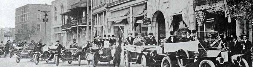
4 2 A LOOK AT MOORESVILLE Introduction History Years before its first days of incorporation in 1873, the seeds of change were planted in the red North Carolina clay that would be known today as the Town of Mooresville. Over time, those seeds took root and wove their fine tendrils through small farms and into large mills. The Town s first development patterns took shape as cotton became intertwined with the rail line. The mill town spun into a hub of commerce and a community was woven around the tracks of growth. The Town grew with the economic success of cotton mills, along with investments in housing, government and community facilities. Like many similar mill towns in the south, Mooresville was a self-contained community, with many of the residents benefiting both directly and indirectly from the mill. In 1999, when the mill operation shut down, Mooresville had already reshaped its image from mill town into Race City USA as it geared for growth. Located approximately 20 miles north of Charlotte, Mooresville boasts award-winning schools and a vibrant business community. From the beauty of Lake Norman to the quaintness of Downtown, Mooresville is an attractive place to live, work and play. Those early seeds of change produced a thriving town and a regional leader in championing a smarter way of accommodating growth. Through its Comprehensive Master Plan process, the Town of Mooresville has cultivated a balanced, sustainable land development pattern that will accommodate planned growth, efficiently utilize public infrastructure, and protect rural and environmental resources.


5 A LOOK AT MOORESVILLE 3 Vision and Strategic Framework Mooresville experienced unprecedented growth and change in the last 20 years. The rate of population growth began to increase in the 1980s and accelerated dramatically in the 1990s. At the same time, the Town changed from a selfcontained industrial community to a rapidly urbanizing, multi-faceted society. Today, with a population of over 34,000, which has surged by almost 74 percent in the past decade, and over 12,300 households, Mooresville is a mix of small town, suburban and urban development. Projections show the Town to double its population in the next 20 years. The Town is ripe with opportunity to manage smart growth with a variety of development patterns. Employment opportunities Shopping opportunities 6% 23% 32% 46% Excellent Good Guided by the desire to enhance the quality of life for its citizens, while also providing valued governmental services and directing well-planned growth and development, the Town Board of Commissioners sanctioned the creation of the Mooresville Comprehensive Master Plan. The Master Plan provides a vision, strategy and framework for future decision making about the Town s growth and development. Mooresville as a place to work 20% 44% Overall quality of business and service establishments in Mooresville 18% 55% RATINGS OF ECONOMIC SUSTAINABILITY AND OPPORTUNITIES Citizen Engagement 0% 25% 50% 75% 100% Percent of respondents In 2006, the Town initiated three planning projects the Comprehensive Land Use Plan, the Comprehensive Transportation Plan and the Zoning Ordinance. All three parallel efforts were coordinated by Development Services. Public engagement for the Land Use Plan began early and continued throughout the process. Recognizing the relationship between land use and transportation, the Comprehensive Land Use Plan and Comprehensive Transportation Plan teams held two joint public workshops that provided participants the opportunity to share their ideas for the future and discuss plan concepts. Additionally, an extensive community survey captured input from Town residents. Led by the Town of Mooresville Planning Board and guided by the technical staff in Development Services, the Comprehensive Master Plan was produced and adopted by a 24-member Citizen Advisory Committee. These committed citizen volunteers worked to ensure the vision, goals and objectives for the Master Plan and companion, Comprehensive Transportation Plan, were developed based on broad goals that set the strategy for managing growth and development.


6 4 A LOOK AT MOORESVILLE Natural, Community and Cultural Resources Mooresville s natural environment contributes to the overall enhanced quality of life for its residents. While natural resources are abundant, they are also fragile and must be protected. Local action and regional cooperation are crucial in achieving the goals of protecting and enhancing the water and air quality, protecting viewsheds, and developing a comprehensive network of greenways. With approximately 53 percent of the land in the planning area within various water supply watershed protection districts, the Town has the opportunity to leverage strict limits on land coverage. Providing these guidelines will encourage new development to take full advantage of natural features and conserve large areas of open space. The presence of open space is an essential element in determining the character and quality of the community. Lake Living Mooresville s proximity to Lake Norman, and its well-maintained network of open space, makes it a highly desirable place to live, work and play. Created by Duke Power in 1963, Lake Norman is the largest man made body of fresh water in North Carolina with 525 miles of shoreline more than the coastlines of North and South Carolina combined and a surface area of more than 32,475 acres. Beginning in the 1980s, parts of Mooresville in the Lake Norman area west of Interstate 77 (I-77) and south of North Carolina Highway 150 (NC 150) began to experience surging residential growth. Commercial and retail centers followed the residential growth, creating regional retail and employment centers first along the NC 150 corridor east of I-77 and then west from Exit 36 as utilities were extended across the interstate. The Brawley School Road, Templeton Road and Langtree Road peninsulas provide many miles of beautiful lakefront property along Lake Norman.


7 A LOOK AT MOORESVILLE 5 Recreation Parks and recreational opportunities play a large role in enhancing the quality of life of the community. The Town of Mooresville operates an extensive active recreation program with 15 parks, 15 tennis courts, 15 basketball courts, 19 lighted ball fields and three gyms. The Mooresville Graded School District along with the Iredell-Statesville School System provides a significant component of the Mooresville parks and recreation program by supplying existing school sites for active recreation. The Town s Cultural & Recreation Services also proudly maintain the War Memorial and hosts programs for all residents from seniors to civic groups at The Charles Mack Citizen Center. The Mooresville Parks and Greenways Comprehensive Master Plan was adopted in 2009 to provide ample parks, recreation and open space for the community. In establishing guidelines for future needs, there was overwhelming consensus that Mooresville is a young, active community with a strong demand for recreation activities. The plan encourages Mooresville to partner with Iredell County to supplement the recreation and park facilities. Additionally, through the strategy of the Comprehensive Master Plan, land developers will share responsibility for the dedication of open space for active recreation, natural area preservation, and greenway development as they seek to develop within the Town of Mooresville. While natural resources are abundant they are also fragile and must be protected. Local action and regional cooperation are crucial to achieving the goals of protecting and enhancing environmental quality, conserving open space, and developing a comprehensive network of greenways and pedestrian facilities throughout the region. Trees and other vegetation represent both an environmental resource and an important landscape feature in the quality of life for the Town. Preserving, maintaining and increasing the Town s tree canopy will have a beneficial impact on air quality, storm water control and visual appearance.


8 6 A LOOK AT MOORESVILLE Education The perceived quality of education is important to attracting and retaining young families and is crucial to the economic vitality of the community. Mooresville s schools are nationally recognized for their quality education. They diligently prepare students with skills and knowledge needed for success in higher education and the workplace, laying the foundation for greater paying jobs. The Town of Mooresville is served by two public school systems, plus numerous private and charter schools. The Mooresville Graded School District (MGSD) and Iredell-Statesville Schools (ISS) represent a total of 40 schools and an enrollment of approximately 20,000 students. MGSD has been featured in multiple news articles and educational journals including: The New York Times, Ed Leadership, Ed Week, District Administration, and the American School Board Journal. They were also featured in a Learning Matters segment on PBS: The News Hour with Jim Lehrer. President Barack Obama toured Mooresville Middle School on June 3, With more than 20,000 students, ISS ranks among the 20 largest school districts in North Carolina, and their 36 schools offer a wide array of services and programs to meet the unique demands of the student population. From International Baccalaureate programs to challenge even the most advanced learner, to alternative schools and a differentiated diploma program designed to help students who need extra support to graduate, the district ensures there is something for everyone. Through the guiding principles and framework of its own Strategic Plan, MGSD embarked on an extraordinary and innovative journey to put laptops in the hands of students in grades four to 12 and SMART boards in all kindergarden to third grade classrooms. Its Digital Conversion Initiative employs technology in ways that improve teaching and learning through increased student engagement while teaching the NC Standard Course of Study focusing on reading and mathematics. MGSD is leading the way as a 21st Century Learning Community.


9 A LOOK AT MOORESVILLE 7 Land Use For many years, the rail line and cotton mills shaped development. The compact Downtown built adjacent to the train depot was the hub of commerce for the Town and surrounding area. The mill buildings were located to the north and south of Downtown, with residential neighborhoods surrounding it. The overall goal of the Comprehensive Land Development Plan is to make Mooresville an attractive place for people of all ages, backgrounds and income levels to live, work and play. This requires not only sound land use and economic policies, but a strong commitment to excellence in community design and appearance. The quality of the physical environment attractive streets, buildings, parks and open space has a direct impact on Mooresville s economy, the sustainability of neighborhoods, and the successful stewardship of its unique natural and cultural resources. Until the early 1970s, development followed a grid pattern of streets with residences, retail, office and institutions within the same neighborhood. The next band of development began to separate residential and commercial uses with neighborhoods defined by curvilinear streets and commercial centers located along major streets. By the late 1970s, the focus of new residential development began to shift to areas outside the traditional town center. Although Downtown Mooresville remained the government and financial center for the community, businesses soon relocated to rapidly developing business parks and commercial centers.


10 8 A LOOK AT MOORESVILLE Beginning in the 1980s and through the two decades that followed, the Lake Norman area began to experience surging residential growth. Today, residential growth is occurring both east and west of I-77. Commercial growth is occurring along the NC 150 corridor, west of I-77 in close proximity to Lake Norman. This pattern is expected to shift predominately to the east as available land for development west of I-77 approaches build-out over the next decade. The 2030 Land Use Plan focuses on achieving a balanced, sustainable land development pattern that will accommodate planned growth, efficiently utilize public infrastructure, and protect rural and environmental resources. The emphasis of the Plan is on defining the form, function, scale and mix of uses in each of the areas, as well as providing general criteria for locating and citing these land use elements or their components. As in the past, the Town expects development to occur in several phases, through residential neighborhoods, neighborhood and village nodes, regional employment centers and regional activity centers interconnected by a network of streets. The Town s ultimate development pattern will be based on the long-term commitment to maintaining distinct neighborhood, employment and regional activity areas with denser clusters of mixed-use development in the growth areas where utilities will be available to serve urban development. Studies indicate that the perception of a safe environment is one of the critical factors to a community s success in attracting residents, visitors and businesses. The Town will continue the approach of community policing as an effective and responsive approach to law enforcement and will ensure fire and rescue services are located to provide the most equitable, effective and efficient services to the community.


11 A LOOK AT MOORESVILLE 9 The second phase will occur as utilities are extended to the north and east of Downtown. Improvements to the road network and construction of a highway interchange at I-77 and Cornelius Road are incentives for business and new industries to become established in employment and industrial planning areas. A third phase is expected to occur in the next 10 to 15 years in the form of redevelopment in nodes of higher density land uses along major thoroughfares. These nodes will be true urban centers with a mix of uses designed for pedestrians, served by public transit and compact in form. The changes that occurred began slowly in the late 1980s and quickened dramatically in the 1990s. It is expected that the rate of development will continue as the employment centers build-out and residential neighborhoods are developed in response to housing demand. Ultimately, development will be driven by the market and the Town s ability to extend public utilities, improve highway access and road networks serving the area to the north. Rural Rural residential areas are low-density areas. Lots for single family homes typically range from one half to five acres and development relies on well and private septic systems. The rural residential planning areas are within the Yadkin Creek/Back Creek and Yadkin Creek/ Coddle Creek WS-II Watershed Protection Areas. While retaining rural areas are an essential asset of the community, neighborhoods in the rural residential area will be developed in a cluster design to preserve rural and forested land, protect groundwater resources, preserve open space and reduce potential congestion on rural roads. In this type of design, a significant portion of the site remains undeveloped, preserving natural areas. To protect the rural and scenic qualities of Coddle Creek Road (NC 3), the Comprehensive Transportation Plan recommends a strategy that would permit development of a four-lane boulevard from the Iredell/Cabarrus/ Mecklenburg County line to Rocky River Road. As the road approaches Downtown, it will be limited to a two-lane road with a boulevard. The Town s rural commercial, industrial, employment and institutional activities will continue to preserve Mooresville s rural character. Businesses development will meet established performance criteria, including traffic capacity limits and site design standards.


12 10 A LOOK AT MOORESVILLE Neighborhood Residential Living Neighborhoods consist of not only homes, but also parks, streets, shops, schools, places of worship, community centers and other services. The collection of neighborhoods creates the community. Residential neighborhoods come in many different densities and configurations, and will include a diversity of housing types and price ranges. Protection, preservation and enhancement of existing neighborhoods must be as important as promoting new construction. Current development patterns of auto-dependent, single use, low-density development has resulted in traffic congestion, loss of open space and lack of street connectivity. As the market changes, new types of neighborhoods with greater diversity in housing styles, sizes, price ranges and amenities will be required to meet the demand for a broader range of housing choices. The changing housing market will affect how Mooresville s neighborhoods are developed. New neighborhoods will have a mix of commercial and residential uses, with a range of housing types, styles and density. Specific types of residential development will reduce sprawl and focus development in areas where there are adequate public facilities and services such as public utilities, road, school, and fire and police protection. Within larger planned neighborhoods, smaller villages may share common unifying elements such as street lighting, signage and landscaping palate. The neighborhood residential planning area will support the majority of the residential development over the next 20 years. The neighborhood residential planning area will be developed as a series of interconnected neighborhoods with the highest density housing located in close proximity to services or in village and neighborhood centers. The neighborhood center provides the essential facilities for the neighborhood in one convenient location. Neighborhood centers and village centers will be strategically located to provide needed services and public facilities. The scale of the use will determine the location. Public investments in utilities, road and community facilities will be focused in this planning area. Surrounding neighborhoods will be able to access the center by a short walk. Public parks, community recreation and social facilities will contribute to the neighborhood character.


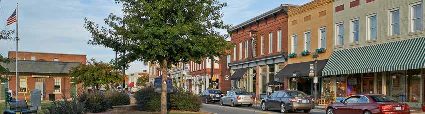
13 A LOOK AT MOORESVILLE 11 Smart Growth Smart Growth initiatives recognize the relationship between development and quality of life. Smart Growth practices are community-focused, transit and pedestrian oriented, and have a greater mix of housing, commercial and retail uses in close proximity to each other. Neighborhoods will have various scales and densities of housing options ranging from the highest densities in close proximity to a village center to densities more appropriate for suburban residential development further from the center. A greater mix of residential and non-residential uses in the neighborhoods will promote a sense of community and encourage less reliance on vehicles for daily activities. Town Center Dating from the 1850s, Downtown Mooresville retains many of the original buildings along Main and Broad Streets. Locally owned shops, restaurants and business services dominate. Public buildings include the new Town Hall, Fire Station, Library, Post Office and the Charles Mack Citizen Center. Between 2003 and 2008, the Town invested in street, sidewalk, water and sewer and lighting improvements, which spurred private development. The result a vibrant Downtown area. Urban Centers Urban neighborhoods have a diverse range of building types, thoroughfares and public open spaces. Urban neighborhoods will have interconnected streets, with pedestrian and bicycle facilities. Centrally located open space, recreation areas or well-designed conservation areas will encourage community gatherings. Concentrated areas of more dense urban development or urban villages a halfmile in diameter will be located along major corridors, supporting the potential for bus transit linking villages, Downtown and employment centers. Residential development will include a range of housing choices, with workforce housing located near transit corridors.

14 12 A LOOK AT MOORESVILLE Economic Development Mooresville s location, quality of life, school systems and existing business clusters are what give our Town a robust economy making it a desirable place for business. The Town s close proximity to Charlotte, reliable infrastructure that is in place through roads, rail, fiber optics, water/sewer and air make it an ideal business location for manufacturers, headquarters, back-office and users alike. Numerous corporations have their headquarters in Mooresville/Southern Iredell County including: Lowe s Companies, Inc., BestCo, Carolina Beverage Group, Custom Products, Inc. and General Microcircuits, Inc. just to name a few. Two of the trends that will directly influence the housing market are the age of householders and household size. The number of people turning 65 will rise dramatically over the next 20 years. In the same time period, there will be more households in every age bracket without children in them, people living alone or people living with others to whom they are not related. Also known as Race City USA the Town is the proud home to numerous NASCAR Teams and over 60 racing related businesses. This core industry sector has built up the labor pool along with the strong K-12 school systems and continuing education systems located in the Town. The Master Plan calls for a comprehensive approach in partnership with the Mooresville-South Iredell Economic Development Corporation and other organizations to enhance the area s economic competitiveness. This collaboration will create an environment that supports the attraction of new and diverse companies while supporting existing companies in their growth and stability. Trends Mooresville is the hub of a growing regional economy. There are approximately 26,000 employees in the Mooresville region. This is projected to increase to 40,000 in the year Growth has come from several factors including the importance of industry clustering, the availability of a skilled workforce, the expanding of the Charlotte Metropolitan Statistical Area (MSA) which the Town became nationally recognized as part of beginning in This area continues to grow northward, along with families and individuals attracted to the region, because of the high quality of life and accessibility to the international airport in Charlotte.


15 A LOOK AT MOORESVILLE 13 This growth has provided an extremely dynamic workforce for the community s economy. Between 2005 and 2025, new office jobs are expected to account for 49 percent of all new jobs. Retail will account for 23 percent of the gain, and industrial accounts for about 15 percent of the projected increase. This translates into an increased demand for both business and industrial space. Mooresville strives to create a climate that grows existing business, attracts new business and cultivates entrepreneurship by offering a world-class workforce in order to maintain and enhance the excellent quality of life. In 2005, the Chamber of Commerce commissioned Angelou Economics to conduct an economic study to evaluate the Town and the surrounding South Iredell region s performance in areas that are most critical to business and industry growth. The study identified five target industries that enhance and support existing industries in the region: business and financial, technology manufacturing, automotive, clean energy technologies, and retail and tourism. Mooresville must continue to cultivate a climate that grows existing business, attracts new business and promotes entrepreneurship by creating a world-class workforce that maintains and enhances the quality of life. However, land available for development is quickly being purchased and developed for residential use. Additionally, rising land prices make the area less attractive to large footprint industrial development, while surrounding areas have more available rural land available at a lower price. These challenges create the opportunity for Mooresville to shift the course of economic development away from businesses that require traditional large industrial tracts and toward those that need higher density commercial/office and flex industrial facilities. A New Approach Public investment alone is not sufficient to attract and sustain economic growth. Instead, public private partnerships better known as P3 sector investments can afford the opportunity to target specific geographic areas and business clusters to maximize their impact. Areas targeted should have the potential for significant job creation to leverage existing clusters of business or industry and enhance the community s overall quality of life and access to services.


16 14 A LOOK AT MOORESVILLE Employment and Business Centers The Comprehensive Land Development Plan identifies areas that are well-suited for a major corporate campus and office employment centers, flex spaces, research and development employment centers and industrial centers. To accommodate growth projections, the plan encourages the development of mixed-use commercial/residential centers in areas near employment centers. Regional Activity Center Mooresville s planning area includes several distinct regional shopping centers, businesses and institutions located within close proximity. These regional activity centers contain the shopping, services, recreation and entertainment, hotels, employment and institutional facilities, like a community college, to serve residents and non-residents alike. This destination requires direct access to major highways and arterial roads. Future regional activity centers will be supported by high-density housing and commercial uses located in vertically integrated buildings within centers or in the adjacent mixed use corridors. The plan proposes one regional activity center that encompasses the major destination retail centers along the NC 150 corridor, east and west of I-77. Buildings will be arranged to create a sense of defined space with an internal network of streets and pedestrian areas, formal outdoor spaces and landscaping. Architectural features and parking areas will present an attractive and inviting appearance. Corridor Mixed-Use Mooresville has several older shopping centers and strip commercial areas, particularly east of the NC 21 corridor. Underutilized shopping centers and commercial sites can be converted to more appropriate uses. By redeveloping these sites as either mixed-use developments or adding new buildings along the street edge and placing the parking into the newly created interior areas, these sites can accommodate a range of needs. Applying the concepts of the village center and corridor mixeduse planning areas will be an incentive to convert these underutilized sites to dynamic business centers. Business Center A business center is strategically located to serve larger employment areas and will vary in scale and intensity depending on the location, service area and availability of adequate roads and public utilities. Any new employment center in the Town will be easily accessible by road and transit. A network of interconnecting roads, with sidewalks and bikeways would provide alternatives for employees to walk to lunch or services. Travel from adjacent residential neighborhoods or activity


17 A LOOK AT MOORESVILLE 15 centers should be possible without requiring travel along a major thoroughfare. A sufficient buffer or transition between the employment center and residential neighborhoods will minimize the impact of noise, light and traffic. Industrial The industrial area is an important asset to Mooresville. The Town will continue to feature concentrations of industrial uses in well-planned centers or parks, or as infill and redevelopment of existing industrial areas. An additional 500 acres has been purchased to facilitate phase two of the Mooresville Business Park. Based on projections for employment growth, the area will need to reserve almost 300 acres of land for employment uses. - The Angelou Economics Study Mixed-Use Activity Centers Activity centers are typically located along major transportation corridors and are physically and aesthetically unified areas designed to function as a whole rather than as a series of unconnected, unrelated developments. The intent is for uses and characteristics that define activity centers to ultimately work together as an integrated community.


18 16 A LOOK AT MOORESVILLE Transportation Mooresville is transitioning from a dispersed pattern of low density development to a more compact pattern that includes an integration of land uses in mixed-use nodes and activity centers. The Mooresville Comprehensive Transportation Plan, which was developed concurrently with the Mooresville Comprehensive Land Use Plan, recognizes the inherent relationship between land use and transportation. Through a forward-looking innovative approach, the plans call for an integrated transportation network that consists of four elements: roadway, bicycle, pedestrian and air. These essential elements of transportation influence how land is developed in terms of density and even types of use. The Town s transportation solutions are designed to address congestion, support economic development, incorporate environmental stewardship and be implemented through a think regionally, act locally collaborative, intergovernmental approach that is supported and enforced by local decision makers. Roadways For Mooresville residents and visitors alike, the principal mode of transportation is the motor vehicle. Mooresville s rapid growth has resulted in peak hour congestion along its many roadway corridors. The Comprehensive Transportation Plan recommends improvements to the major corridors that serve the identified growth areas. A proposed East-West Connector will serve the neighborhood residential planning area improving access to both the employment center areas and NC 3/Coddle Creek. The connection between Mazeppa Road and Cornelius Road will serve the industrial and employment center areas, and provide safer and more efficient access for freight and vehicular traffic. These improvements will provide an alternative route for traffic from the Talbert Pointe Industrial Park and also will provide access for future expansion of the park to the north. Additionally, expanding the transportation system with an increased number of collector streets will enhance travel between local streets and arterials, and improve accessibility to higher intensity residential areas and activity centers. Transportation improvements will ensure Mooresville remains a vibrant community to live, work and play.


19 A LOOK AT MOORESVILLE 17 Compact Development Sustainable development as measured by environmental stewardship and equitable distribution of community resources that reflects the community s unique character and local values can be achieved through more compact development patterns. With this in mind, future growth anticipated for 2030 was directed to one of seven urban or 15 neighborhood activity centers, matching those identified in the Mooresville Comprehensive Pedestrian Plan. Urban and neighborhood centers will limit low-density, sprawl development patterns and reduce public infrastructure cost. This proven development pattern significantly improves the efficiency and effectiveness of the regional transportation system by emphasizing compact, walkable urban and neighborhood centers. It also supports future opportunities for bus and rail transit, increases walking and biking trips, and reduces reliance on the automobile for day-to-day activities.
 has identified an interconnected network of seven greenways and four multi-use trails within the Town limits.")

 and the Mooresville-Charlotte Trail.")

20 18 A LOOK AT MOORESVILLE A Healthier Approach to Active Transportation Connected sidewalks, attractive and safe walking environments, and designated bikeways are required to encourage people to leave their cars at home. The Mooresville Comprehensive Pedestrian Plan (CPP) has identified an interconnected network of seven greenways and four multi-use trails within the Town limits. These facilities will be linked through signed bicycle and pedestrian routes. The Town s subdivision ordinance requires that new subdivisions provide a continuous pedestrian network. However, like most other growing communities, gaps exist throughout the sidewalk network. The CPP has identified several pedestrian development zones where improvements would enable residents to walk and bike to attractions within their neighborhoods. To promote active, healthy living, the Town is involved in two progressive projects The Carolina Thread Trail (The Thread) and the Mooresville-Charlotte Trail. Both are designed to link people, places, cities, towns and attractions. The Thread is a regional network of greenways and trails that reaches 15 counties and 2.3 million people. There are 119 miles of The Thread open to the public including 12.6 miles planned for Mooresville. The Thread preserves our natural areas and is a place for exploration of nature, culture, science and history. This is a landmark project that provides public and community benefits for everyone in every community. The Mooresville-Charlotte Trail is a bicycle and pedestrian trail designed to link existing and planned greenways from Mooresville to Charlotte, including the communities in-between. It is a joint effort between multiple local governments in Mecklenburg and Iredell counties to provide a north-south connection for bicyclists and pedestrians across seven jurisdictions. The vision is for a continuous, multi-jurisdictional bicycle route that will encircle Lake Norman and connect with neighboring communities, destinations, and the various local bicycle facilities, in order to provide a safer, useful and attractive transportation and recreation resource for a wide range of users within the surrounding four-county region. This additional 30 miles of trail will allow bicycle and pedestrian users an off-roadway alternative to high-volume and high-speed NC 115 and other roads. It is intended to provide connectivity for schools, greenways, parks, residential developments, businesses and commercial centers. These expanding trail systems will encourage regional economic investment and development by improving community quality-of-life attractiveness.


21 A LOOK AT MOORESVILLE 19 Mass Transit As the Town s population continues to increase, it is important to look beyond the passenger vehicle when planning future transportation services. While the private vehicle will remain the predominant means of transportation for the majority of citizens, the need for quality alternative modes of transportation will increase with community growth. Several studies, including the 2025 Integrated Transit/Land-Use Plan, the 2025 Corridor System Plan, and a Major Investment Study conducted by both the Charlotte Area Transit System and the City of Charlotte, outline strategies to construct commuter rail between downtown Charlotte and several outlying communities, including Mooresville. The North Corridor Commuter Rail Line (LYNX Red Line) is intended to provide an alternative to the congested I-77 corridor for commuters from the northern section of Mecklenburg County to uptown Charlotte. The Metropolitan Transit Commission established the Red Line Task Force (RLTF), a standing committee to focus on finding alternative means to finance and advance the Red Line rail project. A Norfolk Southern rail line for freight runs north/south connecting Mooresville to the national rail system. Three airports are located within proximity to the Town of Mooresville. Charlotte Douglas International Airport is located approximately 28 miles southwest of Mooresville and services travel throughout the world. The Concord Regional Airport is located 17 miles southeast of Mooresville and Statesville Municipal Airport is located 15 miles northwest of Mooresville. It is home to Lowe s Companies, Inc. corporate fleet.


22 20 A LOOK AT MOORESVILLE Conclusion Rooted in its humble history, the Town of Mooresville has flourished through generations of caring citizens and involved industry partners. From mills to rails, the Town switched gears and its growth became fueled by a new crop of diverse corporate, industrial firms and the popularity of motorsports. Like all seeds of change, the community has and will continue to grow. Through the guidance of the Town s leadership and staff, combined with the vision of its residents as represented in the Comprehensive Master Plan, Mooresville will thrive as a growing, dynamic and sustainable community that is future-focused with a strong economy and a balanced and growing population that values and enjoys a high quality of life within a safe and attractive environment.


23 Acknowledgements The Town of Mooresville sincerely appreciates the involvement, leadership and vision of current and past Board Members who were involved in the creation of the Comprehensive Master Plan. Mayor Miles Atkins Mooresville Town Board Commissioner Eddie Dingler, Ward 1 Commissioner Thurman Houston, Ward 2 Commissioner Mac Herring, Ward 3 Commissioner Lisa Qualls, Ward 4 Commissioner Bobby Compton, At Large Commissioner David Coble, At Large Planning Board Members David Nail, Chair John Robertson, Vice-Chair Allen Brawley Mark Brady Rosalind Campbell Danny Martin Steve McGlothlin William Ogburn Joseph Yanicak The Town of Mooresville gratefully acknowledges the following individuals and organizations for their photographic contributions: Pam Brackett, Kelly Culpepper, Cotton Ketchie and the Mooresville Downtown Commission.
663-3800 www.ci.")
24 Town of Mooresville 413 North Main Street Mooresville NC (704)
CHAPTER 7: Transportation, Mobility and Circulation
 AGLE AREA COMMUNITY Plan CHAPTER 7 CHAPTER 7: Transportation, Mobility and Circulation Transportation, Mobility and Circulation The purpose of the Transportation, Mobility and Circulation Chapter is to
Concord Community Reuse Project Goals and Guiding Principles. Overarching Goals (OG)
") Concord Community Reuse Project Goals and Guiding Principles Overarching Goals (OG) No priority is implied by the order of presentation of the goals and guiding principles. Overarching goals for the Concord
Concord Community Reuse Project Goals and Guiding Principles Overarching Goals (OG) No priority is implied by the order of presentation of the goals and guiding principles. Overarching goals for the Concord
Lake Davidson Village. Langtree Road - Exit 32 Mooresville, North Carolina
 Langtree Road - Exit 32 Mooresville, North Carolina Executive Summary: Lake Davidson Village is located at Exit 32 interchange at Langtree Road and Interstate 77. This new interchange is the first exit
The Five Components of the McLoughlin Area Plan
 The Five Components of the McLoughlin Area Plan This documents contains the complete language of the five components of the McLoughlin Area Plan: The Vision Statement The Values The Guiding Principles
A BLUEPRINT FOR BROCKTON A CITY-WIDE COMPREHENSIVE PLAN
 A BLUEPRINT FOR BROCKTON A CITY-WIDE COMPREHENSIVE PLAN Public Meeting October 2016 1 Plan Summary and Discussion Public Meeting May 4 2017 City of Brockton Bill Carpenter, Mayor Department of Planning
Living in Albemarle County s Urban Places
 Living in Albemarle County s Urban Places ALBEMARLE COUNTY, VIRGINIA A Closer Look at Albemarle s Approach to Managing Growth and Creating Quality Urban Environments www.albemarle.org Page 2 Living in
Silverdale Regional Center
 Silverdale Regional Center Vision for Silverdale Regional Center The Silverdale Regional Center Plan (Plan) will guide the evolution of the Silverdale Regional Center from a collection of strip malls and
Plano Tomorrow Vision and Policies
 Plano Tomorrow Vision and Policies PLANO TOMORROW PILLARS The Built Environment The Social Environment The Natural Environment The Economic Environment Land Use and Urban Design Transportation Housing
Implementation Guide Comprehensive Plan City of Allen
 Implementation Guide 2030 Comprehensive Plan City of Allen DRAFT 2015 Implementation Guide Allen 2030 Comprehensive Plan INTRODUCTION The Comprehensive Plan serves as a guide for the growth and development
The transportation system in a community is an
 7 TRANSPORTATION The transportation system in a community is an important factor contributing to the quality of life of the residents. Without a sound transportation system to bring both goods and patrons
EXISTING COMPREHENSIVE PLAN
 EXISTING COMPREHENSIVE PLAN Town Center Land Use Element: V. LAND USE POLICIES Town Center Mercer Island's business district vision as described in "Your Mercer Island Citizen-Designed Downtown" was an
CHAPTER 1 INTRODUCTION
 TABLE OF CONTENTS Adopted November, 2012 CHAPTER 1 INTRODUCTION... 1-1 1.1 COMPREHENSIVE LAND USE PLAN PURPOSE... 1-1 1.2 RELATIONSHIP TO OTHER TOWN PLANNING DOCUMENTS... 1-2 1.3 MOORESVILLE TODAY... 1-3
1 October Dear Citizens of Charlotte and Mecklenburg County,
 1 October 2011 Dear Citizens of Charlotte and Mecklenburg County, As co-chairs of the Center City 2020 Vision Plan Steering Committee, we are proud to present the Center City 2020 Vision Plan, which sets
Small Area Plan. South Gateway
 Small Area Plan Adopted May 12, 2008 South Gateway Purpose. The South Gateway Small Area Plan defines the City s expectations for the future of the southern entrance to the City at Interstate 85 and Highway
Corridor Vision. 1Pursue Minnehaha-Hiawatha Community Works Project. Mission of Hennepin County Community Works Program
 1Pursue Minnehaha-Hiawatha Community Works Project Minnehaha-Hiawatha Community Works is a project within the Hennepin Community Works (HCW) program. The mission of the HCW program is to enhance how the
V. Vision and Guiding Principles
 V. Vision and Guiding Principles The Master Plan for the Powers Ferry Corridor seeks a foundation in the desires of the community. At times, various elements of the community offered opposing viewpoints,
Economy Vision Statements: Social Wellbeing Vision Statements: Natural Environment Vision Statements:
 Economy Vision Statements: 1. Our business environment makes us a region of choice for new employers as we encourage entrepreneurship and have a vibrant, diversified and resilient regional economy. 2.
Chapter 1: Introduction
 Chapter 1: Introduction The Penn Avenue Community Works Corridor Vision and Implementation Framework presents an integrated communitybased vision and a coordinated, long-term implementation framework for
Developer s Program. The Station at East 54
 Developer s Program The Station at East 54 Existing Conditions The Station at East 54 is proposed for a 1.12 acre site at the northeast corner of Hamilton Road and Prestwick Road, tucked between the East
Chapter 4. Linking Land Use with Transportation. Chapter 4
 Chapter 4 Linking Land Use with Transportation Chapter 4 59 Chapter 4 Linking Land Use with Transportation Community Design and Transportation Program Introduction Since the 1950s, the predominant development
REGIONAL ACTIVITY CENTER
 DRAFT REGIONAL ACTIVITY CENTER 70 EAST BENCH MASTER PLAN DRAFT 06 Introduction The East Bench Regional Activity center is comprised of large educational, research, medical, and employment centers. These
Chapter 2: Vision, Goals and Strategies
 Chapter 2: Vision, Goals and Lake Elmo Today & Tomorrow Comprehensive Plan 2040 2 VISION, GOALS & STRATEGIES - DRAFT 4-6-2018 INTRODUCTION Comprehensive Plan Purpose Perhapse the most important objective
Comprehensive Plan ADOPTED APRIL 2014
 Comprehensive Plan ADOPTED APRIL 2014 8 8. Outstanding Recreational & Cultural Opportunities We are proud of our community s parks and recreation system. Our community will ensure that the legacy of our
What. - Civic anchors including a park and an updated library branch
 SUMMARY What Master Plan aimed at delivering - A walkable, mixed-use downtown in the heart of University City anchored by UNC Charlotte and University Research Park - Civic anchors including a park and
greenprint midtown SUSTAINABILITY ACTION PLAN 2012
 greenprint midtown SUSTAINABILITY ACTION PLAN 2012 MIDTOWN ALLIANCE SOUTHFACE ENERGY INSTITUTE RENAISSANCE PLANNING GROUP SUSTAINABLE ATLANTA PERKINS+WILL 2 GREENPRINT MIDTOWN 1. Introduction Sustainability
DALY CITY VISIONING PROCESS COMMUNITY WORKSHOP 3 MAY 8, 2008
 DALY CITY VISIONING PROCESS COMMUNITY WORKSHOP 3 MAY 8, 2008 PROCESS General Plan - a statement of the community s values, vision and aspirations for now and into the future... Timeframe LONG TERM - 2030
ELK GROVE GENERAL PLAN VISION
 2-1 CHAPTER 2: 2-2 CREATING OUR The Community Vision for Elk Grove, expressed through a Vision Statement and a series of Supporting Principles, is a declaration of the kind of community that Elk Grove
4.1.3 LAND USE CATEGORIES
 4.1.3 LAND USE CATEGORIES a. City Center District The City Center District incorporates the existing character and mix of uses in downtown Belmont to encourage redevelopment and new development in keeping
CHAPTER 3 VISION, GOALS, & PLANNING PRINCIPLES. City of Greensburg Comprehensive Plan. Introduction. Vision Statement. Growth Management Goals.
 CHAPTER 3 VISION, GOALS, & PLANNING PRINCIPLES Introduction The Greensburg Comprehensive Plan is intended as a working community document. A combination of long and short-term goals, this document is intended
2040 LUP is a part of the Comprehensive Plan and carries the same legal authority. Economic Challenges
 1.1. Guiding Anchorage s Growth Where will new residents settle over the next two decades? Where will people work, shop, and play? Will there be enough room to grow? How will Anchorage look? Will growth
Hopkins. Development Guidelines May Overview. Sponsored by: Blake Road Corridor Collaborative City of Hopkins
 Hopkins Blake Road LRT Station Area Development Guidelines May 2015 Sponsored by: Blake Road Corridor Collaborative City of Hopkins Overview Hopkins is a dynamic community of over 17,000 residents located
Visioning Statement and Guiding Principles
 Visioning Statement and Guiding Principles Planning for the Future The General Plan The General Plan represents Woodland's shared vision of the future and defines a path to lead the community toward its
BROOKHILL NEIGHBORHOOD MODEL ZONING MAP AMENDMENT PREFACE TO APPLICATION
 BROOKHILL NEIGHBORHOOD MODEL ZONING MAP AMENDMENT PREFACE TO APPLICATION June 15, 2015 Revised: August 1, 2016 I. VISION Brookhill is a proposed community based upon the principles of Albemarle County
CHAPTER 1. Ms. Guajardo s Class - Central Elementary CH 1 1
 INTRODUCTION CHAPTER 1 Ms. Guajardo s Class - Central Elementary CH 1 1 1.1 SETTING South Centre City is a linear corridor south of Downtown Escondido paralleling Centre City Parkway and South Escondido
PSRC REVIEW REPORT & CERTIFICATION RECOMMENDATION
 PSRC REVIEW REPORT & CERTIFICATION RECOMMENDATION KITSAP COUNTY COUNTYWIDE PLANNING POLICIES July 2, 2012 BACKGROUND A major emphasis of the Washington State Growth Management Act (GMA) is the need to
HE VISION. Building a Better Connected Place
 HE VISION Building a Better Connected Place WALK INTO THE FUTURE. Life in Cranberry, 2030 Here s what our residents told us they wanted to see in their community by 2030: The Cranberry of 2030 is a place
Improve Neighborhood Design and Reduce Non Point Source Water Pollution
 HOW TO Planning Guide Improve Neighborhood Design and Reduce Non Point Source Water Pollution This document was funded by a grant from the New Hampshire Coastal Program with funding from the National Oceanic
iii. Visioning framework
 III. VISION iii. Visioning framework III.1 Overview A vision is a clear and succinct description of what an institution and its community should look like after it successfully implements its goals and
Sherri Ferguson. President/CEO Portland Chamber of Commerce. Tennessee Certified Economic Developer Capstone Project
 Sherri Ferguson President/CEO Portland Chamber of Commerce Tennessee Certified Economic Developer Capstone Project Strategic Plan Development for the North Gateway of Portland, Tennessee The New Gateway
Transportation. Strategies for Action
 Transportation A major priority for the Overlake Neighborhood is to develop a multimodal transportation system. To achieve this system, a balance has to be found among travel, circulation and access needs;
Guiding Principles, Objectives, Strategies and Policies
 Guiding Principles, Objectives, Strategies and Policies Section 1 Introduction These Guiding Principles were adopted as part of the 1999 Athens-Clarke County Comprehensive Plan and are carried over, in
1 Introduction. 4 Environmental Integrity. 7 Community Facilities
 2037: A CALL TO ACTION 2017 COMPREHENSIVE PLAN EXECUTIVE SUMMARY is the purpose of the Q: What Comprehensive Plan? The comprehensive plan serves as a guide for the community s physical, social, and economic
City of Farmington. Downtown Plan. Amendment to the 1998 Master Plan Adopted October 11, 2004
 City of Farmington Amendment to the 1998 Master Plan Adopted October 11, 2004 Introduction Planning Background 1 Scope and Components of the Plan Amendment 2 Concept Introduction 3 Plan Concepts 3 Conceptual
Preliminary Plan Framework: Vision and Goals
 Preliminary Plan Framework: Vision and Goals Draft: May 2015 Introduction Since the Town of Milliken s comprehensive plan was last updated in 2010, the community was heavily impacted by the 2013 flood,
FUTURE LAND USE ELEMENT
 FUTURE LAND USE ELEMENT GOAL I: To create and sustain a great place to live, play, and prosper Objective 1: The City of Ocala shall incorporate the principles and strategies of the Ocala 2035 Vision into
Gold Line Bus Rapid Transit Transit Oriented Development (BRTOD) Helmo Station Area Plan
 Helmo Station Area Plan") Appendix F Gold Line Bus Rapid Transit Transit Oriented Development (BRTOD) Helmo Station Area Plan Introduction and Purpose of the Plan The Gold Line Bus Rapid Transit facility is an eleven-mile dedicated
Appendix F Gold Line Bus Rapid Transit Transit Oriented Development (BRTOD) Helmo Station Area Plan Introduction and Purpose of the Plan The Gold Line Bus Rapid Transit facility is an eleven-mile dedicated
2018 Northampton Township Comprehensive Plan
 2018 BUCKS COUNTY, PENNSYLVANIA What is a? A comprehensive plan is a municipality s main policy document that details the collective vision for the future, the historic, environmental, and cultural facilities
Executive Summary. The Mebane CLP is not a regulatory document, but is intended to guide land development decisions. The plan includes:
 Executive Summary P URPOSE AND O RGANIZATION OF THE P LAN The City of Mebane, with input from citizens and an appointed CLP Advisory Committee, adopted Mebane by Design, a Comprehensive Land Development
This page intentionally blank.
 This page intentionally blank. Parks, Recreation, and Open Space Chapter Relationship to Vision Vision Parks, Recreation and Open Space Chapter Concepts County Government. County government that is accountable
[PLANNING RATIONALE] For Site Plan Control and Lifting of Holding Zone By-Law 101 Champagne Avenue. May 23, 2014
![[PLANNING RATIONALE] For Site Plan Control and Lifting of Holding Zone By-Law 101 Champagne Avenue. May 23, 2014](/thumbs/75/71599615.jpg "[PLANNING RATIONALE] For Site Plan Control and Lifting of Holding Zone By-Law 101 Champagne Avenue. May 23, 2014") [PLANNING RATIONALE] For Site Plan Control and Lifting of Holding Zone By-Law 101 Champagne Avenue May 23, 2014 Contents 1.0 Introduction... 2 2.0 Site Context... 2 2.1 Adjacent Uses... 2 Figure 1: Site
[PLANNING RATIONALE] For Site Plan Control and Lifting of Holding Zone By-Law 101 Champagne Avenue May 23, 2014 Contents 1.0 Introduction... 2 2.0 Site Context... 2 2.1 Adjacent Uses... 2 Figure 1: Site
Section 4 BUILDING THE MASTER PLAN
 The Master Plan 33 Section 4 BUILDING THE MASTER PLAN Figure 4:1. A collaborative effort characterized the two design workshops sponsored by DISC to create hypothetical Master Plans for the Towers Property
DRAFT Subject to Modifications
 TREASURE COAST REGIONAL PLANNING COUNCIL M E M O R A N D U M To: Council Members AGENDA ITEM 8 From: Date: Subject: Staff May 19, 2017 Council Meeting Florida Department of Transportation Complete Streets
ORANGE COUNTY IMPLEMENTING THE FOUR C s
 ORANGE COUNTY IMPLEMENTING THE FOUR C s East Central Florida Corridor Task Force O R A N G E COUN TY P LA N N I N G DIVISION C O M M U N I T Y, E N V I R O N M E N T A L A N D D E V E L O P M E N T S E
FUNDING CORRIDOR REVITALIZATION
 FUNDING CORRIDOR REVITALIZATION Integrated corridor planning for the 21 st Century America Planning Association Annual Conference Atlanta, GA April 27, 2014 Mariia Zimmerman, MZ Strategies, LLC mariia@mzstrategies.com
Town Center (part of the Comprehensive Plan)
") Town Center (part of the Comprehensive Plan) Mercer Island Town Center Looking North (2014) In 1994, a year-long process culminated in a set of design guidelines and code requirements for the Town Center
Town Center (part of the Comprehensive Plan) Mercer Island Town Center Looking North (2014) In 1994, a year-long process culminated in a set of design guidelines and code requirements for the Town Center
Downtown Huntersville in 2030
 Downtown Huntersville in 2030 In 2030 Huntersville s Downtown will be a thriving, mixed-use town center with a variety of housing types (single-family, townhomes, live-work, and apartments), retail establishments,
The Lower SaLuda Greenway
 The Lower SaLuda Greenway InITIaTIve a FLourIShInG Greenway. a hub For economic GrowTh. a ConneCTIon BeTween CoMMunITIeS. In April 2017 the Michael J. Mungo Foundation and Lexington County commissioned
section 3: Vision, Values and Goals
 Vision, Values and Goals 3 2041 Vision: Victoria is an urban sustainability leader inspiring innovation, pride and progress towards greater ecological integrity, livability, economic vitality, and community
3. VISION AND GOALS. Vision Statement. Goals, Objectives and Policies
 Vision Statement Queen Creek s interconnected network of parks, trails, open spaces and recreation opportunities provide safe and diverse activities and programs that sustain its unique, small town, equestrian
Cumberland Region Tomorrow is a private, non-profit, citizen based regional organization working with Greater Nashville Regional Council
 Cumberland Region Tomorrow is a private, non-profit, citizen based regional organization working with Greater Nashville Regional Council and others in the public and private sectors, dedicated to planning
Vision 2020 Economic Redevelopment Team Final Report
 Vision 2020 Economic Redevelopment Team Final Report October 24, 2011 7/30/2011 1 2020 Visioning Redevelopment Economics Team Fritz Beiermeister Mike Evangelista Bill Largent Mark Lifter Team Members Shel
S A C R A M E N T O C O U N T Y JACKSON HIGHWAY & GRANT LINE EAST VISIONING STUDY
 JACKSON HIGHWAY & GRANT LINE EAST S A C R A M E N T O C O U N T Y P L A N N I N G D E P A R T M E N T SUMMARY AND WORKBOOK November 19, 2008 History of the Visioning Study Sacramento County has two growth
CHAPTER 7: VISION AND ACTION STATEMENTS. Noble 2025 Vision Statement
 CHAPTER 7: VISION AND ACTION STATEMENTS This chapter presents the vision, policy and action statements that transform the comprehensive planning study, an analysis of Noble s past, future trends and community
West Ocala Vision & Community Plan City Council Work Session. Presented by West Ocala Community Plan Steering Committee
 West Ocala Vision & Community Plan City Council Work Session Presented by West Ocala Community Plan Steering Committee November 29,2011 Ocala 2035 Vision West Ocala Community Vision & Master Plan West
Ivywild On The Creek PRELIMINARY CREEK DISTRICT MASTER PLAN
 Ivywild On The Creek PRELIMINARY CREEK DISTRICT MASTER PLAN Introduction: Rejuvenating an extraordinary Creekside neighborhood THE CREEKSIDE DISTRICT The Ivywild On The Creek Neighborhood District Master
C. Westerly Creek Village & The Montview Corridor
 C. Westerly Creek Village & The VISION Community Vision When the goals of the city are achieved Westerly Creek Village, a distinctive community defined by Montview Boulevard and Westerly Creek, is a strong
Making TOD Work in the Heart of Suburban Sprawl
 Making TOD Work in the Heart of Suburban Sprawl Rocky Mountain Land Use Institute March 6, 2009 Speakers Ben Herman, FAICP, Principal Clarion Associates Darcie White, AICP, Principal Clarion Associates
1.3 TRANSIT VISION 2040 FROM VISION TO ACTION THEME 1: PUTTING TRANSIT AT THE CENTRE OF COMMUNITIES. Fully integrate transit with community planning
 TRANSIT VISION 2040 FROM VISION TO ACTION TRANSIT VISION 2040 defines a future in which public transit maximizes its contribution to quality of life with benefits that support a vibrant and equitable society,
hermitage town center
 hermitage town center A Community Vision prepared by Strada for The City of Hermitage and The Mercer County Regional Planning Commission January 2007 table of contents introduction 3 design principles
Green Infrastructure The Indianapolis Greenways Connection
 Green Infrastructure The Indianapolis Greenways Connection Fewer things in the transportation industry today make better since than combining the needs for pedestrian and bike trails with the need to locate,
WELCOME TO THE CHOUTEAU GREENWAY ECONOMIC DEVELOPMENT WORKING GROUP!
 WELCOME TO THE CHOUTEAU GREENWAY ECONOMIC DEVELOPMENT WORKING GROUP! Chouteau Greenway Steering Committee and Working Groups Overview Overview January 9, 2019 Chouteau Greenway will transform St. Louis
Wasatch CHOICE for 2040
 Wasatch CHOICE for 2040 Economic Opportunities We Can Choose a Better Future We enjoy an unparalleled quality of life along the Wasatch Front. People from all over the world are drawn to our stunning scenery,
Hockessin Community Redevelopment Plan
 Hockessin Community Redevelopment Plan 3.1 Introduction The Community Redevelopment Plan for the Village of Hockessin is the result of the people s vision for a distinct village center that serves as the
CITY CLERK. Parkland Acquisition Strategic Directions Report (All Wards)
") CITY CLERK Clause embodied in Report No. 10 of the, as adopted by the Council of the City of Toronto at its meeting held on November 6, 7 and 8, 2001. 10 Parkland Acquisition Strategic Directions Report
CITY CLERK Clause embodied in Report No. 10 of the, as adopted by the Council of the City of Toronto at its meeting held on November 6, 7 and 8, 2001. 10 Parkland Acquisition Strategic Directions Report
7Page 72 CLEMMONS COMMUNITY COMPASS 5 DEVELOPMENT AND GROWTH
 5 Development and Growth WHHAATT DDOOEESS IITT I MMEEAANN TTOO BBEE SSUUSSTTAAI IINNAABBLLEE?? Many communities throughout the U.S. are taking on the challenge of becoming more sustainable. But what exactly
Table of Contents. Elm Avenue Improvement Plan City of Waco, Texas. Introduction 1. Existing Context 1 Figure 1 2.
 Table of Contents Introduction 1 Existing Context 1 Figure 1 2 Plan Guidelines 3 Future Urban Form 4 The West-End 4 Main Street 6 The East-End 7 Figure 2 9 Public Improvement Recommendations 7 General
IMPLEMENTING SOMERSET COUNTY S INVESTMENT FRAMEWORK
 IMPLEMENTING SOMERSET COUNTY S INVESTMENT FRAMEWORK SMART CONSERVATION THROUGH SMART GROWTH NJ LAND CONSERVATION RALLY March 22, 2014 Laurette Kratina, PP, AICP, Supervising Planner Somerset County Planning
Executive Summary. NY 7 / NY 2 Corridor
 Executive Summary NY 7 / NY 2 Corridor Transportation and Land Use Study December 2005 Prepared for: Town of Colonie Capital District Transportation Committee Prepared by: Introduction: Land use decisions
Overview of the Plan. The Building Blocks of Centers, Neighborhoods and Network INTERNAL DRAFT
 Overview of the Plan 4 East Davidson Ramah Church Rd June Washam Rd Bradford District Park Bradford Shearer Rd Campus District NC 73 Davidson-Concord North Rocky River This Master Plan projects an approximate
Municipal Development Plan 2013
 UNIQUELY STONY PLAIN: Municipal Development Plan 2013 Quick Reference Guide What is a Municipal Development Plan (MDP)? The Town s highest-level planning document Sets the long-term vision and key themes
Secrest Short Cut and Monroe Expressway Small Area Plan AUGUST 29, 2018
 Secrest Short Cut and Monroe Expressway Small Area Plan AUGUST 29, 2018 Background and Process Monroe Expressway will be open by the end of 2018 Union County and Indian Trail identified a need to revisit
7Page 1 CLEMMONS COMMUNITY COMPASS 1 PLAN OVERVIEW
 1 Plan Overview WHAT IS I THE CLEMMONS COMMUNITY COMPASS? The Clemmons Community Compass is our community s comprehensive plan. It serves as our blueprint and provides direction for the future of the Village
Sahuarita District & Phase 1 Master Plan. Town Council December 11, 2017
 Sahuarita District & Phase 1 Master Plan Town Council December 11, 2017 Visioning Study Visioning Process Advisory Group Meetings Community Questionnaire Town Center Case Studies Community Analysis The
4- PA - LD - LIVELY DOWNTOWN. LD - Background
 4- PA - LD - LIVELY DOWNTOWN LD - Background The downtown has been the service centre for the community since the city s inception and the area continues to supply people with their personal services,
Prepared for the Citizens of Forsyth County by the City-County Planning Board
 Prepared for the Citizens of Forsyth County by the City-County Planning Board Bryce A. Stuart Municipal Building 100 East First Street, Winston-Salem, NC 27101 336.727.8000 www.cityofws.org/planning www.legacy2030.com
Urban Planning and Land Use
 Urban Planning and Land Use 701 North 7 th Street, Room 423 Phone: (913) 573-5750 Kansas City, Kansas 66101 Fax: (913) 573-5796 Email: planninginfo@wycokck.org www.wycokck.org/planning To: From: City Planning
STAFF SUMMARY FOR S17-02 SPECIAL USE PERMIT APPLICATION
 APPLICATION SUMMARY Case Number: S17-02 Request: STAFF SUMMARY FOR S17-02 SPECIAL USE PERMIT APPLICATION SUP application in order to develop a convenience food store. Applicant: Property Owner(s): Cindee
CITY OF UNION CITY MINUTES GENERAL PLAN ADVISORY COMMITTEE
 CITY OF UNION CITY MINUTES GENERAL PLAN ADVISORY COMMITTEE WEDNESDAY, MARCH 4, 2015, 6:30 P.M. IN THE CITY COUNCIL CONFERENCE ROOM OF CITY HALL 34009 ALVARADO-NILES BLVD., UNION CITY, CALIFORNIA Attachment
In surveys, Dallas residents say what they want to change most
 NEIGHBORHOODS ELEMENT In surveys, Dallas residents say what they want to change most in the city is its appearance they want it to look beautiful, with trees and pedestrian-friendly neighborhoods. The
THEMES, VISION, + PRINCIPLES
 CHAPTER 2: THEMES, VISION, + PRINCIPLES This page intentionally left blank. 20 VISION DRAFT AUGUST 2018 2 2 THEMES, VISION, + GUIDING PRINCIPLES The Key Themes, Vision, and Guiding Principles presented
4 Sustainability and Growth Management
 4 Sustainability and Growth Management Introduction Traditionally, has assumed growth and development with limited consideration for the long-term negative social, environmental or economic impacts on
Planning Districts INTRODUCTION
 INTRODUCTION To facilitate detailed examination of development prospects for all areas of the community, Delano has been divided into 14 planning districts. The location of these planning districts is
City of Hermosa Beach Administrative Policy #
 City of Hermosa Beach Administrative Policy # SUBJECT: Living Streets Policy Date: Approved by: City Council Authority: Public Works Department & Community Development Department Mayor, PURPOSE The City
MALL REVITALIZATION CASE STUDIES
 MALL REVITALIZATION CASE STUDIES DECEMBER 9, 2012 MALL REVITALIZATION OVERVIEW Introduction Sample Case Studies prepared for Lacey Woodland District Steering Committee as it considers strategies to revitalize
Port Lavaca Future Land Use
 Port Lavaca Future Land Use Introduction The City of Port Lavaca is beginning to see sustained growth, after many years of relative stable population. New single family homes, apartments, and businesses
Official Plan Review
 Official Plan Review Summary Report - The Built Environment August 2014 Part 1: Introduction Planning for a healthy, prosperous and sustainable community is an important goal for our municipality. From
Harlem Avenue Corridor Plan: Corridor Planning Across Municipal Boundaries
 Harlem Avenue Corridor Plan: Corridor Planning Across Municipal Boundaries Heather Tabbert, Manager, Local Planning and Programs Division Regional Transportation Authority (RTA) Jen McNeil Dhadwal, Principal
3 Vision and Goals. Vision and Goals. Blueprint for Bloomsburg. Vision. Town of Bloomsburg Comprehensive Plan,
 Vision and Goals 3 Vision and Goals Citizens of the Town of Bloomsburg clearly value their natural and cultural heritage, the walkable, mixed use pattern of downtown, the access to education, and the community
1 Introduction. Chapter. In this chapter:
 Chapter 1 Introduction In this chapter: 1.1 A Snapshot of the Region 1.2 Towards a Sustainable Region 1.3 The Provincial Context 1.4 Purpose and Organization The Regional Municipality of York Official
Policies and Code Intent Sections Related to Town Center
 Policies and Code Intent Sections Related to Town Center The Town Center Vision is scattered throughout the Comprehensive Plan, development code and the 1994 Town Center Plan. What follows are sections