COUNCIL AGENDA 28 May 2013
|
|
|
- Philomena Carroll
- 5 years ago
- Views:
Transcription
1 Planning Application PL12/ for Doncaster Road, 4-6 Tower Street and 1A-5 Council Street, Doncaster Construction of three multi-storey buildings comprising 385 apartments, retail premises, trade supplies and restricted retail premises (Bunnings) and associated basement car parking Responsible Director: Director Planning & Environment File No. PL12/ Neither the responsible Director, Manager or the Officer authoring this report have a conflict of interest in this matter. Land: Lot 1, TP213306, Lot 8 Lot 9 and Lot 10 LP5384, Lot 8 and Lot 9 LP7349, and PC Zone Activity Centre Zone 1 and Development Contributions Plan Overlay Applicant: SJB Planning on behalf of Bunnings Properties Pty Ltd Ward: Koonung Melway Reference: 47E1 Time to consider: 4 May 2013 SUMMARY It is proposed to develop land at Doncaster Road, including all land west of Council Street, east of Tower Street and north of the properties on southern side of Berkeley Street (total area of 11700sqm) in three stages with a Bunnings store and apartment tower comprising stage 1, and two residential apartment towers with retail at ground level in stages 2 and 3. Stage 1 will comprise a multi-level Bunnings store positioned front and centre along Doncaster Road with a floor area of 10,532sqm. Above the store in a residential apartments tower rising 6 levels are 124 dwellings. Three levels of basement car parking will provide a total of 538 spaces for the development. Stages 2 and 3 occur on either side of the Bunnings store with buildings aligned to Tower Street (in Stage 2) and Council Street (in Stage 3). Stage 2 provides a further 1266sqm of retail space at ground level and 127 apartments in a building rising 8 levels. 190 basement car parking spaces are provided in the stage also. Stage 3 provides a further 332sqm of retail space at ground level and 134 apartments in a building rising 9 levels. 159 basement car parking spaces are also provided. Roadworks proposed as part of stage 1 include the widening of Council Street with an additional exit lane at Doncaster Road, and additional deceleration and turning lanes on Doncaster Road. This is an amended application due to advice from VicRoads, Public Transport Victoria (PTV) and Council Officers indicating that the original application would be PAGE 1
2 refused on traffic, safety and amenity grounds. The applicant has responded by reducing the size of the Bunnings store, increasing road mitigation measures and redesigning the rear interface of the site where Bunnings has its loading and service area located adjacent to residential development on Berkeley Street. VicRoads and PTV have lifted their objection to the application subject to conditions. The original application was advertised and attracted 10 objections from both owners and occupiers of surrounding and nearby land. Four of the original objectors have made a further submission to the amended application. The grounds of objection mainly relate to the scale of the building, its design, amenity impacts and traffic impacts. The report concludes that the proposal complies with the Manningham Planning Scheme, including the requirements of the Activity Centre Zone 1 and the supporting policy relating to Doncaster Hill Principal Activity Centre, which seeks an intensive and well-designed development outcome for the site. The amended application proposes road mitigation measures commensurate with the expected increase in traffic and servicing vehicles. It also overcomes design issues at the rear of the site which generated unreasonable amenity impacts by enclosing the service driveway and loading areas with the building. This report recommends approving the development subject to conditions. 1. BACKGROUND 1.1. The site is located on the northern side of Doncaster Road and comprises all of the land bounded by Council Street, Tower Street and the rear of properties on the southern side of Berkeley Street. The land includes the Seven Eleven store. The land is 1.17ha (11,700sqm) 1.2. The site is approximately rectangular in shape. It has frontages to: Doncaster Road of approximately 115 metres; Tower Street of approximately 100 metres; and Council Street of approximately 100 metres There is a slight fall in levels towards the western side of the site and a steeper fall (of approximately 7 metres) to the northern boundary The only direct abuttals the site has is with properties to the north. These properties are on the southern side of Berkley Street and consist of (from east to west): The side boundary of one two-storey unit forming part of a dual occupancy (7 Council Street); The rear yard of two traditional residential homes (3 and 5 Berkeley Street); A construction site (7-11 Berkeley Street). Under construction are 57 apartments in a five storey building (by SPEC properties); and, The rear yard of a traditional residential house (13 Berkeley Street). This land holds a permit to construct a four-storey office and apartment complex East of the site on the opposite side of Council Street is the Doncaster Primary School and former Shire Hall (a heritage building housing the Doncaster PAGE 2
3 Templestowe Artists' Society). The primary school has its administration centre and some classrooms immediately opposite the site in a landscaped setting West of the site on the opposite side of Tower Street is Westfield Doncaster and a three-storey office building at 651 Doncaster Road On the opposite side of Doncaster Road is two-storey office development and part of a vacant site where 273 apartments in a twelve storey building have been approved (the Englehart site) Doncaster Road is dual carriageway in front of the site with three lanes in either direction. No parking is allowed. The road is zoned Road Zone 1. A peak hour bus lane commences operation on the inside lane east of the intersection of Doncaster Road and Council Street Council Street is a collector road with a trafficable lane in either direction. It meets Doncaster Road at one of many signalised intersection on Doncaster Road as it passes through Doncaster Hill. Council Street has angled kerbside parking predominately for the primary school on its eastern side. A children s crossing and speed hump is located adjacent to the application site (approx. 60m north of Doncaster Road) Tower Street (comprising part Road and part easement) essentially forms an entry and exit to Westfield Doncaster. Immediately adjacent to the application site is a two way service road that links back to the main entry/exit. The entry features two lanes in and the exit features three right hand turning lanes and two left hand turning lanes. A flyover lane from an upper level car park forms part of the exit arrangements approx. 50m from Doncaster Road. Planning History Planning Permit PL07/ issued on 28/10/09 allowed the construction of a seven-storey building incorporating 113 one and two bedroom apartments, with basement car parking and use of the building for the purposes of a shop and retail premises (including motor vehicle sales, trade supplies and food and drink premises). This development included a new access (left in and left out) onto Doncaster Road. The permit expired in November The first proposal was presented for review at pre-application stage to the Sustainable Design Taskforce on 16 February 2012, and for information to Strategic Briefing Session (SBS) on 7 October 2012 and 19 March The amended application was submitted on 6 March PROPOSAL 2.1. The following paragraphs describe the amended application. The original application was similar, but proposed a larger Bunnings store, reduced setbacks particularly to the northern rear boundary and fewer road mitigation works It is proposed to develop the site in three stages. Stage 1 will cover approx. 60% of the land with frontage to Doncaster Road. Stage 2 will cover approx. 20% of the land with frontage to Tower Street and a small frontage to Doncaster Road. Stage 3 will cover approx. 20% of the land with frontage to Council Street and a small frontage to Doncaster Road. PAGE 3
4 2.3. Stage 1 (Central Tower) incorporates: A 10,500 sqm Bunnings store (trade supplies and restricted retail premises) facing Doncaster Road at street level and one level below street level. 124 one and two bedroom dwellings in a six level tower above the Bunnings. The tower is setback a minimum of 15.7 m from Doncaster Road behind a 10m high podium that incorporates the façade of Bunnings (at ground level) and 4 apartments (at first floor). The tower has a maximum building height of 25m viewed from Doncaster Road and 28m internal to the site. Three levels of basement car parking services the development, including 2 levels solely dedicated to Bunnings customers (401 spaces in total) and 1 level where barriers separate the Bunnings car parking from a residential component (137 spaces including visitor parking). Construction of a 7.5m wide internal driveway setback 4.5m from the rear of the site that provides ingress to the car parking areas associated with this stage from Council Street and egress from the car parking areas associated with this stage to Council Street and Tower Street, as well as, access to Bunnings trade supply area and Bunnings loading area. The roadway is at the Lower Ground Level of Bunnings due to the fall of the land over the site. The roadway is enclosed under the Bunnings nursery above (which is at Doncaster Road ground level) and a concrete wall along the northern façade. The new crossover to Council Street is approx. 11m wide and splayed to allow a fixed wheel 12m long trucks access (no articulated vehicles will access Bunnings). The crossover to Tower Street provides exit only and is approximately 7m wide. Entry to the residential and Bunnings car park via a single width ramp from a new deceleration lane constructed eastbound on Doncaster Road (left in movement only). The deceleration lane continues past the car park entry to Council Street providing Council Street a dedicated left turn lane (currently provided by the inside lane which is also a bus lane a peak times). Roadworks at the corner of Council Street and Doncaster Road (including within the application site) that sees Council Street widened to include 3 lanes exiting onto Doncaster Road and the extension of the right hand turning lane on Doncaster Road turning into Council Street. The rooftop of Bunnings (except for the tower and a screened area of plant) converted to a communal open space area for the apartments in this stage and future stages. Pedestrian access to the residential tower via a residential lobby on the east side of the Bunnings Doncaster Road frontage. The garden nursery area of the Bunnings extended over the roadway below and setback 4.5m from the rear boundary. The nursery area is PAGE 4
5 covered by shade sails. It sits around 5.5m above the ground at the rear boundary. Stage 2 and Stage 3 areas of the site will be landscaped for passive use. The architectural treatment of the building is contemporary in style. Bunnings will not be the traditional green box. Bunnings will feature glazing at ground level with views through a void over the travelators and the level below. The two upper levels of the three storey podium features vertically aligned metal louvered fins with varying degrees of transparency. The transparency increases adjacent to the apartments to gain light into south-facing windows, and is cut out completely in front of a mezzanine office. The backing to the fins is red glass, rendered concrete or void. A large Bunnings logo (hammer within a circle) is cut out of the fins to expose the red glass background. The only other sign is a relatively discrete Bunnings panel sign above the pedestrian entry. The architectural treatment of the tower is highlighted by horizontally aligned metal balstrades which reinforce the horizontal scale of the building across the site s frontage. Grey pre-cast textured concrete and windows form the backdrop. The sides of Stage 1 will feature a textured concrete finish. They will remain exposed until stages 2 and 3 are constructed. The wall will vary in height between 8m and 12m due to the fall over the site. Landscaping will occur adjacent to Doncaster Road to achieve Council s boulevard treatment, on the vacant land associated with stages 2 and 3 and in a strip along the rear northern boundary that is 4.5m wide Stage 2 (West Tower) incorporates: A retail premises of 1,266 sqm facing Tower Street (and a small part of Doncaster Road) that is at street level at Doncaster Road and partly above street level in the northern half of the site. 127 one, two and three bedroom dwellings in seven level tower above the retail premises. Four levels of basement car parking (190 spaces in total), including 1 level for the retail premises (43 spaces) and three levels for the residential component (146 spaces including visitor parking). Ingress and egress of the parking area is via the service road on Tower Street. A loading bay for the retail premises is located off the internal driveway constructed in Stage 1 at the northern end of the building. Pedestrian access to the residential tower is via a residential lobby facing Tower Street. The architectural treatment of the building largely matches Stage 1 and comprises a podium that wraps around the Tower Street / Doncaster Road intersection. The podium features dark bricks and dark coloured balcony balastrades that match the dark grey coloured fins used on the Bunnings façade. PAGE 5
6 At the street level are windows of the retail premises near Doncaster Road, however, the fall of the land means car parking becomes exposed further north. The car parking is hidden by horizontal metal louvers. The tower is setback 15m from Doncaster Road, 4.5m from Tower Street (balconies at 3.7m) and 4.8m from the rear northern boundary (balconies at 3.7m). The tower features similar horizontal balcony banding along Tower Street for six levels as used in Stage 1 (along Doncaster Road). As this is the west-facing façade, aluminium louvered fins have been added to the balconies to provide shading. The top level of the tower (seventh) is recessed and has a lightweight metal cladding finish. The level ends 37m south of the rear boundary keeping it just below the maximum building height (29m) outlined in the planning controls Stage 3 (East Tower) incorporates: A retail premises of 332sqm (NLA) at street level at the north-west corner of Doncaster Road and Council Street. 134 one and two bedroom dwellings in eight levels. Four levels of basement car parking (159 spaces in total), which is dedicated to the residential component of the stage. Ingress and egress to parking is provided via the internal driveway at the rear of the site constructed in Stage 1. Pedestrian access to the residential tower is via a residential lobby facing Council Street. The architectural treatment of the building largely matches Stage 1 and Stage 2 and comprises a podium the wraps around the Council Street / Doncaster Road intersection. The podium features dark bricks and dark coloured balcony balastrades that match the dark grey coloured fins on the Bunnings façade. At the street level are windows associated with the retail premises near Doncaster Road. Where they end, there is a vehicle crossover, pedestrian entry to the building and then 5 residential frontages with direct access from Council Street. The tower is setback 16m from Doncaster Road, 4.5m from Council Street (balconies at 3.2m) and 4.5m from the rear northern boundary (balconies at 3.5m). The tower features similar horizontal balcony banding along most of the Council Street façade as used in Stage 1 and Stage 2 (along Doncaster Road and Tower Street). However, more of this façade is striped back to the podium treatments where the building steps lower with the fall of the land adjacent to the northern rear boundary. The top level of the tower (seventh) is recessed and has a lightweight metal cladding finish. The level ends 55m south of the rear boundary keeping it just below the maximum building height (29m) outlined in the planning controls Submitted with the application are a range of reports dealing with such matters as Traffic and Car Parking, Waste Management, Sustainability and PAGE 6
7 3. PRIORITY/TIMING Landscaping. Bunnings have also provided written information in relation to the operations of their store. Various information from these reports is referenced through this report where relevant The statutory time for considering a planning application is 60 days. Allowing for the time taken to advertise the application, the statutory time lapsed on 4 May RELEVANT LEGISLATION 4.1. The Planning and Environment Act 1987 is the relevant legislation governing planning in Victoria. The Act identifies subordinate legislation in the form of Planning Schemes to guide future land use and development Section 60 of the Act outlines what matters a Responsible Authority must consider in the determination of an application. The Responsible Authority is required to consider: the relevant planning scheme; and the objectives of planning in Victoria; and all objections and other submissions which it has received and which have not been withdrawn; and any decision and comments of a referral authority which it has received; and any significant effects which the responsible authority considers the use or development may have on the environment or which the responsible authority considers the environment may have on the use or development Section 61(4) of the Act makes specific reference to covenants, however, this is not relevant because none of the lots are burdened by a covenant. 5. MANNANGHAM PLANNING SCHEME 5.1. The site is located in Activity Centre Zone Schedule 1 (ACZ1) and is covered by a corresponding Development Contributions Plan Overlay - Schedule 1 (DCPO1), which outlines development contributions for various infrastructure works within Doncaster Hill, and Parking Overlay, which implements the Doncaster Hill Parking Precinct Plan. Activity Centre Zone 5.2. In the ACZ1, a dwelling is a section 1 use no planning permit required. A retail premises, trade supplies and restricted retail premises (Bunnings) is a section 2 use permit required. There are limitations to these section 2 uses, including that they occur in conjunction with one or more other uses and that they occur at ground level. A planning permit is required for buildings and works under the ACZ1 (Clause ) The relevant purposes of the Activity Centre Zone are: To implement the State Planning Policy Framework and the Local Planning Policy Framework, including the Municipal Strategic Statement and local planning policies. PAGE 7
8 To encourage a mixture of uses and the intensive development of the activity centre: o o As a focus for business, shopping, working, housing, leisure, transport and community facilities. To support sustainable urban outcomes that maximise the use of infrastructure and public transport. To deliver a diversity of housing at higher densities to make optimum use of the facilities and services. To create through good urban design an attractive, pleasant, walkable, safe and stimulating environment. To facilitate use and development of land in accordance with the Development Framework for the activity centre Schedule 1, relevant to Doncaster Hill Principal Activity Centre outlines the following objectives: Land use and development objectives to be achieved To advance Doncaster Hill as a sustainable and vibrant mixed-use activity centre with a strong sense of place and civic identity. To develop the centre as a focus for contemporary high density residential development incorporating a mix of complementary retail, social, commercial and entertainment uses. To ensure the activity centre enhances the social, environmental, economic and cultural elements of the municipality and region, advancing Doncaster Hill as a destination in Melbourne s East. Land use To provide for a vibrant range of mixed uses that support the strategic role of the Doncaster Hill Principal Activity Centre. To provide for a high level of activity that attracts people, provides a focal point for the community, creates an attractive and safe urban environment, increasing opportunities for social interaction. To ensure mixed use development comprises flexible floor spaces for a range of uses. To substantially increase the provision, intensity and diversity of housing (especially affordable housing), that allows for all sectors of the community to live in the centre. To provide for high-density residential development on individual sites in conjunction with a diversity of other uses including a mix of retail, commercial, social, community and entertainment uses. To encourage commercial and small-scale retail uses at the lower level of buildings, with high-density apartment style residential development on upper levels. Built form PAGE 8
9 To create treed boulevards framed by podiums, consistent front setbacks and a high quality landscape along Doncaster, Williamsons and Tram Roads. To encourage innovative, contemporary architecture that provides a distinctive sense of identity for the Doncaster Hill Principal Activity Centre. To emphasise the existing dramatic landform of Doncaster Hill through built form that steps down the hill. To ensure an appropriate transition in height both within the activity centre and to surrounding neighbourhoods. To encourage built form that capitalises on key views and vistas including to the middle-ground and distant features including Dandenongs, the Kinglake Ranges and the central Melbourne skyline. To encourage the provision of urban art within built form or in adjacent public areas. To encourage the built form at gateway locations identified in the Framework Plan to be designed to act as markers with distinguishing architectural or urban design treatments. Environmental sustainability To ensure Australian Best Practice environmentally sustainable design is met in relation to building energy management, water sensitive urban design, construction materials, indoor environment quality, waste management and transport. Public realm To encourage active street frontages and pedestrian generating activities to be located along main roads. To ensure public spaces are minimally impacted by overshadowing, including preserving solar access in mid-winter to the key boulevards of Doncaster Road and Williamsons Road. To facilitate the enjoyment of public urban spaces/plazas, streetscapes, pedestrian and bicycle paths by ensuring that these areas are not excessively overshadowed or affected by wind tunnelling. To encourage artwork in suitable locations to contribute to creating a distinctive sense of identity. Open space and landscaping To achieve development that provides accessible, safe, attractive and functional private and public open space opportunities, which are well connected and integrated within a permeable urban environment. To create a healthy and consistently landscaped environment that is dominated by native and indigenous planting. To maximise opportunities for landscaping in the public and private realm. PAGE 9
10 To ensure each precinct has ready access to well designed public open space. Transport and access To achieve development of circulation networks that focus on providing strong linkages within the Doncaster Hill Principal Activity Centre, and enhance public transport, pedestrian and bicycle users amenity. To provide for well-defined vehicular, bicycle and pedestrian access both within and external to all precincts, with strong pedestrian crossing points to be established between the north and south sides of Doncaster Road. To encourage the integration of car parking areas into buildings and the unique sloping landform, including providing under-croft and basement as opposed to open-lot parking. Development Contributions Plan Overlay 5.5. Pursuant to the DCPO1, a permit granted must include a condition that gives effect to the contribution and levies imposed by the schedule. The condition has been included in the recommendation (see Condition 10.) Parking Overlay 5.6. The Overlay operates in conjunction with the permit triggers in Clause Car Parking of the Scheme, and sets car parking requirements for the proposed development consistent with the Doncaster Hill Parking Precinct Plan at the following rates: One or two bedroom dwelling car spaces per apartment; Three bedroom dwelling car spaces per apartment. Restricted retail premises spaces per 100sqm of floorspace. Shop - 4 car spaces per 100sqm of floorspace. State Planning Policy Framework 5.7. Clause (Activity Centres) includes the objective to build up activity centres as a focus for high-quality development, activity and living for the whole community by developing a network of activity centres Clause (Activity Centre Planning) includes the objective to encourage the concentration of major retail, residential, commercial, administrative, entertainment and cultural developments into activity centres which provide a variety of land uses and are highly accessible to the community. Strategies towards achieving this are identified as follows: Encourage a diversity of housing types at higher densities in and around activity centres. Reduce the number of private motorised trips by concentrating activities that generate high numbers of (non-freight) trips in highly accessible activity centres. Improve access by walking, cycling and public transport to services and facilities for local and regional populations. PAGE 10
11 Broaden the mix of uses in activity centres to include a range of services over longer hours appropriate to the type of centre and needs of the population served. Provide a focus for business, shopping, working, leisure and community facilities. Encourage economic activity and business synergies It is a requirement of this Clause, as well as other Clauses within the SPPF, to have regard to, as relevant, the following policy documents: Design Guidelines for Higher Density Residential Development (Department of Sustainability and Environment, 2004) Activity Centre Design Guidelines (Department of Sustainability and Environment, 2005) Safer Design Guidelines for Victoria (Crime Prevention Victoria and Department of Sustainability and Environment, 2005) As relevant, an assessment against the abovementioned policy documents will be carried out at Section 6 of this report Clause (Urban Design) seeks to create urban environments that are safe, functional and provide good quality environments with a sense of place and cultural identity. Strategies towards achieving this are identified as follows: Promote good urban design to make the environment more liveable and attractive. Ensure new development or redevelopment contributes to community and cultural life by improving safety, diversity and choice, the quality of living and working environments, accessibility and inclusiveness and environmental sustainability. Require development to respond to its context in terms of urban character, cultural heritage, natural features, surrounding landscape and climate. Ensure transport corridors integrate land use planning, urban design and transport planning and are developed and managed with particular attention to urban design aspects. Encourage retention of existing vegetation or revegetation as part of subdivision and development proposals Clause (Urban Design Principle) outlines design criteria that contribute positively to local urban character and enhance the public realm while minimising detrimental impact on neighbouring properties. These include considering context, the public realm, safety, light and shade, architectural and landcape quality and energy efficiency Clause (Design for Safety) seeks to improve community safety and encourage neighbourhood design that makes people feel safe. The strategy identified to achieve this objective is to ensure the design of buildings, public spaces and the mix of activities contribute to safety and perceptions of safety. PAGE 11
12 5.13. Clause (Cultural Identity and Neighbourhood Character) seeks to recognise and protect cultural identity, neighbourhood character and sense of place. The clause emphasises the importance of neighbourhood character and the identity of neighbourhoods and their sense of place. Strategies towards achieving this are identified as follows: Ensure development responds and contributes to existing sense of place and cultural identity. Ensure development recognises distinctive urban forms and layout and their relationship to landscape and vegetation. Ensure development responds to its context and reinforces special characteristics of local environment and place Clause (Energy and Resource Efficiency) seeks to encourage land use and development that is consistent with the efficient use of energy and the minimisation of greenhouse gas emissions Clause (Integrated Housing) seeks to promote a housing market that meets community needs. Strategies towards achieving this are identified as follows: Increase the supply of housing in existing urban areas by facilitating increased housing yield in appropriate locations. Ensure housing developments are integrated with infrastructure and services, whether they are located in existing suburbs, growth areas or regional towns Clause (Location of Residential Development) seeks to locate new housing in or close to activity centres and employment corridors and at other strategic redevelopment sites that offer good access to services and transport. Strategies towards achieving this are identified as follows: Increase the proportion of housing in Metropolitan Melbourne to be developed within the established urban area, particularly at activity centres, employment corridors and at other strategic sites, and reduce the share of new dwellings in greenfield and dispersed development areas. In Metropolitan Melbourne, locate more intense housing development in and around Activity centres, in areas close to train stations and on large redevelopment sites. Encourage higher density housing development on sites that are well located in relation to activity centres, employment corridors and public transport. Facilitate residential development that is cost-effective in infrastructure provision and use, energy efficient, incorporates water efficient design principles and encourages public transport use Clause (Housing Diversity) seeks to provide for a range of housing types to meet increasingly diverse needs. Strategies towards achieving this are identified as follows: Ensure housing stock matches changing demand by widening housing choice, particularly in the middle and outer suburbs. PAGE 12
13 Support opportunities for a wide range of income groups to choose housing in well serviced locations Clause (Business) seeks to encourage development which meet the communities needs for retail, entertainment, office and other commercial services and provides net community benefit in relation to accessibility, efficient infrastructure use and the aggregation and sustainability of commercial facilities. Strategies towards achieving this are identified as follows: Locate commercial facilities in existing or planned activity centres. Provide new convenience shopping facilities to provide for the needs of the local population in new residential areas and within, or immediately adjacent to, existing commercial centres. Municipal Strategic Statement (Clause 21) Clause (Key Influences) identifies that future housing need and residential amenity are critical land-use issues. The MSS acknowledges that there is a general trend towards smaller household size as a result of an aging population and smaller family structure which will lead to an imbalance between the housing needs of the population and the actual housing stock that is available This increasing pressure for re-development raises issues about how these changes affect the character and amenity of our local neighbourhoods. In meeting future housing needs, the challenge is to provide for residential redevelopment in appropriate locations, to reduce pressure for development in more sensitive areas, and in a manner that respects the residential character and amenity valued by existing residents Clause (Activity Centre and Commercial Areas) outlines that principal, major and identified neighbourhood activity centres will be the focus of increased residential growth and development. In particular, Doncaster Hill Principal Activity Centre will: Challenges mainstream community planning and building design to achieve desired environmental outcomes. Provides more local jobs to reduce journey to work trips. Provides housing where residents may walk to facilities and services. Encourages reduced levels of car ownership and increased public transport usage The vision for Doncaster Hill Principal Activity Centre is outlined in Council s Doncaster Hill Strategy (2002) and includes: To implement the objectives of Melbourne 2030 in respect of Principal Activity Centres as a focus for retail, social, commercial, entertainment, civic and residential uses. To integrate ecologically sustainable development principles and techniques into every facet of the design, construction and operation/occupancy stages of new development to raise the aspirations of all users, appropriate for a city looking towards a longterm, responsible and sustainable future. PAGE 13
14 To ensure that built form outcomes demonstrate the use of contemporary architecture combined with innovative urban design and building techniques that incorporate ecologically sustainable design principles. To emphasise the existing dramatic landform of Doncaster Hill through built form that steps down the hill. To encourage high density, high rise residential development. To provide a greater diversity of dwelling types. To alleviate pressure for more intense residential development in established urban areas. To reduce travel demand and change travel behaviour. To promote the development of sustainable transport options. To meet the future infrastructure requirements of Doncaster Hill in a comprehensive, timely and equitable way. To develop an integrated mixed-use precinct for Doncaster Hill Activity Centre which provides for an appropriate mix of uses and functions on a location specific level, including the provision of: o o o o mixed uses within buildings, particularly along boulevard locations small scale retail opportunities at ground floor level in conjunction with other mixed use developments additional commercial/office floor space flexible floor spaces within buildings to ensure life cycle adaptability Within Doncaster Hill Principal Activity Centre there are various precincts delineated in accordance with their topographic orientation and aspect on Doncaster Hill, their relationship to main roads, and their present and future uses. The application site, together with land to the north in Berkeley Street and Goodson Street is within Precinct The vision for Precinct 3 is: In light of its strategic location between Precincts 1 (Civic Centre) and 4 (Westfield Doncaster), the future fabric in Precinct 3 will be highly permeable, including well-defined public spaces with linking pathways and with development addressing rear laneways and well designed public plaza(s). Precinct 3 will be well connected to high-density mixeduse development along Doncaster Road and Doncaster Shoppingtown Doncaster. Development will step down the hill and should fully exploit the northerly aspect and commanding views to the northern ranges The ACZ1 also provides further objectives for Precinct 3. These include: To encourage a greater mix of uses including residential and commercial uses in the precinct. To encourage an enhanced pedestrian environment within the precinct. PAGE 14
15 To ensure development steps down the hill to maximise the northerly aspect and commanding views to the northern ranges. To encourage the provision of a pedestrian and bicycle network to Westfield Doncaster and the civic and education precinct Clause (Ecologically Sustainable Development) highlights Council s commitment to ESD and outlines a number of ESD principles to which regard must be given. These include building energy management, water sensitive design, external environmental amenity, waste management, quality of public and private realm and transport In relation to sustainability, the ACZ1 requires applicants to submit a Sustainability Management Plan that demonstrates the application of Australian best practice rating tools and design principles, use of emerging technology, and a commitment to beyond compliance throughout the construction period and subsequent operation of the development. Local Planning Policy Clause (Safety through urban design) is relevant to this application and seeks to provide and maintain a safer physical environment for those who live in, work in or visit the City of Manningham. The policy seeks attractive, vibrant and walkable public spaces where crime, graffiti and vandalism in minimised Clause (Access for disabled people) is relevant to this applicant and seeks to ensure that people with a disability have the same level of access to buildings, services and facilities as any other person. Particular Provisions Clause (Advertising Signs) is relevant to the signage component of this application. The clause provides decision criteria which seek to retain quality visual amenity and limit signage clutter Clause (Car Parking) is relevant to this application. A permit is required to reduce the car parking rates outlined in the Parking Overlay. However, in this instance no reduction is sought. Clause outlines various design standards for parking areas that should be achieved Clause (Loading and Unloading of Vehicles) outlines various requirements in relation to providing retail tenancies loading facilities Clause (Land Adjacent to a Road Zone) is relevant to this application. The clause provides VicRoads a statutory opportunity to condition or reject an application that create or alters access to main roads pursuant to Section 55 of the Planning and Environment Act In this instance there is a new entry off Doncaster Road into the Bunnings car park and roadworks that alter Doncaster Road and the intersection of Doncaster Road and Council Street Clause (Bicycle Facilities) is relevant to this application. The statutory bicycle parking requirements for apartments (in developments of four or more storeys) are 1 bicycle space per 5 dwellings (for residents) and 1 bicycle per 10 dwellings (for visitors). The commercial component generates are requirement of 1 bicycle space per 300sqm of floor area (for employees) and 1 bicycle space per 500sqm (for visitors). Shower and change facilities are also required for Bunnings pursuant to this cause. PAGE 15
16 5.35. Clause (Urban Contex Report) is relevant to this application and requires the submission of an urban context report and design response that outlines how the development Derives from and responds to the urban context report. These documents have been provided with the application Clause (Integrated Public Transport Planning) is relevant to this application. The clause provides Public Transport Victoria (PTV) a statutory opportunity to condition or reject major development applications based on their impacts on the operation of public transport Clause 65 (Decision Guidelines) outlines that before deciding on an application, the responsible authority must consider, as appropriate: 6. REFERRALS The State Planning Policy Framework and the Local Planning Policy Framework, including the Municipal Strategic Statement and local planning policies. The purpose of the zone, overlay or other provision. The orderly planning of the area. The effect on the amenity of the area. VicRoads 6.1. VicRoads is a statutory referral authority pursuant to Clause of the planning scheme. They have considered the amended application and raised no objection subject to the inclusion of 9 conditions on any permit granted. Under Section 61(2) of the Planning and Environment Act 1987, the responsible authority must include these conditions on any permit granted The conditions relate to the road mitigation measures being undertaken on Doncaster Road and relate to the following matters (inter alia): Lengthening the right turn lane on the eastern approach of Doncaster Road into Council Street from 120m (as proposed) to 170m. Relocating existing street lighting, signal pedestals and the bus stop to VicRoads satisfaction. Limiting landscaping within the boulevard treatment to achieve road safety requirements including within 40m of the new entry into Bunning on Doncaster Road to preserve sight lines to pedestrians (and vice versa). Public Transport Victoria (PTV) 6.3. PTV is a statutory referral authority pursuant to Clause of the planning scheme. They have considered the amended application and raised no objection subject to the inclusion of 3 conditions on any permit granted. Under Section 61(2) of the Planning and Environment Act 1987, the responsible authority must include these conditions on any permit granted The conditions relate to retaining the existing bus stop in front of the site by relocating it further to the west to the satisfaction of PTV, and this introduction of bus priority signals at the remodelled Doncaster Road and Council Street intersection. PAGE 16
17 Internal Referrals 6.5. The application was referred to a number of Service Units within Council and the following table summarises their responses: Service Unit Engineering and Technical (Drainage) Engineering and Technical (Traffic) Comments Point of discharge (drainage) is available for the site. Provide an on-site stormwater detention system. All areas are to be drained to the point of discharge. Build over easement consent required. Following significant concerns raised with the initial development, the unit have revised there comments to: Additional detail needs to be provided in relation to the impact on existing car parking spaces in Council Street opposite the proposed internal driveway. Two spaces maybe impacted, and potentially removed, to protect safety and provide for increased traffic movements (more detailed plans are required under Condition 24). The SIDRA analysis indicates that the queue length for traffic turning right from Council Street to Doncaster Road is 75m during the predicted Saturday peak. The new and extended turning lanes in Council Street need to cater for this (this is already recommended, also see Condition 1.5). The width of the proposed splitter island where the internal driveway intersects with Council Street should be 2m wide to allow pedestrians enough space to prop and stage the crossing (see Condition 1.7). There are no measures that prevent large trucks from exiting the site via Council Street. The proposed intersection of the internal driveway and Council Street is not designed for such vehicles (large trucks do not have the capacity to undertake a u-turn on site to exit via Council Street. All trucks will exit the development via Tower Street). Congestion within the development at the access to Stage 3 car parking. The relocation of the school crossing and speed hump is not defined. The relocation could have further implications on car parking in Council Street (see Condition 1.6). Engineering and Technical As part of the development a Vehicle Crossing Permit is required. Redundant vehicle crossovers PAGE 17
18 Service Unit (Infrastructure) Engineering and Technical (Waste Services) Economic and Environmental Planning (Doncaster Hill Unit) Comments shall be removed and the footpath, nature strip and kerbing reinstated to the satisfaction of the Responsible Authority (see Condition 18). The Waste Management Plan (WMP) requires clarification and further information (see Condition 10). Due to there being many different issues pertaining to the 6 different collection areas, the WMP should be amended to separately discuss all aspects of waste management pertaining to each separate collection area. Details must be provided on: chutes, carousels, drop-off areas and compaction facilities access to bin rooms, chutes and drop-off areas access to hard waste. Developers must ensure that it is as easy to dispose of each type of recyclable materials as it is garbage. The drawings must include: generic residential and commercial floor showing garbage and recycling drop-off points bin rooms including any chutes, carousels, compactors and bins bin presentation location (street or on-site) with bin alignment shown. Sweep path diagrams illustrating the collection vehicles to be used as well as height clearance requirements need to be addressed and submitted for approval by the Responsible Authority. This development proposal by Bunnings clearly demonstrates that the face of Doncaster Hill is one that is dynamic and ever-evolving. The application also demonstrates that a chain such as Bunnings can adapt a business model to meet key objectives of the Doncaster Hill Strategy, Schedule 1 to the Doncaster Hill Principal Activity Centre and other relevant provisions. Set on a prominent site within Precinct 3, with a main road street frontage along Doncaster Road, the proposal optimises development opportunities of the land with the combined parcels. However, the Bunnings model is largely a carbased retail offering and is somewhat contrary to Doncaster Hill Strategy that encourages consideration of a retail offering that supports PAGE 18
19 Service Unit Comments pedestrians walking and/or taking public transport. In response to this, it is noted the development makes a particular effort to provide an activated street frontage and additional pedestrian accessibility through stages 2 and 3. There are some further opportunities that can be realised including a review of the activation of the main road street frontage to Doncaster Road (see consideration of Doncaster Hill Vision at paragraph 8.3). It is considered that this application in its current form meets the key objectives outlined in the ACZ1 and in achieving the overall vision for Doncaster Hill. The design proposal responds appropriately to the site constraints and as a focal building on the north-western end of the Doncaster Hill Principal Activity Centre boundary. Economic and Environmental Planning (Urban Design) Boulevard and podium: When compared with the original proposal, the length of the atrium void has been reduced (to roughly 50% of the Bunnings building street frontage), and the store entry lobby has been enlarged. Both of these changes are positive. However, the resubmitted package still does not provide a strong argument for the void atrium adjacent to the boulevard as an activated frontage, though. Suspended artwork / lighting will assist in creating a more interesting entranceway for shoppers, but the escalator void visually separates the activity occurring in the building from the boulevard. The podium height is below the 12m height encouraged in the Activity Centre Zone, however, the intent of the zone has been captured with the podium design proposed. Angled vertical louvers and coloured glasing along the façade of the podium create adequate visual interest. The Bunnings logo is tastefully incorporated into the detail of the vertical screening. The application proposes a series of raised planter boxes and coordinated seating along the frontage of the proposed development, which is broadly consistent with the established boulevard standard. The development, in its current configuration, does not provide or make future provision for an elevated pedestrian link over Tower Street. The applicant should be encouraged to make contact PAGE 19
20 Service Unit Comments with Westfield to discuss the opportunity for a future pedestrian bridge, and that the development be designed to allow for the construction of this at a future stage. The re-submitted plans notionally show a bus shelter within the boulevard. There is opportunity for the materiality of the shelter to relate strongly to the building podium with louver elements and coloured glazing. Greater detail is required from the applicant for this element (see Condition 1.25). Residential interface The resubmitted plans show an increased building and loading bay setback from the northern boundary and interface with the approved apartment development at 7-11 Berkeley Street. This is a positive change to the proposed development and will assist in protecting the amenity of the neighbouring these properties to the north. The Bunnings box and lower levels of the two future residential tower stages still present a very large blank wall to the residential properties to the north, more should be done to breakup the expanse of this façade (see discussion at paragraph 8.76). Residential towers The re-submitted plans show the deletion of the generously wide and well-highlighted residential tower entries to Doncaster Road and the replacement of these with smaller, narrower entryways (see Condition 1.10). The facades of the residential towers are varied and exciting and communicate the high architectural quality envisaged in the strategy. The amenity of first level apartments sitting below the level of the roof terrace immediately adjacent to the exterior side of Bunnings is poor. Access to natural light is extremely limited, particularly for east-facing apartments in the west apartment tower which are a whole level below the roof terrace (see discussion at paragraph 8.93). The external stairways should either be pushed back in to the site to obscure them from Doncaster Road views or be internalized (see Condition 1.13). Development staging and site configuration: Prior to the construction of Stages 2 and 3, the blank east and west facades of the retail box (Stage 1) will be highly visible and exposed. While PAGE 20
21 Service Unit Comments some effort has been made to improve the presentation of these large sections of vertical concrete wall with tonal changes, this is not sufficient. Not enough information is provided to adequately understand how the balance of the site will be treated prior to the construction of Stages 2 and 3; namely pedestrian connections, any temporary roadway and sacrificial landscaping (see Condition 11.2). The western and eastern elevations of Stage 1 do not show an adequate amount of the building stepping (see Condition 1.14). Consideration should be given to shifting the entire major retail floorplate westward to the Tower Street boundary and the creation of one large parcel facing Council Street for the residential component. The west-facing interface with Westfield and the Tower Street traffic volumes are not particularly amenable as a residential proposition (This advice was supplied 2 March 2012 following the Taskforce meeting). Heritage interface While some effort has been made to pull back the built form from the Doncaster Road / Council Street corner to maintain a viewlines to the Old Shire Hall, the development height and stepping on this eastern section should be modified to reduce the effects of overshadowing on the small public plaza space located on the frontage of the Old Shire Hall. The treatment of the eastern façade of the eastern residential tower and the Council Street section of footpath and landscaping proposed on its frontage, should reflect, make reference to, or assist in highlighting the Old Shire Hall heritage building. This could be achieved through the selection of building materials, such as the use of glazed and reflective architectural elements, and the incorporation of paving, landscape and building mounted, heritage-themed public art elements. Strategic Projects (Sustainability) The applicant must submit further details on the sustainability measured to be used in the development via an amended Sustainability Management Plan (SMP). The current SMP provides a number of acceptable initiatives, but without providing certainty. The plans should be amended to reflect the ESD measures proposed. PAGE 21
22 Service Unit Comments The applicant also needs to advise whether an official or unofficial green star rating will be pursued (see Condition 3). 7. CONSULTATION 7.1. The original application was advertised in August 2012 through three large signs displayed on site and mail notice sent to surrounding and nearby owners and occupiers. Ten objections were received. The objectors were advised of the amended application and five further submissions have been received. The affected properties are outlined below: Affected Properties Northern Property Boundary: - 7 Council Street (rear dwelling of former 1 Berkeley Street) - 3 Berkeley Street - 5 Berkeley Street - SPEC Properties, developer of 7-11 Berkley Street Others: - Doncaster Primary School - Westfield Limited - 1 and 2 Berkeley Street, Doncaster - 5 Virginia Court, Bulleen - A ratepayer with a PO Box address in North Balwyn 7.2. A letter of support has also been received from Hudson Bond Real Estate who recently moved into The Pinnacle development The properties to the rear of the site have raised the following issues: Loss of privacy. Noise from vehicles, loudspeakers, deliveries and the open air trade area to the rear of the Bunnings development. Trading hours between 7am and 9pm seven days, as well as, wider product delivery hours are unreasonable. The 4.5m rear boundary setback (under the ACZ1 zone) for the provision of landscaping is not provided. Visual bulk as a result of the Bunnings loading area wall and the elevated nursery area (with shade sails). Items falling from the elevated nursery area. Spec Properties acknowledged support for the general nature of the application, however, maintained reservations with the interface treatment proposed. PAGE 22
23 Several of the individual property owners requested a fence higher than 1.7m. One also requested double glazing be installed in their home. An individual property owner suggested a one or two storey building would be more appropriate in maintaining the quiet, peaceful life for existing residents. Residents raised issue with Bunnings traffic conflicting with the primary school The amended application seeks to address most of the above amenity based concerns through setting back and enclosing the rear internal driveway which is used for customers, staff, residents and deliveries. The concrete wall that encloses the driveway and the nursery of Bunnings above will protect neighbours from noise and loss of privacy. The wall will prevent items falling from the Bunnings nursery. The mix of textured concrete and creeper growing on the wall, which is setback 4.5m behind a landscaped buffer, provides a reasonable southern outlook for the neighbouring properties A condition will ensure that Bunnings uses no external sound amplification equipment or loudspeakers (see Condition 40) Responding to the amended application, one objector has requested the pedestrian path within the 4.5m setback be removed, raised odour issues with the nursery (fertilisers etc) and requested the development go ahead in one stage to minimise ongoing disruptions. Conditions will require the pedestrian path be removed as it is provided with no passive surveillance (see discussions at paragraph 8.20 and Condition 1.2) In relation to odour from fertilisers, officers note that Dynamic Lifter and other fertilisers are currently stocked in-store in other Bunnings, as well as outdoors. Move away from the particular aisle and the smell dissipates quickly. The proposed nursery is surrounded by buildings and high walls that should prevent wind picking up the odours and circulating them widely Doncaster Primary School noted that it is more than just a school, as it provides for a significant number of community organisations that use the school on evenings and weekends. As a school it has 500 enrolments from 390 families, 52 staff and up to 50 volunteers on a daily basis. The school provides before and after school care commencing at 7am until 6.30pm school days, and an after school sport programs that commence at 8.15am and concludes at 4.30pm The school objects to the proposal on the basis of the apparent absence of attention to risk management, safety to the children and traffic management around the school (including access, parking and attendance for school functions) In particular, a significant number of children, parents and visitors use the main entrance and crossing leading into the main entrance which is opposite the proposal in Council Street. The increase in traffic movements and traffic management will make access difficult and unsafe. Parking in Council Street will become prohibitive The school indicated that they have agreed in principle to some proposals to ease traffic congestion and improve safety and risk management with the applicant. However, the proposals had not been finalised. PAGE 23
24 7.12. The applicant has outlined reasonable measures to ensure the impacts on the school activities are minimised. Direct measures includes relocating the pedestrian crossing used by students further north on Council Street to move pedestrian movements away from the portion of Council Street that is to be used by customers, residents and the delivery vehicles servicing the development (see Condition 1.6 and Condition 22). This has specific benefits as most of the students crossing here walk north into the surrounding housing area anyway. The existing signalised intersection of Doncaster Road and Council already provides a safe crossing point of Council Street and Doncaster Road towards the southern boundary of the school Bunnings have also indicated that their deliveries will be restricted and not occur during school drop off and collection times (see Condition 37). The vehicles delivering to Bunnings will be medium ridged vehicles and not large articulated trucks (see Condition 36) The school will also benefit from the construction of a third departure lane in Council Street. This lane is necessary to accommodate peak traffic on Friday evenings and on weekends due to the commercial nature of the development. The lane will provide a secondary benefit of alleviating congestion around the school during the current parent drop off and pick up times In a submission to the amended application the school raised an issue that no safety barriers were proposed where Council Street was being widened in front of the school gates reducing safety. The school also suggested barriers may also need to form part of the new road crossing depending on its design. In response, the applicant has indicated they would not be adverse to a condition that raises the potential need for barriers when undertaking road mitigation works or relocating the pedestrian crossing, and that barriers are only not shown because to date detail planning for the roadworks has not yet commenced (see Condition 1.7) Westfield Limited raised issue with the access arrangements principally using Tower Street, noting this intersection has very little capacity to absorb increased volumes due to capacity restrictions created by the nearby intersection of Doncaster Road and Frederick Street. They indicated that measures should be taken to increase the capacity of this intersection before the development occurs The application site has legal frontage to Tower Street and the design acknowledges the existing capacity issues at the Doncaster Road and Tower Street intersection by encouraging vehicle access to Stage 1 and Stage 3 via alternative roads (entry from Doncaster Road and exit via a Council Street where roadworks are proposed). Access to the commercial and residential component of Stage 2 is via Tower Street exclusively. The traffic report indicates that more than 85% of vehicle using the Tower Street and Doncaster Road intersection during peak times will be departing Westfield and there remains reasonable capacity at this intersection in the context of it already being congested. Further, it is also impossible to increase the capacity of the Tower Street component of the intersection without major implications on Doncaster Road The residents not directly adjacent to the site have raised issue with the commercial nature of the proposal (Bunnings) in the context of the Doncaster Hill vision, the delivery route, school safety and industrial noise levels. PAGE 24
25 8. ASSESSMENT 8.1. The main planning controls that command assessment through the report are: The Activity Centre Zone Schedule 1 Doncaster Hill (ACZ1). Clause and the Parking Overlay in relation to car parking. Clause in relation to vehicle access from Doncaster Road. Policy at Clause in relation to Doncaster Hill Principal Activity Centre. Design Guidelines for Higher Density Residential Development (Department of Sustainability and Environment, 2004) Unfortunately, the above controls raise common issues and therefore a straight consideration of each would not lead to coherent assessment. To overcome this, this report considers the proposal under the following headings: The Doncaster Hill Vision including Precinct 3 Objectives Specific ACZ1 requirements Architectural quality Offsite amenity impacts Internal amenity and servicing Car parking Traffic Landscaping Staging The Doncaster Hill Vision, including Precinct 3 Objectives 8.3. The site falls within Precinct 3 of the Doncaster Hill Strategy, together with adjacent land at the rear of the site in Berkeley and Goodson Streets. The objectives for the precinct outlined in the ACZ1 are: To encourage a greater mix of uses including residential and commercial uses in the precinct. To encourage an enhanced pedestrian environment within the precinct. To ensure development steps down the hill to maximise the northerly aspect and commanding views to the northern ranges. To encourage the provision of a pedestrian and bicycle network to Westfield Doncaster and the civic and education precinct (ACZ1) The vision for the precinct outlined in policy at Clause of the Scheme signals a highly permeable urban fabric with public plazas and laneways as an appropriate response of breaking what is a large site into manageable building units. The laneways would connect buildings and plazas and facilitate increased pedestrian movements between adjacent precincts including Westfield Doncaster (in Precinct 4) and Council s Civic Centre (in Precinct 1). PAGE 25
26 8.5. The Doncaster Hill Strategy 2002 (DHS2002) outlines that the precinct will provide around 653 new dwellings and around 4000sqm of office/retail floorspace In relation to the objective seeking a greater mix of uses, the appropriateness of the various uses that require planning permission (in this instance 2 x Retail Premises and 1 x Bunnings store (Trade Supplies and Restricted Retail Premises)) are dependent on the scale at which they occur and the development they occur within. These are issues that are considered under the various heading in the assessments below and found to be acceptable It is acknowledged that Bunnings is traditionally a largely car based retailer, which is somewhat contrary to the objectives of the DHS2002 that support sustainability outcomes including increased walkability and public transport usage within Doncaster Hill. This is most evident through the provision of 401 car parking spaces in its basement, whereby the statutory requirement under the planning scheme for a restricted retail use of this size is only 157 spaces However, this is not to say that the Bunnings proposal should be rejected because it is traditionally a car based retailer entering a pedestrian focused Activity Centre. The more critical considerations in relation to this are: the impact of the development and traffic generation on pedestrian permeability and the quality of the pedestrian realm; the impact of the traffic generation on the current bus services and future improvements to public transport within Doncaster Hill; and, the impact of the traffic generation on residential amenity so as not to jeopardise future development opportunities on near by sites. Further, it overlooks Bunnings ability to tailor their retail offerings to reflect the sites context in an Activity Centre and reflect local consumer needs These traffic issues are considered throughout the report under the various heading in the assessments below. However, to touch on each briefly now, the report concludes that the Bunnings component will enhance the pedestrian realm in front of its site which enables the walkability objectives of Doncaster Hill Strategy 2002 (DHS2002) to be achieved by other developments including the residential component of the this development. Walking between Council and Westfield in front of the proposed Bunnings, with its windows, activation, street furniture and trees will be a far more superior to the current experience Further, some staff and customers of Bunnings will walk and/or catch public transport, particularly those who live and/or work within Doncaster Hill or shoppers travelling between Westfield and Bunnings VicRoads, PTV and Council Engineer s referrals all suggest that the increased traffic volumes generated from the proposal will not cause increased congestion, safety concerns or unreasonable bus delays due to the mitigation works proposed to be undertaken within Stage 1. These include an additional turning lane outbound on Docaster Road, an additional turn lane in Council Street at the Doncaster Road intersection and a longer turn lane on Doncaster Road inbound at Council Street The extent of these mitigation works (required by VicRoads) highlights the tensions between the road authorities ambitions to maintain the volume of traffic and speed through the precinct and the contrary vision for Doncaster PAGE 26
27 Hill which advocates for improved pedestrian facilities and amenity, a boulevard kerbside treatment, reduced road speeds and fewer through-traffic movements. VicRoads are a statutory referral authority meaning Council must include their conditions on any approval. Officers will continue to advocate and negotiate with VicRoads in relation to minimising mitigation measures where they are contrary to the planning policy position In relation to the third dot point, there should be minimal traffic impacts that jeopardise future development opportunities following the mitigation works being undertaken At a broad level, the Activity Centre Zone generally promotes a mix of landuses within sites and across precincts, particularly at ground level where commercial uses contribute to activating the pedestrian realm. Similar to a host of other development in Doncaster Hill, the commercial uses proposed at ground level in this development will provide for this The number of residential apartments aligns strongly with Council s anticipated outcomes (653 outlined in the DHS, 2002). The application site is around 30% of the precinct s total area and allows buildings approximately twice as high as the remainder of the precinct. As such, the site should be providing well over half of the anticipated number of residential apartments. The development provides 59% of the anticipated residential apartments for the precinct The provision of commercial floorspace exceeds the anticipated amount, but it does so due to the Bunnings floorspace provided in Stage 1 that occupies around 10,500sqm. Bunnings is a very specific type of retailer that requires a large floor area among other unique requirements. None of the precincts within Doncaster Hill anticipated the commercial floorspace necessary for a Bunnings store The large floor area that is required for Bunnings prevents the highly permeable urban fabric outlined in Council s vision for the precinct (at Clause 21.09). However, the opportunities that are lost through having a large building on the site are limited and generally outweighed by positive outcomes that benefit the community and are consistent with the broader vision for Doncaster Hill including more local employment (more than 200 positions ongoing according to the Bunnings Press Release), an increase mix of uses and significant activation of the pedestrian realm along a vital linking portion of Doncaster Road The proposal will see Doncaster Road transformed to the required boulevard, and activated with the pedestrian entrances to Bunnings, two retail premises and a residential entrance (i.e. four entrances, on average 30m apart). The Bunnings interface comprises a large window through to the void between floor levels that will provide transparency, increased passive surveillance and visual interest to the pedestrian realm. It is acknowledged that the window does not provide for the same level of activation than a traditional shop front and doorway, however, windows have been used in other development in Doncaster Hill (such as the library) to provide visual interest. The outcome is acceptable and a condition will be used to ensure it remains transparent (not covered by promotional material or film) and views through to the store are maintained. Bicycle hoops and seating are proposed to occupy parts of the pedestrian realm. Seating is built into the widow façade of Bunnings. PAGE 27
28 8.19. The provision of a high quality public realm interface with Doncaster Road will help achieve the precinct objective relating to a pedestrian connection between Precinct 4 (Westfield Doncaster) and Precinct 1 (the civic and education precinct). Doncaster Road is already the key pedestrian route through Doncaster Hill. Retaining a limited number of connections will funnel pedestrians into this space. The space will receive a particular boost from shopper travelling between the commercial components of this development and Westfield Doncaster The amended application shows a second pedestrian link between Tower Street and Council Street through the rear of the site within the 4.5m landscape setback. This link was not proposed in the original application, but the applicant was encouraged to provide a secondary path of travel whilst the driveway remained open. However, the driveway is now fully enclosed. The pathway does not achieve a level of safety required under Safer Design Guidelines for Victoria (Crime Prevention Victoria and Department of Sustainability and Environment, 2005) as it is provided no passive surveillance between a boundary fence and a 9m high concrete wall. A condition will required this pathway be removed (see Condition 1.2) A pedestrian link in this location is also unlikely to function well given it will be adjacent to the service area of Bunnings and will end at the vehicle ramp associated with the exit of the multi-level car park at Westfield. Doncaster Road, Berkeley Street and Goodson Street offer better connections between Westfield and the civic and education precinct The public realm of Council Street and Tower Street are also enhanced through additional activation in stages 2 and 3 of the proposal, with Council Street having a residential interface including the main residential entry and 5 apartments with direct access from the street. The residential interface within Council Street will reinforce that this is a local side-street rather than a main thoroughfare. Tower Street will have a commercial interface, consistent with its standing as a collector road for Westfield Doncaster The final precinct objective relates to stepping development down the hill to the north, which will be achieved and is discussed further under the heading Architectural Quality below Ultimately, the development (including Bunnings) should be seen as offering an appropriate and alternative development outcome to that first envisaged for the sites. Specific ACZ1 Requirements Section 5 of this report has outlined the purposes and objectives of the ACZ1, including the specific visions for Precinct 3 of the Doncaster Hill Principal Activity Centre where the site is located. However, the ACZ1 is much more prescriptive than simply listing policy ambitions. The ACZ1 sets a number of mandatory and preferred maximums/minimums for buildings within the Activity Centre. These mainly relate to the scale of the development, such as height. The requirements establish a three dimensional building envelope for each site. A permit may be issued where a maximum or minimum is preferred (not mandatory) and has not been met The following assessment identifies and considers these mandatory and preferred requirements from the ACZ1: PAGE 28
29 Building Height Requirement Met This is a mandatory maximum requirement. The maximum building height for this site is 29m with an allowance of another 5.8m for a design element. Each apartment building has a component of roof that approaches 29m in height in several locations, however never exceeds the height. The requirement relating to maximum building height in the ACZ1 is therefore achieved. No allowance for a design element is being sought The screen surrounding the plant on top of the building complies with the requirements of the ACZ1 which make allowances for plant rooms, plant, screens and lift-overruns above the maximum building height if certain parameters are met. In this instance the parameters are achieved and it is not considered that the screening will be highly visible as it is a recessed element on top of the roof. Building Setback Requirement Met The front setback is a mandatory minimum requirement. The minimum front setback is 5m to a podium element and 15 to the front tower edge The building has been setback a minimum of 5m from the front boundary to provide for the 5m wide boulevard treatment in front of the site. The front setback mostly exceeds 8m due to the uneven alignment of the site boundary. The tower element is setback 15m in accordance with the control. The setback will allow for the boulevard treatment, and for the boulevard treatments to vested as public land (see Condition 1.22) The side and rear boundary setbacks are preferred minimum requirement (i.e. they can be varied by a permit). The minimum setback from the side boundaries (Tower Street and Council Street) are 4.5m and the minimum setback from a rear boundary is 4.5m. It is noted minor building elements such as balconies, sunshades and screens may be constructed within the setback areas specified provided they are designed and located to the satisfaction of the responsible authority To Tower Street and Council Street, Stages 2 and 3 buildings are generally setback from the boundary the required distance of 4.5m. The facades include some minor encroachments of balconies and car park screening, although in other areas the setbacks are slightly greater as subtle articulation and design interest is included in the buildings. The setbacks adjacent to Council Street in Stage 3 are mainly used as open space areas for ground level apartments, which is a great outcome that reinforces the residential status of Council Street as a local road There is one area of significant encroachment into the required side boundary setback in Stage 3 where the subject land will be given over to the widening of Council Street towards the Doncaster Road intersection. Here the building is located almost adjacent to the new property boundary. However, visually, this will only be recognisable immediately adjacent to the intersection where the trafficable lanes multiply from two to four. In more distant views, the setback appears coherent with remainder of the building and the compliant setback The required rear boundary setback is achieved in most parts also. The residential towers in Stages 2 and 3 are setback the required 4.5m, although with projecting balconies. This is a common occurrence that has been approved on various other site provided overlooking issues are addressed PAGE 29
30 (refer to the Amenity Impacts discussion in this assessment) and where the majority of the balcony area sits within the building and therefore accord with the required setback. This occurs here, where generally less than a third of each balcony encroaches into the preferred rear setback In the amended application Bunnings, including its nursery and loading area, accords with the 4.5m setback requirement. This was not the case in the previous application. The 4.5m setback form this boundary ensures separation between future buildings and provides for a strong landscaping buffer at the rear of the site as promoted by the Doncaster Hill Strategy. Overshadowing Doncaster Road and land outside of the activity centre Requirement met with conditions This is a preferred minimum requirement (i.e. can be varied with a permit), that development on the north side of Doncaster Road must not overshadow more than 1.2m beyond the back of kerb on the southern side of Doncaster Road between 11.30am and 1.30pm on 22 June The original proposal was designed in such a way that prevented this shadowing as the top level of the Stage 1 apartment buildings was setback slightly further from Doncaster Road than the tower below (at 18.5m). However, this has appeared to have been missed in the amended application where the top level is now setback 17.8m in line with the floors below. A condition will require a greater setback of the top level and plans to show that the extent of shade as shown on previous cross-section plans (TP3.13.3) is maintained (see Condition 1.11) The development will shade no land outside of the activity centre. Boulevard Treatment Requirement Met The Boulevard Treatment consists of a number of elements that seek to transform the pedestrian realm along Doncaster Road including sufficient setbacks to allow pavements and landscaping improvements, and a consistent human scale of buildings adjacent to the street frontage. The proposal is setback a great a distance than the minimum necessary (generally 8m compared to 5m) to provide for the boulevard treatment in front of the development including the necessary tree planting and pedestrian pavement The height of the proposal s podium is slightly below the 12m height encouraged in the ACZ1 at 10m. The undulating topography of Doncaster Hill means podiums will not always be viewed as the same height, and various heights +/- 2m have been approved across the precinct. The podium at The Pinnacle development is one such example that varies in height. The Doncaster Hill Strategy 2002 seeks: The scale (of development) at street level must be consistent. A podium of at least three levels should be provided along Doncaster Boulevard frontage The proposal provides a podium that is of a consistent scale and that is three storeys in height across the Doncaster Road frontage. Architectural Quality The development will have a significant and positive impact on Doncaster Road, Council Street and Tower Street. The buildings in each stage present a PAGE 30
31 legible and coherent presentation that is generally dynamic and visually stimulating. The prominent architectural expression includes façades that balance horizontal and vertical massing through strong balcony elements and changes in materials of construction Importantly, the high quality façades are viewed as an integrated component that wrap around the corners of the development site. This development has no back end, or even side end, that is highly exposed to the public realm. From Berkeley Street, the rear of the development will be screened by development occurring on the south side of Berkeley Street The overall architectural quality of the building fulfils the broad vision for Doncaster Hill: To encourage innovative, contemporary architecture that provides a distinctive sense of identity for the DHPAC (objective ACZ1) To ensure that built form outcomes demonstrate the use of contemporary architecture combined with innovative urban design and building techniques that incorporate ecologically sustainable design principles. (vision DHS,2002) Tower treatments The height and scale of the apartment buildings that sit above the commercial podium are similar to the height and scale of other developments approved on Doncaster Hill including The Pinnacle and the proposed Englehart development opposite on Doncaster Road. The towers may be viewed as being attached from the Doncaster Road approach, but read as separate and more refined elements once viewed closer. The residential towers are separated from each other by 11m and 7m The building in Stage 3 steps lower by two levels at the northern interface to achieve the following precinct objective: To ensure development steps down the hill to maximise the northerly aspect and commanding views to the northern ranges (ACZ1) This stepping will be viewed primarily from Council Street, north of the activity centre (refer to perspective drawing TP.26). It provides a softer visual transition from the height of development allowed on the site (29m), to the lower maximum building height allowed on the sites to the north (14.5m). The building without this transition (as it was first proposed) appeared particularly boxy and overbearing More modest stepping occurs on the top level of the residential towers in Stage 2 and 3, where the top level take on a lighter appearance with metal exterior cladding. This is a proven architectural design technique that helps ground buildings and reduces visual bulk at the upper levels. The prominent and heavy architectural expression of the buildings only rises 23m above natural ground level adjacent to Doncaster Road which is considerably less than the 34.8m maximum height that could be achieved including the design element The only locations where the prominent architectural expression is viewed to the full height of 29m is at the rear of Stage 2, which is hidden from the public realm largely by Westfield Doncaster. PAGE 31
32 8.50. A couple of subtle design changes will be required to the façade of the development in Stage 1 by condition including the removal of the heavy banding at the top of the building that matches the balcony balustrade elements of the lower floors (see Condition 1.12). This was introduced in the amended application as the pervious proposal included a lighter design element on the top floor Conditions will also require the internalisation of the external stairs on the western elevation, as well as a break introduced in the balcony façade on the eastern elevation (see Condition 1.13 and Condition 1.14 respectively). These conditions seek to improve the visual presentation of the tower element given the building is likely to viewed in isolation for a relatively long period before Stages 2 and 3 are constructed. Podium Treatments The architectural treatment of the podium complements the tower elements of the development. The podium is visually bold. It retains a consistent height and introduces a strong horizontal element that reduces the verticality of the development further The podium comprises three slightly different treatments that divide the frontage into the various uses occurring in the building (outlined below). This occurs in a coherent manner, although it was more clearly depicted in the original application plans. In the amended application it is unclear as to the extent of glazing and concrete panels, as the plan showing this detail has been omitted. A condition will require a clear podium elevation including better distinction of materials (see Condition 1.1) Generally though, dark coloured feature brickwork is used at the Doncaster Road corners of the building to help reinforce the notion that Stage 2 and Stage 3 are bookends. This feature brickwork wraps around each corner and helps identify the locations of the retail tenancies In the middle of the Doncaster Road frontage is the podium presentation of Bunnings which comprises vertically aligned grey coloured metal fins that vary in transparency allowing views to natural concrete, transparent glass and red glass facade in the background. In sections the fins are peeled back completely, including at ground level, to allow the background material to dominate. At night, internal lighting will illuminate the glass background façade and spill through the spacing between the fins. This is a high quality façade that is very different to the typical Bunnings store The third treatment is a lighter element and separates the façade of Bunnings from the dark brickwork of the facades in stages 2 and 3. It comprises a textured concrete wall with plants cascading from planter boxes on Bunnings roof top. This highlights the residential entry of Stage 1. Pedestrian interface The residential entries of the three residential towers are visually apparent and generally well designed, although the quality of the entry in Stage 1 has declined from the original proposal as indicated in the urban design referral The single entry on the east side of the Bunnings store is identified by a green wall that cascades from the three level podium, different colour footpath paving, planter boxes and seating. However, the entry s presentation is narrower than previously proposed and there is no longer a transition area or PAGE 32
33 waiting area that provides and receives passive surveillance from Doncaster Road. The entry is in essence a long corridor. The bicycle storage room adjacent to the entry (which is a fabulous addition to the plans due to being easily accessible) is too narrow to function. There is scope for the entry to be amended to have a wider and stronger presence to Doncaster Road and this will form a condition (see Condition 1.10) The residential entries in Stage 2 and Stage 3 from Tower Street and Council Street respectively incorporate wider foyer areas than Stage 1 and are of a high standard. They are identified not by a green wall, but by a void in the building and changes to the materials of construction. These entries provide much shorter corridors to the lifts as the residential towers do not need to be setback behind a podium The pedestrian realm in Council Street also benefits from having a direct residential interface at street level, with windows, balconies, separate entries and open space of apartments adjacent to the footpath. This gives it a softer residential interface that reinforces Council Street as a residential side-street and not a main thoroughfare Adjacent to the footpath in Doncaster Road and Tower Street are commercial frontages. This report has already detailed that the interface incorporate glazing that provide transparency, surveillance and visual interest over the pedestrian realm. Bunnings incorporates a large window with built in seating in front of a void area between its floor levels. The retail tenancies provide wide canopies above the footpath for weather protection. Signage The proposed signs are limited to the large Bunnings hammer logo cut-in and integrated into the design of the podium treatment, as well as a relatively small illuminated panel sign above the pedestrian entry. The signs are well located, high quality and achieve the four decision criteria in the ACZ1 (integrated within the podium, sized to complement the scale of the building, limited in number, and avoids visual clutter). A condition will require additional information in relation to the precise size of the business identification sign above the entry (see Condition 1.1). Amenity Impacts The Design Guidelines for Higher Density Residential Development (Department of Sustainability and Environment, 2004) provide design criteria for assessing amenity impacts from the residential component of the development. The most critical issues are protecting neighbours from overlooking, minimising visual bulk and limiting shade The Guidelines seek equitable access in relation to outlook and sunlight (objective 2.6) and suggest new development be designed to achieve Clause 55 requirements in relation to overlooking and overshadowing secluded private open space The ACZ1 provides some guidance in assessing the amenity impacts of the commercial component of the development (including Bunnings). Overshadowing PAGE 33
34 8.66. The site is favourably positioned with a street interface to the south, east and west and therefore overshadowing is limited to these interfaces and not the residential interface to the north The shadow diagrams provided with the application indicate that there is no shade cast beyond Tower Street in the morning (after 9am) at the equinox. Some shade is cast beyond Council Street in the afternoon, but this is limited to after 3pm at the equinox. This shade will not extend over any of the key outdoor play areas or buildings of the school until well after school hours. The development will eventually shade the former Shire Hall, but not until the late afternoon and evening. The green space in front of the Shire Hall is already largely shaded at this time. Residential Overlooking In relation to overlooking, the guidelines (Objective 2.9) require Council to consider residential overlooking within a 9m radius of habitable room windows and balconies (the same as Clause 55). The only residential interface the site has is to the northern boundary Adjacent to the north boundary the walls and windows of the buildings in Stage 2 and 3 are setback 4.5m. Balconies associated with Stage 2 of the development are setback 3.7m and balconies of Stage 3 of the development are setback 3.8m. The plans make reference to privacy screening but this is not shown on the elevations The residential component of Stage 1 produces no overlooking issues as the building is setback more than 40m from the northern boundary The adjacent properties also fall within the ACZ1 and therefore are subject to increased development potential (development is already underway on the 3 of the 7 properties). To achieve an equitable outcome in these circumstances, it is generally accepted that a sharing of space to resolve overlooking issues may occur, i.e. a setback of 4.5m from the common boundary on both sides will produce the required 9m separation. It is noted 4.5m is also the preferred rear boundary setback in the ACZ The proposed development subject to a condition requiring screens to be shown on elevation, accords with these longer term aspirations. It is considered reasonable for the outer edge of the balconies to sit within the 4.5m setback provided the majority of the balcony area sits outside the 4.5m setback and they include some screening measures where they are within 4.5m (see Condition 1.15) This said, the current residents adjacent to the development who have raised issue with lose of privacy can rightly expect some protection, particularly in the short to medium term before they develop their parcels of land and at the lower levels of the development where the views from the apartments are most direct. A condition requires screening to be introduced at levels 1 to 4 of Stage 2 and Stage 3 buildings to ensure direct overlooking is avoided in accordance with the Design Guidelines for Higher Density Residential Development (Department of Sustainability and Environment, 2004) (see Condition 1.15). Visual Bulk (residential component) The setback and the design of the tower elements of the development generally guard against visual bulk. The setback of the residential towers PAGE 34
35 (4.5m) achieve the ACZ1 requirements (4.5m) and sit behind landscaping planting adjacent to the internal driveway at the rear of the site. The balconies which project slightly into the setback (as indicated above) help break up the façade and provide design interest A conscious effort has also been made to reduce the bulk of the north elevation of Stage 3 through the removal of apartments on levels 5 and 6 at the northern end so there is a step down to a lower building height (from 29m to 22.5m) adjacent to the boundary. This lower height provides greater transition to future development proposed north of the site where the ACZ1 sets a maximum building height to 14.5m. Visual Bulk (Bunnings and service road) The neighbour s southern outlook will be towards a textured concrete wall with a height of around 8.5m. The wall encloses the service driveway associated with the development and Bunnings loading area. The wall is setback 4.5m from the boundary (behind landscaping) and designed with an invasive creeper (climbing fig) to grow on its outside. The visual bulk associated with the high wall is mitigated through its texture, colour and several openings through to the Bunning nursery. These aspects are sufficient to help break up its mass. Noise including from Bunnings The internal driveway at the rear of the site that services the development (customers, residents and deliveries) has been setback and enclosed in the amended application. Previously, the driveway was setback around 1.5m from the rear boundary and open to the sky Enclosing the driveway within a concrete structure will protect the neighbours from vehicle noise associated with the development including noise generated from Bunnings loading/unloading operations and trade area at the rear of the store. It is noted the trade area is fully enclosed similar to Bunnings Hawthorn, and is not a full service outdoor trade area such most Bunnings including Nunawading The concrete wall that encloses the driveway also extends upwards to surround the Bunnings nursery. The wall, which is around 4m in height around the nursery, prevents noise from customers impacting on neighbours. The wall is the same height as the wall around the similar sized nursery area of Bunnings Hawthorn, which also backs onto residential land and apartments although with a lesser setback. A condition will require transparent material such a toughened glass or plastic within three openings in the wall (see Condition1.16). The openings are a desired addition that will help break up the visual mass of the wall when viewed from the adjacent residential properties In relation to resident noise, it is noted that a permit is not required to use land for more than one dwelling and accordingly noise considerations are limited to large plant and the like. Residential noise associated with an apartment is considered normal and reasonable in an urban setting. Air conditioning units and basement exhaust fans etc are not specifically shown on the building s roof, although an area for plant and equipment surrounded by a visual screen is shown. A condition will require details of basement ventilation be shown (see Condition 1.19). PAGE 35
36 Wind A wind impact assessment report concludes that the buildings will generate no discernable impacts to the walking comfort of pedestrians around the site or within the roof garden area. Internal Amenity and Servicing Dwelling variety The residential component of the development provides for a range of apartments in terms of size and orientation in accordance with the vision for Doncaster Hill: To provide greater diversity of dwelling types (vision in DHS, 2002) The variety includes bedroom numbers (single and two bedroom apartments are proposed) and open space provision (balconies, ground floor terraces and roof terraces all of varying sizes between 8sqm and 60sqm) The apartment buildings appear to be aimed at the more affordable end of the market spectrum. This is illustrated by the provision of mostly modest sized one-bedroom apartments (generally sized between 43sqm and 48sqm), modest balcony areas and relatively modest lobby areas. However, this is not to say the development is lacking, or provides poor amenity The proposal is consistent with the following objectives of the Doncaster Hill Strategy and the Manningham Planning Scheme: To substantially increase the provision, intensity and diversity of housing (especially affordable housing), that allows for all sectors of the community to live in the centre (vision in DHS, 2002) Support opportunities for a wide range of income groups to choose housing in well serviced locations (Clause ) The location of the building is exceptional in regards to commercial and community services being adjacent to Westfield Doncaster and its transport interchange. Clause seeks to: Provide housing where residents may walk to facilities and services (Clause 21.09) The development is also opposite Doncaster Primary School and a short walk from Council s Civic Centre and MC2 library and community building Residential amenity throughout the building is high. The precinct objectives in the ACZ1 highlight the substantial views that can be captured from the site particularly to the northern ranges. The residential buildings are positioned to maximise quality long distance outlooks towards the Melbourne CBD (west), Kinglake (north) and The Dandenongs (east), or provide views over the landscaped roofed area of Bunnings The apartments are provided reasonable balconies and roof areas that all exceed the 8sqm recommended in the Design Guidelines for Higher Density Residential Development (Department of Sustainability and Environment, 2004). The apartments and balconies are provided a high level of privacy, natural light and are generally shaded as part of the design detail. PAGE 36
37 8.90. Additional to the private balconies, all apartments have access to the communal open space area on the roof of Bunnings (detailed below). Privacy and Light In terms of privacy, the east facing balconies and windows in the Stage 1 tower are separated from the development in Stage 3 by 11m. This exceeds the recommended 9m viewing arc which prevents unreasonable overlooking. The separation between Stage 1 and Stage 2 is between 6 and 8m, although balcony spaces are not aligned opposite each other. The separation in this location is acceptable There is one instance on each level at the internal corner of the apartment building in Stage 1 where balconies and windows in different apartments are separated from each other by less than 2m. This is less than ideal, but it only occurs on six occasions in total. A condition will require some additional screening to provide additional privacy where this occurs (see Condition ) In terms of natural light, there are no bedrooms that are reliant on borrowed light, due mainly to the relatively narrow footprints of the towers. A modest number of apartments are provided studies and kitchens that are semi enclosed or not immediately adjacent to a window, which is considered acceptable in a development of this scale as it adds further variations and options for purchases There are several apartments at Level 1 of Stages 2 and 3 that have a direct outlook towards the external side wall of Stage 1 (the side wall of Bunnings). The outcome is not ideal given the quality of the outlook (onto a 3m high wall) and the apartments will receive less natural light. However, the applicant has sought to maximise light entering these units by offsetting the balconies above (maximising the size of the lightcourt). The balconies are also oversize and/or well proportioned being able to extend right to the property boundary (i.e. they are much wider than the typical balcony width of 1.8m) The scenario is limited to 17 apartments of the 385 apartments in total. Given the low number and the lack of alternative options the scenario can be seen as providing added variety. Internal noise There is a need for Council to advocate for noise attenuation measures for apartments adjacent to Doncaster Road and adjacent to the Bunnings nursery. This would be resolved via a standard condition asking for an acoustic report. It is noted the Sustainability Management Plan indicates double glazing will be used for all residential apartments which should provide the adequate protection from noise (see Condition 1.29). Communal facilities The apartments are serviced by a minimum of two lifts in each building and 1.5m wide corridors that, although long, are generally easy to navigate. Natural light will illuminate many of the corridors and provides an outlook for those waiting for lifts. Each level has access to waste and recycling chutes The apartments in all three stages share a sizable area of communal open space on top of the roof of Bunnings that comprises deck areas, lawn and landscaping. A veggie patch is also proposed. PAGE 37
38 8.99. A sizable residents lounge, outdoor room and gym space is provided in Stage 3 for the exclusive use of residents in this building. This space is provided at ground level adjacent to the 6m high side wall of Bunnings. Given this space receives very little natural light, the space appears unsuitable for any other purpose. It is envisaged that these spaces may be booked through the body corporate. The room is reasonably located near the building s entry, if for example residents who run a business from their apartments wanted to hold a client meeting or the like. It may also be used for body corporate meetings. The application does not seek permission for this room to be used by the general public. Storage An area of storage is shown on the plans for the majority of apartments in the preferred cupboard arrangement, which is preferable as it leaves storage items more secure and without smelling of car fumes. The cupboards are located on each level of the apartment building in Stage 1, mostly in the car parking area in the apartment building of Stage 2 and mostly at ground level in the apartment building of Stage However, the number of storage cupboards, in Stage 2 currently fall well short of the number of apartments. A condition will require additional storage in this stage, although due to lack of space it is likely to be provided by way of above-bonnet cages (see Condition 1.17). Bicycle Parking Bicycle parking for Stage 1 comprises 73 spaces at the lower basement, 43 spaces within the room adjacent to the residential lobby which has been identified as being unsuitable because of its width and 17 visitor spaces in front of Bunnings within the boulevard treatment. In Stage 2, 26 spaces are shown in the residential car park, 9 spaces are shown in the retail car park, 7 visitor spaces are shown in front of the residential lobby and 2 spaces are shown in front of the retail component within the boulevard treatment. Stage 3 has 25 spaces in the upper level basement for residents and 11 spaces shown in front of the retail component within the boulevard treatment The provision of 213 bicycle parking space in total easily exceeds the statutory requirements (179 in total) The traffic report submitted with the application indicates the Bunnings store will provide four showers and associated change rooms for staff. The provision of such facilities would accord with the statutory requirements. A condition will require these facilities to be shown on plan (see Condition 1.19). Waste and Recycling The Waste Management Plan (WMP) provided with the application indicates residential waste and recycling will be stored in dedicated waste rooms in the basement of each stage. Each residential level has access to waste and recycling chutes. Bunnings will manage their storage and collection of waste from the storage and loading area adjacent to the internal driveway to the rear of the site. The large retail tenancy in Stage 2 will manage their storage and collection of waste room from their dedicated loading area off internal driveway also. The collection of waste is to occur from within the basements, three times a week. PAGE 38
39 Council s Waste Engineer has requested greater detail regarding the management and collection regime, suggesting all six collection regimes be analysed in a report individually as the parameters and issues vary for each. This should be advocated by Council and would be resolved via a standard condition following an ordinary approvals process. Ideally, waste collection should be limited to once a week given noise and parking disruptions caused by the collection. Plans must also demonstrate that the design of basements provide the necessary clearance and turning areas required for collection (see Condition 8). Building Services The plans show major equipment such as substations and fire water storage tanks located in the basement levels. Throughout the basement there are also service rooms for meters and fire pumps etc. Rooms for services and meters are also shown through the residential levels and entries of the proposal. The standard condition ensuring building services are integrated into the development is included in the recommendation (see Condition 1.27). Sustainability A Sustainability Management Plan (SMP) has been provided that outlines how the building may achieve the sustainability objectives of the ACZ1 in the areas of Building Energy Management, Water Sensitive Urban Design, Indoor Environment Quality, Waste Management, Quality of Private and Public Realm, Transport, and Demolition and Construction. The report commits to achieving a 4 star Best Practice rating under the Green Star Mulitunit Residential and Green Star Retail guidelines, although does not indicate whether an official rating will be pursued The sustainably measures proposed in the building outlined in the SMP are separated into two areas, the commercial component and the residential component. Both components will be connected to the third pipe recycled water when available The SMP suggests the commercial component (Bunnings store) will minimise energy use primarily through superior thermal building envelope, reductions in energy use from solar pre-heated hot water, high efficiency HVAC systems and efficient lighting including the provision of skylights to naturally illuminate the upper level during daylight hours. Rain water will be captured for the fire system The residential component will minimise energy use through superior thermal building envelope (including double glazing), reductions in energy use from high efficiency hot water (central gas system with solar pre-heats), efficient appliances and efficient lighting. The hot water system will be serviced by a 280,000 litre rainwater tank There are also a number of passive design features included in the building that will help achieve sustainability targets such as minimising southfacing apartments, shading windows with balconies above (including westfacing windows) and good access to natural light and ventilation Overall and subject to additional details, there are no aspects preventing the building from achieving the beyond compliance target outlined in the ACZ1 (see Condition 3). PAGE 39
40 Car Parking According to the applicant s car parking analysis, Clause of the Manningham Planning Scheme and the Parking Overlay requires the development be provided with 643 spaces in accordance with the Parking Precinct Plan for Doncaster Hill, including 293 spaces associated with Stage 1 (157 for Bunnings based on it being restricted retail), 190 spaces associated with Stage 2 and 160 spaces associated with Stage 3. The development proposes an overall provision of 887 parking spaces, which far exceeds the statutory requirement Independent car parking is provided to each stage, and within each stage residential and commercial car parking is well separated. It is noted the provision of commercial car parking is slightly short in Stage 2 and Stage 3 (17 spaces in total), however the oversupply associated with Bunnings in Stage 1 (more than 240 spaces) more than makes up for this shortfall. Resident visitor parking is provided in accordance with the Parking Precinct Plan Bunnings have used a formula based on their floor area and sales projections to determine they require around 400 car parking spaces during peak operations. As indicated previously, this far exceeds the 157 spaces required based on the floor area being restricted retail. It also demonstrates that despite Bunnings forming part of a vibrant and pedestrian focused activity centre, a Bunnings in this location is expected to attract significant vehicle movements at peak times compared to other traditional restricted retail uses Clause also provides guidance in terms of car parking design. The dimension of aisles and spaces generally accord with the requirements. Neither the applicant s traffic report nor Council s Engineers have raised any specific issues with the design The resident visitor parking is well located and easily accessible at the entry of each respective car park. Space is allocated in the basement for pedestrians to wait for lifts safely As indicated previously, the basements levels are mechanically ventilated and include numerous enclosed rooms for plant and equipment including a substation, fire pumps and fan rooms. Waste collection areas are also provided in the basement (an issue addressed above) There has been a change from the original application in relation to residential parking in Stage 1. In the original application residential parking was accessed via express ramps that bypassed the commercial car parking of Bunnings. These ramps have been removed, in part to reduce car parking to three basement levels rather than four levels. The change may have a positive effect in terms of traffic management and sustainability as it is likely to deter residents from using their vehicles (for short trips etc) when they need to negotiate ramps, car parking aisles and exits already congested by Bunnings customers. Traffic Doncaster Road VicRoads originally expressed concerns with the impacts of the development on the Doncaster Road, sighting unreasonable travel delays and safety concerns through the precinct with the original proposal. PAGE 40
41 The amended application proposed additional road mitigation works and a reduced Bunnings store size (smaller by around 9%). VicRoads have indicated they withdraw their objection and now consent to the development subject to conditions being included on any permit granted. PTV have also provided conditions relation to bus operations (see Conditions 48 to 59) Changes to Doncaster Road, either proposed or required by conditioned, will see: Widening of the roadway to the north to provide a left turn deceleration land to Council Street. This will require some private land to be given up to Road on title, and the existing bus stop to be relocated. The lengthening of the right turn lane on the eastern approach of Doncaster Road into Council Street to 170m. Bus priority signals at the Council Street intersection. A shelter added to the relocated bus stop. Relocated street lighting to the standard Doncaster Hill design. Doncaster Hill boulevard landscape treatment VicRoads have raised a potential issue with the pedestrian path along Doncaster Road which the plans show remaining as part of the application site and not included in the part of land which would be transferred to the Roads Corporation for the proposed road widening. VicRoads fourth condition (Condition 51) requires all footpaths and nature strips (i.e. the boulevard treatment) be vested in the Roads Corporation. A condition will require the plans show notations that accord with this requirement (see Condition 1.24). Officers support the requirement as it ensures the boulevard treatment is provided in public ownership and can be maintained without difficulty Further to the issue that is raised in paragraph 8.12 relating to the tensions between VicRoad s statutory referral requirements for Doncaster Road and the planning policy vision outlined in the Doncaster Hill Strategy. Officers will continue to question the need for such a long turn lane into Council Street inbound (See Condition 48.1 that requires a 170m long lane) when the applicant s own traffic report suggests that only 75m of vehicles queuing is anticipated during peak operations. Other questionable requirements in referral include what appears to be additional control on the type of vegetation that can be planted in the Boulevard (see Condition 49). VicRoads have already given consent to this landscape outcomes on other sites and when the control was original prepared and considered through a panel process. Local Traffic Impacts The primary vehicle access to the development is via Council Street and the internal driveway to the rear of the site. During Saturday peak periods, vehicle movements on Council Street are anticipated to increase by approximately 572 vehicles per hour (237 vehicles entering and 335 vehicles exiting). At other times, including during school drop-off and collection times, the increases will be far more modest. The main generator of traffic in the development is Bunnings, and its retail peak (Friday evening and weekends) will not coincide with the School peak. Other peaks include the residential PAGE 41
42 commute associated with the apartments, which also occurs just outside traditional school hours To cater for the increased traffic in Council Street, it will be widened to include an additional exit lane at Doncaster Road and a wider entry lane. The exit lanes to Doncaster Road will be lengthened to 75m. A supervised crossing area and speed hump is currently located within this distance and will need to be relocated, preferably beyond the north boundary of the application site away from traffic generated by the proposal The applicant and the school are in negotiations in relation to the best location for the crossing following the development. A condition requires the crossing be reconstruction elsewhere at the cost of the permit applicant and prior to development commencing. It will be located and constructed to the satisfaction of Council and with input from the Primary School. A condition will also flag the potential need for barriers along the eastern side of Council Street to make the footpath area adjacent to the road widening safer (see Conditions 1.6 and 1.7) Council s Traffic Engineers originally raised some significant concerns with the design and functioning of the intersection of Council Street and the internal driveway that services the development at the rear of the site. This intersection has been widened considerably to cater for movements of a 12.5m long rigid delivery vehicle entering the site in the amended application with the introduction of the splitter island to aid pedestrians crossing. The Engineer s outstanding concern is that the splitter island is not of sufficient width (2m) to enable safe pedestrian crossings (see Condition 1.8) Council s Engineers have also raised issues with vehicles queuing and banking back in the car park at peak times. This is an internal management issue that will be controlled by signs and linemarking. Condition 19 requires the car parks to be properly constructed and linemarked before the building is occupied Council s Engineers have raised no concerns with the Tower Street access arrangements for Stage 2. Loading and Unloading facilities A loading and unloading area for Bunnings is provided midway along the internal driveway to the rear of the site, adjacent to an internal storeroom and goods lift. The loading area is 7.5m wide and over 25m in length. Delivery trucks will enter via Council Street and depart using Tower Street. The applicant has advised that Bunnings will only be serviced using heavy ridged vehicles (12.5m in length) outside of school pick-up and drop-off times (see Condition 36 and 37) The space allocated to Bunnings for unloading is significantly greater than the 116sqm required under Clause of the Manningham Planning Scheme and, unlike the original application, now appears to be designed for two trucks to unload at one time The unloading area is fully enclosed within the internal driveway and therefore loading and unloading operations are unlikely to directly impact adjoining neighbours On the upper basement level (level 2), Bunnings customers are provide a large item pick up zone in an area that is reasonably convenient to PAGE 42
43 a lift. This maybe an alternative to collecting larger items from the trade supply area. It is noted basement level 2 has additional height clearance to make collection of large items easier The retail tenancy proposed in stage 2 is provided a loading area with direct access from the internal driveway. This space is around 12sqm and requires a truck to park within the 7.5m wide internal driveway. The arrangement is not a dedicated bay in accordance with the loading area requirements of Clause However, the loading area should function appropriately based on the tenancies size and expected use. Landscaping Indicative landscaping plans have been submitted with the application. They show a variety of plantings along the street interface of the site, as well as landscaping to the rear of the site and in the communal area above Bunnings The plans show the necessary canopy planting along Doncaster Road required to achieve the boulevard (plane trees and ornamental pears), as well as some seating and mini plaza areas for artwork or the like. Canopy trees are also proposed to be planted along Council Street and in the small private areas of the apartments at ground level. Landscaping in the verge adjacent to Tower Street will be strengthened. To the rear of the site screen planting is shown in the 4.5m building setback The podium features appropriate landscaping that should provide for mostly passive uses by future residents of the development Condition 11 requires a landscape plan be approved before development starts. Staging The development is proposed to be constructed in three stages. Each stage is independent, except that each residential apartment complex will share the rooftop above Bunnings as communal open space The applicant has provided little information on the reasons and timing behind the staging, other than to indicate that the sale of 350+ apartments on the market at any one time is not feasible. Therefore, if Stage 1 is completed it could be some time before Stage 2 and Stage 3 is constructed Stage 1 comprises the Bunnings store together with 124 residential apartments and 538 car parking space. To each side of Bunnings are parcels of land 22m wide. This is an ideal width for an apartment building if the design is to change as it provides for a typical floor-plate design utilising reasonably narrow apartments on either side of a central corridor, and for car parking either side of a central aisle (as the current plans shown) Plans provided with the application show the two parcels of land will be landscaped following the completion of Stage 1 and used for passive recreation space. This interim use cannot change except with planning permission (either under this permit or a new planning permit) The side elevations of the Bunnings store in Stage 1 are not particularly attractive, comprising two tone concrete panel walls. However, with targeted canopy tree plantings beside the walls and some additional and PAGE 43
44 temporary architectural treatments (such as the horizontal timber battens added similar to those used on the east facing façade of Westfield) the elevations will be reasonable (see Condition 1.30) A condition will also require a break be incorporated in the balcony design of the east elevation of the tower in Stage 1 (see Condition 1.14). This elevation will eventually be screened, but until Stage 3 is constructed the façade features little articulation The land comprising Stage 3 is likely to be used to minimise the construction impact of Stage 1 and Stage 2 on the community, should it be approved. This will be controlled through a Construction Management Plan required by a condition (see Condition 5). The final stage will not have the benefit of vacant land during construction so a comprehensive management plan will be paramount. 9. CONCLUSION 9.1. It is recommended Council issue a Notice of Decision to Grant a Permit as the proposal is acceptable subject to changes that can be implemented through conditions The construction of a well designed and visually interesting mixed use development comprising Bunnings, two retail tenancies and over 350 apartments will make a positive contribution to Doncaster Hill, fill a current unutilised site and activate the main boulevard through the centre The proposal arrives at an acceptable balance between observing the amenity of adjoining and nearby properties, with its attention to the internal amenity of future occupants The development will enable an increase in housing density and diversity in a location that has good access to services being opposite Westfield Doncaster and along several Smart Bus routes. RECOMMENDATION (A) That having considered all objections A NOTICE OF DECISION TO GRANT A PERMIT be issued in relation to Planning Application No No. PL12/ for the use of land for a trade supplies and restricted retail premise, and retail premises, the construction of three multi-storey buildings (in three stages) comprising apartments and the above uses with associated basement car parking, alterations to a Road Zone 1 including new access and display of business identification signage in accordance with the endorsed plans at No Doncaster Road, 4-6 Tower Street and 1A-5 Council Street containing the following conditions Amended Plans 1. Before the development starts, two copies of amended plans drawn to scale and dimensioned, must be submitted to and approved by the Responsible Authority. When approved the plans will be endorsed and will then form part of the permit. The plans must be generally in accordance with the plans submitted with the application (prepared by Hayball Pty Ltd, dated 21 Feb 2012) but modified to show: PAGE 44
45 1.1. An additional plan (similar to Plan 3.14 of Hayball s April 2012 Plan Set) detailing the materials used in the façade of the building fronting Doncaster Road and the dimensions of all proposed business identification signs. (In the current elevations, it is difficult to distinguish between areas of glazing from concrete, and this is to be corrected. The red glazing behind the aluminum fins and glazed wall to the atrium similar to the April 2012 Plan Set is to be shown.) 1.2. The pedestrian pathway within the landscaping buffer at rear of site removed Chain wire fencing (or similar) added to prevent unauthorized access to the landscape buffer area at the rear of the site A notation that the Boulevard Treatment is to be provided in accordance with Part D of Council s Doncaster Hill Strategy (2002) in front of the site and adjacent to Doncaster Road, where possible An additional plan showing the extent of proposed roadworks on Council Street and Doncaster Road in accordance with the recommendations outlined in the conclusions of the Traffic Group Traffic Engineering Assessment (dated 5 March 2013) and VicRoads conditions of this permit A plan notation that the existing speed hump and pedestrian crossing in Council Street is to be relocated north of the application site at the developers cost and with no net loss in the availability of car parking to the primary school to the satisfaction of the responsible authority A plan notation that a safety barrier is to be erected on the eastern side of Council Street in the vicinity of the existing pedestrian entry of the primary school to prevent inadvertent access onto Council Street following its widening A splitter island at the entry/exit of the internal driveway to Council Street widened to 2m Shower and change room facilities for the trade supplies and restricted retail premise staff as per the requirements of Clause of the Manningham Planning Scheme The residential pedestrian entry to the apartments in Stage 1 redesigned to have a wider frontage and a stronger presence to Doncaster Road. The entry is to include a transition/waiting area that receives and provides direct passive surveillance to/from Doncaster Road (similar to the April 2012 Plan Set) and a functional bicycle storage room. The current bicycle storage room is too narrow The setback of the upper level of the apartment building in Stage 1 increased to 18.5m, or an alternative design outcome, so that the extent of shade cast by the building does not exceed the extent shown on TP of the April 2012 Plan Set The design of the upper level of the apartment building in Stage 1 revised so it is lighter in appearance by removing the heavy PAGE 45
46 banding element leaving it similar to the design shown in the April 2012 Plan Set The stairs on the western elevation of the apartment building in Stage 1 internalised A break introduced into the rows of balconies on the east elevation of the apartment building in Stage 1 to provide relief and a vertical element in the facade. Ideally, the section of balcony in front of the bedrooms directly east of the internal stairwell should be removed to achieve this Screening introduced and/or clearly detailed on the plans in the following locations: On the north-facing balconies within Stage 2 and Stage 3, Level 1 to Level On the balconies that overlook the trade supplies and restricted retail premise nursery area in Stage 2 and Stage 3, Level 1 and Level On the eastern side of the north-facing balcony of the apartment adjacent to the internal corner of the building in Stage 1 (the apartment immediately west of the storage rooms) The bedroom window on the western façade of each level in the apartment building in Stage 1 The screen devices must achieve the standards at Clause Glass or a transparent material to fill the openings on the northfacing wall of the nursery area within the trade supplies and restricted retail premise The number of storage areas in Stage 2 increased so there is one per apartment. Should above bonnet cages be used specifications of size of the cages and the clearance above ground is to be shown Specifications of the typical storage cupboards in the basement including their internal capacity Details of basement ventilation, including the location and design treatment of any mechanical intake or outlet required A gate or barrier that allows the entry to the car parking area in Stage 1 from Doncaster Road to close A plan notation that a clear sight distance of pedestrians for exiting vehicles as per Clause of AS will be provided at all exits A plan notation outlining interim measures as part of Stage 1 that protect adjacent residents to the north from the noise associated with vehicles accessing the development whilst sections of the internal driveway remain open. A 2.6m high solid paling fence along the sections of the internal driveway in Stage 2 and Stage 3 would satisfy this requirement. PAGE 46
47 1.23. Fixtures such as seating and/or public artwork that is to be installed in front of the building A notation that is consistent with the VicRoads requirements indicating that the footpath and naturestrip in front of the development is to be vested in the Roads Corporation Details of the bus shelter that is shown associated with the relocated bus stop Minimum sustainability features applicable to the development from the approved Sustainability Management Plan including the location and capacity of rainwater tanks, the uses for captured rainwater, and the solar hot water systems on the roof plans including notes for the solar fraction of the system and boosting types A plan notation to indicate that all fire service and electrical cabinets (including substations) will be integrated into the architectural design, so as not to present as visually dominating elements A plan notation that a communal notice board will be erected within or nearby the lobby for use by residents of the building A report from a qualified person investigating whether specific acoustic measures are required in apartments adjacent to Doncaster Road to combat noise from traffic and the apartments adjacent to the trade supplies and restricted retail premise nursery area. The report is to use Australian Standards as benchmarks. Any recommended measures are to be incorporated into the plans The east and west elevations of the trade supplies and restricted retail premises in Stage 1 amended to include temporary architectural treatments (such as the horizontal timber battens) to provide additional visual interest A plan notation that signage will be erected at the vehicle entry and exit of the internal driveway, and at the vehicle entry from Doncaster Road, that restricts pedestrian access to these areas. Endorsed Plan 2. The layout of the site, the size of buildings and works, the staging and the description of the uses on the approved plans must not be modified for any reason without the written consent of the Responsible Authority. Sustainability Management Plan 3. Before the development commences an amended SMP that outlines proposed sustainable design initiatives for the modified proposal must be submitted to and approved by the Responsible Authority. Upon approval the SMP will be endorsed as part of the planning permit and the development must incorporate the sustainable design initiatives outlined in the endorsed SMP to the satisfaction of the Responsible Authority. The amended SMP must be generally in accordance with SMP prepared by Sustainable Development Consultants Pty Ltd dated April 2012 but modified to show measures outcomes that provide certainty and indicate whether an official or unofficial green star rating will be pursued. PAGE 47
48 4. Prior to the occupation of any building approved under this permit, a report from the author of the SMP report, approved pursuant to this permit, or similarly qualified person or company, must be submitted to the satisfaction of the Responsible Authority. The report must confirm that all measures specified in the SMP have been implemented in accordance with the approved Plan. Construction Management Plan 5. Before each stage of the development starts, two copies of a Construction Management Plan must be submitted to and approved by the Responsible Authority. When approved the plan will form part of the permit. The plan must address, but not be limited to, the following: 5.1. A liaison officer for contact by residents and the responsible authority in the event of relevant queries or problems experienced; 5.2. Hours of construction; 5.3. Delivery and unloading points and expected frequency; 5.4. On-site facilities for vehicle washing; 5.5. Parking facilities/locations for construction workers; 5.6. Other measures to minimise the impact of construction vehicles arriving at and departing from the land; 5.7. Methods to contain dust, dirt and mud within the site, and the method and frequency of clean up procedures; 5.8. The measures for prevention of the unintended movement of building waste and other hazardous materials and pollutants on or off the site, whether by air, water or other means; 5.9. An outline of requests to occupy public footpaths or roads, and anticipated disruptions to local services; The measures to minimise the amount of waste construction materials, including details how the commitment to reduce or reuse 50% of construction waste going to landfill outlined in the SMP is achieved; The measures to minimise noise and other amenity impacts from mechanical equipment/construction activities, especially outside of daytime hours; and Adequate environmental awareness training for all on-site contractors and sub-contractors Land in Stage 3 used to minimise the construction impact of Stage 1 and Stage All works including earthworks, demolition and construction activity associated with the approved development is to be limited to the following hours, unless with the prior written consent of the Responsible Authority: 6.1. Monday to Friday: 7:00am to 7:00pm 6.2. Saturday: 9:00am to 5:00pm 6.3. Sunday and Public Holidays: No construction PAGE 48
49 7. No trucks or heavy construction vehicles associated with earthworks, demolition or construction works are permitted to use Council Street north of the application site to the satisfaction of the Responsible Authority. Waste Management Plan 8. Before the development starts, two copies of an amended Waste Management Plan (WMP) must be submitted and approved to the satisfaction of the Responsible Authority. When approved the plan will form part of the permit. The plan must detail how best practice standards are achieved based on the Manningham City Council Waste Collection for Residential Developments in Manningham Guidelines for Developers, and be consistent with the submitted plan but amended to detail: 8.1. Specific waste management practices pertaining to each separate collection area in the development; 8.2. Chutes, carousels, drop-off areas and compaction facilities; 8.3. Access to bin rooms, chutes and drop-off areas; 8.4. Hard waste collection; 8.5. Collection locations and routines including times and frequency; 8.6. The methods used to educate residents of waste collection system including the recycling component and hard waste; and, 8.7. Sweep path diagrams illustrating the collection vehicles to be used as well as height clearance requirements need to be addressed and submitted for approval by the Responsible Authority. Management Plans 9. The Management Plans approved under Conditions 3, 5 and 8 of this permit must be implemented and complied with at all times to the satisfaction of the Responsible Authority unless with the further written approval of the Responsible Authority Development Contributions 10. Before the completion of each stage of the development, a Development Contribution as agreed by the Responsibility Authority in accordance with Clause 45.06, Development Contributions Plan Overlay Schedule 1 Doncaster Hill Development Contributions Plan must be paid to the Responsible Authority. Landscaping 11. Before the development starts, a landscaping plan must be prepared by a landscape architect showing species, locations, approximate height and spread of proposed planting, and must be submitted to the Responsible Authority for approval. The plan must be generally in accordance with the landscape plan by Tract Consultants dated 19 February 2013, but expanded to show: The boulevard treatment and any permanent fixtures in front of the building on Doncaster Road (as per Part D Doncaster Hill Strategy 2002). PAGE 49
50 11.2. Details of interim landscaping and surface treatments over land in Stage 2 and Stage 3 of the development An in-ground, automatic watering system linked to the rainwater tanks in the basement. 12. Before the release of the approved plans for the development, a $10,000 cash bond or bank guarantee must be lodged with the Responsible Authority to ensure the completion and maintenance of landscaped areas and such bond or bank guarantee will only be refunded or discharges after a period of 13 weeks from the completion of all landscaping works, provided the landscaped areas are being maintained to the satisfaction of the Responsible Authority. 13. Before the occupation of any building in each stage, landscaping works (including interim landscaping) as shown on the approved plans must be completed to the satisfaction of the Responsible Authority and then maintained to the satisfaction of the Responsible Authority. Drainage 14. The owner must provide on site stormwater detention storage or other suitable system (which may include but is not limited to the re-use of stormwater using rainwater tanks), to limit the Permissible Site Discharge (PSD) to that applicable to the site coverage of 35 percent of hard surface or the pre existing hard surface if it is greater than 35 percent. The PSD must meet the following requirements: Be designed for a 1 in 5 year storm; and Storage must be designed for 1 in 10 year storm. 15. Before the development starts, a construction plan for the system required by Condition No. 14 of this permit must be submitted to and approved by the Responsible Authority. The system must be maintained by the Owner thereafter in accordance with the approved construction plan to the satisfaction of the Responsible Authority. 16. Stormwater must not be discharged from the subject land other than by means of drainage to the legal point of discharge. The drainage system within the development must be designed and constructed to the requirements and satisfaction of the relevant Building Surveyor. Vehicle Crossovers 17. Any new crossover or modifications to an existing vehicle crossover must be constructed in accordance with Council s standard details. No such works are permitted to commence unless a Vehicle Crossing Permit is first obtained from the Responsible Authority. 18. Before the completion of Stage 1, the developer must remove all disused or redundant vehicle crossovers in Doncaster Road and Council Street and re-instate kerb, channel and naturestrip in the affected areas to the satisfaction of the Responsible Authority. Car Parking 19. Before the occupation of the buildings in each stage, all basement parking spaces must be properly formed, line-marked, numbered and PAGE 50
51 signposted to provide allocation to the commercial uses and/or each dwelling and visitors to the satisfaction of the Responsible Authority. 20. Car spaces, access lanes and driveways shown on the endorsed plans must not be used for any other purpose and may only be used by occupants of or visitors to the buildings to the satisfaction of the Responsible Authority. 21. Access to the car parking area in Stage 1 outside of the operating hours of the trade supplies and restricted retail premises is to be limited to pass holders only from the internal driveway at the rear of the site. The gate at the Doncaster Road entry is to close. Roadworks 22. All proposed Council road mitigation works shown on the endorsed plans are to be completed before the occupation of any building in Stage 1. These include adding and extending the turn lanes in Council Street, relocating the speed hump and pedestrian crossing in Council Street, erecting security barriers where necessary and any modifications to the existing angled car parking spaces in Council Street as a result of the proposal. 23. All new or replacement street fixtures including street lighting, bollards and bicycle racks are to constructed using the approved themed infrastructure for Doncaster Hill to the satisfaction of the Responsible Authority. 24. Before any roadworks associated with the development start, detailed construction plans must be submitted to and approved by the Responsible Authority. When approved, the plans will then form part of the permit. All works constructed or carried out must be in accordance with the approved plans. The plans must be drawn to scale with dimensions and two copies must be provided. The plans must include: fully sealed pavement with kerb and channel and vehicular crossings where appropriate; footpaths and/or pedestrian/bicycle paths; surface and underground drains; underground conduits for water, gas, electricity and telephone; appropriate intersection and traffication measures; appropriate street lighting and signage; high stability permanent survey marks; vehicle crossings; 25. Before any roadworks associated with the development commence, a plan-checking fee equal to 0.75% of the cost of construction of the development works, and a supervision fee equal to 2.5% of the cost of construction of the development works must be paid to the Responsible Authority. 26. Before the occupation of any building in Stage 1 of the development, a maintenance deposit equal to 5% of the cost of construction of the PAGE 51
52 development roadworks must be lodged with the Responsible Authority and retained thereafter for a minimum of three months. Completion 27. All privacy screens and obscure glazing as required in accordance with the approved plans must be installed prior to occupation of each stage of the development to the satisfaction of the Responsible Authority and maintained thereafter to the satisfaction of the Responsible Authority. 28. All plant and equipment that is not installed within the building must otherwise be installed in the area of plant and equipment on the roof of the building, unless otherwise agreed in writing with the Responsible Authority. 29. No air-conditioning units are to be installed on any balcony or façade so that they are visible from outside the site. 30. Any clothes-drying rack or line system located on a balcony must be lower than the balustrade of the balcony and must not be visible from off the site to the satisfaction of the Responsible Authority. 31. An intercom and an automatic basement door opening system (connected to each dwelling) must be installed, so as to facilitate convenient 24 hour access to the basement car park by visitors, to the satisfaction of the Responsible Authority. 32. A centralised TV antenna system must be installed and connections made to each dwelling to the satisfaction of the Responsible Authority. No individual dish antennas may be installed on balconies, terraces or walls to the satisfaction of the Responsible Authority. 33. All services, including water, electricity, gas, sewerage and telephone, must be installed underground and located to the satisfaction of the Responsible Authority. 34. Buildings, paved areas, drainage and landscaping must be maintained to the satisfaction of the Responsible Authority. 35. The shop front and glass facades of the retail tenancies on ground level facing Doncaster Road including the glazing through to the travelator and atrium of the trade supplies and restricted retail premises, are not to be covered by posters, film or signage that reduces the transparency of the interface to the satisfaction of the responsible authority. Loading and Unloading Operations 36. All commercial deliveries to the site may only be carried out between the hours of 7:00am to 9:00pm and by using medium ridged vehicles (maximum size) to the satisfaction of the Responsible Authority. 37. Delivery access to the loading area of the Trade Supplies and Restricted Retail Preemies is restricted during school pickup and collection times between 8.45am am and 3.15pm pm to the satisfaction of the Responsible Authority. 38. All unloading or loading activities (including by retail customers) must be carried out wholly within the land to the satisfaction of the Responsible Authority. Amenity of Area PAGE 52
53 39. The use and development be managed so that the amenity of the area is not detrimentally affected, to the satisfaction of the Responsible Authority, through the: Transport of materials, goods or commodities to or from the land; Storage of goods and wastes; Appearance of any building, works or materials; Emission of noise, light, vibration, odour & dust. 40. No external sound amplification equipment or loudspeakers are to be used for the purpose of announcement, broadcast, playing of music or similar purpose to the satisfaction of the Responsible Authority. 41. All noise emanating from any mechanical plant (air conditioners, refrigeration plant, etc.) must comply with the State Environment Protection Policy N-1 and in the event of the Responsible Authority receiving justifiable complaints regarding noise from such sources, the onus will be on the owner of the development site to prove compliance with the relevant policy to the satisfaction of the Responsible Authority. 42. External lighting must be designed so to limit loss of amenity to residents of adjoining properties to the satisfaction of the Responsible Authority. Any communal lighting must be connected to reticulated mains electricity and be operated by a time switch, movement sensors or a daylight sensor to the satisfaction of the Responsible Authority. 43. All security alarms or similar devices installed on the land must be of a silent type and be connected to a registered security service. Business Identification Signs 44. The location, size, structure and details of the signs shown on the approved plans, must not be altered without the written consent of the Responsible Authority. 45. The approved sings must be constructed and maintained in good condition to the satisfaction of the Responsible Authority. 46. The approved signs must not contain flashing or intermittent light. 47. The permission under the permit relating to the display of signs expires fifteen years after its issue date. VicRoads conditions 48. Before the development starts and any plans endorsed by the Responsible Authority, a Functional Layout Plan, generally in accordance with the Concept Road Improvement Plan in Appendix A of Traffix Report Reference 13420R8123#2, for the proposed upgrade of Doncaster Road/Council Street intersection must be submitted to VicRoads for approval. The Functional Layout Plan must include the followings: A lengthening of the right turn lane on the eastern approach of Doncaster Road into Council Street to 170metres; Widening of Council Street to facilitate the inclusion of a third departure lane and lengthening of the departure lanes; PAGE 53
54 48.3. Widening of Doncaster Road (to the north) to provide for a left turn deceleration lane to Council Street; Revised landscaping along the Doncaster Road reserve as shown on the VicRoads approved landscaping plan; Relocated locations of street lighting poles and signal pedestals; Relocated location of the existing bus stop. 49. Before the development starts and any plans endorsed by the Responsible Authority, a revised landscape plan must be submitted to VicRoads for approval. The landscape plan must show the following: Any new tree along Doncaster Road will have a clearance of 4.2 metres and 3 metres to the edge of the through traffic lanes and the edge of the left turn deceleration lane on Doncaster Road respectively; A minimum of 40 metres of approach sight distance shall be maintained between driver s line of sight for vehicles within the deceleration lane and pedestrian at Bunnings Doncaster Road driveway access. 50. Before the development starts, amended plans must be submitted to and approved by VicRoads. When approved by VicRoads, the plans must be endorsed by the Responsible Authority and will then form part of the permit. The plans must be drawn to scale with dimensions and two copies must be provided. The plans must be generally in accordance with the submitted drawings (Drawings TP.01 to TP.012, Project No prepared by Hayball Pty Ltd, dated February 2013), but modified to show: All roadworks as depicted on the approved Functional Layout Plan (From VicRoads Condition 47) for the upgrade of Doncaster Road and Council Street intersection; Landscaping along Doncaster Road reserve as shown in the VicRoads approved landscaping plan; The road reserve boundary shall be revised to allow for sufficient setback between the proposed kerb line and property boundary, based on the approved Functional Layout Plan for the upgrade of Doncaster Road and Council Street intersection; The proposed basement layout shall be located wholly within the private property as a result of Condition Where the roadworks, including footpath and nature strip, lie within private property, a widening of the road reserve will be required, at no cost to VicRoads. The developer must engage a licensed surveyor to prepare a Plan of Subdivision showing the affected land labeled Road, which is to be vested in the Roads Corporation upon certification the Plan of Subdivision, without any encumbrances. Subsequent to the registration of the plan, the subdivider must ensure that the original Certificate of Title that issues in the name of Roads Corporation, are posted to: VicRoads Property Services Department, 60 Denmark Steet KEW, PAGE 54
55 52. Provision must be made for a new controller and associated hardware for the intersection of Doncaster Road and Council Street, to allow for the inclusion of bonus left turn movements to and from Council Street and potentially a bus priority signal phase (subject to Public Transport Victoria s approval), to the satisfaction of VicRoads. 53. The Doncaster Road access must remain open during the operating hours of the trade supplies and restricted retail premises. 54. Prior to the use of any retail and or trade supplies premises or certificates of occupancy is issued for any building hereby removed, all roadworks generally in accordance with the approved Functional Layout Plan must be completed at no cost to and to the satisfaction of VicRoads and the Responsible Authority. 55. The preparation of the detailed engineering design and the construction and completion of all work must be undertaken in a manner consistent with current VicRoads policy, procedures and standards and at no cost to VicRoads. In order to meet VicRoads; requirements for these takes the applicant will be required to comply with the requirements documented and standard Requirements Developer Funded Projects and any other requirements considered necessary depending on the nature of the work. 56. No work must be commenced in, on or over the road reserve without having first obtaining all necessary approvals under the Road Management Act 2004, the Road Safety Act 1986, and any other relevant Act or regulations created under those Acts. PTV Conditions 57. Before the development starts, or other time agreed in writing with the Responsible Authority, amended plans to the satisfaction of the responsible authority and Public Transport Victoria must be submitted to and approved by the Responsible Authority. When approved the plans will be endorsed and will then form part of the permit. The plans must be drawn to scale with dimensions and three copies must be provided. The plans must be generally in accordance with the plans submitted with the application but modified to show: Details of the relocated bus stop on Doncaster Road including bus shelter, line marking and all associated infrastructure Disability Discrimination Act (DDA) compliant; Access path and paved surfaces in line with the entrance and exit points of the bus with a minimum width of 1.2 metres; and, Provision for a queue jump facility in the left turn slip lane including a B signal priority light at the intersection of Council Street with Doncaster Road. 58. Before the occupation of the development the bus stop, shelter relocation, bus queue jump and B light as shown on the endorsed plans, must be constructed at a cost born b the permit holder to the satisfaction of Public Transport Victoria and deemed compliant with the Disability Discrimination Act Disability Standards for Accessible Public Transport PAGE 55
56 59. The permit holder must take all reasonable steps to ensure that disruption to bus operations along Doncaster Road is kept to a minimum during the construction of the development. Foreseen disruptions to bus operations and mitigation measures must be communicated to Public Transport Victoria fourteen days (14) prior. Expiry 60. This permit will expire if any one of the following circumstances apply: The development associated with Stage 1 is not started within two (2) years of the date of the issue of this permit; The development associated with Stage 1 is not completed within four (4) years of the date of this permit; The use associated with Stage 1 is not commenced within four (4) years of the date of this permit; The development associated with Stages 2 and 3 is not started within six (6) years of the date of the permit The development associated with Stages 2 and 3 is not completed within eight (8) years of the date of the permit. The Responsible Authority may extend these times if a request is made in writing before the permit expires or within three months afterwards. Refer Attachments * * * * * PAGE 56
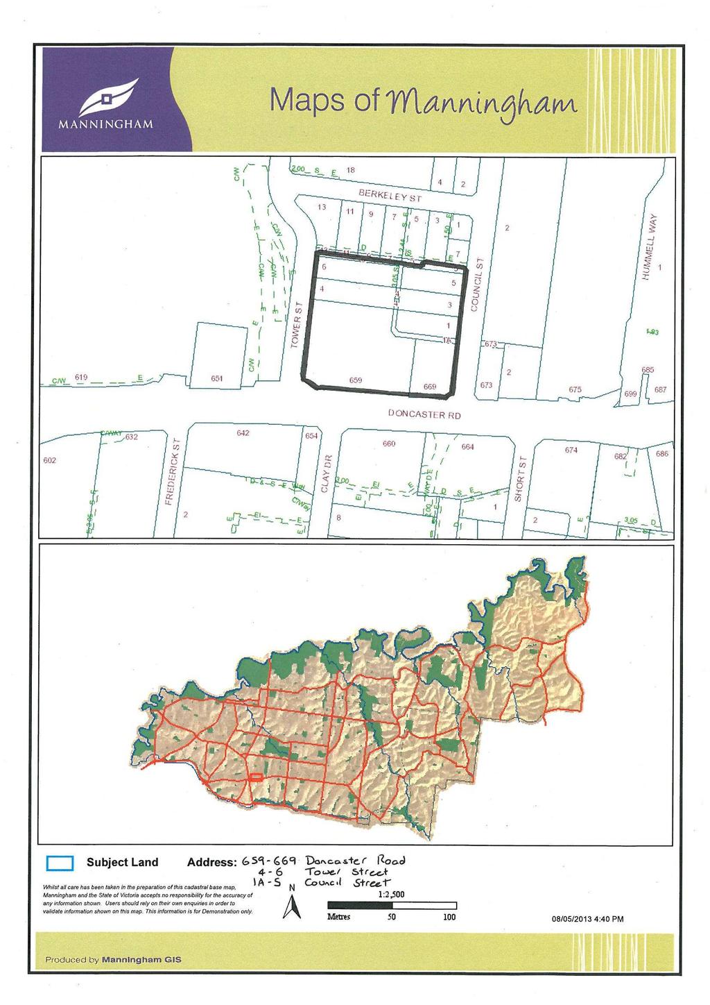
57 PAGE 57
58 PAGE 58
59 PAGE 59
60 PAGE 60

61 PAGE 61
62 PAGE 62

63 PAGE 63
64 PAGE 64
65 PAGE 65
66 PAGE 66
67 PAGE 67
68 PAGE 68
69 PAGE 69
70 PAGE 70
71 PAGE 71
72 PAGE 72
73 PAGE 73
74 PAGE 74
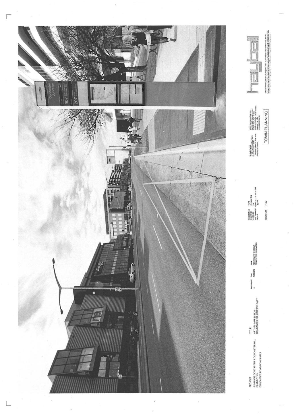
75 PAGE 75
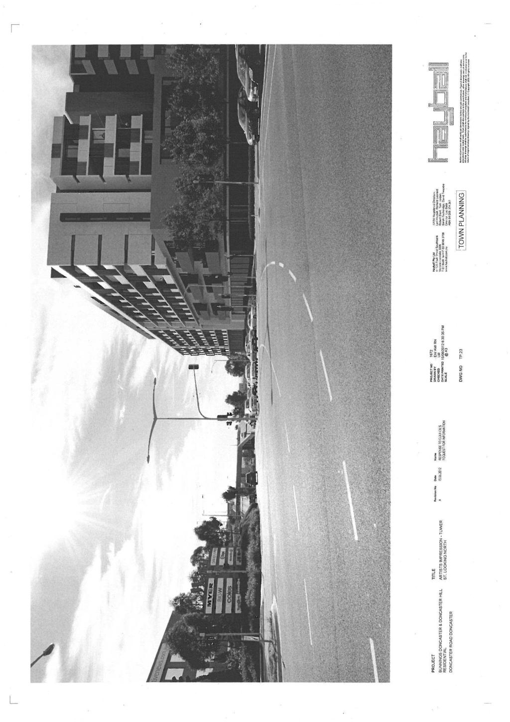
76 PAGE 76
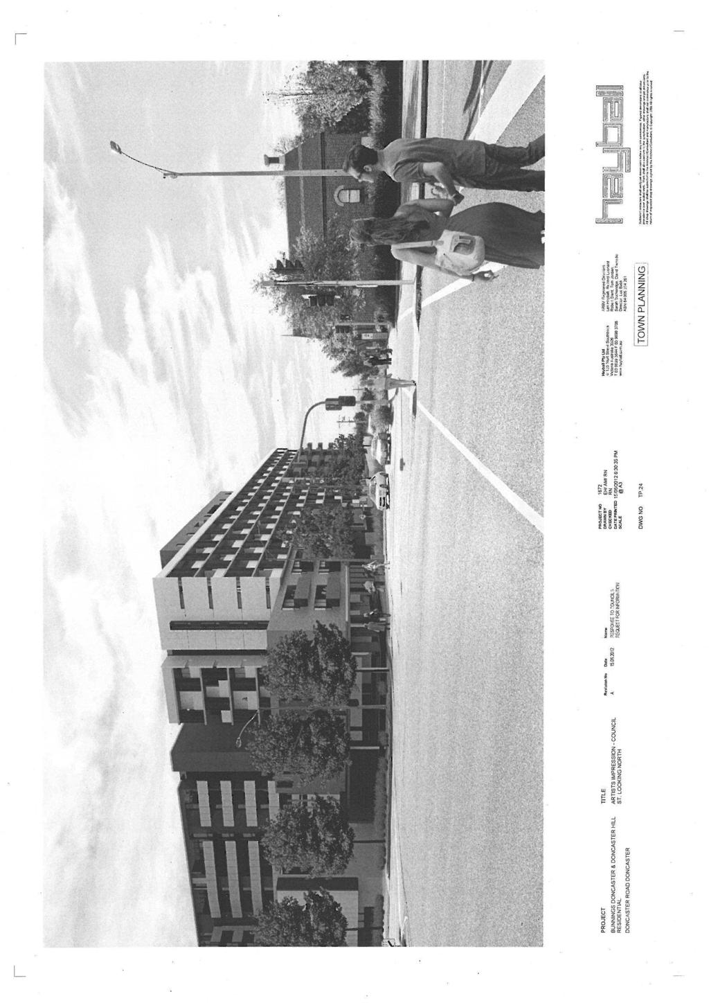
77 PAGE 77
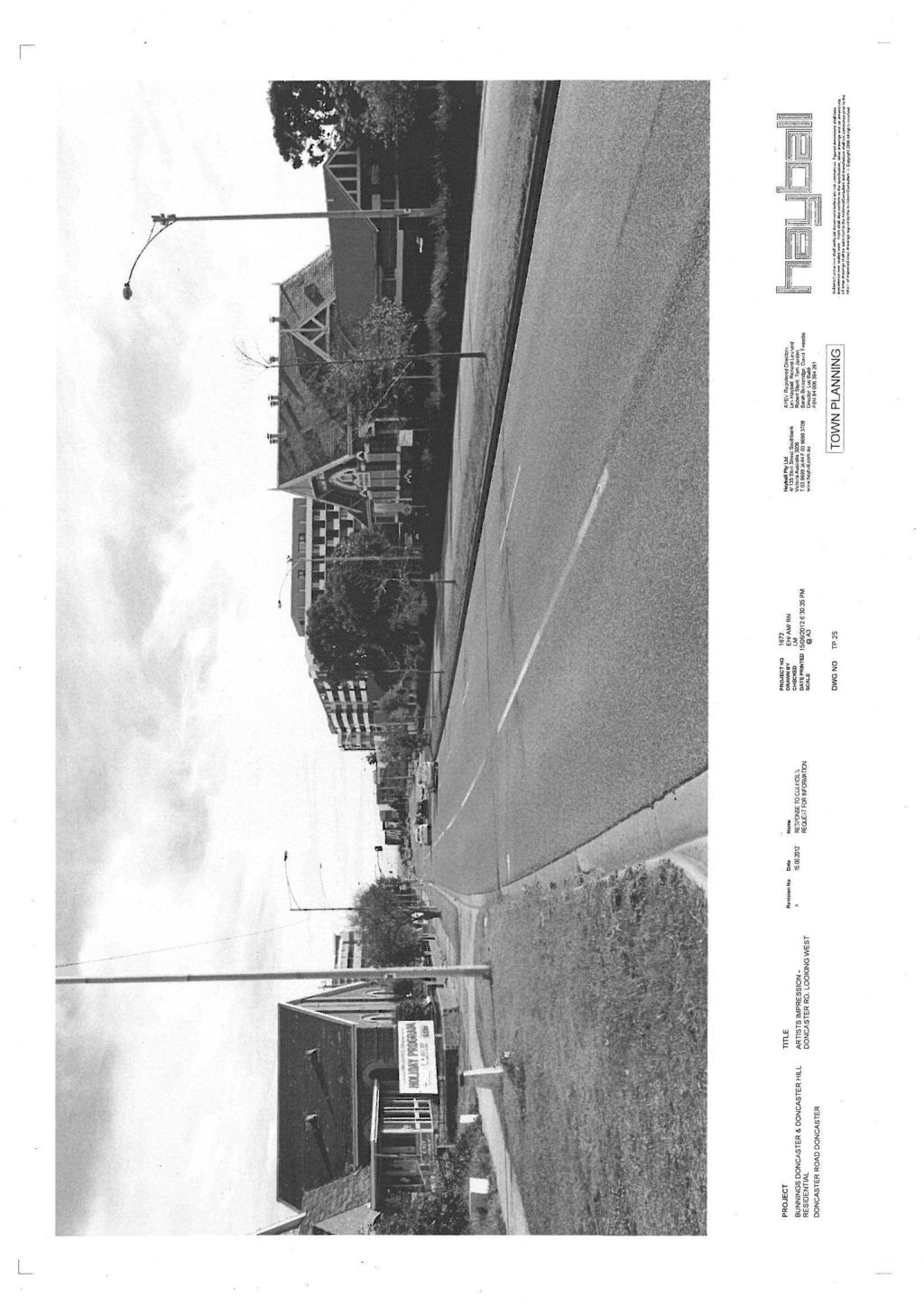
78 PAGE 78
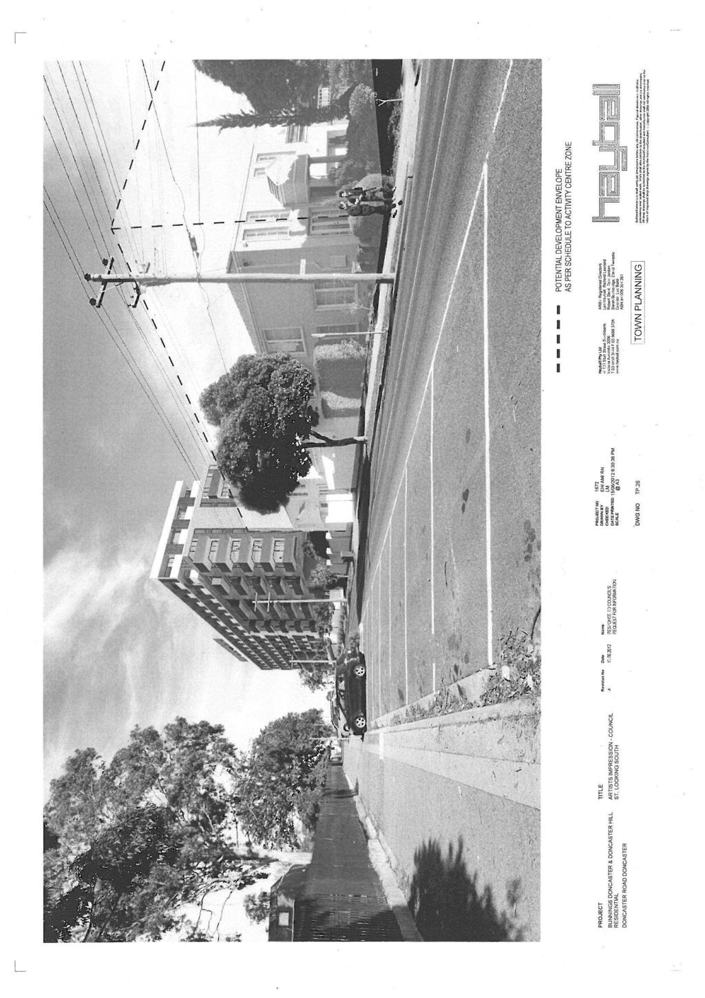
79 PAGE 79
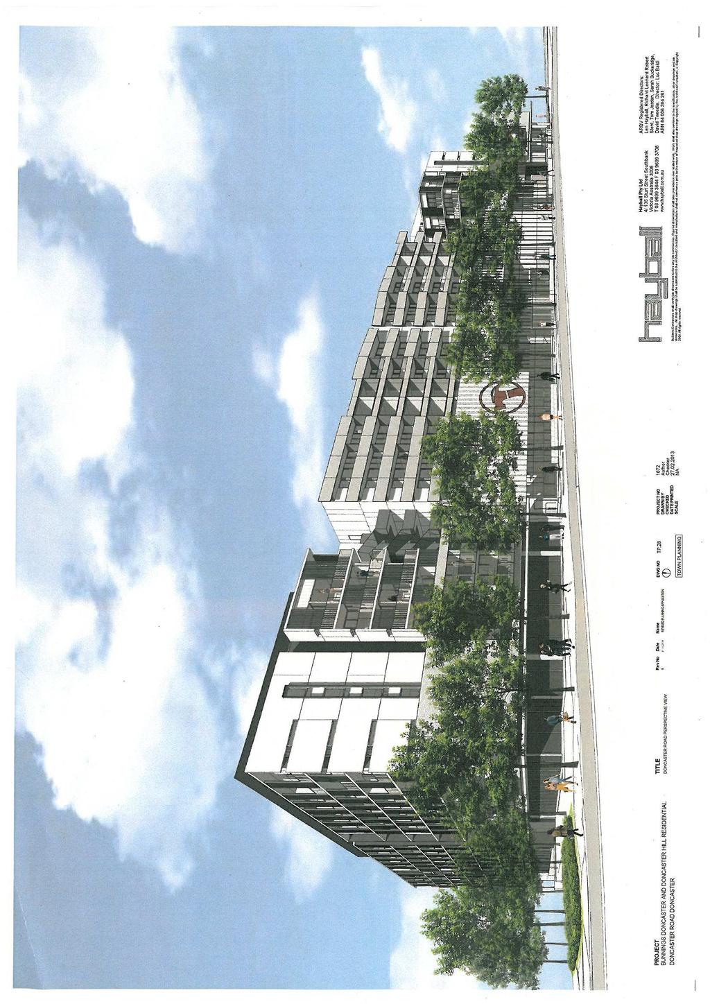
80 PAGE 80
I615. Westgate Precinct
 I615. Westgate Precinct I615.1. Precinct Description The Westgate Precinct is located approximately 18km west of the Auckland city centre. There are seven Sub-precincts in the Westgate Precinct: Sub-precinct
SCHEDULE 12 TO THE DESIGN AND DEVELOPMENT OVERLAY GLEN WAVERLEY ACTIVITY CENTRE STRUCTURE PLAN
 DD/MM/YY Proposed C120 SCHEDULE 12 TO THE DESIGN AND DEVELOPMENT OVERLAY Shown on the planning scheme map as DDO12. GLEN WAVERLEY ACTIVITY CENTRE STRUCTURE PLAN 1.0 Design objectives DD/MM/YY Proposed
Urban Design Manual PLANNING AROUND RAPID TRANSIT STATIONS (PARTS) Introduction. Station Study Areas
 Introduction. Station Study Areas") 111111 PLANNING AROUND RAPID TRANSIT STATIONS (PARTS) Introduction The ION rapid transit system will link Waterloo, Kitchener and Cambridge through a central transit corridor (CTC). There are a number
111111 PLANNING AROUND RAPID TRANSIT STATIONS (PARTS) Introduction The ION rapid transit system will link Waterloo, Kitchener and Cambridge through a central transit corridor (CTC). There are a number
Section Three, Appendix 16C Medium Density Housing, Design Assessment Criteria (Residential 8A zone)
") APPENDIX 16C MEDIUM DENSITY HOUSING, DESIGN ASSESSMENT CRITERIA (RESIDENTIAL 8A ZONE) PURPOSE OF APPENDIX 16C (RESIDENTIAL 8A ZONE) In the Residential 8A Zone the following are defined as restricted discretionary
APPENDIX 16C MEDIUM DENSITY HOUSING, DESIGN ASSESSMENT CRITERIA (RESIDENTIAL 8A ZONE) PURPOSE OF APPENDIX 16C (RESIDENTIAL 8A ZONE) In the Residential 8A Zone the following are defined as restricted discretionary
therry, elizabeth, franklin and queen: BLOCK plan
 therry, elizabeth, franklin and queen: BLOCK plan INTRODUCTION Therry, Elizabeth, Franklin and Queen Street block Purpose & background The City of Melbourne has prepared this document for developers and
URBAN DESIGN BRIEF URBAN DESIGN BRIEF 721 FRANKLIN BLVD, CAMBRIDGE August 2018
 URBAN DESIGN BRIEF URBAN DESIGN BRIEF 721 FRANKLIN BLVD, CAMBRIDGE August 2018 DESIGN BRIEF CONTENTS PART A 1.0 INTRODUCTION 2.0 DESCRIPTION & ANALYSIS OF SITE CONTEXT 3.0 DESIGN CONSTRAINTS AND OPPORTUNITIES
FORMER CANADIAN FORCES BASE (CFB) ROCKCLIFFE SECONDARY PLAN. Official Plan Amendment XX to the Official Plan for the City of Ottawa
 ROCKCLIFFE SECONDARY PLAN. Official Plan Amendment XX to the Official Plan for the City of Ottawa") FORMER CANADIAN FORCES BASE (CFB) ROCKCLIFFE SECONDARY PLAN Official Plan Amendment XX to the Official Plan for the City of Ottawa 1 INDEX THE STATEMENT OF COMPONENTS PART A THE PREAMBLE PAGE Purpose...
FORMER CANADIAN FORCES BASE (CFB) ROCKCLIFFE SECONDARY PLAN Official Plan Amendment XX to the Official Plan for the City of Ottawa 1 INDEX THE STATEMENT OF COMPONENTS PART A THE PREAMBLE PAGE Purpose...
Kaufland supermarket and complementary uses, part 1550 Pascoe Vale Road, Coolaroo Incorporated Document (Insert date) 2019
 2019") Kaufland supermarket and complementary uses, part 1550 Pascoe Vale Road, Coolaroo Incorporated Document (Insert date) 2019 Page 1 of 7 Incorporated document pursuant to section 6(2)(j) of the Planning
Kaufland supermarket and complementary uses, part 1550 Pascoe Vale Road, Coolaroo Incorporated Document (Insert date) 2019 Page 1 of 7 Incorporated document pursuant to section 6(2)(j) of the Planning
Land Use Amendment in Southwood (Ward 11) at and Elbow Drive SW, LOC
 at and Elbow Drive SW, LOC") 2018 November 15 Page 1 of 10 EXECUTIVE SUMMARY This land use amendment application was submitted by Rick Balbi Architect on 2017 August 31 on behalf of Sable Developments Ltd, and with authorization from
2018 November 15 Page 1 of 10 EXECUTIVE SUMMARY This land use amendment application was submitted by Rick Balbi Architect on 2017 August 31 on behalf of Sable Developments Ltd, and with authorization from
Keystone Business Park Precinct Structure Plan North East Industrial Precinct. Part 2 Design Principles
 Keystone Business Park Precinct Structure Plan North East Industrial Precinct Part 2 Design Principles Context Issues Services Landform Issues Geotech and contamination Ecology Traffic and access Issues
DAREBIN PLANNING SCHEME AMENDMENT C137
 Who is the planning authority? Planning and Environment Act 1987 DAREBIN PLANNING SCHEME AMENDMENT C137 EXPLANATORY REPORT This amendment has been prepared by the Darebin City Council, who is the planning
SCHEDULE THREE TO THE DEVELOPMENT PLAN OVERLAY EASTERN GOLF COURSE KEY REDEVELOPMENT SITE
 DD/MM/YY SCHEDULE THREE TO THE DEVELOPMENT PLAN OVERLAY Shown on the planning scheme map as DPO3 EASTERN GOLF COURSE KEY REDEVELOPMENT SITE 1.0 A permit may be granted before a development plan has been
Section Three, Appendix 17C Multiple Unit Housing Design Assessment Criteria
 APPENDIX 17C MULTIPLE UNIT HOUSING DESIGN ASSESSMENT CRITERIA Purpose of Appendix 17C In the Residential 9 Zone the construction and use of multiple household units located within the Multiple Household
Urban Design Brief. Watson Parkway North & Watson Road North Guelph, Ontario. Prepared by Coletara Development
 Urban Design Brief Watson Parkway North & Watson Road North Guelph, Ontario Prepared by Coletara Development December, 2013 Urban Design Brief, Coletara Development 1 Introduction This Urban Design Brief
Proposed Bunnings Warehouse. 90 Benalla Road Shepparton
 90 Benalla Road Shepparton April 2015 CONTENTS 1. Introduction 1 2. Proposed Development 1 3. Existing Conditions 3 3.1 Location and Land Use 3 3.2 Road Network 5 3.3 Turning Movement Counts 8 4. Car Parking
[PLANNING RATIONALE] For Site Plan Control and Lifting of Holding Zone By-Law 101 Champagne Avenue. May 23, 2014
![[PLANNING RATIONALE] For Site Plan Control and Lifting of Holding Zone By-Law 101 Champagne Avenue. May 23, 2014](/thumbs/75/71599615.jpg "[PLANNING RATIONALE] For Site Plan Control and Lifting of Holding Zone By-Law 101 Champagne Avenue. May 23, 2014") [PLANNING RATIONALE] For Site Plan Control and Lifting of Holding Zone By-Law 101 Champagne Avenue May 23, 2014 Contents 1.0 Introduction... 2 2.0 Site Context... 2 2.1 Adjacent Uses... 2 Figure 1: Site
[PLANNING RATIONALE] For Site Plan Control and Lifting of Holding Zone By-Law 101 Champagne Avenue May 23, 2014 Contents 1.0 Introduction... 2 2.0 Site Context... 2 2.1 Adjacent Uses... 2 Figure 1: Site
Chapter 13 Residential Areas: Appendices APPENDIX 1 Residential Areas
 Chapter 13 Residential Areas: Appendices Page 1 Chapter 13 Residential Areas: Appendices APPENDIX 1 Residential Areas Design Code for Intensive Housing INTRODUCTION DESIGN ELEMENTS A NEIGHBOURHOOD DESIGN
DRAFT Northeast Quadrant of Kipling Avenue and Highway 7 DRAFT AUGUST 29, Goals Land Use. The goals of this Plan are to:
 AUGUST 29, 2017 12.15 Northeast Quadrant of Kipling Avenue and Highway 7 12.15.1 Goals 12.15.2 Land Use The goals of this Plan are to: 12.15.2.1 General Provisions: a) Ensure the development of a compact
I539. Smales 2 Precinct
 I539. Smales 2 Precinct I539.1. Precinct Description The Smales 2 Precinct applies to a 4.8 hectare block of land located on the southern side of Northcote Road and fronting Lake Pupuke, Takapuna. The
New-Cast Mixed-use Development Proposal King Street West, Newcastle, Ontario
 URBAN DESIGN BRIEF New-Cast Mixed-use Development Proposal King Street West, Newcastle, Ontario TABLE OF CONTENTS: 1.0 Executive Summary 2.0 Creating Vibrant and Sustainable Urban Places: Excerpts from
ELMVALE ACRES SHOPPING CENTRE MASTER PLAN
 ELMVALE ACRES SHOPPING CENTRE MASTER PLAN Contents 1.0 INTRODUCTION... 2 2.0 LOCATION... 2 3.0 EXISTING CONTEXT... 2 4.0 VISION & GUIDING PRINCIPLES... 2 5.0 LAND USE AND BUILT FORM... 4 5.1 St. Laurent
10 Proposed Redevelopment, Tewkesbury Road, Cheltenham SCHEME EVOLUTION STARBUCKS
 SCHEME EVOLUTION STARBUCKS The proposed Starbucks Drive Thru alongside the proposed food store provides an appropriate mix of uses, suitable for this location. The proposed store is bespoke, designed specifically
Greater Geelong Planning Scheme Proposed Planning Scheme Amendment C and 5-19 Princes Highway, Norlane
 Greater Geelong Planning Scheme Proposed Planning Scheme Amendment C253 PLANNING SUBMISSION prepared for Bunnings Group Ltd by SJB Planning Pty Ltd Level 1, Building D 80 Dorcas Street SOUTHBANK VIC 3006
East Bayshore Road Neighbourhood
 East Bayshore Road Neighbourhood Northridge Property Management Urban Design Brief 3195 East Bayshore Road City of Owen Sound January 2016 East Bayshore Road Neighbourhood Northridge Property Management
URBAN DESIGN BRIEF. 2136&2148 Trafalgar Road. Town of Oakville
 URBAN DESIGN BRIEF 2136&2148 Trafalgar Road Town of Oakville Prepared By: METROPOLITAN CONSULTING INC For 2500674 Ontario Inc November 2016 TABLE OF CONTENTS Page No. 1.0 Introduction/Description of Subject
TOWN PLANNING ASSESSMENT KAUFLAND STORE NETWORK VICTORIAN ENTRY PROPOSAL PART THREE HIGH STREET, EPPING
 TOWN PLANNING ASSESSMENT KAUFLAND STORE NETWORK VICTORIAN ENTRY PROPOSAL PART THREE 592-694 HIGH STREET, EPPING Table of Contents Part Three 592-694 High Street, Epping... 3 1 Local strategic context...
Bel-Air Lexus Automobile Service Station
 Bel-Air Lexus Automobile Service Station Design Brief 443-447 McArthur Avenue Ottawa April 30, 2015 14-1299-MCA Site Details Application: Site Plan Control Legal Description and Municipal Addresses: 443
(DC1) Direct Development Control Provision DC1 Area 4
 Direct Development Control Provision DC1 Area 4") . General Purpose (DC) Direct Development Control Provision DC Area 4 The purpose of this Provision is to provide for an area of commercial office employment and residential development in support of the
. General Purpose (DC) Direct Development Control Provision DC Area 4 The purpose of this Provision is to provide for an area of commercial office employment and residential development in support of the
Urban Design Brief to 1557 Gordon Street & 34 Lowes Road West
 Urban Design Brief 1533 to 1557 Gordon Street & 34 Lowes Road West Reid s Heritage Homes Ltd. & 883928 Ontario Ltd. and RHH Property Management Ltd. City of Guelph Zoning By-law Amendment November 2017
CITY OF FREMANTLE LOCAL PLANNING SCHEME NO. 4 AMENDMENT NO. 68 SCHEME AMENDMENT REPORT
 CITY OF FREMANTLE LOCAL PLANNING SCHEME NO. 4 AMENDMENT NO. 68 SCHEME AMENDMENT REPORT CITY OF FREMANTLE PLANNING AND DEVELOPMENT SERVICES 8 WILLIAM STREET FREMANTLE WA 6160 PLANNING AND DEVELOPMENT ACT
TABLE OF CONTENTS. Human Habitats, 155 Dorcas St South Melbourne, Victoria 3205
 TARNEIT JUNCTION Town Planning Report DECEMBER 2013 TABLE OF CONTENTS Table of contents... 1 1 Introduction... 2 2 SIte context and surrounds... 4 2.1 Site Features... 4 2.2 Surrounding land uses... 4
EAST VILLAGE STRATEGIC SITE NOVEMBER 2017
 EAST VILLAGE STRATEGIC SITE NOVEMBER 2017 East Village will be a sustainable, mixeduse precinct with a focus on innovative employment and education opportunities. Enhanced by green spaces and places for
22.15 OUTDOOR ADVERTISING SIGNAGE POLICY
 22.15 OUTDOOR ADVERTISING SIGNAGE POLICY This policy applies to all land where a planning permit is required to construct or display a sign under the provisions of the Kingston Planning Scheme. 22.15-1
The Proposed Auckland Unitary Plan (notified 30 September 2013)
") 3 Business zones Introduction There are 10 business zones in the Unitary Plan: City Centre Metropolitan Centre Town Centre Local Centre Neighbourhood Centre Mixed Use General Business Business Park Light
3 Business zones Introduction There are 10 business zones in the Unitary Plan: City Centre Metropolitan Centre Town Centre Local Centre Neighbourhood Centre Mixed Use General Business Business Park Light
4 RESIDENTIAL ZONE. 4.1 Background
 4 RESIDENTIAL ZONE 4.1 Background The residential areas within the City are characterised by mainly lowrise dwellings sited on individual allotments. Past architectural styles, settlement patterns and
WELLINGTON HOSPITAL DESIGN GUIDE TABLE OF CONTENTS
 WELLINGTON HOSPITAL DESIGN GUIDE TABLE OF CONTENTS 1.0 Introduction Page 2 The Place of Wellington Hospital 2 The Future of the Hospital 2 2.0 The Intention of the Design Guide 3 3.0 Analysis 4 General
5.1 Site Plan Guidelines
 5. Community Core Guidelines Development of the Community Core will take place by plan of subdivision and site plan approval. It will occur in a phased manner that will reflect the timing of residential
Uptown Rideau Street Secondary Plan [Amendment #166, January 12, 2016]
![Uptown Rideau Street Secondary Plan [Amendment #166, January 12, 2016]](/thumbs/76/73760497.jpg "Uptown Rideau Street Secondary Plan [Amendment #166, January 12, 2016]") [Amendment #166, January 12, 2016] The policies of this Secondary Plan are in effect, save and except for the property at 560 Rideau Street, for which there remains a site specific appeal to this Secondary
[Amendment #166, January 12, 2016] The policies of this Secondary Plan are in effect, save and except for the property at 560 Rideau Street, for which there remains a site specific appeal to this Secondary
Urban Design Brief December 23, 2015 Southside Construction Group Official Plan & Zoning By-Law Amendment
 Urban Design Brief Proposed Official Plan & Zoning By-Law Amendment 3244, 3263 and 3274 Wonderland Road South Southside Group December 23, 2015 TABLE OF CONTENTS Page No. INTRODUCTION... 1 SECTION 1 LAND
RESIDENTIAL ACTIVITY PERFORMANCE STANDARDS
 Preferred Options Consultation Q&A Sheet RESIDENTIAL ACTIVITY PERFORMANCE STANDARDS What are the key goals for managing the design of residential buildings in the Second Generation Plan (2GP)? The key
2.0 Strategic Context 4
 2.0 Strategic Context 4 2.1 The Area Action Plan is a non-statutory plan, which forms a corporate policy document, expressing particular issues and areas of concern while also providing a vision for the
Next Steps / Development Process. Structure Plan. June submitted to City of Fremantle. Structure Plan. July supported for advertising
 overview What is today about? In July 0, the City of Fremantle resolved that the be advertised for public comment. Today is about: Understanding the history and context of the site Having your say on the
Urban Design Manual 2.0 DRIVE-THROUGH FACILITIES. Background. Urban Design Challenges
 222221 2.0 DRIVE-THROUGH FACILITIES Background In recent years, drive-through facilities have grown significantly in popularity with drive-through restaurants, in particular, being established on numerous
Welcome. Walk Around. Talk to Us. Write Down Your Comments
 Welcome This is an information meeting introducing the applications for proposed redevelopment of the Yorkdale Shopping Centre site at 3401 Dufferin Street and 1 Yorkdale Road over the next 20+ years,
CONTENTS 8.0 LAND USE 8.1 GENERAL LAND USE 8.2 RESIDENTIAL 8.3 MIXED USE 8.4 COMMERCIAL 8.5 EMPLOYMENT LANDS
 8-2 Land Use 8.0 LAND USE CONTENTS 8.1 GENERAL LAND USE 8.1.1 Uses provided for in all Land Use Designations 8.1.2 Uses prohibited in Hazardous Lands, Hazardous Sites and Special Policy Areas 8.1.3 Uses
TABLE OF CONTENTS 1.0 INTRODUCTION... 3
 TABLE OF CONTENTS 1.0 INTRODUCTION... 3 1.1. BACKGROUND... 3 1.2. THE PROPOSAL... 5 2.0 EXISTING POLICY FRAMEWORK... 5 2.1. PROVINCIAL POLICY STATEMENT (PPS)... 5 2.2. CITY OF LONDON OFFICIAL PLAN (OP)...
APPENDIX 10 THE RESIDENTIAL DESIGN GUIDE FOR DEVELOPMENTS IN RESIDENTIAL ZONES IN SPECIFIED GROWTH AREAS
 THE RESIDENTIAL DESIGN GUIDE FOR DEVELOPMENTS IN RESIDENTIAL ZONES IN SPECIFIED GROWTH AREAS ISTHMUS SECTION - OPERATIVE 1999 Page 1 CONTENTS... PAGE 1.0 INTRODUCTION... 4 1.1 Growth Management Strategy...
Subdivision Design Criteria. Penihana North GUIDELINES TO THE RULES
 Created September 2013 Penihana North Subdivision Design Criteria GUIDELINES TO THE RULES This part of the Plan sets out the design criteria for subdivision in Penihana North. The criteria will be considered
INCREMENTAL CHANGE AREA REVIEW March 2015 Page 1
 INCREMENTAL CHANGE AREA REVIEW March 2015 Page 1 Table of Contents Introduction... 3 Background to Review... 3 Comparison of the Schedules to the General Residential Zone... 7 Methodology... 7 Policy Context...
Nelson Residential Street Frontage Guideline
 DRAFT 22-06-2012 Nelson Residential Street Frontage Guideline June 2012 1317273 Contents and purpose Residential s are important Residential s are much more than corridors which move traffic. Streets allow
PORT WHITBY COMMUNITY
 PORT WHITBY COMMUNITY SECONDARY PLAN UPDATE COMMUNITY IMPROVEMENT PLAN URBAN DESIGN GUIDELINES September 2015 DRAFT PROPOSED AMENDMENT NUMBER # to the Whitby Official Plan PURPOSE: The intent of this Amendment
H9. Business Metropolitan Centre Zone
 H9. Business Metropolitan Centre Zone H9.1. Zone description The Business Metropolitan Centre Zone applies to centres located in different subregional catchments of Auckland. These centres are second only
and services The protection and conservation of environmentally significant and sensitive natural heritage features and functions.
 6. Land Use 6.0 Preamble A healthy and livable city is one in which people can enjoy a vibrant economy and a sustainable healthy environment in safe, caring and diverse neighbourhoods. In order to ensure
King-Spadina Secondary Plan Community Consultation Meeting. Michelle Knieriem, City Planner October 11, 2017
 King-Spadina Secondary Plan Community Consultation Meeting Michelle Knieriem, City Planner October 11, 2017 Agenda 6:30 Welcome 6:35 Presentation 7:15 Question and Answer Session 8:15 Closing Remarks HOW
523, 525 and 525A Adelaide Street West - Zoning Amendment Application - Preliminary Report
 STAFF REPORT ACTION REQUIRED 523, 525 and 525A Adelaide Street West - Zoning Amendment Application - Preliminary Report Date: May 12, 2012 To: From: Wards: Reference Number: Toronto and East York Community
Altona North. Comprehensive Development Plan
 Altona North Comprehensive Development Plan June 2017 CONTENTS 1 Introduction... 2 1.1 How to read this document... 2 1.2 Land to which the Plan applies... 4 1.3 Background information... 5 1.4 Altona
PMP PRINTING SITE COMMUNITY ENGAGEMENT - PHASE 2
 PMP PRINTING SITE COMMUNITY ENGAGEMENT - PHASE 2 FEBRUARY 2019 0317-0511 - PMP Printng - M001 (8 -Floors) -Final date 14.11.2018 Vision: The PMP Printing site will be transformed into a contemporary mixed-use
Page 1 of 19 URBAN DESIGN FRAMEWORK FOR BOLTON STREET WATERFORD
 Page 1 of 19 URBAN DESIGN FRAMEWORK FOR BOLTON STREET WATERFORD 1.0 Introduction: The relocation of the City Council stores and depot from Bolton Street creates an exciting opportunity for development
Bloor St. W. Rezoning - Preliminary Report
 STAFF REPORT ACTION REQUIRED 1638-1644 Bloor St. W. Rezoning - Preliminary Report Date: April 1, 2008 To: From: Wards: Reference Number: Toronto and East York Community Council Acting Director, Community
Westwind Developments Ltd. PIONEER LANDS AREA STRUCTURE PLAN - PROPOSED AMENDMENT
 FEBRUARY 2013 TABLE OF CONTENTS 1.0 BACKGROUND... 1 1.1 Amendment... 1 2.0 LOCATION & CONTEXT... 2 2.1 Land Ownership... 2 3.0 POLICY CONTEXT... 3 3.1 Municipal Development Plan... 3 3.2 Capital Region
Complete Neighbourhood Guidelines Review Tool
 Complete Neighbourhood Guidelines Review Tool Prepared By: City of Regina Planning Department October 2014 Page 1 of 14 Community Development Review Checklist for Secondary Plans and Concept Plans The
SCHEDULE 10 TO THE URBAN GROWTH ZONE. Shown on the planning scheme map as UGZ10. Truganina Precinct Structure Plan. 1.0 The Plan
 SCHEDULE 10 TO THE URBAN GROWTH ZONE Shown on the planning scheme map as UGZ10 Truganina Precinct Structure Plan 1.0 The Plan Map 1 shows the future urban structure proposed in the Truganina Precinct Structure
4. INDUSTRIAL 53 CASTLE ROCK DESIGN
 4. INDUSTRIAL 53 CASTLE ROCK DESIGN CASTLE ROCK DESIGN 54 4. INDUSTRIAL Overview Well-designed and attractive industrial centers are the product of blending economic realities with both functional and
1 The decision of the Responsible Authority is affirmed. 2 In permit application WH/2014/851, no permit is granted.
 VICTORIAN CIVIL AND ADMINISTRATIVE TRIBUNAL ADMINISTRATIVE DIVISION PLANNING AND ENVIRONMENT LIST VCAT REFERENCE NO. P754/2015 PERMIT APPLICATION NO.WH/2014/851 CATCHWORDS Section 77 of the Planning and
appendix and street interface guidelines
 appendix five: building and street interface guidelines appendix 5 building and street interface guidelines BOULEVARDS Boulevards are generally characterized by higher levels of traffic movement at higher
Highland Village Green Design Guidelines
 Highland Village Green Design Guidelines Publishing Information Title Highland Village Green Design Guidelins Author The City of Calgary Status DRAFT - Proposed document subject to changes Additional Copies
Site layout, density and housing type
 Site layout, density and housing type How can the high densities (up to 30 lots/hectare) be justified in this area and protect adjoining neighbourhood character? The overall site density (15-18 lots/ha)
Derry City and Strabane District Council Planning Committee Report
 Derry City and Strabane District Council Planning Committee Report COMMITTEE DATE: 23 rd March 2016 APPLICATION No: APPLICATION TYPE: PROPOSAL: LOCATION: APPLICANT: LA11/2015/0395/F Residential Development
SOUTH CAMBRIDGESHIRE DISTRICT COUNCIL. Executive Director (Operational Services) Corporate Manager (Planning and New Communities)
 Corporate Manager (Planning and New Communities)") SOUTH CAMBRIDGESHIRE DISTRICT COUNCIL REPORT TO: Planning Committee 12 January 2011 AUTHOR/S: Executive Director (Operational Services) Corporate Manager (Planning and New Communities) Notes: S/1848/10
SOUTH CAMBRIDGESHIRE DISTRICT COUNCIL REPORT TO: Planning Committee 12 January 2011 AUTHOR/S: Executive Director (Operational Services) Corporate Manager (Planning and New Communities) Notes: S/1848/10
DRAFT PLANNING SCHEME AMENDMENT GC81
 Outline of changes proposes to the Melbourne and Port Phillip Planning Scheme Fishermans Bend Fishermans Bend is one of several priority precincts identified in Plan Melbourne and plays a central role
TALL BUILDING GUIDELINES
 TALL BUILDING GUIDELINES Urban Design Guidance for the Site Planning and Design of Tall Buildings in Milton May, 2018 A Place of Possibility Contents 1.0 INTRODUCTION 1 1.1 What is a Tall Building? 2
COMMUNITY DESIGN. GOAL: Create livable and attractive communities. Intent
 COMMUNITY DESIGN Intent An attractive, well-designed County will attract quality development, instill civic pride, improve the visual character of the community, and create a strong, positive image for
Former Rockcliffe Airbase Community Design Plan Guiding Design Vision and Principles December 4, 2013
 APPENDIX 5 - Guiding Design Vision and Principles Former Rockcliffe Airbase Community Design Plan Guiding Design Vision and Principles December 4, 2013 Vision Statement The redevelopment of the former
CONTENTS 6.1 URBAN DESIGN
 6-2 Urban Design and Sustainable Development 6.0 URBAN DESIGN AND SUSTAINABLE DEVELOPMENT CONTENTS 6.1 URBAN DESIGN 6.1.1 General Policies 6.1.2 The Public Realm 6.1.3 Streets and Blocks 6.1.4 Streetscapes
H14. Business General Business Zone
 H14. Business General Business Zone H14.1. Zone description The Business General Business Zone provides for business activities from light industrial to limited office, large format retail and trade suppliers.
ROAD CLOSURE AND LAND USE AMENDMENT SILVER SPRINGS (WARD 1) NORTHEAST OF NOSEHILL DRIVE NW AND SILVER SPRINGS ROAD NW BYLAWS 2C2018 AND 29D2018
 NORTHEAST OF NOSEHILL DRIVE NW AND SILVER SPRINGS ROAD NW BYLAWS 2C2018 AND 29D2018") Page 1 of 19 EXECUTIVE SUMMARY This application proposes redesignating two parcels in the community of Silver Springs from Special Purpose Future Urban Development (S-FUD) District and undesignated road
Page 1 of 19 EXECUTIVE SUMMARY This application proposes redesignating two parcels in the community of Silver Springs from Special Purpose Future Urban Development (S-FUD) District and undesignated road
WINDSOR GLEN DESIGN GUIDELINES
 WINDSOR GLEN DESIGN GUIDELINES Adopted by Council, 2006 WINDSOR GLEN REDEVELOPMENT DESIGN GUIDELINES August 2006 1.0 Master Plan Organization For this area of the Coquitlam Town Centre, a mix of high,
599 Kennedy Road - Official Plan Amendment and Zoning Amendment Application - Preliminary Report
 STAFF REPORT ACTION REQUIRED 599 Kennedy Road - Official Plan Amendment and Zoning Amendment Application - Preliminary Report Date: March 7, 2017 To: From: Wards: Reference Number: Scarborough Community
MVRC ARCHITECTURAL DESIGN STATEMENT
 11251 MOONEE VALLEY RACING CLUB MAY 201 CONTENTS 0 Contents Introduction 1 Site Analysis a. Site Features b. Built form Interfaces c. Existing Streetscape d. Site Opportunities and Constraints 2 Masterplan
URBAN DESIGN BRIEF 181 Burloak Drive, Oakville
 URBAN DESIGN BRIEF 181 Burloak Drive, Oakville February 2017 Our File: 1730B 230-7050 WESTON ROAD / WOODBRIDGE / ONTARIO / L4L 8G7 / T: 905 761 5588/ F: 905 761 5589/WWW.MHBCPLAN.COM TABLE OF CONTENTS
FRUITVALE TRANSIT VILLAGE (Phase 2) Residential Project
 Residential Project") FRUITVALE TRANSIT VILLAGE (Phase 2) Residential Project DEVELOPER: SIGNATURE PROPERTIES ARCHITECT: HKIT ARCHITECTS April 23, 2010 TABLE OF CONTENTS 3 Vision 4 Description of Site 5 Guiding Concepts 6
FRUITVALE TRANSIT VILLAGE (Phase 2) Residential Project DEVELOPER: SIGNATURE PROPERTIES ARCHITECT: HKIT ARCHITECTS April 23, 2010 TABLE OF CONTENTS 3 Vision 4 Description of Site 5 Guiding Concepts 6
Housing and Coach House Guidelines - Ladner
 Housing and Coach House Guidelines - Ladner Policy D.8: Encourage Compatible Housing Design Encourage housing design that is sensitive to existing single family housing neighbourhoods by requiring a design
Memorial Business Park Site. Proposed Future Development. Design guidelines. August
 Memorial Business Park Site Proposed Future Development Design guidelines August 2014 www.designenvironment.co.nz 0064 3 358 3040 Contents 1.0 Background 1.1 Introduction 3 1.2 Objectives 4 2.0 Context
Chapter 2: OUTLINE PLANNING APPLICATION PROPOSALS. A New Garden Neighbourhood Matford Barton 17
 Chapter 2: OUTLINE PLANNING APPLICATION PROPOSALS A New Garden Neighbourhood Matford Barton 17 2.1. SUMMARY AND STATUS OF THE PROPOSALS 2.1.1. The parameter plans and associated wording in this chapter
LAND USE AMENDMENT CORNERSTONE (WARD 3) 60 STREET NE AND COUNTRY HILLS BOULEVARD NE MAP 26NE BYLAW 22D2017
 60 STREET NE AND COUNTRY HILLS BOULEVARD NE MAP 26NE BYLAW 22D2017") Page 1 of 14 EXECUTIVE SUMMARY This Land Use Amendment application covers an area of 43.76 hectares ± (108.14 acres ±) located in northeast Calgary, bound by Country Hills Boulevard NE to the south and
Page 1 of 14 EXECUTIVE SUMMARY This Land Use Amendment application covers an area of 43.76 hectares ± (108.14 acres ±) located in northeast Calgary, bound by Country Hills Boulevard NE to the south and
Draft Eastern District Plan
 Draft Eastern District Plan Submission_id: 31238 Date of Lodgment: 13 Dec 2017 Origin of Submission: Online Organisation name: Turrulla Gardens Pty Ltd C/- Mecone Organisation type: Industry First name:
9 CITY OF VAUGHAN OFFICIAL PLAN AMENDMENT NO BOCA EAST INVESTMENTS LIMITED
 9 CITY OF VAUGHAN OFFICIAL PLAN AMENDMENT NO. 631 - BOCA EAST INVESTMENTS LIMITED The Planning and Economic Development Committee recommends the adoption of the recommendations contained in the following
4.0 Design Guidelines For The Village Centre. South fields Community Architectural Design Guidelines Town of Caledon
 4.0 Design Guidelines For The Village Centre 4.0 Design Guidelines for the Village Centre The Village Centre is the focal point of the entire South Fields Community and is designed as a traditional commercial
Mixed Use Centres Development Permit Guidelines
 1 Mixed Use Centres Development Permit Guidelines Area Commercial or Mixed Use development occurring in City Centre, Urban Centre, Neighbourhood Centre, or Institutional Complex land use designations is
2136 & 2148 Trafalgar Road Town of Oakville Region of Halton
 PLANNING JUSTIFICATION REPORT 2136 & 2148 Trafalgar Road Town of Oakville Region of Halton Zoning By-Law Amendment Application 2500674 Ontario Inc. November 2016 Table of Contents Page 1.0 Location/Summary
4.0 URBAN DESIGN FRAMEWORK. The vision for the future development of the plan area is to:
 4.0 The vision for the future development of the plan area is to: Create a new neighbourhood that focuses on the highly valued natural and aesthetic features of the lands and provides good quality homes,
LOW DENSITY RESIDENTIAL
 LOW DENSITY RESIDENTIAL Corner lots with coach houses to increase diversity, provide unity to the streetscape and increase eyes on the street. Garages and ancillary units accessed via rear lanes. Parking
PART AOTEA PRECINCT
 CONTENTS... PAGE AOTEA PRECINCT...4 14.5.1 INTRODUCTION...4 14.5.2 RESOURCE MANAGEMENT ISSUES...4 14.5.3 RESOURCE MANAGEMENT OBJECTIVES AND POLICIES... 4 14.5.4 RESOURCE MANAGEMENT STRATEGY...5 14.5.5
Clairtrell Area Context Plan
 Clairtrell Area Context Plan March 2005 Urban Development Services City Planning Contents 1. Introduction... 4 2. Development Structure... 6 2.1 Streets... 7 2.1.1 Sheppard Avenue and Bayview Avenue...
APPENDIX MATAKANA COMMERCIAL URBAN DESIGN GUIDELINES
 APPENDIX MATAKANA COMMERCIAL URBAN DESIGN GUIDELINES 1.0 INTRODUCTION The following urban design guidelines are to be utilised by landowners, planners and other persons involved in development at early
Welcome to the Oakridge Centre Open House
 Welcome to the Oakridge Centre Open House Why is the City hosting this event? This open house is to inform you of a rezoning application submitted to the City of Vancouver to amend the existing CD-1 (Comprehensive
H10. Business Town Centre Zone
 H10. Business Town Centre Zone H10.1. Zone description The Business Town Centre Zone applies to suburban centres throughout Auckland, the satellite centres of Warkworth and Pukekohe, and the rural towns
Extract from Whitehorse Planning Scheme - LOCAL PLANNING POLICIES - CLAUSE Preferred Character Statements
 Extract from Whitehorse Planning Scheme - LOCAL PLANNING POLICIES - CLAUSE 22.03 22.03-5 Preferred Character Statements Bush Environment The streetscapes will be dominated by vegetation with subservient
UNIVERSITY TOWN NEIGHBOURHOODS 5.5 HOUSING MELBOURNE CAMPUS MASTER PLAN 2014
 5.5 169 EXISTING CONDITIONS & VISION NEIGHBOURHOOD VISION The provision of on-campus housing into the future will continue to be an important element of the La Trobe University experience. A long-term
... on the draft Arden Vision & Framework
 April 2017 Integrated world-class urban renewal Feedback... on the draft Arden Vision & Framework On 1 September 2016 the Victorian Planning Authority (VPA) released the draft Arden Vision & Framework