MONTGOMERY COUNTY PLANNING DEPARTMENT THE MARYLAND-NATIONAL CAPITAL PARK AND PLANNING COMMISSION
|
|
|
- Eric Flynn
- 5 years ago
- Views:
Transcription
1 MONTGOMERY COUNTY PLANNING DEPARTMENT THE MARYLAND-NATIONAL CAPITAL PARK AND PLANNING COMMISSION CU-19-04: Francisco Landscaping Contractor MCPB Item No.: Date: Elsabett Tesfaye, Planner Coordinator, Area 3 Elsabett.Tesfaye@montgomeryplanning.org Fred Boyd, Master Planner, Area 3 Fred.Boyd@montgomeryplanning.org Richard Weaver, Chief, Area 3 Richard.Weaver@montgomeryplanning.org Description B. Request for a Conditional Use to operate a Landscape Contractor business, on a 6.18-acre property located at Holly Grove Road, Silver Spring, MD, approximately 315 feet southwest of Awkard Road and 1,250 feet southwest of the intersection of Holly Grove Road and Norwood Road, known as P066 on tax map JS41, Snowdens Manor Cloverly Master Plan Area. Staff Recommendation: Approval with conditions Application Filed: September 20, 2018 OZAH Public Hearing: January 18, 2019 Planning Board Hearing: January 3, 2019 Applicant: FM Group, Inc. (d/b/a Francisco Landscaping ) Completed: December 28, 2018 Summary With the recommended conditions, the subject use conforms to all applicable requirements and regulations for approval of a Landscape Contractor Conditional Use, Section of Montgomery County Zoning Ordinance and the applicable development standards under the RE-2C Zone (Section ) The subject use is consistent with the recommendations of the 1997 Cloverly Master Plan and compatible with the character of the surrounding area. Approval of the requested Conditional Use will not cause undue harm or adverse impact on the immediate neighborhood. There are no traffic, circulation, noise or environmental issues associated with the application, provided that the recommended conditions are satisfied. This application complies with the Montgomery County Environmental Guidelines. Staff Recommends approval of the Variance Request from the 50-foot side street setback requirement. The Conditional Use Application proposes to decrease the impervious surface on the property from 18 percent to 16 percent and with staff s recommended condition to reduce the number of parking spaces, the impervious area on the property will be further reduced to approximately 14.8 percent.
2 SECTION I: STAFF RECOMMENDATION AND CONDITIONS OF APPROVAL Staff recommends approval of CU subject to the following conditions: 1. The total number of employees including family members must not exceed a maximum of The conditional use must not use the gated driveway on the west side of the property s frontage along Holly Grove Road for access. 3. The hours of operations must be Monday through Friday 6:00 a.m. to 7:00 p.m. and Saturday, 7:00 a.m. to 5:00 p.m. Snow removal may be provided when needed seven days a week, 24 hours a day. 4. The total number of parking spaces must not exceed 30, including parking for trailers associated with the business on the property. 5. The total number of trucks and trailers for the proposed use must not exceed 16: 10 trucks and 6 trailers. 6. There must be no identification sign on the property. 7. No mulch manufacturing, composting or retail sales of plant materials, garden supplies, or equipment shall be conducted on the conditional use property. 8. The Applicant will be bound by the landscaping plan approved by the Hearing Examiner. 9. The conditional use must comply with the conditions of the Final Forest Conservation Plan. 2

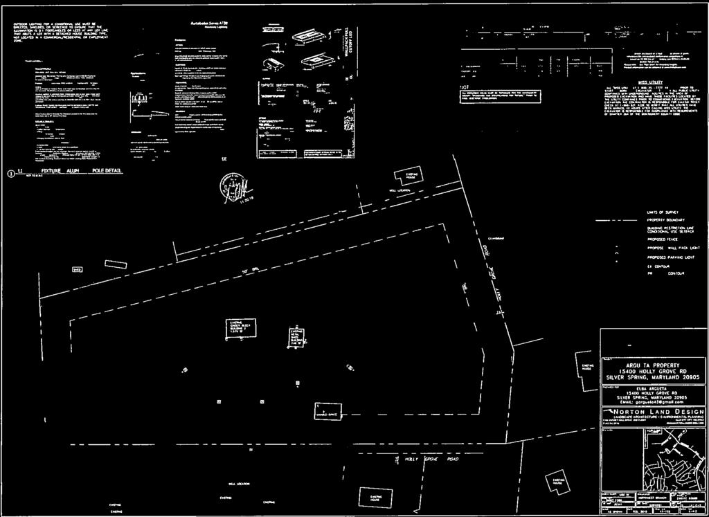
3 SECTION II: PROJECT DESCRIPTION A. Site Description Figure 1: Vicinity Map The subject property is located at Holly Grove Road, Silver Spring, approximately 1,250 feet southwest of the intersection of Holly Grove Road and Norwood Road. The property consists of approximately 6.18 acres of land on an unrecorded parcel known as P066 on tax map JS41, Snowdens Manor. The subject property is an elongated trapezoid, improved with a 2,072 squarefoot dwelling, a 1,575 square-foot cinderblock storage building, and a 740 square-foot metal shed building. Other improvements on the property include gravel parking areas and driveways, material storage bins, a skid steer storage area, and two private garden areas. The property is currently used as a residence and a family owned landscape contractor s business. The property has two frontages on Holly Grove Road (southern and western property lines), a narrow local road that extends approximately 2,350 feet from its intersection with Norwood Road and wraps around the subject property before terminating at the northwest corner of the subject property. Primary access to the property is via a driveway from Holly Grove Road on the property s southern frontage. A second access on the property s western frontage along Holly Grove Road is not actively used, gated, and is kept locked. 3

4 Figure 2: The Subject Site The site slopes generally from north to west. It is located within the Johnson Road subwatershed of the Northwest Branch Watershed (Use Class IV). There are no streams, wetland areas, 100-year floodplains or highly erodible soils on the property. There are no rare, threatened or endangered species on the property. The property is not designated as historic. B. Neighborhood Description For purposes of this Application, staff defines the surrounding neighborhood as the area within a 2,000-foot radius of the Subject Property. Staff s definition of the surrounding area attempts to include developed and vacant residential properties within the RE-2C and R-200 Zones with proximity or direct access to Norwood Road, Holly Grove Road and Awkard Lane. The surrounding area is predominantly semi-rural with approximately 75 percent of the land in the RE-2C Zone. It is sparsely developed and contains several undeveloped and wooded parcels. The denser residential 4
, Holly Grove Road (west and south), and three residential properties (east).")
5 development is concentrated in the southern portion of the neighborhood (Stonegate Subdivision) consisting of single-family detached dwellings in the R-200 zone. Figure 3: Surrounding Area The subject property is surrounded by a 27-acre unimproved wooded property (rear, north), Holly Grove Road (west and south), and three residential properties (east). To the west and south directly across Holly Grove Road are residential properties and a house of worship, all located in the RE-2C Zone. C. Zoning and Land Use History The Property was placed in the RE-2 Zone prior to The 1981 Eastern Montgomery County Master Plan for Eastern Montgomery County Planning Area: Cloverly, Fairland, White Oak confirmed the RE-2 zoning of the Property. The 1997 Cloverly Master Plan and the subsequent Sectional Map Amendment rezoned the Property RE-2C. There has been no previously approved Conditional Uses (formerly referred to as Special Exception) on the property. 5

6 Figure 4: Zoning D. Proposed Use The Applicant, Francisco Landscaping, a family owned business, is requesting approval of a Conditional Use to validate the existing landscaping contractor business that has been in operation on the property for the past 13 years without an approved Conditional Use permit. The Applicant stated that the landscape contractor business provides traditional, commercial, and residential landscaping as well as fencing, gutter cleaning, firewood delivery and snow removal services. The business also offers stonework, including patios, walkways, steps and gardens. The proposed operation consists of two elements: Residential and commercial landscaping and property maintenance Custom stonework and driveway services The justification statement explains that the Holly Grove Road site is primarily used for their loading and field teams. The field staff typically departs around 7:00 AM and is off site until the end of the work day. At the end of the work day, the field staff and management usually return to the site between 4:00 p.m. and 6:00 p.m. After unloading the vehicles and cleaning up for about 15 to 30 minutes, the employees carpool and leave the property for the day. The 6
7 Applicant s Statement of Justification states that many of the laborers carpool to work, and often will report directly to the job site without coming to the property. The number of employees will vary, depending on the season, with the largest number of employees needed during the spring, summer and fall. The Conditional Use application proposes a seasonal maximum of 19 employees, consisting of administrative staff, loading and on-site operation crew, and a field crew. The justification statement provides the following breakdown of employees: Table 1: Breakdown of Employees Employees Current Proposed Owner and family administration 2 2 Field Crew (including 3 family members) 13 17* Total *Staff recommends that the total number of employees remain the same as the existing total number of employees. Hours of operation for the landscape contractor business are Monday through Friday 6:00 a.m. to 7:00 p.m. and Saturday, 7:00 a.m. to 5 p.m. The justification statement indicates that the only landscaping material typically stored on the property is mulch. All other plant materials and supplies are picked up at nurseries and taken directly to the customer s property for planting. At times firewood is also stored on site prior to delivery to customers. The plan shows an existing area assigned for bulk storage bins located on the northern portion of the property on the west side of the existing 1,575-square foot cinderblock storage building. The plan also shows materials, firewood storage and wood splitting area of approximately 1,850 square feet located on the east side of the existing cinderblock building. The Applicant s family maintains two private gardens where they grow corn and vegetables. The gardens that are located on the northwest and southeast portions of the property are strictly dedicated for private use and are not part of the contractor operation. There are no sales of plant material, garden supplies or equipment on the property or as part of the landscape contractor s business. The Conditional Use proposes no new construction or expansion of buildings. The Conditional Use Site Plan shows an existing septic system located on the western portion of the property. Staff asked the Applicant to provide documentary evidence (Attachment C-1) to establish adequacy of the septic system to accommodate the proposed use. The Applicant indicated that while a family member resides in the existing house, no part of the residence will be used as an office. 7
8 In a supplemental statement, the Applicant stated that upon approval of this application, at full capacity, the subject Conditional Use will have the following equipment and vehicles: 10 trucks: including 2 international Dump trucks, 3 large trucks, 4 medium size trucks, 1 box truck 6 trailers: 5 utility trailers and one carry-on trailer 1 Chipper The application proposes a total of 45 onsite surface parking spaces (including two vanaccessible handicapped spaces) of which 20 are dedicated for trucks and trailers (double depth parking) and 31 are dedicated for employees and visitors. 8

9 Figure 5: Conditional Use Site Plan 9

10 SECTION III: ANALYSIS AND FINDINGS A. Master Plan Figure 6: Cloverly Master Plan Area The property is located within the 1997 Cloverly Master Plan Area. This area falls within the part of the area that the Cloverly Master Plan designates as "Residential Wedge communities and within the Northwest Branch Watershed. The Master Plan, discusses the Residential Wedge and states that, the RE-2C zone was applied to properties of sufficient size to provide substantial amounts of open space or properties within the historically African American community of Holly Grove where lot sizes are generally smaller than 2- acre minimum of the RE-2 Zone. (p. 21) The Master Plan also provides guidelines for special exceptions (now Conditional Uses) in the Residential Wedge Communities. The following guidelines (p. 37) are applicable to the subject property and the proposed use: Maintenance of a residential appearance, where feasible. 10
11 Compatibility with the scale and architecture of the adjoining neighborhood, consistent with the proposed use. The impact of signs, lighting, and other physical features on surrounding residential communities. No signs exist or are proposed. No new lighting is proposed with this use. Location of parking, loading, and other service areas to maintain residential appearances to the extent feasible. Options for landscaping that minimize the non-residential appearance of the site and the view from surrounding properties and roads. It is preferable for landscaping to reinforce Cloverly s rural character and be consistent with the streetscape standards (page 49). The existing single-family house on the site will not change with this application. The residential structure that was constructed in 1989 preexisted the landscape contractor business and is a two-story single-family dwelling with a basement. The activities associated with the landscaping contractor use were established before the current Applicant purchased the property in All landscape contractor activities will occur in the rear yard of the property. In addition, these operations will be screened and buffered from surrounding neighbors by existing and proposed landscaping and tree conservation areas. The accessory structures associated with the landscape contractor use are of a height and dimension that is consistent with those in the neighborhood and are in the interior of the property, hidden from the views from the street as well as from the residents of neighboring properties. All parking, loading, and other services are in the rear yard with distance and screening in the form of afforestation and landscaping providing substantial buffer. IMPERVIOUS LEVEL The 1997 Cloverly Master Plan defines the areas within the Upper Northwest Branch Watershed with RE-2 and RE-2C zoning as the Residential Wedge. This wedge area should remain in the percent impervious range, which is within the generally acceptable limits for the protection of cold-water stream systems in Maryland. Individual developments with high site-imperviousness should be discouraged. The subject property is in the Johnson Road tributary of the Northwest Branch. The Johnson Road tributary currently has an impervious level of approximately 13.8 percent. The impervious level of this site has increased incrementally over a period of years with the expansion of the landscaping business. The site s current impervious level is approximately 18 percent. By formalizing and limiting the areas needed for vehicles, and in the process, providing stormwater management for those areas, the impervious level is reduced to approximately 16 percent. With the staff recommendation to reduce the parking areas, the impervious level will be further reduced to approximately
12 percent. The Johnson Road tributary will remain well below the 15% impervious goal in the Master Plan. The proposal calls for removal of currently graveled areas and their conversion to lawn and green areas, reducing the size of impervious areas. With the additional landscaping and afforestation, the existing character and scale of development in the semi-rural residential community would not be negatively impacted by the continuation of the subject landscape contractor business at its current level of operation. B. Development Standards The following table summarizes the relevant RE-2C Zone development standards: RE-2C Development Standard Table 2: Development Standards Required B B Landscape Contractor 12 Proposed Minimum Lot Area 2 acres 2 acres 6.18 acres Minimum Lot Width: At street line At building line Maximum Lot Coverage Minimum Principal Building Setback Front Side street Side Sum of Sides Rear Accessory Building Setback Front Side Street Side Rear % 1.2% * Cinderblock Building Metal Shed Building Height of Principal Building Height of Accessory Building *NOTE: A variance for principal building setback has been requested in conjunction with this application.
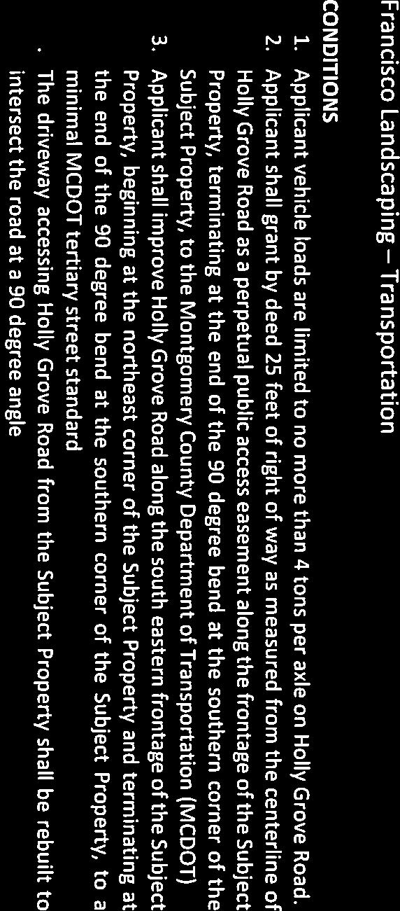
13 C. Transportation The subject property is accessed from and fronts on Holly Grove Road, a publicly maintained right-of-way running through a predominantly residential neighborhood. The existing driveway access for the subject property, which currently intersects Holly Grove Road at an angle, will be realigned to intersect perpendicularly. The property also has a second entrance on the west side of the property also along Holly Grove Road. This entrance is gated. This entrance is primarily reserved for tenants who reside onsite, therefore, it is rarely used. Because of the distance required to reach a bus stop and the lack of a sidewalk network, all access to the property is expected to occur via automobile, either driving alone or carpooling. Holly Grove Road at this location is a narrow rural road that serves a few homes and the subject property. There are no pedestrian or bicycle activities along this road, mainly because it is a dead-end street. There are no existing or future plans for sidewalks or bicycle facilities along Holly Grove Road. The Countywide Long-range Bicycle Plan recommends an on-road class 2 bicycle facility on Norwood Road. The Washington Metropolitan Area Transit Authority (WMATA) Z2 bus route operates on Norwood Road and is the closest bus route serving the site. There are no other transit services serving the area. The Conditional Use Plan for the proposed use of a landscaping contractor with 19 employees produces 18 peak hour AM and PM person trips. This project is exempt from additional LATR review as it is below the 50-person trip peak period threshold. D. Parking In general, the application meets the applicable requirements of Article The parking table in Section requires a base minimum of.50 spaces per employee plus 1 space per each vehicle operated in connection with the landscape contractor use located within the Re-2c Zone: Table 3: Parking Section Required Provided Staff Recommended Parking 0.50 X19=9.5=10 sp X15=7.5=8 sp 0.50 sp/employee 1sp/each Vehicles 1X16=16 sp 1X16=16 sp associated with use Residential dwelling 2X1=2 sp 2X1=2 Total 28 sp including 2 vanaccessible handicapped spaces 45 sp including 2 vanaccessible handicapped spaces. The residential Parking spaces not included sp including 2 vanaccessible Recommended: maximum 30 sp including 2 vanaccessible

14 The proposed total number of spaces is 17 more than the required 28 minimum parking spaces. As indicated earlier, staff recommends that the number of employees remain at the current level of 15 including family members. Staff also recommends that there must be no more than 30 vehicle parking spaces, including parking for trailers associated with the business on the property. The use can adequately be served by a total of 30 spaces given the total number of trucks and trailers, the fact that some of the employees are using ride-share, and others travel directly to the work site. The Applicant s statement indicates that all the vehicles and trailers will be stored overnight on site in parking areas designated on the Conditional Use Site Plan, except the two vehicles of the family members managing the business. Given the existing number of staff and vehicles, staff recommends that 15 of the proposed spaces, including some of the double depth parking spaces, be eliminated to further reduce the amount of impervious surface on the property. E. Landscaping Section C. Parking Lot Requirements for 10 or More Spaces Figure 7: Parking 1. Landscaped Area a. A surface parking lot must have landscaped islands that are a minimum of 100 contiguous square feet each comprising a minimum of 5 percent of the total area of the surface parking lot. Where possible, any existing tree must be protected and incorporated into the design of the parking lot. b. A maximum of 20 parking spaces may be located between islands. c. A landscaped area may be used for a stormwater management ESD facility. The revised Landscape Plan (revision date/engineer signature, November 20, 2018) satisfies the requirements of Section C.1 through 3: Parking Lot Requirements for 10 or more Spaces. The Applicant is proposing 45 parking spaces towards the rear portion of the property, directly accessed via the stretched driveway from Holly Grove Road on the 14
15 southern property line. The driveway widens as it approaches the central part of the property to provide parking spaces along its eastern and western edges. As noted earlier, staff recommends that the number of parking spaces must be reduced from the proposed 45 to 30 spaces. 15

16 Figure 8: Landscape Plan 16

17 The Applicant s Landscape Plan provides a breakdown of total area coverage and the size of landscaped islands (Table 4). Table 4-Parking Lot Requirements The application complies with the 100 square foot and five percent requirement for the size of landscaped islands. 2. Tree Canopy Each parking lot must maintain a minimum tree canopy of 25 percent coverage at 20 years of growth, as defined by the Planning Board's Trees Technical Manual, as amended. Table 5-Canopy Coverage Staff finds that the proposed landscaping meets or exceeds the standards set in Sections C.1 and C.2 of the current Zoning Ordinance for Landscape Area and Tree Canopy Coverage. 17
18 3. Perimeter Planting a. The perimeter planting area for a property that abuts an Agricultural, Rural Residential, or Residential Detached zoned property that is vacant or improved with an agricultural or residential use must: i. Be a minimum of 10 feet wide; ii. Contain a hedge, fence, or wall a minimum of 6 feet high; iii. Have a canopy tree planted every 30 feet on center; and iv. Have a minimum of 2 understory trees planted for every canopy tree. The application meets the requirements through a combination of afforestation areas as well as a combination of canopy trees, evergreen trees, large and medium size shrubs and wood split rail fences with a minimum of at least 10-foot-wide planting area along the entire perimeter of the Conditional Use site. Section : General Landscaping Requirements specifies and defines the types of plant materials, canopy trees, understory trees, and evergreen trees. In response to Staff s comments, the Applicant had submitted a revised Landscape Plan. The revised landscaping satisfies the General Landscape Requirements as defined and specified under Section F. Lighting Pursuant to Division E, outdoor lighting for Conditional Uses must be directed, shielded or screened to ensure that the illumination is 0.1 foot-candles or less at any lot line that abuts a lot with a detached house building type, not located in a Commercial/Residential or employment zone. The Lighting Plan is adequate and safe for vehicular and employee movement. The proposed lighting serves multiple purposes, including illumination of the site entrance, visibility lighting in the employee parking areas and area lighting near the structures. A photometric study submitted with the Application shows measured lighting intensity across the entire property in foot-candles, the locations of lighting fixtures and the manufacturer s specifications on the proposed lighting fixtures. The Photometric Plan shows that the lighting will not cause glare on adjoining properties, nor will it exceed the 0.1 foot-candle standard at the side and rear property lines. The lighting, with no direct light or light glare, will not have a negative impact on neighboring properties. G. Signage There will be no identification sign on the property. H. Environment Consistency with Environmental Guidelines The Application meets the requirements of Chapter 22A of the Montgomery County Forest Conservation Law. A Natural Resource Inventory/Forest Stand Delineation (NRI/FSD) was approved for this Property on April 12,

19 Forest Conservation The Property currently has no forest, but the proposed Forest Conservation Plan provides for 1.24 acres of forest on-site located along the north and portions of the east and west boundaries of the property. A Final Forest Conservation Plan has been submitted for review and is recommended for approval as a separate action by the Planning Board as part of this Conditional Use Application. The Forest Conservation Plan review reveals that over a period of years, there has been a significant amount of off-site clearing that has resulted in the loss of approximately 6,500 square feet of forest. This area will be cleared of debris and re-stabilized as part of the forest planting proposed adjacent to this area (see attached Forest Conservation Report-Attachment B-1-). The Applicant has also requested a tree variance. I. Community Concerns At the time of the Staff s report publication, no direct communication with staff had been received from the community either in support of or in opposition to the proposed use. 19
20 However, the Applicant has submitted several letters supporting the application from residents of the immediate area including from owners of adjoining and confronting properties (see attachment C-2). The Applicant also submitted an aerial photograph identifying the location of the properties corresponding to the letters of support (Figure 9). SECTION IV: COMPLIANCE WITH THE NECESSARY FINDINGS IN SECTION E AND SPECIFIC CONDITIONAL USE REQUIREMENTS IN SECTION 59-3 Section E. Necessary Findings 1. Section E.1 states that, to approve a Conditional Use application, the Hearing Examiner must find that the proposed development satisfies the following requirements of Sections E.a through g. a. Satisfies any applicable previous approval on the subject site or, if not, that the previous approval must be amended; There are no prior Conditional Use approvals associated with the subject property. b. Satisfies the requirements of the zone under Division 59-3, the use standards (Division 4), and applicable general requirements under Article With Staff s recommended conditions of approval and the variance, the proposal satisfies the specific Conditional Use standards and requirements of Section Landscape Contractor. As shown on the Use Standard Table in Section III of this report the application generally meets the RE-2C Zone development standards in Section B and the applicable parking, screening, perimeter landscaping, and sign requirements of Article 6. As noted above, the Applicant has requested a variance from the side street setback requirements Section Landscape contractor: Specific Conditional Use Requirements: A. Defined Landscape contractor means the business of designing, installing, planting, or maintaining lawns, gardens, or other landscaping and providing snow removal services with vehicles, equipment, and supplies that are stored, parked, serviced, or loaded at the business location. Landscape contractor includes tree installation, maintenance, or removal. Landscape contractor does not include Lawn Maintenance Service (see Section G, Lawn Maintenance Service). The proposed landscape contractor business meets the Use Definition of Landscape Contractor as described by this Section. The proposed use does not include a Lawn Maintenance Service. 20
21 B. Use Standard Where a Landscape contractor is allowed as a conditional use, it may be permitted by the Hearing Examiner under Section 7.3.1, Conditional Use, and the following standards: 1. In the Agricultural, Rural Residential, and Residential Detached zones the minimum lot area is 2 acres. The Hearing Examiner may require a larger area if warranted by the size and characteristics of the inventory or operation. The proposal satisfies this requirement. The subject property comprises 6.18 acres of land. 2. Building and parking setbacks, including loading areas and other site operations, are a minimum of 50 feet from any lot line. Areas for parking and loading of trucks and equipment as well as other onsite operations are located a minimum of 50 feet from any property line. Adequate buffering and screening are provided in the form of a landscape strip, and substantial distances from the neighboring residential dwellings. However, the existing building is located within 40 feet and 33 inches of the side street lot line and the Applicant is requesting a 9-foot, 7-inch variance from the required 50-foot setback. Staff supports the requested variance (See section VI: Variance). 3. The number of motor vehicles and trailers for equipment and supplies operated in connection with the contracting business or parked on-site must be limited by the Hearing Examiner to avoid an adverse impact on abutting uses. Adequate parking must be provided on-site for the total number of vehicles and trailers permitted. The Conditional Use Site Plan proposes parking in excess of the required number of parking spaces. Staff has recommended a reduction in the proposed parking from 45 to a maximum of 30 (see discussion in Section III-D under Parking). The parking areas are located in the interior of the property towards the rear portion, a substantial distance from the adjoining residential properties. The closest residential property is located west of the subject property across Holly Grove Road about 140 feet from the closest parking area. Screening of the parking area between the closest residential property includes perimeter planting of two rows of trees, a proposed restored lawn area, and a fence. The landscape contractor business currently has 15 employees, including three family members. 21
22 4. Sale of plant materials, garden supplies, or equipment is prohibited unless the contracting business is associated with a Nursery (Retail) or Nursery (Wholesale). There is no Nursery (Retail) or Nursery (Wholesale) business operating on the property and there will be no sale of plant materials or garden supplies on the property. 5. The Hearing Examiner may regulate hours of operation and other on-site operations to avoid adverse impact on abutting uses. The landscape contractor business operates six days a week, 6:00 a.m. to 7.00 p.m., Monday through Friday and 7:00 a.m. to 5:00 p.m. on Saturdays. Snowplow operations may occur during the winter for up to 24 hours a day. The Applicant s statement of justification indicates that there will be no retail sales and that customers would visit the property very rarely. There will be little activity on-site during most of the day since management and employees will be performing landscaping work at off-site locations. An exception to these hours/days of operations snow removal, occurs on days and times dictated by weather. c. Substantially conforms to the recommendations of the applicable Master Plan. The property is located within the 1997 Cloverly Master Plan area. The subject use conforms to the recommendations of the applicable Master Plan (Please see analysis and findings under SECTION III. A: Master Plan). d. Is harmonious with and will not alter the character of the surrounding neighborhood in a manner inconsistent with the plan. With the recommended conditions, the proposed use will be in harmony with the general character of the neighborhood. The Conditional Use Site Plan and the Landscape and Lighting Plan provide for extensive landscaping and adequate setbacks meeting code requirements. The Conditional Use Site and Landscape Plans provide for extensive landscaping, adequate setbacks, green areas (in the form of lawns and private gardens), new afforestation areas and sufficient building setbacks. There is extensive buffering, in the form of landscaping, afforestation, and fencing between the nearest residential properties and the proposed use. The Applicant proposes 19 employees, including three family members of whom two handle the administration part of the business. Staff recommends that the total number 22

23 of employees to remain unchanged from the current 15 to maintain the family-run business nature of the use at scale that doesn t impose change to the existing semi-rural character of the immediate neighborhood. There is a single-family dwelling on the property that is occupied by one of the three family members working in the business. However, there is no office on site or within the existing residential dwelling. The Applicant has indicated that two of the three family members manage the business electronically via telephone and computers off site. The number of employees varies seasonally, with the largest number of employees being present during the spring, fall and summer seasons. Due to the nature of the use, the restricted hours of operation, and with staff recommended condition that the existing use remain at its current level of operation, it is unlikely that the proposed use will generate a level of traffic or noise that will adversely affect the residential neighborhood. e. Will not, when evaluated in conjunction with existing and approved Conditional Uses in any neighboring Residential Detached zone, increase the number, intensity or scope of Conditional Uses sufficiently to affect the area adversely or alter the predominately residential nature of the area; a Conditional Use application that conforms with the recommendations of a Master Plan does not alter the nature of the area. 23

24 Figure 11: Existing Dwelling (West Side of the Property) It is not likely that the approval of the subject Conditional Use would adversely affect the predominantly semi-rural nature of the area. In fact, it is more likely that the operation will not be visible from any adjacent property or road. There is one approved Conditional Use (Special Exception) within the neighborhood boundary as defined by staff. The use was first approved in 1970 for animal boarding by CBA 2822, amended to add a Kennel for Dogs, in 1972 by S-142 and to increase the size of the property to five acres in The conditional use doesn t appear to be currently active. It is not likely that the approval of the subject Conditional Use would adversely affect the predominantly residential area, nor would it represent an over concentration of Conditional Uses in the immediate neighborhood. f. Will be served by adequate public services and facilities, including schools, police and fire protection, water, sanitary sewer, public roads, storm drainage and other public facilities. If an approved adequate public facilities test is currently valid and the impact of the Conditional Use is equal or less than what was approved, a new adequate public facilities test is not required. If an adequate public facilities test is required and: i. If a preliminary subdivision plan is not filed concurrently or required subsequently, the Hearing Examiner must find that the proposed development will be served by adequate public facilities, including schools, police and fire protection, water, sanitary sewer, public roads, or storm drainage; or ii. If a preliminary plan of subdivision is filed concurrently or required subsequently, the Planning Board must find that the proposed development 24
25 will be served by adequate public services and facilities, including schools, police and fire protection, water, sanitary sewer, public roads, and storm drainage; The Conditional Use does not require approval of a Preliminary Plan of Subdivision at this stage, but one will be required if a building permit application is submitted in the future. The Application does not propose construction of any new structures. Existing public facilities public roads, storm drainage, fire and police protection are adequate to serve the proposed use. (a) Water and Sewer Service The property is served by well and a septic disposal system. The well serves the existing dwelling and will continue to do so. The Applicant explained that the contractor business doesn t have an office on the property and that the use of the residential structure remains as a private dwelling. The existing septic system has been determined to be sufficient to serve the residential dwelling. (b) Storm Water Concept Plan The stormwater management concept plan had been submitted to the MCDPS Water Resource Section. MCDPS has posted on its web site an Approved Storm Water permit dated December 20, Permit Number Type Stormwater Concept Application Date 08/29/2018 Approved Date 12/20/2018 Final Date Status Permit Issued Work Type Disturb HOLLY GROVE RD Site Address Value $0.00 SILVER SPRING, MD Subdivision Colesville Outside Lot/Block N/A/N/A Phase Name Figure 12: Storm Water Concept Approval (c) Transportation Adequate Public Facilities Review (APF) and Local Area Transportation Review (LATR) The Conditional Use Plan for the proposed use of a landscaping contractor with 15 current employees without shifts does not trigger LATR based on the operational statement provided by the applicant. According to the latest 2017 Local Area Transportation Review (LATR) Guidelines, the project will not exceed the threshold for an LATR since the operation does not generate more than 50 new person trips in either the morning or evening peak hour. 25

26 Holly Grove Road west of Norwood Road is a narrow local road with varying width ranging from 14 feet to 24 feet. The Road has about 14 feet of paved width along the property s southern frontage from which it is accessed, the width of the adjoining Holly Grove Road at this location is less than the minimum 50 feet of width standard for publicly owned tertiary roads. Figure 13: Property s Southern Frontage and Access on Holly Grove Road However, although the County maintains a portion of Holly Grove Road and provides snow removal services, the road at this location is a prescriptive right-of-way. Given the status of the road, a right-of-way dedication cannot be obtained or enforced. If at a future time the county takes ownership of the road and decides to widen it, the applicant may be required to provide sufficient dedication to provide 25 feet from the center-line of the road. While the road does not meet any modern road design standards, it over does not appear to present any issues for the safe passage of vehicles. It was noted at a staff field visit that vehicles will have to slow and pull off to the right to allow another vehicle to pass. This driver courtesy has evolved over many decades of vehicular use in this neighborhood on this particularly rural road. Staff notes that sight distance is excellent along this very flat and straight road section and further notes that the Fire Marshall s office has approved a fire access plan discussed below. 26
 Figure 14: Fire Access Plan (d) Other Facilities The Hillandale Volunteer Fire Department is located at 13216 New")
27 Fire Access The Applicant submitted a fire access plan to the MCDPS, Fire Department Access and Water Supply Office. The Office approved the proposed fire access plan on November 1, 2018 (Figure 14) Figure 14: Fire Access Plan (d) Other Facilities The Hillandale Volunteer Fire Department is located at New Hampshire Ave, Colesville approximately 3.4 miles (seven minutes) south of the property. The closest police station is located at 1002 Milestone Dr. White Oak, Maryland, 3.7 miles south of the property. Due to the nature of the Conditional Use, it does not generate any school aged children; therefore, school facilities review is not necessary. g. Will not cause undue harm to the neighborhood as a result of a non-inherent adverse effect alone or the combination of an inherent and a non-inherent adverse effect in any of the following categories: i. The use, peaceful enjoyment, economic value or development potential of abutting and confronting properties or the general neighborhood; ii. Traffic, noise, odors, dust, illumination or lack of parking; or iii. The health, safety or welfare of neighboring residents, visitors or employees. The inherent, generic physical and operational characteristics associated with landscape contractor businesses are (1) buildings, structures, outdoor areas for the storage of 27
28 plants and gardening-related equipment; (2) outdoor storage of plant stock, mulch, soil and landscaping materials in bulk and in containers; (3) on-site storage of business vehicles and equipment including small trucks and landscaping trailers; (4) traffic associated with the trips to the site by employees and suppliers; trips to and from the site by employees engaged in off-site landscaping activities; (5) adequate parking areas to accommodate employees; (6) dust and noise associated with the movement of landscaping products and the loading and unloading of equipment associated with landscaping businesses; and (7) hours of operation. Staff found that the scale of the existing structure, the proposed access points, the internal vehicular circulation system, onsite parking areas, storage buildings, material storage areas, loading and unloading of supplies and equipment for off-site operations are operational characteristics typically associated with a landscape contractor operation. Staff, however, considered the fact that the property fronts on and is accessed from a local road with a paved width of about 14 feet to be a non-inherent characteristic. Staff believes that this non-inherent characteristic does not rise to a level that warrants a denial. The subject landscape contractor business has operated on the subject property for 13 years. There is also evidence that the use existed on the property prior to the Applicant taking ownership of the property in There is no accident data or report of another incident that bring to question the safety of the road due to the operation of the landscape contractor business using the adjoining local road. The proposed operation would not have an adverse impact on the transportation facilities of the area. No LATR review is required, and the proposed landscape contractor business application will have no adverse effect on area roadway conditions. There is no sale of plant materials or equipment on the property customers will only rarely visit the site, and almost all operational activities of the landscape contractor business are conducted in the interior of the property, away from views from the adjoining road and residential properties. Holly Grove Road west of Norwood Road is very lightly traveled, and speeds are generally low. Morning trips generated by the subject property occur before the residents of the 30 residential properties accessing Holly Grove Road begin their morning commutes. The Applicant s statement of justification states that trucks from the business do not return to the site at mid-day. Moreover, the Applicant maintains that the largest truck used by the business has a width of 8 feet and can easily pass oncoming traffic on those infrequent occasions when the situation occurs. To ensure that the current safe road condition remains unchanged and the semi-rural nature of the immediate neighborhood is maintained, staff recommends that the level of operation of the landscape contractor business, number of employees, trucks and trailers remain unchanged. The proposed application provides for a much-improved condition on the property through the Conditional Use process, including less 28
29 impervious surface, more trees, and restricted growth. The Applicant has also offered to provide forest on adjacent property along a shared property line in the back in an area currently destabilized. With the recommended conditions of approval, the inherent and non-inherent impacts associated with the proposed use do not rise to a level sufficient to warrant a denial of the application. SECTION V: VARIANCE The Applicant is requesting a variance of 9 feet, 7 inches (9.6 Feet) from the 50-foot setback requirement for the existing residential structure on the subject property. Pursuant to Section E, granting the variance may only authorize a use of land allowed by the underlying zone. To approve a variance, the board of appeals must find that: 1. denying the variance would result in no reasonable use of the property; or 2. each of the following apply: a. one or more of the following unusual or extraordinary situations or conditions exist: i. exceptional narrowness, shallowness, shape, topographical conditions, or other extraordinary conditions peculiar to a specific property; ii. the proposed development uses an existing legal nonconforming property or structure; iii. the proposed development contains environmentally sensitive features or buffers; iv. the proposed development contains a historically significant property or structure; or The property has exceptional shape or extraordinary conditions due to the following features: 1. Holly Grove Road, which is a local road, bends at the southwestern end of the property and wraps around the property creating a situation that the property fronts the same road on both its western and southern property lines. 2. The property is accessed from a road that is publicly maintained and 14 feet wide (in front of the property). The existing home was constructed with a building permit approved by the County Department of Permitting Services in 1989 and met all required setbacks for a residential dwelling. The dwelling has not been expanded or had any changes to its original footprint since its construction. 29
30 The residential use substantially conformed with the established historic and/or traditional development pattern of the street and/or neighborhood. Although there is no evidence of an approved Special Exception or Conditional Use for Landscape Contractor on the property, there is evidence of the use existing on the property prior to the current owner taking ownership in b. The special circumstances or conditions are not the result of actions by the applicant; As noted, the existing residential dwelling meets and exceeds the setback from the side street requirements for a residential dwelling in the RE-2C Zone. The need for the requested variance is triggered because the specific Conditional Use requirements necessitate an additional setback that is above the normally required setback for residential uses in the zone. Section : Landscape Contractor Building and parking setbacks, including loading areas and other site operations, are a minimum of 50 feet from any lot line. The existing side street setback on the west side of the property is only feet from the property line. Although it exceeds the 20 feet set back requirement for residential use in the RE-2C Zone it fails short of the 50-foot set back requirement causing the need for the requested variance of 9.6 feet. c. The requested variance is the minimum necessary to overcome the practical difficulties that full compliance with this Chapter would impose due to the unusual or extraordinary situations or conditions on the property; The requested variance is the minimum necessary to overcome the practical difficulties that full compliance with the specific Conditional Use requirement would impose due to the unusual or extraordinary situations or conditions on the property. Any attempt to meet the Conditional Use requirement would necessitate a demolition of a portion of the existing house which would be unreasonable and would create an unusual and practical difficulties on the Applicant. d. The variance can be granted without substantial impairment to the intent and integrity of the general plan and the applicable master plan; and The variance can be granted without substantial impairment to the intent and integrity of the General Plan and the 1997 Cloverly Master Plan. In addition, the variance, if granted, would be in harmony with the general purpose, intent and spirit of the Zoning Ordinance. 30
31 e. Granting the variance will not be averse to the use and enjoyment of abutting or confronting properties. Granting the variance will not be averse to the use and enjoyment of abutting or confronting properties. The variance would not result in any change in the current conditions or appearance of existing developments on the property. The requested variance of 9.6 feet from the 50 feet setback requirement, in this case, is minor given the fact that the proposed use meets or exceeds all other required setbacks and other development standards. The variance, if granted, would be in harmony with the general purpose, intent and spirit of the Zoning Ordinance. Based on the preceding analysis, staff recommends approval of the requested variance. SECTION VI: CONCLUSION The proposed Conditional Use satisfies all applicable requirements for approval of a Conditional Use as specified in the 2014 Montgomery County Zoning Ordinance. The proposed use is consistent with the recommendations of the 1997 Cloverly Master Plan. There are no unacceptable traffic, circulation, noise or environmental impacts associated with the Application provided that the recommended conditions are satisfied. Based on the foregoing analysis, staff recommends Approval of Conditional Use CU and the associated variance request subject to the conditions found on Page 2 of this report. ATTACHMENTS A. Plans and Drawings B. Forest Conservation Plan Recommendation C. Supplemental Information and Supporting Documents D. Referral Comments ET/CU19-04/
32


33


34


35


36


37


38
39
40 MONTGOMERY COUNTY PLANNING DEPARTMENT THE MARYLAND-NATIONAL CAPITAL PARK AND PLANNING COMMISSION MCPB Item No.: Date: Francisco Landscaping: Forest Conservation Plan No. CU Katherine E. Nelson, Planner Coordinator, Area 3 Katherine.Nelson@montgomeryplanning.org, Frederick V. Boyd, Supervisor, Area 3 Fred.Boyd@montgomeryplanning.org, Richard A. Weaver, Chief, Area 3 Richard.Weaver@montgomeryplanning.org Staff Report Date: Description Francisco Landscaping A. Forest Conservation Plan to address a request for a Conditional Use to operate a Landscape Contractor business on 6.18-acre property located at Holly Grove Road, Silver Spring, MD, approximately 1,250 feet Summary southwest of the intersection of Holly Grove Road and Norwood The Road, Application identified proposes as Parcel a 066 landscape (Snowdens contracting Manor), RE-2C business Zone, utilizing Cloverly existing Master buildings Plan and Area. no new buildings. Staff Recommendation: Approval with conditions The Application does not propose any forest (Planning Board Action) clearing and generates a 1.24-acre planting requirement. Applicant: FM Group, Inc. There are no outstanding issues to be addressed Application Filed: September 20, 2018 in this Staff Report; the application fully complies Review Basis: Chapter 22A, Forest Conservation with Chapter 22A of the County Code. Law

41 STAFF RECOMMENDATION: Approval of the Forest Conservation Plan No. CU , subject to the following conditions: 1. By May 31, 2019 the Applicant must: a. Record a Category I conservation easement over all areas of forest retention and forest planting as specified on the approved Final Forest Conservation Plan. The Category I Conservation Easement must be approved by the M-NCPPC Office of the General Counsel and recorded by deed in the Montgomery County land records. b. Install permanent forest conservation easement signage along the perimeter of the conservation easement, as determined by the M-NCPPC forest conservation inspector. c. Install permanent fencing along the non-forested conservation easement edge or as determined by the forest conservation inspector. 2. By November 29, 2019 the Applicant must plant 1.24 acres of forest and three variance mitigation trees as specified on the approved Forest Conservation Plan. 3. Submit financial surety for planting 1.24 acres of forest and obtain M-NCPPC approval of a twoyear maintenance and management agreement for the forest planting area before any planting activities occur. SITE DESCRIPTION The subject property is identified as Parcel 066 and is located at Holly Grove Road. ( Subject Property or Property ). The Property is zoned RE-2C, and it is 6.18 acres in size. The Property is developed as an active landscaping business with three existing buildings, material storage areas and operational parking. The entire Property drains to the Johnson Road subwatershed of the Northwest Branch Watershed, which is classified by the State of Maryland as Use Class IV waters. The existing impervious level of the site is approximately 18.2 percent. There are no stream valley buffers or existing forest onsite. Fifty-five large trees were identified on and adjacent to the Property, including twenty-five specimen trees ( 30 inches Diameter at Breast Height (DBH)). Approximately half of these trees are located in the existing forest beyond the northwestern property boundary. There are no steep slopes or highly erodible soils on the property. Neighboring land uses include residential and landscape business uses. (Figures 1 and 2). Figure Aerial Photograph of Vicinity 2
, to operate a landscape contractor business.")

42 Figure Aerial Photograph of Parcel 066 PROJECT DESCRIPTION The Forest Conservation Plan (FCP) was prepared as part of Conditional Use Application No. CU ( Application ), to operate a landscape contractor business. While the Planning Board is technically advisory on Board of Appeals applications, the Planning Board must make a finding that the pending Conditional Use Application complies with Chapter 22A, the Montgomery County Forest Conservation Law. The Application proposes the use of the existing structures and slight reconfiguration of the driveways and parking areas. The Application does not propose to impact or clear any forest. One specimen tree will be removed and seven others with be impacted. ANALYSIS AND FINDINGS Forest Conservation The Application meets the requirements of Chapter 22A of the Montgomery County Forest Conservation Law. A Natural Resource Inventory/Forest Stand Delineation (NRI/FSD) was approved for the Property on April 12, A Forest Conservation Plan has been submitted for review. There is no existing forest on the Property. 3


43 The total tract area for the Property is 6.18 acres. Based on the land use category and the forest conservation worksheet there is a 1.24-acre afforestation planting requirement. The Applicant proposes to plant 1.24 acres of forest on-site. This planting location will connect to the existing forest near the northwest property boundary. It will also incorporate existing on-site large trees along the northern Property boundary into the forest planting. Over a period of years there has been a significant amount of off-site clearing that has resulted in the loss of approximately 6,500 square feet of forest. The Applicant has offered to the property owner for this area to be cleared of debris and re-stabilized as part of the forest planting proposed adjacent to this area. Tree Variance Section 22A-12(b)(3) of the Montgomery County Forest Conservation Law provides criteria that identify certain individual trees as high priority for retention and protection. The law requires no impact to trees that: measure 30 inches or greater DBH ( Protected Tree ); are part of a historic site or designated with an historic structure; are designated as a national, State, or County champion trees; are at least 75 percent of the diameter of the current State champion tree of that species; or trees, shrubs, or plants that are designated as Federal or State rare, threatened, or endangered species. Any impact to a Protected Tree, including removal or disturbance within the Protected Tree s critical root zone (CRZ) requires a variance. An applicant for a variance must provide certain written information in support of the required findings in accordance with Section 22A-21 of the County Forest Conservation Law. In the written request for a variance, an applicant must demonstrate that strict adherence to Section 22A-12(b)(3), i.e. no disturbance to a Protected Tree, would result in an unwarranted hardship as part of the development of a property. Unwarranted Hardship The Subject Property has no forest on site. Eight protected trees grow on and adjacent to the Subject Property. These trees are located within the developed area of the site. Changes, such as paving the driveway and parking lot, extending a water line along the driveway, and adding stormwater management, will impact these trees. Variance Request On November 6, 2018, the Applicant requested a variance for impact to six Protected Trees. This request was modified on December 6, 2018 to request impact to seven Protected Trees and removal of one protected tree (tree#4). These trees are shown on the table below. Variance Tree Table 4
44 Based on the following justifications, the Applicant has met all criteria required to grant the variance for the removal of one tree and impact to other trees subject to the variance provision. Variance Findings The Planning Board must make findings that the Application has met all requirements of section 22A- 21 of the County Code before granting the variance. Staff has made the following determination on the required findings for granting the variance: 1. Will not confer on the applicant a special privilege that would be denied to other applicants; Granting the variance is not unique to this Applicant. This applicant is normalizing an existing use to comply with conditional use requirements. The proposed improvements will have a lesser impact on environmental resources than the existing use of the Site. Granting the variance will not confer on the Applicant a special privilege that would be denied to other applicants. 2. Is not based on conditions or circumstances which are the result of the actions by the applicant; The variance is not based on conditions or circumstances which are the result of the action by the Applicant. The imperviousness associated with the proposed development will be less extensive than the existing Site improvements. The variance is necessary to add stormwater management, improve water service safety and pave the existing gravel drive and parking area. There are no feasible options to deconstruct the current use and construct the proposed use that completely avoid impacting the Protected Trees. 3. Is not based on a condition relating to land or building use, either permitted or non-conforming, on a neighboring property; The requested variance is not related in any way to a condition on an adjacent, neighboring property. 4. Will not violate State water quality standards or cause measurable degradation in water quality; There are no impacts to streams and their buffers. A stormwater management concept has been approved by the Department of Permitting Services. Proposed facilities will improve the quality of runoff where no facilities existing before. Impact will not violate State water quality standards. County Arborist s Recommendation on the Variance In accordance with Montgomery County Code Section 22A-21(c), the Planning Department is required to refer a copy of the variance request to the County Arborist for a recommendation prior to acting on the request. As of the publishing of this report, Staff has not received a recommendation from the County Arborist for this case. Mitigation There is one variance tree proposed for removal. The other seven trees will have limited disturbance within their critical root zone and are candidates for safe retention. Mitigation for the loss of Tree #4 will consist of the planting of three three-inch caliper shade trees. 5
45 Variance Recommendation Staff recommends that the variance be granted. The submitted FCP meets all applicable requirements of the Chapter 22A of the County Code (Forest Conservation Law). CONCLUSION The Forest Conservation Plan meets all applicable requirements of Chapter 22A of the County Code. Therefore, Staff recommends that the Planning Board approve the Forest Conservation Plan with the conditions cited in this Staff Report. Attachments Attachment A Forest Conservation Plan 6

46 7 Attachment A


47
48

49

50


51


52


53


54
55


56


57

58

59

60

61

62


63

64

65
66


67


68

69

70

71

72
73


74
75

76


77
MONTGOMERY COUNTY PLANNING DEPARTMENT THE MARYLAND-NATIONAL CAPITAL PARK AND PLANNING COMMISSION. Completed: Description.
 MONTGOMERY COUNTY PLANNING DEPARTMENT THE MARYLAND-NATIONAL CAPITAL PARK AND PLANNING COMMISSION Emerald Landscaping Corporation CU-16-09 MCPB Item No. Date: 03-24-2016 Elsabett Tesfaye, Planner Coordinator,
Note: Staff reports can be accessed at Zone: I-3. Tier:
 The Maryland-National Capital Park and Planning Commission Prince George s County Planning Department Development Review Division 301-952-3530 Note: Staff reports can be accessed at www.mncppc.org/pgco/planning/plan.htm.
4 January 11, 2012 Public Hearing APPLICANT:
 . 4 January 11, 2012 Public Hearing APPLICANT: MID-ATLANTIC AUTO PROPERTY OWNER: DZR, LLC STAFF PLANNER: Leslie Bonilla REQUEST: Conditional Use Permit (truck rental, automobile service, and automotive/bulk
MONTGOMERY COUNTY PLANNING DEPARTMENT THE MARYLAND-NATIONAL CAPITAL PARK AND PLANNING COMMISSION
 MONTGOMERY COUNTY PLANNING DEPARTMENT THE MARYLAND-NATIONAL CAPITAL PARK AND PLANNING COMMISSION MCPB Item No. Date: 12-10-15 Leisure World Clubhouse II Addition Fitness Center, Limited Site Plan Amendment
12 January 12, 2011 Public Hearing APPLICANT: TAILWIND DEVELOPMENT GROUP,LLC PROPERTY OWNER: CITY OF VIRGINIA BEACH
 12 January 12, 2011 Public Hearing APPLICANT: TAILWIND DEVELOPMENT GROUP,LLC PROPERTY OWNER: CITY OF VIRGINIA BEACH STAFF PLANNER: Faith Christie REQUEST: Conditional Change of Zoning (from PD-H1 Planned
R E S O L U T I O N. Single-Family Residence/ Church. 2,488 sq. ft. 2,488 sq. ft. Area Parking Required: Church
 R E S O L U T I O N WHEREAS, the Prince George s County Planning Board is charged with the approval of Detailed Site Plans pursuant to Part 3, Division 9 of the Zoning Ordinance of the Prince George s
I. Introduction. Prior Approvals
 Statement of Justification First National Bank 19790 Crystal Rock Drive, Germantown, Maryland Application for Site Plan and Limited Preliminary Plan Amendment I. Introduction DPH Architecture, for First
Asbury Chapel Subdivision Sketch Plan
 Asbury Chapel Subdivision Sketch Plan PART 1: PROJECT SUMMARY Applicant: NVR Inc. Project Size: +/- 76.13 acres Parcel Numbers: 02101112,02116101,02116112, 02116113 Current Zoning: Transitional Residential
The Maryland-National Capital Park and Planning Commission Prince George's County Planning Department Development Review Division
 The Maryland-National Capital Park and Planning Commission Prince George's County Planning Department Development Review Division 301-952-3530 Note: Staff reports can be accessed at www.mncppc.org/pgco/planning/plan.htm.
MONTGOMERY COUNTY PLANNING DEPARTMENT THE MARYLAND-NATIONAL CAPITAL PARK AND PLANNING COMMISSION
 MONTGOMERY COUNTY PLANNING DEPARTMENT THE MARYLAND-NATIONAL CAPITAL PARK AND PLANNING COMMISSION MCPB Item No. Date: 3.10.2016 Site Plan 820160040 Nora School Parker Smith, Planning Technician, Area 1,
MONTGOMERY COUNTY PLANNING DEPARTMENT THE MARYLAND-NATIONAL CAPITAL PARK AND PLANNING COMMISSION
 MONTGOMERY COUNTY PLANNING DEPARTMENT THE MARYLAND-NATIONAL CAPITAL PARK AND PLANNING COMMISSION MCPB Item No. Date: 06-12-14 King of the Nations Christian Fellowship Church: Limited Site Plan Amendment
Project Name: MELWOOD HOTEL. Date Accepted: 1/12/04. Waived. Planning Board Action Limit: Plan Acreage: 1.7 Zone: Dwelling Units:
 The Maryland-National Capital Park and Planning Commission Prince George's County Planning Department Development Review Division 301-952-3530 Note: Staff reports can be accessed at www.mncppc.org/pgco/planning/plan.htm.
MONTGOMERY COUNTY PLANNING DEPARTMENT
 MONTGOMERY COUNTY PLANNING DEPARTMENT THE MARYLAND-NATIONAL CAPITAL PARK AND PLANNING COMMISSION Ashburton Elementary School Addition, Mandatory Referral, MR2018009 MCPB Item No. Date: 02-15-18 Troy Leftwich,
Planning Commission Staff Report June 5, 2008
 Owner/Applicant Taylor Village Sacramento Investments Partners, LP c/o Kim Whitney 1792 Tribute Road #270 Sacramento, CA 95815 Staff Recommendation Planning Commission Staff Report Project: File: Request:
6 July 9, 2014 Public Hearing
 6 July 9, 2014 Public Hearing APPLICANT: CAMERON JUSTIN MUNDEN PROPERTY OWNER: GRANTED WISH, L.L.C. STAFF PLANNER: Kevin Kemp REQUEST: Conditional Use Permit (Bulk Storage Yard) ADDRESS / DESCRIPTION:
MONTGOMERY COUNTY PLANNING DEPARTMENT
 MONTGOMERY COUNTY PLANNING DEPARTMENT THE MARYLAND-NATIONAL CAPITAL PARK AND PLANNING COMMISSION MCPB Item No.: Date: 5-03-18 Pike and Rose, Phase I: Site Plan Amendment No. 82012002D Rhoda Hersson-Ringskog,
Location and Field Inspection: History: Master Plan Recommendation:
 R E S O L U T I O N WHEREAS, the Prince George s County Planning Board has reviewed Special Permit Application No. SP-130008, Sudsville Laundry, requesting a special permit to construct an addition and
14 October 10, 2012 Public Hearing APPLICANT: MPB, INC
 14 October 10, 2012 Public Hearing APPLICANT: MPB, INC PROPERTY OWNER: MUNDEN & ASSOCIATES, LP STAFF PLANNER: Karen Prochilo REQUEST: Conditional Change of Zoning (AG-1 & AG-2 to Conditional O-2) ADDRESS
DEPARTURE FROM DESIGN STANDARDS DDS-586
 The Maryland-National Capital Park and Planning Commission Prince George s County Planning Department Development Review Division 301-952-3530 Note: Staff reports can be accessed at www.mncppc.org/pgco/planning/plan.htm.
PLANNED UNIT DEVELOPMENT & SUBDIVISION STAFF REPORT Date: May 18, 2017
 & PUD-0000102-2017 PLANNED UNIT DEVELOPMENT & SUBDIVISION STAFF REPORT Date: May 18, 2017 NAME SUBDIVISION NAME Dauphin Creek Estates Subdivision Dauphin Creek Estates Subdivision LOCATION CITY COUNCIL
1. Request: The subject application requests the construction of a single-family home in the R-R Zone.
 R E S O L U T I O N WHEREAS, the Prince George's County Planning Board is charged with the approval of Detailed Site Plans pursuant to Part 3, Division 9 of the Zoning Ordinance of the Prince George's
4 September 14, 2011 Public Hearing APPLICANT:
 4 September 14, 2011 Public Hearing APPLICANT: MID-ATLANTIC AUTO PROPERTY OWNER: KHJ, LLC STAFF PLANNER: Leslie Bonilla REQUEST: Conditional Use Permit (motor vehicle rental, automotive service, and automotive/bulk
6 May 14, 2014 Public Hearing
 6 May 14, 2014 Public Hearing APPLICANT: MICHAEL D. SIFEN, INC. PROPERTY OWNER: GEORGE STREET CORP. STAFF PLANNER: Stephen J. White REQUEST: Conditional Use Permit (Mini-Warehouse / Self Storage) ADDRESS
MONTGOMERY COUNTY PLANNING DEPARTMENT THE MARYLAND-NATIONAL CAPITAL PARK AND PLANNING COMMISSION
 MONTGOMERY COUNTY PLANNING DEPARTMENT THE MARYLAND-NATIONAL CAPITAL PARK AND PLANNING COMMISSION MCPB Item No. Date: 05/12/2016 North Bethesda Conference Center Parking Structure, Mandatory Referral No.
The Maryland-National Capital Park and Planning Commission Prince George s County Planning Department Development Review Division
 The Maryland-National Capital Park and Planning Commission Prince George s County Planning Department Development Review Division 301-952-3530 Note: Staff reports can be accessed at www.mncppc.org/pgco/planning/plan.htm.
PART 1: PROJECT SUMMARY. Proposed Land Use: 120 single-family lots. The application is Attachment A. The site plan is Attachment B.
 PART 1: PROJECT SUMMARY Applicant: JBH Development, LLC and Hopper Communities, INC Project Size: +/- 80.48 acres Parcel Number: 01513107, 01513108, 01513109, 01513113, 01513120, 01513121, 01513122, 01513124,
MONTGOMERY COUNTY PLANNING DEPARTMENT THE MARYLAND-NATIONAL CAPITAL PARK AND PLANNING COMMISSION
 MONTGOMERY COUNTY PLANNING DEPARTMENT THE MARYLAND-NATIONAL CAPITAL PARK AND PLANNING COMMISSION Clarksburg Childcare Center, Special Exception, S-2850 MCPB Item No. Date: 11-29-2012 Elsabett Tesfaye,
PART 1: PROJECT SUMMARY. The application is Attachment A. The site plan is Attachment B.
 Belleterre Subdivision Sketch Plan Town Board 8.7.17 Belleterre Subdivision Sketch Plan PART 1: PROJECT SUMMARY Applicant: Bowman Development Project Size: +/- 20.85 acres Parcel Number: 01115104 and 01115121
CHAPTER SPECIAL PURPOSE AND OVERLAY ZONING DISTRICTS
 Special Purpose and Overlay Zoning Districts 106.28.010 CHAPTER 106.28 - SPECIAL PURPOSE AND OVERLAY ZONING DISTRICTS SPECIAL PURPOSE AND OVERLAY ZONING DISTRICTS Sections: 106.28.010 - Purpose 106.28.020
WHEREAS, after consideration of the evidence presented at the public hearing on January 14, 2010, the Prince George's County Planning Board finds:
 R E S O L U T I O N WHEREAS, the Prince George s County Planning Board has reviewed DDS-600 requesting a departure for the location of two loading spaces without driveway access along Toledo Terrace in
Neo-Traditional Overlay Application
 MAYOR AND CITY COUNCIL OF LAUREL DEPARTMENT OF ECONOMIC AND COMMUNITY DEVELOPMENT 8103 Sandy Spring Road Laurel, Maryland 20707 (301) 725-5300 Internet Address http://www.cityoflaurel.org E-mail: ecd@laurel.md.us
MONTGOMERY COUNTY PLANNING DEPARTMENT THE MARYLAND-NATIONAL CAPITAL PARK AND PLANNING COMMISSION
 MONTGOMERY COUNTY PLANNING DEPARTMENT THE MARYLAND-NATIONAL CAPITAL PARK AND PLANNING COMMISSION MCPB Item No. 6 Date: 5-9-13 Site Plan No. 820130090, West Chevy Chase Heights Erin Grayson, Senior Planner,
PLANNED UNIT DEVELOPMENT STAFF REPORT Date: June 2, 2016
 # 9 ZON2016-01032 PLANNED UNIT DEVELOPMENT STAFF REPORT Date: June 2, 2016 DEVELOPMENT NAME JJT Properties LLC LOCATION 1147 & 1151 East I-65 Service Road South and 1180 Sledge Drive (Southeast corner
R E S O L U T I O N. 2. Development Data Summary:
 R E S O L U T I O N WHEREAS, the Prince George s County Planning Board has reviewed Departure from Design Standards DDS-631 requesting a departure to allow the loading space and the driveway to the loading
DRIVEWAY REGULATIONS
 TOWN OF NEW LONDON PLANNING BOARD DRIVEWAY REGULATIONS INSTRUCTIONS TO APPLICANTS FOR THE CONSTRUCTION OR ALTERATION OF DRIVEWAYS IMPORTANT: READ CAREFULLY BEFORE FILLING OUT ATTACHED APPLICATION Revised
Application for Site Plan Review
 Application for Site Plan Review City of Pontiac Office of Land Use and Strategic Planning 47450 Woodward Ave, Pontiac, MI 48342 T: 248.758.2800 F: 248.758.2827 Property/Project Address: Sidwell Number:
WHEREAS, after consideration of the evidence presented at the public hearing on September 11, 2008, the Prince George's County Planning Board finds:
 File No.DSDS-648 R E S O L U T I O N WHEREAS, the Prince George's County Planning Board has reviewed DSDS-648 requesting a departure of 571.44 square feet from the maximum permitted sign area of building-mounted
M E M O R A N D U M. Chair and Members of North West Planning Advisory Committee
 Item 9.1.1 PO Box 1749 Halifax, Nova Scotia B3J 3A5 Canada M E M O R A N D U M TO: FROM: Chair and Members of North West Planning Advisory Committee Stephanie Salloum, Planner II DATE: June 26, 2017 SUBJECT:
Note: Staff reports can be accessed at
 The Maryland-National Capital Park and Planning Commission Prince George's County Planning Department Development Review Division 301-952-3530 Note: Staff reports can be accessed at www.mncppc.org/pgco/planning/plan.htm.
D1 September 11, 2013 Public Hearing APPLICANT:
 D1 September 11, 2013 Public Hearing APPLICANT: BEACH MUNICIPAL FEDERAL CREDIT UNION PROPERTY OWNER: SISTERS II, LLC STAFF PLANNER: Karen Prochilo REQUEST: Conditional Change of Zoning (AG-2 Agriculture
VILLAGE OF CLEMMONS PLANNING BOARD DRAFT STAFF REPORT
 VILLAGE OF CLEMMONS PLANNING BOARD DRAFT STAFF REPORT PETITION INFORMATION Docket # C-226 Staff Megan Ledbetter Petitioner(s) JBJH Properties, LLC Owner(s) JBJH Properties, LLC Subject Property 5892-49-1766
ARTICLE 6: Special and Planned Development Districts
 ARTICLE 6: Special and Planned Development Districts 6-10 Traditional Neighborhood Development (TND) District 6-10.10 Purpose and Intent The Traditional Neighborhood Development (TND) District provides
Request Conditional Rezoning (R-10 Residential & I-1 Light Industrial to Conditional I-1 Light Industrial) Staff Recommendation Approval
 Staff Recommendation Approval") Applicant & Property Owner Public Hearing January 9, 2019 City Council Election District Beach Agenda Item 1 Request Conditional Rezoning (R-10 Residential & I-1 Light Industrial to Conditional I-1 Light
Applicant & Property Owner Public Hearing January 9, 2019 City Council Election District Beach Agenda Item 1 Request Conditional Rezoning (R-10 Residential & I-1 Light Industrial to Conditional I-1 Light
MONTGOMERY COUNTY PLANNING DEPARTMENT THE MARYLAND-NATIONAL CAPITAL PARK AND PLANNING COMMISSION
 MONTGOMERY COUNTY PLANNING DEPARTMENT THE MARYLAND-NATIONAL CAPITAL PARK AND PLANNING COMMISSION The Goddard School in North Bethesda Preliminary Plan Amendment 11996015B and Site Plan Amendment 82006005A
ARTICLE VI: SITE PLAN REVIEW
 Section 6.01 - Site Plan Review (All Districts) ARTICLE VI: SITE PLAN REVIEW Site plans give the Planning commission an opportunity to review development proposals in a concise and consistent manner. The
Town of Windham. Planning Department 8 School Road Windham, ME voice fax
 Town of Windham Planning Department 8 School Road Windham, ME 04062 voice 207.864-5960 fax 207.892.1916 MEMO DATE: TO: Staff Review Committee FROM: Amanda Lessard, Planner Cc: Ellen Rathbone, St. Germain
Project phasing plan (if applicable) 12 copies of site plan
 12 copies of site plan") SITE PLAN REVIEW PERMIT APPLICATION City of Grand Haven, 11 N. Sixth Street, Grand Haven, MI 49417 Phone: (616) 847-3490 Fax: (616) 844-2051 Website: www.grandhaven.org 1. Project Information Address/location
SITE PLAN REVIEW PERMIT APPLICATION City of Grand Haven, 11 N. Sixth Street, Grand Haven, MI 49417 Phone: (616) 847-3490 Fax: (616) 844-2051 Website: www.grandhaven.org 1. Project Information Address/location
11 March 9, 2011 Public Hearing APPLICANT: BUDDHIST EDUCATION CENTER OF AMERICA DONG HUNG TEMPLE, INC. PROPERTY OWNER: MOY FAMILY, LLC
 11 March 9, 2011 Public Hearing APPLICANT: BUDDHIST EDUCATION CENTER OF AMERICA DONG HUNG TEMPLE, INC. PROPERTY OWNER: MOY FAMILY, LLC REQUEST: Conditional Use Permit for Religious use STAFF PLANNER: Karen
MONTGOMERY COUNTY PLANNING DEPARTMENT THE MARYLAND-NATIONAL CAPITAL PARK AND PLANNING COMMISSION
 MONTGOMERY COUNTY PLANNING DEPARTMENT THE MARYLAND-NATIONAL CAPITAL PARK AND PLANNING COMMISSION MCPB Item No. Date: 05-22-14 Consent Item - Park Potomac: Site Plan Amendment No. 82004015K MCS. Molline
Colerain Township report to. Hamilton County Regional Planning Commission. December 2, 2010, 1:00PM. t a f f r e p o r t
 Colerain Township report to Hamilton County Regional Planning Commission December 2, 2010, 1:00PM Preliminary Plan: Case No.: ZA2001-04, Forevergreen Prepared By: Amy Bancroft, Land Use Planner t a f f
DEPARTMENT OF PLANNING JEFFERSON PARISH, LOUISIANA
 DEPARTMENT OF PLANNING JEFFERSON PARISH, LOUISIANA DESIGN REVIEW REPORT : CPZ-3-1 : (S) Cynthia Lee-Sheng AT LARGE: A Chris Roberts B Elton M. Lagasse ADVERTISING DATES: 06/03/1 06/10/1 06/17/1 PAB PUBLIC
SUBDIVISION, PLANNED UNIT DEVELOPMENT, PLANNING APPROVAL, REZONING & SIDEWALK WAIVER STAFF REPORT Date: February 7, 2013
 SUBDIVISION, PLANNED UNIT DEVELOPMENT, PLANNING APPROVAL, REZONING & SIDEWALK WAIVER STAFF REPORT Date: February 7, 2013 APPLICANT NAME SUBDIVISION NAME DEVELOPMENT NAME LOCATION S. E. Cemeteries of AL
Urban Planning and Land Use
 Urban Planning and Land Use 701 North 7 th Street, Room 423 Phone: (913) 573-5750 Kansas City, Kansas 66101 Fax: (913) 573-5796 Email: planninginfo@wycokck.org www.wycokck.org/planning To: From: City Planning
AWH REPORT OF THE PLANNING AND DEVELOPMENT DEPARTMENT FOR APPLICATION FOR REZONING ORDINANCE TO PLANNED UNIT DEVELOPMENT
 AWH REPORT OF THE PLANNING AND DEVELOPMENT DEPARTMENT FOR APPLICATION FOR REZONING ORDINANCE TO PLANNED UNIT DEVELOPMENT MAY 8, 2014 The Planning and Development Department hereby forwards to the Planning
MONTGOMERY COUNTY PLANNING DEPARTMENT THE MARYLAND-NATIONAL CAPITAL PARK AND PLANNING COMMISSION
 MONTGOMERY COUNTY PLANNING DEPARTMENT THE MARYLAND-NATIONAL CAPITAL PARK AND PLANNING COMMISSION MCPB Item No. Date: 1/15/2015 Bethesda North Marriott Hotel and Conference Center: Limited Site Plan Amendment
COUNTY COUNCIL OF PRINCE GEORGE'S COUNTY, MARYLAND SITTING AS THE DISTRICT COUNCIL 2010 Legislative Session. Council Members Dernoga and Olson
 DR- COUNTY COUNCIL OF PRINCE GEORGE'S COUNTY, MARYLAND SITTING AS THE DISTRICT COUNCIL 00 Legislative Session Bill No. CB--00 Chapter No. Proposed and Presented by Introduced by Co-Sponsors The Chairman
R E S O L U T I O N. 2. Development Data Summary:
 R E S O L U T I O N WHEREAS, the Prince George s County Planning Board is charged with the approval of Detailed Site Plans pursuant to Part 3, Division 9 of the Zoning Ordinance of the Prince George s
City of Lafayette Study Session Staff Report Design Review Commission
 ++ City of Lafayette Study Session Staff Report Design Review Commission Meeting Date: January 08, 2018 Staff: Subject: Chris Juram, Planning Technician SS12-17 Miramar Homebuilders, R-20 Zoning: Request
Glenborough at Easton Land Use Master Plan
 Implementation 114 9.0 IMPLEMENTATION 9.1 OVERVIEW This chapter summarizes the administrative procedures necessary to implement the proposed land use plan, infrastructure improvements, development standards,
3 June 10, 2015 Public Hearing
 3 June 10, 2015 Public Hearing APPLICANT & PROPERTY OWNERS: DAVID S. & TERESSA A. ITALIANO STAFF PLANNER: Kevin Kemp REQUEST: Conditional Use Permit (bulk storage yard) ADDRESS / DESCRIPTION: 1417 London
At Your Disposal CUP Amendment, Lot 20, Village Service Commercial, at 128 Bastille Dr. (PLN17-208)
") MEMORANDUM Archuleta County Development Services Planning Department 1122 HWY 84 P. O. Box 1507 Pagosa Springs, Colorado 81147 970-264-1390 Fax 970-264-3338 TO: Archuleta County Planning Commission FROM:
MEMORANDUM Archuleta County Development Services Planning Department 1122 HWY 84 P. O. Box 1507 Pagosa Springs, Colorado 81147 970-264-1390 Fax 970-264-3338 TO: Archuleta County Planning Commission FROM:
GENERAL INFORMATIONaaaaaaaaaaaaaaaaaaaaaaaaaaaaaaaa
 To: Planning and Zoning Commission From: City Staff Date: November 15, 2016 Re: Case #16026 Raymore Activity Center Site Plan GENERAL INFORMATIONaaaaaaaaaaaaaaaaaaaaaaaaaaaaaaaa Applicant/ Property Owner:
MONTGOMERY COUNTY PLANNING DEPARTMENT
 MONTGOMERY COUNTY PLANNING DEPARTMENT THE MARYLAND-NATIONAL CAPITAL PARK AND PLANNING COMMISSION MCPB Item No. Date: 12/20/2018 Nucci Subdivision, Preliminary Plan No. 120160170 MF Marco Fuster, Planner
DEPARTMENT OF PLANNING JEFFERSON PARISH, LOUISIANA
 DEPARTMENT OF PLANNING JEFFERSON PARISH, LOUISIANA DESIGN REVIEW REPORT DOCKET NO: CPZ--16 SUMMAR NO.: : : Paul D. Johnston AT LARGE: A: Christopher L. Roberts B: Cynthia Lee-Sheng ADVERTISING DATES: PAB
R E S O L U T I O N. B. Development Data Summary:
 R E S O L U T I O N WHEREAS, the Prince George s County Planning Board has reviewed Special Exception Application No. SE-4750, Sheriff Road Seventh Day Adventist, requesting a special exception to operate
Town of Portola Valley General Plan. Nathhorst Triangle Area Plan
 Town of Portola Valley General Plan Amended December 10, 1997 Table of Contents Introduction... 1 Planning Area... 1 Objectives... 2 Principles... 2 Standards... 4 Description... 4 Community Commercial...
MONTGOMERY COUNTY PLANNING DEPARTMENT THE MARYLAND-NATIONAL CAPITAL PARK AND PLANNING COMMISSION
 MONTGOMERY COUNTY PLANNING DEPARTMENT THE MARYLAND-NATIONAL CAPITAL PARK AND PLANNING COMMISSION MCPB Item No. Date: 9-4-13 Limited Site Plan Amendment No. 81994026B, Darcars at Montgomery Industrial Park,
F. Driveways. Driveways which provide access to off-street parking or loading from public streets shall comply with the following:
 Section 20.945.040 General Design Standards for Surface Parking Areas. A. Review Authority. Parking lot design and drainage shall be subject to review and approval of the City Transportation Manager. B.
Chapter Master Planned Communities (MPC) District
 District") Sections 14.53.010 Purpose and Intent 14.53.020 Applicability 14.53.030 Procedure 14.53.040 MPC Standards 14.53.050 Required Findings 14.53.010 Purpose and Intent Chapter 14.53 Master Planned Communities
Sections 14.53.010 Purpose and Intent 14.53.020 Applicability 14.53.030 Procedure 14.53.040 MPC Standards 14.53.050 Required Findings 14.53.010 Purpose and Intent Chapter 14.53 Master Planned Communities
SUBMITTAL REQUIREMENTS
 WHEN PROCESS TYPE III IS USED References to Process Type III applications are found in several places in the Milton Municipal Code (MMC), indicating that the development, activity, or use, is permitted
MONTGOMERY COUNTY PLANNING DEPARTMENT THE MARYLAND-NATIONAL CAPITAL PARK AND PLANNING COMMISSION
 MONTGOMERY COUNTY PLANNING DEPARTMENT THE MARYLAND-NATIONAL CAPITAL PARK AND PLANNING COMMISSION William H. Farquhar Middle School Modernization MCPB Item No. 10 Date: 09-18-2014 Description Summary Fred
6 March 9, 2011 Public Hearing APPLICANT: OLD DOMINION SOCCER CLUB
 REQUEST: Conditional Use Permit (outdoor recreational facility soccer fields) 6 March 9, 2011 Public Hearing APPLICANT: OLD DOMINION SOCCER CLUB PROPERTY OWNER: CALVARY ASSEMBLY OF GOD STAFF PLANNER: Leslie
1. Request: The subject application is for approval of a gymnasium addition to an existing private school and church.
 R E S O L U T I O N WHEREAS, the Prince George's County Planning Board is charged with the approval of Detailed Site Plans pursuant to Part 3, Division 9 of the Zoning Ordinance of the Prince George's
PLANNING REPORT CITY OF EAGAN. APPLICANT: Cedar Grove Hospitality, LLC HEARING DATE: December 18, 2014
 PLANNING REPORT CITY OF EAGAN REPORT DATE: December 8, 2014 CASE: 19-PA-11-11-14 APPLICANT: Cedar Grove Hospitality, LLC HEARING DATE: PROPERTY OWNER: The Flats at Cedar APPLICATION DATE: Nov. 21, 2014
Request Alternative Compliance (Commercial Parking Lot in Restricted Area) Staff Recommendation Approval. Staff Planner Ashby Moss
 Staff Recommendation Approval. Staff Planner Ashby Moss") Applicant Property Owners Pacific Avenue West, LLC Public Hearing April 11, 2018 City Council Election District Beach Agenda Item 2 Request Alternative Compliance (Commercial Parking Lot in Restricted
Applicant Property Owners Pacific Avenue West, LLC Public Hearing April 11, 2018 City Council Election District Beach Agenda Item 2 Request Alternative Compliance (Commercial Parking Lot in Restricted
CITY OF CYPRESS 5275 Orange Avenue Cypress, California (714) DESIGN REVIEW COMMITTEE PERMIT PROCESS
 DESIGN REVIEW COMMITTEE PERMIT PROCESS") CITY OF CYPRESS 5275 Orange Avenue Cypress, California 90630 (714) 229-6720 DESIGN REVIEW COMMITTEE PERMIT PROCESS 1. Discuss project with Planning staff to determine zoning regulations, any unusual characteristics
CITY OF CYPRESS 5275 Orange Avenue Cypress, California 90630 (714) 229-6720 DESIGN REVIEW COMMITTEE PERMIT PROCESS 1. Discuss project with Planning staff to determine zoning regulations, any unusual characteristics
EXHIBIT B PROJECT NARRATIVE POULSBO MEADOWS
 EXHIBIT B PROJECT NARRATIVE POULSBO MEADOWS Name of Project: Poulsbo Meadows; A Planned Residential Development (PRD)/Plat Applicants Name: PBH Group LLC/Byron Harris PO Box 1010 Silverdale, WA 98038 Description
Wake County Parcel Identification Number (PIN) (10-digit) Total Area 0.48
 (10-digit) Total Area 0.48") STAFF REPORT Town Council, September 3, 2015 Mom's Auto Care Site Plan 14-SP-035 (PL16-019) Conduct public hearing and consider action on proposed site plan request. Speaker: Douglas Loveland From: Jeff
STAFF REPORT Town Council, September 3, 2015 Mom's Auto Care Site Plan 14-SP-035 (PL16-019) Conduct public hearing and consider action on proposed site plan request. Speaker: Douglas Loveland From: Jeff
PLANNED UNIT DEVELOPMENT Date: April 5, 2018
 PLANNED UNIT DEVELOPMENT Date: April 5, 2018 DEVELOPMENT NAME SUBDIVISION NAME LOCATION Robert Myers Robert Myers 2955 and 2989 Dauphin Street (Southeast corner of Dauphin Street and Sage Avenue) CITY
PLANNED UNIT DEVELOPMENT & SUBDIVISION STAFF REPORT Date: March 15, 2012
 PLANNED UNIT DEVELOPMENT & SUBDIVISION STAFF REPORT Date: March 15, 2012 DEVELOPMENT NAME SUBDIVISION NAME LOCATION OSR Subdivision OSR Subdivision 5559 Old Shell Road (South side of Old Shell Road, 570
Request Modification of Proffers Approved by City Council on May 8, 2012 Modification of Conditions (Mini- Warehouse) Staff Recommendation Approval
 Staff Recommendation Approval") Applicant & Property Owner Salem Lakes Storage, LLC, a VA Limited Liability Company Public Hearing February 8, 2017 City Council Election District Centerville Agenda Item 4 Request Modification of Proffers
Applicant & Property Owner Salem Lakes Storage, LLC, a VA Limited Liability Company Public Hearing February 8, 2017 City Council Election District Centerville Agenda Item 4 Request Modification of Proffers
Request Modification of Conditions of a Conditional Use Permit approved October 14, Staff Recommendation Approval. Staff Planner Stephen White
 Applicant Property Owner Public Hearing September 13, 2017 City Council Election District Lynnhaven Agenda Item 3 Request Modification of Conditions of a Conditional Use Permit approved October 14, 2003.
The subject site plan amendment proposes the following revisions to the approved site plan:
 PROPOSED AMENDMENT The subject site plan amendment proposes the following revisions to the approved site plan: 1. The building footprint was modified to accommodate the revised architectural design. 2.
CHAPTER ADDITIONAL REQUIREMENTS IN THE NC, NEIGHBORHOOD COMMERCIAL ZONE
 CITY OF MOSES LAKE MUNICIPAL CODE CHAPTER 18.31 ADDITIONAL REQUIREMENTS IN THE NC, NEIGHBORHOOD COMMERCIAL ZONE Sections: 18.31.010 Purpose 18.31.020 Minimum Lot Area 18.31.030 Setbacks 18.31.040 Maximum
DEPARTMENT OF PLANNING JEFFERSON PARISH, LOUISIANA
 DEPARTMENT OF PLANNING JEFFERSON PARISH, LOUISIANA DESIGN REVIEW REPORT : SUMMAR NO.: 4469 (S) Paul Johnston AT LARGE: A Chris Roberts B Cynthia Lee-Sheng ADVERTISING DATES: PAB PUBLIC HEARING: HEARING:
Chesapeake Bay Critical Area Conservation Plan
 The Maryland-National Capital Park and Planning Commission Prince George s County Planning Department Development Review Division 301-952-3530 Note: Staff reports can be accessed at www.mncppc.org/pgco/planning/plan.htm.
Request Conditional Use Permit (Automobile Repair Garage) Staff Planner Kevin Kemp
 Staff Planner Kevin Kemp") Request Conditional Use Permit (Automobile Repair Garage) Staff Planner Kevin Kemp Location 845 Lynnhaven Parkway GPIN 14963473030000 Election District Rose Hall Site Size 0.40 acre portion of a 6.35 acre
Request Conditional Use Permit (Automobile Repair Garage) Staff Planner Kevin Kemp Location 845 Lynnhaven Parkway GPIN 14963473030000 Election District Rose Hall Site Size 0.40 acre portion of a 6.35 acre
WHEREAS, after consideration of the evidence presented at the public hearing on January 27, 2011, the Prince George's County Planning Board finds:
 R E S O L U T I O N WHEREAS, the Prince George s County Planning Board has reviewed DDS-602, Kinder Explorers Children Learning Center, requesting a waiver of a landscape strip (26 feet long by 10 feet
Planned Development Review Revisions (Project No. PLNPCM )
") Planned Development Review Revisions (Project No. PLNPCM2014-00139) Standard residential development Planned Development Example: Smaller lot sizes than what is allowed to create open space amenity. What
Planned Development Review Revisions (Project No. PLNPCM2014-00139) Standard residential development Planned Development Example: Smaller lot sizes than what is allowed to create open space amenity. What
ARTICLE 17 SITE PLAN REVIEW
 ARTICLE 17 SITE PLAN REVIEW 17.01 INTENT AND PURPOSE The intent of this section is to provide for consultation and cooperation between the applicant and the township planning commission so that the applicant
APPLICATION FOR REZONING PROPERTY CITY OF HOLLAND, MICHIGAN. Name of Applicant. Address, and Phone # of Applicant
 APPLICATION FOR REZONING PROPERTY CITY OF HOLLAND, MICHIGAN Name of Applicant Address, Email and Phone # of Applicant Name and Address of Owner (if other than applicant) Ownership Interest of Applicant
Staff Report. Conditional Use PLANNING DIVISION COMMUNITY & ECONOMIC DEVELOPMENT. Salt Lake City Planning Commission
 Staff Report PLANNING DIVISION COMMUNITY & ECONOMIC DEVELOPMENT To: From: Salt Lake City Planning Commission Maryann Pickering, Principal Planner (801) 535-7660 Date: December 10, 2014 Re: Church of Scientology
MONTGOMERY COUNTY PLANNING DEPARTMENT THE MARYLAND-NATIONAL CAPITAL PARK AND PLANNING COMMISSION
 MONTGOMERY COUNTY PLANNING DEPARTMENT THE MARYLAND-NATIONAL CAPITAL PARK AND PLANNING COMMISSION MCPB Item No. Date: 1/26/12 Hanover Shady Grove, Sketch Plan 320120020 Joshua Sloan, Coordinator, Joshua.Sloan@MontgomeryPlanning.org,
Request Conditional Use Permit (Car Wash Facility) Staff Recommendation Approval. Staff Planner Jonathan Sanders
 Staff Recommendation Approval. Staff Planner Jonathan Sanders") Applicant Property Owner SunTrust Bank Public Hearing October 10, 2018 City Council Election District Princess Anne Agenda Item 2 Request Conditional Use Permit (Car Wash Facility) Staff Recommendation
Applicant Property Owner SunTrust Bank Public Hearing October 10, 2018 City Council Election District Princess Anne Agenda Item 2 Request Conditional Use Permit (Car Wash Facility) Staff Recommendation
Note: Staff reports can be accessed at Special Exception Application No. SE Tier:
 The Maryland-National Capital Park and Planning Commission Prince George's County Planning Department Development Review Division 301-952-3530 Note: Staff reports can be accessed at www.mncppc.org/pgco/planning/plan.htm.
MONTGOMERY COUNTY PLANNING DEPARTMENT THE MARYLAND NATIONAL CAPITAL PARK AND PLANNING COMMISSION
 MONTGOMERY COUNTY PLANNING DEPARTMENT THE MARYLAND NATIONAL CAPITAL PARK AND PLANNING COMMISSION MCPB Item No. 8 Date: 3.30.2017 Project Name: Lot 31/31A Bethesda, Site Plan Amendment, No. 82007018C Elza
Baumgarten MPUD. Exhibit 3 Evaluation Criteria
 Pursuant to LDC subsections 10.02.13 B, 10.02.08 F and Chapter 3 G. of the Administrative Code, staff s analysis and recommendation to the Planning Commission, and the Planning Commission s recommendation
CHAPTER 22 Rural Open Space Community Developments
 CHAPTER 22 Rural Open Space Community Developments Section 22.1 Description and Purpose The intent of this Chapter is to offer property owners an alternative to traditional zoning requirements for rural
ARTICLE IX SPECIAL PERMIT USES
 ARTICLE IX SPECIAL PERMIT USES All special permit uses cited in Article IX and Attachment A of this Ordinance or any other Section of this Ordinance shall be subject to Site Plan Review. The procedures
CITY OF PORTSMOUTH PLANNING DEPARTMENT. MEMORANDUM To: From:
 CITY OF PORTSMOUTH PLANNING DEPARTMENT MEMORANDUM To: From: Subject: Date: Planning Board Juliet T.H. Walker, Planning Director Jillian Harris, Planner 1 Staff Recommendations for the August 23, 2018 Planning