HOLLY WILLIAMS MARK WALLER (CHAIR) STAN VANDERWERF LONGINOS GONZALES (VICE-CHAIR)
|
|
|
- Alexander Wheeler
- 5 years ago
- Views:
Transcription


1 COMMISSIONERS: HOLLY WILLIAMS MARK WALLER (CHAIR) STAN VANDERWERF LONGINOS GONZALES (VICE-CHAIR) CAMMI BREMMER PEGGY LITTLETON PLANNING AND COMMUNITY DEVELOPMENT DEPARTMENT CRAIG DOSSEY, EXECUTIVE DIRECTOR TO: FROM: El Paso County Planning Commission Jim Egbert, Chair Kari Parsons, Planner II Gilbert La Force, PE Engineer II Craig Dossey, Executive Director RE: OWNER: Project File #: PUDSP Project Name: Forest Lakes Parcel No.: REPRESENTATIVE: FLRD, No. 2, LLC 6385 Corporate Dr., Suite 200 Colorado Springs, CO N.E.S. Inc. Andrea Barlow 619 N. Cascade Avenue, Suite 200 Colorado Springs, CO Commissioner District: 1 Planning Commission Hearing Date: 4/2/2019 Board of County Commissioners Hearing Date 4/23/19 EXECUTIVE SUMMARY A request by FLRD, NO.2, LLC, for approval of a map amendment (rezoning) of 287 acres zoned PUD (Planned Unit Development) to a site specific PUD zoning district to develop 180 single-family residential lots, rights-of-way, and five (5) open space and utility tracts to include a 260,000 gallon capacity water tank site. The request also includes approval of the PUD development plan as a preliminary plan. The parcel is located north of Hay Creek Road, south of Doolittle Road, and west of Old Denver Road and is within Sections 28 and 29, Township 11 South, Range 67 West of the 6 th P.M INTERNATIONAL CIRCLE, SUITE 110 COLORADO SPRINGS, CO PHONE: (719) FAX: (719)
2 The subject property is located within the boundaries of the Tri-Lakes Comprehensive Plan (2000). A. REQUEST/WAIVERS/MODIFICATIONS/AUTHORIZATION Request: Approval of a map amendment (rezoning) of 287 acres zoned PUD (Planned Unit Development) zoning district to a site specific PUD zoning district to develop 180 single-family residential lots, rights-of-way, and five (5) open space and utility tracts to include 280,000 gallon capacity water tank site. In accordance with Section E, of the El Paso County Land Development Code (2019), PUD Development Plan May be Approved as a Preliminary Plan, the applicant requests the PUD development plan also be approved as a preliminary plan. In addition, a finding of water sufficiency for water quality, dependability and quantity is being requested. Modification of Existing Land Development Code (LDC) or Engineering Criteria Manual (ECM) Standard: For approval of a modification of a general development standard in the LDC or standard of the ECM, the BoCC shall find that the proposal provides for the general health, safety, and welfare of the citizens and provides for at least one of the following benefits: Preservation of natural features; Provision of a more livable environment, such as the installment of street furniture, decorative street lighting or decorative paving materials; Provision of a more efficient pedestrian system; Provision of additional open space; Provision of other public amenities not otherwise required by the Code; or The proposed modification is granted in exchange for the open space and/or amenity designs provided in the PUD development plan and/or development guide. 1. The applicant is requesting a PUD modification to Sections C.4.c and C.2.e of the Code to allow for a shared access for Lots 3, 4, 5, and 6. An access easement is depicted on Lot 4, which is proposed to provide access to Lots 3, 5, and 6. The shared access will limit Lots 3, 5, and 6 from having direct access to a public road. Section C.4.c of the Code states: The lot layout shall incorporate a cul-de-sac where 3 or more abutting flag lots would occur. Section and C.2.e of the Code states: 2
3 Lots shall have a minimum of 30-feet of frontage on and have access from a public road, except where private roads are approved by the BoCC pursuant to waiver granted under Section (E). PCD Executive Director Recommendation: The PCD Executive Director recommends approval of the requested PUD modifications. Per the PUD/Preliminary Plan, adequate lot accessibility can be provided via the proposed access easement. If the shared access modification is granted, the lots would not have direct frontage to a public road. As summarized in the applicant s letter of intent, reducing the requirement to construct a cul-desac is proposed to preserve the natural features and terrain, by reducing the requirement to grade and construct a cul-de-sac serving each of the lots to a public road standard. 2. The applicant is also requesting a PUD modification to Section C.4 of the ECM to omit midblock pedestrian crossings at specific sections of Mesa Top Drive and Forest Lakes Drive. Section C.4 of the ECM states: Access ramps on local roadways shall be spaced no greater than 600 feet apart. Where spacing is greater than 600 feet, mid-block access ramps shall be provided at spacing that minimize travel distances between access ramps. Private accesses may be used for these access points where the access is designed to meet access ramp requirements. ECM Administrator Recommendation: The ECM Administrator recommends approval of the requested PUD modification. Per the PUD/Preliminary Plan, adequate pedestrian accessibility is provided by access ramps at all intersections and mid-block trail crossings. Additionally, the Federal Americans with Disabilities Act (ADA) has no requirements for maximum distance between pedestrian crossings that would necessitate mid-block pedestrian ramps. It should be noted that the PCD engineering staff is currently evaluating this requirement in coordination with the DPW engineering staff for the purposes of amending this section of the ECM. 3. The applicant requests a PUD modification to Section A of the ECM to exceed the standard cul-de-sac length for Foothills Flash Court (approximately 920 feet) and Timber Trek Way (approximately 800 feet). 3
4 Section A of the ECM states: Cul-de-sacs shall have a minimum radius of 45 feet and a maximum length of 750 feet for urban conditions ECM Administrator Recommendation: The ECM Administrator recommends approval of the requested PUD modification if the applicant obtains a written endorsement from the fire district. The endorsement from the fire protection district is pending. 4. The applicant requests a PUD Modification of Appendix I Section I.7.1.B of the ECM to exclude water quality capture volume for a portion of their development. ECM Administrator Recommendation: The ECM Administrator recommends approval of the requested PUD modification based on Part I Section E.4.iv.A of the Municipal Separate Storm Sewer Systems (MS4) Permit (CDPS General Permit COR090000) which generally states that up to 20 percent of a development property, not to exceed 1 acre, of the applicable development site area may be excluded if it is not practicable to drain towards control measures. Authorization to Sign: PUD Development Plan and any other documents necessary to carry out the intent of the Board of County Commissioners in approving the request. B. PLANNING COMMISSION SUMMARY Request Heard: Recommendation: Waiver Recommendation: Vote: Vote Rationale: Summary of Hearing: Legal Notice: C. APPROVAL CRITERIA The Planning Commission and BOCC shall determine that the following criteria for approval outlined in Section 4.2.6, and Section of the El Paso County Land Development Code (2019), have been met to approve a PUD zoning district: The proposed PUD district zoning advances the stated purposes set forth in this section. The application is in general conformity with the Master Plan; 4
5 The proposed development is in compliance with the requirements of this Code and all applicable statutory provisions and will not otherwise be detrimental to the health, safety, or welfare of the present or future inhabitants of El Paso County; The subject property is suitable for the intended uses and the use is compatible with both the existing and allowed land uses on the neighboring properties, will be in harmony and responsive with the character of the surrounding area and natural environment, and will not have a negative impact upon the existing and future development of the surrounding area; The proposed development provides adequate consideration for any potentially detrimental use to use relationships (e.g. commercial use adjacent to single family use) and provides an appropriate transition or buffering between uses of differing intensities both on-site and off-site which may include innovative treatments of use to use relationships; The allowed uses, bulk requirements and landscaping and buffering are appropriate to and compatible with the type of development, the surrounding neighborhood or area and the community; Areas with unique or significant historical, cultural, recreational, aesthetic or natural features are preserved and incorporated into the design of the project; Open spaces and trails are integrated into the development plan to serve as amenities to residents and provide reasonable walking and biking opportunities; The proposed development will not overburden the capacities of existing or planned roads, utilities and other public facilities (e.g. fire protection, police protection, emergency services, and water and sanitation), and the required public services and facilities will be provided to support the development when needed; The proposed development would be a benefit through the provision of interconnected open space, conservation of environmental features, aesthetic features and harmonious design, and energy efficient site design; The proposed land use does not permit the use of any area containing a commercial mineral deposit in a manner which would unreasonably interfere with the present or future extraction of such deposit unless acknowledged by the mineral rights owner; Any proposed exception or deviation from the requirements if the zoning resolution or the subdivision regulation is warranted by virtue of the design and amenities incorporated in the development plan and development guide; and The owner has authorized the application. The applicant has requested the proposed PUD also be reviewed and considered as a preliminary plan. Compliance with the requirements identified in Chapter 7 and Chapter 8 of the El Paso County Land Development Code (2019) for a preliminary 5
6 plan requires the Planning Commission and the BoCC find that the following additional criteria for a preliminary plan have also been met: The proposed subdivision is in general conformance with the goals, objectives, and policies of the Master Plan; The subdivision is consistent with the purposes of this Code; The subdivision is in conformance with the subdivision design standards and any approved sketch plan; A sufficient water supply has been acquired in terms of quantity, quality, and dependability for the type of subdivision proposed, as determined in accordance with the standards set forth in the water supply standards [C.R.S (6)(a)] and the requirements of Chapter 8 of this Code; A public sewage disposal system has been established and, if other methods of sewage disposal are proposed, the system complies with state and local laws and regulations, [C.R.S (6) (b)] and the requirements of Chapter 8 of this Code. All areas of the proposed subdivision, which may involve soil or topographical conditions presenting hazards or requiring special precautions, have been identified and the proposed subdivision is compatible with such conditions. [C.R.S (6)(c)]; Adequate drainage improvements complying with State law [C.R.S (3)(c)(VIII)] and the requirements of this Code and the ECM are provided by the design; Legal and physical access is or will be provided to all parcels by public rightsof-way or recorded easement, acceptable to the County in compliance with this Code and the ECM; The proposed subdivision has established an adequate level of compatibility by (1) incorporating natural physical features into the design and providing sufficient open spaces considering the type and intensity of the subdivision; (2) incorporating site planning techniques to foster the implementation of the County s plans, and encourage a land use pattern to support a balanced transportation system, including auto, bike and pedestrian traffic, public or mass transit if appropriate, and the cost effective delivery of other services consistent with adopted plans, policies and regulations of the County; (3) incorporating physical design features in the subdivision to provide a transition between the subdivision and adjacent land uses; (4) incorporating identified environmentally sensitive areas, including but not limited to, wetlands and wildlife corridors, into the design; and (5) incorporating public facilities or infrastructure, or provisions therefore, reasonably related to the proposed subdivision so the proposed subdivision will not negatively impact the levels of service of County services and facilities; Necessary services, including police and fire protection, recreation, utilities, open space and transportation systems, are or will be available to serve the proposed subdivision; 6
7 The subdivision provides evidence to show that the proposed methods for fire protection comply with Chapter 6 of this Code; and The proposed subdivision meets other applicable sections of Chapter 6 and 8 of this Code. D. LOCATION North: RR-5 (Residential Rural) Single-family Residential South: RR-5 (Residential Rural) Single-family Residential East: PUD (Planned Unit Development) Single-family Residential West: RR-5 (Residential Rural) Pike National Forest/Vacant E. BACKGROUND The Board of County Commissioners approved the Forest Lakes PUD (PUD ) and preliminary plan (SP ) on February 26, The 977 acre PUD plan included 467 dwelling units, a ten (10) acre school site, 450 acres of passive openspace tracts, and 32 acres of tracts to be used for utilities, public facilities and park land. The original PUD Plan anticipated development to occur in two (2) phases. The first phase was proposed to include 275 dwelling units in the eastern and northern portions of the PUD Plan. Forest Lakes Filing Nos. 1 through 4, totaling 272 lots, have been platted and developed in accordance with the phasing plan. The Board of County Commissioners approved an amendment to the Forest Lakes PUD Development Plan (PUDSP ) on June 21, The amended PUD, which included approval of the preliminary plan amendment, resulted in a reconfiguration and reduction of the number of single family residential lots from 163 to 161. The applicant is requesting to develop 180 dwelling units within the second phase of the overall Forest Lakes PUD Plan, which represents an increase of 46 dwelling units in this area of the approved 2002 PUD Plan. The applicant is proposing to establish five (5) tracts, totaling 191 acres, for open space, trails, utilities, and drainage with this phase. No decrease in open space is proposed in this area from the 2002 approved Plan. A water tank site is located in the northwestern-most corner of the site and is proposed to be an addition to the existing water supply facilities of the Forest Lakes Metropolitan District, which is necessary to serve this development. A trail connection from the existing waterfront park, constructed with phase one (1), to Pike National Forest is proposed to be within a buffer open-space tract along the northern boundary included with this phase of development. In addition, the applicant has identified their intent to separate the southern portion of the PUD plan by proposing to add a third phase to include 61 dwelling units depicted 7
8 as a future phase on the PUD Plan. The third phase is not included in this PUD map amendment (rezoning) request. The 61 dwelling units are not anticipated to increase the overall number of dwelling units beyond the additional 46 dwelling units requested with this PUD plan request. F. ANALYSIS 1. Land Development Code Analysis This application meets the preliminary plan submittal requirements, the standards for Divisions of Land in Chapter 7, and the standards for Subdivision in Chapter 8 as well as the Planned Unit Development (PUD) requirements outlined in Chapter 4 of the El Paso County Land Development Code (2019), if the PUD modifications, outlined above, are approved as requested. 2. Zoning Compliance The proposed Forest Lakes PUD Development Plan identifies allowed and permitted uses; use, density, and dimensional standards such as setbacks, maximum lot coverage, and maximum building height; and overall landscaping requirements. The Forest Lakes PUD Development Plan is consistent with the proposed PUD development guidelines and with the submittal and processing requirements of the Land Development Code. 3. Policy Plan Analysis The El Paso County Policy Plan (1998) has a dual purpose; it serves as a guiding document concerning broader land use planning issues, and provides a framework to tie together the more detailed sub-area elements of the County Master Plan. Staff has provided a detailed guiding document concerning broader land use planning issues, and provides a framework to tie together the more detailed sub-area elements of the County master plan. Relevant policies are as follows: Policy Encourage incorporation of buffers or transitions between areas of varying use or density where possible. Policy Encourage the use of carefully planned and implemented clustering concepts in order to promote efficient land use, conservation of open space and reduction of infrastructure costs. Policy Support development which complements the unique environmental conditions and established land use character of each sub-area of the County. 8
9 Goal 6.1 A Encourage patterns of growth and development which complement the regions unique natural environments and which reinforce community character. Consistency with the Plan was found with the most recently approved amendment to the Forest Lakes PUD Development Plan (PUDSP ) and with approval of the Forest Lakes PUD (PUD ) in The noteworthy areas of change from the previously approved Plan to the proposed PUD/Preliminary Plan amendment include the following: Increasing the overall number of residential lots. Reducing the number of the previously planned estate lots located along the northern boundary of the property, choosing instead to reduce the lot sizes and increase the number of lots in areas that are more internal to the development. Removing the northernmost roadway connection, which was previously planned to extend east and west near the northern border of the property; choosing instead to propose one primary access into the Phase 2 area via Mesa Top Drive and one emergency access road through Tract D. Reducing the size of the lots located along the western boundary adjacent to Pike National Forest while increasing the open space along the boundary to help preserve the natural buffer next to the Forest. In addition, the proposed PUD/preliminary plan amendment includes multiple tracts that should generally serve as large open space areas adjacent to the existing residential development to the north and south, which includes preserving the existing Preble s Meadow Jumping Mouse habitat. Staff recommends that the layout and design of the PUD Plan is consistent with the policies pertaining specifically to the concept of clustering in order to promote conservation of open space, which include significant existing natural features, and to promote the efficient development of the property by minimizing infrastructure costs. 4. Small Area Plan Analysis The Forest Lakes development is located within the boundaries of the Twin Valley Sub-Area of the Tri-Lakes Comprehensive Plan (2000). Approval of the overall Forest Lakes PUD (PUD ) and preliminary plan (SP ) included findings of master plan consistency and consistency with the Tri-Lakes Plan. The same findings were made with the approved Amended Forest Lakes PUD (PUDSP ) Development Plan, which also included approval as a preliminary plan amendment. 9
10 The Plan acknowledges the Forest Lakes development in various sections. The Land Use section of the Plan states: The former Beaver Creek Ranch was acquired by developer who had an 822- acre parcel within this Sub-area rezoned to accommodate 466 clusterhousing units... Also within this Sub-area a second 180-acre parcel was later included in the Forest Lakes Project, but was never approved for specific land uses... While this Sub-Area is sparsely populated today, its proximity to the employment centers of both Colorado Springs and Denver, and its extraordinary natural quality, will exert increasing pressure for residential development of remaining undeveloped areas. The Utilities and Services section of the Plan states: There are no trails or public recreational facilities within the sub-area and no public access to National Forest Also, there is no public access to the two lakes on Forest Lakes property The Opportunities, Constraints and Concerns section of the Plan states: The scenic qualities and rural character of this Sub-area are worthy of preservation. With several ranches actively operating, a portion of this Subarea has the potential to remain open space well into the future. The Twin- Valley Sub-area is exceptional, if not unique, as it has become one of the few remaining rural areas west of I-25. It is a transition zone from the intense development corridor along I-25 to the scenic and pristine beauty of the National Forest along the Front Range. The Forest Lakes residential portion, as well as the remaining working ranches, can provide the County with one of the few remaining opportunities to retain open space and rural character that singularizes Twin- Valley, and thereby preserve, if not enhance, the visual appeal of this section of the Front Range. The Twin-Valley Sub-Area provides one of the few remaining opportunities for County and other governmental agencies to acquire land that can be used for developing new parks for the enjoyment of the people in surrounding communities, all with easy access to I-25 and Santa Fe Trail. Much of this Sub-area has been identified by the County Parks Master Plan as an ideal 10
11 site to acquire for public use here are no trails or public recreational facilities within the sub-area and no public access to National Forest Also, there is no public access to the two lakes on Forest Lakes property. The Twin-Valley Land Use Scenario section of the Plan states: The previous land use approvals in the Forest Lakes project are acknowledged, but it is noted that the development within this property should be sensitive to the surrounding existing and planned lower-densities uses. For this reason, adherence to the originally approved clustering plan is strongly recommended Various opportunities for acquisition and/or preservation of open space should be pursued and implemented with this Sub-area if possible.limited public access to the National Forest land to the west should be considered. All plans for new and expanded development should be carefully evaluated and conditioned to provide assurances water supplies will be adequate and water resources will be conserved The Plan acknowledged the Forest Lakes Development and also anticipated future growth in this area due to proximity to the Interstate 25 corridor and the unique environmental features. The applicant is proposing to amend the 2002 PUD Plan by adding an additional 46 dwelling units within the Phase 2 area. The applicant proposes a reduction in lot size from the approved lot sizes within the 2002 PUD plan to accommodate the increase. As discussed above, the applicant is proposing to provide large open space areas adjacent to the existing residential developments located to the north and south. The lots are proposed to be clustered to ensure preservation of the extraordinary natural quality of the area. The applicant has obtained documentation from the U.S. Fish and Wildlife Service with regard to the Preble s Meadow Jumping Mouse Habitat critical area, and has been determined that there are no concerns since the applicant will place the habitat areas within preservation tracts as depicted on the PUD Plan. The applicant is not proposing a reduction in open space within the Phase 2 area. Since the completion of Phase 1 of the Forest Lakes Development, the waterfront park has been completed and is open to the public providing opportunities for the residents in this area of the County. The requested PUD Plan depicts a regional trail connection from the water front park to Pike National Forest with this phase of development. 11
12 The Forest Lakes Metropolitan District has provided commitment letters to serve the development for water and wastewater services. For the above reasons, staff has no concerns with this development request. 5. Other Master Plan Elements The Master Plan for Mineral Extraction (1996) identifies valley fill (sand and gravel) in the area of the subject parcels. A mineral rights certification was prepared by the applicant indicating that, upon researching the records of El Paso County, no severed mineral rights exist. G. PHYSICAL SITE CHARACTERISTICS 1. Hazards A geology hazards evaluation and preliminary geotechnical investigation report was prepared and submitted by CTL Thompson Engineering dated July 18, 2018, with revisions to the report dated December 11, 2018, and February 18, 2019, with this request. The report identifies constraints within the subject property including expansive soils, shallow ground water, a potential for erosion, flooding and debris flow. There is a floodplain hazard depicted within the PUD development/preliminary plan area as discussed in Section G.3 of this report. The applicant proposes to mitigate the constraints identified in the report by following CTL Thompsons Engineering s recommendations to include: additional geotechnical investigation, testing and analysis for design of individual foundations, floor systems, and subsurface drainage to be completed prior to the issuance of lot specific building permits as identified in Recommended Condition of Approval No. 7. A debris flow/mud flow analysis report was also prepared and submitted by CTL Thompson Engineering on August 6, 2018, and revised December 14, The report concludes that the potential for major debris/mud flow is generally limited to the drainage paths and adjacent over bank areas within the floodplains of North Beaver Creek, South Beaver Creek, Beaver Creek, and Hell Creek. The applicant has depicted these areas in a tract. No development is proposed in these areas. 2. Wildlife The El Paso County Wildlife Habitat Descriptors (1996) identifies the parcels as having a moderate to very high wildlife impact potential. Critical habitat for the Preble s Jumping Mouse has been identified in the Beaver Creek, North Beaver 12
13 Creek and South Beaver Creek drainage areas. A U.S. Fish and Wildlife Service clearance letter ( ) dated July 18, 2018, has been provided by the applicant, which does not indicate any concerns with the proposed development, if the subdivision is developed as depicted on the PUD plan. The applicant has provided a 394-foot buffer from the 100-year floodplain which is known to be habitat area for Preble s Jumping Mouse to preclude disturbance to the habitat. 3. Floodplain FEMA Flood Insurance Rate Map panel numbers 08041C0258G, 08041C0259G, 08041C0266G and 08041C0267G shows that the 100-year floodplain (Zone AE) of North Beaver Creek, South Beaver Creek and Beaver Creek flows through the site. These creeks are planned to be located in tracts to be owned and maintained by the Forest Lakes Metropolitan District. 4. Drainage and Erosion The Forest Lakes development is located within the Beaver Creek drainage basin (FOMO4600), which is a fee basin. The basin does not have a Drainage Basin Planning Study (DBPS). The site generally drains to the east into Beaver Creek. Stormwater runoff will be conveyed by public storm sewer systems into one of three proposed full spectrum detention ponds for water quality and flood control facilities. These facilities will be owned and maintained by the Forest Lakes Metropolitan District. Hydraulic analysis will be performed with the appropriate final plat(s). 5. Transportation Access to the development is via the extension of Forest Lakes Drive and Mesa Top Drive. All streets are planned to be public roads and will be dedicated to the County. The 2016 Major Transportation Corridors Plan Update (MTCP) does not call for any improvement projects in the immediate vicinity of the site. No improvements associated with this development are reimbursable through the MTCP roadway improvement program. The majority of the Forest Lakes development is located west of North Beaver Creek and South Beaver Creek. A single roadway crossing over North Beaver Creek is proposed to serve as the primary access due to topographic constraints. Secondary access is provided via a combined trail/emergency road designed as a low water crossing on North Beaver Creek. 13
14 The Mesa Top Drive connection to Lindbergh Road was approved with Forest Lakes Filing No. 1 with a 100 feet centerline curve which does not meet current ECM criteria. The applicant shall analyze this segment of Mesa Top Drive with the appropriate final plat and implement any necessary mitigation for safe operation. The development is subject to the El Paso County Road Impact Fee program (Resolution No ). H. SERVICES 1. Water Sufficiency: The development is proposed to be served by Forest Lakes Metropolitan District. Quality: Sufficient Quantity: Sufficient Dependability: Sufficient Attorney s summary: The State Engineer s Office has made a finding of adequacy and has stated water can be provided without causing injury to decreed water rights. The County Attorney s Office is anticipated to recommend a finding of sufficiency with regard to water quantity and dependability, which staff plans to provide at the hearing. El Paso County Public Health has made a favorable recommendation regarding water quality. 2. Sanitation Wastewater service is proposed to be provided by Forest Lakes District, which has committed to serve the property. El Paso County Public Health has made a favorable recommendation regarding wastewater disposal. 3. Emergency Services The property is within Tri-Lakes Fire Protection District. The District has committed to serve the development. The District has reviewed the applicant s fire protection report and the applicant s proposed PUD Plan and has provided a letter stating they are in agreement with the report. The correspondence has been attached to this staff report. 4. Utilities Mountain View Electric Association (MVEA) will provide electrical service to the property. Black Hills Energy will provide natural gas service to the property. 14
15 5. Metropolitan Districts The property is within Forest Lakes Metropolitan District. The District has provided a letter stating they anticipate and agree to accept the maintenance and ownership responsibility of the tracts within this development. The District will be responsible for maintaining the drainage tracts, detention ponds, open space and landscaped areas along the platted public right-of-way throughout the development. 6. Parks/Trails The applicant is anticipated to construct a Tier 1 Regional Trail along Forest Lakes Drive to the western boundary of the proposed PUD plan to connect to the Pike National Forest in lieu of $77, due at plat recordation for Regional Park Fees (Area 1). The applicant will provide a 25-foot easement for the trail upon plat recordation. Ultimately, the trail is planned to connect the Santa Fe Trail to the forest. No urban park fees are due at plat recordation. 7. Schools The subject property is located within the boundaries of Lewis Palmer School District No. 38. The applicant is not required to pay fees in lieu of land dedication due to a prior dedication of a 10 acre school site. I. APPLICABLE RESOLUTIONS Approval Page 29 and 25 Disapproval Page 30 and 26 J. STATUS OF MAJOR ISSUES There are no outstanding major issues with this project. K. RECOMMENDED CONDITIONS AND NOTATIONS Should the Planning Commission and the Board of County Commissioners find that the request meets the criteria for approval outlined in Section 4.2.6, and Section of the El Paso County Land Development Code (2019), staff recommends the following conditions and notations: CONDITIONS 1. Development of the property shall be in accordance with this PUD development plan. Minor changes in the PUD development plan, including a reduction in residential density, may be approved administratively by the Director of the Planning and Community Development Department consistent with the Land 15
16 Development Code. Any substantial change will require submittal of a formal PUD development plan amendment application. 2. Approved land uses are those defined in the PUD development plan and development guide. 3. All owners of record must sign the PUD development plan. 4. The PUD development plan shall be recorded in the office of the El Paso County Clerk & Recorder prior to scheduling any final plats for hearing by the Planning Commission. The development guide shall be recorded in conjunction with the PUD development plan. 5. Developer shall comply with federal and state laws, regulations, ordinances, review and permit requirements, and other agency requirements, if any, of applicable agencies including, but not limited to, Colorado Parks and Wildlife, Colorado Department of Transportation, U.S. Army Corps of Engineers and the U.S. Fish and Wildlife Service regarding the Endangered Species Act, particularly as it relates to the Preble's Meadow Jumping Mouse as a listed threatened species. 6. Applicable park, drainage, bridge, and traffic fee shall be paid to El Paso County Planning and Community Development at the time of final plat(s) recordation. 7. The applicants shall mitigate the constraints identified in geology hazards evaluation and preliminary geotechnical investigation report which was prepared and submitted by CTL Thompson Engineering dated July 18, 2018, revisions of the report dated December 11, 2018, and February 18, CTL Thompsons Engineering s recommendations include: additional geotechnical investigation, testing and analysis for design of individual foundations, floor systems, and subsurface drainage to be completed prior to the issuance of lot specific building permits. NOTATIONS 1. If a zone or rezone petition has been disapproved by the Board of County Commissioners, resubmittal of the previously denied petition will not be accepted for a period of one (1) year if it pertains to the same parcel of land and is a petition for a change to the same zone that was previously denied. However, if evidence is presented showing that there has been a substantial change in 16
17 physical conditions or circumstances, the Planning Commission may reconsider said petition. The time limitation of one (1) year shall be computed from the date of final determination by the Board of County Commissioners or, in the event of court litigation, from the date of the entry of final judgment of any court of record. 2. Rezoning requests not forwarded to the Board of County Commissioners for consideration within 180 days of Planning Commission action will be deemed withdrawn and will have to be resubmitted in their entirety. 3. Preliminary plans not forwarded to the Board of County Commissioners within 12 months of Planning Commission action shall be deemed withdrawn and shall have to be resubmitted in their entirety. 4. Approval of the preliminary plan will expire after two (2) years unless a final plat has been approved and recorded or a time extension has been granted. L. PUBLIC COMMENT AND NOTICE The Planning and Community Development Department notified 28 adjoining property owners on March 18, 2019, for the Planning Commission hearing. Responses will be provided at the hearing. M. ATTACHMENTS Vicinity Map Letter of Intent PUD Development Plan/Preliminary Plan State Engineer s Letter County Attorney s Letter (to be provided at hearing) U.S. Fish & Wildlife Service Documentation Fire Protection District Letter 17

18 File Name: PUDSP El Paso County Parcel Information Zone Map No.: -- NAME ADDRESS 6385 CORPORATE DR STE 200 CITY COLORADO SPRINGS STATE CO FS RD No r th B ea v er LINDBERGH RD Date: MARCH 8, 2019 SCHILLING AVE MONUMENT TALBO T DR ARNOLD AVE HARMON DR FS RD REMUDA RD EVANS DR MT HERMAN LN TURNER DR ZIPLUS 5912 CHENNAULT RD DOOLITTLE RD SPAATZ RD ek Cre ent Mo n u m Pike National Forest FS RD 320 D RD FFSS R ZIP WRIGHT RD PARCEL FLRD #2 LLC C r ee k DR R ONT F R E WAT k ree rr CC e e v a e B SITE F FO OR RE E SS T T L LA AK KE E SS eeek CCrr HAY CREEK RD FS RD RO CK VI EW DR rr avee h Be S out F OR RE E SS T T FO L LA AK KE E SS Ha y C reek NORTHERN BOUNDARY RD 1133 D 33 RRD S S FF USAF Academy Please report any parcel discrepancies to: El Paso County Assessor 1675 W. Garden of the Gods Rd. Colorado Springs, CO (719) COPYRIGHT 2018 by the Board of County Commissioners, El Paso County, Colorado. All rights reserved. No part of this document or data contained hereon may be reproduced; used to prepare derivative products; or distributed without the specific written approval of the Board of County Commissioners, El Paso County, Colorado. This document was prepared from the best data available at the time of printing. El Paso County, Colorado, makes no claim as to the completeness or accuracy of the data contained hereon.

19 Forest Lakes Filings 5, 6 & 7 Prepared by N.E.S. Inc. Letter of Intent December 2018, Revised March 2019 FOREST LAKES FILINGS 5, 6 & 7: PUD DEVELOPMENT/PRELIMINARY PLAN MAJOR AMENDMENT LETTER OF INTENT DECEMBER 2018, REVISED MARCH 2019 OWNER: DEVELOPER/APPLICANT: CONSULTANT: Forest Lakes Residential Classic Homes N.E.S. Inc. Development #2 LLC 6385 Corporate Drive 619 North Cascade Ave 111 Main Street, Suite 1600 Colorado Springs, CO Colorado Springs, CO Kansas City, MO LOCATION Forest Lakes is located northwest of the intersection of Interstate 25 and Baptist Road, to the southwest of the Town of Monument. The property comprises approximately 977 acres in total. The eastern 221 acres has already been platted as filings 1 4 and is substantially built out. Two man made lakes/reservoirs have been constructed to supply the development with water and to serve as a recreational amenity. This area also includes Waterfront Park along the north side of Bristlecone Lake, which serves as the community park for the entire development. This current submittal relates to the 287 acre western portion of the property. Beaver Creek flows west to east through the southern half of the property, then splits into North Beaver Creek and South Beaver Creek. The area adjacent to the southern branch of the creek is Preble s Meadow Jumping Mouse critical habitat, which will remain as undisturbed open space. Forest Lakes Filings 5, 6 & 7 Page 1 of 15 File No. PUDSP
20 Forest Lakes Filings 5, 6 & 7 Prepared by N.E.S. Inc. Letter of Intent December 2018, Revised March 2019 REQUEST Forest Lakes Residential Development LLC requests approval of the following: a. A Major Amendment to the Forest Lakes PUD Development Plan/Preliminary Plan for Filings 5, 6 & 7, comprising 180 single family lots, 5 tracts and public roads on 287 acres, at a gross density of 0.63 dwelling units per acre and a maximum height of 30 feet, with PUD modifications (described below). b. A 260,000 gallon water tank for Forest Lakes Metropolitan District (diameter 40 ft; height ft) The initial submittal of this application in January 2018 proposed 231 single family lots. Since that time, the applicant has held three neighborhood meetings, on February 22 nd, April 26 th, and November 15 th The current resubmittal represents the culmination of a series of changes to the plans to address concerns from neighbors regarding density and lot size, and also to address the recommendations of a Debris Flow Analysis requested by Colorado Geologic Survey. This resulted in changes to the proposed lot layout, street configuration, grading and culvert design, which reduced the number of lots initially to 199 and ultimately to the 180 lots currently proposed. The following PUD modifications are requested for Forest Lakes Filings 5, 6 & 7: LDC/ECM Section 1 LDC Chapter 8.4.3(C)(4)(c) 2 LDC Chapter 8.4.3(C)(2)(e) 3 LDC Chapter 8.4.3(B)(2) and ECM Section C.4 4 ECM Section A 5 ECM Section I.7.2 (APPENDIX I) Category Standard Modification Justification Flag lots Lot area and dimensions Mid block crossings Roadway terminations cul de sac length Water Quality Capture Volume Requirements Cul de sac required where 3 or more butting flag lots would occur Lots to have a minimum of 30 feet of frontage on and access from a public road Access ramps on local roadways shall be spaced no greater than 600 feet apart. Cul de sacs shall have a maximum length of 750 feet for urban conditions. Direct all runoff through grass buffers and/or grass swales or provide a similar BMP Lots 3, 4, 5 & 6 will be accessed off a single shared access, which is part of Lot 4 and will be subject to a shared access easement. Lots 3, 5 & 6 will not have direct frontage on or access from a public road. Sections of Mesa Top Drive and Forest lakes Drive exceed 600 feet without a mid block crossing. Foothills Flash Court and Timber Trek Way cul de sacs exceed 750 feet Allow for direct release across grass buffer (or equivalent) for back yards of proposed single family subdivision lots. The proposed median divided section of road restricts lot accessibility and the proposed flag lot condition for the 4 lots will allow each lot to access the public street at an intersection. This will improve safety. Adequate pedestrian accessibility is provided by access ramps at intersections and at mid block trail crossings. The cul de sacs provide for a more efficient layout and do not significantly exceed the standard length and both serve less than 25 lots. The Fire Dept. has reviewed and approved the site layout. All roof drains will be routed to front yard and the street eventually to a permanent downstream water quality facility. There is a natural buffer between the back yards and the waters of the State of Colorado. Page 2 of 15 File No. PUDSP
21 Forest Lakes Filings 5, 6 & 7 Prepared by N.E.S. Inc. Letter of Intent December 2018, Revised March 2019 Chapter F.2.h of the Land Development Code (LDC) allows for a PUD modification of a general development standard in the LDC or criteria of the Engineering Criteria Manual (ECM). The proposed PUD modifications allow for a more efficient layout that minimizes grading, thereby achieving two of the identified benefits in Chapter F.2.h preserving natural features and providing more accessible open space within the development. The site layout has been reviewed and approved by the Fire Department for safety subject to certain stipulations, which are either addressed in the revised plans or relate to the construction phase. Additional justification for the proposed modifications to the ECM standards are appended to this Letter of Intent. PROJECT DESCRIPTION Project History The Forest Lakes subdivision was part of the 1,367 acre High Meadows Sketch Plan that was approved in 1984, which included 466 residential units, four lakes, a school site, and commercial/industrial areas southeast of I 25 and Baptist Road. Two of the four lakes initially planned for the site were constructed along with some rough grading for roadways before the project fell into bankruptcy. The listing of the Preble s Meadow Jumping Mouse as a threatened species in 1995 dramatically reduced the buildable areas and the ability to construct the two additional lakes as proposed in the original Sketch Plan. A Planned Unit Development Plan and Preliminary Plan were subsequently approved in 2002 for the 977 acre residential component of the original Sketch Plan. This proposed 467 homes in a clustered design that preserved the mouse habitat along Beaver Creek and other natural features of the site. The approved plan also included a ten acre school site, 470 acres of parks and open spaces, which included the two existing lakes on the eastern portion of the property and Waterfront Park. The existing development in the eastern portion of Forest Lakes includes Filings 1 4 totaling 272 lots on 222 acres. These have been platted as follows: Filing No. 1: 33 single family lots, 1 school site lot, public road right of way, and 6 tracts (including Waterfront Park) on acres, Filing No. 2A: 73 single family lots, public road right of way, and 5 tracts on 17.1 acres Filing No. 2B: 45 single family lots, public road right of way, and 6 tracts on 31.1 acres Filing No. 3: 79 single family lots, public road right of way, 0 tracts on 39.9 acres Filing No. 4: 42 single family lots, public road right of way, and 4 tracts on 11.6 acres (a replat of Tract B of Filing No. 2B). The focus of this PUD Development Plan/Preliminary Plan Amendment is on the changes proposed to western portion of Forest Lakes, which will be subdivided into future Forest Lakes Filings 5, 6 and 7. Page 3 of 15 File No. PUDSP
22 Forest Lakes Filings 5, 6 & 7 Prepared by N.E.S. Inc. Letter of Intent December 2018, Revised March 2019 Site Layout This plan requests 180 single family lots on 287 acres in the western portion of the Forest Lakes with a gross density of 0.63 units per acre. This portion of the site is accessed by Forest Lakes Drive and Mesa Top Drive. The 2002 PUD Development Plan anticipated 467 lots within the overall Forest Lakes Residential boundary (all phases). This application requests to increase the total number of lots to 513 lots over three phases, a 9.8% increase. The chart below compares the changes to the phase areas: Lot Total Lot Total Difference 2002 Plan 2019 Plan Phase 1 (Filings 1, 2A, 2B, 3 and 4) Phase 2 (Filings 5, 6 and 7) Phase 3 (Future Filings) Total While the total number of lots has increased, the area of impact has decreased. By using generally smaller more efficient lots, the development uses a more compact pattern preserving more areas for open space. In the approved 2002 plan, 160 acres were preserved as open space, whereas in the current plan for 180 lots, 197 acres are preserved as open space (67% of site), an increase of 23%. The additional density does not change the street classifications of any of the roadways within Forest Lakes. The Plan includes a County regional trail, connecting from the existing regional trail along Forest Lakes Drive and through Waterfront Park, to the western boundary of the property. This provides the opportunity for future connection to the National Forest to the west. A network of internal trails is also shown on the plan, which will be field located based on terrain. Development Standards Three general lot sizes are planned for this area. Type A Lots will have a minimum of seventy (70) feet width at the front setback and a one hundred and twenty (120) foot depth, which will range in size from 8,400 to 17,433 square feet. The lots have a fifteen (15) foot front yard setback to the front of the home, with a minimum of twenty (20) feet to the face of the garage from the back of sidewalk. This allows for garages to be set back from the front of the home yet still provide adequate driveway length for parking. A ten (10) feet front setback is permitted for a side loaded garage, as in this configuration the home is setback the width of the garage and the driveway accommodates parking parallel to the front property line. Side yard setbacks are planned at five (5) feet, with a corner lot setback of ten (10) feet when directly abutting public right of way. The rear setback is set at twenty (20) feet. The maximum building height is thirty (30) feet. Type B Lots will range in size from 9,600 to 23,328 square feet, with an eighty (80) feet width at the front setback and a one hundred and twenty (120) foot depth. All other dimensions are the same as the Type A lot. The Type C lots are the larger estate lots, of which there are seven in total, located along in the northern section of the site. These are generally irregular shaped lots, with the smallest being approximately 1.35 acres and the largest approximately 10 acres. These lots will have a minimum of one hundred and fifty (150) feet width at the front setback and a one hundred and fifty (150) foot depth. The lots have a Page 4 of 15 File No. PUDSP
23 Forest Lakes Filings 5, 6 & 7 Prepared by N.E.S. Inc. Letter of Intent December 2018, Revised March 2019 minimum twenty five (25) foot front yard setback, fifteen (15) foot side yard setbacks, and a rear setback of thirty (30) feet, with the exception of lots 1 3 where the rear setback is one hundred (100) feet due to the existing electric easement. A water tank will be constructed in Tract C in the northwest corner of the property for Forest Lakes Metropolitan District. The water tank will have a diameter of 40 feet and a height of feet and will hold 260,000 gallons. There will be a 6 foot chain link fence around the perimeter of the tank. The tank will be accessed by a 20 foot asphalt road off Mesa Top Drive. The water tank setbacks are shown on the plan. Streets Public streets will be constructed to the El Paso County Urban Local Street standard, except for the requested PUD modifications referenced above. The extension of Forest Lakes Drive provides the primary access to the project area. Mesa Top Drive along the northern portion of the site will be extended to provide secondary access. Both roads meet to create a looped access within the western portion of the site. To ensure adequate emergency access, a median divided section of road is provided from the intersection of Forest Lakes Drive and Mesa Top Drive to the beginning of the internal loop. In addition, an emergency access road is provided through Tract D in the northern section of the site. Tract D is to be owned and maintained by the Forest Lakes Metropolitan District, who will also be responsible for maintaining the emergency access road. This meets the requirements of Section 8.4.4(D)(2) of the Land Development Code. A bollard and chain gate will be provided at each end of the emergency access road with a Fire District Knox Lock. These emergency access measures have been reviewed and approved by the Tri Lakes Monument Fire Protection Department, subject to stipulations regarding construction materials, the width of the lanes in the proposed median separated section of road and required median breaks, provision of fuel breaks and that the proposed water tank be operational before certificates of occupancy are issued for the new homes. These requirements are either addressed on the revised plans or will be addressed with building permits/certificate of occupancy and covenants. The Fire Department reviews all building permits and undertakes inspections and sign off for certificates of occupancy for each unit. A new traffic calming island is proposed on Forest Lakes Drive at the easternmost point of this development, in response to comments by neighbors regarding the speed of existing traffic. Open Space and Trails 197 acres of open space and trails are planned throughout the project, which represents 67% of the project site area. Filings 1 4 of the Forest Lakes Development extended the County Regional Trail into and through the property and constructed Waterfront Park, which has a playground, amphitheater, fishing and boat dock, and a multi purpose lawn area. Originally, the plans for the western section of Forest Lakes included Homestead Park, less than a mile from Waterfront Park with similar amenities. The reduced development footprint proposed by this application opens up more open space for informal trails, natural areas, and unique open space experiences in lieu of Homestead Park. Page 5 of 15 File No. PUDSP
24 Forest Lakes Filings 5, 6 & 7 Prepared by N.E.S. Inc. Letter of Intent December 2018, Revised March 2019 The plan illustrates a route for the continuation of the County Regional Trail, which will follow the existing dirt road along the south side of the project area. The trail will then divert northwest through the center of the development alongside the proposed emergency access road, back up to the mesa top, and then west to the northwest corner of the property. The long term goal is to see a connection from this development to the US Forest Service trail network to the west. A twenty five (25) foot easement will be provided to El Paso County for the regional trail with future Final Plats. A prominent knoll in the northwestern portion of the site provides a unique opportunity for hiking trails with views from the top that overlook the surrounding area. Potential trails are identified on the plan and these will be field located based on terrain. Consequently, the location, route and extent of these trails may vary. A small parking area is planned off Mesa Top Drive providing access to the trails through Tract E. Existing vegetation will be retained in the open spaces where appropriate, having regard to the recommendations of the Wildfire Hazard & Mitigation report. The open space and trails will be owned and maintained by Forest Lakes Metropolitan District. Wildlife and Vegetation The Impact Identification Report prepared by CORE Consultants identifies Preble s Meadow Jumping Mouse critical habitat along the western portion of Beaver Creek and recommends that designated Critical Habitat for PMJM should be avoided during project design. The critical habitat is shown on the PUD Development/Preliminary Plan and is contained wholly within Tract B. Recent consultation with US Fish and Wildlife Service confirms that as the proposed development does not encroach into the PMJM critical habitat area (defined as 394 foot buffer from the ordinary high water mark of the creek), there is no impact to the mouse habitat. US Fish and Wildlife Service also confirmed that the continuation of the proposed regional trail on the existing road through the habitat area is acceptable. The report recommends further surveys to assess the potential impact of construction on nesting areas and other wildlife species as necessary. In particular, it recommends that should construction begin during the breeding bird season (February 1 through July 15), nesting raptor and migratory nesting bird ground clearance surveys should be conducted to determine the presence or absence of nesting birds within the project. If construction begins during the breeding bird season, the applicant (through CORE Consultants) will undertake the required surveys for nesting raptors and migratory birds to ensure nesting birds are not disturbed during construction. The report also recommends coordination with Colorado Parks & Wildlife (CPW) to determine appropriate avoidance measures should they express concerns over the potential presence of other wildlife species within the project. The applicant (through CORE Consultants) will consult with CPW regarding any concerns over wildlife and any specific recommendations for avoidance measures. The Impact Identification Report also identifies potential habitat for Ute ladies tresses orchid (ULTO), which is a Federally threatened species, and recommends coordination with the USFWS to determine if ULTO surveys are required for the project. Though the presence of ULTO is unlikely based on the elevations of the project site, the applicant (through CORE Consultants) will initiate informal consultation with USFWS to determine whether ULTO surveys will be necessary. The report recommends the preparation of a noxious weed management plan and to treat noxious weeds on the project prior to construction. CORE Consultants has prepared a noxious weed Page 6 of 15 File No. PUDSP
25 Forest Lakes Filings 5, 6 & 7 Prepared by N.E.S. Inc. Letter of Intent December 2018, Revised March 2019 management plan for the project in accordance with the Colorado State Noxious Weed Act and El Paso County s standards for noxious weed management and treatment. This is included with this submittal. CORE will perform an inventory and will treat identified noxious weeds during and post construction in order to prevent and control the spread of noxious weeds. Floodplain & Wetlands Portions of the site adjacent to Beaver Creek and North Beaver Creek are within a FEMA designated 100 year floodplain. The remainder of the property is outside the 500 year floodplain. All proposed lots are outside the floodplain boundary. The Wetland Delineation Report prepared by CORE Consultants identifies areas of potentially jurisdictional wetland along Beaver Creek and North Beaver Creek. The Impact Identification Report recommends avoiding potentially jurisdictional water features and if the project design unavoidably impacts such features, an application to the US Army Corps of Engineers (USACE) for a permit pursuant to Section 404 of the Clean Water Act should be submitted. All lots are outside the jurisdictional wetland areas. A small pond in the eastern section of the site which is non jurisdictional will be filled. Impact to the wetlands will be limited to road and trail crossings. When the construction drawings for the new infrastructure are prepared, it will be possible to determine the precise impacts to the wetlands. If less than 0.5 acres or 300 linear feet of stream bed are impacted by the project, a Nationwide Permit 29 (Residential Development) will be requested. If it is determined that impacts exceed these thresholds, CORE Consultants will prepare the required Section 404 permit application submittal to USACE. If necessary, a Section 401 permit application to Colorado Department of Public Health and Environment (CDPHE) will also be processed, which is only required if there is potential impact to water quality. Soils and Geology The Geologic Hazards Evaluation and Preliminary Geotechnical Investigation prepared by CTL Thompson Inc., identifies that portions of the proposed subdivision may be impacted by geologic conditions including shallow groundwater, expansive soils and bedrock, and potential for flood, erosion and debris flow. These conditions can be mitigated by avoidance, regrading, proper engineering design, and construction techniques. Following comments from Colorado Geologic Survey on the initial submittal of the application in January 2018, an additional Debris Flow/Mudflow Analysis was prepared. The recommendations of this analysis resulted in changes to the proposed lot layout, street configuration, grading and culvert design, which are reflected in this revised submittal. These constraints are identified on Sheet 9 of the PUD Development/Preliminary Plan. Water & Wastewater Water and sanitary sewer for the project will be provided by the Forest Lakes Metropolitan District. A Water Supply Plan and Wastewater Report is provided with the application, prepared by the District s engineer, JDS Hydro. That report indicates that the District is operational and has the appropriate approvals from the State of Colorado. A new water tank is proposed in Tract C as part of this development, Page 7 of 15 File No. PUDSP
26 Forest Lakes Filings 5, 6 & 7 Prepared by N.E.S. Inc. Letter of Intent December 2018, Revised March 2019 which will be constructed with the first filing (filing no. 5) of this project. The entirety of Tract C will be dedicated to Forest Lakes Metropolitan District. Drainage Storm water detention and water quality are planned within three new ponds proposed within the project area. All of the improvements for the stormwater system will be owned and maintained by the Forest Lakes Metropolitan District. Maintenance, Covenants and Architectural Control The Forest Lakes Metropolitan District will own all tracts and will be responsible, where required, for maintenance of open space and trails, other than the County Regional Trail, which will be maintained by El Paso County Community Services Department. All filings within this development will be annexed into the existing Forest Lakes Home Owners Association, which will enforce covenant and architectural control in the community. PROJECT JUSTIFICATION PUD Development Plan The proposed PUD Development Plan is consistent with the approval criteria set forth in Section D of the LDC as follows: 1. The application is in general conformity with the Master Plan; The site lies within the Twin Valley Sub Area of the Tri Lakes Area Comprehensive Plan (2000) and both the existing and proposed areas of Forest Lakes are designated as medium density residential development on the Tri Lakes Area Concept Plan. The Plan does not define medium density, but other areas that are similarly designated include the Woodmoor, Knollwood and Gleneagle areas. These have all been developed at urban densities and lot sizes. The lot sizes already developed in Forest Lakes and those currently proposed are consistent with the lot sizes in these comparably designated areas but due to the clustering design, the overall density is much lower. The County Policy Plan also encourages development that is compatible with adjacent areas: Policy 6.1.3: Encourage new development which is contiguous and compatible with previously developed areas in terms of factors such as density, land use and access. Policy 6.1.6: Direct development toward areas where the necessary urban level supporting facilities and services are available or will be developed concurrently. Policy 6.1.8: Encourage incorporating buffers or transitions between areas of varying use or density where possible. Policy : Plan and implement land development so that it will be functionally and aesthetically integrated within the context of adjoining properties and uses. Policy : Encourage the use of carefully planned and implemented clustering concepts in order to promote efficient land use, conservation of open space and reduction of infrastructure costs. Page 8 of 15 File No. PUDSP
27 Forest Lakes Filings 5, 6 & 7 Prepared by N.E.S. Inc. Letter of Intent December 2018, Revised March 2019 Policy : Support development which complements the unique environmental conditions and established land use character of each sub area of the County. Policy 6.2.2: Promote the unique identity of neighborhoods through the use of focal points, parks, trails and open spaces, preservation of significant natural features, compatible location and design of mixed uses, and promotion of pedestrian and other non motorized means of travel. Policy : Utilize buffer zones to provide mutually compatible transitions between neighborhoods and adjoining development with differing uses or densities. All the necessary urban services are available to serve this development, as they have been constructed with the Filings 1 4 of the Forest Lakes development. The clustering design of the proposed layout allows for the preservation of extensive areas of open space and protects the natural features and habitat areas on the site. These characteristics together with the provision of regional and local trails a create a unique identity for the development that complements the environment and character of this part of the County. The layout of the site provides appropriate density transitions and/or preserves substantial open space areas and buffer tracts to the adjacent larger lot properties to the north and south. The southernmost proposed lot is 350 feet from the existing homes to the south. Beaver Creek and its associated floodplain, wetlands, and mouse habitat areas, also provide a 118 acre undisturbed buffer tract between the proposed development and the southern property line. To the north, large estate lots are proposed in addition to open space tracts to provide an appropriate transition and buffer to the existing homes to the north. The National Forest is situated to the west, and a large open space tract, approximately 180 to 350 feet wide, will buffer the proposed homes from this natural area. The development now proposed for the west part of Forest Lakes is also compatible with the existing development in the eastern part of Forest Lakes in terms of lot size and open space provision. 2. The proposed development is in compliance with the requirements of this Code and all applicable statutory provisions and will not otherwise be detrimental to the health, safety, or welfare of the present or future inhabitants of El Paso County; The proposed development complies with the requirements of the LDC, other than the requested PUD modifications. The requested PUD modifications will help to protect the physical conditions and natural features of the site and will preserve more open space. The proposed median divided section of road and emergency access road will provide appropriate emergency access to the site. The project proposes similar density to that approved in the 2002 PUD Development Plan. The development provides appropriate density transitions and buffers to existing development and the design complements the environment and character of this part of the County. The project also offers additional housing choice and lot size variety which is needed in the area, as evidenced by the success of Filings 1 4 of the development. As such, the proposed project will not be detrimental to the health, safety, or welfare of the present or future inhabitants of El Paso County. Page 9 of 15 File No. PUDSP
28 Forest Lakes Filings 5, 6 & 7 Prepared by N.E.S. Inc. Letter of Intent December 2018, Revised March The subject property is suitable for the intended uses and the use is compatible with both the existing and allowed land uses on the neighboring properties, will be in harmony and responsive with the character of the surrounding area and natural environment; and will not have a negative impact upon the existing and future development of the surrounding area; The clustering design of the proposed layout allows for the preservation of extensive areas of open space and protects the natural features and PMJM habitat areas on the site. These characteristics together with the provision of regional and local trails a create a unique identity for the development that complements the environment and character of this part of the County. As described above, the layout of the site provides appropriate density transitions and/or preserves substantial open space areas and buffer tracts to the adjacent residential properties to the north and south. The Geotechnical Report prepared by CTL Thompson Inc. indicates that the identified geologic hazards do not preclude development of the site but require mitigation. The geological conditions that exist include shallow groundwater, expansive soils and bedrock, and potential for flood, erosion and debris flow. These conditions will be mitigated by avoidance, regrading, proper engineering design, and construction techniques commonly used in the area, such as spread footing foundations and slab on grade floors. 4. The proposed development provides adequate consideration for any potentially detrimental use to use relationships (e.g. commercial use adjacent to single family use) and provides an appropriate transition or buffering between uses of differing intensities both on site and off site which may include innovative treatments of use to use relationships; The layout of the site provides appropriate density transitions and/or preserves substantial open space areas and buffer tracts to the adjacent larger lot properties to the north and south. The southernmost proposed lot is 350 feet from the existing homes to the south. Beaver Creek and its associated floodplain, wetlands, and mouse habitat areas, also provide a 118 acre undisturbed buffer tract between the proposed development and the southern property line. To the north, large estate lots are proposed in addition to open space tracts to provide an appropriate transition and buffer to the existing homes to the north. The National Forest is situated to the west, and a large open space tract, approximately 180 to 350 feet wide, will buffer the proposed homes from this natural area. The development now proposed for the west part of Forest Lakes is also compatible with the existing development in the eastern part of Forest Lakes in terms of lot size and open space provision. 5. The allowed uses, bulk requirements and required landscaping and buffering are appropriate to and compatible with the type of development, the surrounding neighborhood or area and the community; The proposed homes, 75% of which will be ranch style, are similar to and compatible with the surrounding residential properties in terms of bulk and scale. Building height will be limited to 30 feet. The size and height of allowed accessory uses will be controlled per the PUD development standards and by the HOA covenants. Certain accessory uses will be permitted only on the larger estate lots. Page 10 of 15 File No. PUDSP
29 Forest Lakes Filings 5, 6 & 7 Prepared by N.E.S. Inc. Letter of Intent December 2018, Revised March Areas with unique or significant historical, cultural, recreational, aesthetic or natural features are preserved and incorporated into the design of the project; The unique features of the site include the knoll in the western portion of the site, Beaver Creek, and the beaver pond. These will be preserved and have been incorporated into the design of the project. Critical habitat areas and potentially jurisdictional wetlands have been preserved as referenced in the Impact Identification Report prepared by CORE Consultants, Inc. These areas are identified on the PUD Development/Preliminary Plan. Existing vegetation will be retained in the open space tracts where appropriate, having regard to the recommendations of the Wildfire Hazard & Mitigation report. 7. Open spaces and trails are integrated into the development plan to serve as amenities to residents and provide a reasonable walking and biking opportunities; The plan illustrates a route for the continuation of the County Regional Trail, which will follow the existing dirt road along the south side of the project area. The trail will then divert northwest through the center of the development alongside the proposed emergency access road, back up to the mesa top, and then west to the northwest corner of the property. The long term goal is to see a connection from this development to the US Forest Service trail network to the west. A twenty five (25) foot easement will be provided to El Paso County for the regional trail with future Final Plats. The knoll in the northwestern portion of the site provides a unique opportunity for hiking trails with views from the top that overlook the surrounding area. A small parking area is planned off Mesa Top Drive providing access to the trails through Tract E. 8. The proposed development will not overburden the capacities of existing or planned roads, utilities and other public facilities (e.g. fire protection, police protection, emergency services, and water and sanitation), and the required public services and facilities will be provided to support the development when needed; All necessary utility and fire protection commitments have been obtained. The traffic report demonstrates that the development is within the capacity of existing roads. Water and sanitary sewer for the project will be provided by the Forest Lakes Metropolitan District. A water and sanitary sewer report is provided with the application and was prepared by the District s engineer, JDS Hydro. That report illustrates that the District is operational and has the appropriate approvals from the State of Colorado. A water tank was constructed to serve Filings 1 4 of Forest Lakes and an additional water tank is proposed for Filings 5 7 in the northwest corner of the property, which will be constructed with Filing The proposed development would be a benefit through the provision of interconnected open space, conservation of environmental features, aesthetic features and harmonious design, and energy efficient site design; The project includes interconnected open space areas and trails. Natural features have been incorporated within the design as previously described. 10. The proposed land use does not permit the use of any area containing a commercial mineral deposit in a manner which would unreasonably interfere with the present or future extraction of such deposit unless acknowledged by the mineral rights owner; There are no mineral rights owners on this property. Page 11 of 15 File No. PUDSP
30 Forest Lakes Filings 5, 6 & 7 Prepared by N.E.S. Inc. Letter of Intent December 2018, Revised March Any proposed exception or deviation from the requirements of the zoning resolution or the subdivision regulations is warranted by virtue of the design and amenities incorporated in the development plan and development guide; and PUD modifications are requested, as described above. The proposed PUD modifications allow for a more efficient layout that minimizes grading, thereby achieving two of the identified benefits in Chapter F.2.h preserving natural features and providing more accessible open space within the development. The site layout has been reviewed and approved by the Fire Department for safety subject to certain stipulations, which are either addressed in the revised plans or relate to construction. 12. The owner has authorized the application. Yes. Preliminary Plan The Preliminary Plan is consistent with the approval criteria set forth in Section D.2.e of the LDC as follows: 1. The proposed subdivision is in general conformance with the goals, objectives, and policies of the Master Plan; See response under PUD justification 1 above. 2. The subdivision is consistent with the purposes of this Code; See response under PUD justification 2 above. 3. The subdivision is in conformance with the subdivision design standards and any approved sketch plan; The subdivision design standards are met, subject to the requested PUD modifications described above. The proposed PUD modifications allow for a more efficient layout that minimizes grading, thereby achieving two of the identified benefits in Chapter F.2.h preserving natural features and providing more accessible open space within the development. The site layout has been reviewed and approved by the Fire Department for safety subject to certain stipulations, which are either addressed in the revised plans or relate to construction. The project is in general conformance with the 2002 PUD Plan, which was based upon the 1984 Sketch Plan for this property and proposed 466 residential units. 4. A sufficient water supply has been acquired in terms of quantity, quality, and dependability for the type of subdivision proposed, as determined in accordance with the standards set forth in the water supply standards [C.R.S (6)(a)] and the requirements of Chapter 8 of this Code; Water for the project will be provided by the Forest Lakes Metropolitan District. A water resources report is provided with the application and was prepared by the District s engineer, JDS Hydro. That report illustrates that the District is operational and has the appropriate approvals from the State of Colorado. Page 12 of 15 File No. PUDSP
31 Forest Lakes Filings 5, 6 & 7 Prepared by N.E.S. Inc. Letter of Intent December 2018, Revised March A public sewage disposal system has been established and, if other methods of sewage disposal are proposed, the system complies with state and local laws and regulations, [C.R.S (6) (b)] and the requirements of Chapter 8 of this Code; Sanitary sewer for the project will be provided by the Forest Lakes Metropolitan District. A wastewater report is provided with the application and was prepared by the District s engineer, JDS Hydro. That report illustrates that the District is operational and has the appropriate approvals from the State of Colorado. 6. All areas of the proposed subdivision, which may involve soil or topographical conditions presenting hazards or requiring special precautions, have been identified and the proposed subdivision is compatible with such conditions. [C.R.S (6)(c)]; The Geotechnical Report prepared by CTL Thompson Inc. indicates that the identified geologic hazards do not preclude development of the site but require mitigation. The geological conditions that exist include shallow groundwater, expansive soils and bedrock, and potential for flood, erosion and debris flow. These conditions will be mitigated by avoidance, regrading, proper engineering design, and construction techniques commonly used in the area, such as spread footing foundations and slab on grade floors. 7. Adequate drainage improvements complying with State law [C.R.S (3)(c)(VIII)] and the requirements of this Code and the ECM are provided by the design; These matters are addressed in the Preliminary Drainage Report prepared by Classic Consulting. Storm water detention and water quality are planned within three new ponds proposed within the project area. All of the improvements for the storm water system will be owned and maintained by the Forest Lakes Metropolitan District. 8. Legal and physical access is or will be provided to all parcels by public rights of way or recorded easement, acceptable to the County in compliance with this Code and the ECM; All but four of the proposed residential lots and all tracts required for drainage and utilities will be accessible by public streets. Lots 3, 4, 5 & 6 will not have direct access to a public street. These lots will be accessed off a single shared access, which is part of Lot 4, and will be subject to a shared access easement. The proposed median divided section of road on Mesa Top Drive restricts lot accessibility and the proposed shared access for the 4 lots will allow each lot to access the public street at an intersection. This will improve safety. 9. The proposed subdivision has established an adequate level of compatibility by 1) incorporating natural physical features into the design and providing sufficient open spaces considering the type and intensity of the subdivision; The cluster design of the project preserves physical features and provides ample open space. 2) incorporating site planning techniques to foster the implementation of the County s plans, and encourage a land use pattern to support a balanced transportation system, including auto, bike and pedestrian traffic, public or mass transit if appropriate, and the cost Page 13 of 15 File No. PUDSP
32 Forest Lakes Filings 5, 6 & 7 Prepared by N.E.S. Inc. Letter of Intent December 2018, Revised March 2019 effective delivery of other services consistent with adopted plans, policies and regulations of the County; Appropriate provision is made in this regard given the context of the site and surrounding area. The cluster design and single loop road access helps to minimize cost of transportation and utility infrastructure improvements. The proposed trails will facilitate bike and pedestrian traffic. 3) incorporating physical design features in the subdivision to provide a transition between the subdivision and adjacent land uses; The layout provides appropriate density transitions and/or preserves substantial open space areas and buffer tracts to the adjacent larger lot properties to the north and south. 4) incorporating identified environmentally sensitive areas, including but not limited to, wetlands and wildlife corridors, into the design; and A detailed analysis of the natural features, wildlife and wetlands is provided in the accompanying Impact Identification Report and Wetland Delineation Report prepared by CORE Consultants, Inc. Recent consultation with US Fish and Wildlife Service confirms that as the proposed development does not encroach into the PMJM critical habitat area (defined as 394 foot buffer from the ordinary high water mark of the creek), there is no impact to the mouse habitat and that the use of the existing road through the habitat area for the proposed regional trail is acceptable. If construction begins during the breeding bird season, the applicant (through CORE Consultants) will undertake the recommended surveys for nesting raptors and migratory birds to ensure nesting birds are not disturbed during construction. The applicant (through CORE Consultants) will consult with CPW regarding any concerns over other wildlife species and any specific recommendations for avoidance measures. If required, the applicant (through CORE Consultants) will initiate informal consultation with USFWS to determine whether ULTO surveys will be necessary. The Wetland Delineation Report prepared by CORE Consultants identifies areas of potentially jurisdictional wetland along Beaver Creek and North Beaver Creek. All lots are outside the jurisdictional wetland areas. Impact to the wetlands will be limited to road and trail crossings. If impacts exceed the thresholds identified above for a Nationwide Permit, CORE Consultants will prepare the required Section 404 permit application submittal to USACE and, if necessary, a Section 401 permit application to CDPHE. The need for these will be determined when the construction drawings for the new infrastructure are prepared. 5) incorporating public facilities or infrastructure, or provisions therefore, reasonably related to the proposed subdivision so the proposed subdivision will not negatively impact the levels of service of County services and facilities; All necessary utility commitments have been obtained. The site lies within the Tri Lakes Monument Fire Protection District. A Fire Protection Report is included with the submittal. The traffic report demonstrates that the development is within the capacity of existing roads. Water and wastewater are to be provided by Forest Lakes Metropolitan District and a new water tank will be constructed. Page 14 of 15 File No. PUDSP
33 Forest Lakes Filings 5, 6 & 7 Prepared by N.E.S. Inc. Letter of Intent December 2018, Revised March Necessary services, including police and protection, recreation, utilities, open space and transportation system, are or will be available to serve the proposed subdivision; All necessary utility commitments have been obtained. The site lies within the Tri Lakes Monument Fire Protection District. A Fire Protection Report is included with the submittal. The traffic report demonstrates that the development is within the capacity of existing roads. Water and wastewater are to be provided by Forest Lakes Metropolitan District and a new water tank will be constructed. 11. The subdivision provides evidence to show that the proposed methods for fire protection comply with Chapter 6 of this Code; and The site lies within the Tri Lakes Monument Fire Protection District. A Fire Protection Report is included with the submittal. 12. The proposed subdivision meets other applicable sections of Chapter 6 and 8 of this Code. The proposed subdivision meets the applicable sections of these parts of the Code, subject to the requested PUD modification as described above. ACCOMPANYING REPORTS: The following Reports are submitted to support this application: Geologic Hazards Evaluation and Preliminary Geotechnical Investigation and Debris Flow/Mudflow Analysis by CTL Thompson Inc. Traffic Impact Analysis by LSC Transportation Consultants Inc. Master Development Drainage Plan Amendment and Preliminary Drainage Report by Classic Consulting Engineers and Surveyors Water Supply Plan and Wastewater Report by JDS Hydro Impact Identification Report by CORE Consultants Inc. Wetlands Analysis by CORE Consultants Inc. Noxious Weed Management Plan by CORE Consultants Inc. Wildfire Hazard and Mitigation Report by Stephen J. Spaulding. P:\Classic2\Forest Lakes\Residential\Phase 2\Admin\Submittals\DP Submittal 3\LOI_Forest Lakes P2_Updated Feb 2019.docx Page 15 of 15 File No. PUDSP
34 FOREST LAKES FILINGS 5, 6 and 7 JUSTIFICATION FOR PUD MODIFICATIONS: MID BLOCK CROSSINGS Chapter F.2.g of the Land Development Code (LDC) allows for a PUD modification of a general development standard in the LDC or criteria of the Engineering Criteria Manual (ECM), provided at least one of the benefits identified in Chapter F.2.h are met. Section 5.8 of the ECM establishes an additional mechanism whereby an engineering design standard can be modified provided the limits of consideration in ECM Section are met and the modifications meets the criteria for approval in ECM Section Nature of Request: Section of LDC/ECM from which modification is sought: LDC Chapter 8.4.3(B)(2) and ECM Section C.4. Specific Criteria from which modification is sought: Mid block Crossings: Access ramps on local roadways shall be spaced no greater than 600 feet apart. Proposed nature and extent of modification: Sections of Mesa Top Drive and Forest Lakes Drive exceed 600 feet without a mid block crossing. LDC Chapter F.2.h: Modification of Existing LDC or ECM Standard. For approval of a modification of a general development standard in the LDC or criteria or standard of the ECM, the BoCC shall find that the proposal provides for at least one of the following benefits: Preservation of natural features; N/A. Provision of a more livable environment, such as the installment of street furniture, decorative street lighting or decorative paving materials; N/A. Provision of a more efficient pedestrian system; Pedestrian circulation within Forest Lakes is focused on the provided trail system, which connects the residential areas to the parks and open space. The project is designed to encourage the use of the trail system, rather than the sidewalks, where possible. On the streets where mid block crossings are not provided, there are no pedestrian destinations or trails that would necessitate a midblock crossing to connect to amenities. Provision of additional open space; Extensive open space is already provided in the Forest Lakes development. By encouraging the residents to use the trail system, the project provides better access to the open space in the development. Provision of other public amenities not otherwise required by the Code; or N/A. The proposed modification is granted in exchange for the open space and/or amenity designs provided in the PUD development plan and/or development guide. Extensive open space is already provided in the Forest Lakes development. By encouraging the residents to use the trail system, the project provides better access to the open space in the development. 34
35 ECM Section 5.8.6: Limits of Consideration: The ECM Administrator may only consider a project specific modification to an existing standard when one of the following conditions is met: The ECM standard is inapplicable to a particular situation. The ECM requirement for midblock crossings, and the associated 600 foot minimum distance, is arbitrary and is not based on any specific standard. ADA standards do not require midblock crossings or a minimum distance between crossing points. The ADA standards only require crossings at street intersections as this is the safest location to cross the street, and these are provided. Topography, right of way, or other geographical conditions or impediments impose an undue economic hardship on the applicant, and an equivalent alternative that can accomplish the same design objective is available and does not compromise public safety or accessibility. There is significant topography on this site and the proposed crossings are at intersections or trail crossings where the grade and visibility are more suitable and safer for pedestrian crossing facilities. A change to a standard is required to address a specific design or construction problem, and if not modified, the standard will impose an undue hardship on the applicant with little or no material benefit to the public. The standard does not impose any particular hardship on the applicant. However, it will be more beneficial to public safety to focus pedestrian crossing points at established intersections with suitable grade and visibility and at trail crossings that have striped crosswalks. ECM Section 5.8.7: Criteria for Approval No modification shall be approved unless it is demonstrated that: The request for a modification is not based exclusively on financial considerations; There is no financial consideration to this modification request. It is based purely on practical and safety considerations. The modification will achieve the intended result with a comparable or superior design and quality of improvement; The crossing locations proposed by this development are superior in the context of pedestrian safety. The development proposes 18 crossing points at intersections and at appropriate mid block locations that facilitate trail crossings, which include a striped crosswalk for safety. The ECM requirement for a 600 foot minimum distance between mid block crossings would require 7 additional mid block crossings (See attached exhibit). This requirement is not based on any ADA or other standard and would result in randomly located midblock crossings with no specific destination. The modification will not adversely affect safety or operations; The three mid block crossings proposed in this development include a striped crosswalk for safety. Randomly located, unmarked mid block crossings, as promoted by the ECM, can reduce the safety by providing the pedestrian with an expectation of a safe crossing point. For this reason, the City of Colorado Springs and other jurisdictions will only allow mid block crossings to access schools, shopping centers and other community facilities and these are striped and signed. The modification will not adversely affect maintenance and its associated cost; and N/A. The reduction in the number of mid block crossings will likely reduce future maintenance costs for the County. The modification will not adversely affect aesthetic appearance. N/A. A requirement for a mid block crossing is not related to aesthetic appearance. 35
 TRACT D 21.741 AC MESA TOP DR.(HILLSIDE RESIDENTIAL) MESA TOP DR. (URBAN LOCAL, 60' ROW) TRACT A 9.125 AC PIKE NATIONAL FOREST TRACT E 36.054 AC FOREST LAKES DR.")
36 DIAMONDBACK DR. TRACT C AC TRACT D TRACT D MESA TOP DR. (HILLSIDE RESIDENTIAL) Water Tank MESA TOP DR. (URBAN LOCAL, 60' ROW) MESA TOP DR. (URBAN LOCAL, 60' ROW) TRACT B MESA TOP DR. (URBAN LOCAL, 60' ROW) TRACT D AC MESA TOP DR.(HILLSIDE RESIDENTIAL) MESA TOP DR. (URBAN LOCAL, 60' ROW) TRACT A AC PIKE NATIONAL FOREST TRACT E AC FOREST LAKES DR. (URBAN LOCAL, 60' ROW) HORSE TRADER PLACE (URBAN LOCAL, 50' ROW) UTE MOUNTAIN COURT (URBAN LOCAL, 50' ROW) (URBAN LOCAL, 60' ROW) MESA TOP DR. MESA TOP DR. (URBAN LOCAL, 60' ROW) TIMBER TREK WAY (URBAN LOCAL, 50' ROW) TRACT B AC 100 Year Floodplain Wetland 100 Year Floodplain 394' PMJM Critical Habitat Area MOUNTAIN LEDGE LANE (URBAN LOCAL, 50' ROW) TRACT B FOOTHILLS FLASH COURT (URBAN LOCAL, 50' ROW) TRACT B 394' PMJM Critical Habitat Area TRACT B TRACT B Wetland 100 Year Floodplain Legend: Project Boundary NORTH SCALE: 1" = 600' PEDESTRIAN CROSSING EXHIBIT FOREST LAKES FILINGS
37 FOREST LAKES FILINGS 5, 6 and 7 JUSTIFICATION FOR PUD MODIFICATIONS: CUL DE SAC LENGTH Chapter F.2.g of the Land Development Code (LDC) allows for a PUD modification of a general development standard in the LDC or criteria of the Engineering Criteria Manual (ECM), provided at least one of the benefits identified in Chapter F.2.h are met. Section 5.8 of the ECM establishes an additional mechanism whereby an engineering design standard can be modified provided the limits of consideration in ECM Section are met and the modifications meets the criteria for approval in ECM Section Nature of Request: Section of LDC/ECM from which modification is sought: ECM Section A Specific Criteria from which modification is sought: Cul de sac length Cul de sacs shall have a maximum length of 750 feet for urban conditions. Proposed nature and extent of modification: The cul de sacs Foothills Flash Court (921 feet long) and Timber Trek Way (803 feet long) exceed 750 feet LDC Chapter F.2.h: Modification of Existing LDC or ECM Standard. For approval of a modification of a general development standard in the LDC or criteria or standard of the ECM, the BoCC shall find that the proposal provides for at least one of the following benefits: Preservation of natural features; The cul de sacs allow a more efficient layout that works with the topography of the site and limits the need for additional streets and additional grading. This has enabled the developer to retain significant areas of open space and natural features within the development. Provision of a more livable environment, such as the installment of street furniture, decorative street lighting or decorative paving materials; N/A. Provision of a more efficient pedestrian system; Forest Lakes is designed to encourage the use of the trail system and open space. Pedestrian crossing points are provided at the intersection of both cul de sacs that provide access to the trail system. Provision of additional open space; The cul de sacs provide for a more efficient layout that works with the topography of the site and limits the need for additional streets and additional grading. This has enabled the developer to retain significant areas of open space and natural features within the development. Provision of other public amenities not otherwise required by the Code; or N/A. The proposed modification is granted in exchange for the open space and/or amenity designs provided in the PUD development plan and/or development guide. The cul de sacs provide for a more efficient layout that works with the topography of the site and limits the need for additional streets and additional grading. This has enabled the developer to retain significant areas of open space and natural features within the development. 37
38 ECM Section 5.8.6: Limits of Consideration: The ECM Administrator may only consider a project specific modification to an existing standard when one of the following conditions is met: The ECM standard is inapplicable to a particular situation. N/A. Topography, right of way, or other geographical conditions or impediments impose an undue economic hardship on the applicant, and an equivalent alternative that can accomplish the same design objective is available and does not compromise public safety or accessibility. There is significant topography on this site and the cul de sacs provide for a more efficient layout that works with the topography of the site and limits the need for additional streets and additional grading. This has enabled the developer to retain significant areas of open space and natural features within the development, including the existing pond/wetland area to the east of Timber Trek Way, the large knoll on the western side of the site (Tract E), and the substantial slope along the western boundary adjacent to the National Forest. The proposed cul de sacs do not significantly exceed 750 feet and do not exceed the 25 lot maximum off a single point of access specified in the LDC. The Tri Lakes Monument Fire Marshal has provided a letter indicating that they have no objection to the proposed cul de sac length (attached). A change to a standard is required to address a specific design or construction problem, and if not modified, the standard will impose an undue hardship on the applicant with little or no material benefit to the public. The standard does not impose any particular hardship on the applicant. However, the benefit to the public is that it will help to retain significant accessible natural features and open space within the development without compromising public safety. ECM Section 5.8.7: Criteria for Approval No modification shall be approved unless it is demonstrated that: The request for a modification is not based exclusively on financial considerations; There is no financial consideration to this modification request. It is based purely on topography considerations and the desire to retain open space and natural features.. The modification will achieve the intended result with a comparable or superior design and quality of improvement; The principal reason for the maximum cul de sac length is public safety. The proposed cul de sacs do not significantly exceed 750 feet and do not exceed the 25 lot maximum off a single point of access specified in the LDC. The Tri Lakes Monument Fire Marshal has provided a letter indicating that they have no objection to the proposed cul de sac length. The modification will not adversely affect safety or operations; The proposed cul de sacs do not significantly exceed 750 feet and do not exceed the 25 lot maximum off a single point of access specified in the LDC. The Tri Lakes Monument Fire Marshal has provided a letter indicating that they have no objection to the proposed cul de sac length. The modification will not adversely affect maintenance and its associated cost; and The cul de sacs reduce the need for additional street connections which will reduce future maintenance costs for the County. The modification will not adversely affect aesthetic appearance. N/A. The cul de sac length requirement for a mid block crossing is not related to aesthetic appearance. 38
39 39
40 FOREST LAKES FILINGS 5, 6 and 7 JUSTIFICATION FOR PUD MODIFICATIONS: Back Yard Drainage Direct Release Chapter F.2.g of the Land Development Code (LDC) allows for a PUD modification of a general development standard in the LDC or criteria of the Engineering Criteria Manual (ECM), provided at least one of the benefits identified in Chapter F.2.h are met. Section 5.8 of the ECM establishes an additional mechanism whereby an engineering design standard can be modified provided the limits of consideration in ECM Section are met and the modifications meets the criteria for approval in ECM Section Nature of Request: Section of LDC/ECM from which modification is sought: ECM Section I.7.2 (APPENDIX I) Specific Criteria from which modification is sought: Water Quality Capture Volume Requirements. Proposed nature and extent of modification: Allow for direct release across grass buffer (or equivalent) for back yards of proposed single family subdivision lots, specifically Lots 17 39, 75 93, ECM Section 5.8.6: Limits of Consideration: The ECM Administrator may only consider a project specific modification to an existing standard when one of the following conditions is met: The ECM standard is inapplicable to a particular situation. N/A Topography, right of way, or other geographical conditions or impediments impose an undue economic hardship on the applicant, and an equivalent alternative that can accomplish the same design objective is available and does not compromise public safety or accessibility. There is significant topography on this site and the proposed home lots are walk out lot conditions along natural open space and drainage corridors that contain Preble s Jumping Mouse Habitat and FEMA 100 year floodplain limits. There is limited ability to capture the drainage from the back yards but all roof drains will be routed to front yard and the street eventually to a permanent downstream water quality facility. All major imperviousness (roads, driveways, and rooftops) are all treated by a downstream full spectrum detention and water quality facility. There is a buffer between the property line (end of back yards) and the waters of the State of Colorado; and other than a small patio, no additional anticipated imperviousness within the direct release back yard drainage basins. A change to a standard is required to address a specific design or construction problem, and if not modified, the standard will impose an undue hardship on the applicant with little or no material benefit to the public. Additional permanent water quality facilities would be required to capture all drainage from all of the back yards. As there is limited imperviousness, this runoff should not need detention nor water quality. Therefore, additional facilities to install and maintain would impose unnecessary hardship on the developer, lot owners, and Forest Lakes Metropolitan District. 40
41 ECM Section 5.8.7: Criteria for Approval No modification shall be approved unless it is demonstrated that: The request for a modification is not based exclusively on financial considerations; There is minimal financial consideration to this modification request. More so it is based on the lack of need for rear yard detention (as major imperviousness is directed to ponds) and difficulties in installing such facilities based on topography and adjacent mouse and floodplain limits. The modification will achieve the intended result with a comparable or superior design and quality of improvement; The 300+ open space buffer between the home lots and waters of the State provides adequate and comparable water quality for such tributary areas. The modification will not adversely affect safety or operations; There is no effect on safety or operations with this modification. The modification will not adversely affect maintenance and its associated cost; and The modification will decrease maintenance obligations and costs as there will not be small water quality facilities needed, and difficult to access, for back yard drainage The modification will not adversely affect aesthetic appearance. N/A. 41

42 FOREST LAKES B. Applicability. The provisions of this PUD shall run with the land. The landowners, their successors, heirs, or assigns shall be bound by this PUD Development Plan, as amended and approved by the Planning and Community Development Department Director or Board of County Commissioners. D. Relationship to County Regulations. The provisions of this PUD Development Plan shall prevail and govern the development of Forest Lakes Filings 5, 6 & 7, provided, however, that where the provisions of this PUD Development Plan do not address a particular subject, the relevant provisions of the El Paso County Land Development Code in effect at the time of the PUD plan approval or any other applicable resolutions or regulations of El Paso County, shall be applicable. Enforcement. To further the mutual interest of the residents, occupants, and owners of the PUD and of the public in the preservation of the integrity of this PUD Development Plan, the provisions of this plan relating to the E. use of land and the location of common open space shall run in favor of El Paso County and shall be enforceable at law or in equity by the County without limitation on any power or regulation otherwise granted by law. F. Conflict. Where there is more than one provision within the PUD Development Plan that covers the same subject matter, the provision which is most restrictive or imposes higher standards or requirements shall govern. G. Maximum Level of Development. The total number of dwellings or the total commercial, business, or industrial intensity shown on the PUD Development Plan for development within the specified planning areas is the maximum development requested for platting or construction (plus any approved density transfers). The actual number of dwellings or level of development may be less due to subdivision or Site Development Plan requirements, land carrying capacity, or other requirements of the Board of County Commissioners. H. Project Tracking. At the time of any final plat application, the applicant shall provide a summary of the development, to date, to Planning and Community Development Department, in order to assure maximum development limits are not exceeded. I. Overall Project Standards. The standard zoning requirements of El Paso County Land Use Code, as amended, including off-street parking, landscaping, site development, accessory and temporary uses, and use by special review and variance processes shall apply to this PUD, except as modified in Development Guidelines. FOREST LAKES DEVELOPMENT GUIDELINES A. Applicability: These standards shall apply to all property contained in Forest Lakes Filings 5, 6 & 7 Planned Unit Development (PUD). These guidelines shall govern the land use, the dimensional zoning regulations and, along with the covenants, the regulatory process for determining compliance with the provisions of the Forest Lakes Filings 5, 6 & 7 PUD. B. Project Description: Forest Lakes Filings 5, 6 & 7 is a single-family residential development consisting of 180 single family lots located in El Paso County. C. Permitted Uses And Structures: LINDBERGH RD. HAY LEGAL DESCRIPTION: UrbanDesign BAPTIST RD. 25 I- C. Adoption. The adoption of this PUD Development Plan shall evidence the findings and decisions of the El Paso County Board of County Commissioners that this Development Plan for Forest Lakes Filings 5, 6 & 7 is in general conformity with the El Paso County Master Plan, El Paso County Policy Plan and applicable Small Area Plan; is authorized under the provision of the El Paso County Land Development Code; and that the El Paso County Land Development Code and this PUD Development Plan complies with the Colorado Planned Unit Development Act of 1972, as amended. SPAATZ RD.. K RD CREE Property Owner: A PARCEL OF LAND BEING A PORTION OF THE SOUTHWEST QUARTER OF SECTION 28, AND THE SOUTHEAST QUARTER OF SECTION 29 ALL IN TOWNSHIP 11 SOUTH, RANGE 67 WEST OF THE SIXTH PRINCIPAL MERIDIAN, EL PASO COUNTY, COLORADO, BEING MORE PARTICULARLY DESCRIBED AS FOLLOWS: BASIS OF BEARINGS: A PORTION OF THE NORTHERLY BOUNDARY OF FOREST LAKES FILING NO. 1 RECORDED UNDER RECEPTION NO RECORDS OF EL PASO COUNTY, COLORADO, BEING MONUMENTED AT BOTH ENDS BY A NO. 4 REBAR AND RED PLASTIC SURVEYORS CAP STAMPED ROCKWELL PLS ASSUMED TO BEAR N89 29'26 W, A DISTANCE OF FEET. COMMENCING AT THE NORTHWESTERLY CORNER OF FOREST LAKES FILING NO. 1 RECORDED UNDER RECEPTION NO , RECORDS OF EL PASO COUNTY, COLORADO, SAID POINT BEING ON THE NORTH LINE OF THE SOUTHWEST QUARTER OF SECTION 28, TOWNSHIP 11 SOUTH, RANGE 67 WEST OF THE SIXTH PRINCIPAL MERIDIAN, EL PASO COUNTY, COLORADO, SAID POINT BEING THE POINT OF BEGINNING; THENCE, ON THE WESTERLY BOUNDARY OF SAID FOREST LAKES FILING NO. 1, THE FOLLOWING (17) SEVENTEEN COURSES: 1. S04 27'43 E, A DISTANCE OF FEET; 2. S38 59'42 W, A DISTANCE OF FEET TO A POINT ON CURVE; 3. ON THE ARC OF A CURVE TO THE LEFT WHOSE CENTER BEARS N21 35'30 E, HAVING A DELTA OF 01 06'06, A RADIUS OF FEET AND A DISTANCE OF 7.11 FEET TO A POINT OF REVERSE CURVE; 4.ON THE ARC OF A CURVE TO THE RIGHT HAVING A DELTA OF 31 25'41, A RADIUS OF FEET AND A DISTANCE OF FEET TO A POINT OF REVERSE CURVE; 5. THENCE ON THE ARC OF A CURVE TO THE LEFT HAVING A DELTA OF 32 16'24, A RADIUS OF FEET AND A DISTANCE OF FEET TO A POINT OF TANGENT; 6.S70 21'22 E, A DISTANCE OF FEET TO A POINT OF CURVE; 7. ON THE ARC OF A CURVE TO THE RIGHT HAVING A DELTA OF 27 30'55, A RADIUS OF FEET AND A DISTANCE OF FEET TO A POINT OF TANGENT; 8.S42 50'27 E, A DISTANCE OF FEET TO A POINT OF CURVE; 9.ON THE ARC OF A CURVE TO THE LEFT HAVING A DELTA OF 47 22'46, A RADIUS OF FEET AND A DISTANCE OF FEET TO A POINT OF TANGENT; 10. N89 46'48 E, A DISTANCE OF FEET TO A POINT OF CURVE; 11. ON THE ARC OF A CURVE TO THE LEFT HAVING A DELTA OF 72 40'04, A RADIUS OF FEET AND A DISTANCE OF FEET TO A POINT OF TANGENT; 12. N17 06'44 E A DISTANCE OF FEET; 13. S72 53'16 E, A DISTANCE OF FEET; 14. S17 06'44 W, A DISTANCE OF FEET TO A POINT OF CURVE; 15. ON THE ARC OF A CURVE TO THE RIGHT HAVING A DELTA OF 46 47'45, A RADIUS OF FEET AND A DISTANCE OF FEET TO A POINT ON CURVE; 16. S26 02'29 E, A DISTANCE OF FEET; 17. S16 10'29 W, A DISTANCE OF FEET TO THE SOUTHWESTERLY CORNER OF SAID FOREST LAKES FILING NO. 1; THENCE S02 39'14 E, A DISTANCE OF FEET TO A POINT ON THE SOUTH LINE OF THE SOUTHEAST QUARTER OF THE SOUTHWEST QUARTER OF SECTION 28, TOWNSHIP 11 SOUTH, RANGE 67 WEST OF THE SIXTH PRINCIPAL MERIDIAN, EL PASO COUNTY, COLORADO; THENCE S88 58'38 W, ON SAID SOUTH LINE, A DISTANCE OF FEET TO THE SOUTHEAST CORNER OF THE SOUTHWEST QUARTER OF THE SOUTHWEST QUARTER OF SAID SECTION 28; THENCE S88 58'38 W, ON THE SOUTH LINE OF THE SOUTHWEST QUARTER OF THE SOUTHWEST QUARTER OF SAID SECTION 28, A DISTANCE OF FEET TO THE SOUTHWEST CORNER OF SAID SECTION 28; THENCE S89 10'18 W, ON THE SOUTH LINE OF THE SOUTHEAST QUARTER OF SECTION 29, TOWNSHIP 11 SOUTH, RANGE 67 WEST OF THE SIXTH PRINCIPAL MERIDIAN, EL PASO COUNTY, COLORADO A DISTANCE OF FEET TO THE SOUTH QUARTER CORNER OF SAID SECTION 29; THENCE N00 13'11 E, ON THE WEST LINE OF SAID SOUTHEAST QUARTER OF SECTION 29, A DISTANCE OF FEET TO THE CENTER QUARTER OF SAID SECTION 29; THENCE N89 40'43 E, ON THE NORTH LINE OF THE SOUTHEAST QUARTER OF SAID SECTION 29, A DISTANCE OF FEET TO THE WEST QUARTER CORNER OF SECTION 28; THENCE N89 29'26 E, ON THE NORTH LINE OF THE SOUTHWEST QUARTER OF SAID SECTION 28, A DISTANCE OF FEET TO THE POINT OF BEGINNING. Forest Lakes Residential Development #2 LLC 1111 Main Street, Suite 1600 Kansas City, MO Existing Zoning: (312) Approved Plan: Tax ID Number: Subdivider: Total Area: Classic Homes Number of Lots : 6385 Corporate Drive Total Lot Area: Colorado Springs, CO Average Lot Size: (719) Gross Density: Net Density: Property Address: R.O.W.: 3750 Hay Creek Road, Total Open Space: Colorado Springs, CO DEVELOPMENT DATA PUD Forest Lakes Preliminary Plan/PUD AC 180 Total AC (27%) 18,658 SF (12,080 SF without Type C Estate Lots) 0.63 DU/AC 2.34 DU/AC AC (6%) AC (67%) PLANNER / LANDSCAPE ARCHITECT Authority. This PUD is authorized by Chapter 4 of the El Paso County Land Development Code, adopted pursuant to the Colorado Planned Unit Development Act of 1972, as amended. Landscape Architecture NORTH N.E.S. Inc. 619 N. Cascade Avenue, Suite 200 Colorado Springs, CO Tel Fax All Rights Reserved. Land Planner: NES Inc. 619 N. Cascade Ave., Suite 200 Colorado Springs, CO (719) Name of Landowner Landowner's Signature, notarized Ownership Certification I/we a (one of the following: qualified title insurance company, title company, title attorney, or attorney at law) duly qualified, insured, or licensed by the State of, do hereby certify that I/we have examined the title of all lands depicted and described hereon and that title to such land is owner in fee simple by at the time of this application. IN ASSOCIATION WITH A. MAJOR AMENDMENT TO PUD DEVELOPMENT PLAN AND PRELIMINARY PLAN FOR FILINGS 5, 6 & 7 SITE LandPlanning N.T.S. OLD DENVER RD. GENERAL PROVISIONS VICINITY MAP Notarized Signature OR Name of Attorney and registration number County Certification This rezoning request to PUD has been reviewed and found to be complete and in accordance with the (Board resolution or motion #) (date) approving the PUD and all applicable El Paso County regulations. CONTAINING A CALCULATED AREA OF ACRES. LOT TYPICAL President, Board of County Commissioners Date Director, Planning & Community Development Date FOREST LAKES 1" = 60' FILINGS 5, 6 & 7 30' REAR Clerk and Recorder Certification 15' SIDE 42 15' FRONT* 70' TYPE A LOT LOTS: 8, 12-33, 35-50, , 67, 69-74, 79-84, 108, , , 147, 149, 151, 153, ' SIDE MINIMUM 9,600 sf 15' FRONT* 80' TYPE B LOT LOTS: 4-6, 9-11, 34, 51-53, 55, 66, 68, 75-78, , , , , , 148, 150, 152, DATE: PROJECT MGR: PREPARED BY: A. Barlow R. Sawyer El Paso County Clerk and Recorder 25' FRONT * PUD MODIFICATION TABLE (AS ALLOWED BY LDC SECTION (F)(2)(g)) TYPE C LOT (ESTATE LOTS) LOTS: 1-3, 7, (*Lot dimensions vary and are irregular shapes) Notes: *Minimum Ten (10) foot front setback to side-loaded garage for Lot Types A & B only. ISSUE INFO ENTITLEMENT GENERAL NOTES DATE: BY: DESCRIPTION: RS PER COUNTY COMMENTS RS PER COUNTY COMMENTS ISSUE / REVISION All public streets shall be constructed to El Paso County standards, dedicated to El Paso County, and upon acceptance by El Paso County, shall be maintained by El Paso County. Contour interval shown on plan is generally two (2) feet. Public utility/drainage easements shall be provided on all lots as follows: a. Front: ten (10) feet b. Side: five (5) feet c. Rear: seven and one-half (7.5) feet d. Streets: Ten (10) feet easement along all areas when front easement is not appropriate. e. Subdivision Perimeter: Twenty (20) feet A 25' easement will be provided to El Paso County for the proposed County Regional Trail with Final Plats. The County will maintain the regional trail. All open space/trail/landscape tracts shall be limited to non-motorized use only. Development of the property shall be in accordance with the approved PUD Development Plan and shall be limited to a total of one hundred and eighty (180) single family lots. The Planning and Community Development Director shall have the ability to grant an administrative variance of up to 20% of dimensional standards listed on this PUD Development Plan on a case by case basis. Floodplain Statement: Portions of the site adjacent to Beaver Creek are within Zone AE of the FEMA Floodplain Map No C0267G and Map No C0266G, dated December 7, The remainder of the property is within Zone X, which denotes areas outside the 500-year flood plain. All proposed lots are outside the floodplain boundary. Geologic Hazards Disclosure Statement: Areas of the proposed subdivision have been found to be impacted by geologic conditions including shallow groundwater, expansive soils and bedrock, and potential for flood, erosion and debris flow. These conditions can be mitigated by avoidance, regrading, proper engineering design, and construction techniques. A map of the hazard areas and proposed mitigation measures can be found in the Geologic Hazards Evaluation and Preliminary Geotechnical Investigation prepared by CTL Thompson Inc., dated July 18, 2018, and is held in the Forest Lakes Filings 5, 6 & 7 PUD/Preliminary Plan Amendment File (PUDSP ) at the El Paso County Planning and Community Development Department. A Debris Flow/Mud Flow Analysis prepared by CTL Thompson Inc., dated August 6, 2018 is also held in this file. The proposed lot layout and drainage design addresses the recommendations of that analysis. Forest Lakes Filings 5, 6 & 7 will be annexed into the existing Forest Lakes Home Owners Association, which will enforce covenant and architectural control within the community. All tracts, including the water tank, emergency access road and detention ponds, will be owned and (where required) maintained by the Forest Lakes Metropolitan District. The emergency access road in Tract D shall include bollards and chains at each end, with Knox Lock access for the Fire Department. Existing vegetation to be cleared in accordance with recommendations of the Wildfire Hazard & Mitigation Report. Sight distance triangle easements will be identified on future Final Plats if site visibility lines encroach on private lots. SHEET INDEX Sheet Sheet Sheet Sheet Sheet Sheet Sheet Sheet Sheet Sheet Sheet Sheet Sheet Sheet Sheet Sheet 1 of 16 2 of 16 3 of 16 4 of 16 5 of 16 6 of 16 7 of 16 8 of 16 9 of of of of of of of of 16 Cover Page Overall PUD Development Plan/Preliminary PUD Development Plan/Preliminary PUD Development Plan/Preliminary PUD Development Plan/Preliminary PUD Development Plan/Preliminary PUD Development Plan/Preliminary Building Constraints Map Preliminary Details Preliminary Grading & Utilities Plan Preliminary Grading & Utilities Plan Preliminary Grading & Utilities Plan Preliminary Grading & Utilities Plan Preliminary Grading & Utilities Plan Preliminary Grading & Utilities Plan SHEET TITLE 1. Plan Plan Plan Plan Plan Plan SHEET NUMBER D. Development Standards for residential lots. (see lot typicals on this sheet): TYPE A Maximum Lot Coverage: Fifty-five (55) percent. Lot Size Range: 8,400 s.f. - 17,500 s.f. Maximum Building Height: Thirty (30) feet. Minimum Lot Width at Building Setback Line: Seventy (70) feet, unless otherwise shown on plans. Minimum Lot Depth: One Hundred twenty (120) feet. Setback Requirements (measured from R.O.W.): Front Yard: Fifteen (15) feet. (Ten (10) feet from property line to side-loaded garage.) Side Yard: Five (5) feet. Corner Lot: Ten (10) feet for non-garage front. Rear Yard: Twenty (20) feet. TYPE B Maximum Lot Coverage: Fifty-five (55) percent. Lot Size Range: 8,600 s.f. - 23,500 s.f. Maximum Building Height: Thirty (30) feet. Minimum Lot Width at Building Setback Line: Eighty (80) feet, unless otherwise shown on plans. Minimum Lot Depth: One Hundred Twenty (120) feet. Setback Requirements (measured from R.O.W.): Front Yard: Fifteen (15) feet. (Ten (10) feet from property line to side-loaded garage.) Side Yard: Five (5) feet. Corner Lot: Ten (10) feet for non-garage front. Rear Yard: Twenty (20) feet. TYPE C (Estate Lots) Maximum Lot Coverage: None Lot Size Range: 59,000 s.f ,000 s.f. Maximum Building Height: Thirty (30) feet. Minimum Lot Width at Building Setback Line: One hundred fifty (150) feet, unless otherwise shown on plans. Minimum Lot Depth: One hundred seventy (170) feet. Setback Requirements (measured from R.O.W.): Front Yard: Twenty-five (25) feet. Side Yard: Fifteen (15) feet. Corner Lot: Ten (10) feet for non-garage front. Rear Yard: Thirty (30) feet. WATER TANK Diameter: 40' Height: 28.68' Fence: 6' around perimeter E. Lot Sizes: 1. The PUD Development/Preliminary Plan establishes the lot sizes for each lot. 2. Following initial subdivision, no vacations and replats shall be allowed if these would result in the addition of lots in a manner not fully consistent with the PUD Development/Preliminary Plan. 3. Minor adjustments to lot lines and tract areas can be made with the Final Plats without requiring an amendment to this PUD Development/Preliminary Plan. F. Streets: Streets within Forest Lakes Filings 5, 6 & 7 provide general vehicular circulation throughout the development. Streets shall be publicly owned and maintained. Construction will be to El Paso County Standards except where PUD modifications and deviations are approved by the County. All Streets shall be paved with curb and gutter. G. Architectural Control Committee Review/Covenants: Covenants for Forest Lakes Filings 5, 6 & 7 will be created by separate documents and recorded prior to final plat. The Covenants establish rules and regulations for the property within the subdivisions and establish the governance mechanism of the subdivision, including the creation of the Architectural Control Committee. MINIMUM 8,400 sf *170' I hereby certify that this Plan was filed in my office on this (day) of (month), 20 at o'clock a.m./p.m. and was recorded per Reception No.. PLAN FILE # P:\Classic2\Forest Lakes\Residential\Phase 2\Drawings\Planning\Develop\FL-NES-DP.dwg [Cover - Sheet 1] 3/11/2019 3:35:35 PM rsawyer 5' SIDE MINIMUM 1 AC PROJECT INFO 20' REAR SEAL 20' REAR State of Colorado ) )ss. El Paso County ) COVER SHEET 1 1 OF 16 PUDSP
43 LandPlanning Landscape Architecture PROJECT AREA 8 7 Single Family Residential Zoned: RR-5 Single Family Residential Zoned: RR-5 9 US Government Forest Land Zoned: A-5 RR Block 4 Pine Hills Addition 3 Single Family Residential Zoned: RR-5 UrbanDesign 1 2 Block 4 Pine Hills Addition 3 Single Family Residential Zoned: RR-5 Forest Lakes Filing No. 1 Political Subdivision Zoned: PUD Forest Lakes Filing No Single Family Residential Zoned: PUD 26 Forest Lakes Filing No. 1 Code 100 at Present Worth Zoned: PUD FILING 3 A ES M SIDE RE SIDE NT IAL) FILING 1 24 Forest Lakes Filing No. 1 Single Family Residential Zoned: PUD 10 BRISTLECONE LAKE 23 US Department of Agriculture Forest Land Zoned: RS Year Floodplain 100 Year Floodplain FILING 2B FILING 4 394' PMJM Critical Habitat Area PLANNER / LANDSCAPE ARCHITECT TO P DR. (HILL FILING 2A Wetland 22 N.E.S. Inc. 619 N. Cascade Avenue, Suite 200 Colorado Springs, CO Tel Fax All Rights Reserved. PINON LAKE Forest Lakes LLC Agriculture Grazing Land Zoned: RR-5 394' PMJM Critical Habitat Area DEBRIS FLOW/MUDFLOW INUNDATION AREA 100 Year Floodplain Wetland Drewry & Warsinske Filing No. 1 Single Family Residential Zoned: RR Green Mountain Ranch Estates Filling No. 2 Single Family Residential Zoned: RR Green Mountain Ranch Estates Filling No. 2 Single Family Residential Zoned: RR-5 19 SURFICIAL GEOLOGIC CONTACTS Green Mountain Ranch Estates Filling No. 2 Single Family Residential Zoned: RR-5 Forest Lakes LLC Agriculture Grazing Land Zoned: RR-5 FUTURE PHASE Legend: 0 Project Boundary NORTH Overall Forest Lakes Boundary SCALE: 1" = 600' IN ASSOCIATION WITH Adjacent Property Owners Mailing List: FOREST LAKES FILINGS 5, 6 & 7 A R. I D NT P DE TO SI A RE ES M IDE LS IL L) PROJECT INFO TRACT D TRACT D (H 43 PIKE NATIONAL FOREST ROW ) 6 7 RB MES AN A LO TOP CA L, DR. 60 'R OW ) TIMB E (URB R TREK W AN L OCAL AY, 50' OW) M (URB ESA TOP AN LO D CAL, R. 60' R ) UT (U E M RB O AN UN LO TAI CA N C L, O 50 UR 'R T OW MOUNTAIN LEDGE LANE (URBAN LOCAL, 50' ROW) (U DR.(H ILL SID ER ES IDE NT IAL R. TOP D ROW) MESA 60' CAL, AN LO ) TRACT B AC SEAL TRACT A AC TRACT E AC ) E AC OW PL ' R ER, 50 D A AL TR C E LO RS AN HO RB (U P Year Floodplain 100 Year Floodplain ENTITLEMENT FOREST LAKES DR (URBAN. LOCAL, 60' ROW ) 394' PMJM Critical Habitat Area DATE: BY: DESCRIPTION: RS PER COUNTY COMMENTS RS PER COUNTY COMMENTS Wetland Legend: Project Boundary TRACT B Sheet Divisions Tract Table: TRACT B TRACT B Wetland SHEET TITLE FOOTHILLS FLASH COURT (URBAN LOCAL, 50' ROW) 394' PMJM Critical Habitat Area 100 Year Floodplain OVERALL TRACT B SHEET NUMBER DIAMONDBACK DR. 0 NORTH SCALE: 1" = 300' 600 PLAN FILE # P:\Classic2\Forest Lakes\Residential\Phase 2\Drawings\Planning\Develop\FL-Overall.dwg [Sheet 2] 2/21/2019 3:23:12 PM rsawyer (URB TO ISSUE INFO (UR MES BA N L A TOP OC AL, DR. 60' RO TRACT D AC A M BA ESA T NL OC OP DR AL,. 60' RO W) ES TRACT B 5 (UR A. Barlow R. Sawyer M W) Water Tank 3 4 MESA TOP DR. (URBAN LOCAL, 60' ROW) DATE: PROJECT MGR: PREPARED BY: ISSUE / REVISION TRACT C AC LLINDBERGH RD. PHASE 2 SHEET INDEX & TRACTS 2 2 OF PUDSP
44 44 P:\Classic2\Forest Lakes\Residential\Phase 2\Drawings\Planning\Develop\FL-NES-DP.dwg [Sheet 3] 2/21/2019 3:41:22 PM rsawyer MATCHLINE - SHEET 7 MATCHLINE - SHEET 8 108' TRACT D AC 61' 110' 180' 147' 15' 241' MATCHLINE - SHEET 4 MATCHLINE - SHEET 3 (Rec. No ) Easement 50' MVEA 694' 643' 183' Bollard & Chain with Knox Lock Pedestrian Crossing 4 19,885 SF 3' Split Rail Fence or Equivalent Wetland 100 Year Floodplain 5 12,236 SF Proposed County Regional Trail (8' Section) TRACT B AC Proposed County Regional Trail (8' Section) 86' 125' 54' 27' 257' 171' 84' 87' 30' 195' 79' 79' 83' 2 477,066 SF 6 12,712 SF Stamped Concrete (typ.) 35 13,494 SF 34 15,006 SF 83' 70' 70' 68' 69' (URBAN LOCAL, 60' ROW) 70' 70' 70' 70' 33 11,548 SF 32 10,500 SF FOREST LAKES DR. 68' 75' 77' 80' 80' 80' 80' 74' 24' 78' 48' 8 14,854 SF 31 10,500 SF 9 13,173 SF 30 10,500 SF 10 12,000 SF 29 11,393 SF 11 12,000 SF 28 11,928 SF 9' 62' 271' 5' Attached Sidewalk (typ.) Shared Access Easement for Lots ' Site Visibility Line (typ.) (See Note 14, Sheet 1) 280' S89 29'26"W ' 80' 70' 70' 70' FOREST LAKES DR. (URBAN LOCAL, 60' ROW) 90' 70' 70' 70' 70' 116' 76' 70' 70' Δ=1 06'06" R=370.00' L=7.11' Δ=31 25'41" R=330.00' L=181.01' Δ=32 16'24" R=120.00' L=67.59' N42 50'27"W 31.85' MATCHLINE - SHEET 3 Δ=47 22'46" R=110.00' L=90.96' MATCHLINE - SHEET 8 194' 176' 180' 91' 133' 103' 90' N70 21'22"W 52.28' 54' 482' 68' L=103.25' Δ=27 30'55" R=215.00' 420' MESA TOP DR. (URBAN LOCAL, 60' ROW) 311' 188' 80' N21 35'30"E(R) 180' 314' N38 59'42"E ' 1 319,541 SF 7 74,972 SF TRACT A AC 12 10,500 SF 13 10,500 SF 14 10,500 SF 15 10,968 SF 16 15,422 SF 70' Detention Pond (See Grading Plan for Details) 3 Rail Fence (typ.) Informal Crusher Fines Trail (Alignment To Be Confirmed In Field) Legend: Property Line 100 Year Floodplain Wetland 340' N04 27'43"W ' N16 10'29"E ' N26 02'29"W ' KEY MAP N.T.S. N17 06'44"E 29.40' N72 53'16"W 60.00' S17 06'44"W 29.40' Δ=72 40'04" R=70.00' L=88.78' S89 46'48"W 30.97' Proposed Retaining Wall Δ=46 47'45" R=130.00' L=106.18' NORTH SCALE: 1" = 60' NORTH PLAN FILE # SHEET NUMBER SHEET TITLE ISSUE / REVISION ISSUE INFO SEAL PROJECT INFO IN ASSOCIATION WITH PLANNER / LANDSCAPE ARCHITECT Land Planning Landscape Architecture Urban Design N.E.S. Inc. 619 N. Cascade Avenue, Suite 200 Colorado Springs, CO Tel Fax All Rights Reserved. FOREST LAKES FILINGS 5, 6 & 7 DATE: PROJECT MGR: PREPARED BY: A. Barlow R. Sawyer ENTITLEMENT DATE: BY: DESCRIPTION: RS PER COUNTY COMMENTS RS PER COUNTY COMMENTS PUD DEVELOPMENT PLAN/ PRELIMINARY PLAN LAYOUT 33 OF 16 PUDSP
45 45 P:\Classic2\Forest Lakes\Residential\Phase 2\Drawings\Planning\Develop\FL-NES-DP.dwg [Sheet 4] 2/21/2019 3:42:36 PM rsawyer 101' 140' 67' 59' 44 10,050 SF ,706 SF 70' 63' MATCHLINE - SHEET 5 333' 558' (Rec. No ) 50' MVEA Easement 385' 558' MATCHLINE - SHEET 4 MATCHLINE - SHEET 7 103' 140' 70' 70' 66' (URBAN LOCAL, 50' ROW) MESA TOP DR. 140' 140' 140' 70' 70' 45' 70' 69' 67' 70' 80' 70' 70' 89' 128' 70' 70' 72' 67' 24' 126' 25' 117' 80' 16' MATCHLINE - SHEET 4 Proposed County Regional Trail (4' Section) Concrete Section of Trail Emergency Access Road 3' Split Rail Fence or Equivalent 100 Year Floodplain 36 10,028 SF 37 10,808 SF 38 8,400 SF 39 8,400 SF 40 8,490 SF 41 9,382 SF 42 8,920 SF 43 8,400 SF Potential Informal Crusher Fines Trail (Alignment To Be Confirmed In Field) 180 9,800 SF 179 9,800 SF ,881 SF TRACT E AC Potential Informal Crusher Fines Trail (Alignment To Be Confirmed In Field) 90' 70' 18' 140' 71' 87' 67' Wetland 45 9,244 SF 176 9,856 SF 66' 70' 101' 129' 91' 67' 67' 116' 99' 90' 81' 77' 118' 61' 86' 46' 146' 86' 41' 12,475 SF 149' 56' 82' 112' 10,474 SF 12,796 SF 11,986 SF 10,683 SF 8,944 SF 9,123 SF 80' 67' 107' 80' 112' 124' 67' 89' 133' 68' 89' 67' 87' 46 9,056 SF ,382 SF 48 9,382 SF ,382 SF 50 12,657 SF 52 10,001 SF ,046 SF 12' ' 48' 89' 83' Proposed County Regional Trail & Emergency Access Road (See Detail on Sheet 10) TRACT D AC Informal Crusher Fines Trail (Alignment To Be Confirmed In Field) 165' Site Visibility Line (typ.) (See Note 14, Sheet 1) 74 74' MESA TOP DR. (URBAN LOCAL, 60' ROW) 80' 70' 80' 144' MATCHLINE - SHEET 4 MATCHLINE - SHEET 7 80' 70' 80' 573' Legend: 3 201,445 SF 5' Attached Sidewalk (typ.) 55 9,600 SF 54 8,400 SF 53 9,600 SF Detention Pond (See Grading Plan for Details) Property Line 100 Year Floodplain Wetland 3' Split Rail Fence or Equivalent Stamped Concrete (typ.) 108' TRACT D AC Pedestrian Crossing 61' 110' 180' Bollard & Chain with Knox Lock 4 19,885 SF 3' Split Rail Fence or Equivalent Wetland 100 Year Floodplain TRACT B AC 5 12,236 SF Proposed County Regional Trail (8' Section) 147' 15' 79' 79' 241' MATCHLINE - SHEET 4 MATCHLINE - SHEET 3 PLAN FILE # SHEET NUMBER SHEET TITLE ISSUE / REVISION ISSUE INFO SEAL PROJECT INFO IN ASSOCIATION WITH PLANNER / LANDSCAPE ARCHITECT KEY MAP N.T.S. NORTH NORTH SCALE: 1" = 60' Land Planning Landscape Architecture Urban Design N.E.S. Inc. 619 N. Cascade Avenue, Suite 200 Colorado Springs, CO Tel Fax All Rights Reserved. FOREST LAKES FILINGS 5, 6 & 7 DATE: PROJECT MGR: PREPARED BY: A. Barlow R. Sawyer ENTITLEMENT DATE: BY: DESCRIPTION: RS PER COUNTY COMMENTS RS PER COUNTY COMMENTS PUD DEVELOPMENT PLAN/ PRELIMINARY PLAN LAYOUT 44 OF 16 PUDSP
46 50' MVEA Easement 66' P:\Classic2\Forest Lakes\Residential\Phase 2\Drawings\Planning\Develop\FL-NES-DP.dwg [Sheet 5] 2/21/2019 3:44:15 PM rsawyer '-6" Informal Crusher Fines Trail (Alignment To Be Confirmed In Field) Water Tank Access Driveway (20' Asphalt) Proposed County Regional Trail (4' Section) Water Tank (See Detail 1, Sheet 9) TRACT C AC 3 Rail Fence (typ.) 225'-11" 337'-5" 97'-7" 101' (Rec. No ) 102' 226' 80' 80' 160' 160' 59,231 SF 160' 14,550 SF 14,550 SF 160' ,456 SF ,800 SF 160' ,800 SF 112' 287' 80' 80' 300' 80' 80' 80' 193' MESA TOP DR. (URBAN LOCAL, 60' ROW) 98' 89' ,615 SF 112' 70' 81' 105' ' 170' 170' 190' 111' 170' 15,988 SF ,983 SF ,254 SF ,900 SF 170' 300' ,134 SF ,651 SF 170' 79' ' 70' 80' 170' 15,803 SF 81' 188' ,831 SF 75' 190' 232' Proposed County Regional Trail (4' Section) Informal Crusher Fines Trail (Alignment To Be Confirmed In Field) Wetland Pedestrian Crossing MESA TOP DR. (URBAN LOCAL, 60' ROW) Potential Informal Crusher Fines Trail (Alignment To Be Confirmed In Field) S89 40'43"W ' 100 Year Floodplain 5' Attached Sidewalk (typ.) MATCHLINE - SHEET 5 MATCHLINE - SHEET 6 Bollard & Chain with Knox Lock MATCHLINE - SHEET 5 MATCHLINE - SHEET 4 67' NORTH SCALE: 1" = 60' KEY MAP Legend: Property Line 100 Year Floodplain 3 Rail Fence 8 N.T.S. NORTH PLAN FILE # SHEET NUMBER SHEET TITLE ISSUE / REVISION ISSUE INFO SEAL PROJECT INFO IN ASSOCIATION WITH PLANNER / LANDSCAPE ARCHITECT DATE: Land Planning Landscape Architecture Urban Design N.E.S. Inc. 619 N. Cascade Avenue, Suite 200 Colorado Springs, CO DATE: PROJECT MGR: PREPARED BY: Tel Fax All Rights Reserved. FOREST LAKES FILINGS 5, 6 & 7 ENTITLEMENT BY: OF DESCRIPTION: A. Barlow R. Sawyer RS PER COUNTY COMMENTS RS PER COUNTY COMMENTS PUD DEVELOPMENT PLAN/ PRELIMINARY PLAN LAYOUT 55 PUDSP
47 47 P:\Classic2\Forest Lakes\Residential\Phase 2\Drawings\Planning\Develop\FL-NES-DP.dwg [Sheet 6] 2/21/2019 3:46:34 PM rsawyer 80' 87' 178' TRACT B AC S00 13'11"W ' 27' 164' ,980 SF 154' 78' 80' UTE MOUNTAIN COURT (URBAN LOCAL, 50' ROW) MATCHLINE - SHEET 5 MATCHLINE - SHEET 6 MOUNTAIN LEDGE LANE (URBAN LOCAL, 50' ROW) FOOTHILLS FLASH COURT (URBAN LOCAL, 50' ROW) (SEE SHEET 2 TRACT B DETAIL) 43' 111' 45' 80' 80' 105' 29' 105' 75' 65' 92' 92' 108' 96' 75' 107' 75' 74' 92' 68' 68' 68' 64' 90' 64' 80' 96' 96' 80' 80' 53' 70' 80' 93' 109' 102' 139' 133' 125' 125' 133' 143' 80' 80' 70' 10' 58' 80' 62' 59' 130' 133' 154' 170' 170' 170' 108' 170' 88' 81' 88' 45' 156' 30' 68' 88' 70' 77' 9' 89' 151' 35' (URBAN LOCAL, 60' ROW) 112' 125' MESA TOP DR. 180' 155' 155' 129' 125' 128' 135' 152' 105' 140' 125' 138' 188' 148' 80' 67' 70' 71' 66' 136' 196' 95' 91' 71' 83' 105' 80' 91' 80' 66' 95' 159' 67' 191' 84' 103' 68' 170' 72' 93' 93' 75' 85' 169' 185' 172' 75' 70' 70' 70' 170' 70' 69' 75' 170' 170' 80' 122' 54' 77' 95' 99' 22' 54' 160' 92' 80' 126' 19' 14' 95' 187' 41' HORSE TRADER PLACE (URBAN LOCAL, 50' ROW) 80' 149' 76' 101' 187' 145' 123' 170' 136' 149' 140' 179' 119' 136' 99' 80' 76' 88' 60' 103' 80' 170' 67' 174' 77' 41' 143' 170' 90' 67' 90' 125' 111' 170' 160' 81' 80' 80' 80' 160' 170' 70' 80' ,900 SF ,800 SF ,651 SF ,857 SF ,145 SF ,398 SF 15,315 SF ,808 SF ,126 SF ,141 SF ,433 SF ,257 SF ,760 SF ,478 SF ,328 SF ,459 SF 124 9,996 SF ,855 SF ,258 SF 10,085 SF 8,771 SF 10,315 SF ,960 SF ,573 SF ,190 SF ,749 SF 11,331 SF 11,305 SF ,785 SF ,303 SF 16,022 SF ,102 SF ,446 SF ,218 SF ,655 SF ,969 SF ,613 SF ,574 SF ,898 SF ,494 SF ,240 SF 115 9,219 SF ,810 SF 14,384 SF ,389 SF ,300 SF 99 15,649 SF 49' 15,291 SF 97 12,114 SF 98 15,174 SF 11,900 SF 96 9,798 SF 11,900 SF 95 13,601 SF 12,247 SF 13,219 SF 94 13,601 SF 13,219 SF 93 13,601 SF 44' 44' ' 48' 41' 41' 48' Potential Informal Crusher Fines Trail (Alignment To Be Confirmed In Field) ' Site Visibility Line (typ.) (See Note 14, Sheet 1) 5' Attached Sidewalk (typ.) 155' Site Visibility Line (typ.) (See Note 14, Sheet 1) 3 Rail Fence (typ.) Detention Pond (See Grading Plan for Details) 394' PMJM Critical Habitat Area 155' 170' 68' 96' 13,601 SF 155' 80' 88' ,219 SF 92 TRACT B AC 170' 68' MATCHLINE - SHEET 6 MATCHLINE -SHEET 7 KEY MAP Legend: Property Line PMJM Critical Habitat 3 Rail Fence NORTH SCALE: 1" = 60' 8 N.T.S. NORTH PLAN FILE # SHEET NUMBER SHEET TITLE ISSUE / REVISION ISSUE INFO SEAL PROJECT INFO IN ASSOCIATION WITH PLANNER / LANDSCAPE ARCHITECT Land Planning Landscape Architecture Urban Design N.E.S. Inc. 619 N. Cascade Avenue, Suite 200 Colorado Springs, CO Tel Fax All Rights Reserved. FOREST LAKES FILINGS 5, 6 & 7 DATE: PROJECT MGR: PREPARED BY: A. Barlow R. Sawyer ENTITLEMENT DATE: BY: DESCRIPTION: RS PER COUNTY COMMENTS RS PER COUNTY COMMENTS PUD DEVELOPMENT PLAN/ PRELIMINARY PLAN LAYOUT 66 OF 16 PUDSP
48 48 P:\Classic2\Forest Lakes\Residential\Phase 2\Drawings\Planning\Develop\FL-NES-DP.dwg [Sheet 7] 2/21/2019 3:47:59 PM rsawyer 96' 80' 80' 96' 96' 93' 84' 155' 155' 155' 155' 155' 80' 68' 88' 88' 68' 88' 83' 80' 80' 170' 170' 170' ,219 SF 92 13,601 SF 170' 170' 68' 68' 68' MATCHLINE - SHEET 6 MATCHLINE -SHEET 7 TRACT E AC ,219 SF 13,219 SF 91 13,601 SF MATCHLINE - SHEET 4 MATCHLINE - SHEET 7 Potential Informal Crusher Fines Trail (Alignment To Be Confirmed In Field) 90 13,601 SF ,844 SF 89 13,393 SF 88 11,400 SF 394' PMJM Critical Habitat Area (SEE SHEET 2 TRACT B DETAIL) 81' 97' 130' 109' 80' 34' 47' 80' 101' 101' 121' 101' 99' 66' 66' 49' 66' 101' 66' 64' 48' 187' MESA TOP DR. (URBAN LOCAL, 60' ROW) 15' 66' 53' 70' 100' 70' 80' 70' 80' TIMBER TREK WAY (URBAN LOCAL, 50' ROW) 70' 70' 70' 70' 70' 70' 68' 70' 88' 70' 70' 65' 70' 94' 101' 123' 66' 89' 70' 66' 90' 101' 126' 90' 70' 129' 91' 99' 90' 81' 77' 61' 46' 146' 70' 18' 12,796 SF 10,683 SF 11,935 SF 10,500 SF 11,986 SF 11,986 SF 61 9,718 SF 60 9,734 SF 9,980 SF 9,046 SF 71 10,008 SF 8,400 SF 62 8,402 SF ,400 SF 70 9,349 SF 66 11,563 SF 65 8,400 SF 64 8,400 SF 67 13,829 SF 68 9,600 SF 80 10,011 SF 84 11,066 SF 83 10,011 SF 82 10,011 SF 81 10,011 SF 87 10,000 SF 86 10,626 SF 85 11,373 SF 40' 27' Potential Informal Crusher Fines Trail (Alignment To Be Confirmed In Field) Parking (See Detail on Sheet 10) Mail Kiosk (See Detail on Sheet 10) 155' Site Visibility Line (typ.) (See Note 14, Sheet 1) 5' Attached Sidewalk (typ.) 12' 58' 41' 101' 101' 79' 87' 80' 80' 25' 89' 38' 130' 147' 85' 21' 88' 66' 56' 15' 66' 10,011 SF 66' 15' 67' 144' 66' 101' 67' 74' 67' 116' 8,944 SF 10,017 SF MATCHLINE - SHEET 4 MATCHLINE - SHEET ' 9,123 SF 9,676 SF 80' 70' ,600 SF 80' 86' ,400 SF Detention Pond (See Grading Plan for Details) 9,600 SF 72 14,799 SF 11,778 SF 9,600 SF 9,965 SF 10,011 SF 86' ' PMJM Critical Habitat Area 100 Year Floodplain Legend: Property Line 100 Year Floodplain PMJM Critical Habitat Wetland 80' Wetland MATCHLINE - SHEET 7 MATCHLINE - SHEET 8 KEY MAP NORTH SCALE: 1" = 60' 8 N.T.S. NORTH PLAN FILE # SHEET NUMBER SHEET TITLE ISSUE / REVISION ISSUE INFO SEAL PROJECT INFO IN ASSOCIATION WITH PLANNER / LANDSCAPE ARCHITECT Land Planning Landscape Architecture Urban Design N.E.S. Inc. 619 N. Cascade Avenue, Suite 200 Colorado Springs, CO Tel Fax All Rights Reserved. FOREST LAKES FILINGS 5, 6 & 7 DATE: PROJECT MGR: PREPARED BY: A. Barlow R. Sawyer ENTITLEMENT DATE: BY: DESCRIPTION: RS PER COUNTY COMMENTS RS PER COUNTY COMMENTS PUD DEVELOPMENT PLAN/ PRELIMINARY PLAN LAYOUT 77 OF 16 PUDSP
49 KEY MAP Land Planning Landscape Architecture Urban Design N.T.S. NORTH P:\Classic2\Forest Lakes\Residential\Phase 2\Drawings\Planning\Develop\FL-NES-DP.dwg [Sheet 8] 2/21/2019 3:49:09 PM rsawyer 49 MATCHLINE - SHEET 7 Pedestrian Crossing MATCHLINE - SHEET 8 3' Split Rail Fence or Equivalent Wetland 100 Year Floodplain Proposed County Regional Trail (8' Section) TRACT B AC 108' Proposed County Regional Trail (8' Section) 125' 35 13,494 SF 27' 34 54' 15,006 SF 86' 75' 33 11,548 SF 70' 78' 68' 32 24' 10,500 SF FOREST LAKES DR. (URBAN LOCAL, 60' ROW) 70' 74' 31 10,500 SF 70' 70' 9 13,173 SF 70' 80' 30 10,500 SF 83' 10 12,000 SF 70' 100 Year Floodplain Wetland Proposed Creek Crossing 80' 29 11,393 SF 80' 80' 69' 91' 11 12,000 SF Proposed Country Trail on Existing Road 28 11,928 SF 68' MATCHLINE - SHEET 3 MATCHLINE - SHEET 8 Detention Pond (See Grading Plan for Details) 3 Rail Fence (typ.) Informal Crusher Fines Trail (Alignment To Be Confirmed In Field) 139' 27 11,543 SF 71' (SEE SHEET 2 TRACT B DETAIL) 194' FOREST LAKES DR. 80' 70' 70' 70' 70' 70' 77' 26 10,500 SF 70' 70' 25 10,500 SF Proposed County Regional Trail (8' Section) TRACT A AC 24 10,500 SF 10,500 SF 70' 12 70' (URBAN LOCAL, 60' ROW) 23 10,500 SF 13 70' 10,500 SF 70' 10,500 SF 70' 70' 70' 22 10,500 SF 14 70' 70' 70' 69' Proposed Country Trail on Existing Road Legend: 21 10,923 SF 15 76' 10,968 SF Property Line 66' 20 12,220 SF 97' 90' 16 70' 116' 15,422 SF 19 10,631 SF 394' PMJM Critical Habitat Area 72' 70' 70' 5' Attached Sidewalk (typ.) 18 10,500 SF PMJM Critical Habitat 100 Year Floodplain Existing Road Wetland 3 Rail Fence 78' Stamped Concrete (typ.) 17 9,056 SF 71' 105' Proposed Traffic Calming Island & Road Re-Alignment Δ=46 47'45" R=130.00' L=106.18' N16 10'29"E 60.00' N16 10'29"E ' N26 02'29"W ' NORTH SCALE: 1" = 60' PLAN FILE # SHEET NUMBER SHEET TITLE ISSUE / REVISION ISSUE INFO SEAL PROJECT INFO IN ASSOCIATION WITH PLANNER / LANDSCAPE ARCHITECT N.E.S. Inc. 619 N. Cascade Avenue, Suite 200 Colorado Springs, CO DATE: PROJECT MGR: PREPARED BY: DATE: Tel Fax All Rights Reserved. FOREST LAKES FILINGS 5, 6 & 7 ENTITLEMENT BY: OF DESCRIPTION: A. Barlow R. Sawyer RS PER COUNTY COMMENTS RS PER COUNTY COMMENTS PUD DEVELOPMENT PLAN/ PRELIMINARY PLAN LAYOUT 88 PUDSP
50 LandPlanning Landscape Architecture UrbanDesign Qaf 1 Qc/Tkd Qg2 Qc/Tkd Qaf 2 Qaf 2 Qc/Tkd Qg2 MESA TOP DR. (URBAN LOCAL, 60' ROW) Qc/Tkd PLANNER / LANDSCAPE ARCHITECT Qg2 Qg1 MESA TOP DR. W) RO 60' LO CA L, Qc/Tkd (UR BA N ME SA TO P DR. (URBAN LOCAL, 60' ROW) (U Qaf 1 M RB A ES Qaf 2 N A LO TO CA P L, D 50 R. 'R O W ) MESA Qg3 FO (U R RE BA N ST LO C LA K ES AL,6 0' DR RO W ) Qc/Tkd. Qaf 2 LAKES DR. LOCAL, 60' ROW) Qc/Tkd E AC ) PL OW ER 0' R AD L, 5 CA WA Y, 50' ROW ) RO W ) N LO CAL (URBA A TO P N LO CAL 100 Year Floodplain 100 Year Floodplain (URBA MES TIMB DR., 60' ROW ) ER T REK 50 ' L, TA IN CA N LO MO UN E RB A (U UT Qaf 1 IN ASSOCIATION WITH T LO CO UR R AN O B H (UR All Rights Reserved. 60' (URBAN TR (URB FOREST SE Tel Fax R. TOP D ROW) CAL, AN LO Qaf 2 N.E.S. Inc. 619 N. Cascade Avenue, Suite 200 Colorado Springs, CO ' PMJM Critical Habitat Area Wetland (U MES RB A AN LO TO PD R.,6 0 CA L 'R OW ) Qaf 2 Qaf 2 FOREST LAKES Qaf 1 Qc Qc FOOTHILLS FLASH COURT Qc FILINGS 5, 6 & 7 Qaf 1 (URBAN LOCAL, 50' ROW) PROJECT INFO (URBAN LOCAL, 50' ROW) 394' PMJM Critical Habitat Area 100 Year Floodplain Wetland Year Floodplain Wetland PMJM Critical Habitat Debris Flow/Mudflow Inundation Area Qaf1, Qaf 2 SEAL Qc Qg, Qg, Qg 1 YOUNGER ALLUVIAL FAN (Qaf1) CONSISTS OF BROWN AND REDDISH BROWN SAND AND GRAVEL WITH COBBLES AND OCCASIONAL BOULDERS AND ROUGHLY DEFINES FLOOD PLAINS. OLDER ALLUVIAL FAN (Qaf ) CONSISTS OF REDDISH BROWN, 2 AND SOMETIMES COBBLY, SAND IN GRAVELLY AREAS GENERALLY CONSIDERED RELATIVELY FREE OF GEOLOGIC CONSTRAINTS. SLOPEWASH COLLUVIUM, CLAYEY SAND WITH SOME GRAVEL DEPOSITED BY GRAVITY. UNSTABLE SLOPES AND EXPANSIVE SOILS ARE POTENTIALLY PRESENT. 2 YOUNG (Qg1 ) TO RELATIVELY OLDER AND HIGHER Tkd FACIES UNIT 3 OF THE DAWSON FORMATION OF EOCENE AGE IS PRESENT AT MODERATE TO SHALLOW DEPTH ON THE PARCEL. MOST BORINGS PENETRATED WEAKLY TO WELL-CEMENTED ARKOSIC SANDSTONE. SOME EXPANSIVE CLAYSTONE MAY BE PRESENT. 3 (Qg ) ALLUVIAL TERRACE REMNANTS LEFT BY 3 ENTITLEMENT ISSUE INFO SURFICIAL GEOLOGIC CONTACTS. CONTACTS BETWEEN UNITS ARE SHOWN APPROXIMATELY. MAPPING MODIFIED SLIGHTLY FROM COLORADO GEOLOGICAL SURVEY, GEOLOGY OF THE PALMER LAKE QUADRANGLE, (2007) AND CTL THOMPSON (2001). Property Line EROSION OF PRESENT STREAMS. THESE CONSIST OF SAND AND GRAVEL DEPOSITS WITH SCATTERED TO FREQUENT COBBLES AND BOULDERS. THESE AREAS ARE CONSIDERED TO BE RELATIVELY STABLE. DATE: BY: DESCRIPTION: RS PER COUNTY COMMENTS RS PER COUNTY COMMENTS ISSUE / REVISION 2. GEOLOGIC HAZARDS IDENTIFIED ON THIS DEVELOPMENT PLAN WILL BE MITIGATED AS RECOMMENDED ON THE GEOLOGIC HAZARDS EVALUATION AND PRELIMINARY GEOTECHNICAL INVESTIGATION FOREST LAKES SUBDIVISION (PHASE 2) BY CTL THOMPSON INC., DATED JULY 18, 2018 AND REVISED DECEMBER 11, 2018 IN FILE NO. PUDSP AVAILABLE AT THE EL PASO COUNTY PLANNING AND COMMUNITY DEVELOPMENT DEPARTMENT. DEBRIS FLOW/MUDFLOW IDENTIFIED ON THIS DEVELOPMENT PLAN WILL BE MITIGATED AS RECOMMENDED ON THE DEBRIS FLOW/MUDFLOW ANALYSIS FOREST LAKES SUBDIVISION (PHASE 2) BY CTL THOMPSON INC., DATED AUGUST 6, 2018 IN FILE NO. PUDSP AVAILABLE AT THE EL PASO COUNTY PLANNING AND COMMUNITY DEVELOPMENT DEPARTMENT. IF ANY DISCREPANCIES ARE FOUND BETWEEN PLAN AND SAID REPORTS, THE REPORTS SUPERSEDE. IN AREAS OF HIGH GROUNDWATER IN THE AREA, ALL FOUNDATIONS SHALL INCORPORATE AN UNDERGROUND DRAINAGE SYSTEM. ALL BOUNDARIES SHOWN SHOULD BE CONSIDERED APPROXIMATE. THEY ARE BASED UPON A SUBJECTIVE INTERPRETATION OF PUBLISHED MAPS, AERIAL PHOTOGRAPHS AND AN INITIAL FIELD RECONNAISSANCE. CHANGES IN THE MAPPED BOUNDARIES SHOWN ARE POSSIBLE AND SHOULD BE EXPECTED WITH MORE DETAILED WORK AND FURTHER INFORMATION. ALL INTERPRETATIONS AND CONDITIONS SHOWN ARE PRELIMINARY AND FOR LAND-USE PLANNING ONLY. GEOLOGIC UNITS AND (MODIFIERS) SHEET TITLE P:\Classic2\Forest Lakes\Residential\Phase 2\Drawings\Planning\Develop\FL-NES-DP.dwg [Sheet 9] 2/21/2019 3:59:35 PM rsawyer 1. LEGEND: A. Barlow R. Sawyer Qc Qc GEOLOGIC CONSTRAINTS NOTES DATE: PROJECT MGR: PREPARED BY: SURFICIAL GEOLOGIC CONTACTS SHEET NUMBER Qaf 1 DEBRIS FLOW/MUDFLOW INUNDATION AREA 0 NORTH SCALE: 1" = 200' BUILDING CONSTRAINTS MAP 9 9 OF PLAN FILE # MOUNTAIN LEDGE LANE PUDSP
51 LandPlanning 6'-0" 6" 1'-5" 3'-2" Landscape Architecture 1'-5" UrbanDesign 1'-8" 2'-6" MFR STONE VENEER 12 1P 1P 2P 12 2P 12 1P 7'-4" 1 2 3'-1" 1 WALL SCONCE 6'-8" CAST IN PLACE PYRAMID WALL CAP 58" LENGTH x36"x5" (1" PEAK) 8x14 (10' LENGTH) DF#1 RS FOHC BEAM 4x8 (6' LENGTH) DF#1 RS TRELLIS AT 18" OC W/ DECO END CUTS 2P 8'-4" 3'-0" 4'-4" FRONT ELEVATION 8" 3'-0" 8" 4'-4" PLANNER / LANDSCAPE ARCHITECT 3'-0" 2'-6" 1'-4" 1'-3" CONCRETE SLAB PEDESTAL SECTION 2x4 SILL PLATE SEE STRUCTURAL SHEET FOR ANCHOR BOLT DETAILS 8" TYP 3'-0" 8'-4" N.E.S. Inc. 619 N. Cascade Avenue, Suite 200 Colorado Springs, CO Tel Fax All Rights Reserved. 3'-0" PLAN MAIL KIOSK 2 10 SCALE = NOT TO SCALE IN ASSOCIATION WITH * * 4' TRAIL SECTIONS AS AGREED WITH COUNTY PARKS DEPARTMENT, AS INDICATED ON THE PLAN. FOREST LAKES COUNTY TRAIL- STANDARD TIER 1 DETAIL 3 10 FILINGS 5, 6 & 7 SCALE = NOT TO SCALE PROJECT INFO 22' TRAIL/ROAD CORRIDOR 2' T OF FL L 12' X 4" CRUSHED LIMESTONE OR EQUIVALENT 51 2' NATURAL GRASSES WITH BOULDERS OR 3' SPLIT RAIL FENCE OR EQUIVALENT (WHERE SHOWN ON PLAN) 4' X 4" CRUSHED LIMESTONE OR EQUIVALENT COMBINED EMERGENCY ACCESS ROAD & COUNTY TRAIL DETAIL ENTITLEMENT ISSUE INFO SCALE = NOT TO SCALE DATE: MAIL KIOSK ACCESSIBLE AISLE ROW BY: DESCRIPTION: RS PER COUNTY COMMENTS RS PER COUNTY COMMENTS ISSUE / REVISION ACCESSIBLE PARKING DETAILS SHEET TITLE 8'-0" MUTCD R8-3A NOTE: SIGNS WILL BE INSTALLED EVERY 100' ON EACH SIDE OF THE ROADWAY CONTAINING A CENTER MEDIAN ON MESA TOP DR WATER TANK DETAILS SCALE = NOT TO SCALE 5 10 MESA TOP PARKING DETAIL SCALE = NOT TO SCALE 6 10 NO PARKING SIGN SCALE = NOT TO SCALE SHEET NUMBER 9'-0" PLAN FILE # 5'-0" 18'-1" P:\Classic2\Forest Lakes\Residential\Phase 2\Drawings\Planning\Develop\FL-NES-DP.dwg [Sheet 10] 2/18/2019 2:11:04 PM rsawyer 2" CLASS 6 ROAD BASE A. Barlow R. Sawyer SEAL O 2' T DATE: PROJECT MGR: PREPARED BY: OF 16 PUDSP
52 N:\117521\DRAWINGS\DEVELOPMENT\PUD\ PG-01.dwg, 3/10/2019 5:04:44 PM, 1:1 52
53 N:\117521\DRAWINGS\DEVELOPMENT\PUD\ PG-02.dwg, 3/10/2019 5:05:10 PM, 1:1 53
54 N:\117521\DRAWINGS\DEVELOPMENT\PUD\ PG-03.dwg, 3/10/2019 5:09:12 PM, 1:1 54
55 N:\117521\DRAWINGS\DEVELOPMENT\PUD\ PG-04.dwg, 2/21/2019 2:18:30 PM, 1:1 55
56 N:\117521\DRAWINGS\DEVELOPMENT\PUD\ PG-05.dwg, 3/10/2019 5:14:58 PM, 1:1 56


57 N:\117521\DRAWINGS\DEVELOPMENT\PUD\ PG-06.dwg, 3/10/2019 5:18:42 PM, 1:1 57


58 58

59 59

60 60

61 61


62 62

63 63

64 64
65 65
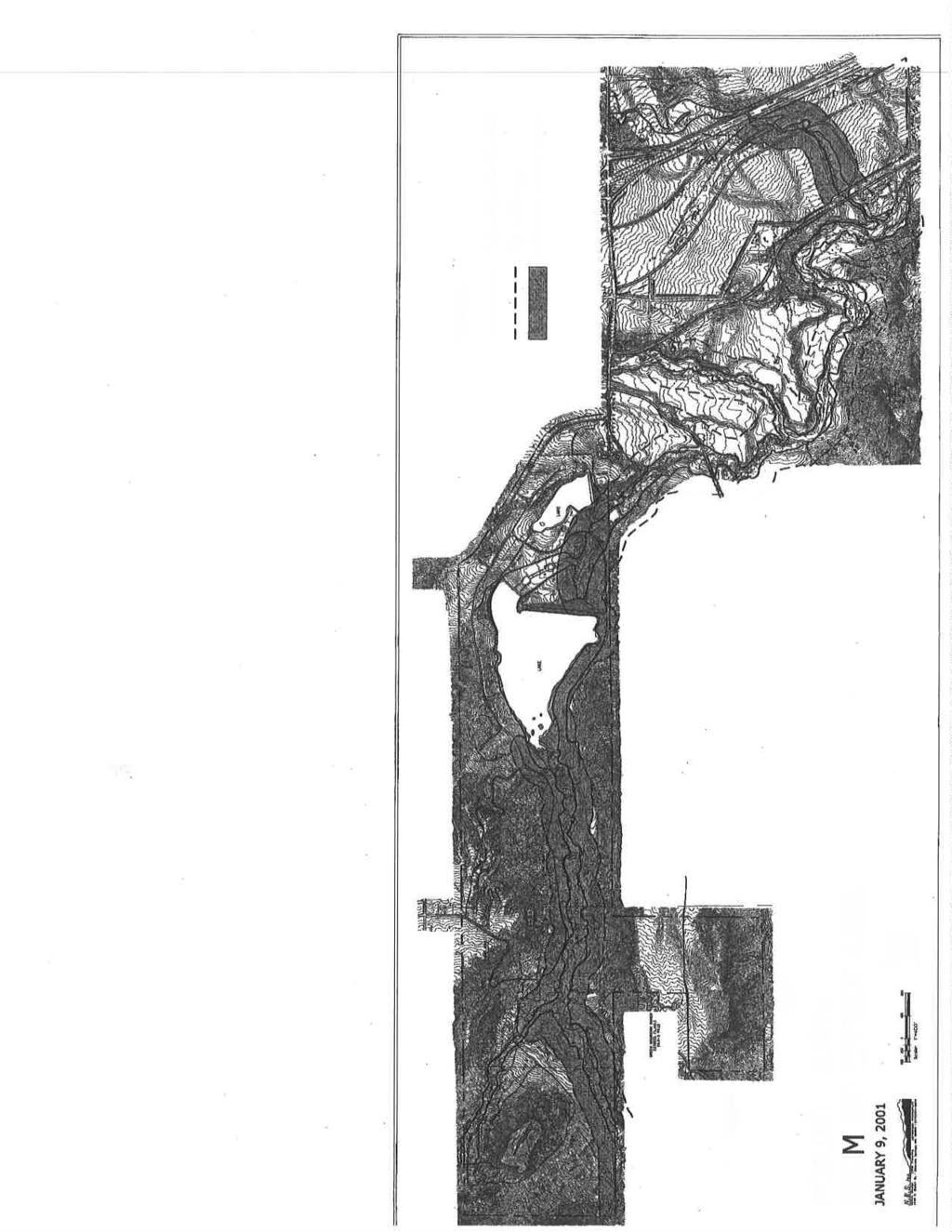
66 66

67 67


68 68

69 69

70 70

71 71

72 72

73 73

74 74

75 75

76 76

77 77
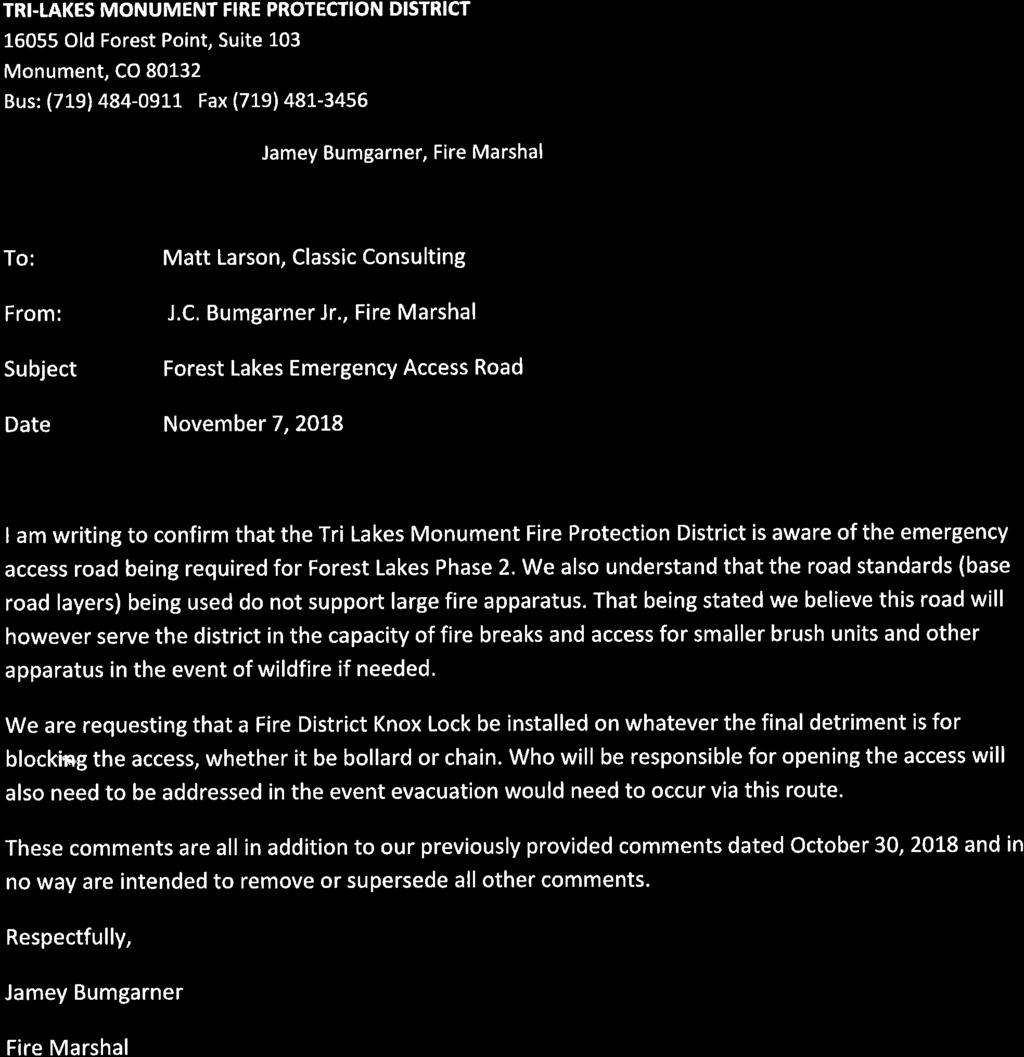
78 78

79 79

80 80


81 81

82 82

83 83

84 84

85 85

86 86

87 87

88 88

89 89

90 90

91 91
92 92


93 93

94 94

95 95

96 96

97 97

98 98

99 99

100 100
Drexel, Barrell & Co.
 Drexel, Barrell & Co. December 21, 2018 Engineers/Surveyors Boulder Colorado Springs Greeley 3 South 7 th Street Colorado Springs, Colorado 80905-1501 719 260-0887 719 260-8352 Fax El Paso County Planning
Drexel, Barrell & Co.
 Drexel, Barrell & Co. June 18, 2018 Engineers/Surveyors Boulder Colorado Springs Greeley 3 South 7 th Street Colorado Springs, Colorado 80905-1501 719 260-0887 719 260-8352 Fax El Paso County Planning
PLANNED UNIT DEVELOPMENT & SUBDIVISION STAFF REPORT Date: May 18, 2017
 & PUD-0000102-2017 PLANNED UNIT DEVELOPMENT & SUBDIVISION STAFF REPORT Date: May 18, 2017 NAME SUBDIVISION NAME Dauphin Creek Estates Subdivision Dauphin Creek Estates Subdivision LOCATION CITY COUNCIL
EXHIBIT B PROJECT NARRATIVE POULSBO MEADOWS
 EXHIBIT B PROJECT NARRATIVE POULSBO MEADOWS Name of Project: Poulsbo Meadows; A Planned Residential Development (PRD)/Plat Applicants Name: PBH Group LLC/Byron Harris PO Box 1010 Silverdale, WA 98038 Description
CONSENT CALENDAR CITY PLANNING COMMISSION AGENDA ITEM NO: A.1, A.2 STAFF: LARRY LARSEN
 Page 8 CONSENT CALENDAR CITY PLANNING COMMISSION AGENDA ITEM NO: A.1, A.2 STAFF: LARRY LARSEN FILE NO: CPC PUZ 14-00013 - QUASI-JUDICIAL FILE NO: CPC PUD 14-00014 QUASI-JUDICIAL PROJECT: APPLICANT: OWNER:
Baumgarten MPUD. Exhibit 3 Evaluation Criteria
 Pursuant to LDC subsections 10.02.13 B, 10.02.08 F and Chapter 3 G. of the Administrative Code, staff s analysis and recommendation to the Planning Commission, and the Planning Commission s recommendation
13. PRELIMINARY PLAT NO MILLS FARM - Vicinity of the southeast corner of 159 th Street and Quivira Road
 13. corner of 159 th Street and Quivira Road 1. APPLICANT: HNTB Corporation is the applicant for this request. 2. REQUESTED ACTION: The applicant is requesting approval of a preliminary plat for a 383-lot
ARTICLE 17 SITE PLAN REVIEW
 ARTICLE 17 SITE PLAN REVIEW 17.01 INTENT AND PURPOSE The intent of this section is to provide for consultation and cooperation between the applicant and the township planning commission so that the applicant
Asbury Chapel Subdivision Sketch Plan
 Asbury Chapel Subdivision Sketch Plan PART 1: PROJECT SUMMARY Applicant: NVR Inc. Project Size: +/- 76.13 acres Parcel Numbers: 02101112,02116101,02116112, 02116113 Current Zoning: Transitional Residential
City of Fort Lupton Administrative Site Plan Process
 City of Fort Lupton Administrative Site Plan Process Purpose The Site Plan process is meant to promote orderly and sound development standards as they apply to the City. These site development standards
R E S O L U T I O N. Single-Family Residence/ Church. 2,488 sq. ft. 2,488 sq. ft. Area Parking Required: Church
 R E S O L U T I O N WHEREAS, the Prince George s County Planning Board is charged with the approval of Detailed Site Plans pursuant to Part 3, Division 9 of the Zoning Ordinance of the Prince George s
Major Subdivision Sketch Plan Checklist
 This checklist provides specific requirements that are apart of the Sketch process. The entire process is described by the Huntersville Subdivision Review Process which details all the submittal and resubmittal
CHAPTER 22 Rural Open Space Community Developments
 CHAPTER 22 Rural Open Space Community Developments Section 22.1 Description and Purpose The intent of this Chapter is to offer property owners an alternative to traditional zoning requirements for rural
PRELIMINARY PLAT DESIGN REQUIREMENTS Updated 4/8/2016
 PRELIMINARY PLAT DESIGN REQUIREMENTS Updated 4/8/2016 The following items are required for the preliminary plat. Numbers correspond with those on the example preliminary plat. RENO COUNTY SUBDIVISION REQUIREMENTS
Note: Staff reports can be accessed at Zone: I-3. Tier:
 The Maryland-National Capital Park and Planning Commission Prince George s County Planning Department Development Review Division 301-952-3530 Note: Staff reports can be accessed at www.mncppc.org/pgco/planning/plan.htm.
AWH REPORT OF THE PLANNING AND DEVELOPMENT DEPARTMENT FOR APPLICATION FOR REZONING ORDINANCE TO PLANNED UNIT DEVELOPMENT
 AWH REPORT OF THE PLANNING AND DEVELOPMENT DEPARTMENT FOR APPLICATION FOR REZONING ORDINANCE TO PLANNED UNIT DEVELOPMENT MAY 8, 2014 The Planning and Development Department hereby forwards to the Planning
ARTICLE V PLANNED UNIT DEVELOPMENT DISTRICT
 ARTICLE V PLANNED UNIT DEVELOPMENT DISTRICT A. Purpose and Objective The Planned Unit Development (PUD) procedure provides a flexible land use and design regulation through the use of performance criteria
SUBDIVISION, PLANNED UNIT DEVELOPMENT, PLANNING APPROVAL, REZONING & SIDEWALK WAIVER STAFF REPORT Date: February 7, 2013
 SUBDIVISION, PLANNED UNIT DEVELOPMENT, PLANNING APPROVAL, REZONING & SIDEWALK WAIVER STAFF REPORT Date: February 7, 2013 APPLICANT NAME SUBDIVISION NAME DEVELOPMENT NAME LOCATION S. E. Cemeteries of AL
Exhibit A. 8:9 Scuffletown Rural Conservation District
 Exhibit A 8:9 Scuffletown Rural Conservation District 8:9.1 Intent and Purpose The Scuffletown Rural Conservation (SRC) District is intended to provide for residential development that supports the development
MOBILE CITY PLANNING COMMISSION LETTER OF DECISION. October 22, 2010
 MOBILE CITY PLANNING COMMISSION LETTER OF DECISION Archbishop of Mobile 400 Government St. Mobile, AL 36602 Re: Case #SUB2010-00075 (Subdivision) 3650 Springhill Avenue (Northwest corner of Springhill
CITY PLANNING COMMISSION AGENDA. ITEM NO(s): C.1 C.3 STAFF: STEVE TUCK
: C.1 C.3 STAFF: STEVE TUCK") Page 34 CITY PLANNING COMMISSION AGENDA ITEM NO(s): C.1 C.3 STAFF: STEVE TUCK FILE NOS: CPC ZC 12-00035 QUASI-JUDICIAL CPC NV 12-00036 QUASI-JUDICIAL AR DP 12-00039 QUASI-JUDICIAL PROJECT: APPLICANT: OWNER:
Page 34 CITY PLANNING COMMISSION AGENDA ITEM NO(s): C.1 C.3 STAFF: STEVE TUCK FILE NOS: CPC ZC 12-00035 QUASI-JUDICIAL CPC NV 12-00036 QUASI-JUDICIAL AR DP 12-00039 QUASI-JUDICIAL PROJECT: APPLICANT: OWNER:
PLANNED UNIT DEVELOPMENT Date: April 5, 2018
 PLANNED UNIT DEVELOPMENT Date: April 5, 2018 DEVELOPMENT NAME SUBDIVISION NAME LOCATION Robert Myers Robert Myers 2955 and 2989 Dauphin Street (Southeast corner of Dauphin Street and Sage Avenue) CITY
Mitchell Ranch South MPUD Application for Master Planned Unit Development Approval Project Narrative. Introduction
 Mitchell Ranch South MPUD Application for Master Planned Unit Development Approval Project Narrative Introduction Mitchell Ranch South is a proposed single family (detached) residential development on
3.10 LAND USE SETTING PROJECT SITE EXISTING LAND USE DESIGNATIONS AND ZONING. General Plan Land Use Designations.
 This section of the Draft EIR addresses the existing land uses on and adjacent to the project site and discusses the potential impacts of the proposed project on existing land uses. Key issues addressed
PART 1: PROJECT SUMMARY. The application is Attachment A. The site plan is Attachment B.
 Belleterre Subdivision Sketch Plan Town Board 8.7.17 Belleterre Subdivision Sketch Plan PART 1: PROJECT SUMMARY Applicant: Bowman Development Project Size: +/- 20.85 acres Parcel Number: 01115104 and 01115121
ARTICLE 6: Special and Planned Development Districts
 ARTICLE 6: Special and Planned Development Districts 6-10 Traditional Neighborhood Development (TND) District 6-10.10 Purpose and Intent The Traditional Neighborhood Development (TND) District provides
12 January 12, 2011 Public Hearing APPLICANT: TAILWIND DEVELOPMENT GROUP,LLC PROPERTY OWNER: CITY OF VIRGINIA BEACH
 12 January 12, 2011 Public Hearing APPLICANT: TAILWIND DEVELOPMENT GROUP,LLC PROPERTY OWNER: CITY OF VIRGINIA BEACH STAFF PLANNER: Faith Christie REQUEST: Conditional Change of Zoning (from PD-H1 Planned
The TimberRidge. Letter of Intent. April 2017
 The Retreat @ TimberRidge Letter of Intent April 2017 (1 st Revision June 2017; 2 nd Revision September 2017) Owners/Developers: Arroya Investments LLC Jacob Decoto 1283 Kelly Johnson Blvd. 23045 Jones
PLANNING COMMISSION. Submitted
 PLANNING COMMISSION City Hall 1275 Main Street El Centro, CA 92243 Submitted PLANNING COMMISSION ACTION ITEM (1844) Meeting: 05/10/16 12:00 AM Department: Community Development Category: Public Hearing
CHAPTER SPECIAL PURPOSE AND OVERLAY ZONING DISTRICTS
 Special Purpose and Overlay Zoning Districts 106.28.010 CHAPTER 106.28 - SPECIAL PURPOSE AND OVERLAY ZONING DISTRICTS SPECIAL PURPOSE AND OVERLAY ZONING DISTRICTS Sections: 106.28.010 - Purpose 106.28.020
CITY PLANNING COMMISSION AGENDA ITEM: C STAFF: ROBERT TEGLER FILE NO: CPC PUD QUASI-JUDICIAL
 CPC AGENDA June 8, 2006 Page 37 CITY PLANNING COMMISSION AGENDA ITEM: C STAFF: ROBERT TEGLER FILE NO: CPC PUD 05-294 - QUASI-JUDICIAL PROJECT: APPLICANT: OWNER: PARKWOOD AT WOLF RANCH NASS DESIGN ASSOCIATES
Town of Windham. Planning Department 8 School Road Windham, ME voice fax
 Town of Windham Planning Department 8 School Road Windham, ME 04062 voice 207.864-5960 fax 207.892.1916 MEMO DATE: TO: Staff Review Committee FROM: Amanda Lessard, Planner Cc: Ellen Rathbone, St. Germain
PLANNED UNIT DEVELOPMENT STAFF REPORT Date: June 2, 2016
 # 9 ZON2016-01032 PLANNED UNIT DEVELOPMENT STAFF REPORT Date: June 2, 2016 DEVELOPMENT NAME JJT Properties LLC LOCATION 1147 & 1151 East I-65 Service Road South and 1180 Sledge Drive (Southeast corner
Chesapeake Bay Critical Area Conservation Plan
 The Maryland-National Capital Park and Planning Commission Prince George s County Planning Department Development Review Division 301-952-3530 Note: Staff reports can be accessed at www.mncppc.org/pgco/planning/plan.htm.
CASE NUMBER: 16SN0701 APPLICANT: Hanky, LLC
 STAFF S ANALYSIS AND RECOMMENDATION Planning Commission (CPC) Public Hearing Date: MAY 17, 2016 CPC Time Remaining: 100 DAYS Applicant s Agent: DANIEL L. CASKIE (804-569-7060) Applicant s Contact: MICHAEL
A BILL FOR AN ORDINANCE TO AMEND CHAPTER 9, KAUAI COUNTY CODE 1987, RELATING TO STREET REQUIRE:MENTS FOR SUBDIVISIONS
 ORDINANCE NO. BILL NO. { vy"yj1j A BILL FOR AN ORDINANCE TO AMEND CHAPTER 9, KAUAI COUNTY CODE 1987, RELATING TO STREET REQUIRE:MENTS FOR SUBDIVISIONS BE IT ORDAINED BY THE COUNCIL OF THE COUNTY OF KAUA'I,
Approved: CITY OF ARDEN HILLS, MINNESOTA PLANNING COMMISSION WEDNESDAY, AUGUST 5, :30 P.M. - ARDEN HILLS CITY HALL
 Approved: CITY OF ARDEN HILLS, MINNESOTA PLANNING COMMISSION WEDNESDAY, AUGUST 5, 2015 6:30 P.M. - ARDEN HILLS CITY HALL PLANNING CASES A. Planning Case 15-016; Final Planned Unit Development Arden Plaza;
Planning Commission Staff Report June 5, 2008
 Owner/Applicant Taylor Village Sacramento Investments Partners, LP c/o Kim Whitney 1792 Tribute Road #270 Sacramento, CA 95815 Staff Recommendation Planning Commission Staff Report Project: File: Request:
PARISH OF ASCENSION OFFICE OF PLANNING AND DEVELOPMENT PLANNING DEPARTMENT. Joint Planning and Zoning Meeting
 1. Call To Order 2. Roll Call of Members 3. Chairman's Comments PARISH OF ASCENSION OFFICE OF PLANNING AND DEVELOPMENT PLANNING DEPARTMENT Joint Planning and Zoning Meeting January 11, 2017 6:00 PM Courthouse
that the Town Board of the Town of East Greenbush will hold a public hearing on April 11,
 TOWN OF EAST GREENBUSH NOTICE OF PUBLIC HEARING PLEASE TAKE NOTICE that the Town Board of the Town of East Greenbush will hold a public hearing on April 11, 2018, at 5:45 p.m. at the East Greenbush Town
 The Park at Fifth Street The Providence Group Legal Description ALL THAT CERTAIN TRACT OF LAND LOCATED IN LAND LOT 279, 18TH DISTRICT, DEKALB COUNTY, GEORGIA, CONSISTING OF FIVE TRACTS: TRACT ONE (PIN:18
Gadsden County Planning Commission Agenda Request
 Date of Meeting: November 16, 2017 To: From: Through: Subject: Gadsden County Planning Commission Agenda Request Honorable Chairperson and Members of the Board Jill A. Jeglie, AICP, Senior Planner Clyde
Procedures IV. V. Rural Road Design Option
 i IV. Procedures A. All applicants required to prepare a Conservation Design Subdivision shall provide the Planning Board with a conceptual conventional subdivision design as well as a proposed layout
Ten Mile Creek Planning Area
 PLANNING AREA POLICIES TEN MILE CREEK Ten Mile Creek Planning Area Location and Context The Ten Mile Creek Planning Area ( Ten Mile Creek area ) is located south of the current Boise AOCI, generally south
PART 1: PROJECT SUMMARY. Proposed Land Use: 120 single-family lots. The application is Attachment A. The site plan is Attachment B.
 PART 1: PROJECT SUMMARY Applicant: JBH Development, LLC and Hopper Communities, INC Project Size: +/- 80.48 acres Parcel Number: 01513107, 01513108, 01513109, 01513113, 01513120, 01513121, 01513122, 01513124,
City of Fort Lupton Site Plan Process
 Form WKBK001 City of Fort Lupton Site Plan Process Purpose The Site Plan process is meant to promote orderly and sound development standards as they apply to the City. These site development standards
D1 September 11, 2013 Public Hearing APPLICANT:
 D1 September 11, 2013 Public Hearing APPLICANT: BEACH MUNICIPAL FEDERAL CREDIT UNION PROPERTY OWNER: SISTERS II, LLC STAFF PLANNER: Karen Prochilo REQUEST: Conditional Change of Zoning (AG-2 Agriculture
TOWNSHIP OF LOGAN SOIL & FILL IMPORTATION AND PLACEMENT APPLICATION SUBMITTAL CHECKLIST
 TOWNSHIP OF LOGAN SOIL & FILL IMPORTATION AND PLACEMENT APPLICATION SUBMITTAL CHECKLIST Applications: 5 copies of application - Applicant will reproduce the copies at his/her costs. The Township Clerk
SPECIFIC PLAN Requirements
 CITY OF LANCASTER PLANNING DEPARTMENT 44933 Fern Avenue, Lancaster, California 93534 (661) 723-6100 SPECIFIC PLAN Requirements Purpose The purpose of a specific plan is to provide for the logical development
SUBMITTAL REQUIREMENTS: FINAL PLAN REVIEW- PROJECT DEVELOPMENT PLAN (PDP)
") 1) Application form and filing fee. Application Form.pdf Development Review Guide STEP 6 of 8 SUBMITTAL REQUIREMENTS: FINAL PLAN REVIEW- PROJECT DEVELOPMENT PLAN (PDP) 2) Transportation Development Review
1) Application form and filing fee. Application Form.pdf Development Review Guide STEP 6 of 8 SUBMITTAL REQUIREMENTS: FINAL PLAN REVIEW- PROJECT DEVELOPMENT PLAN (PDP) 2) Transportation Development Review
City of Yelm. Tahoma Terra Final Master Plan Development Guidelines. Table of Contents
 City of Yelm Tahoma Terra Final Master Plan Development Guidelines Table of Contents Table of Contents... 1 Purpose... 2 Low Density Residential (R4-6)... 3 Moderate Density Residential (R6-10)... 5 Neighborhood
At Your Disposal CUP Amendment, Lot 20, Village Service Commercial, at 128 Bastille Dr. (PLN17-208)
") MEMORANDUM Archuleta County Development Services Planning Department 1122 HWY 84 P. O. Box 1507 Pagosa Springs, Colorado 81147 970-264-1390 Fax 970-264-3338 TO: Archuleta County Planning Commission FROM:
MEMORANDUM Archuleta County Development Services Planning Department 1122 HWY 84 P. O. Box 1507 Pagosa Springs, Colorado 81147 970-264-1390 Fax 970-264-3338 TO: Archuleta County Planning Commission FROM:
COLVER ROAD INDUSTRIAL CONCEPT PLAN
 COLVER ROAD INDUSTRIAL CONCEPT PLAN A CONCEPTUAL LAND USE AND TRANSPORTATION PLAN FOR TA-4 AN URBAN RESERVE AREA OF THE CITY TALENT City of Talent Adopted by City Council Resolution No., June, 2015 PART
ARTICLE VI: SITE PLAN REVIEW
 Section 6.01 - Site Plan Review (All Districts) ARTICLE VI: SITE PLAN REVIEW Site plans give the Planning commission an opportunity to review development proposals in a concise and consistent manner. The
City of Lafayette Study Session Staff Report Design Review Commission
 City of Lafayette Study Session Staff Report Design Review Commission Meeting Date: April 24, 2017 Staff: Payal Bhagat, Senior Planner Subject: HDP18-15 & HDP31-15 Ramesh Patel & Melcor Development (Owners),
Town of Excelsior, Sauk County, Wisconsin DRIVEWAY ORDINANCE
 Town of Excelsior, Sauk County, Wisconsin DRIVEWAY ORDINANCE 1.01 PURPOSE The purpose of this ordinance is to regulate the establishment, construction, improvement, modification or reworking of a driveway
The Maryland-National Capital Park and Planning Commission Prince George's County Planning Department Development Review Division
 The Maryland-National Capital Park and Planning Commission Prince George's County Planning Department Development Review Division 301-952-3530 Note: Staff reports can be accessed at www.mncppc.org/pgco/planning/plan.htm.
THE CITY OF MOBILE, ALABAMA
 THE CITY OF MOBILE, ALABAMA LETTER OF DECISION Ark of Safety, Inc. Mobile, AL 36617 Re: (Northwest corner of Main Street and First Avenue, extending to the Southwest corner of Esau Avenue and Main Street.)
3. VISION AND GOALS. Vision Statement. Goals, Objectives and Policies
 Vision Statement Queen Creek s interconnected network of parks, trails, open spaces and recreation opportunities provide safe and diverse activities and programs that sustain its unique, small town, equestrian
BYLAW C A Bylaw of Rocky View County to amend Land Use Bylaw C
 BYLAW C-7720-2017 A Bylaw of Rocky View County to amend Land Use Bylaw C-4841-97. The Council of Rocky View County enacts as follows: PART 1 TITLE This Bylaw shall be known as Bylaw C-7720-2017. PART 2
Gold Line Bus Rapid Transit Transit Oriented Development (BRTOD) Helmo Station Area Plan
 Helmo Station Area Plan") Appendix F Gold Line Bus Rapid Transit Transit Oriented Development (BRTOD) Helmo Station Area Plan Introduction and Purpose of the Plan The Gold Line Bus Rapid Transit facility is an eleven-mile dedicated
Appendix F Gold Line Bus Rapid Transit Transit Oriented Development (BRTOD) Helmo Station Area Plan Introduction and Purpose of the Plan The Gold Line Bus Rapid Transit facility is an eleven-mile dedicated
Town of Portola Valley General Plan. Nathhorst Triangle Area Plan
 Town of Portola Valley General Plan Amended December 10, 1997 Table of Contents Introduction... 1 Planning Area... 1 Objectives... 2 Principles... 2 Standards... 4 Description... 4 Community Commercial...
CITY PLANNING COMMISSION AGENDA ITEMS: C.1, C.2 STAFF: MEGGAN HERINGTON FILE NO(S): CPC PUZ QUASI-JUDICIAL CPC PUD QUASI-JUDICIAL
: CPC PUZ QUASI-JUDICIAL CPC PUD QUASI-JUDICIAL") Page 32 CITY PLANNING COMMISSION AGENDA ITEMS: C.1, C.2 STAFF: MEGGAN HERINGTON FILE NO(S): CPC PUZ 13-00036 QUASI-JUDICIAL CPC PUD 13-00037 QUASI-JUDICIAL PROJECT: APPLICANT: OWNER: ESTANCIA AT CORDERA
Page 32 CITY PLANNING COMMISSION AGENDA ITEMS: C.1, C.2 STAFF: MEGGAN HERINGTON FILE NO(S): CPC PUZ 13-00036 QUASI-JUDICIAL CPC PUD 13-00037 QUASI-JUDICIAL PROJECT: APPLICANT: OWNER: ESTANCIA AT CORDERA
Michael D, Harvey, Current Planning Supervisor. This project was originally approved in 2012 by the BOCC and is summarized as follows:
 PLANNING & INSPECTIONS DEPARTMENT Craig N. Benedict, AICP, Director Current Planning (919) 245-2575 (919) 644-3002 (FAX) www.orangecountync.gov 131 W. Margaret Lane Suite 201 P. O. Box 8181 Hillsborough,
COUNTY COUNCIL OF PRINCE GEORGE'S COUNTY, MARYLAND SITTING AS THE DISTRICT COUNCIL 2010 Legislative Session. Council Members Dernoga and Olson
 DR- COUNTY COUNCIL OF PRINCE GEORGE'S COUNTY, MARYLAND SITTING AS THE DISTRICT COUNCIL 00 Legislative Session Bill No. CB--00 Chapter No. Proposed and Presented by Introduced by Co-Sponsors The Chairman
Staff Report CONDITIONAL USE
 Staff Report PLANNING DIVISION COMMUNITY & ECONOMIC DEVELOPMENT To: From: Salt Lake City Planning Commission Daniel Echeverria, (801) 535-7165, daniel.echeverria@slcgov.com Date: May 21, 2015 Re: PLNPCM2015-00139
City of Lafayette Study Session Staff Report Design Review Commission
 ++ City of Lafayette Study Session Staff Report Design Review Commission Meeting Date: January 08, 2018 Staff: Subject: Chris Juram, Planning Technician SS12-17 Miramar Homebuilders, R-20 Zoning: Request
O l so n M e morial Highway, S t e , G o l d e n V a l l e y, MN Delano Laketown Homes Concept Plan
 N O R T H W E S T A S S O C I A T E D C O N S U L T A N T S, I N C. 4 1 5 0 O l so n M e morial Highway, S t e. 3 2 0, G o l d e n V a l l e y, MN 5 5 4 2 2 T e l e p h o n e : 7 6 3. 9 5 7. 1 1 0 0 W
Chapter 13: Implementation Plan
 Implementation A. Introduction The Implementation Plan, in table form on the following pages, provides a summary of all the Action Items recommended in Chapters 2 through 12. The table also indicates which
PLANNING APPROVAL & PLANNED UNIT DEVELOPMENT Date: November 2, 2017
 PLANNING APPROVAL & PLANNED UNIT DEVELOPMENT Date: November 2, 2017 DEVELOPMENT NAME LOCATION Mobile Christian School 5900 Cottage Hill Road (North side of Cottage Hill Road, 230 ± West of Freemont Drive
Design Review Application *Please call prior to submittal meeting to determine applicable fees*
 CITY OF EAGLE 660 E. Civic Lane, Eagle, ID 83616 Phone#: (208) 939-0227 Fax: (208) 938-3854 Design Review Application *Please call prior to submittal meeting to determine applicable fees* FILE NO.: CROSS
North Oakville East Parks Facilities Distribution Plan. November, 2009
 North Oakville East November, 2009 POLICY CONTEXT 1) Purpose a) The purpose of this document is to be a guide for the location, configuration, design and development of the parks system for the North Oakville
ARTICLE IV: DEVELOPMENT STANDARDS 404 MASTER PLANNING
 IV 13 404 MASTER PLANNING Master Planning through the Site Analysis (Master Planning Site Analysis) or Planned Development (Master Planning Planned Development) is provided to encourage development which
1. Request: The subject application is for approval of a gymnasium addition to an existing private school and church.
 R E S O L U T I O N WHEREAS, the Prince George's County Planning Board is charged with the approval of Detailed Site Plans pursuant to Part 3, Division 9 of the Zoning Ordinance of the Prince George's
CITY OF ZEELAND PLANNING COMMISSION
 APPLICATION FOR SITE PLAN REVIEW AND SPECIAL LAND USE Date City Official App. Filing Fee Rec'd ($350) NOTE TO APPLICANT: Please submit this application for Site Plan Review along with twenty (20) copies
STAFF SUMMARY FOR S17-02 SPECIAL USE PERMIT APPLICATION
 APPLICATION SUMMARY Case Number: S17-02 Request: STAFF SUMMARY FOR S17-02 SPECIAL USE PERMIT APPLICATION SUP application in order to develop a convenience food store. Applicant: Property Owner(s): Cindee
Watertown City Council
 City of Watertown Watertown City Council April 14 th, 2015 Agenda Item: City Comment on Sun Share CUP Application Request for Action: Motion to Approve City Comments regarding CUP Application Department:
MONTGOMERY COUNTY PLANNING DEPARTMENT
 MONTGOMERY COUNTY PLANNING DEPARTMENT THE MARYLAND-NATIONAL CAPITAL PARK AND PLANNING COMMISSION MCPB Item No.: Date: 5-03-18 Pike and Rose, Phase I: Site Plan Amendment No. 82012002D Rhoda Hersson-Ringskog,
Planned Development Review Revisions (Project No. PLNPCM )
") Planned Development Review Revisions (Project No. PLNPCM2014-00139) Standard residential development Planned Development Example: Smaller lot sizes than what is allowed to create open space amenity. What
Planned Development Review Revisions (Project No. PLNPCM2014-00139) Standard residential development Planned Development Example: Smaller lot sizes than what is allowed to create open space amenity. What
GENERAL INFORMATIONaaaaaaaaaaaaaaaaaaaaaaaaaaaaaaaa
 To: Planning and Zoning Commission From: City Staff Date: November 15, 2016 Re: Case #16026 Raymore Activity Center Site Plan GENERAL INFORMATIONaaaaaaaaaaaaaaaaaaaaaaaaaaaaaaaa Applicant/ Property Owner:
WHEREAS, after consideration of the evidence presented at the public hearing on January 14, 2010, the Prince George's County Planning Board finds:
 R E S O L U T I O N WHEREAS, the Prince George s County Planning Board has reviewed DDS-600 requesting a departure for the location of two loading spaces without driveway access along Toledo Terrace in
OP Council Resolution June 16, Planning and Development Services
 OP-08-01 Council Resolution June 16, 2008 Planning and Development Services Kingsgate Landing Outline Plan Table of Contents 1.0 Introduction 1 1.1 Purpose of Plan 1 1.2 Plan Area Location 1 1.3 Ownership
2.4 FUTURE LAND USE ELEMENT Goals, Objectives and Policies
 GOAL 1: To create developmental patterns that direct future growth to appropriate areas on campus, in a manner that promotes the educational mission of the University, the protection of environmentally
CITY COUNCIL STUDY SESSION MEMORANDUM
 City and County of Broomfield, Colorado CITY COUNCIL STUDY SESSION MEMORANDUM To: From: Prepared by: Mayor and City Council Charles Ozaki, City and County Manager Kevin Standbridge, Deputy City and County
#8) T-1409 CENTENNIAL & LAMB TENTATIVE MAP
 T-1409 CENTENNIAL & LAMB TENTATIVE MAP") #8) T-1409 CENTENNIAL & LAMB TENTATIVE MAP STAFF REPORT To: Planning Commission Meeting Date: June 14, 2017 Item: T-1409 Prepared By: Robert Eastman GENERAL INFORMATION: Applicant: Property Owner(s): Requested
#8) T-1409 CENTENNIAL & LAMB TENTATIVE MAP STAFF REPORT To: Planning Commission Meeting Date: June 14, 2017 Item: T-1409 Prepared By: Robert Eastman GENERAL INFORMATION: Applicant: Property Owner(s): Requested
REQUEST Current Zoning: O-15(CD) (office) Proposed Zoning: TOD-M(CD) (transit oriented development mixed-use, conditional)
 (office) Proposed Zoning: TOD-M(CD) (transit oriented development mixed-use, conditional)") Rezoning Petition 2016-117 Zoning Committee Recommendation January 4, 2017 REQUEST Current Zoning: O-15(CD) (office) Proposed Zoning: TOD-M(CD) (transit oriented development mixed-use, conditional) LOCATION
Rezoning Petition 2016-117 Zoning Committee Recommendation January 4, 2017 REQUEST Current Zoning: O-15(CD) (office) Proposed Zoning: TOD-M(CD) (transit oriented development mixed-use, conditional) LOCATION
MASTER DEVELOPMENT DRAINAGE PLAN FOR MONUMENT HEIGHTS
 MASTER DEVELOPMENT DRAINAGE PLAN FOR MONUMENT HEIGHTS DRAINAGE REPORT STATEMENT ENGINEER'S STATEMENT: The attached drainage plan and report were prepared under my direction and supervision and are correct
Application Number: SD Project Name: Walton Farms Preliminary Subdivision (acting as Master Plan)
") STAFF REPORT Town of Clayton Planning Department 111 E. Second Street, Clayton, NC 27520 P.O. Box 879, Clayton, NC 27528 Phone: 919-553-5002 Fax: 919-553-1720 Planning Board May 22, 2017 Application Number:
STAFF REPORT Town of Clayton Planning Department 111 E. Second Street, Clayton, NC 27520 P.O. Box 879, Clayton, NC 27528 Phone: 919-553-5002 Fax: 919-553-1720 Planning Board May 22, 2017 Application Number:
Staff Report and Recommendation
 Community Planning and Development Planning Services 201 W. Colfax Ave., Dept. 205 Denver, CO 80202 p: 720.865.2915 f: 720.865.3052 www.denvergov.org/cpd TO: City Council Neighborhoods and Planning Committee
Urban Planning and Land Use
 Urban Planning and Land Use 701 North 7 th Street, Room 423 Phone: (913) 573-5750 Kansas City, Kansas 66101 Fax: (913) 573-5796 Email: planninginfo@wycokck.org www.wycokck.org/planning To: From: City Planning
General Location Courtyard at LMH Final Development Plan and Final Plat
 R-1 LEYDEN RIDGE LOMA RIDGE LOBDELL R-3 MILLER PARKWAY LAUSSAC Subject Property R-3 LOCHENSHIRE LESMER R General Location Courtyard at LMH Final Development Plan and Final Plat ¹ 230 115 0 230 Feet Airport
Project Narrative For Fruita RV Resort Conditional Use Permit
 Project Narrative For Fruita RV Resort Conditional Use Permit Date: November 18, 2016 Prepared by: Robert W. Jones, II, P.E. Vortex Engineering & Architecture, Inc. 2394 Patterson Rd., Ste. 201 Grand Junction,
9 th Street Sub Area Plan
 9 th Street Sub Area Plan In the 1990 s, when the Township prepared the last Master Plan, the 9 th Street corridor was studied as part of a larger 9 th Street Focus Area that included the West Main Street
Village of Glenview Plan Commission
 Village of Glenview Plan Commission STAFF REPORT January 22, 2019 TO: Chairman and Plan Commissioners CASE #: P2018-047 FROM: Community Development Department CASE MANAGER: Tony Repp, Senior Planner SUBJECT:
SUBDIVISION, REZONING, PLANNING APPROVAL, PUD & SIDEWALK WAIVER STAFF REPORT Date: May 3, 2007
 SUBDIVISION, REZONING, PLANNING APPROVAL, PUD & SIDEWALK WAIVER STAFF REPORT Date: May 3, 2007 APPLICANT NAME SUBDIVISION NAME LOCATION TOG Properties, LLC Highland Professional Park, Resubdivision of
DRIVEWAY REGULATIONS
 TOWN OF NEW LONDON PLANNING BOARD DRIVEWAY REGULATIONS INSTRUCTIONS TO APPLICANTS FOR THE CONSTRUCTION OR ALTERATION OF DRIVEWAYS IMPORTANT: READ CAREFULLY BEFORE FILLING OUT ATTACHED APPLICATION Revised
SUBMITTAL REQUIREMENTS
 WHEN PROCESS TYPE III IS USED References to Process Type III applications are found in several places in the Milton Municipal Code (MMC), indicating that the development, activity, or use, is permitted
Planning Commission April 4, 2013 BOCC Workshop Page 1
 Planning Commission April 4, 2013 BOCC Workshop Page 1 Planning Commission April 4, 2013 BOCC Workshop Page 2 Planning Commission April 4, 2013 BOCC Workshop Page 3 Planning Commission April 4, 2013 BOCC
11605 JUDGE ORR ROAD PUD (PLANNED UNIT DEVELOPMENT) PLAN LETTER OF INTENT:
 PLAN LETTER OF INTENT:") Est. 1982 Bill Guman, RLA, ASLA Principal Colorado Springs City Councilman 1993-2001 Colorado Springs Planning Commissioner 1992-1993 Regional Building Commissioner 1995-2001 Urban Planning Community Design
Est. 1982 Bill Guman, RLA, ASLA Principal Colorado Springs City Councilman 1993-2001 Colorado Springs Planning Commissioner 1992-1993 Regional Building Commissioner 1995-2001 Urban Planning Community Design
Chapter 3 Site Planning and Low Impact Development
 CHAPTER 3 Site Planning and Low Impact Development Chapter 3 Site Planning and Low Impact Development 3.0 Introduction The City of Charleston requires that major residential, large commercial (>1 acre),