Nith Peninsula Area Study & Supporting Technical Reports Paris, Ontario / County of Brant December 2008 (Updated June 2009)
|
|
|
- Cornelius Atkins
- 5 years ago
- Views:
Transcription

 Prepared")


1 Nith Peninsula Area Study & Supporting Technical Reports Paris, Ontario / County of Brant December 2008 (Updated June 2009) Prepared by: MHBC Planning With Input From: J.H. Cohoon Engineering Limited Ecoplans Limited Naylor Engineering Associates Ltd. Paradigm Transportation Solutions Ltd.
2 TABLE OF CONTENTS Page No. Introduction... 3 Background & Pre-Consultation... 4 Area Study Requirements... 5 Location of Study Area... 6 Existing Land Uses... 7 County of Brant Official Plan Designations... 8 Land Use Type and Intensity... 9 Preferred Concept Plan Design Traffic Impact & Circulation Pedestrian Movement Municipal Services Amount & Location of Neighbourhood Open Space Landscaping Buildings of Architectural and/or Historical Significance Subwatershed Planning Minimum Distance Separation Consistency with Provincial Policy Statement, Growth Plan and County of Brant Official Plan APPENDICES Zoning By-law Amendment and Plan of Subdivision Planning Analysis (MHBC Planning)... 1 Functional Servicing Study (J.H. Cohoon Engineering Limited)... 2 Scoped Environmental Impact Study (Ecoplans Limited)... 3 Traffic Impact Study (Paradigm Transportation Solutions)... 4 Geotechnical Investigation & Slope Stability Assessment (Naylor Engineering Associates Ltd.)... 5 Hydrogeological Investigation (Naylor Engineering Associates Ltd.)... 6 Waste Disposal Report (Ecolog Eris)... 7 Financial Impact Analysis (Hemson Consulting Ltd.)... 8 Tab Nith Peninsula Area Study Paris, Ontario / County of Brant December 2008 (Updated June, 2009) 2


; Scoped Environmental Impact Study (Ecoplans Limited); Preliminary Geotechnical Investigation (Naylor Engineering Associates Ltd.")
3 M INTRODUCTION MHBC Planning has been retained by Mr. Steve Kulmatycky and Mr. Domenic Zavarella to complete an Area Study for the Nith Peninsula, as required by Sections 2.4 and of the County of Brant Official Plan. The intent of this Area Study is to determine the most appropriate urban structure for the last undeveloped parcels within the study area. The lands within the Area Study boundary contain the last two large undeveloped parcels within the Settlement Area of central Paris. These parcels are owned by Mr. Steve Kulmatycky and Mr. Domenic Zavarella and are together known as the Kulmatycky / Zavarella lands. The area study relies on technical reports and information that have been prepared in support of a Zoning By-law Amendment and draft plan, a subdivision application for the Kulmatycky/Zavarella lands. The completed technical reports are included as part of the Area Study: Planning Analysis (MHBC Planning); Functional Servicing Study (J.H. Cohoon Engineering Limited); Scoped Environmental Impact Study (Ecoplans Limited); Preliminary Geotechnical Investigation (Naylor Engineering Associates Ltd.); Slope Stability Assessment (Naylor Engineering Associates Ltd.); Hydrogeological Investigation (Naylor Engineering Associates Ltd.); Traffic Impact Study (Paradigm Transportation Solutions); Financial Impact Analysis (Hemson Consulting Ltd.); and Waste Disposal Report (Ecolog Eris). J.H. Cohoon Engin Nith Peninsula Area Study Paris, Ontario / County of Brant December 2008 (Updated June, 2009) 3
4 BACKGROUND & PRE-CONSULTATION The preparation of the Area Study commenced in January 2006 and included the Kulmatycky/Zavarella lands which are predominantly the last undeveloped parcels within the Study Area except for two parcels owned by the County of Brant. In May 2008, the County of Brant expanded the Study Area to include the existing developed area and the two parcels owned by the County. The Area Study now encompasses all lands within the Nith Peninsula, bounded by the Nith River to the north, east and west, and by Highway 2 (King Street) and the northern boundary of the Southwest Paris Community Design Plan to the south. The following is a summary of the timelines and pre-consultation associated with the Area Study. January, Technical studies in support of the Area Study commenced. March 10, MHBC Planning advised the County of Brant that an Area Study was being prepared, and advised of its contents. July 7, MHBC Planning provided the work plan for the Area Study to the County of Brant. October 31, 2006 and March 4, Pre-consultation meetings were held with County of Brant staff to discuss the details of the Area Study and associated development applications. May 4, The County of Brant prepared a report and expanded the Area Study boundaries to include all lands within the Nith Peninsula, bounded by the Nith River to the north, east and west, and by Highway 2 (King Street) and the northern boundary of the Southwest Paris Community Design Plan to the south. May 7, 2008 MHBC sent a letter to the County of Brant confirming the extent of the lands to be included in the Area Study. December, Submission of Area Study to County of Brant. June 17, Introduction of Concept Plan at Zoning By-Law. Nith Peninsula Area Study Paris, Ontario / County of Brant December 2008 (Updated June, 2009) 4
 states: It is a policy of this Plan that area studies may be prepared by the County of Brant to assist in the implementation of the policies of this Plan and to provide guidance for the")
5 M AREA STUDY REQUIREMENTS Prior to the development of the Kulmatycky/Zavarella lands, the County of Brant Official Plan (Section 2.4) states: It is a policy of this Plan that area studies may be prepared by the County of Brant to assist in the implementation of the policies of this Plan and to provide guidance for the preparation and evaluation of regional facility and community facility development proposals. Area studies may deal with: 1. Land use type and intensity; 2. On-site and off-site parking; 3. Road network and traffic circulation; 4. Pedestrian movement; 5. Municipal services; 6. Amount and location of neighbourhood open space; 7. Landscaping; 8. Presence of buildings of architectural and/or historical significance and location of registered archaeological sites and/or lands of archaeological potential; 9. Subwatershed planning; and/or 10. Traffic impact; 11. Minimum Distance Separation from intensive livestock operations located in the abutting Agricultural Designation. This Area Study has been completed using the above layout in order to be consistent with the requirements of the County of Brant Official Plan; however, additional information has been included in support of the development applications on the Kulmatycky / Zavarella lands. Nith Peninsula Area Study Paris, Ontario / County of Brant December 2008 (Updated June, 2009) 5
.")
6 LOCATION OF STUDY AREA This Area Study encompasses all lands within the Nith Peninsula, bounded by the Nith River to the north, east and west, and by Highway 2 (King Street) and the northern boundary of the Southwest Paris Community Design Plan to the south. In total, the study area is approximately 135 ha (333 acres). Nith Peninsula Area Study Paris, Ontario / County of Brant December 2008 (Updated June, 2009) 6
7 EXISTING LAND USES The study area consists of developed lands, rural lands and environmentally sensitive lands, however, the only remaining undeveloped lands aside from a parcel owned by the County of Brant are the Kulmatycky / Zavarella lands. The southern section of the Study Area consists of two existing institutional uses: the Paris Cemetery and Queen s Ward Public School. Surrounding these institutional uses are low density residential uses in the form of a residential neighbourhood. East of the residential neighbourhood is located medium density residential in the form of 2 apartment buildings. North and west of the residential uses is the Nith peninsula, consisting of agricultural (cash crop) lands located on a plateau. Surrounding the agricultural (cash crop) lands are woodlands associated with the valley slope and wetlands associated with the adjacent Nith River. Nith Peninsula Area Study Paris, Ontario / County of Brant December 2008 (Updated June, 2009) 7

8
9 COUNTY OF BRANT OFFICIAL PLAN DESIGNATIONS The Study area is designated as follows, as per the County of Brant Official Plan: Institutional - Generally located in the southern section of the Study Area where the Paris Cemetery and Queen s Ward Public School are located. Low Density Residential - Generally surrounding the lands designated Institutional in the form of a residential neighbourhood. Medium Density Residential - Generally located east of the residential neighbourhood in the form of 2 apartment buildings. Agricultural with Residential Future Growth Direction Arrows - Generally located north and west of the lands designated low density residential, in the form of agricultural lands (cash crops). Natural Environment & Woodlands - Generally surrounding the agricultural (cash crop) lands are woodlands associated with the valley slope and wetlands associated with the Nith River. Nith Peninsula Area Study Paris, Ontario / County of Brant December 2008 (Updated June, 2009) 8
10


11 LAND USE TYPE AND INTENSITY Existing land uses and intensities in the Nith Peninsula study area include the following: A large, central area that is currently used for agricultural (cash crop) purposes. Existing low and medium density development in the form of single detached dwellings in the southern area of the study area, and medium density residential uses in the form of apartments on the eastern portion of the study area. Two Institutional uses are located in the southern portion of the study area in the forms of the Paris Cemetery and Queen s Ward Public School. Victoria Park is located in the southern area of the study area, and Lions Park, which includes a community swimming pool, is located along the majority of the eastern boundary of the study area. Natural and cultural resources that could be highlighted in highquality neighbourhood design. Proposed land uses and intensities in the Study Area are illustrated in the Preferred Concept Plan. In summary: J.H. Cohoon E Naylor Enginee Paradigm Transport Residential development will be extended northward from the existing residential subdivision along Churchill Drive. This residential development will consist of a mix of single detached dwellings, semi-detached dwellings, street rowhouses and three areas for medium density residential uses which may be in the form of low-rise apartment condominiums. Densities will be higher than the existing low-density neighbourhood; the new development will offer approximately 14.5 to 16.5 units per hectare. Two neighbourhood parks are proposed for active recreation. Stormwater management ponds are proposed in the northern and southern areas of the Kulmatycky / Zavarella lands. These ponds will be naturalized with native plant species for increased visual appeal and natural habitat creation. Low-growing native vegetation will be used in the northern pond to protect the views and vistas over downtown Paris and beyond. A paved pedestrian trail will connect the community to Laurel Street / Lions Park, where a pedestrian bridge exists to access downtown Paris. This will further connect the community with the surrounding community, as well as provide a pedestrian-friendly means of accessing downtown Paris. Nith Peninsula Area Study Paris, Ontario / County of Brant December 2008 (Updated June, 2009) 9
12
13 LAND USE TYPE AND INTENSITY The appropriate development of the last undeveloped parcels within the Study Area: Is a logical extension of development into last undeveloped area in central Paris, which is identified as a Growth Area by the County s Official Plan. Would assist County of Brant in meeting its Provincial Growth Plan targets for an identified Settlement Area. Offers the opportunity to create a well integrated community that is connected to the existing community at multiple points. Offers opportunities to take advantage of the site s views and vistas. The Concept Plan allows for the following: Integration with the surrounding area Neighbourhood parks and natural environment protection areas Tree lined streets Paved pedestrian trail linking the community with downtown Paris A modified grid promotes pedestrian and vehicular connectivity Connection to existing parks Wide range of housing types Having moderate block lengths and situating front doors to the street fosters eyes on the street and creates a safer community Enhanced landscaping marks entrances to the community Nith Peninsula Area Study Paris, Ontario / County of Brant December 2008 (Updated June, 2009) 10
14


15 PREFERRED CONCEPT PLAN DESIGN The Preferred Concept Plan provides a design outline for the last remaining undeveloped parcels to be integrated with the existing developed areas within the Study Area. Because of their large area and proximity to downtown Paris, the appropriate development of these lands is pivotal to the social and economic success of the Paris area. To ensure that the proposed development results in a successful community that is rich in character, the following eight design goals have been identified and implemented through the Preferred Concept Plan: 1. Walkability To create walkable neighbourhoods that are well connected and fully accessible to major destinations and the surrounding community. The development will offer internal pedestrian linkages, ample sidewalks as well as connections to downtown Paris. 2. Variety To provide a range of housing types and neighbourhood focal points. The development offers a variety of single detached, semi-detached, street rowhouse and apartment dwellings that will be located in unique settings. 3. Placemaking To create streetscape quality, and contribute to the historic neighbourhood character and sense of place. The urban design and architecture has focused on building upon Paris s historic sense of place. 4. Conservation To conserve, protect and integrate existing natural and cultural heritage resources. The vast majority of the site is dedicated to natural and cultural conservation purposes. 5. Connectivity To provide multiple route options for multiple modes of travel. Three road connections will connect the community to the neighbouring residential area. In addition, a connected system of natural area and walkways will further connect the community with the adjacent neighbourhood, parks as well as downtown Paris. 6. Transit Supportive To design and build neighbourhoods that provide access to and support for public transit. The community has been designed to accommodate future public transit expansion in Paris. Nith Peninsula Area Study Paris, Ontario / County of Brant December 2008 (Updated June, 2009) 11
16

17 PREFERRED CONCEPT PLAN DESIGN 7. Safety To promote a proactive design that contributes to neighbourhood safety. Eyes on the street, traffic calming and enhanced crosswalks and sidewalks will be incorporated into the community to promote a safe community. 8. Liveability To promote design solutions that contribute to sustainable practices, the celebration of arts and culture and foster healthy communities. The conservation and focus on natural and cultural resources, as well as an increased focus on the pedestrian scale will significantly add to the liveability of this community. The Preferred Concept Plan protects significant natural features while providing for pedestrian-oriented amenities: 60% of the Kulmatycky / Zavarella lands, including the Nith Valley Corridor, will remain undeveloped. These undeveloped lands could be used for environmental conservation and / or outdoor recreation and public education. The existing wetland in the northern portion of the site will be retained and protected. A paved pedestrian trail will connect the community to Downtown Paris and emphasize the pedestrian scale. Vision: The Nith Peninsula is being designed as a community for people to live in harmony with nature and support Downtown Paris through pedestrian connections. M J.H. Cohoon Engin Ec Naylor Engineering Paradigm Transportation N Two neighbourhood parks are proposed to supplement the high level of service that is currently being provided by the existing Victoria and Lions Parks. Regarding architectural style, traditional / heritage architectural style will be coupled with innovative building design. This combination will provide an attractive pedestrian streetscape that is reminiscent of Paris s rich history. Nith Peninsula Area Study Paris, Ontario / County of Brant December 2008 (Updated June, 2009) 12
18

; Designing the lot layouts with the minimum allowable font yard setback, thereby shrinking the distance between the private and public realm; Implementing enhanced architectural design in")
19 PREFERRED CONCEPT PLAN DESIGN This can be achieved by: Making available a variety of housing forms and sizes and a variety of lot sizes; Incorporation of heritage architectural elements (i.e. wrap-around porches, shutters, bay windows and balconies); Designing the lot layouts with the minimum allowable font yard setback, thereby shrinking the distance between the private and public realm; Implementing enhanced architectural design in key locations such as on corner lots, gateway lots and terminating vista lots; Reinforcing street edges; Providing for variation in façade and building materials; Offering a range of housing types (i.e. street rowhouses, semi- detached and single detached dwellings); Orienting the front door toward streets; Designing houses with flush or recessed garages; Architecturally treating garage doors. Providing for transitions in roof heights. For additional details, see Appendix 1 for a copy of the Planning Report, prepared by MHBC Planning. Nith Peninsula Area Study Paris, Ontario / County of Brant December 2008 (Updated June, 2009) 13

20


21 TRAFFIC IMPACT & CIRCULATION The study area is well serviced by an existing road network consisting of two Collector Roads and a series of Local Roads. The existing road network is a modified grid street pattern. The County s Official Plan identifies Dundas Street and King Street as Collector Roads that carry moderate levels of traffic volume. All other roads in within the Area Study are identified as Local roads. M There are three points of access to the residential area north of Dundas Street: Laurel Street, Barker Street and Gort Ave. These points of access all have direct access to Dundas Street. Dundas Street West collector road connects the study area to downtown Paris. The proposed development would extend the existing modified grid street pattern, and Includes a fourth access point from Dundas Street, thereby connecting the proposed development to the existing community in 4 locations. Incorporates a Minor Collector ring-road to provide an efficient movement of daily and emergency vehicular traffic throughout the development. Proposes 20m right-of-ways to allow high quality urban design, including boulevards and sidewalks. J.H. Cohoon Engin Ec Naylor Engineering Paradigm Transportation N Utilizes medians and entrance features to create sense of place and heighten aesthetic appeal. Incorporates moderate block lengths to facilitate pedestrian access. Focuses on local roads to provide pedestrian friendly environment. A Traffic Impact Study has been completed which considered existing and anticipated traffic volumes. This study recommended the following: Traffic control signals be considered at King Street and Dundas Street West easterly intersection to accommodate future total traffic volumes; The addition of a northbound left-turn lane at the King Street and Dundas Street W easterly intersection will improve the level of service conditions at this intersection. For additional details, see Appendix 4 for a copy of the Traffic Impact Study, completed by Paradigm Transportation Solutions. Nith Peninsula Area Study Paris, Ontario / County of Brant December 2008 (Updated June, 2009) 14
22


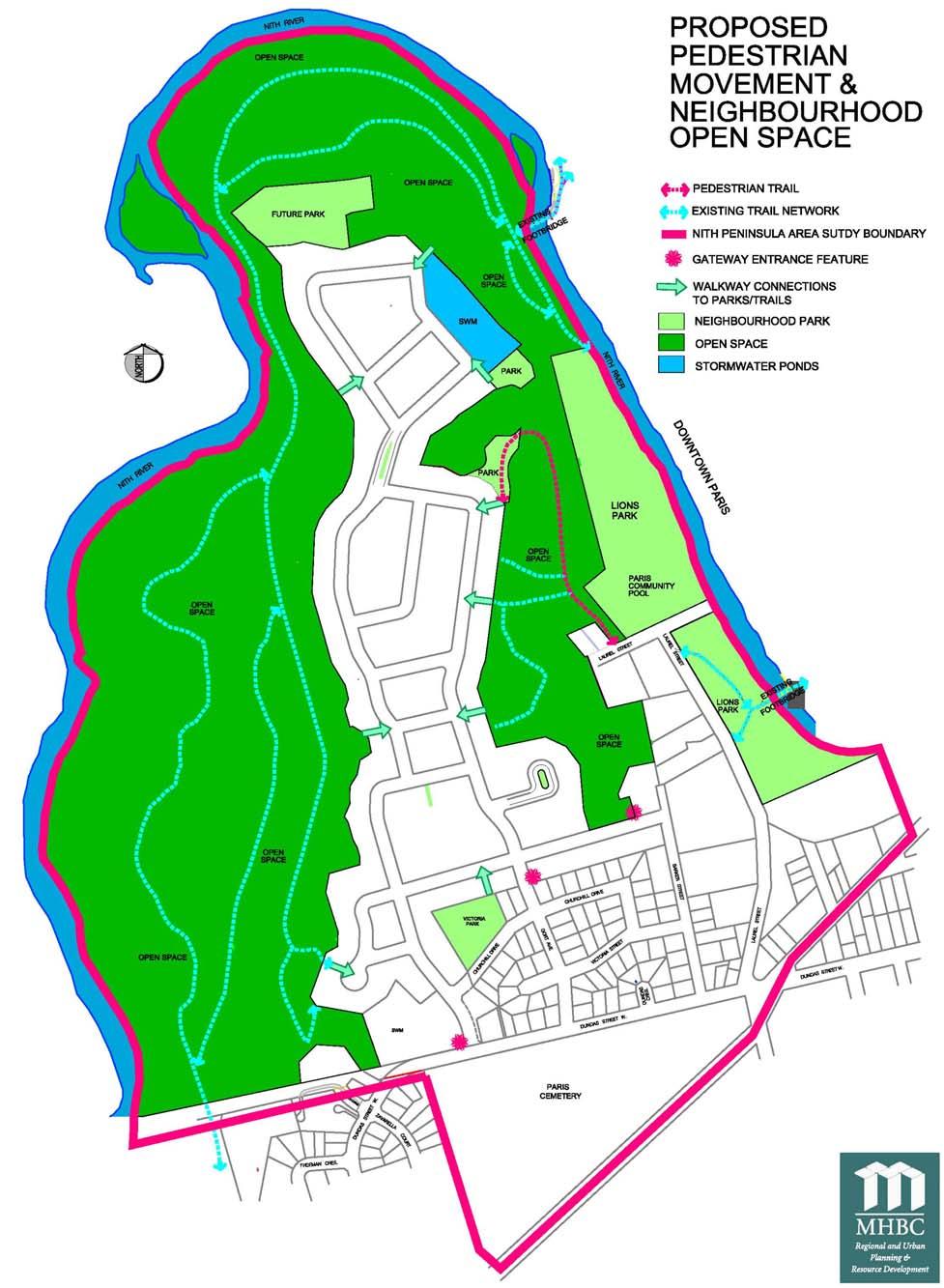
23 PEDESTRIAN MOVEMENT The study area is partially serviced by sidewalks. Sidewalks are located along the northern portion of King Street and Dundas Street throughout the study area, as well as along the majority of the streets in the existing residential development. Pedestrian trails exist throughout the Paris Cemetery as well as through a portion of Lions Park. The trail located through Lions Park connects Barker Street to the existing pedestrian bridge that crosses the Nith River, providing pedestrian access to downtown Paris. The development proposed on the Kulmatycky / Zavarella lands will offer a high degree of pedestrian movement. The Preferred Concept Plan has been designed with the following objectives in order to ensure a pedestrian-friendly environment: To be highly walkable. All residents will be within close proximity to internal pedestrian linkages and the trail system, including the main paved trail linking the development with the Lions Park trail and downtown Paris. To incorporate interconnected street / block pattern (modified grid). To provide a range of block lengths. To include multiple pedestrian and vehicular connections. M J.H. Cohoon Engin Ec Naylor Engineering Paradigm Transportation To include multiple gateways and focal points. To be an integrated, pedestrian-scaled community. N More specific design strategies that have been implemented to create a pedestrian-friendly environment include: A paved pedestrian trail to link the community with downtown Paris and decrease reliance on automobile travel. 20 metre rights-of-way to allow for the development of sidewalks, boulevards and dedicated bicycle lanes. The potential for recessed garages, reduced front yard setbacks, large front porches and pedestrian scaled decorative lighting. Building orientation to provide eyes on the street resulting in a safer community. A variety of building types and styles, including a focus on heritage architecture. Street trees and enhanced landscaping will provide a visually attractive streetscape. A strong building / street relationship. Nith Peninsula Area Study Paris, Ontario / County of Brant December 2008 (Updated June, 2009) 15
24 MUNICIPAL SERVICES The existing residential development north of Dundas Street in the study area is currently serviced by full municipal services. The residential development is proposed to be serviced by full municipal services. A Functional Servicing Study was prepared that analyzed the feasibility of this municipal servicing and it was determined that the Kulmatycky / Zavarella lands could be developed for residential purposes on full municipal services. Two sanitary outlet options are available. Gravity sewers can be used to drain to the existing siphon under the Nith River, or a new sewage pumping station can be constructed north of Lions Park to pump sanitary sewage to the existing King Street sanitary sewer system. The Willow St. Sewage Pumping Station was recently upgraded to provide 295 L/sec. It is estimated that approximately 163 L/sec surplus capacity is available to service the proposed development (29.5 L/sec total combined design peak flow); There is an estimated 2,026 to 2,921 m3/day surplus average day flow capacity available at the Paris Wastewater Treatment Plant. This is equivalent to an average day flow of between 23.4 to 33.8 L/ sec. Therefore there is sufficient capacity to treat the estimated combined 8.5 L/sec (736 m3/day) average day flow from the proposed development; With the recent upgrades to the Gilbert and Telfer well systems, there is 7.3 L/sec surplus (uncommitted) water capacity available to service new development in Paris. This would facilitate partial development of the subject site; however, a new well source is required to achieve full build-out. Phasing of the proposed development is therefore essential; M J.H. Cohoon Engin Ec Naylor Engineering Paradigm Transportation N The September 10, 2007 Project Update for the Bethel Road Water Exploration Program presented to CDC by KMK Consultants indicates a target of L/sec from the Bethel well system. There is also potential for attaining up to 50 L/sec from the Airport Area if required. The current Airport well capacity of 26.5 L/sec is only being partially utilized. For additional details, see Appendix 2 for a copy of the Functional Servicing Report, prepared by J. H Cohoon Engineering Ltd. Nith Peninsula Area Study Paris, Ontario / County of Brant December 2008 (Updated June, 2009) 16


25 AMOUNT & LOCATION OF NEIGHBOURHOOD OPEN SPACE The study area hosts two existing active neighbourhood parks, Victoria Park and Lions Park. These parks are well used by local residents. However, specific improvement areas have been identified: Victoria Park is approximately 0.7 ha and hosts a baseball diamond. The County of Brant Parks and Recreation Master Plan (2000) recommends converting this facility into a soccer pitch. Lions Park is approximately 4.4 ha and hosts a community swimming pool, playground areas, a splash pad, 2 baseball diamonds and a mini soccer pitch. The County of Brant Parks and Recreation Master Plan (2000) recommends converting the 2 baseball diamonds and a mini soccer pitch into one large baseball diamond for minor baseball use, and providing a paved path through the park to connect the park s facilities with each other, as well as other parts of the service area. The development proposal for the Kulmatycky / Zavarella lands can assist in improving the existing two parks by providing the lands required to increase the area of Lions Park in order for the facility to be able to host a more diverse range of activities. Provide the lands required to develop a comprehensive Nith Peninsula trail system to create local venues for: Wetland interpretation kiosks; Hiking and biking opportunities; Wildlife watching; and / or Nature trails. M J.H. Cohoon Engin Ec Naylor Engineering Paradigm Transportation N The paved pedestrian path connecting the proposed community with the existing footbridge and downtown Paris could be used as a catalyst to develop a greater trail system extending through Lions Park. Nith Peninsula Area Study Paris, Ontario / County of Brant December 2008 (Updated June, 2009) 17


26 LANDSCAPING The existing residential development north of Dundas Street contains a streetscape that is defined predominantly by private landscaping efforts; no noticeable community landscaping features exist in this area. A variety of semi-mature deciduous and coniferous trees are located throughout the existing community, most located in rear or side yards. M Landscaping measures in other areas of the study area, including the community parks, cemetery and school, are fairly typical of these types of land uses and include, large sodded areas for active recreation with the inclusion of sporadic deciduous trees for visual appeal. The intersection of Dundas Street and King Street, adjacent to the eastern limit of the Paris Cemetery, has been identified for landscaping improvements. This intersection marks the gateway to the Nith Peninsula and is a natural location for increased landscaping measures. Planting in this area would increase the visual appeal of this intersection and assist in creating a sense of place for the Nith Peninsula. Regarding landscaping details for the development proposal for the Kulmatycky / Zavarella lands, the following design measures could be incorporated: Entrance features are planned at the three community entrances to achieve a gateway effect. Wide boulevards with street trees to provide greenspace between vehicular and pedestrian traffic, as well as a natural canopy along streets. J.H. Cohoon Engin Ec Naylor Engineering Paradigm Transportation N The incorporation of landscaped medians at key points throughout the community to provide heightened aesthetic value. Abundant sidewalks and the possibility of dedicated bicycle lanes to create a high quality streetscape that is focused on the pedestrian. An integrated design that considers all street elements. Nith Peninsula Area Study Paris, Ontario / County of Brant December 2008 (Updated June, 2009) 18

.")

27 BUILDINGS OF ARCHITECTURAL AND/OR HISTORICAL SIGNIFICANCE Paris hosts a multitude of historic and historically significant buildings, many of which are listed on the Ontario Heritage Properties Index. The greatest proportion of historically significant building are located in downtown Paris, and as of 2005, none of the buildings located within the study area are listed on the Ontario Heritage Properties Index. One building, located at the northern end of Barker Street on part of the Kulmatycky / Zavarella lands, is noteworthy given its age and architectural value. This building is a large residence that was once the farmhouse for the adjacent agricultural field (the current Zavarella property). Although this building has not been formally identified as being historically or architecturally significant, the development plan for the Kulmatycky / Zavarella lands intends to retain this building and use it to mark the entrance into the community at the Barker Street access point. This building will anchor the southeast area of the Kulmatycky / Zavarella lands. The development plan for the Kulmatycky / Zavarella lands proposes to rezone this lot to the Residential Heritage (RH) Zone to reflect the building s age and architectural value. Additional research is required in order to explore the possibility of applying more formal levels of heritage protection to this property. Nith Peninsula Area Study Paris, Ontario / County of Brant December 2008 (Updated June, 2009) 19
28 SUB-WATERSHED PLANNING The groundwater elevation is generally at its lowest point in the northern portion of the study area and increases toward the southern portion of the study area. Regarding the Kulmatycky / Zavarella lands, the site is underlain by a variety of soil types including sands, gravels, silts clays and tills. The groundwater table ranges from 230m asl in the north to 255m asl in the south. Seepage points have been identified on the western slope of the Nith Peninsula, and wetlands are located along the western boundary of the Kulmatycky / Zavarella lands. Maintaining groundwater recharge rates is vital to ensuring the health of these seeps and wetlands. Natural features will be protected by maintaining pre-development infiltration rates on the Kulmatycky / Zavarella lands. This can be achieved by implementing a system of soakaway pits connected to roof drainage and / or stormwater management ponds with infiltration galleries that allow surface water to infiltrate into the subsoil. For additional details, see Appendix 5 for a copy of the Hydrogeological Investigation, prepared by Naylor Engineering Associates Ltd. MINIMUM DISTANCE SEPARATION The minimum distance separation formula is a tool used to determine a recommended distance between a livestock facility and another land use. The objective is to prevent land use conflicts and minimize nuisance complaints due to odour. The subject site is located in an identified Settlement Area and is surrounded by urban and natural heritage land uses. Although the subject site consists of lands that are currently used for agricultural (cash crop) purposes, the site is located in an urban area and is adequately removed from such agricultural land uses. Nith Peninsula Area Study Paris, Ontario / County of Brant December 2008 (Updated June, 2009) 20
29 CONSISTENCY WITH PROVINCIAL POLICY STATEMENT, GROWTH PLAN & THE COUNTY OF BRANT OFFICIAL PLAN The study area is located within the Town of Paris Settlement Area where growth is directed. A portion of the study area has previously been developed for low and medium density purposes. This Area Study provides for a mix of housing forms, including single detached dwellings, semi-detached dwellings, street rowhouse dwellings and low-rise apartment units. This Area Study proposes a Preferred Concept Plan for the last remaining undeveloped large-scale parcels in the Area Study. This Concept Plan provides for efficient development in a compact urban form to which services can be readily extended from surrounding development. The Preferred Concept Plan s design creates street configurations, densities and an urban form that supports walking and cycling with pedestrian linkages to neighbourhood parks, natural areas and downtown Paris. The Nith River and surrounding natural corridor will be protected and provides opportunities for a public trail system as well as various other public / educational uses. The influx of new residents will assist in ensuring that the Town of Paris continues to be a vibrant and complete community. Nith Peninsula Area Study Paris, Ontario / County of Brant December 2008 (Updated June, 2009) 21
PORT WHITBY COMMUNITY
 PORT WHITBY COMMUNITY SECONDARY PLAN UPDATE COMMUNITY IMPROVEMENT PLAN URBAN DESIGN GUIDELINES September 2015 DRAFT PROPOSED AMENDMENT NUMBER # to the Whitby Official Plan PURPOSE: The intent of this Amendment
URBAN DESIGN BRIEF. 2136&2148 Trafalgar Road. Town of Oakville
 URBAN DESIGN BRIEF 2136&2148 Trafalgar Road Town of Oakville Prepared By: METROPOLITAN CONSULTING INC For 2500674 Ontario Inc November 2016 TABLE OF CONTENTS Page No. 1.0 Introduction/Description of Subject
URBAN DESIGN BRIEF URBAN DESIGN BRIEF 721 FRANKLIN BLVD, CAMBRIDGE August 2018
 URBAN DESIGN BRIEF URBAN DESIGN BRIEF 721 FRANKLIN BLVD, CAMBRIDGE August 2018 DESIGN BRIEF CONTENTS PART A 1.0 INTRODUCTION 2.0 DESCRIPTION & ANALYSIS OF SITE CONTEXT 3.0 DESIGN CONSTRAINTS AND OPPORTUNITIES
2136 & 2148 Trafalgar Road Town of Oakville Region of Halton
 PLANNING JUSTIFICATION REPORT 2136 & 2148 Trafalgar Road Town of Oakville Region of Halton Zoning By-Law Amendment Application 2500674 Ontario Inc. November 2016 Table of Contents Page 1.0 Location/Summary
Complete Neighbourhood Guidelines Review Tool
 Complete Neighbourhood Guidelines Review Tool Prepared By: City of Regina Planning Department October 2014 Page 1 of 14 Community Development Review Checklist for Secondary Plans and Concept Plans The
URBAN DESIGN BRIEF. Saginaw Subdivision 124 SAGINAW PARKWAY, CAMBRIDGE OCTOBER 2015 OUR FILE 1422A
 URBAN DESIGN BRIEF Saginaw Subdivision 124 SAGINAW PARKWAY, CAMBRIDGE OCTOBER 2015 OUR FILE 1422A Contents 1.0 INTRODUCTION AND SITE DESCRIPTION... 1 2.0 MUNICIPAL DESIGN DIRECTION... 7 3.0 MASTER CONCEPT
East Bayshore Road Neighbourhood
 East Bayshore Road Neighbourhood Northridge Property Management Urban Design Brief 3195 East Bayshore Road City of Owen Sound January 2016 East Bayshore Road Neighbourhood Northridge Property Management
New-Cast Mixed-use Development Proposal King Street West, Newcastle, Ontario
 URBAN DESIGN BRIEF New-Cast Mixed-use Development Proposal King Street West, Newcastle, Ontario TABLE OF CONTENTS: 1.0 Executive Summary 2.0 Creating Vibrant and Sustainable Urban Places: Excerpts from
URBAN DESIGN BRIEF 181 Burloak Drive, Oakville
 URBAN DESIGN BRIEF 181 Burloak Drive, Oakville February 2017 Our File: 1730B 230-7050 WESTON ROAD / WOODBRIDGE / ONTARIO / L4L 8G7 / T: 905 761 5588/ F: 905 761 5589/WWW.MHBCPLAN.COM TABLE OF CONTENTS
Urban Design Brief. Watson Parkway North & Watson Road North Guelph, Ontario. Prepared by Coletara Development
 Urban Design Brief Watson Parkway North & Watson Road North Guelph, Ontario Prepared by Coletara Development December, 2013 Urban Design Brief, Coletara Development 1 Introduction This Urban Design Brief
599 Kennedy Road - Official Plan Amendment and Zoning Amendment Application - Preliminary Report
 STAFF REPORT ACTION REQUIRED 599 Kennedy Road - Official Plan Amendment and Zoning Amendment Application - Preliminary Report Date: March 7, 2017 To: From: Wards: Reference Number: Scarborough Community
DRAFT Northeast Quadrant of Kipling Avenue and Highway 7 DRAFT AUGUST 29, Goals Land Use. The goals of this Plan are to:
 AUGUST 29, 2017 12.15 Northeast Quadrant of Kipling Avenue and Highway 7 12.15.1 Goals 12.15.2 Land Use The goals of this Plan are to: 12.15.2.1 General Provisions: a) Ensure the development of a compact
4780 Eglinton Avenue West - Zoning By-law Amendment and Draft Plan of Subdivision Applications - Preliminary Report
 STAFF REPORT ACTION REQUIRED 4780 Eglinton Avenue West - Zoning By-law Amendment and Draft Plan of Subdivision Applications - Preliminary Report Date: May 29, 2014 To: From: Wards: Reference Number: Etobicoke
1120 Haist Street - Pelham Arena Community Co-Design Recommendation Report Haist Street - Pelham Arena Community Co-Design Recommendation Report
 1120 Haist Street - Pelham Arena Community Co-Design Executive Summary: In May, 2017 the Town retained the services of The Planning Partnership to undertake a community design charrette process to determine
FORMER CANADIAN FORCES BASE (CFB) ROCKCLIFFE SECONDARY PLAN. Official Plan Amendment XX to the Official Plan for the City of Ottawa
 ROCKCLIFFE SECONDARY PLAN. Official Plan Amendment XX to the Official Plan for the City of Ottawa") FORMER CANADIAN FORCES BASE (CFB) ROCKCLIFFE SECONDARY PLAN Official Plan Amendment XX to the Official Plan for the City of Ottawa 1 INDEX THE STATEMENT OF COMPONENTS PART A THE PREAMBLE PAGE Purpose...
FORMER CANADIAN FORCES BASE (CFB) ROCKCLIFFE SECONDARY PLAN Official Plan Amendment XX to the Official Plan for the City of Ottawa 1 INDEX THE STATEMENT OF COMPONENTS PART A THE PREAMBLE PAGE Purpose...
Urban Design Guidelines Townhouse and Apartment Built Form
 Urban Design Guidelines Townhouse and Apartment Built Form Town of Wasaga Beach Table of Contents 1. Introduction 1.1. Purpose 1.2. Urban Design Principles 1.3. Application of Guidelines 2. Site Design,
URBAN DESIGN BRIEF 305, 309, & 315 SOUTHDALE ROAD WEST LONDON ONTARIO
 URBAN DESIGN BRIEF 305, 309, & 315 SOUTHDALE ROAD WEST LONDON ONTARIO CARVEST PROPERTIES LTD. December 2013 Section 1 - Land Use Planning Context 1.1 Subject Lands The subject lands are located immediately
3 TOWN OF WHITCHURCH-STOUFFVILLE OFFICIAL PLAN AMENDMENT NOS. 116 & 117
 3 TOWN OF WHITCHURCH-STOUFFVILLE OFFICIAL PLAN AMENDMENT NOS. 116 & 117 The Planning and Economic Development Committee recommends the adoption of the recommendations contained in the following report,
CONTENTS 8.0 LAND USE 8.1 GENERAL LAND USE 8.2 RESIDENTIAL 8.3 MIXED USE 8.4 COMMERCIAL 8.5 EMPLOYMENT LANDS
 8-2 Land Use 8.0 LAND USE CONTENTS 8.1 GENERAL LAND USE 8.1.1 Uses provided for in all Land Use Designations 8.1.2 Uses prohibited in Hazardous Lands, Hazardous Sites and Special Policy Areas 8.1.3 Uses
HURON COMMUNITY PLAN
 CITY OF KITCHENER DEPARTMENT OF DEVELOPMENT AND TECHNICAL SERVICES PD 94/7 HURON COMMUNITY PLAN Recommended by Planning and Economic Development Committee: October 31, 1994 Adopted by Kitchener City Council:
Attachment 1 TOWN OF NEW TECUMSETH. Manual for the Preparation of an Urban Design Report
 Attachment 1 TOWN OF NEW TECUMSETH Manual for the Preparation of an Urban Design Report July 2010 TABLE OF CONTENTS Background, Policy Framework and the Preparation of Urban Design Reports 1. Introduction
THE CORPORATION OF THE TOWN OF OAKVILLE BY-LAW NUMBER
 THE CORPORATION OF THE TOWN OF OAKVILLE BY-LAW NUMBER 20012-08530 A by-law to adopt an amendment to the Official Plan of the Oakville Planning Area (Official Plan Amendment 198) Land North of Dundas Street.
Land Use Amendment in Southwood (Ward 11) at and Elbow Drive SW, LOC
 at and Elbow Drive SW, LOC") 2018 November 15 Page 1 of 10 EXECUTIVE SUMMARY This land use amendment application was submitted by Rick Balbi Architect on 2017 August 31 on behalf of Sable Developments Ltd, and with authorization from
2018 November 15 Page 1 of 10 EXECUTIVE SUMMARY This land use amendment application was submitted by Rick Balbi Architect on 2017 August 31 on behalf of Sable Developments Ltd, and with authorization from
5.0 VILLAGE AREAS. February 2008 Municipality of West Elgin ~ Official Plan 5-1
 5.0 VILLAGE AREAS This section of the Official Plan deals with the villages of Rodney and West Lorne being the two largest and only fully serviced settlement areas in West Elgin and the most logical and
Urban Design Brief December 23, 2015 Southside Construction Group Official Plan & Zoning By-Law Amendment
 Urban Design Brief Proposed Official Plan & Zoning By-Law Amendment 3244, 3263 and 3274 Wonderland Road South Southside Group December 23, 2015 TABLE OF CONTENTS Page No. INTRODUCTION... 1 SECTION 1 LAND
Regency Developments. Urban Design Brief. Holyrood DC2 Rezoning
 Regency Developments Urban Design Brief Holyrood DC2 Rezoning Stantec Consulting Ltd. 7-31-2017 1. Overview Regency Developments intends to rezone the lands located at 8510 and 8511 93 Avenue, within the
A Growing Community Rural Settlement Areas
 Town of Huntsville Official Plan Review - POLICY BACKGROUND PAPER A Growing Community Rural Settlement Areas BACKGROUND: In addition to the fully municipally-serviced Urban Settlement Area and the Hidden
Urban Design Brief Proposed Residential Development 5219 Upper Middle Road City of Burlington
 Urban Design Brief Proposed Residential Development 5219 Upper Middle Road City of Burlington Prepared by Weston Consulting Prepared for BLOOMFIELD DEVELOPMENT INC. Date: March 2017 Table of Contents 1.
QUEEN-RIVER SECONDARY PLAN
 34 QUEEN-RIVER SECONDARY PLAN 34. QUEEN RIVER SECONDARY PLAN 1. INTRODUCTION The Queen-River area is approximately 6.4 hectares and is located at the eastern edge of the Downtown as shown on Map 34-1.
THE GARDEN CITY PLAN. City of St. Catharines Official Plan. City of St. Catharines
 THE GARDEN CITY PLAN City of St. Catharines Official Plan City of St. Catharines August 2010 APPROVAL INFORMATION This Official Plan of the City of St. Catharines Planning Area, known as the Garden City
Former Rockcliffe Airbase Community Design Plan Guiding Design Vision and Principles December 4, 2013
 APPENDIX 5 - Guiding Design Vision and Principles Former Rockcliffe Airbase Community Design Plan Guiding Design Vision and Principles December 4, 2013 Vision Statement The redevelopment of the former
1.0 Purpose of a Secondary Plan for the Masonville Transit Village
 Report to Planning and Environment Committee To: Chair and Members Planning & Environment Committee From: John M. Fleming Managing Director, Planning and City Planner Subject: Masonville Transit Village
Official Plan Review
 Official Plan Review Summary Report - The Built Environment August 2014 Part 1: Introduction Planning for a healthy, prosperous and sustainable community is an important goal for our municipality. From
II. SINGLE FAMILY RESIDENTIAL
 II. SINGLE FAMILY RESIDENTIAL Castle Rock is made up of numerous individually built houses and subdivision tracts that have been developed during the past century. Some of the tracts are diverse in architectural
K. SMART ASSOCIATES LIMITED
 Planning Justification Report Zoning By-Law Amendment 185 King Street North Waterloo, Ontario April 7th, 2017 Project Reference Number 16-245 K. SMART ASSOCIATES LIMITED CONSULTING ENGINEERS AND PLANNERS
LOW DENSITY RESIDENTIAL
 LOW DENSITY RESIDENTIAL Corner lots with coach houses to increase diversity, provide unity to the streetscape and increase eyes on the street. Garages and ancillary units accessed via rear lanes. Parking
Official Plan Review: Draft Built Form Policies
 PG.30.1 REPORT FOR ACTION Official Plan Review: Draft Built Form Policies Date: May 15, 2018 To: Planning and Growth Management Committee From: Chief Planner and Executive Director, City Planning Division
Wide asphalt driveway abutting school property. garage built with incompatible materials, too close to park. incompatible fencing materials
 Wide asphalt driveway abutting school property incompatible fencing materials garage built with incompatible materials, too close to park Lack of plantings as a buffer between private property and open
3. VISION AND GOALS. Vision Statement. Goals, Objectives and Policies
 Vision Statement Queen Creek s interconnected network of parks, trails, open spaces and recreation opportunities provide safe and diverse activities and programs that sustain its unique, small town, equestrian
5.1 Site Plan Guidelines
 5. Community Core Guidelines Development of the Community Core will take place by plan of subdivision and site plan approval. It will occur in a phased manner that will reflect the timing of residential
Bressa Developments Limited. Planning Justification Report. Revised Draft Plan of Subdivision and Zoning By-Law Amendment
 Bressa Developments Limited Revised Draft Plan of Subdivision and Zoning By-Law Amendment Planning Justification Report Part of Lots 7 & 8 Concession 1, North of Dundas Street Town of Oakville September,
[PLANNING RATIONALE] For Site Plan Control and Lifting of Holding Zone By-Law 101 Champagne Avenue. May 23, 2014
![[PLANNING RATIONALE] For Site Plan Control and Lifting of Holding Zone By-Law 101 Champagne Avenue. May 23, 2014](/thumbs/75/71599615.jpg "[PLANNING RATIONALE] For Site Plan Control and Lifting of Holding Zone By-Law 101 Champagne Avenue. May 23, 2014") [PLANNING RATIONALE] For Site Plan Control and Lifting of Holding Zone By-Law 101 Champagne Avenue May 23, 2014 Contents 1.0 Introduction... 2 2.0 Site Context... 2 2.1 Adjacent Uses... 2 Figure 1: Site
[PLANNING RATIONALE] For Site Plan Control and Lifting of Holding Zone By-Law 101 Champagne Avenue May 23, 2014 Contents 1.0 Introduction... 2 2.0 Site Context... 2 2.1 Adjacent Uses... 2 Figure 1: Site
280 Manse Road - Official Plan Amendment, Zoning Amendment, Draft Plan of Subdivision Applications - Preliminary Report
 STAFF REPORT ACTION REQUIRED 280 Manse Road - Official Plan Amendment, Zoning Amendment, Draft Plan of Subdivision Applications - Preliminary Report Date: March 11, 2014 To: From: Wards: Reference Number:
ELMVALE ACRES SHOPPING CENTRE MASTER PLAN
 ELMVALE ACRES SHOPPING CENTRE MASTER PLAN Contents 1.0 INTRODUCTION... 2 2.0 LOCATION... 2 3.0 EXISTING CONTEXT... 2 4.0 VISION & GUIDING PRINCIPLES... 2 5.0 LAND USE AND BUILT FORM... 4 5.1 St. Laurent
Urban Design Manual PLANNING AROUND RAPID TRANSIT STATIONS (PARTS) Introduction. Station Study Areas
 Introduction. Station Study Areas") 111111 PLANNING AROUND RAPID TRANSIT STATIONS (PARTS) Introduction The ION rapid transit system will link Waterloo, Kitchener and Cambridge through a central transit corridor (CTC). There are a number
111111 PLANNING AROUND RAPID TRANSIT STATIONS (PARTS) Introduction The ION rapid transit system will link Waterloo, Kitchener and Cambridge through a central transit corridor (CTC). There are a number
2.5 Roads. Loading and service areas adjacent to Highway 401 should be screened through architectural walls and/or landscape buffer planting.
 N HIGHWAY OFF RAMP 2.5 Roads A legible road network with a clear hierarchy will help create a connected community, both within and surrounding the Milton Heights. The following section outlines the proposed
Westwind Developments Ltd. PIONEER LANDS AREA STRUCTURE PLAN - PROPOSED AMENDMENT
 FEBRUARY 2013 TABLE OF CONTENTS 1.0 BACKGROUND... 1 1.1 Amendment... 1 2.0 LOCATION & CONTEXT... 2 2.1 Land Ownership... 2 3.0 POLICY CONTEXT... 3 3.1 Municipal Development Plan... 3 3.2 Capital Region
PLANNING JUSTIFICATION REPORT
 PLANNING JUSTIFICATION REPORT 556, 560 and 576 Conservation Drive 2115881 Ontario Limited City of Waterloo, Regional Municipality of Waterloo Zoning By-law Amendment Draft Plan of Subdivision July 2016
URBAN DESIGN BRIEF REPORT
 URBAN DESIGN BRIEF REPORT PREPARED FOR 2568401 ONTARIO INC NEW GASBAR, CONVENIENCE STORE & CARWASH DEVELOPMENT @ 1509 FANSHAWE PARK ROAD WEST LONDON, ONTARIO GAMA ENGINEERING INC. PROJECT NUMBER 1669 PREPARED
GUIDELINES WESTON LOCATION: URBAN DESIGN GUIDELINES
 Development in the Weston area will be consistent with the following urban design guidelines. The guidelines correspond to Site and Area Specific Policies 45, 46, 47, 48, 49, 51, 52 and 232 in Chapter
URBAN DESIGN BRIEF Gordon Street City of Guelph. Prepared on behalf of Ontario Inc. March 25, Project No. 1507
 URBAN DESIGN BRIEF 1131 Gordon Street City of Guelph Prepared on behalf of 1876698 Ontario Inc. March 25, 2016 Project No. 1507 423 Woolwich Street, Suite 201, Guelph, Ontario, N1H 3X3 Phone (519) 836-7526
Figure 3-1: Public Realm Plan
 3 Public Realm Figure 3-1: Public Realm Plan 3.1 Public Realm Concept The public realm concept for the Little Mountain site integrates a clear and accessible movement network with public spaces for social
Re: 1110 Fisher Avenue Proposed Residential Development Revised Proposal File D PLANNING RATIONALE ADDENDUM
 October 23, 2014 Prestige Design & Construction 50 Camelot Drive Ottawa, ON K2G 5X8 Attention: Mr. Enzo DiChiara Dear Mr. DiChiara Re: 1110 Fisher Avenue Proposed Residential Development Revised Proposal
Clair-Maltby Community visioning
 Clair-Maltby Community visioning workshop #1 Summary April 27th, 2017 Table of Contents INTRODUCTIon 1 PURPOSE 1 CONSULTATION STRUCTURE 2 PARTICIPANT FEEDBACK 3 VISIONING EXERCISE 8 ONLINE SURVEY RESULTS
240 and 242 Finch Avenue West Zoning By-law Amendment Application Preliminary Report
 REPORT FOR ACTION 240 and 242 Finch Avenue West Zoning By-law Amendment Application Preliminary Report Date: March 1, 2019 To: North York Community Council From: Director, Community Planning, North York
Leonard s Beach Secondary Plan (Alcona North) Official Plan Amendment
 Official Plan Amendment") Leonard s Beach Secondary Plan (Alcona North) Official Plan Amendment Public Meeting Presentation August 14, 2013 Note: This document is for presentation purposes only. Please see Staff Report DSR-135-13
Leonard s Beach Secondary Plan (Alcona North) Official Plan Amendment Public Meeting Presentation August 14, 2013 Note: This document is for presentation purposes only. Please see Staff Report DSR-135-13
Report to: Development Services Committee Report Date: April 24, 2017
 SUBJECT: Cornell Rouge National Urban Park Gateway - Report on Design Charrette and Next Steps PREPARED BY: Lilli Duoba, MES, MCIP, RPP, Manager, Natural Heritage (ext. 7925) REVIEWED BY: Marg Wouters,
6 Growth Management Challenges and Opportunities
 6 Growth Management Challenges and Opportunities The Town has established a goal of attaining a 50% participation rate with respect to employment opportunities versus residential population. The Town s
OP Council Resolution June 16, Planning and Development Services
 OP-08-01 Council Resolution June 16, 2008 Planning and Development Services Kingsgate Landing Outline Plan Table of Contents 1.0 Introduction 1 1.1 Purpose of Plan 1 1.2 Plan Area Location 1 1.3 Ownership
Urban Design Brief to 1557 Gordon Street & 34 Lowes Road West
 Urban Design Brief 1533 to 1557 Gordon Street & 34 Lowes Road West Reid s Heritage Homes Ltd. & 883928 Ontario Ltd. and RHH Property Management Ltd. City of Guelph Zoning By-law Amendment November 2017
B L A C K D I A M O N D D E S I G N G U I D E L I N E S for Multi-family Development
 B L A C K D I A M O N D D E S I G N G U I D E L I N E S for Multi-family Development Adopted June 18, 2009 This section of the Design and focuses on site planning and design guidance for new multi-family
PLANNING JUSTIFICATION REPORT
 PLANNING JUSTIFICATION REPORT 55 DELHI STREET CITY OF GUELPH PREPARED FOR: VESTERRA PROPERTY MANAGEMENT PREPARED BY: LABRECHE PATTERSON & ASSOCIATES INC. SCOTT PATTERSON, BA, CPT, MCIP, RPP PRINCIPAL,
*** DRAFT 2 FOR PUBLIC REVIEW ***
 6.7 The area is generally bounded by the Red Hill Valley Parkway to the west, Lake Avenue to the east, the Queen Elizabeth Way (QEW) to the north, and by the properties just south of Queenston Road to
ARTICLE 6: Special and Planned Development Districts
 ARTICLE 6: Special and Planned Development Districts 6-10 Traditional Neighborhood Development (TND) District 6-10.10 Purpose and Intent The Traditional Neighborhood Development (TND) District provides
Lambeth Main Street Streetscape Improvements
 Lambeth Main Street Streetscape Improvements Open House October 5th, 2017 Agenda 1. Introduction 2. Project Background 3. Context 4. Project Objectives 5. Design Principles & Approach 6. Streetscape Design
The West Vaughan Employment Area Secondary Plan Policies
 Part 2: The West Vaughan Employment Area Secondary Plan Policies 2.1 General Policies It is the policy of Council: 2.1.1. That the West Vaughan Employment Area (the WVEA), identified on Schedule 1, will
Derry Green Corporate Business Park
 Town of Milton Derry Green Corporate Business Park Urban Design Guidelines BMI/Pace - June 2010 Draft 3 Prepared by: Brook McIlroy Planning + Urban Design / Pace Architects Suite 300-51 Camden Street Toronto,
McCowan Precinct Plan Study Background & Deliverables
 1 DRAFT & WITHOUT PREJUDICE McCowan Precinct Plan Study Background & Deliverables In September, 2011, City Planning (Scarborough District) began a study of an area within the Scarborough Centre, identified
STAFF REPORT. December 20, North York Community Council. Director, Community Planning, North York District
 STAFF REPORT December 20, 2005 To: From: Subject: North York Community Council Director, Community Planning, North York District Preliminary Report Application to Amend the Official Plan and Zoning By-law
Design Specifications & Requirements Manual
 11 PARKS & OPEN SPACES 11.1 DEFINITIONS... 1 11.1.1 Neighbourhood Parks... 1 11.1.2 District Parks... 1 11.1.3. Sport Parks... 1 11.1.4 Urban Parks... 1 11.1.5 Civic Spaces... 1 11.1.6 Open Space System...
City of Grande Prairie Development Services Department KENNEDY DEVELOPMENTS LTD. OUTLINE PLAN OP-09-01
 City of Grande Prairie Development Services Department KENNEDY DEVELOPMENTS LTD. OUTLINE PLAN OP-09-01 July 27, 2009 TABLE OF CONTENTS 1.0 Introduction... 1 1.1 Plan Area Location & Context... 1 1.2 Ownership
Cit of Kitchener Ur 6 an Design Manual PARTA. Desi n for _--::
 Cit of Kitchener Ur 6 an Design Manual Date PARTA Year ) Desi n for k Nodes Corridors _--:: Section Page 01 of 12 2 INTRODUCTION Purpose & Application Nodes and Corridors have been identified as key intensification
BROOKHILL NEIGHBORHOOD MODEL ZONING MAP AMENDMENT PREFACE TO APPLICATION
 BROOKHILL NEIGHBORHOOD MODEL ZONING MAP AMENDMENT PREFACE TO APPLICATION June 15, 2015 Revised: August 1, 2016 I. VISION Brookhill is a proposed community based upon the principles of Albemarle County
Further input invited as Colchester Growth Strategy nears final phase
 IUE 3 / NOVEMBER 2015 Further input invited as Colchester Growth trategy nears final phase trathcona County is seeking public feedback as it enters the final phase of work on a Growth Management trategy
Design Specifications & Requirements Manual
 11 PARKS & OPEN SPACES 11.1 DEFINITIONS... 1 11.1.1 Neighbourhood Parks... 1 11.1.2 District Parks... 1 11.1.3. Sport Parks... 1 11.1.4 Urban Parks... 1 11.1.5 Civic Spaces... 1 11.1.6 Open Space System...
Commercial Development Proposal Tenth Line Road. Planning Rationale Report. Minto Developments Inc.
 Commercial Development Proposal 2168 Tenth Line Road Report September 2015 Prepared for Minto Developments Inc. Paquette Planning Associates Ltd. 56 Hutchison Avenue Ottawa, Ontario K1Y 4A3 PH: 613-722-7217
Highland Village Green Design Guidelines
 Highland Village Green Design Guidelines Publishing Information Title Highland Village Green Design Guidelins Author The City of Calgary Status DRAFT - Proposed document subject to changes Additional Copies
Clairtrell Area Context Plan
 Clairtrell Area Context Plan March 2005 Urban Development Services City Planning Contents 1. Introduction... 4 2. Development Structure... 6 2.1 Streets... 7 2.1.1 Sheppard Avenue and Bayview Avenue...
OFFICE CONSOLIDATION CHAPTER 47 HIGHWAY 427 INDUSTRIAL SECONDARY PLAN
 OFFICE CONSOLIDATION CHAPTER 47 HIGHWAY 427 INDUSTRIAL SECONDARY PLAN NOTE: This Secondary Plan is partially in effect. Highlighted sections are under appeal. August 2017 1 EXPLANATORY NOTE Office Consolidation
178 Carruthers Properties Inc.
 178 Carruthers Properties Inc. Planning Rationale for 178 Carruthers Avenue Site Plan Control Application June 2014 Table of Contents 1.0 Introduction 2.0 Overview of Subject Property 3.0 Current Zoning
Mark-up of the effect of the proposed Bronte Village Growth Area OPA No.18 on the text of section 24, Bronte Village, of the Livable Oakville Plan
 Mark-up of the effect of the proposed Bronte Village Growth Area OPA No.18 on the text of section 24, Bronte Village, of the Livable Oakville Plan Notes: This document is provided for information purposes
The transportation system in a community is an
 7 TRANSPORTATION The transportation system in a community is an important factor contributing to the quality of life of the residents. Without a sound transportation system to bring both goods and patrons
Master Environmental Servicing Plan & Secondary Plan
 East Side Lands Stage 2 1 Master Environmental Servicing Plan & Secondary Plan Public Information Centre #1 June 16, 2016 Welcome! Today s Agenda Please sign in at the front desk. 5:30 pm 6:30 pm: Open
APPLICATION BRIEFING Prepared For: Submitted by: Date: Subject:
 Planning & Development APPLICATION BRIEFING Prepared For: Submitted by: Date: Subject: Planning Advisory Committee Jason Fox, Director of Planning & Development Development Agreement application by Godfrey
The Corporation of the TOWN OF MILTON
 Report to: From: Chair & Members of the Administration & Planning Standing Committee W.F. Mann, Director of Planning and Development Date: April 16, 2012 PD 022-12 (Z19/11) Subject: Technical Report Proposed
Community Design Guidelines. Port Wallace DRAFT
 Community Design Guidelines Port Wallace DRAFT Energy 1 2 3 Nature Movement Connections Built Form DRAFT Layout Energy 1 Nature Community Design Guidelines GREAT COMMUNITIES PROTECT, CELEBRATE, AND CONSERVE
New Street Proposed Redevelopment Architecture & Urban Design Brief
 2130 2136 New Street Proposed Redevelopment Architecture & Urban Design Brief Prepared By: Cynthia Zahoruk Architect Inc. 3077 New Street, Burlington, ON, L7N 1M6 TABLE OF CONTENTS Background and Objective
PROPOSED REDEVELOPMENT OF THE GLEN ABBEY GOLF CLUB. STREETSCAPE DESIGN STUDY (excerpt from the Urban Design Brief) TOWN OF OAKVILLE.
 TOWN OF OAKVILLE.") PROPOSED REDEVELOPMENT OF THE GLEN ABBEY GOLF CLUB STREETSCAPE DESIGN STUDY (excerpt from the Urban Design Brief) TOWN OF OAKVILLE OCTOBER, 2016 for 2.4.2 STREETS Streets are the single largest component
PROPOSED REDEVELOPMENT OF THE GLEN ABBEY GOLF CLUB STREETSCAPE DESIGN STUDY (excerpt from the Urban Design Brief) TOWN OF OAKVILLE OCTOBER, 2016 for 2.4.2 STREETS Streets are the single largest component
URBAN DESIGN BRIEF New Street Burlington, ON
 3225-3237 New Street Burlington, ON MARCH 2017 Prepared for: Royal Living Development Group Inc. Prepared by: adesso design inc. 218 Locke Street South, 2nd Floor Hamilton, ON L8P 4B4 t. 905.526.8876 3225-3237
LAND USE AMENDMENT CORNERSTONE (WARD 3) 60 STREET NE AND COUNTRY HILLS BOULEVARD NE MAP 26NE BYLAW 22D2017
 60 STREET NE AND COUNTRY HILLS BOULEVARD NE MAP 26NE BYLAW 22D2017") Page 1 of 14 EXECUTIVE SUMMARY This Land Use Amendment application covers an area of 43.76 hectares ± (108.14 acres ±) located in northeast Calgary, bound by Country Hills Boulevard NE to the south and
Page 1 of 14 EXECUTIVE SUMMARY This Land Use Amendment application covers an area of 43.76 hectares ± (108.14 acres ±) located in northeast Calgary, bound by Country Hills Boulevard NE to the south and
646 Kingston Road - Official Plan Amendment and Zoning Amendment Applications - Preliminary Report
 STAFF REPORT ACTION REQUIRED 646 Kingston Road - Official Plan Amendment and Zoning Amendment Applications - Preliminary Report Date: December 8, 2014 To: From: Wards: Reference Number: Toronto and East
Be it enacted by the Town Board of the Town of Guilderland that the following new A (Transit Oriented Development (TOD) District) is adopted:
 District) is adopted:") Local Law No. 4 of 2018 (Adoption of 280-18A (Transit Oriented Development District) Be it enacted by the Town Board of the Town of Guilderland that the following new 280-18A (Transit Oriented Development
Local Law No. 4 of 2018 (Adoption of 280-18A (Transit Oriented Development District) Be it enacted by the Town Board of the Town of Guilderland that the following new 280-18A (Transit Oriented Development
Outline Plan in Belvedere (Ward 9) at Street SE, LOC (OP)
 at Street SE, LOC (OP)") 2018 October 04 Page 1 of 12 EXECUTIVE SUMMARY This outline plan application was submitted by B&A Planning Group on 2016 July 15, on behalf of Tristar Communities Inc. for 50.14 hectares (123.89 acres)
2018 October 04 Page 1 of 12 EXECUTIVE SUMMARY This outline plan application was submitted by B&A Planning Group on 2016 July 15, on behalf of Tristar Communities Inc. for 50.14 hectares (123.89 acres)
Lehigh Acres Land Development Regulations Community Planning Project
 Lehigh Acres Land Development Regulations Planning Effort Summary In July, 2010 Commissioner Frank Mann invited the Lehigh Acres community to start discussing how to achieve their recently adopted community
Town of Cobourg Heritage Master Plan. Statutory Public Meeting
 Town of Cobourg Heritage Master Plan Statutory Public Meeting April 25 th 2016 Presentation Overview 1. Introduction 2. Project background and schedule overview 3. Review of strategic direction content
11.4 Highway 400 North Employment Lands Secondary Plan APPROVED BY THE ONTARIO MUNICIPAL BOARD ON NOVEMBER 21, 2011
 11.4 Highway 400 North Employment Lands Secondary Plan APPROVED BY THE ONTARIO MUNICIPAL BOARD ON NOVEMBER 21, 2011 11.4.1 General 11.4.1.1. as approved by the Ontario Municipal Board on November 21, 2011,
Outer Congress Street Land Use
 Outer Congress Street Land Use Outer Congress Street, with its historic residential district, natural resource and open space amenities, trail network, and proximity to major transportation infrastructure
AMENDMENT NO. 42 TO THE OFFICIAL PLAN OF THE TOWN OF GRIMSBY
 AMENDMENT NO. 42 TO THE OFFICIAL PLAN OF THE TOWN OF GRIMSBY INITIATED BY TOWN OF GRIMSBY TABLE OF CONTENTS PART I: THE CERTIFICATION Certification Page Adopting By-law of the Town of Grimsby PART II:
Town Center (part of the Comprehensive Plan)
") Town Center (part of the Comprehensive Plan) Mercer Island Town Center Looking North (2014) In 1994, a year-long process culminated in a set of design guidelines and code requirements for the Town Center
Town Center (part of the Comprehensive Plan) Mercer Island Town Center Looking North (2014) In 1994, a year-long process culminated in a set of design guidelines and code requirements for the Town Center
6 PORT SYDNEY SETTLEMENT AREA
 Section 6 Port Sydney Page 61 6 PORT SYDNEY SETTLEMENT AREA 6.1 Basis and Principles Village of Port Sydney Waterfront Community Existing Services 6.1.1 Port Sydney is an historic settlement that has developed