appendix Tulsa comprehensive plan 1
|
|
|
- Violet Banks
- 5 years ago
- Views:
Transcription
1 Tulsa Comprehensive Plan Contents Land Use: Small Area Planning...2 Transportation I: Context-Sensitive Solutions and Design Transportation II: Urban Corridors Transportation III: Sustainable Network Initiative Housing: Methodology and Assumptions Glossary AP appendix Tulsa comprehensive plan 1
2 Land Use Small Area Planning What Is a Small Area Plan? A small area plan is any plan that addresses the issues of a portion of the city. Small area plans can cover as little as 10 acres or even thousands. The advantage of a small area plan is its ability to engage issues and people at an intimate scale. The result can be a richly detailed plan that addresses the area s unique issues with tailored solutions. Small planning areas usually have a cohesive set of characteristics, such as an existing or future corridor, center, or other element. Accordingly, small area plans should be used in areas of growth and transition areas, focusing resources where change is anticipated and desired. The Small Area Planning process is designed to generate widespread stakeholder consensus that will lead to efficient adoption and implementation of the plan. The small area planning process is designed to minimize the need for excessive hearings and review of projects. Small area plans, ideally, are developed by property owners and area stakeholders then implemented through zoning changes that allow the kinds of development described in PLANiTULSA. A citizen advisory committee, who helps guide the process, is a group of informed citizen stakeholders including, but not limited to landowners, residents, business owners, architects, developers, and builders who have an interest in the area. This advisory committee should represent a full range of interests who meet on a regular basis to critically review analysis and products at each step of plan formation. Prior to the PLANiTULSA comprehensive plan update, INCOG and Tulsa s Planning Department began working with selected communities to create neighborhood plans. The small area and neighborhood planning process will be an important implementation element of the comprehensive plan. To ensure consistency between these plans and overarching city goals, this section lays out a process for how to conduct small area plans and use their results to direct zoning, infrastructure, and other implementation elements. Where Should Small Area Planning Take Place? The small area planning process should be used in areas where significant change is expected and the development in question would be at the scale of a new neighborhood and include many landowners. For example, when there is a proposal to extend utilities and infrastructure to an undeveloped area that will support a large number of new households or jobs, a small area plan should be used to guide that development. Small area plans may be conducted in Areas of Stability, but the time and resources are better put to use in Areas of Growth. Small area plans need not be used for more routine planning actions, such as developments or subdivisions of land under single ownership. In these instances, a subdivision, zone change, PUD or other process under the zoning code is sufficient. However, individual landowners of large tracts may elect to do a small area plan if they choose. Ap 2 Tulsa comprehensive plan appendix
3 Land use: small area planning Another instance where this process should be used is in already-developed areas where new growth or redevelopment is expected, such as neighborhoods along a corridor that will receive significant transit investment. Small Area Planning Process The following are the major steps in the standardized planning process. Step 1 Define Boundary The first step is to identify a study area boundary. The area should be broad enough to cover the area under study without being so broad as to dilute the focus. Step 2 Community Participation The next step is developing an appropriate and effective community participation strategy for the plan. Selections from a variety of participation methods should be used to form a basic strategy that aims to: inform a broad variety of citizens, provide ample opportunities for interested citizens to give their feedback to the process, and give more active citizens an opportunity to directly interact in the process. Some methods for citizen participation are described here. Depending on the size and complexity, several of these methods may be used for one planning effort. Citizen Advisory Committee A citizen advisory committee is a group of informed citizen stakeholders including but not limited to landowners, residents, business owners, architects, developers, and builders who have an interest in the area. This advisory committee should represent a full range of interests and meet on a regular basis to critically review analysis and products at each step of plan formation. These citizen committees are useful as a sounding board for new ideas, to ensure that plan content reflects the values of stakeholders in the area, and as a creative force to develop innovative ideas for the small area. Charrette or Workshop An effective participation technique is a charrette or public input workshop, events in which participants actively design a future for the area using maps, aerial photographs, and drawings. For example, participants may identify how they would like to see land uses change, identify landmarks and historic sites to be preserved, decide where additional growth should go, use the Context Sensitive Solutions methodology to define preferred street typologies, and identify key public improvements to enhance the area. Strengths, Weaknesses, Opportunities and Threats Analysis SWOT (strengths, weaknesses, opportunities and threats) Analysis is an effective participation method to engage the ideas of many people on an equal basis. The results can be used throughout the process to generate a vision statement, check identified issues, and ascertain that implementation covers the identified needs. It can also help to focus planning efforts on those issues that are having the greatest impact on the area. Finally, organizing the resulting strengths, weaknesses, opportunities, and threats by topic is useful throughout the planning process. Within the plan document, the appropriate comprehensive plan subject should organize the results of the SWOT analysis. Newsletters, Often Including Surveys Periodic newsletters can be delivered through the mail to inform a broader constituency. An early newsletter may contain a response survey. In some cases such AP appendix Tulsa comprehensive plan 3
4 Land use: small area planning newsletters can be distributed effectively through the internet, which also provides a medium for public response and comment. Open Houses Open houses are a good way to inform citizens by giving them opportunities to interact with planners and stakeholders. Open houses also help foster a sense of community in a neighborhood, district, or along a corridor to further galvanize support for the planning process. Step 3 Assessment Inventory and Analysis In this step, technical analysis of the plan is completed. Each plan should address the following issues as they apply to the study area. Environmental Features Determine the location of environmentally sensitive and constraining lands based on maps and information from a variety of sources that show locations of environmentally sensitive areas such as flood plains, wetlands, and brownfield sites. Land Use Identify the existing land uses and recent development trends in the area. This analysis should include air photos and field surveys. Each small area plan should review and address the growth concepts in Our Vision for Tulsa and the land use and street designations in and the Comprehensive Plan. In addition, each plan should examine the boundaries of the Areas of Stability and Areas of Growth. The steps are: 1. Refine the land use Plan Map by updating and correcting the boundaries of the land use typologies and other geographic errors 2. Refine boundaries of the areas of stability 3. Refine boundaries of the areas of growth 4. Compare current zoning with the refined map Transportation Gather and review the following transportation planning items: 1. Functional classification of streets 2. Street design typologies from the Comprehensive and Transportation Plan Maps 3. Transit routes and frequency of service 4. Bike routes 5. Pedestrian connections, especially related to destinations 6. Planned transportation improvements 7. On-street and off-street parking capacity, especially in retail or employment areas Legacies Legacies have three primary components historic preservation, urban design, and parks and open space. Define existing historic structures, historic districts and design review districts. 1. Identify additional structures and buildings, not historically designated, that may have historic significance 2. Identify urban design characteristics to be respected and enhanced 3. Map parks, parkways, open spaces Ap 4 Tulsa comprehensive plan appendix
5 Land use: small area planning Housing Providing diverse housing options is one of the primary goals of Tulsa s vision and comprehensive plan. Each small area plan should: 1. Identify housing characteristics, including predominant architectural styles and housing types. Types of housing include single-family residential, townhouses, duplexes to four-plexes, apartments and condominiums. 2. Identify housing trends including recent development activity and sales and rental prices. This is useful in unearthing threats and opportunities to the desired vision of the area. Census data and permit data can be used to determine the numbers and types of housing recently built, indications of what will be built in the future. Economic Development In many areas of the city, maintaining and creating jobs is an important goal. Each small area plan should: 1. Define and characterize business or employment areas 2. Identify other economic generators Neighborhoods Neighborhoods are the building block of Tulsa s residential community. For neighborhood plans in particular, it is important to evaluate the neighborhood as a unique entity as well as a part of the city. An inventory of community facilities and services should be conducted. What facilities (schools, libraries, and community centers) and services (grocery stores, shopping, gathering places) are needed in the area? Understanding future needs of a population requires identifying the demographic characteristics of the existing population, and associated recent trends. Census data, neighborhood profiles, and capacity analysis are useful tools to do so. Arts and cultural facilities and program requirements are part of identifying neighborhood services as well. Education (Neighborhood Plans Only) The presence, location, and accessibility of educational facilities are key to the health of all neighborhoods in the city. Neighborhood plans should: 1. Map all schools, public and private 2. Identify additional school facilities needed in the neighborhood, as well as ways that existing schools can be better used for recreation, adult education, or other community needs. Recommendations regarding additional facilities are most persuasive if they are supported with demographic trend data. Human Services (Neighborhood Plans Only) Identify available human service programs and additional program needs of the existing and expected population. Again, this requires identifying the demographic characteristics of the existing population, recent trends, and coordination with the City and other agencies. Step 4 Vision Statement A vision statement should answer the question: What do we want this area to be in 10 to 20 years? The first step in developing a vision statement is to refine the key opportunities derived from the SWOT analysis. Next, write a concise vision statement describing the area at a specific time in the future, for example 10 to 20 years in the future. The vision statement may be organized into a set of guiding principles, which are statements of values and goals AP appendix Tulsa comprehensive plan 5
6 Land use: small area planning used to measure implementation recommendations of the plan in terms of how well they meet the area s vision, how well they build upon the key opportunities, and how well they address the key threats of the area. Step 5 Civic Responsibilities and Citywide Context An important tenet of small area planning is that neighborhoods must not solve their problems at the expense of adjacent districts or neighborhoods or the city as a whole. Accordingly, each neighborhood can creatively plan for their share of expected growth, but a plan that deflects growth to adjacent neighborhoods outside the subject area is inappropriate. In addition, each small area plan should address a set of civic responsibilities that, if addressed, will improve the livability of the city as a whole. An example of civic responsibility would be the provision within each neighborhood of a variety of housing types necessary to accommodate people of different ages and income levels. By addressing this responsibility, Tulsa can be an accessible place for many different types of individuals and families. Small area plans should follow the Guiding Principles developed during the PLANiTULSA process to ensure they reflect citywide priorities. Step 6 Plan Recommendations Each recommendation should be tied to an issue that defines the problem and a goal that defines the desired outcome. The recommendation is a concise statement about what should be done to solve the problem. Plan recommendations should be organized by goal or issue, which may or may not correspond to the assessment topics. Once the recommendations are complete, standard tools can be applied to create an implementation program. The tools fall into three categories regulatory, public investment or partnership. Some recommendations may need only tools from one category; however, more complex recommendations may use tools from all three categories. Initiating a Small Area Planning Process Small area planning is a partnership between the city and its constituents residents, businesses, institutions, and other government entities. None of these entities alone can develop an effective plan. As there likely will be demand for more planning than the city has resources, it is essential to use consistent criteria to evaluate and prioritize requests for small area plans. PLANiTULSA s Strategic Implementation Plan outlines a number of criteria to establish priorities for small area planning: Key catalytic projects identified in the Strategic Implementation Plan Evidence of disinvestment: deteriorating housing, and high vacancy, unemployment and poverty rates. A great amount of change is evident or anticipated. Needs for public facilities and /or physical improvements. Opportunities for infill or redevelopment Opportunities to influence site selection, development or major expansion of a single, large activity generator Opportunity for development in conjunction with transit enhancements. Ap 6 Tulsa comprehensive plan appendix
7 Land use: small area planning The Planning Director with assistance from the Planning Commission will evaluate neighborhoods, corridors, and districts using these criteria and establish priorities. The Planning Director will allocate available resources and establish a time frame for initiating a project. Like-minded organizations may be able to supplement city resources by assisting with public involvement and participation in the planning process. Required Format For ease of administration, each small area plan should follow the same basic format, which is reflected in the content described above. Within this basic format, flexibility is allowed as long as the minimum content outlined in this chapter is addressed. In addition to the basic order, and minimum content, each plan should: 1. Utilize standardized tools 2. Summarize recommendations 3. Determine priorities among the recommendations Tools For Small Area Plans Land use and transportation conclusions in the plan should use standard tools contained in Tulsa s Redevelopment Toolkit. If a new tool is needed, it will be developed for use in other neighborhoods as well. The use of standardized tools keeps the administrative burden on the City within a reasonable level, and enables recommendations to be more quickly drafted and implemented. Regulatory Tools Regulatory tools can be implemented to shape, encourage and discourage future land use changes. Zoning Zoning options include: Keep zoning as is Amend language in code Rezone to new district Apply basic overlay zones e.g. transit or parking district overlay Prepare a specific overlay zone district in the form of additional or modified design standards, land use standards or development standards of the underlying base zone. Additions, modifications, and limitations should utilize the standardized format and content of the revised Tulsa zoning code. Design review Design tools that may be used are included below. These tools supplement objective design standards applied through zoning. Recommend areas for administrative formal design review. This is accomplished through a specific overlay zone, with clear and objective design standards. Administrative design review is either minsterial, with zoning counter approval or administrative, with zoning administrator review and approval. Where possible, use standards that are already adopted, or standards similar to those already adopted in the Revised Zoning Code. Recommend areas for formal design review by a review board. This is also accomplished through a specific overlay zone with design guidelines. As this tool involves inherent expense and delay, it should be reserved for special issues, with costs to be borne by the district. AP appendix Tulsa comprehensive plan 7
8 Land use: small area planning historic district If all other design tools are insufficient and the vicinity has historical significance, an historic district may be recommended. Public Investment Tools Public investments in an area have an immediate impact and are not subject to market conditions and private decisions. However, they are subject to a competitive budgetary process. Neighborhoods should prioritize desired investments based on a cost-benefit analysis to ensure that the most beneficial investments are addressed earliest. Transportation Transportation investments include: Street improvements including storm drainage Medians Shared parking districts Transit improvements o New bus routes o Improved bus service o Streetcars o Fixed-route buses o Rail Transit o Local circulator buses o Additional transit stops o Improvements to transit stops Bike lanes, routes, paths Sidewalk improvements Priority signals for pedestrians, bikes and transit Neighborhood traffic management Traffic enforcement Street trees/detached walks Street furniture Parks Parks investments include: Green streets beautified pedestrian connections between parks Parks Open spaces Plazas Facilities Some neighborhoods need key civic facilities such as: Recreational centers Libraries Ball fields Partnerships In the absence of a strong private development market that is able to produce positive change without public money, partnerships can be formed between public and private partners. In areas of change, a partnership can help galvanize additional private investment by changing market perceptions. In areas of stability, partnerships can be useful tools in developing affordable housing or in beautifying a business district. Examples of investments that can be accomplished through partnerships include: Shared parking lots or structures Business Improvement Districts Tax Increment Financing (TIF) districts Brownfield mitigation Affordable housing Land assemblage Business recruitment Façade improvement loans Business incubator Pilot projects Financial assistance (loans, grants, rebates). Ap 8 Tulsa comprehensive plan appendix
9 Land use: small area planning Implementation of Small Area Plans into Citywide Policies and Priorities Plan Adoption Because of the importance of small area plans in directing future resource allocation, adoption involves thorough evaluation, as well as formal action. 1. A completed plan draft is formally submitted to the Planning Director. 2. The Planning Director directs a multi-agency technical review committee to evaluate the plan format, contents, and process. The committee recommends changes as needed. The recommended changes, if any, are reviewed by the entity that drafted the plan and then a revised plan is submitted. 3. The Planning Director transmits the revised plan to the Planning Commission for a work session to review the contents, committee recommendations, and compatibility with Our Vision for Tulsa and the Comprehensive Plan. 4. The Planning Commission conducts a public hearing and adopts the plan based on the review committee s findings and public testimony. 5. The City Council approves the plan as a supplement to the Comprehensive Plan. The adopted plan is put into digital format and published electronically. Limited numbers of printed copies will be available. City Commits to Implement Conforming Plans Plans that are adopted by TMAPC and approved by City Council as policy must be in conformance with the Comprehensive Plan. Small area plans benefit from this arrangement because the city, upon approval, commits to implement the policy aspects of the plan into city regulations. Also, the city commits to address the programmatic aspects of the plan subject to competitive budget processes where requests are considered relative to the importance of other city budget requests. After adoption and approval, the neighborhood plan should include a process to periodically review and update the implementation of its recommendations into city policies and investments. Evaluation of Plan Plan implementation and investment will be guided in part by criteria that evaluate effectiveness. Plans will employ measures of success that demonstrate the quantity and quality of both effort and outcome. Using standardized sets of relevant benchmarks for forecasting and tracking improving conditions will ensure that decisions are cost effective and sustainable. The Outcomes and Indicators developed for this purpose will form the basis of the PLANiTULSA Monitoring Plan. Summary of Priorities 1. Small area plans must be in agreement with Our Vision for Tulsa and the Comprehensive Plan prior to adoption by TMAPC and approval by City Council. If the small area plan complies, it may be adopted forthwith. If the small area plan conflicts with them, it must be reconciled, either through amendment to the small area plan or the Comprehensive Plan. 2. The city shall establish a standardized process for small area plans. 3. The city shall establish a standardized format for small area plan documents. 4. The city shall establish a standardized set of tools to implement small area plans. Programmatic elements should be prioritized within the plan document. AP appendix Tulsa comprehensive plan 9
10 Land use: small area planning 5. Small area plans must address a minimum set of civic responsibilities as defined by the city. Civic responsibilities should include at a minimum housing diversity and transportation system integrity. 6. The city shall commit to implement small area plans that are in agreement with Our Vision for Tulsa and the Comprehensive Plan. 7. Programmatic elements will be subject to the city s competitive budget process. The city shall utilize objective benchmarks to help determine spending priorities. 8. Existing small area plans remain in effect, but shall be reviewed for effectiveness of implementation, and new plans and updates shall meet the requirements of the Comprehensive Plan. Ap 10 Tulsa comprehensive plan appendix
11 Transportation I Context-Sensitive Solutions and Design Context sensitive solutions (CSS) is a collaborative, interdisciplinary approach that involves all stakeholders to develop a transportation facility that fits its physical setting and preserves scenic, aesthetic, historic and environmental resources, while maintaining safety and mobility. CSS is an approach that considers the total context within which a transportation improvement project will exist. ~ Federal Highway Administration (FHWA) Common planning and design standards for transportation are established at a national level for construction and maintenance of a safe and efficient transportation system that is predictable and uniform across an interconnected and interdependent conglomeration of states, regions, and municipalities. These guidelines are based on best practices that are continually progressing from theoretical and empirical research. Federal transportation policy for the development and application of design standards is a reflection of need from a host of governmental units, advisory groups, and constituencies through a federal legislative process. Historically, planning and design standards were formed from theories of economics, demographics, community development, and engineering theory and application. More recently these standards have been questioned as to their influence on urban sprawl, dysfunctional and disconnected communities, air quality and the overall relationship to skyrocketing energy consumption. These sustainability-based initiatives have formed a powerful block of public interest. Smart Growth, Complete Streets, Transit Oriented Development (TOD), New Urbanism, Walkable Communities, Safe Routes to School, and Context Sensitive Solutions are interrelated concepts. They have positively influenced the form, policy, and expenditures associated with recent Federal Transportation Acts and the related missions of both the Federal Highway Administration (FHWA) and Federal Transit Administration (FTA). In 2009, the American Association of State Transportation Officials (AASHTO) released guidance to context sensitive design as a set of alternative roadway design standards. The current governing AASHTO standards, often cited as limiting creative community based transportation system development, are now being supplemented by concepts outlined in Designing Walkable Urban Thoroughfares: A Context Sensitive Approach, prepared by the Institute of Transportation Engineers (ITE) under the sponsorship of the Congress for New Urbanism (CNU), FHWA and EPA. Guided by professionals in transportation planning, design and engineering with guidance CNU founders, the landmark ITE publication s recommendations have formed the connection between transportation and land use. To define best practices for this publication, the knowledge base of this team was augmented with research and observation of the European placemaking experience of communities within the Netherlands, Great Britain, and Denmark, as well as case studies of several American cities, including San Francisco, Seattle, Portland, and Boulder, and even Chicago and AP appendix Tulsa comprehensive plan 11


12 transportation I: Context-Sensitive Solutions and Design Table 1: Conventional vs. CSS Approach to Transportation Design Source: ITE New York City, all places associated with congestion but also with urban vitality. These cities demonstrate that concepts such as traffic calming, shared and/ or living streets, and pedestrian/bicycle networks integrated with modern transit systems have proven to be extremely effective for safety, quality of life, and economic development through smart growth. Table 1 compares a few of the design criteria that practitioners use in street design. The conventional approach provides design guidance for essentially two contexts, rural and urban. In the conventional approach the same design criteria is used for urban areas regardless of the intensity or type of development. The CSS approach provides a finer grain of classification in which the design criteria may change. In addition to the urban or rural context zone, the design criteria divides land use into residential and commercial categories, which further influence the selection of design criteria. Conventional thoroughfare design is based primarily on functional class, design speed and often is governed by travel Ap 12 Tulsa comprehensive plan appendix

13 transportation I: Context-Sensitive Solutions and Design One Size Does Not Fit All demand and level of service criteria. In CSS these are still important criteria, but they are balanced with other context-related criteria including community objectives, thoroughfare type and the type and intensity of the adjacent land uses. To achieve CSS, the city must recognize that flexibility in project development and design is necessary to balance safety, mobility, economic development, and environmental issues for new and redesigned urban transportation facilities. The city should institutionalize this stance by adopting the Institute of Transportation Engineers Designing Walkable Urban Thoroughfares: A context Sensitive Approach and consider the following broad policy changes: Streets defined building-face to building-face High degree of land use-transportation integration Increased focus on arterial streets as public space Multi-modal capacity and quality of service Multi-modal access and safety Active right-of-way and curb-side management Heightened user-provider interface Context Sensitive Street Cross Sections and Implementation Process To achieve land use-transportation connectivity and promote neighborhood revitalization and economic growth, more flexibility is needed in roadway design and re-design. PLANiTULSA concludes that Tulsa can achieve multi-modal travel and more livable streets using its current network of streets. Creating a process to identify streets in need of re-design and addressing requests from property owners and developers for context sensitive solutions for roadways is fundamental to the incremental transformation from an auto oriented transport system to a multi-modal, livable network. The following pages detail alternative cross sections for designing new thoroughfares in Tulsa. However, much like the ITE manual for Context-Sensitive Solutions in Designing Major Urban Thoroughfares, this document remains as a guide to implement new street design and not standardized cross sections based on functional classification. Each new street design should be based on the small area planning process that has either taken place or will take place in the future. The cross sections focus on a number of different street types: Main Streets, Multi-Modal Streets, Commuter Streets, and Residential Collector Streets. They are based upon the current standards and are grounded in national standards, such as AASHTO and ITE. AP appendix Tulsa comprehensive plan 13

14 transportation I: Context-Sensitive Solutions and Design Main Streets Main streets serve the highest intensity retail and mixed land uses in Tulsa s areas such as downtown and in regional and neighborhood centers. Like multimodal streets, main streets are designed to promote walking, bicycling, and transit with a continuous urban street frontage and public spaces. Generally, main street activities are concentrated along a two to eight block area, but may extend further depending on the type of adjacent land uses and neighborhoods. Main streets typically have only two lanes, but can be designed with two to four travel lanes. On-street parking usually is provided to serve adjacent land uses. Unlike typical strip commercial developments, main streets offer the ability to park once and walk amongst various destinations, thus reducing arterial trip making. One solution is to create convenient onstreet parking or to provide a shared public parking lot. Careful consideration must be given to the appropriate design and numbers of parking lots to maintain the area s walkability. More attention should be given to make the street frontage walkable and to provide walking and biking connections to adjacent neighborhoods, with further emphasis on tree lawns and detached walks. Within the parking lane, tree wells may be used to create a double row of street trees in combination with a tree lawn. To further create a pedestrian-friendly atmosphere, main streets have wide sidewalks, street furniture, outdoor cafes, plazas, and other public spaces. Initial Priority Elements Wide sidewalks with transit access and pedestrian plazas Bicycle facilities Curb extensions Tree lawns On-street parking Cross Section Indicator Key Secondary Priority Elements Medians Width and number of travel lanes Examples of Traffic Management Features Narrower travel lanes Alternative paving material Tree planters in parking lane On-street parking Reduced pedestrian crossing distances at intersections, using curb extensions, traffic islands, and other measures Raised intersections High-visibility crosswalks Use this cross section indicator key to better understand the recommended traffic volume, speed, transit service, parking, bike, and walk-related attributes of main streets when looking at the cross sections on the next two pages. transportation/land use Building blocks Ap 14 Tulsa comprehensive plan appendix This chart indicates that the main street cross section would apply within downtown, center, and corridor areas.


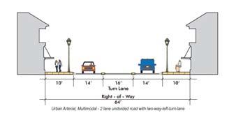
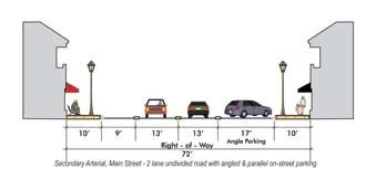
15 transportation I: Context-Sensitive Solutions and Design Main Streets Cross Sections CURRENT URBAN ARTERIAL Volume Speed Transit Parking Bike Walk urban Arterial, Main street Volume Speed Transit Parking Bike Walk CURRENT SECONDARY ARTERIAL Volume Speed Transit Parking Bike Walk Secondary Arterial, Main Street Volume Speed Transit Parking Bike Walk AP appendix Tulsa comprehensive plan 15

16 transportation I: Context-Sensitive Solutions and Design MULTI-MODAL STREETS Multi-modal streets emphasize plenty of travel choices such as pedestrian, bicycle and transit use. Multi-modal streets are located in high intensity mixed-use commercial, retail and residential areas with substantial pedestrian activity. These streets are attractive for pedestrians and bicyclists because of landscaped medians and tree lawns. Multi-modal streets can have on-street parking and wide sidewalks depending on the type and intensity of adjacent commercial land uses. Transit dedicated lanes, bicycle lanes, landscaping and sidewalk width are higher priorities than the number of travel lanes on this type of street. To complete the street, multi-modal streets require frontages that address the street and provide comfortable and safe refuge for pedestrians while accommodating automobiles with efficient circulation and consolidated or shared parking. Cross Section Indicator Key Initial Priority Elements Dedicated transit lanes Transit priority at intersections Wide sidewalks with transit access Bicycle lanes on designated bike routes Bicycle facilities Tree lawns On-street parking Secondary Priority Elements Width and number of travel lanes (on collector and local streets) Medians Examples of Traffic Management Features Landscaped medians On-street parking Street trees Narrower travel lanes Traffic circles and roundabouts Reduced pedestrian crossing distances at intersections, using curb extensions, traffic islands, and other measures Use this cross section indicator key to better understand the recommended traffic volume, speed, transit service, parking, bike, and walk-related attributes of multi-modal streets when looking at the cross sections on the next several pages. transportation/land use Building blocks Ap 16 Tulsa comprehensive plan appendix This chart indicates that multi-modal streets would apply within downtown, center, corridor, and employment areas. Multi-modal streets would also be acceptable in new residential and existing residential areas.


17 transportation I: Context-Sensitive Solutions and Design Multi-Modal Street Cross Sections CURRENT PRIMARY ARTERIAL Volume Speed Transit Parking Bike Walk primary arterial, MULTI-MODAL STREET Volume Speed Transit Parking Bike Walk (Accommodates Bus and Bikes) primary arterial, MULTI-MODAL STREET Volume Speed Transit Parking Bike Walk AP appendix Tulsa comprehensive plan 17


18 transportation I: Context-Sensitive Solutions and Design Multi-Modal Street Cross Sections CURRENT SECONDARY ARTERIAL Volume Speed Transit Parking Bike Walk secondary arterial, MULTI-MODAL STREET Volume Speed Transit Parking Bike Walk Secondary Arterial, Multi-modal Ap 18 Tulsa comprehensive plan appendix


19 transportation I: Context-Sensitive Solutions and Design Current urban arterial Volume Speed Transit Parking Bike Walk urban arterial, multimodal street Volume Speed Transit Parking Bike Walk AP appendix Tulsa comprehensive plan 19

20 transportation I: Context-Sensitive Solutions and Design COMMUTER STREETS These arterials typically serve commercial areas developed with small retail strip centers, with buildings set back from parking lots along the frontage. Because of this, strip commercial arterials have many intersections and driveways that provide access to adjacent businesses. Historically, this type of street often is highly auto-oriented and tends to discourage walking and bicycling. On-street parking is infrequent. Commuter streets are designed with multiple lanes divided by a landscaped median or a continuous twoway left turn lane in the center. Commuter streets are designed to balance traffic mobility with access to nearby businesses. However, because there are so many intersections and access points on commercial streets, they often become congested. Improvements to these streets should come in the form of access management, traffic signal timing and creative intersection lane capacity improvements. Along with providing access to employment centers, commuter streets are also applicable in industrial contexts. Initial Priority Elements Number and width of travel lanes Medians Transit accommodations Cross Section Indicator Key Secondary Priority Elements Pedestrian facilities Bicycle facilities Tree lawns Two-way center left-turn lanes On-street parking Examples of Traffic Management Features Medians Consolidated driveways Synchronization of traffic signals On-street parking Narrower travel lanes Reduced pedestrian crossing distances at intersections, using curb extensions, traffic islands, and other measures Use this cross section indicator key to better understand the recommended traffic volume, speed, transit service, parking, bike, and walk-related attributes of commuter streets when looking at the cross sections on the next pages transportation/land use Building blocks Ap 20 Tulsa comprehensive plan appendix This chart indicates that commuter streets would apply within employment areas, and would be acceptable in corridor and center areas.

21 transportation I: Context-Sensitive Solutions and Design Commuter Street Cross Sections PRIMARY ARTERIAL, Commuter street Volume Speed Transit Parking Bike Walk secondary arterial, COMMUTER STREET Volume Speed Transit Parking Bike Walk secondary arterial Alternative, COMMUTER STREET Volume Speed Transit Parking Bike Walk AP appendix Tulsa comprehensive plan 21

22 transportation I: Context-Sensitive Solutions and Design Transportation Vision: Transit System Transit Rail Transit Streetcar Frequent Bus Bus Rapid Transit Freight Corridor Parks Open Space The PLANiTULSA Transportation Vision illustrates the improvements to the street, transit, bicycle and pedestrian assets. Alignments that extend beyond the City of Tulsa s boundaries do not represent policy or investment obligations on the part of other jurisdictions. The two BRT corridors shown on HWY 169 and Garnett Road illustrate potential alignments; the exact alignments and technologies of transit investments may be refined during a formal alternatives analysis (AA). See Transportation III. Ap 22 Tulsa comprehensive plan appendix At posting/publication, the multi-modal bridge at HWY I244 and the Arkansas River is in the design stage.

23 transportation I: Context-Sensitive Solutions and Design Transportation Vision: Multi-Modal Streets Roadway Main Street Commuter Corridor Multi-Modal Corridor Possible Multi-Modal Bridge Existing/Planned Freeway Parks Open Space The PLANiTULSA Transportation Vision illustrates the improvements to the street, transit, bicycle and pedestrian assets. Alignments that extend beyond the City of Tulsa s boundaries to not represent policy or investment obligations on the part of other jurisdictions. The exact alignments and technologies of transit investments may be refined during a formal alternatives analysis (AA). See Transportation III. At posting/publication, the multi-modal bridge at HWY I244 and the Arkansas River is in the design stage. AP appendix Tulsa comprehensive plan 23


24 transportation I: Context-Sensitive Solutions and Design Commuter Street Traffic Managment Features Signal Timing Signal timing along a corridor can increase the efficiency of the street by allowing for the highest possible number of vehicles to pass through an intersection in the shortest amount of time. It also can improve the air quality of the city because travel time and idling are reduced. This technique can be used to increase capacity on corridors and is less expensive than adding lanes. Access management Access Management defines a set of strategies to make the best use of existing transportation facilities and to enhance transportation improvements. Through strategies such as installing raised medians, and providing adequately spaced driveways, access management will significantly improve the level of safety, efficiency, and effectiveness of the transportation system. Ap 24 Tulsa comprehensive plan appendix


25 transportation I: Context-Sensitive Solutions and Design Advanced Signal Systems As traffic patterns change throughout the day, the operation of a signal controller can be adjusted to match the needs at each intersection. This technology allows a local controller to match the time assigned to each signal phase with actual traffic conditions. It also provides information about how the system can be optimized to manage traffic under special circumstances, such as concerts or sporting events, and when to perform system maintenance. intersection improvements Improvements to congested intersections can significantly affect traffic flow on commuter corridors. When coordinated with signal timing, the introduction of left and right turn bays at intersections can decrease the potential volume of congested intersections. Each intersection should be analyzed individually to identify its unique challenges. AP appendix Tulsa comprehensive plan 25

26 transportation I: Context-Sensitive Solutions and Design RESIDENTIAL COLLECTOR STREETS These streets strengthen neighborhood cohesion, promote alternative transportation, calm traffic and connect recreational destinations. These residential street designs should be used in new housing developments, to ensure that new neighborhoods provide a comfortable pedestrian realm, and can also serve as models for retrofitting existing neighborhood streets. In both cases, these residential streets tend to be more pedestrian-oriented than commuter streets, giving a higher priority to the pedestrian experience by providing landscaped medians, tree lawns, sidewalks, on-street parking, and bicycle lanes. Residential streets consist of two to four travel lanes, but place a much higher priority on pedestrian and bicycle friendliness than on auto mobility. Cross Section Indicator Key Initial Priority Elements Sidewalks Tree Lawns On-street parking Landscaped medians Bike lanes on designated bicycle routes Secondary Priority Elements Number and width of travel lanes (especially collector and local streets) Examples of Traffic Management Features Medians On-street parking Street trees Narrower travel lanes Traffic circles and roundabouts Reduced pedestrian crossing distances at intersections, using curb extensions, traffic islands, and other measures Diverters Use this cross section indicator key to better understand the recommended traffic volume, speed, transit service, parking, bike, and walk-related attributes of residential collector streets when looking at the cross sections on the next pages transportation/land use Building blocks This chart indicates that residential collector streets would apply within downtown, center, new residential, and existing residential areas. Ap 26 Tulsa comprehensive plan appendix

27 transportation I: Context-Sensitive Solutions and Design Residential Collector Street Cross Sections CURRENT RESIDENTIAL COLLECTOR Volume Speed Transit Parking Bike Walk 36 RESIDENTIAL COLLECTOR* Volume Speed Transit Parking Bike Walk *effectively 20 of thru traffic with optional curb extensions AP appendix Tulsa comprehensive plan 27
28 transportation I: Context-Sensitive Solutions and Design How Transportation Building Blocks Relate to Land Use The overarching approach to integrating land uses and transportation facilities is known as Context Sensitive Solutions (CSS). This process, detailed in the Transportation Chapter, provides more detailed direction for balancing or prioritizing the infrastructure for each mode of travel in the context of the adjacent land uses. CSS takes an interdisciplinary approach to street design that will further encourage coordination between traffic engineers, planners, urban designers, architects, emergency response officials, and the community when designing new streets or reconstructing existing streets. This approach fosters communication with those designing other elements of the community and results in better facilities and places. Implementation For the City to successfully use CSS to meet the travel needs of all Tulsa residents, it must institute a process for considering citizen and developer requests for its use. In some instances CSS may not be appropriate and the city should maintain its ability to deny requests for flexibility in roadway design. Conversely, it needs an objective process that assures unbiased consideration of legitimate requests. CSS should be a part of all small area planning process and used to address citizen, property owner and developer requests. The following steps will assure that CSS is used most effectively to benefit the City, its residents and its economy: Institutionalize CSS per the above definition and designate responsible staff and resources Create public information about the program and make it available to neighborhood associations, business organizations and general public through the small area planning process and the city web-site Establish guidelines for residents and business owners to petition the city to consider CSS Accept petitions annually and use selection criteria to prioritize request for further study, funding and design Ap 28 Tulsa comprehensive plan appendix


29 Transportation II Urban Corridors Figure 1: Transportation Life Cycle URBAN CORRIDOR PLANNING Corridors are transportation pathways that provide for the movement of people and goods between and within activity centers. A corridor encompasses a single or multiple transportation routes or facilities (such as thoroughfares, public transit, railroads, highways, bikeways, etc.), the adjacent land uses and the connecting network of streets. Traditionally, corridors were analyzed by identifying high automobile congestion locations through traffic counts and travel demand models. Then congestion was addressed by building automobile capacity improvements with added lanes or building new roads in a parallel corridor to diffuse the traffic. This traditional process leads to a perpetual need for improvements to the roadways system as depicted in Figure 1. The cycle of making roadway improvements without considering potential land use changes has resulted in a land development pattern that is autocentric and costly in terms of quality of life and maintenance. PLANiTULSA identifies a new process to guide the decision-making for urban corridors. The process comprehensively addresses future transportation needs and recommends a series of physical improvements and operational and management strategies within a corridor. Using this process, corridor planning fills the gap between long-range transportation planning and project development. It identifies and provides a link between neighborhood planning and corridor transportation planning and provides an opportunity to direct future development within the corridor to meet Our Vision for Tulsa s growth and economic development goals. Integrating Context Sensitive Solutions (CSS) in urban corridor thoroughfare planning requires stakeholders to consider the economic, social, and environmental consequences of alternatives. The outcome of CSS in urban corridor thoroughfare planning goes beyond street improvements. It defines the short-term and long-term needs of the corridor, AP appendix Tulsa comprehensive plan 29

30 transportation II: urban corridors develops goals and objectives that will achieve the vision of the corridor and evaluates feasible multimodal alternatives. Finally, urban corridor planning promotes interagency cooperation and broad stakeholder and public involvement. It integrally addresses transportation improvements, land development and redevelopment, economic development, scenic and historic preservation, community character and environmental enhancement in a unified process. Because urban corridor planning affects a broad spectrum of the community, public and stakeholder involvement is a central element of the process. Corridor planning addresses issues within the corridor prior to project development for specific transportation improvements. The basic steps in the process, and how CSS principles can be integrated, are described below. Following this overview is a discussion of four potential corridors which the City could focus on as catalyst projects in the near future: 1. East-Side Bus Rapid Transit (BRT) 2. High Frequency Bus, Timed Transfer Station and TOD at Utica Avenue and 21st Street 3. Cherry Street conversion to a Main Street Corridor Vision and Study Area Determination The process begins by developing a vision for the corridor. The vision is a corridor-wide expression of how the facility and the areas it serves will look, function, and feel in the future. From the vision, goals and objectives define a framework for how to implement the vision. Public and stakeholder input and involvement are critical to developing a vision, as the vision should reflect the goals and objectives of the community and address more than the transportation function of the corridor. The PLANiTULSA Vision and Comprehensive Plan should be used to guide the corridor visioning process. In addition to developing a vision, goals and objectives for a corridor can occur as part of a locally-sponsored (City or INCOG) long-range transportation plan, small area planning process or as a stand-alone urban corridor planning process. Because the corridor visioning process feeds directly into the project needs step, the two may be conducted together. Figure 2: CSS Process Overview 4. Park-Once District on Harvard at 11th Ap 30 Tulsa comprehensive plan appendix

31 transportation II: urban corridors Figure 3: Corridor Development one size does not fit all Project Needs and Corridor Context Defining the current or future context for a corridor goes hand-in-hand with defining specific project needs. If the corridor includes areas envisioned as main streets or neighborhood centers, those areas may may need to receive improved transit or pedestrian capacity. Stakeholder input should identify values, issues, priorities and goals and objectives for the corridor. Much of this input will help form criteria for assessing alternatives later in the project. The project needs assessment should result in a problem statement that reflects the needs of all users as well as the corridor s existing and future context and characteristics. It should be noted, however, that not every transportation improvement along a corridor will have the same purpose, as illustrated in Figure 3. Techniques such as those found in the Institute of Transportation Engineers Designing Walkable Urban Thoroughfares: A Context Sensitive Approach, can provide guidance for how to design the facility to function well across a variety of areas and contexts. Alternatives Development The alternatives need to address the problem statement identified in the project needs step and also reflect the community vision and objectives. Stakeholder input is necessary to identify values, issues, priorities and criteria for assessing alternatives. The CSS outcome of this step is an inclusive problem statement, a short-range and long-range vision for the corridor and goals and objectives that will direct the development of alternatives. With a CSS approach, the needs may be stated in terms of context, economic, or other community aspects, as well as mobility needs. The CSS outcome of this step is to provide decision makers with a wide range of choices, derived in a collaborative and participatory process. The alternatives should be competitive in that they address as many of the goals and objectives as possible. Solutions should be innovative and flexible in the application of design guidance. The initial step is to establish a street cross section concepts for the corridor area in question. PLANiTULSA outlines four overarching street typologies: Main Streets Multi-modal Streets Commuter Streets Residential Streets However, the cross section is not the entire solution. The solutions should include ways to enhance and meet the needs of the context, activities generated by adjacent and nearby land uses and objectives that are part of the community vision for the corridor. To AP appendix Tulsa comprehensive plan 31

32 transportation II: urban corridors the extent not already included in the community vision, consideration should also be given to potential environmental consequences when developing the corridor alternatives. Alternatives may include different alignments and parallel routes, modal combinations, roadside treatments, interaction with adjacent development, streetscape approaches, business and community activity and support infrastructure. The important thing to remember is that the alternatives in CSS are developed to meet the full range of a specific community or neighborhood s objectives. The PLANiTULSA plan outlines a number of transportation tools that provide improvements to the transportation system in Tulsa. In many instances one tool may not be only solution. A number of complementary tools can be used to benefit the area or corridor. Depending on the type of enhancement (Street, Transit, Pedestrian or Bicycle) different tools are available for use and implementation in the plan. Figure 4 lists the mobility tools. Alternatives Evaluation The goal of the alternatives evaluation is to provide an objective and balanced assessment of impacts, tradeoffs and benefits of each alternative. This requires careful selection of, and stakeholder agreement on, evaluation criteria. The criteria need to reflect not just transportation objectives, but the community and environmental objectives as well. Examples of evaluation criteria categories include: Mobility: travel demand, roadway capacity, level of service, travel time, connectivity, circulation, access, truck movement, and access to multiple travel modes. Social and Economic Effects: socioeconomic and cultural environment (historic, cultural and archaeological resources), residential and business displacement/dislocation, socioeconomics and equity, neighborhood integrity and cohesion, economic development, place making qualities. Figure 4: Transportation tools identified in transportation Chapter Ap 32 Tulsa comprehensive plan appendix
33 transportation II: urban corridors Environmental Effects: positive and negative effects on the natural environment (air, water, and soil quality, habitat areas and wildlife corridors, wetlands, and floodplains). Cost-effectiveness and Affordability: capital costs, operations and maintenance costs, achievement of benefits commensurate with resource commitment, and sufficiency of revenues. Other Factors: compatibility with local and regional plans and policies, constructability, and construction effects. The alternatives evaluation step includes a comprehensive evaluation of applicable issues and options using selected criteria such as those described above, including modal capacity, alignment, design concepts, costs, right-of-way, environmental, social and economic impacts, operations, and safety. Alternatives can be a combination of capital improvements and management and operations strategies. The selection of a preferred alternative leads to either the development of a detailed corridor plan, such as a thoroughfare plan, access management plan, scenic preservation plan, streetscape plan, or economic vitalization plan, or it can lead to the preliminary design of an individual thoroughfare, network of thoroughfares, or multi-modal transportation corridor with parallel thoroughfares, rail, transit, highway and bikeway systems. Corridor planning varies in level of effort ranging from large-scale planning efforts for corridors in newly developing areas to small-scale planning of segments of individual thoroughfares within constrained rights-of-way. The outcome of corridor planning ranges from broad policies to citywide and regional long-range transportation plans to multimodal systems plans, and to local thoroughfare plans and individual segment concepts and designs. The outcome of this step is the clear communication of trade-offs to the public, stakeholders and decisionmakers, developed and discussed in a transparent and participatory process. Selection of Preferred Alternative The selection of a preferred alternative is a consensus based process. Consensus building in this step engenders community ownership in the selected alternative and helps achieve a commitment towards implementation of the plan or project. The CSS process uses an array of tools for selecting, refining and building consensus on alternatives. A successful selection of a preferred alternative is one that is compatible with the context(s), reflects the needs of all users, and best achieves the objectives and vision established for the corridor. AP appendix Tulsa comprehensive plan 33

34 transportation II: urban corridors The following are potential catalyst corridors within the City of Tulsa. In general, these case studies identify the corridor planning process and illustrate the range of projects that can be served by an urban corridor planning process that incorporates CSS. Figure 5: 2030 Congestion along the Mingo Expressway Catalyst Corridor #1: East-Side Bus Rapid Transit (BRT) Step 1 Identify Corridor Vision and Determine Study Area The U.S. 169 Expressway provides north-south mobility for the east-side of Tulsa using 6 vehicular lanes for automobile traffic. The vision for this corridor is to be multi-modal. Strategically integrating transit, transit oriented development and walkable places into the corridor will provide greater travel choices for Tulsa residents, while improving the regional through traffic capacity. To accomplish this, the study area must include trip patterns beyond the City of Tulsa, thus one half-mile on either side of U.S. 169 Expressway from Owasso city limits to the Creek Turnpike was considered. Step 2 Determine Area Context and Needs Currently, the corridor has over 90,000 cars of average daily traffic with 6 freeway lanes facilitating this vehicular movement. Major employment and commercial destinations in the corridor attract travelers from all parts of the region, but the predominant travel pattern is from northern and southern suburban cities to Tulsa destinations, such as the multiple shopping centers and Hospitals within one mile of the corridor. Currently, planned land uses in the corridor will result in increasing levels of congestion. Figure 5 shows that in 2030 the corridor will have a failing level of service even after the expressway is expanded to 8-lanes. The traffic Ap 34 Tulsa comprehensive plan appendix
35 transportation II: urban corridors growth is mostly a product of increasing suburban development outside of the City of Tulsa and autooriented development within the City. Our Vision for Tulsa defines an alternative future for the corridor that results in a more sustainable traffic pattern. Anchoring three of the City s new mixed use development centers, an intermodal center, an employment center and a neighborhood center challenges the transportation system to provide for a traffic pattern that is very different from the current one. The future traffic pattern will be less oriented toward suburban origins and dispersed corridor destinations to local neighborhood origins and mixed-use center destinations. To be successful the transportation system must be integrally connected to future land development patterns and not be reactive to future traffic demands. Step 3 Alternatives Development Crafting transportation investments in the corridor to support Our Vision for Tulsa s emphasis on sustainable development requires planners and engineers to view the corridor as a part of a new multi-modal network for Tulsa. For transit to have a positive impact on the trip patterns and support sustainable land development patterns, its stations must be located in a walkable location. The idea of locating transit stations within a quarter mile of walkable locations is a fundamental tenant of transit oriented development (TOD). Bus Rapid Transit (BRT) can facilitate TOD if it is placed in a right-ofway that permits its stations to be in close proximity to potential TOD sites. BRT technology involves the high frequency/high capacity buses acting in a separated facility like a bus lane. If signals are warranted in a corridor with BRT, they typically involve signal pre-emption and signal priority to maintain high quality service for the transit riders. BRT corridors can move over 10,000 persons per hour which has the equivalent of over 4 highway lanes. A few alternatives for placement of a potential BRT line in this corridor are: 1) Within the U.S. 169 Expressway Right-of- Way (ROW) The Expressway Alignment The benefits to placing the line within the expressway ROW include: Increased efficiency of transit service Increased person capacity due to the BRT being located on a separate facility with no other modes Limited ROW acquisition The negatives of this corridor alignment include: Significant costs of construction of overpasses and stations to avoid conflicts with current traffic operations on the expressway Limited access to walkable neighborhoods resulting in a need for park and ride lots Limited benefit to surrounding land development potential 2) Along a Parallel Facility The Arterial Alignment The benefits to placing the line on a parallel facility include: Reduced capital costs due to decreased need for grade separations Supports sustainable land development by locating stations in close proximity to development sites Potential for increased value capture Multi-modal access will increase ridership because patrons will be able to access stations via TOD facilitated walking, biking and bus circulation instead of park and ride, thus reducing air pollution and improving community health AP appendix Tulsa comprehensive plan 35
36 transportation II: urban corridors The negatives of this corridor alignment include: Reduction in transit travel times due to BRT being impacted by signals and vehicular conflicts Potential additional ROW can increase the costs of implementation; however, some of these costs could be recovered through value capture mechanisms Step 4 Alternatives Evaluation While the initial ridership of a U.S. 169 Expressway BRT is greater than an arterial BRT alignment, the consultant team found them both to be viable and worthy of further detailed ridership estimates. The arterial alignment will produce a more sustainable land development pattern, thus ensuring an ever growing pool of potential riders. Park and ride transit operations typically have a short growth period in ridership and level off quickly as choice riders are not as likely in a suburban development pattern. A formal alternatives analysis (AA) should be performed on this corridor to establish ridership estimates; however, the PLANiTULSA process revealed that the corridor could attract 40,000 riders and could have as many as 100,000 if it is integrated into a city-wide multi-modal network. The future AA process should consider more than just ridership. Incorporating the new HUD-DOT-EPA livability principles and goals of Our Vision for Tulsa will require the AA to consider livability, sustainability, economic development and the leveraging of public investments into the consideration of transit alignments, technology and service decisions. Step 5 Selection of a Preferred Alternative Advancing the six livability principles adopted by the DOT-HUD-EPA Partnership for Sustainable Communities and the new PLANiTULSA land use and transportation integration goals will require greater inter- and intra-agency coordination to accomplish the multi-modal initiatives. Multi-modal systems are formed from multi-disciplinary plans, project development coordination and sustainable land development regulations that consider the mobility of multiple modes. Linear thought processes that typically drive major public and private investments must be supplanted with methods for meeting mobility and livability desires from the perspective of the end user. To facilitate this, the perspective on transportation planning and project development must focus on connecting land use and transportation at the regional, district and corridor level. Multi-modal transportation paired with sustainable land development initiatives have the ability to solve mobility issues while using existing knowledge and physical resources. A new multi-modal perspective would re-orient projects and initiatives to an outcome that seeks to benefit all users and create sustainable outcomes. The PLANiTULSA workshops revealed a strong desire for transit in this corridor and overwhelming support for mixed-use, walkable centers. To realize the vision of a multi-modal system, multiple, connected transportation options must be present and land development must be coordinated. Then the system will afford a person the opportunity to travel to places where they work, live and play, in a convenient way. This change over time to a multi-modal system can begin today with the alignment of transit in this corridor to support Our Vision for Tulsa s sustainable land development pattern of walkable neighborhoods and centers. Ap 36 Tulsa comprehensive plan appendix

37 transportation II: urban corridors Catalyst Corridor #2: High Frequency Bus, Timed Transfer Station and TOD at Utica Avenue and 21st Street Figure 6: Signal preemption example in the Utica Ave/21st St intersection Step 1 Identify Corridor Vision and Determine Study Area 21st Street is an important east-west arterial and Peoria Avenue is a high-volume north-south arterial that connects Brookside to downtown and from downtown to the North Tulsa. Currently, the Peoria transit route contains the highest ridership in Tulsa and is one of Tulsa s more vibrant streets. In the PLANiTULSA planning process, citizens identified this location as a destination for a number of service and retail employment opportunities. Because this area is quite urban in form, transit, pedestrian and bicycle infrastructure improvements were emphasized, in lieu of the current auto-centric design. Implementing a new multi-modal approach in this area can help solidify Peoria as a key destination while reducing the need for the automobile to travel between areas of the city. Step 2 Determine Area Context and Needs The PLANiTULSA transportation vision describes Peoria Avenue and 21st Street multi-modal corridors with frequent bus operations. Peoria Avenue and 21st Street must transition to a multi-modal operation with priority placed on moving people via high frequency transit. The corridors will need to be coordinated with adjacent land development to achieve transit stations that are integrated into walkable mixed-use and single family neighborhoods. Prioritizing transit in the signal system and providing queue jumps at intersections will require a partnership with the Public Works Department. AP appendix Tulsa comprehensive plan 37
38 transportation II: urban corridors Step 3 Alternatives Development High frequency bus lines are different from typical bus lines in many ways. Frequent buses are line haul oriented, meaning they typically stay on one major corridor throughout the route. The headways on these routes can be as low as five minutes depending on the time of day. Frequent bus lines also have features like intelligent systems operations which use GPS technology to make transit riders aware of wait times. Pre-emption and priority signal operation are recommended in these corridors to increase efficiency and travel times. Figure 6 depicts locations where signal preemption could be used in the corridor. Step 4 Alternatives Evaluation A formal alternatives analysis (AA) should be performed to establish ridership estimates on these corridors. Initial analysis conducted during the PLANiTULSA process found the potential for high performance transit ridership. The future AA process should consider more than just ridership. Incorporating the new HUD-DOT-EPA livability principles and PLANiTULSA goals will require the AA to consider livability, sustainability, economic development and the leveraging of public investments into the consideration of transit alignments, technology and service decisions. Step 5 Selection of a Preferred Alternative The preferred alternative for this corridor should advance the six livability principles adopted by the DOT-HUD-EPA Partnership for Sustainable Communities and the new transportation and land use integration goals. Catalyst Corridor# 3: Cherry Street Conversion to a Main Street STEP 1 Identify Corridor Vision and Determine Study Area Cherry Street is home to 21 restaurants and some of Tulsa s finest local and regional art galleries. With the most locally owned businesses in town, Cherry Street includes a variety of retail and home décor shops, salons, and more. The vision is for this area to be the main street of the vibrant and stable neighborhood and further attract locally owned businesses and appropriate urban residential development. Generally, main street activities are concentrated along a two to eight block area, but may extend further depending on the type of adjacent land uses and the area served. The Cherry Street study area extends between Utica and Peoria on 15th Street. STEP 2 Determine Area Context and Needs The PLANiTULSA vision describes Cherry Street as a Downtown Neighborhood. These are areas located outside but are tightly integrated with the Downtown Core. Downtown Neighborhoods are primarily pedestrian-oriented and are well-connected to the Downtown Core via local transit. Cherry Street should be fully adapted into a main street with priority placed on improving the pedestrian realm, increasing public on-street parking, reducing street crossing distances and frequency and enhancing streetscape elements. The transit connection to downtown will be provided by the Peoria High Frequency Bus Line. Ap 38 Tulsa comprehensive plan appendix
39 transportation II: urban corridors STEP 3 Alternatives Development By placing more emphasis on making the street frontage walkable and direct walking and biking connections to adjacent neighborhoods, tree lawns and detached walks are prioritized over travel lanes. The alternatives were based upon national best practices for converting four lane undivided urban roadways to three lane and two lane facilities. Variations of these lane conversions were tested to better accommodate pedestrians and on-street parking. STEP 4 Alternatives Evaluation Using the daily traffic counts, the traffic engineer estimated peak hour turning movement volumes at the intersections of 15th and Peoria and 15th and Utica and tested them using a Synchro traffic model (Figure 7). The traffic engineer concluded that intersection delay was less than a few seconds and level of service was unchanged for through movement and the left turn level of service was greatly improved. Any diversion of traffic due to the reduction in lanes will be absorbed by the parallel facilities of the Broken Arrow Expressway and 21st Street. Pedestrian and bicycle level of service was not quantitatively tested during this analysis, but qualitatively, the preferred alternative describes a design that has reduced pedestrian crossing distances, frequent mid-block crosses, expanded sidewalks and pedestrian refuge islands. Figure 7: Synchro traffic model of 15th, Peoria & Utica Proposed Conditions Map Peak Hour (Estimated) Map - Proposed Conditions 7/19/ th St Peoria th St Utica th St Figure 8: Scoring matrix of the two alternatives Step 5 Selection of a Preferred Alternative For the purposes of illustrating the urban corridor planning process, this catalyst project simulated the consensus building step that engages the community in the selected alternative by allowing them to score the alternatives (See Figure 8). Figure 9, on the next page, illustrates a conceptual design of the preferred alternative. AP appendix Tulsa comprehensive plan 39


40 transportation II: urban corridors Figure 9: Conceptual design alternative Ap 40 Tulsa comprehensive plan appendix
41 transportation II: urban corridors Catalyst Corridor #4: Park-Once District on Harvard Avenue at 11th Street STEP 1 Identify Corridor Vision and Determine Study Area Adjacent to the University of Tulsa, the segment of Harvard Avenue from 7th Street to 14th Street has potential for re-investment in the form of higher density mixed-use development. Over four thousand students, staff and faculty represent a significant market for retail and service related growth. A key element of the vision is to promote density and encourage walkable developments through the efficient use of parking resources. The vision is to be able to park-once and walk amongst various businesses in the corridor. STEP 2 Determine Area Context and Needs PLANiTULSA envisions this area as a main street. Historically, Harvard Avenue functioned as a main street. In the recent past it has assumed more typical strip commercial development patterns that emphasize automobile over pedestrian access, lot parking over on-street parking and front doors directed towards parking lots instead of sidewalks. This study recognized that parking conflicts are among the most common problems facing designers, operators, planners and investors seeking to revitalize the corridor. Such problems can be often defined either in terms of supply (too few spaces are available, somebody must build more) or in terms of management (available facilities are used inefficiently and should be better managed). Management solutions will best serve this area s parking issues because they support more strategic planning objectives: Reduced development costs and increased affordability More compact, multi-modal community planning (smart growth) Encourage use of alternative modes and reduce motor vehicle use (thereby reducing traffic congestion, accidents and pollution) Improved user options and quality of service, particularly for non-drivers Improved design flexibility, creating more functional and attractive communities Ability to accommodate new uses and respond to new demands Reduced impervious surface and related environmental and aesthetic benefits The key to the successful revitalization of Harvard Avenue is convenient parking, either on-street or in a shared public parking lot. In order to ensure the walkability of Harvard Avenue, careful consideration must be given to the design elements, sizes, and numbers of parking lots. STEP 3 Alternatives Development For main streets to promote walking, bicycling, and transit, parking issues must be resolved at the onset of the redevelopment process. The most fundamental element of a main street is walkability. Walkability includes more than sidewalks for pedestrian access. People will choose to walk if distances between attractions are less than a one-quarter mile, destinations are practical (grocery or pharmacy) and the walk is pleasant and interesting. This last element is achieved by creating a human scale as depicted in Figure 10. The prevailing building heights of two to three stories in relation to the street cross section create a good human scale in relation to the street cross section of Harvard Avenue. The gaps in the AP appendix Tulsa comprehensive plan 41

42 transportation II: urban corridors Figure 10: Ideal height to street width ratio, ITE CSS manual parking standards, the entire area within the parking management district would be considered one lot and would require the provision of a minimum amount of spaces. In order to measure compliance for a new site plan or certificate of occupancy, the applicant must provide a table demonstrating compliance with the requirements of the parking management district. The parking management district must demonstrate how the new development s parking needs will be met, using shared, public or contract spaces. Figure 11, adapted from the Victoria Transport Institute, outlines the adjustments to the parking thresholds that can be used by the district and/or applicant to reduce the parking need. human scale occur when the building frontage is interrupted by parking lots, auto scaled developments and vacant lots. These gaps are perpetuated by the use of conventional planning tools that determine how much parking to provide at a particular site based on recommended minimum parking standards dictated by Tulsa Zoning Code. This provides an index or parking ratio used to calculate the number of spaces to supply at a particular location. These are unconstrained and unadjusted values, which generally reflect the maximum supply that could be needed. Tulsa is considering the adoption of a zoning category that establishes parking management districts. This district would provide adjusted parking requirements and a management plan for a particular area, such as a main street corridor. The parking management district will set the parking spaces available for public use (including spaces that are available for sharing on a contractual basis) in the district. Accordingly, the Harvard Avenue at 11th Street area, under such a zoning category could begin to provide parking through Shared Use Agreements among users and future shared parking lots. For purposes of meeting The entity responsible for managing the required parking within the parking management district, limited to the board of a public improvement district (PID), tax increment financing reinvestment zone (TIF), or parking authority such as the Tulsa Parking Authority, the City, or other governmental entity established under Oklahoma law must provide a plan of action to fulfill parking and walkability requirements with a list of contingency projects that are phased in accordance to the pace of development and re-development. A sample contingency plan might include: Shared parking agreements On-street parking signage and markings Off-street shared parking signage On-street parking meters Pedestrian crossings, curb-extensions and intersection landscaping Public parking lot and signage Corridor streetscaping District parking garage Florence Avenue bicycle boulevard Indianapolis Avenue realignment and public plaza Ap 42 Tulsa comprehensive plan appendix

43 transportation II: urban corridors Figure 11: Parking Management Strategies, Evaluation and Planning (Victoria Transport Institute) STEP 4 Alternatives Evaluation A comprehensive parking management program that includes an appropriate combination of cost-effective strategies can usually reduce the amount of parking required at a destination by 20-40%, while providing additional social and economic benefits. As a demonstration project, this area should be analyzed every five years to demonstrate the ability of main streets to park-once and walk amongst various destinations, thus reducing arterial trips by auto. Figure 12, on the next page, describes a list of reductions that should be tested. Special care is needed when predicting the impacts of a program that includes multiple parking management strategies. Be careful to take into account strategies with overlapping impacts. For example, Transportation Management Associations (TMAs) provide an institutional framework for implementing strategies that directly affect parking requirements. While it would be true to say that a TMA can reduce parking requirements by 10-30% compared with not having such an organization, it would be incorrect to add the demand reductions of the TMA to the impacts of the individual strategies it helps implement. AP appendix Tulsa comprehensive plan 43

44 transportation II: urban corridors Figure 12: Parking Management Strategies, Evaluation and Planning (Victoria Transport Institute) STEP 5 Selection of a Preferred Alternative Developing an integrated parking plan requires the following steps: Define Scope Define the geographic scope of analysis, such as the site, street, district/neighborhood and regional scale. It is desirable to plan for a walkable area, such as a business district or neighborhood, since this is the functional scale of parking activities. Define Problems Carefully define parking problems. For example, if people complain of inadequate parking it is important to determine where, when and to whom this occurs, and for what types of trips such as deliveries, commuting, shopping or tourism. Strategic Planning Context Parking planning should be coordinated with a community s overall strategic vision. This helps ensure that individual decisions reflect broader community objectives. Ap 44 Tulsa comprehensive plan appendix
45 transportation II: urban corridors Establish Evaluation Framework Develop a comprehensive evaluation framework. This provides the basic structure for analyzing options, ensuring that critical impacts are not overlooked and different situations are evaluated consistently. Survey Conditions Survey parking supply (the number of parking spaces available in an area) and demand (the number of parking spaces occupied during peak periods) in the study area. Identify and Evaluate Options Develop a list of potential solutions using ideas from this report and stakeholder ideas. Evaluate each option with respect to evaluation criteria. Develop An Implementation Plan Once the components of a parking management plan are selected, the next step is to develop an implementation plan. This may include various phases and contingency-based options. For example, some strategies will be implemented the first year, others within three years, and a third set will only be implemented if necessary, based on performance indicators such as excessive parking congestion or spillover problems. Figure 13 depicts a conceptual parking management strategy with locations for a surface parking lot (near term) and potential structured garage (long-term). of demographic, geographic and management practices that may affect parking requirements. Parking management requires a change in the current development, zoning and design practices. Public officials, planners and the public will have to change the way they think about parking problems and solutions, and become familiar with the full menu of available parking management strategies and the benefits they can provide. It requires institutions and relationships, such as transportation management associations, and activities to improve enforcement and addressing potential spillover impacts. The strategies and steps outlined in this section can be employed at this location and other areas. PLANiTULSA identifies many potential Main Street areas where parking management strategies can remove barriers to growth while preserving the walkability and the integrity of the built environment. The preferred alternative should result in a minimum reduction of 5 to 15% from existing parking requirements. The parking district will also represent a change from current practices, thus various obstacles must be overcome for parking management to be implemented. Current planning practices are based on the assumption that parking should be abundant and provided free of charge, with costs borne indirectly, incorporated into building construction costs or subsidized by governments. Current parking standards tend to be applied inflexibly, with little consideration AP appendix Tulsa comprehensive plan 45


46 transportation II: urban corridors Figure 13: Conceptual Parking Management Strategy Parking Garage with Building Frontage Surface Parking with Public Space Ap 46 Tulsa comprehensive plan appendix
47 Transportation III Sustainable Network Initiative A network is a structure of streets and highways that serves and connects multiple places and people via multiple modes of travel. A network approach to transportation projects focuses on connecting people to places ultimately allowing places to become more intense centers of economic development. A highly-networked system of streets, with at least 150 intersections per square mile, has redundant routes, compact block sizes, sidewalks, narrower streets and a greater capacity than unconnected street systems. In Tulsa, older core neighborhoods like downtown, Lacy Park and Maple Ridge are good examples; many suburban neighborhoods developed more recently exemplify disconnected networks. Well-connected networked streets provide greater mobility and access. By their nature, networked streets provide shorter, more direct routes between destinations. This increases the efficiency and reliability of the road network. During times of congestion or construction, drivers have more opportunities to switch to different routes and avoid delay. This is especially important for emergency responders as they need the fastest, most direct route to a fire or medical emergency. Networked streets improve health and safety. In addition to improving emergency access and response times by providing multiple, more direct routes networked streets can reduce vehicular crash severity. A system of compact blocks and streets increases the opportunities for and performance of other modes of travel, such as walking, bicycling, and taking transit. Finally, sustainable networks represent a cost effective alternative to expensive grade separations, interchanges and corridors that require extensive rightof-way purchases. Creating networks takes a greater level of planning and creative design, but their results are sustainable in terms of capital and maintenance costs. INCOG and the City of Tulsa should examine a network alternative to any major roadway widening, grade separation or new functionally classified street analysis. Project Development Process Network Alternative Analysis INCOG and the City of Tulsa should explore an addition to the local roadway project development process that includes the examination of a street network alternative. In place of study corridors, study areas should be examined for their capacity to move people via multiple transportation modes. This process would evaluate improvements from a network perspective, and not just corridor metrics. Traditionally, the key performance measure for transportation planning has been vehicular Level of Service (LOS) a measure of automobile congestion. Sustainable network planning takes a broader look at how the system serves all users. Tulsa should measure success through a number of ways: the miles of on-street bicycle routes created; new linear feet of pedestrian accommodation; changes in the number of people using public transportation, bicycling, or walking (mode shift); number of new street trees; and/ AP appendix Tulsa comprehensive plan 47
48 transportation III: SUSTAINABLE NETWORK INITIATIVE or the creation or adoption of a new multi-modal LOS standard that better measures the quality of travel experience. The fifth edition of the Transportation Research Board s Highway Capacity Manual, due in 2010, will include this new way of measuring LOS. Cities like San Francisco and Seattle have already begun to develop their own standards including: Conventional Vehicle hours of delay Speed Volume/capacity Vehicle miles traveled Volumes of auto trips Transit trips Enhanced Mode share (walk, bike, transit, auto) Accessibility measures Lane miles by functional class Connectivity indices (intersections/sq. mi.) Travel time Route directness This process will require portions of the travel demand model to be updated with a finer grain of network detail and possible use of a micro-scale model to examine network and modal conflicts. This process should result in roadway solutions that meet the current traffic demands by building a street network that can adapt to future changes in energy availability and personal travel choices. Project Development Process- Multi-Modal Alternative Analysis A multi-modal transportation system is described as a network of facilities designed for shared use with seamless linkages between at least two or more modes of transportation. A multi-modal system requires coordination between multiple, connected transportation options and land development. The resulting system will allow people the opportunity to conveniently travel to places where they work, live and play. Effective multi-modal transportation systems require a phasing of implementation through incremental investments over decades. Investments will require the involvement of complementary transportation agencies over short-term and long-term capital improvement cycles and planning periods. For example, Copenhagen, Denmark, which is considered a model for pedestrian-friendly streets, gradually realized its multi-modal vision over a 30-year period. It formed consensus for significant change in its urban form and its citizens lifestyles by demonstrating the benefits of that change over time. Extensive inter- and intra-agency coordination is needed to coordinate and accomplish the many projects and initiatives inherent in developing a multimodal transportation system. Multi-modal systems are derived from multi-disciplinary plans project development coordination and smart growth land development regulations that consider the mobility of multiple modes. Linear thought processes that typically drive major public and private investments must be supplanted with methods to meet mobility and livability desires of end users. Ap 48 Tulsa comprehensive plan appendix


49 transportation III: SUSTAINABLE NETWORK INITIATIVE During the PLANiTULSA process, travel demand modeling software was used to estimate how street connectivity, walkability, mixed-use developments, and transit investments could mitigate future traffic congestion. These methods should be further developed and adopted for all future transportation planning efforts in the region. Comparing Network connectivity A disconnected network is not walkable and requires the use of arterial for local trips. Project Development Process Subdivision Connectivity Analysis In concert with the Network Alternatives Analysis, private development in these areas should be designed with a well-connected street system. Neighborhoods designed with one or two streets feeding into a collector or arterial have several negative impacts. Trips are typically longer, even when as the crow flies distances are short. They usually require a motorist or pedestrian to make some portion of the trip on a major road or arterial. All of these factors add to greater capacity needs on arterials, thus increasing capital and maintenance costs, while discouraging short trips on foot. A well-connected street system, in contrast, has many short streets and intersections and few dead-ends. Travel can be more direct, because the network provides many different routes, instead of one or two main corridors. Trips between destinations within the neighborhood can stay within the neighborhood, lessening the need for more arterial capacity. Travel by foot or bicycle is easier on these networks. These networks can include cul-desacs, as long as they are not so frequent as to impede direct travel. A connected network provides many routes for local travel, makes walking and biking easier, and lessens the impact on arterials. AP appendix Tulsa comprehensive plan 49

50 transportation III: SUSTAINABLE NETWORK INITIATIVE Connectivity Criteria To ensure that local travel places fewer demands on arterials and is easier to do by foot and bike, Tulsa should adopt a set of connectivity standards for new neighborhoods and subdivisions. The following is a sample set of criteria for these standards. General Criteria A proposed development or subdivision should provide multiple direct connections in its local street system to and between local destinations, such as parks, schools, and shopping, without requiring the use of arterial streets. New development or subdivisions should incorporate and continue all collector and local streets stubbed or planned at its boundary. Dead-end streets that are not cul-de-sacs should not be permitted except in cases where such streets are designed to connect with future streets on abutting land. Gated street entries on public streets into residential neighborhoods or developments should not be allowed. Street Connectivity Standards New developments and subdivisions should be designed with streets with eight to ten intersections per mile. Most intersections are street-to-street, but other types of junctions should also count toward meeting the connectivity standard: Pedestrian or bicycle trail access points Alley access points (ungated) Sharp curves with 15 mpg design speeds or less Cul-de-sacs no more than 250 feet in length Cul-de-sacs up to 500 feet in length, if they include a pedestrian connection to another street or trail Connectivity standards are not intended to force new development to take place only on a grid-type layout. Many of Tulsa s early neighborhoods were built with with curvilinear streets that are a pleasure to travel on but still provide good connections. By using a set of flexible standards, like those above, developers will still have a great deal of flexibility in how they design their projects. Good Connectivity in Tulsa A one-mile segment of East 38th Street, between South Peoria and Lewis Avenues, has eleven connections. The streets surrounding it are not on a uniform grid, but they permit travel through the neighborhood. S Peoria Ave E 38th St S Lewis Ave Ap 50 Tulsa comprehensive plan appendix
4.1.3 LAND USE CATEGORIES
 4.1.3 LAND USE CATEGORIES a. City Center District The City Center District incorporates the existing character and mix of uses in downtown Belmont to encourage redevelopment and new development in keeping
CITY OF CHARLOTTESVILLE, VIRGINIA CITY COUNCIL AGENDA
 CITY OF CHARLOTTESVILLE, VIRGINIA CITY COUNCIL AGENDA Agenda Date: December 16, 2013 Action Required: Adoption of Resolution Presenter: Staff Contacts: Title: James E. Tolbert, AICP, Director of NDS James
Scope of Services. River Oaks Boulevard (SH 183) Corridor Master Plan
 Corridor Master Plan") Scope of Services River Oaks Boulevard (SH 183) Corridor Master Plan PROJECT AREA The project area consists of the River Oaks Boulevard (SH 183) corridor bounded by SH 199 at the northern end and the Trinity
Scope of Services River Oaks Boulevard (SH 183) Corridor Master Plan PROJECT AREA The project area consists of the River Oaks Boulevard (SH 183) corridor bounded by SH 199 at the northern end and the Trinity
Chapter 1: Introduction
 Chapter 1: Introduction The Penn Avenue Community Works Corridor Vision and Implementation Framework presents an integrated communitybased vision and a coordinated, long-term implementation framework for
DRAFT Subject to Modifications
 TREASURE COAST REGIONAL PLANNING COUNCIL M E M O R A N D U M To: Council Members AGENDA ITEM 8 From: Date: Subject: Staff May 19, 2017 Council Meeting Florida Department of Transportation Complete Streets
Introduction. Chapter 1. Purpose of the Comprehensive Plan Plan Organization Planning Process & Community Input 1-1
 Chapter 1 Introduction Lakewood 2025: Moving Forward Together Purpose of the Comprehensive Plan Plan Organization Planning Process & Community Input 1-1 Purpose of the Comprehensive Plan The Comprehensive
CHAPTER 1. Ms. Guajardo s Class - Central Elementary CH 1 1
 INTRODUCTION CHAPTER 1 Ms. Guajardo s Class - Central Elementary CH 1 1 1.1 SETTING South Centre City is a linear corridor south of Downtown Escondido paralleling Centre City Parkway and South Escondido
Route 1 Corridor Study
 Route 1 Corridor Study Westbrook, Connecticut A Vision for the Connecticut Shoreline Public Informational Meeting July 28, 2015 Lower Connecticut River Valley Council of Governments Fitzgerald & Halliday,
Implementation Guide Comprehensive Plan City of Allen
 Implementation Guide 2030 Comprehensive Plan City of Allen DRAFT 2015 Implementation Guide Allen 2030 Comprehensive Plan INTRODUCTION The Comprehensive Plan serves as a guide for the growth and development
Town Center (part of the Comprehensive Plan)
") Town Center (part of the Comprehensive Plan) Mercer Island Town Center Looking North (2014) In 1994, a year-long process culminated in a set of design guidelines and code requirements for the Town Center
Town Center (part of the Comprehensive Plan) Mercer Island Town Center Looking North (2014) In 1994, a year-long process culminated in a set of design guidelines and code requirements for the Town Center
Town of Oakville Streetscape Strategy
 Town of Oakville Streetscape Strategy Endorsed by PDC on February 10, 2014 (PD-011-14) Town of Oakville Streetscape Strategy [endorsed by PDC February 10, 2014] 0 Town of Oakville Streetscape Strategy
CHAPTER 3 VISION, GOALS, & PLANNING PRINCIPLES. City of Greensburg Comprehensive Plan. Introduction. Vision Statement. Growth Management Goals.
 CHAPTER 3 VISION, GOALS, & PLANNING PRINCIPLES Introduction The Greensburg Comprehensive Plan is intended as a working community document. A combination of long and short-term goals, this document is intended
PSRC REVIEW REPORT & CERTIFICATION RECOMMENDATION
 PSRC REVIEW REPORT & CERTIFICATION RECOMMENDATION KITSAP COUNTY COUNTYWIDE PLANNING POLICIES July 2, 2012 BACKGROUND A major emphasis of the Washington State Growth Management Act (GMA) is the need to
Plan Overview. Manhattan Area 2035 Reflections and Progress. Chapter 1: Introduction. Background
 Plan Overview The Manhattan Urban Area Comprehensive Plan (the Comprehensive Plan) is a joint planning initiative of the City of Manhattan, Pottawatomie County, and Riley County. The 2014 Comprehensive
3. VISION AND GOALS. Vision Statement. Goals, Objectives and Policies
 Vision Statement Queen Creek s interconnected network of parks, trails, open spaces and recreation opportunities provide safe and diverse activities and programs that sustain its unique, small town, equestrian
Chapter 2: Vision, Goals and Strategies
 Chapter 2: Vision, Goals and Lake Elmo Today & Tomorrow Comprehensive Plan 2040 2 VISION, GOALS & STRATEGIES - DRAFT 4-6-2018 INTRODUCTION Comprehensive Plan Purpose Perhapse the most important objective
Urban Planning and Land Use
 Urban Planning and Land Use 701 North 7 th Street, Room 423 Phone: (913) 573-5750 Kansas City, Kansas 66101 Fax: (913) 573-5796 Email: planninginfo@wycokck.org www.wycokck.org/planning To: From: City Planning
EXHIBIT A. Tax Increment Reinvestment Zone No. 1 (Town Center) First Amended Project Plan 1
 First Amended Project Plan 1") EXHIBIT A Tax Increment Reinvestment Zone No. 1 (Town Center) First Amended Project Plan 1 1 As amended by Resolution No. 2008-02-001(TR1R) of the Tax Increment Reinvestment Zone No.1, and approved to
EXHIBIT A Tax Increment Reinvestment Zone No. 1 (Town Center) First Amended Project Plan 1 1 As amended by Resolution No. 2008-02-001(TR1R) of the Tax Increment Reinvestment Zone No.1, and approved to
A. WHAT IS A GENERAL PLAN?
 I. Introduction A. WHAT IS A GENERAL PLAN? A general plan is the planning guideline for the future of a city. It contains goals and policies which regulate urban development, the protection of the natural
2040 LUP is a part of the Comprehensive Plan and carries the same legal authority. Economic Challenges
 1.1. Guiding Anchorage s Growth Where will new residents settle over the next two decades? Where will people work, shop, and play? Will there be enough room to grow? How will Anchorage look? Will growth
The transportation system in a community is an
 7 TRANSPORTATION The transportation system in a community is an important factor contributing to the quality of life of the residents. Without a sound transportation system to bring both goods and patrons
Welcome to the Oakridge Centre Open House
 Welcome to the Oakridge Centre Open House Why is the City hosting this event? This open house is to inform you of a rezoning application submitted to the City of Vancouver to amend the existing CD-1 (Comprehensive
CHAPTER 7: Transportation, Mobility and Circulation
 AGLE AREA COMMUNITY Plan CHAPTER 7 CHAPTER 7: Transportation, Mobility and Circulation Transportation, Mobility and Circulation The purpose of the Transportation, Mobility and Circulation Chapter is to
PLAN ELEMENTS WORKSHOP. April 5, 2016
 PLAN ELEMENTS WORKSHOP April 5, 2016 needs more housing. But there is no one-size fits-all solution. Every neighborhood has its own character. In some places, density is not only appropriate it is badly
Public input has been an important part of the plan development process.
 Lakewood s Comprehensive Plan recognizes that transportation helps shape the community, and that the way the community provides for the safe and efficient movement of people affects the character of the
Chapter 4. Linking Land Use with Transportation. Chapter 4
 Chapter 4 Linking Land Use with Transportation Chapter 4 59 Chapter 4 Linking Land Use with Transportation Community Design and Transportation Program Introduction Since the 1950s, the predominant development
South Davis County COMMUNITY SPOTLIGHT
 South Davis County COMMUNITY SPOTLIGHT Davis/SLC Community Connector Bus Rapid Transit line connecting SLC & Davis County RTP Phase 1 Project Generate 3,100 average weekday riders Relieve congestion on
Midtown Greenway Land Use and Development Plan Executive Summary
 Midtown Greenway Land Use and Development Plan Executive Summary Introduction The Midtown Greenway Land Use and Development Plan sets policy direction for land use and development in the Midtown Greenway
Creating Complete Roadway Corridors:
 Creating Complete Roadway Corridors: The AASHTO Guide to Transportation Landscape Architecture and Environmental Design NCHRP Project 15-33 Status Report AASHTO Standing Committee on Design Technical Committee
Cumberland Region Tomorrow is a private, non-profit, citizen based regional organization working with Greater Nashville Regional Council
 Cumberland Region Tomorrow is a private, non-profit, citizen based regional organization working with Greater Nashville Regional Council and others in the public and private sectors, dedicated to planning
TRANSIT-ORIENTED DEVELOPMENT POLICY DRAFT. City Planning and Development Department Kansas City, Missouri
 TRANSIT-ORIENTED DEVELOPMENT POLICY DRAFT City Planning and Development Department Kansas City, Missouri What is Transit Oriented Development (TOD)? Development that focuses land uses around a transit
Executive Summary. NY 7 / NY 2 Corridor
 Executive Summary NY 7 / NY 2 Corridor Transportation and Land Use Study December 2005 Prepared for: Town of Colonie Capital District Transportation Committee Prepared by: Introduction: Land use decisions
Atlanta BeltLine Corridor Environmental Study. Scoping Meeting August 2008
 Atlanta BeltLine Corridor Environmental Study Scoping Meeting August 2008 What Will We Be Discussing Today? Study Overview - How Did We Get Here? - What Is the Study About? - Who Is Involved? - Where Is
Lesson 6. Corridor Planning
 Lesson 6 Corridor Planning 1 Learning Outcomes Identify land use strategies and solutions that can be incorporated into multimodal transportation corridor plans Identify land use stakeholders and describe
EXECUTIVE SUMMARY DRAFT CHAPTER 1 INTRODUCTION EXECUTIVE SUMMARY
 CHAPTER 1 EXECUTIVE SUMMARY INTRODUCTION Through the joint efforts of the City of Tulsa planning staff and the Land Services division of Indian Nations Council of Governments (INCOG), the Berryhill Land
IMPLEMENTATION STRATEGIES. In This Chapter. Goals & Strategies 182 Project List 183 Future Land Use 186 CHAPTER 11 IMPLEMENTATION STRATEGIES
 In This Chapter Goals & Strategies 182 Project List 183 Future Land Use 186 11 IMPLEMENTATION STRATEGIES NORTH AUGUSTA, SC 2017 COMPREHENSIVE PLAN 179 Individual commitment to a group effort that is what
ITEM #8. Regional Smart Growth Program. Regional Smart Growth Program. Presentation Overview. Coast Highway Vision and Stategic Plan.
 Regional Smart Growth Program Economic Development Commission What is Smart Growth? Adopted as part of the Regional Comprehensive Plan (RCP) RCP provides vision for region based on Smart Growth and sustainability
City of Hermosa Beach Administrative Policy #
 City of Hermosa Beach Administrative Policy # SUBJECT: Living Streets Policy Date: Approved by: City Council Authority: Public Works Department & Community Development Department Mayor, PURPOSE The City
TRANSPORTATION AND LAND USE
 CHAPTER 10 TRANSPORTATION AND LAND USE Transportation and land use are intimately linked. The expansion of a highway typically spurs housing, employment growth and land development in the communities that
Access Management: An Overview
 Figures 1-5 Below Evolution of development along a highway. In the early stages, land along the road is used for farming with little traffic generated. As time passes, the highway corridor becomes a de
Corridor Vision. 1Pursue Minnehaha-Hiawatha Community Works Project. Mission of Hennepin County Community Works Program
 1Pursue Minnehaha-Hiawatha Community Works Project Minnehaha-Hiawatha Community Works is a project within the Hennepin Community Works (HCW) program. The mission of the HCW program is to enhance how the
CHAPTER 12 IMPLEMENTATION
 CHAPTER 12 IMPLEMENTATION The 2010 Town of Denton Comprehensive Plan is intended to capture a vision of the future of Denton. As such, it provides a basis for a wide variety of public and private actions
Definitions. Average Daily Traffic Demand (ADT): The actual number or projected number of cars that pass a point in a 24-hour period.
: The actual number or projected number of cars that pass a point in a 24-hour period.") Definitions Access Management: A combination of physical techniques and transportation policies used to control the flow of traffic between roads and the surrounding lands. Alternative City Form Scenarios:
Definitions Access Management: A combination of physical techniques and transportation policies used to control the flow of traffic between roads and the surrounding lands. Alternative City Form Scenarios:
Staff Report and Recommendation
 Community Planning and Development Planning Services 201 W. Colfax Ave., Dept. 205 Denver, CO 80202 p: 720.865.2915 f: 720.865.3052 www.denvergov.org/cpd TO: City Council Neighborhoods and Planning Committee
SECTION ONE: INTRODUCTION. introduction
 introduction 1 INTRODUCTION Since it was first established in 1843 as a trading post for the Hudson s Bay Company, Victoria has evolved into a Provincial capital city that is recognized across Canada and
CHAPTER 7: VISION AND ACTION STATEMENTS. Noble 2025 Vision Statement
 CHAPTER 7: VISION AND ACTION STATEMENTS This chapter presents the vision, policy and action statements that transform the comprehensive planning study, an analysis of Noble s past, future trends and community
1.0 Purpose of a Secondary Plan for the Masonville Transit Village
 Report to Planning and Environment Committee To: Chair and Members Planning & Environment Committee From: John M. Fleming Managing Director, Planning and City Planner Subject: Masonville Transit Village
Rio/29 Small Area Plan. Design Plan & Implementation Framework Open House - January 25, 2018
 Rio/29 Small Area Plan Design Plan & Implementation Framework Open House - January 25, 2018 MEETING PURPOSE PRESENTATION 1. Orient to the updated design plans 2. Introduce implementing options 3. Explain
Issues Requiring Future Study
 Issues Requiring Future Study Transportation planning is an ongoing process that tends to identify new issues as it finds solutions for others. Some issues are so complex that a solution to one problem
In surveys, Dallas residents say what they want to change most
 NEIGHBORHOODS ELEMENT In surveys, Dallas residents say what they want to change most in the city is its appearance they want it to look beautiful, with trees and pedestrian-friendly neighborhoods. The
Citizen Advisory Group Meeting 5: Land Use April 14, 2011
 Citizen Advisory Group Meeting 5: Land Use April 14, 2011 Meeting Agenda 1. Background Review 2. Transportation Follow-up 3. PED Overlay Approach 4. Land Use Mapping 5. Group Exercise 6. Wrap-up and Next
ELK GROVE GENERAL PLAN VISION
 2-1 CHAPTER 2: 2-2 CREATING OUR The Community Vision for Elk Grove, expressed through a Vision Statement and a series of Supporting Principles, is a declaration of the kind of community that Elk Grove
Official Plan Review
 Official Plan Review Summary Report - The Built Environment August 2014 Part 1: Introduction Planning for a healthy, prosperous and sustainable community is an important goal for our municipality. From
Rezoning Issues Setting a Foundation for Zoning Decisions
 Rezoning Issues Setting a Foundation for Zoning Decisions City Council Workshop May 2, 2016 Agenda Goal Need actionable items and sequence of steps Foundation for Zoning Decisions Council Workshop Discussion
City of Farmington. Downtown Plan. Amendment to the 1998 Master Plan Adopted October 11, 2004
 City of Farmington Amendment to the 1998 Master Plan Adopted October 11, 2004 Introduction Planning Background 1 Scope and Components of the Plan Amendment 2 Concept Introduction 3 Plan Concepts 3 Conceptual
Joint Meeting City Council and the Plan Commission. September 1st, 2015
 Joint Meeting City Council and the Plan Commission September 1st, 2015 1 The City Plan Commission shall recommend a City Plan for the physical development of the City Article IX Section 2 of the City of
Draft Memorandum #1: Goals and Vision for Revitalization
 Keizer Revitalization Plan Draft Memorandum #1: Goals and Vision for Revitalization Submitted to: City of Keizer April 12, 2018 (revised) Prepared By: Angelo Planning Group and Otak, Inc. Project No. 17482.A
Chapter 1.0 Introduction
 Chapter 1.0 Introduction 1.1 Background The North Metro commuter rail line is part of the RTD FasTracks regional transit system expansion program to build more than 100 miles of rail transit throughout
Chapter 10 IMPLEMENTATION RECOMMENDATIONS
 Chapter 10 IMPLEMENTATION RECOMMENDATIONS The recommended land use plan presented in the previous chapter provides a design for the attainment of the urban and rural development and open space preservation
Date: April 10, 2017 City Council Work Session April 24, 2017: Status Report on the Comprehensive Plan Update and Transportation Master Plan
 AGENDA REPORT To: From: By: Honorable Mayor and City Council Members Warren Hutmacher, City Manager Sharon Ebert, Director Community Development Date: April 10, 2017 Agenda: City Council Work Session April
Official Plan Review: Draft Built Form Policies
 PG.30.1 REPORT FOR ACTION Official Plan Review: Draft Built Form Policies Date: May 15, 2018 To: Planning and Growth Management Committee From: Chief Planner and Executive Director, City Planning Division
Living in Albemarle County s Urban Places
 Living in Albemarle County s Urban Places ALBEMARLE COUNTY, VIRGINIA A Closer Look at Albemarle s Approach to Managing Growth and Creating Quality Urban Environments www.albemarle.org Page 2 Living in
LAND USE AMENDMENT DOWNTOWN COMMERCIAL CORE (WARD 7) MACLEOD TRAIL SE AND 5 AVENUE SE BYLAW 254D2017
 MACLEOD TRAIL SE AND 5 AVENUE SE BYLAW 254D2017") Page 1 of 10 EXECUTIVE SUMMARY This Land Use Amendment application seeks to redesignate a full downtown block (currently the YWCA site) from a Direct Control based on the CM-2 District (Land Use Bylaw
Page 1 of 10 EXECUTIVE SUMMARY This Land Use Amendment application seeks to redesignate a full downtown block (currently the YWCA site) from a Direct Control based on the CM-2 District (Land Use Bylaw
Hockessin Community Redevelopment Plan
 Hockessin Community Redevelopment Plan 3.1 Introduction The Community Redevelopment Plan for the Village of Hockessin is the result of the people s vision for a distinct village center that serves as the
TRANSPORTATION ELEMENT GOALS, OBJECTIVES, AND POLICIES
 TRANSPORTATION ELEMENT GOALS, OBJECTIVES, AND POLICIES GOAL 2 The City shall provide a safe, convenient, effective, and energy efficient multimodal transportation system which is coordinated with the Future
Glenborough at Easton Land Use Master Plan
 Implementation 114 9.0 IMPLEMENTATION 9.1 OVERVIEW This chapter summarizes the administrative procedures necessary to implement the proposed land use plan, infrastructure improvements, development standards,
TENNESSEE STATE ROUTE 109 CORRIDOR MANAGEMENT AGREEMENT MEMORANDUM OF UNDERSTANDING CORRIDOR MANAGEMENT ALONG STATE ROUTE 109
 TENNESSEE STATE ROUTE 109 CORRIDOR MANAGEMENT AGREEMENT MEMORANDUM OF UNDERSTANDING CORRIDOR MANAGEMENT ALONG STATE ROUTE 109 I. Purpose The purpose of this Agreement is to provide a framework for the
PREPARED FOR: PLATTEVIEW ROAD CORRIDOR STUDY EXECUTIVE SUMMARY
 PREPARED FOR: PLATTEVIEW ROAD CORRIDOR STUDY EXECUTIVE SUMMARY SEPTEMBER 2016 Introduction The Platteview Road Corridor Study was led by the Metropolitan Area Planning Agency (MAPA) with assistance from
Local Growth Planning in North Central Green Line Communities
 2018 April 30 Page 1 of 6 EXECUTIVE SUMMARY This report outlines a high-level scope for local growth planning for north central Green Line communities. The catalyst for this review is the significant investments
Complete Neighbourhood Guidelines Review Tool
 Complete Neighbourhood Guidelines Review Tool Prepared By: City of Regina Planning Department October 2014 Page 1 of 14 Community Development Review Checklist for Secondary Plans and Concept Plans The
Toronto Complete Streets Guidelines
 c. DTAH 58 60 3.1 70 3.2 Performance Measurement 71 3.3 Exceptions Chapter 3 describes the five general steps in the street design process. Not all projects follow these steps, as the number of steps and
Lehigh Acres Land Development Regulations Community Planning Project
 Lehigh Acres Land Development Regulations Planning Effort Summary In July, 2010 Commissioner Frank Mann invited the Lehigh Acres community to start discussing how to achieve their recently adopted community
CITY OF COLWICH COMPREHENSIVE PLAN LAND USE LAND USE 1
 LAND USE LAND USE 1 WHAT YOU WILL FIND IN THIS CHAPTER: Discussion of today s conditions and tomorrow s projections Discussion of challenges and opportunities Discussion of the environmental quality goals,
MAIN STREET ECONOMIC DEVELOPMENT STRATEGY
 MAIN STREET ECONOMIC DEVELOPMENT STRATEGY A PATHWAY TO A BETTER POUGHKEEPSIE DRAFT Working Paper #2: Planning Strategies Submitted December 1 st, 2015 to the City of Poughkeepsie LAND USE LAW CENTER PACE
ROAD CLOSURE AND LAND USE AMENDMENT SILVER SPRINGS (WARD 1) NORTHEAST OF NOSEHILL DRIVE NW AND SILVER SPRINGS ROAD NW BYLAWS 2C2018 AND 29D2018
 NORTHEAST OF NOSEHILL DRIVE NW AND SILVER SPRINGS ROAD NW BYLAWS 2C2018 AND 29D2018") Page 1 of 19 EXECUTIVE SUMMARY This application proposes redesignating two parcels in the community of Silver Springs from Special Purpose Future Urban Development (S-FUD) District and undesignated road
Page 1 of 19 EXECUTIVE SUMMARY This application proposes redesignating two parcels in the community of Silver Springs from Special Purpose Future Urban Development (S-FUD) District and undesignated road
Chapter 1 - General Design Guidelines CHAPTER 1 GENERAL DESIGN GUIDELINES
 CHAPTER 1 GENERAL DESIGN GUIDELINES 1.0 INTRODUCTION This Publication has been developed to provide current, uniform procedures and guidelines for the application and design of safe, convenient, efficient
C. Westerly Creek Village & The Montview Corridor
 C. Westerly Creek Village & The VISION Community Vision When the goals of the city are achieved Westerly Creek Village, a distinctive community defined by Montview Boulevard and Westerly Creek, is a strong
EXISTING COMPREHENSIVE PLAN
 EXISTING COMPREHENSIVE PLAN Town Center Land Use Element: V. LAND USE POLICIES Town Center Mercer Island's business district vision as described in "Your Mercer Island Citizen-Designed Downtown" was an
City Center Specific Plan Amendments And Background Report City of Richmond. PLANNING COMMISION FINAL DRAFT January, 2001
 City Center Specific Plan Amendments And Background Report City of Richmond PLANNING COMMISION FINAL DRAFT January, 2001 TABLE OF CONTENTS Page LIST OF TABLES... LIST OF FIGURES... INDEX... OVERVIEW...
A BLUEPRINT FOR BROCKTON A CITY-WIDE COMPREHENSIVE PLAN
 A BLUEPRINT FOR BROCKTON A CITY-WIDE COMPREHENSIVE PLAN Public Meeting October 2016 1 Plan Summary and Discussion Public Meeting May 4 2017 City of Brockton Bill Carpenter, Mayor Department of Planning
The Five Components of the McLoughlin Area Plan
 The Five Components of the McLoughlin Area Plan This documents contains the complete language of the five components of the McLoughlin Area Plan: The Vision Statement The Values The Guiding Principles
FUNDING CORRIDOR REVITALIZATION
 FUNDING CORRIDOR REVITALIZATION Integrated corridor planning for the 21 st Century America Planning Association Annual Conference Atlanta, GA April 27, 2014 Mariia Zimmerman, MZ Strategies, LLC mariia@mzstrategies.com
Comprehensive Plan ADOPTED APRIL 2014
 Comprehensive Plan ADOPTED APRIL 2014 8 8. Outstanding Recreational & Cultural Opportunities We are proud of our community s parks and recreation system. Our community will ensure that the legacy of our
Transportation. Strategies for Action
 Transportation A major priority for the Overlake Neighborhood is to develop a multimodal transportation system. To achieve this system, a balance has to be found among travel, circulation and access needs;
Land Use Amendment in Southwood (Ward 11) at and Elbow Drive SW, LOC
 at and Elbow Drive SW, LOC") 2018 November 15 Page 1 of 10 EXECUTIVE SUMMARY This land use amendment application was submitted by Rick Balbi Architect on 2017 August 31 on behalf of Sable Developments Ltd, and with authorization from
2018 November 15 Page 1 of 10 EXECUTIVE SUMMARY This land use amendment application was submitted by Rick Balbi Architect on 2017 August 31 on behalf of Sable Developments Ltd, and with authorization from
Town of Peru Comprehensive Plan Executive Summary
 Town of Peru Comprehensive Plan Executive Communities that plan grow by choice, not by chance. A plan makes growth thoughtful, understandable, and predictable. A plan shows that a community is managing
Making TOD Work in the Heart of Suburban Sprawl
 Making TOD Work in the Heart of Suburban Sprawl Rocky Mountain Land Use Institute March 6, 2009 Speakers Ben Herman, FAICP, Principal Clarion Associates Darcie White, AICP, Principal Clarion Associates
TRANSIT ORIENTED DEVELOPMENT PINELLAS COUNTY MPO LIVABLE COMMUNITIES INITIATIVE PINELLAS COUNTY COMPREHENSIVE PLAN AMENDMENTS
 PINELLAS COUNTY MPO LIVABLE COMMUNITIES INITIATIVE MODEL LAND DEVELOPMENT CODE TRANSIT ORIENTED DEVELOPMENT PINELLAS COUNTY COMPREHENSIVE PLAN AMENDMENTS MPO Livable Communities Initiative Goal: Improve
SUMMERSIDE / MT. CARMEL REINVESTMENT CORRIDOR COMMUNITY DEVELOPMENT STRATEGY
 SUMMERSIDE / MT. CARMEL REINVESTMENT CORRIDOR COMMUNITY DEVELOPMENT STRATEGY FEBRUARY 2013 I. Location of the Summerside/Mt. Carmel Reinvestment Corridor The Summerside/Mt. Carmel Reinvestment Corridor
Olde Towne Vision Plan
 Olde Towne Vision Plan Introduction In 2016, the City of Bellevue will complete its move of City offices from Olde Towne Bellevue to its new municipal complex on Wall Street. The City intends to sell its
East Central Area Plan
 East Central Area Plan Steering Committee Meeting January 10 th, 2019 Tears-McFarlane House Community Room East Central Area Plan Steering Committee Meeting January 10 th, 2019 CHUN Tears-McFarlane House
ARLINGTON COUNTY, VIRGINIA
 ARLINGTON COUNTY, VIRGINIA County Board Agenda Item Meeting October 15, 2005 DATE: September 28, 2005 SUBJECT: Request to Advertise the adoption of the 2005 Clarendon Sector Plan C. M. RECOMMENDATION:
Blueprint Denver A BLUEPRINT FOR AN INCLUSIVE CITY. Executive Summary
 Blueprint Denver A BLUEPRINT FOR AN INCLUSIVE CITY Executive Summary PUBLIC REVIEW DRAFT 2 1/7/2019 DENVERIGHT BLUEPRINTDENVER Blueprint Denver: A Blueprint for an Inclusive City An Equitable City Planning
TOD 101 CREATING LIVABLE COMMUNITIES WITH TRANSIT
 1 CREATING LIVABLE COMMUNITIES WITH TRANSIT What are transit Centered Communities? Benefits of Partnerships to Support and Implement What You Will Learn Portland s Pearl District Your Trainers Today Catherine
Comprehensive Plan. Faribault, Minnesota. Hoisington Koegler Group Inc. Claybaugh Preservation Architecture Inc. Howard R. Green Company Bonz/REA
 Comprehensive Plan Faribault, Minnesota Adopted by the Faribault City Council July 8, 2003 prepared for: prepared by: Hoisington Koegler Group Inc. Claybaugh Preservation Architecture Inc. Howard R. Green
I. INTRODUCTION. Project Background and Study Area
 I. INTRODUCTION Project Background and Study Area Freedom Parkway is a key east-west corridor connecting I-25 on the west to the Town of Kersey on the east, running approximately one to two miles south
DRAFT PLAN PRESENTATION
 DRAFT PLAN PRESENTATION 1.23.2018 AGENDA Process Project Schedule Results from Visioning Workshop Draft Plan Highlights Concept Plans Feedback Next Steps PROJECT SCHEDULE KICK-OFF WORKSHOP August 29 th
V. Vision and Guiding Principles
 V. Vision and Guiding Principles The Master Plan for the Powers Ferry Corridor seeks a foundation in the desires of the community. At times, various elements of the community offered opposing viewpoints,
Streets for People, Place-Making and Prosperity. #TOcompletestreets
 COMPLETE STREETS FOR TORONTO Streets for People, Place-Making and Prosperity COMPLETE STREETS: A NEW APPROACH A Complete Streets design approach considers the needs of all users people who walk, bicycle,
Peoria Avenue BRT Land Use Framework
 Planning Urban Design Landscape Architecture Historic Preservation Community Engagement Peoria Avenue BRT Land Use Framework Public Workshop Presentation Central Center Partners: Duncan Associates CLUE