Update to Zoning Advisory Committee December 2016 DRAFT
|
|
|
- Amice Ball
- 5 years ago
- Views:
Transcription

1 Update to Zoning Advisory Committee December 2016


2 Boyle Heights Setting Approximate Population: 85,000 Plan Area: Approx. 6 square miles Location: Directly East of DTLA LA River forms western border Freeways bisect neighborhoods Character: Commercial Corridors Multi-family Neighborhoods Industrial Districts Issues/Opportunities: Housing Affordability Displacement Transit Oriented Development Industrial Pollution LA River Revitalization Neighborhood Character

3 Boyle Heights Outreach


4 What does the Boyle Heights Community Plan propose to do? Promote Vibrant Mixed-Use Corridors Preserve Industrial Land for Jobs and Innovation Foster Thriving Transit Nodes Conserve Neighborhood Character Improve Compatibility between Industrial Uses, Neighborhoods, and the Los Angeles River


5 Residential Neighborhoods Theme: Complete Neighborhoods Neighborhoods with a complete range of services and amenities to satisfy residents needs Re:Code Zoning Tools: Limited use standards in neighborhoods to allow for corner shops or childcare with specified conditions Ability to regulate size of commercial tenant space Theme: Conserving Neighborhood Character Architectural compatibility appropriate building form, scale and orientation Front yard character secure yet social contribute to the social life of neighborhoods Conservation of Traditional Neighborhoods and Resources Draft Zoning District General-Scale Neighborhood 1 General-Scale Neighborhood 2 Low-Scale Neighborhood Hillside-Scale Zone Symbol GSN MSN LSN HSS Historic-Scale Neighborhood HSN


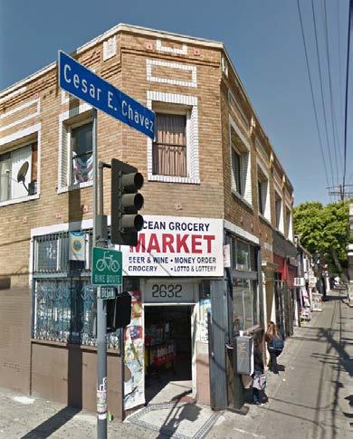
6 Draft Conservation District Brooklyn Heights Conservation of Traditional Neighborhoods and Resources Additional Metrics for Conservation District: Maximum Lot Width Minimum Lot Depth Maximum Lot Depth Separation between two habitable structures on the same lot Ground to floor build-to-range Mt. Pleasant East 2 nd Street Additional Design Requirements for Eligible Planning and Historic Districts*: Roof pitch requirements Required Frontage Elements Porch Standards Building Material Boyle Avenue St. Louis & Chicago Streets *Planning and Historic Districts as identified in the Survey LA Boyle Heights Results

7 Industrial Districts Theme: Land Use Compatibility Forms and uses that provide a buffer between industry and neighborhoods Incorporate standards from the Clean Up Green Up Ordinance (ZI-2458) Re:Code Zoning Tools: Adjacency standards limiting scale Active frontages Tailored use districts that prohibit hazardous uses: electroplating, battery rebuilding automotive painting Asbestos products manufacturing Babbitt metal manufacturing Draft Zoning District Zone Symbol River District Scale 1 RDS 2 River District Scale 2 RDS 1 Production Scale 3 (Heavy Industial) Production Scale 2 (Light Industrial) Production Scale 1 (Limited Industrial) PS3 PS2 PS1


8 Industrial Districts Theme: Riverside Access and Activation Projects are required to dedicate a min. percentage of lot area for Outdoor Amenity Space Provided in the form of: Courtyard Plaza Park Paseo Projects are required to include frontages along the Riverside. Required building breaks to allow views and access to the Riverside. Activation of building breaks with paseo or active alleyway. Incorporate Design Guidelines of the River Improvement Overlay (ZI-2358)
 Outdoor amenity space Active alleys and arcades Maximum tenant space sizes Upper story stepbacks/adjacency")
 Community Corridor 2 (Level 2 Corridor) Neighborhood Corridor 1 (Brooklyn Corridor) Neighborhood Corridor 2 Zone Symbol MR1 TN1 TN2 CC1")
9 Community Corridors Theme: Vibrant Community Corridors Re:Code Zoning Tools: Frontage requirements Build-to-ranges Parking setbacks Street facing façade length (full building breaks) Outdoor amenity space Active alleys and arcades Maximum tenant space sizes Upper story stepbacks/adjacency standards Draft Zoning District Mid-Rise 1 (Regional Center) Transit Node 1 (Level 1 Node) Transit Node 2 (Level 2 Node) Community Corridor 1 (Level 1 Corridor) Community Corridor 2 (Level 2 Corridor) Neighborhood Corridor 1 (Brooklyn Corridor) Neighborhood Corridor 2 Zone Symbol MR1 TN1 TN2 CC1 CC2 NC1 NC2


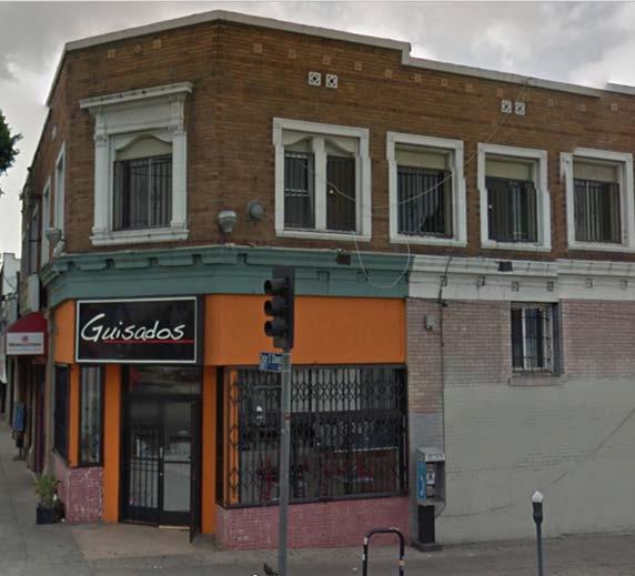
10 Historic Brooklyn Corridor HCM-590


11 Draft Brooklyn Corridor Character Standards
12 Updated Community Plan Text Draft Template Chapter 3 Land Use & Urban Form 3.1 Introduction Overarching Vision Neighborhoods 3.2 Diverse Housing Opportunities 3.3 Complete and Connected Neighborhoods 3.4 Conserving Neighborhood Character Community Corridors 3.5 Vibrant Community Corridors 3.6 Mixed-Use Development Standards 3.7 Community Enhancement Opportunity Areas Industrial Districts 3.8 Land for Industry, Innovation, and Jobs 3.9 Land Use Compatibility and Environmental Standards 3.10 Riverside Access and Awareness
13 Next Steps Working with re:code to: Finalize Use Districts Finalize and model metrics for Conservation Districts Create a process and procedure for Conservation District review without a discretionary approval Update to the Boyle Heights Neighborhood Council on re:code Progress
14
15 Questions? Contact us! Alex Heath Kiran Rishi Check out our new website and follow us on Facebook!
TRANSIT NEIGHBORHOOD PLANS PROGRAM OVERVIEW
 TRANSIT NEIGHBORHOOD PLANS PROGRAM OVERVIEW OCTOBER 2017 Los Angeles Department of City Planning @LATNP and @Planning4LA Outline Introduction Policy Framework The Transit Neighborhood Plans Program Overview:
ORANGE LINE TRANSIT NEIGHBORHOOD PLANS VAN NUYS NEIGHBORHOOD COUNCIL, PLUM COMMITTEE DEPARTMENT OF CITY PLANNING, CITY OF LOS ANGELES
 Photo: Mission Meridian(Moule & Polyzoides) ORANGE LINE TRANSIT NEIGHBORHOOD PLANS VAN NUYS NEIGHBORHOOD COUNCIL, PLUM COMMITTEE DEPARTMENT OF CITY PLANNING, CITY OF LOS ANGELES JULY 18, 2018 Project partially
DRAFT. 10% Common Open Space
 % OF CHARLOTTE IS CATEGORIZED AS A. LAND USES : Placeholder map displaying location of Place Type GOALS: Accommodate XX% of future growth. Provide a concentration of primarily commercial and civic activity
Quarterly Report & Code Evaluation
 A New Zoning Code for a 21st Century Los Angeles To create livable communities, encourage sustainable development and foster economic vitality, we need a modern and user-friendly zoning code we need to
Community Design Plan
 Gardena General Plan 2006 Authority While the is not a required element of a General Plan, it is included because improving the community appearance and image is paramount to the overall quality of life
Status Report: MD 355 Project
 Status Report: MD 355 Project OCTOBER 2006 M-NCPPC MONTGOMERY COUNTY PLANNING DEPARTMENT Summary of Community Comments, and break to the Results of the MD 355 Participation Session Brookside Gardens -
DRAFT Land Use Chapter
 Stevens Creek Urban Village DRAFT 1 18 17 Land Use Chapter INTRODUCTION This Land Use Chapter describes how the Stevens Creek Urban Village will accommodate the growth that is planned for it in the Envision
Chapter 4: Jordan Road Character District
 4: Jordan Road Character District 4.1 Introduction The Jordan Road character district encompasses much of the former Jordan orchard and farmstead, which was a significant part of Sedona s history. The
Policies and Code Intent Sections Related to Town Center
 Policies and Code Intent Sections Related to Town Center The Town Center Vision is scattered throughout the Comprehensive Plan, development code and the 1994 Town Center Plan. What follows are sections
Steering Committee Meeting
 Neighborhood Planning Initiative NPI EAST CENTRAL AREA PLAN Steering Committee Meeting November 9, 2017 6:00PM 8:00PM Tears McFarlane House East Central Area Plan Steering Committee Meeting 11/9/17 AGENDA
chapter DESIGN GUIDELINES NEW RIVER MASTER PLAN REPORT
 chapter DESIGN GUIDELINES NEW RIVER MASTER PLAN REPORT .76 DESIGN GUIDELINES An Overview design guidelines NEW RIVER MASTER PLAN Design Guidelines can transform the image of a city. Specific, design-based
AREA REDEVELOPMENT PLAN THE WAY WE GROW
 AREA REDEVELOPMENT PLAN THE WAY WE GROW Office Consolidation June 2014 Submitted to the City of Edmonton Planning & Development Department By: Edmonton, AB T5G 0Y5 Phone 780 482-4813 Fax 780 488-4566 Email:
DRAFT Civic Center Station Area Plan. Executive Summary
 DRAFT Civic Center Station Area Plan Executive Summary This project is funded in part through the Metropolitan Transportation Commission s Station Area Planning Program. The preparation of this report
Planning Charlotte s Future. Transportation & Planning Committee March 14, 2016
 Planning Charlotte s Future Transportation & Planning Committee March 14, 2016 Charlotte s Vision Livable city Vibrant economy Thriving natural environment Diverse population Choices for housing, education,
Planning Charlotte s Future. Planning Committee May 17, 2016
 Planning Charlotte s Future Planning Committee May 17, 2016 Place Types: Next Steps March - June Public Input: Education & input on community character and place-type framework Public open house (Transportation
A. Background Summary of Existing Challenges and Potential Possibilities. 1. Summary of Existing Assets and Potential Opportunities
 A. Background 1 A Main Street Master Plan Study was performed and completed in October of 2007. The study was initiated to review current land uses and development patterns along Main Street, from Parrish
FRUITVALE TRANSIT VILLAGE (Phase 2) Residential Project
 Residential Project") FRUITVALE TRANSIT VILLAGE (Phase 2) Residential Project DEVELOPER: SIGNATURE PROPERTIES ARCHITECT: HKIT ARCHITECTS April 23, 2010 TABLE OF CONTENTS 3 Vision 4 Description of Site 5 Guiding Concepts 6
FRUITVALE TRANSIT VILLAGE (Phase 2) Residential Project DEVELOPER: SIGNATURE PROPERTIES ARCHITECT: HKIT ARCHITECTS April 23, 2010 TABLE OF CONTENTS 3 Vision 4 Description of Site 5 Guiding Concepts 6
TOD 101 CREATING LIVABLE COMMUNITIES WITH TRANSIT
 1 CREATING LIVABLE COMMUNITIES WITH TRANSIT What are transit Centered Communities? Benefits of Partnerships to Support and Implement What You Will Learn Portland s Pearl District Your Trainers Today Catherine
Rezoning Frequently Asked Questions
 elcome The City of Vancouver has received an application to rezone 6929-6969 Cambie Street and 515 est 54th Avenue from RS-1 (Single Family) District to CD-1 (Comprehensive Development) District. The proposal
Crossroads Specific Plan City of Temple City GPAC Review Draft 10/05/16
 TEMPLE CITY GENERAL PLAN Crossroads Specific Plan City of Temple City GPAC Review Draft 10/05/16 Introduction... 1-3 What is a Specific Plan?... 3 Where is the Crossroads Specific Plan?... 4 Why a Specific
CPD Rules and Regulations. Arapahoe Square Zoning and Design Standards/Guidelines
 CPD Rules and Regulations Arapahoe Square Zoning and Design Standards/Guidelines Denver Planning Board May 4 th, 2016 Sponsor & Community Partners Sponsored by Albus Brooks, Council District 9 Developed
North Fair Oaks Community Plan Summary and Information
 North Fair Oaks Community Plan Summary and Information WHAT IS THE NORTH FAIR OAKS COMMUNITY PLAN? The North Fair Oaks Community Plan is part of the San Mateo County General Plan, and establishes policies
Planning Charlotte s Future. Planning Committee June 21, 2016
 Planning Charlotte s Future Planning Committee June 21, 2016 Charlotte s Vision Livable city Vibrant economy Thriving natural environment Diverse population Choices for housing, education, employment Safe
The Five Components of the McLoughlin Area Plan
 The Five Components of the McLoughlin Area Plan This documents contains the complete language of the five components of the McLoughlin Area Plan: The Vision Statement The Values The Guiding Principles
GENERAL PLAN AND ENVIRONMENTAL IMPACT REPORT
 City of Menifee HEARING DRAFT GENERAL PLAN AND ENVIRONMENTAL IMPACT REPORT City Council November 2013 PURPOSE OF MEETING Overview of GP Process Overview of required and optional GP elements Receive direction
AN ORDINANCE THE COUNCIL OF THE CITY OF PHILADELPHIA HEREBY ORDAINS:
 AN ORDINANCE Amending Title 14 of The Philadelphia Code, entitled Zoning and Planning, by amending Section 14-507, entitled /CDO, Central Delaware Riverfront Overlay District, under certain terms and conditions.
Chapter 5: Mixed Use Neighborhood Character District
 5: Mixed Use Neighborhood Character District 5.1 Introduction The Mixed Use Neighborhood character district acts as a transition or bridge between the State Route 89A District s commercial area to the
ARTICLE 6: Special and Planned Development Districts
 ARTICLE 6: Special and Planned Development Districts 6-10 Traditional Neighborhood Development (TND) District 6-10.10 Purpose and Intent The Traditional Neighborhood Development (TND) District provides
A. WHAT IS A GENERAL PLAN?
 I. Introduction A. WHAT IS A GENERAL PLAN? A general plan is the planning guideline for the future of a city. It contains goals and policies which regulate urban development, the protection of the natural
CHAPTER 1. Ms. Guajardo s Class - Central Elementary CH 1 1
 INTRODUCTION CHAPTER 1 Ms. Guajardo s Class - Central Elementary CH 1 1 1.1 SETTING South Centre City is a linear corridor south of Downtown Escondido paralleling Centre City Parkway and South Escondido
Table L-1 Summary Action Strategy. Action Item Timing Status Responsible Agency
 CHAPTER 4: CIRCULATION ELEMENT ISSUE #1: MAJOR THOROUFARES AND TRANSPORTATION ROUTES A balanced transportation system for Fontana is provided that meets the mobility needs of current and future residents
SALT LAKE CITY PLANNING DIVISION ANNUAL REPORT
 SALT LAKE CITY PLANNING DIVISION ANNUAL REPORT 2017 Planning Division Quick Facts 28 staff members Services Long term land use planning Historic Preservation Urban Design Design Review Land Use Review
AMITY STATION Revised Concept Plan Review West Rosemary Street Chapel Hill, NC September 27, 2016
 AMITY STATION Revised Concept Plan Review West Rosemary Street Chapel Hill, NC September 27, 2016 DEVELOPER'S PROGRAM Introduction This is a request for review of a Revised Concept Plan by Chapel Hill
Institutional Overlay Zone (IOZ) Regulatory Framework
 Regulatory Framework") Institutional Overlay Zone (IOZ) Regulatory Framework Approved by Portland City Council November 20, 2017 APPLICABILITY All development proposed by Maine Medical Center (MMC) within the boundary of the
Institutional Overlay Zone (IOZ) Regulatory Framework Approved by Portland City Council November 20, 2017 APPLICABILITY All development proposed by Maine Medical Center (MMC) within the boundary of the
NORTH LAKE SPECIFIC PLAN AREA
 NORTH LAKE SPECIFIC PLAN AREA June 21, 2018 WELCOME Workshop Agenda Introduction Provide information about the program and introduce the team Background Information Share information about the North Lake
Comprehensive Plan Advisory Panel Meeting #3
 Comprehensive Plan Advisory Panel Meeting #3 November 7, 2016 Agenda 1. September 19 th Meeting Notes 2. Summary of Focus Areas Charrette 3. Heart of the City Focus Area a. HOC2/Station Areas Concept &
2. INTRODUCTION 2.1 AUTHORITY 2.2 PURPOSE AND INTENT 2.3 SITE LOCATION
 2. INTRODUCTION 2.1 AUTHORITY The City of Gardena initiated and prepared the Artesia Corridor Specific Plan pursuant to the provisions of California Government Code, Title 7, Division 1, Chapter 3, Article
ELMVALE ACRES SHOPPING CENTRE MASTER PLAN
 ELMVALE ACRES SHOPPING CENTRE MASTER PLAN Contents 1.0 INTRODUCTION... 2 2.0 LOCATION... 2 3.0 EXISTING CONTEXT... 2 4.0 VISION & GUIDING PRINCIPLES... 2 5.0 LAND USE AND BUILT FORM... 4 5.1 St. Laurent
Draft Memorandum #1: Goals and Vision for Revitalization
 Keizer Revitalization Plan Draft Memorandum #1: Goals and Vision for Revitalization Submitted to: City of Keizer April 12, 2018 (revised) Prepared By: Angelo Planning Group and Otak, Inc. Project No. 17482.A
WEST OAKLAND SPECIFIC PLAN & DRAFT ENVIRONMENTAL IMPACT REPORT
 WEST OAKLAND SPECIFIC PLAN & DRAFT ENVIRONMENTAL IMPACT REPORT Landmarks Preservation Advisory Board Public Hearing February 10, 2014 1 Specific Plan Overview Plan Area is generally bounded by I-580 to
Gary & Regional Investment Project. October 27, Creating Tomorrow Today Comprehensive Regional Plan - NIRPC
 Creating Tomorrow Today 2040 Comprehensive Regional Plan Gary & Regional Investment Project October 27, 2010 Creating Tomorrow Today - 2040 Comprehensive Regional Plan - NIRPC What is NIRPC? - Northwestern
TRANSIT ORIENTED DEVELOPMENT PINELLAS COUNTY MPO LIVABLE COMMUNITIES INITIATIVE PINELLAS COUNTY COMPREHENSIVE PLAN AMENDMENTS
 PINELLAS COUNTY MPO LIVABLE COMMUNITIES INITIATIVE MODEL LAND DEVELOPMENT CODE TRANSIT ORIENTED DEVELOPMENT PINELLAS COUNTY COMPREHENSIVE PLAN AMENDMENTS MPO Livable Communities Initiative Goal: Improve
WASHINGTON COUNTY OREGON
 WASHINGTON COUNTY OREGON July 9, 2009 Revisions to Chapter 2 of the Bethany Community Plan The North Bethany Subarea Plan Exhibit pages 7 and 8 The sections for the Core and Flexible Streets were amended
BAGBY STREET RECONSTRUCTION PROJECT OCTOBER 2, 2015
 BAGBY STREET RECONSTRUCTION PROJECT OCTOBER 2, 2015 CLAIRE HEMPEL, PLA, AICP, LEED GA PREPARED BY Aspen Asheville Austin Chicago Denver Dubai Houston Lake Tahoe Los Angeles MIDTOWN : A MODEL OF URBAN DEVELOPMENT
JANUARY 19, 2011 CENTRAL AVENUE-METRO BLUE LINE TRANSIT-ORIENTED DEVELOPMENT IMPLEMENTATION PROJECT COMMUNITY FORUM
 CENTRAL AVENUE-METRO BLUE LINE TRANSIT-ORIENTED DEVELOPMENT IMPLEMENTATION PROJECT COMMUNITY FORUM JANUARY 19, 2011 THE MARYLAND-NATIONAL CAPITAL PARK AND PLANNING COMMISSION PRINCE GEORGE S COUNTY PLANNING
FUTURE LAND USE ELEMENT
 FUTURE LAND USE ELEMENT GOAL I: To create and sustain a great place to live, play, and prosper Objective 1: The City of Ocala shall incorporate the principles and strategies of the Ocala 2035 Vision into
Slot Home Task Force Meeting #5 Phase 2 June 8, 2017
 Slot Home Task Force Meeting #5 Phase 2 June 8, 2017 MEETING OBJECTIVES Review Staff Recommended Strategy for Mixed Use and Main Street districts Confirm the Strategy for the Mixed Use and Main Street
4.9 Mendocino Avenue Corridor Plan Design Guidelines
 4.9 Mendocino Avenue Corridor Plan Design Guidelines The Mendocino Avenue Corridor Plan addresses the area between College Avenue and Steele Lane. Mendocino Avenue is a busy arterial that runs parallel
EXISTING COMPREHENSIVE PLAN
 EXISTING COMPREHENSIVE PLAN Town Center Land Use Element: V. LAND USE POLICIES Town Center Mercer Island's business district vision as described in "Your Mercer Island Citizen-Designed Downtown" was an
Sahuarita District & Phase 1 Master Plan. Town Council December 11, 2017
 Sahuarita District & Phase 1 Master Plan Town Council December 11, 2017 Visioning Study Visioning Process Advisory Group Meetings Community Questionnaire Town Center Case Studies Community Analysis The
4 C OMMUNITY D ISTRICTS
 4 C OMMUNITY D ISTRICTS N ew development in the Area will include many different types of land uses, including a destination retail area that attracts people from all over the region; recreation opportunities
GUIDING PRINCIPLES IN THIS CHAPTER
 GUIDING PRINCIPLES The guiding principles and design concepts in this chapter work together with the Chapel Hill 2020 Comprehensive Plan to support new public places that can be enjoyed by all while also
ARLINGTON COUNTY, VIRGINIA
 ARLINGTON COUNTY, VIRGINIA County Board Agenda Item Meeting October 15, 2005 DATE: September 28, 2005 SUBJECT: Request to Advertise the adoption of the 2005 Clarendon Sector Plan C. M. RECOMMENDATION:
Blueprint Denver A BLUEPRINT FOR AN INCLUSIVE CITY. Executive Summary
 Blueprint Denver A BLUEPRINT FOR AN INCLUSIVE CITY Executive Summary PUBLIC REVIEW DRAFT 2 1/7/2019 DENVERIGHT BLUEPRINTDENVER Blueprint Denver: A Blueprint for an Inclusive City An Equitable City Planning
WEST LOOP DESIGN GUIDELINES CHECKLIST
 WEST LOOP DESIGN GUIDELINES CHECKLIST Section 1.0 General Strategies 1.1 DESIGN EXCELLENCE: ENCOURAGE HIGH QUALITY AND INNOVATIVE DESIGN OF NEW BUILDINGS WITHIN THE WEST LOOP WITHOUT BEING PRESCRIPTIVE
North Downtown Specific Plan MEMORANDUM
 North Downtown Specific Plan MEMORANDUM MEETING DATE: November 13, 2017 TO: Members of the North Downtown Specific Plan Advisory Committee FROM: Jeanine Cavalli, Senior Planner SUBJECT: Materials for the
City of Charlottesville
 City of Charlottesville MEMORANDUM To: Charlottesville Planning Commission From: Ebony Walden, Neighborhood Planner and Missy Creasy, Planning Manager Date: November 15, 2012 Re: Comprehensive Plan Fall
FLORIN ROAD CORRIDOR Site Plan and Design Review Guidelines Checklist
 FLORIN ROAD CORRIDOR Site Plan and Design Review Guidelines Checklist Applicant s Name: Project Address: Phone: Email: Applicant shall fill out the design guidelines checklist for all guidelines applicable
New Partners for Smart Growth Conference February 5, 2010
 Dan Stroh, Planning Director City of Bellevue Planning and Community Development Bellevue, WA New Partners for Smart Growth Conference February 5, 2010 Summary of Project Long-range plan update for Bel-Red
Executive Summary. May 2014 Page 1
 Executive Summary The Mediterranean Style Design Standards are provided as an incentive to property owners to encourage and expand the creative use of the various architectural styles in association with
Isabel Neighborhood Plan: Alternatives
 Isabel Neighborhood Plan: Alternatives Presented by: Lori Parks, Associate Planner February 2, 2015 Agenda 1. Background on BART to Livermore 2. Isabel Neighborhood Plan 3. Alternative Scenarios 4. General
Residential Commons at Barry s Corner. Boston civic design commission February 5, 2013
 Residential Commons at Barry s Corner Boston civic design commission February 5, 2013 TABLE OF CONTENTS project summary 3 PROJECT site 4 PLANNING APPROACh 6 Parcel Diagams 6 Design Principles 8 Street
Eastlake Subarea plan land use comparison
 Eastlake Subarea plan land use comparison PROPOSED FUTURE LAND USE MAP, as presented SECOND ST BIRCH ST THIRD ST to City Council (2016) LAKE AVE Future Plaza 124th / Eastlake Station RTD FIRST ST Parking
Tyvola & Archdale Transit Station Area Plan. June 5, 2008
 Tyvola & Archdale Transit Station Area Plan Second Public Meeting June 5, 2008 Presentation Outline 1. Purpose and Process 2. Station Area Overview 3. Plan Recommendations 4. Comments Received and Proposed
3.0 URBAN DESIGN. December 6, OVERVIEW
 Urban Design 3.0 URBAN DESIGN December 6, 2007 3.1 OVERVIEW The highly urban character of Easton Place is defined by the overall design of the community. The following sections provide an overview of the
SECTION UNIFIED DEVELOPMENT ORDINANCE SECTION Part 1 Ordinance. ARTICLE 1 Zoning Districts
 SECTION 1-100 UNIFIED DEVELOPMENT ORDINANCE SECTION 1-300 Part 1 Ordinance SECTION 1-100. Introduction. ARTICLE 1 Zoning Districts Crystal Lake strives to maintain a balance of various land uses for a
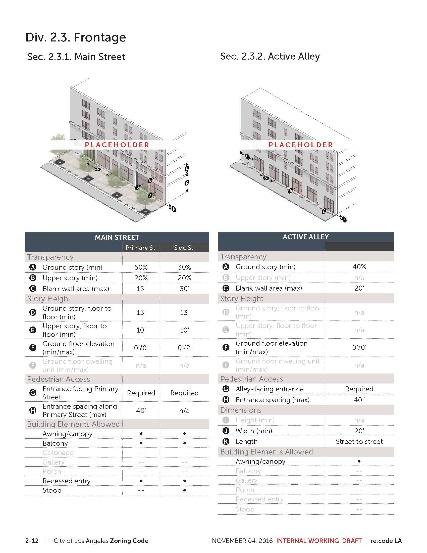
17.11 Establishment of Land Use Districts
 17.11 Establishment of Land Use Districts 17.11.010 Purpose. To promote the health, safety, and general welfare of City residents and those who come to South Salt Lake to work, exchange commerce and recreate.
ANC 2A Presentation. November 9, 2006
 ANC 2A Presentation November 9, 2006 Introduction & Overview Applicants Boston Properties and KSI Services (project developers) The George Washington University (land owner) 2.66 acre site (former GW hospital
Listening Sessions: Guiding Principles and Unified Development Code New Castle County, Delaware
 Listening Sessions: Guiding Principles and Unified Development Code New Castle County, Delaware March 2015 AGENDA Introduction: Who We Are Work Program and Schedule Guiding Principles Discussion Project
Chapter PEDESTRIAN COMMERCIAL (PC) ZONING DISTRICT
 ZONING DISTRICT") Chapter 11-17 PEDESTRIAN COMMERCIAL (PC) ZONING DISTRICT Sections: 11-17-01 GENERAL PURPOSE 11-17-02 PERMITTED BUILDING TYPES 11-17-03 USES PERMITTED WITH DESIGN REVIEW 11-17-04 USES PERMITTED BY CONDITIONAL
Chapter 11-17 PEDESTRIAN COMMERCIAL (PC) ZONING DISTRICT Sections: 11-17-01 GENERAL PURPOSE 11-17-02 PERMITTED BUILDING TYPES 11-17-03 USES PERMITTED WITH DESIGN REVIEW 11-17-04 USES PERMITTED BY CONDITIONAL
CITY OF SANTA MONICA DESIGN GUIDELINES DRAFT
 CITY OF SANTA MONICA DESIGN GUIDELINES DRAFT 5.15.12 Mixed-Use Corridor Districts 1. MU-B 2. MU-BL 3. NC 4. GC Multi-Family Residential Districts 5. RL 6. RM 7. RH MIXED-USE CORRIDOR DISTRICTS MIXED-USE
Denver Moves: Transit Task Force
 Insert transit picture Denver Moves: Transit Task Force Meeting #8 October 5, 2017 1. Welcome & Introductions Opening remarks and housekeeping Task Force and audience introductions Upcoming events and
Be it enacted by the Town Board of the Town of Guilderland that the following new A (Transit Oriented Development (TOD) District) is adopted:
 District) is adopted:") Local Law No. 4 of 2018 (Adoption of 280-18A (Transit Oriented Development District) Be it enacted by the Town Board of the Town of Guilderland that the following new 280-18A (Transit Oriented Development
Local Law No. 4 of 2018 (Adoption of 280-18A (Transit Oriented Development District) Be it enacted by the Town Board of the Town of Guilderland that the following new 280-18A (Transit Oriented Development
1. In the Lark perimeter overlay zone we should set a maximum density of eight units/acre.
 General Plan Committee and Planning Commission Recommendations Regarding Town Council Suggestions for Potential Amendments to the Adopted North 40 Specific Plan The Town Council suggestions for potential
Missoula Design Excellence Project Strategy Report. Public Review Draft Strategy Report September 12, 2017
 Missoula Design Excellence Project Strategy Report Public Review Draft Strategy Report September 12, 2017 Contents EXECUTIVE SUMMARY AND READER S GUIDE 5 I. INTRODUCTION 11 II. COMMUNITY OUTREACH PROCESS,
BUILDING SCALE AND SETBACKS 5 ELEMENTS:... 5 FAÇADES (COMMERCIAL/RESIDENTIAL) 5
 5") VISION STATEMENT 3 UTILIZATION OF THE GUIDELINES 3 IMPLEMENTATION 3 PROCEDURES FOR DESIGN REVIEW 3 LAND USE AND ZONING 4 LAND USE 4 ELEMENTS:... 4 ZONING 4 ELEMENTS:... 4 BUILDING SCALE AND SETBACKS 5
VISION STATEMENT 3 UTILIZATION OF THE GUIDELINES 3 IMPLEMENTATION 3 PROCEDURES FOR DESIGN REVIEW 3 LAND USE AND ZONING 4 LAND USE 4 ELEMENTS:... 4 ZONING 4 ELEMENTS:... 4 BUILDING SCALE AND SETBACKS 5
The Palisades Interstate Parkway and Henry Hudson Drive designated a New Jersey State Scenic Byway, 2005
 The Palisades Interstate Parkway and Henry Hudson Drive designated a New Jersey State Scenic Byway, 2005 What are scenic byways? How Did Scenic Byways Come About? National Scenic Byways Program Administered
BROOKLYN PARK / 85TH AVE LRT STATION CDI DEVELOPMENT GUIDELINES DRAFT
 August 2018 Page intentionally left blank The Brooklyn Park Library adjacent to the 85th Ave LRT Station Area. OVERVIEW The Blue Line LRT Extension / Bottineau corridor offers a unique opportunity to leverage
DRAFT Concept Alternatives
 O c t o b e r 2016 DRAFT Concept Alternatives W a l n u t G e n e r a l P l a n U p d a t e a n d W e s t Va l l e y S p e c i f i c P l a n Contents WHAT IS THE GENERAL PLAN..........................................
Toronto Complete Streets Guidelines Stakeholder Advisory Group #
 Toronto Complete Streets Guidelines Stakeholder Advisory Group #1 2015-03-24 What are Complete Streets? 2 Streets designed with all users in mind: pedestrians/those with disabilities cyclists street car
East Central Area Plan
 East Central Area Plan Steering Committee Meeting January 10 th, 2019 Tears-McFarlane House Community Room East Central Area Plan Steering Committee Meeting January 10 th, 2019 CHUN Tears-McFarlane House
A larger version of this map is located on the last page of this PDF.
 MAP Committee Input McLoughlin Area Draft Vision Map A larger version of this map is located on the last page of this PDF. 1. The map above is intended to portray a vision for the McLoughlin area. It highlights
Welcome! Introduction to Design Guidelines for Livable Communities. Design Guidelines: Setting the Stage for Successful TOD
 Welcome! Introduction to Design Guidelines for Livable Communities Design Guidelines: Setting the Stage for Successful TOD Erin Riddle Specializes in transit-oriented development (TOD) projects including
NEIGHBORHOOD DESIGN ELEMENT
 NEIGHBORHOOD DESIGN ELEMENT INTRODUCTION The following recommendations constitute an urban design oriented "neighborhood analysis" of Plantation. It is an optional Comprehensive Plan Element. The five
Locally Produced Food. Access to Nutritious Foods
 a healthy LA ...eats well Locally Produced Food Access to Nutritious Foods The types, amount, and availability of healthy food is just as important in promoting healthier lifestyles and combating chronic
 Community Workshop #2 December 4, 2014 Team Tonight s Agenda 6:00 pm Welcome! 6:05 pm The Future of Downtown Tustin Ideas, Strategies and Recommendations 6:35 pm Questions and Comments 6:50 pm Open
Illustration of Eastlake Farmer s Cooperative Grain Elevator. Chapter 5: implementation 5-1
 Illustration of Eastlake Farmer s Cooperative Grain Elevator Chapter 5: implementation 5-1 chapter 5: implementation Introduction The Eastlake Subarea Plan includes a wide range of recommendations intended
MIXED-USE VILLAGE OVERLAY FLOATING DISTRICT
 MIXED-USE VILLAGE OVERLAY FLOATING DISTRICT Zoning regulations developed by committee to the Planning Board for the Town of DeWitt, NY Issue date: 13 July 2017 revised 3/12/2018, revised 4/26/2018, 5/9/2018
East Central Area Plan
 East Central Area Plan Steering Committee Meeting March 8 th, 2018 CHUN Tears McFarlane House Vision Statement Development Opportunities Analysis Vision Elements 1. Equitable, Affordable and Inclusive
RESEDA - WEST VAN NUYS COMMUNITY PLAN UPDATE WORKSHOP
 Welcome Agenda 6:00 P.M. to 8:00 P.M. Welcome Community Plan Update Overview Presentation Table Discussions: Preserving Residential Neighborhoods Commercial Corridors Mobility Parks and the Public Realm
THEMES, VISION, + PRINCIPLES
 CHAPTER 2: THEMES, VISION, + PRINCIPLES This page intentionally left blank. 20 VISION DRAFT AUGUST 2018 2 2 THEMES, VISION, + GUIDING PRINCIPLES The Key Themes, Vision, and Guiding Principles presented
WATERFRONT DISTRICT DESIGN STANDARDS
 WATERFRONT DISTRICT DESIGN STANDARDS 20.25.080 WATERFRONT DISTRICT A. Purpose. This section is intended to implement The Waterfront District Subarea Plan by: 1. Creating a safe, vibrant mixed-use urban
Walnut Creek Transit Village Design Guidelines. Part Three III - 25
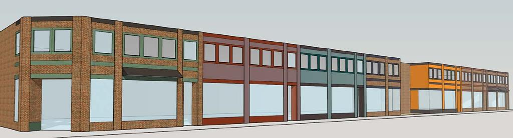
 C. General Design Criteria Part Three DRAFT 0/6/ III - 5 Frontage Types Frontage is a semi-public transition zone at the ground level where public and private realms meet. An understanding of various frontage
Land Use Policy & Development Ordinance Update
 Land Use Policy & Development Ordinance Update Charlotte Chamber of Commerce, Land Use Committee July 27, 2016 Land Use Policy & Development Ordinance Update Land Use Policy & Development Ordinance Update
DOWNTOWN AREA PLAN. June 9, 2009
 DOWNTOWN AREA PLAN June 9, 2009 Issues Identified by Councilmembers Overlap with Southside Plan Southwest Residential Area & Herrick Shadows & Residential Areas Shadows on Streets & Canyon Effect Transit
REPORT OF THE PLANNING AND DEVELOPMENT DEPARTMENT FOR APPLICATION FOR REZONING ORDINANCE TO PLANNED UNIT DEVELOPMENT AUGUST 18, 2016
 REPORT OF THE PLANNING AND DEVELOPMENT DEPARTMENT FOR APPLICATION FOR REZONING ORDINANCE TO PLANNED UNIT DEVELOPMENT AUGUST 18, 2016 AWH The Planning and Development Department hereby forwards to the Planning
The Baileys Planning District portion of the Comprehensive Plan contains site design recommendations for both the Baileys Crossroads Community
 The Baileys Planning District portion of the Comprehensive Plan contains site design recommendations for both the Baileys Crossroads Community Business Center and the Seven Corners Community Business Center.
Mark-up of the effect of the proposed Bronte Village Growth Area OPA No.18 on the text of section 24, Bronte Village, of the Livable Oakville Plan
 Mark-up of the effect of the proposed Bronte Village Growth Area OPA No.18 on the text of section 24, Bronte Village, of the Livable Oakville Plan Notes: This document is provided for information purposes
Othello Neighborhood Design Guidelines
 Othello Neighborhood Design Guidelines 1 S ORCAS ST S OTHELLO ST 42ND AVE S 2 Note: Design Review does not apply to all zones. See Citywide Guidelines for details. Additionally, zoning areas on this map
Commercial Development Standards. City of Homestead
 Commercial Development Standards City of Homestead Presentation Outline Introductions Purpose and Intent Objectives Administrative Process Established Districts Design Standards Purpose and Intent Supplement