Attachment 3: Plan Commission Staff Report
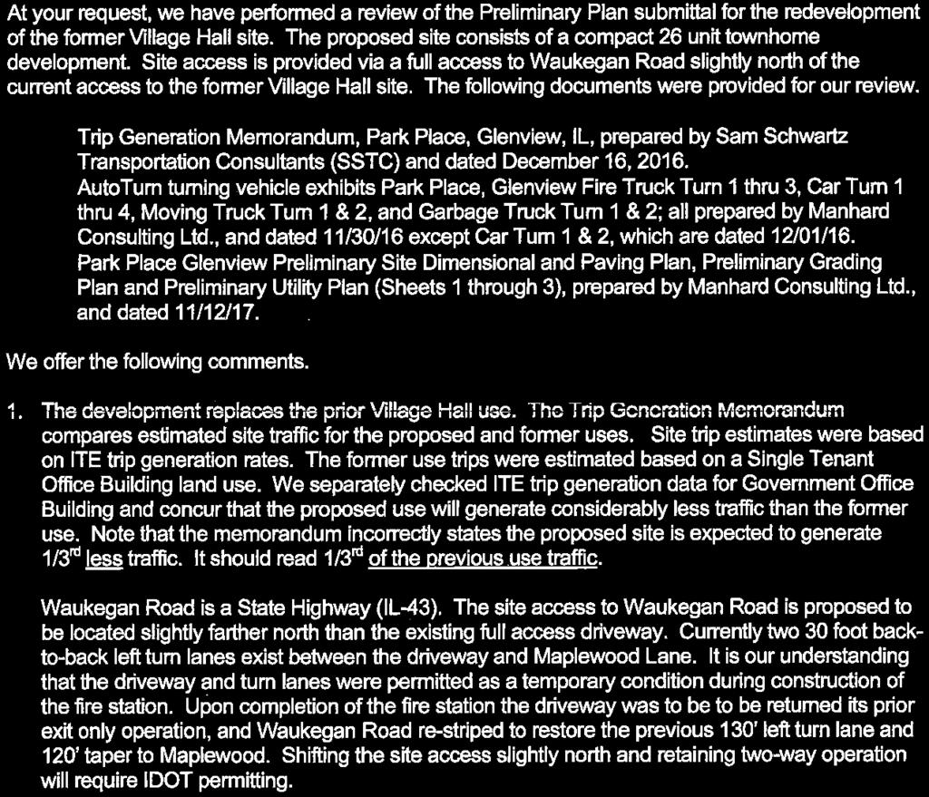
|
|
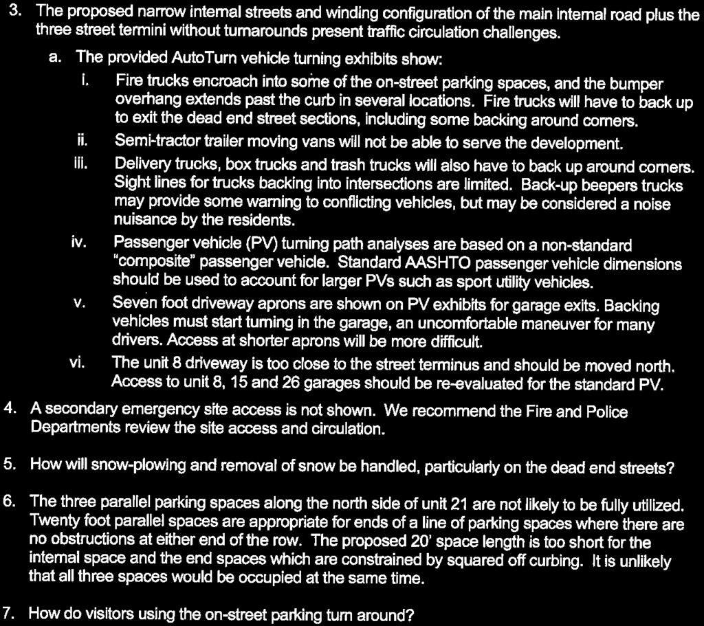
|
- Kelly Hensley
- 5 years ago
- Views:
Transcription
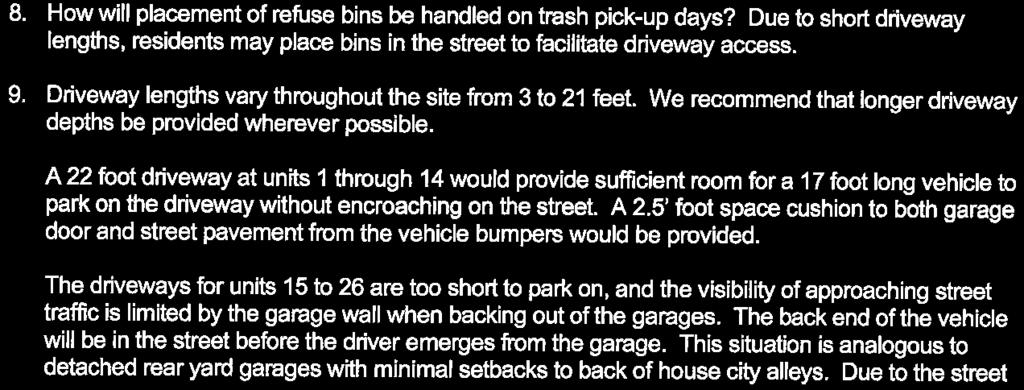
1 Attachment 3: Plan Commission Staff Report 48


2 Village of Glenview Plan Commission Staff Report February 28, 2017 TO: Chairman and Plan Commissioners CASE #: P FROM: Community Development Department CASE MANAGER: Tony Repp, Planner SUBJECT: Planned Development with Variations, Final Site Plan Review, & Preliminary Subdivision ACTION REQUESTED: Staff requests consideration and preliminary review of the proposed site plan APPLICANT / CONTACT: Tom Drake The Drake Group 1967 Johns Drive Glenview, IL Tel: (847) OWNER: Village of Glenview 2500 East Lake Avenue Glenview, IL LOCATION: PROJECT NAME: 1225 Waukegan Road Park Place Glenview PROPOSAL: The applicant, Tom Drake of the Drake Group, requests approval of a Rezoning, Planned Development with Variations, Final Site Plan Review, and Preliminary Subdivision to allow the construction of twenty-six (26) residential units upon the subject property. New content denoted by 02/28/2017 Report Disclaimer: Village staff makes no representations regarding support, endorsement, or the likelihood of approval or disapproval by any Glenview regulatory commission or the Village Board of Trustees. 49

3 Site Assessment VILLAGE OF GLENVIEW ZONING: PIN (S): Current North East South West Glenview D-D Downtown Development District Glenview D-D Downtown Development District Glenview R-5 Residential District Glenview D-D Downtown Development District Glenview D-D Downtown Development District AERIAL PHOTO: PICTOMETRIC PHOTOGRAPHY: 50


4 South Elevation West Elevation 51
5 Project Summary BACKGROUND: 02/28/2017 On February 14, 2017, the Plan Commission completed an initial review of the proposed redevelopment of the former Village Hall site at 1225 Waukegan Road. Staff presented information on similar small home developments in the region, background on the subject property, and an overview of the proposed development. The Plan Commission and applicant continued to discuss the overall plan for redevelopment, which called for the construction of three (3) different product types including rowhome units (13 units), duplex units (4 units), and small-lot single-family residences (9 units). The Plan Commission s discussion focused on the following issues: Density: The Plan Commission commented on the perception that the development felt overly compact and dense for the size and location of the property and requested additional information in order to compare the proposed development to recent projects in the Downtown Development District. The density comparison is included below: Development Units Gross Density Midtown Square units per acre Riverforest units per acre Proposed Park Place (Subject Property) units per acre Neighborhood character: A good deal of the Plan Commission s discussion focused on design elements which were noted as cottage-like and lacking a defined urban feel and building edge particularly along Waukegan Road. The Commission commented the design examples from other communities showed street layouts on through-streets which did not result in the deadend sections shown on the proposed plan. The Commission requested the applicant look at providing architecture or features along Waukegan Road that created an urban edge and asked for confirmation on how the units behind the fire station relate to the street in a more intimate manner given their location and isolated orientation. Circulation / Usability: Given the lack of a looped street pattern or grid system, all circulation is internal and may be circuitous for guests, deliveries, and others accessing the site that may not be familiar with the street pattern. Comments on the availability of guest parking were relayed, however it was clarified that in addition to the street parking, fourteen (14) of the units had one or two parking stalls within driveways. The proposed driveway aprons along the east end of the development site do not provide sufficient width to serve as required parking stalls. Units Garage Driveway Total 1, 2, 3, 4, 5, 6, 7, 9, 10, 11, 12, 13, & 14 2 per unit 2 per unit 4 per unit 8 2 per unit 1 per unit 3 per unit 15, 16, 17, 18, 19, 20, 21, 22, 23, 24, 25, & 26 2 per unit 0 2 per unit 52


6 Green space: The Plan Commission asked the applicant to identify on the plan where the proposed green space and buffer areas were located. The intent was to ensure sufficient landscaping was provided to compliment the compact layout of the development. Pedestrian access: The Plan Commission encouraged the developer to investigate other opportunities for pedestrian access to the site from Waukegan Road in addition to the proposed sidewalk location on the south side of the site. Relationship to surrounding properties: The Plan Commission inquired about other examples from within Glenview or surrounding communities where residential buildings and commercial buildings share a building line adjacent to a major state-route as seen with the proposed development. Photos of townhome projects featuring an urban edge representing multiple styles are included below for reference. Northwest Hwy Arlington Heights Palatine Road Downtown Palatine 53

7 Patriot Blvd. Glenview Following these review comments, members of the public spoke. Questions and concerns raised by the public focused on existing poor drainage conditions, the height of the proposed homes, a request for additional landscaping, preservation of pedestrian cross-access for neighborhood children attending Lyon School, and mitigating impacts of lighting within the development. 02/14/2017 The Village of Glenview relocated the Village Hall to the consolidated Municipal Center at 2500 East Lake Avenue in December Prior to the move, direction was provided by the Village Board to begin the marketing process associated with the sale of the former Village Hall property. The Village coordinated with its Development Advisors, Michael Tobin and Marty Stern of CBRE, who began marketing the former Village Hall site (see attached brochure) to numerous developers in the first quarter of 2016 to ascertain potential redevelopment options. The subject property was zoned D-D Downtown Development District in accordance with figure 2.5 of the Downtown Development Code which was adopted by reference via 5112 in The opportunities for the site could include up to a four-story building height with retail, office, service, or residential uses, or a mix of those uses, as they are all currently permitted under the D-D Downtown District zoning. From April to July 2016, a review of the submitted offers for the redevelopment of the site was conducted by staff and CBRE. All short-listed proposals met the minimum thresholds that would be used to evaluate the offers and included such criteria as: Minimum price range A compliant D-D use(s) Developer s capacity to construct the proposed project Ability to address engineering requirements Medium residential densities Previous high-quality development experience Through the review process, an emphasis was placed on creative site layouts that could add to the vibrancy of downtown, be compatible to the existing uses along Waukegan Road, and be of a similar scale to the existing residential neighborhood to the east. Additionally, the prospective purchaser needed to conduct due diligence in regard to preliminary engineering to ensure any site engineering requirements could be addressed in the proposed development plans. Following the evaluation of the 54
8 multiple configurations of various residential product types and site layouts, and given the constraints of the infill site, the Board of Trustees chose The Drake Group ( Drake ) as the purchaser of the subject property. The proposed Park Place development features mixed-density residential product types similar to several recent new urbanist developments located elsewhere in suburban Chicagoland. For example, the School Street and Floral Avenue developments, in Libertyville and Skokie respectively, offer a mix of housing products including townhomes and higher-density single-family homes with narrow but deep lot widths in locations near the downtown districts of these communities. Within the Village of Glenview, the Cambridge at the Glen development followed a similar model with various housing types located within one neighborhood (rowhomes, single-family, duplexes, two-flats). Photo examples of each development have been provided and a more detailed overview of the characteristics of these types of developments and the proposed Park Place development will be provided during the Plan Commission meeting. 55


9 Floral Avenue - Skokie School Street - Libertyville Cambridge at the Glen 56
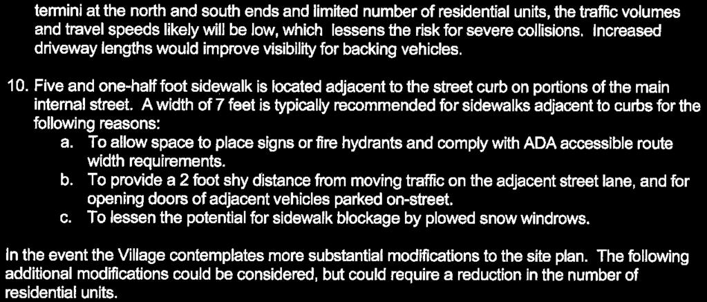
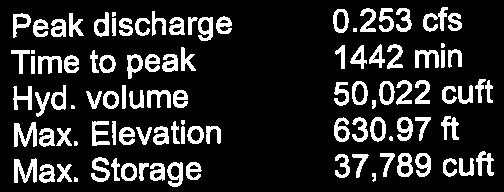
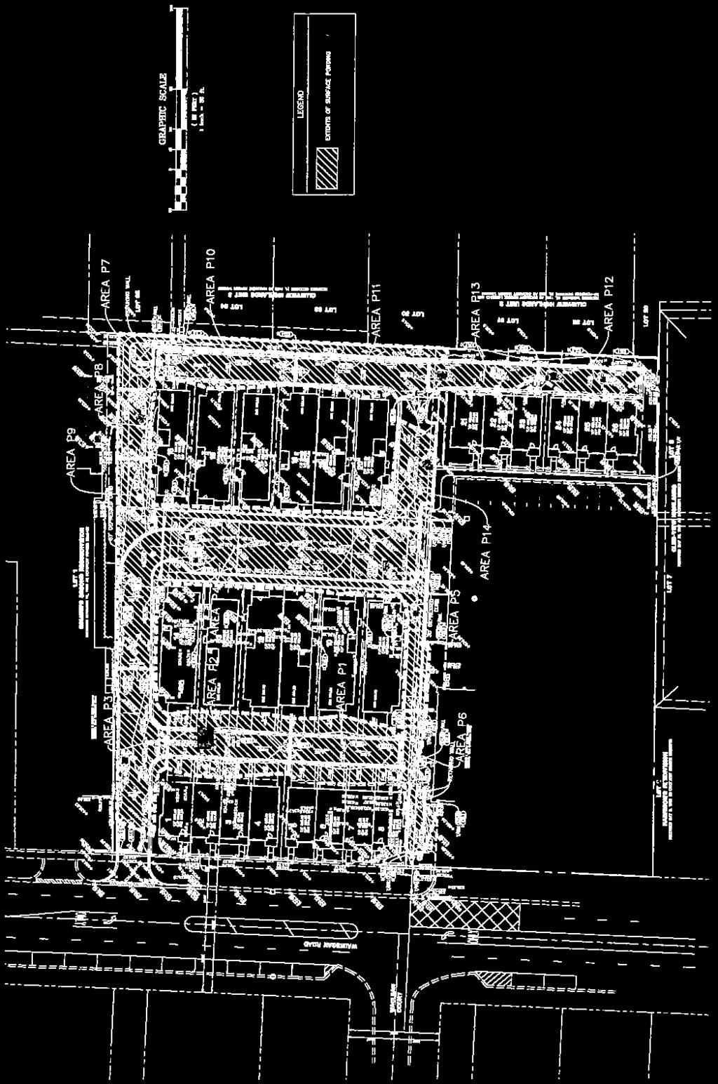
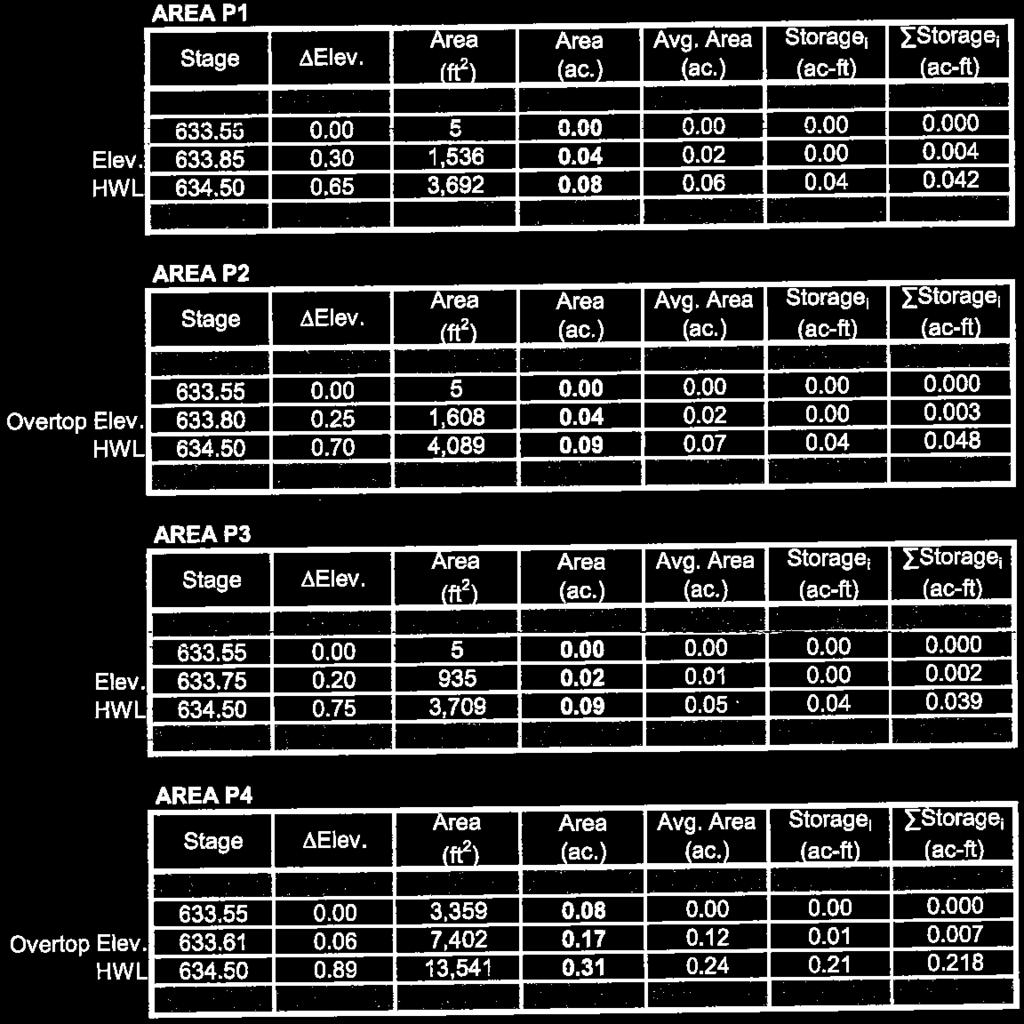
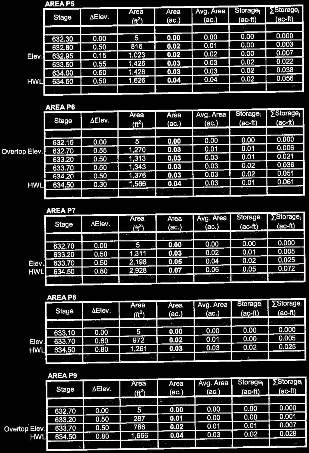
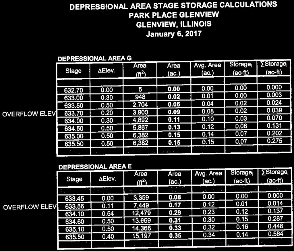
10 SITE ENGINEERING: The engineering of the site has also been designed with consideration given to the adjacent single-family neighborhood and existing drainage routes. The Village is requiring the developer of the site to accept an existing stormwater overflow from the Bonnie Glen neighborhood across the site and into existing storm sewer infrastructure in Waukegan Road. The flow will be handled via the overall site grading and multiple conveyance structures around the site, including a small channel at the south end of the property. Historically, the Bonnie Glen neighborhood has had flooding problems especially near the Raleigh Road and Elizabeth Lane intersection. The development was constructed in an area where a creek and low lands previously existed. This subdivision has been designated a Tier 3 flood area. Vehicle access, including emergency vehicles, to the area is limited during heavy rain events. The 2013 accelerated stormwater program identified this area as a potential candidate for underground stormwater storage. The Village s long-term goals for stormwater management have included providing relief for this neighborhood. As part of this long-term goal, the Village partnered with School District 34 to locate stormwater improvements on the Lyon School property. In 2016, the Plan Commission and Village Board of Trustees approved a 5 acre-foot detention vault on the Lyon School property would provide benefits, both direct and indirect, to 340 parcels with flood levels being reduced along public roadways and on private property. The greatest benefits would be realized during the most commonly occurring storm events, such as 2-, 5-, 10-, and 25-year events. New inlets would be installed on Raleigh Road with storm sewer pipe to connect to the underground detention chamber. PROJECT DESCRIPTION: 02/28/2017 The applicant has made several changes to the proposed site plan and architecture. These changes have been itemized in the Drake Group s written response to comments from the Plan Commission and from Staff. The first item addresses the units in the far southeastern corner of the property. By utilizing fencing and additional landscaping, the applicant has attempted to create a sense of privacy from the adjacent fire station use. The applicant has made changes to the elevations of rowhomes along Waukegan Road to increase the effect of the built-over-time aesthetic and reduce the mirroring effect of the two unit groups. In order to highlight the urban edge, the applicant has added masonry and fencing features to the western lot line to provide a firmer separation and create an aesthetic which establishes a more defined right-of-way line. Additional refinements were made to the architectural elevations for the single-family and duplex products to enhance the design and emphasize the urban nature of the proposed development. Alterations to the parking and pedestrian circulation patterns were included as discussed with staff and the Plan Commission. The alterations were limited in scope and located in the rear of the property near unit
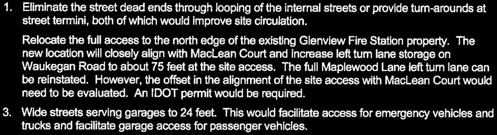
11 02/14/2017 The applicant s proposed plan for the property features a mix of twenty-six (26) for-sale, single-family attached and detached dwelling units, which include three (3) different product types including rowhome units (13 units), duplex units (4 units), and small-lot single-family residences (9 units). The proposed units would be two-stories (single-family homes) and three-stories (two-story townhome with a first floor garage) in height and are oriented in a north-south configuration accessible from private streets and alleys. The larger rowhomes along Waukegan Road address that street, while smaller rowhome units would be positioned east of the fire station. The front facades of the single-family and duplex units would be oriented toward an internal private street, with all the units having access to their garages via private alleys. POTENTIAL NEIGHBORHOOD IMPACTS: At press time, staff had not received any formal correspondence from any neighbors or adjacent property owners. Staff has received phone calls from several residents inquiring about the regulatory review process. The applicant hosted a neighborhood meeting on January 31, 2017 and presented plans to approximately a dozen residents. Plan Commission Review FINAL SITE PLAN REVIEW COMMENTS The purpose of Site Plan Review is to go beyond the basic zoning, subdivision, design and building requirements in order to address site details which these other codes may not regulate in such detail. The review process is intended to promote more orderly and harmonious development and are intended to ensure that all codes and ordinances have been met helping to provide a logical and coordinated review of proposed developments. Staff has coordinated with the applicant on the included submittal which substantially complies with the Site Plan Review Ordinance Criteria: BUILDING AND STRUCTURE LOCATIONS 02/28/2017 The applicant has added masonry fencing elements to the western lot line in order to add interest and identity to the proposed development. The applicant should elaborate on why a looped street pattern is not possible or compatible with the proposed character and usability of the development. The applicant shall relocate the AC condensers for units 1-8 in an area away from vehicle circulation. These units could be grouped in between buildings or placed on the roof. The applicant shall relocate AC condensers for units These may be located in the front yards or on the roof of the units. The Plan Commission should forward necessary comments to the Appearance Commission regarding whether brick materials should be included on all three floors of certain townhome 58
12 units along Waukegan Road in order to establish a clearer urban edge and provide differentiation of the units. 02/14/2017 Driveway widths should be expanded to provide adequate width for multiple vehicles where applicable. An approved site plan would be the controlling document for the Planned Development. As such the following items need to be identified on the site plan as part of any Planned Development approvals: o Accessory uses such as patios, generators, HVAC equipment, spas/pools, sheds, decks, etc. o Final designs should assume full build-out of any home site, inclusive of any accessory uses which may be permitted by the Declaration/CCRs. A summary of the available permissible structures types and maximum area should be provided for review by the Plan Commission. o Building setbacks and dimensions for the latest version of the site plan. o All masonry walls, fences, and fence details are identified and dimensioned. CIRCULATION 02/28/2017 The applicant has removed a parking stall adjacent to unit 21 in order to aid in circulation and for vehicles and pedestrians. The parking stall adjacent to unit should be removed as well because it conflicts with the fire truck turning radius. The applicant shall create a wider outside turning radius for the curve adjacent to units 14 & 15 in order to aid in circulation of the largest fire apparatus accessing the site. Bollards or a small fence shall be added to the north end of the eastern alley in the area around the retaining wall to prevent vehicles from reversing over the edge of the retaining wall. The applicant shall maintain 2.0 feet clear from the back of the curb on the Fire Station 6 site to the face of the proposed fence adjacent to units This will require alterations to the landscaping configuration in those front yards to accommodate the same improvements in a smaller space. The wheel stops on the Fire Station property should also not be included on future plans The applicant should identify the manner by which vehicles will be able to turn-around without entering private property at the south end of the west alley and at the north end of the east alley. The Plan Commission shall determine whether sufficient pedestrian access is provided from Waukegan Road and throughout the site to the adjacent neighborhoods and elementary school. 02/14/2017 The applicant should elaborate on reasons why the main entrance was situated at northwest corner of property. The fire department s largest truck can circulate the site, but does clip potential snow piling areas or parking areas in certain locations. The applicant should widen curb radii and shift parking / snow piling areas to accommodate vehicle circulation. Staff requested that the applicant investigate the possibility of locating a carriage walk immediately adjacent to the northern drive-aisle to accommodate southbound pedestrian 59
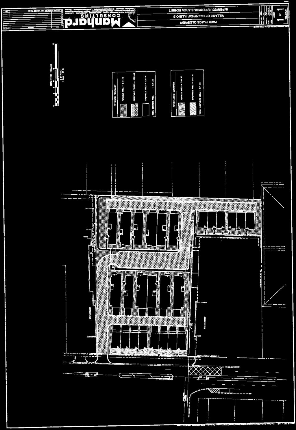
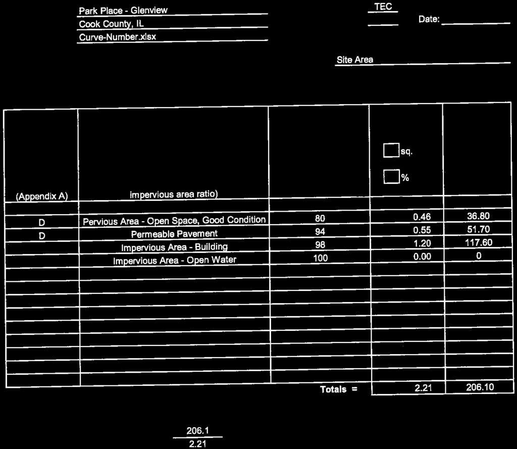
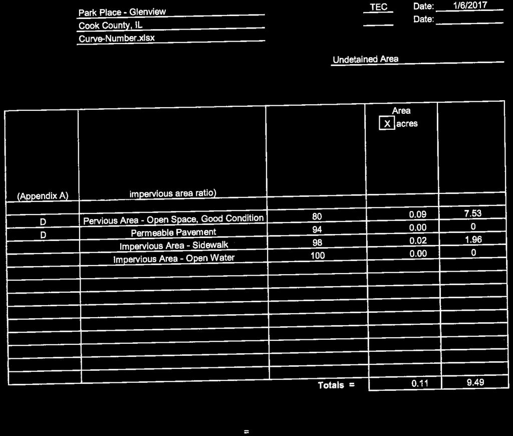
13 traffic. The applicant is opposed to this alteration and has provided written response regarding the proposed change. The main sidewalk route through the property should be straightened where possible. PARKING LOTS 02/28/2017 The applicant should confirm the turnaround method(s) for vehicles utilizing the parallel parking stalls in the center of the site. The applicant is proposing typical driveway widths of 17.0 feet. These should be increased to 18.0 feet to provide compliant parking stall widths for two (2) vehicles. The applicant should identify proposed areas which would accommodate snow piling. BUILDING SCALE 02/14/2017 The Plan Commission should provide comments regarding the proposed building scale and elevations of the various product types, particularly with regard to how the scale and proposed building heights of between approximately feet are consistent with the D-D District requirements which allow for a maximum height of 53.0 feet. LANDSCAPING 02/28/2017 The Plan Commission should review the proposed landscape plan and determine whether the interior and perimeter landscaping are adequate for screening and visual interest. The Downtown Development code does not limit impervious lot coverage. In typical development circumstances within this district, the site could be completely covered in impervious material. In the case of the proposed development, the impervious lot coverage for the site is 52.6%. Alterations to the final landscaping design and all landscaping materials shall be shall be subject to the review and approval of the Appearance Commission. GRAPHICS AND SIGNAGE 02/28/2017 The Plan Commission should comment on the proposed location and character of the sign adjacent to the main entrance. SITE ILLUMINATION 02/28/2017 The applicant has submitted a preliminary photometric plan for review. The preliminary lighting plan will need to be revised to comply with lighting requirements of the ordinance. All exterior fixtures will be required to be 100% cut-off style fixtures. The applicant should confirm that all light fixtures including building-mounted fixtures which include light elements exceeding 1,000 lumens are included upon the photometric plan. 60
14 All lighting elements, poles, and fixtures shall be subject to additional review and approval by the Appearance Commission. Technical Review PARKING REQUIREMENTS: The Zoning Ordinance stipulates formulas to be applied to various possible land uses in order to establish the minimum number of required parking stalls. These parking formulas have been examined by staff to establish the most restrictive requirements, which can be summarized as follows: Parking Requirements Residential Formula Details Proposed Required Compliance 2 Parking Spaces per unit 26 Units 84* 52 Yes *(52 stalls within garages / 27 stalls within driveways / stalls on-street ) RESIDENTIAL USE STATISTICS: Allowed/Permitted Proposed Compliance Zoning PD / D-D PD (D-D) Yes Building Height Yes Perimeter Yard No Variation Required Land Ownership Common Ownership Fee Simple Lots No Variation Required 61


15 DOWNTOWN DEVELOPMENT REQUIREMENTS (FORM BASED CODE): Within the body of the Downtown Revitalization Plan are specific recommendations on how to implement the vision for downtown using a new regulatory tool called a Form-Based Code. The FBC allows for the downtown characteristics desired by the community to be reinforced through the coding of a building s form in accordance with the Preferred Concepts. The Plan recommends that a formbased code be developed as the primary regulatory tool for guiding new development within the Downtown. Form-based codes address the relationship between building facades and the public realm, the form and mass of buildings in relation to one another, and the scale and types of streets and blocks. The regulations and standards in form-based codes, presented in both diagrams and words, are keyed to a regulating plan that designates the appropriate form and scale (and therefore, character) of development rather than only distinctions in land-use types. This is in contrast to conventional zoning's focus on the segregation of land-use types, permissible property uses, and the control of development intensity through simple numerical parameters (e.g., FAR, dwellings per acre, height limits, setbacks, parking ratios). Form-based codes commonly include the following elements: Regulating Plan - A plan or map of the regulated area designating the locations where different building form standards apply, based on clear community intentions regarding the physical character of the area being coded. Building Form/Envelope Standards - Regulations controlling the configuration, features, and functions of buildings that define and shape the public realm. Public Space/Street Standards - Specifications for the elements within the public realm (e.g., sidewalks, travel lanes, street trees, street furniture, etc.). Annotation - Text and illustrations explaining the intentions of specific code provisions Architectural Standards - Regulations controlling external architectural materials and quality. Administration - A clearly defined application and project review process. Definitions - A glossary to ensure the precise use of technical terms. GLENVIEW S DOWNTOWN DEVELOPMENT DISTRICT CODE (FORM-BASED CODE): Below are the relevant excerpts from the Downtown Code: Land Use: 62


16 Building Height: Setbacks: 63
17 Design: PLANNED DEVELOPMENT ZONING: The purpose of the Planned Development (PD) District is to facilitate a more creative and efficient use of land than would otherwise be possible under traditional zoning regulations (Sec , Municipal Code). PD s typically revolve around a mix of product types (horizontal or vertical) that when applied against their respective traditional zoning districts would create multiple variances. Other factors necessitating a PD include a unique product type, unusual parcel configuration, or environmental features of a site. While some would suggest PD zoning is a method to gain multiple variances for higher density developments, the Village has the additional authority to tailor a PD by imposing conditions to offset any development impacts. Traditional zoning establishes bulk and scale requirements in order to separate structures/uses and limit nuisances. Created in 1966, the PD district works differently by establishing a perimeter yard based on the height of structures to create a buffer area between adjacent properties. Inside of the perimeter yard there are no bulk and scale zoning requirements to follow, which allows flexible and variance-free developments controlled by site plan review criteria rather than by lot sizes and building setbacks (bulk and scale requirements). Sometimes variances from the perimeter yard or other PD standards may be requested to account for unique building types or designs. To gauge compatibility, site plans within a PD are evaluated against other similarly scaled projects. Through the greater flexibility of a PD, creative developments can be permitted through site plan specific approvals that ensure site planning best practices are achieved. 64
18 REZONING STANDARDS: The Plan Commission should consider the applicant s responses to the following judicial standards and requisites for rezoning: 1. The existing uses and zoning of nearby property. 2. The extent to which property values may be diminished by the particular zoning restrictions. 3. The extent to which the destruction of property values upon the plaintiff promotes the health, safety, morals, and general welfare of the public. 4. The relative gain to the public as compared to the hardship imposed upon the individual property owner. 5. The suitability of the subject property for the zoned purposes. 6. The length of time the property has been vacant as zoned considered in the context of land development in the area in the vicinity of the subject property. 7. The community need for the proposed use. 8. The care with which the community has undertaken to plan its land use development. Technical Review COMPLIANCE WITH VILLAGE PLANS: Village Plan Compliance Yes / No / N/A Comments Comprehensive Plan Yes - Official Map Yes - Waukegan Road Corridor Plan N/A - Milwaukee Avenue Corridor Plan N/A - Downtown Revitalization Plan Yes The Downtown Revitalization plan calls for a mix of uses in this area, including residential on the ground floor and upper floors. Natural Resources Plan N/A - Bike & Sidewalk Master Plan Yes Sidewalks are provided throughout the site and along Waukegan Road. The GNAS Design Guidelines N/A - 65

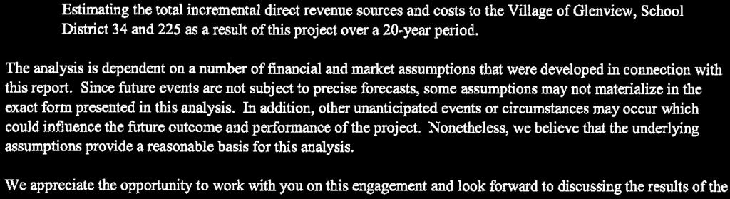
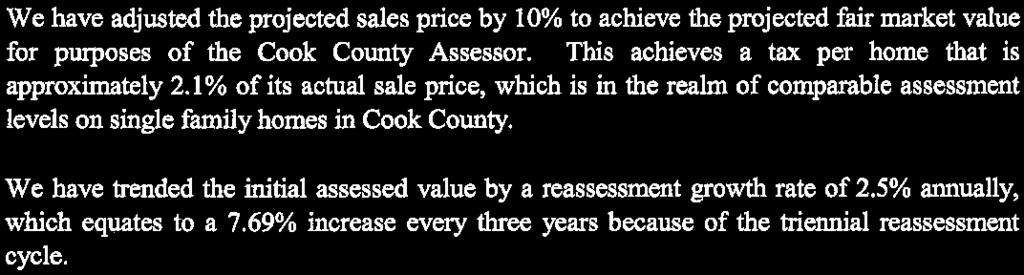
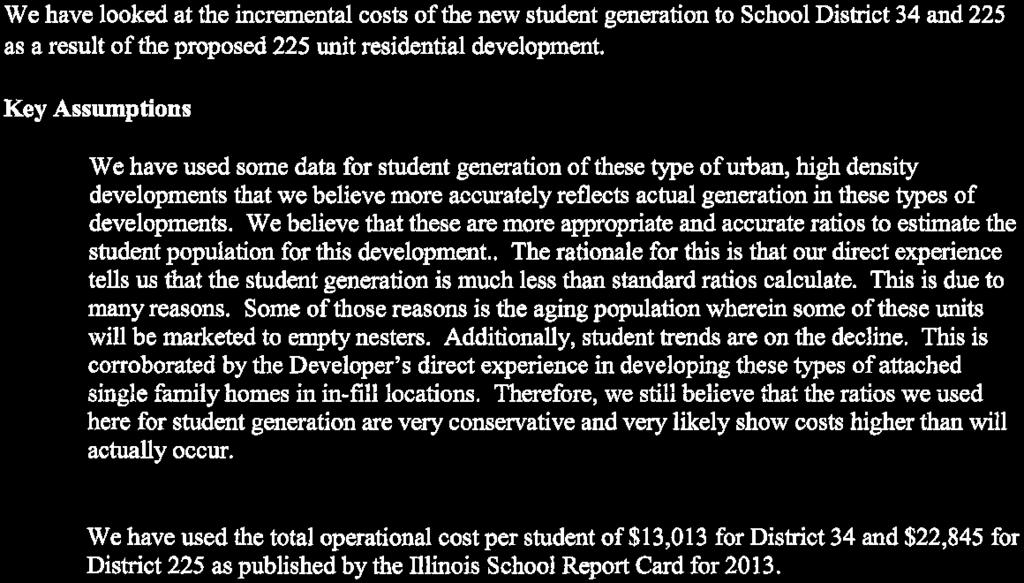
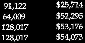
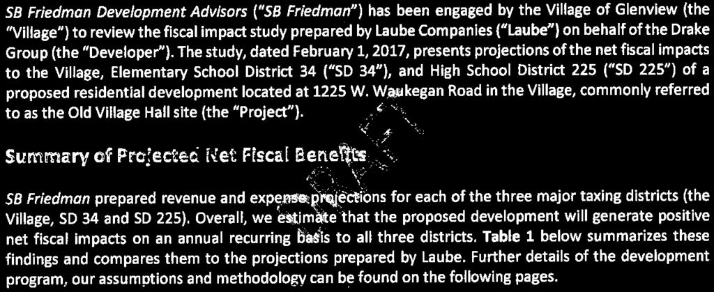
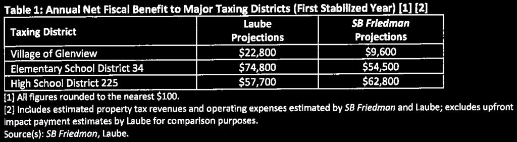
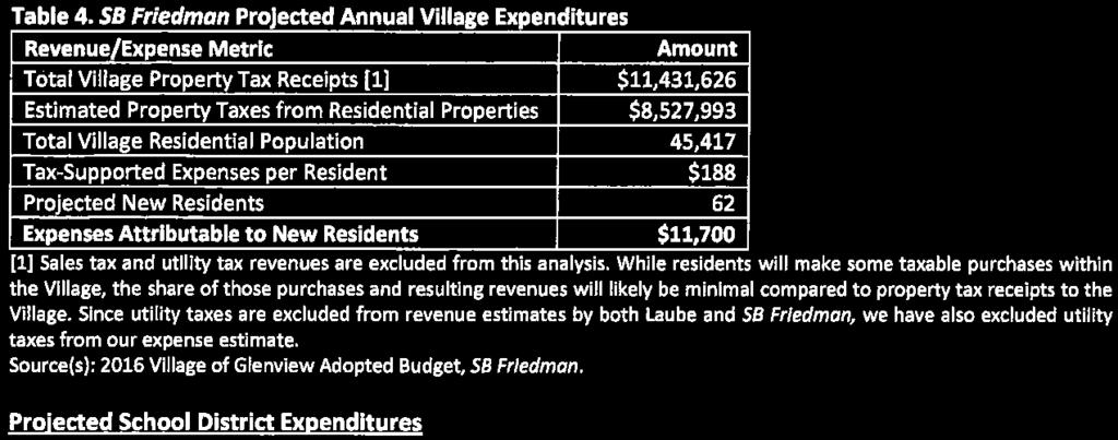
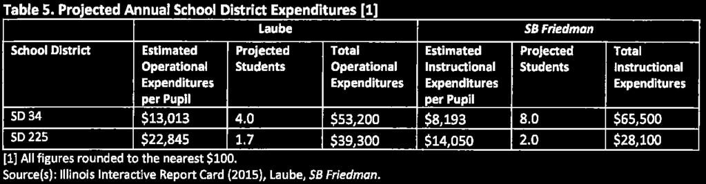
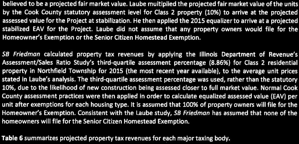
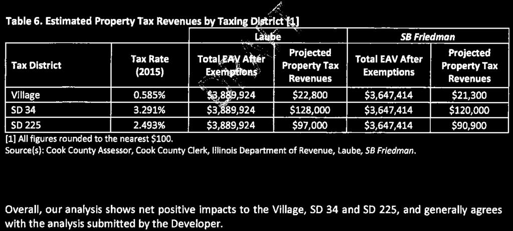
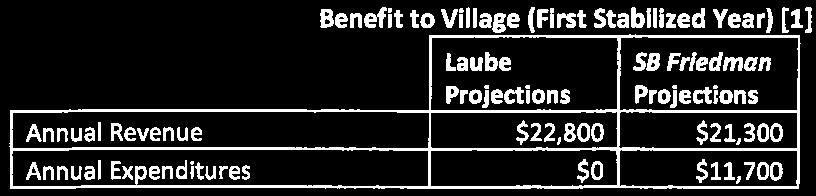
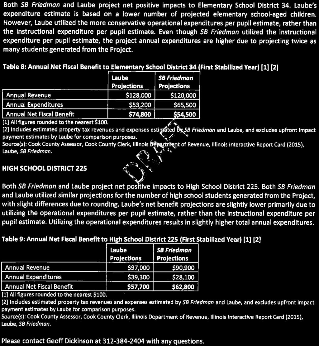
19 PROJECT TIMELINE: A. 11/11/16 Application Submitted B. 11/30/16 Preliminary Review Meeting with Staff C. 01/13/17 FSPR Exhibits Submitted D. 01/26/17 Public Notice published in Glenview Lantern E. 01/26/17 Public notice sign posted upon the subject property F. 01/26/17 Public notices mailed to surrounding property owners G. 01/31/17 Neighborhood Meeting H. 02/14/17 Plan Commission Meeting I. 02/15/17 Appearance Commission Meeting J. 02/28/17 Plan Commission Meeting (2 nd ) K. TBD Village Board of Trustees First Consideration L. TBD Village Board of Trustees Second Consideration M. TBD Building Permit Application & Final Engineering N. TBD Building & Engineering Inspections O. TBD Business License(s) P. TBD Certificates of Occupancy C DEFG H I J A B Jan Feb Mar Apr May Jun Jul Aug Sep Oct Nov Dec Jan Feb Mar Apr May Jun Jul Aug Sep Oct Nov Dec 02/28/2017 FISCAL IMPACT ANALYSIS: The Village s third-party fiscal consultant, S.B. Friedman Development Advisors, has evaluated the applicant s fiscal impact study prepared by Laube Companies, dated February 1, 2017 and projects the proposed development will generate a positive net fiscal impact on an annual recurring basis to the Village, as well as School Districts 34 and
20 TRAFFIC IMPACT ANALYSIS: A traffic study was prepared for the proposed project which evaluated the use and scope. A review of projected impacts and site analysis was conducted by James J. Benes and Associates. This memo showed the proposed use would have minimal impact on traffic during peak travel times and identified several modifications which would improve the site configuration. ENGINEERING REVIEW COMMENTS: Per a memorandum from Steve Amann, Consulting Engineer, there are design revisions and other studies that will be required as part of the final engineering process. However, the Village of Glenview s Engineering Division and Consulting Engineer have been heavily involved with the engineering design from the outset of the project and while additional modeling of the changes to the site plan is required, staff believes the proposed methods for the site improvements are feasible and practical. A copy of staff s engineering review comments are attached to this report. REQUIRED APPROVAL(s): The following chart details the necessary required approvals: Required Regulatory Review A. Annexation B. Annexation with Annexation Agreement C. Comprehensive Plan Amendment D. Official Map Amendment E. Rezoning F. Planned Development G. Conditional Use H. Final Site Plan Review I. Second Curb Cut J. Subdivision (Preliminary, Final, and Waivers) K. Variation(s) (Plan Commission via Planned Development) L. Certificate of Appropriateness (Appearance Commission) M. Final Engineering Approval & Outside Agency Permits N. Building Permits O. Building & Engineering Inspections P. Recorded Documents (Development Agreements, Easements, Covenants, etc.) Q. Business License R. Certificate of Occupancy ATTACHMENTS: 1. Engineering Memorandum from Steve Amann, Consulting Engineer, dated 02/08/ Traffic Impact Analysis Review Memo from James J. Benes and Associates, dated 02/09/ Fiscal Impact Study Analysis Review Memo from S.B. Friedman dated 02/16/


21 68

22 69
23 70


24 71
25 72
26 73

27 74

28 75
29 76
30 77
31 78

32 79
33 80

34 81
35 82

36 83


37 84
38 85
39 86
40 87
41 88
42 89

43 90


44 91


45 92
46 93
47 94
48 95

49 96
50 97

51 98


52 99


53 100
54 101


55 102


56 103


57 104


58 105
59 106


60 107


61 108
62 109

63 110
64 111
65 112


66 113
67 114


68 115

69 116

70 117


71 118

72 119

73 120

74 121
75 122

76 123
77 124
78 125


79 126
80 127
81 128
82 129
83 130


84 131

85 132

86 133


87 134


88 135

89 136


90 137


91 138

92 139
93 140


94 141


95 142


96 143
97 144

98 145
99 146
100 147
Village of Glenview Plan Commission
 Village of Glenview Plan Commission STAFF REPORT January 22, 2019 TO: Chairman and Plan Commissioners CASE #: P2018-047 FROM: Community Development Department CASE MANAGER: Tony Repp, Senior Planner SUBJECT:
Village of Glenview Appearance Commission
 Village of Glenview Appearance Commission STAFF REPORT July 23, 2014 TO: Chairman and Appearance Commissioners CASE #: A2014-059 LOCATION: 727 Harlem Avenue FROM: Community Development Department PROJECT
Village of Glenview Appearance Commission
 Village of Glenview Appearance Commission https://drive.google.com/file/d/0bwqoselr903slw1ovvdnd2nlzws/edit?usp=sharing STAFF REPORT August 13, 2014 TO: Chairman and Appearance Commissioners FROM: Community
Village of Glenview Appearance Commission
 Village of Glenview Appearance Commission STAFF REPORT June 6, 2012 TO: Chairman and Appearance Commissioners FROM: Planning & Economic Development Department CASE #: A2012-044 LOCATION: PROJECT NAME:
Village of Glenview Appearance Commission
 Village of Glenview Appearance Commission STAFF REPORT January 13, 2016 TO: Chairman and Appearance Commissioners FROM: Community Development Department CASE #: A2016-005 LOCATION: PROJECT NAME: 611 Milwaukee
GREEN INFRASTRUCTURE SIGNAGE VILLAGE OF GLENVIEW
 Village of Glenview Appearance Commission STAFF REPORT October 15, 2014 TO: Chairman and Appearance Commissioners FROM: Community Development Department CASE #: A2014-130 LOCATION: PROJECT NAME: Various
Village of Glenview Appearance Commission
 Village of Glenview Appearance Commission STAFF REPORT May 14, 2014 TO: Chairman and Appearance Commissioners FROM: Community Development Department CASE #: A2014-062 LOCATION: PROJECT NAME: 3780 Willow
Village of Glenview Plan Commission
 Village of Glenview Plan Commission Staff Report August 8, 2017 TO: Chairman and Plan Commissioners CASE #: P2017-027 FROM: Community Development Department CASE MANAGER: Tony Repp, Planner SUBJECT: Final
Village of Glenview Appearance Commission
 Village of Glenview Appearance Commission STAFF REPORT July 17, 2013 TO: Chairman and Appearance Commissioners FROM: Planning & Economic Development Department CASE #: A2013-092 LOCATION: PROJECT NAME:
Village of Glenview Plan Commission
 Village of Glenview Plan Commission STAFF REPORT May 22, 2018 TO: Chairman and Plan Commissioners FROM: Community Development Department CASE MANAGER: Tony Repp, Planner CASE #: P2018-016 LOCATION: PROJECT
ARTICLE 6: Special and Planned Development Districts
 ARTICLE 6: Special and Planned Development Districts 6-10 Traditional Neighborhood Development (TND) District 6-10.10 Purpose and Intent The Traditional Neighborhood Development (TND) District provides
Village of Glenview Appearance Commission
 Village of Glenview Appearance Commission STAFF REPORT September 10, 2014 TO: Chairman and Appearance Commissioners FROM: Community Development Department CASE #: A2014-043 LOCATION: PROJECT NAME: 600-670
PLANNED DEVELOPMENT (MASTER PLAN & UNIT PLAN)
") Central Permit Center 555 Santa Clara Street Vallejo CA 94590 Business License Building Fire Prevention Planning Public Works 707.648.4310 707.648.4374 707.648.4565 707.648.4326 707.651.7151 PLANNED DEVELOPMENT
Central Permit Center 555 Santa Clara Street Vallejo CA 94590 Business License Building Fire Prevention Planning Public Works 707.648.4310 707.648.4374 707.648.4565 707.648.4326 707.651.7151 PLANNED DEVELOPMENT
Staff Report and Recommendation
 Community Planning and Development Planning Services 201 W. Colfax Ave., Dept. 205 Denver, CO 80202 p: 720.865.2915 f: 720.865.3052 www.denvergov.org/cpd TO: City Council Neighborhoods and Planning Committee
12 January 12, 2011 Public Hearing APPLICANT: TAILWIND DEVELOPMENT GROUP,LLC PROPERTY OWNER: CITY OF VIRGINIA BEACH
 12 January 12, 2011 Public Hearing APPLICANT: TAILWIND DEVELOPMENT GROUP,LLC PROPERTY OWNER: CITY OF VIRGINIA BEACH STAFF PLANNER: Faith Christie REQUEST: Conditional Change of Zoning (from PD-H1 Planned
Village of Glenview Appearance Commission
 Village of Glenview Appearance Commission STAFF REPORT February 26, 2014 TO: Chairman and Appearance Commissioners FROM: Community Development Department CASE #: A2013-142 LOCATION: PROJECT NAME: 9840
At Your Disposal CUP Amendment, Lot 20, Village Service Commercial, at 128 Bastille Dr. (PLN17-208)
") MEMORANDUM Archuleta County Development Services Planning Department 1122 HWY 84 P. O. Box 1507 Pagosa Springs, Colorado 81147 970-264-1390 Fax 970-264-3338 TO: Archuleta County Planning Commission FROM:
MEMORANDUM Archuleta County Development Services Planning Department 1122 HWY 84 P. O. Box 1507 Pagosa Springs, Colorado 81147 970-264-1390 Fax 970-264-3338 TO: Archuleta County Planning Commission FROM:
Project phasing plan (if applicable) 12 copies of site plan
 12 copies of site plan") SITE PLAN REVIEW PERMIT APPLICATION City of Grand Haven, 11 N. Sixth Street, Grand Haven, MI 49417 Phone: (616) 847-3490 Fax: (616) 844-2051 Website: www.grandhaven.org 1. Project Information Address/location
SITE PLAN REVIEW PERMIT APPLICATION City of Grand Haven, 11 N. Sixth Street, Grand Haven, MI 49417 Phone: (616) 847-3490 Fax: (616) 844-2051 Website: www.grandhaven.org 1. Project Information Address/location
Request Alternative Compliance to the prescribed criteria of the Oceanfront Resort District Form-Based Code. Staff Planner Kristine Gay
 Applicant/Owner Ocean Rental Properties, LLC Public Hearing April 13, 2016 City Council Election District Beach Agenda Item 1 Request Alternative Compliance to the prescribed criteria of the Oceanfront
Harmony Technology Park Third Filing, Second Replat Custom Blending, Project Development Plan/Final Development Plan - FDP #130021
 ITEM NO FDP #130021 MEETING DATE July 23, 2013 STAFF Pete Wray ADMINISTRATIVE TYPE I HEARING STAFF REPORT PROJECT: APPLICANT: OWNER: Harmony Technology Park Third Filing, Second Replat Custom Blending,
DEPARTMENT OF PLANNING JEFFERSON PARISH, LOUISIANA
 DEPARTMENT OF PLANNING JEFFERSON PARISH, LOUISIANA DESIGN REVIEW REPORT : CPZ-3-1 : (S) Cynthia Lee-Sheng AT LARGE: A Chris Roberts B Elton M. Lagasse ADVERTISING DATES: 06/03/1 06/10/1 06/17/1 PAB PUBLIC
ZONING ORDINANCE FOR THE ZONED UNINCORPORATED AREAS ARTICLE 1150 OF PUTNAM COUNTY, WEST VIRGINIA Page 95 ARTICLE 1150 SITE PLAN REVIEW
 OF PUTNAM COUNTY, WEST VIRGINIA Page 95 1150.01 PURPOSE 1150.02 APPLICABILITY 1150.03 APPLICATION PROCESS 1150.04 REVIEW PROCESS 1150.05 REVIEW CRITERIA 1150.06 SITE PLAN GUIDELINES 1150.01 PURPOSE ARTICLE
City of Lafayette Study Session Staff Report Design Review Commission
 City of Lafayette Study Session Staff Report Design Review Commission Meeting Date: April 24, 2017 Staff: Payal Bhagat, Senior Planner Subject: HDP18-15 & HDP31-15 Ramesh Patel & Melcor Development (Owners),
DRAFT DESIGN GUIDELINES
 IHZ Booklet #7 May 6, 2010 DRAFT DESIGN GUIDELINES CANTERBURY 7 Overview During the recent planning process for the Plan of Conservation and Development community character was identified as an important
AMEND DMENT H HOSPITAL
 AMEND DMENT TO LAND USE PLAN ELEMENT VILLAGE OF RIDGEWOOD MASTER PLAN H HOSPITAL ZONE DISTRICT Village of Ridgewood Planning Board February 28, 2014with technical revisions from June 9, 2014 Planning Board
City of Fairfax, Virginia City Council Work Session
 City of Fairfax, Virginia City Council Work Session Agenda Item # WS 2 City Council Meeting 7/5/2016 TO: FROM: SUBJECT: Honorable Mayor and Members of City Council Robert Sisson, City Manager Request of
CHAPTER ADDITIONAL REQUIREMENTS IN THE NC, NEIGHBORHOOD COMMERCIAL ZONE
 CITY OF MOSES LAKE MUNICIPAL CODE CHAPTER 18.31 ADDITIONAL REQUIREMENTS IN THE NC, NEIGHBORHOOD COMMERCIAL ZONE Sections: 18.31.010 Purpose 18.31.020 Minimum Lot Area 18.31.030 Setbacks 18.31.040 Maximum
Town of Portola Valley General Plan. Nathhorst Triangle Area Plan
 Town of Portola Valley General Plan Amended December 10, 1997 Table of Contents Introduction... 1 Planning Area... 1 Objectives... 2 Principles... 2 Standards... 4 Description... 4 Community Commercial...
AWH REPORT OF THE PLANNING AND DEVELOPMENT DEPARTMENT FOR APPLICATION FOR REZONING ORDINANCE TO PLANNED UNIT DEVELOPMENT
 AWH REPORT OF THE PLANNING AND DEVELOPMENT DEPARTMENT FOR APPLICATION FOR REZONING ORDINANCE TO PLANNED UNIT DEVELOPMENT MAY 8, 2014 The Planning and Development Department hereby forwards to the Planning
McDonald s Restaurant - Purcellville Town of Purcellville Special Use Permit Statement of Justification July 24, 2014
 Introduction / Written Statement McDonald s Restaurant - Purcellville McDonald s Corporation is proposing to redevelop the existing McDonald s eating establishment with a drive-through located at 121 N
SPECIFIC PLAN Requirements
 CITY OF LANCASTER PLANNING DEPARTMENT 44933 Fern Avenue, Lancaster, California 93534 (661) 723-6100 SPECIFIC PLAN Requirements Purpose The purpose of a specific plan is to provide for the logical development
VILLAGE OF CLEMMONS PLANNING BOARD DRAFT STAFF REPORT
 VILLAGE OF CLEMMONS PLANNING BOARD DRAFT STAFF REPORT PETITION INFORMATION Docket # C-226 Staff Megan Ledbetter Petitioner(s) JBJH Properties, LLC Owner(s) JBJH Properties, LLC Subject Property 5892-49-1766
PINE CURVE REZONING. Property does not meet criteria for open space preservation and is not a candidate for a park
 PINE CURVE REZONING BACKGROUND Purchased as two parcels in 2001 and 2002 Annexed and Zoned Greater Downtown District Historic Center September 25, 2002 and October 7, 2002 WHAT THE PROJECT IS AND IS NOT
Allen Street Civic District Redevelopment Area Plan Redevelopment Plan & Proposal State College Planning Commission State College Redevelopment
 Allen Street Civic District Redevelopment Area Plan Redevelopment Plan & Proposal State College Planning Commission State College Redevelopment Authority September 17, 2015 Discussion Points Overview of
CHAPTER 13 DESIGN GUIDELINES
 CHAPTER 13 DESIGN GUIDELINES Section 1300.00 Section 1300.01 Design Guidelines Purpose The purposes of this section are to: A. The purpose of this Section is to establish procedures and standards to serve
Project Name: MELWOOD HOTEL. Date Accepted: 1/12/04. Waived. Planning Board Action Limit: Plan Acreage: 1.7 Zone: Dwelling Units:
 The Maryland-National Capital Park and Planning Commission Prince George's County Planning Department Development Review Division 301-952-3530 Note: Staff reports can be accessed at www.mncppc.org/pgco/planning/plan.htm.
PINE CURVE REZONING. BACKGROUND Purchased as two parcels in 2001 and 2002
 BACKGROUND Purchased as two parcels in 2001 and 2002 WHAT THE PROJECT IS AND IS NOT A Rezoning establishes the land use standards for Annexed and Zoned Greater Downtown District Historic Center September
CITY OF PUYALLUP. Background. Development Services
 CITY OF PUYALLUP Development Services 333 South Meridian Puyallup WA 98371 To: City Council From: Katie Baker, AICP, Planning Division Re: South Hill Neighborhood Plan Adoption Date: (Meeting date: February
PRELIMINARY CONDITIONAL USE SUBMITTAL CHECKLIST REQUIREMENTS
 This checklist must accompany your submittal as the cover page. CONDITIONAL USE Application Submittal Checklist for PRELIMINARY AND FINAL APPROVAL Per Winter Park Land Development Code Sec. 58-90 PRELIMINARY
523, 525 and 525A Adelaide Street West - Zoning Amendment Application - Preliminary Report
 STAFF REPORT ACTION REQUIRED 523, 525 and 525A Adelaide Street West - Zoning Amendment Application - Preliminary Report Date: May 12, 2012 To: From: Wards: Reference Number: Toronto and East York Community
14 October 10, 2012 Public Hearing APPLICANT: MPB, INC
 14 October 10, 2012 Public Hearing APPLICANT: MPB, INC PROPERTY OWNER: MUNDEN & ASSOCIATES, LP STAFF PLANNER: Karen Prochilo REQUEST: Conditional Change of Zoning (AG-1 & AG-2 to Conditional O-2) ADDRESS
EXHIBIT B PROJECT NARRATIVE POULSBO MEADOWS
 EXHIBIT B PROJECT NARRATIVE POULSBO MEADOWS Name of Project: Poulsbo Meadows; A Planned Residential Development (PRD)/Plat Applicants Name: PBH Group LLC/Byron Harris PO Box 1010 Silverdale, WA 98038 Description
Complete Neighbourhood Guidelines Review Tool
 Complete Neighbourhood Guidelines Review Tool Prepared By: City of Regina Planning Department October 2014 Page 1 of 14 Community Development Review Checklist for Secondary Plans and Concept Plans The
SMALL LOT DESIGN STANDARDS. An Illustrated Working Draft for Test Implementation
 SMALL LOT DESIGN STANDARDS An Illustrated Working Draft for Test Implementation SMALL LOT DESIGN STANDARDS ILLUSTRATED WORKING FOR TEST IMPLEMENTATION OVERVIEW SMALL LOT CODE AMENDMENT & POLICY UPDATE
R E S O L U T I O N. Single-Family Residence/ Church. 2,488 sq. ft. 2,488 sq. ft. Area Parking Required: Church
 R E S O L U T I O N WHEREAS, the Prince George s County Planning Board is charged with the approval of Detailed Site Plans pursuant to Part 3, Division 9 of the Zoning Ordinance of the Prince George s
Request Modification of Proffers Approved by City Council on May 8, 2012 Modification of Conditions (Mini- Warehouse) Staff Recommendation Approval
 Staff Recommendation Approval") Applicant & Property Owner Salem Lakes Storage, LLC, a VA Limited Liability Company Public Hearing February 8, 2017 City Council Election District Centerville Agenda Item 4 Request Modification of Proffers
Applicant & Property Owner Salem Lakes Storage, LLC, a VA Limited Liability Company Public Hearing February 8, 2017 City Council Election District Centerville Agenda Item 4 Request Modification of Proffers
Colerain Township report to. Hamilton County Regional Planning Commission. December 2, 2010, 1:00PM. t a f f r e p o r t
 Colerain Township report to Hamilton County Regional Planning Commission December 2, 2010, 1:00PM Preliminary Plan: Case No.: ZA2001-04, Forevergreen Prepared By: Amy Bancroft, Land Use Planner t a f f
PLANNING REPORT CITY OF EAGAN. APPLICANT: Cedar Grove Hospitality, LLC HEARING DATE: December 18, 2014
 PLANNING REPORT CITY OF EAGAN REPORT DATE: December 8, 2014 CASE: 19-PA-11-11-14 APPLICANT: Cedar Grove Hospitality, LLC HEARING DATE: PROPERTY OWNER: The Flats at Cedar APPLICATION DATE: Nov. 21, 2014
Application for Site Plan Review
 Application for Site Plan Review City of Pontiac Office of Land Use and Strategic Planning 47450 Woodward Ave, Pontiac, MI 48342 T: 248.758.2800 F: 248.758.2827 Property/Project Address: Sidwell Number:
BOULEVARD AND PARKWAY STANDARDS
 88-323 BOULEVARD AND PARKWAY STANDARDS 88-323-01 PURPOSE Considerable public and private investment exists and is expected to occur adjacent to boulevards and parkways within the city. The following standards
SUBJECT: PREDEVELOPMENT PLAN REVIEW OF PROJECT LOCATED AT 2632 EAST WASHINGTON BOULEVARD ('ST. LUKE MEDICAL CENTER')
") TO: FROM: Honorable Mayor and City Council Planning & Community Development Department SUBJECT: PREDEVELOPMENT PLAN REVIEW OF PROJECT LOCATED AT 2632 EAST WASHINGTON BOULEVARD ('ST. LUKE MEDICAL CENTER')
TO: FROM: Honorable Mayor and City Council Planning & Community Development Department SUBJECT: PREDEVELOPMENT PLAN REVIEW OF PROJECT LOCATED AT 2632 EAST WASHINGTON BOULEVARD ('ST. LUKE MEDICAL CENTER')
CONSENT CALENDAR CITY PLANNING COMMISSION AGENDA ITEM NO: A.1, A.2 STAFF: LARRY LARSEN
 Page 8 CONSENT CALENDAR CITY PLANNING COMMISSION AGENDA ITEM NO: A.1, A.2 STAFF: LARRY LARSEN FILE NO: CPC PUZ 14-00013 - QUASI-JUDICIAL FILE NO: CPC PUD 14-00014 QUASI-JUDICIAL PROJECT: APPLICANT: OWNER:
Chapter PEDESTRIAN COMMERCIAL (PC) ZONING DISTRICT
 ZONING DISTRICT") Chapter 11-17 PEDESTRIAN COMMERCIAL (PC) ZONING DISTRICT Sections: 11-17-01 GENERAL PURPOSE 11-17-02 PERMITTED BUILDING TYPES 11-17-03 USES PERMITTED WITH DESIGN REVIEW 11-17-04 USES PERMITTED BY CONDITIONAL
Chapter 11-17 PEDESTRIAN COMMERCIAL (PC) ZONING DISTRICT Sections: 11-17-01 GENERAL PURPOSE 11-17-02 PERMITTED BUILDING TYPES 11-17-03 USES PERMITTED WITH DESIGN REVIEW 11-17-04 USES PERMITTED BY CONDITIONAL
MULTIFAMILY RESIDENTIAL DESIGN PRINCIPLES Site Plan and Design Review Principles Checklist
 MULTIFAMILY RESIDENTIAL DESIGN PRINCIPLES Site Plan and Design Review Principles Checklist Applicant s Name: Project Address: Phone: Email: Applicant shall fill out the design guidelines checklist for
Request Change in Nonconformity. Staff Recommendation Approval. Staff Planner Jonathan Sanders
 Applicant & Owner Public Hearing April 11, 2018 City Council Election District Beach Agenda Item 5 Request Change in Nonconformity Staff Recommendation Approval Staff Planner Jonathan Sanders Location
Public may provide comments on the GDP within the next two weeks (December 24)
") 25/70 General Development Plan (GDP) Public Meeting Wednesday, December 10, 2014 6:00 8:00 P.M. District 1 Police Station Community Room 1311 W 46th Ave, Denver, CO 80211 Council Woman Montero: This particular
25/70 General Development Plan (GDP) Public Meeting Wednesday, December 10, 2014 6:00 8:00 P.M. District 1 Police Station Community Room 1311 W 46th Ave, Denver, CO 80211 Council Woman Montero: This particular
CITY COUNCIL STUDY SESSION MEMORANDUM
 City and County of Broomfield, Colorado CITY COUNCIL STUDY SESSION MEMORANDUM To: From: Prepared by: Mayor and City Council Charles Ozaki, City and County Manager Kevin Standbridge, Deputy City and County
Design Review Application *Please call prior to submittal meeting to determine applicable fees*
 CITY OF EAGLE 660 E. Civic Lane, Eagle, ID 83616 Phone#: (208) 939-0227 Fax: (208) 938-3854 Design Review Application *Please call prior to submittal meeting to determine applicable fees* FILE NO.: CROSS
Analysis of Environs of 1000 New York Street, German Methodist Episcopal Church
 Item No. 3: L-14-00028 p.1 Analysis of Environs of New York Street, German Methodist Episcopal Church Step One Historical Significance and Context According to the application for Historic Landmark Designation,
Request Alternative Compliance (Commercial Parking Lot in Restricted Area) Staff Recommendation Approval. Staff Planner Ashby Moss
 Staff Recommendation Approval. Staff Planner Ashby Moss") Applicant Property Owners Pacific Avenue West, LLC Public Hearing April 11, 2018 City Council Election District Beach Agenda Item 2 Request Alternative Compliance (Commercial Parking Lot in Restricted
Applicant Property Owners Pacific Avenue West, LLC Public Hearing April 11, 2018 City Council Election District Beach Agenda Item 2 Request Alternative Compliance (Commercial Parking Lot in Restricted
City of Lafayette Study Session Staff Report Design Review Commission
 ++ City of Lafayette Study Session Staff Report Design Review Commission Meeting Date: January 08, 2018 Staff: Subject: Chris Juram, Planning Technician SS12-17 Miramar Homebuilders, R-20 Zoning: Request
ARLINGTON COUNTY, VIRGINIA
 ARLINGTON COUNTY, VIRGINIA County Board Agenda Item Meeting of April 12, 2014 DATE: April 2, 2014 SUBJECT: to the Arlington County Zoning Ordinance, Article 11.1 "CP-FBC" Columbia Pike Form Based Code
DEPARTMENT OF PLANNING JEFFERSON PARISH, LOUISIANA
 DEPARTMENT OF PLANNING JEFFERSON PARISH, LOUISIANA DESIGN REVIEW REPORT : SUMMAR NO.: 4469 (S) Paul Johnston AT LARGE: A Chris Roberts B Cynthia Lee-Sheng ADVERTISING DATES: PAB PUBLIC HEARING: HEARING:
VILLAGE OF SKOKIE Design Guidelines for Mixed-Use Districts NX Neighborhood Mixed-Use TX Transit Mixed-Use CX Core Mixed-Use
 VILLAGE OF SKOKIE Design Guidelines for Mixed-Use Districts NX Neighborhood Mixed-Use TX Transit Mixed-Use CX Core Mixed-Use TABLE OF CONTENTS CHAPTER 1 SITE DESIGN Purpose 1 CHAPTER 2 SITE DESIGN Streetscape
Dwelling Units Max 12 dwelling units per acre/min 8 dwelling units per acre. Development Mix 80% non residential/20% residential
 13. OSTEEN LOCAL PLAN Background: The Osteen Local Plan area is located in southwest Volusia County along the SR 415 corridor between Lemon Bluff Road and Acorn Lake Road and includes 3,990 acres. The
PLANNED UNIT DEVELOPMENT & SUBDIVISION STAFF REPORT Date: May 18, 2017
 & PUD-0000102-2017 PLANNED UNIT DEVELOPMENT & SUBDIVISION STAFF REPORT Date: May 18, 2017 NAME SUBDIVISION NAME Dauphin Creek Estates Subdivision Dauphin Creek Estates Subdivision LOCATION CITY COUNCIL
SUBDIVISION, PLANNED UNIT DEVELOPMENT, PLANNING APPROVAL, REZONING & SIDEWALK WAIVER STAFF REPORT Date: February 7, 2013
 SUBDIVISION, PLANNED UNIT DEVELOPMENT, PLANNING APPROVAL, REZONING & SIDEWALK WAIVER STAFF REPORT Date: February 7, 2013 APPLICANT NAME SUBDIVISION NAME DEVELOPMENT NAME LOCATION S. E. Cemeteries of AL
ONTARIO MUNICIPAL BOARD
 PL 120483 ONTARIO MUNICIPAL BOARD Applicant/Appellant: 2124123 Ontario Limited Subject: OPA, Rezoning and Draft Plan of Subdivision Municipal Address: 3940 Highway 7 East Municipality: City of Markham
Zoning Technical Review Presented by Camiros. November 10, 2015
 Zoning Technical Review Presented by Camiros November 10, 2015 TECHNICAL REVIEW OVERVIEW Purpose of this Report Outline issues with current Ordinance Present preliminary approaches for revisions Set drafting
CITY OF ZEELAND PLANNING COMMISSION
 APPLICATION FOR SITE PLAN REVIEW AND SPECIAL LAND USE Date City Official App. Filing Fee Rec'd ($350) NOTE TO APPLICANT: Please submit this application for Site Plan Review along with twenty (20) copies
Planning Commission April 4, 2013 BOCC Workshop Page 1
 Planning Commission April 4, 2013 BOCC Workshop Page 1 Planning Commission April 4, 2013 BOCC Workshop Page 2 Planning Commission April 4, 2013 BOCC Workshop Page 3 Planning Commission April 4, 2013 BOCC
DEPARTMENT OF PLANNING JEFFERSON PARISH, LOUISIANA
 DEPARTMENT OF PLANNING JEFFERSON PARISH, LOUISIANA DESIGN REVIEW REPORT DOCKET NO: CPZ--16 SUMMAR NO.: : : Paul D. Johnston AT LARGE: A: Christopher L. Roberts B: Cynthia Lee-Sheng ADVERTISING DATES: PAB
Narcoossee Roadway Corridor
 Community Meeting Narcoossee Roadway Corridor April 5, 2012 Meeting Agenda Purpose of Meeting Continuation of Study Update Process (Previous Meetings Oct. & Nov., 2011) Tonight s Objective Review Proposals
Village of Glenview Appearance Commission
 Village of Glenview Appearance Commission STAFF REPORT May 25, 2016 TO: Chairman and Appearance Commissioners FROM: Community Development Department CASE #: A2016-072 LOCATION: PROJECT NAME: 1727 Waukegan
Lehigh Acres Land Development Regulations Community Planning Project
 Lehigh Acres Land Development Regulations Planning Effort Summary In July, 2010 Commissioner Frank Mann invited the Lehigh Acres community to start discussing how to achieve their recently adopted community
D1 September 11, 2013 Public Hearing APPLICANT:
 D1 September 11, 2013 Public Hearing APPLICANT: BEACH MUNICIPAL FEDERAL CREDIT UNION PROPERTY OWNER: SISTERS II, LLC STAFF PLANNER: Karen Prochilo REQUEST: Conditional Change of Zoning (AG-2 Agriculture
REQUEST FOR COUNCIL ACTION 6A AGENDA ITEM ORIGINATING DEPT. AGENDA ITEM CITY ADMINISTRATOR APPROVAL
 DATE REQUEST FOR COUNCIL ACTION 6A AGENDA ITEM ORIGINATING DEPT. AGENDA ITEM CITY ADMINISTRATOR APPROVAL Community Development Territorial Greens PUD Concept Plan Development Stage Plan Subdivision (Preliminary
5.1.1 The streetscape along US Highway 64 (Brevard Road); and, The built environment within new residential developments; and,
; and, The built environment within new residential developments; and,") Article 5. Landscaping 5.1 Purpose The Town of Laurel Park s landscape standards are designed to create a beautiful, aesthetically pleasing built environment that will complement and enhance community
Article 5. Landscaping 5.1 Purpose The Town of Laurel Park s landscape standards are designed to create a beautiful, aesthetically pleasing built environment that will complement and enhance community
Long Branch Neighbourhood Character Guidelines Final Report
 STAFF REPORT ACTION REQUIRED Long Branch Neighbourhood Character Guidelines Final Report Date: October 26, 2017 To: From: Wards: Reference Number: Etobicoke York Community Council Director, Community Planning,
DEPARTURE FROM DESIGN STANDARDS DDS-586
 The Maryland-National Capital Park and Planning Commission Prince George s County Planning Department Development Review Division 301-952-3530 Note: Staff reports can be accessed at www.mncppc.org/pgco/planning/plan.htm.
CASE NUMBER: 16SN0701 APPLICANT: Hanky, LLC
 STAFF S ANALYSIS AND RECOMMENDATION Planning Commission (CPC) Public Hearing Date: MAY 17, 2016 CPC Time Remaining: 100 DAYS Applicant s Agent: DANIEL L. CASKIE (804-569-7060) Applicant s Contact: MICHAEL
4. INDUSTRIAL 53 CASTLE ROCK DESIGN
 4. INDUSTRIAL 53 CASTLE ROCK DESIGN CASTLE ROCK DESIGN 54 4. INDUSTRIAL Overview Well-designed and attractive industrial centers are the product of blending economic realities with both functional and
The Maryland-National Capital Park and Planning Commission Prince George's County Planning Department Development Review Division
 The Maryland-National Capital Park and Planning Commission Prince George's County Planning Department Development Review Division 301-952-3530 Note: Staff reports can be accessed at www.mncppc.org/pgco/planning/plan.htm.
9 th Street Sub Area Plan
 9 th Street Sub Area Plan In the 1990 s, when the Township prepared the last Master Plan, the 9 th Street corridor was studied as part of a larger 9 th Street Focus Area that included the West Main Street
4/8/2015 Item #10D Page 1
 MEETING DATE: April 8, 2015 PREPARED BY: Christy Villa, Associate Civil Engineer DEPT. DIRECTOR: Glenn Pruim DEPARTMENT: Public Works CITY MANAGER: Larry Watt SUBJECT: NORTH COAST HIGHWAY 101 STREETSCAPE
Duplex Design Guidelines
 Duplex Design Guidelines Adopted by Council May 29, 2006 Prepared By: Table of Contents 1.0 Application and Intent 1 2.0 Areas of Application 2 3.0 Design Principles 3 4.0 Design Guidelines 4 4.1 Site
The Maryland-National Capital Park and Planning Commission Prince George s County Planning Department Development Review Division
 The Maryland-National Capital Park and Planning Commission Prince George s County Planning Department Development Review Division 301-952-3530 Note: Staff reports can be accessed at www.mncppc.org/pgco/planning/plan.htm.
WEST LOOP DESIGN GUIDELINES CHECKLIST
 WEST LOOP DESIGN GUIDELINES CHECKLIST Section 1.0 General Strategies 1.1 DESIGN EXCELLENCE: ENCOURAGE HIGH QUALITY AND INNOVATIVE DESIGN OF NEW BUILDINGS WITHIN THE WEST LOOP WITHOUT BEING PRESCRIPTIVE
A. Background Summary of Existing Challenges and Potential Possibilities. 1. Summary of Existing Assets and Potential Opportunities
 A. Background 1 A Main Street Master Plan Study was performed and completed in October of 2007. The study was initiated to review current land uses and development patterns along Main Street, from Parrish
PLANNED UNIT DEVELOPMENT Date: April 5, 2018
 PLANNED UNIT DEVELOPMENT Date: April 5, 2018 DEVELOPMENT NAME SUBDIVISION NAME LOCATION Robert Myers Robert Myers 2955 and 2989 Dauphin Street (Southeast corner of Dauphin Street and Sage Avenue) CITY
DEPARTMENT OF COMMUNITY DEVELOPMENT SERVICES Planning Division m e m o r a n d u m
 DEPARTMENT OF COMMUNITY DEVELOPMENT SERVICES Planning Division m e m o r a n d u m TO: Urbana Plan Commission FROM: Kevin Garcia, Planner II DATE: October 6, 2017 SUBJECT: Plan Case Nos. 2314-PUD-17 and
Residential Design Standards Stakeholders Meeting
 Residential Design Standards Stakeholders Meeting CHARLOTTE-MECKLENBURG PLANNING DEPARTMENT JULY 29 TH, 2008 Agenda Introductions Housekeeping Recap of 1 st meeting Presentation-Planning Policies and Regulations
MIDTOWN MIXED-USE VILLAGE. TECHNICAL DATA SHEET COMPONENT C-1 FOR PUBLIC HEARING - PETITION NUMBER Project No RZ1.1. Issued.
 N MIDTOWN MIXED-USE VILLAGE TECHNICAL DATA SHEET COMPONENT C- FOR PUBLIC HEARING - PETITION NUMBER 04-00 Project No. 496 Issued Revised SCALE: " = 0' N 0 0 0 40 RZ. c GENERAL PROVISIONS: a. SITE LOCATION.
Gold Line Bus Rapid Transit Transit Oriented Development (BRTOD) Helmo Station Area Plan
 Helmo Station Area Plan") Appendix F Gold Line Bus Rapid Transit Transit Oriented Development (BRTOD) Helmo Station Area Plan Introduction and Purpose of the Plan The Gold Line Bus Rapid Transit facility is an eleven-mile dedicated
Appendix F Gold Line Bus Rapid Transit Transit Oriented Development (BRTOD) Helmo Station Area Plan Introduction and Purpose of the Plan The Gold Line Bus Rapid Transit facility is an eleven-mile dedicated
GENERAL INFORMATIONaaaaaaaaaaaaaaaaaaaaaaaaaaaaaaaa
 To: Planning and Zoning Commission From: City Staff Date: November 15, 2016 Re: Case #16026 Raymore Activity Center Site Plan GENERAL INFORMATIONaaaaaaaaaaaaaaaaaaaaaaaaaaaaaaaa Applicant/ Property Owner:
599 Kennedy Road - Official Plan Amendment and Zoning Amendment Application - Preliminary Report
 STAFF REPORT ACTION REQUIRED 599 Kennedy Road - Official Plan Amendment and Zoning Amendment Application - Preliminary Report Date: March 7, 2017 To: From: Wards: Reference Number: Scarborough Community
MEMORANDUM. DATE: March 15, Chairman and Members Community Redevelopment Agency. Leif J. Ahnell, C.P.A., C.G.F.O. Executive Director
 MEMORANDUM DATE: March 15, 2019 TO: FROM: Chairman and Members Community Redevelopment Agency Leif J. Ahnell, C.P.A., C.G.F.O. Executive Director SUBJECT: Camino Square, IDA No. CRP-16-02, located at 171
CITY OF CHARLOTTESVILLE, VIRGINIA CITY COUNCIL AGENDA
 CITY OF CHARLOTTESVILLE, VIRGINIA CITY COUNCIL AGENDA Agenda Date: December 16, 2013 Action Required: Adoption of Resolution Presenter: Staff Contacts: Title: James E. Tolbert, AICP, Director of NDS James
Housing and Coach House Guidelines - Ladner
 Housing and Coach House Guidelines - Ladner Policy D.8: Encourage Compatible Housing Design Encourage housing design that is sensitive to existing single family housing neighbourhoods by requiring a design
FIRE PREVENTION OFFICE Placer Hills Fire Protection District NEW PROJECT GUIDELINES
 Established 1949 FIRE PREVENTION OFFICE Placer Hills Fire Protection District NEW PROJECT GUIDELINES The following are guidelines for new development. Any submitted plans must comply with these guidelines,