VILLAGE OF DOWNERS GROVE REPORT FOR THE VILLAGE COUNCIL MEETING APRIL 8, 2014 AGENDA
|
|
|
- Grant Norman
- 6 years ago
- Views:
Transcription
1 ITEM MOT VILLAGE OF DOWNERS GROVE REPORT FOR THE VILLAGE COUNCIL MEETING APRIL 8, 2014 AGENDA SUBJECT: TYPE: SUBMITTED BY: Design Contract for Roadway Reconstruction - Orchard Brook East (ST-039) Resolution Ordinance Motion Discussion Only Nan Newlon, P.E. Director of Public Works SYNOPSIS A motion is requested to award a design contract for the Roadway Reconstruction project of Orchard Brook East to Burns and McDonnell of Downers Grove, Illinois in the amount of $73, This amount includes a 10% contingency. STRATEGIC PLAN ALIGNMENT The Goals for 2014 to 2018 identified Top Quality Infrastructure. FISCAL IMPACT The adopted FY14 budget includes $100, for professional design services for this project in the Capital Projects Fund. RECOMMENDATION Approval on the April 8, 2014 consent agenda. BACKGROUND The project will consist of roadway reconstruction of Barneswood, Creekwood, Quince, and Barberry. This subdivision was built with inadequate roadway drainage and is substantially within the floodplain of Lacey Creek. Saturated base conditions have caused the pavement to fail and reconstruction is required. This contract will provide final design for the roadway reconstruction improvements. Construction is planned for The Village posted a request for qualifications for final design of the project. Staff pre-qualified six firms from the submitters. All six firms submitted proposals for final design of the project. Staff recommends award of this contract to Burns and McDonnell based on their understanding of the project, capability to perform the work, experience with similar projects, and proposed fee. Burns and McDonnell submitted the lowest fee proposal. Burns and McDonnell successfully completed the design for the water main improvements on Rogers, Gierz, Wilson, and Austin for the Village in They have extensive roadway reconstruction design experience and have satisfactorily completed various projects for other local municipalities, including roadway reconstruction improvements for the City of Elgin and the Village of Glen Ellyn. ATTACHMENTS Contract Document Signature Page Campaign Disclosure Capital Project Sheet ST-039 Contractor Evaluation
2
3
4
5
6
7
8
9
10
11
12
13
14
15
16
17
18
19
20
21
22


23 Proposal for Roadway Reconstruction Orchard Brook East DESIGN ENGINEERING ST-039 Village of Downers Grove March 5, Opus Place, Suite 400 Downers Grove, Illinois (630)
 are of the utmost importance to Burns & McDonnell.")
24 March 5, 2014 Scott A. Vasko, PE Project Engineer Village of Downers Grove 5101 Walnut Avenue Downers Grove, IL Re: Roadway Reconstruction Orchard Brook East DESIGN ENGINEERING ST-039 Dear Mr. Vasko: The needs of the Village of Downers Grove (Village) are of the utmost importance to Burns & McDonnell. Being a hometown firm, we are proud to have an excellent working relationship with the Village. Our Proposal for Design Engineering Services for the Orchard Brook East Roadway Reconstruction Project was developed based on the Request for Qualification / Proposal dated January 24, 2014, the Request for Proposal dated February 19, 2014, along with our experience with the Village s processes and procedures. Burns & McDonnell is highly qualified to provide the design engineering services required for this Project. As you evaluate this Proposal, we ask you consider the following factors in your selection process: Local Firm and Familiarity with the Village The Village s proximity to our Downers Grove office will allow us to provide a timely response to any issues that may arise during your project. Our office is located ten minutes away and we are familiar with the design requirements of the Village having provided design engineering services for Village infrastructure projects in the past. This project familiarity will allow work to be done efficiently without repetition of your processes and procedures. Highly Qualified and Experienced Team The Project Team that has been assembled to work on your project has worked on numerous projects similar to Orchard Brook East within the last five years and completed Phase II Design Engineering Services on schedule and budget. The municipalities we have provided these design services to include, but are not limited to: the Village of Westmont, Village of Rantoul, City of Elgin and the Village of Mount Prospect. Reputation and Integrity of Firm and Quality of Service Our mission is to make the Village of Downers Grove successful. With 85% of our work resulting from repeat business, which includes the Village of Downers Grove, our firm has been recognized by industry experts as being one of the most dependable and professional engineering firms in the market. Should you have any questions regarding our proposal, or if you require additional information, please call me at (630) Sincerely yours, Randy Patchett, PE Associate 1431 Opus Place Suite 400 Downers Grove, IL Tel: Fax:
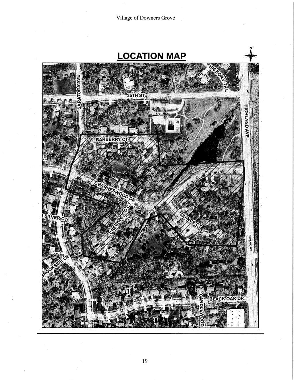
25 Project Approach The Orchard Brook East Roadway Reconstruction/Drainage Improvements project includes roadway reconstruction with associated drainage improvements for the Orchard Brook East subdivision. The approximate length of pavement reconstruction for the Orchard Brook East Subdivision is 3,000 feet. Background Orchard Brook East: Orchard Brook East is a predominantly residential subdivision located in the far north section of the Village. It is bordered by 35 th Street to the north, Saratoga Avenue to the west, Black Oak Drive to the south and Highland Avenue to the east. Based on our site visit, the streets are relatively open and traffic is generally local, consisting of Village residents traveling to and from their homes. The main thoroughfares are Saratoga Avenue, which runs from 31 st Street south where it dead-ends around 39 th Street; and Barneswood Drive, which connects Highland Avenue and Saratoga Avenue. Several courts are also located within the subdivision: Barberry Court, Quince Court, and Creekwood Court. A portion of the project site along Barneswood Drive, between Creekwood Court and Highland Avenue, is located with the Zone AE flood plain of Lacey Creek, with a substantial portion also being within the floodway boundary. The flood plain elevation is approximately feet. Being located Figure 1-1. Pavement Deterioration. Pavement throughout the Orchard Brook East Subdivision has suffered significant pavement deterioration. This can be seen throughout the project area. within a Zone A flood plain, and within the floodway boundary, will subject the design to additional restrictions and design parameters per the Village Ordinance. Due to being located within the flood plain, the existing pavement has experienced significant deterioration, due to saturated base conditions. In addition, the project site is located adjacent to a pond associated with Lacey Creek. This pond will be investigated for wetland and riparian limits. These limits will be delineated and the design of the project will seek to avoid impacts to these sensitive areas. Burns & McDonnell will analyze up to three alternatives to address the drainage issues with respect to the proposed pavement design. Roadway Improvements: The proposed roadway improvements will include reconstruction of the existing roads within the Orchard Brook East subdivision. Improvements to existing geometry and cross-sections are anticipated and Burns & McDonnell will also explore green options as part of the proposed alternatives analysis. A sustainable approach will be taken and best management practices, such as proposing a reduced pavement section, permeable pavement and other items, will be explored as options in order to improve the local stormwater management system without impacting properties downstream. Pavement cores and soil borings will be gathered and analyzed as part of the scope of this project. The results of the Geo-technical investigation will be presented by the Village. Stormwater Improvements: The project site is located within the floodplain of Lacey Creek. The existing roadway drainage system is inadequate and will be analyzed as part of this project. Currently the road has an urban cross-section; however, asphalt overlays have resulted in only one inch of curb reveal in some locations. The proposed design will seek to alleviate the drainage issues that caused the existing pavement to deteriorate. In order to design an optimal solution to the areas drainage concerns, the local hydrology will be analyzed using XP-SWMM or similar Village-approved software. A sustainable approach will be taken and best management practices such as bio-swales, infiltration basins, permeable pavement and other methods
26 Project Approach (continued) will be explored as options in order to improve the local stormwater management system without impacting properties downstream. Method of Analysis / Project Approach The following identifies some key project issues that we typically investigate / address during a project of this type. We believe these issues will be important to analyze on this assignment: Existing Conditions Analysis: A key component to a quality design and construction project is the accurate analysis and assessment of existing conditions. Orchard Brook East: Construct an accurate existing conditions model, using XP-SWMM or a similar stormwater management program, to assess the level of service of the existing Orchard Brook East stormwater management system. Based on the findings of the model, an upgraded drainage system will be proposed. Burns & McDonnell will look to incorporate green infrastructure and other sustainable solutions were appropriate. Pavement cores will also be taken to determine the existing pavement thickness and subgrade condition. Burns & McDonnell will analyze the results from the geo-technical investigation to propose a pavement design appropriate for the saturated site conditions. Burns & McDonnell believes that a key component of the Project is to create an accurate existing conditions model and asses such that the most cost-effective and efficient solutions can be proposed. Topographic Survey & Field Investigation: In order to build an accurate existing conditions modal and propose a quality Phase II design, a comprehensive topographic survey and field investigation must be performed. As part of this survey, necessary topographic information within the project corridor will be attained along with relevant utility information. Most importantly, inverts and routing of the existing storm sewers and culverts will be measured and included in the model. In addition, a wetland determination and delineation will be performed at Orchard Brook East to determine the presence and limits of the existing wetland and riparian areas. Special care will be taken in the design to avoid impacts to these areas. Burns & McDonnell has an in-house Environmental Services and Permitting Department that will be able to assess these special management areas. A comprehensive and accurate topographic survey and field investigation is a key component of the Project in order to build a quality existing conditions model and effective storm water management recommendation. Roadway Routing: Though the proposed roadway routing will primarily follow the existing roadway, there are alternatives that could be proposed as part of the design. The pavement cross-section width could be decreased to reduce surface runoff and ease some of the stormwater burden from the existing system. Pavement cross-section reduction could be applicable along Barneswood Drive, Barberry Court, Creekwood Court and Quince Court. Burns & McDonnell believes that a key component of the Project will be to offer the Village innovative alternates that will be sustainable, make sense for the Village financially, and benefit the community as a whole. Environmental Impact: This portion of the project will be handled by the Village of Downers Grove. If the Village requires any assistance on tasks related to Environmental Impacts, Burns & McDonnell has the capability in the Downers Grove office to assist.
27 Project Approach (continued) Utilities: Utility conflicts could be a significant issue on this Project. Every effort will be made to obtain utility records in and around the proposed project location. The location of existing utilities will be include in the survey done for the drainage and road reconstruction work, In particularly tight areas with significant unknowns, the Village may wish to consider engaging the services of a utility locating firm to assist in identifying and potholing the utility location and depth. Burns & McDonnell will provide recommendations in the event we believe additional utility investigation is required and will obtain the rim and invert elevations of Village owned utilities. Regulatory Agencies and Permitting: Burns & McDonnell anticipates having to coordinate with DuPage County Department of Transportation for any work to be done within County ROW. A county highway is located adjacent to the project site: Highland Avenue between Butterfield Road and 39 th Street. Our project team also has experience in obtaining permits from the IEPA, FEMA, IDNR, and IDOT. Stormwater permitting and coordination will be with the Village, as a fullwaiver community, and DuPage County as necessary. Burns & McDonnell has an excellent working relationship with the Village as we serve as one of their permit review engineers for private developments and capital improvement projects. As such, we are well-versed in the local stormwater ordinance. We are not aware of any other agencies that will need to be contacted for this project. Public Relations: Burns & McDonnell will assist the Village on presenting project information to the public on this Project and will assist with coordination with property owners. Public relations and great project coordination will be important to the success of this project and we offer staff that speak multiple languages and can assist the Village with any special communication needs. We also offer the ability to assist the Village in maintaining a project website or developing a specific project website for public relations support. Special Management Areas: In the Orchard Brook East subdivision, the portion of Barneswood Drive between Creekwood Court and Highland Avenue is located within the floodway boundary and the 100-year flood plain. Along Lacey Creek there are possible wetland and riparian areas that must be identified. All of these areas require special coordination with the Village and special design considerations. Burns & McDonnell has the staff and experience to provide quality design services for roadway reconstruction and drainage improvements within these areas. We have experience in designing green and sustainable solutions that will improve the stormwater management while remaining cost-beneficial to the Village. We have experience successfully coordinating with the Village of Downers Grove, DuPage County, and FEMA on stormwater management issues. Sustainable Solutions: As part of the project design sustainable solutions will be considered and assessed based on constructability, cost-effectiveness, feasibility, and the benefits provided to the Village. Stormwater best management practices such as bio-swales, infiltration trenches, permeable pavements, and pavement cross-section reduction will be considered. Permeable pavement may include permeable
28 Project Approach (continued) pavers, porous asphalt, permeable concrete, or permeable concrete articulated block pavement. Burns & McDonnell will investigate the feasibility of these design elements and present them to the Village along with their alternatives analysis. We have experience in the design of green infrastructure including pervious pavement options along local residential streets. Quality Control/Quality Assurance: In order to provide the highest quality deliverables to the Village, Burns & McDonnell will implement a six-step Quality Control/Quality Assurance Process on this project. This process ensures that all plans, specifications and deliverables get reviewed by independent senior professionals for, among other things, quality, completeness, and constructability. Burns & McDonnell adopted its quality control procedures in March 1981 and updated them in August The company has used this interdisciplinary design review process on all projects since then, including Government and Department of Defense projects. Burns & McDonnell developed this program using guidelines published by the Professional Engineers in Private Practice (PEPP) section of the National Society of Professional Engineers and endorsed by the American Institute of Architects and the American Council of Engineering Companies. Our program is highly effective and provides for interdisciplinary reviews by an independent team of professional engineers, architects and support personnel at various milestones throughout execution of the project design. The six distinct quality control review tasks, which will be scheduled and monitored for your project, are detailed below: Q1 - Schematic Design Review by an independent senior review team to assure that the Village s requirements for the project are sufficiently defined. Typically performed at 15% completion. Q2 - Preliminary Design Review by an independent senior review team to evaluate and determine the appropriateness and compatibility of the design to meet the Village's requirements. Also assures that each element of the design is represented by sufficient technical concepts, criteria and details to support final design. This review is performed prior to submitting the 35% submittal. Q3 - Review of design notes, drawings and specifications by the project manager, team leaders, and the design team at various milestones throughout the design to self-check prior decisions and coordinate design. This is an on-going process throughout design and is supported on a bi-weekly basis with scheduled design review meetings with the in-house project team. Q4 - Final review of design notes, drawings and specifications by an independent project quality control review team of senior staff members: The Q4 provides for review by senior firm members of the design documents for completeness and correctness. This technical review is performed prior to making the Un-Reviewed Final Submittal or 95% Submittal and concurrent with the Q5 review Q5 - Review of rough draft specifications by an independent team in our specifications department Q6 - Final review of drawings, specifications and cost estimates by the review team in the company s quality control department: The Q6 review is performed to assure that drawings and specifications are complete, coordinated with each other and free of omissions, errors and ambiguities. Also provides a full constructability review.
29 Project Approach (continued) All of the items presented in the Method of Analysis / Project Approach will be systematically evaluated and incorporated into a technical memorandum presented to the Village as part of the preliminary design. Scope of Work Our project approach consists of providing the Village with a constructible, cost-effective, and reliable project meeting the operational requirements of the Village. The scope of work for the Project is based on the tasks identified in the RFQ. We will provide all of the design and bidding phase services identified in the RFQ. A discussion of our approach to completing the project scope is presented in the following paragraphs: Task 1- Preliminary Design Phase Services: Task 1 will include surveys necessary for the completion of the selection of pipe routing, roadway alignment and preliminary design, development of base sheets using field data, review and preparation of easement information, preparation of preliminary project drawings and specifications (50% level). Project Kick-off Meeting: Prior to performing any work on this task, Burns & McDonnell will request and coordinate a project kick-off meeting. The purpose of the meeting will include: Introduction of Project Team personnel and the establishment of lines of communication. Acquisition of existing information including previous reports, plans of recent development, and relevant site information. Burns & McDonnell will submit a Request for Information (RFI) list of items to the Village several days prior to the kick-off meeting. Presentation of a work plan for completion of the routing/alignment evaluation and design phase of the Project. The work plan will include project design schedule milestones, design criteria and a checklist of design data and information needed to complete the project. The work plan will be reviewed and refined with the Village at the meeting. The work plan is a dynamic document that will be updated on a bi-weekly basis. It will ultimately be developed into the technical design memorandum required for the project. Present letters or door hangers for review by the Village that can be used to notify residents that Burns & McDonnell personnel will be performing surveying services in the project area. Once approved by the Village, Burns & McDonnell personnel can assist in the distribution of the resident notification letter within the project area. It is proposed that the project kick-off meeting be held within one week of receipt of notice to proceed on the project from the Village. Survey: Burns & McDonnell is familiar with the survey requirements of the Village, having performed numerous surveys previously on Village Projects. Within approximately one week of the project kick-off meeting, Burns & McDonnell will perform a detailed topographic survey of the project area. Property boundaries and vertical and horizontal control points will be established. Topographic survey will be performed using a total station. We are aware the project will be comprised of field surveys and drafting services necessary to accurately depict the existing right-ofway lines, adjoining private property, ground surface features and utility structures. The topographic surveying services will be performed in accordance with Village standards. The survey will include detailed topography with one-foot contour intervals throughout the described project area, including elevations noted for key changes in grade as well as high or low points between contours of the same elevation. Contour lines will be plotted throughout the project with high points or low points indicated between similar contours.
30 Project Approach (continued) The survey will include topographic features, including locations of above ground structures such as mailboxes, utility poles, driveway aprons, culverts and headwalls, sidewalks, etc. Locations and sizes of landscape materials will also be included for bushes, trees larger than 2 diameter, flower beds, etc. Tree sizes (2 diameter and larger) will be measured at 4 ½ feet above the highest ground level at the base of the tree. Locations of landscape timbers, flagstone paths or walls, brick pavers, etc. will be included in the plans. At a minimum, we will obtain invert and rim grade elevations, pipe and conduit sizes of all culverts, manholes, inlets, valve vaults, etc. and elevations of roadway and driveway pavement over culverts. The survey will be performed utilizing IDOT standard drafting symbols and line weights, and indicate lot line intersections, lot numbers and common addresses. We are familiar with IDOT standards and Village practices and will adhere to the standards outlined in the RFP. Plan views, shown at a scale of 1 = 20, and road centerline profile views, shown at 1:20H and 1:5V, will be included. Existing centerline elevations will be shown at low points, high points, other significant slope breaks, and at a maximum interval of twenty-five (25) feet. Detailed development of plan sheets, including but not limited to sheet layout and orientation, page spacing and drawing scale, title blocks and north arrows, will be consistent and will conform to Village standards. Burns & McDonnell will provide the Village with copies of all field notes and electronic base maps of the identified segments in their latest preferred AutoCAD Civil 3D format. Currently we have the capability up to AutoCAD Civil 3D We will provide compatible drawing files on compact desk or other media approved by the Village. Routing and Alignment Evaluation: Within approximately two weeks of the completion of survey, Burns & McDonnell will complete an evaluation of the routing (for drainage improvements) and alignment (for roadway and sidewalk improvements) options for the new storm management elements, roadway reconstruction, and sidewalk improvements. The evaluation will be based on criteria established during the project kick-off meeting. It will include a recommendation for review and acceptance of the routing/design of the new stormwater management items and the alignment/cross-section of the proposed roadway. Routing and Alignment Meeting: As part of this task, Burns & McDonnell will meet with the Village Staff to present the routing/alignment evaluation. A site walk of the proposed routing will be included. Based on interaction with Village, it is anticipated that the preferred roadway and sidewalk alignments and stormwater management routing will be identified. If needed, Burns & McDonnell will update the alignment and routing options and conduct a follow-up meeting within approximately one week of the initial routing and alignment meeting. Upon concurrence of the alignment and routing, Burns & McDonnell will proceed with the 50% detailed design. Review and Acquisition of Geotechnical Information: Burns & McDonnell will review available geotechnical information and acquire the pavement cores necessary for the completing the design. For purposes of this proposal we have included nine pavement cores for the project. Nine subsurface borings have been included. We will develop a sketch of where the pavement cores and subsurface borings would be taken, stake the locations at the project site, and provide a summary of the geotechnical parameters to be analyzed for the project. As part of the design we will subcontract directly with ECS, unless directed otherwise by the Village. If the subsurface borings prove to be not necessary they will not be completed.
31 Project Approach (continued) Special Management Area Investigation: Burns & McDonnell personnel will assess the project site for the presence of special management areas, including wetland and riparian areas. A wetland determination and delineation will be performed, as necessary. The results will be submitted to the Village in the design memorandum. Care will be taken during the design process to avoid impacts to special management areas. Utility Investigation: Burns & McDonnell will perform a detailed investigation of all water, storm, sanitary structures and mains within the project limits. We will submit inspection reports of the investigation in an agreed upon report format that will include recommendations for maintenance needs (rehabilitation or replacement). Based upon the Village s approval, these improvements will be incorporated into the design. Utility Coordination: As part of this task, we will contact J.U.L.I.E. the utilities and request maps of existing utilities located on and in the vicinity of the Project site. This information will be reviewed for potential conflicts and mitigation measures, if needed, and will be presented to the Village. Based on the location of the site and preliminary investigation, we do not anticipate any significant utility conflicts on the proposed site. Modeling of Stormwater Management System: We will construct an existing conditions model to analyze the level of service of the existing stormwater management system. This model will be based on the topographic survey and field investigation and will be used as a baseline for the proposed system analysis. Once the existing conditions model is complete Burns & McDonnell will model several scenarios and coordinate with the Village to determine the best solution to address existing issues. Green infrastructure and best management practices will be presented to the Village as design alternatives for the proposed project site. Preparation of Preliminary Project Plans: We will complete preliminary project plans (50%). Up to hard copy six (6) sets and one (1) electronic copy of the preliminary submittal will delivered to the Village for review. Burns & McDonnell will coordinate and participate in one meeting with the Village to review the preliminary plans. Included with this design submittal will be a preliminary engineer s estimate of probable construction cost. Task 2 - Design and Preparation of Pre-Final and Final Plans, Specifications and Opinions of Probable Construction Cost: Upon receipt and disposition of comments on the preliminary design documents, Burns and McDonnell will proceed with the development of the Pre-Final (90%) and Final (100%) Plans, Specifications, and Opinions of Probable Cost. This task will include: Acquisition and completion of additional survey or data required to complete the design plans and specifications. Development of pre-final design documents based on comments received on the plans, specifications and opinion of probable construction cost submitted as part of Task 1. These documents will be developed taking into consideration Village procurement requirements, general conditions, bid documents, insurance requirements, performance bonds, etc. Up to hard copy six (6) sets and one (1) electronic copy of the pre-final submittal will delivered to the Village for review. Burns & McDonnell will coordinate and participate in one meeting with the Village to review the pre-final plans. Included with this design submittal will be specifications and a
32 Project Approach (continued) preliminary engineer s estimate of probable construction cost. Burns & McDonnell will implement and complete its six-step Quality Assurance Program prior to submittal of the pre-final design plans and specifications. Final Construction Bid Documents (Issued for Bid Documents) will be prepared following resolution and incorporation of comments on the pre-final design submittal from the Village. Written responses to each comment received will be submitted in a disposition of comments document. It is anticipated that these documents will include the following plan sheets: Cover Sheet General Notes and Summary of Quantities Earthwork Schedule Typical Sections and Construction Details Construction Phasing Alignment, Ties, and Benchmarks Grading Plan (1 = 20 ) Storm Sewer Plan & Profile Sediment Erosion, Sediment Control Plan (1 = 20 ) Landscape Plans (1 = 20 ) Cross-Sections (every 50 and at critical locations) SWPPP Any other plans that may be required to complete the work Burns & McDonnell will coordinate and participate in one meeting with the Village to review the final design submittal. Included with this design submittal will be specifications and an engineer s estimate of probable construction cost. Burns & McDonnell will assist the Village in the preparation of permit applications to the DuPage County Department of Transportation and any other governmental agencies having a regulatory interest in the project, and provide all other services to secure permit approval. Possible agencies with which coordination may be required are IEPA, FEMA, IDNR-OWR, Village of Downers Grove, and DuPage County Stormwater Management. As part of the applications we will submit complete sets of the Final Design Drawings and Specifications, as required. As part of this task, Burns & McDonnell will provide the Village with all project drawings, files, notes, calculations, survey documents and other relevant data in an electronic format on CDs suitable for making prints, plans, and reports as requested in the RFP. Task 3 Bidding Phase Services: Task 3 will include providing qualified personnel to answer questions from pre-bid meeting participants, receive and answer bidder questions and requests for clarification, respond to questions in writing, and prepare addenda as necessary prior to the bid opening. The Village will perform all other bidding duties and we are available to assist the Village in reviewing bids and make recommendations concerning the award of contracts. This task will include the development and review of bid tabs, completeness of bid submittals, and reference checks as requested by the Village. We will assist the Village in preparation of conforming copies of contracts.
33 Project Approach (continued) Task 4 -Meetings: Burns & McDonnell will coordinate and participate in the following meetings as part of this project. Village Meetings: Burns & McDonnell anticipates that up to five (5) 1-hour meetings with the Village at the Public Works Building will be required to acquire input from key Village personnel and present the technical information. These meetings will include a project kick-off meeting, an alignment and routing meeting, and progress meetings at the 50%, 90% and 100% submittals. Public Meetings: Burns & McDonnell has included two (2) 2-hour public meetings at Public Works Building or an alternate location in the Village to present the project to Village residents and stakeholders. Bid Phase Meetings: Burns & McDonnell has included three (3) 1-hour meetings at the Public Works Building to assist the Village in bidding the project. These meetings include a pre-bid meeting, a bid-opening and a preconstruction meeting. Conclusion We have assembled a qualified team, have a solid understanding of project needs, and developed a sound Project Approach that will result in delivery of a quality Project on schedule and on budget.

34 Village of Downers Grove Orchard Brook East Roadway Reconstruction Project Schedule * March 5, 2014 * Project Schedule can be expedited at the request of the Village Notice To Proceed 2014 PROPOSED PROJECT TASKS April May June July August September October November Task 1- Preliminary Design Phase Services Task I.1 - Project Kick Off Meeting Task I.2 - Survey Task I.3 - Routing and Alignment Evaluation Task I.4 - Utility Investigation & Coordination Task I.5 - Model of Stormwater Management Task I.6 - Preliminary Design Plans (50%) Task 2 - Final Design Phase Services Task II.1 - Pre-Final Design Plans, Specs & Estimates (90%) Task II.2 - Final Design Plans, Specifications & Estimates (100%) Task 3 - Bidding Phase Services Task 4 - Meetings
35 Village of Downers Grove Engineering Services for Orchard Brook East Roadway Reconstruction Project Estimated Engineering Fees for Design Support March 5, 2014 Task Description Project Senior Project Technology Associate Manager Engineer Engineer Staff Engineer Clerical Expenses Charge Task & Survey (14) (13) (13) (11) (9) (7) Total Task 1 - Preliminary Design Phase Services Data Collection & Project Kick-off Meeting $0.00 $1, Survey 56 $ $0.00 $7, Routing and Alignment Evaluation 4 8 $0.00 $1, Review and Acquisition of Geotechnical Information 4 $4, $0.00 $4, Special Management Area Investigation 2 8 $0.00 $1, Utility Investigation & Coordination 12 $0.00 $1, Stormwater Modeling and Design 8 32 $0.00 $5, Preparation of Preliminary Project Plans (50%) $ $0.00 $13, Task 2 - Design and Preparation of Plans, Specifications and Costs Pre-Final Design Documents (90%) $ $0.00 $9, Technical Quality Assurance 12 $0.00 $1, Final Design (100%) and Submittal $ $0.00 $5, Specifications, Quantities & Cost Estimates $ $0.00 $3, Permitting $ $0.00 $5, Task 3 - Bidding Phase Assistance Bidding Assistance 2 $0.00 $ Task 4 - Meetings Village Meetings 4 4 $0.00 $1, Public Meetings $0.00 $1, Bid Phase Meetings 1 3 $0.00 $ Total hours Hourly Billing Rate $ $ $ $ $ $71.00 Subtotals $0.00 $13, $2, $25, $21, $0.00 $4, $0.00 $66, Total Fee $66, For the Scope of Services described in this Proposal, our total "Not to Exceed" Fee is: $66, **If Burns & McDonnell is Awarded both the Clyde Estates and the Orchard Brook East Project a 5% discount on the proposed "Not to Exceed" will be incorporated
36
37
38
39
40
41
42
43
44
45
46 Capital Project Sheet Project # ST-039 Project Description Roadway Reconstruction, Orchard Brook East (east of Saratoga) Project summary, justification and alignment to Strategic Plan The reconstruction of Barneswood, Creekwood, Quince and Barberry are included in this project. This subdivision was built with inadequate roadway drainage and is substantially within the floodplain of Lacey Creek. Saturated base conditions have caused significant deterioration of the pavement, requiring reconstruction. Future Cost Summary FY 2014 FY 2015 FY 2016 FY 2017 FY 2018 Years TOTAL Professional Services 100,000 25, ,000 Land Acquisition - Infrastructure X 1,500,000 1,500,000 Building - Machinery/Equipment - Other/Miscellaneous - TOTAL COST 100,000 1,525, ,625,000 Funding Source(s) New Maintenance Replacement 220-Capital Improvements 5.00 Fund 100,000 1,525,000 1,625, TOTAL FUNDING SOURCES 100,000 1,525, ,625, Project status and completed work None. Grants (funded or applied for) related to the project. None. Impact-annual operating expenses FY 2014 FY 2015 FY 2016 FY 2017 FY 2018 Future Yrs TOTAL Projected Operating Expense Impact: The reconstruction of these roads will initially reduce current maintenance costs by eliminating the need for emergency patching, extra sweeping and removal of aggregate after snow plow operations. - Map/Pictures of Project Priority Score B Project Manager: Andy Sikich Program: Department: Public Works
47 Village of Downers Grove Contractor Evaluation Contractor: Burns & McDonnell Project: Gierz, Wilson, Austin Watermain Replacement Project (WA-009 & WA-013) Primary Contact: Anthony Bryant Phone: (630) Time Period: April 2008 March 2009 On Schedule (allowing for uncontrollable circumstances) yes no Provide details if early or late completion: Change Orders (attach information if needed): Amendment of $2, was requested on March 10 th 2009 to facilitate changes to the scope of the project resulting in additional design work not included in the original scope of work. Difficulties / Positives: Burns & McDonnell were able to meet the project adverting deadline and provide construction ready plans and specs. Interaction with public: excellent good average poor (Attach information on any complaints or compliments) General Level of Satisfaction with work: Well Satisfied Satisfied Not Satisfied Should the Village contract with this vendor in the future? Yes No Reviewers: Tom Topor Project Engineer Date: 04/17/09
48 Village of Downers Grove Consultant Evaluation Contractor: Burns and McDonnell Engineering Company Project: _ Rogers Street Water Main Phase I & II Engineering Primary Contact: Anthony Bryant Phone: Time Period: _December May 2009 On Schedule (allowing for uncontrollable circumstances) yes no Provide details if early or late completion: Change Orders (attach information if needed): Difficulties / Positives: Interaction with public: excellent good average poor (Attach information on any complaints or compliments) General Level of Satisfaction with work: Well Satisfied Satisfied Not Satisfied Reviewers: Scott A Vasko Date: 12/21/09
VILLAGE OF DOWNERS GROVE REPORT FOR THE VILLAGE COUNCIL MEETING SEPTEMBER 10, 2013 AGENDA
 VILLAGE OF DOWNERS GROVE REPORT FOR THE VILLAGE COUNCIL MEETING SEPTEMBER 10, 2013 AGENDA ITEM BID 00-05329 SUBJECT: TYPE: SUBMITTED BY: Bid: 2013 Fall Roadway Patching Project (CIP Project ST-004D-13)
Request for Statement of Interest in Implementation of the Roosevelt Road Redevelopment Plan
 425 Hillside Avenue Request for Statement of Interest in Implementation of the Roosevelt Road Redevelopment Plan I. INTRODUCTION The is seeking the services of a qualified consulting firm to prepare plans
AGENDA ITEM: IOWA. west] that were not FISCAL IMPACT. the City of Clive. STAFF REVIEW. Resolution II. Amendment PREPARED BY: REVIEWED BY:
![AGENDA ITEM: IOWA. west] that were not FISCAL IMPACT. the City of Clive. STAFF REVIEW. Resolution II. Amendment PREPARED BY: REVIEWED BY:](/thumbs/93/112428810.jpg "AGENDA ITEM: IOWA. west] that were not FISCAL IMPACT. the City of Clive. STAFF REVIEW. Resolution II. Amendment PREPARED BY: REVIEWED BY:") AGENDA ITEM: CITY OF WAUKEE, IOWA CITY COUNCIL MEETING COMMUNICATION MEETING DATE: March 7, 2016 AGENDA ITEM: Consideration of approval of a resolution approving Engineering Services Amendment No. 1 with
AGENDA ITEM: CITY OF WAUKEE, IOWA CITY COUNCIL MEETING COMMUNICATION MEETING DATE: March 7, 2016 AGENDA ITEM: Consideration of approval of a resolution approving Engineering Services Amendment No. 1 with
DESIGN CRITERIA PACKAGE
 RFQ: 17-C-00003 DESIGN-BUILD SERVICES FOR THE DESIGN CRITERIA PACKAGE PREPARED BY: JAMES E. JACKSON, JR. AIA CITY ARCHITECT CONTRACT ADMINISTRATION DEPARTMENT and INTERFLOW ENGINEERING, L.L.C DESIGN CRITERIA
OVERMOUNTAIN VICTORY TRAIL BURKE CALDELL CORRIDOR FEASIBLITY STUDY REQUEST FOR QUALIFICATIONS CALDWELL COUNTY PATHWAYS
 OVERMOUNTAIN VICTORY TRAIL BURKE CALDELL CORRIDOR FEASIBLITY STUDY REQUEST FOR QUALIFICATIONS CALDWELL COUNTY PATHWAYS Caldwell County Pathways along with our co-partners City of Lenoir, Town of Gamewell,
Scope of Work - Ogden Avenue Corridor Plan
 Scope of Work Ogden Avenue Corridor Plan This proposal presents a scope of work and approach to prepare an Ogden Avenue corridor plan within the limits ofthe Village of Downers Grove from Williams Street
Chapter 4 - Preparation of Stormwater Site Plans
 Chapter 4 - Preparation of Stormwater Site Plans The Stormwater Site Plan is the comprehensive report containing all of the technical information and analysis necessary for the City to evaluate a proposed
Village of Forest Park. July 27, Sewer Separation Evaluation
 Village of Forest Park July 27, 2015 Sewer Separation Evaluation Presentation Overview Study Background Historic Nature of Forest Park Drainage Scale of Flooding Problem Forest Park Sewer System Background
CRESCENT RESOURCES INC.
 CRESCENT RESOURCES INC. Due Diligence Checklist Project Name: Client: Project No. Date: 1 Survey Review survey for compliance with Crescent Resources, Inc. s Instructions to Surveyors (see below): All
3/22/2011. City Council City Hall Wilmington, North Carolina Dear Mayor and Councilmembers:
 ITEM C2 OFFICE OF THE CITY MANAGER (910) 341-7810 FAX(910)341-5839 TDD (910)341-7873 3/22/2011 City Council City Hall Wilmington, North Carolina 28401 Dear Mayor and Councilmembers: Attached for your consideration
SECTION 4(f) DE MINIMIS DOCUMENTATION
 DE MINIMIS DOCUMENTATION") SECTION 4(f) DE MINIMIS DOCUMENTATION Illinois Route 60/83 IL 176 to the intersection of IL 60 (Townline Road) Lake County P-91-084-07 Mundelein Park and Recreation District Project Limit SECTION 4(f)
SECTION 4(f) DE MINIMIS DOCUMENTATION Illinois Route 60/83 IL 176 to the intersection of IL 60 (Townline Road) Lake County P-91-084-07 Mundelein Park and Recreation District Project Limit SECTION 4(f)
Project phasing plan (if applicable) 12 copies of site plan
 12 copies of site plan") SITE PLAN REVIEW PERMIT APPLICATION City of Grand Haven, 11 N. Sixth Street, Grand Haven, MI 49417 Phone: (616) 847-3490 Fax: (616) 844-2051 Website: www.grandhaven.org 1. Project Information Address/location
SITE PLAN REVIEW PERMIT APPLICATION City of Grand Haven, 11 N. Sixth Street, Grand Haven, MI 49417 Phone: (616) 847-3490 Fax: (616) 844-2051 Website: www.grandhaven.org 1. Project Information Address/location
RFP REQUEST FOR PROPOSALS CITY OF PORTSMOUTH, NH. DESIGN ENGINEERING SERVICES North Mill Pond Trail and Greenway
 RFP 61-18 REQUEST FOR PROPOSALS CITY OF PORTSMOUTH, NH DESIGN ENGINEERING SERVICES North Mill Pond Trail and Greenway Sealed Requests for Proposals, plainly marked RFP 61-18 Design Engineering Services
Checklists. Project Name: Location: File Number: Date of Submittal: Reviewer: Date: Applicant: Contact Name: Phone Number:
 Applicant: Contact Name: Phone Number: Email: Project Name: Location: File Number: Date of Submittal: Reviewer: Date: Concept Plan Requirements: I. General Project Information 1. Address or parcel number
Drainage Control Plans
 2016 Drainage Design and Erosion Control Manual - Guide Sheet 1C Drainage Control Plans A Drainage Control Plan is the comprehensive submittal package containing all of the technical information, analysis,
Local Growth Planning in North Central Green Line Communities
 2018 April 30 Page 1 of 6 EXECUTIVE SUMMARY This report outlines a high-level scope for local growth planning for north central Green Line communities. The catalyst for this review is the significant investments
REQUEST FOR QUALIFICATIONS
 REQUEST FOR QUALIFICATIONS for the City of Lake Forest Issue Date: September 23, 2015 Bid Due Date: October 19, 2015 The City of Lake Forest 800 N. Field Drive Lake Forest, Illinois 60045 THE CITY OF LAKE
4/8/2015 Item #10D Page 1
 MEETING DATE: April 8, 2015 PREPARED BY: Christy Villa, Associate Civil Engineer DEPT. DIRECTOR: Glenn Pruim DEPARTMENT: Public Works CITY MANAGER: Larry Watt SUBJECT: NORTH COAST HIGHWAY 101 STREETSCAPE
ST. MARY S SOIL CONSERVATION DISTRICT (SMSCD) AND DPW&T CONCEPT EROSION AND SEDIMENT CONTROL AND STORMWATER MANAGEMENT GUIDELINES AND CHECKLIST
 AND DPW&T CONCEPT EROSION AND SEDIMENT CONTROL AND STORMWATER MANAGEMENT GUIDELINES AND CHECKLIST") St. Mary s Soil Conservation District 26737 Radio Station Way, Suite B Leonardtown, MD 20650 Phone: 301-475-8402 ext. 3 Fax: 301-475-8391 www.stmarysscd.com St. Mary s County Government Department of Public
St. Mary s Soil Conservation District 26737 Radio Station Way, Suite B Leonardtown, MD 20650 Phone: 301-475-8402 ext. 3 Fax: 301-475-8391 www.stmarysscd.com St. Mary s County Government Department of Public
Humber Bay Shores Precinct Plan Final Report
 STAFF REPORT ACTION REQUIRED Humber Bay Shores Precinct Plan Final Report Date: May 21, 2010 To: From: Wards: Reference Number: Etobicoke York Community Council Director, Community Planning, Etobicoke
Final Design Activity Descriptions July, 2017
 Final Design Activity Descriptions July, 2017 Check the Capital Project Delivery website to ensure this is the current version. Table of Contents Final Design Final Design Initiated (4000)... 7 Initiate
Problem Understanding
 Introduction...2-1 Previous Data and Mapping...2-2 Known Problem Areas...2-3 Resident Survey.2-3 Introduction The Village of Downers Grove stormwater system includes storm sewers, streams, wetlands, roadway
WASHINGTON COUNTY OREGON
 WASHINGTON COUNTY OREGON LONG RANGE PLANNING DIVISION North Bethany Subarea Stream Corridors: Existing Regulations In Oregon, there is a distinct difference between the land use rules that apply in rural
CHECKLIST FOR PHASE II DRAINAGE REPORT
 I. COVER SHEET CHECKLIST FOR PHASE II DRAINAGE REPORT A. Name of Project B. Address C. Owner D. Developer E. Engineer F. Submittal date and revision dates as applicable II. GENERAL LOCATION AND DESCRIPTION
Leadership This is currently a multi-disciplinary effort, led by the following students:
 To: CSF Committee From: Patrick Green, HSS RE: Feasibility Report: Considerations for Stormwater Remediation Using the Campus Sustainability Fund Winter Quarter Draft Date: February 21, 2012 This report
CONSULTING SERVICES FOR THE WHITEBELT VISIONING EXERCISE ADDENDUM TO THE GTA WEST LAND USE STUDY WORK PROGRAM
 CONSULTING SERVICES FOR THE WHITEBELT VISIONING EXERCISE ADDENDUM TO THE GTA WEST LAND USE STUDY 1. Introduction WORK PROGRAM The Town of Caledon is a large, local municipality located in the Greater Toronto
Draft Rhode Island Stormwater Design and Installation Standards Manual
 Draft Rhode Island Stormwater Design and Installation Standards Manual Summary The May 2009 Public Review Draft version of the RI Stormwater Design and Installation Standards Manual consists of approximately
RECEIVE AN UPDATE ON THE ALMOND GROVE PHASE II PROJECT
 TOWN OF LOS GATOS COUNCIL AGENDA REPORT MEETING DATE: 12/20/2016 ITEM NO: 12 DATE: TO: FROM: SUBJECT: MAYOR AND TOWN COUNCIL LAUREL PREVETTI, TOWN MANAGER RECEIVE AN UPDATE ON THE ALMOND GROVE PHASE II
Huntington Stormwater Utility
 Huntington Stormwater Utility Stormwater Management & Sediment and Erosion Control Requirements for Construction Sites Authorized by Huntington City Code Articles: 971, 970, 930, 935, 955, Revised April
University Park Subdivision Street Assessment Report
 University Park Subdivision Street Assessment Report Prepared for: University Park Subdivision TABLE OF CONTENTS Introduction... 3 Existing Conditions Analysis... 4 Street Improvements... 5 Existing:...
Scope of Services. River Oaks Boulevard (SH 183) Corridor Master Plan
 Corridor Master Plan") Scope of Services River Oaks Boulevard (SH 183) Corridor Master Plan PROJECT AREA The project area consists of the River Oaks Boulevard (SH 183) corridor bounded by SH 199 at the northern end and the Trinity
Scope of Services River Oaks Boulevard (SH 183) Corridor Master Plan PROJECT AREA The project area consists of the River Oaks Boulevard (SH 183) corridor bounded by SH 199 at the northern end and the Trinity
Glencoe Elementary School Parking Lot Retrofit 825 SE 51 st Street
 Glencoe Elementary School Parking Lot Retrofit 825 SE 51 st Street Project Summary Project Type: Technologies: Institutional parking lot retrofit demonstration project Vegetated infiltration swale with
DEPARTMENT OF PUBLIC WORKS & UTILITIES
 CITY OF PORT ANGELES DEPARTMENT OF PUBLIC WORKS & UTILITIES URBAN SERVICES STANDARDS AND GUIDELINES January 2017 Craig Fulton, P.E., Director TABLE OF CONTENTS "URBAN SERVICES STANDARDS AND GUIDELINES"
LONDONDERRY PLANNING BOARD SITE PLAN APPLICATION & CHECKLIST
 LONDONDERRY PLANNING BOARD SITE PLAN APPLICATION & CHECKLIST Planning Department Date Stamp Design Review Formal Application All information provided and submitted with this Application Checklist shall
7th Avenue Creek Master Plan Development Project. City of St. Charles, IL. IAFSM CONFERENCE March 14, 2018 MARKET
 7th Avenue Creek Master Plan Development Project MARKET City of St. Charles, IL IAFSM CONFERENCE March 14, 2018 7 TH AVENUE CREEK PROJECT AREA 2 2008 RAIN EVENT 3 RESIDENTIAL STRUCTURE FLOODING COMMERCIAL
When planning stormwater management facilities, the following principles shall be applied where possible.
 2.0 Principles When planning stormwater management facilities, the following principles shall be applied where possible. 2.0.1 Drainage is a regional phenomenon that does not respect the boundaries between
DC Clean Rivers Project - Green Infrastructure Program. ACEC What s New at DC Water?
 District of Columbia Water and Sewer Authority George S. Hawkins, General Manager Briefing on: DC Clean Rivers Project - Green Infrastructure Program Briefing for: ACEC What s New at DC Water? April 7,
CITY OF CHARLOTTESVILLE, VIRGINIA CITY COUNCIL AGENDA
 CITY OF CHARLOTTESVILLE, VIRGINIA CITY COUNCIL AGENDA Agenda Date: December 16, 2013 Action Required: Adoption of Resolution Presenter: Staff Contacts: Title: James E. Tolbert, AICP, Director of NDS James
STORMWATER GREEN INFRASTRUCTURE AND PLANNING/ZONING BOARDS
 STORMWATER GREEN INFRASTRUCTURE AND PLANNING/ZONING BOARDS Source: Center for Watershed Protection, 2007 Southern Tier Central Regional Planning & Development Board Chemung County Stormwater Team OUTLINE
TOWNSHIP OF LOGAN SOIL & FILL IMPORTATION AND PLACEMENT APPLICATION SUBMITTAL CHECKLIST
 TOWNSHIP OF LOGAN SOIL & FILL IMPORTATION AND PLACEMENT APPLICATION SUBMITTAL CHECKLIST Applications: 5 copies of application - Applicant will reproduce the copies at his/her costs. The Township Clerk
4. Contractor (and subcontractors if applicable) certification statement(s)
 certification statement(s)") CHEMUNG COUNTY STORMWATER COALITION STORMWATER POLLUTION PREVENTION PLAN (SWPPP) SUBMITTAL CHECKLIST GENERAL INFORMATION: 1. Owner/Operator name, legal address, phone number 2. Copy of signed Notice of
CHEMUNG COUNTY STORMWATER COALITION STORMWATER POLLUTION PREVENTION PLAN (SWPPP) SUBMITTAL CHECKLIST GENERAL INFORMATION: 1. Owner/Operator name, legal address, phone number 2. Copy of signed Notice of
Western Pennsylvania Conservancy Clairton & Harrison Community Greening Assessment Projects Request for Proposals July 2018
 Western Pennsylvania Conservancy Clairton & Harrison Community Greening Assessment Projects Request for Proposals July 2018 Proposal Information The Western Pennsylvania Conservancy (WPC) is seeking proposals
LONDONDERRY PLANNING BOARD MINOR SITE PLAN APPLICATION & CHECKLIST
 LONDONDERRY PLANNING BOARD MINOR SITE PLAN APPLICATION & CHECKLIST Planning Department Date Stamp Design Review Formal Application Change of Use (No Site Improvements)* All information provided and submitted
MASTER DEVELOPMENT DRAINAGE PLAN FOR MONUMENT HEIGHTS
 MASTER DEVELOPMENT DRAINAGE PLAN FOR MONUMENT HEIGHTS DRAINAGE REPORT STATEMENT ENGINEER'S STATEMENT: The attached drainage plan and report were prepared under my direction and supervision and are correct
Appendix I. Checklists
 Appendix I Checklists Town of Greenwich Drainage Manual Department of Public Works - Engineering Division Town Hall - 101 Field Point Road, Greenwich, CT 06836-2540 Phone 203-622-7767 - Fax 203-622-7747
Appendix G. Detailed Design
 Appendix G Detailed Design G1: Construction details Construction detail drawings usually include important details and specifications for required project design elements. This section provides information
LANDSCAPE ARCHITECTURAL ASSISTANT, 7931 LANDSCAPE ARCHITECTURAL ASSOCIATE, 7932 LANDSCAPE ARCHITECT, 7929
 2-24-84 LANDSCAPE ARCHITECTURAL ASSISTANT, 7931 Summary of Duties : Performs professional landscape architectural work in the design and preparation of plans, sketches, and drawings for the development
PROP. 84 REMOVING BARRIERS TO LID: MUNICIPAL CODE UPDATE ASSISTANCE CASE STUDY: CODE UPDATES IN ARCATA
 PROP. 84 REMOVING BARRIERS TO LID: MUNICIPAL CODE UPDATE ASSISTANCE CASE STUDY: CODE UPDATES IN ARCATA OCTOBER 7, 2015 CASE STUDY: CODE UPDATES IN ARCATA Arcata is a city located in Humboldt County immediately
Request for Qualifications For Administration of the 2016 Summer Sprout Program
 Page 1 of 6 Request for Qualifications For Administration of the 2016 Summer Sprout Program Requested by: City of Cleveland, Department of Community Development 601 Lakeside Avenue, room 320 Cleveland,
CITY OF URBANA STORMWATER UTILITY FEE FREQUENTLY ASKED QUESTIONS
 CITY OF URBANA STORMWATER UTILITY FEE FREQUENTLY ASKED QUESTIONS GENERAL QUESTIONS 1. What is the stormwater utility fee? A stormwater utility fee is a fee that produces revenue that is dedicated to improving
October 7, City of Thornton 9500 Civic Center Drive Thornton, CO (303) RE: Maverik Thornton, CO - Drainage Report
 RE: Maverik Thornton, CO - Drainage Report") October 7, 2016 City of Thornton 9500 Civic Center Drive Thornton, CO 80229 (303) 538-7295 RE: Maverik Thornton, CO - Drainage Report As per your request, we are submitting to you the drainage report and
October 7, 2016 City of Thornton 9500 Civic Center Drive Thornton, CO 80229 (303) 538-7295 RE: Maverik Thornton, CO - Drainage Report As per your request, we are submitting to you the drainage report and
Title 11 Streets and Sidewalks
 Chapter 11.01 - Definitions Title 11 Streets and Sidewalks Low Impact Development (LID) - A stormwater and land use management strategy that strives to mimic predisturbance hydrologic processes of infiltration,
The Illinois Department of Transportation and Lake County Division of Transportation. Route 173, including the Millburn Bypass
 The Illinois Department of Transportation and Lake County Division of Transportation welcome you to this Public Hearing for U.S. Route 45 from Illinois Route 132 to Illinois Route 173, including the Millburn
North Street Reconstruction & Integrated Stormwater Management System
 OWEA Watershed Workshop-October 30 th, 2014 North Street Reconstruction & Integrated Stormwater Management System Ted Blahnik, PE Principal-Williams Creek Consulting North Street: A Case Study for Integrated
PROJECT BACKGROUND. Preliminary Design Scope and Tasks
 PROJECT BACKGROUND Preliminary Design Scope and Tasks The purpose of this Study is the development of preliminary designs for intersection improvements for Trunk Highway (TH) 36 at the intersections of
PROJECT SCOPE OF WORK CITY OF TOWN AND COUNTRY STORMWATER PROGRAM
 PROJECT SCOPE OF WORK CITY OF TOWN AND COUNTRY STORMWATER PROGRAM Project Name: 362 Featherstone Dr Project ID Number: 27-3 Problem: Anecdotal evidence suggests a natural spring exists in the backyard
Submitted by: Phillip L. Harrington, Director, Department of Public Works. Framework for Green Infrastructure Plan Development
 Page 1 of 8 Office of the City Manager CONSENT CALENDAR June 13, 2017 To: From: Honorable Mayor and Members of the City Council Dee Williams-Ridley, City Manager Submitted by: Phillip L. Harrington, Director,
SITE PLAN REVIEW APPLICATION AND CHECKLIST
 SITE PLAN REVIEW APPLICATION AND CHECKLIST PROJECT SUMMARY: Project Name: City/ETA Location: City ETA (Application fee & number of copies needed are based on location) Property Location (Legal Description
ARTICLE 17 SITE PLAN REVIEW
 ARTICLE 17 SITE PLAN REVIEW 17.01 INTENT AND PURPOSE The intent of this section is to provide for consultation and cooperation between the applicant and the township planning commission so that the applicant
PLANNED DEVELOPMENT (MASTER PLAN & UNIT PLAN)
") Central Permit Center 555 Santa Clara Street Vallejo CA 94590 Business License Building Fire Prevention Planning Public Works 707.648.4310 707.648.4374 707.648.4565 707.648.4326 707.651.7151 PLANNED DEVELOPMENT
Central Permit Center 555 Santa Clara Street Vallejo CA 94590 Business License Building Fire Prevention Planning Public Works 707.648.4310 707.648.4374 707.648.4565 707.648.4326 707.651.7151 PLANNED DEVELOPMENT
THREE-YEAR CAPITAL IMPROVEMENT PLAN FY
 THREE-YEAR CAPITAL IMPROVEMENT PLAN FY2016 2018 Annual CIP Development Process Public Works & Engineering Divisions Prepare List of Capital Needs and Recommended Deferred Maintenance Public Works & Engineering
Essential Skills: Reading and Interpreting Maps and Plans
 Essential Skills: Reading and Interpreting Maps and Plans Prepared for: NYS Tug Hill Commission Local Government Conference March 31, 2016 Prepared by: Peter G. Vars, P.E. BME ASSOCIATES Stages of Plan
City Council Special Meeting AGENDA ITEM NO. C.
 City Council Special Meeting AGENDA ITEM NO. C. DATE: 01/04/2019 TO: Honorable Mayor and City Council Members SUBJECT: Transit Villages Specific Plan project Study Session (Development Services Director
APPLICATION FOR REZONING PROPERTY CITY OF HOLLAND, MICHIGAN. Name of Applicant. Address, and Phone # of Applicant
 APPLICATION FOR REZONING PROPERTY CITY OF HOLLAND, MICHIGAN Name of Applicant Address, Email and Phone # of Applicant Name and Address of Owner (if other than applicant) Ownership Interest of Applicant
ARTICLE 3. LARGE-SCALE SOLAR PHOTOVOLTAIC INSTALLATIONS SECTION XXI
 ARTICLE 3. LARGE-SCALE SOLAR PHOTOVOLTAIC INSTALLATIONS SECTION XXI 1.1 PURPOSE The purpose of this by-law is to regulate the installation of solar photovoltaic installations that are to produce 250 kw
PROJECT SCOPE OF WORK CITY OF TOWN AND COUNTRY STORMWATER PROGRAM
 PROJECT SCOPE OF WORK CITY OF TOWN AND COUNTRY STORMWATER PROGRAM Project ID Number: 25-5 Problem: Stormwater collected from the neighborhood upstream is released at 9 Muirfield Lane and flows west toward
Development Permit Application Form. Property Owner Information as Registered on Legal Title Property Owner Name: Phone:
 Development Application Requirements 1 1926 Tsawwassen Drive Tel: 604-943-2112 Tsawwassen, BC V4M 4G2 www.tsawwassenfirstnation.com Canada Development Permit Application Form Name of Applicant: Address:
Plat Requirements CHECKLIST FOR SITE PLAN REVIEW
 This checklist is to be used as a guide for complying with the Town of Hollis Site Plan Regulations. It is to be used for each individual site plan review application submitted. Applicants are encouraged
City of Mt. Juliet Planning & Zoning Department. Site Plan Checklist. Site plan cklist v1.18
 City of Mt. Juliet Planning & Zoning Department Site Plan Checklist Site Plan approval is required for all specified community facilities, all commercial, industrial, and multi-family residential activities
DRIVEWAY REGULATIONS
 TOWN OF NEW LONDON PLANNING BOARD DRIVEWAY REGULATIONS INSTRUCTIONS TO APPLICANTS FOR THE CONSTRUCTION OR ALTERATION OF DRIVEWAYS IMPORTANT: READ CAREFULLY BEFORE FILLING OUT ATTACHED APPLICATION Revised
5. LOW IMPACT DEVELOPMENT DESIGN STANDARDS
 5. LOW IMPACT DEVELOPMENT DESIGN STANDARDS Low Impact Development (LID) requires a shift in stormwater management away from conveying runoff to a small number of downstream points through hydraulically
PLANNED UNIT DEVELOPMENT & SUBDIVISION STAFF REPORT Date: May 18, 2017
 & PUD-0000102-2017 PLANNED UNIT DEVELOPMENT & SUBDIVISION STAFF REPORT Date: May 18, 2017 NAME SUBDIVISION NAME Dauphin Creek Estates Subdivision Dauphin Creek Estates Subdivision LOCATION CITY COUNCIL
CHARLES COUNTY GOVERNMENT RFP NO POPES CREEK RAIL TRAIL DESIGN
 CHARLES COUNTY GOVERNMENT Department of Fiscal and Administrative Services Purchasing Division Telephone: 301-645-0656 July 7, 2015 RFP NO. 16-02 POPES CREEK RAIL TRAIL DESIGN ADDENDUM NUMBER ONE TO: All
TENTATIVE MAP CHECKLIST
 Business License 707.648.4357 www.cityofvallejo.net Central Permit Center 555 Santa Clara Street Vallejo CA 94590 Building 707.648.4374 Planning 707.648.4326 TENTATIVE MAP CHECKLIST Public Works/Engineering
MEETING DATE: November 12, 2013 SUBJECT: Accept Borden Road Bridge Improvement (CIP No )
") AGENDA REPORT Meeting of the San Marcos City Council MEETING DATE: November 12, 2013 SUBJECT: Accept Borden Road Bridge Improvement (CIP No. 88165) Recommendation Staff recommends the City Council adopt
AGENDA REPORT Meeting of the San Marcos City Council MEETING DATE: November 12, 2013 SUBJECT: Accept Borden Road Bridge Improvement (CIP No. 88165) Recommendation Staff recommends the City Council adopt
SECTION 1 CLEARING /GRADING PERMIT APPLICATION:
 PLEASE REFER TO THE CLEARING & GRADING PERMIT CHECKLIST BELOW FOR SUBMITTAL REQUIREMENTS. SECTION 1 CLEARING /GRADING PERMIT APPLICATION: PROJECT ADDRESS (Street, Suite #): Parcel(s) #: Total Site Area
A. Project Description
 University of Wisconsin Eau Claire RFQ Letter of Interest On behalf of the University of Wisconsin-Eau Claire, qualified firms who are interested in providing Design and Construction Services for a new
Figure 1 Cypress Street Study Area Location Map
 July 20, 2016 TO: FROM: Jim Massarelli Director of Engineering Jeff Julkowski, PE Michael Burke, PE SUBJECT: Cypress Street Study Area Stormwater Analysis (CBBEL Project No. 16-0058) At the request of
Coffee Creek Park Development Low Impact Development (LID)
") Coffee Creek Park Development Low Impact Development (LID) City of Duluth, St. Louis County, MN Presented By: Christopher J. Rousseau, P.E. February 27, 2008 Developer / Owner Information Trinity Development
Coffee Creek Park Development Low Impact Development (LID) City of Duluth, St. Louis County, MN Presented By: Christopher J. Rousseau, P.E. February 27, 2008 Developer / Owner Information Trinity Development
VALLEY COUNTY MINIMUM STANDARDS FOR PRIVATE ROAD DESIGN AND CONSTRUCTION
 MINIMUM STANDARDS FOR PRIVATE ROAD DESIGN AND CONSTRUCTION Adopted November 28, 2005 TABLE OF CONTENTS DEFINITION OF TERMS...II I. DESIGN CRITERIA... 1 A. GENERAL DESIGN CRITERIA... 1 B. ROADWAY CLASSIFICATION...
Request for Proposal
 Request for Proposal 10 th Street Corridor Master Plan Department of Planning and Zoning 500 Quartermaster Court Suite 200 Jeffersonville, IN 47130 April 18, 2017 For further information contact: Chad
Engineering Department
 Engineering Department Department Mission It is the mission of the Engineering Department to protect and enhance the public health, safety and welfare by reviewing, inspecting and maintaining documentation
NAPA COUNTY PUBLIC WORKS Standards & Specifications
 Roadway Design & Construction Manual (Table of Contents) 1. Chapter 1: General Provisions 1.1 Short Title 1.2 Jurisdiction 1.3 Purpose and Effect 1.4 Enactment Authority 1.5 Amendment and Revisions 1.6
STORMWATER SITE PLAN INSTRUCTIONS AND SUBMITTAL TEMPLATE Medium and Large Projects
 DEPARTMENT OF COMMUNITY DEVELOPMENT 621 Sheridan Street, Port Townsend, WA 98368 Tel: 360.379.4450 Fax: 360.379.4451 Web: www.co.jefferson.wa.us/communitydevelopment E-mail: dcd@co.jefferson.wa.us STORMWATER
CITY OF ZEELAND PLANNING COMMISSION
 APPLICATION FOR SITE PLAN REVIEW AND SPECIAL LAND USE Date City Official App. Filing Fee Rec'd ($350) NOTE TO APPLICANT: Please submit this application for Site Plan Review along with twenty (20) copies
Mitchell Ranch South MPUD Application for Master Planned Unit Development Approval Project Narrative. Introduction
 Mitchell Ranch South MPUD Application for Master Planned Unit Development Approval Project Narrative Introduction Mitchell Ranch South is a proposed single family (detached) residential development on
Ken Kortkamp, PE San Francisco Public Utilities Commission San Francisco, CA
 Ken Kortkamp, PE San Francisco Public Utilities Commission San Francisco, CA Development Process of San Francisco s GI Typical Details SCVURPPP GI Workshop April 19, 2017 Outline How to develop GI details
Richton Park Western Development Corridor Green Infrastructure Development Plan August 18, 2017
 Richton Park Western Development Corridor Green Infrastructure Development Plan August 18, 2017 Conservation Design Forum Geosyntec Consultants 403 W. St. Charles Road 1420 Kensington Road, Suite 103 Lombard,
Camden County Development Regulations. Updated February 2017
 Camden County Development Regulations Updated February 2017 GENERAL MEETING SCHEDULE OF THE CAMDEN COUNTY PLANNING BOARD All meetings will convene at 6:00 PM on the 4th Tuesday of each month and will be
August 13, Mayor and Council. City Manager SUBJECT: INFRASTRUCTURE CAPITAL IMPROVEMENT PLAN REPORT
 7 August 13, 2009 TO: FROM: Mayor and Council City Manager SUBJECT: INFRASTRUCTURE CAPITAL IMPROVEMENT PLAN REPORT The Director of Public Works and his fine staff prepared and submitted to you a good overview
The Town Board of the Town of Vienna, County of Dane, State of Wisconsin, does ordain and adopt as follows.
 ORDINANCE DRIVEWAYS AND CULVERTS NO. 6-5-06 ORDINANCE CONCERNING DRIVEWAY AND CULVERT REQUIREMENTS 1-1-1 Driveway Permits; Culvert Requirements 1-1-2 Driveway and Culvert Location, Design and Construction
ONTARIO MUNICIPAL BOARD
 PL 120483 ONTARIO MUNICIPAL BOARD Applicant/Appellant: 2124123 Ontario Limited Subject: OPA, Rezoning and Draft Plan of Subdivision Municipal Address: 3940 Highway 7 East Municipality: City of Markham
Erosion & Sediment Control Plan Application Form & Checklist
 Erosion & Sediment Control Plan Application Form & Checklist GENERAL INFORMATION Application Date: Project Address: Tax Map / Parcel Number(s): PROPERTY OWNER / DEVELOPER Firm Name: Contact Person: Title:
Cottage Grove Road Reconstruction. City of Madison Engineering
 Public Informational Meeting Cottage Grove Road Reconstruction October 8, 2015 Presentation Outline Introduction Project Purpose & Need Proposed Design Overview Environmental Concerns Pedestrian Needs
TO: Mayor & Council DATE: April 12, The Planning and Development Department and the Engineering Department recommend that Council:
 CORPORATE REPORT NO: R080 COUNCIL DATE: April 12, 2010 REGULAR COUNCIL TO: Mayor & Council DATE: April 12, 2010 FROM: SUBJECT: General Manager, Planning and Development General Manager, Engineering Neighbourhood
City of Waco Stormwater Management Regulations
 1.0 Applicability: City of Waco Stormwater Management Regulations These regulations apply to all development within the limits of the City of Waco as well as to any subdivisions within the extra territorial
PARISH OF ASCENSION OFFICE OF PLANNING AND DEVELOPMENT PLANNING DEPARTMENT. Joint Planning and Zoning Meeting
 1. Call To Order 2. Roll Call of Members 3. Chairman's Comments PARISH OF ASCENSION OFFICE OF PLANNING AND DEVELOPMENT PLANNING DEPARTMENT Joint Planning and Zoning Meeting January 11, 2017 6:00 PM Courthouse
A/E REVIEW CHECKLIST SITE & LANDSCAPE
 A/E REVIEW CHECKLIST SITE & LANDSCAPE Reviewers should - Use Checklists when reviewing any type of VA construction project for the following disciplines: Architectural, Boiler Safety Devices Operation
APPENDIX A SIMPLIFIED APPROACH TO STORMWATER MANAGEMENT FOR SMALL PROJECTS. In West Sadsbury Township, Chester County, Pennsylvania
 APPENDIX A SIMPLIFIED APPROACH TO STORMWATER MANAGEMENT FOR SMALL PROJECTS In West Sadsbury Township, Chester County, Pennsylvania TABLE OF CONTENTS I. Introduction 3 II. Importance of Stormwater Management
DRAFT SCOPE OF SERVICES PEER REVIEW OF BAKER PARK. Request for Qualifications (RFQ)
") DRAFT SCOPE OF SERVICES PEER REVIEW OF BAKER PARK Request for Qualifications (RFQ) The following scope of services is presented for consideration and development of firm qualifications submittal. Some
DRAFT SCOPE OF SERVICES PEER REVIEW OF BAKER PARK Request for Qualifications (RFQ) The following scope of services is presented for consideration and development of firm qualifications submittal. Some