MONTGOMERY COUNTY PLANNING DEPARTMENT
|
|
|
- Kathlyn Flynn
- 6 years ago
- Views:
Transcription
 495-2162 Sandra Pereira, Acting Supervisor, Area 3 Sandra.Pereira@montgomeryplanning.")
1 MONTGOMERY COUNTY PLANNING DEPARTMENT THE MARYLAND-NATIONAL CAPITAL PARK AND PLANNING COMMISSION MCPB Item No.: 11 Date: Burtonsville McDonalds: Site Plan No Jonathan Casey, Senior Planner, Area 3 Jonathan.Casey@montgomeryplanning.org, (301) Sandra Pereira, Acting Supervisor, Area 3 Sandra.Pereira@montgomeryplanning.org, (301) Richard Weaver, Acting Chief, Area 3 Richard.Weaver@montgomeryplanning.org, (301) Description Burtonsville McDonalds: Site Plan No Request to replace an existing McDonald s restaurant and drive-thru with a 4,411-square foot restaurant with dual ordering kiosks; 2.4 acres; Commercial/Residential Neighborhood (CRN) Zone; located on the south side of Old Columbia Pike (MD 198), approximately 530 feet southwest of the southbound Columbia Pike on-ramp, in Burtonsville; 2012 Burtonsville Crossroads Neighborhood Plan. Application Acceptance Date: 9/15/2014 Applicant: McDonald s USA LLC Review Basis: Chapter 59 (Old Zoning Ordinance) & Chapter 22A Staff Report Date: 7/10/17 Staff Recommendation: Approval with Conditions Summary Staff recommends approval with conditions. The Application was filed before October 30, 2014 and was reviewed under the standards and procedures of the Property s zoning on October 29, The Application was reviewed under the Local Area Transportation Review Guidelines (LATR) from since it was submitted prior to January 1, The proposed lot meets the standards of development in the CRN Zone (Section 59-C-15.1). The Application is using the Standard method of development, but requires a Site Plan because it includes a drive-through facility under 15.41(c)(6) The Application includes a Chapter 22A variance for the removal of two trees that are 30 inches or greater diameter at breast height. The Application is consistent with the recommendations of the 2012 Burtonsville Crossroads Neighborhood Plan. Staff has not received any citizen correspondence on the Application.
2 SECTION 1 - RECOMMENDATIONS & CONDITIONS Staff recommends approval of Site Plan All site development elements shown on the latest electronic version as of the date of this Staff Report submitted via eplans to the M-NCPPC are required except as modified by the following conditions. 1 Environment 1. Forest Conservation & Tree Save The Applicant must comply with the conditions of approval for the Preliminary/Final Forest Conservation Plan No , approved as part of this Site Plan: a. The Applicant must record a Category I Conservation Easement over 0.55 acres of existing forest as specified on the approved Forest Conservation Plan. The Category I Conservation Easement approved by the M-NCPPC Office of the General Counsel must be recorded in the Montgomery County Land Records by deed prior to the start of any clearing or grading on the Property. b. Mitigation must be provided on the Property for the removal of two variance tree. Mitigation must be provided in the form of planting four native canopy trees with a minimum planting stock size of three caliper inches. The planting locations of these trees and any substitution of species from what is shown on the approved FCP are subject to the approval of the M-NCPPC forest conservation inspector. c. The Applicant must complete all tree variance mitigation planting as shown on the approved Forest Conservation Plan within one year or two growing seasons after the development project is complete. d. The limits of disturbance (LOD) on the Final Sediment and Erosion Control Plan must be consistent with the LOD shown on the approved Forest Conservation Plan. e. The Applicant must comply with all tree protection and tree save measures shown on the approved Forest Conservation Plan. Tree save measures not specified on the approved Forest Conservation Plan may be required by the M-NCPPC forest conservation inspector. f. Prior to the start of any demolition, clearing, or grading occurring on the Property, the Applicant must install permanent conservation easement signage along the perimeter of the Category I conservation easement. Signs must be installed a maximum of 100 feet apart with additional signs installed where the easement changes direction, or as determined by the M-NCPPC forest conservation inspector. 2. Stormwater Management The Planning Board accepts the recommendations of the Montgomery County Department of Permitting Service (MCDPS) Water Resources Section in its stormwater management concept letter dated March 24, 2014, and hereby incorporates them as conditions of approval. The Applicant must comply with each of the recommendations as set forth in the letter, which the MCDPS Water Resources Section may amend if the amendments do not conflict with other conditions of Site Plan approval. The MCDPS Water Resources Section will review, approve, and inspect all landscaping within the Storm Water Management easements and facilities. 1 For the purposes of these conditions, the term Applicant shall also mean the developer, the owner or any successor (s) in interest to the terms of this approval. 2
3 Public Use Space, Facilities and Amenities 3. Public Use Space, Facilities, and Amenities a. The Applicant must provide a minimum of 14,822 square feet of public use space (15.5% of net lot area) on-site. b. Before the issuance of use and occupancy certificates for the commercial development, all public use space areas including, but not limited to street lamps, sidewalks benches, trash receptacles, and bike parking on the Subject Property must be completed. 4. Common Open Space Covenant The record plat must reference the Common Open Space Covenant recorded at Liber Folio 578 (Covenant). 5. Maintenance of Public Amenities The Applicant is responsible for maintaining all publicly accessible amenities including, but not limited to benches, landscaping, lighting, and bike racks. Transportation & Circulation/ Adequate Public Facilities (APF) 6. Transportation a. The project is limited to one 4,500-square-foot Eating and Drinking Establishment with a bifurcated drive-thru, two drive-thru ordering kiosks and the buildings patron area is limited to 1,509-square-feet of patron area with 66 interior seats. b. Prior to issuance of building permit, the Applicant must provide M--NCPPC Staff with documentation to showing that the (3,982 square feet) of right-of-way along the frontage of Parcel P696 has been dedicated to Maryland State Highway Administration ( SHA ), as shown on the Certified Site Plan. c. The Planning Board accepts the recommendations of the SHA in its letter dated October 21, 2014, and hereby incorporates them as conditions of the Site Plan approval. The Applicant must comply with each of the recommendations as set forth in the letter, which may be amended by SHA provided that the amendments do not conflict with other conditions of the Preliminary Plan approval. d. Prior to issuance of access permits, the Applicant must satisfy the provisions for access and improvements as required by SHA. e. Applicant must coordinate with SHA to provide crosswalk striping across the entrance and exit driveways from MD 198, subject to SHA s standards and requirements 7. Pedestrian & Bicycle Circulation a. The Applicant must provide at least 2 publicly accessible short-term bike spaces and 2 private bike spaces. b. Publicly accessible bike spaces must be inverted-u bike racks or equivalent approved by M- NCPPC Staff and located near the front of the building. The specific location(s) of the public bicycle rack(s) must be identified on the Certified Site Plan. c. Private bike storage must be secure, within a bike locker in a well-lit location near the building or a designated secured bike room for employees. 3
4 d. Prior to use and occupancy permit the Applicant must provide 10-foot wide asphalt shared use path along Old Columbia Pike in accordance with the Burtonsville Crossroads Neighborhood Plan. 8. Validity The Adequate Public Facility Review (APF) will remain valid for sixty-one (61) months from the date of mailing of the Planning Board Resolution for the Site Plan. 9. Fire and Rescue The Planning Board accepts the recommendations of the MCDPS Fire Code Enforcement Section in its letter dated February 17, 2017, and hereby incorporates them as conditions of approval. The Applicant must comply with each of the recommendations as set forth in the letter, which may be amended by MCDPS Fire Code Enforcement Section provided the amendments do not conflict with other conditions of Site Plan approval. Site Plan 10. Site Design a. The exterior architectural character, proportion, materials, and articulation must be substantially similar to the schematic elevations shown on Certified Site Plan, as determined by M-NCPPC Staff. 11. Lighting a. Before Certified Site Plan, the Applicant must provide certification to M-NCPPC Staff from a qualified professional that the lighting plans conform to the Illuminating Engineering Society of North America (IESNA) standards for commercial development. b. All onsite down-lights must have full cut-off fixtures. c. Deflectors will be installed on all fixtures causing potential glare or excess illumination. d. Illumination levels must not exceed 0.5 footcandles (fc) at any property line abutting county roads and residentially zoned properties. e. The light pole height must not exceed 21 feet including the mounting base. 12. Site Plan Surety and Maintenance Agreement Before issuance of the any building permit, the Applicant must enter into a Site Plan Surety and Maintenance Agreement with the Planning Board. The Agreement must include a performance bond(s) or other form of surety as required by Section G.1 of the Montgomery County Zoning Ordinance, with the following provisions: a. A cost estimate of the materials and facilities, which, upon Staff approval, will establish the surety amount. b. The cost estimate must include applicable Site Plan elements, including, but not limited to plant material, on-site lighting, site furniture, trash enclosures, retaining walls, fences, railings, paths and associated improvements within the relevant phase of development. The surety must be posted before issuance of the any building permit within each relevant phase of development and will be tied to the development program. 4
5 c. The bond or surety must be tied to the development program, and completion of all improvements covered by the surety for each phase of development will be followed by inspection and potential reduction of the surety. d. The bond or surety shall be clearly described within the Site Plan Surety & Maintenance Agreement including all relevant conditions and specific Certified Site Plan sheets. 13. Development Program The Applicant must construct the development in accordance with a development program table that will be reviewed and approved prior to the approval of the Certified Site Plan. 14. Certified Site Plan Before approval of the Certified Site Plan the following revisions must be made and/or information provided subject to Staff review and approval: a. Include the Final Forest Conservation approval letter, stormwater management concept approval letter, development program, and Site Plan resolution on the approval or cover sheet(s). b. Add a note to the Site Plan stating that M-NCPPC Staff must inspect all tree-save areas and protection devices before clearing and grading. c. Add a note stating that Minor modifications to the limits of disturbance shown on the site plan within the public right-of-way for utility connections may be done during the review of the right-of-way permit drawings by the Department of Permitting Services. d. Modify data table to reflect development standards approved by the Planning Board. e. Ensure consistency of all details and layout between Site and Landscape Plans. SECTION 2 PROPERTY LOCATION AND DESCRIPTION The Subject Property is located on the south side of Old Columbia Pike (MD 198), approximately 530 feet southwest of the intersection of Columbia Pike/U.S. Route 29, in Burtonsville. The Subject Property is 2.29 acres (99,841 square feet) in size and consists of two parcels; Parcel P696, a 63,219-square foot unrecorded parcel and Parcel F (N922), shown on record plat as a 36,622-square foot lot (Attachment 1). Both parcels are zoned Commercial/ Residential Neighborhood (CRN) 1.5, C-1.0, R-0.5, H
.")
6 Figure 1 - Aerial Photo The Subject Property is part of the Main Street MD 198 neighborhood identified in the 2012 Burtonsville Crossroads Neighborhood Plan ( Neighborhood Plan ). The Subject Property fronts on and has access to Old Columbia Pike (MD 198). The Property is improved with an existing McDonald s restaurant, an outdoor play area, approximately 71 parking spaces, landscaping, and other site improvements that are typical for drive-thru restaurant uses. The existing restaurant is 4,068 square feet, including 2,109 square feet of patron area with 78 seats. The Property is currently accessible from MD 198 via two separate full movement access points. The restaurant and drive thru are located on the northern corner of Parcel F. The remainder of Parcel F is predominately surface parking for the restaurant. Parcel 696 is shaped like an L, the northern half or which is also a surface parking lot. The remainder of Parcel 696 is forested and acts as a buffer between the restaurant and adjoining residential development to the south. 6
 sits diagonal to the Subject Property, northeast of the restaurants.")
7 Figure 2 Vicinity Map The Property is surrounded by a mix of commercial and residential uses. There are two restaurants (CRT Zone) directly across Old Columbia Pike from the Property. A large commercial shopping center known as Burtonsville Town Square shopping center (CRT Zone) sits diagonal to the Subject Property, northeast of the restaurants. To the northeast, the Subject Property directly abuts a 7-Eleven gas station/convenience store and the former Bedding Barn property (CRN Zone). The abutting property to the west is developed with an auto repair garage and pizza shop (CRN Zone). Directly behind the Property, to the south, are several lots in the R-200 Zone that are improved with single family detached homes. These adjacent R- 200 zoned properties are buffered by a substantial forest canopy. The Property is located in the Little Paint Branch watershed, which has a Use Class I stream designation but is not within a Special Protection Area or the Patuxent River Primary Management Area. The Property contains 0.80 acres of high priority forest along the southeastern property line. There are no streams, wetlands, 100-year floodplain, stream buffers, or highly erodible soils on or immediately adjacent to the Property. There is an area of steep slopes ( 25%) located between the existing stormwater management facility and the forest, and was likely created by grading during the original development of the Property. There are two trees with a diameter at breast height (DBH) of 30 inches and greater and four trees with a DBH between 24 and 29.9 inches located on the Property. 7
.")
8 History When the existing McDonald s was constructed, the Property was located in the C-2 Zone, which required special exception approval for drive-thru restaurants. Accordingly, a Special Exception was originally approved for the drive-thru restaurant on the Property by the Montgomery County Board of Appeals, on August 12, 1981 (Case No. S-783). The Board of Appeals approved amendments to the Special Exception on May 17, 1985, March 29, 1993 and November 24, As part of the 2012 Burtonsville Crossroads Neighborhood Plan and accompanying Section Map Amendment, the Subject Property was rezoned CRN, which in accordance with Section 59-C-15.5 of the Montgomery County Zoning Ordinance provides that drive-thru eating and drinking establishments are limited uses in the CRN Zone, and are thus allowed with site plan approval. The Site Plan Application was filed before October 31, 2014 when the District Map Amendment G-956 was introduced to implement new Zoning Ordinance. Therefore, the Application has been reviewed under the standards and procedures of the CRN Zone in place before DMA G-956. SECTION 3 PROPOSAL Site Plan Application No , Burtonsville McDonald s ( Application or Site Plan ) proposes to replace an existing McDonald s Restaurant and drive-thru with a new McDonald s Restaurant with dual drive-thru ordering kiosks. The existing restaurant is 4,068 square feet which includes 2,109 square feet of patron area (78 seats) will be removed, and a new 4,411 square-foot building will be constructed. The layout of the site will also be reconfigured to improve on-site circulation, functionality, and achieve many of the goals envisioned in the Neighborhood Plan. The patron area of the building is proposed to be reduced from 2,109 square feet to 1,509 square feet for a 600-square-foot reduction. Likewise, the number of interior seats is proposed to be reduced from 78 to 66 seats. The remaining 2,902 of square footage will be allocated to back of house operations/non-patron area (e.g. food preparation, storage etc.). 8
. The Property is within the W-1 and S-1 water and sewer service categories, respectively.")
9 Figure 3 - Elevations The Applicant will dedicate by deed 3,982 square feet of land, from Parcel P696, along the Property s frontage to achieve the full master planned right-of-way width recommended for MD 198, which is 120 feet (60 feet from centerline). The Property is within the W-1 and S-1 water and sewer service categories, respectively. The new structure will be served by public (community) water and sewer, which is consistent with the category designations for the Property. The required stormwater management goals will be met using multiple on-site micro-bio-retention facilities to via micro biofiltration. The Applicant proposes to remove approximately 0.25 acres of the 0.80 acres of forest on-site for necessary grading and construction of stormwater management facilities and retain the remain 0.55 acres of existing forest on-site within a Category I Conservation Easement. This Application also includes a combined Preliminary/Final Forest Conservation Plan and a tree variance request. Figure 4 Site Plan 9
10 SECTION 4 ADEQUATE PUBLIC FACILITIES REVIEW Adequate Public Facilities (APF) is typically reviewed during the Preliminary Plan process, however, the proposed development does not require a Preliminary Plan because the building will be constructed on the portion of the Subject Property that is a recorded lot. Therefore, APF is being reviewed as part of the Site Plan. Local Area Transportation Review (LATR) The existing fast-food restaurant with a drive-thru aisle is proposed to be replaced with a modernized restaurant having a smaller patron area. The proposed restaurant will not generate any new weekday peak-hour vehicular trips during the weekday morning peak period (6:30 to 9:30 a.m.) and the evening peak period (4:00 to 7:00 p.m.). Even though the existing restaurant generates 30 or more existing peakhour trips during the weekday morning and evening peak periods, a traffic study will not be required to satisfy the LATR test because no additional new peak-hour trips would be generated by the proposed modernized restaurant. Transportation Policy Area Review Having filed the Site Plan application prior to January 1, 2017, the Applicant must satisfy the transportation Adequate Public Facility s (APF s) Transportation Policy Area Review (TPAR) test under the Subdivision Staging Policy. Thus, being located within the Fairland/White Oak Policy Area at the time of Application, both the roadway and transit tests were inadequate. Therefore, the Applicant would have been required to make a TPAR mitigation payment equal to 50 percent of the General District Transportation Impact Tax. However, since the building permit will be filed after March 1, 2017, the Applicant will be required to pay the updated General District Transportation Impact Tax in lieu of the TPAR payment. The Applicant must pay the tax on the increase in square footage between the existing and the proposed building. The timing and amount of the payment will be in accordance with that in Chapter 52 of the Montgomery County Code as amended. The Application has been reviewed by the MCDPS, Fire Code Enforcement Section, which determined that the Property has adequate access for fire and rescue vehicles as shown on the approved Fire Department Access Plan dated February 17, 2017 (Attachment 2). Roadways and Bikeways According to the 2012 Burtonsville Crossroads Neighborhood Plan, MD 198 between Old Columbia Pike and Business 29 is designated as a four-lane divided Major Highway, M-76, with a recommended right-ofway of 120 feet, and a Dual Bikeway, DB-48 consisting of a shared use path along the south side of MD 198. Current SHA policy also dictates bike lanes be provided on-road. The existing right-of-way between the roadway centerline and MD 198 property frontage varies between approximately 28 and 60 feet wide but dedication will insure the full 60 feet from centerline across the entire frontage. The Applicant is proposing to construct a 10-foot wide shared use path as part of the project. Since SHA is currently studying improvements to the MD 198 corridor and has not yet decided on the preferred upgrades and configuration of the future road, and M-NCPPC is currently updating its Bikeways Master 10
11 Plan recommendations across the county, Planning Staff is not requesting the Applicant construct the planned bike lanes at this time as they may be subject to change. Planning Staff supports SHA implementing such additional bike improvements consistently as necessary when they upgrade the corridor. There are currently no sidewalks or bike facilities on either side of the road in front of the Subject Property. SHA is also working on a future potential 2-way inter-parcel connection in the future which is intended to provide a means of vehicular access between the commercial properties south of MD 198, without having to get on MD 198. The most likely configuration is reflected on the Site Plan. SECTION 5 SITE PLAN ANALYSIS AND FINDINGS (Sec 59 D 3.4 (c)) 1. The site plan conforms to all non-illustrative elements of a development plan or diagrammatic plan, and all binding elements of a schematic development plan, certified by the Hearing Examiner under Section 59-D-1.64, or is consistent with an approved project plan for the optional method of development, if required, unless the Planning Board expressly modifies any element of the project plan. This finding does not apply to the Application because neither a Development, Diagrammatic, Schematic Development, nor a Project Plan was required for this Property. 2. The site plan meets all of the requirements of the Zone in which it is located, and where applicable conforms to an urban renewal plan approved under Chapter 56. The Site Plan meets all requirements of the CRN Zone and is not part of an urban renewal plan. The Subject Property is being developed as a McDonald s restaurant (Eating and Drinking establishment) which is a limited use allowed in the CRN Zone, subject to site plan review. Site plan review is also required because the development includes a drive-thru facility, per Section 59-C-15.41(c). Site Plan No was submitted in accordance with the requirements of the CRN Zone, and as stated below, the Application satisfies the limited use standards for the drive-thru use and the general requirements of the CRN Zone. A. Limited Use The Subject Property is in the CRN Zone which allows Eating and Drinking establishments as a Limited Use. Since the abutting land to the south (rear) of the Subject Property is zoned R-200, a one-family residential zone, improved with residential development and not a commercial, industrial, utility or any other use, the Application must comply with the limited use requirements of Section 59-C in addition to the general requirements for development in the CRN Zone. Development applications that include Limited Uses must: (a) Satisfy the site plan requirements of 59-D-3; Site Plan Application No satisfies this requirement. 11
12 (b) Comply with the design recommendations of the applicable sector of master plan and associated design guidelines; As stated below, the Site Plan is substantially consistent with the Approved and Adopted Burtonsville Crossroads Neighborhood Plan and substantially conforms to the design recommendations identified for properties within the Main Street MD 198 South Neighborhood. Separate design guidelines were not developed as part of the Neighborhood Plan. (c) Ensure compatible relationships with existing and proposed adjacent residential housing through mitigating factors including, but not limited to: 1) Satisfy setbacks; As stated below, the building and drive-thru meet the setbacks. 2) Sound and visual barriers; The restaurant operation will not cause any excessive noise, and any noise generated on-site will be significantly diminished by the forest buffer and distance between the Property and the adjoining residences. Based on the building location on the Property and low height of the building, no additional visual barriers area necessary. 3) Decreased structural heights; or As stated below, the building will be no taller than 22 feet, which is below the maximum allowable height of 45 feet. 4) Diminished site lighting The Applicant submitted a photometric analysis verifying that zero footcandles of the light will cross the rear Property line. B. General Requirements Section 59-C-15.6 of the Zoning Ordinance provides the following requirements for development in the CRN Zone: a) Development that requires a site plan must be substantially consistent with the applicable master or sector plan and must substantially conform to any design guidelines approved by the Planning Board that implement the applicable plan. ( 59-C-15.61) The Site Plan is substantially consistent with the Approved and Adopted 2012 Burtonsville Crossroads Neighborhood Plan and substantially conforms to the design recommendations identified for properties within the Main Street MD 198 South Neighborhood. Separate design guidelines were not developed as part of the Neighborhood Plan. The Main Street MD 198 South Neighborhood area supports infill projects and business expansions that include a varied mix of convenience retail and service uses that support the local market, street oriented retail and gathering spaces (p. 35). Improving the visual character and perception of Burtonsville was a design goal in the Neighborhood Plan. The Plan seeks to improve the design of pedestrian infrastructure, public spaces, signage, automobile access, and gateways (page 22). 12

13 The McDonald s Site Plan meets many of the Neighborhood Plan s Main Street MD 198 Neighborhood recommendations (page 36) and desired improvement. The Applicant is constructing the Master Planned 10-foot-wide shared use path connection along the frontage of the Property, the first segment of path to be constructed along MD 198 in the Neighborhood Area. The Site Plan also includes an entrance feature that improves the pedestrian realm and gives this section of main street character. The improvements include a lead in walkway, directly in front of the restaurant that is framed by a pair of benches and landscaping. The seating area is also flanked on either side by brick knee walls that define the pedestrian connection to the Property (Fig. 4). The streetscape, entrance feature, and new building will significantly improve the existing site and appearance of the commercial area. Figure 5 Entrance/ Gateway The Application also proposes to meet their stormwater management goals using microbiolitration (environmental site design) along the sides and rear of the parking area. Neighborhood Plan recommended CRN zoning for the south side of MD 198 because of the limitation of uses in the C-2 Zone. CRN zoning provides more flexibility of uses to respond to the local market. The CRN Zone permits the eating and drinking establishment for the Property as a limited use, requiring a site plan. Currently, McDonald s has an approved special exception on the Property. In addition to the new flexible zoning, the Master Plan recommended CRN zoning for the McDonald s property and other properties on the south side of MD 198 because it introduced requirements for appropriate transitions to protect the adjacent residential neighborhood 13
 As recommended in the Neighborhood Plan, the proposed Site Plan retains the forested buffer along the southern edge of the property to protect the residents on Tolson Place (tree save area is in a")
14 along Tolson Place (page 35.) As recommended in the Neighborhood Plan, the proposed Site Plan retains the forested buffer along the southern edge of the property to protect the residents on Tolson Place (tree save area is in a category 1 easement). Proposed building setback 226 feet from the rear property line adjoining the residential zone and the drive through lanes themselves area setback 150 feet from front the abutting property. In addition, the building will only be 21 feet tall, which will be in scale with the nearby commercial and residential buildings. It is also located such that it will not adversely impact existing or proposed adjacent uses. Figure 6 Transition Area In sum, this Site Plan does provide many of the elements necessary to realize the 2012 Plan s goal to improve the visual character of Burtonsville by improving street character, improving connections, improving building character, providing a local service for nearby employment centers, providing an adequate residential transition buffer, and meeting current stormwater management requirements. b) Bicycle parking spaces ( 59-C-15.62) As discussed in the Development Standards section below, and shown in in the data table, adequate public and private bicycle parking will be provided on the site. c) Vehicular Parking ( 59-C C ) 14
 Drive Thru Facility Design ( 59-C-15.")
15 As described in Section C.3.e below, the Property will provide adequate on-site parking. In accordance with Section 59-C , and as recommended in the Neighborhood Plan, all proposed parking is located behind the main front wall of the building in the side and rear yards. d) Drive Thru Facility Design ( 59-C ) Figure 7 Drive Thru Facility Design a. No part of a drive-through facility, including the stacking area, may be located within 100 feet of a property line shared with one-family or agriculturally zoned land. As shown on the Site Plan, the drive-thru facility is located 150 feet from the adjacent R- 200, residentially zoned land. b. No drive-through service window, drive aisle or stacking area may be located between the street and the main front wall of the main building. The drive-thru service windows are located on the east side of the building. There is no drive aisle or stacking area associated with the drive-thru located between the street and the front of the restaurant. The access lane located in front of the restaurant building is for one-way (counterclockwise) internal circulation purposes only and is not associated with the drive-thru. The Neighborhood Plan identifies that two of the challenges of the area include conflicts between through and local traffic and limited local street networks (p.17). The proposed access lane is necessary to balance the vision of the 15
16 Neighborhood Plan and a safe and efficient development. In an effort to retain the existing forested buffer between the building and residential property, the redevelopment does not include expansion of the building or parking lot into the residential buffer. As a result, vehicular circulation on the site is designed as one way only. The access aisle in front of the building creates a safe circulation pattern for motorists on the site, who may need to circle the building to find parking. Alternatively, patrons would be required to exist the site by making a left turn onto MD 198 and another immediate left to turn back into the site and on MD 198 which could would create an unsafe situation. c. No drive-through service window, drive aisle, or stacking area may be located between the street and the side wall of the main building on a corner lot unless permanently screened from any street by a 5-foot or higher wall or fence. This provision is not applicable because the Property is not a corner lot. e) Landscaping and Lighting ( 59-C ) Landscaping and lighting for the Application will be provided in accordance with the applicable requirements for the CRN Zone, as stated in the Landscaping and Lighting Section below (3.c) and shown on the Landscape and Lighting Plan. 16
17 C. Development Standards The Application also meets the development standards of the CRN Zone (Section 59-C-15.7) with respect to parking, building height, setbacks, and density, as shown In Table 1 below. The following data table indicates the development s compliance with the Zoning Ordinance. Table 1: Project Data Table for the CRN Zone Development Standard Permitted/Required Proposed for Approval Building Height (feet) 45 ft. max. 21 ft. 4 inches Building Setbacks (feet) Right-of-Way 10 ft. 68 ft. min. Rear 30 ft. 75 ft. min. Side N/A N/A Green Area (% of lot) 10% (6,649 sf) 31.4% (20,890 sf) Public Use Space 10% (9,586 sf) 15.5% (14,822 sf) *includes improvements in the public ROW Floor Area Ratio (FAR) Total 1.5 FAR 4,411 sf/0.46 FAR Commercial 1.0 FAR 0.46 FAR Residential 0.5 FAR N/A Building Area (square feet) 4,411 sf Parking Lot Area 12,946 SF 3,363 SF / 25.9 % Canopy Coverage Parking Spaces (Patron Area) Total 18 min. (4sp/1,000 GFA) 31 Handicap 1 2 Loading 1 1 Bicycle Parking 2 Public 2 Private 9 Public 2 Private Parking Analysis Section 59-C of the Zoning Ordinance requires 4 spaces per 1,000 square feet of gross leasable indoor floor area for the Project. Based on the proposed floor area of 4,411 square feet, a minimum of 18 parking spaces are required; the Applicant will provide 35 on-site parking spaces. The Application also provides adequate off-street parking to accommodate loading and unloading in the rear of the building. 17

18 The Applicant is providing a bike rack with a 9-bike capacity and 2 bike lockers. These facilities exceed the minimum required 2 publicly accessible and 2 private, secure bike parking spaces. The publicly accessible bike spaces will be inverted-u bike racks or Staff approved equivalent located near the front of the building, and if private, secure bike spaces are bike lockers, they should be in a well-lit location near the building. 3. The locations of buildings and structures, open spaces, landscaping, recreation facilities, and pedestrian and vehicular circulation systems are adequate, safe, and efficient. a. Locations of buildings and structures The proposed building is centrally located on the Property and facing Old Columbia Pike. The drive-thru and parking will wrap the sides of the building. The building itself will bring an updated and inviting look to the area which is appropriate for the character envisioned by the Neighborhood Plan. These locations provide easy access to the building from adjoining shared use path and parking. The building orientation and location on the lot is ideal because is maximized visibility from the road, minimized visibility from the residential properties and provide an efficient circulation pattern. Staff finds the locations of the buildings and structures to be adequate and efficient, while meeting the aesthetic concerns of the area, and do not pose any safety concerns on the site. Figure 8 Site Plan 18
19 b. Open space The proposed public use space and amenities have been influenced by the recommendations contained in the Neighborhood Plan, which are designed to create a "main street" along MD 198. The Application therefore provides significant streetscape improvements along MD 198. A pedestrian "gateway" feature will be constructed directly in front of the proposed restaurant building, adjacent to MD 198. To define this gateway feature, the Applicant proposes to install brick retaining walls that will flank the sidewalk on either side, creating the feel of a street wall for pedestrians while allowing for the drive-thru restaurant use. This area will also include bench seating to invite pedestrian use. A 10-foot-wide shared use path for cyclists and pedestrians will be constructed along the south side of MD 198 to connect into the gateway feature improvements. The Application is required to provide public use space equivalent to 10% (9,586 sf) of net tract area public use space. Between the improvements on-site and in the right-of-way, the Application includes 15.5% (14,822 sf) public use space. c. Landscaping and Lighting The Application includes a variety of new landscaping and lighting throughout the Property. Street trees are provided along MD 198 to enhance the pedestrian environment and create an aesthetically pleasing presence on road. New pole mounted lights, sconces and accent lighting will create an attractive development with enough visibility to provide safety but not so much as to cause glare on the adjacent roads or properties. The Applicant will be planting a variety of native shade trees such as Maples, Oaks, and Lindens. The shade trees will be planted around the perimeter of the parking lot, in two islands and between building service area and ordering kiosks. The trees will shade 25.9 % (3,363 sf) of the 12,946-square foot parking lot and create depth in the landscape. Shrubs and ground cover, including Laurels, English Yews, and Viburnum will also be planted along the perimeter of the parking area, and along the front entrance of the building. These plantings will help block vehicle headlight glare on the adjacent properties. Lighting on-site consists of 14 freestanding light poles, wall sconces and ascent lighting. Light pole lights will be installed throughout the site to illuminate the pedestrian and vehicular circulation paths. The pole lights with full cutoffs that will be no taller than 21 feet. The sconces will be mounted on the buildings permitted to provide additional illumination near doorways and pathways. Illuminated awnings cover the drive-thru ordering area and will provide a safe area for customers at night and protect from inclement weather. Both the monument sign and flat wall mounted sign attached to the façade are backlit which provide adequate illumination and eliminate unnecessary light pollution at night. Based on the photometric plan submitted by the Applicant, the proposed lighting will create enough visibility to adequately illuminate the site to create a safe environment, without creating light spillage or excessive glare on to adjacent properties and the rights-of-way. All site lighting provides adequate, safe and efficient illumination. 19

20 Figure 9 Landscaping Plan d. Recreational Facilities This Application is not subject to the Recreation Guidelines as it is not a residential development. However, benches and bicycle facilities are provided. e. Pedestrian and Vehicular Circulation Pedestrian access and circulation is safe, adequate and efficient. The current vehicular access to the restaurant is from two in/out access points on MD 198, including one right-in, right-out access point (Figure 10). The Site Plan continues to provide access to the Property by two access points located along MD 198, however the western-most access point is now an enter-only entrance that leads to parking and the drive-thru lane and the east access point is now exit only, with a right lane and a left lane (Figure 11). 20


21 Figure 10 Existing Access and Site Layout Figure 11 Proposed Access and Site Layout 21
22 As part of the project, the Applicant will also reconfigure the existing drive-thru lane and establish a new side-by-side drive-thru. The project also moves the building to the center of the Property and consolidates the parking into a line of parking on either side of the proposed building. Within the site, traffic circulates in a one-way, counterclockwise direction, which minimizes possible pedestrian vehicular conflicts; The intended vehicular circulation pattern is clearly defined using directional pavement markings and signage. For the benefit of drivers and pedestrians, pedestrian crossings in the parking lot crosswalks will be clearly marked. The proposed drive-through bifurcation creates increased area for patron vehicle stacking, which mitigates potential vehicle back-up onto MD 198. Unlike the existing site, the proposed layout incorporates a drive-through bypass aisle that improves site circulation. The Site Plan also redistributes parking on either side of the restaurant, instead of clustering the parking on one side. The Site Plan shows a lead-in sidewalk from the proposed 10-foot path to the door of the building and a designated pedestrian crossing across the drive-thru lane from the eastern parking area to the building, as well crosswalk leading from the ADA parking spots to the western building entrance. The pedestrian crossing area throughout the site will provide a clear path for pedestrians to enter the building from the path and surrounding parking lot. The proposed building location and parking and drive-thru reconfigurations will improve vehicular circulation on the Property and create safer, more controlled site conditions. 4. Each structure and use is compatible with other uses and other site plans and with existing and proposed adjacent development. As previously illustrated in the Limited Use findings, the proposed development is compatible with the adjacent residential uses and is compatible in scale with the adjoining commercial developments. There are not pending developments immediately adjacent or adjoining the Subject Property. 5. The site plan meets all applicable requirements of Chapter 22A regarding forest conservation, Chapter 19 regarding water resource protection, and any other applicable law. Environment Chapter 19 Stormwater Management The MCDPS Water Resources Section approved the stormwater management concept for the project on March 24, 2014 which includes using multiple micro-bio-retention facilities to meet the required stormwater management goals (Attachment 3). Natural Resource Inventory/Forest Stand Delineation The Natural Resources Inventory/Forest Stand Delineation (NRI/FSD) # for the Property was approved and recertified on December 12, The NRI/FSD identified all the required environmental features and forest resources on and adjacent to the Property, as further described in the Guidelines for Environmental Management of Development in Montgomery County. 22
23 Forest Conservation Plan The Application meets the requirements of Chapter 22A of the Montgomery County Forest Conservation Law and Staff recommends approval of the Preliminary/Final Forest Conservation Plan (FCP). As required by the County Forest Conservation Law (Chapter 22A of the County Code), a FCP was submitted with the Site Plan (Attachment 4). The net tract area for forest conservation includes the 2.29-acre Property and 0.14 acres of off-site improvements, for a total of 2.43 acres. The Application proposes to remove approximately 0.25 acres of the 0.80 acres of forest on-site for necessary grading and construction of stormwater management facilities. The Applicant proposes to satisfy the forest conservation requirements by retaining 0.55 acres of existing forest on-site within a Category I Conservation Easement. The Application does not result in a forest planting requirement. Forest Conservation Variance Section 22A-12(b) (3) of Montgomery County Forest Conservation Law provides criteria that identify certain individual trees as high priority for retention and protection. The law requires that there be no impact to: trees that measure 30 inches or greater, DBH; are part of an historic site or designated with an historic structure; are designated as national, State, or County champion trees; are at least 75 percent of the diameter of the current State champion tree of that species; or trees, shrubs, or plants that are designated as Federal or State rare, threatened, or endangered species. Any impact to high priority vegetation, including removal or disturbance within the critical root Zone (CRZ) requires a variance. An application for a variance must provide certain written information in support of the required findings in accordance with Section 22A-21 of the County Forest Conservation Law. Development of the Property requires impact to trees identified as high priority for retention and protection (Protected Trees), therefore, the Applicant has submitted a variance request for these impacts. Staff recommends that a variance be granted and mitigation be required. Variance Request - The Applicant submitted a variance request in a letter dated May 25, 2017, for the impacts/removal of trees (Attachment 5). The Applicant proposes to remove two (2) Protected Trees that are 30 inches or greater, DBH, and considered a high priority for retention under Section 22A- 12(b)(3) of the County Forest Conservation Law. These trees are noted as #1 and #2 on the FCP, listed in Table 2, and shown graphically in Figure 12. Table 2 - Protected Trees to be removed Tree No. Common Name Botanical Name Size (DBH) 1 White Oak Quercus alba 50 inch Fair 2 Silver Maple Acer saccharinum 30 inch Fair Tree Condition Location Offsite, along Old Columbia Pike; future shared use path (tree will remain until path is built or tree becomes a hazard Rear of site; grading, stormwater management 23

24 #2 #1 Figure 12 - Protected Trees to be removed (red X) Unwarranted Hardship Basis - Per Section 22A-21, a variance may only be considered if the Planning Board finds that leaving the Protected Trees in an undisturbed state would result in an unwarranted hardship, denying an applicant reasonable and significant use of a property. The Applicant contends that an unwarranted hardship would be created due to the existing conditions on the Property, recommendations of the Master Plan, and the development standards of the Zone. The Application includes two trees subject to the variance provision, both of these trees will be removed by this Application. Tree #1 is located outside of the forest, within the MD Route 198 rightof-way and will be removed by the construction of a shared use path, which is a recommendation of the Master Plan. Tree #2 is located within and along the edge of the existing forest in the rear of the Property, and will be removed by the Application to allow for the construction of the stormwater management facilities to serve the proposed development. Both of these trees are noted to be in fair condition. The 2.29-acre Property is zoned CRN, and proposes to rebuild the McDonald s with a modernized design that improves vehicular and pedestrian circulation. The new layout utilizes the existing developed area as much as possible, avoiding impacts to existing forest to the extent practicable, while meeting required setbacks and current stormwater management requirements. The existing conditions on the Property, Master Plan recommendations for the new shared use path, and development requirements of enhanced stormwater management create an unwarranted hardship. If the variance were not considered, the Property would not be developed in a manner consistent with the Master Plan and the CRN Zone. Staff has reviewed this Application and finds that there would be an unwarranted hardship if a variance were not considered. Variance Findings - Section 22A-21 of the County Forest Conservation Law sets forth the findings that must be made by the Planning Board or Planning Director, as appropriate, for a variance to be granted. Staff has made the following determination based on the required findings in the review of the variance request and the Forest Conservation Plan: 24
25 Granting of the requested variance: 1. Will not confer on the applicant a special privilege that would be denied to other applicants. Granting the variance will not confer a special privilege on the Applicant as the disturbance to the Protected Trees is due to the reasonable development of the Property. The Protected Trees are located within the developable area of the Property, including the right-of-way. The Protected Trees will be removed to allow construction of a shared use path as recommended by the Master Plan and to provide required stormwater management for the Property. Any development considered for this Property would be faced with the same considerations. Granting a variance request to allow land disturbance within the developable portion of the Property is not unique to this Applicant. Staff believes that the granting of this variance is not a special privilege that would be denied to other applicants. 2. Is not based on conditions or circumstances which are the result of the actions by the Applicant. The need for the variance is not based on conditions or circumstances which are the result of actions by the Applicant. The requested variance is based upon existing Property conditions, the location of the Protected Trees within the developable area of the Property, including the right-of-way, recommendations of the Master Plan, and requirements of the Zone. 3. Is not based on a condition relating to land or building use, either permitted or non-conforming, on a neighboring property. The need for a variance is a result of the existing conditions and the proposed design and layout of the Property, and not a result of land or building use on a neighboring property. 4. Will not violate State water quality standards or cause measurable degradation in water quality. The variance will not violate State water quality standards or cause measurable degradation in water quality. No trees located within a stream buffer, wetland, or Special Protection Area will be impacted or removed as part of this Application. In addition, the MCDPS has found the stormwater management concept for the proposed project to be acceptable as stated in a letter dated March 24, 2014 (Attachment 3). The stormwater management concept incorporates Environmental Site Design (ESD) standards. Additionally, the planting of 12 caliper inches of new trees on the Property will also provide modest water quality benefits. Mitigation for Protected Trees The two Protected Trees subject to the variance provision will be removed. Tree #1 is located outside of forest and mitigation is recommended at a rate that approximates the form and function of the tree removed. Therefore, Staff is recommending that replacement occur at a ratio of approximately one-inch caliper for every four inches removed, using trees that are a minimum of three caliper inches in size. This Application proposes to remove 50 inches in DBH, resulting in a mitigation requirement of 12 caliper inches of planted, native, canopy trees with a minimum size of three-inch caliper. The FCP includes the planting of four native, canopy trees as mitigation for the removal of Tree #1. Although these trees will not be as large as the tree lost, they will provide some immediate benefit and ultimately replace the canopy lost by the removal 25
26 of this tree. Tree #2 is located within the existing forest to be removed and accounted for in the forest conservation worksheet calculations. No additional mitigation is recommended for the loss of Tree #2. County Arborist s Recommendation on the Variance - In accordance with Montgomery County Code Section 22A-21(c), the Planning Department is required to refer a copy of the variance request to the County Arborist in the Montgomery County Department of Environmental Protection for a recommendation prior to acting on the request. The request was forwarded to the County Arborist. On July 6th, 2017, the County Arborist provided a letter recommending that the requested variance be granted with mitigation (Attachment 6). Variance Recommendation - Staff recommends that the variance be granted with mitigation as described above. Citizen Correspondence and Issues The Application was submitted and noticed in accordance with all required procedures. Application signs were posted along the Property s frontage on Old Columbia Pike (MD 198). The Applicant held a presubmission meeting with the citizens on May 21, 2014 at the Marilyn J. Praisner Library. One adjacent property owner attended the meeting where the Applicant presented the Site Plan and answered questions regarding the Application To date, Staff has not received any community inquiries or correspondence regarding this Application. CONCLUSION The Application substantially conform to the recommendations of the 2012 Burtonsville Crossroad Neighborhood Plan and the Application has been reviewed by other applicable county agencies, all of whom have recommended approval of the Application. Staff recommends approval of the Application subject to the conditions cited in the Staff Report. APPENDICES 1. Parcel F Record Plat 2. Fire Access 3. Stormwater Management Letter 4. Preliminary/Final Forest Conservation Plan 5. Variance Request 6. County Arborist Letter 26
27 Attachment 1
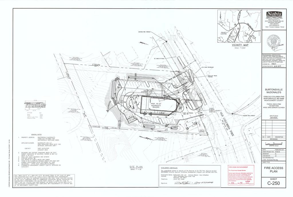
28 Attachment 2
29 Attachment 3
30 Attachment 3
31 DRIVE THRU DRIVE THRU. Attachment 4 Engineering a Sustainable Future Nobis Engineering, Inc Century Boulevard, Suite 230 Germantown, MD T(301) Client - Focused, Employee - Owned THANK YOU BURTONSVILLE McDONALD'S OLD COLUMBIA PIKE BURTONSVILLE, MD MONTGOMERY COUNTY PARCEL N922 & P969 TAX MAP KS62 WSSC GRID 220NE04 & 221NE04 SITE PLAN # NO. DATE DESCRIPTION REVISIONS NAD 83 DATE: NOBIS PROJECT NO. DRAWN BY: CHECKED BY: CAD DRAWING FILE: C FFCP.dwg MAY SL JA GRAPHIC SCALE ( IN FEET ) 1 inch = 30 ft. N O R T O N L A N D D E S I G N LANDSCAPE ARCHITECTURE + ENVIRONMENTAL PLANNING NEW HAMPSHIRE AVENUE, SUITE P F ASHTON, MD SHEET TITLE PRELIMINARY/ FINAL FOREST CONSERVATION PLAN SHEET L-1.1 OF

32 Attachment 5 December 23, 2014 Revised April 6, 2017 Revised May 25, 2017 Revised June 28, 2017 Maryland National Capital Park and Planning Commission (M-NCPPC) 8787 Georgia Avenue Silver Spring, Maryland Re: Burtonsville McDonald s Request for Specimen Tree Variance MNCPPC# NRI-FSD # Dear MaryJo: On behalf of the Applicant, Mr. Gary Kilfeather, McDonald s Corporation, and pursuant to Section 22A-21 Variance provisions of the Montgomery County Forest Conservation Ordinance and recent revisions to the State Forest Conservation Law enacted by S.B. 666, we are writing to request a variance(s) to allow impacts to or the removal of the following tree identified on the approved Natural Resource Inventory/Forest Stand Delineation for the above-named commercial project: Project Description: This is a 2.43 (including 0.14 acres offsite)-acre site that consists of parcels 922 and 969 owned by the McDonald s Corporation. The site currently hosts the existing McDonald s restaurant, circulation and drive-thru service accommodations. The site is bordered by fuel/service stations and a mini storage facility. The site has vehicle access from Rt.198. The proposed construction consists of a modernized restaurant building with revised circulation, parking, drive-thru service accommodations and associated stromwater management. Requirements for Justification of Variance: Section 22A-21(b) Application requirements states that the applicant must: (1) Describe the special conditions peculiar to the property which would cause the unwarranted hardship; (2) Describe how enforcement of these rules will deprive the landowner of rights commonly enjoyed by others in similar areas;
33 Attachment 5 (3) Verify that State water quality standards will not be violated or that a measurable degradation in water quality will not occur as a result of the granting of the variance; and (4) Provide any other information appropriate to support the request. Justification of Variance: (1) Describe the special conditions peculiar to the property which would cause the unwarranted hardship; Response: As part of the program, the task was to provide the Applicant with a modernized restaurant facility. Efforts have been made to impact the site as little as possible. The proposed building is located in the same area as the previous building. The proposed work will require the disturbance and removal of two (2) specimen trees. It should be noted one tree is for the grading associated with the stormwater management and the second tree which requires removal is located within the right of way for sidewalk connections per the masterplan. Although requesting removal for the 50 White Oak, the goal is to retain it in the immediate, with removal at some point in the future if necessitated by the construction of the sidewalk in this area or the tree becomes a hazard. The stormwater from the treatment facilities must connect to the existing storm sewer located in the right of way where there will be impacts to the root zone of a specimen tree. If we are not allowed to impact or remove this tree, there would not be adequate room for the development program. If the Applicant is not allowed to impact the trees, there would not be a method to install the sidewalk in the right-of-way or remove treated stormwater from the site. The site would not be in compliance with the County stormwater regulations or requirements of the Department of Transportation. As such, this would cause an unwarranted hardship to the landowner. (2) Describe how enforcement of these rules will deprive the landowner of rights commonly enjoyed by others in similar areas; Response: If the Applicant is required to keep all improvements outside the root zones of the specimen trees, the restaurant would fail to be built due to the close proximity of specimen trees to necessary utility connection. (3) Verify that State water quality standards will not be violated or that a measurable degradation in water quality will not occur as a result of the granting of the variance; Response: Tree removals have been minimized. However, the requirement of a hiker/biker path is not feasible without removal of the specimen tree within the right of way. In addition, this property will be developed in accordance with the latest Maryland Department of the Environment criteria for stormwater management. This includes Environmental Site Design to provide for protecting the natural resources to the
34 Attachment 5 Maximum Extent Practicable and limiting the impervious areas and providing on-site stormwater management systems. The stormwater management facility does require removal of a specimen tree. A Stormwater Management Concept is currently under review by the Montgomery County Department of Permitting Services to ensure that this criterion is enforced. Therefore, the proposed activity will not degrade the water quality of the downstream areas and will not result in measurable degradation in water quality. (4) Provide any other information appropriate to support the request. Response: The proposed limit of disturbance is minimized to prevent as much disturbance as possible. DOT will be notified of the tree impacts within the right of way. As further basis for its variance request, the applicant can demonstrate that it meets the Section 22A-21(d) Minimum criteria, which states that a variance must not be granted if granting the request: (1) Will confer on the applicant a special privilege that would be denied to other applicants; Response: The proposed construction is in conformance with the County s General plan. As such, this is not a special privilege to be conferred on the applicant. (2) Is based on conditions or circumstances which are the result of the actions by the applicant; Response: The Applicant has taken no actions leading to the conditions or circumstances that are the subject of this variance request. (3) Arises from a condition relating to land or building use, either permitted or nonconforming, on a neighboring property; or Response: The surrounding land uses (fuel/service station & storage) do not have any inherent characteristics or conditions that have created or contributed to this particular need for a variance. (4) Will violate State water quality standards or cause measurable degradation in water quality. Response: Granting this variance request will not violate State water quality standards or cause measurable degradation in water quality. SpecimenTree Summary 30" + Tree Species Species D.B.H Tree Comments Status # (Scientific Name) (Common Name) (inches) Condition 1 QUERCUS ALBA WHITE OAK 50 FAIR OFFSITE/PRUNED/DIEBACK/DEAD & BROKEN SCAFFOLDS & LIMBS TO BE REMOVED 2 ACER SACCHARINUM SILVER MAPLE 30,16,15,6 FAIR EXPOSED & GIRDLED ROOTS/VINES/BROKEN LIMBS TO BE REMOVED Note: the goal is to retain tree #1 it in the immediate, with removal at some point in the future if necessitated by the construction of the sidewalk in this area or the tree becomes a hazard.
35 Attachment 5 Conclusion: For the above reasons, the applicant respectfully requests that the Planning Board APPROVE its request for a variance from the provisions of Section 22A of the Montgomery County Forest Conservation Ordinance, and thereby, GRANTS permission to impact/remove the specimen tree in order to allow the construction of this project. The recommendations in this report are based on tree conditions noted at the time the NRI/FSD field work was conducted. Tree condition can be influenced by many environmental factors, such as wind, ice and heavy snow, drought conditions, heavy rainfall, rapid or prolonged freezing temperatures, and insect/disease infestation. Therefore, tree conditions are subject to change without notice. The site plans and plotting of tree locations were furnished for the purpose of creating a detailed Tree Protection Plan. All information is true and accurate to the best of my knowledge and experience. All conclusions are based on professional opinion and were not influenced by any other party. Sincerely, Copy to: Mr. Jason Azar, Nobis Engineering Michael Norton

36 Attachment 6 Isiah Leggett County Executive DEPARTMENT OF ENVIRONMENTAL PROTECTION July 6, 2017 Lisa Feldt Director Casey Anderson, Chair Montgomery County Planning Board Maryland National Capital Park & Planning Commission 8787 Georgia Avenue Silver Spring, Maryland RE: Burtonsville McDonalds, eplan , NRI/FSD application accepted on 11/15/2012 Dear Mr. Anderson: All applications for a variance from the requirements of Chapter 22A of the County Code submitted after October 1, 2009 are subject to Section 22A-12(b)(3). Accordingly, given that the application for the above referenced request was submitted after that date and must comply with Chapter 22A, and the Montgomery County Planning Department ( Planning Department ) has completed all review required under applicable law, I am providing the following recommendation pertaining to this request for a variance. Section 22A-21(d) of the Forest Conservation Law states that a variance must not be granted if granting the request: 1. Will confer on the applicant a special privilege that would be denied to other applicants; 2. Is based on conditions or circumstances which are the result of the actions by the applicant; 3. Arises from a condition relating to land or building use, either permitted or nonconforming, on a neighboring property; or 4. Will violate State water quality standards or cause measurable degradation in water quality. Applying the above conditions to the plan submitted by the applicant, I make the following findings as the result of my review: 1. The granting of a variance in this case would not confer a special privilege on this applicant that would be denied other applicants as long as the same criteria are applied in each case. Therefore, the variance can be granted under this criterion. 2. Based on a discussion on March 19, 2010 between representatives of the County, the Planning Department, and the Maryland Department of Natural Resources Forest Service, the disturbance of trees, or other vegetation, as a result of development activity is not, in and of itself, interpreted as a condition or circumstance that is the result of the actions by the applicant. Therefore, the variance can be granted under this criterion, as long as appropriate mitigation is provided for the resources disturbed. 255 Rockville Pike, Suite 120 Rockville, Maryland FAX montgomerycountymd.gov/ TTY
MONTGOMERY COUNTY PLANNING DEPARTMENT THE MARYLAND-NATIONAL CAPITAL PARK AND PLANNING COMMISSION
 MONTGOMERY COUNTY PLANNING DEPARTMENT THE MARYLAND-NATIONAL CAPITAL PARK AND PLANNING COMMISSION MCPB Item No. Date: 06-12-14 King of the Nations Christian Fellowship Church: Limited Site Plan Amendment
Clarksburg Square Road Extension
 Clarksburg Square Road Extension Preliminary Plan No. 120140060 Site Plan No. 820140050 Site Plan Amendment No. 82007022C (Clarksburg Town Center) Clarksburg SPA Water Quality Plan Mandatory Referral MR2015008
MONTGOMERY COUNTY PLANNING DEPARTMENT THE MARYLAND-NATIONAL CAPITAL PARK AND PLANNING COMMISSION
 MONTGOMERY COUNTY PLANNING DEPARTMENT THE MARYLAND-NATIONAL CAPITAL PARK AND PLANNING COMMISSION MCPB Item No. Date: 12-10-15 Leisure World Clubhouse II Addition Fitness Center, Limited Site Plan Amendment
MONTGOMERY COUNTY PLANNING DEPARTMENT THE MARYLAND-NATIONAL CAPITAL PARK AND PLANNING COMMISSION
 MONTGOMERY COUNTY PLANNING DEPARTMENT THE MARYLAND-NATIONAL CAPITAL PARK AND PLANNING COMMISSION MCPB Item No. Date: 3.10.2016 Site Plan 820160040 Nora School Parker Smith, Planning Technician, Area 1,
MONTGOMERY COUNTY PLANNING DEPARTMENT THE MARYLAND-NATIONAL CAPITAL PARK AND PLANNING COMMISSION
 MONTGOMERY COUNTY PLANNING DEPARTMENT THE MARYLAND-NATIONAL CAPITAL PARK AND PLANNING COMMISSION Montgomery Auto Sales Park: Preliminary Plan No. 11985027A, Site Plan No. 820140130 and Site Plan No. 820140140
MONTGOMERY COUNTY PLANNING DEPARTMENT THE MARYLAND-NATIONAL CAPITAL PARK AND PLANNING COMMISSION
 MONTGOMERY COUNTY PLANNING DEPARTMENT THE MARYLAND-NATIONAL CAPITAL PARK AND PLANNING COMMISSION The Goddard School in North Bethesda Preliminary Plan Amendment 11996015B and Site Plan Amendment 82006005A
MONTGOMERY COUNTY PLANNING DEPARTMENT
 MONTGOMERY COUNTY PLANNING DEPARTMENT THE MARYLAND-NATIONAL CAPITAL PARK AND PLANNING COMMISSION MCPB Item No. 4 Date: 12-15-16 CVS Derwood: Site Plan No. 820160150 Calvin Nelson, Jr., Planner Coordinator,
MONTGOMERY COUNTY PLANNING DEPARTMENT
 MONTGOMERY COUNTY PLANNING DEPARTMENT THE MARYLAND-NATIONAL CAPITAL PARK AND PLANNING COMMISSION MCPB Item No. Date: 12/20/2018 Nucci Subdivision, Preliminary Plan No. 120160170 MF Marco Fuster, Planner
MONTGOMERY COUNTY PLANNING DEPARTMENT Newell Street. Site Plan Item #2. Maryland-National Capital Park and Planning Commission
 8001 Newell Street Site Plan 820140020 Item #2 December 19, 2013 Redlined Conditions 1. The Applicant must comply with the conditions of approval for Project Plan 920130020 in MCPB Resolution No. 13-74.
MONTGOMERY COUNTY PLANNING DEPARTMENT
 MONTGOMERY COUNTY PLANNING DEPARTMENT THE MARYLAND-NATIONAL CAPITAL PARK AND PLANNING COMMISSION MCPB Item No.: Date: 5-03-18 Pike and Rose, Phase I: Site Plan Amendment No. 82012002D Rhoda Hersson-Ringskog,
I. Introduction. Prior Approvals
 Statement of Justification First National Bank 19790 Crystal Rock Drive, Germantown, Maryland Application for Site Plan and Limited Preliminary Plan Amendment I. Introduction DPH Architecture, for First
MONTGOMERY COUNTY PLANNING DEPARTMENT THE MARYLAND-NATIONAL CAPITAL PARK AND PLANNING COMMISSION
 MONTGOMERY COUNTY PLANNING DEPARTMENT THE MARYLAND-NATIONAL CAPITAL PARK AND PLANNING COMMISSION MCPB Item No. Date: 05-22-14 Consent Item - Park Potomac: Site Plan Amendment No. 82004015K MCS. Molline
MONTGOMERY COUNTY PLANNING DEPARTMENT THE MARYLAND-NATIONAL CAPITAL PARK AND PLANNING COMMISSION
 MONTGOMERY COUNTY PLANNING DEPARTMENT THE MARYLAND-NATIONAL CAPITAL PARK AND PLANNING COMMISSION MCPB Item No.: 2 Date: 12-19-13 Site Plan 820140020, 8001 Newell Street Neil Braunstein, AICP, Area 1, neil.braunstein@montgomeryplanning.org,
MONTGOMERY COUNTY PLANNING DEPARTMENT THE MARYLAND-NATIONAL CAPITAL PARK AND PLANNING COMMISSION
 MONTGOMERY COUNTY PLANNING DEPARTMENT THE MARYLAND-NATIONAL CAPITAL PARK AND PLANNING COMMISSION MCPB Item No. Date: 9-4-13 Limited Site Plan Amendment No. 81994026B, Darcars at Montgomery Industrial Park,
MONTGOMERY COUNTY PLANNING DEPARTMENT THE MARYLAND-NATIONAL CAPITAL PARK AND PLANNING COMMISSION
 MONTGOMERY COUNTY PLANNING DEPARTMENT THE MARYLAND-NATIONAL CAPITAL PARK AND PLANNING COMMISSION MCPB Item No. Date: 1/26/12 Hanover Shady Grove, Sketch Plan 320120020 Joshua Sloan, Coordinator, Joshua.Sloan@MontgomeryPlanning.org,
The Maryland-National Capital Park and Planning Commission Prince George's County Planning Department Development Review Division
 The Maryland-National Capital Park and Planning Commission Prince George's County Planning Department Development Review Division 301-952-3530 Note: Staff reports can be accessed at www.mncppc.org/pgco/planning/plan.htm.
MONTGOMERY COUNTY PLANNING DEPARTMENT THE MARYLAND-NATIONAL CAPITAL PARK AND PLANNING COMMISSION
 MONTGOMERY COUNTY PLANNING DEPARTMENT THE MARYLAND-NATIONAL CAPITAL PARK AND PLANNING COMMISSION Clarksburg Square Road Extension: Preliminary Plan No. 120140060, Preliminary/Final Water Quality Plan,
The subject site plan amendment proposes the following revisions to the approved site plan:
 PROPOSED AMENDMENT The subject site plan amendment proposes the following revisions to the approved site plan: 1. The building footprint was modified to accommodate the revised architectural design. 2.
MONTGOMERY COUNTY PLANNING DEPARTMENT THE MARYLAND-NATIONAL CAPITAL PARK AND PLANNING COMMISSION MCPB Item No.: 13 Date: 07/19/18
 MONTGOMERY COUNTY PLANNING DEPARTMENT THE MARYLAND-NATIONAL CAPITAL PARK AND PLANNING COMMISSION MCPB Item No.: 13 Date: 07/19/18 Black Hill / ViaSat: Project Plan No. 92012004B, Preliminary Plan No. 12012021B,
MONTGOMERY COUNTY PLANNING DEPARTMENT THE MARYLAND-NATIONAL CAPITAL PARK AND PLANNING COMMISSION
 MONTGOMERY COUNTY PLANNING DEPARTMENT THE MARYLAND-NATIONAL CAPITAL PARK AND PLANNING COMMISSION Ashton Market: Preliminary Plan No. 120180180 and Site Plan No. 820180160 Jonathan Casey, Senior Planner,
MONTGOMERY COUNTY PLANNING DEPARTMENT THE MARYLAND-NATIONAL CAPITAL PARK AND PLANNING COMMISSION
 MONTGOMERY COUNTY PLANNING DEPARTMENT THE MARYLAND-NATIONAL CAPITAL PARK AND PLANNING COMMISSION MCPB Item No. 6 Date: 5-9-13 Site Plan No. 820130090, West Chevy Chase Heights Erin Grayson, Senior Planner,
MONTGOMERY COUNTY PLANNING DEPARTMENT THE MARYLAND-NATIONAL CAPITAL PARK AND PLANNING COMMISSION
 MONTGOMERY COUNTY PLANNING DEPARTMENT THE MARYLAND-NATIONAL CAPITAL PARK AND PLANNING COMMISSION MCPB Item No. Date: 1/15/2015 Bethesda North Marriott Hotel and Conference Center: Limited Site Plan Amendment
MONTGOMERY COUNTY PLANNING DEPARTMENT THE MARYLAND-NATIONAL CAPITAL PARK AND PLANNING COMMISSION
 MONTGOMERY COUNTY PLANNING DEPARTMENT THE MARYLAND-NATIONAL CAPITAL PARK AND PLANNING COMMISSION MCPB Item No.: 9 Date: 07-20-17 Topgolf - Germantown: Preliminary Plan Amendment No. 12007065B and Site
MONTGOMERY COUNTY PLANNING DEPARTMENT THE MARYLAND-NATIONAL CAPITAL PARK AND PLANNING COMMISSION
 MONTGOMERY COUNTY PLANNING DEPARTMENT THE MARYLAND-NATIONAL CAPITAL PARK AND PLANNING COMMISSION MCPB Item No.: Date: 9-24-15 Plaza Del Mercado Limited Site Plan Amendment 82006004A Crystal Myers, Senior
TABLE OF CONTENTS SITE DESCRIPTION 3 Vicinity 3 Site Analysis 4. PROJECT DESCRIPTION 5 Proposal 5
 TABLE OF CONTENTS SITE DESCRIPTION 3 Vicinity 3 Site Analysis 4 PROJECT DESCRIPTION 5 Proposal 5 PROJECT ANALYSIS 6 Master Plan 6 Transportation & Circulation 6 Environment 7 Development Standards 8 Community
MONTGOMERY COUNTY PLANNING DEPARTMENT
 MONTGOMERY COUNTY PLANNING DEPARTMENT THE MARYLAND-NATIONAL CAPITAL PARK AND PLANNING COMMISSION MCPB Consent Date: 4-26-18 Cabin John Auto Park (N. Bethesda Home Depot), Site Plan Amendment No. 81980017A
MONTGOMERY COUNTY PLANNING DEPARTMENT THE MARYLAND-NATIONAL CAPITAL PARK AND PLANNING COMMISSION
 MONTGOMERY COUNTY PLANNING DEPARTMENT THE MARYLAND-NATIONAL CAPITAL PARK AND PLANNING COMMISSION MCPB Item No. Date: 05/12/2016 North Bethesda Conference Center Parking Structure, Mandatory Referral No.
MONTGOMERY COUNTY PLANNING DEPARTMENT THE MARYLAND-NATIONAL CAPITAL PARK AND PLANNING COMMISSION
 MONTGOMERY COUNTY PLANNING DEPARTMENT THE MARYLAND-NATIONAL CAPITAL PARK AND PLANNING COMMISSION MCPB Item No. 3 Date: 02-28-13 8415 Fenton Street, Preliminary Plan 120120130, Site Plan 820130050 John
MONTGOMERY COUNTY PLANNING DEPARTMENT THE MARYLAND-NATIONAL CAPITAL PARK AND PLANNING COMMISSION
 MONTGOMERY COUNTY PLANNING DEPARTMENT THE MARYLAND-NATIONAL CAPITAL PARK AND PLANNING COMMISSION MCPB Item Date: 09/08/16 The Collection (Formerly Chevy Chase Center): Site Plan Amendment No. 82001013C,
Note: Staff reports can be accessed at Zone: I-3. Tier:
 The Maryland-National Capital Park and Planning Commission Prince George s County Planning Department Development Review Division 301-952-3530 Note: Staff reports can be accessed at www.mncppc.org/pgco/planning/plan.htm.
MONTGOMERY COUNTY PLANNING DEPARTMENT THE MARYLAND NATIONAL CAPITAL PARK AND PLANNING COMMISSION
 MONTGOMERY COUNTY PLANNING DEPARTMENT THE MARYLAND NATIONAL CAPITAL PARK AND PLANNING COMMISSION MCPB Item No. 8 Date: 3.30.2017 Project Name: Lot 31/31A Bethesda, Site Plan Amendment, No. 82007018C Elza
MONTGOMERY COUNTY PLANNING DEPARTMENT THE MARYLAND-NATIONAL CAPITAL PARK AND PLANNING COMMISSION
 MONTGOMERY COUNTY PLANNING DEPARTMENT THE MARYLAND-NATIONAL CAPITAL PARK AND PLANNING COMMISSION MCPB Item No.: 11 Date: 06-28-18 Black Hill Infrastructure Site Plan Amendment No. 82013025C Benjamin Berbert,
D1 September 11, 2013 Public Hearing APPLICANT:
 D1 September 11, 2013 Public Hearing APPLICANT: BEACH MUNICIPAL FEDERAL CREDIT UNION PROPERTY OWNER: SISTERS II, LLC STAFF PLANNER: Karen Prochilo REQUEST: Conditional Change of Zoning (AG-2 Agriculture
Request Conditional Use Permit (Automobile Service Station) Staff Recommendation Approval. Staff Planner Bill Landfair
 Staff Recommendation Approval. Staff Planner Bill Landfair") Applicant Property Owner RTR Real Estate Associates, Tidewater Investments, LLC, Bruce Ranomski Public Hearing December 12, 2018 City Council Election District Centerville Agenda Item 7 Request Conditional
Applicant Property Owner RTR Real Estate Associates, Tidewater Investments, LLC, Bruce Ranomski Public Hearing December 12, 2018 City Council Election District Centerville Agenda Item 7 Request Conditional
4 January 11, 2012 Public Hearing APPLICANT:
 . 4 January 11, 2012 Public Hearing APPLICANT: MID-ATLANTIC AUTO PROPERTY OWNER: DZR, LLC STAFF PLANNER: Leslie Bonilla REQUEST: Conditional Use Permit (truck rental, automobile service, and automotive/bulk
MONTGOMERY COUNTY PLANNING DEPARTMENT THE MARYLAND-NATIONAL CAPITAL PARK AND PLANNING COMMISSION
 MONTGOMERY COUNTY PLANNING DEPARTMENT THE MARYLAND-NATIONAL CAPITAL PARK AND PLANNING COMMISSION MCPB Item No. Date: 10.25.18 Artery Plaza: Site Plan Amendment 81984002E SD Stephanie Dickel, Planner Coordinator,
R E S O L U T I O N. Single-Family Residence/ Church. 2,488 sq. ft. 2,488 sq. ft. Area Parking Required: Church
 R E S O L U T I O N WHEREAS, the Prince George s County Planning Board is charged with the approval of Detailed Site Plans pursuant to Part 3, Division 9 of the Zoning Ordinance of the Prince George s
MONTGOMERY COUNTY PLANNING DEPARTMENT THE MARYLAND-NATIONAL CAPITAL PARK AND PLANNING COMMISSION
 MONTGOMERY COUNTY PLANNING DEPARTMENT THE MARYLAND-NATIONAL CAPITAL PARK AND PLANNING COMMISSION Preliminary Plan 120120220 & Site Plan 820120140, 7001 Arlington Road MCPB Item No. 8 Date: 11-1-12 Erin
Request Conditional Use Permit (Automobile Repair Garage) Staff Planner Kevin Kemp
 Staff Planner Kevin Kemp") Request Conditional Use Permit (Automobile Repair Garage) Staff Planner Kevin Kemp Location 845 Lynnhaven Parkway GPIN 14963473030000 Election District Rose Hall Site Size 0.40 acre portion of a 6.35 acre
Request Conditional Use Permit (Automobile Repair Garage) Staff Planner Kevin Kemp Location 845 Lynnhaven Parkway GPIN 14963473030000 Election District Rose Hall Site Size 0.40 acre portion of a 6.35 acre
Request Alternative Compliance to the prescribed criteria of the Oceanfront Resort District Form- Based Code. Staff Recommendation Approval
 Applicant Property Owner Steven H. Murden Public Hearing June 14, 2017 City Council Election District Beach Agenda Item 8 Request Alternative Compliance to the prescribed criteria of the Oceanfront Resort
Note: Staff reports can be accessed at Special Permit Application No.
 The Maryland-National Capital Park and Planning Commission Prince George's County Planning Department Development Review Division 301-952-3530 Note: Staff reports can be accessed at www.mncppc.org/pgco/planning/plan.htm.
Location and Field Inspection: History: Master Plan Recommendation:
 R E S O L U T I O N WHEREAS, the Prince George s County Planning Board has reviewed Special Permit Application No. SP-130008, Sudsville Laundry, requesting a special permit to construct an addition and
5.1.1 The streetscape along US Highway 64 (Brevard Road); and, The built environment within new residential developments; and,
; and, The built environment within new residential developments; and,") Article 5. Landscaping 5.1 Purpose The Town of Laurel Park s landscape standards are designed to create a beautiful, aesthetically pleasing built environment that will complement and enhance community
Article 5. Landscaping 5.1 Purpose The Town of Laurel Park s landscape standards are designed to create a beautiful, aesthetically pleasing built environment that will complement and enhance community
REZONING APPLICATION MPD SUPPLEMENT
 REZONING APPLICATION MPD SUPPLEMENT For Staff Use Only: DATE/TIMESTAMP: ZA# RECEIVED BY: The intent of the Master Planned District (MPD) designation is to allow flexibility in the design and construction
STATEMENT OF JUSTIFICATION CLARKSBURG PREMIUM OUTLETS AT CABIN BRANCH NORTH DISTRICT, PHASE
 STATEMENT OF JUSTIFICATION CLARKSBURG PREMIUM OUTLETS AT CABIN BRANCH NORTH DISTRICT, PHASE 1 Southwest Corner of Clarksburg Road and Interstate-270 Clarksburg, Maryland Application for Site Plan #820140160
R E S O L U T I O N. 2. Development Data Summary:
 R E S O L U T I O N WHEREAS, the Prince George s County Planning Board has reviewed Departure from Design Standards DDS-631 requesting a departure to allow the loading space and the driveway to the loading
MONTGOMERY COUNTY PLANNING DEPARTMENT THE MARYLAND-NATIONAL CAPITAL PARK AND PLANNING COMMISSION
 MONTGOMERY COUNTY PLANNING DEPARTMENT THE MARYLAND-NATIONAL CAPITAL PARK AND PLANNING COMMISSION MCPB Item No. Date10/25/12 Sketch Plan No. 32012004, White Flint Mall Redevelopment Nkosi Yearwood, Senior
8 February 9, 2011 Public Hearing APPLICANT: 7-ELEVEN, INC.
 . 8 February 9, 2011 Public Hearing APPLICANT: REQUEST: Conditional Use Permit for an automobile service station with a convenience store ADDRESS / DESCRIPTION: 2448 Nimmo Parkway PROPERTY OWNER: COURTHOUSE
McDonald s Restaurant - Purcellville Town of Purcellville Special Use Permit Statement of Justification July 24, 2014
 Introduction / Written Statement McDonald s Restaurant - Purcellville McDonald s Corporation is proposing to redevelop the existing McDonald s eating establishment with a drive-through located at 121 N
Application for Site Plan Review
 Application for Site Plan Review City of Pontiac Office of Land Use and Strategic Planning 47450 Woodward Ave, Pontiac, MI 48342 T: 248.758.2800 F: 248.758.2827 Property/Project Address: Sidwell Number:
MONTGOMERY COUNTY PLANNING DEPARTMENT THE MARYLAND-NATIONAL CAPITAL PARK AND PLANNING COMMISSION
 MONTGOMERY COUNTY PLANNING DEPARTMENT THE MARYLAND-NATIONAL CAPITAL PARK AND PLANNING COMMISSION Staff Report: Sketch Plan #320110010, Mid-Pike Plaza ITEM #: MCPB HEARING DATE: January 20, 2011 REPORT
12 January 12, 2011 Public Hearing APPLICANT: TAILWIND DEVELOPMENT GROUP,LLC PROPERTY OWNER: CITY OF VIRGINIA BEACH
 12 January 12, 2011 Public Hearing APPLICANT: TAILWIND DEVELOPMENT GROUP,LLC PROPERTY OWNER: CITY OF VIRGINIA BEACH STAFF PLANNER: Faith Christie REQUEST: Conditional Change of Zoning (from PD-H1 Planned
MONTGOMERY COUNTY PLANNING DEPARTMENT THE MARYLAND-NATIONAL CAPITAL PARK AND PLANNING COMMISSION
 MONTGOMERY COUNTY PLANNING DEPARTMENT THE MARYLAND-NATIONAL CAPITAL PARK AND PLANNING COMMISSION MCPB Item No. Date: 6/30/2016 Washington Adventist Hospital, Site Plan Amendment No. 82008021E Michael Brown,
MONTGOMERY COUNTY PLANNING DEPARTMENT
 MONTGOMERY COUNTY PLANNING DEPARTMENT THE MARYLAND-NATIONAL CAPITAL PARK AND PLANNING COMMISSION Ashburton Elementary School Addition, Mandatory Referral, MR2018009 MCPB Item No. Date: 02-15-18 Troy Leftwich,
Project Name: MELWOOD HOTEL. Date Accepted: 1/12/04. Waived. Planning Board Action Limit: Plan Acreage: 1.7 Zone: Dwelling Units:
 The Maryland-National Capital Park and Planning Commission Prince George's County Planning Department Development Review Division 301-952-3530 Note: Staff reports can be accessed at www.mncppc.org/pgco/planning/plan.htm.
CITY OF ZEELAND PLANNING COMMISSION
 APPLICATION FOR SITE PLAN REVIEW AND SPECIAL LAND USE Date City Official App. Filing Fee Rec'd ($350) NOTE TO APPLICANT: Please submit this application for Site Plan Review along with twenty (20) copies
Urban Design Manual 2.0 DRIVE-THROUGH FACILITIES. Background. Urban Design Challenges
 222221 2.0 DRIVE-THROUGH FACILITIES Background In recent years, drive-through facilities have grown significantly in popularity with drive-through restaurants, in particular, being established on numerous
MONTGOMERY COUNTY PLANNING DEPARTMENT THE MARYLAND-NATIONAL CAPITAL PARK AND PLANNING COMMISSION
 MONTGOMERY COUNTY PLANNING DEPARTMENT THE MARYLAND-NATIONAL CAPITAL PARK AND PLANNING COMMISSION MCPB Item No. 8 Date: 12-15-16 Montgomery Village Center Sketch Plan No. 320170020 TL Troy Leftwich, Senior
PLANNED UNIT DEVELOPMENT & SUBDIVISION STAFF REPORT Date: March 15, 2012
 PLANNED UNIT DEVELOPMENT & SUBDIVISION STAFF REPORT Date: March 15, 2012 DEVELOPMENT NAME SUBDIVISION NAME LOCATION OSR Subdivision OSR Subdivision 5559 Old Shell Road (South side of Old Shell Road, 570
CHESAPEAKE LANDSCAPE ORDINANCE
 CHESAPEAKE LANDSCAPE ORDINANCE CONSERVATION PRESERVATION CZO 19-600 Effective October 16, 2008 BUFFER YARD C PARKING LOT REFORESTATION YEAR 1 REFORESTATION YEAR 4 BUFFER YARD F CBPA REFORESTATION Page
MONTGOMERY COUNTY PLANNING DEPARTMENT THE MARYLAND-NATIONAL CAPITAL PARK AND PLANNING COMMISSION
 MONTGOMERY COUNTY PLANNING DEPARTMENT THE MARYLAND-NATIONAL CAPITAL PARK AND PLANNING COMMISSION 8015 Old Georgetown Road, Preliminary Plan 120160220, Site Plan 820160090 MCPB Item No.: 8 Date: 11-03-16
MONTGOMERY COUNTY PLANNING DEPARTMENT
 MONTGOMERY COUNTY PLANNING DEPARTMENT THE MARYLAND-NATIONAL CAPITAL PARK AND PLANNING COMMISSION Ourisman Ford at Montgomery Mall, Sketch Plan No. 320170100 MCPB Item No. Date: 11-30-17 LS Lori Shirley,
COUNTY COUNCIL OF PRINCE GEORGE'S COUNTY, MARYLAND, SITTING AS THE DISTRICT COUNCIL ORDER AFFIRMING PLANNING BOARD DECISION, WITH AMENDED CONDITIONS
 Case No. Applicant: Dawn Limited Partnership COUNTY COUNCIL OF PRINCE GEORGE'S COUNTY, MARYLAND, SITTING AS THE DISTRICT COUNCIL ORDER AFFIRMING PLANNING BOARD DECISION, WITH AMENDED CONDITIONS IT IS HEREBY
DRAFT Northeast Quadrant of Kipling Avenue and Highway 7 DRAFT AUGUST 29, Goals Land Use. The goals of this Plan are to:
 AUGUST 29, 2017 12.15 Northeast Quadrant of Kipling Avenue and Highway 7 12.15.1 Goals 12.15.2 Land Use The goals of this Plan are to: 12.15.2.1 General Provisions: a) Ensure the development of a compact
GENERAL INFORMATIONaaaaaaaaaaaaaaaaaaaaaaaaaaaaaaaa
 To: Planning and Zoning Commission From: City Staff Date: November 15, 2016 Re: Case #16026 Raymore Activity Center Site Plan GENERAL INFORMATIONaaaaaaaaaaaaaaaaaaaaaaaaaaaaaaaa Applicant/ Property Owner:
MONTGOMERY COUNTY PLANNING DEPARTMENT THE MARYLAND-NATIONAL CAPITAL PARK AND PLANNING COMMISSION
 MONTGOMERY COUNTY PLANNING DEPARTMENT THE MARYLAND-NATIONAL CAPITAL PARK AND PLANNING COMMISSION MCPB Item No. Date: 07-17-2014 Rock Spring Park, Preliminary Plan Amendment 11998093B and Site Plan Amendment,
PLANNED UNIT DEVELOPMENT Date: April 5, 2018
 PLANNED UNIT DEVELOPMENT Date: April 5, 2018 DEVELOPMENT NAME SUBDIVISION NAME LOCATION Robert Myers Robert Myers 2955 and 2989 Dauphin Street (Southeast corner of Dauphin Street and Sage Avenue) CITY
MONTGOMERY COUNTY PLANNING DEPARTMENT THE MARYLAND-NATIONAL CAPITAL PARK AND PLANNING COMMISSION
 MONTGOMERY COUNTY PLANNING DEPARTMENT THE MARYLAND-NATIONAL CAPITAL PARK AND PLANNING COMMISSION MCPB Item No. 3 4/3/14 4990 Fairmont Avenue, Site Plan 820140060 Erin Banks, AICP, Senior Planner, Area
CITY OF KEIZER MASTER PLAN APPLICATION & INFORMATION SHEET
 CITY OF KEIZER MASTER PLAN APPLICATION & INFORMATION SHEET PRE-APPLICATION CONFERENCE Prior to the actual filing of a Master Plan application, it is strongly recommended that the applicant contact Planning
Planned Development Review Revisions (Project No. PLNPCM )
") Planned Development Review Revisions (Project No. PLNPCM2014-00139) Standard residential development Planned Development Example: Smaller lot sizes than what is allowed to create open space amenity. What
Planned Development Review Revisions (Project No. PLNPCM2014-00139) Standard residential development Planned Development Example: Smaller lot sizes than what is allowed to create open space amenity. What
MONTGOMERY COUNTY PLANNING DEPARTMENT
 OCT MONTGOMERY COUNTY PLANNING DEPARTMENT THE MARYLAND-NATIONAL CAPITAL PARK AND PLANNING COMMISSION 2 1 2009 MCPB No. 09-124 Project Name: Date of Hearing: September 17,2009 MONTGOMERY COUNTY PLANNING
MONTGOMERY COUNTY PLANNING DEPARTMENT THE MARYLAND-NATIONAL CAPITAL PARK AND PLANNING COMMISSION
 MONTGOMERY COUNTY PLANNING DEPARTMENT THE MARYLAND-NATIONAL CAPITAL PARK AND PLANNING COMMISSION MCPB Item No.: 5 Date: 06-29-17 Bradford s Landing, Site Plan No. 820170060 Sandra Pereira, RLA, Acting
COLERAIN TOWNSHIP ZONING COMMISSION Regular Meeting Tuesday, October 18, :00 p.m.
 COLERAIN TOWNSHIP ZONING COMMISSION Regular Meeting Tuesday, October 18, 2016-6:00 p.m. Colerain Township Government Complex 4200 Springdale Road - Cincinnati, OH 45251 1. Meeting called to order. Pledge
Chesapeake Bay Critical Area Conservation Plan
 The Maryland-National Capital Park and Planning Commission Prince George s County Planning Department Development Review Division 301-952-3530 Note: Staff reports can be accessed at www.mncppc.org/pgco/planning/plan.htm.
lot flankage Y street 16m 6m landscape strip for large site 3m landscape strip for small medium site
 Commercial General Commercial Objectives Create developments compatible with adjacent land uses in scale, function and character Define a consistent and attractive street edge with quality landscaping,
DEPARTMENT OF PLANNING JEFFERSON PARISH, LOUISIANA
 DEPARTMENT OF PLANNING JEFFERSON PARISH, LOUISIANA DESIGN REVIEW REPORT : CPZ-3-1 : (S) Cynthia Lee-Sheng AT LARGE: A Chris Roberts B Elton M. Lagasse ADVERTISING DATES: 06/03/1 06/10/1 06/17/1 PAB PUBLIC
8 October 14, 2015 Public Hearing
 8 October 14, 2015 Public Hearing APPLICANT & PROPERTY OWNER: PRICE S HOLDINGS, LLC STAFF PLANNER: Karen Lasley REQUEST: A. Conditional Use Permit (Automobile Repair Garage) B. Change in Nonconforming
MONTGOMERY COUNTY PLANNING DEPARTMENT
 MONTGOMERY COUNTY PLANNING DEPARTMENT THE MARYLAND-NATIONAL CAPITAL PARK AND PLANNING COMMISSION MCPB Item No. Date: 04/05/2018 850 Sligo Avenue Sketch Plan No. 320180090 Neil Sullivan, Planner Coordinator,
The transportation system in a community is an
 7 TRANSPORTATION The transportation system in a community is an important factor contributing to the quality of life of the residents. Without a sound transportation system to bring both goods and patrons
SUBMITTAL REQUIREMENTS
 WHEN PROCESS TYPE III IS USED References to Process Type III applications are found in several places in the Milton Municipal Code (MMC), indicating that the development, activity, or use, is permitted
CHAPTER 3. Design Standards for Business, Commercial, Industrial, Recreational and Institutional Uses
 CHAPTER 3 Design Standards for Business, Commercial, Section Number Title Ordinance Number Date of Ordinance 16-3-1 Applicability 2006-11 2008-04 07-01-08 16-3-2 Uniform Standards for Architectural Design
The Maryland-National Capital Park and Planning Commission Prince George s County Planning Department Development Review Division
 The Maryland-National Capital Park and Planning Commission Prince George s County Planning Department Development Review Division 301-952-3530 Note: Staff reports can be accessed at www.mncppc.org/pgco/planning/plan.htm.
BUFFERS, TREE PROTECTION AND LANDSCAPING. Sec Purpose and Intent.
 ARTICLE 20 BUFFERS, TREE PROTECTION AND LANDSCAPING Sec. 20.1. Purpose and Intent. Trees improve air and water quality, reduce soil erosion, reduce noise and glare, provide habitat for desirable wildlife,
Gold Line Bus Rapid Transit Transit Oriented Development (BRTOD) Helmo Station Area Plan
 Helmo Station Area Plan") Appendix F Gold Line Bus Rapid Transit Transit Oriented Development (BRTOD) Helmo Station Area Plan Introduction and Purpose of the Plan The Gold Line Bus Rapid Transit facility is an eleven-mile dedicated
Appendix F Gold Line Bus Rapid Transit Transit Oriented Development (BRTOD) Helmo Station Area Plan Introduction and Purpose of the Plan The Gold Line Bus Rapid Transit facility is an eleven-mile dedicated
MIDTOWN MIXED-USE VILLAGE. TECHNICAL DATA SHEET COMPONENT C-1 FOR PUBLIC HEARING - PETITION NUMBER Project No RZ1.1. Issued.
 N MIDTOWN MIXED-USE VILLAGE TECHNICAL DATA SHEET COMPONENT C- FOR PUBLIC HEARING - PETITION NUMBER 04-00 Project No. 496 Issued Revised SCALE: " = 0' N 0 0 0 40 RZ. c GENERAL PROVISIONS: a. SITE LOCATION.
MONTGOMERY COUNTY PLANNING DEPARTMENT THE MARYLAND-NATIONAL CAPITAL PARK AND PLANNING COMMISSION
 MONTGOMERY COUNTY PLANNING DEPARTMENT THE MARYLAND-NATIONAL CAPITAL PARK AND PLANNING COMMISSION Gables White Flint, Preliminary Plan No. 120150010 and Site Plan No. 820150010 MCPB Item No. Date: 4/30/2015
Request Conditional Use Permit (Car Wash Facility) Staff Recommendation Approval. Staff Planner Jonathan Sanders
 Staff Recommendation Approval. Staff Planner Jonathan Sanders") Applicant Property Owner SunTrust Bank Public Hearing October 10, 2018 City Council Election District Princess Anne Agenda Item 2 Request Conditional Use Permit (Car Wash Facility) Staff Recommendation
Applicant Property Owner SunTrust Bank Public Hearing October 10, 2018 City Council Election District Princess Anne Agenda Item 2 Request Conditional Use Permit (Car Wash Facility) Staff Recommendation
ZONING ORDINANCE FOR THE ZONED UNINCORPORATED AREAS ARTICLE 1150 OF PUTNAM COUNTY, WEST VIRGINIA Page 95 ARTICLE 1150 SITE PLAN REVIEW
 OF PUTNAM COUNTY, WEST VIRGINIA Page 95 1150.01 PURPOSE 1150.02 APPLICABILITY 1150.03 APPLICATION PROCESS 1150.04 REVIEW PROCESS 1150.05 REVIEW CRITERIA 1150.06 SITE PLAN GUIDELINES 1150.01 PURPOSE ARTICLE
COMMUNITY DESIGN. GOAL: Create livable and attractive communities. Intent
 COMMUNITY DESIGN Intent An attractive, well-designed County will attract quality development, instill civic pride, improve the visual character of the community, and create a strong, positive image for
Commercial Site Plan Review Checklist
 Commercial Site Plan Review Checklist Updated 1/5/2015 Project Name: EPM #: _ Street: Contact: Phone: Date Submitted: _ Fax: Reviewer: Email: First Review: Second Review: _ Third Review: Reviews Required
Westwood Shopping Center Sketch Plan, Plan # February 23, 2017 Item # 9
 Westwood Shopping Center Sketch Plan, Plan # 320170010 February 23, 2017 Item # 9 Westwood II Site 64,111 s.f. Manor Care site: vacant two story building HOC-Westwood Towers, 15 story tower To be considered
Incentive Zoning Regulations Florida Municipal City of Orlando
 Topic: Resource Type: State: Jurisdiction Type: Municipality: Year (adopted, written, etc.): 2002 Community Type applicable to: Title: Incentive Zoning Regulations Florida Municipal City of Orlando Document
2 January 13, 2010 Public Hearing APPLICANT: AUTOBELL CAR WASH, INC
 REQUEST: Conditional Use Permit (car wash) 2 January 13, 2010 Public Hearing APPLICANT: AUTOBELL CAR WASH, INC PROPERTY OWNER: MESSER 1060 INDEPENDENCE BOULEVARD STAFF PLANNER: Carolyn A.K. Smith ADDRESS
D3 January 14, 2015 Public Hearing
 D3 January 14, 2015 Public Hearing APPLICANT: DONALD J. BOUCHER, JR. PROPERTY OWNER: D.J.B. SERVICE CENTER, LLC STAFF PLANNER: Kristine Gay REQUEST: A. Conditional Change of Zoning (I-1 to B-2) B. Conditional
COUNTY COUNCIL OF PRINCE GEORGE'S COUNTY, MARYLAND, SITTING AS THE DISTRICT COUNCIL ORDER AFFIRMING PLANNING BOARD DECISION (CORRECTED)
") Case No. Applicant: Lanham LLLP COUNTY COUNCIL OF PRINCE GEORGE'S COUNTY, MARYLAND, SITTING AS THE DISTRICT COUNCIL ORDER AFFIRMING PLANNING BOARD DECISION (CORRECTED) IT IS HEREBY ORDERED, after review
Case No. Applicant: Lanham LLLP COUNTY COUNCIL OF PRINCE GEORGE'S COUNTY, MARYLAND, SITTING AS THE DISTRICT COUNCIL ORDER AFFIRMING PLANNING BOARD DECISION (CORRECTED) IT IS HEREBY ORDERED, after review
MONTGOMERY COUNTY PLANNING DEPARTMENT THE MARYLAND NATIONAL CAPITAL PARK AND PLANNING COMMISSION
 MONTGOMERY COUNTY PLANNING DEPARTMENT THE MARYLAND NATIONAL CAPITAL PARK AND PLANNING COMMISSION MCPB Item No. 3 Date: 1.5.17 7272 Wisconsin Avenue: Sketch Plan Amendment No. 32016004A, Preliminary Plan
ARTICLE 17 SITE PLAN REVIEW
 ARTICLE 17 SITE PLAN REVIEW 17.01 INTENT AND PURPOSE The intent of this section is to provide for consultation and cooperation between the applicant and the township planning commission so that the applicant
Urban Planning and Land Use
 Urban Planning and Land Use 701 North 7 th Street, Room 423 Phone: (913) 573-5750 Kansas City, Kansas 66101 Fax: (913) 573-5796 Email: planninginfo@wycokck.org www.wycokck.org/planning To: From: City Planning
MONTGOMERY COUNTY PLANNING DEPARTMENT THE MARYLAND-NATIONAL CAPITAL PARK AND PLANNING COMMISSION
 MONTGOMERY COUNTY PLANNING DEPARTMENT THE MARYLAND-NATIONAL CAPITAL PARK AND PLANNING COMMISSION MCPB Item No. Date: 07-22-13 Preliminary Plan No. 120130050 and Site Plan No. 820130060: Trotters Glen Benjamin
MONTGOMERY COUNTY PLANNING DEPARTMENT THE MARYLAND-NATIONAL CAPITAL PARK AND PLANNING COMMISSION
 MONTGOMERY COUNTY PLANNING DEPARTMENT THE MARYLAND-NATIONAL CAPITAL PARK AND PLANNING COMMISSION MCPB Item No. Date: 11-16-17 Hillandale Gateway, Sketch Plan, 320180020 Summary Lori Shirley, Planner Coordinator,