MONTGOMERY COUNTY PLANNING DEPARTMENT THE MARYLAND-NATIONAL CAPITAL PARK AND PLANNING COMMISSION
|
|
|
- Eustacia Nash
- 5 years ago
- Views:
Transcription
1 MONTGOMERY COUNTY PLANNING DEPARTMENT THE MARYLAND-NATIONAL CAPITAL PARK AND PLANNING COMMISSION MCPB Item No. Date: Preliminary Plan No and Site Plan No : Trotters Glen Benjamin Berbert, Senior Planner Area 3, Richard Weaver, Supervisor Area 3, JAC John Carter, Chief Area 3, Staff Report Date 07/11/13 Description *A. Preliminary Plan No : Trotters Glen (with a Final Forest Conservation Plan) A request for 69 one-family detached dwellings (including 10 MPDU s); located on both sides of Batchellors Forest Road, approximately one mile east of Georgia Avenue on acres; RNC Zone; 2005 Olney Master Plan. Staff recommendation: Approval with conditions *B. Site Plan No : Trotters Glen A request for 69 one-family detached dwellings (including 10 MPDU s); located on both sides of Batchellors Forest Road, approximately one mile east of Georgia Avenue on acres; RNC Zone; 2005 Olney Master Plan. Staff recommendation: Approval with conditions Applicant: Toll Brothers Submittal Dates: Preliminary Plan 09/14/2012 Site Plan 11/27/2012 Review Basis: Preliminary Plan: Chapter 50 Site Plan: Chapter 50-D-3 Summary The proposed development in Olney includes the following: Clustering of 69 lots to create acres (65.3%) Rural Open Space Modified alignment of B-13 Shared Use Path outside of the existing Emory Church Rd right-of-way Overlength culs-de-sacs on all three public roads recommended Relocation of the four-board wooden fence 25 feet from centerline along Batchellors Forest Road Preliminary Plan provides bicycle, pedestrian and emergency vehicular access to Emory Church and Batchellors Forest Roads, does not provide vehicle access to Emory Church Road Removal of an existing pond and conversion to a wetland

2 SITE DESCRIPTION The subject property consists of five unplatted parcels (P230, P220, P660, P444, P925), shown on Tax Map HS563. The RNC zoned parcels total acres and are located on both sides of Batchellors Forest Road, approximately one mile east of Georgia Avenue. The Property is located in the Southeast Quadrant of the 2005 Olney Master Plan (Image 1). Image 1 The Property is improved with the Trotters Glen golf course, a regulation length 18 hole course, utilizing much of the total area on both sides of Batchellors Forest Road. The primary club house and parking lot for the golf course are located on the east side of Batchellors Forest Road. The features of the golf course include fairways, putting greens, sand traps and a network of cart paths. The Property also includes three existing dwellings, one at the southern portion of the Property, a second directly across from the golf course club house that includes fenced in horse paddocks and stables, and a third in the north central part of the Property (Image 2). The northern boundary of the Property is formed by Emory Church Road, and an unimproved segment of the Emory Church right-of-way that contains public sewer mains. The Property is bisected by Batchellors Forest Road, designated as a rustic road within a prescriptive right-of-way. 2

3 Surrounding the Property, the predominant land use is large lot residential development, and the zoning is a combination of RE-2 and RC Zones. Many of the surrounding properties are forested or extensively covered with tree canopy, and some are maintained with open lawns or pastoral areas. The Olney Manor Park is located less than half a mile to the west of the Property and the interchange with Georgia Avenue and the Inter-County Connector is less than a mile to the southwest. The Subject Property is located within the Batchellors Run portion of the Northwest Branch watershed, which is a Use IV stream. The Property has portions of three streams crossing through it, all generally flowing from the northwest to southeast. There are approximately 14 acres of existing forest on the Property, located in the northeast, northwest and southeast corners, in stream valleys. Generally the site is a mix of rolling uplands and stream valley lowlands, with the highest elevations near Emory Church Road, and the lowest elevations in the south, eastern and western edges in the stream valleys. There are wetlands in the northeastern portion of the Property that run into a culvert that drains into a stream, and again along the edge of a stream feeding a man-made pond in the southeast and 100 year FEMA mapped floodplains are found in stream valleys. PROJECT DESCRIPTION Image 2 Toll Brothers ( Applicant ) has applied for both Preliminary Plan and Site Plan review on the Subject Property. 3
4 Preliminary Plan Trotters Glen, Preliminary Plan (Attachment A) requests 69 lots for 69 one-family dwelling units and five parcels for Rural and Common Open Space on the Subject Property. The Preliminary Plan proposes acres of the total acres be included in the lots, acres be dedicated as rightof-way for Batchellors Forest Road, Emory Church Road and the three proposed public streets serving the community, and a total of acres as open space ( acres or 65.3% as Rural Open space, 1.32 acres as Common Open Space). The proposed lots are clustered in the northern half of the Subject Property which allows homes to use the existing sewer line in the stream valley in the northeastern portion of the Property. The Preliminary Plan proposes lots on both sides of Batchellors Forest Road at two separate entrances. On the northwest side of the road, 56 lots would be clustered along two public streets (Public Roads B and C). Another 12 lots would be clustered on the southeast side of Batchellors Forest Road, with public street access (Public Road A). The final lot is proposed as a 15 acre conservancy lot around the existing primary dwelling and the associated horse paddocks, and will retain the existing driveway to Batchellors Forest Road. The two other existing dwellings on the Property will be removed. All lots are proposed for public water and sewer service, except for the 15 acre conservation lot, which will remain on existing well and septic. Vehicular access is proposed to be provided only from Batchellors Forest Road; however, a second alternate emergency vehicle access lane is provided between Public Road B and Emory Church Road on the north side of the Property. A Master Plan designated multi-use trail (B-13) would begin in the northwest corner of the Property, paralleling Emory Church Road for approximately 900 feet before heading southeast through the Property, and eventually intersecting with Batchellors Forest Road in the northeastern portion of the Property. An extensive network of cart paths already exists on site from the current use as a golf course; the Applicant proposes to keep some of these paths as a recreational amenity and remove others that infringe on sensitive environmental areas or will be developed over. All internal streets will have sidewalks on both sides, however Batchellors Forest Road will remain without sidewalks, except for a small section of proposed asphalt trail to connect the two development clusters, and sections of existing cart path that parallel the southeastern side of the road. Site Plan Trotters Glen, Site Plan (Attachment B) has substantially the same layout as the Preliminary Plan and requests 69 lots for 69 one-family dwellings on the Subject Property. The proposed unit mix includes 59 one-family detached, and 10 semi-detached dwellings, including 10 Moderately Priced Dwelling Units (MPDU). Among the 59 one-family detached dwellings, one includes the existing house and would be located on a 15 acre farm conservation lot, and 58 would be on lots ranging in size between approximately 15,000 and 40,000 square feet. Fifty-six of the proposed lots (including 8 of the MPDUSs) will share one access onto the west side of Batchellors Forest road, 12 lots (2 MPDUs) will share a second access point on the east side of Batchellors Forest Road, and the final containing the existing residence is on the west side of Batchellors Forest Road. Open Space and recreational site amenities are located throughout the Subject Property to meet the needs of future residents and include two open play areas, six seating areas, a pedestrian trail network, a Master Plan bicycle trail segment, and a large amount of open natural area. Open space is located 4
5 throughout the proposed development. Areas of open space in the northern half of the Property are used for a variety of reasons including stream valley buffers, natural buffers, and landscaping. A large contiguous area of open space is proposed covering the southern half of the Property and it contains streams, wetlands, forests, uplands and trails. A significant amount of landscaping is proposed on the Subject Property primarily to screen views of the new homes from the existing public roads and surrounding properties, and to make for attractive recreational amenities for future residents. Compliance with Prior Approvals The Subject Property was subject to Pre-Preliminary Plan , heard at a Planning Board hearing on September 27, 2012 (Pre-Preliminary Hearing). There were no binding decisions made at the hearing, however the Planning Board did offer advice on a variety of Master Plan related topics. Generally, the Planning Board was supportive of the concept provided as part of that Pre-Preliminary Plan. Below are the five questions asked of the Planning Board at the Pre-Preliminary Hearing, and the summarized response given by the Planning Board. 1. Should open space parcel C along Batchellors Forest Road be expanded to accommodate additional landscaping in the rear of homes? There was unanimous support of placing landscaping for screening on HOA maintained property and pulling lots slightly away from Batchellors Forest Road 2. Should there be an internal road that connects Emory Church Road and Batchellors Forest Road? There was a majority opinion that the Master Plan implies not providing a through road as a way to preserve the rustic road, and to limit non local traffic. A minority opinion felt not enough information was known at this time to make a decision either way. 3. Should any lots have direct access to Emory Church Road? No direct answer was given by the Planning Board, although discussion on the topic suggested Board Members thought it was covered as part of question two, and may have a visual implication and less of a transportation implication. The Board did discuss a quote from page 31 of the Master Plan that says Access to new houses should be provided from both Batchellors Forest Road and Emory Church Road. A majority of Board members felt emergency vehicle, bicycle and pedestrian access was adequate access. 4. Should staff and Applicant investigate a new alignment for segment B-13 Master Planned bikeway to avoid stream impacts? The Planning Board unanimously agreed an alternative to the Master Planned route could be studied, but agreed the route shown on the Pre-Preliminary Plan taking the path along Public Road B was not appropriate. Finding a more direct route that avoids environmental features was desired. 5. Should staff and the Applicant Investigate B-12 as an off-road, shared use path to provide future connection to Park Property? If sidewalks are required along Emory Church Road by MCDOT, the Planning Board supported creating a shared off-road path instead. If sidewalks were not required, provide an easement across the Property to the neighboring property to the west and leave section B-12 as an onroad route on Emory Church Road. 5
6 RECOMMENDATION and CONDITIONS PRELIMINARY PLAN The Preliminary Plan meets all requirements of Chapter 50 of the County Code, the Subdivision Regulations, and substantially conforms with the recommendations of the Olney Master Plan. Staff recommends approval of Preliminary Plan No and the Final Forest Conservation Plan, subject to the following conditions: 1. This Preliminary Plan is limited to 69 lots for 69 dwelling units including 10 MPDUs. 2. The Applicant must comply with the conditions of approval for the Final Forest Conservation Plan No , approved as part of this Preliminary Plan, subject to: a. Prior to signature set, the Applicant must revise the Planting Schedule table on Sheet 17 of the approved Final Forest Conservation Plan to match the updated table as shown in Attachment L of this report. b. Prior to signature set, the Applicant must revise the Final Forest Conservation Plan to include the isolated wetland and associated wetland buffer, located north of the existing pond on Sheet 14 of the Final Forest Conservation Plan, within a Category I conservation easement. The Category I conservation easement must be shown on the record plat(s). c. The Final Sediment Control Plan must be consistent with the final limits of disturbance shown on the approved Final Forest Conservation Plan. d. A Category I conservation easement must be shown on the record plat(s) over all areas of stream valley buffer, wetland buffer, forest retention and forest planting, as shown on the approved Final Forest Conservation Plan. e. Forest plantings must be provided over all unforested stream valley buffers as shown on the approved Final Forest Conservation Plan. Distribution and installation of plant materials must be coordinated with M-NCPPC forest conservation inspector at the preplanting meeting to preserve and enhance the existing diversity of wetland habitat onsite. f. The Applicant must comply with all tree protection and tree save measures shown on the approved Final Forest Conservation Plan. Additional or adjustments to the tree save measures not specified on the Final Forest Conservation Plan may be required by the M-NCPPC forest conservation inspector at the pre-construction meeting. g. Prior to the start of clearing and grading, the Applicant must submit a financial security instrument for planting and maintenance of acres of forest as shown on the approved Final Forest Conservation Plan, including the planting and maintenance associated with the onsite stream and wetland restoration. h. The Applicant must obtain M-NCPPC approval of a two-year maintenance and management agreement for the forest planting shown on the approved Final Forest Conservation Plan prior to M-NCPPC accepting any on-site planting. i. Prior to the issuance of the 28th building permit the applicant must receive approval of an amendment to the forest conservation plan detailing the limits of disturbance for 6
7 the removal of the dam and onsite stream and wetland restoration by M-NCPPC staff. Prior to (the issuance of the 48th building permit, the Applicant must complete the dam breach and restoration work. j. The Applicant must obtain M-NCPPC approval of a two-year maintenance and management agreement for the planting associated with the onsite stream and wetland restoration prior to M-NCPPC accepting any on-site planting for this area. k. The Applicant must install permanent Category I Forest Conservation Easement signage and/or permanent split rail fencing or other fencing proposed by the Applicant and acceptable to Staff, along the perimeter of the conservation easements, as shown on the approved Final Forest Conservation Plan. l. The Applicant must remove all existing, unnecessary structures and features located within the stream valley buffers and open space areas, including sand traps, putting greens, wells, buildings, pavement, septic fields, and irrigation features as shown on the approved Final Forest Conservation Plan prior to M-NCPPC accepting any on-site planting. 3. The Planning Board has accepted the recommendations of the Montgomery County Department of Transportation ( MCDOT ) in its letter dated May 28, 2013, and hereby incorporates them as conditions of the Preliminary Plan approval. The Applicant must comply with each of the recommendations as set forth in the letter, which may be amended by MCDOT provided that the amendments do not conflict with other conditions of the Preliminary Plan approval. 4. Prior to recordation of plat(s), the Applicant must satisfy the provisions for access and improvements as required by MCDOT. 5. The Applicant must make a lump sum payment of $23, to mitigate the PAMR required 2 peak-hour trips prior to the issuance of the first building permit. 6. The Planning Board has accepted the recommendations of the Montgomery County Department of Permitting Service ( MCDPS ) Water Resources Section in its amended stormwater management concept letter dated May 24, 2013, and does hereby incorporate them as conditions of the Preliminary Plan approval. Therefore, the Applicant must comply with each of the recommendations as set forth in the letter, which may be amended by MCDPS Water Resources Section provided that the amendments do not conflict with other conditions of the Preliminary Plan approval. 7. The certified Preliminary Plan must contain the following note: Unless specifically noted on this plan drawing or in the Planning Board conditions of approval, the building footprints, building heights, on-site parking, site circulation, and sidewalks shown on the Preliminary Plan are illustrative. The final locations of buildings, structures and hardscape will be determined at the time of site plan approval. Please refer to the zoning data table for development standards such as setbacks, building restriction lines, building height, and lot coverage for each lot. Other limitations for site development may also be included in the conditions of the Planning Board s approval. 7
8 8. The Applicant must dedicate and show on the record plat(s) the following dedications: a. Thirty five (35) feet from the existing pavement centerline along the Subject Property frontage for Batchellors Forest Road. b. Thirty Nine (39) feet from the existing pavement centerline along the Subject Property frontage for Emory Church Road or from the western Property line to 700 feet east of the intersection with Norbrook Road. 9. The record plat must show necessary easements including the following: a. A public use and access easement over the eight-foot shared use path between the Emory Church right-of-way and the Batchellors Forest Road right-of-way. b. A public use and access easement over all existing and proposed five-foot pedestrian trails located in the Rural Open Space Areas. c. A public use and access easement over the 21-foot wide emergency vehicle access lane. d. The record plat must reflect all areas under Homeowners Association ownership and specifically identify stormwater management parcels. e. The record plat must have the following note: The land contained hereon is within an approved cluster development and subdivision or resubdivision is not permitted after the property is developed. f. The record plat must reference the Common Open Space Covenant recorded at Liber Folio 578 ( Covenant ). The Applicant must provide verification to Staff prior to release of the final building permit that the Applicant s recorded HOA Documents incorporate the Covenant by reference. 10. A Rural Open Space Easement must be recorded in the Montgomery County Land Records for the acre area designated as private Rural Open Space (Parcels A, B, D, E and Lot 57, as shown on the Preliminary Plan). Reference to the recorded easement is to be noted on the record plat(s). 11. Record Plat to reflect a note that the following items are subject to the terms of a Maintenance and Liability easement agreement with Montgomery County a. Any fence or wall within the dedicated right-of-way b. The off road shared use path B MPDU s a. The Final number of MPDU s are to be determined at the time of Site Plan 13. The Subject Property is within the Blake School cluster area. The Applicant must make a School Facilities Payment to MCDPS at the elementary and high school level at the single-family detached and single-family attached, unit rates for all units for which a building permit is issued and a School Facilities Payment is applicable. The timing and amount of the payment will be in accordance with Chapter 52 of the Montgomery County Code. 8
9 14. The Adequate Public Facility (APF) review for the preliminary plan will remain valid for eightyfive (85) months from the date of mailing of the Planning Board resolution. 15. Concurrent Site Plan a. Prior to recordation of any plat, Site Plan No must be certified by the M- NCPPC Staff. b. No clearing, grading or recording of plats prior to certified site plan approval. c. Final approval of the number and location of buildings, dwelling units, on-site parking, site circulation, sidewalks, and shared use paths will be determined at Site Plan. d. In the event that a subsequent Site Plan approval substantially modifies the subdivision shown on the approved Preliminary Plan with respect to lot configuration or location or right-of-way width, or alignment, the Applicant must obtain approval of a Preliminary Plan amendment prior to certification of the Site Plan. 9
10 ANALYSIS AND FINDINGS Chapter 50 Conformance to the Master Plan The Preliminary Plan is in substantial conformance with the Olney Master Plan. The Master Plan sets out a series of goals for development of the Subject Property in four different sections of the plan; the land use discussion for the Southeast Quadrant, the land use discussion for the Polinger Property, the transportation discussion for the Southeast Quadrant, and the discussion of Rustic Roads. Within the sections of the Master Plan, the reoccurring goals and specific recommendations require the creation of open space and the protection of environmental resources, the provision of bike and pedestrian connectivity and the protection of Batchellors Forest Road as a rustic road. These goals are inter-related and many of the recommendations within the Master Plan implement more than one goal. The proposed subdivision shown on the Preliminary Plan conforms to the Master Plan goals. Open Space & Environmental Resources The recommendations of environmental stewardship and the creation of open space are found throughout the Master Plan. The Southeast Quadrant section of the Master Plan calls for establishing a network of public and private open spaces that include all stream valleys and other environmental resources as a means of protecting water quality in the upper reaches of the Northwest Branch watershed (Image 3). The Polinger Property section of the Master Plan further says to cluster development to allow for access to the existing sewer main in the Batchellors Forest tributary located in the northeastern section of the Property. The Preliminary Plan proposes acres (66%) of the Subject Property be placed in either Rural or Common open space. The locations of open space on the Property protect all stream valleys, wetlands, steep slopes, and connect with other off site forested areas. The Preliminary Plan also establishes category 1 conservation easements in all stream valley buffers, and fully reforests all buffer areas as required by the Master Plan. Of the acres of open space, acres (65.3%) is Rural Open Space and 1.32 acres is Common Open Space. The Rural Open space meets the Zoning ordinance requirements for Rural Open Space and allows for landscaping and passive recreation on the Subject Property. The southern half of the Property is one large contiguous area of Rural Open Space that includes streams, forests and an existing network of golf cart paths that will be converted into trails. The Preliminary Plan also satisfies the Master Plan recommendation that some existing ponds be converted into naturalized wetland areas. There is an existing pond and wetland area in the southern portion of the Property, in one of the tributary stream buffers. The Applicant proposes to breach the pond and establish emergent wetlands using grasses, shrubs and small trees that will thrive in the hydric soils, greatly increasing the diversity of habitat on site. The proposed development clusters the new lots in two development pods, one on the northwest side of Batchellors Forest Road and the other on the southeast side of the road, generally in the white developable areas shown on the map on page 24 of the Master Plan (image 3). The Preliminary Plan substantially follows the Master Plan which recommends that homes should be clustered in the northeastern section of the Property to utilize the existing sewer located in the stream valley crossing the Property and avoid the need to extend new sewer lines in other stream valleys. However, the Master Plan also identifies the existing forest, a stream valley buffer and wetland buffers also located in 10

11 the northeastern portion of the Property and recommends that these features be protected from development. The proposed lots are clustered on the northern half of the Property and generally to the east of the conservancy lot. The lots avoid the identified sensitive environmental features, are compatible with adjacent development, are screened from Batchellors Forest Road, and access to gravity sewer lines. Image 3 Batchellors Forest Road/Rustic Roads The Master Plan designates Batchellors Forest Road as a Rustic Road, and requires that future developments along the road protect its rustic character. The Preliminary Plan protects the scenic vistas, identified by Staff, along Batchellors Forest Road through the clustering of lots, locating the 11

12 entrances away from significant features, and the reconstruction of the wooden four-board fence that lines the existing roadside. Batchellors Forest Road was first identified as a potential Rustic Road and placed on the Interim list in County Bill and in Appendix A of the 1996 Functional Master Plan of Rustic Roads, which established the Rustic Road program. Batchellors Forest Road was not included as a designated Rustic Road the 1996 Functional Master Plan of Rustic Roads because the functional plan s study area was limited to land within the boundary of the Functional Master Plan for the Preservation of Agriculture and Rural Open Space of Other rustic roads that were on the interim list but located outside of the study area of the 1996 Rustic Roads Plan could later be added to the program by recommendation of future master plans. The Master Plan also specifically recommends the RNC Zone for the Subject Property for the combined goal of environmental and rustic road protection. The Preliminary Plan protects rustic views onto the Property from Batchellors Forest road. On the northwest side of Batchellors Forest Road, the development cluster is located at least 120 feet away from the edge of pavement, and many of the proposed lots wrap about the back side of the 15 acre conservation lot, and behind a wetland buffer that will be reforested. The location of the entrance for Public Road B and the location of the lots create an open view into open space at the 90 degree bend in the road (Image 4). The location of the 15 acre conservation lot and the cul-de-sacing of Public Road B both further protect the rustic views on the northwest side of Batchellors Forest Road. On the southeast side of Batchellors Forest Road, the Preliminary Plan proposes open space on the inside corner of the 90 degree bend, to complement the open space on the northwest side of the road. The Preliminary Plan also created about a 30 foot wide open space buffer between the proposed lots and the road right-of-way to allow for landscaping, explained further in the Site Plan analysis. Image 4 12

13 The Preliminary Plan, as conditioned, also offers the best protection possible to the rustic features of Batchellors Forest Road without ignoring the recommendations of MCDOT and MCDPS, by keeping the existing pavement width and replacing or retaining the four-board wooden fence and landscaping where possible. The Preliminary Plan proposes no frontage or other roadway improvements beyond a culvert widening deemed necessary by the Montgomery County Department of Fire and Rescue Services. Batchellors Forest Road is the designated Fire Access Route for the new development. As such the Montgomery County Department of Fire and Rescue Services have analyzed the route from the nearby fire station on Georgia Avenue and have found a restriction to access at the point where Batchellors Forest Road crosses a stream. The pavement over the current culvert on Batchellors Forest Road is approximately 14 feet wide with metal guardrails on each side of the pavement. The roadway is marked with a one lane bridge sign. Fire and Rescue request this bridge crossing be upgraded to 20 feet of pavement width as a standard to allow two emergency vehicles to pass (Image5). The Applicant has engineered a plan that minimizes the additional pavement as much as possible, and is able to keep the guardrails in their existing location, replacing them with wooden railings. The Applicant, Staff, MCDOT and MCDPS have worked to find a compromise plan for protection and relocation of the four-board wooden fence currently located approximately 5 feet from the edge of pavement along Batchellors Forest Road (Image 6). At issue was whether the fence could be maintained by the Applicant after the land around it was dedicated to the County. Image 5 The original request from MCDPS was to remove the existing fence, and reconstruct it outside of the dedicated right-of-way; approximately 35 feet from road centerline. MCDPS later agreed to allow the fence to remain within the right-of-way but would not allow for future maintenance, which was considered by Staff and the Rustic Roads committee as demolition by neglect and did not find this 13

14 provided adequate protection of Batchellors Forest Road s rustic character. Another option considered was dedicating only 50 feet of right-of-way and two ten foot wide easements for future dedication. This would have allowed the reconstruction of the four board fence out of the right-of-way at approximately 25 feet from roadway centerline. Because of concerns raised by MCDOT about receiving reduced rightof-way, the Applicant, MCDOT and MCDPS ultimately agreed to provide full dedication of 70 feet for Batchellors Forest Road, with a reconstructed and maintained fence located 25 feet from centerline of the pavement of Batchellors Forest Road. Transportation Access The Preliminary Plan provides for bicycle and pedestrian access to both Batchellors Forest Road and Emory Church Road; provides future access to Olney Manor Park and provides an off-road bike path identified as B-13 in the Master Plan. The Master Plan makes multiple recommendations to provide multi-modal connections on the Subject Property, and to other sites within the greater Southeast Quadrant of Olney. The Pollinger Property section of the Master Plan specifically recommends bicycle and pedestrian connections between Emory Church and Batchellors Forest through the Subject Property and the Southeast Quadrant transportation section of the Master Plan further requires a bicycle and pedestrian connection from the Subject Property to Olney Manor Park. The Master Plan alignment for the B-13 shared use path recommends using the existing, unimproved area of right-of-way for Emory Church Road between Norbrook Road and Batchellors Forest Road. The existing right-of-way, however, runs along a small stream and then crosses a stream and large area of wetlands, and bisects an existing forest. The Applicant and Staff have worked to find an alternative alignment for the B-13 shared use path (Image 7) that avoids the environmental features while still providing a direct connection between Emory Church and Batchellors Forest. Image 6 Credit: Google Streetview

15 Image 7 *Proposed off-road path shown in Red To provide the required bicycle and pedestrian access to Olney Manor Park, the Applicant is proposing to extend the B-13 off-road shared use path west along the Property s frontage with Emory Church Road as an off-road shared use path to the Property s western border. The parcel to the west of the Subject Property is identified for future park acquisition, and will allow the shared use path to be continued onto Park property once that acquisition is finalized. Bike and Pedestrian access between Batchellors Forest Road and Emory Church Road is further provided by the sidewalks that will be located on both sides of Public Roads A, B and C, and on the proposed alternate emergency access lane, connecting Emory Church Road to Public Road B. The Preliminary Plan does not provide vehicular access to Emory Church Road, or a vehicular connection between Emory Church Road and Batchellors Forest Road. The Master Plan provided the following quote as part of the Pollinger Property discussion on page 31: Access to new houses should be provided from both Batchellors Forest Road and Emory Church Road. A Pedestrian and bikeway connection between Emory Church Road and Batchellors Forest Road should be provided through the property. The Applicant has maintained through the entire plan review process going back to the Pre-Preliminary Hearing that no vehicular connection to Emory Church Road should be made as part of the development of the Subject Property. At the Pre-Preliminary Hearing, the Planning Board was asked to provide advice to the Applicant on the Boards interpretation of the Master Plan. The majority opinion of the Board was that it is not necessary to provide for a vehicular connection to Emory Church Road, as long as adequate bicycle, pedestrian and emergency vehicle access was provided. The Preliminary Plan being reviewed is substantially the same density and layout as was presented to the Planning Board at the Pre-Preliminary Hearing. The Preliminary Plan proposes an emergency vehicle access lane between Emory Church Road and the proposed development, which will locked with bollards to personal vehicles but accessible to emergency responders. Batchellors Forest Road is the designated emergency access route for 15
16 emergency response vehicles, Emory Church Road could be used if found to be necessary by emergency responders. The Applicant has also provided additional material (Attachments N, P, Q) comprised of documents from the public meetings and hearings during the writing of the Master Plan. Attachment N reiterates the Applicant s position on the discussion of access. Attachment P includes discussion over the densities considered for the Southeast Quadrant of Olney and a traffic analysis on page 14 of the attachment stating that even in the high density scenario the number of new units would not exceed what Batchellors Forest Road is capable of handling, and Attachment Q on page four the County Council concluded Emory Church Road was not planned to handle new growth and should not be upgraded to a Primary street. There is further concern that providing a vehicular connection between Batchellors Forest Road and Emory Church Road may increase non-local through traffic volumes along both roads. With respect to Batchellors Forest Road, the current Master Plan went to considerable lengths to reduce the volume of traffic in the Southeast Quadrant and made significant changes from what had been envisioned by the 1980 Olney master plan. The current Master Plan designated Batchellors Forest Road as a rustic road. This designation was made, in part, based on changes to the proposed transportation network of the greater Southeast Olney area recommended in the 1980 Olney master plan. Based on this Plan s recommended RNC zoning for vacant and redevelopable properties, the land use pattern in the Southeast Quadrant will remain fairly low-density in nature. The removal of three primary residential roadway extension or realignments, as described in greater detail in the prior discussion on the Southeast Quadrant, will further protect and enhance the low-density character of this quadrant. Therefore, the designation of most of Batchellors Forest Road as rustic would be appropriate. The westernmost section, from Georgia Avenue to a point 1,200 feet east, carries non-local traffic to Olney Manor Recreational Park and should therefore not be classified as rustic. The same consideration for accommodating non-local traffic should be extended 500 feet further to the east if an institutional use is located on the Gandel Property. The realignment of the northern portion of Batchellors Forest Road as proposed in the 1980 Plan would negatively impact the existing character of Batchellors Forest Road at its junction with that road near Farquhar Middle School since it would require improvements to a much longer section of Batchellors Forest Road. The 1980 s Plan realignment of Batchellors Forest Road (P-16) should be modified so that it would extend from its current termini to meet Batchellors Forest Road in a right-angle configuration opposite one of the school driveway entrances. This new alignment of P-16 is henceforth called Old Vic Boulevard Extended. (Page 100) The above described changes included removing two master planned roads that would extend Emory Lane from its intersection at Georgia Avenue through the Olney Manor Park and through the Pollinger Property to intersect with Batchellors Forest Road at Barn Ridge Drive in the heart of the Subject Property (Image 8). This road extension would have continue southward and intersect with Norbeck Road (MD28), thus creating a new street through the middle of the Southeast Quadrant that would have connected two major highways and introduced additional traffic (local and non-local) on Batchellors Forest Road. The current Master Plan also recommends a new alignment for the intersection of Old Vic 16

17 Image 8 Boulevard and Batchellors Forest Road that has Old Vic Boulevard ending in a T-intersection at Farquhar Middle School. This configuration replaced that in the 1980 master plan that had Old Vic Boulevard functioning as the new alignment of Batchellors Forest Road straight to the signalized intersection with MD Route 108 at the new Good Counsel High School site. The T-intersection, as prescribed in the current Master Plan, was done to minimize improvements in order to protect the character of Batchellors Forest Road. By creating this T intersection, the ease of access to Batchellors Forest Road has been reduced making for a more circuitous and inefficient travel path for both local and non-local traffic. Staff concludes that the 2005 Olney Master Plan made the roadway recommendations discussed above to not only address the lower densities envisioned by the new RNC zoning in the South east Quadrant but to also attempt to keep traffic volumes low on Batchellors Forest Road and to minimize non-local traffic. Staff believes the Preliminary Plan does provide for adequate access to new houses from both Batchellors Forest Road and Emory Church Road with the provided bicycle, pedestrian and emergency vehicle facilities, including the alternate emergency access on Emory Church. Based on this analysis, Staff does not feel there is sufficient reason to require vehicular access to Emory Church Road given the Master Plan language, previous Planning Board advice, and the potential for an unintended increase in non-local vehicle trips to Batchellors Forest Road and Emory Church Road regardless of the potential increase in volume. 17
18 Alternatives Considered There has been ongoing debate throughout the review process of the Subject Property over the interpretation of the Master Plan, particularly the quote from page 31 of the Master Plan, quoted on page 15 of this report over access to new houses. Many of the correspondence received from the community (discussion beginning on page 41 of this report, and Attachments S, T) asks Staff and the Planning Board to re-evaluate the Preliminary Plan with vehicular access provided to Emory Church Road. If the Planning Board chooses to consider vehicle access an important component of access, as discussed on page 37 of the Master Plan, Staff has found the following three alternatives are possible ways of conforming to the Master Plan. In the discussion below, Staff only conceptually describes how these alternatives may work. No formal traffic or design studies were completed looking at these alternatives. Generally, County traffic engineers consider non-local traffic to be any trip generated or destined for a point more than ¼ miles away from the intended area of study. In the following discussion, the use of the word non-local traffic describes any trip that originated from or is destined to any property not generated as part of the Subject Property. 1. Providing a Circuitous Public Through Connection This alternative would provide vehicular, pedestrian, bicycle and emergency vehicle access to all new houses to both Batchellors Forest Road and Emory Church Road and would provide the general motoring public with a means of traversing the development to access both roads. Section 50-26(d) of the Subdivision Regulations require that secondary residential streets shall be planned to discourage their use by nonlocal traffic, therefore, any public road layout on the Property having such a connecting road would need to be redesigned to provide for a circuitous route between Batchellors Forest and Emory Church Road to reduce the convenience of non-local traffic using this route as a through route. The Applicant would need to submit an updated traffic study for review with a new trip distribution, and an analysis that included the intersection of Emory Church Road and Georgia Avenue to meet LATR guidelines, including professional judgment on the number additional non-local traffic that may use the new interconnection between Emory Church and Batchellors Forest Roads. MCDOT would likely need to approve sight distance for an access to the Property from Emory Church Road, and the Applicant may also be responsible for additional frontage improvements along Emory Church Road. The Applicant would not be responsible for offsite upgrades to Emory Church Road, except for any potential improvements needed at the intersection of Emory Church and Georgia Avenue, depending on the results of the traffic study. Note that Emory Church Road currently has substandard pavement width and has insufficient rightof-way to widen the pavement (and provide necessary drainage and stormwater management) to a 20 foot side standard. To select this option, Staff suggests that the Planning Board would need to defer action on the Preliminary Plan until the required studies have been provided and a redesigned site layout can be evaluated by the necessary Staff and County Agencies. 2. Providing a Private Controlled Vehicle Access to Emory Church This alternative would require a similar redesign as described in alternative 1; however instead of building all new streets as public streets, the Applicant would provide access from Batchellors Forest Road, and all proposed lots on public streets, and would construct a private street that would connect Emory Church Road to one of the public streets within the community. This private street could be gated, granting ingress and egress only to residents of the new homes, but not to anyone else. This option would eliminate the possibility of additional non-local traffic on Batchellors Forest 18
19 or Emory Church Roads, but would provide vehicle access to new houses within the Application from both roads. Bicycle, pedestrian and emergency vehicle access could still be provided from both roads to all new lots. As in alternative 1, the Applicant would need to update the traffic study with new trip distributions and include an analysis of the intersection of Emory Church Road and Georgia Avenue. As in alternative 1, the Applicant would also have to work with MCDOT to determine if additional improvements to frontage along Emory Church would be required. The Planning Board would need to defer action on the Preliminary Plan until the traffic study has been updated and analyzed, and a redesigned Property layout can be evaluated by the necessary Staff and County Agencies. 3. Bifurcate the Community with Non-connected Access to Emory Church Road and Batchellors Forest Road This alternative would require a redesign of the current Property to provide vehicle access to some homes to Emory Church Road only, and others to Batchellors Forest Road only. The Applicant would still need to provide access for bicycles, pedestrians and emergency vehicles to all new lots. This design would serve to further bifurcate the community which is currently split into two development areas by Batchellors Forest Road by creating three development areas with unique vehicle access points. As in the other alternatives, the Applicant would need to update trip distributions and analyze the intersection of Emory Church Road and Georgia Avenue for compliance with LATR guidelines. MCDOT would have to approve site distance at a proposed access point, and may require additional frontage improvements to Emory Church Road. This alternative would require the Applicant satisfy with the Montgomery County Department of Fire and Rescue that emergency access can be provided to all lots from Batchellors Forest Road through the use of an emergency access lane, or would need to provide emergency access to some lots from Emory Church Road. The Planning Board would need to defer action on the Preliminary Plan until the traffic study has been updated and analyzed, and a redesigned Property layout can be evaluated by the necessary Staff and County Agencies. Public Facilities Roads and Transportation Facilities Proposed vehicle and pedestrian access for the subdivision will be safe and adequate with the proposed public improvements. Local Area Transportation Review (LATR) Analysis A traffic study dated June 18, 2012 and a supplemental analysis dated March 26, 2013 were submitted to determine the impact of the proposed development on the area transportation system. Two local intersections were identified as critical intersections for analysis to determine whether they meet the applicable congestion standard of 1,450 Critical Lane Volume (CLV) for the Olney Policy Area. The proposed development trips were added to the existing and the background traffic (trips generated from approved but unbuilt developments) to determine the total future traffic volume. The total future traffic volume was then assigned to the critical intersections to evaluate the total future CLVs. The result of CLV calculation is shown in the following table. 19
20 CLV Calculations Existing Background Total AM PM AM PM AM PM MD 97/Emory Lane. 1,326 1,362 1,349 1,364 1,369 1,365 MD 355/Batchellors Forest Road. 1,325 1,249 1,335 1,291 1,350 1,318 As shown in the above table, all analyzed intersections are currently operating within an acceptable 1,450 CLV congestion standards and are expected to continue operating within the acceptable standards with background and total future development conditions. Therefore, the subject site plan and preliminary plan applications meet the LATR requirements of the APF review. Transportation Policy Area Review (TPAR)/Policy Area Mobility Review (PAMR) The Property is located in the Olney Policy Area. According to the Subdivision Staging Policy (SSP), the Olney Policy Area is adequate under the roadway test and inadequate under transit test, requiring a 25% of Impact Tax as a TPAR payment. The Preliminary Plan application, however, was completed and submitted before January 1, According to the current SSP, the application may meet its TPAR requirement by complying with either the current TPAR or the PAMR requirements that were in force immediately before the County Council's SSP resolution, Resolution No , which was amended in The Applicant chose to be reviewed using the PAMR analysis. According to the FY2013 PAMR, there is 5% trip mitigation requirement for the Olney Policy Area. The project will generate a maximum of 28 new PM peak hour trips of which 5% must be mitigated or 2 trips. The current PAMR payments are $11,700 per trip; therefore the Applicant is required to make a lump sum payment of $23, prior to obtaining the building permit to mitigate the 2 peak-hour trips. With the required payments, the Preliminary Plan meets the TPAR requirement under the current SSP. Adequacy of rights-of-way, access The Preliminary Plan proposes to create three new public streets, identified currently as Public Streets A, B and C. Each of these public streets will be located in a 74 foot wide right-of-way which meets MCDOT s context sensitive design standards for an open section secondary residential street. Batchellors Forest Road splits the Property into two development areas, with the northern area of 57 new lots sharing one access point at Public Road B and Batchellors Forest. The second development area of 12 lots shared one access point at Public Road A and Batchellors Forest. Both access points were found to be adequate for site distance and operations by MCDOT. The Preliminary Plan also provides for 39 feet of dedication from centerline along Emory Church Road, even though no direct vehicle access is provided between the new lots and Emory Church. The Applicant is proposing the dedication from the western Property boundary east until opposite the eastern property line for the Hollow Tree Farm HOA parcel, or approximately 1,485 feet in length. An existing 30 feet of right-of-way continues east to Batchellors Forest Road, however, there are no existing public improvements in this right-of-way, and the Master Plan does not call for the construction of a road in this right-of-way. 20
21 The Preliminary Plan also provides for a 70 foot (35 feet from centerline) dedication for Batchellors Forest Road along all Property frontages as required by the Master Plan. A maintenance easement will be created for any Site Plan elements located within the right-of-way including any fencing, walls or pedestrian paths. Pedestrian and Vehicle Circulation The Preliminary Plan proposes extensive opportunities for pedestrian circulation and connection through the provision of the Master Plan shared use path B-13, sidewalks on both sides of all public streets, the use of Batchellors Forest Road a the preferred emergency access road with a alternate route on Emory Church Road with improvements to some existing golf cart paths as a trail network. The Master Plan identifies an on road bike route long Emory Church Road, and an off road shared use path in the unused Emory Church right-of-way to Batchellors Forest Road. As discussed by Staff at the Pre-Preliminary Hearing, there are substantial environmental concerns over routing a shared use path through the unused right-of-way (section B-13). Staff and the Applicant have created an alternative route to the shared use path that provides for an off road, multi-use asphalt trail from the western Property edge, all the way to Batchellors Forest Road, and substantially avoids environmental resources located in the northeastern corner of the Property. A public access agreement and private maintenance agreement will be provided allowing public use of the shared use path and requiring private maintenance of all portions of the trail not located in a County owned right-of-way. The asphalt shared use path has connections to the sidewalks provided on both sides of all new public streets, providing new residents of this community access to the path, and access to other portions of the community. A single pedestrian crossing is located near the intersection of Public Road B and Batchellors Forest Road, to allow pedestrian connectivity to both sides of Batchellors Forest Road. The sidewalk network also connects to a network of natural area pedestrian trails, comprised of abandoned cart paths and some new trail construction in a large portion of the Rural Open Area over the southern half of the Property. Overlength Cul-de-Sac In Chapter 50, section (b) Roads and streets Design Standards, culs-de-sac and turnarounds, it states A cul-de-sac or a street that would end in a turnaround must not be longer than 500 feet, measured on its centerline, unless, because of property shape, size, topography, large lot size, or improved street alignment, the Board approves a greater length. The Applicant has submitted an overlength cul-de-sac justification (Attachment G), acknowledging the creation of cul-de-sacs longer than 500 feet on all three proposed public streets. The justification by the Applicant explains the desire of the Master Plan to create interconnected open space, preserve stream valleys, and protect the character of Batchellors Forest Road is stated as justification that roads cannot be designed to avoid the cul-de-sacs. Staff agrees that the creation of the overlength culs-de-sac is appropriate for the proposed Preliminary Plan. As described earlier, the layout of the Preliminary Plan is an attempt to achieve multiple Master Plan and site specific goals. The current layout does an adequate job of providing screening of the new lots from Batchellors Forest Road, allows all new lots to be serviced by gravity sewer lines, and provides the open space and environmental protection required by the Master Plan. Further justification is because of the location of environmental features in the northeastern portion of the Property, and to 21
22 maintain a 15 acre conservation lot in the shown location. This lot presents an opportunity to maintain one of the last equestrian uses that were once fairly common on Batchellors Forest Road, and provides screening of new lots from Batchellors Forest Road. Other Public Facilities and Services All other public facilities and services are available and will be adequate to serve the proposed use. Public water and sewer is available to the Property and will serve 68 of the 69 proposed lots. Other services including natural gas, electric, and telecommunications are available to the Property. The Preliminary Plan has been reviewed by the Montgomery County Fire and Rescue Service who have determined that the submitted Fire Access Plans adequately provide fire and emergency access to the Property (Attachment F). Other public facilities and services, and health services are currently operating within the standards set by the Subdivision Staging Policy currently in effect. The Property is located within the Blake High School Cluster. As of July 1, 2012, a school facility payment is required at the elementary and high school level. Environment The Preliminary Plan is subject to the Montgomery County Forest Conservation Law, Chapter 22A of the County Code, and requires a Forest Conservation Plan. Included with the forest conservation plan is a tree variance for impacts and removal of subject trees. Staff finds that the Preliminary Plan is in compliance with the Montgomery County Environmental Guidelines and the Forest Conservation Law, as conditioned in the Staff Report. Environmental Guidelines A Natural Resource Inventory/Forest Stand Delineation (NRI/FSD) # ) for this property was approved on February 1, The NRI/FSD identifies the environmental constraints and forest resources on the subject property. The property contains approximately 13.9 acres of existing forest, 2.7 acres of wetlands, and 29.6 acres of stream valley buffer. A large, instream pond is located in the southern portion of the site. The Applicant proposes approximately 0.11 acres of encroachment into the environmental buffer for sewer line connections in two locations and one location for a portion of the proposed shared use path. The sewer line connections are necessary in these locations in order to serve the proposed community and connect to existing sewer. The Master Plan recommends a shared use path (B-13) connection between Emory Church Road and Batchellors Forest Road. Due to the steep side slopes along Batchellors Forest Road, it is difficult to connect the path to Batchellors Forest Road without resulting in excessive grading along the side of this Rustic Road. In addition to these concerns, adequate sight distance between pedestrians and motorists was a consideration. The trail is designed to meet Batchellors Forest Road at a flatter location, which minimizes the grading and maximizes visibility at the connection. The impacts to the stream valley buffer are the minimum necessary to achieve this connection. The path does not disturb any wetlands, wetland buffer or 100-year floodplain. Minor encroachment to the environmental buffers also occurs by stormwater management outfalls in order to provide safe conveyance of stormwater discharges at non-erosive velocities. The remainder of the environmental buffer is shown as protected by a Category I conservation easement. 22
23 The FCP proposes to reforest the entire stream valley buffer, resulting in approximately 3.66 acres in excess of the planting required per the forest conservation law. In addition, the existing, large inline pond and surrounding area located in the southern portion of the Property will be restored to a stream and wetlands per the recommendations of the Master Plan. These proposed environmental benefits will mitigate the effects of the stream valley buffer encroachments. Environmental Guidance in the Master Plan Per the recommendations in the Master Plan, all stream valleys on the Subject Property should be reforested and any reforestation in excess of that which is required under the forest conservation law may be used for forest banking; whereby forest would be planted and credits sold to meet the requirements of other projects. The FCP proposes reforestation of all stream valley buffers on the Property. Staff supports the idea of a forest bank, however if the Applicant chooses to create a forest bank to include the excess forest planting of 3.66 acres, a separate approval will be required that depicts the specific area that is proposed to be used as a forest bank. The Master Plan also recommends on the Subject Property that the Applicant convert some of the existing man-made ponds into naturalized wetland areas where appropriate. The FCP proposes to remove the existing large, inline pond by breaching the dam, and restoring the stream and wetlands in this area. Staff has recommended that the restoration include a variety of wetland habitat (emergent, scrub shrub and forested), and the Applicant has agreed with Staff. The result will include planting a portion of the stream valley buffer with vegetation other than trees; however, the FCP includes planting the same number of trees as would be necessary to meet the density requirements for planting the entire stream valley buffer. The required trees will be planted in a clustered configuration that allows the varied habitat that is desired in this area. Staff believes that this site presents a unique opportunity to create a diverse ecological habitat because of the existing open landscape and the mapped hydric soils that are suitable for wetland restoration. Forest Conservation As required by the Forest Conservation Law, a Final Forest Conservation Plan (FCP) (Attachment C) for the project was submitted with the Preliminary Plan. The subject FCP includes 0.77 acres of offsite area that will be disturbed as part of the Preliminary Plan, and approximately 0.59 acres of land dedication that will not be disturbed, resulting in a net tract area of acres. The Preliminary Plan is subject to Section 22A-12(f) of the forest conservation law, which requires any development in a cluster zone to retain or plant a specified percentage of the Property in forest. In this particular case, all onsite forest must be retained and additional forest planted onsite to reach a total onsite forest amount equal to 20 percent of the net tract area. For this Property, the Applicant must save and/or plant acres of forest. Section 22A12(f)(3) states that if the Planning Board finds that the required forest retention is not possible, the Applicant must meet the requirement by providing the maximum possible onsite retention in combination with onsite reforestation and afforestation, not including landscaping. The Subject Property contains acres of existing forest. The FCP proposes clearing 0.43 acres of forest, retaining acres of forest, and planting acres of forest onsite, for a total of acres of forest. All retained and planted forests will be protected in a Category I conservation easement. Approximately 0.26 acres is of existing forest to be removed is located within the dedicated right-of-way 23
24 of Batchellors Forest Road. The Preliminary Plan does not propose clearing this forest, but must include it as forest cleared because there is future potential to clear any forest not in a conservation easement. The remaining 0.17 acres of forest clearing is existing forest located within the dedicated right-of-way of Emory Church Road. The majority of this forest in the right-of-way will be cleared for the construction of an off road multi-use trail and water main installation. The remaining acres of onsite forest will be retained and protected in a Category I conservation easement. The FCP proposes to retain the maximum amount of forest possible; it is only the forest located in the right-of-way dedication areas that will not be retained and/or protected in a conservation easement. In order to comply with Section 22A-12(f)(3), the Applicant must provide acres of forest planting onsite, which combined with the acres of forest retention, results in the afforestation threshold and the minimum onsite forest required under Section 22A-12(f), acres. The forest conservation worksheet requires that the Applicant provide a total of acres of planting. The plan proposes to provide acres of onsite forest planting, thus satisfying Section 22A-12(f)(3). Tree Variance Section 22A-12(b) (3) of the Montgomery County Forest Conservation Law provides criteria that identify certain individual trees as high priority for retention and protection. Any impact to these trees, including removal of the subject tree, disturbance within the tree s critical root zone (CRZ), or pruning requires a variance. An Applicant for a variance must provide certain written information in support of the required findings in accordance with Section 22A-21 of the County Forest Conservation Law.. The law requires no impact to trees that: measure 30 inches or greater, diameter at breast height (DBH); are part of an historic site or designated with an historic structure; are designated as a national, State, or County champion trees; are at least 75 percent of the diameter of the current State champion tree of that species; or trees, shrubs, or plants that are designated as Federal or State rare, threatened, or endangered species. Variance Request The Applicant submitted a variance request dated March 20, 2013 for the impacts/removal of trees by the Preliminary Plan (Attachment H). The Applicant has requested a variance for the removal of eight (8) trees that are 30 inches and greater, DBH, and to impact, but not remove, forty (40) others that are considered high priority for retention under Section 22A-12(b) (3) of the County Forest Conservation Law (Attachment J, Tables 1 and 2). The disturbance proposed by the plan will require the removal of Tree #151, the other seven trees (#1, #6, #43, #72, #76, #85, and #86) are included in the request for removal because they are located within the dedicated road right-of-way or public utility easement and therefore have the potential to be removed in the future. Similarly, the plan proposes to impact the critical root zones of thirty-two trees, but eight additional trees were included because a portion of their critical root zone is located within the dedicated road right-of-way, public utility easement, or existing WSSC easement and may potentially be impacted in the future. Unwarranted Hardship As per Section 22A-21, a variance may only be considered if the Planning Board finds that leaving the requested trees in an undisturbed state would result in an unwarranted hardship. Development on the Property is dictated by the existing site conditions, development standards of the RNC zone, and requirements associated with Master Plan objectives. Most of the Property is open land with numerous 24
25 trees scattered throughout. Of the eight trees proposed for removal, seven are located within the rights-of-way of the existing Emory Church and Batchellors Forest roads, and no disturbance to these trees is actually proposed by this plan; however, because of their locations, the potential for their removal and/or disturbance exists. Only one tree (#151) is actually proposed to be removed due to the development of the project. Tree #151 is located in the northeastern part of the Property near an existing house that will be removed. The development is designed to cluster lots in the northern portion of the Property, with a large continuous Rural Open Space parcel to the south, which includes the restoration and protection of environmentally sensitive features. There are numerous trees included in this variance request for potential impact because they are located adjacent to the dedicated right-ofway and public utility easements for Emory Church and Batchellors Forest Roads. Existing buildings, pavement and golf course features that will be removed as part of this project will also temporarily impact the critical roots zones of several trees. Construction of a water line will impact the critical root zone of several trees along Emory Church Road; however, per WSSC requirements, the water line will be constructed within the paved road to minimize disturbance to these trees and other vegetation. Staff has reviewed this variance request and finds that there would be an unwarranted hardship if a variance were not considered. Section 22A-21 of the County Forest Conservation Law sets forth the findings that must be made by the Planning Board in order for a variance to be granted. Staff has made the following determinations in the review of the variance request and the proposed forest conservation plan: Variance Findings Staff has made the following determination based on the required findings that granting of the requested variance: 1. Will not confer on the applicant a special privilege that would be denied to other applicants. Granting the variance will not confer a special privilege on the Applicant as the removal and disturbance to the specified trees are due to the development of the Property. The Property contains numerous large trees located within the developable area of the site and within the existing and dedicated road rights-of-way for Batchellors Forest Road and Emory Church Road. Granting a variance request to allow land disturbance within the developable portion of the site is not unique to this Applicant. Staff believes that the granting of this variance is not a special privilege that would be denied to other applicants. 2. Is not based on conditions or circumstances which are the result of the actions by the applicant. The need for the variance is not based on conditions or circumstances which are the result of actions by the Applicant. The requested variance is based upon existing site conditions, Master Plan recommendations for roadway dedication and lot location, and the development standards of the RNC zone. 3. Is not based on a condition relating to land or building use, either permitted or non-conforming, on a neighboring property. The need for a variance is a result of the existing conditions and the proposed site design and layout on the Subject Property, and not a result of land or building use on a neighboring property. 25
26 4. Will not violate State water quality standards or cause measurable degradation in water quality. The variance will not violate State water quality standards or cause measurable degradation in water quality. The FCP proposes 3.36 acres of forest planting above the minimum requirement under the forest conservation law. The combined reforestation and landscaping proposed on the site will replace the functions currently provided by the subject trees. In addition, Montgomery County Department of Permitting Services has found the stormwater management concept for the proposed project to be acceptable. The stormwater management concept incorporates Environmentally Sensitive Design (ESD). Mitigation for Trees Subject to the Variance Provision There are eight (8) trees proposed for removal in this variance request. Seven of these trees will not be disturbed by this plan, but were included due to their potential to be removed in the future because of their location within the road rights-of-way and/or public utility easements for Emory Church Road and Batchellors Forest Road. No mitigation is recommended for these trees. The entire stream valley buffer will be reforested, including 3.66 acres in excess of the planting required by the forest conservation law; therefore, no additional mitigation is recommended for the removal of the remaining tree (Tree #151). There is some disturbance within the critical root zones of forty trees; however, they will receive adequate tree protection measures. No mitigation is recommended for trees impacted but retained. County Arborist s Recommendation on the Variance In accordance with Montgomery County Code Section 22A-21(c), the Planning Department is required to refer a copy of the variance request to the County Arborist in the Montgomery County Department of Environmental Protection for a recommendation prior to acting on the request. The request was forwarded to the County Arborist on May 9, On May 20, 2013 the County Arborist issued a letter recommending that the variance be granted, with mitigation. (Attachment K). Variance Recommendation Staff recommends that the variance be granted. Stormwater Management Concept The MCDPS Stormwater Management Section accepted an amended stormwater management concept for the Application on May 24, The stormwater management goals will be met using Bio Swales for the roadways and Dry Wells on the lots for rooftops. The concept also requires the existing pond on the Property be upgraded to comply with current State standards or be breached. The Preliminary Plan proposes to breach the existing pond and establishing wetland areas. Compliance with the Subdivision Regulations and Zoning Ordinance The Preliminary Plan has been reviewed for compliance with the Montgomery County Code, Chapter 50, the Subdivision Regulations. The Preliminary Plan meets all applicable sections. The proposed lot size, width, shape and orientation are appropriate for the location of the subdivision in the southeast quadrant of the Master Plan in the RNC zone for purposes of compatibility, environmental protection and Master Plan conformance. 26
27 The lots were reviewed for compliance with the dimensional requirements for the RNC Zone Optional Method of Development as specified in the Zoning Ordinance Section 59-C The lots as proposed will meet all the dimensional requirements for area, frontage, width, and proposed dwellings can meet setbacks in that zone. The Preliminary Plan is providing for adequate amounts of Rural Open Space and Common Open Space, as required by the RNC Zone. A detailed review is included in the Site Plan Project Data Table for the RNC Zone located on page 31 of this report. The Preliminary Plan has been reviewed by other applicable county agencies, all of whom have recommended approval of the plan. 27
28 SITE PLAN RECOMMENDATION: Approval subject to the following conditions CONDITIONS Conformance with Previous Approvals 1. Preliminary Plan Conformance a. The development must comply with the conditions of approval for preliminary plan as listed in the Planning Board Resolution. This includes but is not limited to all references to density, rights-of-way, dedications, easements, transportation conditions, DOT conditions, and DPS stormwater conditions. Parks, Open Space, & Recreation 2. Common Open Space Covenant a. Record plat of subdivision shall reference the Common Open Space Covenant recorded at Liber Folio 578 ( Covenant ). Applicant shall provide verification to M-NCPPC staff prior to issuance of the 48th building permit that Applicant s recorded Homeowners Association Documents incorporate by reference the Covenant. 3. Recreation Facilities a. The Applicant must provide the following recreation facilities: Two Open Play Areas, Six Picnic/Sitting Areas including one gazebo, a Pedestrian System, Natural Area Trails, and a Natural Area. 4. Maintenance of Public Amenities a. The Applicant is responsible for maintaining all publicly accessible amenities including, but not limited to: two Open Play Areas, six picnic/sitting Areas including one gazebo, sidewalks, asphalt and natural surface trails, multi-use asphalt path, four board wooden fences, stone walls, landscaping, and all Rural Open Space not in a category 1 easement. Transportation and Circulation 5. Transportation a. The Applicant must construct a 12-foot wide asphalt emergency access road, and provide four feet of grasscrete pavers on either side of the asphalt, for a total cross-section of 20 feet, located between Emory Church Road and Public Road B. 6. Pedestrian Circulation a. The Applicant must relocate the current pedestrian crossing shown on Batchellors Forest Road at the north side of Public Road B to the south side of Public Road B 28
29 Density & Housing 7. Density a. This Site Plan is limited to 69 dwelling units, including 58 new one-family detached units, 10 one family semi-detached units, and one existing one-family detached unit. 8. Moderately Priced Dwelling Units (MPDUs) a. The development must provide percent MPDUs on-site as shown on the Site Plan and approved by Department of Housing and Community Affairs letter dated May 15, The Applicant is receiving a density bonus of 1.19 for providing percent MPDUs on-site. b. The MPDU agreement to build shall be executed prior to the release of any building permits. 9. Orientation a. The houses constructed on lots 1, 5, 6, and 12 as shown on the Site Plan must be constructed with building fronts or sides facing Batchellors Forest Road. Site Plan 10. Surety Prior to issuance of first building permit within each relevant phase of development, Applicant must provide a performance bond(s) or other form of surety in accordance with Section 59-D- 3.5(d) of the Montgomery County Zoning Ordinance with the following provisions: a. Applicant must provide a cost estimate of the materials and facilities, which, upon staff approval, will establish the initial surety amount. b. The amount of the bond or surety shall include plant material, recreational facilities, emergency access road, multi-use trails, site furniture, stone walls and fencing within the relevant phase of development. c. Prior to issuance of the first building permit, Applicant must enter into a Site Plan Surety & Maintenance Agreement with the Planning Board in a form approved by the Office of General Counsel that outlines the responsibilities of the Applicant and incorporates the cost estimate. d. Bond/surety must be tied to the development program, and completion of plantings and installation of particular materials and facilities covered by the surety for each phase of development will be followed by inspection and reduction of the surety. 11. Development Program The Applicant must construct the development in accordance with a development program that will be reviewed and approved prior to the approval of the Certified Site Plan. The development program must include the following items in its phasing schedule: a. Clearing and grading must correspond to the construction phasing to minimize soil erosion and must not occur prior to approval of the Final Forest Conservation Plan, Sediment 29
30 Control Plan, and M-NCPPC inspection and approval of all tree-save areas and protection devices. b. The development program must provide phasing of dedications, stormwater management, sediment and erosion control, afforestation, trip mitigation, and other features. c. Provide each section of the development with necessary roads. d. Street lamps and sidewalks must be installed within six months after each segment of public street construction is completed. e. Street trees shall be planted within six months after the completion of each phase of development f. Landscaping on individual lots shall be planted within six months of the issuance of the use and occupancy permit for the corresponding lot. Landscaping located on Open Space parcels within each phase shall be completed within six months, or the next planting season, of the issuance of the first building permit within the corresponding phase. g. Community-wide pedestrian pathways and recreation facilities, including the relocation and reconstruction of all asphalt or natural surface paths in the Rural Open Space, construction of the gazebo, and the construction of the off road multi-use asphalt trail must be completed prior to issuance of the 48 th building permit. h. The Open Play area on Parcel C, also known as the Village Green, and associated seating areas, must be completed prior to the issuance of the first building permit of phase 2 of development, as labeled on the Site Plan. i. The Open Play area on Parcel E, and associated seating area, located on Batchellors Forest Road must be completed prior to the issuance of the 8 th building permit in that section. j. Relocation of the four board wooden fences and construction of stone walls along Batchellors Forest Road as shown on the Site Plan must be completed prior to the issuance of the 48th building permit. 12. Certified Site Plan Prior to approval of the Certified Site Plan the following revisions must be made and/or information provided subject to Staff review and approval: a. Include the final forest conservation approval, stormwater management concept approval, development program, inspection schedule, and site plan resolution on the approval or cover sheet. b. Clearly label blocks A and B on the Site Plan and Landscape sheets c. Add a note to the site plan stating that M-NCPPC staff must inspect all tree-save areas and protection devices prior to clearing and grading. 30
31 ANALYSIS AND FINDINGS Sec 59 D 3.4 (c) 1. The site plan conforms to all non-illustrative elements of a development plan or diagrammatic plan, and all binding elements of a schematic development plan, certified by the Hearing Examiner under Section 59-D-1.64, or is consistent with an approved project plan for the optional method of development, if required, unless the Planning Board expressly modifies any element of the project plan. The Site Plan is not subject to a development plan, diagrammatic plan, a schematic development plan certified by the Hearing Examiner or a project plan. 2. The site plan meets all of the requirements of the zone in which it is located, and where applicable conforms to an urban renewal plan approved under Chapter 56. The Subject Property is not subject to an urban renewal plan approved under Chapter 56. The Property is zoned RNC and the intent of the RNC Zone, paraphrased from Section 59-C-23 is to preserve open land, environmentally sensitive natural resources and rural community character that would be lost under conventional large-lot development. The Zone is also meant as a tool to achieve goals in a master plan that desire maintaining vistas of open space, preserving agrarian character or preserving environmentally sensitive natural resources. The Property proposes to use the cluster method of development, which has a further purpose, found in 59-C-9.571, to preserve large areas on contiguous Rural Open Space through the use of cluster development, when recommended in a Master Plan. The provision of Rural Open Space is a major component of the RNC Zone, and has its own requirements identified in Section 59-C Rural Open Space may be managed with reforestation, meadows, wetlands, agriculture and non-structural stormwater, or may be allowed to return to a natural state without human intervention. Passive recreation is allowed, including natural trails or other amenities recommended in the Master Plan, but no active recreation is permitted. The Proposed Site Plan is being developed under the optional method of development, detailed in Section 59-C-9.574, which has specific minimum criteria on minimum development area, requires a diversity of new lot sizes, encourages a diversity of housing sizes and has specific development standards that differ from the standard method of development. The following data table indicates the proposed development s compliance with the Zoning Ordinance, under the RNC Zone for optional method of development. 31
32 Project Data Table for the RNC Zone, Optional Method of Development, 59-C Development Standard and the specific citation Permitted/Required Proposed for Approval Area of Development 10 acres acres Density Total density (units per acre/no. of 0.39 / / 69 units) MPDU s One-family detached One-family semi-detached Building Height (feet) or less Lot Area (sq. ft.) One-family detached (SFD) 4,000 4,000 or greater One family semi-detached (SFSD) 3,500 3,500 or greater Building Setbacks (feet) Front (from public street) or greater Side (SFD only) 8 8 or greater Rear (Abuts RNC Zoned land) or greater Rear (Abuts RE-2 Zoned land) or greater Percent Open Space Rural Open Space 65% 65.9% Common Open Space Required, no minimum 1.34 acres Lot Coverage Single Family Detached 35% 35% or less Single Family Semi-detached Not specified 60% or less Parking SFD (2 spaces/dwelling unit) (59 two car garages) SFSD (2 spaces/dwelling unit) (10 one car garages + 1 space/driveways) Accessory Structures Setbacks (feet) Front (from street) or more Side 5 5 or more Rear 5 5 or more 32
33 As the project data table presented above indicates, the site plan meets all of the development standards of the zone. The Property is larger than 10 acres, allowing for the use of the optional method of development design standards. With respect to lot area and setbacks, the Site Plan meets or exceeds the minimum required. With regard to building height and density, the Site Plan proposes to be at or below the maximum allowed. With respect to the Rural Open Space and Common Open Space, the Site Plan provides 65.9% Rural Open Space, more than the 65% minimum requirement. The Site Plan also provides Common Open Space, required for any residential neighborhood with 10 dwellings or more (59-C-9.574(e)). Another requirement of optional method development projects in the RNC Zone is the diversification of lot sizes. The following Lot Size Diversity Table provides a breakdown of ranges of lot sizes and a quantity of lots that fit in each range. The largest concentration of lots are between 23,000 and 26,999 square feet, however there are lots that range from as small as 5,133 square feet for a MPDU dwellings, to as large as 92,042 square feet, not including the 15 acre conservation lot. Lot Size Diversity Table Lot size (sq. ft.) Number of Lots Under 6, ,000 10, ,000 14, ,000 18, ,000 22, ,000 26, ,000 30, ,000 34, ,000 and larger 9 15 acre conservancy lot 1 Total 69 This range of lot sizes is appropriate for the Subject Property when considering the lot sizes of the surrounding developments and the surrounding RE-2 RC Zoning. Staff has worked with the Applicant during the review process to ensure lot compatibility, and adequate diversity of lot sizes. The lot size diversity also helps with creating a diversity of house sizes, which is encouraged in the RNC Zone. 3. The locations of buildings and structures, open spaces, landscaping, recreation facilities, and pedestrian and vehicular circulation systems are adequate, safe, and efficient. Buildings, Structures, and Landscaping Buildings and Structures The location of buildings and structures on the Property is adequate, safe and efficient. The locations of new homes are shown lining the three public streets to create a traditional community feel. The layout of the community adequately avoids disturbance to all the stream valley buffers, wetland buffers and other environmental features. The proposed houses on the northwest side of Batchellors Forest Road 33
34 are located away from Batchellors Forest and around the conservancy lot in a layout that efficiently provides room landscaping and screening on HOA owned property. The location of the proposed homes also allows for the paved multi-use trail to cross Public Road C in a landscaped open space area by creating a minimum 25 foot wide open space between lots, with an additional 8 foot minimum setback on each side for the buildings. Four of the proposed homes on the southeast side of Batchellors Forest Road are located closer to Batchellors Forest than homes northwest of the road, and are efficiently oriented in a way that either the front or side of the buildings are visible to the road. The Site Plan also proposes a series of fences, stone walls and a gazebo as decorative elements across the Subject Property. New four-board wooden fences are proposed along portions of both sides of Batchellors Forest Road, located approximately 25 feet from centerline, along the frontage of the Subject Property. Two low stone walls are also proposed along Batchellors Forest Road on either side of the intersection with Public Road B. These features are mostly for aesthetics and to keep with the rustic character of Batchellors Forest Road. The location of these decorative features is a negotiated compromise between Staff and various County agencies. Setting these features 25 feet from centerline enhance safety for vehicles driving on the road, white adequately maintaining features important to the rustic character of the road. The fence and wall material tie the new community to the larger area by mimicking designs and materials found along surrounding properties. The wooden four-board fence extends most of the length of Batchellors Forest Road and continuing along Public Roads A and B short distances. Sidewalks will be located in front of the fences along the two new public roads, and an off road path will be located behind the fence along Batchellors Forest Road for both safety and screening purposes. The gazebo proposed as part of the Rural Open Space and recreational amenity is located along one of the existing cart paths, and is positioned to take advantage of a natural high spot in the terrain, providing great views south and west over the Rural Open Space area. Landscaping The landscaping provided on the Site Plan is adequate, safe and efficient. The Applicant proposes significant amounts of landscaping on open space parcels across the Property to create naturalized screening of the new houses from surrounding development and from Batchellors Forest Road without blocking all views in or out of the community. Open space buffers were intentionally left along the northern perimeter of the Property adjacent to Emory Church Road to provide open space for plantings that will screen views of new houses from the road. Landscaped buffers are also proposed in an open space parcel along the southeast side of Batchellors Forest Road, screening the twelve lots proposed along Public Road A from the road. Additional plantings are located along the rear property lines of lots on the south side of Public Road A, and the western cul-de-sac of Public Road B to minimize views of new homes from Batchellors Forest Road while traveling northeast. Landscaping is also proposed between the residential lots along Public Road B and the 15 acre conservation lot to provide privacy and screening for the conservation lot. Landscaping is also shown in sections along the shared use path (B-13) to naturalize the path in the open space setting. All of these landscaping buffers have natural breaks so that a wall of vegetation is not created, which could completely block views or inhibit wildlife movement. Additionally, landscaping is proposed on some private lots, especially corner lots, and around the MPDU s to ensure compatibility and to provide for private back yards. An example shown below in image 9 illustrates how rows of plantings will provide the corner lots with back yard privacy that they 34

.")
35 otherwise would not have. Detailed landscaping is also proposed around the four seating areas in the Village Green and other Open Play Area for visual interest. Decorative landscaping in the Village Green is clustered around the seating areas to keep views open across the green from the public streets. Image 9 After discussion with Staff, the Applicant has agreed to provide additional plantings pending approval from MCDOT along the southeast side of Batchellors Forest Road, from the western Property boundary up until the four-board wooden fence begins (Image 10). Originally, Staff had asked that a wooden fence be rebuilt along the entire length of Batchellors Forest Road; however an existing cart path the Applicant wishes to keep for public use was in the way. To keep the feeling of Batchellors Forest Road narrow and rustic, and to provide some separation between the road and the path, the Applicant will provide plantings of various grasses and trees to recreate a hedge row along the road. As with the other landscaped areas, the idea was not to create a wall of vegetation but to create some visual and physical separation without completely blocking access or views. Image 10 35
36 Open Space and Recreational Facilities Open Space The proposed location and quantity of open spaces are adequate, safe and efficient. The Site Plan proposes acres (65.3%) Rural Open Space, which exceeds the required acres (65%) of Rural Open Space in the RNC Zone. Rural Open Space is supposed to be contiguous and provide for the protection of natural features. The Rural Open Space proposed protects all stream valleys and environmental features, and preserves a large natural area recommended for preservation in the Master Plan. The Applicant is proposing some of the Rural Open Space as part of the 15 acre conservation lot, which is permissible under the Zone and achieves the purpose of protecting the horse paddocks on the conservation lot. The Site Plan also proposes two areas of Common Open Space for active recreation. The RNC Zone requires Common Open Space in all communities with more than 10 dwellings. The larger 0.95 acre Common Open Space is centrally located and is proposed as an open play area and Village Green, which is further discussed in the recreational facilities section. The Applicant has also agreed to provide a smaller 0.39 acre Common Open Space and open play area on the southeast side of Batchellors Forest Road, which will serve the 12 lots of Public Road A. The provision of this second open space area was important to Staff because these 12 lots function as a separate development cluster separated from the rest of the community by Batchellors Forest Road. Recreational Facilities The proposed location and quantity of the Recreational Facilities are adequate, safe and efficient for the number of lots on the Site Plan. The Applicant is proposing a variety of recreational amenities throughout the Property, including sitting areas, open play areas, natural areas and an extensive trail network. The passive recreational amenities such as the sitting areas, natural areas and pedestrian and trail networks provide amenities that greatly benefit adults and seniors, and the open play areas provide maintained open space for children of all ages to play a variety of games. The quantity of recreational facilities is adequate for the size of the Site Plan, as verified by the Recreation Adequacy table below. Recreation Adequacy Table Supply of Facilities Quantity Tots Children Teens Adults Seniors Recreation Facility Provided 0 to 4 5 to to to Picnic/Sitting Open Play Area I Pedestrian System Nature Trails Natural Areas Total: Adequacy of Facilities Total On-site Supply Total Off-site Supply Gross Total Supply Net Total Supply % Demand Adequate? yes yes yes yes yes 36
37 The location and design of the recreational amenities are provided in a safe and efficient way. The larger of the two open play areas is 0.95 acres and is shown as the Village Green on the Site Plan. This Village green is centrally located among the 56 lots that are on the northwest side of Batchellors Forest Road. Although this Village Green is surrounded by public roads on all sides, these roads only serve local traffic, and the Green is buffered from the street by street trees, sidewalks and landscaped sitting areas. The second, smaller open play area is 0.39 acres in size and is designed to serve the twelve lots that are southeast of Batchellors Forest Road. This area is accessible by an asphalt path that is part of the larger pedestrian network, and is set back nearly 60 feet from the edge of pavement along Batchellors Forest Road, with a fence, landscaping and an asphalt path all acting as adequate buffering from traffic. Landscaping is provided around both open play areas to enhance the aesthetics and define the space, but not totally block visibility. Four of the six sitting areas are part of the larger Village Green and are located in a way that will help frame the open play area in the center. An additional sitting area is provided along the pedestrian trail next to the smaller open play area. The final sitting area is a gazebo proposed by the Applicant along part of the large network of walking trails in the southern portion of the Property. This gazebo is situated on a knoll to provide for views and a quiet area to relax or picnic. The pedestrian system and natural trails take advantage of the existing golf cart paths located on the southern half of the Property. The Site Plan proposes to keep some of the cart paths, and remove others to limit the total amount of impervious surface in the Rural Open Space. In areas where new path construction is necessary to route the trail out of environmental buffers, a natural surface is proposed. This trail network will be a great amenity to both the future residents of this community, and to other residents within the Southeast Quadrant of Olney. Circulation Pedestrian and vehicular circulation as provided by the Site Plan is adequate, safe and efficient for the number of proposed lots, and the location of the lots on the Subject Property, Pedestrian The Site Plan proposes adequate, safe and efficient pedestrian circulation within the community and with adjacent uses. All public streets internal to the community will have five foot wide sidewalks located on both sides of the street, ensuring all lots except the 15 acre conservation lot will have direct access to a sidewalk. Because Batchellors Forest Road is a designated Rustic Road there will not be sidewalks directly built along the road, but a five foot wide asphalt path will be built along the east side of the road for a short segment. This pedestrian path is set back further than a normal sidewalk and will provide pedestrian connections between the new homes and the Rural Open Space trails. Pedestrian circulation is also provided along the off-road multi-use trail (B-13), built as part of a Master Plan shared use path. This will provide for a future connection to Olney Manor Park, and will connect to Batchellors Forest Road. Recreational pedestrian circulation is provided for both with the multi-use trail and with the nature trails located in the southern Rural Open Space. Safety is ensured by using crosswalks and handicap ramps at all internal street crossings, and by planting only street trees approved by MCDOT within the public right-of-ways. 37
38 Staff and the community did identify one area of concern with regard to pedestrian safety; the location of pedestrian crossing on Batchellors Forest Road. There is one crossing identified on the Site Plan, located on the north side of the intersection of Public Road B and Batchellors Forest Road (red oval, Image 11). There is a concern that site distance may be limited by the presence of a 90 degree curve in the road, located 130 feet north of this location. Although Staff feel there is adequate site distance considering the presence of the 90 degree bend in the road, the Applicant is willing to move the crossing south by approximately 65 feet, to cross at the south side of the intersection of Public Road B and Batchellors Forest Road (green bar, Image 12). This additional 65 feet make for a total distance of 195 feet from the curve in the road and the crossing. Image 11 Image 12 Vehicular Vehicular circulation is adequate, safe and efficient for the development proposed on the Site Plan. The developable lots are located in two separate groupings, with 56 lots sharing one access point on the northwest side of Batchellors Forest Road, and 12 lots sharing a second access point on the southeast side of Batchellors Forest Road. Due to topographical and visibility concerns raised by MCDOT, the two intersections were unable to be located directly across from each other and are instead are staggered approximately 400 feet apart along Batchellors Forest Road. This separation of entrances allows for the maximum of site distance at each intersection. The lots on the northwest side of Batchellors Forest Road are served by two public streets, currently identified as Public Road B and Public Road C on the Site Plan. The two roads intersect twice, once at a four way intersection, and again at a T intersection, creating the Village Green (Image 13). 38

39 Image 13 These intersections are designed with stop signs and have adequate site distance given the operating vehicle speeds. As in the Preliminary Plan discussion on transportation, the Applicant has submitted a variance request for creating cul-de-sac streets that are longer than 500 feet, which is necessary due to constraints by the environment and the citing of the 15 acre conservation lot. 4. Each structure and use is compatible with other uses and other site plans, and with existing and proposed adjacent development. The proposed structures and uses are compatible with the adjacent and confronting uses and will be compatible with future development plans. The layout of lots on the Site Plan is done to provide lot size compatibility with adjacent development and to provide adequate buffer space for landscaping. With the exception of the two MPDU units proposed, the lots located along Public Road A are the largest lots on the proposed Site Plan, and this was done to be compatible with the existing homes built to the east in the RE-2 Zone along Westminster Drive and Cross Timber Terrace. Locating larger lots along Public Road A also reduce the total number of lots in this corner of Batchellors Forest Road, minimizing visual impact and allowing for ample landscaping. The proposed houses on the lots that are most visible to Batchellors Forest Road are shown as having their fronts or sides visible to the road, and rears and garages turned away from the road. This design is aesthetically more appealing and will be more compatible with the rustic character of Batchellors Forest Road. The lots located along Public Roads B and C are generally smaller than the lots along public road A, and were designed to maximize clustering, creating for more Rural Open Space and room for landscaping and buffering of the surrounding properties. There is little redevelopment anticipated north of the Subject Property along Emory Church Road, and the Master Plan shows land to the west of the Subject Property as potential future Park property, therefore the proposed layout of lots and homes 39
40 is adequately anticipating future surrounding development by not providing room for new road connections. The four board fences and stone walls proposed along Batchellors Forest Road are designed to be in character with surrounding existing four board fences in the area. Staff worked with various agencies to have the location of the new fences placed as close to the edge of pavement as possible without becoming a safety or maintenance concern. 5. The site plan meets all applicable requirements of Chapter 22A regarding forest conservation, Chapter 19 regarding water resource protection, and any other applicable laws. The proposed development is subject to the forest conservation law and meets all the applicable requirements for forest protection under Chapter 22A. The Subject Property has a Final Forest Conservation Plan that will be approved as part of the Preliminary Plan. A detailed discussion on the Final Forest Conservation Plan can be found in the Preliminary Plan section of this report, specifically on pages The Site Plan is subject to Chapter 19 regarding water resource protection and stormwater management, also discussed as part of the Preliminary Plan on page
41 COMMUNITY OUTREACH The Applicant met all proper signage, noticing, and submission meeting requirements. A presubmission meeting was held for the Preliminary Plan on Monday July 23, from 6:30pm until 8:30pm, advertised by a letter dated June 29, Records show 19 parties attended the meeting. Numerous issues were discussed at the meeting, including questions about the prepared traffic study, the Rural Open Space parcels, provided and maintained amenities, environmental features and Batchellors Forest Road. The Applicant addressed all comments as they were raised at the meeting. A pre-submission meeting was also held for the Site Plan on November 8, 2012, from 6:30pm until 8:30pm, advertised by a letter dated October 29, Records show 10 parties attended the meeting. The primary topics of discussion were the proposed use for the Rural Open Space, the overall status of the project, and issues pertaining to Batchellors Forest Road. The Applicant addressed all comments as they were raised at the meeting. The Applicant and MNCPPC staff have met or provided numerous opportunities for communication on with the community over the past year about the Preliminary Plan and Site Plan (Attachment R). The primary issues discussed involved the impacts this development would have to Batchellors Forest Road. Concerns over Batchellors Forest Road include whether a through vehicular connection was warranted between Batchellors Forest Road and Emory Church Road, the results of various traffic studies, the need for safety and fire/rescue improvements, and impact to the rustic character (fence and landscaping). Other topics discussed at community meetings include the maintenance and use of the Rural Open Space by the larger community, the alignment of Master Plan shared use path section B-13 through the Property, the location of recreational amenities, and the location of pedestrian crossing on Batchellors Forest Road. Staff attempted to address concerns as they were raised at each meeting, and Staff s final positions on these issues are clearly discussed as part of the findings made for the Preliminary Plan and Site Plan. In addition to meetings, Staff has also received written correspondence from 36 different individual parties and four group correspondence regarding the Preliminary Plan and Site Plan, including a citizen petition, Rustic Roads, and GOCA (Attachment S). Staff has also received a traffic analysis, provided by some of the citizens, and prepared by Joe Mehra, of MCV Associates (Attachment T) ( MCV Study ). The following discussion summarizes the comments received by Staff and explains Staff s position. Access to Emory Church Road The topic that has generated the most correspondence between the community members and Staff is whether or not the Master Plan calls for a vehicular connection between Batchellors Forest Road and Emory Church Road, and whether it s appropriate to build a connection, regardless of the Master Plan language. A majority of the written correspondence received supports establishing a circuitous vehicular connection through the Property, connecting Batchellors Forest Road and Emory Church Road. The proponents of a vehicular connection believe it would provide more efficient access for emergency vehicles, and better traffic circulation for local traffic. The community has offered suggestions to Staff and the Applicant on how to provide some vehicle access to Emory Church Road. These suggestions include providing a direct vehicle route on a public through road, a circuitously designed connection 41
42 involving multiple stops and 90 degree turns on public roads, a private gated street with gate access available to only new residents of the community, or providing for right-of-way dedication but not currently constructing a road. Some of these ideas were used when coming up with alternative compliance scenarios that are discussed on pages 18 and 19 of this report. The MCV Study identifies reasons why a connection between Emory Church Road and Batchellors Forest Road for vehicles may not be as great of an impact to the traffic volumes in Southeast Olney as the Applicant believes. The MCV Study calls into debate the number of total trips that would use a Trotters Glen cut through as a bypass for using Old Baltimore Road between Georgia Avenue and Olney - Sandy Spring Road. One argument is the number of new potential trips pointed out in the Applicant s traffic study would almost equal the number of vehicles that currently pass Batchellors Forest Road and instead turn left on Old Baltimore Road in the morning peak hour to access Georgia Avenue, and says it s unreasonable to think that high a volume of trips would change their behavior over an interconnection. The MCV Study also details the distances and estimated travel times between Olney - Sandy Spring Road and Georgia Avenue with three scenarios; using Old Baltimore Road, using the Batchellors Forest Road today, and using Batchellors Forest, with a future connection to Emory Church Road. The findings suggest the shortest and quickest vehicle route is using Old Baltimore Road and not Batchellors Forest, reducing the likelihood that non-local traffic would increase substantially. A substantial minority of the correspondence, along with the Applicant, disagree and instead say the Master Plan is clear that only bicycle and pedestrian connections are required, and remind Staff of the Planning Board s decision during the Pre-Preliminary Hearing where the Board decided that the Master Plan does not require a vehicular connection. These citizens raise concerns over the safety of Emory Church Road in the event of a substantial increase in vehicle traffic and point to the substandard road width and bad sight distances as the primary concerns. Staff ultimately agrees with the Applicant that a vehicle connection through the Property to Emory Church Road is not required, with the reasons discussed in detail on pages of the Staff Report. Although the MCV Study does make a strong argument that Staff believes where the travel distance and time to use Batchellors Forest Road to Georgia Avenue is less efficient than Old Baltimore Road, and that the Applicant may be overestimating the potential for new non-local trips along Batchellors Forest Road, Staff still does not feel this changes the interpretation of the Master Plan, and does not feel creating a situation that may encourage non-local traffic of any volume is appropriate. The provision of an alternate emergency only access road, however, is supported by Staff and is proposed on both the Preliminary Plan and Site Plan. Traffic and the use of Olney Manor Park One of the concerns raised by many in the community is the potential increase in local traffic as a result of the proposed development, particularly in Olney Manor Park. The community letters claim there is existing extensive use of Olney Manor Park as a cut-through route for Batchellors Forest Road traffic wishing to head southbound on Georgia Avenue by both local and non-local traffic. Community members also raised concerns over what would happen to traffic if the entrance to Olney Manor Park were closed, forcing current cut-through traffic to instead continue on Batchellors Forest Road to Georgia Avenue. The community is concerned the intersection of Batchellors Forest Road and Georgia Avenue may fail under our transportation analysis tests if the current cut-through at Olney Manor Park was stopped. Staff has made sure the Applicant s submitted traffic study only uses public streets and 42
43 intersections when it did trip distribution for both the background development trips, and the trips generated by the proposed development. Therefore, all trips from Batchellors Forest Road that ultimately were assigned to travel south on Georgia Avenue were modeled to make a right turn on Georgia Avenue north, and then a U-turn at the signal for Emory Lane. No trips were modeled to use the Olney Manor Park roads. Rules on the scope of traffic studies set forth in the LATR and TPAR guidelines do not require the Applicant to study the use of non-public roads or the effects the opening or closing of these non-public roads may have, unless they are identified as trip generators in the background development. Keeping Batchellors Forest Road Rustic and Safe Concerns were raised in a lot of the correspondence over development of the Subject Property having a negative impact to the rustic character of Batchellors Forest Road. These concerns were both over the visual impact the development would have on the Property, and the increase in traffic expected as a result of development. Staff and the Applicant have worked to design the community and the amenities in a way that will protect existing view-sheds and screens development through the use of landscaping and topography. Staff has also recommended extreme measures to protect many of the rustic features in the roadway, including locating fencing and landscaping inside of the roadway dedication that will be maintained by the future Homeowners Association. As previously discussed, Staff has also ensured the proposed amount of development is consistent with the Master Plan, and that the proposed access is adequate for the Property and appropriately cited along the road. Other Issues To a lesser extent, Staff heard issues related to traffic and safety on Emory Church Road, whether the proposed B-13 bicycle trail alignment is safely located, and whether the RNC Zone is being properly used. Because the current Site Plan does not propose non-emergency motor vehicles having access to Emory Church Road, the concerns over safety and traffic on Emory Church Road are not an issue. There has been discussion between the Applicant and Staff over the ultimate alignment of the bicycle trail segment B-13. Both parties agree the alignment shown on the Preliminary Plan and Site Plan conforms substantially to the goal in the Master Plan, and offers the best site distance possible along Batchellors Forest Road for a connection north of the two 90 degree curves in the road. Staff and DPS have both found the RNC Zone requirements are being adequately met with the Site Plan and no further action is necessary. CONCLUSION The proposed lots meet all requirements established in the Subdivision Regulations and the Zoning Ordinance and substantially conform to the recommendations of the Olney Master Plan. Access and public facilities will be adequate to serve the proposed lots, and the Preliminary Plan and Site Plan have been reviewed by other applicable county agencies, all of whom have recommended approval of the plan. Citizen concerns have also been heard and addressed to the best of our ability. Therefore, approval of the Preliminary Plan and Site Plan with the conditions specified above is recommended. 43
44 Attachments A Preliminary Plan Composite B Site Plan Composite C Final Forest Conservation Plan Composite D MCDOT Letter E MCDPS Stormwater Letter F Fire Marshal Letter G Culs-De-Sac Variance request H Tree Variance request J Variance Trees table K Arborist Variance approval L Revised forest conservation planting M DHCA Letter N Master Plan interpretation, Applicant P MCPB work session minutes, Jan 15, 2004 Q PHED work session minutes, Nov 22, 2004 R Citizen outreach S - Public correspondence Addition T Mehra Traffic Analysis, June
45 SHEET 2 OF 3 SHEET 3 OF 3 MATCHLINE SHEET 3 OF 3 SHEET 2 OF 3
46 Attachment B DEVELOPER'S CERTIFICATE The Undersigned agrees to execute all the features of the Site Plan Approval No , including Approval Conditions, Development Program, and Certified Site Plan. Developer's Name: TOLL BROTHERS, INC. Company Tom Mateya Contact Person Address: 7164 Columbia Gateway Drive, Suite 230 Columbia, Maryland Phone: Signature: M-NCPPC APPROVAL STAMP Certified Site Plan File No. Montgomery County Planning Board Chair or Designee Date
47 Attachment C #87 forest planting, maintenance, and all other applicable agreements.
48
49
50
51
52
53
54
55

56 FIRE MARSHAL COMMENTS DATE: TO: FROM: RE: 15-Apr-13 Kevin Foster Gutschick Little & Weber, PA Marie LaBaw Trotters Glen PLAN APPROVED 1. Review based only upon information contained on the plan submitted 15-Apr-13.Review and approval does not cover unsatisfactory installation resulting from errors, omissions, or failure to clearly indicate conditions on this plan. 2. Correction of unsatisfactory installation will be required upon inspection and service of notice of violation to a party responsible for the property. *** 7/11/13 Addition of Preliminary Plan # ***
57 April 23, 2013 Montgomery County Planning Board Maryland National Capital Planning Commission 8787 Georgia Avenue Silver Spring, MD Re: Trotters Glen Site Plan On behalf of our client, Toll Brothers, we are requesting a waiver of the Montgomery County Code, Section (b), Cul-de-sacs and turnarounds to allow three cul-de-sacs longer than 500 feet. Section (b) provides that a cul-de-sac or a street that would end in a turnaround must not be longer than 500 feet, measured on its centerline, unless, because of property shape, size, topography, large lot size or improved alignment, the Board approves a greater length. Section (a)(1) of the Montgomery County Code gives authority to Montgomery County Planning Board to grant a waiver from the requirements of this Chapter upon a determination that practical difficulties or unusual circumstances exist that prevent full compliance with the requirements from being achieved, and that the waiver is: 1) the minimum necessary to provide relief from the requirements; 2) not inconsistent with the purposes and objectives of the General Plan; and 3) not adverse to the public interest. The Subject Property, Trotters Glen is located in southwest Olney, on Batchellors Forest Road approximately 1000 from the intersection of Georgia Avenue and Batchellors Forest Road. The Subject Property is acres, it is zoned RNC, and 69 single family detached lots are proposed, 10 of which are MPDU s. The Subject Property is surrounded by neighborhoods zoned RNC or RE-2 with single family detached houses on lots of various sizes. The 69 single family detached lots are clustered into small neighborhoods on the northern portion of the property with a Common Open Space parcel as a community focal point. The neighborhoods are located away from the more sensitive natural resources such as, steep slopes, the Batchellors Forest tributary, mature woodland, and an existing pond. The majority of the remaining undeveloped area will remain as Rural Open Space which runs throughout the project with the vast majority in the southern portion of the property. In most cases the Rural Open Space will provide a separation between the proposed lots and adjacent subdivisions. The Rural Open Space will be reforested in appropriate areas to both screen homes from view and create a more natural wooded landscape.
58 The following proposed cul-de-sacs are over 500 long: Public Road 'A' is 645 long Public Road 'B' is 970' long Public Road 'C' is 1,196' long. The subject property is bisected by Batchellors Forest Road which has been designated in the Olney Master Plan as a Rustic Road. After meetings with the Rustic Roads Committee a request was made to reduce the number of entrances in to the Trotters Glen development and thus minimize the impacts to the rustic character of Batchellors Forest Road. The Applicant has complied and the current street layout shows only two entrances off Batchellors Forest Road. One entrance serves the area west of Batchellors Forest Road and the other entrance serves the east side of Batchellors Forest Road. As a result, the entrance cul-de-sac roads must be longer than the 500 maximum length because they cannot loop back through the property to Batchellors Forest Road and create another entrance point. The current owner will retain a 15+ acre lot for her existing home which is located in the center of the northern portion of the property. The large size and shape of this lot and its central location causes all new development roads to be routed around it resulting in cul-de-sacs longer than the 500 maximum. The Trotters Glen site plan street layout provides for the clustering of smaller lots to avoid sensitive natural landscape features such as stream valleys, steep slopes and woodlands. The shape and topography of the property requires long cul-de-sacs that are laid out on flatter, less sensitive areas of the property away from these valuable resources. Additionally, clustering lots leaves a large amount of open space which benefits the motorists and pedestrians alike. The Applicant requests that the Planning Board consider and approve a waiver for three cul-de-sacs longer than the 500 maximum for the following reasons: 1. The Olney Master Plan states a clustered development would be the best mechanism to create significant open space and protect the rustic character of Batchellors Forest Road (The Olney Master Plan has designated Batchellors Forest Road a Rustic Road). Allowing culs-de-sac longer than 500 would permit the clustering lots away from Batchellors Forest Road and minimize the visibility of development impacts from a Rustic Road. Granting the requested waiver would therefore not be inconsistent with the purposes and objectives of the Master Plan. Additionally, the Applicant has met with the Rustic Roads committee which requested that the number of entrances into the development be minimized to reduce the
59 impacts to Batchellors Forest Road. The Committee has approved the road layout for the development. 2. Granting the waiver is not adverse to the public interest because it would create a safer, more enjoyable driving experience. Longer cul-de-sacs allow for clustering of lots away from Batchellors Forest Road to reduce visibility of the development from a Rustic Road. Granting the waiver also encourages fewer intersections of development roads with Batchellors Forest Road and thus creates an environment that is safer for both pedestrians and motorists alike. 3. The waiver is the minimum necessary to provide relief from the requirements. While the three proposed cul-de-sacs for which we are requesting a waiver do provide access to the number of lots allowed in the RNC zone, they are not so long that they disturb any existing streams, wetlands, steep slopes or other sensitive natural resources existing on the property.
60 March 20, 2013 Forest Conservation Program Manager Environmental Planning Section Maryland National Park & Planning Commission 8787 Georgia Avenue Silver Spring, Maryland Re: Trotters Glen Variance Request On behalf of our client, Toll Brothers, Inc., we are requesting a variance of Section (c).(2).(III) Natural Resources of the Maryland State Code (c) (2) The following trees, shrubs, plants and specific areas shall be considered priority for retention and protection, and they shall be left in an undisturbed condition unless the applicant has demonstrated, to the satisfaction of the state or local authority, that reasonable effects have been made to protect them and the plan cannot be reasonably altered. The applicant qualifies for a variance under Section of this subsection. (III) Trees having a diameter measured 4.5 feet above the ground of (1) 30 inches, or (2) 75 % of the diameter measured 4.5 above the ground, of the current state champion tree of that species as designated by the Department. Section of the Maryland State Code grants the authority to Montgomery County (local authority) for approval of the variances, and Section 22A-21 Variance, of the Montgomery County Code establishes the criteria to grant a variance. The subject property, Trotters Glen, Parcel, is located approximately ½ mile east of the intersection of Georgia Avenue (MD Rte. 197) and Batchellors Forest Road in Olney, a community in Montgomery County, Maryland. The property is irregularly shaped and comprised of mostly gently rolling, open land with scattered specimen trees and mature woodland along its edges. It is currently maintained as a golf course with a club house, cart paths, and a large pond in the southeast corner. Three residences are located on the property, two of which will be removed. Batchellors Forest Road runs through the property and is designated a rustic road by the Maryland National Park and Planning Commission. The neighborhoods surrounding the property are single family detached houses in the Batchellors Forest Estates subdivision to the south, the Anscroft subdivision to the west, and Norbrook Village subdivision to the north and other single lot detached non-subdivision homes. The applicant is requesting a variance to affect the following trees that measures 30 or greater in diameter at breast height (dbh). We would like to remove the following tree: Tree # and 30 dbh Black Walnut (twin), good condition.
61 We would like to remove the following trees in a dedicated right-of-way or public utility easement: Tree #1 35 dbh, Black Walnut, poor condition Tree #6 61 dbh, Tulip Poplar, fair condition Tree #43 47 dbh, White Ash, poor condition Tree #72 33 dbh, Black Oak, good condition Tree #76 30 dbh, White Oak, poor condition Tree #85 33 dbh, Black Oak, good condition Tree #86 37 dbh, Tulip Poplar, good condition We would like to impact the critical root zones of trees: Tree #11 31 dbh, Black Walnut, good condition Tree #12 41 dbh, Black Walnut, good condition Tree #13 35 dbh, Sweet Gum, good condition Tree # dbh, American Elm, good condition Tree # dbh, Black Walnut, good condition Tree #30 36 dbh, Tulip Poplar, good condition Tree #31 55 dbh, Tulip Poplar, good condition Tree #32 35 dbh, Black Cherry, poor condition Tree #35 36 dbh, Tulip Poplar, good condition Tree # dbh, Black Walnut, good condition Tree # Black Walnut, poor condition Tree # dbh, Black Walnut, poor condition Tree # dbh, Tulip Poplar, good condition Tree # dbh, Willow, good condition Tree # dbh, Tulip Poplar, good condition Tree # dbh, Willow, good condition Tree # dbh, Willow, good condition Tree # dbh, Willow, good condition Tree # dbh, Norway Spruce, good condition Tree # dbh, Canadian Hemlock, good condition Tree # dbh, Norway Spruce, good condition Tree # dbh, Green Ash, good condition Tree # dbh, Green Ash, good condition Tree # dbh, Tulip Poplar, good condition Tree # dbh, White Oak, good condition Tree # dbh, Tulip Poplar, good condition Tree # dbh, Tulip Poplar, good condition Tree # dbh, Tulip Poplar, good condition Tree # dbh, Tulip Poplar, good condition Tree # dbh, Tulip Poplar, good condition Tree # dbh, Tulip Poplar, good condition Tree # dbh, Red Maple, good condition We would like to impact the critical root zones of trees in a dedicated right-of-way or public utility easement: Tree #44 40 dbh, Tulip Poplar, good condition Tree #45 38 &24, Black Gum (twin), good condition
62 Tree #47 30 dbh, Black Oak, good condition Tree #48 31 dbh, Tulip Poplar, good condition Tree #49 38 dbh, Tulip Poplar, good condition Tree #52 42 dbh, White Ash, poor condition Tree #63 33 dbh, Tulip Poplar, good condition Tree #75 33 dbh, Tulip Poplar, poor condition Section 22A-21 (b) lists the criteria for the granting of the variance requested herein. The following narrative explains how the requested variance is justified under the set of circumstances described above. 1. Describe the special conditions peculiar to the property which would cause the unwarranted hardship: Great care has been taken by the applicant to minimize impacts to any of existing trees on the property. The property has been used principally as a golf course for the past several decades as well as homesites for several residences, barns and outbuildings. During that time numerous significant specimen trees grew up around the houses and in select areas suited to a golf course. On the applicant s property, the Montgomery County Master Plan calls for the clustering of homes on smaller lots to allow the remaining area to be left undisturbed and put in open space. In particular, the Master Plan recommends cluster development on the northeastern portion of the property away from the stream valley to the south. As a result the applicant is required to concentrate development in areas to avoid sensitive natural resources such as steep slopes, stream valleys, and mature woodland. Removal of Tree #151 Tree #151 is located in the northeast part of the property near an existing house that is slated for removal. The tree was planted in this location to screen the house from nearby golf tees. Proposed roads and site grading has been adjusted to avoid other nearby trees with the result being that these three trees could not be saved. In particular, lots were reduced in size and roads were pulled further to the south away from a group of mature trees in order to save them. Removal of Trees in a Dedicated Right-of-Way or Public Utility Easement - #1, 6, 43, 72, 76, 85, 86 Batchellors Forest Road R/W and PUE Trees #1, 6, 43, 76, 85, and 86 are located within the dedicated right-of-way of Batchellors Forest Road. Subdivision regulations require this R/W and Public Utility Easement to be dedicated so there is the potential for these trees to be removed in the future. However, the Applicant has no road improvements or tree removal planned. Emory Church Road R/W Trees #72 lies within the Emory Church Rd R/W and has the potential to be removed at a later time. The applicant is not required to make any road improvements within the Emory Church R/W in this location and thus there will be no impacts to Tree #72 or its CRZ. Impacts to CRZ s in a Dedicated Right-of-Way and/or Public Utility Easement - Tree #40, 41, 44, 45, 47, 48, 49, 52, 63,75
63 Batchellors Forest Road The CRZ s of Trees #40, 41, 44 and 45 lie within the dedicated R/W resulting in a potential impact. Subdivision regulations require the Applicant to dedicate this R/W, however, no road improvements are required within the Batchellors Forest R/W in this location and so their CRZ s will not be impacted. Emory Church Road R/W Tree CRZ of Tree #75 crosses into the Emory Church R/W resulting in a potential impact. The applicant is not required to make any road improvements within the existing Emory Church R/W in this location and thus there will be no impacts to the CRZ of Tree #75. WSSC Sewer Easement - Existing Trees #47, 48, 49, 52, and 63 are located in an existing WSSC sewer easement. The Applicant has no planned development work within the easement and will not be impacting any CRZ of any trees. Impacting Critical Root Zones (CRZ) of Trees #11, 12, 13, 14, 15, 30, 31, 32, 35, 42, 157, 177, 182, 189, 192, 196, 199, 200, 201, 204, 205, 220, 233, 234, 235, 238, 240, 241, 242, 243. Trees #11, 12, 13, 14, 15, and 220 are located adjacent to an existing house, garage and driveway that are planned to be removed. The house and garage are currently abandoned and in disrepair and located on land that will be owned to the Trotters Glen Homeowners Association. The HOA is small (69 homeowners) and will not have the need or means to maintain the house. Special care will be taken during the removal process. The demolition equipment will be positioned out of the critical root zones (on the northeast side of the house) and will remove and drag the house piece by piece in that direction away from the specimen trees. After the house and garage are removed, a smaller backhoe (such as a Bobcat) will be positioned outside of the CRZ and reach in to remove the foundation walls. Clean up will be done by individuals rather than mechanized equipment. To the greatest extent possible, no demolition equipment be located within the CRZ of either of the trees. Trees #199, 200 and 201 are located at the rear of Lot 27 and require a minor amount of grading in less than 20% of their CRZ s. The grading is needed to carve a small swale for positive drainage away from the house on Lot 27 which would also drain additional water to the tree s CRZ. The CRZ of Tree #201 is also impacted by the removal of a sand trap. Removal of the trap requires minor excavation to remove the existing sand in the trap and then backfill with soil. Trees #31, 32, 35, 177, 182 are located adjacent to asphalt cart paths to be removed. Based on staff comments, we have utilized more of the existing trail to reduce the impacts from removing it. Special care will be taken when removing the asphalt. The demolition equipment (backhoe) will be positioned out of their CRZ s and will grab and lift or drag the chunks of asphalt out away from the specimen trees and into a truck. The demolition equipment will work outside the CRZ to avoid compaction of roots. Trees #30, 31, 32 will be impacted by the excavation of approximately 8 of soil over a 14 x14 area for a concrete pad to place a gazebo and the excavation of approximately 6 of soil for an asphalt trail approximately 5 x24 that leads to the gazebo. The excavation is will occur at the outside edge of the CRZ s of Trees #30 and 31 resulting in a very minor impact. The excavation will impact approximately 10% of the CRZ of Tree #32. Special care will be taken when removing the soil. The demolition equipment (backhoe) will enter the CRZ from one point of the CRZ, excavate soil and back out to load into a truck that is positioned outside of the CRZ in an effort to minimize impacts to the remainder of the CRZ.
64 Trees #40, 41, and 42 will have a small impact due to the removal of an existing asphalt driveway. The demolition equipment (backhoe) will be positioned out of their CRZ s and will grab and lift or drag the chunks of asphalt out away from the specimen trees and into a truck. The demolition equipment will work outside the CRZ to avoid compaction of roots. Tree #157 will have a very minor impact due to the removal of a sand trap that lies within approximately 2% of the outer portion of the CRZ. In this case the sand will be removed and replaced with soil. The backhoe will be located outside of the CRZ to minimize its impact. Trees #189, 192, and 196 are located adjacent to a maintenance shed and asphalt parking area associated with the shed. The small area of the top 8 (approximately) of soil within their critical root zones will be impacted by the removal of the asphalt parking area. Special care will be taken when removing the asphalt. The demolition equipment (backhoe) will be positioned out of the critical root zones and will grab lift or drag the chunks of asphalt out away from the specimen trees and into a truck. The demolition equipment will not work within the CRZ to avoid compaction of roots. Trees #204, 205 will have an 8 hiker/biker trail run within their critical root zones. The Master Planned trail has been requested/required by MNCPPC to keep the trail within the public R/W of Emory Church Rd for as great a length as possible. In order to do that we impact the CRZ s of #204 and 205. To construct the trail a minor impact occurs due to digging down approximately 8 to put down a 4 layer of gravel and then 4 of asphalt. The CRZ s of trees #233, 234, 235, 238, 240, 241, 242, 243 will be impacted by the construction of a water line in Emory Church Road. The water line provides a connection to the closest and most direct existing water source to the project and is required by the Washington Suburban Sanitary Commission. The WSSC requirement that the water line run in the paved road to minimizes disturbance to vegetation and sensitive natural resources on either side of the road. 2. Describe how enforcement of these rules will deprive the landowner of rights commonly enjoyed by others in similar areas: Not granting this variance would cause undue hardship on the applicant because based on the existing zoning only limited areas are available to build on the property. The applicant has followed the requirements of the zoning regulations. Nearby developments have been allowed to develop in this manner and therefore the Applicant would be denied the ability to fully utilize the property. Having a virtually unbuildable parcel is an unwarranted hardship to the applicant and by enforcement of this chapter will deprive the landowner the rights to build on the property. Granting of the variance will ultimately allow the property to be developed. 3. Verify that State water quality standards will not be violated or that a measurable degradation in water quality will not occur as a result of the granting of the variance: The variance will not violate state water quality standards or cause measurable degradation in water quality. All proposed land development activities will require sediment control and or storm water management plan approvals by Montgomery County. 4. Provide any other information appropriate to support the request:
65 As mentioned above, great care has been taken to locate development to avoid impacting significant and specimen trees. The applicant recognizes the value and need for mature trees and has selected areas to locate the houses that would impact the trees the least amount. Special attention will be given to any construction work that may impact the critical root zones of specimen trees. In particular: The Applicant believes that the information set forth above is adequate to justify the requested variance to impact the critical root zone of four specimen trees on the subject property. Furthermore, the Applicant's request for a variance complies with the "minimum criteria" of Section 22A-21 (d) for the following reasons: 1. This Applicant will receive no special privileges or benefits by the granting of the requested variance that would not be available to any other applicant. 2. The variance request is not based on conditions or circumstances which result from the actions of the applicant. The applicant did not create the existing site conditions, including the random location of the specimen trees. 3. The variance is not based on a condition relating to the land or building use, either permitted or nonconforming on a neighboring property. All of the conditions discussed above exist on Parcel P Loss of the requested trees will not violate State water quality standards or cause measurable degradation in water quality. If you have any further questions or concerns, please do not hesitate to contact me. Sincerely, Michael Clay Senior Planner/Landscape Architect
66 Tree No. Common Name Botanical Name D.B.H. Location Tree Condition 1 Black Walnut Juglans nigra 35 inch Poor Road R/W 6 Tuliptree Liriodendron tulipifera 61 inch Fair Road R/W 151 Black Walnut Juglans nigra (twin) 38 & 30 inch Good Lot White Ash Fraxinus americana 47 inch Poor Road R/W 72 Black Oak Quercus velutina 33 inch Good Road R/W 76 White Oak Quercus alba 30 inch Poor Road R/W 85 Black Oak Quercus velutina 33 inch Good Road R/W 86 Tuliptree Liriodendron tulipifera 37 inch Good P.U.E.
67 Tree No. Common Name Botanical Name D.B.H. C.R.Z. Radius Location Tree Condition 11 Black Walnut Juglans nigra 31 inch Good Removal of ex. bldg., etc. 12 Black Walnut Juglans nigra 41 inch Good Removal of ex. bldg., etc. 13 Sweet Gum Liquidambar styraciflua 35 inch Good Removal of ex. bldg., etc. 14 American Elm Ulmus Americana 38 inch Good Removal of ex. bldg., etc. 15 Black Walnut Juglans nigra 33 inch Good Removal of ex. bldg., etc. 30 Tuliptree Liriodendron tulipifera 36 inch Good Proposed gazebo adjacent to ex. path 31 Tuliptree Liriodendron tulipifera 55 inch Good Ex. cart path removal, prop. gazebo 32 Black Cherry Prunus serotina 35 inch Poor Ex. cart path removal, prop. gazebo 35 Tuliptree Liriodendron tulipifera 36 inch Good Ex. cart path removal 40 Black Walnut Juglans nigra 32 inch Good Prop. sewer, Road R/W 41 Black Walnut Juglans nigra 31 inch Poor Road R/W 42 Black Walnut Juglans nigra 33 inch Poor Storm drain outfall 44 Tuliptree Liriodendron tulipifera 40 inch Good Road R/W 45 Black Gum Nyssa sylvatica (twin) 38 & 24 inch Good Road R/W 47 Black Oak Quercus velutina 30 inch Good Ex. WSSC Easement 48 Tuliptree Liriodendron tulipifera 31 inch Good Ex. WSSC Easement 49 Tuliptree Liriodendron tulipifera 38 inch Good Ex. WSSC Easement 52 White Ash Fraxinus Americana 42 inch Poor Ex. WSSC Easement 63 Tuliptree Liriodendron tulipifera 33 inch Good Ex. WSSC Easement 75 Tuliptree Liriodendron tulipifera 33 inch Poor Road R/W 157 Tuliptree Liriodendron tulipifera 42 inch Good Sand trap removal 177 Willow Salix sp. 30 inch Good Ex. golf cart path removal 182 Tuliptree Liriodendron tulipifera 34 inch Good Ex. golf cart path removal 189 Willow Salix sp. 33 inch Good Ex. building removal 192 Willow Salix sp. 39 inch Good Ex. building removal 196 Willow Salix sp. 33 inch Good Ex. building removal 199 Norway Spruce Picea abies 32 inch Good Grading Lot Canadian Hemlock Tsuga canadensis 32 inch Good Grading Lot Norway Spruce Picea abies 34 inch Good Grading Lot 27, sand trap removal 204 Green Ash 205 Green Ash Fraxinus pennsylvanica Fraxinus pennsylvanica 43 inch Good Hiker/biker trail in EC Road R/W 32 inch Good Hiker/biker trail in EC Road R/W 220 Tuliptree Liriodendron tulipifera 30 inch Good Removal of ex. bldg., etc. 233 White Oak Quercus alba 31 inch Good Water line in Emory Church Road
68 234 Tuliptree Liriodendron tulipifera 41 inch Good Water line in Emory Church Road 235 Tuliptree Liriodendron tulipifera 50 inch Good Water line in Emory Church Road 238 Tuliptree Liriodendron tulipifera 44 inch Good Water line in Emory Church Road 240 Tuliptree Liriodendron tulipifera 44 inch Good Water line in Emory Church Road 241 Tuliptree Liriodendron tulipifera 47 inch Good Water line in Emory Church Road 242 Tuliptree Liriodendron tulipifera 52 inch Good Water line in Emory Church Road 243 Red Maple Acer rubrum 52 inch Good Water line in Emory Church Road
69
70
71 Final Forest Conservation Plan Table To Be Revised
72
73
74
75
76
77
78
79
80
81
82
83
84
85
86
87
88
89
90
91
92
93
94
95
96
97
98
99
100
101
102
103
104
105
106
107
108
109 Citizens Outreach, Trotters Glen 2012 Pre-Preliminary Plan Jan Community Meeting (SEROCA, Applicant) Feb Community Meeting (GOCA, Applicant) Feb Rustic Roads Advisory Committee Meeting (Applicant) April 9 - DRC Meeting (MNCPPC, Applicant) April 19 - Meeting at MNCPPC (public hearing room, Applicant) May 16 SEROCA Meeting (Staff Q&A at Batchellors Forest Rd, MNCPPC) June 20 - SEROCA meeting (informal executive committee meeting at Batchellors Forest Rd, Applicant) Aug Residents Landscaping Sub-committee Meeting (Applicant) August 29 - Residents Community Meeting (16740 Batchellors Forest Rd, MNCPPC, Applicant) September 27 - Planning Board Hearing Preliminary/Site Plan June 29 Community Meeting for Preliminary Plan November 6 - Community Meeting for Site Plan November 26 - Preliminary Plan DRC 2013 Preliminary/Site Plan January 22 Meeting with select residents living on BF Road (MNCPPC) January 29 - Rustic Road Committee meeting (Applicant) February 4 - Site Plan DRC (MNCPPC, Applicant) February 12 Preliminary & Site Plan at GOCA (Applicant) February 20 - SEROCA meeting (Site Plan presentation, Applicant) February 27 - Site meeting with DOT, DPS, MNCPPC, Applicant, Engineer April 23 Meeting with Rustic Roads Committee about revised fence and entrance feature locations. (Applicant) April 24 Meeting with select residents living on BF Road (MNCPPC) June 19 Meeting with select residents living on BF Road (MNCPPC)
110 Berbert, Benjamin From: Sent: To: Cc: Subject: Ann G. Wylie Friday, February 01, :11 PM Carter, John; Berbert, Benjamin; Weaver, Richard 'John Wylie Pease-Fye, Meg access to Emory Church Road for development at Trotters Glen Dear Members of the Planning Board staff; I am writing to request that the Trotters Glen project on Batchellors Forest Road include access to Emory Church Road, and that the developer be asked to improve that portion of Emory Church Road that serves the entrance. It is simply unacceptable that when needed there are not several means of access to Georgia Avenue for all of these people moving into Trotters Glen. I understand and support that this access not be the primary access to the new development, and that there be traffic mitigation to discourage cut through traffic for those coming north on Georgia looking for access to 108 or other points east. It would also be helpful in your planning that you use this opportunity to consider discouraging people from coming south on Batchellors Forest Road to access the ICC by placing stop signs on Batchellors forest Road at the entrance to Trotter Glenn development wherever reasonable. This would help both the residents of Batchellors forest road and Trotters Glen. It is simply unreasonable to ask Batchellors forest road residents to absorb the entire impact of development when the Trotters Glen development fronts on another road, and one on which a stop light at Georgia Avenue has been planned! Even without a stop light, access to Emory Church makes sense. I have been a resident of this area for more than 37 years, as have many of my neighbors. We value our way of life and in fact have been deprived of the right to develop our land at higher density in order to preserve the rural character of this area as an asset for the entire Olney community. To ask us to simply serve as a pretty place for hundreds of cars to drive through when some of this burden can be mitigated, thereby protecting the rural character of our road, with little real impact to others, is unfair. I appreciate your consideration. Ann G. Wylie Batchellors Forest Road Olney, MD 1
111 Berbert, Benjamin From: Sent: To: Subject: Importance: B. S. Brownley, Ed. D. Friday, February 01, :10 PM Berbert, Benjamin Access for Emory Church and Batchellors Forest Roads High Dear Mr. Berbert; Good afternoon I am requesting your support in obtaining an access road to connect Emory Church Road (ECR) and Batchellors Forest Road (BFR) through the Trotter s Glen development. Just to be clear, I would not favor a direct route that can be seen from either road I would suggest a very circuitous route, appropriately signed for Local Traffic, and containing roundabouts around green spaces. Such an access would support the residents by providing multiple means of egress, which is critical, particularly during thesevere weather events we ve had recently. As a reminder, two years ago, during Snowmaggedon, we had, as you recall, several feet of snow. BFR was beautiful. However, there was no vehicular access for over 48 hours, and then only 4 x 4s could get through. Please notice that this was wide enough for one vehicle and when a vehicle got stuckjust beyond the poles on the right, residents were completely blocked from that direction. My main concern is that someone may need emergency assistance. My mother-in-law is a resident in The Amahl home, a private senior care facility, is in the center of BFR. They routinely require and receive the services of ambulances fortunately they did not during this Snow-magedden. I cannot fathom the outcome if there was an emergency. More recently, we had the derecho and Hurricane Sandy. Both of these events blocked travel along BFR, making it impassable, due to downed trees and power lines. I was not able to get home that night because of the blockages. I am anticipating the opening of Old Vic Road as another access to the community, but the sales reprepresentative in the new housing development told me that this would not happen until all house constructions would be finished. Additionally, more access is needed because of the increased traffic. It is virtually impossible to exit the community during school dismissal and start. These types of events would also have similarly completely cut off residents of ECR. From a safety standpoint, it only makes sense to have multiple access points to any community or development. To only have one way on and one way off a road is a dangerous scenario for its residents. Other considerations are: - An access road would provide the new homeowners and ECR residents a safe and efficient means to access southbound Georgia Avenue via the traffic light at ECR - Traffic through Olney Manor Park would be reduced, particularly during rush hour and during pick-up and drop-off times for Washington Christian Academy. This would also provide a safer environment for park users and limit expected volume in future fromfarquhar Middle School expansion, Trotter s Glen, Pulte s Batchellors Forest, and Stanmore developments. - Conformity with the Master Plan s intent to have access to new houses provided from both BFR and ECR if this is in question, we have many long-time residents on BFR who were actively engaged in the 2005 Master Plan process who can remind P and P of the intent. - Help BFR preserve the rustic road designation by sharing traffic volumes. 1
112 Finally, my concern is for the new homeowners who pay upwards of $1 M for a new home who come to discover, the hard way, that the surrounding infrastructure leaves much to be desired. This is the time for vision and to provide necessary infrastructureproactively, so we don t have the need to be reactive later. Many thanks for your time and consideration to this matter. Sincerely, Blanche S. Brownley, Ed. D Cross Timber Terrace Olney, MD
113 Berbert, Benjamin From: Sent: To: Subject: andrew campbell Sunday, February 03, :25 PM Berbert, Benjamin; Carter, John; Weaver, Richard Trotters Glen Proposed Development I would like to take this opportunity to commet on the proposed Toll Brothers, Trotter's Glen (TG) developement on Batchellors Forest Road. 1.) The proposed bike path thru the development comes out onto Batchellors Forest Rd. (BFR) right on the hill going down to Batchellors Creek. This is one of the most dangerous spots on the entire road as is evidenced with the fatal accident that occurred there on Fri. 2/01/2013. It also has a high bank that would have to be cut through to level it with the road. This would not only lead to erosion of the bank but more than likely water would flow into BFR and in the winter could create an icy patch on an already dangerous stretch of road. This would also impact the water quality of the creek. It makes much more sense to have the bike path come out on the relatively flat surface near the edge of the development and the Snee's property east of the 90 degree turn, down from the entrance of the proposed development or down near the creek at the bottom of the hill where the field is level with the road surface, not almost five feet above the road surface where the proposed bike path comes out. Near the creek however will have a negative potential to cause additional runoff into the creek. 2.) The access from TG to Emory Church Road.(ECR) The Olney Master Plan states that any future development of the Pollinger property have access to ECR as well as BFR. However, it was purposely left vague as to what type of access. At the very least I feel that there should be emergency access between TG and ECR as this would benefit both communities. However, if what we were told at the meeting that we had last week at Park and Planning is correct, that any more than one additional house on ECR would require widening of ECR to a minimum of the agreed changes with Streams of Hope Church prior to their development denial, then TG should be able to access ECR. 3.) The proposed lot sizes. It was our understanding when the Olney Master Plan was approved that the develoments on BFR would vary their lot size to prevent the "cookie cutter" appearence of most developments and to protect the rural rustic character of BFR. The plans from Toll Brothers don't really conform to this intention at all. The varying lot sizes should be located throughout the development, not have one area with large lots and the rest with smaller similar sized lots. Please take these comments into consideration in your Development Review Meeting. Thank you, Lynn and Andrew Campbell Batchellors Forest Road 1
114 Berbert, Benjamin From: L CLAUDIA HANLON <ponydublin@msn.com> Sent: Saturday, February 02, :10 AM Subject: Trotters Glen Development Review Committee Meeting--Feb. 4, 2013 Importance: High Greetings, It has come to our attention that there is a question about whether or not a connection between Batchellors Forest Road (BFR) and Emory Church Road (ECR) should be made in the new development known as Trotters Glen. As residents of Norbrook Drive, let us state unequivocally that we believe such a connection should NOT be made. Further, let us state that we can see absolutely no justification for this and that there is no Master Plan recommendation to support such a connection. Because so much open land was available along BFR was the strong motivation many years ago for having BFR designated officially a "rustic road" as a measure to save it from the undesirable effects of development that could/would possibly take place in the future. That future is now here. The golf course, Trotters Glen located on Batchellors Forest Road (land expanse is on both sides of BFR) has been sold to the Toll Brothers with development plans underway. As explained at a meeting of SEROCA by Toll Brothers representatives, this development does not plan to have an exit onto Emory Church Road which shares a very short boarder with the property. However, it is very clear that some of our friends and neighbors are unhappy with the various developments along Batchellors Forest Road and the anticipated increase in traffic. Our small neighborhood (a dead-end with one access to Georgia Avenue) consists of three streets. We believe that the residents and members of SEROCA on Emory Church Road, Norbrook Drive, and Ascott Lane are fully sympathetic with the concerns of the residents of the very long and scenic Batchellors Forest Road. But destroying Emory Church Road and our neighborhood is not a way to resolve the development issues on Batchellors Forest Road. As SEROCA president, Meg Pease Fye testified before the Planning Board, there is No New Position from SEROCA and SEROCA's official position of September 27, 2012 has not changed. Please note: My neighbor Mrs. Barbara Jackson and her daughter Ms. Dawn Jackson do not have access to a computer at their home Norbrook Drive, and we are submitting this letter together using the computer of L.Claudia Hanlon, ponydublin@msn.com. Please consider this as three letters from three different people who are in agreement. Respectfully, L.Claudia Hanlon, Norbrook Drive, Olney, Mrs. Barbara Jackson, Norbrook Drive, Olney, Ms. Dawn Jackson, Norbrook Drive, Olney,
115 Berbert, Benjamin From: Sent: To: Subject: Elizabeth Symonds Saturday, February 02, :53 PM Weaver, Richard; Carter, John; Berbert, Benjamin Trotters Glenn Development Dear Sir: In light of Monday's scheduled planned Development Review Committee meeting on the Trotters Glen development, I would like to reaffirm the views I expressed before the Planning Board during the prepreliminary plan hearing on September 27, I live in the last house on Emory Church Road, which is a narrow, dead end road with mature trees on both sides. My house faces the Trotters Glen golf course. I strongly support the position my neighborhood association took during the September hearing regarding the issue of access from the new development. The SEROCA position, which remains unchanged, is as follows: "[O]ne of SEROCA's highest priorities is to preserve the rustic road designation of Batchellors Forest Road and to ensure that traffic from any new development is mitigated to permit the community to continue to enjoy this scenic road with the least disruption possible. As previously stated, we emphasize that traffic calming techniques and/or devices appropriate to a rural rustic road (to assure that the traffic along Batchellors Forest Road remains local and not commuter in nature) should be required in the plan. Based upon these considerations, SEROCA will not oppose the plan's proposal that the new houses in the development should access only Batchellors Forest Road." As I noted in my previous testimony, the staff report addressing this issue correctly stated that "Emory Church is a substandard road with insufficient right-of-way and an almost rustic character of its own." Adding additional traffic from a new development will make it very difficult to safely drive on this road. It will make safely walking and running along the road (which I do on practically a daily basis, often in the dark) impossible. Even the addition of a few cars and trucks going to and from the rental property on the Polinger property has made it significantly more difficult to walk along the road. The impact if access were permitted from the new development is almost unimaginable. The staff report accurately stated that "[t]he change to the character of Emory Church Road... was a significant community issue when the Wheaton Baptist Church application was reviewed." The change to the character of our road if access is permitted from the new development would probably be even more drastic, which is why I unequivocably oppose it. I have great respect and compassion for my neighbors on Batchellors Forest Road, which is one of the loveliest roads in our area. Nonetheless, I urge you to continue to support SEROCA's position (which does not urge access from the development on to Emory Church Road). I also would ask that you make the installation of traffic calming devices on Batchellors Forest Road a high priority. Thank you very much for taking these views into consideration as you make your recommendations. Sincerely, Elizabeth Symonds 1
116 2800 Emory Church Road Olney, MD
117 Berbert, Benjamin From: Sent: To: Subject: Kathleen Bowser Wednesday, February 06, :24 PM Berbert, Benjamin; Carter, John; Weaver, Richard; Emory Church Road/ Batchellors Forest Road Connection It has come to our attention there is a question as to whether or not a connection between Batchellors Forest Road and Emory Church Road should be made in the development known as Trotters Glen. As residents of Norbrook Drive, we believe such a connection should NOT be made. There is no justification for this and as you will note, there is no Master Plan recommending to support such a connection. We are members of SEROCA and know their position on this topic has remained the same since September 27 th, Destroying Emory Church Road and our neighborhood is not a way to resolve the development issues of Batchellors Forest Road. If the placement of emergency ONLY access onto Emory Church Road is a viable option and if it would not result in any deleterious impact to the rural character of Emory Church Road, then that option should be carefully reviewed but also getting input from the community. Thank you for taking the time to read this . Your response to it would be most appreciated. Michael & Kathleen Bowser Norbrook Drive Olney, MD
118 Berbert, Benjamin From: Sent: To: Subject: Leslie Bragg Monday, February 04, :05 AM Berbert, Benjamin; Carter, John; Weaver, Richard TROTTERS GLEN access road The purpose of this is to ask for your consideration and support to include an access road to connect Emory Church Road (ECR) and Batchellors Forest Road (BFR) in the Trotter's Glen Development plan. Apparently, the plan has been revised, without input from surrounding property owners or SEROCA. Residents of Batchellors Forest Road have purposedly chosen to live in a quiet, rural environment, yet one that is close to many amenities. From meetings we have had with Toll Brothers, it appears this is one of the reasons they would like to build in our community; and would be one of their marketing angles. Yet, to maintain the rustic character of Batchellors Forest Road, it would clearly be beneficial to mitigate local traffic through ECR. Moreover, from a safely concern, an access road should be provided, which is why it is part of the Master Plan. An access road would provide the new homeowners and ECR residents a safe and efficient means to access southbound Georgia Avenue via the traffic light at ECR. Traffic through Olney Manor Park would be reduced, particularly during rush hour and during pick-up and dropoff times for Washington Christian Academy. This would also provide a safer environment for park users. The access road would help to ease a future leap in traffic volume due to Farquhar Middle School expansion, the opening of Old Vic, Trotter s Glen development, completion of the Pulte build out and the Stanmore development. The access road would conform with the Master Plan s intent to have access to new houses provided from both BFR and ECR The access road would help BFR preserve the rustic road designation by sharing traffic volumes. Please thoughtfully consider the necessity to include the access road in the proposed development of the Trotter's Glen property. We look forward to working with Toll Brothers and Park and Planning on this project. Leslie and Barry Bragg Batchellors Forest Road Olney, MD
119 Berbert, Benjamin From: Sent: To: Subject: Sunday, February 03, :17 PM Berbert, Benjamin; Carter, John; Weaver, Richard; Trotters Glenn, Toll Brothers Development Dear Sirs. It has come to my attention that there is a question about whether or not a connection between Batchellors Forest Road (BFR) and Emory Church Road (ECR) should be made in the new development known as Trotters Glen. As a 25+ year resident of Norbrook Drive, let me state unequivocally that a connection should NOT be made. I see absolutely no justification for this and that there is no Master Plan recommendation to support such a cut-through. SEROCA's position (dated September 27, 2012) has been and remains to this day: Emory Church Road/Batchellors Forest Road Link: SEROCA understands the Developer's desire not to divide or break the community into distinct pieces. As already stated, one of SEROCA's highest priorities is to preserve the rustic road designation of Batchellors Forest Road and to ensure that traffic from any new development is mitigated to permit the community to continue to enjoy this scenic road with the least disruption possible. As previously stated, we emphasize that traffic calming techniques and/or devices appropriate to a rural rustic road (to assure that the traffic along Batchellors Forest Road remains local and not commuter in nature) should be required in the plan. Based upon these considerations, SEROCA will not oppose the plan's proposal that the new houses in the development should access only Batchellors Forest Road. As SEROCA president, Meg Pease Fye testified before the Planning Board to this fact, as SEROCA had specifically approved THIS language. I was in attendence at the September meeting and a great deal of thought and compromise between neighbors went into the above position. Again, there is NO NEW position from SEROCA and SEROCA's official position HAS NOT CHANGED. If placing an emergency ONLY access onto Emory Church Road is a viable option AND if it would not result in any deleterious impact to the rural character of ECR, then this option should be reviewed carefully with input from the community. It is very clear that some of our friends and neighbors are unhappy with the various developments along Batchellors Forest Road and the anticipated increase in traffic. I believe that the residents and members of SEROCA on Emory Church Road, Norbrook Drive, and Ascott Lane are fully sympathetic with these concerns. Those neighbors living on Bachellors Forest, however, knowingly purchased homes that were on a *through* road, while it is a beautiful, rustic road, it was intended to carry traffic from Georgia Avenue over to Route 108. Likewise, those of us living on ECR, Norbrook & Ascott, purchased homes in a neighborhood of dead-end streets. Destroying Emory Church Road and our neighborhood is not a way to resolve the development issues on Batchellors Forest. Thank you for your consideration. Sincerely, 1
120 Liz Erwin Norbrook Drive Olney, MD
121 Berbert, Benjamin From: Sent: To: Subject: Mary Howard Tuesday, February 05, :26 AM Berbert, Benjamin Trotters Glen Traffic Issue Bejamin Berbert, Montgomery County Planning Dear Sir, It has come to our attention that a connection between Batchellors Forest Road (BFR) and Emory Church Road (ECR) may be under consideration in association with the new Trotters Glen development. As residents of Emory Church Road, we wish to state our position that such a connection should NOT be made. Such a connection is not supported by a Master Plan recommendation. Neither is it supported by SEROCA s official stance on this issue, as recapped below. Emory Church Road/Batchellors Forest Road Link: SEROCA understands the Developer s desire not to divide or break the community into distinct pieces. As already stated, one of SEROCA s highest priorities is to preserve the rustic road designation of Batchellors Forest Road and to ensure that traffic from any new development is mitigated to permit the community to continue to enjoy this scenic road with the least disruption possible. As previously stated, we emphasize that traffic calming techniques and/or devices appropriate to a rural rustic road (to assure that the traffic along Batchellors Forest Road remains local and not commuter in nature) should be required in the plan. Based upon these considerations, SEROCA will not oppose the plan s proposal that the new houses in the development should access only Batchellors Forest Road. Our position does not preclude EMERGENCY ONLY access onto ECR if such access can be implemented without impact to the rural character of ECR. However, the pursuit of such an option should involve review and input on the part of the affected community. Although we are sympathetic to the traffic concerns of our BFR neighbors, we believe that an ECR cut-through will do little or nothing to resolve BFR traffic problems and could, in fact, encourage more non-local traffic on parts of BFR. While gains from a BFR-ECR link are doubtful at best, a ECR cut-through will most certainly destroy the rural character of the Emory Church Road neighborhood. Respectfully, Regan and Mary Howard 3315 Emory Church Rd. Olney, MD

122 Berbert, Benjamin From: Sent: To: Cc: Subject: Pease-Fye, Meg Friday, February 01, :21 AM Berbert, Benjamin; Carter, John; Weaver, Richard Tom Mateya Trotter's Glen - access to ECR Good afternoon I am requesting your support in obtaining an access road to connect Emory Church Road (ECR) and Batchellors Forest Road (BFR) through the Trotter s Glen development. Just to be clear, I would not favor a direct route that can be seen from either road I would suggest a very circuitous route, appropriately signed for Local Traffic, and containing roundabouts around green spaces. Such an access would support the residents by providing multiple means of egress, which is critical, particularly during the severe weather events we ve had recently. As a reminder, two years ago, during Snowmaggedon, we had, as you recall, several feet of snow. BFR was beautiful. However, there was no vehicular access for over 48 hours, and then only 4 x 4s could get through. The photo below shows how it looked in front of Trotter s Glen. Please notice that this was wide enough for one vehicle and when a vehicle got stuck just beyond the poles on the right, residents were completely blocked from that direction. 1


123 It looked like this at both ends of the road except just south of Farquhar Middle School (and south of Old Vic) the cleared path ended abruptly - the way was blocked entirely, until a loader got through from the north end several days later. I remember thinking at the time: I hope no one needs an ambulance. But clearly someone needed emergency assistance: The Amahl home, a private senior care facility, is in the center of BFR. They routinely require and receive the services of ambulances fortunately they did not during this Snow-magedden. More recently, we had the derecho and Hurricane Sandy. Both of these events blocked travel along BFR, making it impassable, due to downed trees and power lines. These types of events would also have similarly completely cut off residents of ECR.. 2
124 From a safety standpoint, it only makes sense to have multiple access points to any community or development. To only have one way on and one way off a road is a dangerous scenario for its residents. Other considerations are: An access road would provide the new homeowners and ECR residents a safe and efficient means to access southbound Georgia Avenue via the traffic light at ECR Traffic through Olney Manor Park would be reduced, particularly during rush hour and during pick-up and drop-off times for Washington Christian Academy. This would also provide a safer environment for park users and limit expected volume in future from Farquhar Middle School expansion, Trotter s Glen, Pulte s Batchellors Forest, and Stanmore developments. Conform with the Master Plan s intent to have access to new houses provided from both BFR and ECR if this is in question, we have many long-time residents on BFR who were actively engaged in the 2005 Master Plan process who can remind P and P of the intent. Help BFR preserve the rustic road designation by sharing traffic volumes. Finally, my concern is for the new homeowners who pay upwards of $1 M for a new home who come to discover, the hard way, that the surrounding infrastructure leaves much to be desired. This is the time for vision and to provide necessary infrastructure proactively, so we don t have the need to be reactive later. Many thanks for your time and consideration to this matter. Meg Pease-Fye, M.S., R.A.C. Office of International Programs Office of Global Regulatory Operations and Policy U.S. Food and Drug Administration Phone:
125 Berbert, Benjamin From: Sent: To: Subject: Michael Cafarelli Sunday, February 03, :32 PM Berbert, Benjamin; Carter, John; Weaver, Richard; Trotters Glen Development John Carter, Benjamin Berbert Richard Weaver and Tom Mateya: I request that you reject any proposal to connect Batchellors Forest Road to Emory Church Road in the new development at Trotters Glen. This proposal will not benefit those in the new development or those living on Bachelors Forest Road. It would only have a detrimental effect on our community (on Emory Church Road, Norbrook Drive, and Ascott Lane). As a group our community effectively lobbied and used legal action to stop a previously planned inappropriate development that would have had a detrimental effect on our community. If the proposal to connect Batchellors Forest Road to Emory Church Road is considered we will have an organized legal and lobbying effort to stop it. Please save yourself and our community a lot time and effort by rejecting the proposal for the needless connection of Batchellors Forest Road to Emory Church Road. Take Care, Michael Cafarelli Norbrook Road Olney Maryland
126 Berbert, Benjamin From: Sent: To: Cc: Subject: Michael Swaine Wednesday, March 13, :03 AM Berbert, Benjamin Michael Swaine; Patty Markos A Please for Equity of Acces From BFR and ECR to Pollinger Development Michael D. Swaine Batchellors Forest Road Olney, Maryland March 13, 2013 Ben Berbert Montgomery County Planning Department 8787 Georgia Avenue Silver Spring, MD Dear Mr. Berbert: As residents served by Batchellors Forest Road, we have a direct interest in the 69 home development currently planned for the Trotters Glen development, located in the southeast quadrant of Olney. These and other homes under construction or approved will triple the number of homes on the road. We ask that approval of this Toll Brothers development plan be denied unless there is full vehicle access for the residents of the development to Emory Church Road. We ask that this requirement be placed on Toll Brothers for the following reasons: For the Polinger Trotters Glen property, the Olney Master Plan states on page 31 Access to new houses should be provided from both Batchellors Forest Road and Emory Church Road. Furthermore, the Plan as well as testimony given at the time of the Master Plan approval process reflects the understanding that this refers to vehicular access as well as bike and pedestrian. Limiting access to Batchellors Forest Road alone is a violation of the Olney Master Plan. 1
127 A traffic light has just been installed at the intersection of Georgia and Emory Church Road, allowing safer access to Georgia Avenue, both north and south. Use of Emory Church Road by the new residents will limit the use of the road through Olney Manor Park to access Georgia Avenue by the light at Emory Lane. Concerns have been expressed that increased traffic through the park will impact its patrons and create significant safety and usage issues. Batchellors Forest Road has been formally designated as a Rustic Road, the only road in the south eastern part of the County to have such a designation. It will be impacted not only by the Trotters Glen development, but also by new development at its north end (virtually tripling the number of homes) as well as the expansion of Farquhar. To maintain the rustic rural character, and its status as a Rustic Road, every possible effort should be made to limit traffic growth and mitigate existing traffic. Use of the Emory Church Road alternative by the homeowners in the new development will reduce vehicular traffic and encourage pedestrians and bicycle use on Batchellors Forest Road. The traffic studies completed by Toll Bros. are unreliable given what we know to be the current traffic use of Batchellors Forest Road. Emergency vehicles coming from the Sandy Spring Fire Station will have a more direct and faster access to these 69 new homes from Georgia Avenue. The staff of the Panning board has indicated to us that their preference is for connectivity; having two means of exit for a community of this size is simply good community planning. Sincerely, Michael D. Swaine 2
128 Berbert, Benjamin From: Sent: To: Subject: Norman Wang Saturday, February 02, :52 PM Berbert, Benjamin concedrns at Batchellors Forest Rd. in Olney Hello: I am a resident of Olney. We live in a house on Batchellors Forest Rd. I am writing to you to voice our concerns and support the idea of creating a connection road between Batchellors Forest Rd. and Emory Church Rd. As you know, there will be three new residential developments along BFR and the expansion of Faquier school will add 300 additional students. These will add tremendous amount of traffic volume to BFR. There was a fatal accident yesterday on BFR; the road was blocked for almost 8 hours. In addition to accidents, the road has been closed for weather related reasons many times in the past. We support the idea of crating a new connection road between BFR & ECR. The road will be a very circuitous route, appropriately signed for Local Traffic Only, and containing round-abouts around green spaces. Such an access would support both the existing and new residents by providing multiple means of egress. From a safety standpoint, it only makes sense to have multiple access points to any community or development. To only have one way on and one way off a road is a dangerous scenario for its residents. Thanks for your time and consideration to this matter. Regards, Norman Wang & Yow-Ming Wang Batchellors Forest Rd. Olney, MD
129 Berbert, Benjamin From: Sent: To: Subject: Carter, John Monday, March 04, :24 AM Berbert, Benjamin; Weaver, Richard FW: Please DENY the current development plan by Toll Brothers. From: Joe Pasternak Sent: Saturday, March 02, :20 AM To: Joe Pasternak Subject: Please DENY the current development plan by Toll Brothers. As a resident living off of a side street served by Batchellors Forest Road in Olney, I would like to add my voice to those that have a direct interest in the 69 home development currently planned for the Trotters Glen development, located in the southeast quadrant of Olney. These and other homes under construction or approved will triple the number of homes on the road. We ask that approval of this Toll Brothers development plan be denied unless there is full vehicle access for the residents of the development to Emory Church Road. I am sure you have heard the compelling reasons that dual access is a must: For the Polinger Trotters Glen property, the Olney Master Plan states on page 31 Access to new houses should be provided from both Batchellors Forest Road and Emory Church Road. Furthermore, the Plan as well as testimony given at the time of the Master Plan approval process reflects the understanding that this refers to vehicular access as well as bike and pedestrian. Limiting access to Batchellors Forest Road alone is a violation of the Olney Master Plan. A traffic light has just been installed at the intersection of Georgia and Emory Church Road, allowing safer access to Georgia Avenue, both north and south. Use of Emory Church Road by the new residents will limit the use of the road through Olney Manor Park to access Georgia Avenue by the light at Emory Lane. Concerns have been expressed that increased traffic through the park will impact its patrons and create significant safety and usage issues. Batchellors Forest Road has been formally designated as a Rustic Road, the only road in the south eastern part of the County to have such a designation. It will be impacted not only by the Trotters Glen development, but also by new development at its north end (virtually tripling the number of homes) as well as the expansion of Farquhar. To maintain the rustic rural character, and its status as a Rustic Road, every possible effort should be made to limit traffic growth and mitigate existing traffic. Use of the Emory Church Road alternative by the homeowners in the new development will reduce vehicular traffic and encourage pedestrians and bicycle use on Batchellors Forest Road. Emergency vehicles coming from the Sandy Spring Fire Station will have a more direct and faster access to these 69 new homes from Georgia Avenue. The staff of the Panning board has indicated to us that their preference is for connectivity; having two means of exit for a community of this size is simply good community planning. Very respectfully submitted, Joseph Pasternak and Patricia Liszewski 1
130 16430 Cross Timber Terrace Olney, Maryland
131 Berbert, Benjamin From: Sent: To: Subject: Rich Hastings Sunday, February 03, :27 PM Berbert, Benjamin Trotters glen Please be advised that I fully support a connection between batchellors forest and Emory church roads within the pollinger development. Rich Hastings Sent from my iphone 1
132 Berbert, Benjamin From: Sent: To: Cc: Subject: Tworkowski, Robert Monday, February 04, :04 AM Berbert, Benjamin Sorensen, Sonja (UBC) Trotters Glen Property in Southeast Olney Dear Representative: My family and I wanted to express our thoughts on the proposed development of the Pollinger property on Batchellors Forest Road. It is clear that the development of this property in inevitable. One of the primary concerns to me and my family is the traffic on Batchellors Forest Road. This road as we all know is deemed as a Rural and Rustic Road and that is why many of the property owners have chosen to live at this location - for its natural beauty. The road does not have southern access to Georgia Avenue and thus all west bound traffic must go through the Park ( For cutting across Georgia to get in the left hand lane and doing a U-Turn at the light is very dangerous.) A Park should not be used for through traffic. For the traffic exiting on Dr. Bird from the east side of Batchellors Forest Road - left hand turns are almost impossible due to the excessive traffic stopped at this light and the blind curve where people come off of 108 heading south on Dr. Bird makes this intersection already very dangerous. So by putting extra traffic on this road without an alternative or improvement is just not wise. The road is not designed for it! That is why from a community perspective - having another out for the traffic on Emory Church Road appears to be a favorable alternative and one we support. Thank you for the time and attention you have given this matter. Robert J. Tworkowski HSSE Environmental Coordinator BP Products North America Inc. 760 Roosevelt Avenue Carteret, New Jersey
133 Berbert, Benjamin From: Sent: To: Subject: matt Wednesday, March 13, :41 AM Berbert, Benjamin Batchellors Forest Rd Stella T Johnson Batchellors Forest Rd Olney, MD March 13, 2013 Ben Berbert Montgomery County Planning Department 8787 Georgia Avenue Silver Spring, MD Dear Ben Berbert: As residents served by Batchellors Forest Road, we have a direct interest in the 69 home development currently planned for the Trotters Glen development, located in the southeast quadrant of Olney. These and other homes under construction or approved will triple the number of homes on the road. We ask that approval of this Toll Brothers development plan be denied unless there is full vehicle access for the residents of the development to Emory Church Road. We ask that this requirement be placed on Toll Brothers for the following reasons: For the Polinger Trotters Glen property, the Olney Master Plan states on page 31 Access to new houses should be provided from both Batchellors Forest Road and Emory Church Road. Furthermore, the Plan as well as testimony given at the time of the Master Plan approval process reflects the understanding that this refers to vehicular access as well as bike and pedestrian. Limiting access to Batchellors Forest Road alone is a violation of the Olney Master Plan. A traffic light has just been installed at the intersection of Georgia and Emory Church Road, allowing safer access to Georgia Avenue, both north and south. Use of Emory Church Road by the new residents will limit the use of the road through Olney Manor Park to access Georgia Avenue by the light at Emory Lane. Concerns have been expressed that increased traffic through the park will impact its patrons and create significant safety and usage issues. Batchellors Forest Road has been formally designated as a Rustic Road, the only road in the south eastern part of the County to have such a designation. It will be impacted not only by the Trotters Glen development, but also by new development at its north end (virtually tripling the number of homes) as well as the expansion of Farquhar. To maintain the rustic rural character, and its status as a Rustic Road, every possible effort should be made to limit traffic growth and mitigate existing traffic. Use of the Emory Church Road alternative by the homeowners in the new development will reduce vehicular traffic and encourage pedestrians and bicycle use on Batchellors Forest Road. The traffic studies completed by Toll Bros. are unreliable given what we know to be the current traffic use of Batchellors Forest Road. Emergency vehicles coming from the Sandy Spring Fire Station will have a more direct and faster access to these 69 new homes from Georgia Avenue. The staff of the Panning board has indicated to us that their preference is for connectivity; having two means of exit for a community of this size is simply good community planning. 1
134 Sincerely, Stella T Johnson 2
135 Berbert, Benjamin From: Sent: To: Cc: Subject: Steve Fye Thursday, January 31, :46 AM Berbert, Benjamin; Carter, John; Weaver, Richard Access to the Pollinger Development Sirs: It is my understanding that Toll Brothers, Inc. s site plan for the Pollinger Development will be under review shortly. I am writing to urge that the plan include access to Emory Church Road from that portion of the Pollinger Development that is North of Batchellors Forest Road. Connection with Emory Church Road would provide easier access to Georgia Avenue for a majority of the 56 lots, rather than traveling Batchellors Forest Road. It would also provide an additional point of entry to the community, in the event of an emergency. Thank you for your consideration. Stephen W. Fye, V.P. Metro Paving Corporation phone = ext. 103 cell =
136
137 Greetings: It has come to my attention that there is a question about whether or not a connection between Batchellors Forest Road (BFR) and Emory Church Road (ECR) should be made in the new development known as Trotters Glen. As a confronting land owner to the proposed development, let me state unequivocally that I believe such a connection should NOT be made. Further, let me state that I can see absolutely no justification for this and that there is no Master Plan recommendation to support such a connection. Our local community (Emory Church Road, Norbrook Drive, and Ascott Lane) as well as SEROCA, GOCA, and numerous other civic associations fought a four and a half year battle against an inappropriate (and illegal) development on Emory Church Road. A significant part of the objection to this project was the expected increased traffic the development would bring AND the destruction of the rural character of the road as a result of the proposed and required road upgrades. In her September 10, 2012 opinion, Judge Burrell echoed the Montgomery County Council's April 8, 2008 imperative that "the Planning Board ensure that deleterious environmental impacts...and potential road improvements (such as to Emory Church Road) are minimized." For nearly five years it has been the Council's stated position that the Planning Board is to ENSURE that road improvements to Emory Church Road are minimized; and less than five months ago, a circuit court judge restated and affirmed this position. In the Polinger Property section of the 2005 Olney Master Plan, the following statement is made: "Access to new houses should be provided from both Batchellors Forest Road and Emory Church Road." However, what form this access should take (vehicular for residents, vehicular for fire/rescue only, pedestrian, bicycles, etc.) is not specified in this sentence. Interestingly enough, the statement which immediately follows the one above is "A pedestrian and bikeway connection between Emory Church Road and Batchellors Forest Road should be provided through the property." It is very clear in this section that a connection between the two roads should be for pedestrians and bicycles only. If the designers of the 2005 Olney Master Plan had intended for a public road to go through from Batchellors Forest Road to Emory Church Road, they would have specified it. In fact, they did not and no inference that the Master Plan encourages or recommends a vehicular connection can be made. The ONLY connection recommended in the Olney Master Plan concerning Batchellors Forest Road and Emory Church Road is clearly stated in Recommendation item 4, page 32: "Provide a pedestrian path between Emory Church Road and Batchellors Forest Road through the property." There is no other mention anywhere in the Master Plan recommending or even suggesting that vehicular access through a development on the Polinger Property should ever connect Batchellors Forest Road and Emory Church Road. Again, in her September 10, 2012 opinion, Judge Burrell affirmed the significance of the Olney Master Plan in land development cases. While her decision specifically addressed sewer and environmental impacts, the language of her decision upholds the primacy of the Olney Master Plan. Absent a recommendation for linking these two roads in the Master Plan, coupled with a clear
138 recommendation that any linkage be for pedestrian and bicycle use, I do not believe that allowing a road to link ECR and BFR is in conformance with the 2005 Olney Master Plan. As far as I am aware, no residents of Emory Church Road, Norbrook Drive, and Ascott Lane are not requesting a connection between Emory Church Road and Batchellors Forest Road. In fact, I believe that the residents of Emory Church Road, Norbrook Drive, and Ascott Lane are expressly against such a connection. The only reason why these residents have not written letters opposing this connection thus far is because SEROCA has a stated position AGAINST such a connection. However, realizing that Park and Planning have received a few letters in favor of such a connection, I can assure you that you will receive letters clearly opposing this option. Regarding SEROCA's position, nothing has changed which should be construed as requiring a new position on this matter. SEROCA's position (dated September 27, 2012) has been and remains to this day: Emory Church Road/Batchellors Forest Road Link: SEROCA understands the Developer s desire not to divide or break the community into distinct pieces. As already stated, one of SEROCA s highest priorities is to preserve the rustic road designation of Batchellors Forest Road and to ensure that traffic from any new development is mitigated to permit the community to continue to enjoy this scenic road with the least disruption possible. As previously stated, we emphasize that traffic calming techniques and/or devices appropriate to a rural rustic road (to assure that the traffic along Batchellors Forest Road remains local and not commuter in nature) should be required in the plan. Based upon these considerations, SEROCA will not oppose the plan s proposal that the new houses in the development should access only Batchellors Forest Road. As SEROCA president, Meg Pease Fye testified before the Planning Board to this fact, as SEROCA had specifically approved THIS language. Again, there is NO NEW position from SEROCA and SEROCA's official position HAS NOT CHANGED. The notion that slight revisions to the Toll Brothers development plans would negate a previously approved resolution is inappropriate and unacceptable. As you well know, Toll Brothers will likely be required by Park and Planning to revise their plans numerous times before one shovel goes into the ground. The latest "revisions" have absolutely nothing to do with the issue of a roadway connecting Batchellors Forest Road and Emory Church Road. The changes are minor and include a revised hiker/biker trail, two revised cul-de-sacs, and removal of a small round-about because it was too close to another. These minor changes have nothing to do with the roadway connection issue and do not require notification of neighbors and civic associations. Any inference that the developer intentionally withheld this information or misled SEROCA and our neighbors is completely out of place. I am aware that at some point, Toll Brothers removed the emergency access from Emory Church Road. I checked into this and have been informed that this was based on a stated preference of the Fire Department. Apparently the preferred access was off of Batchellors Forest Road with a
139 recommendation to enlarge a bridge. If placing an emergency ONLY access onto Emory Church Road is a viable option AND if it would not result in any deleterious impact to the rural character of ECR, then this option should be reviewed carefully with input from the community. Some have suggested that the new (soon to be implemented ) fully functioning light at Emory Church Road changes everything. It most assuredly does not change the facts above. If anything, it makes an even stronger case against connecting Batchellors Forest Road and Emory Church Road. If these two roads were connected, the residents of all 56 houses to be built between the two roads would then likely enter and exit onto Emory Church Road. That would mean that upwards of 100+ cars several times a day, generating hundreds of trips, would be traversing Emory Church Road just from this new development alone. This narrow dead end road is not equipped for such traffic. And if, as suggested by the traffic studies, a minimum of 5% of the current traffic on Batchellors Forest Road and Georgia Avenue were to use this new connection, that could add hundreds of additional trips to Emory Church Road AND Batchellors Forest Road. As a result, Batchellors Forest Road would likely lose its rustic road designation. Additionally, Emory Church Road would have to be widened, resulting in significant tree loss and environmental disturbance. This would be clearly counter to the admonition that the Planning Board ensure that improvements to Emory Church Road are minimized and deleterious environmental impacts be avoided. It is very clear that some of our friends and neighbors are unhappy with the various developments along Batchellors Forest Road and the anticipated increase in traffic. I believe that the residents and members of SEROCA on Emory Church Road, Norbrook Drive, and Ascott Lane are fully sympathetic with these concerns. Destroying Emory Church Road and our neighborhood, however, is not a way to resolve the development issues on Batchellors Forest Road. Respectfully Submitted, David M. Reile 3100 Emory Church Road Olney, MD 20832
140
141
142
143
144 The Flannery Family Batchellors Forest Road Olney, MD February 28, 2013 Ben Berbert Montgomery County Planning Department 8787 Georgia Avenue Silver Spring, MD Dear Mr. Berbert: As homeowners/residents served by Batchellors Forest Road, we have a direct interest in the 69 home development currently planned for the Trotters Glen development, located in the southeast quadrant of Olney. These and other homes under construction or approved will triple the number of homes on the road. We ask that approval of this Toll Brothers development plan be denied unless there is full vehicle access for the residents of the development to Emory Church Road. We ask that this requirement be placed on Toll Brothers for the following reasons: For the Polinger Trotters Glen property, the Olney Master Plan states on page 31 Access to new houses should be provided from both Batchellors Forest Road and Emory Church Road. Limiting access to Batchellors Forest Road alone is a violation of the Olney Master Plan. A traffic light has just been installed at the intersection of Georgia and Emory Church Road, allowing safer access to Georgia Avenue, both north and south. To maintain the rustic rural character, and Batchellors Forest status as a Rustic Road, the only road in the south eastern part of the County to have such a designation, every possible effort should be made to limit traffic growth and mitigate existing traffic. The traffic studies completed by Toll Bros. are unreliable given what we know to be the current traffic use of Batchellors Forest Road. Emergency vehicles coming from the Sandy Spring Fire Station will have a more direct and faster access to these 69 new homes from Georgia Avenue. The staff of the Panning board has indicated to us that their preference is for connectivity; having two means of exit for a community of this size is simply good community planning. Sincerely, Pat Flannery Cell Phone On behalf of the entire Flannery family: Kady Flannery Jim Flannery Peter Flannery Molly Flannery Kerryanne Flannery
145
146
147
148
149
150
151
152 February 1, 2013 Dear Ben, Rich, and John: First let me thank you all for taking the time to meet with our crew last week. You do have your hands full! I guess what I took away from the meeting as the most compelling threat to our community was that the developer is obviously in the driver s seat... is this the way it always is? I d like to see a little more gumption from you guys. I was struck by John Carter s question to Rich Weaver along the lines of Rich, if you had your druthers, would you like to see Trotters Glen connected via roadway to Emory Church and the answer was YES. And YES is the RIGHT answer... from a planning viewpoint it is always advantageous to have more than one way in and out of a community and certainly if I lived at Trotters Glen I would want it. And isn t there a public policy effort to attain connectivity? So PLEASE, stand up to the developer and tell him that... if he doesn t like it, he can go elsewhere. I am unclear actually why the developer does not want it it would be a plus for me if I were seeking a house there. I was also struck by John s view of the present layout I think he is quite right and that some changes could be made to make it more desirable, both in terms of how it meets the RNC requirements and how it appears to the existing community. And YES is the right response in terms of interpreting the language of the Master Plan which calls for Trotters Glen access to both BFR and Emory. They would have written that access would be from Batchellors Forest...period. Or that no access to Emory Church is intended. Or some other language equally clear. Quite coincidentally, I m currently involved in a major effort to clean up my den and came across testimony on the Olney Master Plan dated Sept 25, I am concerned that access to new houses on the Pollinger property should be provided from both Batchellors Forest Rd and Emory Church... Emory Church Road is an extremely narrow road, with a width of no more than feet and no sidewalks. It is inappropriate to utilize this road to access a new development with scores of houses... And it goes on, but guess who submitted it? Elizabeth Symonds. She has certainly been consistent in her argument if not her interpretation of the MP. I might add that her description of Emory Church applies equally to BFR. Should you let the Planning Board s pre-preliminary decision on connectivity stand, it will be disappointing and then REALLY critical to make the developer contribute to traffic mitigation measures on BFR (and widening the bridge is not what I had in mind). Sincerely, Leslie Cronin,
153 Meseretu Amare Norbeck Farm Drive Olney, MD March 3, 2013 Ben Berbert Montgomery County Planning Department 8787 Georgia Avenue Silver Spring, MD Dear Mr.Berbert : As residents served by Batchellors Forest Road, we have a direct interest in the 69 home development currently planned for the Trotters Glen development, located in the southeast quadrant of Olney. These and other homes under construction or approved will triple the number of homes on the road. We ask that approval of this Toll Brothers development plan be denied unless there is full vehicle access for the residents of the development to Emory Church Road. We ask that this requirement be placed on Toll Brothers for the following reasons: For the Polinger Trotters Glen property, the Olney Master Plan states on page 31 Access to new houses should be provided from both Batchellors Forest Road and Emory Church Road. Furthermore, the Plan as well as testimony given at the time of the Master Plan approval process reflects the understanding that this refers to vehicular access as well as bike and pedestrian. Limiting access to Batchellors Forest Road alone is a violation of the Olney Master Plan. A traffic light has just been installed at the intersection of Georgia and Emory Church Road, allowing safer access to Georgia Avenue, both north and south. Use of Emory Church Road by the new residents will limit the use of the road through Olney Manor Park to access Georgia Avenue by the light at Emory Lane. Concerns have been expressed that increased traffic through the park will impact its patrons and create significant safety and usage issues. Batchellors Forest Road has been formally designated as a Rustic Road, the only road in the south eastern part of the County to have such a designation. It will be impacted not only by the Trotters Glen development, but also by new development at its north end (virtually tripling the number of homes) as well as the expansion of Farquhar. To maintain the rustic rural character, and its status as a Rustic Road, every possible effort should be made to limit traffic growth and mitigate existing traffic. Use of the Emory Church Road alternative by the homeowners in the new development will reduce vehicular traffic and encourage pedestrians and bicycle use on Batchellors Forest Road. The traffic studies completed by Toll Bros. are unreliable given what we know to be the current traffic use of Batchellors Forest Road. Emergency vehicles coming from the Sandy Spring Fire Station will have a more direct and faster access to these 69 new homes from Georgia Avenue. The staff of the Panning board has indicated to us that their preference is for connectivity; having two means of exit for a community of this size is simply good community planning.
154 Sincerely, Meseretu Amare
155
156
157
158
159 Greetings: 2 February 2013 It has come to our attention that there is a question about whether or not a connection between Batchellors Forest Road (BFR) and Emory Church Road (ECR) should be made in the new development known as Trotters Glen. As residents of Ascott Lane, let us state clearly that we believe such a connection should NOT be made. Further, let us state that there is absolutely no justification for this and that there is no Master Plan recommendation to support such a connection. SEROCA's position (dated September 27, 2012) has been and remains to this day: Emory Church Road/Batchellors Forest Road Link: SEROCA understands the Developer s desire not to divide or break the community into distinct pieces. As already stated, one of SEROCA s highest priorities is to preserve the rustic road designation of Batchellors Forest Road and to ensure that traffic from any new development is mitigated to permit the community to continue to enjoy this scenic road with the least disruption possible. As previously stated, we emphasize that traffic calming techniques and/or devices appropriate to a rural rustic road (to assure that the traffic along Batchellors Forest Road remains local and not commuter in nature) should be required in the plan. Based upon these considerations, SEROCA will not oppose the plan s proposal that the new houses in the development should access only Batchellors Forest Road. As SEROCA president, Meg Pease Fye testified before the Planning Board to this fact, as SEROCA had specifically approved THIS language. Again, there is NO NEW position from SEROCA and SEROCA's official position HAS NOT CHANGED. If placing an emergency ONLY access onto Emory Church Road is a viable option AND if it would not result in any deleterious impact to the rural character of ECR, then this option should be reviewed carefully with input from the community. It is very clear that some of our friends and neighbors are unhappy with the various developments along Batchellors Forest Road and the anticipated increase in traffic. Residents and members of SEROCA on Emory Church Road, Norbrook Drive, and Ascott Lane are fully sympathetic with these concerns. Destroying Emory Church Road and our neighborhood, however, is not a way to resolve the development issues on Batchellors Forest Road. Respectfully Submitted, Charles and Molly Stier 2901 Ascott Lane Olney, MD 20832
160
161


162
163

164

165

166
167

168
169 Greetings: It has come to my attention that there is a question about whether or not a connection between Batchellors Forest Road (BFR) and Emory Church Road (ECR) should be made in the new development known as Trotters Glen. As a confronting land owner to the proposed development, let me state unequivocally that I believe such a connection should NOT be made. Further, let me state that I can see absolutely no justification for this and that there is no Master Plan recommendation to support such a connection. Our local community (Emory Church Road, Norbrook Drive, and Ascott Lane) as well as SEROCA, GOCA, and numerous other civic associations fought a four and a half year battle against an inappropriate (and illegal) development on Emory Church Road. A significant part of the objection to this project was the expected increased traffic the development would bring AND the destruction of the rural character of the road as a result of the proposed and required road upgrades. In her September 10, 2012 opinion, Judge Burrell echoed the Montgomery County Council's April 8, 2008 imperative that "the Planning Board ensure that deleterious environmental impacts...and potential road improvements (such as to Emory Church Road) are minimized." For nearly five years it has been the Council's stated position that the Planning Board is to ENSURE that road improvements to Emory Church Road are minimized; and less than five months ago, a circuit court judge restated and affirmed this position. In the Polinger Property section of the 2005 Olney Master Plan, the following statement is made: "Access to new houses should be provided from both Batchellors Forest Road and Emory Church Road." However, what form this access should take (vehicular for residents, vehicular for fire/rescue only, pedestrian, bicycles, etc.) is not specified in this sentence. Interestingly enough, the statement which immediately follows the one above is "A pedestrian and bikeway connection between Emory Church Road and Batchellors Forest Road should be provided through the property." It is very clear in this section that a connection between the two roads should be for pedestrians and bicycles only. If the designers of the 2005 Olney Master Plan had intended for a public road to go through from Batchellors Forest Road to Emory Church Road, they would have specified it. In fact, they did not and no inference that the Master Plan encourages or recommends a vehicular connection can be made. The ONLY connection recommended in the Olney Master Plan concerning Batchellors Forest Road and Emory Church Road is clearly stated in Recommendation item 4, page 32: "Provide a pedestrian path between Emory Church Road and Batchellors Forest Road through the property." There is no other mention anywhere in the Master Plan recommending or even suggesting that vehicular access through a development on the Polinger Property should ever connect Batchellors Forest Road and Emory Church Road. Again, in her September 10, 2012 opinion, Judge Burrell affirmed the significance of the Olney Master Plan in land development cases. While her decision specifically addressed sewer and environmental impacts, the language of her decision upholds the primacy of the Olney Master Plan. Absent a recommendation for linking these two roads in the Master Plan, coupled with a clear
170 recommendation that any linkage be for pedestrian and bicycle use, I do not believe that allowing a road to link ECR and BFR is in conformance with the 2005 Olney Master Plan. As far as I am aware, no residents of Emory Church Road, Norbrook Drive, and Ascott Lane are not requesting a connection between Emory Church Road and Batchellors Forest Road. In fact, I believe that the residents of Emory Church Road, Norbrook Drive, and Ascott Lane are expressly against such a connection. The only reason why these residents have not written letters opposing this connection thus far is because SEROCA has a stated position AGAINST such a connection. However, realizing that Park and Planning have received a few letters in favor of such a connection, I can assure you that you will receive letters clearly opposing this option. Regarding SEROCA's position, nothing has changed which should be construed as requiring a new position on this matter. SEROCA's position (dated September 27, 2012) has been and remains to this day: Emory Church Road/Batchellors Forest Road Link: SEROCA understands the Developer s desire not to divide or break the community into distinct pieces. As already stated, one of SEROCA s highest priorities is to preserve the rustic road designation of Batchellors Forest Road and to ensure that traffic from any new development is mitigated to permit the community to continue to enjoy this scenic road with the least disruption possible. As previously stated, we emphasize that traffic calming techniques and/or devices appropriate to a rural rustic road (to assure that the traffic along Batchellors Forest Road remains local and not commuter in nature) should be required in the plan. Based upon these considerations, SEROCA will not oppose the plan s proposal that the new houses in the development should access only Batchellors Forest Road. As SEROCA president, Meg Pease Fye testified before the Planning Board to this fact, as SEROCA had specifically approved THIS language. Again, there is NO NEW position from SEROCA and SEROCA's official position HAS NOT CHANGED. The notion that slight revisions to the Toll Brothers development plans would negate a previously approved resolution is inappropriate and unacceptable. As you well know, Toll Brothers will likely be required by Park and Planning to revise their plans numerous times before one shovel goes into the ground. The latest "revisions" have absolutely nothing to do with the issue of a roadway connecting Batchellors Forest Road and Emory Church Road. The changes are minor and include a revised hiker/biker trail, two revised cul-de-sacs, and removal of a small round-about because it was too close to another. These minor changes have nothing to do with the roadway connection issue and do not require notification of neighbors and civic associations. Any inference that the developer intentionally withheld this information or misled SEROCA and our neighbors is completely out of place. I am aware that at some point, Toll Brothers removed the emergency access from Emory Church Road. I checked into this and have been informed that this was based on a stated preference of the Fire Department. Apparently the preferred access was off of Batchellors Forest Road with a
171 recommendation to enlarge a bridge. If placing an emergency ONLY access onto Emory Church Road is a viable option AND if it would not result in any deleterious impact to the rural character of ECR, then this option should be reviewed carefully with input from the community. Some have suggested that the new (soon to be implemented ) fully functioning light at Emory Church Road changes everything. It most assuredly does not change the facts above. If anything, it makes an even stronger case against connecting Batchellors Forest Road and Emory Church Road. If these two roads were connected, the residents of all 56 houses to be built between the two roads would then likely enter and exit onto Emory Church Road. That would mean that upwards of 100+ cars several times a day, generating hundreds of trips, would be traversing Emory Church Road just from this new development alone. This narrow dead end road is not equipped for such traffic. And if, as suggested by the traffic studies, a minimum of 5% of the current traffic on Batchellors Forest Road and Georgia Avenue were to use this new connection, that could add hundreds of additional trips to Emory Church Road AND Batchellors Forest Road. As a result, Batchellors Forest Road would likely lose its rustic road designation. Additionally, Emory Church Road would have to be widened, resulting in significant tree loss and environmental disturbance. This would be clearly counter to the admonition that the Planning Board ensure that improvements to Emory Church Road are minimized and deleterious environmental impacts be avoided. It is very clear that some of our friends and neighbors are unhappy with the various developments along Batchellors Forest Road and the anticipated increase in traffic. I believe that the residents and members of SEROCA on Emory Church Road, Norbrook Drive, and Ascott Lane are fully sympathetic with these concerns. Destroying Emory Church Road and our neighborhood, however, is not a way to resolve the development issues on Batchellors Forest Road. Respectfully Submitted, David M. Reile 3100 Emory Church Road Olney, MD 20832
172 February 1, 2013 Dear Ben, Rich, and John: First let me thank you all for taking the time to meet with our crew last week. You do have your hands full! I guess what I took away from the meeting as the most compelling threat to our community was that the developer is obviously in the driver s seat... is this the way it always is? I d like to see a little more gumption from you guys. I was struck by John Carter s question to Rich Weaver along the lines of Rich, if you had your druthers, would you like to see Trotters Glen connected via roadway to Emory Church and the answer was YES. And YES is the RIGHT answer... from a planning viewpoint it is always advantageous to have more than one way in and out of a community and certainly if I lived at Trotters Glen I would want it. And isn t there a public policy effort to attain connectivity? So PLEASE, stand up to the developer and tell him that... if he doesn t like it, he can go elsewhere. I am unclear actually why the developer does not want it it would be a plus for me if I were seeking a house there. I was also struck by John s view of the present layout I think he is quite right and that some changes could be made to make it more desirable, both in terms of how it meets the RNC requirements and how it appears to the existing community. And YES is the right response in terms of interpreting the language of the Master Plan which calls for Trotters Glen access to both BFR and Emory. They would have written that access would be from Batchellors Forest...period. Or that no access to Emory Church is intended. Or some other language equally clear. Quite coincidentally, I m currently involved in a major effort to clean up my den and came across testimony on the Olney Master Plan dated Sept 25, I am concerned that access to new houses on the Pollinger property should be provided from both Batchellors Forest Rd and Emory Church... Emory Church Road is an extremely narrow road, with a width of no more than feet and no sidewalks. It is inappropriate to utilize this road to access a new development with scores of houses... And it goes on, but guess who submitted it? Elizabeth Symonds. She has certainly been consistent in her argument if not her interpretation of the MP. I might add that her description of Emory Church applies equally to BFR. Should you let the Planning Board s pre-preliminary decision on connectivity stand, it will be disappointing and then REALLY critical to make the developer contribute to traffic mitigation measures on BFR (and widening the bridge is not what I had in mind). Sincerely, Leslie Cronin,
173 Greetings: 2 February 2013 It has come to our attention that there is a question about whether or not a connection between Batchellors Forest Road (BFR) and Emory Church Road (ECR) should be made in the new development known as Trotters Glen. As residents of Ascott Lane, let us state clearly that we believe such a connection should NOT be made. Further, let us state that there is absolutely no justification for this and that there is no Master Plan recommendation to support such a connection. SEROCA's position (dated September 27, 2012) has been and remains to this day: Emory Church Road/Batchellors Forest Road Link: SEROCA understands the Developer s desire not to divide or break the community into distinct pieces. As already stated, one of SEROCA s highest priorities is to preserve the rustic road designation of Batchellors Forest Road and to ensure that traffic from any new development is mitigated to permit the community to continue to enjoy this scenic road with the least disruption possible. As previously stated, we emphasize that traffic calming techniques and/or devices appropriate to a rural rustic road (to assure that the traffic along Batchellors Forest Road remains local and not commuter in nature) should be required in the plan. Based upon these considerations, SEROCA will not oppose the plan s proposal that the new houses in the development should access only Batchellors Forest Road. As SEROCA president, Meg Pease Fye testified before the Planning Board to this fact, as SEROCA had specifically approved THIS language. Again, there is NO NEW position from SEROCA and SEROCA's official position HAS NOT CHANGED. If placing an emergency ONLY access onto Emory Church Road is a viable option AND if it would not result in any deleterious impact to the rural character of ECR, then this option should be reviewed carefully with input from the community. It is very clear that some of our friends and neighbors are unhappy with the various developments along Batchellors Forest Road and the anticipated increase in traffic. Residents and members of SEROCA on Emory Church Road, Norbrook Drive, and Ascott Lane are fully sympathetic with these concerns. Destroying Emory Church Road and our neighborhood, however, is not a way to resolve the development issues on Batchellors Forest Road. Respectfully Submitted, Charles and Molly Stier 2901 Ascott Lane Olney, MD 20832
174 Meseretu Amare Norbeck Farm Drive Olney, MD March 3, 2013 Ben Berbert Montgomery County Planning Department 8787 Georgia Avenue Silver Spring, MD Dear Mr.Berbert : As residents served by Batchellors Forest Road, we have a direct interest in the 69 home development currently planned for the Trotters Glen development, located in the southeast quadrant of Olney. These and other homes under construction or approved will triple the number of homes on the road. We ask that approval of this Toll Brothers development plan be denied unless there is full vehicle access for the residents of the development to Emory Church Road. We ask that this requirement be placed on Toll Brothers for the following reasons: For the Polinger Trotters Glen property, the Olney Master Plan states on page 31 Access to new houses should be provided from both Batchellors Forest Road and Emory Church Road. Furthermore, the Plan as well as testimony given at the time of the Master Plan approval process reflects the understanding that this refers to vehicular access as well as bike and pedestrian. Limiting access to Batchellors Forest Road alone is a violation of the Olney Master Plan. A traffic light has just been installed at the intersection of Georgia and Emory Church Road, allowing safer access to Georgia Avenue, both north and south. Use of Emory Church Road by the new residents will limit the use of the road through Olney Manor Park to access Georgia Avenue by the light at Emory Lane. Concerns have been expressed that increased traffic through the park will impact its patrons and create significant safety and usage issues. Batchellors Forest Road has been formally designated as a Rustic Road, the only road in the south eastern part of the County to have such a designation. It will be impacted not only by the Trotters Glen development, but also by new development at its north end (virtually tripling the number of homes) as well as the expansion of Farquhar. To maintain the rustic rural character, and its status as a Rustic Road, every possible effort should be made to limit traffic growth and mitigate existing traffic. Use of the Emory Church Road alternative by the homeowners in the new development will reduce vehicular traffic and encourage pedestrians and bicycle use on Batchellors Forest Road. The traffic studies completed by Toll Bros. are unreliable given what we know to be the current traffic use of Batchellors Forest Road. Emergency vehicles coming from the Sandy Spring Fire Station will have a more direct and faster access to these 69 new homes from Georgia Avenue. The staff of the Panning board has indicated to us that their preference is for connectivity; having two means of exit for a community of this size is simply good community planning.
175 Barbara Falcigno President OLNEY OAKS John Webster Executive Vice President MANOR OAKS Howard Greif First Vice President NORBECK GROVE June 17, 2013 Montgomery County Planning Board 8787 Georgia Avenue Silver Spring, MD P.O. Box 212 Olney, Maryland Kathy Curtis Second Vice President LAKE HALLOWELL Mark Hill Recording Secretary CAMELBACK VILLAGE Greg Intoccia Corresponding Secretary ASHLEY HOLLOW Ruth Laughner Treasurer WILLIAMSBURGVILLAGE Dear Chairwoman Carrier and Planning Board Commissioners: After many meetings and long discussions, the Greater Olney Civic Association approved the following motion: Whereas the addition of 69 homes in Trotters Glen will almost double the number of current homes living off Batchellors Forest Road, GOCA believes that another method of egress is needed from that community to access southbound Georgia Avenue other than having the traffic use Batchellor s Forest Road and cut through Olney Manor Recreation Park to access 97S at Emory Lane. The park has already complained about safety with cut-through traffic and GOCA feels that additional cut-through traffic from the new community will make matters worse. GOCA feels a second method of egress should be constructed. The simplest method would appear to be the connection of Emory Church Road to the Trotters Glen property since Emory Church Road already abuts the Trotters Glen property and traffic could access Georgia Avenue via an existing traffic signal without cutting through the park and the already failing signal at Emory Lane/97. An alternate, and perhaps more desirable option, would be to connect Mt. Everest Lane to the Trottters Glen property allowing traffic to exit on Route 28 to get to 97. This option minimizes F-level congestion that has already occurred between the ICC and Emory Lane. These two suggested options do not preclude other possible options of egress from the new development to 97S OTHER than cutting through the park. There are currently approximately 50 homes along Batchellors Forest and adding the already approved Stanmore (13 more homes) and Batchellors Forest (37 homes) as well as the proposed Trotters Glen (69 homes), the number of homes will total ~ 170 homes. Throughout the Olney Master Plan discussions ( ), staff predicted as long as the number of total housing units stayed under 200 units, Batchellors Forest Road would still meet the the Rustic Road requirements of less than 3,000 trips per day 1. However, no analysis was done on how these vehicles would access southbound Georgia Avenue. Currently it appears over 300 cars use Olney Manor Park (data supplied by Dr. Anne Wylie's analysis of Toll Brothers' traffic study data) as a means to access Georgia Ave south. The members of GOCA find it unacceptable that traffic funnels through the park and the additional development along Batchellors Forest Road may double or even triple that number. Mike Little, manager of Olney Manor Recreational Park, has shared that

, and make a u- turn at Emory Lane.")
176 P.O. Box 212 Olney, Maryland speeding through the park has been a growing problem and he has had park police in the park to catch speeders. The parking lot also has several speed bumps and the asphalt is breaking up. To not use the park to access southbound Georgia Ave from Batchellors Forest Road, a vehicle must first travel north, cross three lanes of traffic in 0.1 miles (~500 feet on a 50 mile an hour road), and make a u- turn at Emory Lane. At peak hours, traffic at Emory Lane backs up south of Batchellors Forest Road which forces these vehicles to travel to the next signalized intersection approximately 0.5 miles north at Emory Church Road to make a u-turn. The State Highway Administration has been very clear that they would not approve a light at Batchellors Forest Road and Georgia Avenue due to its proximity to the light at Emory Lane. A traffic light at that intersection would also have other unintended consequences. None of these scenarios are safe for drivers or users of the park. Thus the members of GOCA feel there needs to be safe access to southbound Georgia Ave from this relatively large development. We suggest two options (connect Batchellors Forest Road to Emory Church Road or to Mount Everest Lane), but we do not feel these preclude other possibilities. Any connection should be circuitous and long in order to discourage any non-local traffic and to maintain the rural nature of the area. The Olney Master Plan states on page 31 in the discussion of the Polinger Property that Access to new houses should be provided from both Batchellors Forest Road and Emory Church Road. The next sentence is specific for A pedestrian and bikeway connection between Emory Church Road and Batchellors Forest Road should be provided through the property. In the bulleted recommendations on pages 31 and 32, nothing is mentioned about a vehicular access between these two roads. In 2006, there was a pre-preliminary plan from a different developer that connected these two roads through that proposed development. No issue was made by the local community at that time about the connection. GOCA's concern is to protect park users from additional through traffic as well as ensuring vehicles can safely reach southbound Georgia Avenue from these developments. Sincerely, Barbara Falcigno Barbara Falcigno President Greater Olney Civic Association 1. In 2002, there were 630 average daily trips on Batchellors Forest Road south of Farquhar Middle School (Olney Master Plan, page 101). In 2012, Toll Brother's Traffic Study shows 1,500 average daily trips in the southern area of Batchellors Forest Road and the only new housing development that has been built since 2002 is Batchellors Forest which has only a handful of homes occupied at this time (Exhibit 1 of Memorandum dated 9/20/2012). Washington Christian Academy and Good Counsel High School were constructed post 2002.
177 Added
178 Added

179 Added
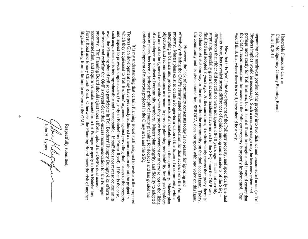
180 Added
MONTGOMERY COUNTY PLANNING DEPARTMENT THE MARYLAND-NATIONAL CAPITAL PARK AND PLANNING COMMISSION
 MONTGOMERY COUNTY PLANNING DEPARTMENT THE MARYLAND-NATIONAL CAPITAL PARK AND PLANNING COMMISSION MCPB Item No. Date: 12-10-15 Leisure World Clubhouse II Addition Fitness Center, Limited Site Plan Amendment
MONTGOMERY COUNTY PLANNING DEPARTMENT THE MARYLAND-NATIONAL CAPITAL PARK AND PLANNING COMMISSION
 MONTGOMERY COUNTY PLANNING DEPARTMENT THE MARYLAND-NATIONAL CAPITAL PARK AND PLANNING COMMISSION MCPB Item No. Date: 06-12-14 King of the Nations Christian Fellowship Church: Limited Site Plan Amendment
Asbury Chapel Subdivision Sketch Plan
 Asbury Chapel Subdivision Sketch Plan PART 1: PROJECT SUMMARY Applicant: NVR Inc. Project Size: +/- 76.13 acres Parcel Numbers: 02101112,02116101,02116112, 02116113 Current Zoning: Transitional Residential
MONTGOMERY COUNTY PLANNING DEPARTMENT THE MARYLAND-NATIONAL CAPITAL PARK AND PLANNING COMMISSION
 MONTGOMERY COUNTY PLANNING DEPARTMENT THE MARYLAND-NATIONAL CAPITAL PARK AND PLANNING COMMISSION The Goddard School in North Bethesda Preliminary Plan Amendment 11996015B and Site Plan Amendment 82006005A
MONTGOMERY COUNTY PLANNING DEPARTMENT THE MARYLAND-NATIONAL CAPITAL PARK AND PLANNING COMMISSION
 MONTGOMERY COUNTY PLANNING DEPARTMENT THE MARYLAND-NATIONAL CAPITAL PARK AND PLANNING COMMISSION MCPB Item No. Date: 05-22-14 Consent Item - Park Potomac: Site Plan Amendment No. 82004015K MCS. Molline
The subject site plan amendment proposes the following revisions to the approved site plan:
 PROPOSED AMENDMENT The subject site plan amendment proposes the following revisions to the approved site plan: 1. The building footprint was modified to accommodate the revised architectural design. 2.
MONTGOMERY COUNTY PLANNING DEPARTMENT THE MARYLAND-NATIONAL CAPITAL PARK AND PLANNING COMMISSION
 MONTGOMERY COUNTY PLANNING DEPARTMENT THE MARYLAND-NATIONAL CAPITAL PARK AND PLANNING COMMISSION Ashton Market: Preliminary Plan No. 120180180 and Site Plan No. 820180160 Jonathan Casey, Senior Planner,
MONTGOMERY COUNTY PLANNING DEPARTMENT
 MONTGOMERY COUNTY PLANNING DEPARTMENT THE MARYLAND-NATIONAL CAPITAL PARK AND PLANNING COMMISSION MCPB Item No.: Date: 5-03-18 Pike and Rose, Phase I: Site Plan Amendment No. 82012002D Rhoda Hersson-Ringskog,
MONTGOMERY COUNTY PLANNING DEPARTMENT THE MARYLAND-NATIONAL CAPITAL PARK AND PLANNING COMMISSION
 MONTGOMERY COUNTY PLANNING DEPARTMENT THE MARYLAND-NATIONAL CAPITAL PARK AND PLANNING COMMISSION MCPB Item No. Date: 3.10.2016 Site Plan 820160040 Nora School Parker Smith, Planning Technician, Area 1,
Westwood Shopping Center Sketch Plan, Plan # February 23, 2017 Item # 9
 Westwood Shopping Center Sketch Plan, Plan # 320170010 February 23, 2017 Item # 9 Westwood II Site 64,111 s.f. Manor Care site: vacant two story building HOC-Westwood Towers, 15 story tower To be considered
MONTGOMERY COUNTY PLANNING DEPARTMENT THE MARYLAND-NATIONAL CAPITAL PARK AND PLANNING COMMISSION
 MONTGOMERY COUNTY PLANNING DEPARTMENT THE MARYLAND-NATIONAL CAPITAL PARK AND PLANNING COMMISSION William H. Farquhar Middle School Modernization MCPB Item No. 10 Date: 09-18-2014 Description Summary Fred
Town of Portola Valley General Plan. Nathhorst Triangle Area Plan
 Town of Portola Valley General Plan Amended December 10, 1997 Table of Contents Introduction... 1 Planning Area... 1 Objectives... 2 Principles... 2 Standards... 4 Description... 4 Community Commercial...
MONTGOMERY COUNTY PLANNING DEPARTMENT
 MONTGOMERY COUNTY PLANNING DEPARTMENT THE MARYLAND-NATIONAL CAPITAL PARK AND PLANNING COMMISSION Ashburton Elementary School Addition, Mandatory Referral, MR2018009 MCPB Item No. Date: 02-15-18 Troy Leftwich,
Gold Line Bus Rapid Transit Transit Oriented Development (BRTOD) Helmo Station Area Plan
 Helmo Station Area Plan") Appendix F Gold Line Bus Rapid Transit Transit Oriented Development (BRTOD) Helmo Station Area Plan Introduction and Purpose of the Plan The Gold Line Bus Rapid Transit facility is an eleven-mile dedicated
Appendix F Gold Line Bus Rapid Transit Transit Oriented Development (BRTOD) Helmo Station Area Plan Introduction and Purpose of the Plan The Gold Line Bus Rapid Transit facility is an eleven-mile dedicated
13. PRELIMINARY PLAT NO MILLS FARM - Vicinity of the southeast corner of 159 th Street and Quivira Road
 13. corner of 159 th Street and Quivira Road 1. APPLICANT: HNTB Corporation is the applicant for this request. 2. REQUESTED ACTION: The applicant is requesting approval of a preliminary plat for a 383-lot
MONTGOMERY COUNTY PLANNING DEPARTMENT THE MARYLAND-NATIONAL CAPITAL PARK AND PLANNING COMMISSION
 MONTGOMERY COUNTY PLANNING DEPARTMENT THE MARYLAND-NATIONAL CAPITAL PARK AND PLANNING COMMISSION Tapestry - Preliminary Plan No. 120050950 and Site Plan 820050370 JAC MCPB Item No. Date: May 30, 2013 completed
MONTGOMERY COUNTY PLANNING DEPARTMENT THE MARYLAND-NATIONAL CAPITAL PARK AND PLANNING COMMISSION
 MONTGOMERY COUNTY PLANNING DEPARTMENT THE MARYLAND-NATIONAL CAPITAL PARK AND PLANNING COMMISSION MCPB Item No. Date: 1/26/12 Hanover Shady Grove, Sketch Plan 320120020 Joshua Sloan, Coordinator, Joshua.Sloan@MontgomeryPlanning.org,
EXHIBIT B PROJECT NARRATIVE POULSBO MEADOWS
 EXHIBIT B PROJECT NARRATIVE POULSBO MEADOWS Name of Project: Poulsbo Meadows; A Planned Residential Development (PRD)/Plat Applicants Name: PBH Group LLC/Byron Harris PO Box 1010 Silverdale, WA 98038 Description
PART 1: PROJECT SUMMARY. The application is Attachment A. The site plan is Attachment B.
 Belleterre Subdivision Sketch Plan Town Board 8.7.17 Belleterre Subdivision Sketch Plan PART 1: PROJECT SUMMARY Applicant: Bowman Development Project Size: +/- 20.85 acres Parcel Number: 01115104 and 01115121
CHAPTER 22 Rural Open Space Community Developments
 CHAPTER 22 Rural Open Space Community Developments Section 22.1 Description and Purpose The intent of this Chapter is to offer property owners an alternative to traditional zoning requirements for rural
SPECIFIC PLAN Requirements
 CITY OF LANCASTER PLANNING DEPARTMENT 44933 Fern Avenue, Lancaster, California 93534 (661) 723-6100 SPECIFIC PLAN Requirements Purpose The purpose of a specific plan is to provide for the logical development
MONTGOMERY COUNTY PLANNING DEPARTMENT THE MARYLAND-NATIONAL CAPITAL PARK AND PLANNING COMMISSION
 MONTGOMERY COUNTY PLANNING DEPARTMENT THE MARYLAND-NATIONAL CAPITAL PARK AND PLANNING COMMISSION MCPB Item No. Date: 1/15/2015 Bethesda North Marriott Hotel and Conference Center: Limited Site Plan Amendment
TABLE OF CONTENTS SITE DESCRIPTION 3 Vicinity 3 Site Analysis 4. PROJECT DESCRIPTION 5 Proposal 5
 TABLE OF CONTENTS SITE DESCRIPTION 3 Vicinity 3 Site Analysis 4 PROJECT DESCRIPTION 5 Proposal 5 PROJECT ANALYSIS 6 Master Plan 6 Transportation & Circulation 6 Environment 7 Development Standards 8 Community
MONTGOMERY COUNTY PLANNING DEPARTMENT
 MONTGOMERY COUNTY PLANNING DEPARTMENT THE MARYLAND-NATIONAL CAPITAL PARK AND PLANNING COMMISSION MCPB Item No. Date: 12/20/2018 Nucci Subdivision, Preliminary Plan No. 120160170 MF Marco Fuster, Planner
MONTGOMERY COUNTY PLANNING DEPARTMENT THE MARYLAND-NATIONAL CAPITAL PARK AND PLANNING COMMISSION
 MONTGOMERY COUNTY PLANNING DEPARTMENT THE MARYLAND-NATIONAL CAPITAL PARK AND PLANNING COMMISSION MCPB Item No.: 11 Date: 06-28-18 Black Hill Infrastructure Site Plan Amendment No. 82013025C Benjamin Berbert,
Seneca Meadows. Block 4 Locate office, technology, and medical development adjacent to I Screen views of garage structures from I-270.
 Seneca Meadows Seneca Meadows has an industrial park in its southern end and a mixed-use employment area planned for the north end. The district benefits from extensive I-270 visibility, stream valley
Mitchell Ranch South MPUD Application for Master Planned Unit Development Approval Project Narrative. Introduction
 Mitchell Ranch South MPUD Application for Master Planned Unit Development Approval Project Narrative Introduction Mitchell Ranch South is a proposed single family (detached) residential development on
MONTGOMERY COUNTY PLANNING DEPARTMENT THE MARYLAND-NATIONAL CAPITAL PARK AND PLANNING COMMISSION
 MONTGOMERY COUNTY PLANNING DEPARTMENT THE MARYLAND-NATIONAL CAPITAL PARK AND PLANNING COMMISSION MCPB Item No.: 9 Date: 07-20-17 Topgolf - Germantown: Preliminary Plan Amendment No. 12007065B and Site
Clarksburg Square Road Extension
 Clarksburg Square Road Extension Preliminary Plan No. 120140060 Site Plan No. 820140050 Site Plan Amendment No. 82007022C (Clarksburg Town Center) Clarksburg SPA Water Quality Plan Mandatory Referral MR2015008
The transportation system in a community is an
 7 TRANSPORTATION The transportation system in a community is an important factor contributing to the quality of life of the residents. Without a sound transportation system to bring both goods and patrons
AWH REPORT OF THE PLANNING AND DEVELOPMENT DEPARTMENT FOR APPLICATION FOR REZONING ORDINANCE TO PLANNED UNIT DEVELOPMENT
 AWH REPORT OF THE PLANNING AND DEVELOPMENT DEPARTMENT FOR APPLICATION FOR REZONING ORDINANCE TO PLANNED UNIT DEVELOPMENT MAY 8, 2014 The Planning and Development Department hereby forwards to the Planning
Access Management: An Overview
 Figures 1-5 Below Evolution of development along a highway. In the early stages, land along the road is used for farming with little traffic generated. As time passes, the highway corridor becomes a de
PRELIMINARY PLAT DESIGN REQUIREMENTS Updated 4/8/2016
 PRELIMINARY PLAT DESIGN REQUIREMENTS Updated 4/8/2016 The following items are required for the preliminary plat. Numbers correspond with those on the example preliminary plat. RENO COUNTY SUBDIVISION REQUIREMENTS
PLANNED UNIT DEVELOPMENT & SUBDIVISION STAFF REPORT Date: May 18, 2017
 & PUD-0000102-2017 PLANNED UNIT DEVELOPMENT & SUBDIVISION STAFF REPORT Date: May 18, 2017 NAME SUBDIVISION NAME Dauphin Creek Estates Subdivision Dauphin Creek Estates Subdivision LOCATION CITY COUNCIL
R E S O L U T I O N. Single-Family Residence/ Church. 2,488 sq. ft. 2,488 sq. ft. Area Parking Required: Church
 R E S O L U T I O N WHEREAS, the Prince George s County Planning Board is charged with the approval of Detailed Site Plans pursuant to Part 3, Division 9 of the Zoning Ordinance of the Prince George s
I. Introduction. Prior Approvals
 Statement of Justification First National Bank 19790 Crystal Rock Drive, Germantown, Maryland Application for Site Plan and Limited Preliminary Plan Amendment I. Introduction DPH Architecture, for First
COMMUNITY DESIGN. GOAL: Create livable and attractive communities. Intent
 COMMUNITY DESIGN Intent An attractive, well-designed County will attract quality development, instill civic pride, improve the visual character of the community, and create a strong, positive image for
Major Subdivision Sketch Plan Checklist
 This checklist provides specific requirements that are apart of the Sketch process. The entire process is described by the Huntersville Subdivision Review Process which details all the submittal and resubmittal
STATEMENT OF JUSTIFICATION CLARKSBURG PREMIUM OUTLETS AT CABIN BRANCH NORTH DISTRICT, PHASE
 STATEMENT OF JUSTIFICATION CLARKSBURG PREMIUM OUTLETS AT CABIN BRANCH NORTH DISTRICT, PHASE 1 Southwest Corner of Clarksburg Road and Interstate-270 Clarksburg, Maryland Application for Site Plan #820140160
12 January 12, 2011 Public Hearing APPLICANT: TAILWIND DEVELOPMENT GROUP,LLC PROPERTY OWNER: CITY OF VIRGINIA BEACH
 12 January 12, 2011 Public Hearing APPLICANT: TAILWIND DEVELOPMENT GROUP,LLC PROPERTY OWNER: CITY OF VIRGINIA BEACH STAFF PLANNER: Faith Christie REQUEST: Conditional Change of Zoning (from PD-H1 Planned
Drexel, Barrell & Co.
 Drexel, Barrell & Co. June 18, 2018 Engineers/Surveyors Boulder Colorado Springs Greeley 3 South 7 th Street Colorado Springs, Colorado 80905-1501 719 260-0887 719 260-8352 Fax El Paso County Planning
MONTGOMERY COUNTY PLANNING DEPARTMENT THE MARYLAND-NATIONAL CAPITAL PARK AND PLANNING COMMISSION
 MONTGOMERY COUNTY PLANNING DEPARTMENT THE MARYLAND-NATIONAL CAPITAL PARK AND PLANNING COMMISSION MCPB Item No.: 2 Date: 12-19-13 Site Plan 820140020, 8001 Newell Street Neil Braunstein, AICP, Area 1, neil.braunstein@montgomeryplanning.org,
MONTGOMERY COUNTY PLANNING DEPARTMENT THE MARYLAND-NATIONAL CAPITAL PARK AND PLANNING COMMISSION
 MONTGOMERY COUNTY PLANNING DEPARTMENT THE MARYLAND-NATIONAL CAPITAL PARK AND PLANNING COMMISSION Montgomery Auto Sales Park: Preliminary Plan No. 11985027A, Site Plan No. 820140130 and Site Plan No. 820140140
MONTGOMERY COUNTY PLANNING DEPARTMENT THE MARYLAND-NATIONAL CAPITAL PARK AND PLANNING COMMISSION
 MONTGOMERY COUNTY PLANNING DEPARTMENT THE MARYLAND-NATIONAL CAPITAL PARK AND PLANNING COMMISSION Clarksburg Square Road Extension: Preliminary Plan No. 120140060, Preliminary/Final Water Quality Plan,
MONTGOMERY COUNTY PLANNING DEPARTMENT THE MARYLAND-NATIONAL CAPITAL PARK AND PLANNING COMMISSION
 MONTGOMERY COUNTY PLANNING DEPARTMENT THE MARYLAND-NATIONAL CAPITAL PARK AND PLANNING COMMISSION MCPB Item No. Date10/25/12 Sketch Plan No. 32012004, White Flint Mall Redevelopment Nkosi Yearwood, Senior
MONTGOMERY COUNTY PLANNING DEPARTMENT THE MARYLAND-NATIONAL CAPITAL PARK AND PLANNING COMMISSION
 MONTGOMERY COUNTY PLANNING DEPARTMENT THE MARYLAND-NATIONAL CAPITAL PARK AND PLANNING COMMISSION MCPB Item No. 6 Date: 5-9-13 Site Plan No. 820130090, West Chevy Chase Heights Erin Grayson, Senior Planner,
PLANNED UNIT DEVELOPMENT PUD For The Proposed Antietam Subdivision Escambia County, Florida. Introduction
 PLANNED UNIT DEVELOPMENT PUD For The Proposed Antietam Subdivision Escambia County, Florida Introduction The project is located in Escambia County approximately 0.75 + miles north of the US Highway 90,
IV. Development in the Rural Overlay District
 Intracoastal Waterway Route 17 Route 168 Great Dismal Swamp VIRGINIA NORTH CAROLINA IV. Development in the Rural Overlay District IV-1 Route 17 in Chesapeake s Rural Overlay District affords distant views
9 th Street Sub Area Plan
 9 th Street Sub Area Plan In the 1990 s, when the Township prepared the last Master Plan, the 9 th Street corridor was studied as part of a larger 9 th Street Focus Area that included the West Main Street
ARTICLE 13 STREETS General
 ARTICLE 13 STREETS 13.1 General Streets shall be designed to suit their functions. Many streets have purposes other than vehicular traffic. As an alternative to current N.C. Department of Transportation
ARTICLE 13 STREETS General
 ARTICLE 13 STREETS 13.1 General Streets shall be designed to suit their functions. Many streets have purposes other than vehicular traffic. As an alternative to current N.C. Department of Transportation
Application Number: SD Project Name: Walton Farms Preliminary Subdivision (acting as Master Plan)
") STAFF REPORT Town of Clayton Planning Department 111 E. Second Street, Clayton, NC 27520 P.O. Box 879, Clayton, NC 27528 Phone: 919-553-5002 Fax: 919-553-1720 Planning Board May 22, 2017 Application Number:
STAFF REPORT Town of Clayton Planning Department 111 E. Second Street, Clayton, NC 27520 P.O. Box 879, Clayton, NC 27528 Phone: 919-553-5002 Fax: 919-553-1720 Planning Board May 22, 2017 Application Number:
MONTGOMERY COUNTY PLANNING DEPARTMENT THE MARYLAND-NATIONAL CAPITAL PARK AND PLANNING COMMISSION MCPB Item No.: 13 Date: 07/19/18
 MONTGOMERY COUNTY PLANNING DEPARTMENT THE MARYLAND-NATIONAL CAPITAL PARK AND PLANNING COMMISSION MCPB Item No.: 13 Date: 07/19/18 Black Hill / ViaSat: Project Plan No. 92012004B, Preliminary Plan No. 12012021B,
MONTGOMERY COUNTY PLANNING DEPARTMENT THE MARYLAND-NATIONAL CAPITAL PARK AND PLANNING COMMISSION
 MONTGOMERY COUNTY PLANNING DEPARTMENT THE MARYLAND-NATIONAL CAPITAL PARK AND PLANNING COMMISSION 8015 Old Georgetown Road, Preliminary Plan 120160220, Site Plan 820160090 MCPB Item No.: 8 Date: 11-03-16
MONTGOMERY COUNTY PLANNING DEPARTMENT THE MARYLAND-NATIONAL CAPITAL PARK AND PLANNING COMMISSION
 MONTGOMERY COUNTY PLANNING DEPARTMENT THE MARYLAND-NATIONAL CAPITAL PARK AND PLANNING COMMISSION MCPB Item No.: 5 Date: 06-29-17 Bradford s Landing, Site Plan No. 820170060 Sandra Pereira, RLA, Acting
The Illinois Department of Transportation and Lake County Division of Transportation. Route 173, including the Millburn Bypass
 The Illinois Department of Transportation and Lake County Division of Transportation welcome you to this Public Hearing for U.S. Route 45 from Illinois Route 132 to Illinois Route 173, including the Millburn
E. RURAL COMMERCIAL/INDUSTRIAL PARK MODEL
 E. RURAL COMMERCIAL/INDUSTRIAL PARK MODEL 1. PURPOSE The purpose of the Rural Commerce/Industrial Park Model is to provide parameters within which a grouping of business buildings with parking, loading
CONSENT CALENDAR CITY PLANNING COMMISSION AGENDA ITEM NO: A.1, A.2 STAFF: LARRY LARSEN
 Page 8 CONSENT CALENDAR CITY PLANNING COMMISSION AGENDA ITEM NO: A.1, A.2 STAFF: LARRY LARSEN FILE NO: CPC PUZ 14-00013 - QUASI-JUDICIAL FILE NO: CPC PUD 14-00014 QUASI-JUDICIAL PROJECT: APPLICANT: OWNER:
Secrest Short Cut and Monroe Expressway Small Area Plan AUGUST 29, 2018
 Secrest Short Cut and Monroe Expressway Small Area Plan AUGUST 29, 2018 Background and Process Monroe Expressway will be open by the end of 2018 Union County and Indian Trail identified a need to revisit
MONTGOMERY COUNTY PLANNING DEPARTMENT THE MARYLAND-NATIONAL CAPITAL PARK AND PLANNING COMMISSION
 MONTGOMERY COUNTY PLANNING DEPARTMENT THE MARYLAND-NATIONAL CAPITAL PARK AND PLANNING COMMISSION Gables White Flint, Preliminary Plan No. 120150010 and Site Plan No. 820150010 MCPB Item No. Date: 4/30/2015
PART 1: PROJECT SUMMARY. Proposed Land Use: 120 single-family lots. The application is Attachment A. The site plan is Attachment B.
 PART 1: PROJECT SUMMARY Applicant: JBH Development, LLC and Hopper Communities, INC Project Size: +/- 80.48 acres Parcel Number: 01513107, 01513108, 01513109, 01513113, 01513120, 01513121, 01513122, 01513124,
MONTGOMERY COUNTY PLANNING DEPARTMENT THE MARYLAND-NATIONAL CAPITAL PARK AND PLANNING COMMISSION
 MONTGOMERY COUNTY PLANNING DEPARTMENT THE MARYLAND-NATIONAL CAPITAL PARK AND PLANNING COMMISSION MCPB Item No. Date: 7/26/12 Camden Shady Grove (Danac Stiles), Sketch Plan 320120050 Joshua Sloan, Planner
Drexel, Barrell & Co.
 Drexel, Barrell & Co. December 21, 2018 Engineers/Surveyors Boulder Colorado Springs Greeley 3 South 7 th Street Colorado Springs, Colorado 80905-1501 719 260-0887 719 260-8352 Fax El Paso County Planning
Town Center. Block 5 Existing multifamily residential units are expected to remain.
 Area Guidelines Germantown s districts should be developed as distinct communities with unique features that are supported through the guidelines. The guidelines not only help distinguish these districts
MONTGOMERY COUNTY PLANNING DEPARTMENT THE MARYLAND-NATIONAL CAPITAL PARK AND PLANNING COMMISSION
 MONTGOMERY COUNTY PLANNING DEPARTMENT THE MARYLAND-NATIONAL CAPITAL PARK AND PLANNING COMMISSION MCPB Item No. Date: 05/12/2016 North Bethesda Conference Center Parking Structure, Mandatory Referral No.
MONTGOMERY COUNTY PLANNING DEPARTMENT THE MARYLAND-NATIONAL CAPITAL PARK AND PLANNING COMMISSION
 MONTGOMERY COUNTY PLANNING DEPARTMENT THE MARYLAND-NATIONAL CAPITAL PARK AND PLANNING COMMISSION MCPB Item No. Date: 9-4-13 Limited Site Plan Amendment No. 81994026B, Darcars at Montgomery Industrial Park,
Description of Preferred Alternative
 Chapter 2 Description of Preferred Alternative 2.1 Introduction This chapter of the programmatic Sammamish Town Center Sub-area Plan Final EIS provides a more detailed description of the Preferred Alternative
Exhibit A. 8:9 Scuffletown Rural Conservation District
 Exhibit A 8:9 Scuffletown Rural Conservation District 8:9.1 Intent and Purpose The Scuffletown Rural Conservation (SRC) District is intended to provide for residential development that supports the development
PLANNING COMMISSION. Submitted
 PLANNING COMMISSION City Hall 1275 Main Street El Centro, CA 92243 Submitted PLANNING COMMISSION ACTION ITEM (1844) Meeting: 05/10/16 12:00 AM Department: Community Development Category: Public Hearing
SPECIFIC DESIGN PLAN
 The Maryland-National Capital Park and Planning Commission Prince George's County Planning Department Development Review Division 301-952-3530 Note: Staff reports can be accessed at www.mncppc.org/pgco/planning/plan.htm.
MONTGOMERY COUNTY PLANNING DEPARTMENT
 MONTGOMERY COUNTY PLANNING DEPARTMENT THE MARYLAND-NATIONAL CAPITAL PARK AND PLANNING COMMISSION MCPB Item No. 4 Date: 12-15-16 CVS Derwood: Site Plan No. 820160150 Calvin Nelson, Jr., Planner Coordinator,
Century Highfield Sub Area Plan
 Century Highfield Sub Area Plan The Century Highfield Sub Area Plan provides an opportunity to re evaluate the vision that was set forth for this area when the Township conducted a similar planning exercise
MONTGOMERY COUNTY PLANNING DEPARTMENT
 MONTGOMERY COUNTY PLANNING DEPARTMENT THE MARYLAND-NATIONAL CAPITAL PARK AND PLANNING COMMISSION MCPB Item No.: 11 Date: 7-20-17 Burtonsville McDonalds: Site Plan No. 820150020 Jonathan Casey, Senior Planner,
Planning Districts INTRODUCTION
 INTRODUCTION To facilitate detailed examination of development prospects for all areas of the community, Delano has been divided into 14 planning districts. The location of these planning districts is
Sanford/Lee County Technical Review Committee (TRC) DEADLINES & MEETING DATES
 DEADLINES & MEETING DATES") Sanford/Lee County Technical Review Committee (TRC) DEADLINES & MEETING DATES The following 2019 information is based on the information available to staff at the time of creation. Dates & time may change
Sanford/Lee County Technical Review Committee (TRC) DEADLINES & MEETING DATES The following 2019 information is based on the information available to staff at the time of creation. Dates & time may change
SHEFFIELD PARK Paulding County, GA DRI #588
 SHEFFIELD PARK Paulding County, GA DRI #588 Supplemental Information for RDC s DRI (Form 2) Review August 16, 2004 Prepared for: Mr. David Howerin Coosa Valley RDC 1 Jackson Hill Drive Rome, GA 30161 P.O.
ROAD CLOSURE AND LAND USE AMENDMENT SILVER SPRINGS (WARD 1) NORTHEAST OF NOSEHILL DRIVE NW AND SILVER SPRINGS ROAD NW BYLAWS 2C2018 AND 29D2018
 NORTHEAST OF NOSEHILL DRIVE NW AND SILVER SPRINGS ROAD NW BYLAWS 2C2018 AND 29D2018") Page 1 of 19 EXECUTIVE SUMMARY This application proposes redesignating two parcels in the community of Silver Springs from Special Purpose Future Urban Development (S-FUD) District and undesignated road
Page 1 of 19 EXECUTIVE SUMMARY This application proposes redesignating two parcels in the community of Silver Springs from Special Purpose Future Urban Development (S-FUD) District and undesignated road
TCPII/193/ Project Name: BELMONT CREST SUBDIVISION. Date Accepted: 03/08/04. Planning Board Action Limit: Waived. Plan Acreage: 62.
 The Maryland-National Capital Park and Planning Commission Prince George's County Planning Department Development Review Division 301-952-3530 Note: Staff reports can be accessed at www.mncppc.org/pgco/planning/plan.htm.
November 21, Planning Commission Charter Township of Lyon Grand River Ave. New Hudson, MI 48165
 Planning Commission Charter Township of Lyon 58000 Grand River Ave. New Hudson, MI 48165 Subject: AP-18-68; 11 Mile and Milford Road Park, Site Plan Review #1 Based on site plan dated 11/12/18 Location:
BROOKHILL NEIGHBORHOOD MODEL ZONING MAP AMENDMENT PREFACE TO APPLICATION
 BROOKHILL NEIGHBORHOOD MODEL ZONING MAP AMENDMENT PREFACE TO APPLICATION June 15, 2015 Revised: August 1, 2016 I. VISION Brookhill is a proposed community based upon the principles of Albemarle County
Applicant Name Phone / Fax / Address City State Zip Code . Property Owner Phone / Fax / Address City State Zip Code
 Master Development Plan Application Community Development Department City of Redmond 411 SW 9 th Street Redmond, Oregon 97756 541-923-7721 541-548-0706 FAX Master Development Plan Fee $38,862.52 File Number
Project Name: MELWOOD HOTEL. Date Accepted: 1/12/04. Waived. Planning Board Action Limit: Plan Acreage: 1.7 Zone: Dwelling Units:
 The Maryland-National Capital Park and Planning Commission Prince George's County Planning Department Development Review Division 301-952-3530 Note: Staff reports can be accessed at www.mncppc.org/pgco/planning/plan.htm.
Glenborough at Easton Land Use Master Plan
 Implementation 114 9.0 IMPLEMENTATION 9.1 OVERVIEW This chapter summarizes the administrative procedures necessary to implement the proposed land use plan, infrastructure improvements, development standards,
Ten Mile Creek Planning Area
 PLANNING AREA POLICIES TEN MILE CREEK Ten Mile Creek Planning Area Location and Context The Ten Mile Creek Planning Area ( Ten Mile Creek area ) is located south of the current Boise AOCI, generally south
ROLL CALL Member Anthony, Member Avdoulos, Member Greco, Member Lynch, Member Maday, Chair Pehrson
 CALL TO ORDER The meeting was called to order at 7:00 PM. PLANNING COMMISSION ACTION SUMMARY CITY OF NOVI Regular Meeting July 11, 2018 7:00 PM Council Chambers Novi Civic Center 45175 W. Ten Mile (248)
Land Use Amendment in Southwood (Ward 11) at and Elbow Drive SW, LOC
 at and Elbow Drive SW, LOC") 2018 November 15 Page 1 of 10 EXECUTIVE SUMMARY This land use amendment application was submitted by Rick Balbi Architect on 2017 August 31 on behalf of Sable Developments Ltd, and with authorization from
2018 November 15 Page 1 of 10 EXECUTIVE SUMMARY This land use amendment application was submitted by Rick Balbi Architect on 2017 August 31 on behalf of Sable Developments Ltd, and with authorization from
Chapter 13: Implementation Plan
 Implementation A. Introduction The Implementation Plan, in table form on the following pages, provides a summary of all the Action Items recommended in Chapters 2 through 12. The table also indicates which
MONTGOMERY COUNTY PLANNING DEPARTMENT THE MARYLAND-NATIONAL CAPITAL PARK AND PLANNING COMMISSION
 MONTGOMERY COUNTY PLANNING DEPARTMENT THE MARYLAND-NATIONAL CAPITAL PARK AND PLANNING COMMISSION Preliminary Plan 120120220 & Site Plan 820120140, 7001 Arlington Road MCPB Item No. 8 Date: 11-1-12 Erin
2. Analysis. DRAFT Gerald Richards & Pleasantview Park Master Plan
 DRAFT Gerald Richards & Pleasantview Park Master Plan 19 Historic Features According to the National Register of Historic Places and the National Historic Landmarks Program, there is nothing of national
1. Request: The subject application is for approval of a gymnasium addition to an existing private school and church.
 R E S O L U T I O N WHEREAS, the Prince George's County Planning Board is charged with the approval of Detailed Site Plans pursuant to Part 3, Division 9 of the Zoning Ordinance of the Prince George's
Procedures IV. V. Rural Road Design Option
 i IV. Procedures A. All applicants required to prepare a Conservation Design Subdivision shall provide the Planning Board with a conceptual conventional subdivision design as well as a proposed layout
City of Grande Prairie Development Services Department
 City of Grande Prairie Development Services Department ROYAL OAKS NORTH OUTLINE PLAN OP-07-03 NW 35-71-6 W6M May 7, 2007 Royal Oaks North Outline Plan TABLE OF CONTENTS 1.0 INTRODUCTION........ 3 1.1 Purpose
CONCEPTUAL DEVELOPMENT PLAN REVIEW - CITY OF MARYLAND HEIGHTS
 APPLICATION NUMBER: CDP15-0004 APPLICATION (PROJECT) NAME: MARYLAND OAKS APPLICANT: PROPERTY OWNER NAME: APPLICANT S REQUEST: McBride Maryland Oaks, LLC 16091 Swingley Ridge Road, Suite 300 Chesterfield,
MONTGOMERY COUNTY PLANNING DEPARTMENT Newell Street. Site Plan Item #2. Maryland-National Capital Park and Planning Commission
 8001 Newell Street Site Plan 820140020 Item #2 December 19, 2013 Redlined Conditions 1. The Applicant must comply with the conditions of approval for Project Plan 920130020 in MCPB Resolution No. 13-74.
Rezoning Petition Pre-Hearing Staff Analysis March 19, 2018
 Rezoning Petition 2017-171 Pre-Hearing Staff Analysis March 19, 2018 REQUEST Current Zoning: R-3 (single family residential) Proposed Zoning: MX-2 (INNOV) (mixed used, innovative) with five-year vested
COUNTY COUNCIL OF PRINCE GEORGE'S COUNTY, MARYLAND, SITTING AS THE DISTRICT COUNCIL ORDER AFFIRMING PLANNING BOARD DECISION, WITH AMENDED CONDITIONS
 Case No. Applicant: Dawn Limited Partnership COUNTY COUNCIL OF PRINCE GEORGE'S COUNTY, MARYLAND, SITTING AS THE DISTRICT COUNCIL ORDER AFFIRMING PLANNING BOARD DECISION, WITH AMENDED CONDITIONS IT IS HEREBY
COUNTY COUNCIL OF PRINCE GEORGE'S COUNTY, MARYLAND, SITTING AS THE DISTRICT COUNCIL ORDER AFFIRMING PLANNING BOARD DECISION (CORRECTED)
") Case No. Applicant: Lanham LLLP COUNTY COUNCIL OF PRINCE GEORGE'S COUNTY, MARYLAND, SITTING AS THE DISTRICT COUNCIL ORDER AFFIRMING PLANNING BOARD DECISION (CORRECTED) IT IS HEREBY ORDERED, after review
Case No. Applicant: Lanham LLLP COUNTY COUNCIL OF PRINCE GEORGE'S COUNTY, MARYLAND, SITTING AS THE DISTRICT COUNCIL ORDER AFFIRMING PLANNING BOARD DECISION (CORRECTED) IT IS HEREBY ORDERED, after review
Rezoning Transportation Analysis Petition Number: General Location Identifier:
 From: Kelsie Anderson, PE Kelsie.Anderson@charlottenc.gov 704-432-5492 Staff Reviewer: Kory Hedrick, PE, PMP Khedrick@charlottenc.gov 704-432-6511 CDOT s review of this rezoning petition is intended to
Chapter IV: Development Pattern
 Chapter IV: Development Pattern Introduction The 2002 Prince George s County Approved General Plan designates three growth policy tiers Developed, Developing, and Rural as well as three center designations
APPENDIX A 6 CONCEPTUAL PRELIMINARY PLAN GUIDE AND CHECKLIST FOR MAJOR SUBDIVISIONS CARRBORO DEVELOPMENT GUIDE APPENDIX A
 6 CONCEPTUAL PRELIMINARY PLAN GUIDE AND CHECKLIST FOR MAJOR SUBDIVISIONS Conceptual Preliminary Guide/Checklist for Major Subdivisions Page 1 FORM: REVIEW DATE: CONCEPTUAL PLAN REVIEW 2000 REVIEWED BY: