BALLARD TO DOWNTOWN SEATTLE
|
|
|
- Marshall Horton
- 6 years ago
- Views:
Transcription


1 TRANSIT EXPANSION STUDY BALLARD TO DOWNTOWN SEATTLE 05/30/2014 FINAL FINAL REPORT
2 This page intentionally left blank
3 Table of Contents Executive Summary Introduction Previous Studies and Findings Planning Documents Previous Studies Market Analysis Daily Transit Trips Existing Zoning Population and Employment Vehicle Ownership Peak Period Traffic Congestion Existing Transit Travel Times Conclusions Project Goals and Objectives Evaluation Criteria and Methodologies Definition and Review of Initial Concepts Initial Options Definition Initial Screening Definition and Evaluation of Level 1 Corridors Level 1 Corridors Definition Level 1 Analysis and Evaluation Definition and Evaluation of Level 2 Corridors Level 2 Corridors Definition Level 2 Analysis and Evaluation Public Engagement Public Meeting # Purpose Participation Results and Comment Themes...65 Final Report i
4 9.2 Public Meeting # Purpose Participation Results and Comment Themes Public Meeting # Purpose Participation Results and Comment Themes...68 Bibliography ii Final Report
5 List of Tables Table 3-1. Daily Transit Trips... 8 Table 3-2. Growth in Daily Transit Trips: 2011 to Table 3-3. Transit Share of Commute Trips... 9 Table 3-4. Population and Employment Table 4-1. Project Goals and Objectives Table 6-1. Initial Concept Development Screening Criteria and Measures Table 6-2. Alignment Link Options Not Advanced Table 7-1. Corridors for Level 1 Evaluation Table 7-2. Level 1 Evaluation Criteria and Measures Table 7-3. Level 1 Evaluation Results Table 8-1. Corridors for Level 2 Evaluation Table 8-2. Level 2 Evaluation Criteria Table 8-3. Level 2 Evaluation Results Table 8-4. Summary Level 2 Evaluation Results Table 9-1. Public Input Results: Favorite Corridor List of Figures Figure 2-1. Sound Transit 2005 Long-Range Plan Map... 3 Figure 2-2. Transit Master Plan High Priority Corridors... 5 Figure 2-3. Transit Master Plan Corridor Figure 3-1. Daily Transit Trips Figure 3-2. City of Seattle Generalized Zoning Figure 3-3. Population and Employment Figure 3-4. Vehicle Ownership by Household Figure 3-5. PM Peak Period Congestion Figure 3-6. Existing Transit Travel Times Figure 6-1. Initial Options Figure 6-2. Alignment Link Options Not Advanced Figure 7-1. Corridor Figure 7-2. Corridor Figure 7-3. Corridor Final Report iii
6 Figure 7-4. Corridor Figure 7-5. Corridor Figure 7-6. Corridor Figure 7-7. Corridor Figure 7-8. Corridor Figure 8-1. Corridor A Figure 8-2. Corridor B Figure 8-3. Corridor C Figure 8-4. Corridor D Figure 8-5. Corridor E iv Final Report
7 Acronyms and Abbreviations ACS BAT BMP BRT CBD CTR EIS ETC FTA HCT ICT LRT MSF O&M OCS PSRC ROW SDOT SR ST American Community Survey Business and Transit Bicycle Master Plan Bus Rapid Transit Central Business District Commute Trip Reduction Environmental Impact Statement Elevated Transportation Company Federal Transit Administration High Capacity Transit Intermediate Capacity Transit Light Rail Transit Maintenance and Storage Facility Operations and Maintenance Overhead Catenary System Puget Sound Regional Council Right-of-Way Seattle Department of Transportation State Route Sound Transit ST2 Sound Transit 2008 TMP VMT WSDOT Transit Master Plan Vehicle Miles Traveled Washington State Department of Transportation Final Report v
8 This page intentionally left blank
9 EXECUTIVE SUMMARY Sound Transit and the City of Seattle partnered on a conceptual-level study exploring opportunities for improving transit connections between Ballard and Downtown Seattle. By partnering and increasing efficiencies, Sound Transit and the City of Seattle saved planning dollars during this project development phase. The purpose of the Ballard to Downtown Seattle Transit Expansion Study was to: 1. Support implementation of the City of Seattle Transit Master Plan. 2. Support future Sound Transit Board discussions on long-range high capacity transit (HCT) options and update to the Sound Transit Long- Range Plan. The results of this study will inform future decisions regarding mode, alignment and implementation responsibilities to be included in an updated Sound Transit Long-Range Plan. It will also help establish priorities for the next phase of possible investments in a higher capacity mode of transit by the City of Seattle. This is a conceptual-level study only. The cost estimates included here are conceptual and are intended for the purpose of comparison. A full environmental process would be required if and when any study corridors were to move forward. Public input solicited throughout the course of the study helped the project team evaluate corridors between Ballard and Downtown Seattle, serving neighborhoods such as Fremont, Queen Anne, Interbay and Belltown. Three open houses and interactive online tools drew the interest of over 2,500 stakeholders. The following sections describe the study process, including how initial concepts were developed, screened, and refined for Level 1 and Level 2 evaluation, as well as the key study findings. Final Report S-1
10 STUDY PROCESS The following steps were completed in the development and evaluation of rail alternatives: Initial Screening Evaluation Review transit alignment link options for consistency with goals and objectives Advance options that meet goals and objectives, are consistent with rail design criteria, and align with public input Level 1 Evaluation Refine transit link options to a set of corridors based on Initial Screening results Perform evaluation based on mostly qualitative criteria and measures Level 2 Evaluation Initial Screening Evaluation Level 1 Evaluation Refine transit corridors based on Level 1 evaluation results and public input Perform more detailed evaluation based on more quantitative criteria and measures Initial Screening Level 2 Evaluation In March 2013, over 400 people (nearly 150 at an open house and nearly 270 online) provided input on study goals and objectives, commute origins and destinations, and ideas for potential routes. The project team utilized input gathered through the open houses and interactive online tools to evaluate public feedback and develop a set of initial alternative alignment links to represent the range of potential corridors along which new rail service could connect Downtown Seattle with Ballard and potentially other neighborhoods in the study area. The Initial Screening evaluation reviewed the transit alternatives for consistency with the study s goals and objectives. This evaluation considered the full range of transit alternatives identified through the stakeholder and public input process and narrowed down the set of alternatives to a set of corridors to be considered in the Level 1 evaluation. A detailed summary of public input can be found in the Public Meeting and Engagement Summary Open House #1 Technical Memo (Sound Transit, April 2013). Level 1 Evaluation Following the initial review of alternative concepts, eight preliminary corridors were identified for Level 1 evaluation. These eight corridors provided a range of representative routes that included various combinations of rail transit running in at-grade, elevated, and tunnel profiles. S-2 Final Report
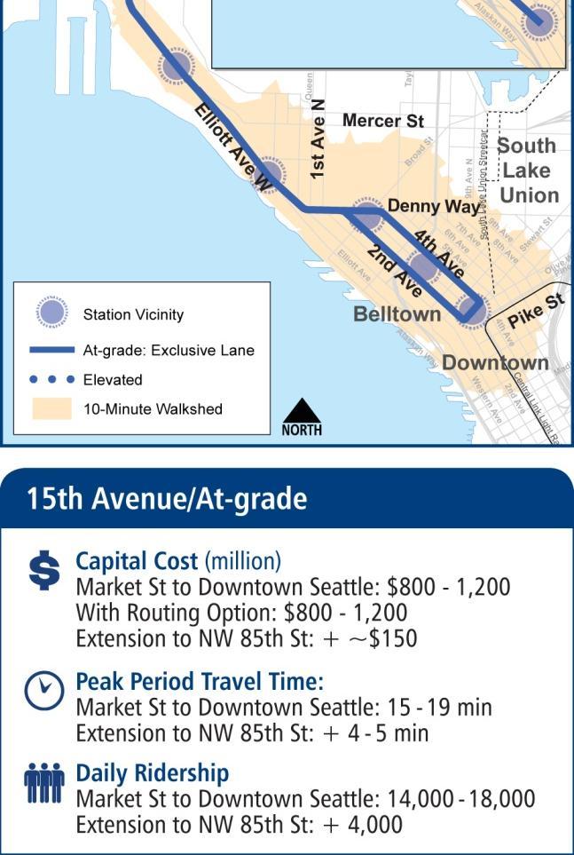
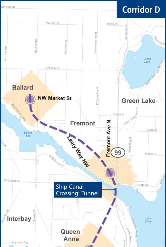
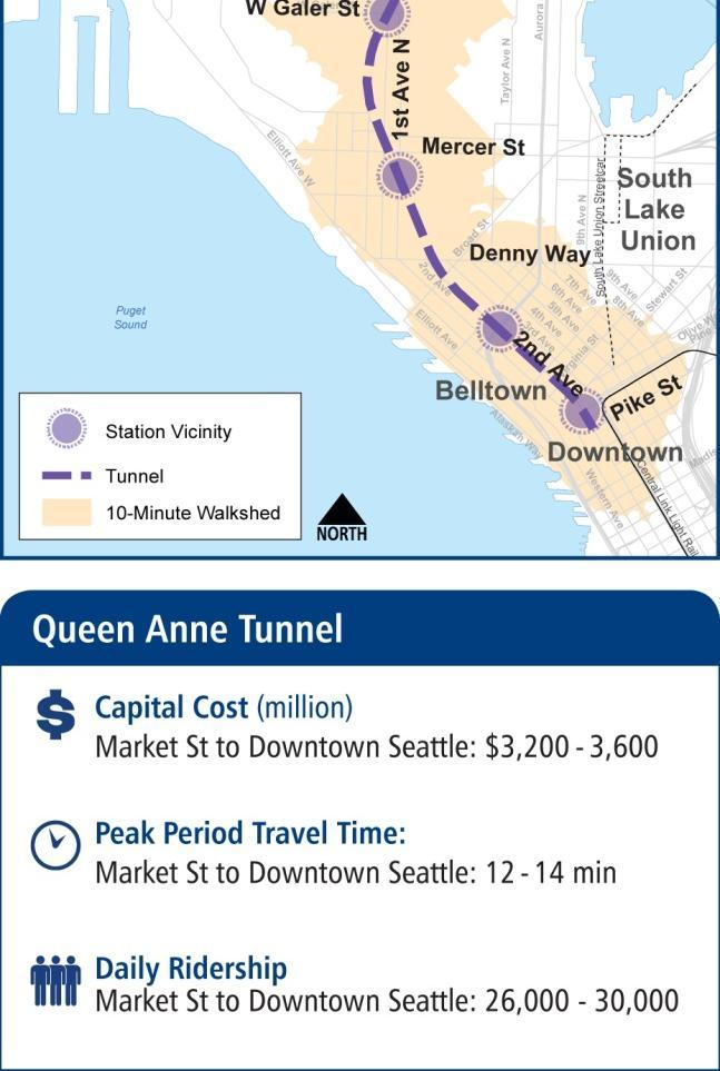
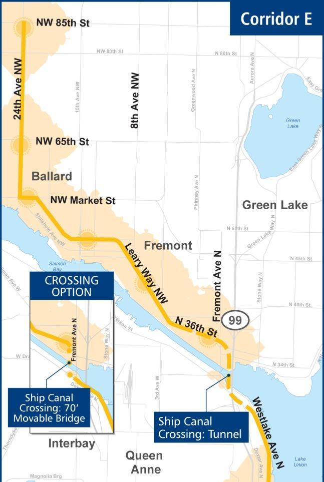
11 Level 1 evaluation was based on an analysis of potential benefits and effects including travel time, cost, and land use integration. In June 2013, more than 1,350 people (over 165 at a public meeting and over 1,200 online) provided feedback on their preferred corridor, Ship Canal crossing, Downtown Seattle connection, and other study elements. More detail can be found in the Public Meeting and Engagement Summary Open House #2 Technical Memo (Sound Transit, September 2013). Level 2 Evaluation The project team refined the potential rail corridor options with consideration of Level 1 evaluation results and public input received from the June open house and web-based tool. Based on Level 1 evaluation results and public input, five corridors were advanced and refined for Level 2 evaluation. The five corridors are described below and illustrated on the following page. Corridor A Interbay West: connects Ballard to Downtown Seattle via Interbay with a completely grade-separated route. Corridor A presents two Ship Canal crossing options: a tunnel and a 70 movable bridge. Corridor B 15th Avenue/Elevated: provides the most direct connection between Ballard and Downtown Seattle via Interbay using a combination of profiles. A tunnel through Downtown, Belltown, and Uptown/Lower Queen Anne would shift to an elevated profile through Interbay along 15th Avenue until touching down to grade in Ballard. It would then continue at-grade in an exclusive lane along 15th Avenue NW to NW 85th. Corridor B would include a proposed 70 movable bridge across Salmon Bay. Corridor C 15th Avenue/At-Grade: would follow a similar alignment to Corridor B, including a 70 movable bridge crossing option for the Ship Canal, except with a fully atgrade profile in an exclusive lane. This corridor has two routing options through Downtown Seattle and Belltown: running along 1st Avenue, and a couplet running along 2nd and 4th Avenues. Corridor D Queen Anne Tunnel: is completely grade-separated with a tunnel from Ballard to Downtown Seattle that serves both Upper Queen Anne and Fremont, and includes a tunnel crossing under the Ship Canal. Corridor E Westlake: runs at-grade in an exclusive lane through South Lake Union along Westlake Avenue. This corridor has two Ship Canal crossing options: tunnel through Fremont, and a 70 movable bridge returning to an at-grade profile in Fremont. The Level 2 evaluation was the final analysis step in the Ballard to Downtown Seattle Transit Expansion study. The key findings, provided in the following section, were presented to the public at a third open house on December 5th, More detail can be found in the Public Meeting and Engagement Summary Open House #3 Technical Memo (Sound Transit, 2014). Final Report S-3
12 S-4 Final Report
13 KEY FINDINGS A summary of the Level 2 evaluation is provided below and summarized in the figures on the following pages. More detailed information is available in the Level 2 Corridors Analysis and Evaluation Technical Memo (Sound Transit, January 2014). Ridership: Corridors A and D were rated highest performing based on the ridership forecasts developed for the study. Both corridors would be fully exclusive and serve many key transit markets, including Upper Queen Anne. Corridor B was the next highest performing option, with significantly higher ridership than Corridor C due to a faster travel time, a better downtown connection, and a more centrally located Uptown station. Corridors C and E were the lowest performing corridors with lower ridership projections due to slower travel times and service to fewer transit markets. Reliability: Corridors A and D were the most reliable corridors because of their fully gradeseparated profiles (elevated and/or tunnel). No at-grade signalized intersections would be traversed and a tunnel crossing ship canal would not experience any delays as a result of boat traffic. The Corridor A option with a bridge over the ship canal received a slightly lower performance rating due to some delays to transit operations caused by bridge openings. Corridor B was the next highest performing corridor with only 11 signalized intersections traversed along 15 th Ave NW and a bridge crossing the ship canal. The Corridor E tunnel option scored slightly lower in reliability performance due to a high number of intersections traversed. The Corridor E bridge option and Corridor C were the lowest rated due to the greatest number of signalized intersections traversed combined with a bridge crossing the ship canal. Travel Time Improvement: Corridors A, B, and D performed the highest for travel time improvement with similar travel times between Ballard and Downtown Seattle. In general, faster travel times were related to greater grade separation, fewer stations, and shorter total distances. Corridors C and E received slightly lower ratings due to slower travel times resulting from minimal grade separation and more stops. Disruption to Other Modes: Corridors A and D received the highest performance rating for being least disruptive to other modes. Full grade-separation for both corridors would cause little to no effect on traffic operations and multimodal mobility. Corridors B and E received lower performance ratings for having moderate effects on traffic operations, parking, and freight mobility. The fully at-grade profile of Corridor C, particularly through Belltown and Uptown, resulted in this corridor being the most disruptive to other modes. Station Area Development Potential: Corridors A and D received the highest performance ratings due to the high development propensity in the potential station areas, particularly with the inclusion of Upper Queen Anne. Corridor E received a medium-high rating, followed by Corridors B and C with medium ratings. Final Report S-5
14 Cost: The primarily grade-separated corridors and corridors with long tunnel segments had the highest conceptual cost estimates. The Corridor E bridge option received the highest performance rating with the lowest capital cost estimate, followed by Corridor C and the Corridor E tunnel option with a medium-high rating. The Corridor A bridge option and Corridor B received medium-low ratings, while the Corridor A tunnel option and Corridor D received the lowest ratings with the highest capital cost estimates. Cost Effectiveness: Corridor E was the most cost effective due to the lowest cost per rider, followed by Corridor C. Corridors A, B, and D received low performance ratings for having higher costs per rider. Complexity (Risk/Construction Challenges): The primarily grade-separated corridors featuring long tunnels would be the most complex. Corridors that are mostly at-grade would be the least complex. Corridor C and the Corridor E bridge option received the highest rating, followed by the Corridor A bridge option, Corridor B, and the Corridor E tunnel option. The Corridor A tunnel option received a medium-low rating, while Corridor D received the lowest rating due to the fully-below grade profile and deep tunnel station. Environmental Effects: Corridor D received the highest performance rating primarily due to the lack of visual effects (being fully below grade) and highest potential reduction in VMT. Corridor C received the lowest rating due to visual effects of a new bridge combined with vulnerability to sea level rise in the Interbay area and the lowest potential reduction in VMT. Construction of any potential future rail extensions would be subject to Sound Transit and City policy decisions and identification of funding sources. Voter approval is required for potential Sound Transit investments. Public Engagement: The majority of comments received through the final public open house and online engagement indicated a preference for Corridor D (76%), followed by 9% for Corridor B, 7% for Corridor A, 5% for Corridor E, and 2% for Corridor C. S-6 Final Report

15 Final Report S-7 March 2014
16 This page intentionally left blank


17 S-8 Final Report
18 This page intentionally left blank

19 1 INTRODUCTION The Ballard to Downtown Seattle Transit Expansion Study was a collaboration between Sound Transit and the City of Seattle to explore opportunities for improving transit connections between Ballard and Downtown Seattle. The study results will inform future decisions regarding mode, alignment and implementation responsibilities to be included in an updated Sound Transit Long- Range Plan. It will also help establish priorities for the next phase of possible investments in a higher capacity mode of transit by the City of Seattle. This is a conceptual-level study only. The cost estimates included here are conceptual and are intended for the purpose of comparison. A full environmental process would be required if and when any study corridors were to move forward. Ballard, Fremont, and other adjacent neighborhoods have experienced significant population and employment growth in the past several years. This trend is forecasted to continue, along with increasing traffic congestion and reduced reliability of bus transit service between these neighborhoods and Downtown Seattle, which is the primary employment destination for residents of the area. The limited number of crossings of the Ship Canal (Ballard, Fremont, and Aurora bridges) present chokepoints for north-south movement of both general purpose traffic and transit service through this study area. As a result, both regional and local transit planning efforts have identified the need for improved transit service between Ballard and Downtown Seattle. The Ballard-to-Downtown Seattle corridor is identified as a potential rail corridor in the Sound Transit Long-Range Plan. This study is one of nine HCT corridor studies that were called for in the ST2 package approved by voters in The results of these studies will be used by Sound Transit staff and board members to inform the update of Sound Transit s Long-Range Plan, as well as development of a potential future system expansion program. In April 2012, the Seattle City Council adopted the Transit Master Plan (TMP), which focuses on using transit to connect communities in the City of Seattle. The TMP indentified a series of HCT Final Report 1
20 corridors that would connect dense Seattle neighborhoods with limited stop, high quality service running at-grade in exclusive transit lanes. The Ballard to Downtown Seattle corridor was recommended for further study in coordination with Sound Transit, with rapid streetcar identified as the preferred mode. 2 PREVIOUS STUDIES AND FINDINGS The purpose of this compilation was to document the studies conducted and the pertinent findings that might affect this study. The following planning documents and previous studies were selected as the most relevant to the Ballard to Downtown Study: Sound Transit Long Range Plan Sound Transit 2 Seattle Transit Master Plan Trans-Lake Washington Project Seattle Transit Study for Intermediate Capacity Transit Seattle Popular Transit Plan (Seattle Monorail Project)/FEIS Below is an overview of each relevant planning document and previous study. Additional information can be found in the Previous Studies and Findings Technical Memorandum (Sound Transit, April 2013), as well as in the respective reports for each. 2.1 Planning Documents Sound Transit Long Range Plan The Regional Transit Long-Range Plan (Sound Transit 2005) first was developed in 1996 as part of the original Sound Move package of projects. The Long-Range Plan was updated in 2005 prior to development of the Sound Transit 2 plan that was approved by voters in The plan provides a vision of the unconstrained build-out of the regional High-Capacity Transit system. The map (Figure 2-1) identifies a corridor between Ballard and Downtown Seattle as a potential rail extension. This plan is currently being updated. 2 Final Report


21 Figure 2-1. Sound Transit 2005 Long-Range Plan Map Source: Regional Transit Long-Range Plan, 2005 Final Report 3
22 Sound Transit 2 In November 2008, voters in the Puget Sound region approved a package of projects (called ST2 [Sound Transit 2008]) to extend the regional transit system. Along with extensions of light rail north to Lynnwood, east to Overlake, and south of Sea-Tac Airport, as well as other system improvements, the ST2 plan includes funding for a series of system planning studies. These studies include a study of high-capacity transit from the University District to Ballard to Downtown Seattle. This study focused on the portion of that corridor between Ballard and Downtown. A separate HCT study will focus on the portion between Ballard and the University District. Seattle Transit Master Plan The Seattle City Council approved and adopted the Transit Master Plan (TMP) (SDOT 2012) in April The TMP, which is an update to the 2005 Seattle Transit Plan, examined existing and potential future high ridership corridors and travel markets in the city, as well as integration with walking and bicycling infrastructure and enhancement of bus transit performance through roadway investments. Based on these analyses, the plan identifies a prioritized set of corridors for capital investment (Figure 2-2). Of these priority corridors, a seven-mile long Loyal Heights- Ballard-Fremont-South Lake Union-Downtown corridor was identified as a high-capacity transit corridor. Multiple modes were considered for the corridor, including rail, Bus Rapid Transit (BRT), and enhanced bus. Based on the vehicle capacity needs to meet projected ridership, rail (rapid streetcar) was selected as the recommended mode for the corridor. 4 Final Report


23 Figure 2-2. Transit Master Plan High Priority Corridors Source: Transit Master Plan: Final Summary Report and Appendices, 2012 Final Report 5
 and Sound Transit engaged in the Trans-Lake Washington Project")
24 Figure 2-3. Transit Master Plan Corridor 11 Source: Transit Master Plan: Final Summary Report and Appendices, Previous Studies Trans-Lake Washington Project From 1999 to 2002, the Washington State Department of Transportation (WSDOT) and Sound Transit engaged in the Trans-Lake Washington Project (Trans-Lake Washington Project Team 2001) to explore options for improving mobility and access across Lake Washington. A wide range of options was considered in the study, including replacement of existing bridges, new bridges at various locations, and transit alternatives. Alternatives considered included fixedguide way alignments that would cross the lake along the SR 520 corridor to the University District and then Ballard before turning south to Downtown Seattle. 6 Final Report
25 Seattle Transit Study for Intermediate Capacity Transit Released in 2001, the Seattle Transit Study for Intermediate Capacity Transit (ICT) (City of Seattle 2001) examined the feasibility of developing new ICT corridors in the city, including BRT, streetcars and trams, and elevated transit. ICT service would connect neighborhoods to each other, to major destinations, and to transit transfer stations. The service would include fewer stops than regular bus service to improve travel speeds. Based on technical studies, stakeholder meetings, and input from the public, the report recommended moving ahead with ICT from West Seattle through Downtown Seattle to Ballard and Northgate. The corridor extends from 145 th Street NE, along Lake City Way, west to Northgate and Crown Hill, south to Ballard, Interbay, Lower Queen Anne, and to Downtown Seattle. In the study, primary and secondary route were developed for various transit technologies in the corridor (BRT, streetcar system, and elevated transit). Seattle Popular Transit Plan (Seattle Monorail Project) / FEIS Initiative 41 was passed by Seattle voters in November Initiative 41 created the Elevated Transportation Company (ETC) to study the possibility of building a 40-mile monorail system in Seattle. Initiative 53, passed in 2000, provided funding to ETC to create a plan for building a monorail system. Based in part on the findings of the Intermediate Capacity Transit Study, the ETC, selected a 14-mile corridor that would extend from Ballard through Downtown Seattle to West Seattle. This corridor was studied in an Environmental Impact Statement (EIS) (ETC 2002), and examined various alignment options, including a West Alternative, an East Alternative, and other options/linkages. In 2005, another vote (Proposition 1) resulted in a decision to end the monorail project. The Seattle Monorail Authority was dissolved in MARKET ANALYSIS A market analysis was conducted to identify potential transit markets, service levels, ridership, operating issues, and performance in the Ballard to Downtown Seattle Transit Expansion Study corridor. Key findings from this analysis were presented at a public open house on March 12, The analysis was used in the development of potential alternatives for the study. Data collected as part of this analysis include the following: Current and projected demographics Traffic data Modeled daily transit trips to and from Ballard and Fremont Existing land use Vehicle ownership Peak period traffic congestion Final Report 7
26 The market analysis results are discussed below. More information can be found in the Market Analysis Results Technical Memorandum (Sound Transit, May 2013). 3.1 Daily Transit Trips Figure 3-1 shows the distribution of daily transit trips traveling to and from Ballard and Fremont. The information displayed in the figure is based on output from the Sound Transit Ridership Forecasting Model, and shows that for both Ballard and Fremont, the largest transit market is Downtown Seattle. As shown in the figure and in Table 3-1, other major transit markets include Belltown, First Hill, the Central Area/Madrona, the University District, the University of Washington, and trips between Ballard and Fremont. Markets with less than 2% of the trips were not shown. Table 3-1. Daily Transit Trips Neighborhood Trips to/from Ballard Trips to/from Fremont Downtown Seattle 16% 18% UW Campus 9% 9% University District 8% 6% First Hill 7% 7% Central Area / Madrona 6% 4% Belltown 5% 6% South Lake Union 4% 5% Northgate 4% 4% Queen Anne 4% 2% Fremont 5% - Ballard - 5% Many of the same neighborhoods highlighted in Table 3-1 are also expected to see significant growth in transit trips in the future. Table 3-2 shows the forecasted growth in daily transit trips between Ballard and Fremont and selected neighborhoods from 2011 to Table 3-2. Growth in Daily Transit Trips: 2011 to 2035 Neighborhood Trips to/from Ballard Trips to/from Fremont Total Growth Percentage Growth Total Growth Percentage Growth Downtown Seattle % % UW Campus % % University District % % First Hill % % Central Area / Madrona 54 14% 107 6% Belltown % % South Lake Union % % Northgate % % 8 Final Report
27 Queen Anne 86 28% 61 32% Fremont % - - Ballard % Commute Trips In addition to modeled transit trips, data from the Commute Trip Reduction (CTR) survey (surveys conducted between 2007 and 2011) were reviewed. Table 3-3 shows the percent of commute trips taken by transit for selected locations from Ballard and Fremont. The CTR survey is conducted every two years by employers with more than 100 employees (commute trips to the University of Washington are not included in this data set). The transit share for commute trips from Ballard and Fremont to Downtown Seattle is strong, with 60% or more of trips being made by transit. In addition, almost half of all Ballard and Fremont-based commute trips to Belltown are made by transit, as are a third of trips to SODO and more than a quarter of the trips to South Lake Union. Table 3-3. Transit Share of Commute Trips Neighborhood Trips from Ballard Trips from Fremont Downtown Seattle 60% 63% Belltown 47% 49% First Hill 39% 42% University District 34% 31% SODO 31% 31% South Lake Union 27% 32% Interbay 26% 25% Final Report 9


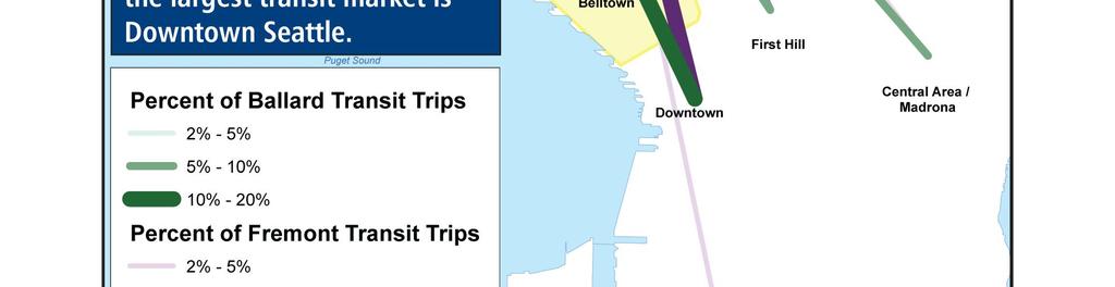
28 Figure 3-1. Daily Transit Trips 10 Final Report
29 3.2 Existing Zoning Figure 3-2 shows existing zoning the project study area from City of Seattle data. The figure highlights the locations of major concentrations of multi-family, neighborhood/commercial, and manufacturing/industrial zoning in the study area. The centers of Ballard and Fremont show a concentration of multi-family and neighborhood/commercial zoning which are highly supportive of transit. Final Report 11


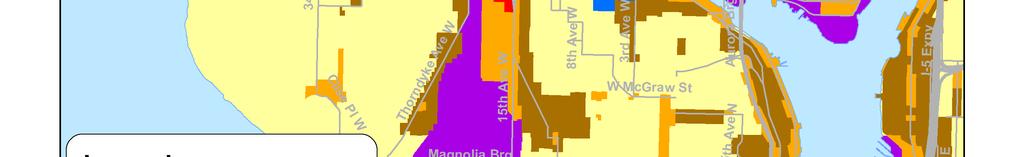

30 Figure 3-2. City of Seattle Generalized Zoning 12 Final Report
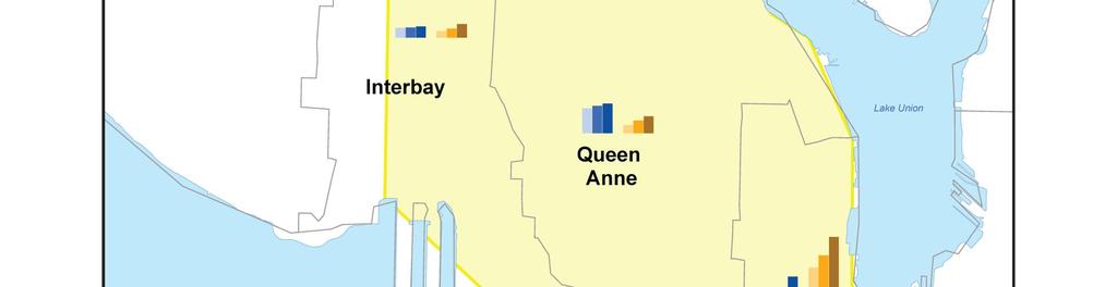
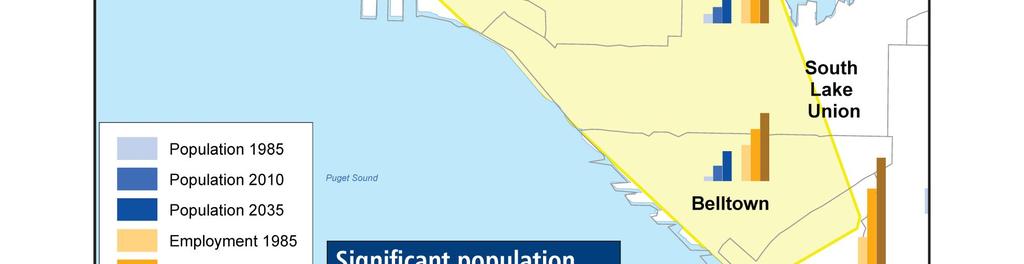
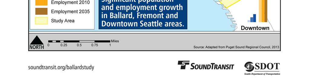
31 3.3 Population and Employment Figure 3-3 shows the historic ( ) and forecasted (2035) growth in population and employment in the study area. Historic population and employment data were obtained from the Puget Sound Regional Council (PSRC) and adjusted to match the boundaries shown on the map. Current and forecasted population and employment data were also obtained from PSRC. As shown in the figure and in Table 3-4, significant population and employment growth occurred in the study area between 1985 and 2010 and is forecasted to occur by Downtown, South Lake Union, and Belltown continue to have more employment than population, while Ballard, Fremont, and other areas remain more residential in character (although Ballard and Fremont have experienced an increase in higher density, multi-family development). Table 3-4 also shows the total forecasted population and employment for 2035 and orders the neighborhoods in the table from largest to smallest based upon this. While Downtown, South Lake Union, and Belltown are at the top of the list, the combined forecasted population and employment of both Ballard and Fremont are greater than several other Seattle neighborhoods. Final Report 13
32 This page intentionally left blank
33 Table 3-4. Population and Employment Population Employment Total Population and Employment Neighborhood Downtown 6,415 16,090 26,570 65% 100, , ,100 21% 207,670 South Lake Union 9,340 16,430 33, % 41,531 52,930 70,050 32% 103,210 Belltown 4,584 15,410 29,880 94% 36,090 52,250 68,380 31% 98,260 Fremont 25,298 28,230 31,810 13% 11,521 13,650 24,070 76% 55,880 Ballard 27,329 29,580 33,820 14% 11,014 12,010 16,630 38% 50,450 Queen Anne 23,202 25,320 27,350 8% 7,455 11,730 15,620 33% 42,970 Green Lake 16,208 17,240 20,460 19% 2,859 4,330 6,270 45% 26,730 Interbay 9,102 9,390 10,350 10% 5,938 8,390 12,690 51% 23,040 Magnolia 12,239 12,040 12,380 3% 1,126 2,440 3,830 57% 16, Final Report
34 This page intentionally left blank

35 Figure 3-3. Population and Employment Draft Final Report 15
36 3.4 Vehicle Ownership Figure 3-4 illustrates levels of vehicle ownership in the study area. Vehicle ownership information was collected from the American Community Survey (ACS) year dataset, which is the most recent and comprehensive dataset available. As shown in the figure, the percentage of households without vehicles in Ballard and Fremont (10-20%) is higher than in the surrounding areas, where 0 to 10% of households have no vehicles. The highest percentages of households without vehicles are in the southern portion of the study area, including Lower Queen Anne, South Lake Union and Belltown. 16 Final Report
37 Figure 3-4. Vehicle Ownership by Household Final Report 17
38 3.5 Peak Period Traffic Congestion Figure 3-5 shows PM peak period traffic volumes and volume-to-capacity (v/c) ratios for selected arterials in the study area. Volumes were provided by the City of Seattle, while roadway capacities were derived from the City of Seattle travel demand forecasting model. Arterials labeled in green are those with an estimated v/c ratio of 0.70 or less, which indicates moderate congestion or better. Arterials labeled in yellow indicate moderate to high levels of congestion, while arterials labeled in red often experience significant levels of congestion during the PM peak period. The most congested arterials where data was available include Elliott Avenue, 15 th Avenue south of Market Street, and Nickerson Street, while arterials with moderate to high levels of congestion include Westlake Avenue, Dexter Avenue, Denny Way, and 15 th Avenue north of Market Street. 18 Final Report


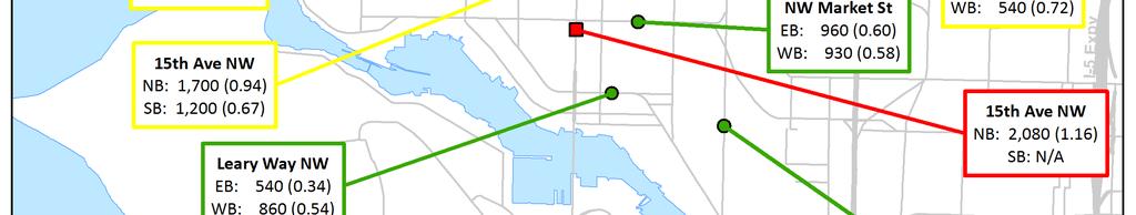
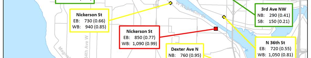
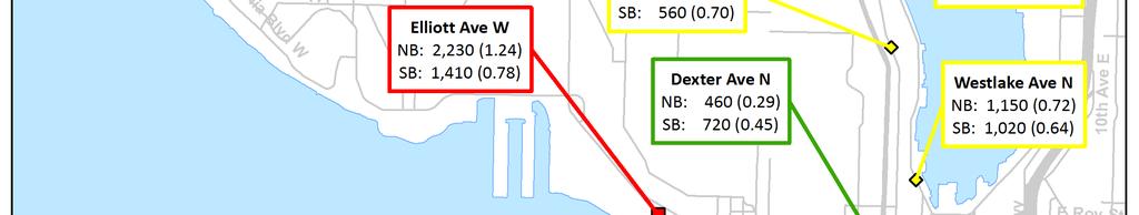

39 Figure 3-5. PM Peak Period Congestion Final Report 19
40 3.6 Existing Transit Travel Times Figure 3-6 shows existing transit travel times for selected King County Metro bus routes that serve the study corridor between Ballard and Downtown Seattle. These include the 15, 17, and 18 Express routes, the RapidRide D line, and route 40. Travel times shown in the figure are for travel between NW 85 th Street and Pike/Pine Streets in Downtown Seattle. Overall, travel times for the routes shown range from 29 to 43 minutes southbound during the AM peak hour and from 34 to 46 minutes northbound during the PM peak hour. Variability, expressed by the difference in travel time for the peak hour compared to mid-day operations, shows that the RapidRide D line travel time increases by as much as 5 minutes in the peak hour compared to mid day, while the travel time for route 40 increases by as much as 9 minutes in the peak hour versus mid day operations. 20 Final Report


41 Figure 3-6. Existing Transit Travel Times *Express routes only operate in the peak direction of travel during the peak hours. Source: King County Metro s Automatic Vehicle Location system, January-February Final Report 21
42 3.7 Conclusions Based on the review of existing and forecasted transit market conditions, there is a significant level of existing and future forecasted demand for transit between the neighborhoods of Ballard and Fremont and Downtown Seattle. Output from the Sound Transit Ridership Forecast Model shows that for both Ballard and Fremont the largest transit market, of all the neighborhoods studied, is Downtown Seattle. Currently 16% and 18% of daily transit trips are comprised of trips between Ballard and Downtown Seattle and Fremont and Downtown Seattle respectively. The forecasted growth in daily transit trips between the years of 2011 and 2035 for Ballard and Fremont shows that Downtown Seattle will continue to be the largest transit market for both of these neighborhoods. About 54% and 64% growth is expected for transit trips between Ballard and Downtown Seattle and Fremont and Downtown Seattle respectively. Data from the CTR survey, conducted between 2007 and 2011, show the transit share for commute trips from Ballard and Fremont to Downtown Seattle is strong, with 60% or more trips being made by transit. It should be noted, however, that the transit market between Ballard and Fremont is not as strong as the market between each neighborhood and Downtown Seattle. Ballard and Fremont residents and employers are supportive of transit in terms of existing zoning, forecasted population and employment growth, and vehicle ownership. Areas in the immediate vicinity of downtown Ballard and Fremont show a concentration of commercial/mixed-use and multi-family zoning, which is highly supportive of transit. Future forecasted growth in population and employment for both Ballard and Fremont is expected, with 14% growth in population and 38% growth in employment in Ballard from 2010 to During that same time period, 13% growth in population and 76% growth in employment is expected in Fremont. Additionally, the higher percentage of households without vehicles in Ballard and Fremont (10-20%) compared to the surrounding areas (0-10%) make these neighborhoods more supportive of transit and indicates potential for increased transit ridership with the introduction of higher capacity service. One of the challenges to the development of new higher capacity transit connecting Ballard with Downtown Seattle is the existence of moderate to high levels of traffic congestion along key arterials in the study corridor, particularly Denny Way, Westlake Avenue, Elliott Avenue, 15 th Avenue, and Nickerson Street. Congestion on arterial streets in the study area is also reflected in the variability in existing transit travel times, with RapidRide D line travel times varying by as much as 5 minutes between mid-day and the peak hour, and travel times for the route 40, varying by as much as 9 minutes. 22 Final Report
43 4 PROJECT GOALS AND OBJECTIVES The goals and objectives of the study are outlined in Table 4-1. Table 4-1. Project Goals and Objectives Goal 1. Improve connection to the regional transit system Objectives Connect communities in the corridor to the regional transit network and other regional centers Provide user-friendly connections between regional and local transit services 2. Increase transit ridership by providing services that are reliable, frequent, and efficient 3. Improve mobility options for residents and businesses between Ballard and Downtown Seattle 4. Preserve and enhance the environment 5. Provide equitable access for residents and businesses Preserve mobility of people and goods in the corridor Improve connections between neighborhoods by providing higher capacity transit service Seek to improve multimodal access Avoid potential effects on existing natural and cultural resources in the corridor Improve local air quality by providing alternative to travel by single occupant vehicle Improve transit access to jobs, education, and other regional resources for a broad cross-section of socioeconomic groups, ethnicities, and household types 6. Support sustainable urban growth Support economic and transit-oriented development in the corridor 7. Make efficient use of public financial resources Support development of compact and sustainable communities Final Report 23
44 5 EVALUATION CRITERIA AND METHODOLOGIES The study s evaluation methodology included the development and evaluation of transit alternatives using three steps: Initial Screening Evaluation Review transit alignment link options for consistency with goals and objectives Advance options that meet goals and objectives, are consistent with rail design criteria, and align with public input Level 1 Evaluation Refine transit link options to a set of corridors based on Initial Screening results Perform evaluation based on mostly qualitative criteria and measures Level 2 Evaluation Refine transit corridors based on Level 1 evaluation results and public input Perform more detailed evaluation based on more quantitative criteria and measures Initial Screening Evaluation Level 1 Evaluation Level 2 Evaluation 6 DEFINITION AND REVIEW OF INITIAL CONCEPTS This section describes the process by which an initial set of transit options for connecting Ballard with Downtown Seattle was developed and then screened. The results of this initial screening were used in the identification and refinement of corridors for Level 1 evaluation, which is described in section Initial Options Definition The initial set of transit options was developed by the project team through multiple avenues: Input from public meeting held on March 12, 2013 Input through web-based interactive mapping tool Meeting with the United States Coast Guard Brainstorming by consultant team Review of previous studies 24 Final Report
45 The results of the public input obtained through the March 12, 2013 public meeting and the public input collected from the web-based tool were mapped and reviewed by the project team, along with comments submitted by the public. Based on this input, a set of initial options was developed to represent the range of potential corridors along which new transit rail service could be established to connect Downtown Seattle with Ballard and potentially other neighborhoods in the study area. This initial set of options was then reviewed by the project team to identify additional issues and opportunities that should also be considered to further develop the range of options. Figure 6-1 shows the initial set of alignment options that were identified based on the process described above. The corridor is divided into four main segments for the purpose of identifying and screening alignment segments, shown in the different colors in the figure: 1. Downtown to Uptown CBD core to Mercer Street 2. Uptown to Ship Canal Mercer Street to Ship Canal 3. Ship Canal Crossing utilizing existing or new bridges or tunnel 4. Ship Canal to Ballard Ship Canal to Market Street or NW 85 th Street Final Report 25


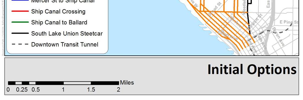
46 Figure 6-1. Initial Options 26 Final Report
47 6.2 Initial Screening After the review with ST and SDOT staff, the initial set of options was screened using the methodology outlined in Table 6-1. As indicated in the table, most evaluation conducted at this level was qualitative in nature, drawing from knowledge of the study area, public input, previous studies, and GIS information provided by the City of Seattle. For more details on the overall evaluation process, see the Evaluation Criteria and Methodologies Technical Memorandum (Sound Transit, October 2013). The Initial Screening evaluation reviewed the transit options for consistency with the study s goals and objectives. This evaluation considered the full range of transit alternatives identified through the stakeholder and public input process and advanced a set of corridor options to be considered in the Level 1 evaluation. Table 6-1 describes the Initial Screening criteria and measures that correlate to each of the goals and objectives. The consultant team met on April 29, 2013 to identify options that should not be advanced due to issues related to inconsistencies with the project goals and objectives and/or inconsistencies with rail design criteria, or which were significantly contrary to public input. In Figure 6-2, the links labeled with red numbers are those that were identified to not be advanced through this process. Table 6-2 provides a description and explanation for each link that not advanced, along with the applicable screening criteria. Final Report 27
48 Table 6-1. Initial Concept Development Screening Criteria and Measures Goals and Objectives Screening Criteria Measure Improve connection to the regional transit system Connect communities in the corridor to the regional transit network and other regional centers Provide user-friendly connections between regional and local transit services Increase transit ridership by providing services that are reliable, frequent, and efficient Connections to the regional system Connections to local transit services Directness of route Amenable to exclusivity Proximity to Link station(s) in Downtown Serve King County Metro key transfer points? NW Market St & Ballard Ave Fremont Ave & N 34 th St 1 st Ave N & Mercer St Qualitative Qualitative Improve mobility options for residents and businesses between Ballard and Downtown Seattle Preserve mobility of people and goods in the corridor Improve connections between neighborhoods by providing higher capacity transit service Seek to improve multimodal access Preserve and enhance the environment Avoid effects on existing natural and cultural resources in the corridor Improve local air quality by providing alternative to travel by single occupant vehicle Provide equitable access for residents and businesses Improve transit access to jobs, education, and other regional resources for a broad cross-section of socio-economic groups, ethnicities, and household types Support sustainable urban growth Support economic and transit-oriented development in the corridor Support development of compact and sustainable communities Make efficient use of public financial resources Effects on mobility of people and goods Service to urban centers and urban villages, defined by Seattle s Comprehensive Plan Multimodal access opportunities Negative environmental effects Service to transit-dependent populations Opportunity for economic and transit-oriented development Major cost and constructability issues Qualitative Number served Qualitative Qualitative Qualitative Qualitative Qualitative 28 Final Report


49 Figure 6-2. Alignment Link Options Not Advanced Final Report 29
50 Table 6-2. Alignment Link Options Not Advanced Number Link Reason for Not Advancing Applicable Screening Criteria 1 20 th Ave NW Dead-ends at Salmon Bay Park; does not serve commercial areas as well as 24 th and 15 th Ave options 2 14 th Ave NW Dead-ends at Ballard High School; park space currently under development within street ROW 3 NW Market St Potential traffic effects on major eastwest arterial; steep grades would be at upper limits for rail transit; would increase travel time between Fremont and Ballard compared with alternative routes Directness of route; Service to urban centers and urban villages Directness of route; Negative environmental effects Effects on mobility of people and goods; Major cost and constructability issues; Directness of route 4 Ballard Ave NW Historic district along Ballard Ave NW Negative environmental effects 5 17 th Ave NW Narrow ROW; requires multiple turns at north and south ends 6 Shilshole Ave NW Potential effects on freight mobility in industrial area; does not serve neighborhood as well as alternative routes 7 N 46 th St Connects to Aurora Ave N and NW Market St, neither advanced (see 3 and 9) 8 Fremont Ave N Steep grades would be at upper limits for rail transit; would increase travel time between Fremont and Ballard compared with alternative routes 9 Aurora Ave N Potential traffic effects on state highway with significant traffic volumes 10 Aurora Bridge Potential traffic effects on state highway with significant traffic volumes; would not serve Fremont neighborhood well; would increase travel time to Ballard; bridge structure would likely need to be replaced or widened and strengthened significantly for LRT vehicles 1 11 W Nickerson St Accessing Ballard Bridge from the east would be difficult due to alignment of adjacent roadways 12 Tunnel under NW Queen Anne hill 13 Tunnel under W Queen Anne hill Unnecessarily long tunnel to reach Interbay (shorter alternative routes available); travels under cemetery Unnecessarily long tunnel to reach Interbay (shorter alternative routes available) 14 Aurora Ave N Potential traffic effects on state highway with significant traffic volumes Effects on mobility of people and goods; Directness of route Effects on mobility of people and goods; Service to urban centers and urban villages Effects on mobility of people and goods; Major cost and constructability issues; Directness of route Major cost and constructability issues; Directness of route Effects on mobility of people and goods Effects on mobility of people and goods; Service to urban centers and urban villages; Directness of route; Major cost and constructability issues Major cost and constructability issues Directness of route; Negative environmental effects Directness of route Effects on mobility of people and goods 15 W Mercer St Potential traffic effects on major east- Effects on mobility of people and 1 Analysis of the Rhododendron Line Concept: At-Grade Light Rail Transit (LRT) on State Route 99, Regional Transit Project, September Final Report
51 Number Link Reason for Not Advancing Applicable Screening Criteria west arterial; narrow ROW on west end goods 16 W Harrison St Narrow ROW; multiple turns required Effects on mobility of people and goods; Directness of route 17 Elliott Ave W Potential traffic effects on major waterfront access arterial; on waterfront away from CBD core 18 Western Ave W Potential traffic effects on major waterfront access arterial; on waterfront away from CBD core Effects on mobility of people and goods; Service to urban centers and urban villages Effects on mobility of people and goods; Service to urban centers and urban villages 19 1 st Ave Likely route of Center City Connector Effects on mobility of people and goods 20 7 th Ave Planned cycle-track on 7 th Ave Effects on mobility of people and goods 21 5 th Ave Monorail is historic landmark Negative environmental effects Final Report 31
52 7 DEFINITION AND EVALUATION OF LEVEL 1 CORRIDORS This section describes the refinement and evaluation of Level 1 corridors. The results of the Level 1 evaluation were used in the further refinement of corridors for Level 2 evaluation, which is described in section Level 1 Corridors Definition Following the initial review of options, a set of eight corridors was identified to be carried forward into Level 1 evaluation. These eight corridors provide a range of representative alignments that include various combinations of rail transit running in at-grade, elevated, and tunnel profiles. Initial options that were advanced from the initial screening step but that were not included in the Level 1 corridors are considered design variations that could be considered in future phases of study. Also, some components of the Level 1 corridors could be intermixed to create different combinations. Approximate station vicinities were selected to serve key travel markets while maintaining station spacing appropriate for high capacity transit service. The conceptual definition of these corridors was provided in the Conceptual Definition of Level 1 Corridors Technical Memorandum (Sound Transit, July 2013). Summary information about the eight corridors is provided in Table 7-1, with more detailed information and illustrative figures for each corridor following the table. 32 Final Report
53 Table 7-1. Corridors for Level 1 Evaluation Corridor Downtown -Mercer St Mercer St-Ship Canal Ship Canal Crossing Ship Canal- Ballard Corridor Length (mi) Neighborhoods Served Potential Stations in the vicinity of: Average Station Spacing (mi) 1 Interbay West/ New Bridge At-grade Elevated New bridge (140 ) Elevated 5.5 Downtown Uptown Interbay Ballard 2 nd /3 Stewart 2 nd /3 Bell 2 nd /3 Broad Prospect 20 th Dravus 20 th NW Interbay West/ Ship Canal Tunnel Tunnel Elevated Tunnel Tunnel 5.4 Downtown Uptown Interbay Ballard 2 Pine 2 Battery 2 nd Republican 15 th Garfield 20 th Dravus 17 th NW th Avenue/ Elevated Tunnel Elevated New bridge (140 ) Elevated 5.1 Downtown Uptown Interbay Ballard 2 Pine 2 Battery 1 st John Prospect 15 th Dravus 15 th Market th Avenue/ At-grade At-grade At-grade New bridge (70 ) At-grade 6.4 (4.9 to Market) Downtown Uptown Interbay 2 nd /4 Stewart 2 nd /4 Bell 2 nd /4 Broad Prospect 1.1 Final Report 33
54 Corridor Downtown -Mercer St Mercer St-Ship Canal Ship Canal Crossing Ship Canal- Ballard Corridor Length (mi) Neighborhoods Served Potential Stations in the vicinity of: Average Station Spacing (mi) Ballard Crown Hill 15 th Dravus 15 th Market 15 th NW 85th 5 Queen Anne Tunnel Tunnel Tunnel New bridge (70 ) At-grade 5.4 Downtown Uptown Queen Anne Fremont Ballard 2 Pine 2 Battery 2 nd Republican QA Blaine N 36 Phinney 17 th NW Westlake/ Ship Canal Tunnel At-grade At-grade; Preserve existing travel lanes Tunnel Tunnel/Atgrade 6.5 (5.0 to Market) Downtown Westlake Fremont Ballard Crown Hill Stewart Denny Mercer Galer Fremont Evanston 17 th NW Ballard Av 24 th NW 65 th 24 th NW 85 th Dexter At-grade At-grade Fremont Bridge At-grade 6.3 (4.8 to Market) Downtown SLU Westlake Stewart 6 Bell Harrison Galer Wheeler Final Report
55 Corridor Downtown -Mercer St Mercer St-Ship Canal Ship Canal Crossing Ship Canal- Ballard Corridor Length (mi) Neighborhoods Served Potential Stations in the vicinity of: Average Station Spacing (mi) Fremont Leary Ballard Crown Hill N 36 Dayton 8 th NW 15 th NW 15 th NW@ NW 65 th 15 th NW 85 th 8 Westlake/ New Bridge At-grade At-grade; Displace existing travel lanes New bridge (70 ) At-grade 6.6 (5.1 to Market) Downtown Westlake Fremont Leary Ballard Crown Hill Stewart Thomas Galer 4th N Dravus 3 rd NW 15 th NW Ballard Av 24th NW 65 th 24th NW 85 th 0.7 Final Report 35
56 This page intentionally left blank

57 Figure 7-1. Corridor 1 At-grade surface couplet on 2nd and 3rd Avenues between Stewart Street and Denny Way At-grade on Denny Way, Western Avenue and Elliott Avenue West between the Seattle Center and W Mercer Place Elevated on Elliott from Mercer Place to the NW then around the east end of the Magnolia Bridge onto a new bridge over 15 th Ave West and BNSF tracks Elevated on edge of Port of Seattle property and on 20 th Avenue West and Gilman Avenue West to 24 th Ave W New fixed span bridge over Salmon Bay to Ballard (140 clearance over water surface) Elevated on NW Market Street from 24 th Ave NW to 17 th Ave NW Light rail is the potential mode for this corridor 36 Final Report


58 Figure 7-2. Corridor 2 Tunnel under 2nd Avenue, Seattle Center, and Southwest Queen Anne from Pine Street to Interbay New Bridge over 15th Ave West and BNSF tracks Elevated on edge of Port of Seattle property and 20th Ave West to West Dravus St At-grade on 20th Ave West from West Dravus St to tunnel portal Tunnel from 20th Avenue West, under Salmon Bay, and into Ballard, terminating under NW Market Street Light rail is the potential mode for this corridor Final Report 37

 Elevated on")
59 Figure 7-3. Corridor 3 Tunnel under 2nd Avenue and Lower Queen Anne to Elliott Avenue West Elevated along Elliott Avenue West Elevated around east end of Magnolia Bridge to 15th Ave West Elevated on west side of 15th Ave West between the Magnolia Bridge and the Ballard Bridge New bridge adjacent to the Ballard Bridge (140 clearance over water surface) Elevated on NW Market Street from 15th Ave NW to 11th Ave NW Light rail is the potential mode for this corridor 38 Final Report


60 Figure 7-4. Corridor 4 At-grade surface couplet on 2nd and 4th Avenues between Stewart Street and Denny Way At-grade in the center of Denny Way, Western Avenue and Elliott Avenue West between the Seattle Center and the Magnolia Bridge At-grade in the center of 15th Ave West from Magnolia Bridge to W Bertona Street. New bridge adjacent to the Ballard Bridge (70 clearance over water surface) At-grade on 15th between NW Market St and NW 85th Street Light rail or rapid streetcar could be accommodated in this corridor Final Report 39


61 Figure 7-5. Corridor 5 Tunnel under 2nd Avenue, Seattle Center, and Queen Anne from Pine Street to 3rd Ave N near Fulton Street New bridge over the Ship Canal (70 clearance over water surface) At-grade on N 36th Street and NW Leary Way from Evanston Ave N to 17th Ave NW. At-grade on 17th Ave NW from NW Leary Way to NW Market Street At-grade on NW Market Street from 17th Ave NW to 15th Ave NW Light rail is the potential mode for this corridor 40 Final Report


62 Figure 7-6. Corridor 6 At-grade on 5th Avenue from Pike Street to Olive Way At-grade on Westlake from Olive Way to McGraw Street New tunnel under Lake Union and Fremont from McGraw Street to Leary Way west of 15th Ave NW At-grade on Leary Way NW from west of 15th Ave NW to Market Street. At-grade on Market Street from Leary Way to 24th Ave NW At-grade on 24th Ave NW from Market Street to NW 85 th St Rapid streetcar is the potential mode for this corridor Final Report 41


63 Figure 7-7. Corridor 7 At-grade on 5th Ave from Pike Street to Olive Way At-grade on Westlake from Olive Way to 6th Ave At-grade on 6th Ave from Westlake to Battery Street At-grade on Battery Street from 6th Ave to Denny Way At-grade on Dexter Ave from Denny Way to the Fremont Bridge Cross the Ship Canal on the existing Fremont Bridge At-grade on N 36th Street and NW Leary Way from the Fremont Bridge to 14th Ave NW. At-grade on 14th Ave NW from NW Leary Way to NW Market Street At-grade on NW Market Street from 14th Ave NW to 15th Ave NW At-grade on 15th Ave NW between NW Market St and NW 85th Street Rapid streetcar is the potential mode for this corridor 42 Final Report


64 Figure 7-8. Corridor 8 At-grade on 5th Avenue from Pike Street to Olive Way At-grade on Westlake from Olive Way to Nickerson Street At-grade on Nickerson Street from Westlake to 3rd Ave N New bridge on 3rd Ave N/Evanston Ave N over Ship Canal (70 clearance over water surface) At-grade on N 36th Street and NW Leary Way from Evanston Ave N to NW Market Street At-grade on NW Market Street from NW Leary Way to 24th Ave NW At-grade on 24th Ave NW from NW Market Street to NW 85th St Rapid streetcar is the potential mode for this corridor Final Report 43
65 7.2 Level 1 Analysis and Evaluation The Level 1 evaluation refined the transit corridors based on the Initial Screening results and performed an evaluation based on mostly qualitative criteria and measures. The Level 1 evaluation was based on an analysis of potential benefits and effects including travel time, cost, and land use integration. The analysis for the Level 1 evaluation was not as detailed or as quantitative as the analysis for the Level 2 evaluation. Table 7-2 describes the Level 1 evaluation criteria and measures that correlate to each of the goals and objectives. Table 7-3 summarizes the Level 1 evaluation results. More information can be found in the Level 1 Analysis and Evaluation Technical Memorandum (Sound Transit, July 2013). 44 Final Report
66 This page intentionally left blank
67 Table 7-2. Level 1 Evaluation Criteria and Measures Goals and Objectives Evaluation Criteria Measure Methodology Increase transit ridership by providing services that are reliable, frequent, and efficient Transit travel markets Service to key transit travel markets For each corridor, identify the potential markets served from the following list of markets in the study area: Ballard, Fremont, Upper Queen Anne, Lower Queen Anne, South Lake Union, Belltown, Denny Triangle, and Downtown. Schedule reliability Number of at-grade signalized intersections traversed Count the at-grade signalized intersections that would be traversed by each corridor alignment. Reliability of Ship Canal crossing Consider exclusive crossings that do not require openings to be more reliable than exclusive crossings requiring non-peak period openings. Consider non-exclusive existing bridges to be less reliable than a new exclusive moveable bridge because the train would be mixed with general purpose traffic and subject to more frequent openings during off-peak periods. Travel time Peak period travel time from Ballard to Downtown Seattle Estimate the travel time from Ballard (Market Street) to Downtown Seattle (Stewart Street) using alignment length and estimated running speed given alignment characteristics. Movable bridges are assumed to not open during peak periods. Improve mobility options for residents and businesses between Ballard and Downtown Seattle Preserve mobility of people and goods in the corridor Seek to improve multimodal access Effects on traffic operations Effects on multimodal mobility Effects on traffic operations (general purpose traffic, freight mobility, local circulation, and parking) Effects on multimodal mobility (pedestrians, bicycles, and transit) Qualitatively assess effects on traffic operations, including potential lane restrictions, special signal phasing requirements, and loss of parking. Qualitatively assess issues and effects related to other transportation modes, including potential barriers to pedestrian and/or bicycle access across the corridor and connections to local bus service. Support sustainable urban growth Support economic and transit-oriented development in the corridor Support development of compact and sustainable communities Land use integration Opportunity for economic and transitoriented development Evaluate the number of urban areas that would be served by stations associated with each corridor as well as the quality/performance of that station. The urban areas include those recognized in the City of Seattle Comprehensive plan (Urban Centers, Hub Urban Villages, and Residential Urban Villages). Because the type, size and location of the proposed stations within each area vary significantly, also make a detailed qualitative assessment of each station in order to more accurately capture current ridership opportunities and the relative economic development potential. Improve connection to the regional transit system Connect communities in the corridor to the regional transit network and other regional centers Provide user-friendly connections between regional and local transit services Connections to the regional rail system Ease of pedestrian connection to Westlake Link station Determine the potential for economic and transit-oriented development by assigning a value to the proposed station based upon the type of center and the amount of urban area within a half mile catchment area of the station location, also considering grades (topography) and other potential impediments to access. In situations where an urban area contains more than one station or multiple station catchment areas overlap, scoring would be adjusted down for those stations. Category and rating assignments of station locations are as follows: Urban Center Stations 20 points for a central location, 15 points for central location with significant catchment overlap, 12 points for an edge location Hub Urban Village Stations 12 points for a central location, 8 points for an edge location Residential Urban Village Stations 6 points for a central location, 4 points for an edge location Commercial District Stations (non-designated areas) 6 points for a central location, 4 points for an edge location Lower Density Stations (narrow corridor of employment) 2 points for a central location, 1 point for an edge location Qualitatively assess the ease of a pedestrian connection between the south end of the corridor and Westlake tunnel station. Assume that corridors that include a tunnel connection to downtown would provide an underground pedestrian connection to the Westlake Link station and therefore receive a higher rating than corridors with an at-grade downtown connection, which would require patrons to connect to the Westlake Link station via surface streets. Connections to local transit services Connectivity to local bus network Identify existing bus routes that are intersected by corridors near potential station locations. Give added weight to east-west routes compared with north-south routes, with the assumption that east-west routes would provide better feeder service; give less weight to peak period-only routes. To better differentiate between corridors, do not include bus routes at the downtown stations. Make efficient use of public financial resources Cost and ease of implementation Conceptual capital cost Estimate a conceptual capital cost (in 2013 $) for each corridor, using historical data for similar modes and alignments. Capital costs are conceptual and intended for comparative purposes. Final Report 45
68 Goals and Objectives Evaluation Criteria Measure Methodology O&M cost Construction challenges of major infrastructure elements Develop a generalized assessment of conceptual operations and maintenance (O&M) cost for each corridor based on the following six factors, all of which correlate with higher O&M cost: Route Length: more miles equates to more operating cost Number of Stations: more stations means more passenger interface elements such as informational signs, fare collection equipment, and shelters that need to be kept clean and working Grade-separated Stations: these require more sophisticated safety systems than at-grade stations, and vertical circulation elements (elevators and escalators) require electricity and frequent maintenance Number of Vehicles: more vehicles to maintain means more cost for staff and the operation of storage facilities Grade-separated guideway: tunnel and elevated trackways take more staff hours per track mile to maintain New movable bridge: power and sophisticated monitoring systems are required to open a movable bridge for marine traffic to pass through it. For each corridor, identify major bridge and tunnel elements. For this evaluation, it is assumed that more of these elements included in a corridor would correlate with more complex construction in terms of cost, coordination, and schedule. Potential conflicts with major water, sewer, and power utilities Identify potential conflicts with major water, sewer, and power utilities using geographic information systems (GIS). Consider major utilities to be water mains larger than 18 inches in diameter, sewers larger than 36 inches in diameter, and any overhead or buried electrical transmission lines. Potential availability and ease of access to maintenance and storage facility Qualitatively assess the proximity of each corridor to a potential maintenance and storage facility location. In addition to proximity, assess whether complex traffic effect mitigation measures or flyover structures would be required for trains to access the potential facility location. Preserve and enhance the environment Avoid effects on existing natural and cultural resources in the corridor Improve local air quality by providing alternative to travel by single occupant vehicle Environmental screening Potential visual and cultural resource effects Qualitatively assess potential visual effects (particularly new elevated structures) and environmental effects (e.g., historic districts, greenbelts) for each corridor, using environmental documentation from other projects and agencies in the study area. Provide equitable access for residents and businesses Improve transit access to jobs, education, and other regional resources for a broad crosssection of socio-economic groups, ethnicities, and household types Service to transit-dependent populations Number of census tracts served with medium and high concentrations of zero-car households Identify census tracts that would be served by potential stations in which more than 10% of households do not own a car. 46 Final Report
69 Table 7-3. Level 1 Evaluation Results Final Report 47
70 This page intentionally left blank
71 8 DEFINITION AND EVALUATION OF LEVEL 2 CORRIDORS This section describes the refinement and evaluation of Level 2 corridors. 8.1 Level 2 Corridors Definition The Level 2 evaluation refined the eight transit alternatives from Level 1 based on Level 1 evaluation results and public feedback. A detailed summary of public input can be found in the Public Meeting and Engagement Summary Open House #2 Technical Memorandum (Sound Transit, September 2013). Based on evaluation results and public input, the project team worked together to identify five corridors to undergo further analysis in Level 2. Corridor 7 was not advanced due to the lack of available right-of-way on Dexter Avenue N as well as a high level of anticipated traffic effects; it would not have improved travel time due to operating in mixed-traffic and poor transit reliability resulting from use of the Fremont Bridge. In addition, a new 140 fixed bridge across the Ship Canal was originally included as a crossing option that would not require openings; however, for all corridors, a 140 fixed bridge was not advanced due to significant visual effects and its inability to accommodate pedestrians and cyclists. Finally, due to the strong preference for transit operating in exclusive right-of-way, options with transit operating in shared lanes (e.g., segments of Corridors 7 and 8) were not advanced to further consideration. Elements from Level 1 corridors that increased ridership, minimized travel time, improved mobility options, regional connections and accessibility, supported sustainable urban growth, and made efficient use of public resources were advanced into Level 2 evaluation. Also advanced were corridors that provided a range of applicable potential modes (i.e., corridors that would be appropriate for light rail, rapid streetcar, or both). Five corridors were advanced for a more detailed evaluation based on more quantitative criteria and measures. These included an all-tunnel corridor that addressed the strong preference indicated by public comments for a completely grade-separated corridor serving Upper Queen Anne and Fremont. Also, some station vicinities were refined to address public input and the refined alignments. These included inclusion of an Upper Queen Anne station in Corridor A, a relocated Uptown station in Corridor B, inclusion of a NW 65 th Street station in Corridors B and C, and inclusion of an Elliott/Thomas station in Corridor C. Table 8-1 provides information on profile type (at-grade, elevated, tunnel), corridor length, neighborhoods served, potential station vicinities, and average station spacing for the five Level 2 corridors. Figures 8-1 through 8-5 illustrate the alignment, profile type, and potential station vicinities for each of the five Level 2 corridors. 48 Final Report
72 This page intentionally left blank
73 Table 8-1. Corridors for Level 2 Evaluation Corridor Downtown- Mercer St Mercer St- Ship Canal Ship Canal Crossing Ship Canal- Ballard Corridor Length (mi) Neighborhoods Served Potential Stations in the Vicinity of: Average Station Spacing (mi) A Interbay West Tunnel Tunnel and Elevated New Bridge (70 ) or Tunnel Tunnel or At-Grade 5.6 Downtown Uptown Upper Queen Anne Interbay Ballard Pine Battery 2nd Republican Queen Anne Galer 15th Garfield 20th Dravus 17th NW 0.9 B 15th Avenue/ Elevated Tunnel Elevated New Bridge (70 ) At-Grade 6.5 Downtown Uptown Interbay Ballard Crown Hill Pine Battery 1st Republican Prospect 15th Dravus 15th Market 15th NW 65th 15th NW 85th 0.9 C 15th Avenue/ At-Grade At-Grade At-Grade New Bridge (70 ) At-Grade 6.3 2nd/4th Ave Option Downtown Uptown Stewart Bell Broad Thomas 0.8 1st Ave Option Downtown Uptown Stewart Bell Broad 1st Republican 2nd/4th & 1st Ave Options Interbay Prospect Final Report 49
74 Corridor D Queen Anne Tunnel E Westlake Downtown- Mercer St Mercer St- Ship Canal Ship Canal Crossing Ship Canal- Ballard Corridor Length (mi) Neighborhoods Served Ballard Crown Hill Tunnel Tunnel Tunnel Tunnel 5.3 Downtown At-Grade At-Grade New Bridge (70 ) or Tunnel Uptown Queen Anne Fremont Ballard At-Grade 6.6 Downtown SLU Westlake Fremont Leary Ballard Crown Hill Potential Stations in the Vicinity of: 15th Dravus 15th Market 15th NW 65th 15th NW 85 th Pine Battery 2nd Republican Queen Anne Galer N Phinney 17th NW Stewart Denny Mercer Galer N Dayton 6th Ave NW 14th NW 24th Market 24th NW 65th 24th NW 85th Average Station Spacing (mi) Final Report


75 Figure 8-1. Corridor A Tunnel under 2nd Ave, Seattle Center, and Queen Anne from Pine Street to Interbay New bridge over 15 th Ave W and BNSF tracks, north of Magnolia Bridge, with station near 15 th Ave W Elevated on edge of Port of Seattle property and 20 th Ave W to south of W Dravus St Tunnel portal on 20 th Ave W south of W Dravus St Tunnel from 20 th Ave W/W Dravus St, under Salmon Bay, and into Ballard, terminating under NW Market St Crossing Option: Elevated on edge of Port of Seattle property and on 20 th Ave W and Gilman Ave W via 70 movable bridge to 24 th Ave NW and along NW Market St to elevated station at 15 th Ave NW Light rail is the potential mode for this corridor Final Report 51

 Elevated on 15 th Ave NW in center alignment to NW Market St Transition to")
76 Figure 8-2. Corridor B Tunnel under Belltown and Lower Queen Anne to Elliott Avenue W Elevated along Elliott Ave W, in center alignment Elevated around east end of Magnolia Bridge to 15 th Ave W Elevated on west side of 15 th Ave W (side running) between the Magnolia Bridge and the Ballard Bridge New bridge adjacent to the Ballard Bridge (70 clearance over water surface) Elevated on 15 th Ave NW in center alignment to NW Market St Transition to at-grade center alignment in 15 th Ave NW from NW 58 th to NW 85 th St Light rail is the potential mode for this corridor 52 Final Report

 with transition to/from center alignment to new")
77 Figure 8-3. Corridor C At-grade surface couplet on 2nd and 4th Avenues between Stewart St and Denny Way At-grade on north side of Denny Way from 4 th to Western Ave. One or two track options under consideration. Routing Option: Streetcar in center alignment on 1 st Ave, crossing Denny Way, extending to Republican, then west to bridge connection to center alignment in Elliott Ave W. Center atgrade alignment on Elliott Ave W and 15 th Ave W New bridge adjacent to the Ballard Bridge (70 clearance over water surface) with transition to/from center alignment to new bridge At-grade center alignment on 15 th Ave NW between new bridge and NW 85 th St Light rail or rapid streetcar could be accommodated in this corridor Final Report 53


78 Figure 8-4. Corridor D Tunnel under 2nd Avenue, Seattle Center, and Queen Anne Tunnel under the Ship Canal Tunnel through Fremont to Ballard at NW Market Street near 17 th Ave NW Light rail is the potential mode for this corridor 54 Final Report


79 Figure 8-5. Corridor E At-grade on Westlake Ave from Stewart Street to Valley Street, with revised alignment both directions in exclusive lanes. Center or curb alignment to be determined. At-grade in center alignment where development exists on both sides and then along west side of Westlake Avenue N to portal at approximately Halliday Street. Tunnel under ship canal with tunnel station west of Fremont Ave N Optional bridge over ship canal would run center alignment through Fremont Ave N intersection into Nickerson Street to bridge approach. At-grade center alignment along N 36 th Street, Leary Way NW to NW Market Street at 24 th Ave NW Keep two travel lanes on Leary Way NW, remove parking. Shared lane is required under 15 th Ave NW overpass. At-grade center alignment on 24 th Ave NW to NW 85 th Street, with single lane and parking each direction. Removes center turn lane Rapid streetcar is the potential mode for this corridor Final Report 55
80 8.2 Level 2 Analysis and Evaluation The Level 2 evaluation consisted of a more detailed evaluation based on more quantitative criteria and measures, as described in the Evaluation Criteria and Methodologies Memorandum (Sound Transit, October 2013). Table 8-2 presents the Level 2 evaluation criteria. Results of the Level 2 evaluation are shown in Table 8-3, with summary results shown in Table 8-4. The Level 2 Alternatives Analysis and Evaluation Technical Memorandum (Sound Transit, January 2014) provides further detail of the methodology and evaluation results for each measure. 56 Final Report
81 Table 8-2. Level 2 Evaluation Criteria Goals and Objectives Evaluation Criteria Measure Methodology Increase transit ridership by providing services that are reliable, frequent, and efficient Ridership 2035 daily riders on the proposed rail line Estimate daily boardings on the proposed rail line for year 2035 using the ridership forecasting model. For comparison purposes, ridership modeling results will be presented for Market Street to Downtown Seattle for all corridors. For corridors that extend north of Market Street, incremental additional ridership will also be provided daily new transit trips Compare daily linked transit trips assuming the proposed rail line for year 2035 with the daily linked transit trips assuming the 2035 baseline system Transit travel markets Service to key transit travel markets For each corridor, identify the potential markets served from the following list of markets in the study area: Ballard, Fremont, Upper Queen Anne, Lower Queen Anne, South Lake Union, Belltown, Denny Triangle, and Downtown. Schedule reliability Number of at-grade signalized intersections traversed Count the at-grade signalized intersections that would be traversed by each corridor alignment Give consideration to level of daily traffic volumes when assessing potential effects on reliability. Travel time Reliability of Ship Canal crossing during non-peak hours 2035 PM peak period travel time from Downtown Seattle to Ballard Consider exclusive crossings that do not require openings to be more reliable than exclusive crossings requiring non-peak period openings. Consider non-exclusive existing bridges to be less reliable than a new exclusive moveable bridge because the train would be mixed with general purpose traffic and subject to more frequent openings during off-peak periods. Using the travel forecasting model, estimate the 2035 PM peak period travel time from 5 th South & South Jackson and from Westlake Hub to Ballard (Market Street). Improve mobility options for residents and businesses between Ballard and Downtown Seattle Preserve mobility of people and goods in the corridor Seek to improve multimodal access Effects on traffic operations Effects on multimodal mobility Effects on traffic operations (general purpose traffic, freight mobility, local circulation, and parking) Effects on multimodal mobility (pedestrians, bicycles, and transit) Qualitatively assess effects on traffic operations, including potential lane restrictions, special signal phasing requirements, and loss of parking. In key locations, use a traffic operations simulation model to estimate increase in traffic delay (compared to existing conditions). Key locations to be identified based on where the proposed rail line would reduce or restrict existing capacity and streets that are part of important freight corridors. Qualitatively assess issues and effects related to other transportation modes, including potential barriers to pedestrian and/or bicycle access across the corridor and connections to local bus service. Consider both existing and future planned non-motorized network. Support sustainable urban growth Support economic and transit-oriented development in the corridor Support development of compact and sustainable communities Land use integration Opportunity for economic and transitoriented development Update Level 1 analysis of urban areas that would be served based on station locations for Level 2 corridors: Identify station-area factors that would support transit use and the formation of compact, sustainable communities: o Diversity of land use mix (e.g., single-family, multi-family, retail/service, office) o Proximity to major employers (threshold based on # employees for required CTR program participation) o Proximity to destination locations (tourist/institutional e.g. Seattle Center, SPU) Identify opportunities for expanding station access via improvements in pedestrian and bicycle facilities and/or integration with other modes Based on individual station-area characteristics and assets, assign station-area typologies based on Seattle Transit Communities designations to inform development propensity analysis Conduct a development propensity analysis to estimate land use capacity under three scenarios: 1) existing zoning, 2) existing zoning plus transit investment, and 3) a potential station area zoning response catalyzed by transit investments (based on Seattle Transit Communities station-area typology and policy guidance). Factors to be considered in this analysis include: o Improvement-to-value ratio o Existing-to-allowable FAR ratio o Historic sales and development data o Comparison with established PSRC and/or Comprehensive Plan growth targets and estimates Describe potential land use effects of potential maintenance yard locations Employment served 2035 employment density Calculate the 2035 employment density within 0.5 miles of the corridor s proposed rail stations Population served 2035 population density Calculate the 2035 population density within 0.5 miles of the corridor s proposed rail stations Final Report 57
82 Goals and Objectives Evaluation Criteria Measure Methodology Improve connection to the regional transit system Connect communities in the corridor to the regional transit network and other regional centers Provide user-friendly connections between regional and local transit services Connections to the regional Link light rail system 2035 PM peak period travel time from Ballard to Sea-Tac Airport Using the travel forecasting model, estimate the 2035 PM peak period travel time from Ballard (Market Street) to Sea-Tac Airport. Connections to local transit services Connectivity to local bus network Identify existing bus routes that are intersected by corridors near potential station locations. Give added weight to east-west routes compared with north-south routes, with the assumption that east-west routes would provide better feeder service; give less weight to peak period-only routes. Identify potential station locations that provide high frequency of connecting bus service due to combined local routes. To better differentiate between corridors, do not include bus routes at the downtown stations. Make efficient use of public financial resources Cost and ease of implementation Capital cost Estimate a conceptual capital cost for the proposed rail line in each corridor and a operations and maintenance facility, using historical data for similar modes and alignments. For corridors that extend north of Market Street, costs will be broken out for the corridor segments north and south of Market Street. O&M cost Estimate a conceptual operating and maintenance cost for the proposed rail line in each corridor. Cost per rider Estimate the annual capital and operating cost per trip on the proposed rail line. Use the annualized capital cost plus annual operating cost of the project divided by the annual number of estimated trips on the project in Construction challenges of major infrastructure elements For each corridor, identify major bridge and tunnel elements. For this evaluation, it is assumed that more of these elements included in a corridor would correlate with more complex construction in terms of cost, coordination, and schedule. Potential conflicts with major water, sewer, and power utilities Identify potential conflicts with major water, sewer, and power utilities using geographic information systems (GIS). Consider major utilities to be water mains larger than 18 inches in diameter, sewers larger than 36 inches in diameter, and any overhead or buried electrical transmission lines. Potential availability and ease of access to maintenance and storage facility Identify potential maintenance and storage facility location for each corridor and qualitatively assess the proximity of the corridor alignment to the potential facility location. In addition to proximity, assess whether complex traffic effect mitigation measures or flyover structures would be required for trains to access the potential facility location. Preserve and enhance the environment Avoid effects on existing natural and cultural resources in the corridor Improve local air quality by providing alternative to travel by single occupant vehicle Environmental screening Potential visual and natural environment effects Qualitatively assess potential visual effects (particularly new elevated structures) and environmental effects (e.g., historic districts, greenbelts) for each corridor, using environmental documentation from other projects and agencies in the study area. Identify corridor elements that could potentially be vulnerable to sea level rise, and describe potential associated effects on the facility, the community, and the environment. Environmental benefits Estimate the reduction in 2035 daily vehicle miles travelled (VMT) for a system with the proposed rail line compared to the 2035 baseline system. Provide equitable access for residents and businesses Improve transit access to jobs, education, and other regional resources for a broad crosssection of socio-economic groups, ethnicities, and household types Service to transit-dependent households Number of transit dependents using the project Estimate daily boardings for year 2035 on the proposed rail line by persons in the lowest income bracket using the ridership forecasting model 58 Final Report
83 Table 8-3. Level 2 Evaluation Results Final Report 59
84 This page intentionally left blank

85 Table 8-4. Summary Level 2 Evaluation Results 60 Final Report
CENTRAL AND EAST CORRIDORS
 HIGH-CAPACITY TRANSIT STUDY CENTRAL AND EAST CORRIDORS SEPTEMBER 2014 CORRIDOR REPORT: BALLARD-UNIVERSITY DISTRICT HIGH-CAPACITY TRANSIT CORRIDOR STUDY Ballard to University District Corridor Sound Transit
RESOLUTION NO. R Refining the route, profile and stations for the Downtown Redmond Link Extension
 RESOLUTION NO. R2018-32 Refining the route, profile and stations for the Downtown Redmond Link Extension MEETING: DATE: TYPE OF ACTION: STAFF CONTACT: Capital Committee Board PROPOSED ACTION 09/13/2018
South King County High Capacity Transit Corridor Report. Figure 1-1. Study Area
 Figure 1-1. Study Area 2 Figure 1-2. Sound Transit Long-Range Plan 3 1.2 Goals, Objectives, and the Need for HCT Sound Transit developed a set of HCT guiding principles, goals, and objectives for the Long-Range
South King County High Capacity Transit Corridor Report. Figure Other Infrastructure
 South King County High Capacity Transit Corridor Report Figure 3-10. Other Infrastructure 30 Shorelines and Critical Areas The corridor is framed by three major water bodies: Puget Sound to the west, Elliott
112th Avenue Light Rail Options Concept Design Report JUNE 2010 PREPARED FOR PREPARED BY TBG PGH
 112th Avenue Light Rail Options Concept Design Report JUNE 2010 PREPARED FOR PREPARED BY TBG060310124909PGH C ontents Introduction 1 Project Overview 1 Public Involvement and Technical Coordination 4 Description
Knoxville Area Transit (KAT) Transit Development Plan Corridor Analysis
 Transit Development Plan Corridor Analysis") Knoxville Area Transit (KAT) Transit Development Plan Submitted to: Knoxville-Knox County Metropolitan Planning Commission Submitted by: PB Americas, Inc. Under contract to: The Corradino Group, Inc. October
Knoxville Area Transit (KAT) Transit Development Plan Submitted to: Knoxville-Knox County Metropolitan Planning Commission Submitted by: PB Americas, Inc. Under contract to: The Corradino Group, Inc. October
REVIEW AND EVALUATION OF REGIONAL LAND USE
 REVIEW AND EVALUATION OF REGIONAL LAND USE AND TRANSPORTATION SCENARIOS #220831 Environmental Justice Task Force October 7, 2014 VISION 2050 Process Development of Guiding Vision for Land Use and Transportation
West Seattle and Ballard Link Extensions. Early Scoping Information Report
 West Seattle and Ballard Link Extensions Early Scoping Information Report February 2018 1. Early Scoping 1.1 Introduction 1.1.1 West Seattle and Ballard Link Extensions Early Scoping: February 2, 2018
Early in the scoping process, several groups submitted a letter that reflected our collective values for Sound Transit 3. These values include:
 October 3, 2018 TO: West Seattle and Ballard Link Extension Elected Leadership Group FROM: Transit Access Stakeholders: Transportation Choices Coalition, Futurewise, Feet First, Cascade Bicycle Club, Housing
Stakeholder Advisory Group Level 2 Recommendations Snapshot
 Stakeholder Advisory Group Level 2 Recommendations Snapshot The following recommendation tables were completed with the West Seattle and Ballard Link Extensions Stakeholder Advisory Group (SAG) during
Seattle City Council Central Staff - Memorandum
 Seattle City Council Central Staff - Memorandum Date: June 2, 2016 To: From: Subject: Councilmember Rob Johnson, Chair Councilmembers Mike O Brien and Lisa Herbold, Members Planning, Land Use and Zoning
Issues Requiring Future Study
 Issues Requiring Future Study Transportation planning is an ongoing process that tends to identify new issues as it finds solutions for others. Some issues are so complex that a solution to one problem
Transportation. Strategies for Action
 Transportation A major priority for the Overlake Neighborhood is to develop a multimodal transportation system. To achieve this system, a balance has to be found among travel, circulation and access needs;
Midtown Corridor Alternatives Analysis. Appendix A - Initially Considered Alternatives Screening
 Midtown Corridor Alternatives Analysis Appendix A - Initially Considered Alternatives Screening Arterial BRT on Lake Street - Overall Rating: RATING Metropolitan Council recommendations stated in the Transportation
East Corridor Final Environmental Impact Statement
 East Corridor Final Environmental Impact Statement Alternatives Considered Operating Plan The requirements for opening day operations versus year 2030 are based on ridership and operations. Opening day
What s Up Next In The Seattle Squeeze. PSRC Transportation Policy Board April 11
 What s Up Next In The Seattle Squeeze PSRC Transportation Policy Board April 11 1 Current construction Alaskan Way Viaduct removal Removes the viaduct (including foundations and ramps) and restores the
PREPARED FOR: PLATTEVIEW ROAD CORRIDOR STUDY EXECUTIVE SUMMARY
 PREPARED FOR: PLATTEVIEW ROAD CORRIDOR STUDY EXECUTIVE SUMMARY SEPTEMBER 2016 Introduction The Platteview Road Corridor Study was led by the Metropolitan Area Planning Agency (MAPA) with assistance from
Shift Rapid Transit Public Participation Meeting May 3, 2017
 Shift Rapid Transit Public Participation Meeting May 3, 2017 Shift Rapid Transit Initiative Largest infrastructure project in the city s history. Rapid Transit initiative will transform London s public
Locally Preferred Alternative (LPA) Report (Volume I) Appendix A
 Report (Volume I) Appendix A") The Seattle Department of Transportation Seattle Center City Connector Transit Study Locally Preferred Alternative (LPA) Report (Volume I) Appendix A September 2014 in association with: URS Shiels Obletz
The Seattle Department of Transportation Seattle Center City Connector Transit Study Locally Preferred Alternative (LPA) Report (Volume I) Appendix A September 2014 in association with: URS Shiels Obletz
Growth Management Planning in the Central Puget Sound Region. Today s Presentation. Puget Sound Region. New Partners for Smart Growth
 Growth Management Planning in the Central Puget Sound Region New Partners for Smart Growth Denver, CO January 2006 Today s Presentation Regional growth management in central Puget Sound, WA Regional geographies
Alaskan Way, Promenade, and Overlook Walk Final EIS Appendix D - Supplemental Draft EIS Comments and Responses October 2016.
 B-001-001 The use of Columbia Street for two-way transit was a decision made by King County Metro as part of its Southwest Transit Pathway evaluation. This project is separate from AWPOW. B-001-002 Modeling
South Davis County COMMUNITY SPOTLIGHT
 South Davis County COMMUNITY SPOTLIGHT Davis/SLC Community Connector Bus Rapid Transit line connecting SLC & Davis County RTP Phase 1 Project Generate 3,100 average weekday riders Relieve congestion on
Plan Review for High-Capacity Transit in the Project Corridor: S. 200th Street to Federal Way City Center
 Federal Way Transit Extension Plan Review for High-Capacity Transit in the Project Corridor: S. 200th Street to Federal Way City Center Prepared for: Sound Transit Prepared by: CH2M HILL Contents Executive
BeltLine Corridor Environmental Study
 BeltLine Corridor Environmental Study Joint TAC and SAC Meeting December 8, 2008 What We Will Discuss Today Outreach and Agency Coordination Scoping Results Existing Conditions Historical and Archeological
Eastern Terminus TECHNICAL MEMORANDUM CENTRAL BROWARD EAST-WEST TRANSIT ANALYSIS BROWARD COUNTY, FLORIDA
 Eastern Terminus TECHNICAL MEMORANDUM CENTRAL BROWARD EAST-WEST TRANSIT ANALYSIS BROWARD COUNTY, FLORIDA FINANCIAL PROJECT ID NUMBER 411189-2-22-01 FLORIDA DEPARTMENT OF TRANSPORTATION DISTRICT 4 Prepared
2. AGENCY COORDINATION AND PUBLIC INVOLVMENT
 2. AGENCY COORDINATION AND PUBLIC INVOLVMENT This chapter discusses the process carried out for conducting agency coordination and public involvement activities. TECHNICAL ADVISORY COMMITTEE A Technical
NORTH-SOUTH CORRIDOR STUDY EXECUTIVE SUMMARY. Executive Summary
 Executive Summary Background As congestion continues to affect mobility in the region, the Ozarks Transportation Organization (OTO) is particularly concerned with traffic movement. The North-South Corridor
Ashland BRT Environmental Assessment: logos of CTA, CDOT, Chicago Department of Housing and Economic Development
 Ashland BRT Environmental Assessment: logos of CTA, CDOT, Chicago Department of Housing and Economic Development Overview The Chicago Transit Authority (CTA), in partnership with the Chicago Department
Welcome. Green Line LRT. Beltline Alignment Options. Stay engaged! Follow the Green Line story at calgary.ca/greenline
 Welcome Green Line LRT Beltline Alignment Options Stay engaged! Follow the Green Line story at calgary.ca/greenline Green Line LRT Why are we here? Our Challenge Determine the best alignment in the Beltline.
Coordinated Transit Planning in Toronto SmartTrack GO RER Scarborough Relief Line Waterfront Transit
 Coordinated Transit Planning in Toronto SmartTrack GO RER Scarborough Relief Line Waterfront Transit Public Information Centres February 2016 Transportation Planning Section City Planning Division Toronto
master plan of highways bus rapid transit amendment
 Scope of Work master plan of highways bus rapid transit amendment September 2011 Montgomery County Planning Department M-NCPPC MontgomeryPlanning.org 1 Scope of Work master plan of highways bus rapid transit
Point A Point B Point C Point D. City of Hapeville Public Meeting July 25, 2017
 City of Hapeville Public Meeting July 25, 2017 Fulton County Transit Master Plan Overview Following last year s ¾-cent TSPLOST effort, the Mayors of the 14 Cities outside of Atlanta and the Fulton County
Appendix E: Evaluation of Network Alternatives - July 2017
 Appendix E: Evaluation of Network Alternatives - July 2017 1 Overview This Appendix provides information used in the corridor level screening and detailed corridor assessment. Corridor Level Screening:
West Broadway Transit Study Initial Screening of Alternatives Memo
 West Broadway Transit Study Initial Screening of Alternatives Memo 5/22/2015 Prepared by the SRF Consulting Group Team for Table of Contents Purpose... 1 Methodology... 1 Screening... 5 Screening Criteria...
Southeast Extension to RidgeGate Parkway Scoping Booklet
 Southeast Extension to RidgeGate Parkway Scoping Booklet PUBLIC SCOPING MEETING SCHEDULE Public Scoping Meeting Wednesday, November 2, 2011 6:00pm to 7:30pm City of Lone Tree Recreation Center Willow Room
Atlanta BeltLine Corridor Environmental Study. Scoping Meeting August 2008
 Atlanta BeltLine Corridor Environmental Study Scoping Meeting August 2008 What Will We Be Discussing Today? Study Overview - How Did We Get Here? - What Is the Study About? - Who Is Involved? - Where Is
DOWNTOWN REDMOND LINK EXTENSION SEPA Addendum to the East Link Project Final Environmental Impact Statement
 DOWNTOWN REDMOND LINK EXTENSION 2018 SEPA Addendum to the East Link Project Final Environmental Impact Statement AUGUST 2018 Downtown Redmond Link Extension SEPA Addendum to the 2011 East Link Project
Economic Development & Housing Council Committee Comprehensive Plan Update September 20, 2005
 1 Economic Development & Housing Council Committee Comprehensive Plan Update September 20, 2005 Purpose To update the Committee on the ForwardDallas! Plan, including: Status Anticipated Products Public
Sound Transit 3. Appendix A: Detailed Description of Facilities and Estimated Costs
 Sound Transit 3 Appendix A: Detailed Description of Facilities and Estimated Costs Table of Contents Sound Transit 3 Plan Map... 3 Total agency: Projects... 4 Total agency: Sources and uses of funds...
PLAN ELEMENTS WORKSHOP. April 5, 2016
 PLAN ELEMENTS WORKSHOP April 5, 2016 needs more housing. But there is no one-size fits-all solution. Every neighborhood has its own character. In some places, density is not only appropriate it is badly
Corridor Vision. 1Pursue Minnehaha-Hiawatha Community Works Project. Mission of Hennepin County Community Works Program
 1Pursue Minnehaha-Hiawatha Community Works Project Minnehaha-Hiawatha Community Works is a project within the Hennepin Community Works (HCW) program. The mission of the HCW program is to enhance how the
St. Clair Avenue West Area Transportation Master Plan
 1 (Between Keele Street and Old Weston Road) Public Information Centre 1 December 2, 2015 2 Welcome Welcome to the first Public Information Centre for the St. Clair Avenue West Area. The panels will present
1.0 PROJECT PURPOSE AND NEED
 1.0 PROJECT PURPOSE AND NEED The FasTracks Plan includes the extension of the Central Corridor from its current terminus at 30th/Downing to a connection to the East Corridor commuter rail service planned
I-84 Hartford Project Open Planning Studio #12. April 25, 2017
 I-84 Hartford Project Open Planning Studio #12 April 25, 2017 Meeting Agenda 1. I-84 Hartford Project alternatives update 2. Multimodal station area planning 3. I-84 / I-91 Interchange Study coordination
Green Line North Centre City Alignment
 Project overview The Green Line will be an important piece of Calgary's transit network, adding 40 kilometres of track to the existing 59 kilometre LRT system. End-to-end, the line will connect North Pointe
Seattle Transit Master Plan
 Seattle Transit Master Plan Seattle City Council Transportation Committee Briefing May 10, 2011 Seattle Department of Transportation Presentation Outline Review of project schedule and goals Review of
Bus Rapid Transit Backgrounder. December 2016
 Bus Rapid Transit Backgrounder December 2016 Background The City of London is completing the second stage of Shift, its public transit planning exercise. Shift, focuses on rapid transit, along with vehicular
TOD 203 CORRIDOR PLANNING and TOD
 2 CORRIDOR PLANNING and Scales of What You Will Learn The Transit Corridor Types of Corridors Objectives and Strategies for Transit and at the Corridor Level Main Street Corridor Planning and Your Trainers
Mississippi Skyway Preliminary Engineering Report
 EXECUTIVE SUMMARY Mississippi Skyway Preliminary Engineering Report CITY OF RAMSEY, MINNESOTA DECEMBER 2014 City of RAMSEY EXECUTIVE SUMMARY Project Need and Intent The Mississippi Skyway pedestrian bridge
DRAFT Subject to Modifications
 TREASURE COAST REGIONAL PLANNING COUNCIL M E M O R A N D U M To: Council Members AGENDA ITEM 8 From: Date: Subject: Staff May 19, 2017 Council Meeting Florida Department of Transportation Complete Streets
CITY COUNCIL AGENDA REPORT
 CITY COUNCIL AGENDA REPORT Subject: COUNCIL MOTION LRT ALIGNMENT REMOVAL FROM THE TRANSPORTATION MASTER PLAN On February 10, 2016 Councillor Hughes provided notice in accordance with Section 23 of Procedure
Transit Implementation Strategy Westside Study Group Meeting
 Westside Study Group Meeting February 27, 2012 The Portland Streetcar Passing Through a Park Near Portland State University Westside Study Group Meeting February 27, 2012 1. TIA Update 2. TIS Process To-Date
CHAPTER 7: Transportation, Mobility and Circulation
 AGLE AREA COMMUNITY Plan CHAPTER 7 CHAPTER 7: Transportation, Mobility and Circulation Transportation, Mobility and Circulation The purpose of the Transportation, Mobility and Circulation Chapter is to
12/9/2013. HOLLYWOOD/PINES CORRIDOR PROJECT AMPO 2013 Annual Conference October 24, Our Perspective. Broward.
 HOLLYWOOD/PINES CORRIDOR PROJECT AMPO 2013 Annual Conference October 24, 2013 Our Perspective Broward Fort Lauderdale 1 Broward Metropolitan Planning Organization Fort Lauderdale Fort Lauderdale Skyline
Dallas CBD Second Light Rail Alignment (D2)
") Dallas CBD Second Light Rail Alignment (D2) Subway Project Refinement Public Meetings January 19, 2017 Discussion Items Background Schedule Public/Stakeholder Involvement Subway Construction Overview Potential
Dallas CBD Second Light Rail Alignment (D2) Subway Project Refinement Public Meetings January 19, 2017 Discussion Items Background Schedule Public/Stakeholder Involvement Subway Construction Overview Potential
Chapter 1.0 Introduction
 Chapter 1.0 Introduction 1.1 Background The North Metro commuter rail line is part of the RTD FasTracks regional transit system expansion program to build more than 100 miles of rail transit throughout
Tier 1 Analysis August 21, North-South Corridor Study
 Tier 1 Analysis August 21, 2014 North-South Corridor Study i Table of Contents 1. Introduction... 1 1 1.1 Project Description... 1 1 1.2 Project Purpose and Need... 1 3 1.3 Project Goals and Objectives...
1.0 Introduction. Purpose and Basis for Updating the TMP. Introduction 1
 1.0 Introduction The Town of Castle Rock is situated between the metropolitan areas of Denver and Colorado Springs, amidst a unique terrain of rolling hills, mesas, ravines, and waterways. Like many Front
The University District envisions, in its neighborhood
 Envisioning the University District Link Light Rail in Seattle s neighborhoods CIY OF SEALE CONCEP-LEVEL SAION AREA PLANNING RECOMMENDAION RESOLUION # 30165 EXHIBI L Vision 08.2000 he University District
of ZONING OVERHAUL
 City City of Somerville of ZONING OVERHAUL www.somervillezoning.com November 27, 2018 TONIGHT S AGENDA 1. Recreational Marijuana 2. Answering Alderman questions 1. Mapped Densities Across Somerville Mapped
FANSHAWE PARK ROAD/RICHMOND STREET INTERSECTION IMPROVEMENTS. PUBLIC INFORMATION CENTRE 2 June 16, 2016
 FANSHAWE PARK ROAD/RICHMOND STREET INTERSECTION IMPROVEMENTS Municipal Class Environmental Assessment PUBLIC INFORMATION CENTRE 2 June 16, 2016 ACCESSIBILITY Under the Accessibility Standards 2015 for
Dallas CBD Second Light Rail Alignment (D2)
") Dallas CBD Second Light Rail Alignment (D2) Subway Project Refinement City of Dallas Transportation and Trinity River Project Committee February 13, 2017 Discussion Items Background Schedule Public/Stakeholder
Dallas CBD Second Light Rail Alignment (D2) Subway Project Refinement City of Dallas Transportation and Trinity River Project Committee February 13, 2017 Discussion Items Background Schedule Public/Stakeholder
CITY OF PUYALLUP. Background. Development Services
 CITY OF PUYALLUP Development Services 333 South Meridian Puyallup WA 98371 To: City Council From: Katie Baker, AICP, Planning Division Re: South Hill Neighborhood Plan Adoption Date: (Meeting date: February
Route 110 Alternatives Analysis
 Route 110 Alternatives Analysis Public Meeting #1 December 15, 2014 Source: Town of Babylon Agenda Welcome/Introduction Hon. Antonio A. Martinez Deputy Supervisor, Town of Babylon Update on East Farmingdale
Tysons Circulator Study: Process and Preliminary Results Summary. March 2012
 Tysons Circulator Study: Process and Preliminary Results Summary March 2012 Background: 1. The Comprehensive Plan for the Tysons Corner Urban Center calls for a System of Circulators in Tysons Corner to:
Secrest Short Cut and Monroe Expressway Small Area Plan AUGUST 29, 2018
 Secrest Short Cut and Monroe Expressway Small Area Plan AUGUST 29, 2018 Background and Process Monroe Expressway will be open by the end of 2018 Union County and Indian Trail identified a need to revisit
Evaluation Criteria. Detailed Evaluation Criteria
 Evaluation Criteria Detailed Evaluation Criteria Community Well-being A safe and socially inclusive service that improves access to key community destinations and provides transportation choices for Calgarians.
SCARBOROUGH SUBWAY EXTENSION. Scarborough Subway Extension. Final Terms of Reference
 Scarborough Subway Extension Final Terms of Reference 1 1.0 Introduction and Background 1.1 Introduction Toronto City Council recently confirmed support for an extension of the Bloor-Danforth Subway from
ROAD CLOSURE AND LAND USE AMENDMENT SILVER SPRINGS (WARD 1) NORTHEAST OF NOSEHILL DRIVE NW AND SILVER SPRINGS ROAD NW BYLAWS 2C2018 AND 29D2018
 NORTHEAST OF NOSEHILL DRIVE NW AND SILVER SPRINGS ROAD NW BYLAWS 2C2018 AND 29D2018") Page 1 of 19 EXECUTIVE SUMMARY This application proposes redesignating two parcels in the community of Silver Springs from Special Purpose Future Urban Development (S-FUD) District and undesignated road
Page 1 of 19 EXECUTIVE SUMMARY This application proposes redesignating two parcels in the community of Silver Springs from Special Purpose Future Urban Development (S-FUD) District and undesignated road
New Partners for Smart Growth Conference February 5, 2010
 Dan Stroh, Planning Director City of Bellevue Planning and Community Development Bellevue, WA New Partners for Smart Growth Conference February 5, 2010 Summary of Project Long-range plan update for Bel-Red
FATAL FLAW ANALYSIS. March 2014 FINAL. DRAFT Febru
 FATAL FLAW ANALYSIS March 2014 DRAFT Febru Table of Contents 1.0 Introduction... 1 1.1 Project Description... 1 1.2 Project Purpose and Need... 1 1.3 Project Goals and Objectives... 2 1.4 Alternative Development
Strachan Ave. Overpass Community Design Update. October 26, 2010 Stephen Lipkus Executive Director Georgetown South Project GO Transit
 Strachan Ave. Overpass Community Design Update October 26, 2010 Stephen Lipkus Executive Director Georgetown South Project GO Transit Welcome Program Overview 6:30 8:30 p.m.: Storyboard Review Project
TRANSIT SUPPORTIVE DEVELOPMENT ANALYSIS
 7 TRANSIT SUPPORTIVE DEVELOPMENT ANALYSIS One of the key comments heard over and over through the public involvement process was that the region needs a more robust transit system to provide a viable alternative
Vision & Land Use. Discussion. Historic Preservation Plan. Foggy Bottom Campus Plan:
 Vision & Land Use Foggy Bottom Campus Plan: 2006-2025 Historic Preservation Plan Discussion Community Meeting Presentation August 2, 2006 Presentation Format Overview Sherry Rutherford, GW Foggy Bottom
PIKE PINE RENAISSANCE: ACT ONE. October 19, 2017
 PIKE PINE RENAISSANCE: ACT ONE October 19, 2017 WATERFRONT SEATTLE PROGRAM PROJECT INTRODUCTION Pike and Pine streets, between First and Melrose avenues Pedestrian and streetscape improvements Budget:
Executive Summary. NY 7 / NY 2 Corridor
 Executive Summary NY 7 / NY 2 Corridor Transportation and Land Use Study December 2005 Prepared for: Town of Colonie Capital District Transportation Committee Prepared by: Introduction: Land use decisions
SDOT DPD. SDOT Director s Rule DPD Director s Rule DCLU DR SED DR of 7 CITY OF SEATTLE
 SDOT SDOT Director s Rule 2-07 DPD Applicant: CITY OF SEATTLE Page 1 of 7 Supersedes: DCLU DR 11-93 SED DR 93-4 Seattle Department of Transportation (SDOT) Department of Planning and Development (DPD)
3. Endorse the LRT vision in transforming Surrey into Connected-Complete-Livable communities, and more specifically, the official vision statement:
 CORPORATE REPORT NO: R038 COUNCIL DATE: February 20, 2017 REGULAR COUNCIL TO: Mayor & Council DATE: February 16, 2017 FROM: General Manager, Engineering FILE: 8740-01 SUBJECT: Surrey Light Rail Transit
Port Credit Local Advisory Panel October 20 th Meeting
 Port Credit Local Advisory Panel October 20 th Meeting Focus Of This Evening s Meeting: 1. Hurontario Main Street Higher Order Transit Study 2. Port Credit Mobility Hub & GO Station Parking Structure Study
CITY OF CHARLOTTESVILLE, VIRGINIA CITY COUNCIL AGENDA
 CITY OF CHARLOTTESVILLE, VIRGINIA CITY COUNCIL AGENDA Agenda Date: December 16, 2013 Action Required: Adoption of Resolution Presenter: Staff Contacts: Title: James E. Tolbert, AICP, Director of NDS James
PUBLIC OPEN HOUSE HURONTARIO-MAIN CORRIDOR SECONDARY PLAN
 PUBLIC OPEN HOUSE HURONTARIO-MAIN CORRIDOR SECONDARY PLAN Tuesday, February 28, 2012 6pm 9pm 1 st Floor Atrium, City Hall 2 Wellington Street West, Brampton 1 POLICY FRAMEWORK The 2006 Provincial Growth
TOD 101 CREATING LIVABLE COMMUNITIES WITH TRANSIT
 1 CREATING LIVABLE COMMUNITIES WITH TRANSIT What are transit Centered Communities? Benefits of Partnerships to Support and Implement What You Will Learn Portland s Pearl District Your Trainers Today Catherine
Relief Line Project Assessment
 Relief Line Project Assessment Stakeholder Advisory Meeting #4 May 30, 2016 Tonight s Meeting PURPOSE To present and discuss: Results of the evaluation of potential alignments Emerging preferred alignment
TRANSPORTATION ELEMENT GOALS, OBJECTIVES, AND POLICIES
 TRANSPORTATION ELEMENT GOALS, OBJECTIVES, AND POLICIES GOAL 2 The City shall provide a safe, convenient, effective, and energy efficient multimodal transportation system which is coordinated with the Future
117 E. Louisa St. #1 Seattle, WA January 29, 2016
 Alison Townsend, Strategic Advisor Seattle Department of Transportation P.O. Box 34996 Seattle, WA 98124-4996 Dear Ms. Townsend: 117 E. Louisa St. #1 Seattle, WA 98102-3278 January 29, 2016 The Eastlake
Chapter 1: Introduction
 Chapter 1: Introduction The Penn Avenue Community Works Corridor Vision and Implementation Framework presents an integrated communitybased vision and a coordinated, long-term implementation framework for
PSRC REVIEW REPORT & CERTIFICATION RECOMMENDATION
 PSRC REVIEW REPORT & CERTIFICATION RECOMMENDATION KITSAP COUNTY COUNTYWIDE PLANNING POLICIES July 2, 2012 BACKGROUND A major emphasis of the Washington State Growth Management Act (GMA) is the need to
Future Proposed Development
 Future Proposed Development on and around Link light rail s Capitol Hill Station Meeting September 24, 2012 Tonight s Agenda 6:00 pm Open House 6:30 pm Introductions Richard Conlin, City of Seattle Councilmember/Sound
1.0 INTRODUCTION 1.1 TH 14 WEST STUDY AREA Project Description Functional Classification Purpose of the Project
 1.0 INTRODUCTION 1.1 TH 14 WEST STUDY AREA 1.1.1 Project Description The Trunk Highway (TH) 14 West Corridor is a two-lane roadway approximately 22 miles in length. Located in Nicollet County, the corridor
Date: April 10, 2017 City Council Work Session April 24, 2017: Status Report on the Comprehensive Plan Update and Transportation Master Plan
 AGENDA REPORT To: From: By: Honorable Mayor and City Council Members Warren Hutmacher, City Manager Sharon Ebert, Director Community Development Date: April 10, 2017 Agenda: City Council Work Session April
Right-of-Way Acquisitions and Relocations Technical Memorandum
 Right-of-Way Acquisitions and Relocations Technical Memorandum Southeast Extension Project Lincoln Station to RidgeGate Parkway Prepared for: Federal Transit Administration Prepared by: Denver Regional
Northwest Rail Corridor and US 36 BRT Development Oriented Transit Analysis 4.4 STATION AREA FINDINGS
 4.4 STATION AREA FINDINGS Each station is different, and each one requires a separate set of recommendations based on the vision for the site. This section outlines an initial TOD strategy and recommendations
John M. Fleming Managing Director, Planning and City Planner. Old East Village Dundas Street Corridor Secondary Plan Draft Terms of Reference
 Report to Planning and Environment Committee To: From: Subject: Chair and Members Planning & Environment Committee John M. Fleming Managing Director, Planning and City Planner Old East Village Dundas Street
ELMVALE ACRES SHOPPING CENTRE MASTER PLAN
 ELMVALE ACRES SHOPPING CENTRE MASTER PLAN Contents 1.0 INTRODUCTION... 2 2.0 LOCATION... 2 3.0 EXISTING CONTEXT... 2 4.0 VISION & GUIDING PRINCIPLES... 2 5.0 LAND USE AND BUILT FORM... 4 5.1 St. Laurent
PROJECT BACKGROUND. Preliminary Design Scope and Tasks
 PROJECT BACKGROUND Preliminary Design Scope and Tasks The purpose of this Study is the development of preliminary designs for intersection improvements for Trunk Highway (TH) 36 at the intersections of
PROJECT STATEMENT LOCATION/DESIGN PUBLIC HEARING. 19 th AVENUE NORTH EXTENSION PROJECT FROM SPRINGDALE DRIVE TO NORTH 2 ND STREET/U.S.
 PROJECT STATEMENT LOCATION/DESIGN PUBLIC HEARING 19 th AVENUE NORTH EXTENSION PROJECT FROM SPRINGDALE DRIVE TO NORTH 2 ND STREET/U.S. 67 HEARING LOCATION: ERICKSEN COMMUNITY CENTER 1401 11 TH AVENUE NORTH
Town Center (part of the Comprehensive Plan)
") Town Center (part of the Comprehensive Plan) Mercer Island Town Center Looking North (2014) In 1994, a year-long process culminated in a set of design guidelines and code requirements for the Town Center
Town Center (part of the Comprehensive Plan) Mercer Island Town Center Looking North (2014) In 1994, a year-long process culminated in a set of design guidelines and code requirements for the Town Center
Transportation Working Team Duane Diggs, Co-Chair (VOICE Buffalo) Kelly Dixon, Co-Chair (GBNRTC) Paul Ray, Facilitator (UB Regional Institute)
 Kelly Dixon, Co-Chair (GBNRTC) Paul Ray, Facilitator (UB Regional Institute)") towards a more sustainable Buffalo Niagara Transportation Working Team Duane Diggs, Co-Chair (VOICE Buffalo) Kelly Dixon, Co-Chair (GBNRTC) Paul Ray, Facilitator (UB Regional Institute) Agenda Welcome,
towards a more sustainable Buffalo Niagara Transportation Working Team Duane Diggs, Co-Chair (VOICE Buffalo) Kelly Dixon, Co-Chair (GBNRTC) Paul Ray, Facilitator (UB Regional Institute) Agenda Welcome,
Place and Opportunity: An Equity Assessment of the Twin Cities Region (www.metrocouncil.org/
 1 Purpose and Need This chapter gives an overview of the proposed METRO Blue Line Light Rail Transit (BLRT) Extension project, including its location and setting within the local communities and the region,
Northwest LRT Downtown to. Northwest Edmonton Study. Public Workshops
 Northwest LRT Downtown to Northwest Edmonton Study Public Workshops March 23 & 24, 2010 Welcome Thank you all for attending Welcome Introductions Welcome Our Team s Commitment to You for Tonight To provide