Beamsville GO Transit Station Background Study. October 2017
|
|
|
- Cassandra Walters
- 5 years ago
- Views:
Transcription

1 Beamsville GO Transit Station Background Study October 207

2 Play structures in Hilary Bald Community Park, Lincoln. This document provides the background and draft policy framework to support the development of the Beamsville GO Transit Station Secondary Plan Official Plan Amendment. Please refer to the Town of Lincoln website for the final policies contained in the Amendment. This document was prepared for the Town of Lincoln in association with the Region of Niagara by: Dillon Consulting Limited in Partnership with: Brook McIlroy ARUP Cushman & Wakefield ii
3 Contents.0 INTRODUCTION. Background 2.2 Purpose of the Plan 2.3 Secondary Plan Process 2. Organization 3.5 Integration with Lincoln Official Plan 3.6 Authority BASIS FOR THE PLAN 5 2. Secondary Plan Area Existing Conditions Planning Context 8 2. Key Issues and Opportunities 3.0 VISION & OBJECTIVES 5 3. Vision for Change Beamsville GO Transit Station Secondary Plan Objectives 6.0 POLICIES 2. Secondary Plan Area Limits 25.2 Land Use Policies 25.3 Transportation Policies 38. Infrastructure Policies 2 iii
4 Contents 5.0 URBAN DESIGN 6 5. Urban Design Improvements Urban Design Guidelines for the Public Realm Urban Design Guidelines for the Private Realm Design Integration Demonstration Plan IMPLEMENTATION & PHASING Phasing and General Timeline for Capital Improvements General Implementation Municipal Works within the Secondary Plan Official Plan Amendments Zoning By-Law Site Plan Approval, Plans of Subdivision, Plans of Condominium and Severances Community Improvement Plan Signage and Wayfinding Strategy for the Secondary Plan Area Coordination with the Regional Municipality of Niagara Development Charges Parkland Dedication Monitoring Program Updating the Plan Conflicts with Official Plan Boundaries 80 iv
5 Figures and Tables Figure. Niagara GO Rail Expansion Routes and Stations Figure 2. Existing Land Use 7 Figure 2.2 Offical Plan Land Use 9 Figure 2.3 Priority Areas for Change Figure 5. Boulevard and Street Elements 53 Figure 5.2 Example of Street and Boulevard Elements Within a Typical Right-of-Way 5 Figure 5.3 Cross Section - Ontario Street 57 Figure 5. Cross Section - Greenlane 59 Figure 5.5 Schematic Representation of Building Stepback for a Mid-rise Building 67 Figure 5.6 Secondary Plan Area Demonstration Plan: Build to 20 Concept 7 Figure 5.7 Secondary Plan Area Demonstration Plan: Full Build Out Concept 75 Table 6. Phasing Plan for Capital Improvements 77 Schedules Schedule : Secondary Plan Area 26 Schedule 2: Land Use Plan 27 Schedule 3: Maximum Building Heights 37 Schedule : Planned Road Network 3 Schedule 5: New Road Connections and Improvements Schedule 6: Planned Active Transportation Network 5 Schedule 7: Public Realm Improvement Plan 8 v

6 View of Westbrook Greenhouses plant. vi
7 .0 INTRODUCTION
8 . Background With a growing population, increased congestion and the need to support healthy lifestyles, communities are trying to attract higher order transit infrastructure investment. Higher order transit supports a competitive business environment, improves connectivity and accessibility and can act as a catalyst to attract broader community investment, talent, growth and innovation. For Niagara Region, the extension of GO services from the Greater Toronto Area and Hamilton (GTAH) is critical for long-term growth, prosperity and sustainability. Lincoln has been considered as one of four municipalities within Niagara Region for future GO rail services to better connect Niagara to the Greater Golden Horseshoe, along with Grimsby, St. Catharines, and Niagara Falls. The future GO Transit Stations were selected through the 20 Niagara Rail Service Expansions Environmental Study Review (ESR) to provide direct transit connection between Niagara Falls and Hamilton s West Harbour GO Transit Station, see Figure.. The ESR recommended stations for Grimsby, St. Catharines and Niagara Falls as part of the first phase of implementing GO rail services in Niagara. Lincoln (Beamsville) was identified as a potential future fourth station where, depending on ridership levels, services could be added. To support the Provincial investment in high order transit, Niagara Region is undertaking a GO Hub and Transit Stations Study (GHTSS) of the four future GO Transit Station Areas to prepare the lands for transit-oriented development and growth. The study includes the preparation of the following planning and design elements: Design vision and principles; Secondary Plans (under Section 7 of the Planning Act) for the lands in and around the stations; Conceptual station area plans; Market value assessments for station areas (focused on potential for redevelopment); Transportation plans for station areas, including lands in and around the stations; Functional design for proposed infrastructure, including station designs; and Implementation plans, including a Regional Official Plan Amendment (if required). This study is being completed in coordination with the local municipalities of all four station areas along with Metrolinx, and includes a comprehensive consultation program to engage stakeholders, agencies, residents and businesses. Recognizing the importance of partnership, in 205, the Region signed four Memorandums of Understanding with the Town of Grimsby, Town of Lincoln, City of St. Catharines and City of Niagara Falls to guide the conceptual transit station designs and create a planning and transportation framework for the area surrounding each of the four stations. The MOU s outline the role of the Region in facilitating this project, along with the role of the participating municipality in implementing it. The Niagara GHTSS is also being undertaken in coordination with the Region s Municipal Comprehensive Review, the Regional Transportation Master Plan and the Regional Transit Investigation Study..2 Purpose of the Plan The purpose of this Secondary Plan is to provide the vision and planning framework that will guide future transit-oriented development and redevelopment in the Beamsville GO Transit Station Area. The plan provides long-range policy direction for the following elements: Land use; Transportation including walking, cycling, and road infrastructure; Municipal infrastructure improvements; Urban design and public realm improvements; and, Implementation tools and monitoring program..3 Secondary Plan Process The Secondary Plan process is embedded within the broader Niagara GHTSS process, which involves six phases of work:. Study Context and Site Review 2. Visioning for Hub and Transit Stations 3. Preparation of Secondary Plans. Technical Analysis of Transportation Amenities and Transit Servicing 5. Transit Station Area Design and Layout 6. Implementation Plan and Planning Framework Update Phases 3 and of the process were conducted concurrently. Note that Metrolinx is responsible for the Station Area Design aspects of this project. 2
9 . Organization rather these sections have been provided for This Secondary Plan is divided into six main explanatory purposes. sections: Section provides an introduction, describing the purpose and secondary plan process; Section 2 identifies the basis for the Plan, documenting the context, key issues and opportunities; Section 3 outlines the vision and principles of the Plan; Section includes the policies of the Secondary Plan, including land use, transportation and municipal infrastructure policies; Section 5 provides urban design guidance including improvements to the Plan Area and guidelines for public and private realm design; Section 5 identifies the phasing and implementation elements and tools for the Secondary Plan; and, Section 6 outlines the phasing strategy and policies for the build out, the implementation elements and tools and how policies of the Secondary Plan should be interpreted. Footnotes, figures, graphics and images are provided for explanatory purposes only. The contents of Sections 3 to 6 are considered to be the formal Secondary Plan. Accordingly, in the future, any alterations to the policies in Sections 3 to 6 require an Amendment to the area municipal Official Plan (unless otherwise stated in the Plan). Alterations to the contents of Sections and 2, including all text, images, formatting, footnotes and graphics, are not subject to an Official Plan Amendment,.5 Integration with Lincoln Official Plan This Secondary Plan is being prepared to provide the details and context of the vision and policies of the Secondary Plan area. It is written as a stand-alone plan, but is intended to be integrated into the Town of Lincoln Official Plan. Town Planning Staff will utilize Sections 3 to 6 of the Secondary Plan to prepare an Official Plan Amendment that integrates these policies into the Town of Lincoln Official Plan..6 Authority This Secondary Plan has been prepared under Section 7 of the Planning Act and aligns with the policies of the Town of Lincoln Official Plan, the Region of Niagara Official Plan, the 20 Provincial Policy Statement, the 207 Growth Plan for the Greater Golden Horseshoe and the 207 Greenbelt Plan. 3

10 Recommended future station Recommended Future GO Rail Station Beamsville Figure. Niagara GO Rail Expansion Routes and Stations Source: Adapted from 20 GO Transit ESR: Niagara Rail Service Expansion, RJ Burnside (Niagara Region).
11 2.0 BASIS FOR THE PLAN

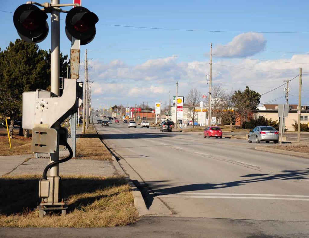
12 2. Secondary Plan Area The Beamsville GO Secondary Plan Area is located west of Ontario Street along the rail corridor, as shown on Figure 2.. The Secondary Plan Area encompasses 25 hectares of land and includes the Transit Station and associated parking. The Plan Area captures a number of adjacent properties that may redevelop as a result of the GO Transit Station, as well as key corridors pertinent to transportation connections to and from the Station. Ontario Street and Greenlane are two of the key corridors in the Plan Area for which the study will consider opportunities to improve connections to and from the station site for all modes of transportation. The lands south of Greenlane feature stable low-density residential uses, with some medium density residential development along Juniper Court. Commercial establishments are present along the western side of Ontario Street, and open space amenities are present in the form of neighbourhood parks. Agricultural uses occupy a large proportion of the Plan Area, at just under 30% (72 ha) of the total Plan Area. There is limited availability of vacant land, representing just 7.2% (8 hectares) of the Plan Area, with a number of the parcels located adjacent to the rail corridor. It should be noted that the current agricultural uses within the Plan Area are located within both the Urban Area and Rural Agricultural Areas. The expectation is that future development within the Urban Area will be for urban uses (see Section 2.3 for additional details) Existing Conditions Figure 2. illustrates the existing land use within the Secondary Plan Area. Greenlane effectively acts as a key corridor running east-west through the area, creating two main segments within the Plan Area:. Lands north of Greenlane 2. Lands south of Greenlane The Transit Station Area is located north of Greenlane, in a predominantly agricultural zone with some surrounding commercial and industrial uses. The view of the Secondary Plan Area from the QEW features agricultural, business industrial, and commercial uses, with some business industrial properties visible from the highway. Ontario Street acts as a major arterial corridor through the area, with four lanes of traffic. There are limited public realm amenities or streetscape improvements along this corridor, resulting in a highly automobileoriented streetscape. Commercial uses are scattered along the axis of Ontario Street, and typically feature restaurants or gas stations with a limited number of retail establishments. Streetscape conditions looking west on Greenlane towards Ontario Street. 6
13 Lincoln Avenue a Bartle tt Road South Service Road North Ontario Street North Service LEGEND Road Queen Elizabeth Way Christie Drive Union Road Delta Way Bartlett Road Commercial 5.9 ha (6.3%) Institutional 0.32 ha (0.%) Industrial.0 ha (5.%) Business Industrial 0.0 ha (3.9%) Low Density Residential 65.8 ha (25.9%) Medium Density Residential.7 ha (0.7%) Agricultural 9.7 ha (37.3%) Parks and Open Space. ha (.7%) Natural Environment 3.0 ha (.2%) Utility.0 ha (.6%) GO Parking 2.2 ha (0.9%) Vacant 2.0 ha (9.%) Transit Station Area 9.8 ha 2 Greenlane Juniper Court Ontario Street Hickory Lane Carriage Road Secondary Plan Limits 25 ha Northgate Crescent Urban Area Boundary Lincoln Avenue Cedarbrook Lane Me dow Boulevard Ivy G ardens C rescen t Homestead Drive Drake Avenue G arden G a te Terrace Weltman Way reen G Cameron Avenue NORTH Friesen Boul eva rd Alexandra Avenue MAP PREPARED BY: ZMJ DILLON CONSULTING CHECKED BY: PJK DILLON CONSULTING PROJECT: STATUS: DRAFT DATE: 2/02/207 Scale Figure 2. Existing Land Use 7

14 2.3 Planning Context The Town of Lincoln Official Plan was officially adopted in 990 and last amended in 206. The general purpose of the Official Plan is to provide goals, objectives and policies to guide Council on land use matters. The Plan reflects the changes in legislation and includes the growth targets of the Growth Plan and the Regional Policy Plan. Figure 2.2 illustrates the current planned land use for the Secondary Plan Area. According to the Town of Lincoln Official Plan, a significant portion of the Secondary Plan Area is within the Urban Area Boundary, including the Industrial lands north of the rail track. The Transit Station Area is located within these designated Industrial lands, which represent the predominant planned land use in the Secondary Plan Area (accounting for approximately 58 hectares or 25% of the Plan Area, excluding roads). This includes approximately 0 hectares of business industrial uses along Ontario Street and the South Service Road. The main designated General Commercial component of the area is located between Greenlane and the CN Railway, east of the Urban Area Boundary. There is also a Natural Environment area that runs north-south through the western portion of the area, along the Urban Area Boundary and west into the Agricultural area. Ontario Street is identified as an Intensification Corridor, and development fronting onto Ontario Street is subject to specific community design policies provided in Section of the Town s Official Plan. The Town has an intensification target of 0% by 203 (where 0% of the annual housing growth after 205 is planned to occur within the built-up area), and Beamsville is an important area to accommodate intensification 2. The lands south of Greenlane and east of the Urban Area Boundary are designated as Residential, which permits low, medium, and high density residential development in addition to various neighbourhood and community amenity uses. A small portion of the residential 2 It should be noted that this target is subject to change based on the 207 Growth Plan and revised planning horizon of 20. During the preparation of this Plan, the Region s Municipal Comprehensive Review process is underway. area directly south of Greenlane is designated specifically for Medium Density Residential development. Some Parks and Open Space land are also designated within the area south of Greenlane and east of the Urban Area Boundary. Lands outside of the Urban Area Boundary have been included within the Secondary Plan Area in order to address interface issues, transportation and connectivity. All lands outside of the Urban Area Boundary within the Secondary Plan Area are designated as Agricultural Area and, more specifically, the Town of Lincoln Official Plan designates these lands as Specialty Agricultural, representing approximately 58 hectares or 23% of the Plan Area. This designation implements the Provincial 207 Greenbelt Plan and recognizes the importance of specialty croplands for their unique ability to produce certain crops and their importance to the Provincial, Regional and local economies. 2 Residential housing along Lincoln Avenue. 8
15 Lincoln Avenue a Delta Way Bartlett Road B artlett Road North Service Road 2 Ontario Street North Queen Elizabeth Way South Service Road Christie Drive LEGEND General Commercial 9.3 ha (3.7%) Industrial 6. ha (25.%) Residential 6. ha (8.3%) Medium Density Residential.5 ha (0.6%) Agricultural 57.9 ha (22.8%) Parks and Open Space.9 ha (.9%) Natural Environment 9.0 ha (3.5%) Union Road Transit Station Area 9.8 ha Secondary Plan Limits 25 ha Urban Area Boundary Greenlane Juniper Court Ontario Street Hickory Lane Carriage Road Northgate Crescent Lincoln Avenue Cedarbrook Lane Me dow reen Boulevard Ivy G ardens C rescen t Homestead Drive Drake Avenue Cameron Avenue G arden G a te Terrace Weltman Way NORTH G Friesen Bou l eva rd Alexandra Avenue MAP PREPARED BY: ZMJ DILLON CONSULTING CHECKED BY: PJK DILLON CONSULTING PROJECT: STATUS: DRAFT DATE: 2/02/207 Figure 2.2 Current Official Plan Land Use Scale

16 2 View of trail network through Hilary Bald Community Park. 0
17 2. Key Issues and Opportunities Through a review of existing policies, plans and site visits, as well as discussions with stakeholders and the public, a number of key issues and opportunities for leveraging the GO Transit Station investment and improving the area were identified. The following provides a short overview of the issues and opportunities for the Beamsville Secondary Plan Area. Issues There is a need for transit-oriented development in proximity to the GO Transit Station in order to support transit ridership. It is critical that the Secondary Plan prevents the marginalization of development within proximity to the GO Transit Station location. There are significant areas of land that are vacant or underutilized, and as this Station does not currently have a firm commitment from Metrolinx, protection of these lands for the future Transit Station and transit supportive development may be a challenge; Current and past market trends for Beamsville suggest that there is a gradual increase in development applications for higher density development formats. Historically, the Beamsville housing market has seen mostly ground-oriented forms of housing (singles, semis and, to a lesser extent, townhomes), and as a result there may be challenges in shifting public perception with respect to how higher density, transit-oriented development may impact the character of the area; The majority of the lands around the Transit Station that are within the Urban Boundary are designated Industrial. The current Industrial designation allows for a broad range of general industrial uses, including some uses which may not be supportive of higher order transit, such as warehousing and logistics type uses; The Urban Area Boundary is fixed, as the lands to the west of the Transit Station Area (and edge of the current Urban Area Boundary) are designated as Niagara Peninsula Tender Fruit and Grape Area as part of the policies for the Provincial Greenbelt Plan s Protected Countryside in the Provincial Greenbelt Plan. The close proximity of the Transit Station Area to the rural agricultural area/greenbelt area suggests a need to plan for appropriate transitions between urban and rural agricultural uses to limit the potential for interface and landuse compatibility issues; Providing sufficient Station access may be a challenge. Obtaining access from Ontario Street north of the Transit Station Area should be feasible; however, a second accessway (with full turning movements) at the railway crossing will be a challenge to implement. In addition, access from the west via Lincoln Avenue may result in potentially significant traffic issues along Ontario Street; Managing traffic leading to and from the GO Transit Station during peak travel periods will need to be addressed through a traffic study, which should also take into consideration the large developments occurring outside of the Secondary Plan Area (i.e., Cherry Heights, Vista Ridge subdivisions, etc.) and the growing number of vehicles accessing the QEW as a result; Active transportation connections and sidewalks are needed along collector and local streets to improve pedestrian and cyclist safety, as well as to provide a connection to the GO Transit Station site from the south; Natural heritage features to the west of the GO Transit Station present a constraint on development patterns in the Transit Station Area; and, The current mix of light industrial and commercial uses in close proximity to the station presents a limitation for nearterm intensification. 2

18 2 Commercial uses along Ontario Street, looking north towards the Escarpment. 2
19 Opportunities The integration of Complete Streets Development and policies along major corridors in the Intensification Areas Higher order transit is most feasible in large urban centres; however, it should be noted that the broader GO network does include stations in smaller communities (e.g. Bradford, Acton). The introduction of GO rail services should provide a positive boost to local development and could also be a catalyst for improved local transit services throughout Lincoln; Mixed use is becoming more prominent in Beamsville, and there are opportunities to expand this designation through Official Plan amendments and design guidelines; The existing GO Bus service (with a temporary location by the QEW) has been well received by the community, and bus bays could be accommodated at the GO Transit Station site; There are opportunities to improve active transportation and trail connections between residential areas and the GO Transit Station site, particularly for neighbourhoods in the vicinity of Konkle Creek; Economic growth in Beamsville can leverage its existing tourism uses and build upon its agricultural assets; There is an opportunity to provide for affordable housing through the provision of a wider range of multiple unit housing of varying scales; Traffic mitigation and access to the site could be achieved through the use of alternative routes that pass through the Transit Station Area; study area would promote sustainable transportation and community planning; The GO Transit Station may also attract some riders from communities south of Beamsville; and, Parking accommodations at the station site would be sufficient to support opening day needs. The Town of Lincoln has identified residential development as a key avenue towards meeting Provincially-directed intensification targets between 205 and 20. As noted earlier, there are vacant sites within the Area that provide an opportunity for development, as well as a number of underutilized sites which have potential for redevelopment or intensification. Figure 2.3 presents these development and intensification areas. These areas have been defined as either potential mixed use or employment development/redevelopment opportunities, and are located within the Urban Area Boundary. There are a few vacant employment sites that have the potential to accommodate new employment developments and a few occupied sites that could accommodate redevelopment or infill developments. In addition, there are a number of occupied sites that could support mixed use redevelopment or intensification and a couple of vacant sites that could accommodate mixed use development. Note that the properties identified on Figure 2.3 are for illustrative purposes only and do not represent a definitive inventory of all opportunities. 2 3
20 Lincoln Avenue a Delta Way Bartlett Road Bartlett Road North Ontario Street North Service Road LEGEND Potential Residential/Mixed Use Development/ Redevelopment Opportunity Vacant 7.3 ha (2.9%) Occupied 8.3 ha (3.3%) 2 Queen Elizabeth Way Potential Employment Development/ Redevelopment Opportunity South Service Road Vacant 26. ha (0.%) Occupied 2.0 ha (9.%) Christie Drive Transit Station Area 9.8 ha Secondary Plan Limits 25 ha Urban Area Boundary Union Road Greenlane Juniper Court Ontario Street Hickory Lane Carriage Road Northgate Crescent Lincoln Avenue Cedarbrook Lane Me dow reen Boulevard Ivy G ardens C rescen t Homestead Drive Drake Avenue Cameron Avenue G arden G a te Terrace Weltman Way NORTH G Friesen Bou l eva rd Alexandra Avenue MAP PREPARED BY: ZMJ DILLON CONSULTING CHECKED BY: PJK DILLON CONSULTING PROJECT: STATUS: DRAFT DATE: 2/02/207 Scale Figure 2.3 Priority Areas for Change

21 3.0 VISION & OBJECTIVES
22 3. Vision for Change The Beamsville GO Transit Station Area represents a long-term opportunity for a fourth GO rail station in Niagara, providing a stop between Grimsby and St. Catharines. The main accessway into Beamsville is Ontario Street, which is lined with industrial uses to the north of the railway, residential to the south of the railway, with some clusters of commercial throughout. Beamsville is surrounded by agricultural lands, with the GO Transit Station location proposed adjacent to the Urban Area Boundary. The Beamsville community is supported by wine-related tourism and agricultural-related industry. Maintaining the small town character of Lincoln is an important goal in the Town s Official Plan, and the vision for future development in the Plan Area is mindful of this. To support rapid transit expansion, the lands around the GO Transit Station will be planned with midrise residential and mixed use development. This growth should be focussed along the north side of Greenlane Boulevard, which will accommodate a range of mixed use built form. The intensification of this area will provide a transition between the stable residential lands to the south of Greenlane and the industrial uses to the north of the railway and should incorporate new open spaces and community facilities. highway interchange. Significant streetscape improvements will be directed to Ontario Street, to improve the public realm for pedestrians, cyclists and transit users. By 20, the area has potential to accommodate an additional,300 people and 950 employees. 3.2 Beamsville GO Transit Station Secondary Plan Objectives. Plan for redevelopment along Greenlane in proximity to the future GO Transit Station 2. Improve the streetscape and pedestrian realm along Ontario Street 3. Protect employment lands and attract new investment. Support connectivity and integration of the GO Transit Station 5. Protect stable residential neighbourhoods 6. Promote active transportation and make efficient use of existing infrastructure. 3 The industrial lands to the north of the railway will be protected for employment use and, where possible, will evolve to provide opportunities for denser forms of employment. New office commercial uses will be directed to locate along Ontario Street, facilitating a street edge while providing for higher density uses in proximity to the GO Transit Station and 6


23 3 Visualization of future conditions looking west along Greenlane towards Ontario Street (below). Existing conditions shown for context (top right). 7

24 Plan for redevelopment along Greenlane in. proximity to the future station The north side of Greenlane will be planned to provide medium density mixed use development to support transit-oriented growth, introduce a range of housing choice, and provide a transition between the stable residential areas to the south and the employment and commercial areas to the north. The mixed use built form should be attractive, define the street edge and incorporate open space. 3 Example of mid-rise mixed use building with high quality facade and commercial uses framing the street edge. 8

25 Improve the streetscape, pedestrian, and 2. cyclist realm along Ontario Street Ontario Street is the main accessway into Beamsville. With the redevelopment of the lands on either side of the street as office commercial uses, there is an opportunity to define the street edge, improve the streetscape and provide an enhanced public realm for pedestrians, cyclists and transit users. 3 Visualization of the potential future streetscape conditions along Ontario Street. Source: Region of Niagara Phase 2 Employment Lands Study Project Report, November 205 9

26 3. Protect employment lands and attract new investment The evolving industrial park to the north of the station site will be protected for employment uses. Where possible, opportunities for denser forms of employment should be promoted. Higher density built form will be directed along Ontario Street, while adjacent lands provides opportunities for a full range of employment uses. 3 Example of employment use facility with high quality built form. 20

27 . Support connectivity and integration of the GO Transit Station The GO Transit Station should be easily accessible for a full range of transportation modes and be integrated into the Town s urban structure. The uses around the Station should be planned to complement and integrate with the existence of the Station as the character of the area evolves over time. 3 Active transportation connections are an important component of access and linkages to the future GO Transit Station. 2

28 5. Protect stable residential neighbourhoods Recognizing that this area will transition over the long term, the Plan will identify transitional uses to protect the character of stable residential neighbourhoods and provide for adequate transportation improvements to accommodate increased traffic volumes and reduce impacts to residential areas. 3 Example of a stable residential neighbouhood in the southeast portion of the Secondary Plan Area. 22

29 Promote active transportation and make 6. efficient use of existing infrastructure The existing roadways should be evaluated for improvements to integrate active transportation uses. Additional off-road active transportation connections should be provided to connect the GO Transit station with the broader tourism opportunities in the area, as well as improvements to link residential and employment uses. 3 Active transportation connections are an important component of access and linkages to the future GO Transit Station. 23

30 .0 POLICIES
31 . Secondary Plan Area Limits The limits of the Beamsville GO Transit Station Secondary Plan Area are depicted on Schedule. The Secondary Plan Area extends approximately 800 metres around the GO Transit Station site and includes key properties that may redevelop as a result of the GO Transit Station, as well as corridors that will form important transportation arteries and connections to and from the GO Transit Station. Changes to the boundary of the Secondary Plan will require an Official Plan Amendment..2 Land Use Policies.2. Land Use Structure Lands within the Secondary Plan Area are designated one of the following land use categories, as depicted on Schedule 2: a. Low Density Residential b. Medium Density Residential c. High Density Residential d. Mixed Use e. Industrial f. Office Commercial g. Agricultural Area h. Parks and Open Space i. Natural Environment j. Transit Station Area.2.2 Relationship with the Town of Lincoln Official Plan Land Use Categories and Permissions The land use designations for the Secondary Plan are intended to complement the broader land use designations provided in the Town of Lincoln Official Plan. In most cases, the land use policies and permissions described in the Secondary Plan are more detailed than those provided for within the Town of Lincoln Official Plan. Where there are inconsistencies between a particular policy in the Official Plan and the Secondary Plan, the policies of the Secondary Plan shall prevail..2.3 General Policies The following uses are permitted in all land use designations in this Secondary Plan: a. A use which is accessory to a permitted use; b. Replacement and expansions to existing legal uses, buildings and structures in conformity with the policies of the Official Plan, the Town s Zoning By-Law, and this Secondary Plan; c. Public utilities, including water, wastewater and stormwater infrastructure (except within the Natural Open Space system); d. City parks, public spaces, and recreational facilities; e. Trails and active transportation connections, such as pedestrian and cycling network improvements; and, f. Institutional uses, as outlined in this Plan. Nothing in this Plan will prohibit the continued operation of legal non-conforming uses of land, buildings or structures within the Secondary Plan Area. Please refer to the Town of Lincoln Official Plan Section 9. on Non-Conforming Uses..2. Overall Density Targets The land uses of the Plan are identified to support an overall density target of 50 people and jobs per hectare. 25
32 Lincoln Avenue a Ontario Street North Christie Drive Delta Way Bartlett Road Bartlett Road Schedule : Secondary Plan Area North Service Road LEGEND Transit Station Area South Service Road Secondary Plan Limits Urban Area Boundary Queen Elizabeth Way Union Road Greenlane Juniper Court Ontario Street Hickory Lane Carriage Road Northgate Crescent Lincoln Avenue Cedarbrook Lane G Me dow reen Boulevard Ivy G ardens C rescen t Homestead Drive Drake Avenue Cameron Avenue G arden G a te Terrace Weltman Way NORTH Friesen Boul eva rd Alexandra Avenue MAP PREPARED BY: ZMJ DILLON CONSULTING CHECKED BY: PJK DILLON CONSULTING PROJECT: STATUS: DRAFT DATE: 2/02/207 Scale
33 Lincoln Avenue a Delta Way Bartlett Road Bartlett Road Schedule 2: Land Use Plan North Service Road LEGEND Ontario Street North Low Density Residential Medium Density Residential High Density Residential South Service Road Queen Elizabeth Way Christie Drive Mixed Use Industrial Office Commercial Agricultural Area Parks and Open Space Natural Environment Transit Station Area Secondary Plan Limits Urban Area Boundary Union Road Greenlane Juniper Court Ontario Street Hickory Lane Carriage Road Northgate Crescent Lincoln Avenue Cedarbrook Lane G Me dow reen Boulevard Ivy G ardens C rescen t Homestead Drive Drake Avenue Cameron Avenue G arden G a te Terrace Weltman Way NORTH Friesen Bou l eva rd Alexandra Avenue MAP PREPARED BY: ZMJ DILLON CONSULTING CHECKED BY: PJK DILLON CONSULTING PROJECT: STATUS: DRAFT DATE: 2/02/207 Scale


34 .2.5 Low Density Residential Planned Function The planned function of the Low Density Residential designation is to provide opportunities for ground- oriented housing in a low density format. The intention of this designation is to recognize the existing, established low density residential neighbourhoods which occupy a large portion of the study south of Greenlane. Areas which are designated for low density residential development are expected to be maintained as low density areas and should not be the focus of significant intensification. Permitted Uses Permitted uses include residential uses such as: a. Single detached dwellings; b. Semi-detached dwellings; c. Townhouses; and, d. Other compatible housing forms (as defined in this Secondary Plan and the Town of Lincoln Official Plan). All new residential development within existing stable residential neighbourhoods shall be subject to site plan control in accordance with the policies in Section 9.0 of the Town s Official Plan. For sites located along the intensification corridor indicated on Schedule A2 of the Town s Official Plan, policies in Section of the Official Plan will also apply. Density The permitted net density for new low density residential ranges from a minimum net density of 0 units per hectare up to a maximum of 25 units per hectare..2.6 Medium Density Residential Planned Function The planned function of the Medium Density designation is to provide opportunities for residential development in a medium density format in proximity to existing residential uses. A diversity of dwelling types is encouraged to support the Town s range of accommodation options and housing intensification objectives for Downtown. Permitted Uses Permitted uses include medium density residential uses such as: a. Townhouses; b. Stacked townhouses; c. Apartments; and, d. Other multiple dwellings. All new Medium Density Residential development shall be subject to site plan control in accordance with the policies in Section 9.0 of the Town s Official Plan. For sites located along the intensification corridor indicated on Schedule A2 of the Town s Official Plan, policies in Section of the Official Plan will also apply. Density The permitted net density for new medium density residential development shall range from a minimum residential density of 25 units per hectare up to a maximum of 60 units per hectare. Example of low density residential development in the form of single family homes. Example of medium density residential development in the form of townhomes. 28
35 .2.7 High Density Residential Planned Function The planned function of the High Density Residential designation is to provide opportunities for residential development in a higher density development format. Diversity of dwelling types is encouraged to support the Town s range of housing options. Permitted Uses Permitted uses include high density residential uses such as: a. Townhouses; b. Apartments; and, c. Other forms of multi-unit residential uses (as defined in this Secondary Plan and the Town of Lincoln Official Plan). All new High Density Residential development shall be subject to site plan control in accordance with the policies in Section 9.0 of the Town s Official Plan. Density The permitted net density for new High Density Residential development shall range from a minimum residential density of 50 units per hectare up to a maximum of 20 units per hectare. Example of mixed use development. 29

36 .2.8 Mixed Use Planned Function The planned function of the Mixed Use designation is to provide opportunities for mixed use development in a medium to high density format. Uses can be mixed across a parcel or mixed within a building. Commercial, office, institutional uses that enliven the street should be located on the ground floor of buildings close to the front property line to help frame and animate the street. Consideration should be given to lower development ` as a transition to the adjacent residential areas. Density Residential development within the Mixed Use designation is permitted from a minimum net density of 50 units per hectare up to a maximum of 200 units per hectare. Form of Mixed Use Development and Redevelopment On existing developed sites, mixed use and/ or stand-alone residential, commercial and institutional infilling is permitted. On vacant sites, new development shall be in a mixed use format (either mixed within a building or across the site). Permitted Uses Permitted uses include medium and high density residential uses such as: a. Low and mid-rise apartments; b. Townhouses; c. Commercial uses; and d. Office uses. Permitted commercial uses include a full range of personal and professional service commercial uses, office, and may include recreational, community and cultural facilities as secondary uses. Large format retail uses are not permitted. All new Mixed Use development shall be subject to site plan control in accordance with the policies in Section 9.0 of the Town s Official Plan. For sites located within the intensification area indicated on Schedule A2 of the Town s Official Plan, policies in Section of the Official Plan will also apply. Example of high density residential uses. 30

37 .2.9 Industrial Planned Function The planned function of the Industrial Area designation is to provide a range of employment uses with provisions allowing for a variety of lot sizes that offer flexibility for attracting and accommodating a wide range of industrial and associated employment uses. Permitted Uses Permitted uses include: a. Manufacturing; b. Processing; c. Servicing; d. Research and laboratories; e. Data processing and development; and f. Uses of similar nature (as per the Town of Lincoln Official Plan). Form of Industrial and Redevelopment While areas designated as Industrial will continue to accommodate vehicles and trucks, development in these areas will be designed to accommodate pedestrian and cycling connections to and from industrial facilities in order to serve the daily population and to facilitate access to public transit. The Secondary Plan envisions a comprehensively planned and high quality employment area with office and other employment uses. This area will serve as one of the gateways in the Town, and as such, is intended to reflect a dedication towards a strong sense of place, sustainability, and economic development. Uses that are incidental or ancillary to industrial operations such as a retail and wholesale division operated as a subsidiary function of any industry may be permitted in the Industrial Area. Retailing is only permitted as an accessory use to a permitted use and will be limited in size so as not to interfere with, or detract from the primary function of the area. Major retail uses are considered to be non-employment uses and are not permitted. Storage of outdoor goods and materials is not permitted. View of existing industrial employment uses on Union Road. 3

38 .2.0 Office Commercial Planned Function The Office Commercial designation corresponds to existing industrial lands generally located along Ontario Street north of the CN Railway leading to the QEW. This area acts as the main gateway to the Transit Station Area and as a transition from the Industrial uses around the Transit Station Area. Therefore, their use and form should be of the highest quality and built form complementary to the streetscape along Ontario Street. Particular attention should be paid to architectural design, and the animation of streetscape with active building frontages, high quality public realm, and sustainable site design. Office Commercial Areas shall be characterized by high quality buildings in an attractive pedestrian friendly, connected, and transit-oriented working environment as outlined in Section 5.0 of this Secondary Plan. f. Personal service uses; g. Banks and financial services; h. Commercial parking garages (if associated with commercial/retail development); i. Commercial-recreational facilities; j. Complementary uses including licensed child care establishment, food service, food service, restaurants, security services, and janitorial services may be permitted provided the uses are compatible with the development and operation of the surrounding industrial uses; and, k. Limited retail sales and service commercial uses as an accessory use in conjunction with a permitted use. Form of Office Commercial and Redevelopment The Office Commercial area is located in proximity to the QEW and provides an ideal location for landmark buildings that can benefit from direct highway exposure. The range and scale of uses are designed to be sensitive to the adjacency and compatibility with the surrounding residential neighbourhoods, and benefit from exposure to the QEW and planned GO Transit Station. The Secondary Plan envisions a comprehensively-planned and high quality business district with office and other employment uses. This area will serve as one of the gateways in the Town and, as such, is intended to reflect a dedication towards a strong sense of place, sustainability, and economic development. Permitted Uses Notwithstanding Section 3.5 of the Town of Lincoln Official Plan regarding Industrial uses, the Office Commercial designation is intended to accommodate office-related uses that are compatible with the evolving nature of the Transit Station Area. Permitted uses include: a. Office uses; b. Hotels, conference centres and banquet facilities; c. Community colleges or universities; d. Medical clinics; e. Commercial schools; Example of an employment office with high-quality architectural design and facade treatments. 32

39 Commercial uses on Ontario Street, Lincoln. 33


40 .2. Agricultural Area Please refer to Section 2. of the Town of Lincoln Official Plan. The Agricultural Area within the Secondary Plan boundary is designated specifically as Specialty Agricultural within the Town s Official Plan. This designation implements the Provincial Greenbelt Plan and recognizes the importance of specialty croplands for their unique ability to produce certain crops..2.2 Parks and Open Space Please refer to Section 3.6 of the Town of Lincoln Official Plan for the planned function and permitted uses within the Parks and Open Space designation. New recreation and open spaces shall be provided for based on the public realm policies, as outlined in the Urban Design Guidelines in Section 5.0 of this Secondary Plan. In general, the public realm policies outlined in Section 5.0 are intended to ensure that a highquality public realm, open space, and protected environment is achieved. The policies define an open space framework that links outdoor spaces through the creation of new parks, gateways, streetscape improvements, and active transportation paths to create a unique, beautiful, and healthy public realm environment. The public realm policies also provide guidance and direction for future investment into new parks, trails, streetscapes, sidewalks, and green spaces. Example of existing specialty agricultural uses on South Service Road, Lincoln. Trails and open spaces can be used to provide linkages between neighbourhoods and recreational areas. 3
41 View of expansive agricultural land along Lincoln Avenue. 35
42 .2.3 Natural Environment Natural Environment areas within the Secondary Plan area have been identified on Schedule 2. Please refer to Section 2. of the Town of Lincoln Official Plan for policies relating to Natural Environment Areas..2. Transit Station Area The Transit Station Area should enhance traveller amenities, including internal pedestrian pathways, retail, shared commuter parking etc. The future land use and development of this area will be subject to the land use and urban design policies contained in Section 5 this Secondary Plan. Depending on the amount of space needed for parking at the GO Transit Station site, there may also be opportunities for on-site intensification and mixed use development. The parking demand estimates will be confirmed through the detailed station design that would be undertaken by Metrolinx..2.5 Land Use Compatibility Employment Uses Any new proposed development which is within,000 metres of an existing Class 3 industrial facility, 300 metres of an existing Class 2 industrial facility or 70 metres of an existing Class industrial facility shall be subject to Ministry of the Environment and Climate Change D-6 Guidelines for Land Use Compatibility. Active Rail No new residential development is permitted within a 30-metre setback of a rail right-of-way. Permitted uses within this setback include public and private roads, parkland and other outdoor recreational space including backyards, swimming pools and tennis courts unenclosed gazebos, garages and other parking structures and storage sheds, where permitted within the policies of this Plan and subject to the policies and regulations of CN Rail. Provincial Highway In addition to all the applicable municipal requirements, all proposed development located adjacent to and in the vicinity of a provincial highway within the Ministry of Transportation (MTO)'s permit control area under the Public Transportation and Highway Improvement Act (PTHIA) will also be subject to MTO approval. Early consultation with the MTO is encouraged to ensure the integration of municipal planning initiatives with provincial transportation planning. Any new areas in the municipality identified for future development that are located adjacent to or in the vicinity of a provincial highway or interchange/intersection within MTO's permit control area will be subject to MTO's policies, standards and requirements. Direct access will be discouraged and often prohibited..2.6 Building Height The planned maximum building heights are shown on Schedule 3. The heights depicted on Schedule 3 are intended to reflect the planned maximum number of storeys and the following policies apply: a. On a site-by-site basis, the Town may allow for marginally taller buildings where the findings of supporting studies, such as an urban design study and light/ shadow study, can demonstrate that there are no negative impacts on adjacent properties; b. The Town may require a peer review for any studies which propose to exceed the planned building heights; and, c. All developments which are proposed to be taller than 6 storeys shall require a light/shadow study and an urban design study to demonstrate how the development fits within the context of the site and surrounding area. In addition to the above provisions, new proposed development should be oriented and designed to avoid land use incompatibility with surrounding employment uses. 36
43 L incoln Avenue a Ontario Street North Christie Drive Delta Way Bartlett Road Bartlett Road Schedule 3: Maximum Building Heights North Service Road LEGEND Max. 3 Storeys Queen Elizabeth Way Max. Storeys Max. 6 Storeys Max. 0 Storeys South Service Road Secondary Plan Limits Transit Station Area Urban Area Boundary Union Road Greenlane per Court Ontario Street Northgate Crescent Juni Hickory Lane Carriage Road Lincoln Avenue Cedarbrook Lane G Me dow reen Boulevard Ivy G ardens C rescen t Homestead Drive Drake Avenue Cameron Avenue G arden G a te Terrace Weltman Way NORTH Friesen Bou l eva rd Alexandra Avenue MAP PREPARED BY: ZMJ DILLON CONSULTING CHECKED BY: PJK DILLON CONSULTING PROJECT: STATUS: DRAFT DATE: 2/02/207 Scale

44 .3 Transportation Policies.3. Transportation Network The Secondary Plan Area is planned to be served by a multi-modal, integrated transportation network, which accommodates pedestrians, cyclists, transit users and automobiles. Presently, there are a number of transportation challenges in the Plan Area and the expectation is that there will continue to be challenges as the area grows. Accordingly, there is a need to plan for a variety of improvements to to the transportation network within the Plan Area to better connect people to destinations while also allowing people to move through the area in a relatively safe and efficient manner. The expectation is that improvements will be required to enhance automobile, transit, cycling and walking networks within and around the area to ensure that an appropriate balance of transportation options are provided. The transportation network must provide for a better balance of the full range of transportation modes. The transportation network and improvements identified in this Plan build on the Town and Region s planned transportation improvements, as outlined in a number of approved plans. The implementation of the proposed transportation infrastructure improvements should be undertaken as part of the Region s master planning process/environmental Assessment process and/or development approvals process (as the case may be), in addition to coordination with the Town s Transportation Master Plan process that is currently ongoing (and the implementation of the Region s Complete Streets Guidelines). View along North Service Road, Beamsville. 38
45 .3.2 Improvements and Enhancements to Transportation Network The Secondary Plan contemplates the following potential improvements to the transportation network as part of the implementation of the Region s Complete Streets policies: Road improvements and connections; Transit improvements; and, Active transportation improvements..3.3 Planned Road Hierarchy The planned road hierarchy is shown on Schedule, illustrating Arterial Roads, Collector Roads and Local Roads. The following policies describe the general planned function for each road type. Section 5.0 further elaborates on the unique functionality and design of the key streets within the Secondary Plan Area. Arterial Roads (26 metre Right of Way) Arterial Roads are under the jurisdiction of the Region of Niagara and are planned to accommodate 2 to lanes of traffic within 26 metre right-of-ways. Direct access to adjoining properties and on-street parking is generally restricted to allow for the movement of traffic through the area. The road allowance is planned to accommodate a complete street framework, including bicycle facilities such as bike lanes, shared-use lanes, paved shoulders and bicycle parking facilities and sidewalks on both sides of the street. On-street parking is generally not permitted on Arterial Roads. Regional Arterial Roads within Secondary Plan Area include: North Service Road (26 metre right of way); South Service Road (26 metre right of way); and, Ontario Street (26 metre right of way). Collector Roads (23 metre Right of Way) Collector Roads are under the jurisdiction of the Town of Lincoln and are planned to accommodate two lanes of traffic. Collector Roads are undivided with a road allowance width of 23 metres, allowing for the addition of turning lanes, bicycle lanes, landscaping, sidewalks on both sides of the street and utilities. On-street parking is not permitted on Collector Roads. Collector Roads within the Secondary Plan Area include: Greenlane (23 metre right of way); Lincoln Avenue (23 metre right of way); and, Bartlett Road (23 metre right of way) (23 metre right of way). Local Roads (20 metre Right of Way) Local Roads provide access to properties and carry traffic predominantly of a local nature. Typically, roadways in this section carry low volumes of traffic short distances. Local roads are generally designed to accommodate onstreet parking, sidewalks on both sides of the street and landscaping in the boulevards. All local road allowances are to be 20 metres in width..3. Planned Road Improvements and Connections Schedule 5 illustrates new connections, road widening and other road improvement opportunities which are intended to support the implementation of the Secondary Plan. The current road network operates fairly effectively with few operational challenges. This will not change significantly with the forecasted travel demand resulting from intensification as well as commuter traffic accessing/egressing the planned GO Rail service at the Beamsville GO Transit Station. The majority of improvements required to accommodate this increase in trips are operational, and focus on key intersections along the Ontario Street corridor. In addition to this, some limited increase in traffic level is anticipated on Lincoln Avenue as a potential by-pass of Ontario Street for local Beamsville residents. The introduction of transit services and improvements to the active transportation network will also help mitigate some of the forecasted travel demand. The following summarizes the key road-related improvements (note that the numbers assigned coincide with those listed on Schedule 5, and are further described in Section 6.0):. Potential Additional North Access to the GO Transit Station The southern entrance to the GO Transit Station will have limited movements due to its proximity to the rail corridor. Accordingly, a second access from the South Service Road should be protected for. 2. Geometric Improvements to Ontario Street at the South Service Road Intersection improvements will be required at the juncture of Ontario Street and the South Service Road, in order to accommodate higher traffic volumes and improve traffic flow between the GO Transit Station and the QEW. 39

46 3. GO Transit Station Access The GO Transit Station access off of Ontario Street will require an intersection assessment given increased traffic volumes. The intersection should be planned to accommodate higher volumes at peak periods.. Intersection Improvements on Ontario Street and Greenlane: Ontario Street is currently a 2 to lane Regional Road which forms the central north-south spine of Beamsville, connecting residents to the QEW and the future GO Transit Station. Ontario Street is expected to see increasing volumes over the planning horizon, in particular between Greenlane and the QEW. 5. Roadway Improvements to Lincoln Avenue: Lincoln Avenue is currently a two-lane Collector Road with an existing road width of approximately 8 metres. The road has a rural cross section with two narrow lanes of traffic and no sidewalks or cycling facilities. It is anticipated that growth in traffic on Ontario Street will shift some traffic to Lincoln Avenue. This increased traffic volume may create conflict points with potential active transportation users (cyclists or pedestrians). As a result, the corridor should be identified for further study through an environmental assessment to determine the most effective means of accommodating the growth in active modes and motorized vehicles on this narrow corridor. This could include the implementation of a sidewalk (at least on one side of the street), bike sharrows/bike lanes and other active transportation improvements. Example of an off-road multi-use trail. 0
47 .3.5 GO Transit Station Area The GO Transit Station Area is located to the west of Ontario Street, north of the South Service Road. The station includes lands on the north side of the CN rail corridor. The design of the Transit Station Area will be planned in conjunction with Metrolinx to address the following elements: Access to the Transit Station Area for pedestrians, cyclists, transit users, kiss and riders, and carpool users; A sufficient supply of parking for commuters; Wayfinding solutions; Buffering and landscaping for natural heritage features and rural lands adjacent to and within the Transit Station Area; and, Opportunities for universal access and incorporation of sustainable design measures..3.6 Active Transportation Network The existing and planned Active Transportation Network is depicted on Schedule 6. The network is planned to improve connectivity for pedestrians and cyclists within the Secondary Plan Area and to surrounding areas..3.7 Active Transportation Improvements The Active Transportation Network should provide direct and safe connections to the GO Transit Station, multi-use trails, public spaces and parks, schools, mixed use areas, employment opportunities and recreational facilities. Amenities for cyclists and pedestrians as well as wayfinding signage provided to direct users along key routes, should be located at key points along the network. On-road bike lanes should be protected from traffic with the use of buffer zones. There are a number of active transportation improvements proposed for the area, including the following (as per Schedule 6): Bike Route/Lanes (on-road): Ontario Street; Greenlane; Lincoln Avenue; and Neighbourhood streets. Multi-Use Trail (off road): Connection between Greenlane and the GO Transit Station; Connection between Greenlane and Friesen Boulevard; Connection between the South Service Road and the GO Transit Station; and, Connection between Ontario Street and the GO Transit Station..3.9 Secure Bike Parking Facilities The implementing Zoning By-law may require the provision of secure bicycle parking facilities in a conspicuous location, long-term bike parking areas within buildings and onsite shower facilities and lockers for employees who bike to work. The Town may allow for the reduction in the number of required parking spaces where bicycle parking facilities are provided..3.0 Transportation Demand Management Council shall require that development applications include a Transportation Demand Management (TDM) Plan, prepared to the satisfaction of the Town. The intent of the TDM Plan shall be to implement and promote measures to reduce the use of low-occupancy automobiles for trips and to promote cycling and walking..3. Traffic Impact Future developments may require a Traffic Impact Assessment. Note that any Traffic Impact Assessment shall be subject to the Regional Traffic Impact Assessment Guidelines where a Regional Road is impacted..3.2 Parking Through the development approvals process, the Town may consider alternative parking requirements for mixed use and high-density developments including shared parking standards..3.3 Future Transit System The Town has had recent discussions about the potential to implement a local transit system. In the event that a transit system is launched, the Town should develop transit-supportive Official Plan policies, including any revisions to the policies of this Secondary Plan. The Niagara Transit Service Delivery and Governance Strategy (Dillon, 207) has recommended intermunicipal transit connections utilizing GO Transit to form a future Grimsby-Beamsville link service. This will be explored further in partnership with the Region of Niagara.
48 . Infrastructure Policies.. Water and Sanitary Servicing As part of the implementation of this Secondary Plan, the Town will work with Niagara Region to ensure that there is adequate water and sanitary servicing and capacity to accommodate the long-term planned development for the Secondary Plan Area...2 Municipal Servicing Study As part of the implementation of this Secondary Plan and the policies of Part 7 of the Town of Lincoln Official Plan, the Town will undertake an analysis of local infrastructure to ensure that adequate servicing is in place to accommodate the planned growth for the Plan Area. The Town will update its municipal master servicing strategy as required...5 Coordination of Public Works The Town will work with the Region to ensure that planned public works for the area are coordinated to minimize the impacts of construction on the residents and businesses within the Secondary Plan Area. Coordination efforts will consider the phasing of streetscape improvements, any future road works and maintenance, as well as any upgrades to water and sanitary networks...3 Development Applications and Servicing Requirements The Town may also require development applications to be supported by site-specific servicing studies... Sustainable Stormwater Management The municipality encourages innovative measures to help reduce the impacts of urban runoff and maintain base groundwater flow. Such measures may include bioswales, permeable pavers, rain barrels and green roofs. 2
49 Lin coln Avenue a i Ontario Street Delta Way Bartlett Road Bartlett Road Schedule : Planned Road Hierarchy North Service Road Ontar o Street North LEGEND Provincial Highway Highway Ramp Connections South Service Road Queen Elizabeth Way Arterial Road Width: 26m Collector Roads Width: 23m Local Roads Width: 20m Christie Drive Secondary Plan Limits Transit Station Area Urban Area Boundary Union Road Greenlane Juniper Court Hickory Lane Carriage Road Northgate Crescent Lincoln Avenue Cedarbrook Lane G Me dow reen Boulevard G ardens C rescen t Ivy Homestead Drive Drake Avenue Cameron Avenue G arden G a te Terrace Weltman Way NORTH Friesen Bou l eva rd Alexandra Avenue MAP PREPARED BY: ZMJ DILLON CONSULTING CHECKED BY: PJK DILLON CONSULTING PROJECT: STATUS: DRAFT DATE: 2/02/207 Scale
50 Lincoln Avenue a Delta Way Bartlett Road Bartlett Road Schedule 5: New Connections and Road Improvements North Service Road LEGEND South Service Road Ontario Street North Potential north additional Location of Improvement access to the station Road Network Geometric improvements Secondary Plan Limits to Ontario Street at the Transit Station Area South Service Road Urban Area Boundary 5 Roadway improvements to Lincoln Avenue 2 Queen Elizabeth Way Christie Drive 3 GO Station Access Union Road Greenlane Juniper Court Ontario Street Intersection improvements at Ontario Street and Greenlane H ckory i Lane Carriage Road Northgate Crescent Lincoln Avenue Cedarbrook Lane G Me dow reen Boulevard Ivy G ardens C rescen t Homestead Drive Drake Avenue Cameron Avenue G arden G a te Terrace Weltman Way NORTH Friesen Bou l eva rd Alexandra Avenue MAP PREPARED BY: ZMJ DILLON CONSULTING CHECKED BY: PJK DILLON CONSULTING PROJECT: STATUS: DRAFT DATE: 2/02/ Scale
51 Lin coln Avenue a orth De lta Way Bartlett Road Bartlett Road Schedule 6: Planned Active Transportation Network North Service Road outh S d e vice Roa Ontario Street N LEGEND Existing Bike Route/Lane (On-Road) Queen Elizabeth Way Planned Bike Route/Lane (On-Road) S r Existing Multi-Use Trail (Off-Road) Planned Multi-Use Trail (Off-Road) Secondary Plan Limits Christie Drive Transit Station Area Union Road Greenlane Juniper Court Ontario Street Hickory Lane Carriage Road Northgate Crescent Lincoln Avenue Cedarbrook Lane G Me dow reen Boulevard Ivy G ardens C rescen t Homestead Drive Drake Avenue Cameron Avenue G arden G a te Terrace Weltman Way NORTH Boulevard Friesen Alexandra Avenue MAP PREPARED BY: ZMJ DILLON CONSULTING CHECKED BY: PJK DILLON CONSULTING PROJECT: STATUS: DRAFT DATE: 2/02/ Scale

52 5.0 URBAN DESIGN
53 The urban design guidelines are intended to inform and provide the guidance for achieving the intended vision, appearance and functionality of the Beamsville Secondary Plan Area for local residents, commuters, visitors, business owners and patrons. The guidelines are intended to complement and build upon the community design guidelines in Section 8 of the Town of Lincoln Official Plan and be implemented through the site plan process. The purpose of these guidelines is to provide guidance for enhancing the character of the Secondary Plan Area s private and public realm. The guidelines are intended to provide a degree of flexibility, allowing for a range of design styles and expressions which will contribute to creating a unique sense of place. The following sections provide an overview of the urban design improvements being recommended as part of this plan, present the urban design guidelines for the public realm, outline the design guidelines for the private realm, and describe the design integration policies. 5. Urban Design Improvements The urban design improvements are intended to enhance the attractiveness and functionality of the Secondary Plan Area. The planned Public Realm Improvement Plan is depicted on Schedule 7 and considers the following:. Major Gateway Improvement Area; 2. Minor Gateway Improvement Area; 3. Major Streetscape Improvement Area;. Minor Streetscape Improvement Area; 5. Potential New Public Space; 6. Public Space Improvement Area; and 7. Active Transportation Connections. 5 7
54 Lin coln Avenue a Bartle tt Road Schedule 7: Public Realm Improvement Strategy North Service Road LEGEND Major Gateway Ontario Street North Minor Gateway Queen Elizabeth Way Major Streetscape Improvement Minor Streetscape Improvement South Service Road Potential Public Space Improvement Potential New Public Space Christie Drive Existing Active Transportation Connection Planned Active Transportation Connection Existing Multi-Use Trail (Off-Road) Planned Multi-Use Trail (Off-Road) 5 Union Road Potential GO Station Location Bartlett Road Natural Environment Delta Way Parks and Open Space Transit Station Area Secondary Plan Limits Greenlane Urban Area Boundary Juniper Court Ontario Street Hickory Lane Carriage Road Northgate Crescent Lincoln Avenue Cedarbrook Lane G Me dow reen Boulevard Ivy G ardens C rescen t Homestead Drive Drake Avenue Cameron Avenue G arden G a te Terrace Weltman Way NORTH Boulevard Friesen Alexandra Avenue MAP PREPARED BY: ZMJ DILLON CONSULTING CHECKED BY: PJK DILLON CONSULTING PROJECT: STATUS: DRAFT DATE: 2/02/207 Scale
55 5.. Gateways Gateways are intended to function as formal entranceways into the Secondary Plan Area and are intended to create a strong sense of place. Presently, the Secondary Plan Area does not feature any prominent public space treatments at gateway locations and, accordingly, the Plan contemplates two levels of improvement: a. Major gateway improvements; and, b. Minor gateway improvements. Gateways include lands within the right-of-ways and all abutting lands Major Gateway Improvement Area Major gateway improvements should include prominent signage, enhanced lighting, intensive landscaping (such as seasonal floral displays and tree planting), cycling infrastructure, public art and other types of public realm enhancements. Adjacent redevelopment should be designed to support the function of the gateway. One major gateway improvement area has been identified: Greenlane and Ontario Street intersection and surrounding area: There is an opportunity to establish a visual identity for this intersection as a key gateway to the Beamsville GO Transit Station. As a major intersection point for traffic heading to and from the QEW, this node is an important juncture in the Secondary Plan Area. The potential for mixed use development and redevelopment in the area of this intersection also presents an ideal opportunity to enhance the public realm and promote non-vehicle amenities and pedestrian and cyclist comfort. To achieve this, private realm signage should be consolidated and minimized, new welcome and wayfinding public signage should be introduced, sidewalks should be widened and landscaping and planting should be expanded for the intersection. Future development shall consider the future urban design intent of this gateway intersection and reflect a human-scale format to improve the pedestrian and cyclist quality of the streetscape. New development should be oriented close to the street edge and designed with active frontages such as retail and other entrances for an enhanced sense of place Minor Gateway Improvement Areas Minor gateway improvements should include a smaller scale of public realm enhancements, such as landscaping, public art, lighting and appropriately-scaled wayfinding cues. Adjacent redevelopment should be designed to support the function of the gateway. There is one minor gateway improvement area in the Secondary Plan Area: North Transit Station Area Access and Ontario Street: This intersection includes the Transit Station Area to the west and commercial uses to the north and south, and is an intermediate point between the QEW and the CN Railway. The current pedestrian environment presents a number of opportunities for improvements. Furthermore, the parcels all around this node are identified for Office Commercial redevelopment opportunities that would benefit from an enhanced character along the street frontage, as well as an improved sense of place stemming from public realm improvements. Minor Gateway improvements should include new high quality mixed use development, street furniture, street trees, planting, and hard landscaping. New pedestrian realm enhancements should include signage and wayfinding. Pedestrian realm design treatments should be expanded to link the GO Transit Station with the commercial areas through the introduction of a new linear public space and sidewalk connections. In addition, enhanced landscaping and tree plantings, cycling facilities, pedestrian-scaled lighting and street furniture, and new public spaces should be considered Streetscape Improvements Streetscape improvements are intended to provide direction for future enhancements to the key roads within the Secondary Plan Area. Two levels of improvement area contemplated in this Plan: a. Major streetscape improvements; and, b. Minor streetscape improvements. Streetscape improvements apply to the public land within the right-of-way Major Streetscape Improvement Areas Major streetscape improvements are proposed for Ontario Street (between the South Service Road and Greenlane) and for Greenlane (between the Urban Area Boundary and Carriage Road). Key improvements should include (but are not limited to) completion of sidewalk networks on both sides of the street, tree plantings on both sides of the street to provide shade and comfort for pedestrians, improved lighting, occasional street furniture and pedestrian refuge islands at key locations. 5 9
56 Significant efforts should be made to consolidate access points, consolidate and minimize private signage and improve visibility for pedestrians. Opportunities to break up the large blocks should be explored to support an improved pedestrian environment. Future reconstruction of the roadways shall include the burying of hydro lines. Future active transportation connects have been identified for some of these streets and are discussed in Section 5.. Active Transportation Minor Streetscape Improvement Areas Minor streetscape improvements are proposed for portions of Greenlane as well as the potential entryway to the Transit Station Area off Ontario Street. Key improvements should include (but are not limited to) completion of sidewalk networks (on both sides of the street), tree plantings on both sides of the street to provide shade and comfort for pedestrians and bike lanes. Future active transportation connections have been identified for some of these streets and are discussed in Section 5.. Active Transportation Potential New Public Spaces and Public Space Improvements Where new major mixed use development or redevelopment is planned, new public spaces should be provided to enhance the pedestrian environment and provide amenities for residents, employees and visitors. Where public spaces exist, improvements should be made to better serve the existing and planned community. New public spaces should be designed to be barrier free and to include a mix of design elements including, but not limited to, enhanced landscaping, shade trees, ample locations for seating and public art. New public spaces should be located close to the street and be connected to the pedestrian network. New public spaces should also be connected with existing or planned transit stops. Schedule 7 identifies a number of potential new public spaces; however, the icons depicted are for illustrative purposes only and the need, location and design of public spaces shall occur through the site plan application process. The icons depicted on Schedule 7 are not intended to be comprehensive, and additional new public spaces will be required though the development application process. 5.. Active Transportation Connections In addition to the existing and planned active transportation network, new active transportation connections are illustrated on Schedule 7. The network is intended to provide a finer grain network of pedestrian connections and is provided for illustration purposes. The expectation is that improvements to the pedestrian networks be made through the redevelopment process and their location would be confirmed at that time. The following planned active transportation connections have been identified: New dedicated cycling lane along Ontario Street: Ontario Street is the main corridor linking the Transit Station with the surrounding commercial and residential areas. With the redevelopment of the properties directly adjacent to the Transit Station Area, Ontario Street should be provided with a dedicated protected cycling lane to provide an enhanced mobility split and seamless cycling connectivity with planned active transportation routes. Active transportation improvement along Lincoln Avenue: Lincoln Avenue is a key connector for residential areas in the western segment of the Secondary Plan Area, and presents some challenges with respect to its narrow width. An active transportation connection should be explored as part of future upgrades to this road, potentially in the form of a bike lane along one side of the street or widening of the road to accommodate sharrows or a dedicated bike lane in both directions. Extension of bike routes along Greenlane: The existing bike lanes on Greenlane should be extended east to Bartlett Road and west to Lincoln Avenue, to improve completeness of the bikeway network. These bike lanes should be protected from traffic by buffer zones. Multi-use trail connections to the future GO Transit Station: Non-vehicle access to the future GO Transit Station would be improved by multi-use trails connecting to the major north-south and east-west corridors in the area, namely Ontario Street and Greenlane respectively. 5 50

57 5..5 Adjacent Development Where new development or redevelopment is planned near a Gateway Improvement Area, the proposed development/redevelopment should be designed in a manner which enhances the function of the gateway, through:. Complementary building orientation and massing; 2. Enhanced architectural detailing; 3. Linked private and public pedestrian connectivity;. Enhanced private realm landscaping; and, 5. Other elements as appropriate Implementation of Public Realm Improvements The public realm improvements depicted on Schedule 7 shall be implemented through a future Community Improvement Plan, Public Realm Master Plan, the redevelopment approvals process, or as part of other municipal works. The improvements depicted on Schedule 7 are intended to support growth and intensification within the Secondary Plan Area. Additional public realm improvements should be implemented through the development approvals process, based on the needs of the proposed development. Section 6 of this Plan provides additional details regarding implementation. Example of active transportation connection in proximity to a rail corridor. 5

58 5.2 Urban Design Guidelines for the Public Realm 5.2. Building Public Spaces for People The Beamsville Secondary Plan Area and, in particular, the lands surrounding Ontario Street and the QEW suffer from an inadequate public realm. Large setbacks, large streets fronting surface parking lots, highway-oriented development, lack of weather protection and outdoor public spaces, and small, poorlydefined sidewalks result in inadequate walking and cycling conditions. Key directions in the Secondary Plan, including the following text, provide solutions towards improving this condition. 5 Improving the public realm for pedestrians, cyclists and transit users will contribute to livable and animated streets and parks. As properties within the Plan Area redevelop and the area intensifies in population and visitors, it will be increasingly important to improve the public realm. Example of public space integrated with mixed use development. 52

59 5.2.. Boulevard Design Boulevards are the component of the public right-of-way from building face to street edge (see Figure 5. and Figure 5.2). The design of the boulevard must accommodate pedestrian circulation and an attractive public realm. It should support its multi-purpose function; accommodating pedestrian circulation, adequate space for healthy tree growth, plants and other landscaping, bicycle parking, public art, transit shelters, street lighting, signage, street furniture, utilities and adequate space for commercial and social activity. Within the Plan Area the boulevard width should reflect the character and function of the street. Where insufficient space exists within the rightof-way to achieve the minimum boulevard width, a combination of measures should be explored including setting buildings back at-grade and reduced lane widths. Boulevards typically consist of the Patio and Marketing Zone (Transition Zone), Pedestrian Through Zone (Sidewalk), Planting and Furnishing Zone and Edge Zone. Cycle Tracks or Multi-Use Paths may also be part of the boulevard. Development of these zones should adhere to the following guidelines: Patio and Marketing Zone Elements that may be located within this zone include private seating areas, planters, signage, and temporary retail displays. In areas with retail at grade, this zone should be wider to accommodate active at-grade uses. Elements within the patio and marketing zone should not impede the pedestrian clearway in any manner. Overhanging signage and awnings can be installed if they do not impede pedestrian travel in any manner and meet local signage regulations. Pedestrian Through Zone Pedestrian through zones shall typically have an unobstructed width of.8 to 3.0 metres. May include demarcated areas along sidewalks where vehicles are likely to encounter pedestrians along their route (i.e. at drive aisles, crosswalks and intersections). In this case, accent paving should be implemented. Should be designed to meet all AODA standards and be unobstructed both horizontally and vertically. Constructed of a solid, stable and textured material, such as concrete. Pedestrian through zones should be provided on both sides of the road. 5 Boulevard elements are identified with orange and roadway elements are identified with green. Boulevard Street Elements Boulevard Elements Elements Figure 5. Boulevard and street elements. 53

60 front property line front property line 5 Frontage and Markerting Zone Pedestrian Clearway Planting and Furnishing Zone Patios Signage Landscaping Barrier Free Public Art Patios Barrier Free Street Trees Street Trees Bus Shelters Signage Landscaping Landscaping Site Landscaping Site Furnishings Furnishings Pedestrian Clearway Barrier Free Drainage Drainage Barrier Free Public Art Public Art Public Art Bus Shelters Bus Shelters Bus Shelters B o u l e v a r d E l e m e n t s S t r e e t E l e m e n t s Boulevard Elements Planting and Furnishing Zone Edge Zone Cycling Lane On-Street Parking Lane Travel Lanes Travel Lanes On-Street Parking Lane Cycling Lane Edge Zone Planting and Furnishing Zone Figure 5.2 Example of street and boulevard elements within a typical right-of-way 5

61 Planting and Furnishing Zone The width of the planting and furnishing zone may range between.0 to 3.0 metres depending on available space. The planting and furnishing zone will contain street furniture, street trees, street lighting and other fixed objects. Tree plantings and landscaping should be optimized to provide sun protection and reduce heat islands. In hardscaped areas, trees should be planted in continuous tree trenches utilizing soil cells to encourage longevity and viability. Soil cells can be extended under on-street parking, multi-use paths and bike facilities where soil volume is critical. No elements located within the planting and furnishing zone should impede travel within the adjacent pedestrian through zone. The planting and furnishing zone can be hardscaped or softscaped or include a mix of both types of landscaping. The design of hardscaped and softscaped surfaces should be designed to promote low maintenance and durable materials. The planting and furnishing zone should be located a minimum of 0.5 metres to a maximum of.2 metres from on-street parking. Snow storage will likely occur in this area and all elements should be designed to accommodate and withstand snow loading. Edge Zone Located next to the curb. Should be a hard surface contiguous with the grade of the planting and furnishing zone. Should be constructed of durable materials appropriate for snow storage and street cleaning. Should not overlap with cycling facilities. May be designed with decorative paving. 5 Plantings and street furniture contribute towards a strong public realm. 55

62 Ontario Street Of all streets within the Plan Area, redevelopment of Ontario Street between the North Service Road and Greenlane is the most critical towards supporting the creation of a vibrant community. Ontario Street provides access from the North and the South Service Roads to the Transit Station Area. The Secondary Plan identifies lands fronting onto Ontario Street as primarily Office Commercial, with smaller areas designated Industrial north of the QEW, and Mixed Use south of the rail corridor. Lands along Ontario Street tend to consist of large consolidated properties, which will help facilitate redevelopment. Ontario Street should be redesigned to provide a more balanced priority for all transportation modes. This includes better accommodation for pedestrians and cyclists. Wider sidewalks can be introduced during redevelopment by requiring increased setbacks. A minimum. metre boulevard is recommended along Ontario Street to enhance pedestrian mobility and accommodate street trees, landscaping, street furniture, etc. Dedicated, protected bicycle lanes should be provided on both sides of the street to safely accommodate active transportation. Two gateways are proposed within the Plan Area: a major gateway at the intersection of Ontario Street and Greenlane, and a minor gateway where Ontario Street intersects with the Transit Station Area, south of the South Service Road. Gateway treatments for these sites should adhere to the guidelines established in Section Gateway Features. Excluding the patio and marketing zone, the design of Ontario Street is to be accommodated within a planned 26 metre public right-ofway (Figure 5.3). The location of boulevard and street elements should be provided as illustrated. The following includes supportive design recommendations: Provide a pedestrian clearway / sidewalk of 2. metres on both sides of the street. Construct all sidewalks with brushed concrete and ensure they are barrier free. Provide a planting and furnishing and edge zone of 2.0 metres on both sides of the street. Provide dedicated, protected cycling lanes of.8 metres on both sides of the street, with a 0.5 metre buffer to protect cyclists from traffic. Use signs and symbol markings for cycling facilities as per the Transportation Association of Canada (TAC) Bikeway Traffic Control Guidelines for Canada and OTM Book 5, and 8. Provide two vehicle travel lanes of 3.3 metres in each direction. Use feature paving to delineate areas of pedestrian priority at the two gateways that intersect with Ontario Street. 5 Locate decorative lighting within the planting and furnishing zone. Existing commercial and residential uses along Ontario Street. 56

63 Office Commercial Area Setback Pedestrian Clearway/ Sidewalk Planting, Furnishing /Edge Zone Dedicated Cycling Lane Buffer Travel Lane Travel Lane Travel Lane Travel Lane Buffer Dedicated Cycling Lane Planting, Furnishing /Edge Zone Pedestrian Clearway/ Sidewalk Office Commercial Area Setback Property Line Property Line 5 2. m 2.0 m m 3.3 m 3.3 m 3.3 m m m m m m 2. m. m 7.8 m Boulevard Roadway. m Boulevard 26 m Ontario Street with four travel lanes and dedicated, protected cycling lanes on both sides of the street Figure 5.3 Cross Section - Ontario Street 57
64 Greenlane Greenlane is an east-west collector south of the rail corridor that provides access to Ontario Street and the Transit Station Area. Existing uses north of Greenlane include vacant lands east of Ontario Street and commercial, vacant and agricultural uses west of Ontario Street. Commercial uses consist of a strip mall anchored by a Sobeys and surrounded by surface parking. South of Greenlane, existing uses are primarily low-density residential with some vacant and agricultural uses also present. Please refer to Schedule 2 Land Use Plan for Secondary Plan land uses. One major gateway is proposed at the intersection of Greenlane and Ontario Street. Refer to Schedule 7 Public Realm Improvement Plan for further information. Gateway treatment for this location should follow the guidelines identified in Section Gateway Features. Excluding the patio and marketing zone, the design of Greenlane is to be accommodated within a planned 23 metre public right-ofway (Figure 5.). The location of boulevard and street elements should also be provided as illustrated on the following page (Figure 5.). The Greenlane Cross Section is located between Ontario Street and Carriage Road with mixed use development to the north and high density residential uses to the south. The design of Greenlane should include: A pedestrian clearway / sidewalk of 2.2 metres provided on both sides of the street. All sidewalks constructed of brushed concrete and should be barrier free. A planting and furnishing and edge zone of 2.2 metres provided on both sides of the street. Dedicated, protected cycling lanes of.8 metres provided on both sides of the street. Signs and symbol markings for cycling facilities as per the Transportation Association of Canada (TAC) Bikeway Traffic Control Guidelines for Canada and OTM Book 5, and 8. One vehicle travel lanes of 3.2 metres provided in each direction, with an eastbound centre turning lane of the same width. Feature paving used to delineate areas of pedestrian priority at the intersection with Ontario Street. 5 58
65 Residential Low Density Area Setback Pedestrian Clearway/ Sidewalk Planting, Furnishing/ Edge Zone Dedicated Cycling Lane Buffer Travel Lane Travel/Turning Lane Travel Lane Buffer Dedicated Cycling Lane Planting, Furnishing/ Edge Zone Pedestrian Clearway/ Sidewalk Mixed-use Area Setback Property Line Property Line m 2.2 m m 3.2 m 3.2 m m 2.2 m m m m m. m.2 m Boulevard Roadway. m Boulevard 23 m Greenlane Road with two travel lanes and dedicated, protected cycling lanes on both sides of the street Figure 5. Cross Section - Greenlane 59

66 5.2.. Street Furniture Street furniture consists of the benches and seats, waste receptacles, shelters, fountains, weather protection, etc. and other features that provide the setting for resting, sitting and eating, and social encounters within the public realm. For future road construction, as identified in Section.3 of this Plan, it will be important to properly locate street furniture so that they do not impede pedestrian movement. Preferably, street furniture should be located within the Planting and Furnishing Zone (see Section 5.2..). Other guidelines for street furniture include: The Town should select strategic locations for groupings of furniture that would benefit adjacent retail establishments and the public. For example, waste receptacles are appropriate near food establishments and benches are welcome near public spaces and cafes and patios. These locations should include the major and minor gateways along Ontario Street identified in Schedule 7 of this Plan. Groupings of benches should be located in new green/park spaces throughout the Plan Area. Street furniture should be designed with the aim of being accessible for all, including the disabled and elderly. Street furniture should be linked together, where appropriate, to stimulate social encounters Public Art Public art installations can be stand-alone or integrated into buildings, street furniture and other infrastructure. Public art has the capacity to animate public spaces, bringing them to life. Public art can be temporary or permanent. It can reflect an area s natural setting, spirit, unique history or aspirations and can draw attention to universal themes or local, regional, national and global issues. Public art has the ability to inspire thought and reflection. Or it can just be fun. The design of public art should: Be located in high-use areas such as public parks, plazas, curb extensions, multi-use paths, etc. These locations should include the major and minor gateways along Ontario Street, areas allocated for potential public space improvements along Greenlane, and potential new public spaces north and south of the rail corridor, as per Schedule 7 of this Plan. Be limited near forms of traffic control (i.e. stop signs) to minimize driver distractions and sight-line obstructions. Durable and easily maintained. Reflect Secondary Plan policy for its coordination and maintenance New Public Open Spaces Schedule 7 as well as the demonstration plan on Figure 5.7 identifies new public open spaces or public open space improvements at the following locations: The intersection of Ontario Street and Greenlane serving as a major gateway to the Transit Station Area. See Section Gateway Features for guidance related to the design of gateways. 5 At the southwest corner of Ontario Street and the South Service Road serving as a minor gateway to the Transit Station Area. A transit plaza along the proposed Transit Station access street west of Ontario Street. A pedestrian crossing over the railway tracks west of Ontario Street. Existing Hilary Bald Park in Beamsville. 60

67 Semi-Public Open Spaces The majority of open spaces within the Plan Area will be semi-public open spaces. Their function will be similar to that of public open spaces, but the land will be under control of agencies such as Metrolinx or private developers via condominium corporations. Semi-public open spaces should be designed to: Provide direct access from adjacent public sidewalks. Be visible from active indoor areas. Include features (e.g. paving, seating, public art, etc.) constructed of materials equal in quality and appearance to those used in station entrances, main private buildings and nearby public spaces. Maximize sun exposure through the location and massing of building elements. Use hard and soft landscaping Example of semi-public open space. materials that are high quality, easily replaceable and low maintenance. Use plant materials that are low maintenance, and pest and disease resistant. A key semi-public open space has been included within the demonstration and public realm plans (Schedule 7, Figure 5.6, and Figure 5.7) as a mid-point connection between Greenlane and the Transit Station Area within the mixed-use development west of Ontario Street. This recommended semi-public open space provides a view-corridor and direct pedestrian connections from Greenlane north to the Transit Station Area Landscaping Providing improved landscaping, along Ontario Street and within public and semi-public open spaces, will help create visual continuity throughout the Plan Area. Trees shall be incorporated into public street design and will frame all streets and pathways with enhanced landscaping. These enhancements shall be a priority along the major and minor streetscape improvement areas identified on Schedule 7. Trees provide shade and comfort and enhance the visual and environmental qualities of the street. To sustain trees, planting should occur in sufficiently deep and wide planting areas which are backfilled with appropriate soil. Native and disease-resistant species for street trees should be used, wherever possible, to promote longterm growth. The following are landscaping guidelines that should be adhered to as the Plan Area develops: To allow for full growth and to ensure their long-term viability, street trees should be planted with appropriate soil volume in continuous tree trenches. Where compaction of planting soil is anticipated, the use of soil cells should be considered. Only species that are tolerant of urban conditions should be used. Monoculture planting may, in the case of disease, be entirely lost and is, therefore, strongly discouraged. Refer to Niagara Peninsula Conservation Authority s Native Plant Guide for information on appropriate native plants. Plantings should be selected that require little maintenance and do not require the use of pesticides and fertilizers. Shrub and ground cover planting should be utilized in open tree pits, provided the minimum pedestrian clearway dimension is available. Careful consideration should be given to the type and location of trees. Higher 5 6

68 branching trees should be positioned to ensure there is no interference with truck traffic. Sight lines should also be considered in the location of trees planted at intersections. Seasonal appeal, especially for the winter months, should be considered for all plantings. The planting of trees as infill along existing streets where the rhythm of existing trees is interrupted should be implemented Low-Impact Development Low-Impact Development (LID) is an approach to managing stormwater run-off at the source by replicating natural watershed functions. It uses simple, cost-effective methods to capture, detain and treat stormwater. General guidelines include: Incorporate LID practices where possible and as appropriate. LID options include: Bio-swales or drainage swales; Bioretension planters, units or curb extensions; Perforated pipe systems; Permeable paving; and, Pre-cast tree planters or soil cells. Where possible, replace unnecessarily paved areas with permeable materials (i.e. medians, dedicated parking lanes/ lay-bys, and traffic islands). However, permeable materials should not be used within the pedestrian clearway. 5 Example of Low Impact Development in the form of bioswale. 62
69 5.3 Urban Design Guidelines for the Private Realm 5.3. Site Design A Strong Neighbourhood Framework Community design includes the location and orientation of buildings. When sited and designed correctly, buildings can enhance the character of the street. This can be accomplished through protecting and directing sight lines, providing a consistent street wall and relating buildings to the street and pedestrian activities. The Plan Area includes significant lands with redevelopment potential. These lands are primarily located within the following four areas: West and east of Ontario Street south of the North Service Road, and north of the South Service Road; West of Ontario Street and east of the Plan Area boundary between the South Service Road and the Rail Corridor; East of Ontario Street and west of the Plan Area boundary between the South Service Road and the Rail Corridor; and, The surface parking and commercial plaza lands south of the Rail Corridor. These lands are designated Office Commercial, Industrial or Mixed Use. It is critical that the design of these sites ensure that buildings contribute to a human scale while providing a fine grained street and block network. Building floor plates should be appropriate to support intensification and innovative employment and tourism uses as well as transit investment. New buildings within the Plan Area should frame and address the street, with taller buildings located to minimize shadow impacts and maximize solar exposure. Tall buildings (over 6 storeys) are permitted south of the Rail Corridor Gateway Features Gateways are proposed in two locations within the Transit Station Area: a major gateway for the intersection of Greenlane and Ontario Street, and a minor gateway where Ontario Street meets the entrance to the Transit Station Area, south of the South Service Road. The demarcation of gateways are created through the provision of consistent elements such as signage and wayfinding, well-designed public open space, hardscaped or landscaped surfaces, public art and appropriate built form to provide orientation and to assist in defining a neighbourhood s distinct character. The design of gateway features should: Create a sense of entrance and arrival, contributing to community image and identity, at a scale appropriate for the given context. Elements contributing to gateway features and design include: signage and wayfinding, trees and other landscaping, feature lighting, paving, seat walls and public art. Development at gateways should meet a high standard of design, recognizing their key role in the development and character of the Plan Area, and be appropriately oriented to the public realm. 5 63

70 Access and Entrances Vehicular access to on-site parking, and loading and servicing facilities should be located from collector streets and rear lanes wherever possible. Where this is not possible, mid-block access can be considered in instances where: The driveway is located an appropriate distance from the nearest intersection or side street. Appropriate spacing between adjacent driveways is maintained resulting in no more than one driveway every 30 metres. Opportunities to consolidate shared access to minimize curb-cuts are prioritized. Consideration is provided to contain mid-block driveways within the building massing with additional floors built above. Existing surface parking lot along Ontario Street Parking As the Plan Area develops, a variety of parking solutions will be appropriate to support increased densities. As a general rule, surface parking should be designed to minimize its visual impact and to allow for future intensification as a development site. As such, the layout of parking should consider site access, landscaping and site servicing that will permit the eventual redevelopment of these sites. Surface Parking Surface parking lots should be divided into smaller parking courts. Large areas of uninterrupted surface parking should be avoided. Surface parking areas should be located at the rear, or side-yard of a building and should not be placed between the front face of a building and the sidewalk. Driveways to parking should be from rear lanes and side streets wherever possible. Shared parking and shared driveways between adjacent properties are encouraged. Where multiple access points currently exist, they should be consolidated where possible. Where appropriate, permeable paving should be considered to promote drainage. Planting strips, landscaped traffic islands and/or paving articulation should be used to define vehicle routes that include pedestrian walkways, improve edge conditions and minimize the aesthetic impact of surface conditions. Distinctive pavement and pavement markings should be used to indicate pedestrian crossings and create an interesting visual identity. Clear, dedicated pedestrian routes at.5 metres wide(minimum) should provide direct connections from parking areas to building entrances. Pedestrian-scaled lighting should be provided along pathways. Preferential parking (i.e. accessible parking stalls, bicycles, car-share, and energy efficient vehicles) should be located close to building entrances. Provision of charging stations for electric vehicles should be considered. Parking along the GO rail tracks should be adequately screened with high quality landscaping. Parking on corner lots is discouraged. However, where required, it should be screened by landscaping. 5 6

71 Landscaping for Parking High quality landscaping treatments should be used to define site boundaries, provide buffers between adjoining developments, and screen storage and utility areas. Parking should be screened from the public realm. Landscaped parking islands with a minimum width of.5 metres are encouraged at the end of parking rows and pedestrian connections that contain salt tolerant shade trees. Selection of plant materials should consider the following: Year-round maintenance; Seasonal variety; Hardiness and resistance to disease; Maintenance requirements; and, Tolerance of plant materials to salt and urban conditions. Bicycle Parking Bicycle parking should be provided at regular intervals along major roads such as Ontario Street, Greenlane Road and both the North and the South Service Roads, other areas of high pedestrian activity and located close to building entrances (Where located near commercial or residential buildings, bicycle parking should be provided close to the building s entrances). Bicycle parking should not impede pedestrian circulation. Post-and-ring and inverted u parking, constructed of painted or galvanized steel, is preferred as larger units can impede pedestrian movement and snow clearing. Bicycle parking and storage facilities should encourage active transportation, including parking at the GO Transit Station, within public parks and open spaces and short term bicycle storage at employment areas. Provide secure and plentiful bicycle parking at the GO Transit Station entrances. Provide sheltered bike areas that are integrated with the station design and located in highly visible areas in vicinity of platform access points. In addition to bicycle racks, bicycle lockers are strongly encouraged especially for large office developments and at the GO Transit Station. Structured Parking Parking lots are to be designed such that, as the Plan Area intensifies, surface parking lots can transition to structured parking if and when warranted. Structured parking should adhere to the following guidelines: Integrate above-ground parking structures into the streetscape through active-at grade uses, and attractive facades that animate the streetscape and enhance pedestrian safety. Locate pedestrian entrances for parking structures adjacent to station entrances, main building entrances, public streets or other highly visible locations. Screen parking structures from view at sidewalk level through architectural detailing and landscaping Storage, Servicing and Loading Landscaping can be used to define site boundaries and provide a sense of enclosure. Loading docks, outside storage and service areas are to be located in areas of low visibility such as at the side or at the rear of buildings. Where possible, accommodate garbage storage areas within the building. Where this is not possible, screen outdoor storage areas from public view through 65
72 an attractive and integrated enclosure. Outside storage and servicing facilities should be constructed of materials to match or complement the building material. Service and refuse areas should be designed with a paved, impervious surface asphalt or concrete to minimize the potential for infiltration of human materials. Loading and service areas may occupy the full rear yard if adequate landscape edge and buffer treatments are provided. Service and refuse areas are not to encroach into the exterior side or frontyard setback Front Property Setbacks Where retail uses are located, buildings should be oriented so as to create an active streetscape and encourage engagement with the street. Beyond the policies of the Town of Lincoln Official Plan, buildings with retail uses should be sited as follows: Buildings should be located at the front property line, or applicable setback line Rear Setbacks and Transitions Where mid-rise sites abutting stable residential areas exist, the following rear setbacks and transitions are required to minimize shadow and privacy issues on adjacent uses: 7.5 metre rear-yard setback from the abutting property line. 5-degree angular plane from the abutting property line for sites deeper than 36 metres. 5-degree angular plane from a height of 0.5 metres above the 7.5 mere setback line on properties less than 36 metres deep Sites Abutting Open Spaces Where buildings are adjacent to open spaces (i.e. transit plazas, etc.) apply shadow testing on a case-by-case basis to ensure a minimum of five hours of sunlight per day from spring to fall Building Height and Massing Getting the Right Fit The majority of buildings within the Plan Area will be low to mid-rise with some higher buildings located south of the rail corridor Mid- and High-Rise Building Design The potential for mid-rise mixed use buildings has primarily been identified for parcels south of the rail corridor, north of Greenlane, and east of Ontario Street. The potential for higher rise mixed use buildings has been identified south of the rail corridor, north of Greenlane, and west of Ontario Street. These buildings should: Focus residential mixed-use density, to support the feasible integration of ground floor retail and amenity spaces surrounding the Transit Station Area. Generally be located at the front property line to create a continuous streetwall. 5 Additional setbacks should be provided in areas with retail at grade to accommodate outdoor display areas, seating and landscaping. Where streets have a variety of setbacks, new buildings should be located at a setback distance that reflects the average of adjacent buildings. Be aligned with street frontages along corner sites. Provide minor variations in setbacks to facilitate wider boulevards, accommodate public amenity space and create a more interesting streetscape. Taller buildings should have a building base (i.e. a podium). Taller buildings should step back 3.0 metres above the building base. 66


73 An additional stepback should be determined by a 5-degree angular plane applied at a height equivalent to 80 percent of the width of the right-ofway. Main building entrances should be directly accessible from the public sidewalk Building Podiums and Stepbacks A clear building podium, defined by a front stepback, reinforces a consistent streetwall, helps to integrate new development into an existing lower building fabric, and creates a human-scaled building at grade. As no established streetwall height exists within the Plan Area, the height of the podiums should range between 3 to storeys. Achieve a minimum building stepback of 2.5 metres. In special circumstances (i.e. to protect views) a setback of 5 metres may be appropriate. The ground floor of all buildings with commercial uses should be.5 metres (floor-to-floor height) to accommodate internal servicing and loading, and where appropriate, future conversion to retail. Maximum building height should be no greater than the identified Schedule 3 building heights and be no greater than that determined by a : ratio with the right-of-way width. Property line 5 Create appropriate transitions in built form to existing residential uses. 60% of the building frontage on the ground floor and at building base levels should be glazed to allow views of indoor uses and to create visual interest for pedestrians. Clear glass is preferred over tinted glass to promote the highest level of visibility, and mirrored glass should be avoided at street level. 2.5 m minimum stepback 5 degree angular plane Balconies should be designed as integral parts of the building, which may include protruding balconies. Balconies should not be designed as an afterthought. 3D renderings of proposed developments that include midand high-rise buildings should be developed to depict interaction and fit with adjacent development and existing uses. Building setback/ marketing zone 80% of Width of Right of Way Width of Right of Way Figure 5.5 Schematic representation of building stepback for a mid-rise building. 67

74 Office Commercial Industrial Minimum amounts of parking should be located in the front yard. Office Commercial uses are primarily identified Industrial uses are located between the South along Ontario Street between the South Service Service Road and the rail corridor on properties Where large parking fields are Road and the rail corridor. not fronting onto Ontario Street. necessary, landscape elements should be introduced to break up large asphalt Short- and long-term bike parking shall Industrial buildings should address the areas and identify pedestrian access to be provided. street to define a more urban street buildings. edge. Buildings should be located to address the principal public street, in particular Ontario Street, but may incorporate setbacks that provide attractive landscaping and tree-planting. The principal facades should incorporate large glazed areas and entrances, providing visibility between the building and the street. Parking should not be located between the principal facade and the adjacent street / sidewalk. Main entrances should be directly accessible from public sidewalks. Shared driveways should be provided where possible. Open storage should be minimized. Where permitted, it should be screened from public view. Site design must define a well organized system of entrances, driveways and parking areas that minimizes conflicts between pedestrians, bicycles and vehicles. Roof top units should be screened from view. On large, flat roofs, opportunities for green roofs and/or patios should be incorporated to create green spaces and usable outdoor amenity areas for employees. The highest quality of building design should be applied to the building facades facing the public street or open space. Corner buildings should address both street frontages. Example of high quality building design for an industrial development. Existing Outdoor storage should generally not be visible from the public street or open space. Where outdoor storage is required, it should be screened with fencing and/or landscaping. 5 68

75 Facade Design The aesthetic qualities of a building s facade are a vital factor in how the public perceives the building and how that building impacts their experience of the street. Facades facing streets, sidewalks and public open spaces should be composed of large areas of glazing to encourage pedestrian interaction and enhance safety. Extend finishing materials to all sides of the building, including building projections and mechanical penthouses. Avoid blank walls, or unfinished materials along property lines, where new developments are adjacent to existing smaller-scaled buildings. Articulate the facades of large buildings to express individual commercial or residential units through distinct architectural detailing, including entrance and window design. Utilize a design and material quality that is consistent and complementary. Where lots have frontages on an open space, provide dual facades that address both frontages with an equal level of material quality and articulation. Emphasize the focal nature of corner buildings through elements such as projections, recesses, special materials, and other architectural details. Provide weather protection through architectural details such as vestibules, recessed entrances, covered walkways, canopies and awnings. Exterior of the Fire Rescue and Emergency Services Station at the intersection of Ontario Street and Greenlane. 5 69
76 5.3.3 Sustainability Considering the Future Buildings account for approximately 0% of greenhouse gas (GHG) emissions in North America. Adopting sustainable practices in building design not only decreases GHG emissions, but also lowers operating costs. Key considerations for achieving sustainable building design include: Building orientation; Sustainable landscape design; Urban heat island mitigation; Stormwater management; Renewable energy; Green roofs; Building envelope design; Natural ventilation; Daylight design; Dark sky design; Bird friendly design; Waste management; and Water use reduction and waste water technologies. Sustainable objectives and guidelines are included throughout the document with key guidelines outlined below Passive Solar Design The locations of buildings to each other and to open spaces influences the amount of energy they consume as well as comfort and quality of interior and exterior spaces. New development within the Plan Area should be massed to maximize opportunities for access to natural light and heating, cooling, security and views. Building design should analyze site characteristics and address existing conditions. For example: Intended uses within buildings should be arranged to make the best use of natural conditions. The following climatic conditions should be analyzed when designing block layout, buildings and open spaces: Solar loss and gain; Temperature; Air quality; Wind conditions Cloud cover; and Precipitation. Within new developments, residential uses should maximize indirect natural light. Within new developments, retail or office uses that employ heat-producing machinery should face north. Trees and vegetation, operable windows, treated glass, roof coverings and other building elements should be selected to take advantage of natural means of regulating interior temperature, lighting and other environmental variables. 5 70

77 Energy Efficiency As mentioned earlier, buildings use a significant amount of energy and contribute to the production of GHGs. Reducing energy use in buildings is, therefore, an important strategy to reduce the environmental impact of urban development. Buildings should consume energy at a rate that is at least 0% lower than specified by the Commercial Building Incentive Program (CBIP) administered by Natural Resources Canada. Design should utilize life-cycle cost analysis to take long-term energy costs into account. This will lead to adjustments in the orientation of buildings and the configuration of internal space to make the best use of natural processes to control interior environmental variables. Life-cycle cost analysis should be used to evaluate mechanical, electrical and plumbing systems. Buildings and windows should be oriented and designed to optimize natural means of heating, cooling, ventilating and lighting interior spaces. Street and pedestrian-scaled lighting systems should incorporate LED technology to reduce energy and maintenance demand. Development proposals are encouraged to explore the potential use of geothermal technology to reduce grid energy dependency. Inventories of all plumbing fixtures and equipment, as well as all heating, ventilation and air conditioning systems, should be summarized in building packages as well as a strategy for minimizing water demand. Canada Mortgage and Housing Corporation standards and design guidelines should be implemented and exceeded where appropriate. Example of sustainable landscaping in the form of a low-water rain garden. 5 7

78 5. Design Integration 5.. Developing Accessible and Comfortable Communities The transformation of the Plan Area into a vibrant, transit supportive community will be measured by transit ridership, the number of people on the streets, the vitality of new businesses, a more urban built form for new industrial and office commercial buildings, and an improved public realm. The successful design of buildings, streets and open spaces will be reinforced by new comfortable, welcoming, weather protected and accessible connections between buildings that promote an inviting community atmosphere. The guidelines in this section outline key considerations to support development of accessible and comfortable communities Accessibility Complete communities are accessible for all residents. While this includes ensuring residents have access to jobs and transit, it also includes designing buildings and public spaces that allow for ease of movement for people of all ages and abilities. A key to providing a high quality public realm is making it accessible to all people. The guidelines and requirements in the following documents provide more detailed information with respect to creating and promoting accessible environments and should be referred to in the design of all public and private spaces: Ontario Building Code Accessibility for Ontarians with Disabilities Act Principles of Universal Design As well, recent changes to the Planning Act enable the Town of Lincoln to secure facilities designed to have regard for accessibility for persons with disabilities through Site Plan Control. 5 Building accesses should be fully accessible. 72
79 5...2 Crime Prevention Through Environmental Design All publicly accessible areas, including streetscapes, parks, parkettes, mid-block connections, forecourts and patios, should conform to the provisions recommended through CPTED (Crime Prevention Through Environmental Design). The application of CPTED principles should address items such as: Providing clear views to sidewalks and public areas. Taking advantage of passing traffic surveillance as a deterrent for unwanted activities. Identifying point of entry locations. Placing amenities such as seating and lighting in areas where positive activities are desired and expected Microclimate and Shadows The design of buildings should be informed by their context including their impact on adjacent properties. The design of buildings within the Plan Area will be informed by shade and micro-climatic studies that examine wind mitigation, solar access and shadow impacts on adjacent streets, open spaces, buildings and associated properties. Building massing should allow ample sunlight to penetrate to the sidewalk and adjacent public spaces, and should mitigate the impact of high winds to support pedestrian comfort. Where existing and future open spaces are adjacent to development sites, the scale of development will be restricted as determined through wind and shadow studies. Building and site design will provide semi-weather protected spaces that blend indoor and outdoor uses including deep canopies, overhangs, sheltered terraces, roof terraces, courtyards, forecourts and gardens that optimize active use throughout the year. Building heights above four storeys will incorporate step backs to mitigate the perception of building height from the surrounding areas. Shadow studies for blocks and individual buildings should be undertaken on the equinoxes and solstices. 5.5 Demonstration Plan Figure 5.6 and Figure 5.7 on the following pages provide demonstration plans showing how the various aspects of the Secondary Plan could be applied over the 20 year horizon and to full build out. The demonstration plans are provided for illustrative purposes only. 5 73
80 North Service Rd Queen Eliza eth Way 5 South S Ontario St ervice R d Transit Station Area Secondary Plan Limits Pedestrian Tunnel Natural Environment Streetscape mprovements Open Space Grass 2 6 Parking Lot Roads Ofÿce Commercial Mixed Use Residential 0 Station Area Design TBD 2 Station Main Street/ Special Paving Greenlane Building Heights m 50 N.T.S. Figure 5.6 Secondary Plan Area Demonstration Plan: Build to 20 Concept 7


81 North Service Rd Queen Eliza eth Way 5 South S ervice R d Ontario St Transit Station Area Secondary Plan Limits Pedestrian Tunnel Natural Environment Streetscape mprovements Open Space 3 Grass ndustrial Lot Parking Lot 3 3 ndustrial Ofÿce Commercial Mixed Use Residential Station Area Design TBD 2 Station Main Street/ Special Paving Greenlane Building Heights 2 Roads m 50 N.T.S. Figure 5.7 Secondary Plan Area Demonstration Plan: Full Build Out Concept 75
82 6.0 IMPLEMENTATION & PHASING
PART 2 THE AMENDMENT DRAFT
 PART 2 THE AMENDMENT 2.1 PREAMBLE All of this part of the document entitled PART 2 THE AMENDMENT, consisting of the explanatory text and the attached maps identified as Schedules B3 to Schedule B8 constitute
Mark-up of the effect of the proposed Bronte Village Growth Area OPA No.18 on the text of section 24, Bronte Village, of the Livable Oakville Plan
 Mark-up of the effect of the proposed Bronte Village Growth Area OPA No.18 on the text of section 24, Bronte Village, of the Livable Oakville Plan Notes: This document is provided for information purposes
Trafalgar Road Corridor Planning Study Open House
 Trafalgar Road Corridor Planning Study Open House June 24, 2013 6:30-8:30 p.m. Oakville & Trafalgar Rooms Overview The Livable Oakville Plan identifies the lands along Trafalgar Road, between the QEW and
AMENDMENT NO. 6 TO THE OFFICIAL PLAN OF THE TOWN OF GRIMSBY INITIATED BY TOWN OF GRIMSBY
 AMENDMENT NO. 6 TO THE OFFICIAL PLAN OF THE TOWN OF GRIMSBY INITIATED BY TOWN OF GRIMSBY TABLE OF CONTENTS PART I: THE CERTIFICATION Certification Page Adopting By-law of the Town of Grimsby PART II: THE
This page has been intentionally left blank.
 This page has been intentionally left blank. Chapter 3 3-2 3. Employment 3.A Niagara Economic Gateway 3.A.1 General The Niagara Economic Gateway comprises: a) The Gateway Economic Zone which includes all
and services The protection and conservation of environmentally significant and sensitive natural heritage features and functions.
 6. Land Use 6.0 Preamble A healthy and livable city is one in which people can enjoy a vibrant economy and a sustainable healthy environment in safe, caring and diverse neighbourhoods. In order to ensure
CONTENTS 8.0 LAND USE 8.1 GENERAL LAND USE 8.2 RESIDENTIAL 8.3 MIXED USE 8.4 COMMERCIAL 8.5 EMPLOYMENT LANDS
 8-2 Land Use 8.0 LAND USE CONTENTS 8.1 GENERAL LAND USE 8.1.1 Uses provided for in all Land Use Designations 8.1.2 Uses prohibited in Hazardous Lands, Hazardous Sites and Special Policy Areas 8.1.3 Uses
The West Vaughan Employment Area Secondary Plan Policies
 Part 2: The West Vaughan Employment Area Secondary Plan Policies 2.1 General Policies It is the policy of Council: 2.1.1. That the West Vaughan Employment Area (the WVEA), identified on Schedule 1, will
URBAN DESIGN BRIEF. 2136&2148 Trafalgar Road. Town of Oakville
 URBAN DESIGN BRIEF 2136&2148 Trafalgar Road Town of Oakville Prepared By: METROPOLITAN CONSULTING INC For 2500674 Ontario Inc November 2016 TABLE OF CONTENTS Page No. 1.0 Introduction/Description of Subject
Draft Urban Hamilton Official Plan. Amendment No. XX
 1 of 75 The following text, together with: Draft Appendix A Appendix B Volume 1, Schedule E-1 Urban Land Use Designations Appendix C Volume 1, Appendix A Parks Classification Map Appendix D Volume 1, Appendix
YONGE STEELES CORRIDOR SECONDARY PLAN. Young + Wright / IBI Group Architects Dillon Consulting Ltd. GHK International (Canada) Ltd.
 Ltd.") PART A: PREAMBLE 1.0 PURPOSE The purpose of this Secondary Plan is to provide a development framework for intensification of the Yonge/ Steeles corridor including the north side of Steeles Avenue West
PART A: PREAMBLE 1.0 PURPOSE The purpose of this Secondary Plan is to provide a development framework for intensification of the Yonge/ Steeles corridor including the north side of Steeles Avenue West
Sustainable Growth. Sustainable Growth
 2 Sustainable Growth Sustainable Growth SUSTAINABLE GROWTH 2.1 COMMUNITY VISION... 2-5 2.2 THE CITY SYSTEM... 2-7 2.2.1 AREAS... 2-7 2.2.2 CITY-WIDE SYSTEMS... 2-8 2.2.3 PROVINCIAL PLAN BOUNDARIES AND
QUEEN-RIVER SECONDARY PLAN
 34 QUEEN-RIVER SECONDARY PLAN 34. QUEEN RIVER SECONDARY PLAN 1. INTRODUCTION The Queen-River area is approximately 6.4 hectares and is located at the eastern edge of the Downtown as shown on Map 34-1.
WELCOME and introduction
 1 WELCOME and introduction Mobility Hub Locations within Burlington STUDY OVERVIEW STUDY OBJECTIVES The City of Burlington is developing four Area Specific Plans, one for each of Burlington s Mobility
SCHEDULE 'A' TO BY-LAW as Amended by AMENDMENT NO. 90 TO THE WHITBY OFFICIAL PLAN
 SCHEDULE 'A' TO BY-LAW 6413-10 as Amended by 6553-11 AMENDMENT NO. 90 TO THE WHITBY OFFICIAL PLAN SECTION A: GROWTH PLAN CONFORMITY PURPOSE: LOCATION: BASIS: The purpose of this Amendment is to: conform
*** DRAFT 2 FOR PUBLIC REVIEW ***
 6.7 The area is generally bounded by the Red Hill Valley Parkway to the west, Lake Avenue to the east, the Queen Elizabeth Way (QEW) to the north, and by the properties just south of Queenston Road to
Urban Design Manual PLANNING AROUND RAPID TRANSIT STATIONS (PARTS) Introduction. Station Study Areas
 Introduction. Station Study Areas") 111111 PLANNING AROUND RAPID TRANSIT STATIONS (PARTS) Introduction The ION rapid transit system will link Waterloo, Kitchener and Cambridge through a central transit corridor (CTC). There are a number
111111 PLANNING AROUND RAPID TRANSIT STATIONS (PARTS) Introduction The ION rapid transit system will link Waterloo, Kitchener and Cambridge through a central transit corridor (CTC). There are a number
Niagara GO Hub and Transit Stations Study
 Niagara GO Hub and Transit Stations Study Public Open House #2 June 2017 Study Purpose The purpose of this study is to prepare four key deliverables for each station area: 1. Work with Metrolinx to provide
[PLANNING RATIONALE] For Site Plan Control and Lifting of Holding Zone By-Law 101 Champagne Avenue. May 23, 2014
![[PLANNING RATIONALE] For Site Plan Control and Lifting of Holding Zone By-Law 101 Champagne Avenue. May 23, 2014](/thumbs/75/71599615.jpg "[PLANNING RATIONALE] For Site Plan Control and Lifting of Holding Zone By-Law 101 Champagne Avenue. May 23, 2014") [PLANNING RATIONALE] For Site Plan Control and Lifting of Holding Zone By-Law 101 Champagne Avenue May 23, 2014 Contents 1.0 Introduction... 2 2.0 Site Context... 2 2.1 Adjacent Uses... 2 Figure 1: Site
[PLANNING RATIONALE] For Site Plan Control and Lifting of Holding Zone By-Law 101 Champagne Avenue May 23, 2014 Contents 1.0 Introduction... 2 2.0 Site Context... 2 2.1 Adjacent Uses... 2 Figure 1: Site
CONTENTS 2.0 A FRAMEWORK FOR SUSTAINABLE GROWTH 2.1 MANAGING SUSTAINABLE GROWTH THE VISION TO GOALS AND OBJECTIVES 2.3 MARKHAM STRUCTURE
 2 A Framework for Sustainable Growth 2.0 A FRAMEWORK FOR SUSTAINABLE GROWTH CONTENTS 2.1 MANAGING SUSTAINABLE GROWTH THE VISION TO 2031 2.2 GOALS AND OBJECTIVES 2.2.1 Protecting the Natural Environment
PORT WHITBY COMMUNITY
 PORT WHITBY COMMUNITY SECONDARY PLAN UPDATE COMMUNITY IMPROVEMENT PLAN URBAN DESIGN GUIDELINES September 2015 DRAFT PROPOSED AMENDMENT NUMBER # to the Whitby Official Plan PURPOSE: The intent of this Amendment
WELCOME! PUBLIC EVENT SERIES #3. Niagara GO Hub and Transit Stations Study OPEN HOUSE. 5:30pm - 7:30pm TOWN OF GRIMSBY
 WELCOME! Niagara GO Hub and Transit Stations Study PUBLIC EVENT SERIES # OPEN HOUSE 5:0pm - 7:0pm TOWN OF GRIMSBY PROJECT BACKGROUND In 0, GO Transit/Metrolinx completed an Environmental Study Report (ESR)
FORMER CANADIAN FORCES BASE (CFB) ROCKCLIFFE SECONDARY PLAN. Official Plan Amendment XX to the Official Plan for the City of Ottawa
 ROCKCLIFFE SECONDARY PLAN. Official Plan Amendment XX to the Official Plan for the City of Ottawa") FORMER CANADIAN FORCES BASE (CFB) ROCKCLIFFE SECONDARY PLAN Official Plan Amendment XX to the Official Plan for the City of Ottawa 1 INDEX THE STATEMENT OF COMPONENTS PART A THE PREAMBLE PAGE Purpose...
FORMER CANADIAN FORCES BASE (CFB) ROCKCLIFFE SECONDARY PLAN Official Plan Amendment XX to the Official Plan for the City of Ottawa 1 INDEX THE STATEMENT OF COMPONENTS PART A THE PREAMBLE PAGE Purpose...
2136 & 2148 Trafalgar Road Town of Oakville Region of Halton
 PLANNING JUSTIFICATION REPORT 2136 & 2148 Trafalgar Road Town of Oakville Region of Halton Zoning By-Law Amendment Application 2500674 Ontario Inc. November 2016 Table of Contents Page 1.0 Location/Summary
PLANNING AND URBAN DESIGN RATIONALE REPORT. Hunters Pointe Golf Course Redevelopment 289 Daimler Parkway Prepared For: Ontario Ltd.
 PLANNING AND URBAN DESIGN RATIONALE REPORT Hunters Pointe Golf Course Redevelopment 289 Daimler Parkway Prepared For: 2599587 Ontario Ltd. February 2018 Redevelopment of Hunters Pointe Golf Course, Welland
38 Queen s University Campus Master Plan Part 1
 38 Queen s University Campus Master Plan Part 1 46 The Campus at the City Scale Chapter 4 The Campus at the City Scale 39 Queen s is an urban University centrally located in Kingston. Decisions made by
Employment and Commercial Review Analysis of Policy Directions
 Employment and Commercial Review Analysis of Policy Directions Appendix A The following analysis is town staff s response to the policy directions provided by the consultants who prepared the Employment
2.0 A FRAMEWORK FOR SUSTAINABLE GROWTH CONTENTS
 2-2 A Framework for Sustainable Growth 2.0 A FRAMEWORK FOR SUSTAINABLE GROWTH CONTENTS 2.1 MANAGING SUSTAINABLE GROWTH THE VISION TO 2031 2.2 GOALS AND OBJECTIVES 2.2.1 Protecting the Natural Environment
AMENDMENT NO. 42 TO THE OFFICIAL PLAN OF THE TOWN OF GRIMSBY
 AMENDMENT NO. 42 TO THE OFFICIAL PLAN OF THE TOWN OF GRIMSBY INITIATED BY TOWN OF GRIMSBY TABLE OF CONTENTS PART I: THE CERTIFICATION Certification Page Adopting By-law of the Town of Grimsby PART II:
Welcome. Walk Around. Talk to Us. Write Down Your Comments
 Welcome This is an information meeting introducing the applications for proposed redevelopment of the Yorkdale Shopping Centre site at 3401 Dufferin Street and 1 Yorkdale Road over the next 20+ years,
URBAN DESIGN BRIEF URBAN DESIGN BRIEF 721 FRANKLIN BLVD, CAMBRIDGE August 2018
 URBAN DESIGN BRIEF URBAN DESIGN BRIEF 721 FRANKLIN BLVD, CAMBRIDGE August 2018 DESIGN BRIEF CONTENTS PART A 1.0 INTRODUCTION 2.0 DESCRIPTION & ANALYSIS OF SITE CONTEXT 3.0 DESIGN CONSTRAINTS AND OPPORTUNITIES
SUBJECT: GO Station Mobility Hubs Preferred Concepts: Aldershot GO, Burlington GO and Appleby GO. Planning and Development Committee - Public Meeting
 Page 1 of Report PB-76-17 SUBJECT: GO Station Mobility Hubs Preferred Concepts: Aldershot GO, Burlington GO and Appleby GO TO: FROM: Planning and Development Committee - Public Meeting Planning and Building
Official Plan Review
 Official Plan Review Summary Report - The Built Environment August 2014 Part 1: Introduction Planning for a healthy, prosperous and sustainable community is an important goal for our municipality. From
178 Carruthers Properties Inc.
 178 Carruthers Properties Inc. Planning Rationale for 178 Carruthers Avenue Site Plan Control Application June 2014 Table of Contents 1.0 Introduction 2.0 Overview of Subject Property 3.0 Current Zoning
11.4 Highway 400 North Employment Lands Secondary Plan APPROVED BY THE ONTARIO MUNICIPAL BOARD ON NOVEMBER 21, 2011
 11.4 Highway 400 North Employment Lands Secondary Plan APPROVED BY THE ONTARIO MUNICIPAL BOARD ON NOVEMBER 21, 2011 11.4.1 General 11.4.1.1. as approved by the Ontario Municipal Board on November 21, 2011,
9 CITY OF VAUGHAN OFFICIAL PLAN AMENDMENT NO BOCA EAST INVESTMENTS LIMITED
 9 CITY OF VAUGHAN OFFICIAL PLAN AMENDMENT NO. 631 - BOCA EAST INVESTMENTS LIMITED The Planning and Economic Development Committee recommends the adoption of the recommendations contained in the following
and Richmond Street West - Official Plan Amendment Application - Preliminary Report
 STAFF REPORT ACTION REQUIRED 822-838 and 860-862 Richmond Street West - Official Plan Amendment Application - Preliminary Report Date: August 14, 2017 To: From: Wards: Reference Number: Toronto and East
DRAFT: OPA 125, DOWNTOWN NIAGARA FALLS GO TRANSIT SECONDARY PLAN CITY OF NIAGARA FALLS OFFICIAL PLAN
 DRAFT: OPA 125, DOWNTOWN NIAGARA FALLS GO TRANSIT SECONDARY PLAN CITY OF NIAGARA FALLS OFFICIAL PLAN PART 2 - BODY OF THE AMENDMENT All of this part of the document entitle PART 2 Body of the Amendment,
13 THORNHILL YONGE STREET STUDY IMPLEMENTATION CITY OF VAUGHAN OPA 669 AND TOWN OF MARKHAM OPA 154
 13 THORNHILL YONGE STREET STUDY IMPLEMENTATION CITY OF VAUGHAN OPA 669 AND TOWN OF MARKHAM OPA 154 The Planning and Economic Development Committee recommends the adoption of the recommendations contained
THE STRUCTURE OF THE PLAN...
 TABLE OF CONTENTS THE STRUCTURE OF THE PLAN... 1 A1 THE COMMUNITY VISION... 3 A2 GOALS AND OBJECTIVES... 3 A2.1 THE NATURAL ENVIRONMENT... 3 A2.1.1 Goal... 3 A2.1.2 Objectives... 3 A2.2 GROWTH AND SETTLEMENT...
Regency Developments. Urban Design Brief. Holyrood DC2 Rezoning
 Regency Developments Urban Design Brief Holyrood DC2 Rezoning Stantec Consulting Ltd. 7-31-2017 1. Overview Regency Developments intends to rezone the lands located at 8510 and 8511 93 Avenue, within the
The protection of the agricultural resources of the Province;
 PART II INTRODUCTION An Official Plan is a policy document, which is intended to serve as the basis for making land use decisions and managing change in any municipality in Ontario. According to the Planning
2.0 A FRAMEWORK FOR SUSTAINABLE GROWTH CONTENTS
 2-2 A Framework for Sustainable Growth 2.0 A FRAMEWORK FOR SUSTAINABLE GROWTH CONTENTS 2.1 MANAGING SUSTAINABLE GROWTH THE VISION TO 2031 2.2 GOALS AND OBJECTIVES 2.2.1 Protecting the Natural Environment
THE CITY OF VAUGHAN BY-LAW BY-LAW NUMBER A By-law to adopt Amendment Number 1 to the Official Plan of the Vaughan Planning Area.
 THE CITY OF VAUGHAN BY-LAW BY-LAW NUMBER 015-2014 A By-law to adopt Amendment Number 1 to the Official Plan of the Vaughan Planning Area. NOW THEREFORE the Council of the Corporation of the City of Vaughan
Complete Neighbourhood Guidelines Review Tool
 Complete Neighbourhood Guidelines Review Tool Prepared By: City of Regina Planning Department October 2014 Page 1 of 14 Community Development Review Checklist for Secondary Plans and Concept Plans The
1 Introduction. Chapter. In this chapter:
 Chapter 1 Introduction In this chapter: 1.1 A Snapshot of the Region 1.2 Towards a Sustainable Region 1.3 The Provincial Context 1.4 Purpose and Organization The Regional Municipality of York Official
Clairtrell Area Context Plan
 Clairtrell Area Context Plan March 2005 Urban Development Services City Planning Contents 1. Introduction... 4 2. Development Structure... 6 2.1 Streets... 7 2.1.1 Sheppard Avenue and Bayview Avenue...
Table 8-4: Road Classification Local Roads, second table, of Chapter 8 Create a Multi-Modal City, be amended by adding the following:
 1 Port Street East Official Plan Amendment APPENDIX 3 Amendments to Mississauga Official Plan Table 8-4: Road Classification Local Roads, second table, of Chapter 8 Create a Multi-Modal City, be amended
16. KING-SPADINA SECONDARY PLAN
 16. KING-SPADINA SECONDARY PLAN 1. INERPREAION 1.1 he lands affected by this Secondary Plan for the King-Spadina Area are shown on Map 16-1. 1.2 Where a building within a Regeneration Areas designation
Midtown Oakville will be a vibrant, transit-supportive, mixed use urban community and employment area.
 Livable Oakville Part E: Growth Areas, Special Policy Areas and Exceptions 20. MIDTOWN OAKVILLE 20.1 Goal The interchange of Trafalgar Road and the QEW and the Oakville GO Station are major entry points
DAVENPORT VILLAGE SECONDARY PLAN
 27 DAVENPORT VILLAGE SECONDARY PLAN 27. DAVENPORT VILLAGE SECONDARY PLAN 1. VISION FOR THE DAVENPORT VILLAGE SECONDARY PLAN Davenport Village, municipally known as 830, 940, 980 and 1100 Lansdowne Avenue,
ELMVALE ACRES SHOPPING CENTRE MASTER PLAN
 ELMVALE ACRES SHOPPING CENTRE MASTER PLAN Contents 1.0 INTRODUCTION... 2 2.0 LOCATION... 2 3.0 EXISTING CONTEXT... 2 4.0 VISION & GUIDING PRINCIPLES... 2 5.0 LAND USE AND BUILT FORM... 4 5.1 St. Laurent
Figure 1- Site Plan Concept
 Figure 1- Site Plan Concept Parking will be provided underground on three levels at rate of 1.0 space/ unit; this rate includes all visitors parking. MMM Group has prepared a parking assessment (April,
THE GARDEN CITY PLAN. City of St. Catharines Official Plan. City of St. Catharines
 THE GARDEN CITY PLAN City of St. Catharines Official Plan City of St. Catharines August 2010 APPROVAL INFORMATION This Official Plan of the City of St. Catharines Planning Area, known as the Garden City
NEW REGIONAL OFFICIAL PLAN HIGH LEVEL PROCESS & FRAMEWORK
 NEW REGIONAL OFFICIAL PLAN HIGH LEVEL PROCESS & FRAMEWORK Why A New Official Plan Originally the role of Regionally Planning and content of Regional Official Plan (1970s) primarily focused on protecting
11.4 Highway 400 North Employment Lands Secondary Plan
 11.4 Highway 400 North Employment Lands Secondary Plan APPROVED BY THE ONTARIO MUNICIPAL BOARD ON NOVEMBER 21, 2011 11.4.1 General 11.4.1.1. The following policies and Schedules A - I form Official Plan
SECTION ONE: INTRODUCTION. introduction
 introduction 1 INTRODUCTION Since it was first established in 1843 as a trading post for the Hudson s Bay Company, Victoria has evolved into a Provincial capital city that is recognized across Canada and
KING-SPADINA SECONDARY PLAN
 16 KING-SPADINA SECONDARY PLAN 16. KING-SPADINA SECONDARY PLAN 1. INERPREAION 1.1 he lands affected by this Secondary Plan for the King-Spadina Area are shown on Map 16-1. 1.2 Where a building within a
A Growing Community Rural Settlement Areas
 Town of Huntsville Official Plan Review - POLICY BACKGROUND PAPER A Growing Community Rural Settlement Areas BACKGROUND: In addition to the fully municipally-serviced Urban Settlement Area and the Hidden
GO Station Mobility Hubs: Draft Precinct Plans. Committee of the Whole July 12, 2018
 GO Station Mobility Hubs: Draft Precinct Plans Committee of the Whole July 12, 2018 Purpose of this Workshop Present Draft Precinct Plans for the 3 GO Station Mobility Hubs Continue the conversations that
AGINCOURT SECONDARY PLAN
 1 AGINCOURT SECONDARY PLAN 1. AGINCOURT SECONDARY PLAN The following policies and principles apply to the area herein referred to as Agincourt, as outlined on Map 1-1. 1. GENERAL POLICIES 1.1 This Secondary
burlington mobility hubs study Downtown Burlington Mobility Hub
 burlington mobility hubs study Downtown Burlington Mobility Hub Draft Precinct Plan Workbook PIC #3, September 7, 2017 downtown mobility hub objectives City staff and their consultants are proposing an
K. SMART ASSOCIATES LIMITED
 Planning Justification Report Zoning By-Law Amendment 185 King Street North Waterloo, Ontario April 7th, 2017 Project Reference Number 16-245 K. SMART ASSOCIATES LIMITED CONSULTING ENGINEERS AND PLANNERS
Derry Green Corporate Business Park
 Town of Milton Derry Green Corporate Business Park Urban Design Guidelines BMI/Pace - June 2010 Draft 3 Prepared by: Brook McIlroy Planning + Urban Design / Pace Architects Suite 300-51 Camden Street Toronto,
The lands identified as Residential Areas on Schedule A1, Urban Structure, represent the areas that provide for stable residential communities.
 Livable Oakville Part D: Land Use Designations and Policies 11. RESIDENTIAL 11.1 General The lands identified as Residential Areas on Schedule A1, Urban Structure, represent the areas that provide for
Westwind Developments Ltd. PIONEER LANDS AREA STRUCTURE PLAN - PROPOSED AMENDMENT
 FEBRUARY 2013 TABLE OF CONTENTS 1.0 BACKGROUND... 1 1.1 Amendment... 1 2.0 LOCATION & CONTEXT... 2 2.1 Land Ownership... 2 3.0 POLICY CONTEXT... 3 3.1 Municipal Development Plan... 3 3.2 Capital Region
OFFICIAL PLAN FOR THE CITY OF NIAGARA FALLS
 OFFICIAL PLAN FOR THE CITY OF NIAGARA FALLS Planning & Development Office Consolidation Amended to April 2017, Approved October 6, 1993 by the Ministry of Municipal Affairs 1 OFFICIAL PLAN CITY OF NIAGARA
CITY OF NIAGARA FALLS. By-law No A by-law to provide for the adoption of Amendment No. 125 to the City of Niagara Falls Official Plan.
 CITY OF NIAGARA FALLS By-law No. 2018- A by-law to provide for the adoption of Amendment No. 125 to the City of Niagara Falls Official Plan. THE COUNCIL OF THE CORPORATION OF THE CITY OF NIAGARA FALLS,
Town Center (part of the Comprehensive Plan)
") Town Center (part of the Comprehensive Plan) Mercer Island Town Center Looking North (2014) In 1994, a year-long process culminated in a set of design guidelines and code requirements for the Town Center
Town Center (part of the Comprehensive Plan) Mercer Island Town Center Looking North (2014) In 1994, a year-long process culminated in a set of design guidelines and code requirements for the Town Center
Agenda. 7 Wright Crescent Urban Design Study. Public Meeting and Urban Design Workshop. 1 INTRODUCTION AND BACKGROUND (City of Kingston)
") Urban Design Study Public Meeting and Urban Design Workshop October 02, 2013 Agenda 1 INTRODUCTION AND BACKGROUND (City of Kingston) 2 URBAN DESIGN STUDY PRESENTATION (Antonio Gomez-Palacio, DIALOG) 3
Urban Design Study Public Meeting and Urban Design Workshop October 02, 2013 Agenda 1 INTRODUCTION AND BACKGROUND (City of Kingston) 2 URBAN DESIGN STUDY PRESENTATION (Antonio Gomez-Palacio, DIALOG) 3
SCARBOROUGH SUBWAY EXTENSION. Scarborough Subway Extension. Final Terms of Reference
 Scarborough Subway Extension Final Terms of Reference 1 1.0 Introduction and Background 1.1 Introduction Toronto City Council recently confirmed support for an extension of the Bloor-Danforth Subway from
DRAFT Northeast Quadrant of Kipling Avenue and Highway 7 DRAFT AUGUST 29, Goals Land Use. The goals of this Plan are to:
 AUGUST 29, 2017 12.15 Northeast Quadrant of Kipling Avenue and Highway 7 12.15.1 Goals 12.15.2 Land Use The goals of this Plan are to: 12.15.2.1 General Provisions: a) Ensure the development of a compact
CITY COUNCIL AGENDA REPORT
 CITY COUNCIL AGENDA REPORT Subject: COUNCIL MOTION LRT ALIGNMENT REMOVAL FROM THE TRANSPORTATION MASTER PLAN On February 10, 2016 Councillor Hughes provided notice in accordance with Section 23 of Procedure
1.0 Purpose of a Secondary Plan for the Masonville Transit Village
 Report to Planning and Environment Committee To: Chair and Members Planning & Environment Committee From: John M. Fleming Managing Director, Planning and City Planner Subject: Masonville Transit Village
Further input invited as Colchester Growth Strategy nears final phase
 IUE 3 / NOVEMBER 2015 Further input invited as Colchester Growth trategy nears final phase trathcona County is seeking public feedback as it enters the final phase of work on a Growth Management trategy
TABLE OF CONTENTS 1.0 INTRODUCTION... 3
 TABLE OF CONTENTS 1.0 INTRODUCTION... 3 1.1. BACKGROUND... 3 1.2. THE PROPOSAL... 5 2.0 EXISTING POLICY FRAMEWORK... 5 2.1. PROVINCIAL POLICY STATEMENT (PPS)... 5 2.2. CITY OF LONDON OFFICIAL PLAN (OP)...
Official Plan Review: Draft Built Form Policies
 PG.30.1 REPORT FOR ACTION Official Plan Review: Draft Built Form Policies Date: May 15, 2018 To: Planning and Growth Management Committee From: Chief Planner and Executive Director, City Planning Division
Trafalgar Road Corridor Planning Study FINAL REPORT
 Trafalgar Road Corridor Planning Study FINAL REPORT February 2014 Table of Contents Executive Summary... 1 SECTION I Introduction... 2 What is a corridor?... 2 Why are corridors important?... 2 Why study
1.0 PLANNING MARKHAM S FUTURE CONTENTS
 1-1 Planning Markham s Future 1.0 PLANNING MARKHAM S FUTURE CONTENTS 1.1 THE PURPOSE OF THE OFFICIAL PLAN 1.2 THE MARKHAM CONTEXT 1.3 THE REGULATORY CONTEXT 1.3.1 Province of Ontario 1.3.2 York Region
The Corporation of the Town of Milton
 Report To: From: Council Barbara Koopmans, Commissioner, Planning and Development Date: May 7, 2018 Report No: Subject: Making it Possible Positioning the Town s Strategy for Growth and Economic Development
5 TOWN OF MARKHAM OFFICIAL PLAN AMENDMENT NO. 144 MILLIKEN MAIN STREET SECONDARY PLAN
 5 TOWN OF MARKHAM OFFICIAL PLAN AMENDMENT NO. 144 MILLIKEN MAIN STREET SECONDARY PLAN The Planning and Economic Development Committee recommends the following: 1. The communication from Brendan O Callaghan,
Town of Cobourg Heritage Master Plan. Statutory Public Meeting
 Town of Cobourg Heritage Master Plan Statutory Public Meeting April 25 th 2016 Presentation Overview 1. Introduction 2. Project background and schedule overview 3. Review of strategic direction content
6 Growth Management Challenges and Opportunities
 6 Growth Management Challenges and Opportunities The Town has established a goal of attaining a 50% participation rate with respect to employment opportunities versus residential population. The Town s
City of Toronto Official Plan Indicators
 City of Toronto Official Plan Indicators Attachment 1 2017 Gladki Planning Associates in association with Hemson Consulting & Studio Jaywall City of Toronto Official Plan Indicators 1 Introduction What
Urban Design Brief. Watson Parkway North & Watson Road North Guelph, Ontario. Prepared by Coletara Development
 Urban Design Brief Watson Parkway North & Watson Road North Guelph, Ontario Prepared by Coletara Development December, 2013 Urban Design Brief, Coletara Development 1 Introduction This Urban Design Brief
1120 Haist Street - Pelham Arena Community Co-Design Recommendation Report Haist Street - Pelham Arena Community Co-Design Recommendation Report
 1120 Haist Street - Pelham Arena Community Co-Design Executive Summary: In May, 2017 the Town retained the services of The Planning Partnership to undertake a community design charrette process to determine
SUBJECT: Proposed Downtown Mobility Hub Precinct Plan and Proposed Official Plan Policies
 Page 1 of Report PB-81-17 SUBJECT: Proposed Downtown Mobility Hub Precinct Plan and Proposed Official Plan Policies TO: FROM: Committee of the Whole Planning and Building Department Report Number: PB-81-17
St. Lawrence Neighbourhood Focused Area - Official Plan Amendment Status Report
 STAFF REPORT ACTION REQUIRED St. Lawrence Neighbourhood Focused Area - Official Plan Amendment Status Report Date: May 21, 2015 To: From: Wards: Reference Number: Toronto and East York Community Council
Tremaine Dundas Secondary Plan (Draft May 2017)
") PB-52-17 Appendix A Tremaine Dundas Secondary Plan (Draft May 2017) Page 2 Tremaine Dundas Secondary Plan (Draft May 2017) This page has been left blank intentionally Page 3 Tremaine Dundas Secondary Plan
PB-52-17 Appendix A Tremaine Dundas Secondary Plan (Draft May 2017) Page 2 Tremaine Dundas Secondary Plan (Draft May 2017) This page has been left blank intentionally Page 3 Tremaine Dundas Secondary Plan
HEMSON C o n s u l t i n g L t d.
 INVENTORY & ASSESSMENT OF INTENSIFICATION OPPORTUNITIES City of Brampton Discussion i Paper for Public Review C o n s u l t i n g L t d. November 2008 EXECUTIVE SUMMARY This report is one of the key background
MILTON HEIGHTS COMMUNITY January 2006 Revised February 2015 Revised November 2015
 REVISED DRAFT MILTON HEIGHTS COMMUNITY January 2006 Revised February 2015 Revised November 2015 Urban Design Guidelines Milton Heights Landowners Group This page has been intentionally left blank. Contents
Director, Community Planning, Etobicoke York District
 STAFF REPORT ACTION REQUIRED Baby Point Gates Planning Study 227-430 Jane Street, 665-685 Annette Street, 494 Armadale Avenue, 143 Evans Avenue and 502 504 Willard Avenue Status Report Date: August 11,
AMENDMENT NUMBER ## TO THE VAUGHAN OFFICIAL PLAN 2010 FOR THE VAUGHAN PLANNING AREA
 AMENDMENT NUMBER ## TO THE VAUGHAN OFFICIAL PLAN 2010 FOR THE VAUGHAN PLANNING AREA The following text and schedules "1", 2, 3, 4 and 5 constitute Amendment Number ## to the Official Plan of the Vaughan
1071 King Street West Zoning Amendment Application - Preliminary Report
 STAFF REPORT ACTION REQUIRED 1071 King Street West Zoning Amendment Application - Preliminary Report Date: August 9, 2012 To: From: Wards: Reference Number: Toronto and East York Community Council Director,
King-Spadina Secondary Plan Community Consultation Meeting. Michelle Knieriem, City Planner October 11, 2017
 King-Spadina Secondary Plan Community Consultation Meeting Michelle Knieriem, City Planner October 11, 2017 Agenda 6:30 Welcome 6:35 Presentation 7:15 Question and Answer Session 8:15 Closing Remarks HOW
PUBLIC OPEN HOUSE HURONTARIO-MAIN CORRIDOR SECONDARY PLAN
 PUBLIC OPEN HOUSE HURONTARIO-MAIN CORRIDOR SECONDARY PLAN Tuesday, February 28, 2012 6pm 9pm 1 st Floor Atrium, City Hall 2 Wellington Street West, Brampton 1 POLICY FRAMEWORK The 2006 Provincial Growth
CITY OF LANGLEY OFFICIAL COMMUNITY PLAN BYLAW, 2005, NO APPENDIX II - REGIONAL CONTEXT MAP
 CITY OF LANGLEY OFFICIAL COMMUNITY PLAN BYLAW, 2005, NO. 2600 APPENDIX II - REGIONAL CONTEXT MAP ± Legend Agricultural Mixed Employment Industrial Conservation & Recreation Regional City Centre Urban Containment
THE CORPORATION OF THE TOWN OF OAKVILLE BY-LAW NUMBER
 THE CORPORATION OF THE TOWN OF OAKVILLE BY-LAW NUMBER 2017-120 A by-law to adopt an amendment to the Livable Oakville Plan, Official Plan Amendment Number 20 (Downtown Oakville Growth Area) WHEREAS the
GUIDELINES. Transit Oriented Development. Approved by Edmonton City Council on February 15, 2012 in tandem with City Policy C565
 Transit Oriented Development GUIDELINES Prepared by the City of Edmonton Sustainable Development and Transportation Services Departments Approved by Edmonton City Council on February 15, 2012 in tandem
Planning Assessment Report. Southeast Corner of John Street West & Victoria Street, Niagara-on-the-Lake April, Planning & Design Inc.
 Planning Assessment Report Southeast Corner of John Street West & Victoria Street, Niagara-on-the-Lake April, 2016 Planning & Design Inc. TABLE OF CONTENTS 1! Introduction... 1! 1.1! Purpose... 1! 1.2!