Masterplan development
|
|
|
- Aubrey Robertson
- 5 years ago
- Views:
Transcription

1 4 Masterplan development Page 35


2 4:1. Masterplan vision In the first part of this Design Statement the constraints affecting the Former Southall Gas Works site and its context within Southall are described. These constraints relate to access, contamination, gas infrastructure and the railway line. They have had an impact on the development of the scheme although it has not been shaped by these constraints. The masterplan rather builds on the assets of the site; proximity to the Minet Country Park and the Grand Union Canal to the west, and to a thriving multi-cultural centre to the east; to create a unique new urban quarter. This is envisaged as a high-density, mixed-use focus for West London with a broad range of housing and employment uses. An urban quarter creating an ideal base for people and activities with links to Central London, Heathrow Airport and other parts of West London. The development proposal is based on the following principles: A sufficient density of activity to generate its own vitality and create a lively public realm that is active throughout the day and that is able to support a range of facilities (see Section 4.2). A scheme that has a strong sense of place and a distinctive identity. Because of the scale of the site we are proposing a series of character areas that can add to the diversity of Southall (see Section 4.3). creating an integrated, permeable street network that maximises links to the surrounding area. (see Section 4.4). A street network that includes a Page 36


 A network of attractive open spaces and parks so that all residents are")
.")


3 clear heirarchy of streets each with a distinctive form and character. This ranges from the grand main boulevard to intimate home zones (see Sections 5.2 and 5.3). A neighbourhood that is socially, economically and environmentally sustainable (see Section 4.6). A development that is served by public transport where all residents and workers are within walking distance of a bus stop. (see Section 5.4) A network of attractive open spaces and parks so that all residents are within easy reach of a park, play area and recreational facilities (see Section 6). destination, community facilities and employment uses alongside a series of new residential neighbourhoods so that the area becomes a functioning piece of city (see Section 7.1). These principles are described in more detail in the following sections. They combine to create a distinctive highdensity urban quarter. This is designed with densities that are higher than those of the surrounding area to make the most of the transport connections and to create an lively urban area. It is envisioned that the development would merge at the edges with the surrounding urban fabric and not to be visually intrusive. It will transform the image and the market of Southall while adding to its distinctive diversity and character. A scheme that makes the most of the canal frontage as a location for leisure uses and canalside housing (see Section 6.1) New accesses to link development to the wider area. A rich mix of uses creating a new local shopping centre, a leisure Page 37
 Stratford (second from top) Wembley (Above) and Elephant and Castle (Right).")


4 The Southall site is a mile long from tip to tip, the equivalent of the distance from Marble Arch to Soho Square 4:2. Scale of development Some major development schemes in London at the moment: Woolwich Arsenal (top) Stratford (second from top) Wembley (Above) and Elephant and Castle (Right). All are being developed to densities similar to the Southall Gas Works scheme. LONDON PLAN Density Guidance Within 10 mins of a town centre Parking 1-1.5ps/u <1ps/u Central u/ha Urban u/ha Suburban u/ha On a transport Corridor Parking 1-1.5ps/u <1ps/u Urban u/ha Suburban A key part of the masterplanning has been to establish the scale and density of the development. The starting point for this was an understanding of the scale of the site. The developable area if the Site is hectares making it one of the largest sites being developed in London at the present time. Because of the shape of the site a flattened triangle the site feels even larger. Indeed the distance from east to west is nearly a mile, which is the equivalent of the distance from Marble Arch to Soho Square along Oxford Street. Density of development A number of factors have determined the proposed density for the site. The most important is a need to create a functioning urban quarter. The size of the site and the restricted access means that it could easily become a backwater unable to support a mix of uses and to generate activity. Increasing the density of development allows the scheme to generate its own vitality. This also takes advantage of public transport links and is in line with the aim of the London Plan to increase the density of development to accommodate housing growth. In exploring options for the site, low density housing and employment solutions have therefore been rejected as they fail to maximise its potential. The aspiration to create a high density urban quarter has been tempered by the need to ensure that an attractive environment with good quality open space and space standards is created. Guidance has been taken from the density guidance in the London Plan (set out on the table to the left). This assesses density based upon location, proximity to facilities and parking levels. The assumption has been made that the former Southall Gas Works is an urban location and parking has been provided at less than one space per unit. The residential parts of the masterplan cover 20.85ha so that the average density of the housing is unints/ha. This translates into a habitable room density of just over 600 hr/ha. This density is concentrated along the boulevard through the site which is a focus for retailing, leisure and employment uses. It is therefore based on the assumption that the boulevard will extend Southall Town Centre into the site so that much of the new housing will be within 10 minutes walk of this extended town centre. This justifys the inclusion of the site in the higher density bands and is comparable with other major sites in London. Page 38

 shows a series of distinctive places including the high intensity nodes (shown in light blue) such as Oxford Street, Regent")


5 Identity areas West End 4:3. Distinctive identities Identity areas Southall While it is proposed that the development creates a new high density urban quarter it has also been designed to tie into the distinctive identity of Southall. This has been based on an analysis of urban grain and identity that suggests that a site as large as the former Southall Gas Works cannot be developed as just one place. The plan of the comparable area of the West End of London (above left) shows a series of distinctive places including the high intensity nodes (shown in light blue) such as Oxford Street, Regent Street, Piccadilly and Portland Place and the quieter neighbourhoods in between these nodes such as Bloomsbury, Mayfair, Soho and Fitzrovia. The development of the former Southall Gas Works is not envisioned to be of the same intensity as the West End. Nevertheless as the plan to the left shows, Broadway, South Road and Southall Green create strong nodes together with Hayes Town Centre. Between these nodes there are neighbourhoods such as the Beaconsfield Road area and the housing areas on Dudley Road, south of the railway. We have looked at simply extending these neighbourhoods into the former Gas Works site. However the scale of the site and the potential of the development mean that this would be a lost opportunity. The masterplan therefore creates two new nodes, Southall Rise and Etoile on the new public transport corridor running through the site. These new areas are intended to compliment the existing nodes in Southall by adding to the offer of uses and facilities and creating distinct identities. They are described in more detail in Section 8 and include: Southall Rise: This is in the eastern part of the Main Site that will be a focus for retailing and local facilities. This will add a third 'pole' to the current bi-polar structure of Southall based on the original two village centres. These three poles would radiate from the station the highest accessibility point of the district. The retailing in Southall Rise would predominantly serve the needs of residents of the Main Site but would also add to the retail mix of Southall as a whole. Etoile: In the centre of the site is a second high intensity node. This has been called Etoile (star) because of the radiating roads that focus activity on this area. It is a new leisure destination with a series of leisure, cafe, bar and restaurant uses on a public transport node facing the canal. Between these two new activity nodes two new residential neighbourhoods are proposed : Beacons Field: The northern part of the site is seen as an extension of the Beaconsfield Road neighbourhood. Rather than being a neighbourhood that stretches from the vitality of Broadway to the backwater that is the current boundary with the Gas Works site, this neighbourhood will stretch between Broadway and the new activity nodes of Southall Rise and Etoile. Waterside: The western part of the site is proposed as a new neighbourhood opposite the Country Park with an extensive waterfront. It is based on a public transport corridor but is mid way between Hayes and Southall and so is seen as having an identity that is distinct from either of the existing centres Page 39
 and New York (below) are uncommon in the UK where street networks tend to be more organic like Central London (below left). 4.")


6 4:4. Masterplan structure 1. Grid 2. High Street 3. Distorted grid Attraction of the poles Grids: Formal grids such as Barcelona (left) and New York (below) are uncommon in the UK where street networks tend to be more organic like Central London (below left). 4. Masterplanning is not like architecture because a masterplanner does not have direct control over the buildings that will be developed as part of the plan. URBED uses the analogy of a trellis and vine to describe the role of a masterplan. The masterplanner s role is to create a trellis onto which development can grow over a number of years. The trellis gives shape to the neighbourhood and can ensure the unity, beauty and efficient functioning of the whole. However the way in which development grows onto the trellis will change over time. This is the way that much of Central London was planned, perhaps the most successful example being John Nash s masterplan for the area from Regents Park to Piccadilly shown on the previous page. The trellis is created by the street and open space network of the area and is encapsulated in the Parameter Plans. The plans to the left show the way in which the trellis has been formed for the former Gas Works site: Grid: Plan 1 shows a simple grid applied to the site. This is a standard urban grid made up of blocks that are 40m wide and 90m long. This is a standard dimension that holds true of most UK urban areas and optimises density while allowing sufficient internal Page 40 space and privacy distances. It would allow us to link in to every other road on Beaconsfield (subject to land ownership). High Street: Plan 2 starts to apply the urban principle of a street heirarchy to this grid by identifying a 'high street' through the site. This links the proposed accesses at each point of the triangle and necessitates the reorientation of the grid in the western part of the site. Early versions of the masterplan explored this simple grid however it has been modified for three reasons: Organic v orthogonal grids: The first is the character of London. There are broadly two types of grid as illustrated on the figure ground plans (above left). Many cities in the United States are based on orthogonal grids like New York. These create efficient building plots but they are not particularly efficient for pedestrians. There are very few gridded cities because UK urban areas grew gradually around existing movement routes. They are therefore characterised by curves and angles and are, as a result, easier and more pleasant to walk around as shown by the plan of the square mile. Much of London, including the Regent Street


 in order")

.")
7 area is a combination of the two a series of masterplanned streets and squares overlaid on existing routes and ownership boundaries. It is this hybrid that we have sought to create in the masterplan so that the key routes retain the formality and vistas of an orthogonal grid but the other roots curve and create attractive walking routes. West End Blocks Distorted grid: The second reason that the grid has been stretched is to make use of the points of access to the Main Site, to optimise the development plots and to allow the block sizes to get smaller around the high intensity nodes as Plan 3 shows. Attraction of the poles: The grid has also been pulled together at the two poles of Southall Rise and Etoile (Plan 4) in order to focus activity on these areas so that they can be easily reached from any of the residential areas. Block dimensions: This exercise has resulted in the plan described in the remaining sections of this Design Statement. The trellis of the street network creates a series of building plots and open spaces. This has been compared again to the West End (Plans to the right). This shows that the number of blocks in the Southall Parameter Plans is broadly the same as a comparable section of the West End. Block dimensions: While Southall is very different to the West End it is a useful comparison for the sort density and urban form that we are seeking to create. The two plans to the left are at the same scale and show the scale and form of urban blocks. Identity areas and grid Southall Blocks Page 41


8 4:5. Masterplan development Iterations of the masterplan: The plan has evolved through a number of iterations Tram depot The plan has evolved over the last three years into the plan shown on the opposite page via a series of iterations shown to the left. The plan has evolved as a result of the following influences: Analysis of urban form. Discussions with the local authority and the GLA. Assessment of constraints and opportunities Consultations with local people. Investigations of environmental factors such as noise and visual impact. Assessment of the highways and access strategy by Capita Symonds Architectural testing of the plots by Jestico & Whiles. Market appraisal of the viability of the development by DTZ. The development of a public realm strategy by Lovejoys. The possible location of a tram depot on the site. The ground conditions and the remediation strategy by WYG. The plans to the left are representative of some of the iterations of the plan that have been developed over a threeyear period. The main changes over this period have been: Tram Depot: For a long time the scheme incorporated a tram depot in the western part of the site. This was a significant constraint on this part of the site and we were able to reassess this area when it was confirmed that the depot would be located on an alternative site. The western part of the site: Partly because of the depot but also because of the complex interaction of constraints the western part of the plan has undergone the greatest change. The final plan has a curving spine road set away from the canal to maximise the connection between the majority of residents and the water. The Canal: Various schemes have explored canal inlets into the site. However, such major excavations raised significant ground water, contamination and underground construction issues. They also created difficulty in bridging the canal while maintaining an accessible public realm and were not supported in the public consultation exercise. Access points: The principle of the Pump Lane access has remained fixed throughout albeit that the detailed alignment has changed. The access to Springfield Road has been through a number of changes sometimes being included and sometimes excluded.the Eastern access was at one point via a new skewed bridge over the railway. However, this created undesirable technical and safety issues in relation to the railway and South Road bridge, as well as significant adverse impacts on the listed water tower. Also the reconfiguration on the final plan to create a link under South Road has the benefit of providing a transport interchange north of the station. Open space: There have been a variety of approaches to the provision of open space on the Main Site. The early schemes had an eastern park next to the railway which has now been shown as sports pitches. This was reconsidered as part of a coordinated open space strategy that created two London Square type parks in the northern and western parts of the scheme. Page 42

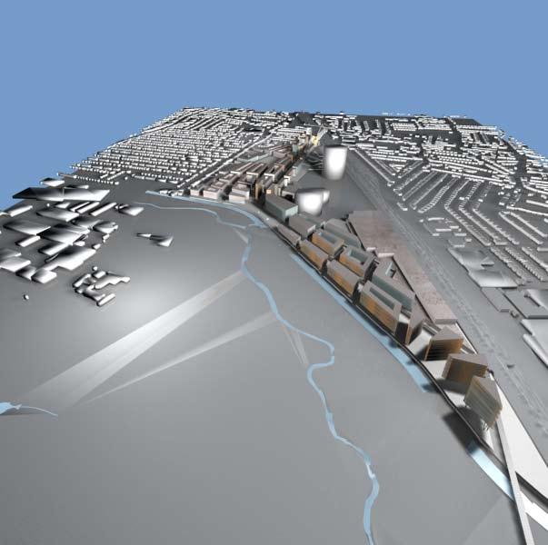
9 Illustrative masterplan Page 43


10 4:6. Masterplan and sustainability The Sustainability Strategy is set out in a separate report by WYG. In this section we describe how this strategy has influenced the Main Site masterplanning to create the Parameter Plans. This has drawn on URBED s experience over some 10 years on the Sustainable Urban Neighbourhood (SUN) Initiative, a project that has received funding from the UK Government and European Union to explore the creation of urban areas that are sustainable environmentally, economically and socially. This work has shown that all three aspects of sustainability are vital. Problems are created where a single issue such as solar orientation dominates. The former Southall Gas Works Parameter Plans are therefore guided by principles of social and economic sustainability relating to the density of development, the use of street-based perimeter blocks and a mix of uses. This is influenced by environmental sustainability, however the environmental standards relate more to the specification of the buildings and the energy and waste infrastructure described in the Sustainability Report. These issues have shaped the Parameter Plans in the following ways: Social sustainability: Location and Connectivity: The scheme seeks to integrate with the surrounding residential areas and with the centre of Southall. There will be limited vehicular connections to the local streets. There will however be a series of pedestrian links to maximise connections between new and existing development and to encourage residents to walk into Southall. Engagement and Social Capital: The scheme has been developed in consultation with local people as described in Communique's Consultation Report. Balanced Communities: The scheme has been designed to create a balanced community by adding to the diversity of housing in Southall. This has balanced housing needs identified by the council with housing demand. The scheme includes a mix of housing types, sizes and tenures so that, together with the surrounding communities it becomes a balanced community. Amenities and Services: The scheme is primarily concerned with meeting the needs of the development. However it does acknowledge the need to create facilities of benefit to the wider community. This includes a health centre that will take the pressure off local GPs, a community facility with sports pitches along the railway and a range of open spaces together with links to the Minet Country Park so that new and existing residents can gain access to good quality open space. Economic sustainability Economic Diversity: The Parameter Plans have drawn upon commercial advice to create a mix of employment uses including office space along the boulevard to create local jobs and to contribute to the economy of Southall. In total the scheme could include some 3,500 jobs thereby creating economic opportunities for local residents. Maximising benefits to local companies: The involvement of local companies and people in construction is a detailed issue. However the Parameter Plans have made provision for space for local businesses as suggested by the local regeneration agency. Page 44


 to ensure sufficient bin storage space.")
11 Local competitiveness: The type of retailing and leisure uses on the site will complement existing businesses in Southall. Consultations have been held with the local community who are supportive of a broader range of retailing that will add to the attractions of the area. Environmental sustainability Energy Use: The scheme will be designed to minimise energy use and achieve 10% renewables as set out in the Sustainability Report. While the Parameter Plans have not been dictated by solar orientation, the number of blocks with south-facing elevations has been maximised. The shading studies (Section 7.3) have been done to ensure that there is no significant loss of solar gain for the majority of properties. We have also sought to minimise single aspect units. The energy efficiency of new development is a detailed design issue that is covered in the Sustainability Report and will be developed in detail as part of reserved maters applications. Car Dependency: The reduction of car dependency is central to the scheme as set out in the Transport Assessment. This is achieved through restrictions of parking to zones of 50%, 70% and 100% depending on proximity to public transport. Provision is made for direct, pleasant and safe walking and cycling routes and provision is made in parking areas for cycle parking. Construction: The sustainable construction of the buildings and infrastructure of the scheme is a detailed matter that will be dealt with at the reserved matters stage. Waste Minimisation: The scheme is based a sustainable waste strategy that is able to accommodate a future where a majority of household waste is recycled. This has been explored through the housing typology work (Section 9) to ensure sufficient bin storage space. On the apartment blocks this will be accommodated in the communal waste stores accessible from street level. For the houses, bin space will be created in the curtilage in front of the housing. This will be developed at detailed design stage. There is also the potential to create a series of bring sites throughout the scheme depending on the recycling system being adopted by Ealing. Habitats and Biodiversity: The site currently has very little natural habitat other than some mature trees. The most important area is the canal and the scheme has been designed to leave a soft edge to the water to preserve this. The open space network has also been designed to create a series of connected spaces where new planting can encourage wildlife as described in Lovejoy s Landscape Strategy. This includes green fingers that connect the canal and Yeading brook corridor into the heart of the scheme. Water Use: Water use is covered in the Sustainability Report and will include measures to reduce water use and explore the recycling of waste water. Page 45
12 Page 46
Colchester Northern Gateway Master Plan Vision Review Draft. July 2016
 Colchester Northern Gateway Master Plan Vision Review Draft July 2016 Contents Introduction 4 Context 8 Purpose of the Report 8 Strategic Position 9 Overview of the Process 11 2012 Master Plan Vision 12
Urban Design Assessment
 3 Urban Design Assessment Page 27 3:1. Urban form Figure Ground The plan to the left is a 'figure ground' plan of the Southall area. This shows that Southall is a distinct place, surrounded by open land
Newcourt Masterplan. November Exeter Local Development Framework
 Newcourt Masterplan November 2010 Exeter Local Development Framework Background The Exeter Core Strategy Proposed Submission sets out the vision, objectives and strategy for the development of Exeter up
3.3. Urban Structure Defining a New Hierarchy of Routes and Spaces >Images
 Section 3.0 I The Masterplan Framework 18 >Images Examples of high quality routes and spaces 3.3. Urban Structure The success of any masterplan lies in a clear definition of the future urban structure
WELCOME GYPSY LANE. Wider Site Location plan. Proposals for the development of LAND OFF FOXLYDIATE LANE WEBHEATH. Proposals for the development of
 WELCOME The developers are preparing an outline planning application for a residential led development and need the community s views in order to develop the proposals further WHAT IS PROPOSED? A high
Peckham Peckham Area Vision Map
 Area Vision Map PNAAP13 PNAAP8 Sumner Road Surrey Canal Walk Bird in Bush Park Key: NSP Site Allocations PNAAP Allocations Greenspace Low Line Cycle Network Primary Shopping Areas Square Surrey Canal Walk
Public Consultation. Land at Monks Farm, North Grove. Welcome
 Welcome Welcome to our public exhibition for development on Land at Monks Farm, orth Grove. Gallagher Estates and Gleeson Strategic Land are preparing an outline planning application for new homes, open
Southall Gas Works: Design Statement by URBED with Capita Symonds, WYG, Lovejoys, Jestico and Whiles and RPSDesign Statement. The Site.
 2 The Site Page 17 2:1. Site context The site Rich habitat The site The site is roughly triangular in shape and runs from just to the west of Southall Railway Station for a mile along the main railway
01 the vision NEW LYNN IS WAITING FOR THE GREAT LEAP FORWARD
 [A] FRAMEWORK 01 the vision 02 the framework 03 urban design principles 04 c o n t e x t 05 issues a n d o p p o r t u n i t i e s 06 creating a t.o.d. 07 key recommendations 08 seven strategic areas of
Huddersfield Urban Design Framework. 3. Framework
 3. Framework The illustrative plan has been used as the basis for developing an urban design framework and strategy in Part 3 of this report. This is based on a series of regulatory plans that code the
Tāhuhu whakaruruhau ā-taone The sheltering ridge pole
 B2. Tāhuhu whakaruruhau ā-taone - Urban growth and form B2.1. Issues Tāhuhu whakaruruhau ā-taone The sheltering ridge pole Auckland s growing population increases demand for housing, employment, business,
16. Peckham Peckham Area Vision
 16. 16.1. Area Vision 16.1.1. is: A lively town centre providing a range of daytime and night time activities on Rye Lane including a Library, a Leisure Centre and many independent retailers which specialise
Environmental and Landscape Mapping
 Environmental and Landscape Mapping In support of the Calveley Neighbourhood Plan November 2016 Project Name and Number: Calveley Neighbourhood Plan 16-025 Document Name and Revision: Environmental and
Welcome to our exhibition
 Welcome to our exhibition housing development A46 Wildmoor Alcester Road Canal Quarter A422 Town Centre housing development Warwickshire-based IM Properties, one of the UK s largest privately owned property
Euston Area Plan - Examination: Statement in response to the Inspector s Matters, Issues and Questions
 1 Euston Area Plan - Examination: Statement in response to the Inspector s Matters, Issues and Questions Sydney and London Properties Limited June 2014 2 3 This document is the Statement in response to
ENVIRONMENTAL AND LANDSCAPE MAPPING
 APPENDIX IV : Environmental and Landscape Mapping ENVIRONMENTAL AND LANDSCAPE MAPPING Calveley Neighbourhood Plan November 2016 ENVIRONMENTAL AND LANDSCAPE MAPPING Calveley Neighbourhood Plan Calveley
Our City Centre is a vibrant, creative and welcoming destination, with a modern business, cultural, shopping, leisure and residential offer
 3. Sheffield in 2034 Our City sits at the heart of a strong, distinctive and internationally successful City Region economy which supports innovation and enterprise Our City Centre is a vibrant, creative
York Road Arial View
 Arial View Bridge Ave YORK ROAD THE SITE TODAY View west down View west from View east The 1.5 ha site is located south of the and to the east of Queen Street. The site includes an existing car park, disused
Chapter 2: OUTLINE PLANNING APPLICATION PROPOSALS. A New Garden Neighbourhood Matford Barton 17
 Chapter 2: OUTLINE PLANNING APPLICATION PROPOSALS A New Garden Neighbourhood Matford Barton 17 2.1. SUMMARY AND STATUS OF THE PROPOSALS 2.1.1. The parameter plans and associated wording in this chapter
Rochford District Council Allocations Development Plan Document: Discussion and Consultation Document Sustainability Appraisal
 Option SWH1 Balanced Communities Option SWH1 1 To ensure the delivery of high quality sustainable communities where people want to live and work Will it ensure the phasing of infrastructure, including
Soho Loop, Dudley Road
 01 Early artists impression of the Soho Loop site from the early stages of the design process Welcome Soho Loop Limited intend to submit new planning proposals for the derelict Soho Loop site on Dudley
Neighbourhood Planning Local Green Spaces
 Neighbourhood Planning Local Green Spaces Introduction... 2 1. Why green space is important... 4 2. Neighbourhood plans and green space... 6 3. Evidence... 8 Statutory designations... 9 Green space audit...
Horwood Map of London, Westminster & Southwark First edition
 Barratt London is developing plans in tandem with Southwark Council and TfL to transform the southern end of Blackfriars Road. The residential-led, mixed-use scheme will deliver new private and affordable
Land at Rampton Road. Cottenham
 Land at Rampton Road Cottenham Introduction TEP is preparing an outline planning application for 54 dwellings on 6.9 hectares of land adjacent to Rampton Road, Cottenham on behalf of the owners Cambridgeshire
REPORT BACK BROADSHEET 3 May 2016
 Paddington Place REPORT BACK BROADSHEET May 06 Architects and planners should work with the community first and then thinking about developers profits second. - Quote from participant at Paddington Place
Rotherhithe Rotherhithe Area Vision Map
 Area Vision Map CWAAP1 Improved pedestrian and cycle links to the wider area Improved link from town centre to River Thames and docks CWAAP2 Brunel Museum NSP79 CWAAP3 Proposed Thames Crossing Station
elbridge Core Strategy
 C elbridge Core Strategy Celbridge is designated as a Moderate Growth Town in the RPGs. The County Development Plan reinforces this designation in its settlement strategy. Moderate Growth Towns within
Shaping the heart of Stroud - Policy options
 Shaping the heart of Stroud - Policy options Objective Relevant LP policies Policy options (options may be inconsistent and/or conflict with one another) To make the town centre accessible by all modes
Taking forward the All London Green Grid
 Taking forward the All London Green Grid Foreword Earlier this year, the Mayor published the All London Green Grid Supplementary Planning Guidance to the London Plan which set the vision, and framework,
Table 8-4: Road Classification Local Roads, second table, of Chapter 8 Create a Multi-Modal City, be amended by adding the following:
 1 Port Street East Official Plan Amendment APPENDIX 3 Amendments to Mississauga Official Plan Table 8-4: Road Classification Local Roads, second table, of Chapter 8 Create a Multi-Modal City, be amended
Plan Modification to Chapter B2 of the Auckland Unitary Plan(AUP) Operative in part (15 November 2016)
 Operative in part (15 November 2016)") UNITARY PLAN UPDATE REQUEST MEMORANDUM TO FROM Phill Reid Linley Wilkinson DATE 25 September 2018 SUBJECT Plan Modification to Chapter B2 of the Auckland Unitary Plan(AUP) Operative in part (15 November
UNITARY PLAN UPDATE REQUEST MEMORANDUM TO FROM Phill Reid Linley Wilkinson DATE 25 September 2018 SUBJECT Plan Modification to Chapter B2 of the Auckland Unitary Plan(AUP) Operative in part (15 November
Housing Development at Balloonagh Tralee Co Kerry
 Design Statement Housing Development at Balloonagh Tralee Co Kerry Area of site 10,400m2 24 houses-12no 3 bed, 12no 2 bed and 4 single bed apartments total residential area of 2411m2 Open space provided
A VISION FOR BLAIRGOWRIE
 Welcome to the Westpark Partnership and Lidl UK GmbH Community Presentation. The purpose of this presentation is for you to view and comment upon the revised and updated proposals for the allocated development
HS2 Interchange Station Design
 Working on behalf of HS2 Interchange Station Design October 2018 www.hs2.org.uk 1 Interchange Station, Solihull Introduction In February 2018, HS2 Ltd appointed Arup to take forward the design of Interchange
Welcome to our public exhibition
 About Our Scheme Welcome to our public exhibition This exhibition gives you the chance to view and comment upon our emerging proposals for a new residential development of 68 new homes on the site of the
Introduction to MP3. MP3 H4 Park Central (North)
") MP H4 Park Central (North) Introduction to MP A visualisation of the Illustrative Masterplan with MP shaded in blue MP is the third phase of the Elephant Park regeneration and is bounded by on the north,
MP H4 Park Central (North) Introduction to MP A visualisation of the Illustrative Masterplan with MP shaded in blue MP is the third phase of the Elephant Park regeneration and is bounded by on the north,
8.0 Design and Form of Development 43/
 42/ 8.0 Design and Form of Development 43/ Rothwells Farm, Golborne/ Development Statement Figure 7. Site Constraints Key 44/ Site Boundary 360 Bus Route/Stops Existing Trees Underground Water Pipe Sensitive
ISIS BCC MADE. Warwick Bar Development in Eastside Birmingham. Artist s Brief
 ISIS BCC MADE Warwick Bar Development in Eastside Birmingham Artist s Brief Grand Union Canal towards Warwick Bar and city centre INTRODUCTION A lead artist is being sought to join the masterplanning team
5. Bankside and The Borough 5.1. Bankside and The Borough Area Vision
 5. 5.1. Area Vision 5.1.1. are: A globally significant central London business district which is home to international business headquarters; At the heart of the commercial and cultural life of the capital
Schedule of Planning Applications Committee Date: 23 May Reference: 06/17/0726/F Parish: Hemsby Officer: Mr J Beck Expiry Date:
 Schedule of Planning Applications Committee Date: 23 May 2018 Reference: 06/17/0726/F Parish: Hemsby Officer: Mr J Beck Expiry Date: 22-05-2018 Applicant: Proposal: Site: Mr Gillett Change of use to the
ELMVALE ACRES SHOPPING CENTRE MASTER PLAN
 ELMVALE ACRES SHOPPING CENTRE MASTER PLAN Contents 1.0 INTRODUCTION... 2 2.0 LOCATION... 2 3.0 EXISTING CONTEXT... 2 4.0 VISION & GUIDING PRINCIPLES... 2 5.0 LAND USE AND BUILT FORM... 4 5.1 St. Laurent
WELCOME. North East Haverhill. The Planning Process
 WELCOME North East The site to the North East of, known as Great Wilsey Park, is identified by St Edmundsbury Borough Council in its Core Strategy as capable of delivering a Sustainable Urban Extension.
Northern Territory Compact Urban Growth Policy
 Northern Territory Compact Urban Growth Policy A Reference Policy Document to clause 2.7 (Reference to Policy) of the NT Planning Scheme May 2015 Table of Contents 1 Policy Setting... 3 1.1 Context for
Welcome to our exhibition
 Welcome to our exhibition The Homes & Communities Agency (HCA) welcomes you to this public exhibition explaining our proposals for the redevelopment of the former Lea Castle Hospital site. About the Homes
Kibworth Harcourt. Introduction. Introduction
 Introduction Introduction Welcome to this public exhibition on the proposals for the delivery of new homes on land at The Kibworths. The purpose of today s exhibition is to give you the opportunity to
Stantonbury Neighbourhood Plan
 Stantonbury Neighbourhood Plan 2018-2031 Basic Conditions Statement October 2018 Intentionally blank 1.0 Basic Conditions Statement Introduction 1.1 This statement has been prepared by Stantonbury Parish
V. Vision and Guiding Principles
 V. Vision and Guiding Principles The Master Plan for the Powers Ferry Corridor seeks a foundation in the desires of the community. At times, various elements of the community offered opposing viewpoints,
Design Guidance. Introduction, Approach and Design Principles. Mauritius. November Ministry of Housing and Lands. .. a
 sig evelo r D Mauritius s. Utilities.. Individu a s. er itects.to ls chpers.po e Public. T. h rban D Sc U e me Promot e h ners. A Design Guidance o.h Planne rs n w iticians r l useholde National Development
Response to the London Bridge Area Vision and Site Allocations within the New Southwark Plan
 1 Melior Place London SE1 3SZ 020 7407 4701 teamlondonbridge.co.uk info@teamlondonbridge.co.uk 28 April 2017 Response to the London Bridge Area Vision and Site Allocations within the New Southwark Plan
Droitwich Spa 6. Reasoned Justification
 87 Droitwich Spa 6 Reasoned Justification 6.1 Droitwich Spa is identified in the settlement hierarchy (Policy SWDP1) as a main town being the largest settlement in Wychavon District with an estimated population
PROPOSED REDEVELOPMENT OF THE GLEN ABBEY GOLF CLUB. STREETSCAPE DESIGN STUDY (excerpt from the Urban Design Brief) TOWN OF OAKVILLE.
 TOWN OF OAKVILLE.") PROPOSED REDEVELOPMENT OF THE GLEN ABBEY GOLF CLUB STREETSCAPE DESIGN STUDY (excerpt from the Urban Design Brief) TOWN OF OAKVILLE OCTOBER, 2016 for 2.4.2 STREETS Streets are the single largest component
PROPOSED REDEVELOPMENT OF THE GLEN ABBEY GOLF CLUB STREETSCAPE DESIGN STUDY (excerpt from the Urban Design Brief) TOWN OF OAKVILLE OCTOBER, 2016 for 2.4.2 STREETS Streets are the single largest component
SUB AREA 3 CENTRAL STRATFORD AND SOUTHERN QUEEN ELIZABETH OLYMPIC PARK
 191 ADOPTED LOCAL PLAN: THE SUB AREAS SUB AREA 3 CENTRAL STRATFORD AND SOUTHERN QUEEN ELIZABETH OLYMPIC PARK SECTION 12 Vision VISION Central Stratford and Southern Queen Elizabeth Olympic Park will become
WELCOME. Land North of STEVENAGE. We would like to thank you for attending our public exhibition today.
 WELCOME We would like to thank you for attending our public exhibition today. The purpose of this event is to share our proposals and hear your thoughts on our ideas. Members of the project team are on
The Proposed Auckland Unitary Plan (notified 30 September 2013)
") 3 Business zones Introduction There are 10 business zones in the Unitary Plan: City Centre Metropolitan Centre Town Centre Local Centre Neighbourhood Centre Mixed Use General Business Business Park Light
3 Business zones Introduction There are 10 business zones in the Unitary Plan: City Centre Metropolitan Centre Town Centre Local Centre Neighbourhood Centre Mixed Use General Business Business Park Light
Design and Access Statement Volume I Part 7 of 9 Masterplan. May 2018 Allies and Morrison
 Design and Access Statement Volume I Part 7 of 9 Masterplan May 2018 Allies and Morrison 4.3 Central Cluster 303 CANADA WATER MASTERPLAN Design and Access Statement May 2018 4.3 Central Cluster L H K
2.0 Strategic Context 4
 2.0 Strategic Context 4 2.1 The Area Action Plan is a non-statutory plan, which forms a corporate policy document, expressing particular issues and areas of concern while also providing a vision for the
Place Brief. National Collections Facility (NCF site)
") Place Brief. National Collections Facility (NCF site) Contents 1.0 Purpose 2.0 Location and Proposal 3.0 Vision and Aim 4.0 Placemaking Principles 5.0 Conclusion Plan 1 Location Plan Plan 2 Placemaking
Place Brief. National Collections Facility (NCF site) Contents 1.0 Purpose 2.0 Location and Proposal 3.0 Vision and Aim 4.0 Placemaking Principles 5.0 Conclusion Plan 1 Location Plan Plan 2 Placemaking
Chapter 5 Urban Design and Public Realm
 5.1 Introduction Public realm is all areas of the urban fabric to which the public have access. It is where physical interaction takes place between people. It therefore, includes buildings and their design,
UDF PLANS AND GUIDELINES
 UDF PLANS AND GUIDELINES 5 Land Use Land Use Development Plan Plan no. 3 Land Use Development Mixed Use Retail / Leisure Residential Civic and Institutional Proposed Zoning Table Development Edges Plan
WELCOME TO THE NEW WILTON PARK
 WELCOME TO THE NEW WILTON PARK VISION HISTORY OF WILTON PARK TOWARDS A PLANNING APPLICATION Our objective is to create a truly outstanding environment at Wilton Park. At the heart of our proposals is a
Woodbrook - Shanganagh
 Section 4: Key Sites Framework Strategy Woodbrook - Shanganagh Local Area Plan 2017-2023 4. Site Framework Strategies The Master Plans shall have regard to the thematic objectives under the LAP Development
Page 1 of 19 URBAN DESIGN FRAMEWORK FOR BOLTON STREET WATERFORD
 Page 1 of 19 URBAN DESIGN FRAMEWORK FOR BOLTON STREET WATERFORD 1.0 Introduction: The relocation of the City Council stores and depot from Bolton Street creates an exciting opportunity for development
BLETCHLEY PARK AREA - DEVELOPMENT FRAMEWORK
 ANNEX A To Item 9 REVISED TEXT: additions shown bold and underlined, deletions in (brackets and in italics). BLETCHLEY PARK AREA - DEVELOPMENT FRAMEWORK This framework sets out the key objectives and requirements
Urban Design Guidelines
 Urban Design Guidelines These Urban Design Guidelines comprise the Key Design Objectives below, the Roads Design Guidelines overleaf and Neighbourhood Framework Plans. Together with Section 3: Urban Design
THE PROJECT KEY FACTS & FIGURES SOUTHALL GASWORKS EXPECTED BENEFITS
 SOUTHALL GASWORKS THE PROJECT KEY FACTS & FIGURES THE PLANNING CONSENT THE CHALLENGES EXPECTED BENEFITS LAND ASSEMBLY Secure land or rights over different land interests to implement development ACCESS
SQUAMISH 2010 AND BEYOND COMMUNITY VISION
 Our plan has been imagined and created to be both pragmatic and visionary. At the core of the strategy is a consideration of the highway s role and its impact on the community. First and foremost in creating
Longbridge Town Centre Phase 2 Planning Application
 Longbridge Town Centre Phase 2 Planning Application Non-Technical Summary of the Environmental Statement December 2013 Introduction A full application for Planning Permission has been submitted to Birmingham
Elephant and Castle. Elephant and Castle Area Vision Map. Elephant and Castle. 216 New Southwark Plan Proposed Submission Version NSP42 NSP49 NSP44
 Area Vision Map Lamberth North Station Waterloo Road Southwark Station NSP49 NSP43 Blackfriars Rd St George s Road Borough Road NSP48 Great Suffolk Street NSP42 NSP44 NSP45 Borough Station Newington Gardens
13. London Bridge London Bridge Area Vision
 13. 13.1. Area Vision 13.1.1. is: A globally significant central London business district which is home to international business headquarters; Internationally renowned for its prominent riverfront location
January Galashiels Development Parcels
 January 2018 Galashiels Development Parcels 3 This document summarises each of the key Galashiels Projects. The business case for each project will contain additional information to assist with costing.
1.0 INTRODUCTION. Brantham Industrial Area Regeneration - Factory Lane - Brantham
 1.0 INTRODUCTION Welcome to this exhibition of our proposals for the regeneration of the Brantham Industrial Area located off Factory Lane in Brantham. This presentation will give you an opportunity to
Has there been interest in the site from other parties since St. Modwen owned it? No
 Wolverton Works Q&A from November Public Meeting January 2016 1. General Proposals Can you explain the phases and why they have been timed in the way they have? The discount foodstore will be delivered
CHAPTER 3 VISION, GOALS, & PLANNING PRINCIPLES. City of Greensburg Comprehensive Plan. Introduction. Vision Statement. Growth Management Goals.
 CHAPTER 3 VISION, GOALS, & PLANNING PRINCIPLES Introduction The Greensburg Comprehensive Plan is intended as a working community document. A combination of long and short-term goals, this document is intended
Welcome. Walk Around. Talk to Us. Write Down Your Comments
 Welcome This is an information meeting introducing the applications for proposed redevelopment of the Yorkdale Shopping Centre site at 3401 Dufferin Street and 1 Yorkdale Road over the next 20+ years,
Vision for Mayfair and Belgravia
 Vision for Mayfair and Belgravia Vision for Mayfair and Belgravia Foreword We have a 20 year vision for Mayfair and Belgravia. It summarises our aspirations for the future of this London estate, which
Tauranga City Centre Spatial Framework
 Tauranga City Centre Spatial Framework Stakeholder Engagement Workshop 15 October 2015 Project Design Team Beca & LandLAB Our team Henry Crothers (LandLab) Landscape Architect/Urban Designer Urban and
A. The sites in Table 16 below, as identified on the Policies Map, are allocated for retail-led development:
 SWDP 44: Worcester City Centre A. The sites in Table 16 below, as identified on the Policies Map, are allocated for retail-led development: Table 16: Sites Allocated for Retail-Led Development Policy Reference
1.0 VISION STATEMENT. December 6, PRINCIPLES
 Vision Statement Lincoln Regional Airport 1.0 VISION STATEMENT 1.1 City LOCATION of AND OVERVIEW The Easton Lincoln Place Land Use Master Plan identifies the principles, goals, policies, and standards
Scottish Natural Heritage. Better places for people and nature
 Scottish Natural Heritage Better places for people and nature Contents Summary... 3 SNH approach... 5 Place-making in policy and practice... 6 Developing the contribution of the natural heritage to place-making...
Croydon s Future. Councillor Paul Scott Chair Of the Planning Committee Croydon Council
 Croydon s Future Councillor Paul Scott Chair Of the Planning Committee Croydon Council capacity for London s growth 1x croydon COA = Our COA has significantly more capacity than other Opportunity Areas
University Park, Worcester Non Technical Summary December 2011
 University Park, Worcester Non Technical Summary December 2011 Introduction UW Wrenbridge LLP, a Joint Venture Company of the University of Worcester and Wrenbridge Land Ltd (the Applicants ) intend to
SITE ASSESSMENT CHECKLIST
 1. Site Details a. What is the site s name/reference? SITE ASSESSMENT CHECKLIST CR3NPWHY 3007 Gasometer Site Godstone Road CR3 0EG b. Where is the site located? Wyhteleafe; Godstone Road. Urban category1
3.1 The hybrid planning application proposes the following description of development:
 CHAPTER 3: PROPOSED DEVELOPMENT 3.1 The hybrid planning application proposes the following description of development: Hybrid (part-outline/part-full) planning application for a single composite development
Urban Development and Upgrading of Unplanned Districts of Jeddah, Saudi Arabia. Bani-Malek East Al-Boughdadiyah. 10th October 2012
 Urban Development and Upgrading of Unplanned Districts of Jeddah, Saudi Arabia Bani-Malek East Al-Boughdadiyah 10th October 2012 Presentation Overview Introduction Effat Team Principle of Sustainable urbanism
AOTEA SUPERMARKET ZONE. Zone Introduction
 C18 AOTEA SUPERMARKET ZONE Zone Introduction C18.1 Objective This zone identifies a specific area in Aotea for a stand alone supermarket. The zone is site specific and has a range of objectives, policies
Draft Eastern District Plan
 Draft Eastern District Plan Submission_id: 31238 Date of Lodgment: 13 Dec 2017 Origin of Submission: Online Organisation name: Turrulla Gardens Pty Ltd C/- Mecone Organisation type: Industry First name:
New Bolton Woods Cricket Club
 New Bolton Woods Cricket Club 1 1. New Bolton Woods Partnership Area What IS THIS ALL ABOUT? New Bolton Woods Ltd is a development partnership between regeneration company Urbo and Bradford Council. It
WELCOME. Spend a little Live a lot. View of store entrance, overlooking the adjacent park - bonded warehouse detailing
 WELCOME View of store entrance, overlooking the adjacent park - bonded warehouse detailing Aldi is pleased to be bringing forward a planning application to develop a new discount foodstore on Commercial
Draft Western District Plan
 Powered by TCPDF (www.tcpdf.org) Draft Western District Plan Submission_id: 31440 Date of Lodgment: 15 Dec 2017 Origin of Submission: Online Organisation name: Goodman Property Services Australia Pty Ltd
ROCHFORD LOCAL DEVELOPMENT FRAMEWORK: Sustainability Appraisal/ Strategic Environmental Assessment. Rochford Core Strategy Preferred Options Document
 ROCHFORD LOCAL DEVELOPMENT FRAMEWORK: Sustainability Appraisal/ Strategic Environmental Assessment Non Technical Summary Rochford Core Strategy Preferred Options Document October 2008 SUSTAINABILITY APPRAISAL
The Five Components of the McLoughlin Area Plan
 The Five Components of the McLoughlin Area Plan This documents contains the complete language of the five components of the McLoughlin Area Plan: The Vision Statement The Values The Guiding Principles
C. Westerly Creek Village & The Montview Corridor
 C. Westerly Creek Village & The VISION Community Vision When the goals of the city are achieved Westerly Creek Village, a distinctive community defined by Montview Boulevard and Westerly Creek, is a strong
DUBLIN DOCKLANDS MASTER PLAN AND RELATIONSHIP WITH OTHER PLANS
 .1 National Policy and Programmes.1.1 Sustainable Development A Strategy for Ireland, 1997.1.2 National Climate Change Strategy, 2007-2012.1. National Development Plan 2007-201.1.4 National Spatial Strategy,
6 Site Framework Strategies
 6 Site Framework Strategies 6.1 Introduction Section 6 identifies a number of specific areas which are considered to be key sites within the Plan area and which may have potential for development / redevelopment.
10. East Dulwich East Dulwich Area Vision
 10. 10.1. Area Vision 10.1.1. is: A predominantly residential area characterised by mostly medium density housing, including many family homes. Many parts of have retained historic character and it includes
PHASE III: Reserved Matters Submission
 Statement of Compliance with the outline approval for the proposed residential development of land at: BURGES LANE, WIVELISCOMBE PHASE III: Reserved Matters Submission Foreword Contents: This Statement
COURTHOUSE CAMPUS BARNSLEY Executive Summary March 2010
 COURTHOUSE CAMPUS BARNSLEY Executive Summary March 2010 Estell Warren Cartwright Pickard Buro Happold King Sturge BWA Barnsley Metropolitan Borough Council introduction Courthouse Campus is the last major
Table of Allocated Housing Sites
 Draft as of 0 November 016 Table of Allocated Housing s Name Green 1 (30, 33, 10, 169, 36/ 100) Barratt s Farm Balsall Common Yes 57 800 Includes existing park. Listed buildings to edge of site. of search
0 9 Areas of Change 59
 09 Areas of Change 59 09 Areas of Change This section explores seven areas of change within Solihull Town Centre which provide practical interventions in order to deliver the emerging concepts outlined
Create Policy Options Draft Plan Plan Approval. Public Consultation Events. Phase 2
 Background Grandview-Woodland Community Plan In the spring of 2012, the City of Vancouver embarked on a comprehensive community planning program in the Grandview-Woodland neighbourhood. The process has