PUBLIC REALM DESIGN PLAN APRIL, 2012
|
|
|
- Brent Snow
- 5 years ago
- Views:
Transcription


1 PUBLIC REALM DESIGN PLAN APRIL, 2012

2

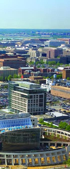
3 Introduction NoMa is growing quickly. Fueled by transit accessibility, proximity to both Downtown and Capitol Hill and streamlined entitlements, the neighborhood has seen over $6 billion in private investment since Approximately half of NoMa s 34 million square feet of development potential is built out to date. Office uses developed initially but over time the complexion of NoMa has become increasingly mixed-use. Of the 10,000 planned overall, 3500 residential units are either built or under construction within the boundary of the Business Improvement District (BID) as of February The growing population of residents and employees is significant but the businesses, amenities and public spaces in NoMa must serve more than those who live and work within the BID boundary. Tens of thousands live within walking distance of the retail destinations on First Street NE. NoMa represents the most convenient shopping opportunity for some adjoining communities as well as the greatest potential for improving access to recreational amenities. Currently, there are few dedicated sites for parks within NoMa. As development continues, the public realm must provide the transportation, environmental, recreation and social amenities needed to ensure a high quality of life. The public realm is the physical and symbolic connection between people and meeting these demands requires optimized use of public property and right of way as well as creative partnerships on privately controlled land. This plan identifies an openspace framework, destinations and design opportunities that enhance private development and establish a distinctive, active, and sustainable public realm. Transportation Environment Public Realm Social Recreation 1


4 Input from Stakeholders The planning process began with review of previous planning efforts and community outreach. More and more residents and workers identify their neighborhood as NoMa and their opinions and preferences should guide public realm enhancements. The BID and the planning team interviewed a number of NoMa residents, workers, property managers, developers and individuals involved in previous planning efforts. The goal of this stakeholder engagement was to understand the motivations and aspirations of each constituent group and solicit suggestions from the people who will use the public realm every day. Overall, the people who currently live in, and will likely move to, NoMA can be considered an active, social group of young professionals who commute largely via transit, bicycle or on foot. The surrounding neighborhoods are more mixed in age and include a greater number of families. The resident group consistently identified the need to overcome barriers like New York Avenue and North Capital Street and connect the community better in an east/west direction. The employee group was most interested in new outdoor amenities that could be enjoyed at lunch. A common theme between all groups was that one central park would not be sufficient, that a system of connected, flexible open spaces with a variety of amenities would better serve the community. The design team asked a few specific questions to help shape recommendations. The questions and the most common answers are listed below. What is NoMa s greatest strength? Transit accessibility Proximity to employment Emphasis on green development Events like summer screen and the farmer s market What is NoMa s greatest weakness? Sterile or uninviting east/west streets Lack of park space Low visibility from outside the neighborhood What is the most important element to add within the public realm? Comfortable places to sit Outdoor fitness facilities Lush landscaping Gathering space for events Place to throw out a blanket and picnic/read Places to eat lunch Additional facilities for bicycles Playgrounds Community dog parks Art installations Gateway elements that announce the neighborhood Signature post card moments 2


5 Public Realm Design Principles To address the needs of NoMa stakeholders the public realm must be designed as part of a new type of city. This new city is an environment where an active lifestyle coincides with historic significance, interactive art and enhanced urban ecology. With that in mind, the concepts and recommendations within this plan area based on the following Principles: Focus on enhancing public property first. Integrate new public space with adjacent private development. Design streetscapes to function as linear parks. Provide scalable gathering spaces to support a variety of events. Create signature spaces that become community focal points. Establish a series of park spaces distributed throughout NoMa. Create streetscapes that are unified in appearance but not uniform. Optimize pedestrian and bicycle convenience and comfort. Incorporate low impact development runoff management. Create interactive artistic experiences. Embrace historic elements and incorporate the railroad influence. Accomodate needs of families with children. 3

6 Opportunities The planning process considered multiple factors when evaluating opportunity sites for signature spaces and streetscape enhancements including the locations of: Existing and or previously planned public spaces Existing and or previously planned community destinations Existing open spaces such as the Metropolitan Branch Trail and Columbus Circle. Significant opportunities to integrate public space and future private development Previously planned public spaces such as the plaza north of the Uline arena, the park proposed in phase II of the Loree Grand, Burnham Park at First and K Streets NE, High Point Park south of the NoMA Metro station, Pepco Park and First Street Park. Significant opportunity to cluster amenities Existing community destinations such as Union Station, Galludet University, H Street and the Harris Teeter Grocery store. Previously proposed destinations such as the to-be-renovated Uline Arena, the Florida Avenue Market redevelopment, the Walmart site. Development sites were identified that held significant potential integrate public space during their eventual redevelopment. The area bounded by First Street, M Street, Third Street and K Street emerged as a center of gravity for proposed amenities that can add value to private development, connect the community and establish a distinctive sense of place. 4 Public space considerations diagram

7 Public Realm Framework The proposed public realm framework establishes connections between parks on public land, within the public right of way and on adjacent private land with limited development potential. The public realm system incorporates existing destinations, previously planned parks and proposed public space enhancements. The framework diagram illustrates the public realm network and locations of signature spaces. More information about each location can be found on the pages listed. The following pages highlight the signature spaces within the framework. Public realm framework diagram 5


8 L Street Plaza This signature space utilizes the L Street right of way and small strips of adjacent private land to create a flexible gathering area for festivals, exhibits and outdoor dining. Part plaza, part park, L Street is scalable to stage events of all sizes. The central space is broad enough to incorporate interactive fountains, shaded seating and a pavilion venue for the farmer s market, summer screen, art exhibits and other community events. L Street Plaza creates a new east/west linkage as well as an opportunity to connect to the Metropolitan Branch Trail adjacent to the railroad tracks. This connection can be made via bicycle lanes along the street or a cycle track through the central space. L Street NE First Street NE Concept Sketch Plan Location Existing conditions NORTH 6

9 Future Development Metropolitan Branch trail Railroad Tracks Existing Development Future Development Railroad Tracks Second Street NE Future Development 7

10 L Street Plaza L Street Plaza is envisioned with narrow, calm, curbless travel lanes for vehicles. The street can be closed to traffic to support larger events. View from First Street NE looking east 8

11 The L Street railroad bridge can be enhanced with additional pedestrian space and projected art and light effects. Bridges throughout NoMa can employ a similar treatment. 9


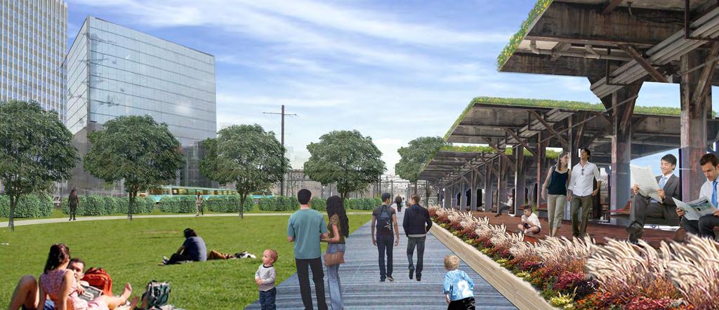
12 The Tracks Park The Tracks Park offers a unique setting for active and passive recreation adjacent to the railroad. Currently a privately owned parking lot with constrained development potential, The Tracks Park site sits at the train level and is surrounded by the Burnham wall, the traction station and the catenary structures of the railroad. By reconfiguring the parking, the 1.7 acre site can provide for neighborhood recreation and fitness as well as a significant dog park and overlooks for observing the trains. The site is level with the Second Street and I Street Intersection and can be accessed vertically from L Street. A pedestrian bridge across Second Street can also connect to the park within the Loree Grand development. The existing parking could either be reconfigured as an above grade structure or built below the park. The Tracks Park can also include connections to the Burnham Place Development Location Existing conditions NORTH Concept Sketch Plan 10

13 View of the great lawn looking north 11


14 The Breezeway The Breezeway is an under-utilized asset that can incorporate art, play elements, vending kiosks and or seating opportunities in addition to bicycle storage. The Breezeway s shade and weather protection make it a unique community feature. Existing condition Location View of the breezeway looking north 12


15 N Street Park Existing condition The N Street corridor between 3rd Street and Florida Avenue provides limited parking and circulation. If combined with the modest triangular private parcel to the north, a public space can be created that serves the adjoining neighborhood, improves pedestrian conditions along Florida Avenue and integrates with development south of N Street. Florida Avenue and N Street View from the N Street and Florida Avenue intersection looking west Location 13


16 The Gateway The intersection of First Street and New York Avenue acts as a gateway both to NoMA and greater Downtown area. This dual gateway can be made legible by incorporating two sets of sculptural elements; one located on the ATF site and the other installed in the O Street corridor west of First Street. Existing condition Location View along New York Avenue looking west 14

17 Railroad Bridge Enhancements The railroad bridges at Florida Avenue, M Street, and K Street are a characteristic features of NoMA. They are vital east/west community connections as well that can be enhanced by incorporating light and art. These enhancements could support public safety and establish a distinct atmosphere that simultaneously acknowledges NoMA s history and future. Example of artistic enhancements to railroad bridges Location 15

18 Additional Public Realm Opportunities Additional public space opportunities exist within NoMa. These destinations and connections are also integral components of the public space system that serve the community: Pepco Park - The undeveloped Pepco site east of Harry Thomas Way has the scale and proximity to be an active recreation resource. Metropolitan Branch Trail- The existing trail supports commuting and recreation and would ideally continue as an elevated trail to Union Station with an additional community connection at L Street. New York and N Street Public Art- This highly visible intersection is a prime location for public art and simplified vehicular circulation. M Street Park- relocation of the District of Columbia offices on this parcel can open its potential to serve neighborhood recreation needs west of First Street. Highpoint Park- Identified during previous planning efforts, Highpoint Park can be a linear venue for art inspired by the movement of the railroad. Congress Street- Congress Street can be enhanced as a plaza space supporting adjacent retail and office development. Loree Grand Park- The park space planned within the Loree Grand development will offer public amenities to the eastern edge of the neighborhood. Second Street Pedestrian Priority Area- Limiting vehicular access along Second Street, adjacent to the Uline Arena, would allow for event staging, and a wider bicycle corridor. Burnham Place- Future development above the rail yard will incorporate public space amenities and multiple connection points to the surrounding NoMa neighborhood. First Street Pedestrian Priority Area- Originally recommended in the 2010 neighborhood access study, the segment of First Street between Massachusetts Avenue and G Street can better accommodate pedestrian access to the Union Station Metro Station and shuttle service drop-off and loading if vehicular access is limited. 16


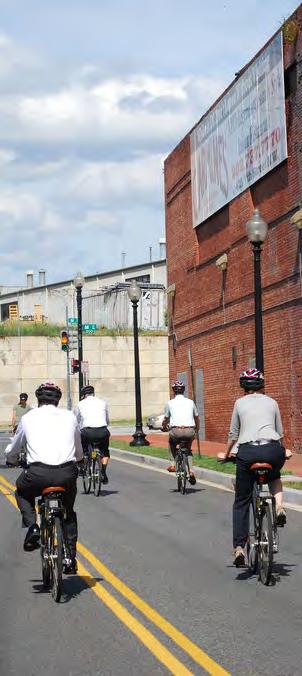
19 Walkability and Bicycle Infrastructure Bicycle connectivity is an important amenity for the current and future residents and commuters to NoMa. Improving facilities for bicycle circulation will reduce local vehicle trips and associated congestion. Similarly, ensuring two-way vehicular traffic on all NoMa streets will calm traffic and support enhanced walkability. Bicycle Lanes Cycle Track or Bicycle Lanes Metropolitan Branch Trail Pedestrian/Bicycle Priority Street Recommended Bicycle Infrastructure 17

20 First Street NE Design Concept First Street from K Street to Florida Avenue is intended to function as a linear park with a variety of seating opportunities, gardens, integrated artwork and commercial amenities at frequent intervals. The sidewalk space is configured to aggregate amenity space where it is most usable, to provide clear sidewalk where pedestrians naturally want to be and to allow cafe space for ground floor commercial uses. Public Art Information / Retail kiosk Seating area/outdoor living room Café zone Clear sidewalk Planting, LID and amenity zone Step out Location Conceptual rendering of recommended streetscape elements and proportions 18

21 First Street NE Design Concept - Typical Block Streetscape elements are arranged in a unified, rather than uniform, manner to accommodate changing below-grade constraints and transitions between existing and newly constructed street segments. Conceptual plan depicting a typical block and recommended streetscape elements and dimensions 19
22 First Street NE Design Concept - Typical Section The design concept allows flexibility between the curbs to configure the roadway for on street parking and bicycle lanes or a combination of on-street parking and two-way cycle track. The amenity space behind the curb can be designed to incorporate low impact development storm water management techniques and adequate uncompacted root space for street trees. Whenever feasible, a double row of staggered street trees should be provided. BUILDING FACADE BUILDING FACADE FLUSH CURB LID AND ROOT ZONE LID AND ROOT ZONE CAFE CLEAR SIDEWALK VARIABLE PLANTING/ STEP PARKING/ TRAVEL TRAVEL PARKING/ STEP VARIABLE PLANTING/ SIDEWALK SEATING AREA OUT TRAVEL TRAVEL OUT SEATING AREA CROSS SECTION WITHOUT BICYCLE FACILITIES PARKING TRAVEL TRAVEL BICYCLE TRACK 40-0 CROSS SECTION WITH BICYCLE TRACK OPTION PARKING BICYCLE LANE TRAVEL TRAVEL BICYCLE LANE 40-0 CROSS SECTION WITH BICYCLE LANE OPTION 20
23 First Street NE Design Concept - Section Variations EXPANDED SIDEWALK BUILDING FACADE BUILDING FACADE CAFE ZONE The design concept encourages variation along the streetscape. The amenity zone can be configured in multiple ways to accommodate additional sidewalk space or cafe zone, public art installations and seating areas that function as outdoor living rooms. The illustrations on this page convey potential configurations. LID AND ROOT ZONE LID AND ROOT ZONE 10-0 CLEAR SIDEWALK 10-0 CLEAR SIDEWALK ART INSTALLATION OUTDOOR LIVING ROOM BENEATH TREES OPTIONAL FACADE INSET BUILDING FACADE BUILDING FACADE LID AND ROOT ZONE 10-0 CLEAR SIDEWALK 10-0 CLEAR SIDEWALK 21
 The design concept for east/ west streets is a variation on the First Street concept including the curbside amenity zone and broad sidewalk adjacent to the")
24 90 r.o.w. Design Concept ( N, M, and L Streets) The design concept for east/ west streets is a variation on the First Street concept including the curbside amenity zone and broad sidewalk adjacent to the buildings with integrated cafe space. Streetscape materials shall be similar to First Street. The existing curb line can be altered to provide on-street parking on either side of the street. The parking lane shall incorporate permeable pavements to capture run-off and improve water quality. Seating area/outdoor living room with permeable pavement Parking lane if desired by developer Location Conceptual rendering of recommended streetscape elements and proportions
 Street lighting with decorative light panel Permeable pavement within parking lane Narrow streets like Pierce and Patterson shall take on their own")
25 50 r.o.w. Design Concept (Pierce and Patterson Streets) Street lighting with decorative light panel Permeable pavement within parking lane Narrow streets like Pierce and Patterson shall take on their own variation of the same concept including permeable on street parking along one side of the street, travel lanes shared by bicycles and vehicles and a characteristic lighting approach to provide interest and a safe atmosphere in the evening. These streets can provide locations for shallowdepth neighborhood commercial amenities and enhanced east/west connectivity Conceptual rendering of recommended streetscape elements and proportions 11 8 Location 23

26 Mid-block Alley System A mid-block alley system, running parallel to North Capitol Street, can reduce congestion on First Street, improve circulation choices within NoMa and provide service access to adjoining development. Moving service and garage access from the east/west streets to an alley allows for more leasable street frontage. Conceptual section through mid-block alley Conceptual location of the mid-block alley 24


27 Animating Existing Spaces There are a number of unwelcoming streetscapes in NoMa that can be enhanced to better support the neighborhood. In many cases, building facades do not create an inviting sense of scale or sufficiently animate the public realm. These undefined spaces can be improved by adding architectural elements that orient pedestrians, provide weather protection and establish a human scale environment. Vertical gardens can also be added to improve visual appeal, augment air quality and support urban agriculture. Illustration of architectural elements used to create an inviting human scale Example of green wall used to animate a pedestrian pathway. Existing condition 25


28 Site Furnishings Site furnishings shall utilize responsibly harvested wood or recycled materials and stainless steel or visually similar, powder coated steel components. Benches and chairs shall include arms. A consistent tree fence should be utilized at the edges of all planters to unify the streetscape. Robert tree fence by Landscape forms Neoliviano Bench and Parc Center Table by Landscape forms 26

29 Street Lighting Street lighting offers a significant opportunity to differentiate the community. Standard lights and poles can be used in combination with custom elements to create a lighting system unique to NoMa. These tailored features can be incorporated at signature locations and incorporate electrical connections for staging events. The concept shown on this page incorporates street and pedestrian oriented lighting in a manner that reflects the form of near-by railroad structures. Illustration of street lighting concept 27

30 Vending and Information Kiosks Vending and information kiosks can be part of a vibrant streetscape and add vitality in areas where ground floor retail is not present. 28 Products by sddretail, GES Global Network illustrate the recommended kiosk style


31 Planting Design Planting design within the amenity zone shall reflect the dynamic rhythm of the railroad. Linear bands shall be arranged in straight or curvilinear segments running approximately parallel with the curbline. A palette of contrasting colors and textures are recommended to make the rhythm legible. The images below depict examples of the recommended concept. Image: SWA Group London Plane Tree shall be the unifying street tree along First Street NE. Image: SWA Group 29
32
DRAFT. October Wheaton. Design Guidelines
 October 2011 DRAFT Wheaton Design Guidelines 2 Draft - Design Guidelines - Wheaton Sector Plan Contents 04 Section 1: Introduction 06 Section 2: Context 08 Section 3: Design Guidelines 09 Goal 1: Create
3.1 community vision. 3.3 required plan elements
 Chapter 3 Community Form 3.1 community vision 3.2 Parks & landscaping concepts 3.3 required plan elements D R A F T 20 Community Form Chapter 3 3.0 Community form 3.1 community vision The Specific Plan
New York Avenue Streetscape and Trail Project Public Meeting #1 Summary
 New York Avenue Streetscape and Trail Project Public Meeting #1 Summary I. King Jordan Student Academic Center (SAC) Gallaudet University, Washington, DC February 23, 2017 Table of Contents 1.0 Introduction...
PUBLIC RIGHT-OF-WAY IN THIS CHAPTER PUBLIC REALM
 PUBLIC RIGHT-OF-WAY This section provides design guidelines for improvements in the public right-of-way. The public right-of-way refers to streets, sidewalks, non-vehicular thoroughfares, parks and greenways
Transportation. Strategies for Action
 Transportation A major priority for the Overlake Neighborhood is to develop a multimodal transportation system. To achieve this system, a balance has to be found among travel, circulation and access needs;
DRAFT. 10% Common Open Space
 % OF CHARLOTTE IS CATEGORIZED AS A. LAND USES : Placeholder map displaying location of Place Type GOALS: Accommodate XX% of future growth. Provide a concentration of primarily commercial and civic activity
Town Center. Block 5 Existing multifamily residential units are expected to remain.
 Area Guidelines Germantown s districts should be developed as distinct communities with unique features that are supported through the guidelines. The guidelines not only help distinguish these districts
VISION AND GUIDING DESIGN PRINCIPLES
 pleasure point commercial corridor VISION AND GUIDING DESIGN PRINCIPLES Public Draft November 26, 2018 County of Santa Cruz with assistance from MIG CONTENTS PART I: INTRODUCTION AND VISION... 3 Community
ANCHOR TO ANCHOR. Rescale the street to create an iconic boulevard.
 ANCHOR TO ANCHOR Rescale the street to create an iconic boulevard. UR NE ER UV GO NE LA OBJECTIVES 1. Maintain appropriate traffic flow and prioritize commercial curb access 2. Mark gateways at the street
Lehigh Acres Land Development Regulations Community Planning Project
 Lehigh Acres Land Development Regulations Planning Effort Summary In July, 2010 Commissioner Frank Mann invited the Lehigh Acres community to start discussing how to achieve their recently adopted community
Town Center (part of the Comprehensive Plan)
") Town Center (part of the Comprehensive Plan) Mercer Island Town Center Looking North (2014) In 1994, a year-long process culminated in a set of design guidelines and code requirements for the Town Center
Town Center (part of the Comprehensive Plan) Mercer Island Town Center Looking North (2014) In 1994, a year-long process culminated in a set of design guidelines and code requirements for the Town Center
appendix and street interface guidelines
 appendix five: building and street interface guidelines appendix 5 building and street interface guidelines BOULEVARDS Boulevards are generally characterized by higher levels of traffic movement at higher
Ivywild On The Creek PRELIMINARY CREEK DISTRICT MASTER PLAN
 Ivywild On The Creek PRELIMINARY CREEK DISTRICT MASTER PLAN Introduction: Rejuvenating an extraordinary Creekside neighborhood THE CREEKSIDE DISTRICT The Ivywild On The Creek Neighborhood District Master
Hamilton Road Corridor Streetscape Master Plan. Open House October 4 th, 2017
 Hamilton Road Corridor Streetscape Master Plan Open House October 4 th, 2017 Agenda 1. Introductions Agenda Overview 2. Project Background 3. Existing Conditions 4. Strengths, Weaknesses, Opportunities
3. STRATEGY FOR NEIGHBORHOOD SUSTAINABILITY
 3. STRATEGY FOR NEIGHBORHOOD SUSTAINABILITY This neighborhood plan focuses on assuring that Government Hill retains a high degree of sustainability, in that it conserves built resources that are part of
VEHICULAR AND PEDESTRIAN CIRCULATION
 This perspective sketch communicates the intended character and quality of a proposed streetscape design. Locate benches near a major intersection where people tend to gather. Seating and lighting provide
Figure 3-1: Public Realm Plan
 3 Public Realm Figure 3-1: Public Realm Plan 3.1 Public Realm Concept The public realm concept for the Little Mountain site integrates a clear and accessible movement network with public spaces for social
The Vision. Photo provided by The Minervini Group. 46 Vision, Objectives & Strategies
 Vision, Objectives & Strategies The is the public framework and guide for future development of the Grand Traverse Commons. The establishes public polices for infrastructure, the preservation of natural
Establish a network of streetscaped vehicle and pedestrian routes that connect within and outside the Plan area.
 This Plan s urban design goals are to create an urban scale, walkable community with connections to transit, parks, and services and with amenities and facilities for residents and employees. The 1992
Policies and Code Intent Sections Related to Town Center
 Policies and Code Intent Sections Related to Town Center The Town Center Vision is scattered throughout the Comprehensive Plan, development code and the 1994 Town Center Plan. What follows are sections
Westwind Developments Ltd. PIONEER LANDS AREA STRUCTURE PLAN - PROPOSED AMENDMENT
 FEBRUARY 2013 TABLE OF CONTENTS 1.0 BACKGROUND... 1 1.1 Amendment... 1 2.0 LOCATION & CONTEXT... 2 2.1 Land Ownership... 2 3.0 POLICY CONTEXT... 3 3.1 Municipal Development Plan... 3 3.2 Capital Region
PIKE PINE RENAISSANCE: ACT ONE. October 19, 2017
 PIKE PINE RENAISSANCE: ACT ONE October 19, 2017 WATERFRONT SEATTLE PROGRAM PROJECT INTRODUCTION Pike and Pine streets, between First and Melrose avenues Pedestrian and streetscape improvements Budget:
97 Lea Bridge Road, Leyton, E10 7QL London Borough of Waltham Forest December 2015
 97 Lea Bridge Road, Leyton, E10 7QL London Borough of Waltham Forest December 2015 Public Realm and Landscape Proposals LEA BRIDGE ROAD, WALTHAMSTOW Public Realm & Landscape Proposals BDP(90)RPT001 December
1 st now. Design Elements. iii STREET TREES PATTERNED CROSSWALKS SPECIAL SIDEWALK PAVING. First Street ELEMENTS TRANSIT SHELTER / LANTERN
 Design Elements A framework for Design Elements has been developed in response to Project Restore s vision and goals for the First Street Corridor. Guided by the principles good urban design and smart
Throughout. square. (Crystal City Vision Plan 2050)
") 1: Terms related to the PSMP document 1 public space (see also public realm, civic space) An open space designated on the regulating plan, accessible to all, including Plazas, Mini Parks, and Neighborhoods
1: Terms related to the PSMP document 1 public space (see also public realm, civic space) An open space designated on the regulating plan, accessible to all, including Plazas, Mini Parks, and Neighborhoods
SOUTH UNIVERSITY Street Design Alternatives in Progress
 1 Alternatives in Progress 2016.01.20 Meeting Agenda 2 1. Progress & Schedule 2. Utilizing the Street Design Manual 3. Site Characteristics and Input Received 4. Street Geometry What can we accomplish
Table of Contents. Elm Avenue Improvement Plan City of Waco, Texas. Introduction 1. Existing Context 1 Figure 1 2.
 Table of Contents Introduction 1 Existing Context 1 Figure 1 2 Plan Guidelines 3 Future Urban Form 4 The West-End 4 Main Street 6 The East-End 7 Figure 2 9 Public Improvement Recommendations 7 General
Planning Board Briefing
 Planning Board Briefing Why Now? The Sector Plan Implementation Chapter States: Before Stage 1 begins, the following must occur: Approval of the Sectional Map Amendment. Approval of the Greater Lyttonsville
COMPLETE GREEN STREET CHECKLIST
 COMPLETE GREEN STREET CHECKLIST This document was developed to dissect the structure of an urban street and explore opportunities to make our streets more complete while also integrating green street strategies.
City of Farmington. Downtown Plan. Amendment to the 1998 Master Plan Adopted October 11, 2004
 City of Farmington Amendment to the 1998 Master Plan Adopted October 11, 2004 Introduction Planning Background 1 Scope and Components of the Plan Amendment 2 Concept Introduction 3 Plan Concepts 3 Conceptual
Neighborhood Districts
 NEIGHBORHOOD DISTRICTS SEVEN MAIN DISTRICTS Neighborhood Districts While the Development Plan provides a broad-scale overview of the neighborhood, this section focuses on uses and relationships at the
VILLAGE OF SKOKIE Design Guidelines for Mixed-Use Districts NX Neighborhood Mixed-Use TX Transit Mixed-Use CX Core Mixed-Use
 VILLAGE OF SKOKIE Design Guidelines for Mixed-Use Districts NX Neighborhood Mixed-Use TX Transit Mixed-Use CX Core Mixed-Use TABLE OF CONTENTS CHAPTER 1 SITE DESIGN Purpose 1 CHAPTER 2 SITE DESIGN Streetscape
R STREET CORRIDOR NEIGHBORHOOD Site Plan and Design Review Supplemental Guidelines Checklist
 R STREET CORRIDOR NEIGHBORHOOD Site Plan and Design Review Supplemental Guidelines Checklist Applicant s Name: Project Address: Phone: Email: Applicant shall fill out the design guidelines checklist for
B. Blocks, Buildings and Street Networks
 B. Blocks, Buildings and Street Networks Figure IV.4 A rational block pattern with connected streets Introduction The single most important element in the physical and functional integration of mixed use
BRADENTON RIVERWALK EXPANSION MASTER PLAN
 BRADENTON RIVERWALK EXPANSION MASTER PLAN INTRODUCTION & AGENDA Process Update Community Engagement Summary Center for Active Design (CfAD) Recommendations Context and Existing Conditions Master Plan Alternatives
4.9 Mendocino Avenue Corridor Plan Design Guidelines
 4.9 Mendocino Avenue Corridor Plan Design Guidelines The Mendocino Avenue Corridor Plan addresses the area between College Avenue and Steele Lane. Mendocino Avenue is a busy arterial that runs parallel
Complete Neighbourhood Guidelines Review Tool
 Complete Neighbourhood Guidelines Review Tool Prepared By: City of Regina Planning Department October 2014 Page 1 of 14 Community Development Review Checklist for Secondary Plans and Concept Plans The
WELCOME and introduction
 1 WELCOME and introduction Mobility Hub Locations within Burlington STUDY OVERVIEW STUDY OBJECTIVES The City of Burlington is developing four Area Specific Plans, one for each of Burlington s Mobility
Section4 Design Vision & Implementation Plan
 Section4 Design Vision & Implementation Plan W Woodschurch Rd 4.1 Design Focus Areas The Framework Plan is simply the starting point for directing the design and implementation of a wide range of transportation
A Vibrant Downtown. Chapter 5 Cary Public Art Opportunities 31
 A Vibrant Downtown Cary s vision for Downtown is a unique, vibrant, dynamic, pedestrian friendly location; a regional destination and a place to live, work, and recreate, according to the 2001 Town Center
Seneca Meadows. Block 4 Locate office, technology, and medical development adjacent to I Screen views of garage structures from I-270.
 Seneca Meadows Seneca Meadows has an industrial park in its southern end and a mixed-use employment area planned for the north end. The district benefits from extensive I-270 visibility, stream valley
Courthouse Square Planning & Urban Design Study. Courthouse Square Working Group #13 October 15, 2014
 Courthouse Square Planning & Urban Design Study Courthouse Square Working Group #13 October 15, 2014 1 Courthouse Square Process Working Group Community Courthouse Square Advisory Groups & Civic Associations
Study Area. Capitol Way. Greening America s Capitals 11/13/2014. A Greening America s Capitals Project
 Olympia, WA: Greening Capitol Way Supporting Communities move towards sustainability is a priority for the federal government. A Greening America s Capitals Project Office of Sustainable Communities U.S.
7Page 91 CLEMMONS COMMUNITY COMPASS 7 COMMUNITY CHARACTER
 7 Community Character The beauty of Clemmons won t necessarily be a reflection of our past, but our future. This quote from Comprehensive Plan Steering Committee member Wayne Dodson captures the essence
Sheridan Boulevard S TAT I O N A R E A P L A N S H E R I D A N B O U L E VA R D S TAT I O N A R E A P L A N
 Sheridan Boulevard S TAT I O N A R E A P L A N 1 City of Lakewood Adopted November, 2006 S H E R I D A N B O U L E VA R D S TAT I O N A R E A P L A N The Vision The City of Lakewood s overall vision is
Landscape and Streetscape Design 2.5
 Landscape and Streetscape Design 2.5 2.5.1 Goals 2.5.2 Planting 2.5.3 Sidewalks and Pavement 2.5.4 Furnishings 2.5.5 Walls 2.5.6 Lighting 2.5.7 Stormwater 2.5.8 Street Cross Sections 2.5 LANDSCAPE AND
Cleveland Park Streetscape and Drainage Improvement Project 1
 Cleveland Park Streetscape and Drainage Improvement Project 1 Urban Context Washington, D.C. Connecticut Avenue Cleveland Park Streetscape and Drainage Improvement Project 2 Neighborhood Context Contributing
6.3 Elyria-Swansea. Basin Snapshot
 6.3 Elyria-Swansea The Elyria-Swansea Map Unit is comprised of the I-70 & Colorado Blvd basin (0060-01) and the I-70 & York basin (0060-02) from the Denver Storm Drainage Master Plan (SDMP) and has a total
open house 3 CITY OF SALEM Downtown Streetscape Plan
 open house 3 Streetscape concepts CITY OF SALEM Downtown Streetscape Plan analysis concepts we are here refined concepts & document Feb 13th 1 2 3 apr 18th KICKOFF OPEN HOUSE Streetscape Work Group Walking
Maplewood Avenue Downtown Complete Street Project
 Maplewood Avenue Downtown Complete Street Project Second Public Meeting January 24, 2018 Welcome and Introduction of Project Team City Planning and Public Works Staff City of Portsmouth Juliet Walker Planning
Developer s Program. The Station at East 54
 Developer s Program The Station at East 54 Existing Conditions The Station at East 54 is proposed for a 1.12 acre site at the northeast corner of Hamilton Road and Prestwick Road, tucked between the East
East Bayshore Road Neighbourhood
 East Bayshore Road Neighbourhood Northridge Property Management Urban Design Brief 3195 East Bayshore Road City of Owen Sound January 2016 East Bayshore Road Neighbourhood Northridge Property Management
FROM DUPONT CIRCLE NORTH TO CALIFORNIA STREET, NW. Welcome!
 FROM DUPONT CIRCLE NORTH TO CALIFORNIA STREET, NW Welcome! Meeting Agenda 6:00 PM Open House 6:30 PM Presentation 7:00 PM Open House / Q&A at the Boards Project Design Team Connecticut Avenue, NW Project
HE VISION. Building a Better Connected Place
 HE VISION Building a Better Connected Place WALK INTO THE FUTURE. Life in Cranberry, 2030 Here s what our residents told us they wanted to see in their community by 2030: The Cranberry of 2030 is a place
URBAN DESIGN BRIEF URBAN DESIGN BRIEF 721 FRANKLIN BLVD, CAMBRIDGE August 2018
 URBAN DESIGN BRIEF URBAN DESIGN BRIEF 721 FRANKLIN BLVD, CAMBRIDGE August 2018 DESIGN BRIEF CONTENTS PART A 1.0 INTRODUCTION 2.0 DESCRIPTION & ANALYSIS OF SITE CONTEXT 3.0 DESIGN CONSTRAINTS AND OPPORTUNITIES
Queensborough Eastern Neighbourhood Node. Community Open House
 Queensborough Eastern Community Open House The Vision The Queensborough Eastern will become the heart of eastern Queensborough. Through a sensitive mix of viable commercial and residential areas, the neighbourhood
Figure Example of out door dining in the public right-of-way.
 Section 2 Core Area Goal 2.2.1 To maintain and enhance the character of existing streets in the Downtown Area. Character Figure 2.2.1 Example of out door dining in the public right-of-way. A. Provide street
The University District envisions, in its neighborhood
 Envisioning the University District Link Light Rail in Seattle s neighborhoods CIY OF SEALE CONCEP-LEVEL SAION AREA PLANNING RECOMMENDAION RESOLUION # 30165 EXHIBI L Vision 08.2000 he University District
Bloor Street East Potential Ravine Portal Overlook and Access Passage to the Rosedale Valley and Don River Valley Ravine, Toronto, Canada
 TRANSFORMATIVE IDEA 2. GREAT STREETS Bloor Street Christie Pits Park Bloor St Spadina Ave Bathurst St Shaw St 1 Recognize the significant public realm improvements along Bloor Street and extend and enhance
THE NEIGHBORHOOD TODAY
 THE NEIGHBORHOOD TODAY CORE AREA VISION How are we Good Urbanism A Site s DNA thinking about Elements of great Unique elements urban communities embedded in a place the site and design? ELEMENTS LIKE:
Buildings may be set back to create small plazas provided that these setbacks do not substantially disrupt the street wall s continuity.
 6-22 Community Design Street Walls and Street-front Setbacks The siting of buildings will play a critical role in establishing the character and sense of place for the District. Siting buildings at the
CHAPTER 3. Design Standards for Business, Commercial, Industrial, Recreational and Institutional Uses
 CHAPTER 3 Design Standards for Business, Commercial, Section Number Title Ordinance Number Date of Ordinance 16-3-1 Applicability 2006-11 2008-04 07-01-08 16-3-2 Uniform Standards for Architectural Design
Streets Vision
 streets 86 2.9 Vision : The Most Prevalent and Important Public Spaces Fixed routes of human travel have served as corridors for commerce and places for human interaction from the earliest trails and foot
FLORIN ROAD CORRIDOR Site Plan and Design Review Guidelines Checklist
 FLORIN ROAD CORRIDOR Site Plan and Design Review Guidelines Checklist Applicant s Name: Project Address: Phone: Email: Applicant shall fill out the design guidelines checklist for all guidelines applicable
public review draft Key objectives for this chapter are:
 5 - parks & open space Providing a rich collection of outdoor places for informal gathering and recreation, as well as planned promotional activities and community events, is a key concept for Midtown.
Wheaton CBD & Vicinity Sector Plan D E S I G N G U I D E L I N E S
 Wheaton CBD & Vicinity Sector Plan D E S I G N G U I D E L I N E S 1 a b s t r a c t This document contains the design guidelines the property owners, community members, and planners should use to implement
The open space system should provide connective elements, relate to natural resources, and enhance the suburban character of the landscape..
 The open space system should provide connective elements, relate to natural resources, and enhance the suburban character of the landscape.. Mixed-use and infill development should maintain or enhance
Wadsworth Boulevard S TAT I O N A R E A P L A N
 Wadsworth Boulevard S TAT I O N A R E A P L A N City of Lakewood Adopted November, 2006 The Vision The City of Lakewood s overall vision is to transform the area around the light rail station into a mixed-use
STREETSCAPE IMPROVEMENTS - RECOMMENDATIONS
 STREETSCAPE IMPROVEMENTS - RECOMMENDATIONS Figure 4.3.1- A map of all of the recommended streetscape improvements. The key component of downtown s public realm, apart from its public spaces, is its street
greenprint midtown SUSTAINABILITY ACTION PLAN 2012
 greenprint midtown SUSTAINABILITY ACTION PLAN 2012 MIDTOWN ALLIANCE SOUTHFACE ENERGY INSTITUTE RENAISSANCE PLANNING GROUP SUSTAINABLE ATLANTA PERKINS+WILL 2 GREENPRINT MIDTOWN 1. Introduction Sustainability
WEST LOOP DESIGN GUIDELINES CHECKLIST
 WEST LOOP DESIGN GUIDELINES CHECKLIST Section 1.0 General Strategies 1.1 DESIGN EXCELLENCE: ENCOURAGE HIGH QUALITY AND INNOVATIVE DESIGN OF NEW BUILDINGS WITHIN THE WEST LOOP WITHOUT BEING PRESCRIPTIVE
DALY CITY VISIONING PROCESS COMMUNITY WORKSHOP 3 MAY 8, 2008
 DALY CITY VISIONING PROCESS COMMUNITY WORKSHOP 3 MAY 8, 2008 PROCESS General Plan - a statement of the community s values, vision and aspirations for now and into the future... Timeframe LONG TERM - 2030
the village at market creek
 the village at market creek executive summary october 2012 i ii introduction The Village at Market Creek is primed to grow into one of San Diego s most lively, multi-cultural arts destinations. Our community
MISSION STREETSCAPE PLAN. Neighborhood Commercial Streets handle continuous activity. Neighborhood Commercial STREET ROW: Main Design Treatments
 Neighborhood Commercial STREET ROW: 64-80 Main Design Treatments CORNER reduce crossing distance for pedestrians, create entrances to a residential area and slow cars down. help widen sidewalk allocating
A Plan for the Heart of the Region: Tukwila, WA
 : Tukwila, WA 1 The Plan orchestrates the Restructuring of a 1,000-acre Regional Shopping Area into a Social and Symbolic for the Region. REGIONAL CONTEXT Downtown Seattle (Metropolitan ) 20 miles Bellevue
4- PA - LD - LIVELY DOWNTOWN. LD - Background
 4- PA - LD - LIVELY DOWNTOWN LD - Background The downtown has been the service centre for the community since the city s inception and the area continues to supply people with their personal services,
Building Great Neighbourhoods. Strathcona
 Building Great Neighbourhoods Strathcona March 21, 2018 Becky Redford Project Manager, Planning & Design Building Great Neighbourhoods Integrated Infrastructure Services Welcome and Purpose To provide
Cit of Kitchener Ur 6 an Design Manual PARTA. Desi n for _--::
 Cit of Kitchener Ur 6 an Design Manual Date PARTA Year ) Desi n for k Nodes Corridors _--:: Section Page 01 of 12 2 INTRODUCTION Purpose & Application Nodes and Corridors have been identified as key intensification
Chapter 4: The Vision
 Chapter 4: The Vision This plan is organized around the community vision detailed in this chapter. The vision describes the collective thoughts, values, and hopes of the community for its future. The community
Urban Design Guidelines
 Potomac Yard Urban Design Guidelines ALTERNATIVE CONCEPT PLAN Submitted by: Commonwealth Atlantic Properties Prepared by: Cooper, Robertson & Partners Cunningham + Quill Oculus cristopher consultants,
The transportation system in a community is an
 7 TRANSPORTATION The transportation system in a community is an important factor contributing to the quality of life of the residents. Without a sound transportation system to bring both goods and patrons
CHAPTER 6: Community Design and Appearance
 AGLE AREA COMMUNITY Plan CHAPTER 6 CHAPTER 6: Community Design and Appearance Community Design and Appearance How a community is designed and what a community looks like are attributes fundamental to the
Civic Center District
 Civic Center District The Civic Center district is the civic and social heart of Warrenville, containing such public buildings as the City Hall, Warrenville Public Library, Police Station, Park District
PLAN ELEMENTS WORKSHOP. April 5, 2016
 PLAN ELEMENTS WORKSHOP April 5, 2016 needs more housing. But there is no one-size fits-all solution. Every neighborhood has its own character. In some places, density is not only appropriate it is badly
13. New Construction. Context & Character
 13. New Construction Context & Character While historic districts convey a sense of time and place which is retained through the preservation of historic buildings and relationships, these areas continue
Illustration of Eastlake Farmer s Cooperative Grain Elevator. Chapter 5: implementation 5-1
 Illustration of Eastlake Farmer s Cooperative Grain Elevator Chapter 5: implementation 5-1 chapter 5: implementation Introduction The Eastlake Subarea Plan includes a wide range of recommendations intended
OPPORTUNITY SITES. A. Introduction. Chapter 5
 OPPORTUNITY SITES A. Introduction As described in Chapter 2, the land use framework establishes an organizing structure for where and how growth within the plan area will occur. The land use framework
7-PARKS, OPEN SPACE & PUBLIC ART
 7-s, Open Space & Public Art 7-PARKS, OPEN SPACE & PUBLIC ART This chapter provides recommendations for the expansion of new parks, plazas and open space that serve the many user groups targeted for downtown.
This Review Is Divided Into Two Phases:
 Semiahmoo Town Centre Review The purpose of this review: To review the Semiahmoo Town Centre Concept Plan, originally approved in 1993, to ensure that this centre will continue to serve the needs of South
Urban Design & Placemaking
 Urban Design & Placemaking What is Urban Design? Urban Design is the discipline of creating equitable, vibrant, and sustainable places with distinct identities. The profession pulls from other built environment
Carlsbad Village Redevelopment Concept Summary of Features
 Carlsbad Village Redevelopment Concept Summary of Features Calthorpe Associates November 5, 2003 The Redevelopment Concept illustrates a vision for the future of Carlsbad Village. The overall vision of
The Village of Shirlington
 The Village of Shirlington Suburban Smart Growth Without Rail Transit July 2018 Agenda History (1940 to present) Attributes and Outcomes Lessons Learned Setting the Stage Arlington County Arlington is
SECTION TWO: Urban Design Concepts
 SECTION TWO: Urban Design Concepts The Gardnerville Plan for Prosperity shapes economic opportunities presented by regional growth. The Urban Design Concepts provide policies and concepts for land use,
EcoVerde MADISON TO DOWNTOWN TO BEACH. Legend Highway Major Connection Major Street Local Street Proposed Access. Response to Tropicana Field RFP
 EcoVerde TO BEACH 275 16th Street North 16th Street South 13th Street North 13th Street South 11th Street North 11th Street South 1st Avenue North Central Avenue 1st Avenue South TO DOWNTOWN 2nd Avenue
IMAGINE CLEARWATER. Community Workshop 3. November 2016
 IMAGINE CLEARWATER Community Workshop 3 November 2016 Imagine Clearwater has been a 6-month community-focused process to re-envision the downtown waterfront. VISIONING FRAMEWORK MASTER PLAN HOW CAN WE
Preliminary Recommendations Tk Takoma/Langley Crossroads Sector Plan
 Preliminary Recommendations Tk Takoma/Langley Crossroads Sector Plan Vision is to achieve a Transit Oriented, pedestrian friendly Community that Celebrates and builds upon the cultural Diversity of the
B L A C K D I A M O N D D E S I G N G U I D E L I N E S for Multi-family Development
 B L A C K D I A M O N D D E S I G N G U I D E L I N E S for Multi-family Development Adopted June 18, 2009 This section of the Design and focuses on site planning and design guidance for new multi-family
Sahuarita District & Phase 1 Master Plan. Town Council December 11, 2017
 Sahuarita District & Phase 1 Master Plan Town Council December 11, 2017 Visioning Study Visioning Process Advisory Group Meetings Community Questionnaire Town Center Case Studies Community Analysis The
Johnson Street Bridge Public Realm Update
 Johnson Street Bridge Public Realm Update August 20, 2015 Background Johnson Street Bridge Replacement Project impacts a diverse range of stakeholders In addition to a new bridge, the project also includes
Chapter 1.0 Introduction
 Chapter 1.0 Introduction 1.1 Background The North Metro commuter rail line is part of the RTD FasTracks regional transit system expansion program to build more than 100 miles of rail transit throughout