1 st now. Design Elements. iii STREET TREES PATTERNED CROSSWALKS SPECIAL SIDEWALK PAVING. First Street ELEMENTS TRANSIT SHELTER / LANTERN
|
|
|
- Darcy Flynn
- 5 years ago
- Views:
Transcription

 wayfinding markers")
 the development of continuous, inviting pedestrian pathways along the entire length of the Corridor, the identification of opportunities to")

1 Design Elements A framework for Design Elements has been developed in response to Project Restore s vision and goals for the First Street Corridor. Guided by the principles good urban design and smart growth, these elements intend to make First Street more walkable, encourage the use of transit and facilitate connections between the segments of First Street while reinforcing distinct identities of each. PATTERNED CROSSWALKS SPECIAL SIDEWALK PAVING STREET TREES The conceptual framework of these Design Elements has three major components: 1) wayfinding markers that define the corridor and its districts, including special lantern/pylon elements, skyline palm plantings, and a family of lighting fixtures and public art and furnishings; 2) the development of continuous, inviting pedestrian pathways along the entire length of the Corridor, the identification of opportunities to extend the width of these paths into broad linear paseos at key locations 3) the augmentation of the many existing and planned public transit linkages along the Corridor with a First Street Shuttle providing access to each block its entire length, from Boyle Heights to Bunker Hill, marked by the distinctive special lantern/pylon elements noted above. TRANSIT SHELTER / LANTERN STREET LIGHTS WAYFINDING MARKERS


2 Existing Urban Context


3 Urban Design Concepts Animate the skyline with Mexican Fan Palms Design an inviting vibrant Civic Square Identify opportunities to connect pedestrian pathways by linear paseos at key locations Create a Bridge Park under the First Street Bridge Create public art opportunities at places like the Santa Ana Freeway overpass Incorporate a distinctive lantern/pylon wayfinding element for the proposed First Street Shuttle Design a broad promenade with existing landmark specimen trees Signify the the Gateways of Little Tokyo Widen sidewalks with double rows of trees to create a welcoming, shady and green streetscape Enhance greenways along the LA River LEGEND Typical First Street Element Special Civic Center Element Special Little Tokyo/Arts District Element Special Bridge Park Element Special Boyle Heights Element
 spectacular monumental specimens, such as Moreton Bay Fig Trees and Floss Silk Trees have become landmarks.")
4 Trees and the Urban Forest The Urban Forest of the parkways, streets, and open spaces of downtown Los Angeles is noted for its diversity of species, many of which thrive only in our mild subtropical climate. Where space has been set aside (typically surrounding public buildings) spectacular monumental specimens, such as Moreton Bay Fig Trees and Floss Silk Trees have become landmarks. These are joined by tall Mexican Fan Palms, the signature skyline trees of Los Angeles. The trees of downtown, and of Los Angeles as a whole, represent not only a remarkable botanical collection, but are reflective of the history of the City as a cultural crossroads from its inception. The celebration of exotic trees from the old world and the new Europe, Latin America, and across the Pacific has been a characteristic of the public environment of Los Angeles since the days of the Manila Galleon. While there are many tree stands and extraordinary individual specimens of attractive trees downtown, there are extensive areas including block long segments of First Street that lack the continuous street tree plantings conducive to a comfortable, legible pedestrian environment. Consistent with our overall design approach, and building on the presence of existing specimens, this Project has identified a vocabulary of street trees for the Corridor, which are intended to provide a unifying legibility without uniformity. This vocabulary proposes an armature or framework of tree types including: 1) Signature skyline Palms 2) Large-Scale landmark specimen trees 3) A variety of flowering deciduous canopy trees closely spaced and planted in multiple rows where possible Specific tree type recommendations for each block and opportunity parcel are outlined in this section. LEGEND Civic Center Little Tokyo/Arts District Bridge Park Boyle Heights


5 Trees and the Urban Forest First Street/Calle Primera has identified a vocabulary of street trees for the Corridor, which are intended to provide a unifying legibility without uniformity. This vocabulary proposes a framework of tree types including: LEGEND Typical First Street Element Signature skyline Palms; Large-Scale landmark specimen trees; and A variety of flowering deciduous canopy trees Special Civic Center Element Special Little Tokyo/Arts District Element Special Bridge Park Element Special Boyle Heights Element

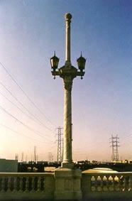
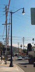
6 Existing Street Lighting

 New, distinctive signature fixtures for Little Tokyo and the Arts district 4) Historic fixtures for")
 Special artist designed lighting under the Santa Ana Freeway (c) (d) LEGEND Typical First Street Element")
7 Proposed Street Lighting City lighting can express a set of civic values. They are yet another layer to the design elements that establish and reinforce the character of a streetscape. This project recommends pedestrian lamps, roadway lighting and lanterns that include: 1) A new contemporary fixture family for Bunker Hill 2) The reinforcement of the family of historic fixtures for the Civic Center 3) New, distinctive signature fixtures for Little Tokyo and the Arts district 4) Historic fixtures for the Bridge 5) New signature fixtures for Rivergate East 6) Historic fixtures for Boyle Heights 6) An integrated lighting element affixed to the skyline palms 7) An integrated transit shelter/lantern element 8) Special artist designed lighting under the Santa Ana Freeway (c) (d) LEGEND Typical First Street Element Special Civic Center Element illustr (a) (b) Special Little Tokyo/Arts District Element Special Bridge Park Element Special Boyle Heights Element

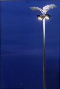
8 Lighting Elements


9 Surfaces & Ground Plane This Project has identified opportunities for distinctive unifying paving within each district for both sidewalks and crosswalks and adjacent plaza spaces; it does not recommend a uniform paving pattern or surface treatment throughout the corridor. Sustainable porous concrete alternatives include special resilient composite walking/jogging pathway materials, permeable composite concrete sidewalk and decomposed granite. These materials are recommended for sidewalk segments wherever feasible. The use of these surfaces, in conjunction with structural substrates are compatible with low impact, sustainable development practices related to the retention of urban storm water runoff and have been found to be significantly advantageous to the long-term health of street trees. Integrating these materials and methods into the design of the public realm translates to smart growth planning for a cleaner and healthier environment. alternating bands of integrally colored concrete and D.G. treewells along Grand Avenue examples of porous paving surfaces including rubber, decomposed granite and permeable concrete

, Streetscape strategies can take advantage of an interactive numbering and wayfinding systems")
10 Surfaces & Ground Plane Patterned Crosswalks Special crosswalk paving can highlight First Street as different from all the surrounding streets. Inspired by its propinquity to the L.A. River, abstractions of river rock are shown here as an embedded or stamped pattern in the asphalt or integrally colored concrete. On the one hand the pattern can be an abstract mural in the street. On the other had it can be a literal reminder of the ecological context that makes First Street a walkable recreational corridor. River Rock Measure from the Bridge In the advent of enthusiasm for Global Positioning Systems (GPS), Streetscape strategies can take advantage of an interactive numbering and wayfinding systems reinforced with public art. Such a system could measure distances from the riverbed in miles from and feet above the river and river level. In this way the L.A. River becomes the zero point of the project while the height of the two valley hillsides Bunker Hill and Boyle Heights are emphasized. This system could be integrated into the language of the design elements by embedding numbers in the crosswalks and paving, applying a special fritted pattern to the glass panels on transit shelters or signage elements as a few examples. Illustration numerating street blocks from the L.A. River with mid-block markers integrated into a wayfinding/mapping/art element River Rock image abstracted for crosswalk pattern Crosswalk Plan


 while the shelter overhang notches into this structure at 8 high (the sidewalk scale or pedestrian scale ).")
11 Design Elements: Transit Shelter / Lantern Through the combination of an ornamental beacon and a pragmatic transit element, the proposed Transit Shelter / Lantern establishes a rhythm that dots First Street from Downtown to Boyle Heights. Like the monumental pylons of the First Street Bridge, these illuminated beacons serve as multifaceted wayfinders. Not only do the shelters highlight First Street as different from the other streets downtown, they are also directional figures casting their light on the presence of the L.A. River. Traveling eastbound from downtown or westbound from Boyle Heights, one notices that the tall light bars function as arrows pointing towards the river. Facing away from the river, the other sides of the pylon carry signage elements. The structure of these pylons measure 35 tall (the city scale or urban scale ) while the shelter overhang notches into this structure at 8 high (the sidewalk scale or pedestrian scale ). In plan, the pylon is shaped like an arrow with the narrow edge designed as a glowing light bar from top to bottom. This pylon is capped by an illuminated cube seen from all directions. Signage (advertising, holidays, special events) can be applied on the three non-illuminated sides of the pylons as either decals or clipped fabric onto the metal frame. Fritted glass skylights and side panels will provide translucent shelter from wind or sun and may also be used for signage. KEY PLAN: TRANSIT SHELTER/LANTERN ELEMENT LOCATIONS SIDE ELEVATION FACING L.A. RIVER FRONT ELEVATION SIDE ELEVATION FACING AWAY FROM L.A. RIVER
12 Design Elements: Furnishings Furnishings using the same language of illumination and signage as the Transit Shelter/Lantern are proposed for mid-block furnishings. These custom furnishings are simple prototypes using off the shelf materials such as fiber reinforced plastic for the lanterns and a sustainable metal or concrete for the pylons. Local outdoor furnishing manufactures can provide trash receptacles and water fountains that can be fit into a customized vertical infrastructure, similar to what is shown in the illustrations below. TRASH RECEPTACLE ELEVATION BENCH / BUBBLER ELEVATION L.A. RIVER SPECIAL EVENT ARMATURE ELEVATION L.A. RIVER TRASH RECEPTACLE PLANS BENCH / BUBBLER PLANS SPECIAL EVENT ARMATURE PLAN 0 4
1 st now. First Street Segments. First Street SEGMENTS
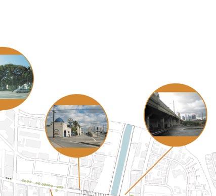
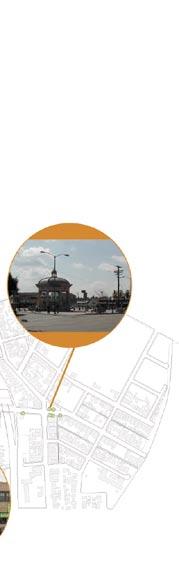
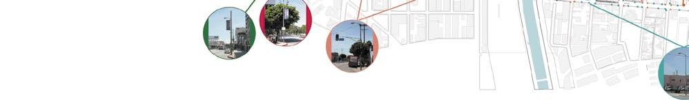
 First Street Segments First Street is clearly a collage of many neighborhoods, districts and influences. This plan proposes a melding of these parts into a distinctive four-segment overlay. They include
V. Gateways GATEWAYS / V-1
 V. GATEWAYS / V-1 Many of Chesapeake s gateways are located on highways and call for bold and attractive designs that motorists can understand, appreciate, and enjoy. can also take the form of natural
GREENING THE BOULEVARD Master Plan Concepts for Venice Boulevard between Lincoln and Sawtelle
 GREENING THE BOULEVARD Katherine Spitz Associates Inc. 4212½ Glencoe Avenue Marina Del Rey, CA 90292 310 574 4460 Fax 574 4462 January 2008 Table of Contents Overview Proposed Design Improvements Illustration
PUBLIC RIGHT-OF-WAY IN THIS CHAPTER PUBLIC REALM
 PUBLIC RIGHT-OF-WAY This section provides design guidelines for improvements in the public right-of-way. The public right-of-way refers to streets, sidewalks, non-vehicular thoroughfares, parks and greenways
Corridor Identity. Section 9. Introduction. Corridor Guiding Principles
 Corridor Identity An attractive and healthy community is a critical element of a quality place, and the design of quality places is a balance between environmental, economic, and social considerations.
CHAPTER 5: GUIDING PRINCIPLES
 CHAPTER 5: GUIDING PRINCIPLES The following 10 principles were developed based on public consultation, planning policy and the background analysis conducted during Phase 1. The Guiding Principles significantly
R STREET CORRIDOR NEIGHBORHOOD Site Plan and Design Review Supplemental Guidelines Checklist
 R STREET CORRIDOR NEIGHBORHOOD Site Plan and Design Review Supplemental Guidelines Checklist Applicant s Name: Project Address: Phone: Email: Applicant shall fill out the design guidelines checklist for
PUBLIC REALM DESIGN PLAN APRIL, 2012
 PUBLIC REALM DESIGN PLAN APRIL, 2012 Introduction NoMa is growing quickly. Fueled by transit accessibility, proximity to both Downtown and Capitol Hill and streamlined entitlements, the neighborhood has
Figure 3-1: Public Realm Plan
 3 Public Realm Figure 3-1: Public Realm Plan 3.1 Public Realm Concept The public realm concept for the Little Mountain site integrates a clear and accessible movement network with public spaces for social
University of Saskatchewan CAMPUS MASTER PLAN. Senate Meeting Preliminary Presentation. April 21, 2018 DIALOG ECS DA WATT
 University of Saskatchewan CAMPUS MASTER PLAN Senate Meeting Preliminary Presentation April 21, 2018 DIALOG ECS DA WATT project process presentation agenda Stakeholder Engagement Project Control phase1
PIKE PINE RENAISSANCE: ACT ONE. October 19, 2017
 PIKE PINE RENAISSANCE: ACT ONE October 19, 2017 WATERFRONT SEATTLE PROGRAM PROJECT INTRODUCTION Pike and Pine streets, between First and Melrose avenues Pedestrian and streetscape improvements Budget:
Figure Example of out door dining in the public right-of-way.
 Section 2 Core Area Goal 2.2.1 To maintain and enhance the character of existing streets in the Downtown Area. Character Figure 2.2.1 Example of out door dining in the public right-of-way. A. Provide street
Welcome. Community Consultation Meeting November 28, Review and discuss the Bathurst Quay Neighbourhood Plan Framework
 Welcome Community Consultation Meeting November 28, 2016 Why Are We Here Today? Review and discuss the Bathurst Quay Neighbourhood Plan Framework Review and discuss an Action Plan for Implementation Next
Community Design Guidelines. Port Wallace DRAFT
 Community Design Guidelines Port Wallace DRAFT Energy 1 2 3 Nature Movement Connections Built Form DRAFT Layout Energy 1 Nature Community Design Guidelines GREAT COMMUNITIES PROTECT, CELEBRATE, AND CONSERVE
VEHICULAR AND PEDESTRIAN CIRCULATION
 This perspective sketch communicates the intended character and quality of a proposed streetscape design. Locate benches near a major intersection where people tend to gather. Seating and lighting provide
Bloor Street East Potential Ravine Portal Overlook and Access Passage to the Rosedale Valley and Don River Valley Ravine, Toronto, Canada
 TRANSFORMATIVE IDEA 2. GREAT STREETS Bloor Street Christie Pits Park Bloor St Spadina Ave Bathurst St Shaw St 1 Recognize the significant public realm improvements along Bloor Street and extend and enhance
The Vision. Photo provided by The Minervini Group. 46 Vision, Objectives & Strategies
 Vision, Objectives & Strategies The is the public framework and guide for future development of the Grand Traverse Commons. The establishes public polices for infrastructure, the preservation of natural
FLORIN ROAD CORRIDOR Site Plan and Design Review Guidelines Checklist
 FLORIN ROAD CORRIDOR Site Plan and Design Review Guidelines Checklist Applicant s Name: Project Address: Phone: Email: Applicant shall fill out the design guidelines checklist for all guidelines applicable
Hockessin Community Redevelopment Plan
 Hockessin Community Redevelopment Plan 3.1 Introduction The Community Redevelopment Plan for the Village of Hockessin is the result of the people s vision for a distinct village center that serves as the
CHARLOTTESVILLE. Streetscape ENTRANCE CORRIDOR DESIGN GUIDELINES. Amendments adopted by City Council March 7, Design Principles...
 CHARLOTTESVILLE ENTRANCE CORRIDOR DESIGN GUIDELINES Amendments adopted by City Council March 7, 2011 2 Streetscape A. B. C. D. E. F. G. H. I. Design Principles...5 Plantings & Open Space...6 Pedestrian
A Vibrant Downtown. Chapter 5 Cary Public Art Opportunities 31
 A Vibrant Downtown Cary s vision for Downtown is a unique, vibrant, dynamic, pedestrian friendly location; a regional destination and a place to live, work, and recreate, according to the 2001 Town Center
Streetscape Patterns. Design Guidelines, Ridgewood Village Center Historic District, Ridgewood, N.J. page 20
 North Broad Street has a unique streetscape pattern with broad curving street, tight enclosure on the east side with attached commercial buildings aligned with the sidewalk, and landscaped open space on
Image Credit: crja.com
 Image Credit: crja.com 6 ADDITIONAL PLACEMAKING ELEMENTS 6A 6B 6C 6D Signage and Wayfinding in the Public Realm Gateways Public Art Water Features ADDITIONAL PLACEMAKING ELEMENTS INTENT In addition to
Table of Contents. Elm Avenue Improvement Plan City of Waco, Texas. Introduction 1. Existing Context 1 Figure 1 2.
 Table of Contents Introduction 1 Existing Context 1 Figure 1 2 Plan Guidelines 3 Future Urban Form 4 The West-End 4 Main Street 6 The East-End 7 Figure 2 9 Public Improvement Recommendations 7 General
CHAPTER 5 Public Realm Improvements
 5.1 OVERVIEW This chapter focuses on the public realm, that is, spaces within and directly adjacent to public rights-of-way (ROWs), including streets, Oso Creek, the rail corridor, and the freeway edge.
The Anaheim Resort Public Realm Landscape Program. City of Anaheim. Adopted September 1994 (94R-239)
") Public Realm Landscape Program City of Anaheim Adopted September 1994 (94R-239) Amendment No. 1 October 1996 (96R-178) Amendment No. 2 June 1999 (99R-137) Amendment No. 3 February 2001 (2002R-56) Amendment
Public Realm Landscape Program City of Anaheim Adopted September 1994 (94R-239) Amendment No. 1 October 1996 (96R-178) Amendment No. 2 June 1999 (99R-137) Amendment No. 3 February 2001 (2002R-56) Amendment
open house 3 CITY OF SALEM Downtown Streetscape Plan
 open house 3 Streetscape concepts CITY OF SALEM Downtown Streetscape Plan analysis concepts we are here refined concepts & document Feb 13th 1 2 3 apr 18th KICKOFF OPEN HOUSE Streetscape Work Group Walking
Streets Vision
 streets 86 2.9 Vision : The Most Prevalent and Important Public Spaces Fixed routes of human travel have served as corridors for commerce and places for human interaction from the earliest trails and foot
FRUITVALE TRANSIT VILLAGE (Phase 2) Residential Project
 Residential Project") FRUITVALE TRANSIT VILLAGE (Phase 2) Residential Project DEVELOPER: SIGNATURE PROPERTIES ARCHITECT: HKIT ARCHITECTS April 23, 2010 TABLE OF CONTENTS 3 Vision 4 Description of Site 5 Guiding Concepts 6
FRUITVALE TRANSIT VILLAGE (Phase 2) Residential Project DEVELOPER: SIGNATURE PROPERTIES ARCHITECT: HKIT ARCHITECTS April 23, 2010 TABLE OF CONTENTS 3 Vision 4 Description of Site 5 Guiding Concepts 6
WEST LOOP DESIGN GUIDELINES CHECKLIST
 WEST LOOP DESIGN GUIDELINES CHECKLIST Section 1.0 General Strategies 1.1 DESIGN EXCELLENCE: ENCOURAGE HIGH QUALITY AND INNOVATIVE DESIGN OF NEW BUILDINGS WITHIN THE WEST LOOP WITHOUT BEING PRESCRIPTIVE
4.9 Mendocino Avenue Corridor Plan Design Guidelines
 4.9 Mendocino Avenue Corridor Plan Design Guidelines The Mendocino Avenue Corridor Plan addresses the area between College Avenue and Steele Lane. Mendocino Avenue is a busy arterial that runs parallel
LOS ANGELES SPORTS AND ENTERTAINMENT DISTRICT Streetscape Plan
 LOS ANGELES SPORTS AND ENTERTAINMENT DISTRICT Streetscape Plan TABLE OF CONTENTS Section 1. Section 2. Section 3. Section 4. Section 5. Section 6. Section 7. Introduction Goals and Principles Administration
GUIDING PRINCIPLES IN THIS CHAPTER
 GUIDING PRINCIPLES The guiding principles and design concepts in this chapter work together with the Chapel Hill 2020 Comprehensive Plan to support new public places that can be enjoyed by all while also
section five BEAUTIFICATION PLAN
 section five BEAUTIFICATION PLAN BEAUTIFICATION PLAN Section Five Beautification Plan The goal of the Beautification Plan is to improve the Route 8-Sunnyland Corridor in terms of aesthetics and to create
CHAPTER 8. Mrs. Zimman s Class - Central Elementary
 SUSTAINABILITY CHAPTER 8 Mrs. Zimman s Class - Central Elementary 8.1 OVERVIEW Green infrastructure also known as low impact development (LID) and environmental or sustainable site design is an environmentally
ANCHOR TO ANCHOR. Rescale the street to create an iconic boulevard.
 ANCHOR TO ANCHOR Rescale the street to create an iconic boulevard. UR NE ER UV GO NE LA OBJECTIVES 1. Maintain appropriate traffic flow and prioritize commercial curb access 2. Mark gateways at the street
Maplewood Avenue Downtown Complete Street Project
 Maplewood Avenue Downtown Complete Street Project Second Public Meeting January 24, 2018 Welcome and Introduction of Project Team City Planning and Public Works Staff City of Portsmouth Juliet Walker Planning
Pedestrian and Bike Bridge LOGO
 6.2.2 Pedestrian and Bike Bridge The proposed pedestrian and bike crossing re-envisions the existing bridge at Pismo Creek on Cypress Street. The bridge is currently underutilized by vehicular through
9IMPLEMENTATION AND PHASING
 9IMPLEMENTATION AND PHASING Purpose A key objective of the Railyard Master Plan is the integration of the public and private realm to provide a network of places that connect to and complement Commercial
11.0. Design Manual: Sustainable Initiatives. Chapel Hill Streetscape and Lighting Master Plan mikyoung kim design all rights reserved.
 11.0 Design Manual: Sustainable Initiatives 2008 mikyoung kim design all rights reserved. Chapel Hill Streetscape and Lighting Master Plan 109 110 Chapel Hill Streetscape and Lighting Master Plan DESIGN
BUSINESS DISTRICT DESIGN GUIDELINES
 Des Plaines, Illinois Prepared for the City of Des Plaines by: The Lakota Group Laurie Marston, AICP March 2005 Section 5: Streetscape Elements Business District Design Guidelines STREETSCAPE ELEMENTS
3.1 community vision. 3.3 required plan elements
 Chapter 3 Community Form 3.1 community vision 3.2 Parks & landscaping concepts 3.3 required plan elements D R A F T 20 Community Form Chapter 3 3.0 Community form 3.1 community vision The Specific Plan
SDOT DCLU. Director s Rule Seattle Design Guidelines for Link Light Rail, Beacon Hill Station. City of Seattle
 SDOT DCLU Director s Rule 11-2003 Applicant: Page Supersedes: City of Seattle Department of Transportation (SDOT) Department of Design, Construction and Land Use (DCLU) 1 of 10 Publication: 7/3/03, 8/29/02*
13. New Construction. Context & Character
 13. New Construction Context & Character While historic districts convey a sense of time and place which is retained through the preservation of historic buildings and relationships, these areas continue
The open space system should provide connective elements, relate to natural resources, and enhance the suburban character of the landscape..
 The open space system should provide connective elements, relate to natural resources, and enhance the suburban character of the landscape.. Mixed-use and infill development should maintain or enhance
Sidewalks Street Lights
 Boston Complete Streets Guidelines 013 Boston Transportation Department Sidewalks Introduction 17 Sidewalk Design Principles 18 Sidewalk Zones 0 Sidewalk Zones Widths Preferred and Minimum Widths for Sidewalk
Potential Green Infrastructure Strategies May 6, 2015 Workshop
 Potential Green Infrastructure Strategies May 6, 2015 Workshop Background The City of Cortland is developing the Tioughnioga Urban Headwaters Green Infrastructure Action Plan with funding from the National
Division VI Community Mixed Use (CMU) Architectural Guidelines and Standards
 Architectural Guidelines and Standards") Division VI 18.40.800 Community Mixed Use (CMU) Architectural Guidelines and Standards 18.40.810 Guidelines The goals of the Comprehensive Plan include a focus on pedestrian safety, amenities and aesthetics
Division VI 18.40.800 Community Mixed Use (CMU) Architectural Guidelines and Standards 18.40.810 Guidelines The goals of the Comprehensive Plan include a focus on pedestrian safety, amenities and aesthetics
appendix and street interface guidelines
 appendix five: building and street interface guidelines appendix 5 building and street interface guidelines BOULEVARDS Boulevards are generally characterized by higher levels of traffic movement at higher
Cit of Kitchener Ur 6 an Design Manual PARTA. Desi n for _--::
 Cit of Kitchener Ur 6 an Design Manual Date PARTA Year ) Desi n for k Nodes Corridors _--:: Section Page 01 of 12 2 INTRODUCTION Purpose & Application Nodes and Corridors have been identified as key intensification
Resolution : Exhibit A. Downtown District Design Guidelines March 2003
 Resolution 03-011: Exhibit A Downtown District Design Guidelines March 2003 DOWNTOWN DISTRICT DESIGN GUIDELINES CITY OF SOUTHLAKE, TEXAS Adopted March 2003 1 DOWNTOWN DISTRICT DESIGN GUIDELINES Adopted
AIRPORT BUSINESS PARK
 PIER MAC PETROLEUM INSTALLATION LTD. AIRPORT BUSINESS PARK DEVELOPMENT APPLICATIONS March 2003 4.1 Airport Business Park Development Permit Area 4.1.1 Justification/Design Concept The design concept envisioned
APPENDIX I: GREENWAY DESIGN STANDARDS
 APPENDIX I: GREENWAY DESIGN STANDARDS The goal of this report is to develop a palette of standard design elements that will help establish a distinct identify for the Bronx River Greenway. The greenway
The Project. In 2013, construction was completed between 100 Street and 102 Street.
 The Project Jasper Avenue New Vision (JANV) is a major catalyst project identified in the Capital City Downtown Plan (2010) between 92 Street and 109 Street, including the streets half a block north and
DRAFT. October Wheaton. Design Guidelines
 October 2011 DRAFT Wheaton Design Guidelines 2 Draft - Design Guidelines - Wheaton Sector Plan Contents 04 Section 1: Introduction 06 Section 2: Context 08 Section 3: Design Guidelines 09 Goal 1: Create
Los Angeles River-Arroyo Seco Confluence Restoration Vision Plan. Professor Meredith McKenzie, JD Urban & Regional Planning Dept Cal Poly Pomona
 Los Angeles River-Arroyo Seco Confluence Restoration Vision Plan Professor Meredith McKenzie, JD Urban & Regional Planning Dept Cal Poly Pomona The Los Angeles River Watershed Arroyo Seco Watershed Map
Buildings may be set back to create small plazas provided that these setbacks do not substantially disrupt the street wall s continuity.
 6-22 Community Design Street Walls and Street-front Setbacks The siting of buildings will play a critical role in establishing the character and sense of place for the District. Siting buildings at the
2.5 Roads. Loading and service areas adjacent to Highway 401 should be screened through architectural walls and/or landscape buffer planting.
 N HIGHWAY OFF RAMP 2.5 Roads A legible road network with a clear hierarchy will help create a connected community, both within and surrounding the Milton Heights. The following section outlines the proposed
Conceptual Design. Main Street Enhancement and Extension Project. Bothell, Washington. June 11, 2009
 Conceptual Design Main Street Enhancement and Extension Project Bothell, Washington June 11, 2009 Berger/ABAM Engineers and Cascade Design Collaborative, Inc For Main Street Bothell to succeed it must
Surface Materials Strategy Reference Images
 2.0 RETAIL & HOTEL PLOTS, BRENT CROSS MAIN SQUARE THRESHOLD SPACES & ENERGY CENTRE Surface Materials Strategy Reference Images Riparian themes and patterns reflected in the paving Palette of warm granite
Landscape and Streetscape Design 2.5
 Landscape and Streetscape Design 2.5 2.5.1 Goals 2.5.2 Planting 2.5.3 Sidewalks and Pavement 2.5.4 Furnishings 2.5.5 Walls 2.5.6 Lighting 2.5.7 Stormwater 2.5.8 Street Cross Sections 2.5 LANDSCAPE AND
Public input has been an important part of the plan development process.
 Lakewood s Comprehensive Plan recognizes that transportation helps shape the community, and that the way the community provides for the safe and efficient movement of people affects the character of the
City of Nogales General Plan
 Open Space, Parks, Recreation and Trails City of Nogales General Plan Residents of Nogales place a high priority in the development of a comprehensive system of open space, parks, recreation and trails
CHAPTER 3. Design Standards for Business, Commercial, Industrial, Recreational and Institutional Uses
 CHAPTER 3 Design Standards for Business, Commercial, Section Number Title Ordinance Number Date of Ordinance 16-3-1 Applicability 2006-11 2008-04 07-01-08 16-3-2 Uniform Standards for Architectural Design
Page
 Page 16 18 20 22 24 26 28 30 32 City Identity Neighborhood Identity District Anchors Urban Forest Parks and Open Space Public Passage and Promenade Social Activity Centers Built Environment SJDA and PBID
The Trinity River Corridor, offering Dallas areas of natural
 IMPLEMENTATION PLAN FOR THE TRINITY RIVER CORRIDOR The Trinity River Corridor, offering Dallas areas of natural beauty and untapped potential, runs through the heart of the city. Proposed improvements
11.5 Kipling Avenue Corridor Secondary Plan
 11.5 Kipling Avenue Corridor Secondary Plan ADOPTED BY VAUGHAN CITY COUNCIL NOT YET APPROVED BY THE ONTARIO MUNICIPAL BOARD 11.5.1 Development Principles and Objectives The following principles support
City of Long Beach. creating vibrant and exciting places
 City of Long Beach creating vibrant and exciting places Land Use Element Urban Design Element Overview of the two draft General Plan elements Discuss areas of change Economic goals of the plans Case study
Design Guidelines for PRINCESS ANNE COMMONS
 Design Guidelines for PRINCESS ANNE COMMONS January 25, 2002 To create a unique and identifiable place with attractive, exciting, efficient and safe components to enhance the consistency of the built environment
THE 355/270 CORRIDOR:
 THE 355/270 CORRIDOR: Strategic Ideas for Sustaining a Livable Work Place Project Summary ACCESS LIFE DESIGN HEALTH WORK Montgomery County Planning Department The Maryland-National Capital Park and Planning
SECTION TWO: Overall Design Guidelines
 SECTION TWO: Overall Design Guidelines This section provides overall design principles and guidelines for the Gardnerville Mixed-use Overlay. They provide criteria for mixed-use places consisting of residential,
Wayfinding. North Gateway: Integrate a vertical gateway marker on the west side of Ward Street at the south corner of Vernon Street.
 3.3.6.2 Wayfinding Existing Conditions Wayfinding signage is important to direct visitors and tourists to different locations in the downtown. A significant part of the wayfinding signage in the downtown
SQUAMISH 2010 AND BEYOND COMMUNITY VISION
 Our plan has been imagined and created to be both pragmatic and visionary. At the core of the strategy is a consideration of the highway s role and its impact on the community. First and foremost in creating
the village at market creek
 the village at market creek executive summary october 2012 i ii introduction The Village at Market Creek is primed to grow into one of San Diego s most lively, multi-cultural arts destinations. Our community
 Health Sciences City The available land area, although limited, combined with the unique partnership between the primary institutions and the supporting partnerships of the development interests within
MAIN STREET DESIGN GUIDELINES CONTEXT
 MAIN STREET DESIGN GUIDELINES CONTEXT VISION The re-imagining of Main Street offers an unparalleled opportunity to strengthen and link Fredericton North through the integration of local neighbourhoods,
WELLINGTON STREET WEST COMMUNITY DESIGN PLAN
 36 3.CDP POLICIES 37 Wellington Street West CDP Vision Statement 38 3.1 Introduction 3.1.1 Purpose The development of buildings and public spaces is influenced by a variety of factors over time. City of
Site Planning. 1.0 Site Context. 2.0 Pedestrian Circulation Systems. Pag e 2-23
 The following photographs from throughout the country illustrate key urban design principles. Photographs are provided to illustrate the overall urban design concepts described in Chapter 1 of the Downtown
WELCOME TO THE CHOUTEAU GREENWAY DESIGN, DEVELOPMENT AND CONSTRUCTION WORKING GROUP!
 WELCOME TO THE CHOUTEAU GREENWAY DESIGN, DEVELOPMENT AND CONSTRUCTION WORKING GROUP! Chouteau Greenway Steering Committee and Working Groups Overview Overview January 9, 2019 Chouteau Greenway will transform
New-Cast Mixed-use Development Proposal King Street West, Newcastle, Ontario
 URBAN DESIGN BRIEF New-Cast Mixed-use Development Proposal King Street West, Newcastle, Ontario TABLE OF CONTENTS: 1.0 Executive Summary 2.0 Creating Vibrant and Sustainable Urban Places: Excerpts from
Bow to Bluff Public Realm Plan Design Update
 Bow to Bluff Public Realm Plan Design Update December 017 Great public spaces encourage people to gather, recreate, explore and discover. Introduction The City of Calgary is planning to improve the corridor
Community Mixed Use Zone Districts (CMU)
") 18.28.500 Community Mixed Use Zone Districts (CMU) The Community Mixed Use Zone Districts (CMU) are intended to help implement the land use goals and strategies found in the Golden Vision 2030 values,
18.28.500 Community Mixed Use Zone Districts (CMU) The Community Mixed Use Zone Districts (CMU) are intended to help implement the land use goals and strategies found in the Golden Vision 2030 values,
3.0 master plan concept
 3.0 master plan concept 3.1 introduction The purpose of the Huron Church Road Master Plan Concept is to provide an overview of the Master Plan design process, identify preliminary streetscape installations
Design Guidelines for the Route 30 Corridor Master Plan: Subdivision and Land Development Elements
 Design Guidelines for the Route 30 Corridor Master Plan: Subdivision and Land Development Elements East Whiteland Township- Chester County, PA Prepared by: Draft: May 7, 2018 Design Guidelines for the
Campus Identity & Design Guidelines
 WSU RFP 7840-GC23215 Exhibit E Campus Identity & Design Branding Specification Washington State University Tri-Cities Campus Campus Identity & Design Guidelines G G L O architecture I interior design I
DOWNTOWN PARKS & PUBLIC REALM PLAN
 DOWNTOWN PARKS & PUBLIC REALM PLAN CHALLENGES The Parks and Public Realm Strategy addresses challenges associated with a growing Downtown, including: GOALS 3.3 New buildings will fit within their existing
4- PA - LD - LIVELY DOWNTOWN. LD - Background
 4- PA - LD - LIVELY DOWNTOWN LD - Background The downtown has been the service centre for the community since the city s inception and the area continues to supply people with their personal services,
TREASURE ISLAND PHASE ONE PROJECTS PUBLIC ART PROJECT OUTLINE
 TREASURE ISLAND PHASE ONE PROJECTS PUBLIC ART PROJECT OUTLINE BACKGROUND (DEVELOPMENT PROJECT OVERVIEW) The Treasure Island Development is an approved 405-acre redevelopment project on Treasure Island
Planning Board Hearing October 20th, 2016
 Planning Board Hearing October 0th, 06 Developer: Real Estate Management & Leasing: Architect: Transportation Engineers: Landscape Architect: Civil Engineer: THE ARSENAL PROJECT Planning Board AGENDA Introduction
Chapter 4: Jordan Road Character District
 4: Jordan Road Character District 4.1 Introduction The Jordan Road character district encompasses much of the former Jordan orchard and farmstead, which was a significant part of Sedona s history. The
1 Adapted from the Statewide Transit-Oriented Development Study by CalTrans, 2006
 APPENDIX C: LAND USE PLANNING FOR ENHANCED RAIL SERVICE 72 BACKGROUND One of the consistent themes heard from localities in the Route 29 corridor Planning Forums was the need for expanding rail service
DRAFT Civic Center Station Area Plan. Executive Summary
 DRAFT Civic Center Station Area Plan Executive Summary This project is funded in part through the Metropolitan Transportation Commission s Station Area Planning Program. The preparation of this report
Table L-1 Summary Action Strategy. Action Item Timing Status Responsible Agency
 CHAPTER 4: CIRCULATION ELEMENT ISSUE #1: MAJOR THOROUFARES AND TRANSPORTATION ROUTES A balanced transportation system for Fontana is provided that meets the mobility needs of current and future residents
EXISTING CONDITIONS 41. Existing Conditions
 EXISTING CONDITIONS 41 Existing Conditions The Existing Analysis phase of the planning process involved a study of the existing conditions on the campus in order to identify key planning issues to be addressed
Town Center. Block 5 Existing multifamily residential units are expected to remain.
 Area Guidelines Germantown s districts should be developed as distinct communities with unique features that are supported through the guidelines. The guidelines not only help distinguish these districts
TALL BUILDING GUIDELINES
 TALL BUILDING GUIDELINES Urban Design Guidance for the Site Planning and Design of Tall Buildings in Milton May, 2018 A Place of Possibility Contents 1.0 INTRODUCTION 1 1.1 What is a Tall Building? 2
DRAFT ROOSEVELT ROAD. District Recommendations. Figure 5.23 The Roosevelt Road Corridor
 CHAPTER 5 Figure 5.23 The Road Corridor Road will develop as a mixed-use corridor, emphasizing regional retail, west of the river and mixed-use development east of the river. KEY RECOMMENDATIONS 1. High
Urban Design Manual PLANNING AROUND RAPID TRANSIT STATIONS (PARTS) Introduction. Station Study Areas
 Introduction. Station Study Areas") 111111 PLANNING AROUND RAPID TRANSIT STATIONS (PARTS) Introduction The ION rapid transit system will link Waterloo, Kitchener and Cambridge through a central transit corridor (CTC). There are a number
111111 PLANNING AROUND RAPID TRANSIT STATIONS (PARTS) Introduction The ION rapid transit system will link Waterloo, Kitchener and Cambridge through a central transit corridor (CTC). There are a number
TIER ONE - CMI URBAN DESIGN OBJECTIVES
 TIER ONE - CMI URBAN DESIGN OBJECTIVES V I S I O N TO CREATE A MOTORWAY CORRIDOR THAT: makes a positive contribution to city-wide connectivity and the urban fabric of Auckland is visually stimulating and
Planning Board Briefing
 Planning Board Briefing Why Now? The Sector Plan Implementation Chapter States: Before Stage 1 begins, the following must occur: Approval of the Sectional Map Amendment. Approval of the Greater Lyttonsville