The Town of Cary, North Carolina
|
|
|
- Clyde O’Connor’
- 5 years ago
- Views:
Transcription

1 The Alston Activity Center Concept Plan f o r The Town of Cary, North Carolina prepared by Design Collective, Inc., Architects & Town Planners and The Town of Cary, North Carolina Adopted March 23, 2006 Amended December 11, 2008 Amended December 13, 2012 Amended August 14, 2014
2 TABLE OF CONTENTS I. Introduction 1. Hierarchy of Plan Geography 1 2. Neighborhood Character 5 II. Allowed uses and development limits 1. Use and Limits by Traffic Analysis Zone (TAZ) 7 III. Design Standards 1. Design Zones Circulation Classification and Character Streetscape Entries and Sections Public Art Open Space and Greenways 56 IV. Appendix 1. Illustrative Diagram Examples Project Background Information Definitions 77 ii
3 ACKNOWLEDGEMENTS Cary Town Council Ernie McAlister, Mayor Jack Smith, Mayor Pro Tem Marla Dorrel Michael Joyce Jennifer Robinson* Julie Robison* Nels Roseland Planning and Zoning Board Christopher Brooks, Chairperson* Harry Baulch Paul Broderick (former member) Scott Brookhart Lori Bush* Kelly Commiskey Matthew Danielson Wally Dawson (former member) Don Frantz Steven Goodridge (former member) Bill Johnson William Lyke (former member) Christy Perrin (former member) Ervin Portman (former member) Julia Rudy Carla Sadtler Town of Cary Staff William B. Coleman, Jr., Town Manager Jeffery G. Ulma, AICP, Planning Director Ricky Barker, AICP, Associate Planning Director Tim Bailey, PE, Director of Engineering Mary Henderson, Parks, Recreation, and Cultural Resources Director Project Staff for the Alston Activity Center Concept Plan Scott Ramage, AICP, project manager Meredith Chandler, RLA, project coordinator and design guidelines Philip Smith, AICP, Long Range Planning Manager J.W. Shearin, AICP, Current Planning Manager Juliet Andes, AICP, transportation planning Don Belk, AICP, land use and open space Greg Barnes, technical support Amity Little, maps and GIS support Doug McRainey, parks and greenways Paul Kuhn, RLA, parks and greenways Joe Moore, PE, transportation engineering Dick Moore, PE, transportation engineering Betsy Pearce, stormwater planning and management Consultants Design Collective, Inc. Matt D Amico, Principal cecily Bedwell, Project Manager Tom Bauley, Architect shannon Mitchell rebecca Roberts chris Brueckner Anna Owen jack Himmelheber Encore Arts eric Hyne Kimley-Horn and Associates, Inc. roger Henderson, AICP, PE David Whyte, PE Allison Lockwood A special thanks to Crosspointe Church for providing studio and assembly space for the week-long charrette design process. * project liaison iii
, an area of approximately 970 acres at the intersection of I-540 and NC 55.")

, five neighborhoods (see Figure I.2), fifteen Traffic Analysis Zones (see Figure I.3), and five Design Zones (see Figure I.")
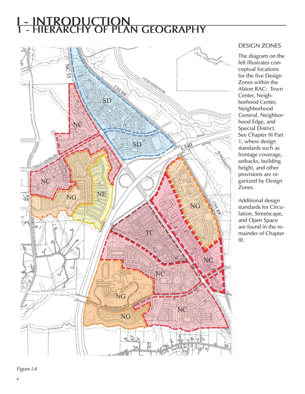
4 I - Introduction 1 - Hierarchy of plan Geography Boundary Map Vicinity Map The Town of Cary has prepared this Plan for the Alston Regional Activity Center (RAC), an area of approximately 970 acres at the intersection of I-540 and NC 55. This document is divided into four chapters: I--Introduction, II--Allowed Uses and Development Limits, III--Design Standards, and IV--Appendix. The hierarchy of geography in the Alston Activity Center Concept Plan (ACCP) includes the boundary of the Alston Regional Activity Center (see Figure I.1), five neighborhoods (see Figure I.2), fifteen Traffic Analysis Zones (see Figure I.3), and five Design Zones (see Figure I.4). The Alston ACCP will be re-evaluated by Staff and Stakeholders every two years after Council adoption. The first re-evaluation of this plan was completed in December Figure I.1
5 I - Introduction 1 - Hierarchy of Plan Geography Neighborhood Character The diagram at the left illustrates the five neighborhoods within the Alston RAC: Alston Center, McCrimmon, Evans Farm, Parkside, and Petty Farm. Properties within each neighborhood will conform to, support, and create the general neighborhood character described starting on page 5 of this document. Figure I.2 2
6 I - Introduction 1 - Hierarchy of Plan Geography Allowed uses and Development limits by TAZ (Traffic Analysis zone) See Chapter II Part 1, where information related to allowed uses, commercial and office square footage limits, and residential unit limits is organized by TAZ. The permitted maximum amount of development allowed, per land use type, is regulated at the level of TAZs. Figure I.3 3
7
8 I - Introduction 2 - NEIGHBORHOOD Character The Alston ACCP contains five neighborhoods: Alston Center, McCrimmon, Evans Farm, Parkside and Petty Farm. The pattern of development within these neighborhoods should support the distinct character described below. Alston Center As the heart and hub of the new community, Alston Center will provide a destination point with a mix of retail, office, and residential uses that serve local residents. The location of Alston Center in the southwest quadrant of the plan area was determined the most advantageous due to the nature and amount of local road connections possible and the physical site characteristics. Alston Center is the most urban of the five neighborhoods and is characterized by buildings set close to the street with continuous facades, by sidewalks extending from curb to building front to allow for sidewalk cafes, and by open space in the form of plazas and squares. Figure I.5 1,320 = Approximately a 5 minute walk
9 I - Introduction 2 - NEIGHBORHOOD Character Evans Farm The Evans Farm Neighborhood is located in the northwest quadrant of the study area adjacent to the approved Stonewater development and the existing large-lot single-family Ridgefield subdivision. A Neighborhood Center with retail and office serving local residents may be developed within Evans Farm near the intersection of Green Level to Durham Road and O Kelly Chapel Road. A mix of residential unit types is envisioned in the Evans Farm Neighborhood including multi-family, townhouses, and other single family homes. Parkside Parkside is located in the northeast quadrant of the study area. Although somewhat isolated from the other land bays of the study area, Parkside is directly adjacent to the Research Triangle Park (RTP) and is a critical bridge for employees and clients of RTP to Alston. Parkside will be a destination for RTP businesses and employees providing services which are not available within the Park including restaurants, retail establishments and hotel rooms and facilities. Residential units will be integrated into this neighborhood in the form of loft apartments (or condominium units) above commercial or in the form of hotel rooms or stand-alone higher density housing. The inclusion of these units will provide 24/7 activity. Petty Farm The Petty Farm Neighborhood is located in the southeast quadrant of the Alston area. Office, light industrial, retail and a variety of housing types are envisioned in this neighborhood. Nonresidential and/or mixed use development will both frame the neighborhood s main street and be located adjacent to NC 55 Highway and the future McCrimmon Parkway extension. Residential developments in Petty Farm will be conveniently located for work and play. The topography and stream buffers in this neighborhood may limit building footprints. McCrimmon The McCrimmon Neighborhood is directly adjacent to the Alston Center and, as such, transitions between the more urban center and the residential areas south and west of Alston Center. The neighborhood contains a mix of uses including retail, office, residential and civic. The new Panther Creek High School is located within the neighborhood, and occupies approximately 70 acres. One of the goals defined in the charrette was to provide opportunities for the students to walk to sandwich or pizza shops during their lunch period. The school cafeteria will serve only a fraction of the students (300 of the total 1700 students) leaving the majority to find other options. Typically, in suburban locations, students venture off school grounds in their cars. At Alston, the choice will be presented to walk safely to shops along pedestrian-friendly streets or along the Greenway Corridors, without requiring students to cross McCrimmon Parkway. 6
1 - Illustrative Diagram Examples
 1 - Illustrative Diagram Examples Illustrative Masterplan The Illustrative Masterplan at right was developed by The Design Collective, Inc. during the Alston design charrette in March 2005 and refined
Mark-up of the effect of the proposed Bronte Village Growth Area OPA No.18 on the text of section 24, Bronte Village, of the Livable Oakville Plan
 Mark-up of the effect of the proposed Bronte Village Growth Area OPA No.18 on the text of section 24, Bronte Village, of the Livable Oakville Plan Notes: This document is provided for information purposes
RESOLUTION NO R
 e e RESOLUTION NO R04 0054 BE IT RESOLVED by the Mayor and City Council ofthe City ofpapillion that The Papillion Comprehensive Plan is hereby amended to incorporate the Option A Future Land Use Map Transportation
STATEMENT OF JUSTIFICATION CLARKSBURG PREMIUM OUTLETS AT CABIN BRANCH NORTH DISTRICT, PHASE
 STATEMENT OF JUSTIFICATION CLARKSBURG PREMIUM OUTLETS AT CABIN BRANCH NORTH DISTRICT, PHASE 1 Southwest Corner of Clarksburg Road and Interstate-270 Clarksburg, Maryland Application for Site Plan #820140160
Wadsworth Boulevard S TAT I O N A R E A P L A N
 Wadsworth Boulevard S TAT I O N A R E A P L A N City of Lakewood Adopted November, 2006 The Vision The City of Lakewood s overall vision is to transform the area around the light rail station into a mixed-use
Sheridan Boulevard S TAT I O N A R E A P L A N S H E R I D A N B O U L E VA R D S TAT I O N A R E A P L A N
 Sheridan Boulevard S TAT I O N A R E A P L A N 1 City of Lakewood Adopted November, 2006 S H E R I D A N B O U L E VA R D S TAT I O N A R E A P L A N The Vision The City of Lakewood s overall vision is
Ridgefield Drive, east of Green Level Church Road and north of McCrimmon Parkway Schedule. Public Hearing March 26, 2015
 STAFF REPORT Town Council, May 21, 2015 Ridgefield Farms Rezoning 14-REZ-17 (PL15-048b) Consideration of a proposed rezoning request. Speaker: Ms. Mary Beerman From: Jeffery G. Ulma, AICP, Planning Director
Obey Creek July 17, Vicinity Map. Concept Plan Submittal. No
 15/501 Fordham Blvd. 15/501 By-Pass To Downtown Chapel Hill Vicinity Map 0 1000 2000 FT Arlen Park DR. Bennett Road Mt. Carmel Church Rd. Southern Village Parkside Circle Market St. 15/501 Founder's Ridge
Small Area Plan. South Gateway
 Small Area Plan Adopted May 12, 2008 South Gateway Purpose. The South Gateway Small Area Plan defines the City s expectations for the future of the southern entrance to the City at Interstate 85 and Highway
Town Center. Block 5 Existing multifamily residential units are expected to remain.
 Area Guidelines Germantown s districts should be developed as distinct communities with unique features that are supported through the guidelines. The guidelines not only help distinguish these districts
State Highway 5 Corridor Context Sensitive Master Plan
 ADOPTED June 17, 2014 (Resolution 2014-06-071) Travel Lane Travel Lane 11 11 Median 16 Min State Highway 5 Corridor Context Sensitive Master Plan 1 Prepared for: Prepared by: State Highway 5 Corridor
III - design standards
 III - design standards The Circulation Classification and Character section of the Design Standards chapter prescribes the types of circulation routes, the location of the circulation routes, the connections
MEMO 1. INTRODUCTION PURPOSE & PROCESS REQUEST
 MEMO Date: August 22, 2017 To: Board of Commissioners From: Jason Burdette, Planning Director Re: Davidson Commons East Hotel Stakeholder Feedback 1. INTRODUCTION PURPOSE & PROCESS This memorandum summarizes
SECTION UNIFIED DEVELOPMENT ORDINANCE SECTION Part 1 Ordinance. ARTICLE 1 Zoning Districts
 SECTION 1-100 UNIFIED DEVELOPMENT ORDINANCE SECTION 1-300 Part 1 Ordinance SECTION 1-100. Introduction. ARTICLE 1 Zoning Districts Crystal Lake strives to maintain a balance of various land uses for a
Gold Line Bus Rapid Transit Transit Oriented Development (BRTOD) Helmo Station Area Plan
 Helmo Station Area Plan") Appendix F Gold Line Bus Rapid Transit Transit Oriented Development (BRTOD) Helmo Station Area Plan Introduction and Purpose of the Plan The Gold Line Bus Rapid Transit facility is an eleven-mile dedicated
Appendix F Gold Line Bus Rapid Transit Transit Oriented Development (BRTOD) Helmo Station Area Plan Introduction and Purpose of the Plan The Gold Line Bus Rapid Transit facility is an eleven-mile dedicated
Lehigh Acres Land Development Regulations Community Planning Project
 Lehigh Acres Land Development Regulations Planning Effort Summary In July, 2010 Commissioner Frank Mann invited the Lehigh Acres community to start discussing how to achieve their recently adopted community
Jason D. Sutphin, Community Development Division Chief. Through: Brooke Hardin, Director of Community Development and Planning
 Meeting Date: 12/18/2017 Agenda Item: 9a. MEMORANDUM To: Chairman Cunningham and Members of the Planning Commission From: Jason D. Sutphin, Community Development Division Chief Through: Brooke Hardin,
Seneca Meadows. Block 4 Locate office, technology, and medical development adjacent to I Screen views of garage structures from I-270.
 Seneca Meadows Seneca Meadows has an industrial park in its southern end and a mixed-use employment area planned for the north end. The district benefits from extensive I-270 visibility, stream valley
CITY COUNCIL Arthur C. Brown Mayor Fred Smith Mayor Pro Tem Patsy Marshall Council Member Don McCay Council Member Jim Dow Council Member
 CITY COUNCIL Arthur C. Brown Mayor Fred Smith Mayor Pro Tem Patsy Marshall Council Member Don McCay Council Member Jim Dow Council Member PLANNING COMMISSION Larry Barstow Brian Chambers Paul Gonzales
BROOKHILL NEIGHBORHOOD MODEL ZONING MAP AMENDMENT PREFACE TO APPLICATION
 BROOKHILL NEIGHBORHOOD MODEL ZONING MAP AMENDMENT PREFACE TO APPLICATION June 15, 2015 Revised: August 1, 2016 I. VISION Brookhill is a proposed community based upon the principles of Albemarle County
ORDINANCE AN ORDINANCE TO ADD A NEW SECTION 4.N. IN THE ZONING CODE FOR THE TOWN OF MIDDLETOWN, RELATING TO MIXED-USE DEVELOPMENT
 Introduced: November 5, 2018 Approved: ORDINANCE 18-11-01 AN ORDINANCE TO ADD A NEW SECTION 4.N. IN THE ZONING CODE FOR THE TOWN OF MIDDLETOWN, RELATING TO MIXED-USE DEVELOPMENT BE IT ENACTED BY THE MAYOR
City of Brookfield 2035 Comprehensive Plan. DRAFT #2 October 6, 2009
 City of Brookfield 2035 Comprehensive Plan DRAFT #2 October 6, 2009 Public Hearing Presentation: December 1, 2009 Process Overview Phase I: Community Visioning (2008) - Developed long-term vision to direct
VILLAGE OF CLEMMONS PLANNING BOARD DRAFT STAFF REPORT
 VILLAGE OF CLEMMONS PLANNING BOARD DRAFT STAFF REPORT PETITION INFORMATION Docket # C-226 Staff Megan Ledbetter Petitioner(s) JBJH Properties, LLC Owner(s) JBJH Properties, LLC Subject Property 5892-49-1766
Staff Report to the North Ogden City Planning Commission
 Staff Report to the North Ogden City Planning Commission SYNOPSIS / APPLICATION INFORMATION Application Request: Concept review on a legislative application to rezone land located at approximately 1750
EXECUTIVE SUMMARY DRAFT CHAPTER 1 INTRODUCTION EXECUTIVE SUMMARY
 CHAPTER 1 EXECUTIVE SUMMARY INTRODUCTION Through the joint efforts of the City of Tulsa planning staff and the Land Services division of Indian Nations Council of Governments (INCOG), the Berryhill Land
Pine Island Road Corridor Master Plan
 RECOMMENDED DEVELOPMENT PLAN Figure 9: Del Prado Village District Conceptual Framework The Conceptual Framework (Figure 8) for development of the Pine Island Corridor is to encourage mixed-use development
LAND USE MEADOWS PLANNING AREA
 LAND USE MEADOWS PLANNING AREA I. Profile of Meadows Planning Area A. Location Meadows Planning Area is delineated by I-5 on the north, the Nisqually Bluffs representing the growth boundary on the east,
North Salt Lake General Plan Update 2013
 North Salt Lake General Plan Update 2013 Acknowledgements Updating the North Salt Lake General Plan was a process that would not have been possible without the support of elected officials and the general
IH35 Corridor Plan Amendment to the Comprehensive Plan
 IH35 Corridor Plan Amendment to the Comprehensive Plan Background The corridor plan for the IH35 corridor is an amendment to the Burleson comprehensive plan. Generally, the purpose of a corridor plan is
MILLS PARK & PANTHER CREEK GREENWAY
 , North Carolina August 19th, 2014 Introduction, North Carolina Why are we here? Planning Investment to Date - Park, North Carolina 2012 Parks, Recreation, and Cultural Resources Master Plan Planning Investment
Brampton. Secondary Plan. Review. Bram West. A New Direction in Planning & Public Consultation
 Brampton Bram West Secondary Plan Review A New Direction in Planning & Public Consultation Introduction The Bram West Secondary Plan Review offers an important opportunity for the community to define a
AWH REPORT OF THE PLANNING AND DEVELOPMENT DEPARTMENT FOR APPLICATION FOR REZONING ORDINANCE TO PLANNED UNIT DEVELOPMENT
 AWH REPORT OF THE PLANNING AND DEVELOPMENT DEPARTMENT FOR APPLICATION FOR REZONING ORDINANCE TO PLANNED UNIT DEVELOPMENT MAY 8, 2014 The Planning and Development Department hereby forwards to the Planning
1.0 Future Land Use. 1.1 Introduction. 1.2 Future Land Use Objectives
 1.0 Future Land Use 1.1 Introduction Can Holly Springs continue to accommodate significant growth while retaining and enhancing a Village-like atmosphere? Can enough commercial land be set aside for business
C. Westerly Creek Village & The Montview Corridor
 C. Westerly Creek Village & The VISION Community Vision When the goals of the city are achieved Westerly Creek Village, a distinctive community defined by Montview Boulevard and Westerly Creek, is a strong
DRAFT. 10% Common Open Space
 % OF CHARLOTTE IS CATEGORIZED AS A. LAND USES : Placeholder map displaying location of Place Type GOALS: Accommodate XX% of future growth. Provide a concentration of primarily commercial and civic activity
Planning & Zoning Board Meeting. DRAFT Comprehensive Transportation Plan Update, February 23, 2018 version
 Planning & Zoning Board Meeting DRAFT Comprehensive Transportation Plan Update, February 23, 2018 version May 10, 2018 Overview Overview of Agency Comments Overview of proposed modifications to the Draft
City Center Master Plan
 City Center Master Plan Bellingham, Washington August 2002 City Center Master Plan Bellingham, Washington August 2002 Prepared for the City of Bellingham by: Winter & Company Hoshide Williams Architects
Developer s Program. The Station at East 54
 Developer s Program The Station at East 54 Existing Conditions The Station at East 54 is proposed for a 1.12 acre site at the northeast corner of Hamilton Road and Prestwick Road, tucked between the East
Planning Districts INTRODUCTION
 INTRODUCTION To facilitate detailed examination of development prospects for all areas of the community, Delano has been divided into 14 planning districts. The location of these planning districts is
Description of Preferred Alternative
 Chapter 2 Description of Preferred Alternative 2.1 Introduction This chapter of the programmatic Sammamish Town Center Sub-area Plan Final EIS provides a more detailed description of the Preferred Alternative
ARTICLE 6: Special and Planned Development Districts
 ARTICLE 6: Special and Planned Development Districts 6-10 Traditional Neighborhood Development (TND) District 6-10.10 Purpose and Intent The Traditional Neighborhood Development (TND) District provides
Secrest Short Cut and Monroe Expressway Small Area Plan AUGUST 29, 2018
 Secrest Short Cut and Monroe Expressway Small Area Plan AUGUST 29, 2018 Background and Process Monroe Expressway will be open by the end of 2018 Union County and Indian Trail identified a need to revisit
PINE CURVE REZONING. Property does not meet criteria for open space preservation and is not a candidate for a park
 PINE CURVE REZONING BACKGROUND Purchased as two parcels in 2001 and 2002 Annexed and Zoned Greater Downtown District Historic Center September 25, 2002 and October 7, 2002 WHAT THE PROJECT IS AND IS NOT
University City Area Plan
 University City Area Plan Economic Development & Planning Committee June 6, 2007 Purpose of the Meeting Provide an overview of the plan Set a date for public comment with City Council Mallard Creek Church
Additional information about land use types is given in Chapter 5. Design guidelines for Centers and Neighborhoods are given in Chapter 7.
 4. Place Types Introduction In Albemarle County s Development Areas, the Neighborhood is the fundamental unit of community planning. The County s Neighborhood Model, an adopted part of the Comprehensive
Neighborhood Districts
 NEIGHBORHOOD DISTRICTS SEVEN MAIN DISTRICTS Neighborhood Districts While the Development Plan provides a broad-scale overview of the neighborhood, this section focuses on uses and relationships at the
APPENDIX 4 NEWBURY TOWNSHIP TOWN CENTER MASTER PLAN
 APPENDIX 4 NEWBURY TOWNSHIP TOWN CENTER MASTER PLAN Prepared by the Urban Design Center of Northeast Ohio September, 2008 Newbury Township Land Use Plan A4-1 INDEX Page No. 1 Newbury Township Town Center
Applicant Name Phone / Fax / Address City State Zip Code . Property Owner Phone / Fax / Address City State Zip Code
 Master Development Plan Application Community Development Department City of Redmond 411 SW 9 th Street Redmond, Oregon 97756 541-923-7721 541-548-0706 FAX Master Development Plan Fee $38,862.52 File Number
Agenda Summary December 11, 2017
 Agenda Summary December 11, 2017 Agenda Item No. 5 VT 108 Roadway Master Plan for Mountain Road Village (Including the Luce Hill / Rt.100 Intersection) Summary: David Saladino, vhb Transportation Systems
THAT the attached Terms of Reference for the Thornhill Centre Street Study be approved.
 COMMITTEE OF THE WHOLE AUGUST 18, 2003 THORNHILL CENTRE STREET STUDY PLANNING FILE: 15.92 Recommendation The Commissioner of Planning recommends: THAT the attached Terms of Reference for the Thornhill
Chapter IV: Development Pattern
 Chapter IV: Development Pattern Introduction The 2002 Prince George s County Approved General Plan designates three growth policy tiers Developed, Developing, and Rural as well as three center designations
General Location Annex, Rezone & Preliminary Plat Lansdowne Addition, Unit Three
 NEWFOUNDLAND I-5 Agricultural District Subject Site SUNDANCE ANDERSON Single Family Residential CHRISTY PUD Agricultural District Highway Business General Location Annex, Rezone & Preliminary Plat Lansdowne
MIXED-USE VILLAGE OVERLAY FLOATING DISTRICT
 MIXED-USE VILLAGE OVERLAY FLOATING DISTRICT Zoning regulations developed by committee to the Planning Board for the Town of DeWitt, NY Issue date: 13 July 2017 revised 3/12/2018, revised 4/26/2018, 5/9/2018
CARPENTER PARK MASTER PLAN REPORT. Town of Cary Parks, Recreation, and Cultural Resources
 REPORT Town of Cary Parks, Recreation, and Cultural Resources www.townofcary.org APPROVAL DATE JANUARY 10, 2013 TABLE OF CONTENTS 3 Acknowledgements...5 Project Introduction...7 Project Process...11 Site
IH35 Corridor Plan Amendment to the Comprehensive Plan
 IH35 Corridor Plan Amendment to the Comprehensive Plan Background The corridor plan for the IH35 corridor is an amendment to the Burleson comprehensive plan. Generally, the purpose of a corridor plan is
Sam Furr and McCord Road Huntersville, North Carolina
 108± Acres of Sam Furr and McCord Road Huntersville, North Carolina NorthCross Shopping Center Land for Sale 108 Acres located in northeast Huntersville wth extensive frontage along both Sam Furr Road
CHAPTER 4 - LAND USE CLASSIFICATIONS
 CHAPTER 4 - LAND USE CLASSIFICATIONS Four new land use classification categories are established in the Gualala Town Plan: Gualala Village Mixed Use; Gualala Highway Mixed Use; Gualala Planned Development
City of Fort Lauderdale UPTOWN URBAN VILLAGE. Public Workshop December 7, 2016
 Public Workshop December 7, 2016 Workshop Agenda Introductions Project Presentation o o o History Project Scope/Timeline Character of Study Area o o o o Land Use Public Realm/Pedestrian Mobility Multimodal
Planning Board Briefing
 Planning Board Briefing Why Now? The Sector Plan Implementation Chapter States: Before Stage 1 begins, the following must occur: Approval of the Sectional Map Amendment. Approval of the Greater Lyttonsville
ALBEMARLE COUNTY CODE CHAPTER 18 ZONING SECTION 20A NEIGHBORHOOD MODEL - NMD
 CHAPTER 18 ZONING SECTION 20A NEIGHBORHOOD MODEL - NMD Sections: 20A.1 PURPOSE AND INTENT 20A.2 STATUS AS A PLANNED DEVELOPMENT DISTRICT 20A.5 CODES OF DEVELOPMENT 20A.6 PERMITTED USES 20A.7 RESIDENTIAL
UNIVERSITY OF MICHIGAN:
 Chapter Eight UNIVERSITY OF MICHIGAN: North Campus I. Introduction The University of Michigan currently owns approximately 800 acres of land in the northeast section of Ann Arbor. North Campus refers to
The City of Poway Creating a Town Center. Patti Brindle, AICP City Planner, City of Poway APA Luncheon September 28, 2006
 The City of Poway Creating a Town Center Patti Brindle, AICP City Planner, City of Poway APA Luncheon September 28, 2006 1 The City in the Country Population: 50,542 Area: 25,047 acres Incorporated December
MORRISVILLE TRANSPORTATION PLAN TOWN COUNCIL PRESENTATION AUGUST 22, 2017
 TOWN COUNCIL PRESENTATION AUGUST 22, 2017 SCENARIO PLANNING CORRIDORS Town Hall Drive Baseline + 2 McCrimmon Parkway Baseline + 2 NC 54 Baseline + 2 7 subregion model runs determining carrying capacity
Subject: City of Richfield Cedar Avenue Corridor Plan Comprehensive Plan Amendment, Review File No
 Committee Report Business Item No. 2017-21 Community Development Committee For the Metropolitan Council meeting of January 25, 2017 Subject: City of Richfield Cedar Avenue Corridor Plan Comprehensive Plan
Downtown by Design: The Bradenton CRA Master Plan. Glatting Jackson, Inc Robert Charles Lesser & Co. Downtown Bradenton Development Authority
 Downtown by Design: The Bradenton CRA Master Plan Glatting Jackson, Inc Robert Charles Lesser & Co. Downtown Bradenton Development Authority October 3, 2006 Our Goal for Today: Introduce Project Introduce
Establish a network of streetscaped vehicle and pedestrian routes that connect within and outside the Plan area.
 This Plan s urban design goals are to create an urban scale, walkable community with connections to transit, parks, and services and with amenities and facilities for residents and employees. The 1992
The Floyds Fork Area Plan
 The Floyds Fork Area Plan Growth Framework and Design Principles Presented by: Wallace Roberts & Todd, LLC March 24, 2009 Ted Wathen / Quadrant Agenda Project overview and purpose Growth framework Design
Comprehensive Plan Advisory Panel Meeting #3
 Comprehensive Plan Advisory Panel Meeting #3 November 7, 2016 Agenda 1. September 19 th Meeting Notes 2. Summary of Focus Areas Charrette 3. Heart of the City Focus Area a. HOC2/Station Areas Concept &
Rezoning Petition Pre-Hearing Staff Analysis March 19, 2018
 Rezoning Petition 2017-171 Pre-Hearing Staff Analysis March 19, 2018 REQUEST Current Zoning: R-3 (single family residential) Proposed Zoning: MX-2 (INNOV) (mixed used, innovative) with five-year vested
Full Plan Document. Adopted October 4, 2011
 Full Plan Document Adopted October 4, 2011 For more information, contact: Justin Steinmann Principal Planner 334.501.3045 jsteinmann@auburnalabama.org TABLE OF CONTENTS Preface... 1 Acknowledgements...
Citizen Comment Staff Response Staff Recommended Revision Planning Committee
 Citizen Comment Staff Response Staff Recommended Revision Planning Committee Area No. 1: Owner desires retail land uses. Area No. 1a: Owner of two small parcels adjacent to Area No. 1 desires retail land
Policies and Code Intent Sections Related to Town Center
 Policies and Code Intent Sections Related to Town Center The Town Center Vision is scattered throughout the Comprehensive Plan, development code and the 1994 Town Center Plan. What follows are sections
LOS ANGELES CITY PLANNING DEPARTMENT STAFF REPORT
 LOS ANGELES CITY PLANNING DEPARTMENT STAFF REPORT LOS ANGELES CITY PLANNING COMMISSION CASE NO: CPC 2006-9374 CRA CEQA: Exempt DATE: December 21, 2006 Location: Valley Plaza and Laurel Plaza TIME: after
THE NEIGHBORHOOD TODAY
 THE NEIGHBORHOOD TODAY CORE AREA VISION How are we Good Urbanism A Site s DNA thinking about Elements of great Unique elements urban communities embedded in a place the site and design? ELEMENTS LIKE:
Silver Line CPAM UPDATE. Transportation and Land Use Committee October 14, 2016
 Silver Line CPAM UPDATE Transportation and Land Use Committee October 14, 2016 Purpose Recap Project History and Map Changes Provide Overview of CPAM Components Discuss Transportation Impacts Discuss Fiscal
SITE PLAN REVIEW COMMITTEE MEETING AGENDA Clarendon Boulevard Conference Room 311 Arlington, VA 22201
 SITE PLAN REVIEW COMMITTEE MEETING AGENDA DATE: Thursday, July 13, 2017 TIME: 7:00 8:30 p.m. PLACE: 2100 Clarendon Boulevard Conference Room 311 Arlington, VA 22201 SPRC STAFF COORDINATOR: TBD Item 1.
TOWN OF WILTON 22 TRAVER ROAD WILTON, NY
 TOWN OF WILTON 22 TRAVER ROAD WILTON, NY 12831-9127 (518) 587-1939 FAX (518) 587-2837 Website: www.townofwilton.com Ryan K. Riper, P.E. Director of Planning & Engineering Lucy B. Harlow Executive Secretary
Green Gables. April 24, 2013
 Green Gables Preliminary and Final Plat April 24, 2013 Development Team Green Gables Development Corporation (Owner/Developer) DTJ Design (Planner/Landscape Architect) Enertia Consulting Group (Civil Engineer)
What Does It Take To Create A Town Center?
 What Does It Take To Create A Town Center? Context, Design, and Process The Prince Frederick Master Plan Update 1 Background and Overview A Brief History of Town Centers in Calvert County 2 Background
A Healthy Future Walkability Through Community Design. Fit Families North Carolina October 18, 2004
 A Healthy Future Walkability Through Community Design Fit Families North Carolina October 18, 2004 Joe Morris, AICP Planning & CD Manager jmorr@salisburync.gov 704-638-5324 Dan Mikkelson, PE Land Management
DRAFT ROOSEVELT ROAD. District Recommendations. Figure 5.23 The Roosevelt Road Corridor
 CHAPTER 5 Figure 5.23 The Road Corridor Road will develop as a mixed-use corridor, emphasizing regional retail, west of the river and mixed-use development east of the river. KEY RECOMMENDATIONS 1. High
Courtice Main Street Study Community Vision Workshop PLANNING SERVICES DEPARTMENT
 Courtice Main Street Study Community Vision Workshop PLANNING SERVICES DEPARTMENT July 22, 2009 Tonight s Meeting 7:00 pm Introduction David Crome, Director of Planning 7:05 Presentation Stasia Bogdan,
section five BEAUTIFICATION PLAN
 section five BEAUTIFICATION PLAN BEAUTIFICATION PLAN Section Five Beautification Plan The goal of the Beautification Plan is to improve the Route 8-Sunnyland Corridor in terms of aesthetics and to create
MIDTOWN MIXED-USE VILLAGE. TECHNICAL DATA SHEET COMPONENT C-1 FOR PUBLIC HEARING - PETITION NUMBER Project No RZ1.1. Issued.
 N MIDTOWN MIXED-USE VILLAGE TECHNICAL DATA SHEET COMPONENT C- FOR PUBLIC HEARING - PETITION NUMBER 04-00 Project No. 496 Issued Revised SCALE: " = 0' N 0 0 0 40 RZ. c GENERAL PROVISIONS: a. SITE LOCATION.
Staff Report and Recommendation
 Community Planning and Development Planning Services 201 W. Colfax Ave., Dept. 205 Denver, CO 80202 p: 720.865.2915 f: 720.865.3052 www.denvergov.org/cpd TO: City Council Neighborhoods and Planning Committee
M E M O R A N D U M January 6, 2017
 Item #4 M E M O R A N D U M January 6, 2017 To: 2035 Corridor Planning Committee From: Kenneth Baker, Sr. Director of Planning and Development Services Subject: Item #4 Overview Fidelis Purpose: Review
DESIGN REVIEW COMMITTEE AGENDA ITEM
 DESIGN REVIEW COMMITTEE AGENDA ITEM AGENDA DATE: AUGUST 2, 2017 TO: THRU: FROM: SUBJECT: Chair Imboden and Members of the Design Review Committee Anna Pehoushek, Assistant Community Development Director
The Urban Core: Downtown Lincoln
 The 'P' Street corridor linking The Urban Core: Downtown Lincoln the Haymarket District to the Antelope Valley Parkway is a place of many possibilities. What are the conditions & attributes that will successfully
Chapter 1 - General Design Guidelines CHAPTER 1 GENERAL DESIGN GUIDELINES
 CHAPTER 1 GENERAL DESIGN GUIDELINES 1.0 INTRODUCTION This Publication has been developed to provide current, uniform procedures and guidelines for the application and design of safe, convenient, efficient
City of Yelm. Tahoma Terra Final Master Plan Development Guidelines. Table of Contents
 City of Yelm Tahoma Terra Final Master Plan Development Guidelines Table of Contents Table of Contents... 1 Purpose... 2 Low Density Residential (R4-6)... 3 Moderate Density Residential (R6-10)... 5 Neighborhood
Planning Commission Special Workshop. October 25, 2018
 Planning Commission Special Workshop October 25, 2018 Composition of Committee Steven Neeves, Chair Marvin Heyd, Vice-Chair Joe Burch Pam Creech Ruth Anne Ellis Rick Elliott Christy Everett Chris Hennigan
(APN: );
;") Gardnerville Town Board AGENDA ACTION SHEET 1. For Possible Action: Discussion to approve, approve with modifications or deny a project review application for Chase Bank located South of Lampe Drive, East
Gardnerville Town Board AGENDA ACTION SHEET 1. For Possible Action: Discussion to approve, approve with modifications or deny a project review application for Chase Bank located South of Lampe Drive, East
Prosperity Hucks Area Plan. Transportation and Planning Committee May 11, 2015
 Prosperity Hucks Area Plan Transportation and Planning Committee May 11, 2015 Presentation Outline 1. Background and Location 2. Community Dialog Process 3. Activity Center Recommendations 4. Wedge Recommendations
Commercial Node Plan Devine Street/Jackson Blvd. COLUMBIA, SC
 Commercial Node Plan Devine Street/Jackson Blvd. COLUMBIA, SC 9.17.13 AGENDA 1 Introductions 2 Project Update 3 Concepts 4 Recommendations 5 Next Steps Introductions Project Update Process 5-Phase Process
Mitchell Ranch South MPUD Application for Master Planned Unit Development Approval Project Narrative. Introduction
 Mitchell Ranch South MPUD Application for Master Planned Unit Development Approval Project Narrative Introduction Mitchell Ranch South is a proposed single family (detached) residential development on
KANATA WEST BUSINESS PARK. Subdivision, Official Plan Amendment & Zoning By-law Amendment. Planning Rationale
 KANATA WEST BUSINESS PARK Subdivision, Official Plan Amendment & Zoning By-law Amendment Planning Rationale February 2014 PREPARED BY: FOTENN Consultants Inc. 223 McLeod Street Ottawa, ON K2P 0Z8 613-730-5709
Carrville District Centre Urban Design Streetscape Master Plan Study
 THE CITY OF VAUGHAN Carrville District Centre Urban Design Streetscape Master Plan Study Council Approved June 2010 THE CITY OF VAUGHAN Carrville District Centre Urban Design Streetscape Master Plan Study
ARLINGTON COUNTY, VIRGINIA
 ARLINGTON COUNTY, VIRGINIA County Board Agenda Item Meeting October 15, 2005 DATE: September 28, 2005 SUBJECT: Request to Advertise the adoption of the 2005 Clarendon Sector Plan C. M. RECOMMENDATION:
BRYN MAWR. Tier 2 Characteristics: Location: Lancaster Avenue from Old Lancaster Road on the east to Norwood Avenue on the west
 BRYN MAWR Tier 2 Characteristics: Transit-oriented Mixed use Along Lancaster Avenue Serve township-wide needs Civic space Employment centers Location: Lancaster Avenue from Old Lancaster Road on the east
THE CORPORATION OF THE TOWN OF OAKVILLE BY-LAW NUMBER
 THE CORPORATION OF THE TOWN OF OAKVILLE BY-LAW NUMBER 2017-120 A by-law to adopt an amendment to the Livable Oakville Plan, Official Plan Amendment Number 20 (Downtown Oakville Growth Area) WHEREAS the