S SUMMARY S.1 PREFACE S.2 PURPOSE AND NEED S.3 PROJECT BACKGROUND
|
|
|
- Kevin Rodgers
- 5 years ago
- Views:
Transcription
1 S SUMMARY S.1 PREFACE The Federal Highway Administration (FHWA) and the District Department of Transportation (DDOT), in cooperation with the National Park Service (NPS), are proposing the rehabilitation of the 1.7-mile segment of Oregon Avenue, NW, between Military Road and Western Avenue along the northwestern border of Rock Creek Park. An Environmental Assessment (EA) for this project was completed in May 2011 in accordance with the National Environmental Policy Act of 1969 (NEPA), Council on Environmental Quality (CEQ) regulations (40 CFR ), FHWA's Environmental Impact and Related Procedures (23 CFR 771), FHWA s Technical Advisory Guidance for Preparing and Processing Environmental and Section 4(f) Documents (T6640.8A), DDOT s Environmental Policy and Process Manual, and NPS Director s Order #12: Conservation Planning, Environmental Impact Analysis, and Decision-making. The EA was released for 30-day public comment on June 13, 2011 and a public hearing was held on June 29, The public and agencies were given the opportunity to review and comment on the EA until July 14, In response to public requests, the public comment period was extended for 15 days to July 29 th, 2011 and upon further request from the community the comment period was extended to August 29th, This Final EA addresses comments submitted on the EA at the public hearing and during the associated public comment period. This Final EA also identifies Alternative 3-Modified as the Preferred Alternative. S.2 PURPOSE AND NEED The purpose of the proposed action is to rehabilitate Oregon Avenue to satisfy operational, safety, and multi-modal transportation needs. Context sensitive solutions will take into account the adjoining land uses - residential developments to the west and Rock Creek Park to the east. The project needs are a culmination of infrastructure deficiencies, including deteriorating pavement, inadequate stormwater drainage, and aging and inadequate structures; safety concerns due to substandard roadway geometrics and the lack of separate facilities for pedestrians and bicycles; gaps in system linkage for pedestrians and bicyclists to parks, schools, and residential areas adjacent to Oregon Avenue and to the Rock Creek Park multi-use trail system; and local legislation: the District of Columbia s Priority Sidewalk Assurance Act of S.3 PROJECT BACKGROUND The rehabilitation of Oregon Avenue was originally placed on DDOT s schedule of planned improvements because of the needs for roadway repair and the desire for a safer facility. Failing drainage, poor lighting, limited sight distances, and speeding are creating unsafe conditions. Aging infrastructure has also been cited as a deficiency within the roadway S-1
2 Final Environmental Assessment of Oregon Avenue NW corridor. The culvert carrying Oregon Avenue over Pinehurst Run has been found to be in poor condition with deficiencies in the outlet headwall and abutments due to scour and aging, deterioration of concrete parapets, failed guardrails, and a need for in-stream stabilization (Wilbur Smith Associates, 2003). The uncontrolled runoff from elevated parcels to the west of the roadway has contributed in large part to the deterioration of this two-lane roadway. The large volume of stormwater has had detrimental effects on the adjacent streambeds in Rock Creek Park, which is owned by NPS and located immediately east of Oregon Avenue over its entire length. The need for a total solution involving improvements on NPS property has resulted in the NPS serving as a Cooperating Agency in the development of the EA. S.4 ALTERNATIVES Alternatives development consisted of a multi-step collaborative process with the study team, stakeholders, and the public to develop a range of alternatives that incorporate elements to address each of the project s needs: roadway improvements, stormwater management, and bicyclist and pedestrian facilities. The No Action Alternative and three Candidate Build Alternatives are presented in this Final EA. The Preferred Alternative is also identified. S.4.1 ALTERNATIVE 1 NO ACTION ALTERNATIVE Under the No Action Alternative (Alternative 1), the improvements to Oregon Avenue would include short-term minor restoration activities (safety and routine maintenance) that maintain the continuing operation of the existing roadway. While the No Action Alternative does not meet the purpose and need of the project, it provides a basis for comparing the environmental consequences of the Candidate Build Alternatives. S.4.2 PROPOSED ACTION Along its 1.7-mile length, Oregon Avenue varies in terms of traffic volumes, function, and character of roadway; therefore, in order to facilitate the development of end-to-end alternatives and the identification of impacts, the corridor was divided into two sections: Southern Section - Military Road to Nebraska Avenue Northern Section - Nebraska Avenue to Western Avenue In addition, the width of the DDOT-owned right-of-way ranges from 33 to 90 feet along Oregon Avenue, with an average width of 75 feet along most of the corridor. The narrowest width (33 feet) is located in the southern section of the corridor, adjacent to St. John s High School College. As further described below, multiple cross-sections were proposed for some of the build alternatives. This approach allowed for the development of end-to-end alternatives that best satisfied the project s purpose and need while at the same time fulfilling the requirement to stay within the existing DDOT right-of-way. No major disruption to the surrounding topography is expected with the proposed action because the proposed improvements follow the existing roadway alignment. Improvements remain S-2
3 Summary within DDOT-owned right-of-way with two minor exceptions. There is one small section of the existing roadway where approximately 100 feet of the northbound lane lies within NPS-owned property (see Station on page B-4 in Appendix B). This encroachment is the result of inconsistencies in survey bounds that existed when the current Oregon Avenue was constructed. This EA will cover the appropriate action needed from NPS to correct this inconsistency, which may include an easement, land transfer, or permit to DDOT. The second minor encroachment would occur under Alternatives 3 and 4 and is located at the base of a private driveway (see Station 154 on page B-83 in Appendix B). The continuity of drainage facilities would require an easement to cross this 63-foot stretch of private driveway. With modifications to Alternative 3 for the Preferred Alternative, the need for this encroachment on the private driveway was eliminated. Notwithstanding these exceptions and the placement of silt fences and restoration of outfalls during construction, there are no other physical components which would require use of lands within Rock Creek Park or on private property for any of the alternatives. Prior to any land disturbance activities, tree protection measures, protective fencing, and other best management practices (BMPs) would be used. The existing roadway infrastructure within the project area would be removed including pavement, curb and gutter, inadequate stormwater drainage systems, as well as debris and trees that present a hazard. DDOT would include in the contractor specifications that removed materials be disposed of or recycled in accordance with the DDOT Standard Specifications for Highways and Structures (2009). Additional measures for the protection of cultural resources (e.g., stone boundary markers along the park boundary) will also be incorporated in the contractor specifications. The proposed action would be designed to accommodate widths and weights of utility maintenance vehicles and emergency response vehicles. Grading and placement of clean fill would be necessary to prepare a stable bed for the roadway and to provide adequate drainage conveyance. Existing profile elevations would be raised or lowered in steeper areas to remove blind crests and improve sight distances along the roadway. Inadequate stormwater outfalls and culverts would be reconstructed and resized to appropriately convey water, including but not limited to the Pinehurst Run culvert. Coping and retaining walls would be incorporated where feasible to minimize the limits of disturbance and footprint of the roadway. Retaining walls would be designed to complement the setting of Rock Creek Park and the surrounding area as well as incorporate construction methods that minimize intrusion into the Park property Following construction, additional restoration along Oregon Avenue would include replanting of native tree species and vegetation. Species would be selected in consideration of the natural and cultural landscapes, as well as the aesthetics of Rock Creek Park. The reconstructed roadway would be properly signed and marked in accordance with standards of the American Association of State Highway and Transportation Officials (AASHTO), DDOT, and the Manual on Uniform Traffic Control Devices (MUTCD). Features such as signage and lighting would be incorporated into more detailed design plans. S-3
4 Final Environmental Assessment of Oregon Avenue NW PREFERRED ALTERNATIVE/ALTERNATIVE 3 MODIFIED Following the EA comment period and incorporating comments from the public, a modified version of Alternative 3 that allowed reduction in footprint of Alternative 3 was selected as the Preferred Alternative for the rehabilitation of Oregon Avenue. The Preferred Alternative/Alternative 3 Modified consists of two cross-section widths. In the Southern Section between Military Road and Nebraska Avenue, where most of the existing DDOT-owned right-of-way is only 33-feet wide, Oregon Avenue would be reconstructed, with two 10-foot travel lanes with curb and gutter and a 5-foot sidewalk on the west side and a curb on the east. In the Northern Section, or north of Nebraska Avenue to Western Avenue, the Preferred Alternative would transition to a cross-section width of 33 feet and would consist of two 10- foot travel lanes with curb and gutter, a 4-foot grass strip/tree buffer and a 6-foot sidewalk for pedestrians on the west side, and curbing only on the east side. DDOT will work with the community in the design stages to ensure that sidewalk materials and treatments fit with the context of the project area. Runoff will be captured at several inlets in a closed, underground system on the west side of the roadway. Some of the sections of roadway will require retaining walls in order to stay within the right-ofway and preserve the use of the adjacent homes front yards. Alternative 3 was modified to reduce the typical cross-section for the Northern Section of the roadway in response to public comments regarding impacts on adjacent property owners and tree removal; dedicated bike lanes or shared bike paths are not included in the Preferred Alternative. To the extent possible to maintain the minimum required cross-section, DDOT will rehabilitate the road in the existing corridor and minimize the expansion into areas of DDOT right-of-way currently maintained by adjacent property owners as landscaped lawns. Any landscaped areas that are impacted during construction will be landscaped commensurate with existing landscaping. The Preferred Alternative will also minimize the construction of retaining walls on the west side of the roadway which, where required, will be designed in a context- sensitive manner to ensure that these walls fit the historic and park-like setting of the area. As the design proceeds, DDOT will evaluate reduction in lengths and widths of retaining walls where possible. The alternative also reduces the number of trees that would be impacted along the property boundary with Rock Creek Park on the east side of the road. As the design proceeds, DDOT will further investigate opportunities to reduce impacts to mature trees. Further, although the Preferred Alternative does not include dedicated or shared bicycle facilities, the alternative is consistent with the DC Bicycle Master Plan because it would improve safety along the existing bicycle route by providing a consistent roadway width and stabilizing the edge of pavement. During design DDOT will further investigate sections of the roadway where complete reconstruction is not required and moderate rehabilitation can be used to ensure reduction in impacts. The Preferred Alternative will incorporate several stormwater management and drainage improvements. Existing roadway ponding would be controlled by the installation of an underground drainage system serving the full length of the project. The drainage system will S-4
5 Summary include inlets connected to existing storm sewers. No new culverts are proposed. The drainage system would incorporate features to prevent erosive sheet flow of waters into Rock Creek Park. The existing crossing of Pinehurst Run would be replaced with a bottomless arch culvert or short bridge. Both crossing options would provide a natural stream bottom and adequate capacity to pass periodic flood waters. The total estimated construction cost for Alternative 3 is $27.2 million. CANDIDATE BUILD ALTERNATIVES CANDIDATE BUILD ALTERNATIVE 2 Candidate Build Alternative 2 is the minimum width alternative that meets the purpose and need of the project. It consists of two 10-foot travel lanes with curb and gutter and a 5-foot sidewalk on the west side and a curb on the east. This alternative has a cross-section width of approximately 27 feet and no additional right-of-way would be required for the entire length of the roadway. Some of the sections of roadway in the narrower Southern Section will, however, require retaining walls estimated at 2 to 5 feet high in order to stay within the right-of-way. Where possible, both travel lanes would slope from east to west so that all roadway runoff would be directed to the curb and gutter on the west side of the roadway. Stormwater management would be accomplished through a closed, underground system, which would collect and treat the runoff and direct it to the existing outfall locations along the corridor. The total estimated construction cost for Candidate Build Alternative 2 is $23.4 million. CANDIDATE BUILD ALTERNATIVE 3 Candidate Build Alternative 3 consists of two cross-sections. In the Southern Section between Military Road and Nebraska Avenue, where most of the existing DDOT-owned right-of-way is only 33-feet wide, Oregon Avenue would be reconstructed similar to Candidate Build Alternative 2, with two 10-foot travel lanes with curb and gutter and a 5-foot sidewalk on the west side and a curb on the east. In the Northern Section, or north of Nebraska Avenue to Western Avenue, Candidate Build Alternative 3 would transition to a cross-section width of approximately 43 feet and would consist of two 10-foot travel lanes with a 2-foot shoulder, a 10-foot vegetated swale and a 10-foot shared-use path for pedestrians and bicyclists on the west side, and mountable curbing only on the east side. To match the Southern Section, where possible, both travel lanes would be reverse crowned from east to west. But whereas the runoff will be captured in a closed, underground system in the Southern Section, the roadway runoff in the Northern Section would also incorporate a vegetated swale on the west side of the roadway. Some of the sections of roadway will require retaining walls in order to stay within the right-ofway and preserve the use of the adjacent homes front yards. These walls are estimated at 2 to 5 feet high in the Southern Section and up to 8 feet high in the Northern Section of the project. S-5
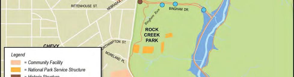
6 Final Environmental Assessment of Oregon Avenue NW The total estimated construction cost for Alternative 3 is $30.5 million. CANDIDATE BUILD ALTERNATIVE 4 Candidate Build Alternative 4 also consists of two cross-section widths. In the Southern Section, where the existing right-of-way is 33 feet, Oregon Avenue would be reconstructed similar to Candidate Build Alternative 2, with two 10-foot travel lanes with curb and gutter and a 5-foot sidewalk on the west side and a curb on the east. In the Northern Section, or north of Nebraska Avenue to Western Avenue, Alternative 4 would have a cross-section width of 44 feet and include two 10-foot travel lanes, a 4-foot bike lane, 10- foot vegetated swale, and 5-foot sidewalk on the west side, and a 4-foot bike lane and mountable curbing on the east side. Similar to the Southern Section, both travel lanes would slope from east to west so that all roadway runoff would be directed to the west side of the roadway. Runoff will be captured in a closed, underground system in the Southern Section. The roadway runoff in the Northern Section would be directed to a vegetated swale on the west side of the roadway. Some of the sections of roadway will require retaining walls in order to stay within the right-ofway and preserve the use of the adjacent homes front yards. These walls are estimated at 2 to 5 feet high in the Southern Section and up to 8 feet high in the Northern Section of the project. The total estimated construction cost for Alternative 4 is $35.3 million. S.5 AFFECTED ENVIRONMENT Environmental resources were identified and mapped within the project corridor, including natural, cultural, and socioeconomic resources (see Figure S-1). In addition, the existing conditions in the Oregon Avenue project corridor were assessed in terms of the condition of the transportation network, air and noise quality, and energy conservation. Key natural resources within the project corridor include Pinehurst Run, a perennial stream with a mapped 100-year floodplain, and Rock Creek Park, the only large area of mostly contiguous deciduous forest habitat in the District metropolitan area. A tree survey was conducted as part of this project to determine the number, size, and health (condition) of existing trees along the roadway corridor. The inventory was used to determine the potential impact (direct and indirect) to trees adjacent to the roadway and will help determine the level of replacements required to mitigate any loss. In terms of cultural resources, archeological sites, areas of archeological potential, historic structures, and cultural landscapes are located in the Oregon Avenue project area. The Rock Creek Park Historic District (RCPHD) is listed on the National Register of Historic Places (NRHP) and is immediately adjacent to the Oregon Avenue project corridor. Several contributing elements of the RCPHD are located within the APE, including elements of the circulation network, culverts, and boundary monuments. Water control features identified along Oregon Avenue include culverts, headwalls, and access manholes that may date to the development of the roadway. Residential and institutional facilities on the west side S-6


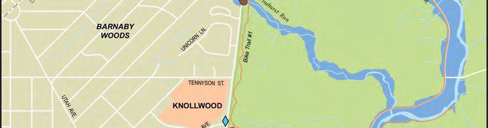

7 Summary Figure S-1. Existing Environmental Resources in Project Area S-7
8 Final Environmental Assessment of Oregon Avenue NW of the roadway, including the NRHP-eligible Knoll House at Knollwood, are also located within the APE. The NPS is currently drafting a Historic Trails Cultural Landscape Report (CLR) for Rock Creek Park that documents the multi-use trail (Bike Trail #1) just inside the park along Oregon Avenue among components of the park s cultural landscape. While Rock Creek Park, designated Park/Recreation/Open Space land use, dominates the entire eastern side of the roadway, land use on the western side is predominantly Low and Medium Density Residential, interspersed with two Institutional land areas (St. John s College High School and Knollwood military retirement facility) and one NPS Park/Recreation/Open Space near Pinehurst Run. Oregon Avenue mainly provides access to these residences and facilities along the roadway. Daily commuters also use one section of Oregon Avenue as a cut through route: from Nebraska Avenue to Oregon Avenue to Wise Road (through Rock Creek Park). Existing traffic volumes suggest that there is adequate capacity and no need for capacity improvements on Oregon Avenue. With the exception of a very short stretch of sidewalk north of Moreland Place, Oregon Avenue currently lacks amenities to serve pedestrians and bicycles. Other than crosswalks and stop signs connecting Tennyson Street to Rock Creek Park, there are no internal linkages or crosswalks for pedestrians to the parks, schools, and residential areas adjacent to Oregon Avenue, nor are there pedestrian connections to serve those who ride the Metrobus E-6 route, which serves seven bus stops in the northern portion of the roadway. The reconstruction of Oregon Avenue is included in the Transportation Improvement Program (TIP) for the Metropolitan Washington Region (Fiscal Years 2011 to 2016), and the scope of the project is consistent with the regional analysis included in the TIP. The National Capital Region 2010 Constrained Long-Range Transportation Plan (CLRP) and the TIP have been determined by the Metropolitan Washington Council of Governments (MWCOG) to conform to the intent of the State Implementation Plan (SIP). The Oregon Avenue project is not a project of air quality concern and existing noise levels do not exceed federal noise abatement criteria. S.6 SUMMARY OF IMPACTS The following briefly describes the principal environmental effects of the proposed project. Table S-1, located at the end of this summary, is a matrix showing the comparative effects of the alternatives. Based on the evaluation included in the EA and this Final EA, as well as comments received from regulatory agencies and the public, it is anticipated that the project would not have a significant impact on the environment either in context or intensity as defined by the Council on Environmental Quality (CEQ). Therefore a Finding of No Significant Impact (FONSI) would be appropriate for the project. This Final EA document complies, to the extent possible, with all applicable environmental laws and Executive Orders, or provides reasonable assurance that their requirements can be met. S.6.1 NATURAL RESOURCES Construction of each of build alternatives would disturb land areas beyond the existing roadway infrastructure. The areas of disturbance range from 1.4 acres for the narrowest S-8
9 Summary alternative (Candidate Build Alternative 2) to approximately 3.4 acres for Candidate Build Alternatives 3 and 4. For the Preferred Alternative, Candidate Build Alternative 3 was modified to reduce the area of disturbance by about three-quarters of an acre to approximately 2.6 additional acres that have not been previously graded for facility construction. The majority of land disturbance will occur within a narrow band along the western edge of the existing roadway areas that have been previously disturbed during construction of the original roadway and adjacent residences. To minimize off-site impacts, Erosion and Sedimentation Control and Stormwater Management Plans will be developed in accordance with DC Municipal Regulations. Each of the build alternatives is anticipated to result in improvements to local water quality by incorporating effective stormwater management systems. The proposed systems will reduce the volume and velocity of stormwater runoff entering receiving surface waters by increasing retention and infiltration. The improved stormwater management systems will at least offset all additional runoff generated through increased impervious areas created by the alternatives. Primary impacts to Pinehurst Run and other stream crossings will be limited to short-term construction activities associated with the replacement or reconstruction of four existing culverts and installation of sand seepage berms. The proposed alternatives would be 32 to 40 feet wide, or 5 to 13 feet wider than the existing 27-foot crossing over Pinehurst Run. An additional 30 feet of disturbance upstream and downstream (combined) is expected to construct the new crossing. Minor encroachments on the Pinehurst Run floodplain are anticipated with the build alternatives. Encroachments occur immediately adjacent to the existing roadway and involve between 2,508 square feet (0.06 acres) for Candidate Build Alternative 2 to 6,760 square feet (0.16 acres) for Candidate Build Alternative 4 the widest alternative. Candidate Build Alternative 3 was modified in the development of the Preferred Alternative to reduce the amount of encroachment in the Pinehurst Run floodplain to 5,081 square feet (0.12 acres). None of the encroachments are expected to cause any increase in backwater elevations. An overall reduction in backwater flooding is expected with the increased capacity provided by the new crossing. No wetlands, navigable waters, or wild or scenic rivers are located in the immediate project area. Consultation with the US Fish and Wildlife Service and the National Park Service indicate that there are no threatened or endangered species in the immediate project area and no further consultation under Section 7 of the Endangered Species Act is required. Construction activities associated with replacing the roadway bed may impact some large trees immediately adjacent to the roadway. Root systems from larger trees are expected to have spread beneath the existing roadway; therefore, damage to these root systems during construction could result in loss of the trees. It was estimated that between 62 and 85 mature trees (specimens with diameters at breast height greater than 6 inches) could have been impacted under alternatives 2, 3, and 4. Modifications to Alternative 3 reduced the number of S-9
10 Final Environmental Assessment of Oregon Avenue NW trees to be impacted from 85 to 65 trees, thus reducing the impacts from implementation of the Preferred Alternative on vegetation and adjacent property owners. S.6.2 CULTURAL AND PALEONTOLOGICAL RESOURCES Pursuant to the requirements of the Section 106 of the National Historic Preservation Act (NHPA), the District of Columbia State Historic Preservation Office (DC SHPO) has concurred with FHWA and DDOT in a letter dated July 15, 2011, that the Oregon Avenue Reconstruction Project will have no adverse effect on historic properties under Section 106 of the NHPA. In order to ensure this determination of no adverse effect, the following conditions have to be implemented: 1. DC SHPO will be provided an opportunity to review and comment on the design of the replacement culvert over Pinehurst Branch in order to ensure it is compatible with its setting adjacent to the Rock Creek Park Historic District. The Arch Culvert or Bridge options appear to be more appropriate for this setting than the Box Culvert ; 2. DC SHPO will also be provided an opportunity to review and comment on any alterations proposed for the stone and concrete outfall south of Bingham Drive if it is determined to be a contributing element of the Rock Creek Park Historic District (Subsequent revisions to the design of stormwater management system upgrades eliminated the need to alter this outfall). The NPS indicated that the stone and concrete outfall south of Bingham Drive is considered a contributing element to the RCPHD. Because no impacts will occur to this or any culvert in Rock Creek Park, the second condition above will not be implemented.) 3. DDOT shall ensure that the stone boundary monuments that mark the border of Rock Creek Park will not be altered or damaged in any way; and 4. In consultation with the DC SHPO, DDOT shall conduct a Phase IA archaeological survey including geoarchaeological consultation if the LOD [Limits of Disturbance] to determine if any locations warrant testing for the presence of potentially significant archaeological resources. (Appendix F Maloney comment). Conditions 1 and 4 will be implemented during the design phase and Condition 3 will be implemented in the construction phase.. S.6.3 SOCIOECONOMIC RESOURCES Candidate Build Alternatives 2, 3, and 4, and the Preferred Alternative, are expected to have no effect on land use and zoning within the project corridor. The project will not result in any impacts to low-income or minority populations. Alternatives have been developed to include context-sensitive design features that maintain the bucolic or rural-like feel of the existing roadway. Candidate Build Alternatives 2, 3, and 4, and the Preferred Alternative, will have no impact on local community resources. Improved travelways should prove beneficial to local emergency service providers. S-10
11 Summary S.6.4 TRANSPORTATION The long-term impacts of the build alternatives will include improvements to travel safety of all modes: automobile, bus, bicycle, and pedestrian. Short-term detours will be required during the 3 to 9 month construction periods for the various project sections. Maintenance of traffic and detour plans will be developed to alleviate impacts to local travelers. S.6.5 AIR QUALITY The proposed action will not result in any change in roadway capacity or adjacent land uses; therefore, there will be no measurable change in air quality parameters. Short-term impacts associated with construction will be mitigated through implementation of DDOT standard specifications. S.6.6 NOISE As noted above, the proposed build alternatives will not result in any change in roadway capacity or any major change in its horizontal or vertical alignment. Therefore, no appreciable impacts to noise and vibration would occur from implementation of the proposed action. S.6.7 HAZARDOUS WASTE AND MATERIALS Based on a review of available data and site inspections, no evidence of recognized environmental concerns (hazardous material sites) were identified in the project area. S.6.8 INDIRECT AND CUMULATIVE EFFECTS There will be no induced or secondary effects caused by the Candidate Build alternatives, or the Preferred Alternative. The proposed project would serve traffic generated by development on adjoining lands and beyond the limits of the project, but it would not cause any further such development. Moreover, the project is consistent with local comprehensive planning regarding land use goals in the surrounding area and transportation in the project corridor. Despite the dramatic changes in the landscape that have occurred over time due to human settlement and development in the surrounding area, the intensity of the incremental or cumulative impacts of the project are considered small when reviewed in the context of impacts from other past, present, and reasonably foreseeable future actions and would not rise to a level that would cause significant cumulative impacts. S.6.9 SECTION 4(f) EVALUATION The proposed action will not require the use of any new Section 4(f) resource. S.7 AGENCY COORDINATION AND PUBLIC INVOLVEMENT As part of the planning process for the Oregon Avenue Final EA, DDOT conducted a comprehensive agency coordination program. This coordination included project scoping, consultation with resource agencies in accordance with Section 7 of the Endangered Species Act (ESA), consultation with the DC SHPO and NPS in accordance with Section 106 of the National Historic Preservation Act (NHPA), individual meetings, and a public hearing following completion of the EA. DDOT and FHWA also conducted a series of regularly scheduled meetings with the NPS and the District Department of the Environment (DDOE) to ensure S-11
12 Final Environmental Assessment of Oregon Avenue NW continuous input from these two partner agencies. Each agency provided extensive information on existing conditions within the project area and helped coordinate the roadway improvement with on-going improvements in Rock Creek Park most notably stormwater management and stream restoration activities. Throughout the study DDOT actively sought public input. Numerous methods were employed to solicit input including two public information meetings, a project website and a formal public hearing following publication of the EA. Input from the participating agencies and the general public were instrumental in the development and refinement of project alternatives. After consideration of the agency and public comments received during the comment period for the EA, a modified version of Candidate Build Alternative 3 was selected as the Preferred Alternative. Based on the comments the typical section for the northern segment of the original alternative was reduced in width by replacing the 10-foot grass swale with a 4-foot planting strip and incorporating a 6- foot wide sidewalk in place of the 10-foot wide shared-use path. S-12
13 Summary Table S-1. Summary of Impacts Additional Area of Disturbance (acres) ALT 1 NO ACTION ALT 2 ALT 3 BUILD ALTERNATIVES PREFERRED/ ALT 3 MODIFIED ALT Pinehurst Run - Limits of Disturbance (linear feet) 74 Improvements to Stormwater Management No Yes Yes Yes Yes Pinehurst Run - Floodplain Encroachments (acres) Wetlands Displaced (acres) Threatened and Endangered Species None None None None None Loss of Mature Trees Archeological Resource Impacts Historic Structure Impacts None None, with conditions None, with conditions None, with conditions None, with conditions None Minor short-term Minor short-term Minor short-term Minor short-term Cultural Landscapes None Minor short-term Minor short-term Minor short-term Minor short-term Land Use and Zoning No Change No Change No Change No Change No Change Pedestrian Improvements No Yes Yes Yes Yes Bicyclist Improvements No No Yes No Yes Air Quality Impacts None None None None None Noise Impacts None None None None None Hazardous Materials None None None None None Environmental Justice Populations Affected Visual Intrusions No Change Minor Minor Minor Minor Construction Costs (millions) N/A $23.4 $30.5 $27.2 $35.3 S-13
14 Final Environmental Assessment of Oregon Avenue NW S-14
2 ALTERNATIVES AND OPTIONS
 2 ALTERNATIVES AND OPTIONS This chapter documents the process used to develop improvement concepts for Oregon Avenue and describes the resulting project alternatives and options, which were developed in
1 PURPOSE AND NEED 1.1 PURPOSE OF THE PROPOSED ACTION 1.2 NEEDS FOR THE PROPOSED ACTION
 1 PURPOSE AND NEED The Federal Highway Administration (FHWA) and the District Department of Transportation (DDOT), in cooperation with the National Park Service (NPS), are proposing the rehabilitation
WELCOME! 8 8:30 6: TH STREET IMPROVEMENTS. Open House. Presentation & Q&A
 WELCOME! 168 TH STREET IMPROVEMENTS 6:30 Open House 7 8 Presentation & Q&A 8 8:30 Open House WELCOME Todd Pfitzer City of Omaha Engineer Bob Stubbe City of Omaha Public Works Director Jon Meyer Project
When planning stormwater management facilities, the following principles shall be applied where possible.
 2.0 Principles When planning stormwater management facilities, the following principles shall be applied where possible. 2.0.1 Drainage is a regional phenomenon that does not respect the boundaries between
Asbury Chapel Subdivision Sketch Plan
 Asbury Chapel Subdivision Sketch Plan PART 1: PROJECT SUMMARY Applicant: NVR Inc. Project Size: +/- 76.13 acres Parcel Numbers: 02101112,02116101,02116112, 02116113 Current Zoning: Transitional Residential
The Illinois Department of Transportation and Lake County Division of Transportation. Route 173, including the Millburn Bypass
 The Illinois Department of Transportation and Lake County Division of Transportation welcome you to this Public Hearing for U.S. Route 45 from Illinois Route 132 to Illinois Route 173, including the Millburn
TOWNSHIP OF LOGAN SOIL & FILL IMPORTATION AND PLACEMENT APPLICATION SUBMITTAL CHECKLIST
 TOWNSHIP OF LOGAN SOIL & FILL IMPORTATION AND PLACEMENT APPLICATION SUBMITTAL CHECKLIST Applications: 5 copies of application - Applicant will reproduce the copies at his/her costs. The Township Clerk
DESIGN CRITERIA PACKAGE
 RFQ: 17-C-00003 DESIGN-BUILD SERVICES FOR THE DESIGN CRITERIA PACKAGE PREPARED BY: JAMES E. JACKSON, JR. AIA CITY ARCHITECT CONTRACT ADMINISTRATION DEPARTMENT and INTERFLOW ENGINEERING, L.L.C DESIGN CRITERIA
PROJECT BACKGROUND. Preliminary Design Scope and Tasks
 PROJECT BACKGROUND Preliminary Design Scope and Tasks The purpose of this Study is the development of preliminary designs for intersection improvements for Trunk Highway (TH) 36 at the intersections of
Bostwick Road. Municipal Class Environmental Assessment. Public Information Centre #2 June 14, City of London
 Bostwick Road Municipal Class Environmental Assessment Public Information Centre #2 June 14, 2017 Welcome! Welcome to the 2 nd Public Information Centre for the. Representatives from the and the consulting
Berkshire Regional Planning Commission Clearinghouse Review Report
 August 19, 2013 SUBJECT: Reconstruction of Housatonic Street, Dalton, MA EOEA#: 15083 LOCATION: Dalton ESTIMATED COST: $8.1 million REVIEW TYPE: ENF PROPONENT: MassDOT and Town of Dalton COMMENTS DUE:
DRAFT MAP AMENDMENT FLU 04-4
 DRAFT MAP AMENDMENT FLU 04-4 SW 24 TH AVENUE ROADWAY CORRIDOR The University of Florida participates with the Metropolitan Transportation Planning Organization (MTPO) in its responsibilities for the continuing,
Clay Street Bridge Replacement Project
 Clay Street Bridge Replacement Project Frequently Asked Questions (FAQs) No. 2 April 4, 2018 The project is located in downtown Placerville on Clay Street between US Highway 50 and Main Street and Cedar
Public Hearing. Charlotte County-Punta Gorda MPO - Meeting Rooms A and B March 14, open house at 4 p.m., formal presentation at 5 p.m.
 Public Hearing Charlotte County-Punta Gorda MPO - Meeting Rooms A and B March 14, 2019 open house at 4 p.m., formal presentation at 5 p.m. Welcome to the Public Hearing for the Harborview Road (CR 776)
STATE OF TENNESSEE DEPARTMENT OF TRANSPORTATION ENVIRONMENTAL DIVISION
 STATE OF TENNESSEE DEPARTMENT OF TRANSPORTATION ENVIRONMENTAL DIVISION Suite 900 - James K. Polk Building 505 Deaderick Street Nashville, Tennessee 37243-0334 MEMORANDUM TO: FROM: Files Joe W. Matlock,
CITY OF TUMWATER 555 ISRAEL RD. SW, TUMWATER, WA (360) (360) (FAX)
 (360) (FAX)") CITY OF TUMWATER 555 ISRAEL RD. SW, TUMWATER, WA 98501 (360) 754-4180 (360) 754-4126 (FAX) Email: cdd@ci.tumwater.wa.us APPENDIX II-C SHORT FORM CONSTRUCTION STORMWATER POLLUTION PREVENTION PLAN (SWPPP)
CITY OF TUMWATER 555 ISRAEL RD. SW, TUMWATER, WA 98501 (360) 754-4180 (360) 754-4126 (FAX) Email: cdd@ci.tumwater.wa.us APPENDIX II-C SHORT FORM CONSTRUCTION STORMWATER POLLUTION PREVENTION PLAN (SWPPP)
AESTHETIC APPEARANCE. Design Guidelines for Grade-Separated Pedestrian, Cyclist and Equestrian Structures
 III. AESTHETIC APPEARANCE The aesthetic qualities of a grade-separated structure are as important as the specific design criteria. For example, a structure may be constructed to the exact criteria set
7.0 SOCIAL, ECONOMIC, AND ENVIRONMENTAL ISSUES
 7.0 SOCIAL, ECONOMIC, AND ENVIRONMENTAL ISSUES The following list of social, economic, and environmental issues have been identified based on a preliminary inventory of resources in the project area, an
Draft Rhode Island Stormwater Design and Installation Standards Manual
 Draft Rhode Island Stormwater Design and Installation Standards Manual Summary The May 2009 Public Review Draft version of the RI Stormwater Design and Installation Standards Manual consists of approximately
COMPLETE GREEN STREET CHECKLIST
 COMPLETE GREEN STREET CHECKLIST This document was developed to dissect the structure of an urban street and explore opportunities to make our streets more complete while also integrating green street strategies.
STORMWATER MANAGEMENT CODES ANALYSIS RICHLAND COUNTY, SC SITE PLANNING ROUNDTABLE
 STORMWATER MANAGEMENT CODES ANALYSIS RICHLAND COUNTY, SC SITE PLANNING ROUNDTABLE Codes analyses for each subcommittee were completed to assist participants of the Richland County Site Planning Roundtable.
Creating Complete Roadway Corridors:
 Creating Complete Roadway Corridors: The AASHTO Guide to Transportation Landscape Architecture and Environmental Design NCHRP Project 15-33 Status Report AASHTO Standing Committee on Design Technical Committee
Bostwick Road. Municipal Class Environmental Assessment. October 13, City of London. Bostwick Road Municipal Class Environmental Assessment
 Bostwick Road Municipal Class Environmental Assessment October 13, 2016 Welcome! Welcome to the first Public Information Centre for the Bostwick Road Municipal Class Environmental Assessment. Representatives
Chapter 5: Natural Resources and Environment
 NATURAL RESOURCES AND ENVIRONMENT 5-1 5 Chapter 5: Natural Resources and Environment BACKGROUND AND INTENT Urban expansion represents the greatest risk for the future degradation of existing natural areas,
ST. MARY S SOIL CONSERVATION DISTRICT (SMSCD) AND DPW&T CONCEPT EROSION AND SEDIMENT CONTROL AND STORMWATER MANAGEMENT GUIDELINES AND CHECKLIST
 AND DPW&T CONCEPT EROSION AND SEDIMENT CONTROL AND STORMWATER MANAGEMENT GUIDELINES AND CHECKLIST") St. Mary s Soil Conservation District 26737 Radio Station Way, Suite B Leonardtown, MD 20650 Phone: 301-475-8402 ext. 3 Fax: 301-475-8391 www.stmarysscd.com St. Mary s County Government Department of Public
St. Mary s Soil Conservation District 26737 Radio Station Way, Suite B Leonardtown, MD 20650 Phone: 301-475-8402 ext. 3 Fax: 301-475-8391 www.stmarysscd.com St. Mary s County Government Department of Public
BUFFERS, TREE PROTECTION AND LANDSCAPING. Sec Purpose and Intent.
 ARTICLE 20 BUFFERS, TREE PROTECTION AND LANDSCAPING Sec. 20.1. Purpose and Intent. Trees improve air and water quality, reduce soil erosion, reduce noise and glare, provide habitat for desirable wildlife,
STREAM BUFFERS
 88-415 STREAM BUFFERS 88-415-01 PURPOSE In the Kansas City region and throughout the nation, vegetated stream buffers have been clearly shown to protect stream stability and related infrastructure, improve
COMMUNITY DESIGN. GOAL: Create livable and attractive communities. Intent
 COMMUNITY DESIGN Intent An attractive, well-designed County will attract quality development, instill civic pride, improve the visual character of the community, and create a strong, positive image for
Chapter 3 Site Planning and Low Impact Development
 CHAPTER 3 Site Planning and Low Impact Development Chapter 3 Site Planning and Low Impact Development 3.0 Introduction The City of Charleston requires that major residential, large commercial (>1 acre),
Town of Portola Valley General Plan. Nathhorst Triangle Area Plan
 Town of Portola Valley General Plan Amended December 10, 1997 Table of Contents Introduction... 1 Planning Area... 1 Objectives... 2 Principles... 2 Standards... 4 Description... 4 Community Commercial...
5. LOW IMPACT DEVELOPMENT DESIGN STANDARDS
 5. LOW IMPACT DEVELOPMENT DESIGN STANDARDS Low Impact Development (LID) requires a shift in stormwater management away from conveying runoff to a small number of downstream points through hydraulically
Key elements : Filter Strips must be designed within parameters required by the Fort Wayne s Development Standards/Criteria Manual.
 4.4. Filter Strips Filter Strips are densely vegetated lands that treat sheet flow storm water from adjacent pervious and impervious areas. They function by slowing runoff, trapping sediment and pollutants,
Public Information Centre # 2 Coronation Park Drainage Improvements Town of Oakville Municipal Class Environmental Assessment
 November 26, 2014 Public Information Centre # 2 Coronation Park Drainage Improvements Town of Oakville Municipal Class Environmental Assessment Study Area & Drainage System Legend Coronation Project Park
Municipal Class EA Study Public Information Centre No. 1 December 13, :00 pm 7:00 pm. Please sign in so we can keep you updated on this study
 Reconstruction of Regional Road 45 (Creek Road) Between Regional Road 27 (River Road) and Regional Road 63 (Canborough Road) in the Township of Wainfleet Municipal Class EA Study Public Information Centre
Appendix E Preliminary Location Hydraulic Study
 Appendix E Prepared for: State of Alaska Department of Transportation and Public Facilities Prepared by: HDR Alaska, Inc. 2525 C Street, Suite 305 Anchorage, Alaska 99503 February 2014 This page intentionally
Town of Vershire Road Erosion Inventory Report
 Town of Vershire Road Erosion Inventory Report Taylor Valley Road. Photo taken by TRORC staff. Prepared by: 128 King Farm Road Woodstock, VT 05091 Inventory and report funded by the Vermont Agency of Transportation
Glenn Highway MP DSR. Landscape Narrative
 Glenn Highway MP 34-42 DSR Landscape Narrative Project Landscape Goals The Glenn Highway MP 34-42 Project extends through a variety of landscape types typical to the Matanuska-Susitna Valley. In general,
LOUISIANA STATE UNIVERSITY COMPREHENSIVE & STRATEGIC CAMPUS MASTER PLAN. APPENDIX G - Stormwater Study Findings & Stormwater Solutions
 LOUISIANA STATE UNIVERSITY COMPREHENSIVE & STRATEGIC CAMPUS MASTER PLAN APPENDIX G - Stormwater Study Findings & Stormwater Solutions LSU: MP Narrative July 2017 3.5 Open Space Existing Conditions The
DRAFT SECTION 4(f) EVALUATION INTERSTATE 73 FEIS: I-95 to I-73/I-74 in North Carolina
 EVALUATION INTERSTATE 73 FEIS: I-95 to I-73/I-74 in North Carolina") DRAFT SECTION 4(f) EVALUATION INTERSTATE 73 FEIS: I-95 to I-73/I-74 in North Carolina 1.0 INTRODUCTION Section 4(f) of the Department of Transportation Act of 1966, 49 U.S.C. 303, requires that prior to
DRAFT SECTION 4(f) EVALUATION INTERSTATE 73 FEIS: I-95 to I-73/I-74 in North Carolina 1.0 INTRODUCTION Section 4(f) of the Department of Transportation Act of 1966, 49 U.S.C. 303, requires that prior to
Appendix E Section 4(f) Evaluation
 Evaluation") Appendix E Section 4(f) Evaluation Appendix E Draft Section 4(f) Evaluation E.1 Introduction This appendix addresses a federal regulation known as Section 4(f), which protects parks, recreation areas,
Appendix E Section 4(f) Evaluation Appendix E Draft Section 4(f) Evaluation E.1 Introduction This appendix addresses a federal regulation known as Section 4(f), which protects parks, recreation areas,
GREEN SHEET ENVIRONMENTAL COMMITMENTS FOR THE IOWA HIGHWAY 100 EXTENSION
 County: Linn County, IA GREEN SHEET Location: IA 100, from its terminus at Edgewood Rd. to US 30 southwest of Cedar Rapids Route: IA 100 Extension Project No.: NHS-100-1(36) 19-57 OLE Project Managers:
Chapter 1 - General Design Guidelines CHAPTER 1 GENERAL DESIGN GUIDELINES
 CHAPTER 1 GENERAL DESIGN GUIDELINES 1.0 INTRODUCTION This Publication has been developed to provide current, uniform procedures and guidelines for the application and design of safe, convenient, efficient
SECTION 4(f) DE MINIMIS DOCUMENTATION
 DE MINIMIS DOCUMENTATION") SECTION 4(f) DE MINIMIS DOCUMENTATION Illinois Route 60/83 IL 176 to the intersection of IL 60 (Townline Road) Lake County P-91-084-07 Mundelein Park and Recreation District Project Limit SECTION 4(f)
SECTION 4(f) DE MINIMIS DOCUMENTATION Illinois Route 60/83 IL 176 to the intersection of IL 60 (Townline Road) Lake County P-91-084-07 Mundelein Park and Recreation District Project Limit SECTION 4(f)
CARVER COUNTY DIVISION OF PUBLIC WORKS LANDSCAPE POLICY. Adopted by the Carver County Board of Commissioners March 3, 2015
 CARVER COUNTY DIVISION OF PUBLIC WORKS LANDSCAPE POLICY Adopted by the Carver County Board of Commissioners March 3, 2015 Policy Statement Goals It is the goal of Carver County Public Works to provide
Transportation Improvements
 Transportation Improvements 0 0 Volume II of the Final EIS for the DHS Headquarters consolidation at St. Elizabeths includes analysis to transportation improvements for the DHS Headquarters Consolidation
River Corridor Overlay Zone (RCOZ) Article 5
 Article 5") River Corridor Overlay Zone (RCOZ) Article 5 The site is in one of two designated districts. The first is the CBD (central business district) River District, which recognizes the urban character and unique
River Corridor Overlay Zone (RCOZ) Article 5 The site is in one of two designated districts. The first is the CBD (central business district) River District, which recognizes the urban character and unique
SUMMARY. Support the Southeast Arkansas Regional Intermodal Facility.
 SUMMARY THE I-69 LOCATION STUDY The proposed I-69 Location Study from El Dorado to McGehee, Arkansas, represents one section (Section of Independent Utility No. 13) of the nationally designated I-69 Corridor
4-Town Comprehensive Plan DRAFT 7/30/07
 4-Town Comprehensive Plan DRAFT 7/30/07 Acknowledgements ning Committee Town of Harrisburg Norman Roof Randy Nicol Town of Martinsburg Terry Thisse Paul Kelly Town of Montague Jan Bagdanowicz Wendy Perry
Section 11 Grading and Drainage Standards
 Section 11 Grading and Drainage Standards 11.1 INTRODUCTION The proper grading, conveyance, storage and release of storm water is critical to maintain the integrity of the Property. Drainage facilities,
PART 1: PROJECT SUMMARY. Proposed Land Use: 120 single-family lots. The application is Attachment A. The site plan is Attachment B.
 PART 1: PROJECT SUMMARY Applicant: JBH Development, LLC and Hopper Communities, INC Project Size: +/- 80.48 acres Parcel Number: 01513107, 01513108, 01513109, 01513113, 01513120, 01513121, 01513122, 01513124,
CHECKLIST FOR PHASE II DRAINAGE REPORT
 I. COVER SHEET CHECKLIST FOR PHASE II DRAINAGE REPORT A. Name of Project B. Address C. Owner D. Developer E. Engineer F. Submittal date and revision dates as applicable II. GENERAL LOCATION AND DESCRIPTION
Public Information Centre. Welcome
 Transportation Improvements from the Beaver Creek Bridge to the Entrance of Santa s Village District of Muskoka Municipal Class Environmental Assessment Welcome Please sign in Take a comment sheet Staff
5.1.1 The streetscape along US Highway 64 (Brevard Road); and, The built environment within new residential developments; and,
; and, The built environment within new residential developments; and,") Article 5. Landscaping 5.1 Purpose The Town of Laurel Park s landscape standards are designed to create a beautiful, aesthetically pleasing built environment that will complement and enhance community
Article 5. Landscaping 5.1 Purpose The Town of Laurel Park s landscape standards are designed to create a beautiful, aesthetically pleasing built environment that will complement and enhance community
APPENDIX J PERFORMANCE STANDARDS FOR GRAVEL MINE, PIT MINE, OR QUARRY
 APPENDIX J PERFORMANCE STANDARDS FOR GRAVEL MINE, PIT MINE, OR QUARRY A. Purpose: 1. Regulatory Requirement and Use Mitigation: The purpose of this appendix is to provide a regulatory context (standards)
Overview of Southwestern Pennsylvania Commission s (SPC) 2040 Long Range Transportation Plan (LRTP)
 2040 Long Range Transportation Plan (LRTP)") Overview of Southwestern Pennsylvania Commission s (SPC) 2040 Long Range Transportation Plan (LRTP) Presented to Pennsylvania Agency Coordination Meeting May 27, 2015 Doug Smith & Ryan Gordon 1 Southwestern
Overview of Southwestern Pennsylvania Commission s (SPC) 2040 Long Range Transportation Plan (LRTP) Presented to Pennsylvania Agency Coordination Meeting May 27, 2015 Doug Smith & Ryan Gordon 1 Southwestern
Toronto Complete Streets Guidelines
 Toronto Complete Streets Guidelines 108 110 7.1 Green Infrastructure Design Principles 112 7.2 Context-Sensitive Green Streets 114 7.3 Key Green Street Elements Green infrastructure refers to natural and
PREPARED FOR: PLATTEVIEW ROAD CORRIDOR STUDY EXECUTIVE SUMMARY
 PREPARED FOR: PLATTEVIEW ROAD CORRIDOR STUDY EXECUTIVE SUMMARY SEPTEMBER 2016 Introduction The Platteview Road Corridor Study was led by the Metropolitan Area Planning Agency (MAPA) with assistance from
COLVER ROAD INDUSTRIAL CONCEPT PLAN
 COLVER ROAD INDUSTRIAL CONCEPT PLAN A CONCEPTUAL LAND USE AND TRANSPORTATION PLAN FOR TA-4 AN URBAN RESERVE AREA OF THE CITY TALENT City of Talent Adopted by City Council Resolution No., June, 2015 PART
Improve Neighborhood Design and Reduce Non Point Source Water Pollution
 HOW TO Planning Guide Improve Neighborhood Design and Reduce Non Point Source Water Pollution This document was funded by a grant from the New Hampshire Coastal Program with funding from the National Oceanic
PURPOSE: The purpose is to provide commercial facilities in the Vancouver and Clark County vicinity.
 US Army Corps of Engineers Seattle District Joint Public Notice Application for a Department of the Army Permit and a Washington Department of Ecology Water Quality Certification and/or Coastal Zone Management
2.4 FUTURE LAND USE ELEMENT Goals, Objectives and Policies
 GOAL 1: To create developmental patterns that direct future growth to appropriate areas on campus, in a manner that promotes the educational mission of the University, the protection of environmentally
Appendix I. Checklists
 Appendix I Checklists Town of Greenwich Drainage Manual Department of Public Works - Engineering Division Town Hall - 101 Field Point Road, Greenwich, CT 06836-2540 Phone 203-622-7767 - Fax 203-622-7747
PLANNED UNIT DEVELOPMENT STAFF REPORT Date: June 2, 2016
 # 9 ZON2016-01032 PLANNED UNIT DEVELOPMENT STAFF REPORT Date: June 2, 2016 DEVELOPMENT NAME JJT Properties LLC LOCATION 1147 & 1151 East I-65 Service Road South and 1180 Sledge Drive (Southeast corner
HAZARD MITIGATION GOALS AND OBJECTIVES
 SEWRPC Community Assistance Planning Report No. 282, 2nd Edition CITY OF MILWAUKEE ALL HAZARDS MITIGATION PLAN UPDATE Chapter IV HAZARD MITIGATION GOALS AND OBJECTIVES [NOTE: Throughout this plan update
INFRASTRUCTURE EXISTING INFRASTRUCTURE A. Circulation B. Signals C. Drainage D. Utilities
 7.01. EXISTING INFRASTRUCTURE A. Circulation B. Signals C. Drainage D. Utilities 7.02. PROPOSED INFRASTRUCTURE A. Overall Concept B. Circulation C. Signals D. Drainage 7.03. INFRASTRUCTURE MAP A. Key Infrastructure
Overall Map. Chicago. St. Louis. Summit. Joliet. Dwight. Pontiac. Bloomington-Normal Lincoln. Springfield. Carlinville. Alton EXPERIENCE IT YOURSELF.
 Overall Map Summit Chicago Bloomington-Normal Lincoln New Station Planned New Station Planned Dwight Pontiac Joliet Pedestrian overpass and second platform planned Higher speed service began in this section
East River Waterfront Esplanade and Piers New York, New York Draft Environmental Impact Statement
 East River Waterfront Esplanade and Piers New York, New York Draft Environmental Impact Statement October 12, 2006 CEQR No.: TO COME ULURP Nos.: TO COME Lead Agency: Lower Manhattan Development Corporation
PROJECT STATEMENT LOCATION/DESIGN PUBLIC HEARING. 19 th AVENUE NORTH EXTENSION PROJECT FROM SPRINGDALE DRIVE TO NORTH 2 ND STREET/U.S.
 PROJECT STATEMENT LOCATION/DESIGN PUBLIC HEARING 19 th AVENUE NORTH EXTENSION PROJECT FROM SPRINGDALE DRIVE TO NORTH 2 ND STREET/U.S. 67 HEARING LOCATION: ERICKSEN COMMUNITY CENTER 1401 11 TH AVENUE NORTH
City of Kelowna Consolidated Zoning Bylaw No. 8000
 Section 7 Landscaping and Screening 7.1 Required Landscaping 7.1.1 The minimum level of landscaping required in each zone along all front, rear and side yards shall be determined from the Minimum Landscape
Gold Line Bus Rapid Transit Transit Oriented Development (BRTOD) Helmo Station Area Plan
 Helmo Station Area Plan") Appendix F Gold Line Bus Rapid Transit Transit Oriented Development (BRTOD) Helmo Station Area Plan Introduction and Purpose of the Plan The Gold Line Bus Rapid Transit facility is an eleven-mile dedicated
Appendix F Gold Line Bus Rapid Transit Transit Oriented Development (BRTOD) Helmo Station Area Plan Introduction and Purpose of the Plan The Gold Line Bus Rapid Transit facility is an eleven-mile dedicated
Meeting Display Boards for Public Hearing on the Wilson Transfer Station Project held Tuesday, February 18, 2014.
 Meeting Display Boards for Public Hearing on the Wilson Transfer Station Project held Tuesday, February 18, 2014. Board 1: Welcome Welcome to the Wilson Transfer Station Project Public Hearing. The purpose
LITTLE ITALY UNIVERSITY CIRCLE (MAYFIELD STATION) COMMUNITY MEETING FEBRUARY 21, 2013
 COMMUNITY MEETING FEBRUARY 21, 2013") LITTLE ITALY UNIVERSITY CIRCLE (MAYFIELD STATION) COMMUNITY MEETING FEBRUARY 21, 2013 Environmental Assessment (EA) Availability Completed in Compliance with the National Environmental Policy Act (NEPA)
LITTLE ITALY UNIVERSITY CIRCLE (MAYFIELD STATION) COMMUNITY MEETING FEBRUARY 21, 2013 Environmental Assessment (EA) Availability Completed in Compliance with the National Environmental Policy Act (NEPA)
The West Vaughan Employment Area Secondary Plan Policies
 Part 2: The West Vaughan Employment Area Secondary Plan Policies 2.1 General Policies It is the policy of Council: 2.1.1. That the West Vaughan Employment Area (the WVEA), identified on Schedule 1, will
I611. Swanson North Precinct
 I611. Swanson North Precinct I611.1. Precinct Description Swanson North is located in the north eastern foothills of the Waitakere Ranges. It is outside the Waitakere Ranges Heritage Area Act and the Waitakere
Southwest Transitway Extension Baseline Road to Norice Street. Environmental Assessment Minor Modification Report
 Southwest Transitway Extension Baseline Road to Norice Street Environmental Assessment Minor Modification Report September 2009 Environmental Assessment Minor Modification Report Southwest Transitway
ARTICLE IV: DEVELOPMENT STANDARDS 404 MASTER PLANNING
 IV 13 404 MASTER PLANNING Master Planning through the Site Analysis (Master Planning Site Analysis) or Planned Development (Master Planning Planned Development) is provided to encourage development which
COMMISSION ACTION FORM
 ITEM #: 6 DATE: 09-06-17 COMMISSION ACTION FORM REQUEST: Introduction and Initial Review of Proposed Amendments to the Ames Urban Fringe Future Land Map for the North Growth Gap Area BACKGROUND INFORMATION:
ARTICLE 17 SITE PLAN REVIEW
 ARTICLE 17 SITE PLAN REVIEW 17.01 INTENT AND PURPOSE The intent of this section is to provide for consultation and cooperation between the applicant and the township planning commission so that the applicant
Town of Windham. Planning Department 8 School Road Windham, ME voice fax
 Town of Windham Planning Department 8 School Road Windham, ME 04062 voice 207.864-5960 fax 207.892.1916 MEMO DATE: TO: Staff Review Committee FROM: Amanda Lessard, Planner Cc: Ellen Rathbone, St. Germain
4. CONCEPT PLAN DEVELOPMENT
 4. CONCEPT PLAN DEVELOPMENT Concept Plan Step 1: Identify Site Constraints and Opportunities Review the existing site to identify constraints and opportunities for GI Practices to meet the RRv. Constraints
Planning Districts INTRODUCTION
 INTRODUCTION To facilitate detailed examination of development prospects for all areas of the community, Delano has been divided into 14 planning districts. The location of these planning districts is
STORMWATER GREEN INFRASTRUCTURE AND PLANNING/ZONING BOARDS
 STORMWATER GREEN INFRASTRUCTURE AND PLANNING/ZONING BOARDS Source: Center for Watershed Protection, 2007 Southern Tier Central Regional Planning & Development Board Chemung County Stormwater Team OUTLINE
SITE PLAN REVIEW APPLICATION AND CHECKLIST
 SITE PLAN REVIEW APPLICATION AND CHECKLIST PROJECT SUMMARY: Project Name: City/ETA Location: City ETA (Application fee & number of copies needed are based on location) Property Location (Legal Description
4.500 Preston Road Overlay District
 Section 4.500 Preston Road Overlay District 2004 Zoning Ordinance 4.500 Preston Road Overlay District (ZC 98-29; Ordinance No. 98-9-12) 4.501 Purpose To provide appropriate design standards for the use
Venice Pumping Plant Dual Force Main Project Draft EIR
 City of Los Angeles 5.9 LAND USE PLANS 5.9.1 Environmental Setting Venice Pumping Plant Dual Force Main Project Draft EIR The Project lies within the bounds of Los Angeles County and the City of Los Angeles.
FDOT D4 Complete Streets
 FDOT D4 Complete Streets Context Sensitive Solutions Directs that complete street solutions will complement the context of the community. Collaborative approach to decision making, project development,
SITE PLAN REVIEW ITEMS - REFERENCE CHECKLIST
 City of Seminole 9199 113 th Street N. Seminole, FL 33772 Ph: (727) 392-1966 Fx: (727) 319-6583 SITE PLAN REVIEW ITEMS - REFERENCE CHECKLIST Note: This checklist is designed to aid designers in the review
SOUTHWEST CORRIDOR EXTENSION. Environmental Evaluation and Basic Engineering Results PUBLIC MEETING/OPEN HOUSE November 18, 2009
 SOUTHWEST CORRIDOR EXTENSION Environmental Evaluation and Basic Engineering Results PUBLIC MEETING/OPEN HOUSE November 18, 2009 AGENDA I. Welcome/Introductions II. Project Review and Status III. Environmental
APPENDIX A SIMPLIFIED APPROACH TO STORMWATER MANAGEMENT FOR SMALL PROJECTS. In West Sadsbury Township, Chester County, Pennsylvania
 APPENDIX A SIMPLIFIED APPROACH TO STORMWATER MANAGEMENT FOR SMALL PROJECTS In West Sadsbury Township, Chester County, Pennsylvania TABLE OF CONTENTS I. Introduction 3 II. Importance of Stormwater Management
At Your Disposal CUP Amendment, Lot 20, Village Service Commercial, at 128 Bastille Dr. (PLN17-208)
") MEMORANDUM Archuleta County Development Services Planning Department 1122 HWY 84 P. O. Box 1507 Pagosa Springs, Colorado 81147 970-264-1390 Fax 970-264-3338 TO: Archuleta County Planning Commission FROM:
MEMORANDUM Archuleta County Development Services Planning Department 1122 HWY 84 P. O. Box 1507 Pagosa Springs, Colorado 81147 970-264-1390 Fax 970-264-3338 TO: Archuleta County Planning Commission FROM:
1.0 Circulation Element
 5/9/18 1.0 Circulation Element 1.1 Introduction As growth and development occur in Apache County, enhancements to its circulation system will be necessary. With time, more roads will be paved and air and
Staff Report CONDITIONAL USE
 Staff Report PLANNING DIVISION COMMUNITY & ECONOMIC DEVELOPMENT To: From: Salt Lake City Planning Commission Daniel Echeverria, (801) 535-7165, daniel.echeverria@slcgov.com Date: May 21, 2015 Re: PLNPCM2015-00139
Zoning Ordinance Chapter 10
 CHAPTER 10 - WASHES SECTION 10.0 GENERAL: A. The purpose of this Ordinance is to establish standards for development in or near Major and Minor Washes as defined in Appendix A Glossary of Terms and Definitions
Major Subdivision Sketch Plan Checklist
 This checklist provides specific requirements that are apart of the Sketch process. The entire process is described by the Huntersville Subdivision Review Process which details all the submittal and resubmittal
Red Fox Commercial Outline Plan
 Red Fox Commercial Outline Plan City of Cold Lake, Alberta Prepared by Durrance Projects Ltd and Ross W. Sharp & Associates Ltd October 2014 Rupert 1 Table of Contents 1. PURPOSE...3 1.1. Location...4
B. DESCRIPTION OF THE PROPOSED ACTION
 Executive Summary A. INTRODUCTION Metro-North Commuter Railroad Company ( Metro-North or the Project Sponsor ) is proposing the construction of a new, expanded parking garage at 50 Haarlem Avenue (formerly
City of Lafayette Study Session Staff Report Design Review Commission
 City of Lafayette Study Session Staff Report Design Review Commission Meeting Date: April 24, 2017 Staff: Payal Bhagat, Senior Planner Subject: HDP18-15 & HDP31-15 Ramesh Patel & Melcor Development (Owners),
Advance Engineering & Surveying PLLC
 Advance Engineering & Surveying, PLLC Consulting in: Civil & Environmental Engineering Land Surveying Land Development 11 Herbert Drive Phone: (518) 698-3772 Latham, N.Y. 12110 Email:ncostape@gmail.com
PennDOT. single spann lanes and 3- mayy need to be to accommodate. any bridge. addition to III. Date: CRP 07/27/2015 CRP.
 (10/27/14) PennDOT Section 106 Field Assessments and Finding Combined Early tification/finding? Yes Concurrence required or requested: Yes MPMS: 51507 ER# (if consultation with PHMC required) ): County:
Title 11 Streets and Sidewalks
 Chapter 11.01 - Definitions Title 11 Streets and Sidewalks Low Impact Development (LID) - A stormwater and land use management strategy that strives to mimic predisturbance hydrologic processes of infiltration,