URBAN LEGEND DEVELOPMENTS LTD. PLANNING JUSTIFICATION REPORT
|
|
|
- Nora Hopkins
- 5 years ago
- Views:
Transcription

1 URBAN LEGEND DEVELOPMENTS LTD. PLANNING JUSTIFICATION REPORT In Support of Official Plan and Zoning By-Law Amendment Applications for 255 Northfield Drive East, Waterloo January 2018 Prepared by:
2 Table of Contents 1.0 INTRODUCTION SITE DESCRIPTION AND SURROUNDING LAND USES Site Description Surrounding Land Uses PROPOSED DEVELOPMENT Previous Development Proposal Applications Required Proposed Official Plan Amendments Proposed Zoning By-law Amendments PLANING ANALYSIS Provincial Policy Statement (2014) Places to Grow Growth Plan for the Greater Golden Horseshoe (2017) Region of Waterloo Official Plan (2015) City of Waterloo Official Plan City of Waterloo Zoning By-law Draft City of Waterloo Comprehensive Zoning By-law (2017) TECHNICAL STUDIES Functional Servicing and Stormwater Management Report Environmental Noise Assessment Wind Opinion Tree Management Plan Sun Shadow Analysis Traffic Impact and Demand Management Study Urban Design Brief Summary & Conclusions... 76
3 List of Figures Figure 1 Location Map.4 Figure 2 Context Plan 8 Figure 3 Proposed Official Plan Designations.24 Figure 4 Region of Waterloo Official Plan Map 3A Urban Area.36 Figure 5 Region of Waterloo Official Plan Map 5A Regional Transit Corridors 40 Figure 6 Region of Waterloo Official Plan Map 5C Regional Cycling Routes.41 Figure 7 City of Waterloo Official Plan Schedule B3 Designated Greenfield Areas 42 Figure 8 City of Waterloo Official Plan Schedule B1 Height and Density 47 Figure 9 City of Waterloo Official Plan Schedule B Nodes and Corridors..47 Figure 10 City of Waterloo Official Plan Schedule E Road Classification.48 Figure 11 City of Waterloo Official Plan Schedule F Active Transportation Framework..53 List of Tables Table 3.1 Proposed Development Statistics 16 Table 3.2 Density Calculation.17 Table 3.3 Design Related Specific Provision Area 46 Requirements 19 Table 3.4 Site Specific Zoning By-law ( ) Provisions 20 Table 3.5 Zoning By-law Regulations in the MXR Zone.27 Table 3.6 Zoning By-law Regulations in the CC Zone..29 Table 4.1 Region of Waterloo Official Plan General Development Policy Evaluation Criteria..37 Table 4.2 Region of Waterloo Official Plan Transit-Oriented Development Policies 38 Table 4.3 City of Waterloo Official Plan Medium Density Evaluation Criteria.43 Table 4.4 Requested Site Specific Zoning Regulations..55 List of Appendices Appendix A: Master Site Plan Appendix B: Neighbourhood Information Pamphlet
4 1.0 INTRODUCTION This report has been prepared in support of Official Plan and Zoning By-law Amendment applications on behalf of Urban Legend Developments Ltd., to permit the development of two 6 storey residential apartment buildings and three commercial pad site buildings on land known municipally as 255 Northfield Drive East (the Site ) shown on Figure 1. Specifically, the applicant is requesting: An Official Plan Amendment to redesignate the Site from Mixed-Use Neighborhood Commercial and Minor Node to Mixed-Use Medium Density Residential, Convenience Commercial and Minor Corridor with site specific policies; and, A Zoning By-law Amendment to rezone the Site from Mixed Use Commercial ( MXC ) to Mixed Use Residential ( MXR ) and Convenience Commercial ( CC ) Zones with site specific regulations. By way of history, in 2012, an Official Plan amendment (OPA No. 79) and Zoning amendment (Z-10-11) application was approved to permit a mixed-use development including a 6 storey building with 110 residential units and ground floor commercial, a single storey multi-unit commercial building and a food store. Originally designated Medium Density Residential and Minor Corridor and zoned Multiple Residence-6 MR-6 the subject lands were redesignated Commercial and more specifically Mixed Use Neighbourhood Commercial and Minor Node with Specific Provision Area 46 in the City of Waterloo Official Plan (2012). The lands were rezoned Mixed Use Commercial MXC with site specific provisions in Zoning By-law No The site specific provisions in both the Official Plan and Zoning By-law were tailored to a concept site plan that was provided in support of the OPA/Zoning By-law applications. Market interest for a food store, in particular, did not materialize. Although there is demand for commercial uses at this location, there is no market interest for the extent of commercial uses in the mixed-use building form originally contemplated in the 2012 applications. In order to facilitate a mixed-use development that is compatible with the character and scale of the neighbourhood, an Official Plan and Zoning amendment application is required to facilitate the development of the two 6 storey residential apartment buildings and three commercial pad site buildings. A formal pre-application consultation meeting was held on June 7, 2017 for both a Major Site Plan application and joint Official Plan and Zoning By-law amendment. The subject lands are part of a multi-phased development proposal of which the first phase, Phase 1A complies with the current Mixed Use Neighbourhoood Commercial policy framework and the Mixed Use Commercial zone provisions. As such, a Site Plan application was submitted to facilitate the first phase of the master planned development. Phase 1A consists of a sixty-nine (69) unit, six storey mixed used building 1 P a g e
5 with ground floor commercial uses. The first phase also contains the majority of at grade parking that is required for the site as a whole; a landscaped buffer and berm along the south property boundary including protection of the existing coniferous buffer; a 2.0 metre asphalt multi-use pathway along the southerly property boundary connecting Bridge Street and Deer Run Park which will provide an east-west pedestrian linkage for future residents and a direct connection to the commercial component of the development for existing residents of the adjacent neighbourhood. The Site Plan application for Phase 1A was considered at a Site Plan Review Committee meeting on November 28, 2017 and subsequently received conditional approval. The Official Plan and Zoning amendment applications are required to facilitate the development of future phases proposed on the balance of the site. The proposed Master Site Plan is included in Appendix A. In anticipation of the planning application submissions, the applicant, Mr. Paul Leveck sought feedback from the property owners on Deer Run Drive that back onto the subject lands. On the evening of October 18, 2017, Mr. Leveck went door-to-door to introduce himself and to advise the residents of his new vision and development proposal for the subject lands. Each homeowner was provided with an information pamphlet, attached as Appendix B, that describes the current proposal. Contact information was provided and, as part of the door-to-door consultation, the homeowners were encouraged to contact the new landowner/developer should they have any concerns with the development proposal or require additional information. The residents were also advised that once the required development applications are submitted, further notification by the City will be provided as part of the formal planning process. Overall, positive feedback was received on the revised proposal as most of the homeowners that were involved in the original 2012 proposal had expressed concerns regarding the 24-hour grocery store that was originally contemplated. In addition to the personal introduction to the homeowners immediately adjacent to the subject lands, Mr. Leveck attended the Eastbridge Neighbourhood Association (ENA) meeting on December 18, Mr. Leveck presented the revised development proposal to those in attendance and answered questions from the residents and local business owners. Most questions were about the proposed commercial uses. There were no issues or concerns raised by those in attendance. Complete application requirements were outlined for the Official Plan Amendment and Zoning Amendment application in correspondence dated June 15, Separate pre-consultation meeting minutes dated June 7, 2017 were provided for the Phase 1 Site Plan application. The City identified several requirements for a complete application, including a Planning Justification Report in support of the master plan and proposed amendments to the Official Plan and Zoning By-law. This Planning Justification Report should be read in conjunction with the other associated studies prepared in support of the combined OPA and Zoning By-law Amendment and Phase 1A Site Plan application. 2 P a g e
6 The purpose of this Planning Justification Report is to provide: A description of the site, its existing physical conditions, and its context within the surrounding community; An outline of the proposed master planned development and corresponding development applications; An overview of the relevant planning policy and regulations that affect the planning applications, including Provincial, Regional and City policy, regulations and guidelines; A summary of each of the technical studies; and; A planning opinion and justification for the proposed amendments. This report and Official Plan and Zoning By-law Amendment applications have been prepared by JV Planning and Development Consulting in association with Kirkor Architects + Planners, MHBC Planning Limited, MTE Consultants Inc., Stantec Consulting Ltd., Novus Environmental Inc. and Paradigm Transportation Solutions Ltd. 3 P a g e


7 FIGURE 1 - SUBJECT LANDS SOURCE: REGION OF WATERLOO GIS 2.0 SITE DESCRIPTION AND SURROUNDING LAND USES 2.1 Site Description As shown on Figure 1, the subject site is located on the southwest corner of the intersection of Northfield Drive East and Bridge Street West. The entire site is comprised of 2.93 hectares, is generally flat with no vegetation and contains a 43 metre wide hydro transmission corridor running through the southerly portion of the site. The hydro corridor easement is approximately 1 hectare in size and accounts for 34% of the area of the site. A steel lattice tower and overhead transmission cables are located within the hydro right-of-way. Development with the exception of parking is prohibited within the hydro easement thereby limiting the development potential 4 P a g e

8 of the site as a whole. The subject lands have a frontage of m along Bridge Street, 43 metres of which is the hydro corridor and 230 m along Northfield Drive. IMAGE 1 - INTERSECTION OF NORTHFIELD DRIVE EAST AND BRIDGE STREET WEST SOURCE: GOOGLE MAPS, 2017 The subject lands are currently vacant and have been used for cash crop farming (soya beans, corn, etc.) over the years as an interim use (Image 1). Both Northfield Drive and Bridge Street are Regional arterial roads that extend beyond the City of Waterloo. Both roads provide connections to employment lands in northwest Waterloo and the Conestoga Expressway. Being a major intersection in this area, there is an opportunity to provide a gateway feature as it acts as a significant entry point to a large employment area in northwest Waterloo and is a significant collector road for the Lincoln and Eastbridge subdivisions. Northfield Drive and Bridge Street are planned transit corridors in which transit supportive densities are encouraged. The area is currently well serviced by two transit routes providing service links to Downtown Kitchener, Conestoga Mall, the Boardwalk Shopping Centre and both local Universities. Increased service is planned for these routes to support the ION light rail transit system. Transit shelters are located on both the west and east side of Bridge Street, the west side transit shelter located adjacent to the subject lands and the east side transit shelter located in close proximity to the subject lands. A new transit shelter is being installed on Northfield Drive west of the proposed main driveway as part of the Region of Waterloo s Northfield Drive reconstruction project. Improvements to Northfield Drive are planned to begin in 2018 and are scheduled to be completed by These improvements include widening Northfield Drive within the study area 5 P a g e

9 from a two-lane cross-section to a four-lane cross-section. The intersection of Northfield Drive and Bridge Street will also be reconstructed to accommodate the additional lanes. The plan also includes the addition of a multi-use trail along the south side of Northfield Drive along the frontage of the subject lands, concrete sidewalks along the north side, and cycle lanes in both directions. As part of the previous application, the Region requested a 3 metre road widening from the subject lands on Northfield Drive beyond which was contemplated in the Regional Official Plan to accommodate the Northfield Drive road improvements. Confirmation of the extent of the road widening has been confirmed by the Region and is reflected on both the Phase 1A Site Plan and proposed Master Site Plan. Cycling lanes are provided along Northfield Drive and Bridge Street. Road improvements on Bridge Street have been recently constructed and include urbanization (curb and gutter) and the installation of a 3.0 m multi-use trail along the west side of Bridge extending along the frontage of the subject lands as shown in Image 2. IMAGE 2 - NEW MULTI-USE TRAIL ON THE WEST SIDE OF BRIDGE STREET ADJACENT TO THE SITE 6 P a g e


10 There are a number of mature trees on the southerly property line most of which are located on the adjacent residential properties fronting Deer Run Drive, as shown in Image 3. With the exception of 635 Deer Run Drive, the most eastly lot located adjacent to Bridge Street, there is existing solid board fencing on the rear of the lots backing onto the subject lands. IMAGE 3 - VIEW OF EXISTING VEGETATION ALONG THE SOUTHERLY PROPERTY LINE IMAGE 4 - VIEW OF DEER RUN DRIVE HOMES THAT BACK ONTO THE SUBJECT LANDS, HYDRO TOWER AND EXISTING VEGETATION SOURCE: GOOGLE MAPS, P a g e


11 2.2 Surrounding Land Uses The intersection of Northfield Drive East and Bridge Street West contain a mix of industrial, commercial and residential uses. The north side of Northfield Drive and lands to the west and east contain predominantly traditional industrial uses as well as office uses. A two storey office building is located directly to the north. The majority of lands to the north, west and east are one to two storey industrial buildings. The lands to the south of the subject lands are predominantly low density residential with single detached dwellings. Single detached dwellings which front onto Deer Run Drive back onto the southerly lot line of the subject lands. Deer Run Park, a municipal park is located directly to the west. FIGURE 2 - CONTEXT PLAN SOURCE: KIRKOR ARCHITECTS + PLANNERS 8 P a g e


12 IMAGE 5 - TWO STOREY OFFICE BUILDING LOCATED DIRECTLY NORTH OF THE SITE AT THE NORTHWEST CORNER OF NORTHFIELD DRIVE AND BRIDGE STREET IMAGE 6 - ONE STOREY INDUSTRIAL BUILDING LOCATED ON THE NORTHEAST CORNER OF NORTHFIELD DRIVE AND BRIDGE STREET 9 P a g e


13 IMAGE 7 - NORTHBRIDGE BUSINESS CENTRE, AN INDUSTRIAL PLAZA LOCATED DIRECTLY TO THE EAST OF THE SITE ON THE SOUTHEAST CORNER OF NORTHFIELD DRIVE AND BRIDGE STREET IMAGE 8 - TWO STOREY INDUSTRIAL BUILDING LOCATED ON THE SOUTHEAST CORNER OF BRIDGE STREET WEST AND LABRADOR STREET 10 P a g e


14 IMAGE 10 - DEER RUN PARK LOCATED DIRECTLY TO THE WEST OF THE SITE IMAGE 9 - AERIAL VIEW OF DEER RUN PARK ADJACENT TO THE SITE SOURCE: GOOGLE MAPS, P a g e

15 IMAGE 11 - VIEW TO THE NORTH OF THE INDUSTRIAL BUILDINGS BACKING ONTO THE NORTH SIDE OF NORTHFIELD DRIVE EAST SOURCE: GOOGLE MAPS, P a g e
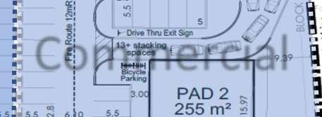
16 3.0 PROPOSED DEVELOPMENT The proposed development is a mix of residential and commercial uses with medium density housing being the predominate use of the subject lands. The proposed development is intended to be developed as part of a phased master planned development. The site and building design prepared by Kirkor Architects + Planners proposes a total of two 6 storey multiple residential buildings, one 6 storey residential mixed-use building and three commercial pad site buildings. Specifically, the development proposal is comprised of the following: Phase 1A - a 6 storey mixed use building with multi-tenant commercial units on the ground floor. Identified as Building A on the Master Site Plan, this building is proposed to contain a total of 69 residential units on floors 2 through 6 and 927 square metres of gross leasable retail commercial space. Building A is proposed to be positioned close to the street edge of Northfield Drive East with setbacks ranging from 4.48 to 6 metres. The front entrance to the residential building and two retail entrances front onto Northfield Drive. Canopies over the building entrances, balconies and a roof top terrace over the commercial component of the building are proposed. Phase 1B consists of a 6 storey, 92 unit multiple residential building with underground parking. Building B is proposed to be connected to Building A by a one storey lobby. Amenity areas as well as bicycle, waste storage rooms and underground parking will be shared between Buildings A and B. An indoor amenity area is located on the first floor of Building A and fronts onto Northfield Drive. An outdoor amenity area is proposed fronting Northfield Drive east of the front entrance. Phase 2 is proposed to consist of three commercial pad site buildings fronting onto Bridge Street West. Building 1 is located closest to the intersection of Northfield Drive East and Bridge Street West and is proposed to be the largest of the three pad site buildings at 462 square metres. The design of Building 1 is proposed to incorporate enhanced building design as it will contribute to the pedestrian scaled gateway feature planned for the corner. Buildings 2 and 3 are 255 square metres and 215 square metres respectively. A drive-through facility is proposed for Building 2. All buildings will support a number of neighbourhood convenience commercial uses however they are ideal for sit-down and convenience style restaurants. A 6 storey, 104 unit multiple residential building with underground parking is proposed for the final phase. Identified as Building C in Phase 3 on the Master Site Plan, the building is proposed to be located close to Northfield Drive at the most westerly end of the site adjacent to Deer Run Park. Building C is proposed to have its own amenity and service areas and will function independently from Buildings A and B save and except for an interconnected underground parking garage. Building C is proposed to have similar 13 P a g e

17 architectural features to ensure a cohesive and unified design throughout the development. Building Height The mixed use residential building proposed as part of Phase 1A and identified as Building A on the Master Site Plan, is proposed to be 21.1 metres in height in order to accommodate a higher floor to ceiling height for the commercial uses on the ground floor. As a condition of Site Plan approval for Phase 1A, a minor variance application is required to permit a maximum building height of 21.1 metres whereas 18 metres is permitted. Buildings B and C are proposed to be 20 metres in height. IMAGE 12 VIEW FROM THE NORTHFIELD DRIVE EAST AND BRIDGE STREET WEST INTERSECTION LOOKING SOUTHWEST SOURCE: KIRKOR ARCHITECTS + PLANNERS 14 P a g e


18 IMAGE 13 PHASE 1A - MIXED USE COMMERCIAL BUILDING LOOKING SOUTHEAST SOURCE: KIRKOR ARCHITECTS + PLANNERS IMAGE 14 - PHASE 1A - MIXED USE COMMERCIAL BUILDING LOOKING NORTHWEST SOURCE: KIRKOR ARCHITECTS + PLANNERS 15 P a g e
19 Parking A total of 387 parking spaces are proposed with 297 at grade parking spaces and 90 underground parking spaces. Two underground parking structures are proposed for Buildings B and C but are accessed by one ramp that is proposed to be constructed as part of Building B. Buildings A and B will share the underground parking facility constructed as part of Building B. Eleven (11) residential parking spaces are proposed to be designated as visitor parking, two (2) Type A and two (2) Type B as barrier-free parking spaces as part of Phase 1A. Additional visitor and accessible parking spaces will be identified for each phase as part of Site Plan approval. Given the size of the subject lands (2.93 ha), the maximum development potential is 439 residential units (based on the current maximum density of 150 units per hectare). Based on the number of units proposed and the total land area, the density on the site is proposed to be 90.4 residential units per hectare. The hydro corridor subtracts approximately 34% of the land area available for development, thereby reducing the development potential by a significant amount. Based on developable land area, the proposed density on the site is still below the current maximum permitted density at 137 residential units per developable hectare. Overall, the proposed development of the subject lands will accommodate the following: TABLE PROPOSED DEVELOPMENT Component Units No. of Bedrooms Building Footprint (m²) Residential GFA (m²) Commercial GFA (m²) Total GFA (m²) Building A ,850 6, ,298 Building B ,528 9,192 9,192 Building C ,687 10,020 10,020 Pad Pad Pad Total ,997 25,585 1,859 27,442 Parking Surface 297 Underground 90 Total 387 The proposed development will also accommodate an overall density of 188 people and jobs per hectare and 286 people and jobs per hectare when subtracting the hydro corridor lands calculated as follows: 16 P a g e
20 TABLE DENSITY CALCULATION Use Density Value 1 Area/Units Total People/Jobs Residential Apartment 1.88 PPU 265 units people Total People Commercial Population Related 35 m²/employee 1,859 m² 53 jobs Total People and Jobs Total Land Area 2.93 ha Total Land Area (2.93 ha) Hydro Corridor (1.0 ha) = 1.93 ha 1.93 ha Overall Density 188 people and jobs/ha Overall Density w/o Hydro Corridor people and jobs/ha The proposed apartment buildings and mixed-use residential building front onto Northfield Drive. Due in part to the location of the hydro corridor, the proposed apartment buildings are located in close proximity to Northfield Drive which allows for a more urban form and provides a significant physical separation between the proposed 6 storey buildings and the low density, single detached dwellings to the south. It also allows surface parking to be provided internal to the site. The parking areas are enhanced by pedestrian connections to the residential and commercial buildings. Landscaping minimizes the visual expanse of the hard surfaces as well as provides a visual buffer between the proposed development and the single detached residences along the southerly property line. The commercial pad site buildings front onto Bridge Street. It is the intent that the commercial pad site buildings will act as a transition between the industrial plaza that is located on the adjacent southeast corner and the proposed residential uses. The commercial component located on the ground floor of Building A is oriented towards the commercial pads creating a sense of separation on the subject lands between the proposed commercial and residential uses. The intent of the design and orientation of the residential mixed-use building and commercial pad site buildings and drive-through facility is to provide a distinct separation of uses on the Site to minimize any potential conflicts between the residential and commercial land uses while providing for a mixed-use development. The orientation of Pad 1 at the southwest corner of the subject property is intended to provide a focal point at the intersection. Due in part to the location of the hydro corridor, all proposed buildings are located in close proximity to Northfield Drive and Bridge Street which allows for a more urban form and helps frame the site in relation to the intersection. 1 PPU and employment density are from the City of Waterloo DC Background Study, Watson & Associates Economists Ltd., September 29, P a g e
21 Commercial Building 2 has been designed to accommodate a proposed drive-through facility. The Urban Design Brief prepared in support of the OPA/ZBA describes how the proposed drive-through facility has incorporated the design objectives of the Urban Design Manual supplemental design guidelines for drive-through facilitates and should therefore be read in conjunction with this report. Section XX provides the planning rational and justification for the drive-through facility in relation to the relevant Official Plan policies and Section XX describes how the proposed drive-through complies with the City s proposed drive-through zone regulation. 3.1 Previous Development Proposal As noted previously, the subject lands were the subject of an Official Plan and Zoning amendment application in The previous land owner and applicant requested an amendment to the 1990 Official Plan to create a new Minor Node at the intersection of Northfield Drive and Bridge Street and to designate the lands as Commercial (Neighbourhood Shopping Centre) and to amend the Zoning By-law to rezone the lands from Multiple Residence- 6 MR-6 to Commercial Four-6 C4-6 with site specific provisions to permit a mixed use development including a 6 storey mixed-use building with 110 residential units and ground floor commercial, a single storey multi-unit commercial building and a single storey food store. The applications were approved, and the lands were designated Mixed Use Neighbourhood Commercial and Minor Node with Specific Provision Area 46 in the City of Waterloo Official Plan (2012) and were zoned Mixed Use Commercial MXC with site specific provisions in Zoning By-law No to facilitate the proposed development. There was significant neighbourhood input as part of the planning process to facilitate the mixed use and grocery store proposal. Several issues and concerns were identified by the community, the majority of which were in relation to the impact of the grocery store on the adjacent neighbourhood. As indicated in Planning Staff report DS , the food store loading area, the buffer between commercial and residential uses, traffic, lighting and noise and site design were identified as the key neighbourhood issues. In an effort to address the issues raised by the community and to ensure the development achieved specific urban design objectives such as pedestrian connectivity, interesting building design and coordinated streetscape character and built form and massing, a number of site specific design policies were incorporated into the implementing Official Plan amendment and are reflected in Specific Provision Area 46 ( ) in the City of Waterloo Official Plan (2012). Table 3.3 outlines the site-specific design policies contained in Section Specific Provision Area 46: 18 P a g e
22 TABLE DESIGN RELATED SPECIFIC PROVISION AREA 46 REQUIREMENTS ( ) Lighting Site Access The Lighting Plan submitted with the Site Plan supplication shall demonstrate that all lighting be maintained on site (no glare on surrounding properties) and directed towards the ground rather than towards the sky ( (c)(i)). That, in addition to a right-in and left-in from Bridge Street, the site be designed with a right-out only at the Bridge St entrance/exit, with the geometrics of the exit lane such that a tractor trailer truck cannot exit the site onto Bridge St. ( (c)(ii)). Loading Area That the loading area for the food store be located at the south end of the food store building, closest to the hydro corridor ( (c)(iii)). That the loading area for the food store be fully enclosed, including a roof and roll up automatic doors ( (c)(iv)). Food Store Building Design Elements That the food store contains design features on the north (facing Northfield Drive) and east (facing Bridge Street) façades create visual interest along these key streets and pedestrian avenues, including windows (open to the interior of the store) on the Northfield façade. Both facades shall be designed with exteriors that match the façade of the building facing the parking lot ( (c)(v)). That a second storey (floor) community room be strongly encouraged within the food store, with design elements, including windows, directed towards the intersection of Northfield Drive and Bridge Street. ( (c)(vi)). Pedestrian Linkages That clear and direct pedestrian linkages be provided from both Northfield Drive and Bridge Street into the site at key entry points, for both the residential and commercial components of the development ( (c)(vii)). The requirement for a direct pedestrian connection from the site to the transit stop on Northfield Drive ( (c)(viii)). Multi-Use Pathway That the design of the site include a multi-use pathway on the north side of the berm along the rear of the property, connecting Bridge Street, the site and Deer Run Park. The pathway shall: be a minimum of 2.0 metres wide; connect with the existing pathway in Deer Run Park; and, be paved with asphalt ( (c)(ix)). Buffer 19 P a g e That a landscape buffer be provided between the parking/multi-use pathway and the side lot line. The average depth of the buffer shall be determined in accordance with the site-specific by-law. The landscape buffer shall include berms. The berms shall be planted with a mix of species, satisfactory to the City of Waterloo. The objective of the berms and landscaping shall be to provide a visual barrier between the rear yards
23 of the homes on Deer Run Drive and the parking area on the subject lands ( (c)(x)). Noise Study The Owner shall submit a detailed Noise Study as part of their site plan application submission to the satisfaction of the City and Regional Municipality of Waterloo. The Noise Study shall be conducted when grading plans, elevations and floor plans are available to specify the glazing requirements for the residential building. The Noise Study shall assess the impacts of road and stationary noise (on- and off-site) on the proposed residential use as well as the impacts of on-site stationary noise on adjacent residential uses, review the location of any proposed outdoor amenity areas; and provide recommendations for any mitigation measures that may be required. The Owner shall implement any required recommendations and shall enter into an agreement (with the City and/or Region, as required) under the provisions of the Planning Act. ( (d)). Similar to the site-specific provisions in the Official Plan amendment, the Table 3.4 outlines the site specific regulations were incorporated into the Zoning By-law ( ) to ensure implementation of the above noted urban design objectives and mitigation of potential land use conflicts. TABLE SITE SPECIFIC ZONING BY-LAW ( ) PROVISIONS Building Setbacks A minimum 45% buildout (combined buildout of all buildings) shall be required within a minimum of 0.5 metres from Northfield Drive and a maximum of 6 metres from Northfield Drive. The mixed use building containing a minimum of 110 residential units shall be setback a minimum of 4 metres from the flankage lot line. A minimum 50% buildout (combined buildout of all buildings) shall be required within a minimum of 4.0 metres from Bridge Street and a maximum of 18 metres from Bridge Street. For any multi-storey building containing residential units outside of Area A, identified on Schedule 'B' attached hereto, the second through sixth storeys shall be subject to a minimum 4 metre setback from the flankage and/or front lot line and shall be subject to the provisions of Sections and of By-law 1418 that apply to the MR-6 zone. Buffer A minimum 40 metre setback shall be required from the side lot line (southerly property line abutting Deer Run Drive lots is defined as the side lot line). A landscape buffer, which shall include a minimum 2.0 metre wide asphalt trail shall be required within the side yard between the parking area and the side lot line 20 P a g e the landscape buffer shall be a minimum average depth of 9.5 metres and shall be no less than 5.6 metres, except where the landscape buffer abuts the lands known as 635 Deer Run Drive,
24 where the depth of the landscape buffer shall be no less than 3.5 metres. The landscape buffer shall contain a minimum of two berms, which shall range in height (at their peak) from a minimum of 1.0 metres to a maximum of 2.0 metres. 3.2 Applications Required The site specific provisions in both the Official Plan and Zoning By-law were tailored to a concept site plan that was provided in support of the previous OPA/Zoning By-law applications. Although there is demand for commercial uses at this location, there is no market interest for a food store or the extent of commercial uses contemplated under the current planning framework in the building form originally contemplated. As a result, in order to facilitate a mixed-use development that is compatible with the character and scale of the neighbourhood, an Official Plan and Zoning amendment is required Proposed Official Plan Amendments In order to accommodate the originally contemplated mixed use food store proposal, an amendment to the then in-effect 1990 Official Plan was required. As the proposal was being considered in 2012, the Council endorsed but yet to be approved 2012 Official Plan carried forward the existing designation on the subject lands - Medium Density Residential (all be it in a new designation called the Mixed Use Medium Density Residential which replaced the Medium Density Residential designation in the previous OP) pending a decision on the applications. Following Council s evaluation and decision of the mixed use food store proposal, OPA 79 was approved creating a new Minor Node at the intersection of Bridge Street and Northfield Drive East and the lands were designated Commercial (Neighborhood Shopping Centre). The provisions of OPA 79 were incorporated in the 2012 OP as Specific Provision Area 46. As part of the review of OPA 79, consideration was given to retaining the Mixed-Use Medium Density Residential designation on the subject lands as the food store proposal had some elements that were consistent with this designation. The Mixed-Use Medium Density Residential designation does for example permit food stores and other convenience commercial uses provided however they are developed in conjunction with residential uses within the same building and provided they do not exceed 15% of the overall Building Floor Area of the development. Conversely, the Mixed-Use Neighbourhoood Commercial designation does not require commercial uses to be located within a mixed use residential building but envisions commercial uses to be in separate buildings at a larger scale than contemplated in the Mixed-Use Medium Density Residential designation. The Plan envisions small to mid-scale food stores anchoring Mixed-Use Neighbourhood Commercial areas. Residential uses may be permitted within mixed- 21 P a g e
25 use buildings only on storeys above the ground floor provided the area retains a primarily commercial function. Lands designated Mixed-Use Neighbourhood Commercial are required to have a minimum of 2,000 square metres of gross leasable area of primary permitted uses which include retail uses, a food store, drug store, commercial and personal services, offices, medical clinics, banks and financial services and restaurants. Alternatively, the intent of including food stores as a permitted use within the Mixed-Use Medium Density Residential is to permit neighbourhood servicing commercial uses closer to neighbourhoods on roads with transit routes to allow residents to access their daily and weekly needs through alternative forms of transportation (walking, cycling, transit). The Mixed-Use Medium Density Residential is a designation where the predominant use of land is intended to be residential although complementary and ancillary uses are permitted. The aim of this designation is to encourage medium density, mixed-use, primarily residential development within Minor Corridors. Ancillary commercial uses within Mixed-Use Medium Density Residential designations are not intended to be standalone uses but rather according to Policy (21) must be provided within a mixed-use, multi-storey building and in a manner, that is oriented toward, activates and enhances the pedestrian environment. While Building A in phase 1A of the current development proposal provides commercial uses within a residential, mixed use building, the proposed standalone commercial pad site buildings are not contemplated within the Mixed-Use Medium Density Residential designation. Lands designated Convenience Commercial are planned to accommodate one or more retail or service establishments in a small-scale centre or area and are intended to help meet the day to day needs of nearby neighbourhood and/or business areas through the provision of a range of convenience goods and services. Such centres or areas may according to the vision of the Convenience Commercial designation as outlined in Policy be used solely for commercial purposes or may incorporate residential uses in mixed-use buildings, provided the primary commercial function of the lands is maintained. Prior to the food store proposal, the subject lands were designated as a Minor Corridor. Both Major and Minor Corridors are anticipated to act as key active transportation linkages between destinations. Planned land uses within Minor Corridors in particular are intended to be predominantly medium to medium high density residential with some limited areas having a planned function other than residential. Conversely, Minor Nodes generally include neighbourhood-serving commercial centres and where appropriate are planned to accommodate medium-sized food stores. The food store proposal was more directly aligned with the intent of the Minor Node policy framework and for that reason, a Minor Node was created. Based on the analysis above, we are proposing to re-designate the subject lands from Minor Node and Mixed-Use Neighbourhood Commercial to Minor Corridor, Mixed Use Medium Density Residential and Convenience Commercial to facilitate a predominately residential 22 P a g e
26 development while still providing for a limited range of commercial uses that cater to pedestrian, bicycle and non-vehicular travel and are intended to support the primary residential uses, the surrounding neighbourhood and businesses. Specifically, the applicant is requesting the following amendments to the Official Plan: Redesignate the subject lands from Minor Node to Minor Corridor ; Redesignate the subject lands identified as Area A on Figure XX from Commercial and Mixed Use Neighbourhood Commercial to Mixed-Use Medium Density Residential ; Redesignate the subject lands identified as Area B on Figure XX from Mixed Use Neighbourhood Commercial to Convenience Commercial. In addition, the following policies are proposed to be incorporated as site specific policies in part to achieve urban design objectives outlined in the City s Official Plan and to address the concerns expressed by the neighbours in the previous proposal: Notwithstanding the maximum height within the Medium Density 20 metres designation, the subject lands shall be permitted a single building with a maximum height of 22 metres. All other buildings shall be permitted a maximum height of 20 metres; The Lighting Plan submitted with the Site Plan application shall demonstrate that all lighting be maintained on site (no glare on surrounding properties) and directed towards the ground rather than towards the sky; That clear and direct pedestrian linkages be provided from both Northfield Drive and Bridge Street into the site at key entry points, for both the residential and commercial components of the development; The requirement for a direct pedestrian connection from the site to the transit stop on Northfield Drive; That the design of the site include a multi-use pathway on the north side of the berm along the rear of the property, connecting Bridge Street, the site and Deer Run Park. The pathway shall be a minimum of 2.0 metres wide; connect with the existing pathway in Deer Run Park; and be paved with asphalt. 23 P a g e That a landscape buffer be provided between the parking/multi-use pathway and the side lot line. The average depth of the buffer shall be determined in accordance with the site specific by-law. The landscape buffer shall include berms. The berms shall be planted with a mix of species, satisfactory to the City of Waterloo. The objective of the berms and landscaping shall be to provide a visual barrier between the rear yards of the homes on Deer Run Drive and the parking area on the subject lands.


27 Area B Area A Mixed-Use Medium Density Convenience Commercial Residential FIGURE 3 - PROPOSED OFFICIAL PLAN DESIGNATIONS 24 P a g e
28 The Owner shall submit a detailed Noise Study as part of their site plan application submission to the satisfaction of the City and Regional Municipality of Waterloo. The Noise Study shall be conducted when grading plans, elevations and floor plans are available to specify the glazing requirements for the residential building. The Noise Study shall assess the impacts of road and stationary noise (on- and off-site) on the proposed residential use as well as the impacts of on-site stationary noise on adjacent residential uses, review the location of any proposed outdoor amenity areas; and provide recommendations for any mitigation measures that may be required. The Owner shall implement any required recommendations and shall enter into an agreement (with the City and/or Region, as required) under the provisions of the Planning Act. All site specific policies relating to the design elements are proposed to be maintained with the exception of the site specific policies relating to the design of the right-out only at the Bridge Street entrance/exit and policies relating specifically to the food store including the loading area and building design. As noted earlier, many residents at the time of the original application who abut the site had concerns relating to the impact of the grocery store including noise that would be generated by trucks coming to and from the site to deliver supplies to the food store. As such, a number of design related policies were incorporated into the OPA to mitigate any potential negative impacts. As the food store is no longer being contemplated for the site, issues with respect to delivery trucks and the location of the loading area are no longer applicable to the site. The proposed convenience commercial uses will not generate the need for daily deliveries or deliveries requiring large transport trucks. The Transportation Impact Study prepared by Paradigm Transportation Solutions Ltd. provides the appropriate analysis and justification to support a full turning movement access based on the revised Site Plan Proposed Zoning By-law Amendments The applicant is also requesting a Zoning By-law amendment to rezone an area of the site identified as Area A on Figure 3 from Mixed-Use Neighbourhood Commercial (MXC) to Mixed Use Residential (MXR) and an area of the site identified as Area B on Figure 3 from Mixed-Use Neighbourhood Commercial (MXC) to Convenience Commercial ( CC ) with the following site specific regulations: a minimum 45% buildout (combined buildout of all buildings) shall be required within a minimum of 0.5 metres from Northfield Drive and a maximum of 6 metres from Northfield; 25 P a g e
29 The second through sixth storeys of any residential or mixed use residential building shall be subject to a minimum 4 metre setback from the flankage and/or front lot line and shall be subject to the provisions of Sections and of By-law 1418 that apply to the MR-6 zone; a minimum 50% buildout (combined buildout of all buildings) shall be required within a minimum of 4.0 metres from Bridge Street and a maximum of 15 metres from Bridge Street. For the purposes of calculating the building line setback from Bridge Street, the hydro corridor frontage shall not be considered as part of the streetline; a minimum 40 metre side yard setback from the southerly property line; a minimum 2.5 metre set back shall be required from the rear lot line; A maximum of 6 storeys (21.2 metres in height) for a single mixed use residential building and a maximum of 6 storeys (20 metres in height) for residential buildings; A landscape buffer, which shall include a minimum 2.0 metre wide asphalt trail, shall be required within the side yard between the parking area and the side lot line; The landscape buffer shall be a minimum average depth of 9.5 metres and shall be no less than 5.6 metres, except where the landscape buffer abuts the lands known as 635 Deer Run Drive, where the depth of the landscape buffer shall be no.less than 3.5 metres; the landscape buffer shall contain a minimum of two berms, which shall range in height (at their peak) from a minimum of 1.0 metres to a maximum of 2.0 metres; Common landscape open space provided on the roof or terrace of the residential building may contribute to the requirement for amenity space; No underground parking structure or part thereof is permitted within 0.5 m of the flankage lot line or front lot line No underground parking structure of part thereof is permitted within 0.5 m of the rear lot line or 3.0 metres from the side lot line; No setbacks shall apply to shoring, footings, and tie-backs, whether attached or independent of any building or structure including underground parking structures, except for within the side yard, whereby no shoring, footing or tie-back shall permitted within 3.0 metres of the side lot line; No building, structure or part thereof is permitted within 0.5 metres of the streetline created by the daylight triangle at the intersection of Northfield Drive and Bridge Street; One drive-through facility is permitted within Area B on Schedule B; Four (4) off street parking spaces provided to satisfy the requirement for residential uses within Area A on Schedule B may be considered to equal one (1) parking space to satisfy a commercial use located within Area B on Schedule B. 26 P a g e
30 In the event of any future subdivision of land within the area shown on Schedule 'A' attached hereto, individual parcels of land shall be exempt from the requirements for internal yard setbacks, density, amenity area, landscape buffer and parking, provided however, that the whole of the area shown on Schedule 'A' attached hereto is in full compliance with all provisions of the Zoning By-law (and/or this by-law), including the requirements for yard setbacks, density, amenity area, landscape buffer and parking. The site specific provisions will establish site specific regulations in the MXR and CC zones including specific requirements for setbacks from the lot lines, minimum and maximum building heights and minimum landscape buffer requirements to implement the relevant policy framework of the Official Plan and to establish appropriate zone standards to achieve the proposal. The proposed amendment will also include a provision to permit a drive through facility on the portion of the lands zoned Convenience Commercial to allow for a drive-through facility subject to locational criterial that require such uses to abut arterial roads. The proposed application will rezone the subject lands to Mixed-Use Residential MXR and Convenience Commercial CC. The MXR zone permits apartment and mixed use residential apartment buildings and the CC zone permits a number of commercial uses including restaurants, banks, grocery stores and medical clinics. Drive-through facilities are permitted on lands designated Convenience Commercial subject to locational criteria that require such uses to abut arterial roads. The proposed application includes a number of site specific provisions that were included in the implementing zoning by-law for the food store proposal (By-law No ) and a site specific provision to permit a drive-through facility on the lands proposed to be rezoned to CC. The following regulations apply to the MXR and CC zone. The regulations that are subject to a proposed site specific zoning regulation are noted. TABLE 3.5 REGULATIONS IN THE MXR ZONE Section Regulation Requirement of the MXR Zone Site Specific Regulation Required 27D Maximum Retail and 465 sq.m. No Restaurant Unit Size 27D Streetline Buildout 70% buildout shall be provided Yes with a minimum setback of 2 m and a maximum of 4 m 27D Minimum Lot Frontage 6.6 m No 27D Minimum Corner Lot Frontage 9.6 m No 27D No Side Yard Required except as follows: Yes 27 P a g e
31 27D D D Where a side lot line is a boundary of a Residential Zone or a municipal park Where a side lot line abuts a public lane Where a garage with an entrance facing the flankage yard. 1.2 m 2.0 m 6 m from the street line 27D Minimum Rear Yard 7.5 m Yes 27D Impervious Factor The maximum impervious area permitted on any lot zoned MXR shall be determined by a numerical prefix shown on the zoning map attached as Appendix A to this by-law. The numerical prefix represents the maximum percentage of impervious area permitted on the lot. Development of land shall be prohibited if it fails to comply with the Impervious Factor requirements of this paragraph. If a numerical prefix is absent, then there shall be no Impervious Factor. 27D Corner Lot Provisions All buildings shall be subject to the provisions for corner lots, Section 8.12 No No 27D Minimum Building Height 7.5 m No 27D Maximum Building Height 14 m Yes Off-Street Parking 27D D Non-residential parking requirement Parking is not permitted in any front yard or flankage yard 5 spaces per 100 sq. m. of non-residential building floor area No 28 P a g e
32 27C On-Street Parking For all non-residential uses for lots which front onto a public street and provide on-street parking for the entire frontage, a minimum of 3 offstreet parking spaces shall be provided for every 100 sq. m of building floor area No Regulations for Residential Uses 27D D D D Minimum Amenity Space Residential Parking Requirement Res/Commercial Parking Ratio Each dwelling unit shall be provided with 11 sq.m. of amenity area. Amenity area shall mean areas used for recreational purposes and includes landscaped open space, balconies, indoor recreational areas but does not include lobbies, washrooms, laundries, storage areas, reception areas or rooftop decks For residential uses 1 parking space shall be provided behind the building line Four off-street parking spaces provided to satisfy a requirement for residential uses, may be considered to equal one parking space required to satisfy a parking requirement for a commercial or institutional use. Yes No No TABLE REGULATIONS IN THE 'CC' ZONE Section Regulation Requirement of the CC Zone Site Specific Regulation Required Minimum Front Yard 5.0 m No Flankage Yard 5.0 m No Planting Strip Where the property boundary of a CC zone abuts a Suburban, Agricultural or any Residential Zone, a 1.5 metre planting strip must be maintained between the abutting zones. No 29 P a g e
33 Rear Yard 7.5 m Yes Low rise Residential Area Yard Setback Landscape Buffer within Low Rise Residential Area Yard Setback Landscaped Buffer Average Depth Landscaped Buffer Plant Materials Prohibited within Landscaped Buffer ½ the height of the building and in no case less than 7.5 metres to any lot line abutting a Low Rise Residential Area. 3 metre landscaped buffer adjacent to any lot line abutting a Low Rise Residential Area 3.0 metres and at no point less than 1.5 metres. Shall contain plant materials that form a visual screen and are not less than 1.5 metres in height. Buildings, structures, enclosures, parking areas, driveways, retaining walls, and Impervious Areas shall be prohibited within the Landscaped Buffer No No No No Height Maximum height of four storeys (12 metres) No Parking based on Use For each use, 4.5 parking spaces for every 100 square metres of Building Floor Area Where a Building Contains less than 1,000 square metres of Building Floor Area, parking requirements shall apply for the following specific Uses: Restaurant 1 space for every four (4) seats in the designed maximum capacity Take-Out Restaurant 15 spaces per 100 square metres of Building Floor Area Building Floor Area Each permitted occupancy shall be restricted to not more than 280 square metres of Building Floor Area Yes 30 P a g e
34 Lot Coverage Not more than 25% of the total Lot Area shall be used for all Buildings on a Lot in this zone Landscaped Open Space 25% of the total Lot Area shall consist of Landscaped Open Space Maximum Lot Size The maximum size of any lot in the convenience commercial zone shall not exceed one (1) hectare Section 8.10 Section 8.10 of the General Provisions of By-law 1418 shall not apply to the convenience commercial zone More than One Building More than one main Building or Accessory Buildings shall be permitted on any Lot in this zone. No No No No No 31 P a g e
35 4.0 PLANING ANALYSIS The following section sets out the planning policy regime relevant in evaluating the proposed development. 4.1 Provincial Policy Statement (2014) The Provincial Policy Statement (PPS), issued under the authority of the Planning Act, the latest version coming into effect on April 30, 2014, sets a policy foundation for regulating the development and use of land; it provides policy direction on matters of provincial interest related to land use planning and development and supports the enhancement of the quality of life for all citizens of Ontario. The legislation requires that Planning Act applications must be consistent with the PPS. With regard to the PPS, the proposal is consistent with the following policies in support of the applications: Policy identifies that planning authorities shall identify appropriate locations and promote opportunities for intensification and redevelopment where this can be accommodated taking into account existing building stock or areas, including brownfield sites, and the availability of suitable existing or planned infrastructure and public service facilities required to accommodate projected needs. Land use patterns within settlement areas shall, according to Policy be based on densities and a mix of land uses which: efficiently use land and resources; are appropriate for, and efficiently use the infrastructure and public service facilities which are planned or available, and avoid the need for unjustified and/or uneconomical expansion; and minimize negative impacts to air quality and climate change, and promote energy efficiency in accordance with policy 1.8. Policy supports new development taking place in designated growth areas adjacent to the existing built-up area having a compact form, mix of uses and densities that allow for the efficient use of land, infrastructure and public service facilitates. Section provides policies to ensure an appropriate range and mix of housing types and densities is available to meet projected requirements of current and future residents of the market area. To this end, Policy d) supports planning 32 P a g e
36 for an appropriate range and mix of housing types and densities in part by promoting densities for new housing which efficiently use land, resources, infrastructure and public service facilities, and support the use of active transportation and transit in areas where it exists. Policy identifies that healthy, active communities should be promoted by planning public streets, spaces and facilities to be safe, meet the needs of pedestrians, foster social interaction and facilitate active transportation and community connectivity. Policy supports energy conservation and efficiency and improved air quality, reduced greenhouse gas emissions, and climate change adaptation through, amongst others, land use and development patterns which promote compact urban form and promotion of active transportation and transit. The site will be serviced with municipal sewage and water services consistent with the Provincial Policy Statement. The proposal will assist the City in providing an appropriate range and mix of housing types and densities adding variety to the housing stock in an area that is predominately comprised of single detached dwellings. The proposal supports a more efficient land use providing a mixed use development accommodating both residential and commercial uses. The proposed development will efficiently use infrastructure and public service facilities such as municipal services, parks, existing and planned multi-use trails and public transit. The proposal for the subject property is consistent with the Provincial Policy Statement Places to Grow Growth Plan for the Greater Golden Horseshoe (2017) The Growth Plan for the Greater Golden Horseshoe, 2017 ( Growth Plan ) was released on May 18, 2017 and came into effect on July 1, 2017, replacing the Growth Plan for the Greater Golden Horseshoe, Places to Grow is the Ontario government's program to plan for growth and development in a way that supports economic prosperity, protects the environment and helps communities achieve a high quality of life across the province. The plan works to support the achievement of complete communities, curb sprawl, protect the natural environment, support economic development, and ensure that land to accommodate forecasted population and employment growth will be available when needed, now and in the future. To support these goals, the Growth Plan for the Greater Golden Horseshoe works to: 33 P a g e
37 Support the achievement of complete communities that offer more options for living, working, learning, shopping and playing. Reduce traffic gridlock by improving access to a greater range of transportation options. Provide housing options to meet the needs of people at any age. Curb sprawl and protect farmland and green spaces. Promote long-term economic growth. The Growth Plan provides an overall growth strategy for the Region that complements the Provincial Policy Statement and is implemented by municipal planning documents and tools. At the core of the Growth Plan are guiding principles of building compact, vibrant and complete communities; planning and managing growth to support a strong, competitive economy; and optimizing the use of existing or planned infrastructure to support growth in a compact and efficient form. The Site is identified as being part of the Built-up Area in the Growth Plan. The Growth Plan prioritizes intensification and higher densities within the built-up area to make efficient use of land and infrastructure and support transit viability. Policy promotes accommodating population and employment growth in communities that are compact, transit-supportive, and pedestrian-friendly; have a balance of jobs and housing; are complete with a diverse mix of uses and activities; and provide convenient access to intra and inter-city transit. Policy identifies that by 2015 a minimum of 40 percent of all residential development occurring annually within each upper- and single-tier municipality will be within the Built-Up Area. Policy identifies that all intensification areas are to be planned and designed to accommodate a significant share of population and employment growth, provide a diverse and compatible mix of land uses, provide high quality and vibrant public open spaces, support transit, walking and cycling for everyday activities, achieve higher densities, and achieve an appropriate transition of built form to adjacent areas. The Growth Plan also states that communities will need to grow at transit-supportive densities, with transit-oriented street configurations. Essentially, the Province is seeking to intensify urban areas like Waterloo to accommodate future population and economic growth in a more compact urban form to make more efficient use of existing and planned infrastructure. 34 P a g e
38 The proposal for the subject property will assist the City to meet the Places to Grow s guiding principles by prioritizing intensification and higher densities to make efficient use of land and infrastructure and support transit viability. An overall density of 188 residents and jobs per hectare is proposed by the proposed development contributing to the achievement of the minimum density target established in the Growth Plan. The proposed development provides for a higher, mixed use density development that utilizes a vacant parcel of land within the Delineated Built-up Area within the City that will contribute towards achieving a complete community. The future residents of the proposed development will be within walking distance of commercial uses and many employment generators including the Blackberry Campus as well as bus transit which leads to future planned rapid transit stations. 4.3 Region of Waterloo Official Plan (2015) On June 16, 2009, the Regional Municipality adopted the ROP. The ROP incorporates the policy objectives of the PPS (2005) and the Growth Plan, as well as implements the strategies and objectives of the Regional Growth Management Strategy, which was approved by Regional Council in The ROP was approved by the Ontario Municipal Board on June 18, 2015 and is in effect. The Site is within the Urban Area and is identified in the ROP as within the Built-Up Area as shown on Map 3a Urban Area of the Regional Official Plan (Figure 4). In accordance with Policy 2.B.2 of the ROP, lands within the Urban Area are intended to accommodate the majority of the Region s future growth and development, including a range of residential uses. 35 P a g e

39 FIGURE 4 - MAP 3A - URBAN AREA The Urban Area designation broadly identifies where the majority of the region s future growth will occur. This designation contains the physical infrastructure and community infrastructure to support major growth, including transportation networks, municipal drinking-water supply systems and municipal wastewater systems, and a broad range of social and public health services. It is also well-served by the existing Regional transit system, which is intended to be further enhanced through the introduction of rapid transit. For these reasons, lands within the Urban Area have the greatest capacity to accommodate growth and serve as the primary focus for employment, housing, cultural and recreational opportunities in the region The ROP requires that proposed amendments and development applications be reviewed with respect to the General Development Policies (Policy 2.D.1) and Transit Oriented Development Policies (Policy (2.D.2) of the Plan. Table 4 outlines the policy and evaluates the relevant criteria against the proposed development. Specifically, in preparing or reviewing planning studies, or in reviewing development applications or site plans, the Region and/or Area Municipalities will ensure that development occurring within the Urban Area is planned and developed in a manner that: 36 P a g e
40 TABLE 4.1 GENERAL DEVELOPMENT POLICY EVALUATION CRITERIA (POLICY 2.D.1) Policy General Development Policies 2.D.1 (a) Supports the Planned Community Structure described in this Plan. Justification The application represents an appropriate intensification of a vacant site within the Built-Up Area. A minimum of 45 per cent of all new residential development occurring annually within the region as a whole will be constructed within the Built-Up Area. The proposal has a density of approximately 188 people and jobs per hectare which contributes to the minimum density target established for development to occur within the Built-Up Area. The proposal will also add approximately 500 new residents to the area which will support existing and future businesses in the surrounding area as well as increase transit ridership on existing transit routes on both Northfield Drive and Bridge Street. (b) (c) (d) Is serviced by a municipal drinking-water supply system and a municipal wastewater system. Contributes to the creation of complete communities with development patterns, densities and an appropriate mix of land uses that supports walking, cycling and the use of transit. Protects the natural environment, and surface water and groundwater resources. The subject lands have access to municipal services located in the surrounding public right-of-ways. A Functional Servicing Report has been prepared in support of the proposed amendments and concludes that existing water sanitary, and storm services are sufficient to service the subject lands. The medium density apartment units will provide a housing choice not readily available in northeast Waterloo and will allow those who work in the many businesses in the area an opportunity to live close to work. The synergies offered by the proposed commercial uses combined with the availability of transit on both Northfield Drive and Bridge Street and the existing and planned multi-use trails along both frontages of the subject lands provides opportunity for walking, cycling and the use of transit to access day-today/weekly shopping needs. The subject lands are currently vacant and have been used for agricultural purposes as an interim use. There are no natural features identified on the subject lands. The lands are not located within a Wellhead Protection Area and are not subject to Source Water Protection Plan policies. (f) 37 P a g e Respects the scale, physical character and context of established neighbourhoods in areas where reurbanization is planned to occur. The proposed amendments implement the permitted heights and densities that apply to the subject lands. As demonstrated in the Urban Design Brief submitted in support of the proposed amendments, the proposed development achieves a number of key guidelines within the City s Urban Design Manual. The proposed implementing OP and Zoning By-law also incorporates a number of design policies and provisions which will address
41 (g) Facilitates residents access to locally grown and other healthy foods in neighbourhoods. a number of issues identified in the previous application to mitigate any negative impacts in terms of compatibility. The proposed application will result in a development that provides an appropriate transition from the commercial/employment uses located to the north and east of the site and, due to the location of the hydro corridor, provides a significant separation from the low rise residential development to the south. The location of the buildings close to the streets will provide for development that visually enhances the Northfield Drive East and Bridge Street West streetscape. There are a number of grocery stores in the immediate area including the Zehrs located at Conestoga Mall, the Food Basics located at University Downs Plaza (University and Bridge) and the newly expanded, Sobey s located at the northeast corner of Northfield Drive and Weber Street North. There is a future food store contemplated in the Official Plan as part of the Rural East Node. The subject lands are also located in close proximately to the St. Jacob s Farmers Market. In addition to the general development provisions described in Policy 2.D.1, Policy 2.D.2 outlines transit-oriented policies for the review of development applications on or near sites that are served by existing or planned higher frequency transit. The Region and/or area municipalities are required to apply the following Transit Oriented Development provisions in reviewing development applications or site plans, on or near sites that are served by existing or planned rapid transit, or higher frequency transit to ensure that development establishes the following: TABLE TRANSIT-ORIENTED DEVELOPMENT POLICIES (POLICY 2.D.2) Policy Transit Oriented Policies 2.D.2 (a) Creates an interconnected and multi-modal street pattern that encourages walking, cycling or the use of transit and supports mixed-use development. Justification The proposed development provides an urban environment which is conducive to walking, cycling and using transit. (b) 38 P a g e Supports a more compact urban form that locates the majority of transit supportive uses within a comfortable walking distance of the transit stop or Major Transit Station Area; As shown on Figure 5, Northfield Drive East and Bridge Street West are identified as Planned Transit Corridors on Map 5A Regional Transit Network. Transit Corridors are roads that accommodate existing or planned high frequency transit service. The proposed development has the potential to increase ridership of existing transit routes. There are existing transit stops immediately adjacent to the subject lands on Bridge Street and a new,
42 (c) (d) (e) (f) Provides an appropriate mix of land uses, including a range of food destinations, that allows people to walk or take transit to work, and also provides for a variety of services and amenities that foster vibrant, transit- supportive neighbourhoods. Promotes medium and higher density development as close as possible to the transit stop to support higher frequency transit service and optimize transit rider convenience. Fosters walkability by creating pedestrianfriendly environments that allow walking to be a safe, comfortable, barrier-free and convenient form of urban travel. Supports a high quality public realm to enhance the identity of the area and create gathering points for social interaction, community events and other activities. planned transit stop on Northfield Drive East immediately adjacent to the subject lands. The proposed development provides medium density residential units in an area of the City that contains predominately low density housing. The adjacent proposed commercial uses will provide neighbourhood convenience commercial uses that will easily allow people to walk or cycle from the proposed development, adjacent neighbourhood and employment areas. Transit stops and multi-use trails will be located immediately to both frontages. The proposed development accommodates an overall density of 188 people and jobs/hectare (286 people and jobs/hectare excluding the hydro corridor lands) immediately adjacent to two transit stops on Bridge Street West and a future transit stop on Northfield Drive East immediately adjacent to the proposed 6 storey residential buildings. The proposed development has been designed with wellarticulated and distinct pedestrian walkways to integrate with the existing street network and coordinate with vehicular and pedestrian movement on site. Direct pedestrian connections are provided to the adjacent park and transit shelter on Bridge Street. The residential building design incorporates building entrances to connect directly to Northfield Drive and the commercial units within the mixed use residential building generating increased activity along the street frontages. A direct pedestrian connection will be provided to the future transit shelter planned to be installed on Northfield Drive in close proximity to proposed Buildings B and C, just west of the main proposed driveway entrance. The proposed development is designed to recognize the importance of the Northfield Drive and Bridge Street intersection as a gateway to the northwest employment area. The proposed development will be a positive contribution to the streetscape through the provision of a strong street edge, visually interesting architecture and a variety of at-grade uses. Enhanced landscaping including a patio area is proposed at the northeast corner to support the creation of a pedestrian friendly streetscape. (g) 39 P a g e Provides access from various transportation modes to the transit facility, including consideration of pedestrian, bicycle parking, and where applicable, passenger transfer and commuter pick-up/drop off areas. As shown on Figure 6, Regional Cycling Routes Map 5C identifies Northfield Drive as a planned cycling route and Bridge Street West as an existing cycling route. Policy 5.A.14 states, Regional cycling routes are designated as shown on Map 5C. These regional-scale routes have been identified within the Regional Cycling Master Plan and


43 will be developed in association with ongoing Regional and Area Municipal road improvements and other activities. A multi-use trail has been recently constructed along the Bridge Street frontage of the subject lands. A multi-use trail is planned to be constructed on the south side of Northfield Drive adjacent to the subject lands as part of the planned Northfield Drive reconstruction project. The multi-use trail on Northfield Drive is planned to be constructed in Spring The proposed development will accommodate sufficient secured indoor bicycle parking for future residents and a number of outdoor bicycle parking spaces strategically located close to the commercial uses of the site. Subject Lands FIGURE 5 -MAP 5A REGIONAL TRANSIT CORRIDORS 40 P a g e

44 Subject Lands FIGURE 6 - MAP 5C - REGIONAL CYCLING ROUTES The proposed development and corresponding amendments conform to the Regional Official Plan. 41 P a g e


.")

45 4.4 City of Waterloo Official Plan The City of Waterloo Official Plan (the Official Plan ) was approved with modifications on November 21, The Official Plan sets out the principles, objectives and policies designed to direct the form, extent, nature and rate of growth and change within the City to In addition, the Official Plan includes policy changes and revisions as a result of the ROP including the Provincial Policy Statement and the Growth Plan for the Greater Golden Horseshoe. The Official Plan implements the ROP, providing further policy direction at the local level. The following provides a summary of the relevant Official Plan policies as they relate to the proposed applications. The subject lands are designated within the Built-Up Area on Schedule B3 of the Official Plan (Figure 7). Lands within the Built-Up Area are intended to accommodate a significant proportion of the City s population and employment growth which is expected to be accommodated through intensification. Subject Lands FIGURE 7 - SCHEDULE 'A3' - DESIGNATED GREENFIELD AREAS Policy (3) states that the City will plan for an appropriate range and mix of housing types, sizes, costs and tenure within neighbourhoods through different means and specifically, will 42 P a g e
46 permit intensification in low density residential neighbourhoods if it is compatible in terms of context with the existing neighbourhood. Policies specific to supporting a range of housing are included in Section of the Official Plan and states, this Plan recognizes that access to a range of housing contributes to the quality of life within a City. The City will continue to plan for a range of housing types, including low density, medium density, medium high density and high density housing. In considering development applications proposing to redesignate lands to the Mixed-Use Medium Density Residential designation, Policy (12) sets out a number of evaluation criteria. The table below outlines the criteria and evaluates the criteria against the proposed development. TABLE OFFICIAL PLAN EVALUATION CRITERIA FOR MEDIUM DENSITY Criteria The proposed density is deemed appropriate for the neighbourhood and contributes to an appropriate height and density transition by buffering or being buffered from lands designated Low Density Residential. Justification The hydro corridor provides a significant physical separation between the proposed six storey buildings and the adjacent predominately low density neighborhood located to the south of the subject lands. As shown on Figure 7, the Site is designated Medium Density, 20 metres on Schedule B1 Height and Density. Policy identifies that the maximum net residential density permitted is 450 bedrooms per hectare with a maximum height of 20 metres. The proposed application will realize a density of 161 bedrooms per hectare and a maximum height of 21.2 metres for the mixed use building and 20 metres for the proposed apartment buildings. The proposed amendments will implement these height and density permissions. The subject lands are located within a Minor Corridor where medium density land uses are encouraged (Policy (2)). Appropriate location for increased density with access to two major regional arterial roads. Sun Shadow analysis illustrates that there are no shadow impacts on the adjacent properties including the residential properties located to the south and the office and industrial properties located to the north. 43 P a g e
47 There is a demonstrated community benefit associated with additional medium, medium-high or high density uses to accommodate additional population in the context of Waterloo s population forecast and the supply of lands within existing designated Nodes and Corridors. The medium density apartment units will provide a housing choice not readily available in northeast Waterloo and will allow those who work in the area an opportunity to live in the same neighbourhood. The units will provide an opportunity for those wishing to downsize to remain in the same neighbourhood. Lands are proposed to be located within a designated Node or Corridor and satisfy all relevant policies of the City Form Chapter. The proposal achieves the applicable performance standards set out in this Official Plan and implementing Zoning By-Law. The subject lands were originally designated as a Minor Corridor, but as previously noted, were redesignated Minor Node to reflect the scale of the previously approved commercial component of the development, namely the proposed food store. Both Minor Nodes and Minor Corridors are anticipated to accommodate a significant proportion of the City s population and employment growth over the life of the Plan. Minor Nodes are planned as medium to medium-high density mixed-use areas that accommodate a range of uses which may include residential and commercial uses and generally include neighbourhood serving commercial centres that provide for the day to day and weekly shopping needs of the surrounding neighbourhood. Where appropriate, Minor Nodes are planned to accommodate small to medium sized food stores. Planned land uses within Minor Corridors will be predominantly medium to medium high density residential uses with some limited areas having a planned function other than residential. A limited amount of commercial uses are permitted as set out in the applicable land use designations. Medium density land uses will be encouraged to located in designated Nodes and Corridors and therefore in proximity to major roads, major community infrastructure, public transit and other supporting land uses (Policy (2). As a food store has been determined to be unviable at this location, the proposed development continues to support the vision and intent of the policies of the City form chapter. Apart from the right-out only at the Bridge Street proposed entrance/exit and the specific policies related to the design of the food store and loading area, all design related policies are proposed to be incorporated in the special policy area policies and implementing Zoning By-law. The proposal achieves all performance standards identified in the Mixed-Use Medium Density 44 P a g e
48 Residential designation including the regulations provided for in Section (3) as outlined below. Surface parking is minimized in favour of more intensive forms of parking. Within both nodes and corridors, surface parking is to be minimized in favour of more intensive forms of parking. Underground and structured parking is encouraged by Policy According to Policy (3) (a) and (b), parking requirements will be defined in the Zoning By-law and may include provisions for reduced parking standards where sharing of parking facilities or areas is feasible and, transit service is readily available. The proposal includes both surface parking and underground parking structures. As previously noted, the hydro corridor consumes approximately 34% of the land area available for development. In order to maximize the development potential of the balance of the Site, the lands within the hydro corridor are required to be used for parking. A total of 387 parking spaces are proposed with 297 surface parking spaces and 90 underground parking spaces. The underground parking spaces will be reserved for residential use only while the surface parking spaces will allow for both commercial and residential parking. As the site has been designed and planned as a master planned development, the shared parking regulation that allows for every four residential parking spaces to equal one parking space to satisfy a parking requirement for a commercial use. This recognizes that a number of the surface parking spaces required to satisfy the residential parking requirement may not be utilized during regular commercial business hours or, because of the transit supportive elements of the proposed development may not be utilized at all. Cultural heritage resources are conserved. There are no identified cultural heritage resources identified on or adjacent to the Site. The proposal demonstrates a high standard of urban design. As outlined in the Urban Design Brief prepared in support of the OPA/ZBA and summarized in Section 5.7 of this report, the proposed development contributes to achieving the City s Official Plan urban design policies and will enhance the character and built form of the neighbourhood. 45 P a g e
49 The proposal identifies and implements any required transportation improvements, with a particular focus on transportation demand management measures Medium to high density residential uses are located with direct vehicular access to arterial or collector roads to the extent possible. Where such access is deemed by the City to be undesirable or not feasible, vehicular access may be provided by local streets if traffic is directed to the nearest arterial or collector road via a route that minimizes vehicular travel within the low density residential neighbourhood. A Transportation Impact Study which includes a Transportation Demand Management analysis has been submitted concurrently with the OPA/ZBA applications. Transportation improvements including a northbound left turn lane at Bridge Street and Labrador Drive and a westbound left-turn lane on Northfield Drive and the proposed site are recommended to mitigate identified problem movements. A number of TDM features were identified as being included in the development. Further TDM measures are recommended to be considered and implemented into the development to reduce the volume of single occupant vehicles and demand for parking. As shown on Figure 10, both Northfield Drive East and Bridge Street West are identified as Regional arterial roads on Schedule E. The locational advantages of the site on Regional arterial roads with higher frequency transit and the availability of schools, parks and recreational facilities and the availability of existing infrastructure required to service the proposed development, the proposal reflects the vision of the Mixed-Use Medium Density Residential and Minor Corridor policies of the plan. Traffic does not have access to the residential neighbourhoods. Infrastructure capacity is not exceeded. The Functional Servicing Report concluded that services are available and have capacity to support the proposed development. If applicable, safe access, flood protection and geotechnical stability is achieved to the satisfaction of the City and the Grand River Conservation Authority. The proposal satisfies all other applicable policies of this Official Plan. No water courses or natural features are identified on or adjacent to the subject lands. As further discussed, the proposal satisfies all other applicable polices of the OP. 46 P a g e


50 FIGURE 8 -SCHEDULE B1 - HEIGHT AND DENSITY Subject Lands FIGURE 9 - SCHEDULE 'B' - CITY STRUCTURE 47 P a g e


51 Subject Lands FIGURE 10 - SCHEDULE E ROAD CLASSIFICATION SYSTEM Section of the Official Plan outlines the vision for the Mixed-Use Medium Density Residential designation as a category in which medium density housing types are the predominant use of the land. Properties are to be developed primarily for residential purposes although complementary and ancillary uses are also permitted. The aim of this designation, according to Policy is to encourage medium density, mixed-use, primarily residential development within Minor Corridors. In addition to multiple residential uses, lands designated Mixed-Use Medium Density Residential may permit a limited range of commercial uses that cater to pedestrian, bicycle and non-vehicular travel and are intended to support the primary residential uses. Ancillary commercial uses are not intended to be standalone uses but rather must be provided in a mixed use multi-storey building and in a manner that is oriented toward, activates and enhances the pedestrian environment. For clarity, Policy (3) provides the following regulations that apply within the Mixed-Use Medium Density Residential designation: (a) The maximum net residential density permitted on any one site shall not exceed 450 bedrooms per hectare. 48 P a g e
52 (b) The maximum height of any building shall not exceed 20 metres (4) To ensure properties are of sufficient size to accommodate the additional height and density, Mixed-Use Medium Density Residential shall have adequate frontage and/or flankage. The implementing Zoning By-Law may contain minimum frontage and/or flankage requirements (5) Lands designated Mixed-Use Medium Density Residential may be zoned to permit offices, medical clinics, convenience retail, restaurants, food stores, child care centres, and personal services as ancillary uses, subject to the following: (a) Any proposed ancillary use set out in this policy shall be located in a mixed-use building, within a designated Node or Corridor, and shall not exceed fifteen percent (15%) of the total building floor area devoted to residential uses, excluding any parking areas and/or structures; (b) The Zoning By-law shall limit retail commercial uses to 5,000 square metres of gross leasable area. Proposals including more than 5,000 square metres of gross leasable area of retail commercial uses shall only be considered by way of an amendment to the Zoning By-law and such proposals shall be subject to the complete development application policies included in (2) of this Plan. (c) Ancillary uses shall be oriented to the street or other pedestrian environment, with a design that activates the streetscape. (d) Further definition of uses, associated performance standards, restrictions on the scope of any ancillary uses and associated floor space caps and permitted locations for uses shall be regulated through the implementing Zoning By-law. The proposed OPA/ZBA is consistent with the above noted policies as follows: The subject lands are permitted to develop at a density of 450 bedrooms per hectare with a maximum height of 20 metres based on the Height and Density designation (Policy 3.4 (1) (c)). Specific Policy Area 46, which was implemented to provide the framework for the previous proposal maintains the maximum permitted density of 450 bedrooms per hectare but includes a site specific policy to permit a single building with a maximum height of 23 metres. 49 P a g e
53 The proposed development is well below the maximum density at 161 bedrooms per hectare and therefore maintains the maximum permitted density of 450 hectares bedrooms per hectare One building, the mixed use building identified as Building A on the Master Site Plan is proposed to be 21.1 metres in height to accommodate a higher floor to ceiling height for the ground floor commercial units. The two 6 storey residential buildings are proposed to be a maximum of 20 metres. The subject lands have adequate frontage and flankage along both Bridge Street West and Northfield Drive East. Building A contemplates convenience retail, medical clinics and personal services uses on the ground floor as part of a mixed use building. The commercial uses represent 6.8% of the total building floor area. 927 square metres of retail commercial uses are proposed The commercial units at the north end of Building A front onto Northfield Drive and contain large windows and entrances facing the street. A 3.8 metre wide unit paved sidewalk is proposed to delineate the commercial units internal to the site and is provided along the full length of the Building A commercial façade to emphasize the pedestrian commercial component of the building. Convenience Commercial As previously indicated, although there is no market interest in developing a food store on the subject lands, there is still demand for commercial uses but not in the mixed use building form contemplated within the Mixed-Use Neighbourhood Commercial or the Mixed-Use Medium Density designation where commercial uses are permitted only within in a mixed use building. Lands designated Convenience Commercial however are planned to accommodate one or more retail or service establishments in a small-scale centre or area and are intended to help meet the day to day needs of nearby neighbourhood and/or business areas through the provision of a range of convenience goods and services. Unlike the mixed use designations, such centres or areas may be used solely for commercial purposes or may incorporate residential uses in mixeduse buildings, provided the primary commercial function of the lands is maintained. Lands designated Convenience Commercial should be located adjacent to Primary or Collector roads, generally outside of designated Nodes, and in close proximity to areas designated Residential. Convenience Commercial designations shall only be permitted in locations where such uses are considered compatible with existing or planned development. 50 P a g e
54 According to Policy (7), the gross leasable area of ground floor uses in Convenience Commercial buildings shall not exceed 2,000 square metres, although the OP recognizes that many such centres are developed with less than 1,000 square metres of ground floor gross leasable area. Based on the context of the Convenience Commercial site and the scale of the surrounding neighbourhood, the Zoning By-Law may limit the gross leasable area of ground floor uses to less than 2,000 square metres, and may limit the size of individual commercial units. Individual units should generally be small in scale, with the intent that the majority of units would be less than 300 square metres in size, with provisions for an anchor tenant (or tenants, depending on the size of the centre) of up to 500 square metres in size. Proposed commercial Building 1 is the largest commercial building proposed at 462m². The intent is that this building will accommodate a higher end type restaurant and will serve as the anchor tenant of the overall convenience commercial area of the development. A larger upscale restaurant will provide more opportunity for enhanced architectural and urban design at the intersection. The applicant is proposing to re-designate the lands identified as Phase 2 on the Mater Site Plan which contain the three commercial pad site buildings from Mixed-Use Neighbourhood Commercial to Convenience Commercial designation for the following reasons: May be used solely for commercial purposes and in mixed use buildings unlike the Mixed- Use Medium Density designation which permits commercial uses but only in mixed use buildings.; The Phase 2 area is proposed to be all commercial with a combined total of 932 square metres of gross leasable area in three separate buildings the form of development which is permitted within the Convenience Commercial designation. Range of convenience commercial uses are proposed including standalone sit-down and convenience restaurants, one of which is proposed to accommodate a drive-through; Intended to serve the nearby employment and residential areas with the intent that people will walk or cycle. Drive-through Facilities in Commercial Designations Lands designated Commercial outside of the Uptown Commercial Core may permit drive-through facilities in association with permitted uses. Provisions to permit and/or regulate drive-through facilities will be included in the City s implementing Zoning By-law. Where permitted by way of the Zoning By-law, drive-through facilities shall be subject to approval of a site plan application. In the review of such applications, particular attention shall be given to sites which abut residential uses, with an objective of mitigating impacts on residential uses. Lands designated Convenience Commercial may permit drive-through facilities, subject to locational criteria that require such uses to abut Arterial Roads. Northfield Drive East and Bridge 51 P a g e
55 Street West are identified as regional arterials within the Street Hierarchy on Schedule E of the Official Plan (Figure 10). Proposed commercial Building 2, has been designed to accommodate a proposed drive-through facility. The Urban Design Brief describes how the proposed drive-through facility has incorporated the design objectives of the Urban Design Manual s supplemental design guidelines for drive-through facilities and should be read in conjunction with the Planning Justification report in support of the proposed drivethrough facility. The potential for noise impacts on and from the proposed development were assessed in an Environmental Noise Assessment prepared by Novus Environmental Inc. and are detailed in Section 5.2 of the report. Modelling was performed on significant noise sources associated with the proposed development including two drive-through speakers and thirteen idling cars. The nearest existing noise sensitive receptors located within a 500 metre radius are the single detached homes on Deer Run Drive, located directly to the south of the proposed development. The Noise Study concluded that the sound levels, due to the development s commercial operations are predicted to be below applicable guideline limits for the surrounding area. The Study has recommended noise barriers for the outdoor rooftop terrace amenity area to mitigate any noise impacts from the development itself. No other mitigation measures were identified as being required to satisfy noise level requirements from the proposed commercial operations. Specific Provision Area 46 Section (1)(c) was implemented to ensure a number of design elements were incorporated into the previous proposal. As previously noted, all the design elements of Specific Provision Area 46 that are not specific to the design of the food store building or food store loading area are proposed to be maintained as part of the current development proposal with the exception of Policy (1)(c)(ii) which requires the site to be designed with a right-out only at the Bridge Street entrance/exit with geometrics of the exit such that a tractor trailer truck cannot exit the site onto Bridge Street. As a food store is no longer being contemplated for the site, issues with respect to tractor trailer trucks accessing the site and the location of the loading area are no longer applicable to the site. The proposed convenience commercial uses will not generate the need for daily deliveries or deliveries requiring large tractor trailers as a large food store would require. Traffic volumes are also anticipated to be lower for the proposed development as the convenience commercial uses are intended to help meet the day to day needs of the nearby neighbourhoods and businesses whereas a food store would serve a larger market area with more single occupant vehicle travel. In light of the convenience commercial nature of the proposed development and the larger 52 P a g e

56 residential component proposed, it is more likely that the future and nearby residents and employees will walk or cycle to the development to access the convenience commercial services. The Transportation Impact Study provides the appropriate analysis to support a full turning movement access based on the revised Master Site Plan. To allow for efficient movement of pedestrians, bicycles and vehicles entering and exiting the site, and for the reasons noted above, the Bridge Street access is proposed to be an all moves access. Section 6.5 of the OP speaks to supporting transit and active forms of travel. Policy (1) states, The City will plan for a transportation network and land use pattern that supports the Region of Waterloo in the provision of an efficient and effective public transit system. Efficient and safe transit movement shall be supported through the application of the following transitoriented development principles when reviewing development applications, on or near sites that are served by existing or planned high frequency transit service, as shown on Map 5a Regional Transit Network of the Region of Waterloo Official Plan. FIGURE 11 - SCHEDULE 'F' - ACTIVE TRANSPORTATION FRAMEWORK In light of the fact that a food store has proven unviable at this location, the proposed mixed use development is more directly aligned with the Mixed-Use Medium Residential Density, Convenience Commercial and Minor Corridor designations. The previous mixed use development proposal acknowledged that the subject lands is a suitable location for a mix of residential and commercial uses given its proximity to both surrounding residential areas in the Lincoln and Eastbridge neighbourhoods and the large areas of employment in northeast Waterloo. The site, as indicated in the previous Staff report DS has the ability to provide a housing choice 53 P a g e
599 Kennedy Road - Official Plan Amendment and Zoning Amendment Application - Preliminary Report
 STAFF REPORT ACTION REQUIRED 599 Kennedy Road - Official Plan Amendment and Zoning Amendment Application - Preliminary Report Date: March 7, 2017 To: From: Wards: Reference Number: Scarborough Community
URBAN DESIGN BRIEF. 2136&2148 Trafalgar Road. Town of Oakville
 URBAN DESIGN BRIEF 2136&2148 Trafalgar Road Town of Oakville Prepared By: METROPOLITAN CONSULTING INC For 2500674 Ontario Inc November 2016 TABLE OF CONTENTS Page No. 1.0 Introduction/Description of Subject
CONTENTS 8.0 LAND USE 8.1 GENERAL LAND USE 8.2 RESIDENTIAL 8.3 MIXED USE 8.4 COMMERCIAL 8.5 EMPLOYMENT LANDS
 8-2 Land Use 8.0 LAND USE CONTENTS 8.1 GENERAL LAND USE 8.1.1 Uses provided for in all Land Use Designations 8.1.2 Uses prohibited in Hazardous Lands, Hazardous Sites and Special Policy Areas 8.1.3 Uses
PLANNING JUSTIFICATION REPORT
 PLANNING JUSTIFICATION REPORT 55 DELHI STREET CITY OF GUELPH PREPARED FOR: VESTERRA PROPERTY MANAGEMENT PREPARED BY: LABRECHE PATTERSON & ASSOCIATES INC. SCOTT PATTERSON, BA, CPT, MCIP, RPP PRINCIPAL,
Clairtrell Area Context Plan
 Clairtrell Area Context Plan March 2005 Urban Development Services City Planning Contents 1. Introduction... 4 2. Development Structure... 6 2.1 Streets... 7 2.1.1 Sheppard Avenue and Bayview Avenue...
DRAFT Northeast Quadrant of Kipling Avenue and Highway 7 DRAFT AUGUST 29, Goals Land Use. The goals of this Plan are to:
 AUGUST 29, 2017 12.15 Northeast Quadrant of Kipling Avenue and Highway 7 12.15.1 Goals 12.15.2 Land Use The goals of this Plan are to: 12.15.2.1 General Provisions: a) Ensure the development of a compact
280 Manse Road - Official Plan Amendment, Zoning Amendment, Draft Plan of Subdivision Applications - Preliminary Report
 STAFF REPORT ACTION REQUIRED 280 Manse Road - Official Plan Amendment, Zoning Amendment, Draft Plan of Subdivision Applications - Preliminary Report Date: March 11, 2014 To: From: Wards: Reference Number:
1296 Kennedy Road - Zoning Amendment Application - Preliminary Report
 STAFF REPORT ACTION REQUIRED 1296 Kennedy Road - Zoning Amendment Application - Preliminary Report Date: January 15, 2016 To: From: Wards: Reference Number: Scarborough Community Council Acting Director,
CHAIR AND MEMBERS PLANNING & ENVIRONMENT COMMITTEE GEORGE KOTSIFAS MANAGING DIRECTOR, DEVELOPMENT & COMPLIANCE SERVICES & CHIEF BUILDING OFFICIAL
 TO: CHAIR AND MEMBERS PLANNING & ENVIRONMENT COMMITTEE FROM: SUBJECT: GEORGE KOTSIFAS MANAGING DIRECTOR, DEVELOPMENT & COMPLIANCE SERVICES & CHIEF BUILDING OFFICIAL APPLICATION BY: 2261531 ONTARIO LIMITED
393, 395, 397, 399, 401 and 403 Spring Garden Avenue Official Plan and Zoning By-law Amendment Application Preliminary Report
 STAFF REPORT ACTION REQUIRED 393, 395, 397, 399, 401 and 403 Spring Garden Avenue Official Plan and Zoning By-law Amendment Application Preliminary Report Date: March 29, 2010 To: From: Wards: Reference
PORT WHITBY COMMUNITY
 PORT WHITBY COMMUNITY SECONDARY PLAN UPDATE COMMUNITY IMPROVEMENT PLAN URBAN DESIGN GUIDELINES September 2015 DRAFT PROPOSED AMENDMENT NUMBER # to the Whitby Official Plan PURPOSE: The intent of this Amendment
K. SMART ASSOCIATES LIMITED
 Planning Justification Report Zoning By-Law Amendment 185 King Street North Waterloo, Ontario April 7th, 2017 Project Reference Number 16-245 K. SMART ASSOCIATES LIMITED CONSULTING ENGINEERS AND PLANNERS
1071 King Street West Zoning Amendment Application - Preliminary Report
 STAFF REPORT ACTION REQUIRED 1071 King Street West Zoning Amendment Application - Preliminary Report Date: August 9, 2012 To: From: Wards: Reference Number: Toronto and East York Community Council Director,
Bloor St. W. Rezoning - Preliminary Report
 STAFF REPORT ACTION REQUIRED 1638-1644 Bloor St. W. Rezoning - Preliminary Report Date: April 1, 2008 To: From: Wards: Reference Number: Toronto and East York Community Council Acting Director, Community
Urban Design Brief December 23, 2015 Southside Construction Group Official Plan & Zoning By-Law Amendment
 Urban Design Brief Proposed Official Plan & Zoning By-Law Amendment 3244, 3263 and 3274 Wonderland Road South Southside Group December 23, 2015 TABLE OF CONTENTS Page No. INTRODUCTION... 1 SECTION 1 LAND
Urban Design Brief. 583, 585 and 589 OXFORD STREET EAST. Salt Clinic Canada Inc.
 Urban Design Brief 583, 585 and 589 OXFORD STREET EAST Salt Clinic Canada Inc. February 3, 2013 TABLE OF CONTENTS Page No. INTRODUCTION... 1 SECTION 1 LAND USE PLANNING CONCEPT... 1 1.1 The Subject Property...
Regency Developments. Urban Design Brief. Holyrood DC2 Rezoning
 Regency Developments Urban Design Brief Holyrood DC2 Rezoning Stantec Consulting Ltd. 7-31-2017 1. Overview Regency Developments intends to rezone the lands located at 8510 and 8511 93 Avenue, within the
Commercial Development Proposal Tenth Line Road. Planning Rationale Report. Minto Developments Inc.
 Commercial Development Proposal 2168 Tenth Line Road Report September 2015 Prepared for Minto Developments Inc. Paquette Planning Associates Ltd. 56 Hutchison Avenue Ottawa, Ontario K1Y 4A3 PH: 613-722-7217
10 COPE DRIVE. May 08, 2018 Planning Rationale and Design Brief. Site Plan Control
 10 COPE DRIVE May 08, 2018 Planning Rationale and Design Brief Site Plan Control Prepared for: Taggart Realty Management 225 Metcalfe Street, Suite 708 Ottawa, ON K2P 1P9 taggart.ca Prepared by: Fotenn
141 GEORGE STREET PLANNING RATIONALE
 141 GEORGE STREET PLANNING RATIONALE MINOR ZONING BY-LAW AMENDMENT NOVEMBER 2, 2016 PLANNING RATIONALE 223 McLeod Street Ottawa, ON K2P 0Z8 613.730.5709 fotenn.com INTRODUCTION FOTENN Consultants is acting
30 and 44 Zorra Street - Zoning By-law Amendment Application - Preliminary Report
 STAFF REPORT ACTION REQUIRED 30 and 44 Zorra Street - Zoning By-law Amendment Application - Preliminary Report Date: March 14, 2016 To: From: Wards: Reference Number: Etobicoke York Community Council Director,
The West Vaughan Employment Area Secondary Plan Policies
 Part 2: The West Vaughan Employment Area Secondary Plan Policies 2.1 General Policies It is the policy of Council: 2.1.1. That the West Vaughan Employment Area (the WVEA), identified on Schedule 1, will
5959 Yonge Street Rezoning Application - Preliminary Report
 STAFF REPORT ACTION REQUIRED 5959 Yonge Street Rezoning Application - Preliminary Report Date: February 23, 2011 To: From: Wards: Reference Number: North York Community Council Director, Community Planning,
8 Oak Street - Official Plan and Zoning By-law Amendment Application - Preliminary Report
 STAFF REPORT ACTION REQUIRED 8 Oak Street - Official Plan and Zoning By-law Amendment Application - Preliminary Report Date: March 17, 2014 To: From: Wards: Reference Number: Planning and Growth Management
*** DRAFT 2 FOR PUBLIC REVIEW ***
 6.7 The area is generally bounded by the Red Hill Valley Parkway to the west, Lake Avenue to the east, the Queen Elizabeth Way (QEW) to the north, and by the properties just south of Queenston Road to
URBAN DESIGN BRIEF URBAN DESIGN BRIEF 721 FRANKLIN BLVD, CAMBRIDGE August 2018
 URBAN DESIGN BRIEF URBAN DESIGN BRIEF 721 FRANKLIN BLVD, CAMBRIDGE August 2018 DESIGN BRIEF CONTENTS PART A 1.0 INTRODUCTION 2.0 DESCRIPTION & ANALYSIS OF SITE CONTEXT 3.0 DESIGN CONSTRAINTS AND OPPORTUNITIES
ONTARIO MUNICIPAL BOARD
 PL 120483 ONTARIO MUNICIPAL BOARD Applicant/Appellant: 2124123 Ontario Limited Subject: OPA, Rezoning and Draft Plan of Subdivision Municipal Address: 3940 Highway 7 East Municipality: City of Markham
URBAN DESIGN BRIEF 181 Burloak Drive, Oakville
 URBAN DESIGN BRIEF 181 Burloak Drive, Oakville February 2017 Our File: 1730B 230-7050 WESTON ROAD / WOODBRIDGE / ONTARIO / L4L 8G7 / T: 905 761 5588/ F: 905 761 5589/WWW.MHBCPLAN.COM TABLE OF CONTENTS
(DC1) Direct Development Control Provision DC1 Area 4
 Direct Development Control Provision DC1 Area 4") . General Purpose (DC) Direct Development Control Provision DC Area 4 The purpose of this Provision is to provide for an area of commercial office employment and residential development in support of the
. General Purpose (DC) Direct Development Control Provision DC Area 4 The purpose of this Provision is to provide for an area of commercial office employment and residential development in support of the
178 Carruthers Properties Inc.
 178 Carruthers Properties Inc. Planning Rationale for 178 Carruthers Avenue Site Plan Control Application June 2014 Table of Contents 1.0 Introduction 2.0 Overview of Subject Property 3.0 Current Zoning
[PLANNING RATIONALE] For Site Plan Control and Lifting of Holding Zone By-Law 101 Champagne Avenue. May 23, 2014
![[PLANNING RATIONALE] For Site Plan Control and Lifting of Holding Zone By-Law 101 Champagne Avenue. May 23, 2014](/thumbs/75/71599615.jpg "[PLANNING RATIONALE] For Site Plan Control and Lifting of Holding Zone By-Law 101 Champagne Avenue. May 23, 2014") [PLANNING RATIONALE] For Site Plan Control and Lifting of Holding Zone By-Law 101 Champagne Avenue May 23, 2014 Contents 1.0 Introduction... 2 2.0 Site Context... 2 2.1 Adjacent Uses... 2 Figure 1: Site
[PLANNING RATIONALE] For Site Plan Control and Lifting of Holding Zone By-Law 101 Champagne Avenue May 23, 2014 Contents 1.0 Introduction... 2 2.0 Site Context... 2 2.1 Adjacent Uses... 2 Figure 1: Site
Bank Street Secondary Plan
 1.1 Introduction The is a guide to the long term design and development of the portion of Bank Street between Riverside Drive and Ledbury Park, and provides direction on land use, built form, design, parking,
4780 Eglinton Avenue West - Zoning By-law Amendment and Draft Plan of Subdivision Applications - Preliminary Report
 STAFF REPORT ACTION REQUIRED 4780 Eglinton Avenue West - Zoning By-law Amendment and Draft Plan of Subdivision Applications - Preliminary Report Date: May 29, 2014 To: From: Wards: Reference Number: Etobicoke
646 Kingston Road - Official Plan Amendment and Zoning Amendment Applications - Preliminary Report
 STAFF REPORT ACTION REQUIRED 646 Kingston Road - Official Plan Amendment and Zoning Amendment Applications - Preliminary Report Date: December 8, 2014 To: From: Wards: Reference Number: Toronto and East
11.4 Highway 400 North Employment Lands Secondary Plan APPROVED BY THE ONTARIO MUNICIPAL BOARD ON NOVEMBER 21, 2011
 11.4 Highway 400 North Employment Lands Secondary Plan APPROVED BY THE ONTARIO MUNICIPAL BOARD ON NOVEMBER 21, 2011 11.4.1 General 11.4.1.1. as approved by the Ontario Municipal Board on November 21, 2011,
FORMER CANADIAN FORCES BASE (CFB) ROCKCLIFFE SECONDARY PLAN. Official Plan Amendment XX to the Official Plan for the City of Ottawa
 ROCKCLIFFE SECONDARY PLAN. Official Plan Amendment XX to the Official Plan for the City of Ottawa") FORMER CANADIAN FORCES BASE (CFB) ROCKCLIFFE SECONDARY PLAN Official Plan Amendment XX to the Official Plan for the City of Ottawa 1 INDEX THE STATEMENT OF COMPONENTS PART A THE PREAMBLE PAGE Purpose...
FORMER CANADIAN FORCES BASE (CFB) ROCKCLIFFE SECONDARY PLAN Official Plan Amendment XX to the Official Plan for the City of Ottawa 1 INDEX THE STATEMENT OF COMPONENTS PART A THE PREAMBLE PAGE Purpose...
Urban Design Brief. Watson Parkway North & Watson Road North Guelph, Ontario. Prepared by Coletara Development
 Urban Design Brief Watson Parkway North & Watson Road North Guelph, Ontario Prepared by Coletara Development December, 2013 Urban Design Brief, Coletara Development 1 Introduction This Urban Design Brief
Committee of the Whole (Public Hearing) Report
 Report") Item:1 Committee of the Whole (Public Hearing) Report DATE: Tuesday, June 05, 2018 WARD: 2 TITLE: OFFICIAL PLAN AMENDMENT FILE OP.17.016 ZONING BY-LAW AMENDMENT FILE Z.17.046 IMPORTANNE MARKETING INC.
Item:1 Committee of the Whole (Public Hearing) Report DATE: Tuesday, June 05, 2018 WARD: 2 TITLE: OFFICIAL PLAN AMENDMENT FILE OP.17.016 ZONING BY-LAW AMENDMENT FILE Z.17.046 IMPORTANNE MARKETING INC.
ELMVALE ACRES SHOPPING CENTRE MASTER PLAN
 ELMVALE ACRES SHOPPING CENTRE MASTER PLAN Contents 1.0 INTRODUCTION... 2 2.0 LOCATION... 2 3.0 EXISTING CONTEXT... 2 4.0 VISION & GUIDING PRINCIPLES... 2 5.0 LAND USE AND BUILT FORM... 4 5.1 St. Laurent
Figure 1- Site Plan Concept
 Figure 1- Site Plan Concept Parking will be provided underground on three levels at rate of 1.0 space/ unit; this rate includes all visitors parking. MMM Group has prepared a parking assessment (April,
REPORT MINOR ZONING BY-LAW AMENDMENT & SITE PLAN APPLICATION
 PLANNING JUSTIFICATION REPORT MINOR ZONING BY-LAW AMENDMENT & SITE PLAN APPLICATION 5 Westhill Drive Waterloo, Ontario Date: July 12, 2017 Prepared for: Sifton Properties Limited Prepared by: MacNaughton
STAFF REPORT TO COUNCIL PLANNING AND DEVELOPMENT
 DATE: April 29, 2013 STAFF REPORT TO COUNCIL PLANNING AND DEVELOPMENT 1100 Patricia Boulevard, Prince George, B.C., V2L 3V9 TO: FROM: SUBJECT: MAYOR AND COUNCIL JESSE DILL, PLANNER Development Variance
5.1 Site Plan Guidelines
 5. Community Core Guidelines Development of the Community Core will take place by plan of subdivision and site plan approval. It will occur in a phased manner that will reflect the timing of residential
Director, Community Planning, North York District
 STAFF REPORT ACTION REQUIRED 36 and 37 Jane Osler Boulevard and 42 and 44 Cartwright Avenue Zoning By-law Amendment and Draft Plan of Subdivision Approval Applications - Preliminary Report Date: May 22,
6.0 Land Use Policies for Rural Settlements. 6.1 Rural Settlement Strategy
 6.0 Land Use Policies for Rural Settlements 6.1 Rural Settlement Strategy INTRODUCTION AMENDMENT NO. 131 PURPOSE Designated rural settlements comprise Rural Clusters, Villages and Serviced Villages as
Planning Justification Report
 Planning Justification Report Application for Zoning By-law Amendment Prepared for: Sherrill Becker (OK Tire Auto Service) Prepared By: Black, Shoemaker, Robinson & Donaldson Limited June 2015 Sherrill
Urban Design Brief 1576 Richmond Street City of London
 Urban Design Brief City of London Treadstone Developments October 31, 2014 Urban Design Brief October 31, 2014 TABLE OF CONTENTS Page No. INTRODUCTION... 1 SECTION 1 LAND USE PLANNING CONCEPT... 1 1.1
11.4 Highway 400 North Employment Lands Secondary Plan
 11.4 Highway 400 North Employment Lands Secondary Plan APPROVED BY THE ONTARIO MUNICIPAL BOARD ON NOVEMBER 21, 2011 11.4.1 General 11.4.1.1. The following policies and Schedules A - I form Official Plan
New Street Proposed Redevelopment Architecture & Urban Design Brief
 2130 2136 New Street Proposed Redevelopment Architecture & Urban Design Brief Prepared By: Cynthia Zahoruk Architect Inc. 3077 New Street, Burlington, ON, L7N 1M6 TABLE OF CONTENTS Background and Objective
Planning Rationale Fernbank Road, Ottawa. Major Zoning By-law Amendment and Site Plan Control Application Ontario Inc.
 Planning Rationale Major Zoning By-law Amendment and Site Plan Control Application 5264 Fernbank Road, Ottawa 1872089 Ontario Inc. March 2014 Planning Rationale Major Zoning By-law Amendment and Site Plan
Complete Neighbourhood Guidelines Review Tool
 Complete Neighbourhood Guidelines Review Tool Prepared By: City of Regina Planning Department October 2014 Page 1 of 14 Community Development Review Checklist for Secondary Plans and Concept Plans The
Bayview Avenue Official Plan Amendment, Zoning Amendment and Site Plan Control Applications Request for Direction Report
 STAFF REPORT ACTION REQUIRED 2425 2427 Bayview Avenue Official Plan Amendment, Zoning Amendment and Site Plan Control Applications Request for Direction Report Date: May 28, 2015 To: From: Wards: Reference
KANATA CENTRUM 255 KANATA AVENUE OFFICIAL PLAN AMENDMENT ZONING BY-LAW AMENDMENT
 KANATA CENTRUM 255 KANATA AVENUE OFFICIAL PLAN AMENDMENT ZONING BY-LAW AMENDMENT JUNE 2015 PREPARED BY: FOTENN Consultants Inc. 223 Mcleod Street Ottawa, ON K2P OZ8 (613) 730-5709 PREPARED FOR: Kanata
Outline Plan in Belvedere (Ward 9) at Street SE, LOC (OP)
 at Street SE, LOC (OP)") 2018 October 04 Page 1 of 12 EXECUTIVE SUMMARY This outline plan application was submitted by B&A Planning Group on 2016 July 15, on behalf of Tristar Communities Inc. for 50.14 hectares (123.89 acres)
2018 October 04 Page 1 of 12 EXECUTIVE SUMMARY This outline plan application was submitted by B&A Planning Group on 2016 July 15, on behalf of Tristar Communities Inc. for 50.14 hectares (123.89 acres)
URBAN DESIGN BRIEF Gordon Street City of Guelph. Prepared on behalf of Ontario Inc. March 25, Project No. 1507
 URBAN DESIGN BRIEF 1131 Gordon Street City of Guelph Prepared on behalf of 1876698 Ontario Inc. March 25, 2016 Project No. 1507 423 Woolwich Street, Suite 201, Guelph, Ontario, N1H 3X3 Phone (519) 836-7526
770 BRONSON AVENUE. Zoning By-law Amendment and Site Plan Control
 770 BRONSON AVENUE Zoning By-law Amendment and Site Plan Control Revised Planning Rationale + Design Brief August 2016 REVISED PLANNING RATIONALE 223 McLeod Street Ottawa, ON K2P 0Z8 613.730.5709 fotenn.com
4121 Lawrence Avenue East Rezoning Application Preliminary Report
 STAFF REPORT ACTION REQUIRED 4121 Lawrence Avenue East Rezoning Application Preliminary Report Date: October 11, 2011 To: From: Wards: Reference Number: Scarborough Community Council Director, Community
Bel-Air Lexus Automobile Service Station
 Bel-Air Lexus Automobile Service Station Design Brief 443-447 McArthur Avenue Ottawa April 30, 2015 14-1299-MCA Site Details Application: Site Plan Control Legal Description and Municipal Addresses: 443
Planning and Growth Management Committee. Chief Planner and Executive Director, City Planning Division. Pg12013 (File No NNY 34 OZ)
") 865 York Mills Road Official Plan Amendment Application Preliminary Report STAFF REPORT ACTION REQUIRED Date: February 28, 2012 To: From: Wards: Reference Number: Planning and Growth Management Committee
865 York Mills Road Official Plan Amendment Application Preliminary Report STAFF REPORT ACTION REQUIRED Date: February 28, 2012 To: From: Wards: Reference Number: Planning and Growth Management Committee
Urban Design Guidelines Townhouse and Apartment Built Form
 Urban Design Guidelines Townhouse and Apartment Built Form Town of Wasaga Beach Table of Contents 1. Introduction 1.1. Purpose 1.2. Urban Design Principles 1.3. Application of Guidelines 2. Site Design,
The Corporation of the TOWN OF MILTON
 Report to: From: Chair & Members of the Administration & Planning Standing Committee W.F. Mann, Director of Planning and Development Date: April 16, 2012 PD 022-12 (Z19/11) Subject: Technical Report Proposed
Mark-up of the effect of the proposed Bronte Village Growth Area OPA No.18 on the text of section 24, Bronte Village, of the Livable Oakville Plan
 Mark-up of the effect of the proposed Bronte Village Growth Area OPA No.18 on the text of section 24, Bronte Village, of the Livable Oakville Plan Notes: This document is provided for information purposes
71 75 Curlew Drive - Zoning Amendment Application - Preliminary Report
 STAFF REPORT ACTION REQUIRED 71 75 Curlew Drive - Zoning Amendment Application - Preliminary Report Date: May 19, 2017 To: From: Wards: Reference Number: North York Community Council Director, Community
8 & 10 Donalda Crescent Official Plan & Rezoning Application Final Report
 STAFF REPORT ACTION REQUIRED 8 & 10 Donalda Crescent Official Plan & Rezoning Application Final Report Date: July 26, 2010 To: From: Wards: Reference Number: Scarborough Community Council Director, Community
East Bayshore Road Neighbourhood
 East Bayshore Road Neighbourhood Northridge Property Management Urban Design Brief 3195 East Bayshore Road City of Owen Sound January 2016 East Bayshore Road Neighbourhood Northridge Property Management
Official Plan Review: Draft Built Form Policies
 PG.30.1 REPORT FOR ACTION Official Plan Review: Draft Built Form Policies Date: May 15, 2018 To: Planning and Growth Management Committee From: Chief Planner and Executive Director, City Planning Division
2136 & 2148 Trafalgar Road Town of Oakville Region of Halton
 PLANNING JUSTIFICATION REPORT 2136 & 2148 Trafalgar Road Town of Oakville Region of Halton Zoning By-Law Amendment Application 2500674 Ontario Inc. November 2016 Table of Contents Page 1.0 Location/Summary
240 and 242 Finch Avenue West Zoning By-law Amendment Application Preliminary Report
 REPORT FOR ACTION 240 and 242 Finch Avenue West Zoning By-law Amendment Application Preliminary Report Date: March 1, 2019 To: North York Community Council From: Director, Community Planning, North York
From: Director, Community Planning, Etobicoke York District
 STAFF REPORT ACTION REQUIRED 4208, 4210 and 4214 Dundas Street West - Official Plan Amendment and Zoning By-law Amendment Application - Preliminary Report Date: July 22, 2014 To: Etobicoke York Community
420 FANSHAWE PARK ROAD EAST London, ON
 420 FANSHAWE PARK ROAD EAST London, ON URBAN DESIGN BRIEF, CHARACTER STATEMENT & COMPATIBILITY REPORT April 2016 Prepared by MHBC Planning 630 COLBORNE STREET SUITE 202 LONDON, ON N6B 2V2 TABLE OF CONTENTS
4155 Yonge Street Official Plan Amendment and Rezoning Application Preliminary Report
 STAFF REPORT ACTION REQUIRED 4155 Yonge Street Official Plan Amendment and Rezoning Application Preliminary Report Date: May 5, 2011 To: From: Wards: Reference Number: North York Community Council Director,
Westwind Developments Ltd. PIONEER LANDS AREA STRUCTURE PLAN - PROPOSED AMENDMENT
 FEBRUARY 2013 TABLE OF CONTENTS 1.0 BACKGROUND... 1 1.1 Amendment... 1 2.0 LOCATION & CONTEXT... 2 2.1 Land Ownership... 2 3.0 POLICY CONTEXT... 3 3.1 Municipal Development Plan... 3 3.2 Capital Region
Broadview Avenue Zoning Amendment Application Final Report
 STAFF REPORT ACTION REQUIRED 796-802 Broadview Avenue Zoning Amendment Application Final Report Date: May 26, 2017 To: From: Wards: Reference Number: Toronto and East York Community Council Director, Community
Urban Design Brief Woodland Cemetery Funeral Home 493 Springbank Drive
 Urban Design Brief Woodland Cemetery Funeral Home The Incorporated Synod of the Diocese of Huron April 15, 2016 Urban Design Brief April 15, 2016 TABLE OF CONTENTS Page No. INTRODUCTION... 1 SECTION 1
2450 Victoria Park Avenue Official Plan Amendment Application Preliminary Report
 STAFF REPORT ACTION REQUIRED 2450 Victoria Park Avenue Official Plan Amendment Application Preliminary Report Date: December 19, 2012 To: From: Wards: Reference Number: Planning and Growth Management Committee
Yonge Eglinton Centre Urban Design Guidelines
 Yonge Eglinton Centre Urban Design Guidelines City Planning Urban Design January 2009 YONGE EGLINTON CENTRE INTRODUCTION.................................................... 1 GENERAL SITE PLAN OBJECTIVES......................................
Town of Portola Valley General Plan. Nathhorst Triangle Area Plan
 Town of Portola Valley General Plan Amended December 10, 1997 Table of Contents Introduction... 1 Planning Area... 1 Objectives... 2 Principles... 2 Standards... 4 Description... 4 Community Commercial...
ARTICLE 6: Special and Planned Development Districts
 ARTICLE 6: Special and Planned Development Districts 6-10 Traditional Neighborhood Development (TND) District 6-10.10 Purpose and Intent The Traditional Neighborhood Development (TND) District provides
TABLE OF CONTENTS 1.0 INTRODUCTION... 3
 TABLE OF CONTENTS 1.0 INTRODUCTION... 3 1.1. BACKGROUND... 3 1.2. THE PROPOSAL... 5 2.0 EXISTING POLICY FRAMEWORK... 5 2.1. PROVINCIAL POLICY STATEMENT (PPS)... 5 2.2. CITY OF LONDON OFFICIAL PLAN (OP)...
1-17 Anndale Drive, Bales Avenue and Glendora Avenue Zoning Amendment Application Preliminary Report
 STAFF REPORT ACTION REQUIRED 1-17 Anndale Drive, 31-35 Bales Avenue and 22-70 Glendora Avenue Zoning Amendment Application Preliminary Report Date: August 20, 2007 To: From: Wards: Reference Number: North
20 & 50 Ashtonbee Road, 1920 & 1940 Eglinton Avenue East, and 880, 890 & 900 Warden Avenue Zoning Amendment Application Final Report
 STAFF REPORT ACTION REQUIRED 20 & 50 Ashtonbee Road, 1920 & 1940 Eglinton Avenue East, and 880, 890 & 900 Warden Avenue Zoning Amendment Application Final Report Date: August 16, 2012 To: From: Wards:
13 THORNHILL YONGE STREET STUDY IMPLEMENTATION CITY OF VAUGHAN OPA 669 AND TOWN OF MARKHAM OPA 154
 13 THORNHILL YONGE STREET STUDY IMPLEMENTATION CITY OF VAUGHAN OPA 669 AND TOWN OF MARKHAM OPA 154 The Planning and Economic Development Committee recommends the adoption of the recommendations contained
THE CITY OF VAUGHAN BY-LAW BY-LAW NUMBER
 THE CITY OF VAUGHAN BY-LAW BY-LAW NUMBER 123-2013 A By-law to designate the whole of the City of Vaughan as a Site Plan Control Area, and to adopt site development guidelines and rules of procedure for
Workshop 3. City of Burlington Waterfront Hotel Planning Study. September 14, The Planning Partnership
 Workshop 3 City of Burlington Waterfront Hotel Planning Study September 14, 2017 The Planning Partnership The Waterfront Hotel Planning Study 01 The Brant & Lakeshore Planning Study will establish a Strategic
City of Grande Prairie Development Services Department
 City of Grande Prairie Development Services Department ROYAL OAKS NORTH OUTLINE PLAN OP-07-03 NW 35-71-6 W6M May 7, 2007 Royal Oaks North Outline Plan TABLE OF CONTENTS 1.0 INTRODUCTION........ 3 1.1 Purpose
1350 Ellesmere Road and 1560 Brimley Road Zoning Amendment Application - Preliminary Report
 STAFF REPORT ACTION REQUIRED 1350 Ellesmere Road and 1560 Brimley Road Zoning Amendment Application - Preliminary Report Date: December 6, 2017 To: From: Wards: Reference Number: Scarborough Community
GUIDELINES. Transit Oriented Development. Approved by Edmonton City Council on February 15, 2012 in tandem with City Policy C565
 Transit Oriented Development GUIDELINES Prepared by the City of Edmonton Sustainable Development and Transportation Services Departments Approved by Edmonton City Council on February 15, 2012 in tandem
PLANNING RATIONALE FOR THE PROPOSED RIVERSIDE SOUTH ELEMENTARY SCHOOL 715 BRIAN GOOD AVENUE, OTTAWA, ON
 PLANNING RATIONALE FOR THE PROPOSED RIVERSIDE SOUTH ELEMENTARY SCHOOL 715 BRIAN GOOD AVENUE, OTTAWA, ON Conseil des écoles publiques de l'est de l'ontario (CEPEO) French Public School Board TABLE OF CONTENTS
20 & 30 Frank Nighbor Place
 Engineering Land / Site Development Municipal Infrastructure Environmental / Water Resources Traffic / Transportation Structural Recreational Planning Land / Site Development Planning Application Management
North York Community Council. Director, Community Planning, North York District. Ward No. 26, Don Valley West
 STAFF REPORT ACTION REQUIRED 85 Laird Drive Zoning Application - Final Report Date: December 18, 2007 To: From: Wards: Reference Number: North York Community Council Director, Community Planning, North
9 CITY OF VAUGHAN OFFICIAL PLAN AMENDMENT NO BOCA EAST INVESTMENTS LIMITED
 9 CITY OF VAUGHAN OFFICIAL PLAN AMENDMENT NO. 631 - BOCA EAST INVESTMENTS LIMITED The Planning and Economic Development Committee recommends the adoption of the recommendations contained in the following
Urban Design Brief Fanshawe Park Road. Competition Toyota
 Urban Design Brief 1300 Fanshawe Park Road Competition Toyota May 2, 2014 TABLE OF CONTENTS Page No. INTRODUCTION... 1 SECTION 1 LAND USE PLANNING CONTEXT... 1 1.1 The Subject Lands... 1 1.2 The Proposal...
2901 Bayview Avenue and 630 Sheppard Avenue East - Official Plan Amendment and Zoning Amendment Application - Preliminary Report
 STAFF REPORT ACTION REQUIRED 2901 Bayview Avenue and 630 Sheppard Avenue East - Official Plan Amendment and Zoning Amendment Application - Preliminary Report Date: September 27, 2017 To: From: Wards: Reference
LAKEVIEW LOCAL ADVISORY PANEL. THE COPORATION OF THE CITY OF MISSISSAUGA THURSDAY, NOVEMBER 18, 2010
 LAKEVIEW LOCAL ADVISORY PANEL THE COPORATION OF THE CITY OF MISSISSAUGA www.mississauga.ca/lakeviewportcreditreview THURSDAY, NOVEMBER 18, 2010 MISSISSAUGA SENIORS CENTRE LUCY TURNBALL ROOM (1389 Cawthra
7437, 7439 and 7441 Kingston Road - Zoning By-law Amendment and Site Plan Control Applications - Preliminary Report
 STAFF REPORT ACTION REQUIRED 7437, 7439 and 7441 Kingston Road - Zoning By-law Amendment and Site Plan Control Applications - Preliminary Report Date: August 13, 2015 To: From: Wards: Reference Number:
THE CITY OF VAUGHAN BY-LAW BY-LAW NUMBER A By-law to adopt Amendment Number 1 to the Official Plan of the Vaughan Planning Area.
 THE CITY OF VAUGHAN BY-LAW BY-LAW NUMBER 015-2014 A By-law to adopt Amendment Number 1 to the Official Plan of the Vaughan Planning Area. NOW THEREFORE the Council of the Corporation of the City of Vaughan
Wide asphalt driveway abutting school property. garage built with incompatible materials, too close to park. incompatible fencing materials
 Wide asphalt driveway abutting school property incompatible fencing materials garage built with incompatible materials, too close to park Lack of plantings as a buffer between private property and open
URBAN DESIGN BRIEF 305, 309, & 315 SOUTHDALE ROAD WEST LONDON ONTARIO
 URBAN DESIGN BRIEF 305, 309, & 315 SOUTHDALE ROAD WEST LONDON ONTARIO CARVEST PROPERTIES LTD. December 2013 Section 1 - Land Use Planning Context 1.1 Subject Lands The subject lands are located immediately
70 and 80 Wicksteed Avenue, 202, 204 and 206. Parkhurst Boulevard and 99 Vanderhoof Avenue
 STAFF REPORT ACTION REQUIRED 70 and 80 Wicksteed Avenue, 202, 204 and 206 Zoning By-law Amendment Application Preliminary Report Date: December 13, 2011 To: From: Wards: Reference Number: North York Community
and Richmond Street West - Official Plan Amendment Application - Preliminary Report
 STAFF REPORT ACTION REQUIRED 822-838 and 860-862 Richmond Street West - Official Plan Amendment Application - Preliminary Report Date: August 14, 2017 To: From: Wards: Reference Number: Toronto and East