PARAMETERS TRAFFIC ENVIRONMENTAL GEOTECH CIVIL ARCHITECTURAL
|
|
|
- Jacob Thompson
- 5 years ago
- Views:
Transcription

1
2 Study Team Master Planning and Architecture Environmental Analysis Traffic Study Geotechnical Engineering Landscape Design Cambridge Seven Associates Guntlow & Associates Fuss & O Neil Haley & Aldrich, Inc. Stephen Stimson Associates
3 PARAMETERS TRAFFIC ENVIRONMENTAL GEOTECH CIVIL ARCHITECTURAL
4 site analysis

5

6
7

8
9 program
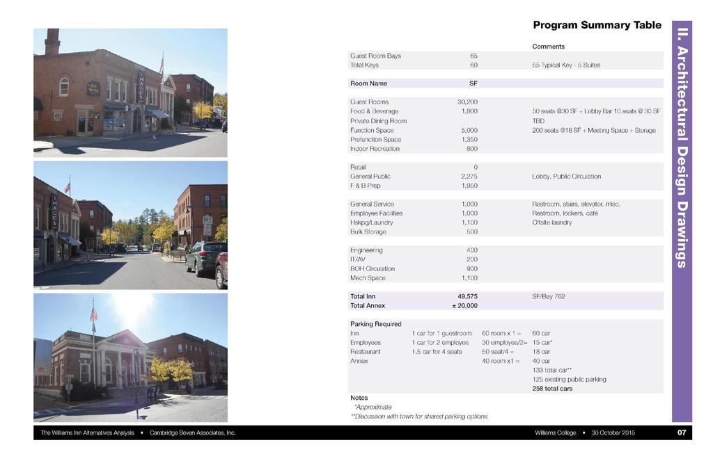
10
11 option A 60 rooms + 40 annex rooms under one roof Inn located at Agway Barn Site
12
13

14
15
16
17
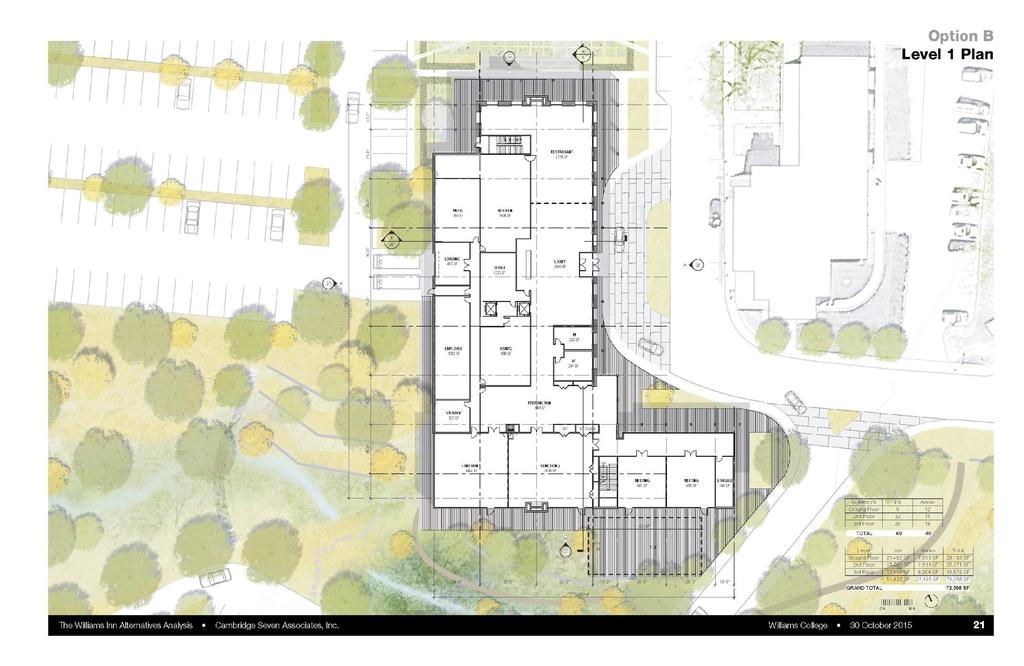
18 option B 60 Room Inn Direct on Spring Street Remote Annex Building

19
20
21
22
23
24
25 summary of study

26
27
28 traffic study summary
29
30
31 town REVIEW COMMENTS
32 Town Review Comments 13 November 2015 From: Jason Hoch Date: Fri, Nov 13, 2015 at 9:18 AM Subject: FW: Inn site study To: Jim Kolesar Jim Thank you for the opportunity to review the site study for the Inn. Our staff has reviewed the report with an intent of offering general observations about findings and potential areas for further study before finalizing. We did not review it as a full pre-regulatory type filing as we understand this is a draft and there is ample time for formal review later. The most notable issue of concern is the further deterioration of service at the Water/Main intersection. I am happy to discuss the items noted below in greater detail with the project team or to provide additional clarification. Further, please feel free to attribute any of these comments and subsequent analysis that may be added to the report as resulting from the Town of Williamstown s informal review if it is helpful to differentiate from the College s initial plans.
33 Land Use One of the key recommendations of the 2002 Master Plan is that the Village Business District needs to be gradually expanded to accommodate more business space as this is lacking in town. Additionally, tourism should be pursued as a major avenue of economic development. Option A seems to accomplish these goals more effectively than Option B as it preserves the Town Parking Lot as a future site for mixed use development once the parking situation is addressed by using another site in the future for parking. A mixed use building at the Option A hotel site would be less ideal than on the Town Parking lot site as a mixed use building would more heavily rely on pedestrian traffic. A hotel on the other hand is an ideal anchor institution and generates its own pedestrian traffic and is ideal for the Option A site as long as steps noted in the report to ensure pedestrian connectivity are taken into account. Both Police and Fire Departments expressed concern about fully restricting the existing Denison Park Drive such that the hotel has only one main access in Option A. They would prefer having a secondary access. This can be a bollard protected emergency only lane similar to the installation at Weston Field. The same observation holds for the Annex as shown in Option B. The Fire Department notes that access to two sides of the buildings is necessary for appropriate fire protection. In both options, the annex shows little to no accessibility for fire lanes.
34 Traffic Placing the hotel at the Option A site preserves more of the existing traffic pattern and does not force as many vehicles towards the Hoxsey Street intersection which will be difficult to improve from a LOS perspective. Based on the report, one can surmise that the proposed Walden Street extension to South Street could enhance LOS at all area intersections. The Town needs to consider methods of improving upper Water Street due to the serious LOS at this area. Mitigation might have to be considered during a hotel permitting process, as this LOS will decrease further. A roundabout could be a major improvement to the Water Street intersection. gov/publications/research/safety/00067/ pdf. Traffic volumes at this intersection however, are near the upper limit for capacity of a single lane urban compact roundabout on a peak hour basis. This should be studied further. From a design perspective, a significant amount of pavement already exists at the Water/Main/Waterman intersection and could likely be reconfigured without significant loss of additional land or existing parking on Water Street. Option B seems very problematic from a traffic perspective with congested drop off and bus loading areas.
35 Traffic Continued The report notes that the existing Latham / Denison/ Spring / Parking lot intersection is problematic, and dangerous for pedestrians. Serious design attention must be paid to this site in the development process. If site A is selected the College could consider relocating Walden Street during the process of reconstructing and expanding the Town parking lot to create a 4 way intersection with significantly improved site lines. This approach, when combined with the separate Walden Street Extension could provide one continuous through street from Water Street to South Street which could offer an overall reduction of volume on Main Street. Wetlands & Site Technical Analysis Guntlow s wetlands report is excellent and captures the concerns shared by the Community Development office and the Conservation Commission when the project was discussed last year. We have no comments on the geotechnical work.
36 THANK YOU OFFICE OF PLANNING, DESIGN AND CONSTRUCTION JANUARY 2016
Emery Village Road 2A Municipal Class Environmental Assessment Study
 PW12.11 STAFF REPORT ACTION REQUIRED Emery Village Road 2A Municipal Class Environmental Assessment Study Date: March 30, 2016 To: From: Wards: Reference Number: Public Works and Infrastructure Committee
Mavis Road Class Environmental Assessment
 Mavis Road Class Environmental Assessment Public Information Centre #2 Wednesday November 9, 2016 6:00 to 8:00 p.m. Please sign in and complete a comment sheet Review the displays on your own or join in
4/8/2015 Item #10D Page 1
 MEETING DATE: April 8, 2015 PREPARED BY: Christy Villa, Associate Civil Engineer DEPT. DIRECTOR: Glenn Pruim DEPARTMENT: Public Works CITY MANAGER: Larry Watt SUBJECT: NORTH COAST HIGHWAY 101 STREETSCAPE
California Environmental Quality Act (CEQA) Environmental Review Process
 Environmental Review Process") California Environmental Quality Act (CEQA) Environmental Review Process Los Angeles Union Station Forecourt and Esplanade Improvements constitute a Project Los Angeles County Metropolitan Transportation
California Environmental Quality Act (CEQA) Environmental Review Process Los Angeles Union Station Forecourt and Esplanade Improvements constitute a Project Los Angeles County Metropolitan Transportation
Executive Summary. NY 7 / NY 2 Corridor
 Executive Summary NY 7 / NY 2 Corridor Transportation and Land Use Study December 2005 Prepared for: Town of Colonie Capital District Transportation Committee Prepared by: Introduction: Land use decisions
Description of Preferred Alternative
 Chapter 2 Description of Preferred Alternative 2.1 Introduction This chapter of the programmatic Sammamish Town Center Sub-area Plan Final EIS provides a more detailed description of the Preferred Alternative
FANSHAWE PARK ROAD/RICHMOND STREET INTERSECTION IMPROVEMENTS. PUBLIC INFORMATION CENTRE 2 June 16, 2016
 FANSHAWE PARK ROAD/RICHMOND STREET INTERSECTION IMPROVEMENTS Municipal Class Environmental Assessment PUBLIC INFORMATION CENTRE 2 June 16, 2016 ACCESSIBILITY Under the Accessibility Standards 2015 for
GEOMETRIC IMPROVEMENTS AND WATERMAIN LOOPING MUNICIPAL CLASS ENVIRONMENTAL ASSESSMENT
 GEOMETRIC IMPROVEMENTS AND WATERMAIN LOOPING MUNICIPAL CLASS ENVIRONMENTAL ASSESSMENT Veterans Way (previously Powerline Road) and Klondike Park Road Wasaga Beach Welcome Please sign in Take a comment
City of Edmonton. Walterdale Bridge Replacement and Approach Roads Evaluation. Concept Planning Study. Final Report
 City of Edmonton Final Report Walterdale Bridge Replacement and Approach Roads Evaluation April, 2011 Walterdale Bridge Replacement and Approach Roads Evaluation Final Report April 2011 Acknowledgement
Creating Complete Roadway Corridors:
 Creating Complete Roadway Corridors: The AASHTO Guide to Transportation Landscape Architecture and Environmental Design NCHRP Project 15-33 Status Report AASHTO Standing Committee on Design Technical Committee
37 Interlaken A Vision To The Future
 37 Interlaken A Vision To The Future The History The Beckwith or Bonnie Briar Estate is one of the original Berkshires Cottages. It was built in 1892 and designed by architect and wealthy owner Leonard
IOWA HIGHWAY 57 / WEST 1 ST STREET STUDY PUBLIC INFORMATIONAL MEETING APRIL 22, 2014
 IOWA HIGHWAY 57 / WEST 1 ST STREET STUDY PUBLIC INFORMATIONAL MEETING APRIL 22, 2014 INTRODUCTION The City of Cedar Falls and the Iowa Department of Transportation are conducting a Public Informational
CITY PLANNING COMMISSION AGENDA ITEM: K STAFF: STEVE TUCK FILE NO.: CPC CU QUASI-JUDICIAL
 Page 92 CITY PLANNING COMMISSION AGENDA ITEM: K STAFF: STEVE TUCK FILE NO.: CPC CU 08-00043 QUASI-JUDICIAL PROJECT: APPLICANT: OWNER: COTTONWOOD ARTISTS SCHOOL & ART GALLERY COTTONWOOD ARTISTS SCHOOL ELMER
Master Plan for Preservation and Scenic Conservation (1995)
") 3.2 Master Plan for Preservation and Scenic Conservation (1995) The Master Plan for Preservation and Scenic Conservation was developed under the direction of the Guilford Preservation Alliance in the 1980s
3.2 Master Plan for Preservation and Scenic Conservation (1995) The Master Plan for Preservation and Scenic Conservation was developed under the direction of the Guilford Preservation Alliance in the 1980s
PINE CURVE REZONING. BACKGROUND Purchased as two parcels in 2001 and 2002
 BACKGROUND Purchased as two parcels in 2001 and 2002 WHAT THE PROJECT IS AND IS NOT A Rezoning establishes the land use standards for Annexed and Zoned Greater Downtown District Historic Center September
Alternatives Development Three conceptual alternatives were developed for the Race Road/Jessup Village Planning Study and are described below:
 Race Road/Jessup Village Planning Study (H550601) Project Newsletter Spring 2015 Project Description The Study Team, consisting of staff from Anne Arundel County (Department of Public Works and Department
Portage Parkway Environmental Assessment Public Information Centre No. 1
 City of Vaughan Portage Parkway Environmental Assessment Public Information Centre No. 1 November 25, 2015 Welcome to the Public Information Centre This first Public Information Centre (PIC) introduces
The Residences at Alewife Station
 The Residences at Alewife Station 195 & 211 Concord Turnpike Community Meeting Peabody School November 10, 2016 Site Context Special District 4 Special District 4 Restored Planned Development Special District
Bypass #16 - Bend Parkway (new alignment for US 97) (MP )
 (MP )") Bypass #16 - Bend Parkway (new alignment for US 97) (MP 134.76-141.83) Description: The Parkway is on new alignment for US 97 through Bend. US 97 is a Statewide Highway on the National Highway System that
Bypass #16 - Bend Parkway (new alignment for US 97) (MP 134.76-141.83) Description: The Parkway is on new alignment for US 97 through Bend. US 97 is a Statewide Highway on the National Highway System that
PINE CURVE REZONING. Property does not meet criteria for open space preservation and is not a candidate for a park
 PINE CURVE REZONING BACKGROUND Purchased as two parcels in 2001 and 2002 Annexed and Zoned Greater Downtown District Historic Center September 25, 2002 and October 7, 2002 WHAT THE PROJECT IS AND IS NOT
Berkshire Regional Planning Commission Clearinghouse Review Report
 August 19, 2013 SUBJECT: Reconstruction of Housatonic Street, Dalton, MA EOEA#: 15083 LOCATION: Dalton ESTIMATED COST: $8.1 million REVIEW TYPE: ENF PROPONENT: MassDOT and Town of Dalton COMMENTS DUE:
The Van Ness Campus. Weekly Construction Bulletin #259
 The Van Ness Campus Weekly Construction Bulletin #259 Construction Update Week of September 24, 2018 The Van Ness Campus Weekly Bulletins are intended to help inform members of the community about upcoming
Northeast Corner of Steeles Avenue West and Alness Street, East of Keele Street, City of Vaughan
 STAFF REPORT ACTION REQUIRED Northeast Corner of Steeles Avenue West and Alness Street, East of Keele Street, City of Vaughan Date: August 24, 2009 To: From: Wards: Reference Number: North York Community
Pine Island Road Corridor Master Plan
 RECOMMENDED DEVELOPMENT PLAN Figure 9: Del Prado Village District Conceptual Framework The Conceptual Framework (Figure 8) for development of the Pine Island Corridor is to encourage mixed-use development
St. Laurent Transit Improvements Innes / Industrial to Smyth. Public Information Session December 2, 2015
 St. Laurent Transit Improvements Innes / Industrial to Smyth Public Information Session December 2, 2015 Agenda Introduction Project Background Preliminary Design Widening for transit lanes Roadway resurfacing
ENBRIDGE GAS DISTRIBUTION INC. Proposed Relocation for Ninth Line, Markham and Whitchurch-Stouffville. Environmental Screening Report
 Page 1 of 18 ENBRIDGE GAS DISTRIBUTION INC. Proposed Relocation for Ninth Line, Markham and Whitchurch-Stouffville Environmental Screening Report July 2011 Page 2 of 18 Table of Contents 1.0 INTRODUCTION
Reconfiguration of The Six Points Interchange. Community Update #2 June 18, 2014
 Reconfiguration of The Six Points Interchange Community Update #2 June 18, 2014 Outline 1. Project overview 2. How did we get here? 3. Etobicoke Centre 4. Existing and future road network 5. Design Update
112th Avenue Light Rail Options Concept Design Report JUNE 2010 PREPARED FOR PREPARED BY TBG PGH
 112th Avenue Light Rail Options Concept Design Report JUNE 2010 PREPARED FOR PREPARED BY TBG060310124909PGH C ontents Introduction 1 Project Overview 1 Public Involvement and Technical Coordination 4 Description
Appendix I. Access Management & Land Use Zoning Strategies Memo
 Appendix I ` Access Management & Land Use Zoning Strategies Memo Route 96 Access Management and Land Use/Zoning Strategies The Town of Victor has access management guidelines in Section 5.0 of the 2014
Transportation. Strategies for Action
 Transportation A major priority for the Overlake Neighborhood is to develop a multimodal transportation system. To achieve this system, a balance has to be found among travel, circulation and access needs;
Status Report: MD 355 Project
 Status Report: MD 355 Project OCTOBER 2006 M-NCPPC MONTGOMERY COUNTY PLANNING DEPARTMENT Summary of Community Comments, and break to the Results of the MD 355 Participation Session Brookside Gardens -
PROJECT STATEMENT LOCATION/DESIGN PUBLIC HEARING. 19 th AVENUE NORTH EXTENSION PROJECT FROM SPRINGDALE DRIVE TO NORTH 2 ND STREET/U.S.
 PROJECT STATEMENT LOCATION/DESIGN PUBLIC HEARING 19 th AVENUE NORTH EXTENSION PROJECT FROM SPRINGDALE DRIVE TO NORTH 2 ND STREET/U.S. 67 HEARING LOCATION: ERICKSEN COMMUNITY CENTER 1401 11 TH AVENUE NORTH
BRIDGE OF DON MASTERPLAN & PLANNING SUMMARY
 BRIDGE OF DON MASTERPLAN & PLANNING SUMMARY SITE LOCATION The site of the existing AECC lies in an area of predominately residential and business use in Bridge of Don and extends approximately 50 acres.
TREASURE COAST REGIONAL PLANNING COUNCIL M E M O R A N D U M. To: Council Members AGENDA ITEM 8B5
 TREASURE COAST REGIONAL PLANNING COUNCIL M E M O R A N D U M To: Council Members AGENDA ITEM 8B5 From: Date: Subject: Staff February 17, 2017 Council Meeting Local Government Comprehensive Plan Review
Beatties Ford Road & Mt. Holly-Huntersville Road Small Area Plan
 Beatties Ford Road & Mt. Holly-Huntersville Road Small Area Plan Town of Huntersville October 2005 Town of Huntersville Planning Department 101 Huntersville Concord Road Post Office Box 664 Huntersville,
City of Cornwall Municipal Class Environmental Assessment. Proposed Improvement and Extension of Lemay Street
 Welcome City of Cornwall Municipal Class Environmental Assessment Proposed Improvement and Extension of Lemay Street Redevelopment and Design of the Municipal Works Yard Public Information Centre #1 Thursday,
City of Toronto. Emery Village Transportation Master Plan
 City of Toronto Emery Village Transportation Master Plan May 2009 Emery Village Transportation Master Plan Toronto, ON May 2009 Consulting Inc. 100 York Blvd., Suite 300 Richmond Hill, ON L4B 1J8 Tel:
Brian Madigan, RLA, CPESC Director Land Planning & Design
 Brian Madigan, RLA, CPESC Director Land Planning & Design bmadigan@gymodpc.com Architecture, Engineering & Land Surveying, DPC 18969 US Route 11 Watertown, New York 13601 T: (315) 788-3900 F: (315) 788-0668
Master Environmental Servicing Plan & Secondary Plan
 1 East Side Lands Stage 2 Master Environmental Servicing Plan & Secondary Plan Public Consultation Centre #4 March 20, 2018 Welcome! Today s Agenda Please sign in at the registration table. 6:00 pm 6:30
PUBLIC HEARING. Thursday, December 14, 2017 FDOT Urban Office 2198 Edison Avenue Jacksonville, FL 32204
 DISTRICT TWO PUBLIC HEARING I 10 (SR 8) from I 295 to I 95 Project Development & Environment Study Duval County, Florida Financial Project Number 213326 2 22 01 Efficient Transportation Decision Making
Highway 427 Industrial Secondary Plan Area 47 Schedule C Class Environmental Assessment For Arterial Roadways
 Welcome to Pubic Information Centre #1 Highway 427 Industrial Secondary Plan Area 47 Schedule C Class Environmental Assessment For Arterial Roadways Welcome to Open House # 1 Tonight, we invite you to.
Public Open House. Yonge Street and Bernard Avenue (Bernard KDA) Planning Study Update Town of Richmond Hill. March 30, 2017
 Planning Study Update Town of Richmond Hill. March 30, 2017") Public Open House Yonge Street and Bernard Avenue (Bernard KDA) Planning Study Update Town of Richmond Hill March 30, 2017 Open House Review of Project Purpose and Process Policy Refresher Highlights of
Public Open House Yonge Street and Bernard Avenue (Bernard KDA) Planning Study Update Town of Richmond Hill March 30, 2017 Open House Review of Project Purpose and Process Policy Refresher Highlights of
CITY OF WESTERVILLE, PLANNING AND DEVELOPMENT. BASSEM BITAR / (614) /
 /") Staff Report Meeting Date: September 21, 2016 Case #: PC 2016-17 WESTERVILLE PLANNING COMMISSION Request: Applicant: Staff Liaison: RECOMMEND TO CITY COUNCIL FOR ITS FURTHER ACTION THE IMAGINE WESTERVILLE
Staff Report Meeting Date: September 21, 2016 Case #: PC 2016-17 WESTERVILLE PLANNING COMMISSION Request: Applicant: Staff Liaison: RECOMMEND TO CITY COUNCIL FOR ITS FURTHER ACTION THE IMAGINE WESTERVILLE
ARLINGTON COUNTY, VIRGINIA. County Board Agenda Item Meeting of January 28, 2017 SUPPLEMENTAL REPORT
 ARLINGTON COUNTY, VIRGINIA County Board Agenda Item Meeting of January 28, 2017 SUPPLEMENTAL REPORT DATE: January 26, 2017 SUBJECT: The Virginia Department of Transportation s Transform I-66 Inside the
Rezoning Transportation Analysis Petition Number: General Location Identifier: , ,
 From: Kelsie Anderson, PE Kelsie.Anderson@charlottenc.gov 704-432-5492 Staff Reviewer: Rick Grochoske, PE rgrochoske@charlottenc.gov 704-432-1556 CDOT s review of this rezoning petition is intended to
Carleton University. Nicol Building New Sprott School of Business. Design Brief and Planning Rationale. Carleton University
 Carleton University Nicol Building New Sprott School of Business Design Brief and Planning Rationale Carleton University Design Team Proposal New Sprott School of Business Academic Building 2019 October
SCARBOROUGH SUBWAY EXTENSION. Scarborough Subway Extension. Final Terms of Reference
 Scarborough Subway Extension Final Terms of Reference 1 1.0 Introduction and Background 1.1 Introduction Toronto City Council recently confirmed support for an extension of the Bloor-Danforth Subway from
County of Fairfax, Virginia
 County of Fairfax, Virginia To protect and enrich the quality of life for the people, neighborhoods and diverse communities of Fairfax County Wyatt Shields, City Manager 300 Park Avenue Falls Church, Virginia
Community Engagement Committee Meeting #1 December 10, :30pm-8:30pm
 Community Engagement Committee Meeting #1 December 10, 2014 6:30pm-8:30pm Welcome and Introductions Dana Murdoch Minneapolis Park and Recreation Board Project Manager Ryan French Walker Art Center Director
ONTARIO MUNICIPAL BOARD
 PL141318 ONTARIO MUNICIPAL BOARD Bronte Green Corporation has appealed to the Ontario Municipal Board under subsection 51(34) of the Planning Act, R.S.O. 1990, c. P.13, from the failure of the Town of
ARLINGTON COUNTY, VIRGINIA. County Board Agenda Item Meeting of January 28, 2017 SUPPLEMENTAL REPORT-2
 ARLINGTON COUNTY, VIRGINIA County Board Agenda Item Meeting of January 28, 2017 SUPPLEMENTAL REPORT-2 DATE: January 27, 2017 SUBJECT: The Virginia Department of Transportation s Transform I-66 Inside the
Stephanie Eyestone-Jones l President Matrix Environmental l 17 September 2013
 Stephanie Eyestone-Jones l President Matrix Environmental l 17 September 2013 Manhattan Beach Shopping Center Enhancement Project l City of Manhattan Beach Overview of Matrix Environmental Qualifications
The GATEWAYS Sub Area Master Plan. City of Walker
 The GATEWAYS Sub Area Master Plan City of Walker Introduction: The Walker City Commission and Planning Commission decided in 2011 to create a sub-area master plan for the Remembrance Road and Wilson Avenue
Northeast Corner of Steeles Avenue West and Jane Street, City of Vaughan
 STAFF REPORT ACTION REQUIRED Northeast Corner of Steeles Avenue West and Jane Street, City of Vaughan Date: June 1, 2010 To: From: Wards: Reference Number: North York Community Council Director, Community
The West College Avenue Corridor Redevelopment Plan
 The West College Avenue Corridor Redevelopment Plan Proposed dby Educational Property Group, Inc. & Apex Development Project Summary The intent of this proposal is to introduce market-driven mixed-use
III. PROJECT DESCRIPTION
 III. PROJECT DESCRIPTION LOCATION AND BOUNDARIES The City of Manhattan Beach is located in the South Bay region of Los Angeles County, California, approximately 2 miles south of the Los Angeles International
2.0 PURPOSE AND NEED. 2.1 Purpose. 2.2 Need Traffic Congestion in and around Downtown Derry
 2.0 PURPOSE AND NEED Taking into consideration agency and public input, the purpose and need for the Project was identified early in Project planning. As noted in Appendix A, for purposes of meeting the
Ashland BRT Environmental Assessment: logos of CTA, CDOT, Chicago Department of Housing and Economic Development
 Ashland BRT Environmental Assessment: logos of CTA, CDOT, Chicago Department of Housing and Economic Development Overview The Chicago Transit Authority (CTA), in partnership with the Chicago Department
Memorandum. Executive Summary. Dwight Bassett Town of Chapel Hill. From: Amy Massey, P.E. Date: June 21, 2013
 Memorandum To: Dwight Bassett Town of Chapel Hill 2000 South Boulevard Suite 440 Charlotte, NC 28203 From: Amy Massey, P.E. Date: June 21, 2013 Re: Ephesus Church Road/Fordham Boulevard Small Area Plan
New Stanton Project Update July 3, 2012
 New Stanton Project Update July 3, 2012 The Needs BACKGROUND INFO I-70 Geometric Concerns Substandard Horizontal & Vertical Clearance at Center Ave. Bridge (The Center Avenue Bridge is Replaced in all
The Corporation of the TOWN OF MILTON
 Report to: From: Chair & Members of the Administration & Planning Standing Committee W.F. Mann, Director of Planning and Development Date: April 16, 2012 PD 022-12 (Z19/11) Subject: Technical Report Proposed
Overall Map. Chicago. St. Louis. Summit. Joliet. Dwight. Pontiac. Bloomington-Normal Lincoln. Springfield. Carlinville. Alton EXPERIENCE IT YOURSELF.
 Overall Map Summit Chicago Bloomington-Normal Lincoln New Station Planned New Station Planned Dwight Pontiac Joliet Pedestrian overpass and second platform planned Higher speed service began in this section
Special Joint Meeting. Emerald Isle Planning Board. Emerald Isle Board of Commissioners. January 18, 2017
 Special Joint Meeting Emerald Isle Planning Board Emerald Isle Board of Commissioners January 18, 2017 STEERING COMMITTEE: Jim Normile Town Commissioner Ken Sullivan Planning Board Larry Watson Retail
PROJECT BACKGROUND. Preliminary Design Scope and Tasks
 PROJECT BACKGROUND Preliminary Design Scope and Tasks The purpose of this Study is the development of preliminary designs for intersection improvements for Trunk Highway (TH) 36 at the intersections of
Heritage Road Improvements from Steeles Avenue to Rivermont Road
 The Corporation of the City of Brampton Heritage Road Improvements from Steeles Avenue to Rivermont Road Class Environmental Assessment Study (Schedule C) September 19, 2013 The Corporation of the City
Application Number: SD Project Name: Walton Farms Preliminary Subdivision (acting as Master Plan)
") STAFF REPORT Town of Clayton Planning Department 111 E. Second Street, Clayton, NC 27520 P.O. Box 879, Clayton, NC 27528 Phone: 919-553-5002 Fax: 919-553-1720 Planning Board May 22, 2017 Application Number:
STAFF REPORT Town of Clayton Planning Department 111 E. Second Street, Clayton, NC 27520 P.O. Box 879, Clayton, NC 27528 Phone: 919-553-5002 Fax: 919-553-1720 Planning Board May 22, 2017 Application Number:
Reconstruction Project. Wayzata Task Force Meeting September 3, 2009
 CSAH 101 Reconstruction Project Wayzata Task Force Meeting September 3, 2009 Agenda 700 7:00 Re-Introductions ti 7:05 2008 Activity Recap / 2009 Activities-to-date 7:10 Discussion of Layout Revisions (per
John M. Fleming Managing Director, Planning and City Planner. Old East Village Dundas Street Corridor Secondary Plan Draft Terms of Reference
 Report to Planning and Environment Committee To: From: Subject: Chair and Members Planning & Environment Committee John M. Fleming Managing Director, Planning and City Planner Old East Village Dundas Street
This is the East Carolina University Comprehensive Facilities Master Plan Final Draft Plan Review. This workbook reviews the campus draft master plan
 This is the East Carolina University Comprehensive Facilities Master Plan Final Draft Plan Review. This workbook reviews the campus draft master plan first presented on campus on June 29 and June 30, 2011.
SFMTA PHELAN LOOP AND PUBLIC PLAZA PHELAN OCEAN AVENUE
 SFMTA Municipal Transportation Agency Image: a bus in front of the Palace of the Legion of honor SFMTA PHELAN LOOP AND PUBLIC PLAZA PHELAN AVENUE @ OCEAN AVENUE Community Meeting May 23, 2012 San Francisco,
Public input has been an important part of the plan development process.
 Lakewood s Comprehensive Plan recognizes that transportation helps shape the community, and that the way the community provides for the safe and efficient movement of people affects the character of the
UAA School of Engineering Parking Garage Master Plan Amendment. 1. Purpose
 UAA School of Engineering Parking Garage Master Plan Amendment 1. Purpose Since the UAA campus master plan was drafted in 2003, adopted in 2004, and amended in 2009 a number of significant changes regarding
East Panorama Ridge Concept Plan Amendment
 Page 1 of 7 L003 : East Panorama Ridge Concept Plan Amendment Corporate NO: L003 Report COUNCIL DATE: March 4, 2002 REGULAR COUNCIL LAND USE TO: Mayor & Council DATE: February 27, 2002 FROM: General Manager,
Strachan Ave. Overpass Community Design Update. October 26, 2010 Stephen Lipkus Executive Director Georgetown South Project GO Transit
 Strachan Ave. Overpass Community Design Update October 26, 2010 Stephen Lipkus Executive Director Georgetown South Project GO Transit Welcome Program Overview 6:30 8:30 p.m.: Storyboard Review Project
Inter River Park Sportsfields
 Inter River Park Sportsfields Council Workshop February 26, 2018 Presented by: Carolyn Girard, Park Planner, DNV Parks Susan Rogers, Parks Manager, DNV Parks Agenda 1. Potential for 2 nd ATF Field in Inter
PLANNING ADVISORY BOARD AGENDA OCTOBER
 ! City of Langley PLANNING ADVISORY BOARD AGENDA OCTOBER 1, 2014 3-5pm LANGLEY CITY HALL - 112 2 nd Street, Langley WA 1) Call to Order and Roll Call 2) Approval of the Minutes September 10, 2014 3) Public
THREE-YEAR CAPITAL IMPROVEMENT PLAN FY
 THREE-YEAR CAPITAL IMPROVEMENT PLAN FY2016 2018 Annual CIP Development Process Public Works & Engineering Divisions Prepare List of Capital Needs and Recommended Deferred Maintenance Public Works & Engineering
Declarations of Pecuniary Interest under the Municipal Conflict Of Interest Act
 Regional Municipality of Waterloo Heritage Planning Advisory Committee Minutes February 8, 2018 5:00 PM Regional Administrative Headquarters, Room 110 150 Frederick Street, Kitchener Present were: Councilor
WELCOME TO PUBLIC INFORMATION CENTRE #2. Please Sign In
 WELCOME TO PUBLIC INFORMATION CENTRE #2 Replacement of Oxtongue Lake Narrows Bridge & Oxtongue River Bridge, Highway 60 (G.W.P. 93-89-00 & G.W.P. 5550-04-00) Class Environmental Assessment (Group B) Please
November 9, Lew Jones, Director of Facilities Berkeley Unified School District 1720 Oregon Street Berkeley, CA 94703
 Planning and Development Department Land Use Planning Division November 9, 2006 Lew Jones, Director of Facilities Berkeley Unified School District 1720 Oregon Street Berkeley, CA 94703 SUBJECT: Comments
3 MARKHAM NORTH-SOUTH LINK CORRIDOR PUBLIC TRANSIT IMPROVEMENTS ENVIRONMENTAL ASSESSMENT UPDATE
 3 MARKHAM NORTH-SOUTH LINK CORRIDOR PUBLIC TRANSIT IMPROVEMENTS ENVIRONMENTAL ASSESSMENT UPDATE The Rapid Transit Public/Private Partnership Steering Committee recommends the adoption of the recommendations
SBCAG STAFF REPORT. MEETING DATE: March 17, 2016 AGENDA ITEM: 5I
 SBCAG STAFF REPORT SUBJECT: Cabrillo-UPRR Bridge Project MEETING DATE: March 17, 2016 AGENDA ITEM: 5I STAFF CONTACT: Fred Luna RECOMMENDATION: Authorize the chair to sign a Memorandum of Understanding
SR-2 Freeway Terminus Improvement Project
 SR-2 Freeway Terminus Improvement Project Welcome! Public Hearing, Mayberry Elementary June 16, 2009, 6:30 p.m. 8:30 p.m. Agenda 6:30 PM 6:50 PM Registration and Open House 6:50 PM 7:00 PM Welcome and
CITY OF MANHATTAN BEACH STAFF REPORT. THROUGH: Marisa Lundstedt, Director of Community Development
 CITY OF MANHATTAN BEACH STAFF REPORT TO: Planning Commission THROUGH: Marisa Lundstedt, Director of Community Development FROM: Tony Olmos, Director of Public Works DATE: April 29, 2015 SUBJECT: Determination
Municipal Class EA Study Public Information Centre No. 1 December 13, :00 pm 7:00 pm. Please sign in so we can keep you updated on this study
 Reconstruction of Regional Road 45 (Creek Road) Between Regional Road 27 (River Road) and Regional Road 63 (Canborough Road) in the Township of Wainfleet Municipal Class EA Study Public Information Centre
(APN: );
;") Gardnerville Town Board AGENDA ACTION SHEET 1. For Possible Action: Discussion to approve, approve with modifications or deny a project review application for Chase Bank located South of Lampe Drive, East
Gardnerville Town Board AGENDA ACTION SHEET 1. For Possible Action: Discussion to approve, approve with modifications or deny a project review application for Chase Bank located South of Lampe Drive, East
124 Subarea Visions. Vision Plan. A. Nelessen Associates, INC I Visioning I Planning I Urban Design
 Subareas 124 Subarea Visions The next seven sections describe specific recommendations tailored to each subarea. Each subarea is discussed separately except for certain aspects of 95th Street and Antioch
TRANSPORTATION ELEMENT
 TRANSPORTATION ELEMENT GOAL I: To create and maintain a safe, efficient and aesthetic transportation system that encourages multi-modal transportation and promotes the mobility strategies of the Ocala
TOWN OF INNISFIL SPECIAL COUNCIL AGENDA OUR JOBS INNISFIL HEIGHTS WORKSHOP WEDNESDAY JANUARY 20, :30 P.M.
 January 13, 2016 TOWN OF INNISFIL SPECIAL COUNCIL AGENDA INNISFIL HEIGHTS WORKSHOP WEDNESDAY JANUARY 20, 2016 5:30 P.M. PLEASE REMEMBER TO TURN OFF CELL PHONES 1. OPENING OF MEETING BY THE MAYOR Opening
DRAFT PLAN OF SUBDIVISION PLANNING RATIONALE 5100 KANATA AVENUE CITY OF OTTAWA. Hawthorn Retirement Group MALONE GIVEN PARSONS LTD.
 DRAFT PLAN OF SUBDIVISION PLANNING RATIONALE 5100 KANATA AVENUE CITY OF OTTAWA Prepared By: MALONE GIVEN PARSONS LTD. Prepared For: Hawthorn Retirement Group July 2015 Draft Plan of Subdivision 5100 Kanata
9 th Street Sub Area Plan
 9 th Street Sub Area Plan In the 1990 s, when the Township prepared the last Master Plan, the 9 th Street corridor was studied as part of a larger 9 th Street Focus Area that included the West Main Street
Acting Director, Transportation Services Division. p:\2010\cluster B\TRA\EtobicokeYork\eycc tp
 STAFF REPORT ACTION REQUIRED Closing Sections of Indian Line between Eglinton Avenue West and Renforth Drive, and Eglinton Avenue West between Orbitor Drive to West of Spectrum Way Date: July 14, 2010
2 STATUTORY PUBLIC MEETING AND INFORMATION REPORT FOR PUBLIC MEETING ON AMENDMENT NO. 62 TO THE YORK REGION OFFICIAL PLAN
 2 STATUTORY PUBLIC MEETING AND INFORMATION REPORT FOR PUBLIC MEETING ON AMENDMENT NO. 62 TO THE YORK REGION OFFICIAL PLAN Pursuant to Section 17(15) of the Planning Act, as amended, the Regional Planning
Welcome. to the 95th Street Terminal Improvement Project Public Hearing
 Welcome to the 95th Street Terminal Improvement Project Public Hearing The purpose of this Public Hearing is to solicit comments from the community about the Environmental Assessment prepared for the 95th
Former North Works, Lickey Road, Longbridge, Birmingham
 Committee Date: 14/11/2013 Application Number: 2013/06431/PA Accepted: 27/08/2013 Application Type: Full Planning Target Date: 26/11/2013 Ward: Longbridge Former North Works, Lickey Road, Longbridge, Birmingham
WATERS EDGE AT DOBBS FERRY DRAFT ENVIRONMENTAL IMPACT STATEMENT VOLUME I
 WATERS EDGE AT DOBBS FERRY DRAFT ENVIRONMENTAL IMPACT STATEMENT VOLUME I Atilda, Fairlawn and Constance Avenues Village of Dobbs Ferry Town of Greenburgh Westchester County, New York Tax Lot Numbers Section
McDonald s Restaurant - Purcellville Town of Purcellville Special Use Permit Statement of Justification July 24, 2014
 Introduction / Written Statement McDonald s Restaurant - Purcellville McDonald s Corporation is proposing to redevelop the existing McDonald s eating establishment with a drive-through located at 121 N
5.8 PUBLIC SERVICES FIRE PROTECTION AND EMERGENCY SERVICES
 5.8 PUBLIC SERVICES FIRE PROTECTION AND EMERGENCY SERVICES 5.8.1 INTRODUCTION This section assesses the proposed projects potential impacts on fire protection services. Information for the following analysis
LITTLE ELM CAPTIAL IMPROVEMENT BOND STREET PRESENTATION
 LITTLE ELM 2009-2014 CAPTIAL IMPROVEMENT BOND STREET PRESENTATION Denton Frisco Little Elm Lewisville Legacy Southlake Grapevine Addison DENTON COUNTY & LEWISVILLE LAKE MATCHING FUNDS DENTON COUNTY BOND
East Corridor Final Environmental Impact Statement
 East Corridor Final Environmental Impact Statement Alternatives Considered Operating Plan The requirements for opening day operations versus year 2030 are based on ridership and operations. Opening day