Proposed Extension. County Buildings (Aras an Chontae), Carrick on Shannon. for. Leitrim County Council PLANNING REPORT
|
|
|
- Louisa Sparks
- 5 years ago
- Views:
Transcription

 1 865 62 65 T +353 (0) 56 77 62907 F + 353 (0) 1 865 62 64 E:")
1 Proposed Extension to County Buildings (Aras an Chontae), Carrick on Shannon for Leitrim County Council PLANNING REPORT Project Ref : Date : 19 th. June 2017 NO. 1 CHANCERY STREET, NO. 2 JOHN STREET, DUBLIN 7. KILKENNY. IRELAND T (0) T +353 (0) F (0) E: mail@boda.ie F +353 (0)
2 CONTENTS SITE LOCATION MAP PART 8 PLANNING SUBMISSION; SCHEDULE OF DOCUMENTS 1. Introduction 1.1 Project Overview 1.2 The Design Team 2 The Design Process 2.1 History & Context 2.2 Preliminary Design Options 2.3 Preferred Design Options 3 The Proposed Development 4 Development Plan Policies & Objectives 5 Architectural Heritage Impact Assessment 6 Conclusion Appendix 1; Photomontage views 1 and 2 Appendix 2; NIAH Record Nos , 13, 14 Appendix 3; Architectural Heritage Impact Assessment of Preliminary Design Options Appendix 4; Schedule of Accommodation

3 Site Location Map PART 8 PLANNING SUBMISSION; SCHEDULE OF DOCUMENTS PLANNING REPORT Incorporating ARCHITECTURAL HERITAGE IMPACT ASSESSMENT & photomontage views from St. Georges Terrace and from across the River Shannon. SCREENING FOR APPROPRIATE ASSESSMENT ARCHAEOLOGICAL IMPACT ASSESSMENT ARCHITECTURAL DRAWINGS S-01 Topographical Survey P-01 Site Location Map P-02 Site layout Plan P-03 Basement Floor Plan P-04 Ground Floor Plan P-05 First Floor Plan P-06 Second Floor Plan P-07 Sections P-08 Elevations P-09 Contiguous Elevations/Site Sections P-10 Demolitions; Machinery Shed & Gate Lodge Lean-to. Photomontage views from St. Georges Terrace and from across the River Shannon. ENGINEERING PLANNING REPORT Incorporating Flood Risk Assessment, & Traffic Impact Assessment ENGINEERING DRAWINGS : Proposed Watermain Layout; : Proposed Foul and Storm Sewer; : Proposed Road Layout.
4 1. Introduction 1.1 Project Overview This report, together with the Drawings and Reports listed in the Schedule of Documents, comprises the planning documentation for public consultation for the proposed extension of Aras an Chontae in Carrick-on-Shannon. The report has been prepared by Bluett & O Donoghue Architects at the request of Leitrim County Council in compliance with Part XI, Section 179 of the Planning and Development Act The proposed extension to Aras an Chontae provides offices, a conference room, staff canteen and ancillary facilities for Leitrim County Council. In addition, it is proposed to refurbish and carry out alterations to the Old Jail to function as a public concourse at ground level to link the Aras and the new extension. It is proposed to install new integrated mechanical and electrical services across the entire complex. Additional car parking is also proposed in the light of the about 50 staff from out-lying offices that are to be accommodated. 1.2 The Design Team The design has been progressed by a multi-disciplinary team of architects, civil & structural engineers, mechanical & electrical services engineers and quantity surveyors. - Architects; Bluett & O Donoghue Architects 2 John Street, Kilkenny Tel Contact: James O Donoghue - Civil & Structural Engineers: Punch Engineers 97 Henry Street, Limerick Tel Contact: Vicky Manuel - Services Engineers; Ronan Mealy Consulting Engineers 1 City Wall, James Street, Kilkenny Tel Contact: Ronan Mealy - Quantity Surveyors M.J. Turley Associates Redhouse, Patrick Street, Portarlington, Co. Offaly Tel Contact: Peter Turley
 records provides a good understanding of the evolution of the site.")
5 2. The Design Process 2.1 History & Context Aras an Chontae is located on a prominent site overlooking the River Shannon, approached from the centre of Carrick-on-Shannon via St. George s Terrace. A review of historic maps, plans and photographs and inspection of the National Inventory of Architectural Heritage (NIAH) records provides a good understanding of the evolution of the site. This research identified the original context of the surviving historic structures and allows their contribution to the modern townscape to be appreciated. Ref. Appendix 1 NIAH Records Historic Plan of the Jail of with the Old Jail of 1750 indicated in darker tone.

 and east gable of")
6 Plan of the historic Jail with the surviving buildings highlighted in blue. Remnants of the main range and the yard walls also survive. View towards the Gate Lodge from St. Georges Terrace with the former Courthouse (1822) and east gable of the Old Jail (1750) to the right.


7 View towards the Governor s House and the Gate Lodge from the east in 1980 before construction of Aras an Chontae. View westwards from St. Georges Terrace in 1980 before construction of Aras an Chontae.
8 The Old Jail building dates from c.1750 and the remains of the scaffold and trap are evident at the upper level of the south façade. This structure was used as part of the female block within the new prison which was built between 1815 and Surviving elements of the later prison are the Governor s House, the Infirmary and the Gate Lodge or Guard House. The recess over the entrance to the Gate Lodge from St. George s Terrace, which was infilled in the 1940 s, was formerly the scaffold for public hangings, the last of which occurred in A passage under the stone boundary wall for conveying prisoners from the Crown Courtroom in the Courthouse (now The Dock Arts Centre) to the prison still exists. The prison ceased to function about 1903 although British forces remained in occupation until The Governor s House remained in residential use until 1953 and the Infirmary until Most of the prison was demolished in 1968 and in 2000 the new County Council offices, including the converted Old Jail, Governor s House, Gate Lodge and Infirmary were commissioned as an integrated campus for the local authority. Aras an Chontae is integrated with elements of the historic prison; the Gate Lodge, the Governor s House and the Old Jail (women s block). 2.2 Preliminary Design Options A wide range of design options were initially explored in tandem with information gathering and historical research. These design options addressed the requirements of the Project Brief in a variety of ways with structures ranging in size between 1600 sq.m and 1800 sq.m. gross floor area.


9 - OPTION 1 ; Provision of the accommodation in two blocks ; a two storey block to the west of the Aras and a partly two / partly three storey block between the Old Jail and The Dock, each with glazed links back to the Aras.


10 - OPTION 2 ; Provision of the accommodation in a four storey structure to the north of the Old Jail, and linked to the Aras via the Old Jail.

11 - OPTION 3 ; Provision of the accommodation in a four storey structure to the east of the Old Jail to form a courtyard between the Aras, the Governors House, the Old Jail and the new extension, with access via lean-to corridors onto the historic buildings.

12 - OPTION 4 ; Provision of the accommodation in a four storey structure as per option 3 but linked to the Aras by a detached glazed link set between the Old Jail and the Governors House.


13 - OPTION 5 ; Provision of the accommodation in two blocks ; a three storey block to the west of the Aras and a three storey block to the east of the Old Jail each with glazed links back to the Aras.


14 OPTION 6 ; Provision of the accommodation in a single three storey block, located as per Options 3 and 4, connecting to the Aras via a ground level link and via an upper level enclosed bridge to the Old Jail. - OPTION 7 ; Provision of the accommodation in a single two storey structure extending from the Governors House / Gate Lodge northwest to align with the Infirmary Block.


15 - OPTION 8 ; Provision of the accommodation in a partly two storey and partly three storey structure to the north and east of the Old Jail and linked to the Aras via the Old Jail. - OPTION 9 ; Provision of the accommodation in two no. three storey extensions off the east and west gables of the Old Jail and also connecting to the Infirmary Block.
16 2.3 Preferred Design Options These design options were explored in tandem with carrying out topographical and dimensional surveys and in gaining a good understanding of the historical context. This stage also involved a series of consultations with the Local Authority Management Team as Client, and with relevant officers of the Council as statutory Planning, Sanitary and Building Control Authority. These consultations allowed the Project Brief to be refined by; - consideration of practical and functional requirements, - consideration of architectural conservation issues, - identification of historic views which are worthy of retention - consideration of preliminary cost estimates for the various options. This exercise served to narrow down the design options to those which were most sensitive to the historic character and where mitigation measures to offset any negative impacts on the heritage significance of the site were feasible. Appendix 2 Architectural Heritage Impact Assessment of Preliminary Design Options gives an overview of the process under which the many preliminary design options were assessed. The preliminary design options were each assessed under the following criteria ; - Functionality of the new accommodation, including the efficiency of linkages and travel distances to the Aras. - Impact on the architectural heritage value of the site. - Impact on established views and prospects. - Attendant alterations within the Aras or disruption of existing facilities. - Fire safety considerations. - Universal access considerations. - Distribution and configuration of carparking. - Estimated cost. Following this assessment, the principal determinants in the selection of the preferred design options emerged as ; - Efficient location and distribution of staff by Section/Department according to their specific requirements. - Preservation of the views of the Old Jail from St. Georges Terrace and from the forecourt between the Governors House and the Turnkey s Lodge. - Maximising the value of the funding available for the project. By these measures, it was concluded that a development on two levels of c sq.m. would meet the terms of the Project Brief in an appropriate manner and in order to test this conclusion, two design options were explored in greater detail These were termed The Bookends option and The Quadrangle option respectively and included the provisional allocation of offices by Section/Department.

17 The Bookends Option involved construction of a two storey block to both the east and west sides of the Old Jail. The Old Jail provided accommodation for ancillary functions and the single storey link corridor between the two blocks and the Aras was set off the south façade of the historic structure. The Bookends Scheme Ground Level

18 The Bookends Scheme Upper Level

19 The Courtyard Option involved the construction of a single larger two storey block to the east of the Old Jail. The Old Jail provided accommodation for ancillary functions and the single storey link corridor to the Aras was set off the south façade of the historic structure. The Courtyard Scheme Ground Level

20 The Courtyard Scheme Upper Level
21 The Bookends and Quadrangle preferred design options were further assessed in terms of functionality and convenience, fire safety and cost. Following this evaluation, it was concluded that the Quadrangle scheme was best suited to meeting the requirements of the Project Brief. However, it was decided that accommodation for the Water Services Department should be included in the Brief and that an elongation of the Quadrangle scheme over two levels was the most cost effective means to achieve this. As a result, the Project Brief upon completion of the preliminary design stage was confirmed as office and ancillary accommodation for 96 staff in a two storey structure of c sq.m, including conference and canteen facilities, located between the Old Jail and The Dock in the area currently occupied by the machinery shed and portacabins. It was also concluded that the Old Jail should be made central to the overall complex rather than be used solely for ancillary purposes. This approach was considered to be of merit in two principal respects, firstly to integrate one of the historic elements of the site into the scheme as a publicly accessible concourse at ground level and secondly to remove the need for a new link corridor between the Aras and the extension and thus significantly reduce the impact on the setting of the Old Jail and the Governors House.
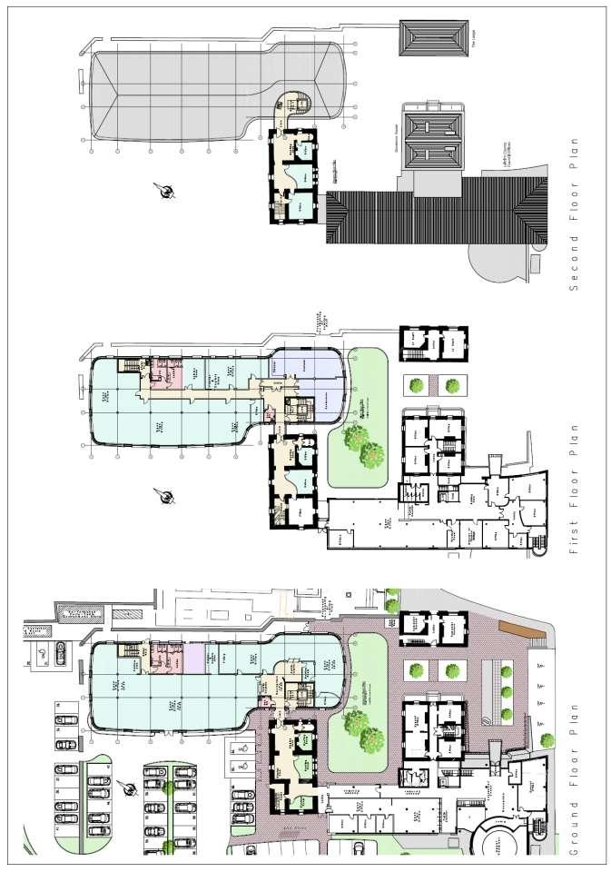
22 3. The Proposed Development The proposed extension takes the form of a 2-storey structure which is 52m long, between 15m and 18m wide and c. 9.5m high located between the east gable of the Old Jail and the boundary wall to the former Courthouse (The Dock Arts Centre). Finishes comprise glazing set within colonnades with stone clad pilasters or within rendered masonry and the curved roof structure has a zinc covering. At present, this area is occupied by the machinery yard and workshop, a large steel container, the Aras oil tank and a variety of pre-fabricated structures. It is proposed to relocate the container and prefabricated structures and to demolish the machinery workshop in order to facilitate construction of the new extension. It is also proposed to take down the sheet metal clad extension to the north of the Gate Lodge which leans onto the high stone boundary wall in order to improve the setting of the new extension. The extension connects to the Aras via the Old Jail and the lift in the extension will extend upwards to provide access to the top floor of the Old Jail. The total floor area of the extension is 1636 sq.m and the Old Jail, which will be refurbished, is c.400 sq.m in area. The extension will accommodate a mixture of singular and open plan offices for 96 staff in addition to meeting rooms, a conference room, a staff canteen and ancillary toilets, plant room, comms room etc. At ground level, the Old Jail will function as the public concourse between the Aras and the extension and will also accommodate three small consultation spaces. On the upper levels, the Old Jail will provide offices and informal meeting areas. The Old Jail is connected to the stairs and lift core of the extension at each level in order to ensure universal access and to improve fire safety. This is achieved by altering a window on the east gable at each level to a door opening to access a short link element to the extension. It is proposed to remove the cement render from the north, east and west facades of the Old Jail and to re-plaster these walls using lime render in order to alleviate the dampness in the masonry. Within the Aras, there are a number of minor alterations to reconfigure the office layouts and to widen the corridor at ground level to cater to the increased foot traffic to the extension. The new extension is contained within the confines of the historic prison as still delineated today by the sections of low stone wall within the north car park. It is proposed to refurbish one of the existing containers and one of the portacabins as the card/paper recycling facility and a store/water samples testing unit respectively. Additional cycle stands are provided by the west entrance to the Aras/Old Jail and additional car parking (c. 50 spaces) is provided along the northern boundary of the site and to the west of the Old Jail. 4 parking bays, suitable for the disabled, are located beside the new extension. It is proposed that 2-way vehicular access would be via the existing northmost entrance via control barriers with the existing entrance beside the Infirmary secured by a new sliding gate and reserved for occasional or emergency use only.

23 Proposed Site Layout
24
25
26 4. Development Plan Policies & Objectives The proposed development has been designed having regard to the Planning Policies and Objectives set out in the Carrick-on-Shannon Local Area Plan whereby; - The site of the proposed extension to Aras an Chontae is zoned mixed-use where office use is acceptable in principle. - The proposed development is in accordance with Policy 11.3 (a) of the LAP whereby the Council seeks to protect the structures listed for protection in the Record of Protected Structures. - The proposed development is in accordance with Policy 11.3 (c) of the LAP whereby the Council seeks to protect the external fabric of structures of heritage value in the Architectural Conservation Area. - The proposed development is in accordance with Objective 11.5 (c) of the LAP whereby the Council seeks to protect the vista along St. Georges Terrace terminating in the former gaol building. - The proposed development is in accordance with the Development Standards contained in the Local Area Plan as set out in the Engineering Planning Report. The overall site layout has been modified to create an additional 51 car parking spaces and this tallies closely with the number of staff in outlying offices who are to be accommodated. - Flood Risk Assessment has determined that the site lies outside the 1 in 1000 year flood event whereby development is acceptable. The Project constitutes urban development in a business district of less than 2 hectares in area. The area of the complete site of Aras an Chaontae is c hectares and as such, under Article 10 (iv) of Schedule 5, Part 2 of the Planning & Development Regulations , the requirement for Environmental Impact Assessment does not arise. An Archaeological Appraisal of the proposed development has been carried out by Edmond Donovan Associates. In view of the good understanding of the historic layout of the site, it can be anticipated that below ground remnants of the old prison structures will be unearthed during the course of the works. In this regard, the archaeologist makes recommendations on how the foundations for the proposed extension could bridge across historic fabric deemed worthy of preservation in-situ. It is also possible that human burials will be revealed and allowance should be made for following the appropriate protocols in such circumstances. Screening for Appropriate Assessment The proposed development has been screened for appropriate assessment by the Moore Group, Environmental Consultants in order to ascertain if there could be any significant impact on the natural environment or ecology of the site. The ecologist observes that there are no Natura (European designated sites) within 15 KM of the site and concludes that subject to the appropriate treatment of wastewater (which is feasible via public mains drainage), there will be no environmental impact on the River Shannon and as such, further assessment is not required.
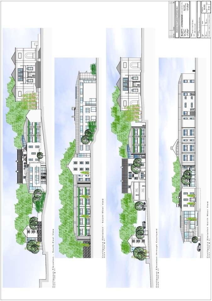
27 5. Architectural Heritage Impact Assessment The history and heritage significance of the site is set out in Section 2.1 of this report. The impact of the proposed development, from a heritage perspective is set out below, firstly on how it affects the setting of the protected structures in the immediate vicinity and secondly by describing the interventions proposed to the Old Jail. Impact on townscape and the setting of the historic structures ; The proposed extension sits between the Old Jail and the former Courthouse (the Dock Arts Centre) and in close proximity to the Governors House and the Gate Lodge. The effect on the setting of these buildings and on the wider townscape is illustrated in the attached photo-montage views from St. George s Terrace and from across the River Shannon. In order to mitigate the impact of the proposed development on established views : The extension is limited to two storeys in height with eaves aligning with the parapets of the Governor s House and the ridge of the Gate Lodge. The stairs and lift enclosure to the top floor of the Old Jail is framed by the east gable so that the historic profile remains prominent in the view from St. Georges Terrace. In addition to the principal views across the town, the setting of the protected structures within the Aras is altered by the formation of additional carparking between the west gable end of the Old Jail, the Infirmary and the stone wall within the green acre which is a remnant of the original three storey prison cell block. Ref. photographs no. 8 and 9. This is a necessary intervention to provide adequate car parking relative to the number of incoming staff. The setting to the historic structures will change from soft landscaping to hard landscaping but there will be no impact on the structures themselves. Within the Aras campus, the setting of the protected structures is also altered by removal of the long single storey timber and metal lean-to structure which extends northwards from the Gate Lodge. Ref. photographs no. 5 and 10. The removal of this structure is considered to be a positive aspect of the project. It will reveal the old prison wall and the north wall of the Gate Lodge at the lower levels and will allow the previous external faces to be made good and presented in their original form. It also creates the opportunity to open up the blind arch in the east stone boundary wall Between the Aras and The Dock (former Courthouse) Ref. photograph no.13. This will establish a spatial connection to St. George s Terrace in a sensitive manner and will also brighten the new offices.
28 Alterations to the Old Jail The impact of the proposed development on the fabric of the protected structures is mainly limited to the interventions required to make the Old Jail central to the operations of the Local Authority by providing the link between offices providing public services in the existing facility and in the new extension. The interventions to the Old Jail comprise ; Altering of a window opening on the west gable to a door opening at each level to access short link corridors to the new extension. These alterations can be carried out with little impact on the historic character of the building. Floor finishes are modern, as are the window units, which are without linings, and the openings can be widened below the springing point of the vaulted floor / ceiling structures. Ref. photograph no. 14. Connection of the 3-storey glazed link structure to the east gable of the building. Widening of three internal door openings at ground level, two internal door openings at first floor level and two internal door openings at second floor level. As with the lowering of window cills, the widening of these openings can be achieved without significant impact on the historic character with the alterations contained below the springing point of the vaulted floor / ceiling structures., Ref. photograph no. 14. Insertion of self-supporting glazed screens to provide privacy to consultation spaces, two at ground level, one at first floor and one at second floor. The centre rooms in the Old Jail are barrel vaulted at each level. Ref. photographs 16, 17, 18 and 19. It is intended that the glazed screens will stop short of the vaulting in each case and will essentially comprise demountable fit out items within these rooms. It appears that the external masonry of the Old Jail is retaining moisture although the internal drylining may be covering overt evidence of this. There is an pronounced smell of dampness within the building and it can be assumed that the cement render on the north east and west wall is preventing the evaporation of moisture to outside from these walls. It is proposed to remove the cement render from these walls and to replaster using lime render in order to dramatically improve the breathability of structure. Ref. photograph no. 20. The significant long term benefit of this element of the proposed development is considered a valid mitigation measure to balance against impacts on the setting and the modification of a number of internal door openings. Most of all, it is considered that making the Old Jail central to the operation of Aras an Chontae, as a public concourse and offices, is a decision which is sympathetic to the conservation of the protected structure, whereby an active future use is proposed rather than a mothballing of the structure for ancillary uses or storage. The public concourse at ground level will be an ideal venue to mount a display to explain the history of the site and to describe the special architectural, historical and social interest of the surviving elements of the prison.

29


30 1. View west from St. George s Terrace with the Gate Lodge terminating the view and the gable of the Old Jail of 1750 to the right. The proposed two-storey extension will be constructed under the Old Jail behind the high stone boundary wall and the stairs and lift enclosure rising to serve the top floor of the Old Jail will be contained within the east gable of the historic structure. Ref. Appendix 1; Photomontage view The main entrance to Aras an Chontae is via the modern wing constructed in The Governor s House is part of the complex and the proposed two storey extension will fill the gap to the right of the Governor s House beside the Old Jail.


31 2. View from across the River Shannon. The south elevation of the extension will be set back between the Governor s House and the Gate Lodge. Ref. Appendix 1; Photomontage view View of the site of the proposed development from the Old Jail. Currently, it functions as the machinery yard and workshop and also accommodates various temporary structures.

 and the former Courthouse (the Dock Arts Centre, centre).")
32 5. The site lies between the Old Jail and the former Courthouse (The Dock Arts Centre) and extends c. 6 metres forward of the hoarding to the left. The timber and metal lean-to structure will be removed to reveal the historic prison boundary wall in full. 6. View south-east across the site with the Old Jail (right) and the former Courthouse (the Dock Arts Centre, centre). The low stone wall is a remnant of the boundary wall of the historic prison and retention of this wall defines and limits the extent of the site for the proposed extension.


33 7. A portion of the historic prison boundary wall survives to the north of the machinery shed. The shed is to be demolished to allow for construction of the proposed extension. 8. South façade of the Old Jail. The two storey extension will be to the right with short link corridors between the buildings set back from the front building line at each level.


34 9. The ground floor of the Old Jail will function as a public concourse connecting the existing Aras to the extension. The upper levels will be used as offices. The stairs and lift in the extension will rise to provide universal access to the top floor of the Old Jail and the enclosure will be contained within the profile of the east gable. 10. It is proposed to extend the carparking to the west of the Old Jail.


35 11. It is proposed to extend the carpark southwards by 25 metres between the Old Jail and the stone wall which is a remnant of the historic prison cell block. 12. Taking down the modern lean-to will allow the prison boundary wall and the north wall of the Gate Lodge to be conserved.
.")

36 13. Removal of the modern lean-to behind the east stone boundary wall creates the opportunity to open up the blind arch between Aras an Chontae and The Dock Arts Centre (former Courthouse). This will brighten the offices within the Aras Extension and will establish a visual connection to St. Georges Terrace. 14. It is proposed to alter a window opening to a door opening the Old Jail at each level in order to link across to the new extension. The windows are modern, the openings are plain and the alteration can be achieved without impact on the vaulted floor and ceiling structures.


37 15. It is proposed to widen some internal door openings to facilitate public circulation between the Aras and the extension. This can be achieved without impact on the vaulted floor / ceiling structures. 16. Central chamber, second floor level, looking north. The central chambers in the Old Jail at each level have barrel vaulted ceilings. It is proposed to create consultation spaces and small offices within the central chambers by fitting glazed screens which will follow the line of the vaults in each case but stop short of touching.


38 17. Central chamber, second floor level, looking south. 18. Central chamber, first floor level, looking south.


39 19. Central chamber, ground floor level, looking south. 20. The fabric of the Old Jail is damp and retaining moisture. It is proposed to remove the impervious cement render from the north, east and west façades and to replace with lime render. This will improve the breathability of the structure and will allow the building to dry out over time.
40 6. Conclusion The proposed extension to Aras an Chontae provides offices, a conference room, staff canteen and ancillary facilities for Leitrim County Council. Services are integrated with the existing Aras complex and additional car parking is also provided. Circulation between the Aras and the new extension is via the ground floor of the Old Jail and this historic structure becomes central to the overall complex. Documentary and cartographic research has provided a good understanding of the heritage value of the site. From this, a suitable location for the new development was identified and the scale and massing of the new extension has regard to the context and the surrounding structures. A wide range of design options were explored and these were measured in terms of functionality and convenience, heritage impact and cost. This exercise identified two preferred options as possible solutions and these were taken to greater detail to test internal office layouts and Section allocations. After further assessment of functionality, fire safety and cost, a two storey structure set between the Old Jail and The Dock was selected as the optimum solution to the Project Brief. A new lift within this structure is extended upwards to serve the top floor of the Old Jail and this will make this historic building universally accessible and create improved means of fire escape. The principal elevations of the extension emulate the classical elevations of the Governors House, The Gate Lodge and The Dock in a restrained manner and the location and massing of the proposed extension ensures that established views of the historic structures are maintained. The proposed development is in accordance with the Policies and Objectives of the Local Area Plan and has regard to all relevant Guidelines for Architectural Heritage and Environmental Protection.

41 APPENDIX 1 ; Photomontage Views 1 and 2 View from St. Georges Terrace

42 View from across the River Shannon


43 APPENDIX 2 ; NIAH Record Nos , 13, 14
44
45 APPENDIX 3; Architectural Heritage Impact Assessment of Scheme Options 24 th October 2016 A number of options have been prepared. The impact of these options on the character, fabric and setting of the former county gaol, the adjoining courthouse and George s Terrace is assessed. Possible mitigation measures, to reduce the impact of the option, are identified. Option 1 Description Impact Possible Mitigation Measures Two-storey new-build block with glazed link to west of existing civic a) Governor s House: No impact No mitigation measures necessary offices Part-2-storey/part-3- storey new-build block to east of old Gaol (i.e. between Old Gaol and boundary to Courthouse) Two-storey glazed link attached to south façade b) Old Gaol : Two-storey extension to south façade; predominantly in glass; this will obscure a substantial part of the façade, which survives largely intact from the eighteenth century. A reduction in the height of the glazed link to single-storey would reduce the impact of this extension on the existing façade. of Old Gaol. Glazed link to arch in east boundary wall c) Gatehouse No impact Consideration should be given to connecting the gatehouse into the new-build extension to its d) The Dock (former courthouse): Limited impact new extension is well set back; some reduction in natural light on west façade. e) View along George s Terrace: No impact; three-storey new build block is well set back north. The proposed extension has a limited impact. There are no obvious measures to mitigate the reduction of light to the west façade of the Dock. No mitigation measures necessary f) Forecourt (between Gatehouse and Governor s House The proposed development will be visible but will have no real impact. g) View from Carrick-on-Shannon Bridge: Limited impact the new-build part-2-storey/part-3-storey extension will be visible but is well set back. No mitigation measures necessary Stepped form helps to mitigate the impact of the new buildings. No mitigation measures necessary
46 Option 4 Description Impact Possible Mitigation Measures Part-2-storey/part-4- storey new-build block to east of old Gaol (i.e. between Old Gaol and boundary to Courthouse) Two-storey glazed link running through courtyard to north of Governor s House Glazed bridge at first and second floor level to east gable of Old Gaol. Glazed link to arch in east boundary wall a) Governor s House: There are a number of negative impacts a two-storey glazed link is to be constructed within 1 metre of the north façade. This will alter the setting of the Governor s house, which was envisaged as the centre-piece of the gaol, detached on three sides. Historic views between the Governor s House and the Old Gaol will be lost. The south façade of the two-storey new building comes very close to the north-east corner of the Governor s House. Alternative locations for the connecting link would mitigate or eliminate the impact of the link corridor; alternatively, consideration should be given to reducing the height of the proposed link to a single-storey. A greater set-back should be provided between the front (south) façade of the newbuild extension and the Governor s House. b) Old Gaol : There are a number of negative impacts The proposed glazed bridge will impact on the east gable of Old Gaol. There is a likelihood that the Old Gaol will function primarily as a circulation zone between the existing civic offices and the new extension. Historic views between the Old Gaol and the Governor s House will be lost. The proposed link corridor and extension will be much less visible from the forecourt of the Governor s House. c) Gatehouse The proximity of the proposed two-storey block to the north gable will have a negative impact on the setting of the former gatehouse. d) The Dock (former courthouse): The south façade of the proposed four-storey extension is aligned with the front façade of the former courthouse. The proximity of the new building to the primary façade will negatively impact on the setting of the former courthouse. There will be some reduction in natural light on west façade. Consideration should be given to omitting the glazed bridge to the Old Gaol. Alternative locations for the connecting link would mitigate or eliminate the impact of the link corridor; alternatively, consideration should be given to reducing the height of the proposed link to a single-storey. A greater set-back should be provided between the front (south) façade of the newbuild extension and the Gatehouse. This is a significant impact, which can only be mitigated by setting back the new building well behind the façade of the courthouse. There are no obvious measures to mitigate the reduction of light to the west façade of the Dock.
47 e) View along George s Terrace: The south façade of the proposed four-storey extension is aligned with the front façade of the former courthouse. The east gable of the eighteenth century Old Gaol, which is currently visible from George s Terrace, will be concealed. This creates a terrace effect which will have a negative impact on the setting of the former courthouse and Old Gaol. f) Forecourt (between Gatehouse and Governor s House There are a number of negative impacts The proximity of the proposed two-storey extension will negatively impact on the smaller Governor s House and Gatehouse. Established views to the Old Gaol will be lost. g) View from Carrick-on-Shannon Bridge: The proposed option will have a significant impact on the setting of the former Gaol. The newbuild part-2-storey/part-4-storey extension is in close proximity to the Governor s House, Gatehouse and former courthouse. The east gable of the Old Gaol will be concealed. It is recommended that the portion of the new building above two-storeys should be set back behind the north façade of the Old Gaol. Consideration should be given to setting the new building further back from the smaller Governor s House and Gatehouse. Consideration should be given to reducing the height of the proposed glazed link to a single-storey to allow improved views of the Old Gaol. Consideration should be given to reducing the height of the new building and increasing the set-back from the historic buildings on the site. Option 7 (a) Description Impact Possible Mitigation Measures Stepped (Part-2- storey/part-3- storey/part-4-storey) new-build block to east of old Gaol (i.e. between Old Gaol and boundary to Courthouse); the south façade of the fourstorey block being aligned with the north façade of the Old Gaol. Two-storey glazed link running through courtyard to north of Governor s House Glazed bridge at first floor level to east gable of Old Gaol. Glazed link to arch in a) Governor s House: There are a number of negative impacts a two-storey glazed link is to be constructed within 1 metre of the north façade. This will alter the setting of the Governor s house, which was envisaged as the centre-piece of the gaol, detached on three sides. Historic views between the Governor s House and the Old Gaol will be lost. The south façade of the two-storey new building comes very close to the north-east corner of the Governor s House. Alternative locations for the connecting link would mitigate or eliminate the impact of the link corridor; alternatively, consideration should be given to reducing the height of the proposed link to a single-storey. A greater set-back should be provided between the front (south) façade of the newbuild extension and the Governor s House.
48 east boundary wall b) Old Gaol : There are a number of negative impacts The proposed glazed bridge will impact on the east gable of Old Gaol. There is a likelihood that the first floor of the Old Gaol will function primarily as a circulation zone between the existing civic offices and the new extension. Historic views between the Old Gaol and the Governor s House will be lost. The proposed link corridor and extension will make the building much less visible from the forecourt of the Governor s House. c) Gatehouse The proximity of the proposed two-storey block to the north gable will have a negative impact on the setting of the former gatehouse. d) The Dock (former courthouse): The south façade of the proposed three-storey setback is aligned with the front façade of the former courthouse. The proximity of the new building to the primary façade will negatively impact on the setting of the former courthouse. e) View along George s Terrace: The south façade of the proposed three-storey set-back extension will be visible above the east boundary wall of the Gaol complex. The east gable of the eighteenth century Old Gaol, which is currently visible from George s Terrace, will be concealed in part. This will have a negative impact on the setting of the former courthouse and Old Gaol. f) Forecourt (between Gatehouse and Governor s House There are a number of negative impacts The proximity of the proposed two-storey extension will negatively impact on the smaller Governor s House and Gatehouse. Established views to the Old Gaol will be lost. Consideration should be given to omitting the glazed bridge to the Old Gaol. Alternative locations for the connecting link would mitigate or eliminate the impact of the link corridor; alternatively, consideration should be given to reducing the height of the proposed link to a single-storey. A greater set-back should be provided between the front (south) façade of the new-build extension and the Gatehouse. This is a significant impact, which can only be mitigated by setting back the new building well behind the façade of the courthouse. There are no obvious measures to mitigate the reduction of light to the west façade of the Dock. It is recommended that the portion of the new building above two-storeys should be set back behind the north façade of the Old Gaol. Consideration should be given to setting the new building further back from the smaller Governor s House and Gatehouse. Consideration should be given to reducing the height of the proposed glazed link to a single-storey to allow improved views of the Old Gaol.
49 g) View from Carrick-on-Shannon Bridge: The proposed option will have a significant impact on the setting of the former Gaol. The stepped new-build extension is in close proximity to the Governor s House, Gatehouse and former courthouse. The east gable of the Old Gaol will be substantially concealed. Consideration should be given to reducing the height of the new building and increasing the set-back from the historic buildings on the site. Option 7 (b) Description Impact Possible Mitigation Measures Stepped (Part-2-storey/ part-4-storey) new-build block to east of old Gaol (i.e. between Old Gaol and boundary to Courthouse) Two-storey glazed link running through courtyard to north of Governor s House Glazed bridge at first and second floor level to east gable of Old Gaol. Glazed link to arch in east boundary wall a) Governor s House: There are a number of negative impacts a two-storey glazed link is to be constructed within 1 metre of the north façade. This will alter the setting of the Governor s house, which was envisaged as the centre-piece of the gaol, detached on three sides. Historic views between the Governor s House and the Old Gaol will be lost. The south façade of the two-storey new building comes very close to the north-east corner of the Governor s House. Alternative locations for the connecting link would mitigate or eliminate the impact of the link corridor; alternatively, consideration should be given to reducing the height of the proposed link to a single-storey. A greater set-back should be provided between the front (south) façade of the newbuild extension and the Governor s House. b) Old Gaol : There are a number of negative impacts The proposed glazed bridge will impact on the east gable of Old Gaol. There is a likelihood that the Old Gaol will function primarily as a circulation zone between the existing civic offices and the new extension. Historic views between the Old Gaol and the Governor s House will be lost. The proposed link corridor and extension will make the building much less visible from the forecourt of the Governor s House. c) Gatehouse The proximity of the proposed two-storey block to the north gable will have a negative impact on the setting of the former gatehouse. Consideration should be given to omitting the glazed bridge to the Old Gaol. Alternative locations for the connecting link would mitigate or eliminate the impact of the link corridor; alternatively, consideration should be given to reducing the height of the proposed link to a single-storey. A greater set-back should be provided between the front (south) façade of the new-build extension and the Gatehouse.
50 d) The Dock (former courthouse): Limited impact new extension is well set back; some reduction in natural light on west façade. h) View along George s Terrace: Limited impact; four-storey new build block is well set back e) Forecourt (between Gatehouse and Governor s House There are a number of negative impacts The proximity of the proposed two-storey extension will negatively impact on the smaller Governor s House and Gatehouse. Established views to the Old Gaol will be lost. f) View from Carrick-on-Shannon Bridge: The proposed option will have a significant impact on the setting of the former Gaol. The stepped new-build extension is in close proximity to the Governor s House, Gatehouse and former courthouse. The proposed extension has a limited impact. There are no obvious measures to mitigate the reduction of light to the west façade of the Dock. No mitigation measures necessary Consideration should be given to setting the new building further back from the smaller Governor s House and Gatehouse. Consideration should be given to reducing the height of the proposed glazed link to a single-storey to allow improved views of the Old Gaol. Consideration should be given to reducing the height of the new building and increasing the set-back from the historic buildings on the site. Bookends Option (a) Description Impact Possible Mitigation Measures Two-storey new-build block with glazed link to north west of existing h) Governor s House: No impact No mitigation measures necessary civic offices (i.e. west of Old Gaol) Part-2-storey/part-3- i) Old Gaol : Single-storey extension to south façade; predominantly in glass; The detailed design of the glazed corridor should maximise transparency. storey new-build block to east of old Gaol (i.e. between Old Gaol and boundary to Courthouse) Single-storey glazed link attached to south façade of Old Gaol. Glazed link to arch in east boundary wall j) this will obscure the ground floor façade only. Gatehouse No impact Consideration should be given to connecting the gatehouse into the new-build extension to its north. k) The Dock (former courthouse): Limited impact new extension is well set back; some reduction in natural light on west façade. l) View along George s Terrace: No impact; three-storey new build block is well set back The proposed extension has a limited impact. There are no obvious measures to mitigate the reduction of light to the west façade of the Dock. No mitigation measures necessary
51 m) Forecourt (between Gatehouse and Governor s House The proposed development will be visible but will have no real impact. n) View from Carrick-on-Shannon Bridge: Limited impact the new-build part-2-storey/part-3-storey extension will be visible but is well set back. No mitigation measures necessary Stepped form helps to mitigate the impact of the new buildings. No mitigation measures necessary Bookends Option (b) Description Impact Possible Mitigation Measures Two-storey new-build block with glazed link to o) Governor s House: No impact No mitigation measures necessary north west of existing civic offices (i.e. west of Old Gaol) Part-2-storey/part-3- p) Old Gaol : Two-storey extension to south façade; predominantly in glass; The detailed design of the glazed corridor should maximise transparency. storey new-build block to east of old Gaol (i.e. between Old Gaol and boundary to Courthouse) Two-storey glazed link attached to north façade of Old Gaol. Visual link to arch in east boundary wall this will obscure the north façade only, which has been previously altered and does not form part of key views of the site.. q) Gatehouse No impact Consideration should be given to connecting the gatehouse into the new-build extension to its north. r) The Dock (former courthouse): Limited impact new extension is well set back; some reduction in natural light on west façade. s) View along George s Terrace: No impact; three-storey new build block is well set back The proposed extension has a limited impact. There are no obvious measures to mitigate the reduction of light to the west façade of the Dock. No mitigation measures necessary t) Forecourt (between Gatehouse and Governor s House The proposed development will be visible but will have no real impact. u) View from Carrick-on-Shannon Bridge: Limited impact the new-build part-2-storey/part-3-storey extension will be visible but is well set back. No mitigation measures necessary Stepped form helps to mitigate the impact of the new buildings. No mitigation measures necessary Prepared by: Michael O Boyle, Grade 1 Conservation Architect Bluett & O Donoghue Architects. Date: 24 th October 2016
52 APPENDIX 4; SCHEDULE OF ACCOMMODATION Extension to Aras an Chontae & refurbishment of the Old Jail, Carrick-on-Shannon, Co. Leitrim EXTENSION FUNCTION STAFF AREA (net of stair/lift cores & toilets) OFFICES 84 1,036 sq.m COMMS ROOM PLANT ROOM CONFERENCE ROOM MEETING ROOMS CANTEEN/KITCHEN 24 sq.m 24 sq.m 62 sq.m 28 sq.m 82 sq.m TOTAL AREA OF EXTENSION OVER TWO LEVELS (incl. stair/lift cores & toilets) 1,636 sq.m OLD JAIL FUNCTION STAFF AREA PUBLIC CONCOURSE MEETING AREAS (net of stairs, circulation & stores) 80 sq.m 58 sq.m OFFICES sq.m TOTAL AREA OF THE OLD JAIL OVER THREE LEVELS (incl. stairs/circulation) 410 sq.m
Page 1 of 19 URBAN DESIGN FRAMEWORK FOR BOLTON STREET WATERFORD
 Page 1 of 19 URBAN DESIGN FRAMEWORK FOR BOLTON STREET WATERFORD 1.0 Introduction: The relocation of the City Council stores and depot from Bolton Street creates an exciting opportunity for development
2bPlanning Scheme. Appendix. Conservation - Removal of Structures. Grangegorman
 Appendix 2bPlanning Scheme Grangegorman Conservation - Removal of Structures Innovative Urban Quarter Contemporary Healthcare Facilities Modern Education Hub Accessible Public Spaces Appendix 2b: Purpose
BORRISOKANE SETTLEMENT PLAN
 BORRISOKANE SETTLEMENT PLAN 1.0 General Introduction and Development Context Location Borrisokane is located 15km north of Nenagh on the N52. While the town is primarily residential, it acts as a market
Lancaster Conservation Area Appraisal. Character Area 8. Cathedral
 Lancaster Conservation Area Appraisal Character Area 8. Cathedral March 2013 118 3.8 Character Area 8. Cathedral 3.8.1. Definition of Special Interest "This character area is distinctive for the fine group
Adversely impact the cultural heritage value of properties designated under Part IV of the Ontario Heritage Act (OHA).
.") Cultural Heritage Impact Assessment Rezoning of 180 Metcalfe Street, Ottawa A. Introduction: Robertson Martin Architects (The Consultant) was retained in March 2014 by Roderick Lahey Architect Inc. (the
Cultural Heritage Impact Assessment Rezoning of 180 Metcalfe Street, Ottawa A. Introduction: Robertson Martin Architects (The Consultant) was retained in March 2014 by Roderick Lahey Architect Inc. (the
I615. Westgate Precinct
 I615. Westgate Precinct I615.1. Precinct Description The Westgate Precinct is located approximately 18km west of the Auckland city centre. There are seven Sub-precincts in the Westgate Precinct: Sub-precinct
Heritage Property 70 Liberty Street (Central Prison Chapel)
") STAFF REPORT ACTION REQUIRED Alteration of a Designated Heritage Property 70 East Liberty Street (Central Prison Chapel) Date: October 9, 2012 To: Toronto Preservation Board Toronto East York Community
STAFF REPORT ACTION REQUIRED Alteration of a Designated Heritage Property 70 East Liberty Street (Central Prison Chapel) Date: October 9, 2012 To: Toronto Preservation Board Toronto East York Community
Rev John Withy, Sion House, 120 Melmount Road, Sion Mills
 Derry City and Strabane District Council Planning Committee Report COMMITTEE DATE: 4 th October 2017 APPLICATION No: APPLICATION TYPE: PROPOSAL: LOCATION: APPLICANT: AGENT: LA11/2016/0701/F Full Retrospective
Urban Design Brief Woodland Cemetery Funeral Home 493 Springbank Drive
 Urban Design Brief Woodland Cemetery Funeral Home The Incorporated Synod of the Diocese of Huron April 15, 2016 Urban Design Brief April 15, 2016 TABLE OF CONTENTS Page No. INTRODUCTION... 1 SECTION 1
Design Guidelines - 1 -
 Design Guidelines REAR YARDS Rear yard decks and porches, attached to a garden or garage suite, should be permitted provided minimum rear yard setbacks, separation distances, and necessary site access
6 PORT SYDNEY SETTLEMENT AREA
 Section 6 Port Sydney Page 61 6 PORT SYDNEY SETTLEMENT AREA 6.1 Basis and Principles Village of Port Sydney Waterfront Community Existing Services 6.1.1 Port Sydney is an historic settlement that has developed
6 Site Framework Strategies
 6 Site Framework Strategies 6.1 Introduction Section 6 identifies a number of specific areas which are considered to be key sites within the Plan area and which may have potential for development / redevelopment.
REVIEW OF ENVIRONMENTAL FACTORS HUDSON LIBRARY FIT OUT FOR MERIDEN SCHOOL, STRATHFIELD NSW
 24 August 2018 Richard Arkell Head of Operations Meriden Anglican School 10-12 Redmyre Road Strathfield NSW 2135 REVIEW OF ENVIRONMENTAL FACTORS HUDSON LIBRARY FIT OUT FOR MERIDEN SCHOOL, STRATHFIELD NSW
Urban Design Brief. 875 Wellington Road. Proposed One-Storey Fast Food Restaurant and Two-Storey Restaurant. Wellington Harlech Centre Inc.
 Urban Design Brief 875 Wellington Road Proposed One-Storey Fast Food Restaurant and Two-Storey Restaurant Wellington Harlech Centre Inc. Prepared By: (519) 433-7587 info@yorkdev.ca May 3 rd 2013 1 Table
Planning Department Dover District Council Council Offices White Cliffs Business Park Dover Kent CT16 3PJ. Our Ref: MB/LP/11002.
 Planning Department Dover District Council Council Offices White Cliffs Business Park Dover Kent CT16 3PJ Our Ref: MB/LP/11002 1 June 2016 Dear Sir/Madam, RE LINWOOD YOUTH CENTRE, 92 MILL ROAD, DEAL, CT14
Visual and Aesthetic Resources
 Visual and Aesthetic Resources 7.1 INTRODUCTION This chapter evaluates the effects of the Modified Design on visual and aesthetic resources, in comparison to the effects of 2004 FEIS Design. The 2004 FEIS
7. The Landscape. 7.1 Introduction. Environmental Impact Statement (EIS) Scoping Report
 Scoping Report") 7. The Landscape 7.1 Introduction The purpose of this section of the EIS Scoping Report is to describe the scope of work and methods to be applied in the identification and assessment of landscape and
7. The Landscape 7.1 Introduction The purpose of this section of the EIS Scoping Report is to describe the scope of work and methods to be applied in the identification and assessment of landscape and
PLANNING COMMITTEE REPORT
 PLANNING COMMITTEE REPORT TO: BY: Planning Committee South Head of Development DATE: 19 December 2017 DEVELOPMENT: SITE: WARD: APPLICATION: APPLICANT: Conversion of existing water storage reservoir to
stakeholders Zoning Conservation Connections
 4.7.1 Zoning The Phoenix Park site is identified as an important gateway site to the city. The site should be developed as a landmark public building with office or cultural use. The present zoning, Z9,
WELLINGTON HOSPITAL DESIGN GUIDE TABLE OF CONTENTS
 WELLINGTON HOSPITAL DESIGN GUIDE TABLE OF CONTENTS 1.0 Introduction Page 2 The Place of Wellington Hospital 2 The Future of the Hospital 2 2.0 The Intention of the Design Guide 3 3.0 Analysis 4 General
Conservation Area Designation, amendments and Review
 Conservation Area Designation, amendments and Review Location: No.s 37-49 (odd) Twickenham Road Date Assessed: January 2018 Adjacent Conservation Area Significance: Teddington Lock CA. The Teddington Lock
Stoke Newington High Street 1.0 Site Analysis
 1.0 Site Analysis 9-11 Stoke Newington Church Street Grade II Existing Entrance via Wilmer Place Stoke Newington Church Street 187-191, 18th C; Grade II* including forecourt wall, railings and gates Rights
Chapter 4. Route Window C12: Mile End Park and Eleanor Street Shafts
 Chapter 4 Route Window C12: Mile End Park and Eleanor Street Shafts 48 Crossrail Amendment of Provisions 4 Route Window C12: Mile End Park and Eleanor Street Shafts Location plan of Mile End Park and Eleanor
1 The development hereby permitted shall be carried out in accordance with the following approved plans:
 Location 59 Greenway Close London N20 8ES Reference: 16/00011/HSE Received: 30th December 2015 Accepted: 7th January 2016 Ward: Totteridge Expiry 3rd March 2016 Applicant: Mr Ankit Shah Proposal: Part
Board Order 29S.PA0049
 Board Order 29S.PA0049 Planning and Development Acts, 2000 to 2017 Planning Authority: Dublin City Council Application for permission under section 37E of the Planning and Development Act 2000, as amended,
New-Cast Mixed-use Development Proposal King Street West, Newcastle, Ontario
 URBAN DESIGN BRIEF New-Cast Mixed-use Development Proposal King Street West, Newcastle, Ontario TABLE OF CONTENTS: 1.0 Executive Summary 2.0 Creating Vibrant and Sustainable Urban Places: Excerpts from
Schedule of Planning Applications Committee Date: 23 May Reference: 06/17/0726/F Parish: Hemsby Officer: Mr J Beck Expiry Date:
 Schedule of Planning Applications Committee Date: 23 May 2018 Reference: 06/17/0726/F Parish: Hemsby Officer: Mr J Beck Expiry Date: 22-05-2018 Applicant: Proposal: Site: Mr Gillett Change of use to the
Derry City and Strabane District Council Planning Committee Report
 Derry City and Strabane District Council Planning Committee Report COMMITTEE DATE: 23 rd March 2016 APPLICATION No: APPLICATION TYPE: PROPOSAL: LOCATION: APPLICANT: LA11/2015/0395/F Residential Development
PLANNING & ENVIRONMENT COURT APPEAL NO. 313 of 2010
 PLANNING & ENVIRONMENT COURT APPEAL NO. 313 of 2010 BARNES & COOK v SOUTHERN DOWNS REGIONAL COUNCIL & ORS TOWN PLANNING REPORT by Annette Doherty July 2011 TABLE OF CONTENTS 1.0 Introduction... 1 2.0 Description
SOUTH CAMBRIDGESHIRE DISTRICT COUNCIL. Executive Director (Operational Services) Corporate Manager (Planning and New Communities)
 Corporate Manager (Planning and New Communities)") SOUTH CAMBRIDGESHIRE DISTRICT COUNCIL REPORT TO: Planning Committee 12 January 2011 AUTHOR/S: Executive Director (Operational Services) Corporate Manager (Planning and New Communities) Notes: S/1848/10
SOUTH CAMBRIDGESHIRE DISTRICT COUNCIL REPORT TO: Planning Committee 12 January 2011 AUTHOR/S: Executive Director (Operational Services) Corporate Manager (Planning and New Communities) Notes: S/1848/10
URBAN DESIGN BRIEF. 2136&2148 Trafalgar Road. Town of Oakville
 URBAN DESIGN BRIEF 2136&2148 Trafalgar Road Town of Oakville Prepared By: METROPOLITAN CONSULTING INC For 2500674 Ontario Inc November 2016 TABLE OF CONTENTS Page No. 1.0 Introduction/Description of Subject
Development Control Plan
 Development Control Plan Liberty Grove Development Control Plan Date of Adoption: 4 September 2007 Effective Date: 7 March 2008 Index 1 INTRODUCTION... 3 1.1 NAME OF PLAN... 3 1.2 AREA TO WHICH THIS PLAN
NHS DUMFRIES & GALLOWAY - NITHBANK
 NHS DUMFRIES & GALLOWAY - NITHBANK Feasibility Options 19 March 2018 nithbank - site appraisal Site Analysis Set high on a terrace above a formal garden and the main road. This position and setting is
Friends Meeting House, Broughton. Meeting House Lane, Little Broughton, Cockermouth, CA13 0YQ. National Grid Reference: NY
 Friends Meeting House, Broughton Meeting House Lane, Little Broughton, Cockermouth, CA13 0YQ National Grid Reference: NY 07832 31740 Statement of Significance The modest building has medium significance
Design & Access Statement
 PI 007 RIBA Chartered Architects Design & Access Statement Ocean Beach Pleasure Park South Shields 1.0 Appraising the Context 1.1 Assessment of the sites immediate and wider context 1.2 Involvement Consultation
LONDON BRIDGE STATION ENVIRONMENTAL STATEMENT NON-TECHNICAL SUMMARY
 LONDON BRIDGE STATION ENVIRONMENTAL STATEMENT NON-TECHNICAL SUMMARY June 2011 1 EXECUTIVE SUMMARY 2 INTRODUCTION CONTENTS Page 2.1 Introduction 4 2.2 The Site 4 3 THE DEVELOPMENT 3.1 What is it? 5 3.2
Overview Report. Proposed Development
 Overview Report Proposed Development the construction of a 1km cycle/pedestrian trail including a new footbridge, new car park and entrance road at Drumshanbo Lock and a new pedestrian/cycle road crossing,
6.0 Development of Amenities,
 6.0 Development of Amenities, conservation of architectural heritage and other features This chapter outlines the Area's significant potential to provide for amenities of city wide and local importance
Derry City and Strabane District Council Planning Committee Report. Amended layout from approval A/2004/0462/F with reduction from 166 units
 Derry City and Strabane District Council Planning Committee Report COMMITTEE DATE: 1 st February 2017 APPLICATION No: APPLICATION TYPE: PROPOSAL: LOCATION: APPLICANT: AGENT: Full Planning application Amended
Parish Derry Slopes ITM Coordinates ; NG Coordinates C House B1 and farm buildings B2; Registered Garden L061
 Asset Ref No. HB/01/27/018A-C, Ballyarnett & Farm; Registered Historic Garden L061 Heritage Type Location Protection Status Condition Ownership (if known) Built Post-Medieval house & farm OS 6-inch map
Section Three, Appendix 16C Medium Density Housing, Design Assessment Criteria (Residential 8A zone)
") APPENDIX 16C MEDIUM DENSITY HOUSING, DESIGN ASSESSMENT CRITERIA (RESIDENTIAL 8A ZONE) PURPOSE OF APPENDIX 16C (RESIDENTIAL 8A ZONE) In the Residential 8A Zone the following are defined as restricted discretionary
APPENDIX 16C MEDIUM DENSITY HOUSING, DESIGN ASSESSMENT CRITERIA (RESIDENTIAL 8A ZONE) PURPOSE OF APPENDIX 16C (RESIDENTIAL 8A ZONE) In the Residential 8A Zone the following are defined as restricted discretionary
Division 13 Local Business and Industry Buffer Zone: Assessment Criteria and Assessment Tables
 Division 13 Local Business and Industry Buffer Zone: Assessment Criteria and Assessment Tables 4.13.1 Local Business and Industry Buffer Zone The provisions in this division relate to the Local Business
Duplex Design Guidelines
 Duplex Design Guidelines Adopted by Council May 29, 2006 Prepared By: Table of Contents 1.0 Application and Intent 1 2.0 Areas of Application 2 3.0 Design Principles 3 4.0 Design Guidelines 4 4.1 Site
by Jennifer Tempest BA(Hons) MA PGDip PGCert Cert HE MRTPI IHBC an Inspector appointed by the Secretary of State for Communities and Local Government
 MA PGDip PGCert Cert HE MRTPI IHBC an Inspector appointed by the Secretary of State for Communities and Local Government") Appeal Decisions Site visit made on 19 January 2015 by Jennifer Tempest BA(Hons) MA PGDip PGCert Cert HE MRTPI IHBC an Inspector appointed by the Secretary of State for Communities and Local Government
Appeal Decisions Site visit made on 19 January 2015 by Jennifer Tempest BA(Hons) MA PGDip PGCert Cert HE MRTPI IHBC an Inspector appointed by the Secretary of State for Communities and Local Government
Proposed Student Accommodation Development
 Statement of Response to the Notice of Pre- Application Consultation Opinion Former "Matts of Cabra" public house and lands to the rear, Fassaugh Avenue, Cabra, Dublin 7 Proposed Student Accommodation
Tazewell Pike. Neighborhood Conservation Overlay District Design Guidelines
 Tazewell Pike Neighborhood Conservation Overlay District Design Guidelines Knoxville Knox County Metropolitan Planning Commission November 2, 2000 These design guidelines were: Adopted by the Knoxville
Urban Design Brief December 23, 2015 Southside Construction Group Official Plan & Zoning By-Law Amendment
 Urban Design Brief Proposed Official Plan & Zoning By-Law Amendment 3244, 3263 and 3274 Wonderland Road South Southside Group December 23, 2015 TABLE OF CONTENTS Page No. INTRODUCTION... 1 SECTION 1 LAND
BLACKHEATH SQUASH CLUB Blackheath Sports Club, Rectory Field, Charlton Road, London, SE7 7EY. Planning, Design and Access Statement
 Planning, Design and Access Statement Revised: 28 th Jan 2016 Peter Pendleton & Associates Ltd Introduction Planning permission will be sought for a refurbishment of existing courts and extension to provide
FORMER CANADIAN FORCES BASE (CFB) ROCKCLIFFE SECONDARY PLAN. Official Plan Amendment XX to the Official Plan for the City of Ottawa
 ROCKCLIFFE SECONDARY PLAN. Official Plan Amendment XX to the Official Plan for the City of Ottawa") FORMER CANADIAN FORCES BASE (CFB) ROCKCLIFFE SECONDARY PLAN Official Plan Amendment XX to the Official Plan for the City of Ottawa 1 INDEX THE STATEMENT OF COMPONENTS PART A THE PREAMBLE PAGE Purpose...
FORMER CANADIAN FORCES BASE (CFB) ROCKCLIFFE SECONDARY PLAN Official Plan Amendment XX to the Official Plan for the City of Ottawa 1 INDEX THE STATEMENT OF COMPONENTS PART A THE PREAMBLE PAGE Purpose...
Woodbrook - Shanganagh
 Section 4: Key Sites Framework Strategy Woodbrook - Shanganagh Local Area Plan 2017-2023 4. Site Framework Strategies The Master Plans shall have regard to the thematic objectives under the LAP Development
Ref: A073350/SM/sm Date: 13 September 2013
 Ref: A073350/SM/sm Date: 13 September 2013 Ian Parkinson Development Control Team Leader Planning Portsmouth City Council Civic Offices Guildhall Square Portsmouth PO1 2AY Dear Ian LIGHT & GLEAVE VILLA
Welcome to our public exhibition
 About our development Welcome to our public exhibition This exhibition gives you the chance to view and comment on our proposals for a new residential development of 165 high-quality homes, along with
6. Ballintogher Mini-Plan
 County Development Plan 2017-2023 Consolidated Draft + Adopted Amendments August 2017 Volume 2, Chapter 6 Ballintogher Mini-Plan 6. Ballintogher Mini-Plan Village profile Ballintogher is located approximately
PART AOTEA PRECINCT
 CONTENTS... PAGE AOTEA PRECINCT...4 14.5.1 INTRODUCTION...4 14.5.2 RESOURCE MANAGEMENT ISSUES...4 14.5.3 RESOURCE MANAGEMENT OBJECTIVES AND POLICIES... 4 14.5.4 RESOURCE MANAGEMENT STRATEGY...5 14.5.5
County Development Plan Consolidated Draft + Adopted Amendments August 2017 Volume 2, Chapter 22 Easky Mini-Plan
 22. Easky Mini-Plan Village profile Easky is a coastal settlement located approximately 40 km to the west of Sligo City, in a designated Rural Area In Need of Regeneration. The nearby coastline is designated
North York Community Council. Director, Community Planning, North York District. Ward No. 26, Don Valley West
 STAFF REPORT ACTION REQUIRED 85 Laird Drive Zoning Application - Final Report Date: December 18, 2007 To: From: Wards: Reference Number: North York Community Council Director, Community Planning, North
Description Details submitted pursuant to discharge of condition 5 (Design Code) attached to planning permission 13/01729/OUT.
 attached to planning permission 13/01729/OUT.") ITEM 9 Application Number: 18/00266/DISCON Description Details submitted pursuant to discharge of condition 5 (Design Code) attached to planning permission 13/01729/OUT. AT The Point, 602 Midsummer Boulevard,
ITEM 9 Application Number: 18/00266/DISCON Description Details submitted pursuant to discharge of condition 5 (Design Code) attached to planning permission 13/01729/OUT. AT The Point, 602 Midsummer Boulevard,
Land Adj. 63 Sunny Bank Road, Sutton Coldfield, Birmingham, B73 5RJ
 Committee Date: 11/07/2013 Application Number: 2013/03520/PA Accepted: 20/05/2013 Application Type: Full Planning Target Date: 15/07/2013 Ward: Sutton Vesey Land Adj. 63 Sunny Bank Road, Sutton Coldfield,
PROPOSED RESIDENTIAL DEVELOPMENT LAND AT TRETHURFFE LADOCK, TRURO Design & Access Statement
 PROPOSED RESIDENTIAL DEVELOPMENT LAND AT TRETHURFFE LADOCK, TRURO Design & Access Statement Heron Way, Newham, Truro, Cornwall, TR1 2XN Tel: 08453 707 111 Fax: 08453 707 113 www.csa-architects.co.uk E:
Strategic Environmental Assessment Screening Report. Dublin Port Masterplan Review 2017
 Strategic Environmental Assessment Screening Report Dublin Port Masterplan Review 2017 Table of Contents 1 Introduction... 1 2 Purpose of the Masterplan... 2 3 Task 1.1 Pre-Screening Check... 5 4 Task
YMCA Erdington (Phase 2), 300 Reservoir Road, Erdington, Birmingham, B23 6DB
, 300 Reservoir Road, Erdington, Birmingham, B23 6DB") Committee Date: 13/06/2013 Application Number: 2013/03011/PA Accepted: 30/04/2013 Application Type: Full Planning Target Date: 30/07/2013 Ward: Stockland Green YMCA Erdington (Phase 2), 300 Reservoir Road,
Committee Date: 13/06/2013 Application Number: 2013/03011/PA Accepted: 30/04/2013 Application Type: Full Planning Target Date: 30/07/2013 Ward: Stockland Green YMCA Erdington (Phase 2), 300 Reservoir Road,
an Inspector appointed by the Secretary of State for Communities and Local Government
 Appeal Decision Site visit made on 11 October 2016 by Mike Hayden BSc DipTP MRTPI an Inspector appointed by the Secretary of State for Communities and Local Government Decision date: 21 November 2016 Appeal
6.0 Land Use Policies for Rural Settlements. 6.1 Rural Settlement Strategy
 6.0 Land Use Policies for Rural Settlements 6.1 Rural Settlement Strategy INTRODUCTION AMENDMENT NO. 131 PURPOSE Designated rural settlements comprise Rural Clusters, Villages and Serviced Villages as
PLANNING JUSTIFICATION REPORT
 PLANNING JUSTIFICATION REPORT 55 DELHI STREET CITY OF GUELPH PREPARED FOR: VESTERRA PROPERTY MANAGEMENT PREPARED BY: LABRECHE PATTERSON & ASSOCIATES INC. SCOTT PATTERSON, BA, CPT, MCIP, RPP PRINCIPAL,
Cape Cabarita (Formerly known as the Wellcome Site) Development Control Plan. Date of Adoption: 4 September 2007 Effective Date: 7 March 2008
 Development Control Plan. Date of Adoption: 4 September 2007 Effective Date: 7 March 2008") Cape Cabarita (Formerly known as the Wellcome Site) Development Control Plan Date of Adoption: 4 September 2007 Effective Date: 7 March 2008 Development Control Plan Index 1 INTRODUCTION...3 1.1 LAND TO
Cape Cabarita (Formerly known as the Wellcome Site) Development Control Plan Date of Adoption: 4 September 2007 Effective Date: 7 March 2008 Development Control Plan Index 1 INTRODUCTION...3 1.1 LAND TO
LONDON BOROUGH OF WALTHAM FOREST
 LONDON BOROUGH OF WALTHAM FOREST Committee/Date: Planning 5th December 2006 Application reference: Applicant: Location: Proposed development: Wards affected: Appendices: 2006/1330/OUT Mr Z Ahmed Nita Villa
Character Area 1: Town Core
 Character Area 1: Town Core Map S 354 Copyright Cotswold District Council 109 Character Area 1: Town Core Key Characteristics 355 356 357 358 359 360 361 362 363 364 365 366 367 368 369 370 Copyright Cotswold
ABOUT CALA HOMES CALA HOMES
 WELCOME Welcome to this public consultation event for our proposed development on land to the east of Salisbury Road, in Hungerford. Thank you for taking the time to come along today. Homes and Wates Developments
Purpose of the Variation: The purpose of an ACA is to protect and enhance the special character of the ACA by:
 To the Lord Mayor and Report No. 202/2017 Members of Dublin City Council Report of the Assistant Chief Executive Proposed Draft Variation (No. 2) of Dublin City Development Plan 2016 2022 Designating Hollybrook
URBAN DESIGN BRIEF REPORT
 URBAN DESIGN BRIEF REPORT PREPARED FOR 2568401 ONTARIO INC NEW GASBAR, CONVENIENCE STORE & CARWASH DEVELOPMENT @ 1509 FANSHAWE PARK ROAD WEST LONDON, ONTARIO GAMA ENGINEERING INC. PROJECT NUMBER 1669 PREPARED
Section Three, Appendix 17C Multiple Unit Housing Design Assessment Criteria
 APPENDIX 17C MULTIPLE UNIT HOUSING DESIGN ASSESSMENT CRITERIA Purpose of Appendix 17C In the Residential 9 Zone the construction and use of multiple household units located within the Multiple Household
Wide asphalt driveway abutting school property. garage built with incompatible materials, too close to park. incompatible fencing materials
 Wide asphalt driveway abutting school property incompatible fencing materials garage built with incompatible materials, too close to park Lack of plantings as a buffer between private property and open
Harrow Lane, St Leonards-on-Sea, East Sussex, TN37 7JZ ERECTION OF 113 DWELLINGS TOGETHER WITH ESTATE ROADS (DETAILED SUBMISSION)
") AGENDA ITEM NO: Report to: PLANNING BOARD Date: 10 September, 2003 Report from: Borough Planning Officer Application Address: Proposal: Application No: Recommendation: Ward: File No: Applicant: Interest:
AGENDA ITEM NO: Report to: PLANNING BOARD Date: 10 September, 2003 Report from: Borough Planning Officer Application Address: Proposal: Application No: Recommendation: Ward: File No: Applicant: Interest:
VILLAGE OF BOLTON HERITAGE CONSERVATION DISTRICT PLAN
 Page 1 1. INTRODUCTION AND BACKGROUND 1.1 THE PROJECT VILLAGE OF BOLTON HERITAGE CONSERVATION DISTRICT PLAN TERMS OF REFERENCE The Town of Caledon (Town) is a large, predominantly rural municipality with
CITY OF EDMONTON FIRST PLACE PROGRAM
 CITY OF EDMONTON FIRST PLACE PROGRAM Kirkness (3015 151 Ave NW) Consultation Meeting #2 June 23, 2015 Clareview Community Rec Centre (Rm MP #2) 3804 139 Ave NW AGENDA 1. Opening comments. 2. Firm Up Site
Your ref: 1608 My ref: PA16/03150/PREAPP Date: 7 December 2016
 Redesign Architecture Ltd The Workbox Fourth Floor PZ360 St Marys Terrace Penzance Cornwall TR18 4DZ Your ref: 1608 My ref: PA16/03150/PREAPP Date: Dear Sir/Madam Pre-application enquiry reference Proposal
APPENDIX MATAKANA COMMERCIAL URBAN DESIGN GUIDELINES
 APPENDIX MATAKANA COMMERCIAL URBAN DESIGN GUIDELINES 1.0 INTRODUCTION The following urban design guidelines are to be utilised by landowners, planners and other persons involved in development at early
About 10% of the Borough's population lives in the seven rural parishes. Population figures from the 1991 census are given below:-
 8. THE DISTRICT VILLAGES 8.1 Population About 10% of the Borough's population lives in the seven rural parishes. Population figures from the 1991 census are given below:- Village No. of Persons Cottingham
Toronto Preservation Board Toronto and East York Community Council. Director, Policy and Research, City Planning Division
 STAFF REPORT ACTION REQUIRED 104 John Street - Alteration to a Heritage Property and Intention to Designate, Part IV, Section 29, Ontario Heritage Act and Authority to Enter Into a Heritage Easement Agreement
Land at Cardigan Street / Belmont Row / Gopsal Street, Eastside, Birmingham, B4 7RJ
 Committee Date: 02/10/2014 Application Number: 2014/05637/PA Accepted: 07/08/2014 Application Type: Full Planning Target Date: 02/10/2014 Ward: Nechells Land at Cardigan Street / Belmont Row / Gopsal Street,
3.1 The hybrid planning application proposes the following description of development:
 CHAPTER 3: PROPOSED DEVELOPMENT 3.1 The hybrid planning application proposes the following description of development: Hybrid (part-outline/part-full) planning application for a single composite development
COURTHOUSE CAMPUS BARNSLEY Executive Summary March 2010
 COURTHOUSE CAMPUS BARNSLEY Executive Summary March 2010 Estell Warren Cartwright Pickard Buro Happold King Sturge BWA Barnsley Metropolitan Borough Council introduction Courthouse Campus is the last major
Barvills Solar Farm Environmental Statement Non-Technical Summary
 Barvills Solar Farm Environmental Statement Non-Technical Summary 13 March 2015 Produced for Prepared by St John s House Queen Street, Manchester M2 5JB Contents Contents... 2 1 Introduction... 3 1.1 Development
Urban Design Brief to 1557 Gordon Street & 34 Lowes Road West
 Urban Design Brief 1533 to 1557 Gordon Street & 34 Lowes Road West Reid s Heritage Homes Ltd. & 883928 Ontario Ltd. and RHH Property Management Ltd. City of Guelph Zoning By-law Amendment November 2017
SCHEDULE 12 TO THE DESIGN AND DEVELOPMENT OVERLAY GLEN WAVERLEY ACTIVITY CENTRE STRUCTURE PLAN
 DD/MM/YY Proposed C120 SCHEDULE 12 TO THE DESIGN AND DEVELOPMENT OVERLAY Shown on the planning scheme map as DDO12. GLEN WAVERLEY ACTIVITY CENTRE STRUCTURE PLAN 1.0 Design objectives DD/MM/YY Proposed
GUIDELINES BAYVIEW INSTITUTIONS CONTEXT PLAN LOCATION PLAN COMPONENTS URBAN DESIGN GUIDELINES
 Development in the Bayview Sunnybrook area will be consistent with the following urban design guidelines. They provide a framework for development in the area and are to be read in conjunction with the
Bel-Air Lexus Automobile Service Station
 Bel-Air Lexus Automobile Service Station Design Brief 443-447 McArthur Avenue Ottawa April 30, 2015 14-1299-MCA Site Details Application: Site Plan Control Legal Description and Municipal Addresses: 443
DESIGN & ACCESS STATEMENT
 . DESIGN & ACCESS STATEMENT Site Adjacent to The Manor House, Upper Street,, Kingsdown, Deal, Kent. DESIGNS ARCHITECTURE + PLANNING CONTENTS Design and Access Statement Introduction Site and Location Planning
30. Riverstown Mini-Plan
 County Development Plan 2017-2023 Consolidated Draft + Adopted Amendments August 2017 Volume 2, Chapter 30 Riverstown Mini-Plan 30. Riverstown Mini-Plan Village profile Riverstown is located approximately
I539. Smales 2 Precinct
 I539. Smales 2 Precinct I539.1. Precinct Description The Smales 2 Precinct applies to a 4.8 hectare block of land located on the southern side of Northcote Road and fronting Lake Pupuke, Takapuna. The
FORMER TESSENDERLO SITE, WIDNES
 FORMER TESSENDERLO SITE, WIDNES PROPOSED DISTRIBUTION CENTRE DESIGN AND ACCESS STATEMENT AUGUST 2008 Client: Stobart Group Solway Business Centre Kingstown Carlisle Cumbria CA6 4BY Consultant: 11 th Floor
2.0 Strategic Context 4
 2.0 Strategic Context 4 2.1 The Area Action Plan is a non-statutory plan, which forms a corporate policy document, expressing particular issues and areas of concern while also providing a vision for the
Land North of Hall Road, Rochford. Rochford District Council. Planning Application Index. Prepared on behalf of Bellway Homes Ltd
 Land North of Hall Road, Rochford Rochford District Council Planning Application Index Prepared on behalf of Bellway Homes Ltd April 2010 Land North of Hall Road, Rochford Rochford District Council Scope
Planning & Development. Background. Subject Lands
 Planning & Development APPLICATION BRIEFING Prepared For: Planning Advisory Committee Submitted by: Jason Fox, Director of Planning & Development Date: Subject: Development Agreement Application by Brentwood
Wiltshire College. Introduction. Have your say. Public Exhibition. Welcome. About Wiltshire College. Turley Consultation Team
 Introduction Welcome Welcome to the Wiltshire College public exhibition on the proposed plans for the transformation of Salisbury Campus. Earlier this year the College was awarded government Local Growth
MOMENTUM. Design Brief. Site Plan Control and Minor Variance Applications. 59 Russell Avenue
 MOMENTUM PLANNING AND COMMUNICATIONS Design Brief Site Plan Control and Minor Variance Applications 59 Russell Avenue December 2014 Revised February 2015 Prepared by: Dennis Jacobs MCIP, RPP Index 1. Introduction
University Park, Worcester Non Technical Summary December 2011
 University Park, Worcester Non Technical Summary December 2011 Introduction UW Wrenbridge LLP, a Joint Venture Company of the University of Worcester and Wrenbridge Land Ltd (the Applicants ) intend to
I505. Chelsea Precinct
 I505. Chelsea Precinct I505.1. Precinct Description This precinct covers land and water areas owned and/or formerly used by the Chelsea Sugar Refinery at Birkenhead. Chelsea Estate Heritage Park is owned
Photo 4: Dart Line Traversing Plan Area. (c) Luas
 Luas") The Plan also envisages movement restrictions in and out of the development lands onto the Old Dublin Road in order to discourage traffic movement towards Shankill Village. Additional measures are proposed
The Plan also envisages movement restrictions in and out of the development lands onto the Old Dublin Road in order to discourage traffic movement towards Shankill Village. Additional measures are proposed
Division 7 Character Areas Housing Zone: Assessment Criteria and Assessment Tables
 Division 7 Character Areas Housing Zone: Assessment Criteria and Assessment Tables 4.7.1 Character Areas Housing Zone The provisions in this division relate to the Character Areas Housing Zone as follows