Eightmile River O F A. COOPERATIVE EXTENSION SYSTEM College of Agriculture and Natural Resources
|
|
|
- Kelley Hopkins
- 5 years ago
- Views:
Transcription

1 W E L C O M E T O T H E Eightmile River W A T E R S H E D T H E H E A R T O F A L A S T G R E A T P L A C E COOPERATIVE EXTENSION SYSTEM College of Agriculture and Natural Resources

2 The Connecticut River Watershed encompasses much of New England, extending from its confluence with Long Island Sound to its headwaters in southern Canada. Tributaries like the Eightmile River are a critical component of the Lower River system.

3 We re talking about a precious, shared resource. To protect that resource, people and communities of the Eightmile Watershed have to understand what a watershed is, and how they fit into the bigger picture. Anthony Irving, Eightmile River Watershed Advisory Commitee Draining to scenic Hamburg Cove on the eastern bank of the lower Connecticut River, this sixty-two square mile area is a corner of Connecticut that still retains the cultural and natural heritage of times past. The classic New England scenery of rolling hills, old houses and stone walls is dotted with sites of historic and archeological interest. Colonial mills and shipyards. Native American camps. Historic family graveyards. Victorian mansions. In fact, seven sites in the watershed are included in the National Registry of Historic Places, and forty-six other important sites have been identified by the State Office of Archeology.

4 And the natural environment is truly remarkable. The Lower Connecticut River has been recognized by a host of organizations concerned with the environment - The Nature Conservancy, the U.S. Fish & Wildlife Service, and the Connecticut Department of Environmental Protection, to name a few. Geology

5 and history have combined to spare this region from the intense development common at the mouth of major rivers. Since the 1970 s, the cleanup of the River from pollution has transformed what was once described as American s bestlandscaped sewer to a Last Great Place one of only 40 in the Western Hemisphere so designated by The Nature Conservancy.


6 But even in a Last Great Place, the Eightmile The watershed - an area that contains large portions of the towns of East Haddam, Lyme, and Salem, as well as pieces of Colchester and East Lyme drains to scenic and historic Hamburg Cove, a well-used recreational area known to harbor rare and endangered plants and animals. A number of other rare and unusual plants and animals populate the watershed as well, providing a rich assemblage of biota increasingly hard to find in southern New England. Bobcat, otter, and red fox reside here. Spectacular birds of the secluded forest like the Cerulean Warbler can be found as well, in addition to large raptors such as the Great Horned Owl and the American Bald Eagle.


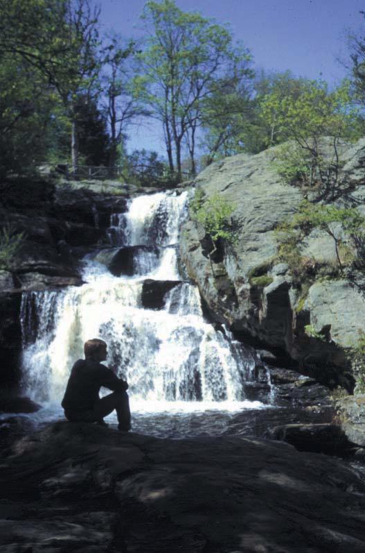
7 stands out. The rich assemblage of wildlife can be mainly attributed to the fact that, despite over 350 years of settlement, the watershed is still over 80% forested. Impressive bedrock ledges, waterfalls, vernal pools, floodplains, bogs, and large tracts of unfragmented hardwood forest, tied together by the Eightmile main stem and its tributaries, make for an incredibly diverse landscape which then gives rise to a diversity of life. These natural areas, combined with farms, villages, and winding roads, create the unique mosaic that makes the Eightmile watershed a special place.


8 It s beautiful, historic, ecologically important and quintessentially New England. But for how long? Like much of Connecticut, the Eightmile is threatened by the type of unplanned growth that can quickly degrade or destroy the cultural and natural resources of an area. Streams, lakes and wetlands degraded by polluted runoff; forest lands and fragile stream corridors fragmented by cookie-cutter subdivisions; historic and archaeological sites lost to inadequate construction precautions in sum, the homogenization of the rural New England landscape into Everytown, USA. The inevitable price of progress and economic prosperity? Absolutely not!


9 There are alternatives, but they require good land use planning by local governments and thoughtful stewardship by local land owners. The Eightmile River Watershed Committee, a group of local officials and citizens, is working to make these alternatives a reality. The Committee s goal: balance conservation and growth in the watershed in ways that ensure the long term social, economic, and environmental health of its communities. Their tools: information and education. Information about the condition, location and significance of cultural and natural resources, to help land use decision makers and land owners know what they have. Education, to help them know what their options are, and how they can make a difference.
,The Nature Conservancy and other organizations to compile an")

10 Through the Eightmile River Watershed Project, the Watershed Committee is working with natural resource experts from the University of Connecticut Cooperative Extension System (CES),The Nature Conservancy and other organizations to compile an impressive body of information on a computerized mapping system, known as a geographic information system, or GIS. Maps depicting the natural and cultural resources of the watershed are produced for the review, input and use of all interested members of the community.

11 Cooperative Extension educational programs then translate this information into knowledge that can be used by local officials and property owners. Forest stewardship programs to help forest owners do a better job of caring for their forest while enjoying it and earning income from it. Estate planning programs to help property owners preserve their land for future generations. Water quality programs to help land use boards do a better job of protecting the lifelines of the watershed. Environmentally-friendly gardening and landscaping programs to help streamside property owners beautify their land while protecting water quality and wildlife. Municipal planning programs to help local commissions articulate their vision for the future of their communities, and give them tools to preserve the rural landscapes, historic sites, and natural resources that make the area unique.

12 On December 23, 1997 the First Selectmen of Lyme, Project through the signing of the Eightmile River Wat a non-binding cooperative agreement that underscores the towns commitment to work to There are many ways to contribute, from attending educational programs to signing a compact of your own that affirms your commitment to manage your property in ways to protect the watershed.

13 , East Haddam and Salem signaled their support of the Eightmile Watershed ershed Conservation Compact, gether to protect their natural and cultural heritage. You can join this effort, too.
14 It all boils down to quality of life, University of Connecticut COOPERATIVE EXTENSION SYSTEM College of Agriculture and Natural Resources and the need for local residents to take a more active role in determining the future of their communities. Because when you drive to the store, go out for a walk, or look out your window, you ought to know just where you are -- not in Everytown, USA, but in the Eightmile River Watershed, the heart of a Last Great Place. The Eightmile River Watershed Project is a collaboration of the towns of Lyme, East Haddam and Salem with the University of Connecticut Cooperative Extension System, The Nature Conservancy, Connecticut Chapter, the U.S. Fish and Wildlife Service, and the Environmental Protection Agency, Region One. Funding provided by the Silvio O. Conte Refuge of the U.S. Fish and Wildlife Service, and the Water Quality Initiative of the USDA Cooperative State Research, Education and Extension Service (CSREES).
15
 345-4511 FAX: (860) 345-3357 INTERNET: lkane@canr1.cag.uconn.edu WORLD WIDE WEB: http://www.")

.")
16 For more on the Eightmile River Watershed Project, including community contacts, get in touch with us at the University of Connecticut Cooperative Extension System at: TEL: (860) FAX: (860) INTERNET: WORLD WIDE WEB: WRITTEN BY: Chester L. Arnold, July 1998 GRAPHIC DESIGN BY: Sue Schadt PHOTOGRAPHY BY: Joel Stocker, Chet Arnold and Heather Nelson The Nonpoint Education for Municipal Officials (NEMO) Project educates local officials about the links between land use and natural resource protection. NEMO is a Water Quality Initiative project of the USDA Cooperative State Research, Education and Extension Service (CRSEES). The Eightmile River Watershed is part of the overall natural resource-based planning approach that NEMO promotes.
Improve Neighborhood Design and Reduce Non Point Source Water Pollution
 HOW TO Planning Guide Improve Neighborhood Design and Reduce Non Point Source Water Pollution This document was funded by a grant from the New Hampshire Coastal Program with funding from the National Oceanic
STEWARDSHIP OF LONG ISLAND SOUND S ECOLOGICAL AND RECREATIONAL RESOURCES
 STEWARDSHIP OF LONG ISLAND SOUND S ECOLOGICAL AND RECREATIONAL RESOURCES Robin Kriesberg, Save the Sound, Inc. Thomas Halavik, US Fish and Wildlife Service Coastal Program An Initiative to Identify, Protect
Framework for Sustainable Recreation
 Framework for Sustainable Recreation USDA Framework for Sustainable Recreation Laurie Thorpe, USFS Rachel Franchina, USFS Robert Burns, WVU Service USDAForest Forest Service Presentation Outline USFS Framework
Town of Peru Comprehensive Plan Executive Summary
 Town of Peru Comprehensive Plan Executive Communities that plan grow by choice, not by chance. A plan makes growth thoughtful, understandable, and predictable. A plan shows that a community is managing
Planning for and Managing Open Space and Natural Areas
 Planning for and Managing Open Space and Natural Areas Increasingly, development proposals in Delaware include large amounts of open space and natural areas. While open space is important as a community
INTRODUCTION PLANNING HISTORY
 INTRODUCTION The Upper Rock Creek Master Plan Area lies in the east central part of Montgomery County. The Master Plan Area is adjacent to the City of Rockville to the south, the Olney Planning Area to
Westport Master Plan. Town of Westport. Master Plan Master Plan Update Committee. Westport, Massachusetts
 Town of Westport Master Plan 2004 Master Plan Update Committee Westport, Massachusetts Open Space and Recreation 5-1 Table of Contents Table of Contents... i List of Tables... ix List of Figures... ix
Tackling Difficult SEQR Topics
 Presented by Nan Stolzenburg AICP CEP and Don Meltz AICP Tackling Difficult SEQR Topics COMMUNITY CHARACTER, HISTORIC/ARCHAEOLOGICAL RESOURCES & HABITATS/ENDANGERED SPECIES Training Agenda Introductions
UPPER BRODHEAD CREEK PARADISE CREEK GREENWAY PLAN
 UPPER BRODHEAD CREEK PARADISE CREEK GREENWAY PLAN The Upper Brodhead & Paradise Creeks Greenway Cooperating Municipalities Mount Pocono Borough Paradise Township Barrett Township Price Township Funding
Green Infrastructure. NYS Department of Environmental Conservation
 Green Infrastructure Green infrastructure is an interconnected network of natural areas and open spaces that sustains ecosystems. Benedict, M.A. and E.T. McMahon. 2006. Green Infrastructure Linking Landscapes
Green Infrastructure Policies and Ordinances
 Green Infrastructure Policies and Ordinances October 23, 2013 By Karen Firehock, Green Infrastructure Center 2013 Georgia Urban Forest Council s 23 rd Annual Conference The mission of the nonprofit Green
Regional Context Statement
 Regional Context Statement REGIONAL CONTEXT STATEMENT 3. REGIONAL CONTEXT STATEMENT In 1995, the Provincial Government passed into law the Growth Strategies Act. The purpose of this provincial initiative
Planning for Staten. Habitat Restoration and Green Infrastructure. Island s North Shore
 Habitat Restoration and Green Infrastructure Planning for Staten Island s North Shore Walker Park December 7, 2017 NYC Parks Forestry, Horticulture, and Natural Resources Funded by the NYS Department of
INTRODUCTION Key Issues and Findings Goals, Objectives, and Policies - Natural Resources - Map M18 - Environmental Resources
 Natural, Environmental, Cu INTRODUCTION This Element provides policies related to the preservation and protection of the Centre Region s natural, environmental, cultural, and historic resources. This Element
National Association of Conservation Districts. Kris Hoellen Vice President, Sustainable Programs The Conservation Fund September 19, 2013
 National Association of Conservation Districts Kris Hoellen Vice President, Sustainable Programs The Conservation Fund September 19, 2013 Our Mission The Conservation Fund forges partnerships to conserve
The Niantic River Watershed. Implementation
 The Niantic River Watershed Successful Partnerships for Watershed-Based Plan Implementation Judy Rondeau Eastern Connecticut Conservation District August 16, 2018 Watershed Partners Watershed towns East
TOWN OF SPRINGFIELD, NEW HAMPSHIRE
 TOWN OF SPRINGFIELD, NEW HAMPSHIRE NATURAL RESOURCES INVENTORY EXECUTIVE SUMMARY March 2008 Prepared by: Watershed to Wildlife, Inc. Natural Resource Consultants 42 Mill Street, Suite 3 Littleton, NH 03561
Brockton. Produced in This report and associated map provide information about important sites for biodiversity conservation in your area.
 CONSERVING THE BIODIVERSITY OF MASSACHUSETTS IN A CHANGING WORLD Brockton Produced in 2012 This report and associated map provide information about important sites for biodiversity conservation in your
OPEN SPACE CHAPTER 7: OVERVIEW. Preserve open space to protect natural resources, enhance character and provide passive recreation opportunities
 CHAPTER 7: OPEN SPACE OVERVIEW Ridgefield has made tremendous progress permanently preserving areas of town as open space. Open space preservation can serve many important purposes, including: protect
SALISBURY TOMORROW Our Vision
 SALISBURY TOMORROW Our Vision Salisbury is committed to supporting a high quality of life and sense of community for all residents. These commitments need to be reflected in our community programs, services
Exceptional ecological landscapes support wildlife across New Hampshire
 Natural Com Exceptional ecological landscapes support wildlife across New Hampshire T he natural landscape of New Hampshire offers a fascinating study of great contrasts and rich biological wonders. To
7.0 SOCIAL, ECONOMIC, AND ENVIRONMENTAL ISSUES
 7.0 SOCIAL, ECONOMIC, AND ENVIRONMENTAL ISSUES The following list of social, economic, and environmental issues have been identified based on a preliminary inventory of resources in the project area, an
On the Map. Conservation Planning for the Kansas City Region. Mid-America Regional Council. Mid-America February Regional 2005Council
 On the Map Conservation Planning for the Kansas City Region Mid-America Regional Council Mid-America February Regional 2005Council Introduction In 2003, the Mid-America Regional Council (MARC) began developing
CHAPTER 4 FUTURE LAND USE AND URBAN SERVICES DISTRICTS
 CHAPTER 4 FUTURE LAND USE AND URBAN SERVICES DISTRICTS Introduction This chapter discusses how Benzie County should grow and change in the future. A community can grow and change in many different ways.
Canyon Lake Master Plan Revision Public Information Meeting March 18, 2016
 Canyon Lake Master Plan Revision Public Information Meeting March 18, 2016 Marcus Schimank Canyon Lake Manager Capital Regional Office U.S. Army Corps of Engineers Fort Worth District US Army Corps of
Lake and Stream Restoration Project
 Pre-project Fact Sheet May 2012 Toledo Botanical Garden (TBG) is a 60 acre public garden visited by more than 120,000 people annually. It is located in Toledo, Ohio in the Ottawa River watershed within
APWA Expo August 27, Ground Water Recharge With Storm Management: A Sustainable Development
 APWA Expo August 27, 2013 Ground Water Recharge With Storm Management: A Sustainable Development Presented by: Joel S. Koenig, P.E. Andrew J. Hawkins Chris P. Dagiantis, P.E., CFM Bios Joel S. Koenig,
CHAPTER 1 Background Information
 CHAPTER 1 Background Information Introduction Antietam Lake Park is located in Berks County, just east of the City of Reading. The 643 acre county park was assembled through several acquisitions in 2005,
Changing Land Use Decision Making One Town at a Time
 Changing Land Use Decision Making One Town at a Time The NEMO Project At the Ten Year Mark Laurie A. Giannotti and Chester L. Arnold University of Connecticut Cooperative Extension System Originally published
3-2 Environmental Systems
 3-2 Environmental Systems 3.0 ENVIRONMENTAL SYSTEMS CONTENTS 3.1 GREENWAY SYSTEM 3.1.1 General Policies 3.1.2 Natural Heritage Network 3.1.3 Natural Heritage Network Enhancement Lands 3.1.4 Rouge Watershed
Green. Clean Water. Trees, Roots, and their Role in Stormwater Management. By John Bilotta
 Green Infrastructure for Clean Water Trees, Roots, and their Role in Stormwater Management By John Bilotta Green Infrastructure for Clean Water: Trees, Roots, and their Role in Stormwater Management September
Sorted citizen input comments in review of Blount County plans July, August, and September 2007
 Sorted citizen input comments in review of Blount County plans July, August, and September 2007 The following presents sorted citizen input comments from three sessions held in July, August and September
This page intentionally blank.
 This page intentionally blank. Parks, Recreation, and Open Space Chapter Relationship to Vision Vision Parks, Recreation and Open Space Chapter Concepts County Government. County government that is accountable
ELIGIBILITY CRITERIA CHECKLIST OPEN SPACE CLASSIFICATION
 THURSTON COUNTY DEVELOPMENT SERVICES OPEN SPACE TAX PROGRAM ELIGIBILITY CRITERIA CHECKLIST OPEN SPACE CLASSIFICATION Use this checklist to help you determine whether your property is eligible for open
Portage County Parks, Trails and Greenways Plan
 Portage County Parks, Trails and Greenways Plan Agenda for Local Planning Meeting Introductory Presentation Why we need a Plan Plan project goals and process Benefits Overview of local planning region
Green Infrastructure. by Karen Engel, NYS DEC. NYS Department of Environmental Conservation
 Green Infrastructure by Karen Engel, NYS DEC What is Green Infrastructure? For some it s all about water Green Infrastructure techniques use soils and vegetation to infiltrate, evapotranspirate, and/or
Community Conservation Workshop. Saranac River Basin Communities
 Community Conservation Workshop Saranac River Basin Communities 2 Community Conservation Program Welcome! We have designed a Community Conservation Program that listens to the needs of community members.
Sustainability Planning in your Community
 Sustainability Planning in your Community South Central and Western Regions CFDC Conference October 4 th, 2010 Liz Nield, CEO Lura Consulting About Our Team 33 Experience 44 55 "Meeting the needs of
GREEN NETWORK APPLICATIONS IN ESTONIA
 GREEN NETWORK APPLICATIONS IN ESTONIA Kalev Sepp, Tuuli Veersalu, Martk Külvik Estonian University of Life Sciences 1 WHY? BACKGROUND - POLITICAL By adopting the Pan-European Biological and Landscape Diversity
A Delta Renewed: A Guide to Science Based Ecological Restoration in the Delta
 A Delta Renewed: A Guide to Science Based Ecological Restoration in the Delta J. Letitia Grenier, San Francisco Estuary Institute, letitia@sfei.org Julie Beagle, San Francisco Estuary Institute, julieb@sfei.org
Gulf Islands National Park Reserve Management Plan Newsletter #3
 Management Plan Newsletter #3 P A R K S C A N A D A November 2011 Parks Canada is using a multi-phase planning process to develop the first management plan for the park. This newsletter provides a short
4. What are the goals of the Kawarthas, Naturally Connected project? 7. What are watersheds and why are they being used as the project boundaries?
 Frequently Asked Questions (FAQs) 1. What are Natural Heritage Systems (NHS)? 2. Why are they important? 3. Which areas of the province have undertaken NHS projects? 4. What are the goals of the Kawarthas,
Master Plan for Preservation and Scenic Conservation (1995)
") 3.2 Master Plan for Preservation and Scenic Conservation (1995) The Master Plan for Preservation and Scenic Conservation was developed under the direction of the Guilford Preservation Alliance in the 1980s
3.2 Master Plan for Preservation and Scenic Conservation (1995) The Master Plan for Preservation and Scenic Conservation was developed under the direction of the Guilford Preservation Alliance in the 1980s
Preface. Erie. Scranton. Allentown. Pittsburgh. Harrisburg. Philadelphia
 The Southern Alleghenies Region The Southern Alleghenies Region spans the Laurel Highlands and Allegheny Front in the west across the Appalachians to the east. It is comprised of Blair, Bedford, Cambria,
Public Information Meeting
 Lavon Lake Master Plan Revision Public Information Meeting March 10, 2015 Presented By Michael Kinard Lake Manager U.S. Army Corps of Engineers Fort Worth District US Army Corps of Engineers Purpose of
Community Conservation Workshop. Lake Placid
 Community Conservation Workshop Lake Placid 2 Community Conservation Program Welcome! We have designed a Community Conservation Program that listens to the needs of community members. We are conducting
Florida Forever Conservation Needs Assessment Overview Maps
 Florida Forever Conservation Needs Assessment Overview Maps Prepared by Florida Natural Areas Inventory, The maps in this document are derived from the Florida Forever Conservation Needs Assessment, an
1 Introduction. Chapter. In this chapter:
 Chapter 1 Introduction In this chapter: 1.1 A Snapshot of the Region 1.2 Towards a Sustainable Region 1.3 The Provincial Context 1.4 Purpose and Organization The Regional Municipality of York Official
Linking Ecological Restoration and Economic Recovery at a Great Lakes Area of Concern: Muskegon Lake, MI. Heather Braun Great Lakes Commission
 Linking Ecological Restoration and Economic Recovery at a Great Lakes Area of Concern: Muskegon Lake, MI Heather Braun Great Lakes Commission Why Here? Restoration in urban centers: Muskegon Lake AOC Why
Goleta Community Plan Update
 Goleta Community Plan Update Ecology, Biology, and Habitats GVPAC Meeting Agenda [Wednesday, December 17, 2008, 6:00PM] Pledge of Allegiance and Roll Call Public Comment Period Administrative December
APPENDIX I Presentations
 APPENDIX I Presentations Workshop Summary Report 11 Peel Region Official Plan Review May 5, 2010 Compatible Active Recreation Workshop July 29, 2010 Components of PROPR Sustainability Planning Tools/Updates
Greenways as an alternative to traditional infrastructure. Green Infrastructure
 Greenways as an alternative to traditional infrastructure Green Infrastructure What is a Greenway? Little (1990) - A linear open space along a natural or human made corridor. Fabos - linked corridors nature
Lewisville Lake Master Plan Revision Public Information Meeting May 2 & 4, 2017
 Lewisville Lake Master Plan Revision Public Information Meeting May 2 & 4, 2017 Presented By Rob Jordan Lake Manager U.S. Army Corps of Engineers Fort Worth District US Army Corps of Engineers Purpose
Samuel E. Paul War Memorial Recreation Area Natural Resource Inventory
 Samuel E. Paul War Memorial Recreation Area Natural Resource Inventory Created By: Timothy Rosadini Keene State College Environmental Studies Acknowledgments I would like to acknowledge the following people
When I came to Colonial National Historical Park in late 1988 as
 Charles D. Rafkind One P&ik m&the ChefMredze Bay: 'the CdmtmlExfeiienee When I came to Colonial National Historical Park in late 1988 as its first full-time natural resource management specialist, I knew
Green Infrastructure Planning for Sustainability and Resiliency
 Green Infrastructure Planning for Sustainability and Resiliency Linking Lands and Communities in the Land-of-Sky Region SAMAB Conference - November 18, 2010 www.linkinglands.org Linda Giltz, AICP, Regional
Development of a Resource Planning Index for Washington's Scenic and Recreational Highways
 Development of a Resource Planning Index for Washington's Scenic and Recreational Highways WA-RD 740.1 Kevin Ramsey February 2010 WSDOT Research Report Office of Research & Library Services Final Technical
Climate Smart Communities Green Infrastructure Case Studies
 New York State Water Resources Institute Climate Smart Communities Green Infrastructure Case Studies Emily Vail Hudson River Estuary Program NYS Department of Environmental Conservation Cornell University
Open Space and Farmland Preservation
 Vibrant. Green. Connected. Competitive. Open Space and Farmland Preservation Statement of Purpose The purpose of this section of the Plan is to encourage and support the preservation of open space areas
OFFICIAL PLAN FOR THE TOWN OF NEW TECUMSETH
 OFFICIAL PLAN FOR THE TOWN OF NEW TECUMSETH Approved by Simcoe County- March 10, 2010 TABLE OF CONTENTS PAGE# 1.0 TITLE AND COMPONENTS... 5 2.0 INTRODUCTION... 6 2.1 Purpose... 6 2.2 Organization of the
How To Get the Development You Planned
 How To Planning Series Prepared by Strafford Regional Planning Commission. Funded by the NH Office of State Planning How To Get the Development You Planned The purpose of the master plan is... to guide
BE WATER WISE. Managing Your Onlot Stormwater. Sept. 23, 2006 Watershed Weekend
 BE WATER WISE Managing Your Onlot Stormwater Sept. 23, 2006 Watershed Weekend 2006 1 All water resources are interrelated through the Hydrologic Cycle Sept. 23, 2006 Watershed Weekend 2006 2 What is Storm
It Takes A Village.. Preserving Rural Character In Standish
 It Takes A Village.. Preserving Rural Character In Standish A Public Workshop Hosted by Conservation and Open Space Plan Committee & Standish Corner Village Implementation Committee June 12, 2008 Desired
3. STATEMENTS OF DESIRED CHARACTER FOR PLANNING AREAS AND PRECINCTS
 3.30 Planning Area No. 30 Mary River Valley 3.30.1 Location and Role This Planning Area encompasses rural lands in the western part of the Shire. These lands are located within the catchment area of the
At the Heart of the Great Lakes
 Walpole Island Heritage Centre May 2010 At the Heart of the Great Lakes Bkejwanong: Where the Waters Divide Bkejwanong s Ecosystems OVERVIEW Walpole Island supports a rich mosaic of natural areas including
Chapter 1 Vision Statement & Goals
 Chapter 1 Section 1.1 Section 1.2 Section 1.3 Section 1.4 Section 1.5 Introduction Vision Statement Visioning Exercise Prioritization of Land Use Issues Goals of the Comprehensive Plan CHAPTER 1 SECTION
CHONGMING ISLAND SHANGHAI CENTRAL CITY
 Chongming Island CHONGMING ISLAND SHANGHAI CENTRAL CITY Chongming Island Shanghai, China THE VISION: A GREEN ISLAND Chongming Island benefits from a magnificent setting, adjacency to the vibrant center
Member Service Plan Sierra Nevada AmeriCorps Partnership
 Member Service Plan Sierra Nevada AmeriCorps Partnership Service plans lay the framework for what each Member will be doing during their service. Service plans detail the major projects and expected results
Central Lake Ontario Conservation Conservation Lands Master Plan
 Conservation Lands Master Plan Top 13 Frequently Asked Questions 1. What are conservation lands? Where are these conservation lands located in the Central Lake Ontario Conservation watershed? Conservation
Middle Mississippi River. Regional Corridor
 Middle Mississippi River St. Louis District Regional Corridor Lessons Learned from a Collaborative Planning Study Brian Johnson US Army Corps of Engineers 12 th Biennial Governor s Conference on the Management
Joe Pool Lake Master Plan Revision Public Information Meeting May 23, 2017
 Joe Pool Lake Master Plan Revision Public Information Meeting May 23, 2017 Presented By Jason Owen Lake Manager U.S. Army Corps of Engineers Fort Worth District US Army Corps of Engineers Purpose of this
Rocky Areas Project Guidance HABITAT
 Rocky Areas Project Guidance HABITAT Introduction Rocky habitats are surface areas dominated by exposed rock, such as mountain peaks, inland cliffs, buttes and rocky outcrops. In many cases, rocky areas
Stream Corridor Management Plan
 Stream Corridor Management Plan A unified and comprehensive approach to protecting, restoring and managing the Upper Delaware River Graydon Dutcher Delaware County Soil and Water Conservation District
Municipal Plan*Assessment
 Municipal Plan*Assessment This tool was developed to assist in reviewing municipal master plans and in determining if these plans are consistent with smart growth principles, neighboring municipal plans,
The Development of Riparian Stream Buffers in Greensboro, NC
 The Development of Riparian Stream Buffers in Greensboro, NC Why our stream banks have grown up? Presented by: Peter Schneider, Water Quality Supervisor City of Greensboro Stormwater Management Division
Conservation Development
 Acknowledgements RIDEM: Scott Millar Anthony Lachowicz-Planning and Zoning Consultant Director of Planning 1 : a creative land use technique that allows a community to guide growth to the most appropriate
Arlington, Virginia is a worldclass
 EXECUTIVE S U M M A RY Arlington maintains a rich variety of stable neighborhoods, quality schools and enlightened land use policies, and received the Environmental Protection Agency s highest award for
Pinellas County Greenways
 Pinellas County Greenways USING GREENWAYS TO LINK OPEN SPACES The Florida Greenways Commission has defined a greenway as...a corridor of protected open space that is managed for conservation and/or recreation.
Planning for Staten. Habitat Restoration and Green Infrastructure. Island s North Shore
 Habitat Restoration and Green Infrastructure Planning for Staten Island s North Shore Community Board 1 March 1, 2018 NYC Parks Forestry, Horticulture, and Natural Resources Funded by the NYS Department
Office of Planning & Quality Growth. Helping communities address issues of growth, development, and quality of life
 Office of Planning & Quality Growth Helping communities address issues of growth, development, and quality of life Planning & Quality Growth DCA s planning and quality growth assistance is aimed at helping
Great Rivers Greenway CLEAN GREEN CONNEC TED T RAILS
 Great Rivers CLEAN GREEN CONNEC TED T RAILS Great Rivers (GRG) was established in 2000 to create a clean, green, connected St. Louis region. Today, many new and exciting projects demonstrate the social,
The Nature Conservancy relies on volunteers to manage invasive shrubs at the Snake Mountain South Natural Area in Bridport.
 The Nature Conservancy relies on volunteers to manage invasive shrubs at the Snake Mountain South Natural Area in Bridport. A new tool for volunteer citizen scientists and land managers imapinvasives is
COMMUNITY ENVIRONMENTAL MANAGEMENT
 COMMUNITY ENVIRONMENTAL MANAGEMENT CEM HANDBOOK FOR COMMUNITY CONSERVATION PLANNING ----- Draft ----- Prepared by the CENTER FOR COMMUNITY ENVIRONMENTAL MANAGEMENT in association with the NEW YORK STATE
Managing Stormwater in Urban Areas
 Managing Stormwater in Urban Areas Using Restorative Redevelopment to Enhance the Community and the Environment Managing Stormwater in Urban Areas, aka "Urban NEMO", is a new educational presentation that
FUTURE LAND USE PLAN 7
 FUTURE LAND USE PLAN 7 The recommendations of each of the preceding chapters can be combined to present an overall Future Land Use Plan for Wilton. The Future Land Use Plan, presented on the following
Germantown Forward Status Report to the Planning Board M NCPPC
 Germantown Forward Status Report to the Planning Board Germantown Forward March 27, 2008 What s new? CCT alignment Capital Improvement Program Agency partners Water quality conditions Sustainability Design
Upper Dean Landscape Character Area: A1 Landscape Character Type: River Valley
 Upper Dean Landscape Character Area: A1 Landscape Character Type: River Valley Key characteristics A well wooded river valley landscape Strong human influence with urban development and sections of engineered
GIS to Estimate Archaeological Site Loss and Develop Conservation Strategies
 GIS to Estimate Archaeological Site Loss and Develop Conservation Strategies Terry Jackson Office of Decision Support Systems Planning and Environmental Management Division Georgia Department of Community
SEWRPC. Joint Meeting of the Advisory Committees on Regional Land Use Planning and Regional Transportation Planning APRIL 26, 2018
 SEWRPC Joint Meeting of the Advisory Committees on Regional Land Use Planning and Regional Transportation Planning APRIL 26, 2018 WISCONSIN DEPARTMENT OF TRANSPORTATION BRETT WALLACE, FOXCONN PROJECT DIRECTOR
Master Plan Objectives and Policies
 Master Plan Objectives and Policies Introduction This chapter identifies the Park issues and recommended policies established by this Master Plan. The issues were identified through meetings with staff,
DRAFT Open Space Technical Bulletin
 DRAFT Open Space Technical Bulletin This guidance is intended to clarify how the Open Space Goal and Objectives of the Regional Policy Plan (RPP) are to be applied and interpreted in Cape Cod Commission
Sustainable Natural Environment Wetlands
 Town of Huntsville Official Plan Review - POLICY BACKGROUND PAPER Sustainable Natural Environment Wetlands BACKGROUND: Wetlands are an important natural resource. The ecological, social and economic benefits
Cooperative Extension s Role in Land Use Planning and Conservation. Sabrina Drill UCCE- Los Angeles/Ventura Integrated Hardwood Range Mgmt.
 Cooperative Extension s Role in Land Use Planning and Conservation Sabrina Drill UCCE- Los Angeles/Ventura Integrated Hardwood Range Mgmt. Program Cooperative Extension Land Grant Universities: 1862 Agricultural
Chapter 10 IMPLEMENTATION RECOMMENDATIONS
 Chapter 10 IMPLEMENTATION RECOMMENDATIONS The recommended land use plan presented in the previous chapter provides a design for the attainment of the urban and rural development and open space preservation
2 Vision. Master Plan
 19 2 Vision Master Plan 20 Chapter 2 MASTER PLAN VISION 2.1 Master Plan Organization Lake Calhoun/Bde Maka Ska and Lake Harriet are places where complex human and natural systems intersect and converge.
Conservation Corridor Planning and Green Infrastructure Themes
 Conservation Corridor Planning and Green Infrastructure Themes Prepared by the Green Infrastructure Center Inc. and the Northern Virginia Regional Commission February 22, 2011 Brief Overview Project Background
Gather information from online resources covering the following topics:
 Assignment #1: Regional Analysis Project Site Location: Greater Boston Area What comprises a region? The many elements within a region comprise the region as a whole. Natural as well as manmade environmental
LAMPREY RIVER SUBWATERSHED
 LAMPREY RIVER SUBWATERSHED PISCATAQUA REGION ENVIRONMENTAL PLANNING ASSESSMENT 05 Lamprey River Subwatershed, including: Candia, Deerfield, Epping, Newmarket, Northwood, Nottingham, Raymond www.prepestuaries.org
Milwaukee River Watershed Fish Passage Program. Making Connections Across Our Watershed
 Milwaukee River Watershed Fish Passage Program Making Connections Across Our Watershed 2 71 st Annual Upper Midwest Fish & Wildlife Conference Wednesday, December 15, 2010 Milwaukee River Watershed Fish
Presentation to Planning Committee, DMM
 District Municipality of Muskoka Muskoka Official Plan Review Background Study: Natural Heritage Review of Urban Centres and Species At Risk Dale Leadbeater 1 September 2011 Presentation to Planning Committee,