C AMPUS MASTER PLAN THE C AMPUS PLAN
|
|
|
- Jack Austin
- 5 years ago
- Views:
Transcription
1

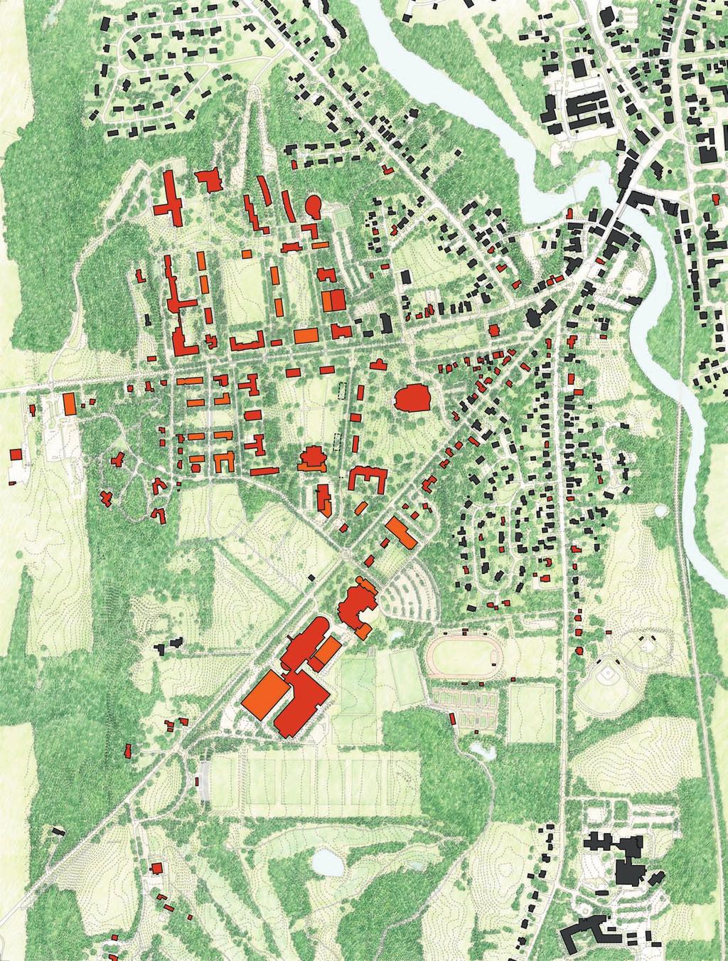
2 THE CAMPUS PLAN. the campus plan The Middlebury Campus Master Plan is intended as a framework within which carefully balanced, incremental decisions may be judiciously made within a long-term vision. It is not prescriptive in most of its details especially building use but it is highly prescriptive in its larger ideas. It is intended as a broad framework that will guide development of the campus over the next fifty years. It addresses issues of college planning policies, openspace structure, land use, density of development, primary circulation systems, infrastructure, and relationship to the surrounding community. The goal is to provide a stable but precise framework that enables near-term decisions regarding physical development to contribute to a sustained long-range vision of the campus a vision that conserves campus resources and produces an efficient and coherent campus environment throughout the twenty-first century while maintaining and enhancing the beauty of the campus. Environmental considerations are the foundations of the Plan, and will become more important as resources diminish. CONCEPT AND PRINCIPLES The Plan proposes careful, limited, internal building development, rather than continued outward expansion of the campus, and recommends significant restructuring of the landscape. Indeed, the landscape plan is the most important element of the Plan. It emphasizes, clarifies, and augments the existing pattern of open spaces, and rejuvenates the campus ecology. The campus comprises three major parts: the South Campus (Athletics and Art); the Central Campus; and the North Campus. These areas are disconnected, separated by two state highways, which exacerbates the psychological distance between them. The Plan seeks to enhance each of these campuses and bind them together through a safer, more continuous network of spaces. THE LONG-RANGE PLAN The essential concept of a long-range plan is that spaces are more important than buildings. As long as buildings help define the spaces, then building use, character, and form may vary as changing circumstances require. Thus, the most important part of a long-range plan is the Civic Structure the pattern of quadrangles, courts, streets, and walks around which the buildings are organized. As such, the civic structure is inversely analogous to the skeleton and major organs of the human body. Another important, related concept is that larger campuses may comprise distinct precincts, or neighborhoods. These precincts, like the larger campus, may have one or more of three characteristics: a clear center (quadrangle, walk, etc.), consistent fabric (similar stone buildings), and a clear edge. Of these three, the least important, and least prevalent, is a clear edge. MAJOR COMPONENTS The major components of the Plan are described by district from the North Campus, to the Central Campus, to the South Campus beginning with the central space of each area. The major components are:. Bicentennial Park. Battell Field. Le Chateau Quad. College Street. Main Quad. Old Chapel Walk 7. Library Park 8. Hillcrest Residential 9. Centeno Plaza/Campus Entry 0. South Main Street. Arts Quad. Athletic Complex and Fields FIGURE Proposed Campus Plan FIGURE Existing Campus Plan If the three major parts of the Middlebury campus may be considered as precincts, or neighborhoods, the idea of the Long-Range Plan is to provide each neighborhood with at least one major quadrangle, related courtyards, and a consistent fabric of landscape and buildings. Streets and walks help form both centers and edges, and bind the neighborhoods together into a continuous network. The three Middlebury districts, in turn, comprise components, which are described in detail below.


3 FIGURE Existing plan of the Battell Field area FIGURE Proposed plan of the Battell Field area

4 THE CAMPUS PLAN 7 Bicentennial Park and Battell Field The area to the north of Forest Hall is vast, ill-defined, and poorly drained. The plan proposes articulating this area into more perceivable and defined components. The area between McCardell Bicentennial Hall and Coffrin Hall is proposed as a more picturesque park similar to the recently renovated Library Park. In contrast to the more structured quadrangles and courts, Bicentennial Park would be characterized by rolling topography, curving paths, and picturesque groupings of trees. Recommendations. Bicentennial Park. Proposed Battell Field. Renovated Forest Court. Renovated Ross Court. Proposed Ross Court. Proposed building FIGURE Aerial perspective view of Bicentennial Park and Battell Field The area now referred to as Battell Beach should be defined and reinforced by buildings, trees, and tree-lined walks. It should remain a very large space, suitable for soccer, informal activities, and reception tents. The soil should be rejuvenated for drainage, and the sloped lawn area on the west side should be replaced with diverse groundcover and canopy trees, carefully located so as to preserve views. A new north-south path should be added at the east edge of the slope.


5 8 FIGURE Existing plan of the Battell Hall area FIGURE Proposed plan of the Le Chateau Quad area 7 Le Chateau Quad When Le Chateau was built it stood alone in the open landscape like a French chateau. Over the years its siting has been compromised by other, poorly sited buildings. The resulting space to the south is not a quadrangle, but an illegible no-man s land. Pedestrian paths are random and chaotic. Battell Hall is the biggest problem because of its siting. In the long run, Battell Hall should be replaced to facilitate a real quadrangle with orthogonal and diagonal paths, and tree-lined walks. The topography and the roadways also mar the current area. The current service road to Le Chateau should be replaced by a treelined, pedestrian-oriented walk, similar to the proposed Old Chapel Walk. The diagonal path that connects to McCardell Bicentennial Hall should accommodate bicycles and service vehicles. Recommendations. Proposed Le Chateau Quadrangle. Tree-lined walk to replace service road. Proposed Atwater Court. New buildings to replace Battell Hall. New building. Addition to Johnson 7. New building (possible future Campus Center)


6 THE CAMPUS PLAN 9 FIGURE Perspective view of the proposed Le Chateau Quad FIGURE View of the Battell Hall area from the same viewpoint as the above perspective FIGURE Aerial perspective view of the proposed Le Chateau Quad area


7 0 FIGURE Existing plan of College Street FIGURE Proposed plan of College Street College Street College Street is a key element in the integration of the campus. The presence of parallel parking on College Street has the positive effect of calming traffic on what is technically a state highway. There are too many hidden pedestrian crossings, however; the street is too wide; and there is no sidewalk on the south side. The street functions as a divisive element between the Central Campus and the North Campus, rather than as a zipper that unites. Recommendations. Reconfigured College Street. Underground power lines. Reduced number of pedestrian crossings. New roundabouts The proposed plan narrows the curb-to-curb dimension of College Street to two twelve-foot lanes by removing bike lanes to a new pedestrian promenade on the north side, and by limiting parking to the east and west ends of the street as it passes through the campus. Street trees are proposed, as are sidewalks on both the north and south sides of the street. Pedestrian crossings are rationalized and reduced in number from eight to five. Pedestrian paths leading to crosswalks are moved and strengthened to guide pedestrians to the crosswalks. Proposed roundabouts near the Materials Recycling Facility, and at Storrs Park, will help calm traffic and signal a change to a more urban character. The plan also recommends putting the power lines underground along the south side of the street.


8 THE CAMPUS PLAN FIGURE Cross-section of proposed College Street FIGURE View of College Street from same viewpoint as perspective below FIGURE Perspective view of proposed College Street


9 FIGURE Existing plan of the Main Quad FIGURE Proposed plan of the Main Quad Main Quad The Main Quad is the core of the Middlebury College campus. It is one of America s most uniquely beautiful spaces, but it needs serious landscape rejuvenation. The tree pattern in particular obscures the perception of the space. Thinning the existing trees by selective removal, and clearing vistas by limbing-up trees, will greatly enhance the space and make it more functional for ceremonial events, such as Commencement. Shrubs on the hillside below Mead Chapel should also be removed. Recommendations. Selectively remove trees, and plant others. Thin the trees on the upper slope and limb them up. Replace low shrubs on upper slope with ground cover. Rejuvenate the soil to improve growth and drainage. Re-grade the lower parts for better drainage. Replace Old Chapel Road with a tree-lined walk Drainage is poor, and the soil should be rejuvenated. The replacement of Old Chapel Road with a pedestrianoriented promenade Old Chapel Walk will also significantly improve the quality of the space by increasing its definition.


10 THE CAMPUS PLAN FIGURE Aerial perspective view of the proposed Main Quad FIGURE Perspective view of the proposed Main Quad


11 FIGURE Existing plan of Old Chapel Road FIGURE Proposed plan of Old Chapel Walk FIGURE Cross-section of proposed Old Chapel Walk


12 THE C A MPUS PL AN Old Chapel Walk Recommendations FIGURE Currently, Old Chapel Road is an unfriendly vehicular. Proposed pedestrian-oriented walk street with no continuous sidewalks on either side.. Proposed Old Chapel Plaza Perspective view of proposed Old Chapel Walk Recommendation #78 in the Strategic Plan is to Convert. Parking Old Chapel Road into a pedestrian-friendly campus artery.. Axinn Center Plaza. Possible future buildings A tree-lined promenade with special parking would greatly enhance this area of the campus, by making it more pedestrian-friendly. Pocket parking areas are located at the ends of Old Chapel Walk. FIGURE View of Old Chapel Road


13 FIGURE Existing plan of Hillcrest residential area FIGURE Proposed plan of Hillcrest residential area Hillcrest Residential The two-block area bounded by College Street, Hepburn Road, Stewart Hill Road, and Adirondack View Road is a long-term reservoir for completion of residential life at Middlebury the Commons System. Because this area slopes down to the west from the crest of the hill at Mead Chapel, it feels like the back side of the hill. Currently, this area is small grain, rather than institutional, and both Hepburn Road and, especially, Hillcrest Road are somewhat tattered and shabby. Thick vegetation begins about halfway between Hillcrest Road and Adirondack View Road, while spectacular views are possible to the west. Three ideas should guide the development of this area:. Buildings should be small, or of small increments, and should align on Hepburn Road and Hillcrest Road, with wings running east-west to define courtyards.. Groups should form Commons courtyards.. Hepburn Road and Hillcrest Road should be redesigned Hepburn as a tree-lined walk, and Hillcrest Road as an intimate residential street. Proctor Hall has few redeeming features, and ultimately, will probably be removed, but at this time it is unclear whether it will be replaced by a dining facility or not. The area currently occupied by Proctor should be designed as a courtyard or small quad behind Mead Chapel. As a public space opening to the western view, this is a major new feature of the campus. Recommendations. Proposed court or quadrangle. Proposed Commons courts. New residential buildings. Redesigned Hepburn Road as pedestrian-oriented walk. Redesigned Hillcrest Road

14 THE CAMPUS PLAN 7 FIGURE Aerial perspective view of the proposed Hillcrest Residential area


15 8 FIGURE Existing plan of Library Park FIGURE Proposed plan of Library Park Library Park Library Park has recently been renovated and is a beautiful front lawn for the campus, but it needs minor improvements. Trees should be added to replace those that are dead or dying, but the vista of Old Stone Row should be preserved. The meadow installation should be completed around the Garden of the Seasons. Recommendations. Library Park with tree replacement. Restored landscaping at Garden of the Seasons


16 THE CAMPUS PLAN 9 FIGURE Aerial perspective view of proposed Library Park FIGURE View of Library Park


17 FIGURE Existing plan of the Centeno/Arts area FIGURE Proposed plan of the Centeno/Arts area Centeno Plaza One of the major vehicular entries to the Middlebury College campus has long been through the parking lot of the Service Building via Old Chapel Road. The Biomass addition to the Service Building and the proposed transformation of Old Chapel Road into a pedestrianoriented walk provide the opportunity to reorganize this area into a vehicular drop-off and a new pedestrian entrance to the campus. The long-range plan proposes relocating the Service Building and its parking near the Materials Recycling Center. The development of a paved plaza related to Centeno House provides short-term parking for health services and a drop-off linked to the proposed Old Chapel Walk. South Main Street Street trees and parallel parking are proposed for South Main Street, as well as a roundabout and new entrance to the Arts campus at the intersection of South Main Street and Stewart Hill Road. All of these elements contribute to a more organized civic face for the College along South Main Street, and a safer, more legible connection to the town and the rest of the Middlebury campus. The plan proposes widening Stewart Hill Road if necessary to accommodate two-way traffic as well as a sidewalk.

18 THE CAMPUS PLAN Arts Quad The existing Mahaney Center for the Arts is an isolated object that is remote from the other arts facilities at Middlebury. It is also inadequate in program area, and faces a dangerous intersection that connects it to the main campus. The proposed plan for the arts recommends removing the museum from the Mahaney CFA and transforming the Mahaney CFA into a Center for the Performing Arts by expanding the theater functions, as well as facilities for music and dance. A new museum, including art history, is proposed to the northeast of Meeker House. A proposed new quadrangle behind Meeker House and Munford House, the Arts Quad, forms the center of the expanded arts area. Recommendations. Centeno Plaza. New connection to Old Chapel Walk. Widen Stewart Hill Road if necessary for two-way traffic. Proposed building adjacent to Centeno House. New roundabout at Stewart Hill Road and South Main Street. South Main Street with street trees and parallel parking 7. New entrance to Mahaney CFA parking 8. New Arts Quadrangle 9. Mahaney Center for the Performing Arts 0. Additions for theater, music, and dance. New Museum and Art History FIGURE Aerial perspective view of the proposed Centeno/Arts area

19 FIGURE Proposed plan of athletics area Athletics Middlebury s athletics campus is extensive and beautiful. Like the academic campus, it enjoys a spectacular relationship to the surrounding landscape. Alumni Stadium, especially, enjoys an unforgettable relationship with its setting. Nevertheless, some areas are a bit ad hoc, and would benefit from reorganization and rejuvenation. Recommendations. New Field House on the site of the Bubble. Expansion of the Fitness Center. Addition of new outdoor tennis courts. Soil reconstruction of practice fields. Renovated, sustainable golf course. New all-weather surface at Youngman Field The practice fields are badly in need of soil reconstruction, an underground drain system, and expansion to the east. The golf course is especially in need of a major renovation.
C A MPUS M ASTER PL AN
 C A MPUS M ASTER PL AN 10 1 BACKGROUND 2. background 11 REGIONAL CONTEXT Middlebury College enjoys a stunning visual relationship with the vast geographic landscape of which it is a part. It is located
NEIGHBORHOOD 7: FEE LANE AREA. Aerial View of Briscoe and McNutt Dormitories
 NEIGHBORHOOD 7: FEE LANE AREA Aerial View of Briscoe and McNutt Dormitories Fee Lane Area Map Briscoe Dormitory 278 neighborhoods NEIGHBORHOOD 7: FEE LANE AREA EXISTING CHARACTER The Fee Lane Area neighborhood
GUIDING PRINCIPLES IN THIS CHAPTER
 GUIDING PRINCIPLES The guiding principles and design concepts in this chapter work together with the Chapel Hill 2020 Comprehensive Plan to support new public places that can be enjoyed by all while also
Preci nct P l ans Figure 56 Campus Aerial Photo, 2008 CAL STATE EAST BAY, HAYWARD CAMPUS MASTER PLAN
 9 Precinct Plans This section contains a detailed discussion of the planning and design concepts for specific areas or precincts of the Cal State East Bay Hayward campus. The Precinct Plans pertain to
Physical Structure. This historic image from 1882 emphasizes the dramatic topography that distinguishes Cornell s setting at the top of East Hill.
 Physical Structure The natural, agrarian and urban setting for Cornell s campus is a precious resource to protect and enhance. It has also shaped the physical structure of the campus. Buildings, roads
U n i v e r s i t y o f S o u t h C a r o l i n a A i k e n. Land Plan Study
 U n i v e r s i t y o f S o u t h a r o l i n a A i k e n Land Plan Study 06.27.2008 Goals ampus Growth Develop a Land Plan that allows for the orderly expansion of the campus over the next ten years and
242 neighborhoods NEIGHBORHOOD 4: JORDAN AVENUE CORRIDOR
 NEIGHBORHOOD 4: JORDAN AVENUE CORRIDOR Aerial View of Jordan Avenue Corridor EXISTING CHARACTER The Jordan Avenue Corridor is the portion of North Jordan Avenue that extends north from East Third Street
There are five comprehensive goals that inform the Urban Design element at FIU. They are:
 3.0 URBAN DESIGN ELEMENT This Comprehensive Master Plan Update reflects the University s commitment to the refinement and extension of the base concepts earlier master planning efforts have created. FIU
10 February CAMPUS MASTER PLAN UPDATE Focus Group - Landscape & Hensel Park
 10 February 2016 CAMPUS MASTER PLAN UPDATE Focus Group - Landscape & Hensel Park AGENDA Introductions Planning Scope The 2004 Campus Plan & Survey Observations 2004 Landscape Plan SWOT Exercise Analysis
theme 4 : Penn connects...
 38TH STREET STREETSCAPE WALNUT STREET STREETSCAPE GENERATIONAL BRIDGE LOCUST WALK RESTORATION SHOEMAKER GREEN 34TH STREET STREETSCAPE LOCUST WALK RESTORATION penn park SPRUCE STREET PLAZA HAMILTON WALK
Subcampus Recommendations
 T he campus is is comprised of three major areas. These subcampus areas are known as WestCampus, South Campus, Campus Oakland and Drive East Campus. and Future East growth Campus. requires a Future careful
appendix and street interface guidelines
 appendix five: building and street interface guidelines appendix 5 building and street interface guidelines BOULEVARDS Boulevards are generally characterized by higher levels of traffic movement at higher
Section4 Design Vision & Implementation Plan
 Section4 Design Vision & Implementation Plan W Woodschurch Rd 4.1 Design Focus Areas The Framework Plan is simply the starting point for directing the design and implementation of a wide range of transportation
5.0 P A R K R E C O M M E N D A T I O N S
 5.0 P A R K R E C O M M E N D A T I O N S 5.1 Confederation Park The analysis of Confederation Park recognizes that it, along with City Hall, is the symbolic heart of Kingston. While the existing layout
PUBLIC RIGHT-OF-WAY IN THIS CHAPTER PUBLIC REALM
 PUBLIC RIGHT-OF-WAY This section provides design guidelines for improvements in the public right-of-way. The public right-of-way refers to streets, sidewalks, non-vehicular thoroughfares, parks and greenways
Civic Center District
 Civic Center District The Civic Center district is the civic and social heart of Warrenville, containing such public buildings as the City Hall, Warrenville Public Library, Police Station, Park District
Illustrative Campus Plan with Proposed Development
 Illustrative Campus Plan with Proposed Development Approved Compiled Plan January 2003 Figure IV-52 89 The supportive relationship and interaction between the campus and the surrounding community is an
VEHICULAR AND PEDESTRIAN CIRCULATION
 This perspective sketch communicates the intended character and quality of a proposed streetscape design. Locate benches near a major intersection where people tend to gather. Seating and lighting provide
Town Center. Block 5 Existing multifamily residential units are expected to remain.
 Area Guidelines Germantown s districts should be developed as distinct communities with unique features that are supported through the guidelines. The guidelines not only help distinguish these districts
DOWNTOWN RESIDENTIAL DISTRICT DEVELOPMENT OPPORTUNITES
 DOWNTOWN RESIDENTIAL DISTRICT DEVELOPMENT OPPORTUNITES Out of all the areas in Downtown Painesville, this district provides the greatest opportunity for change with the vacation of Lake East Hospital.
CHAPTER 3. Design Standards for Business, Commercial, Industrial, Recreational and Institutional Uses
 CHAPTER 3 Design Standards for Business, Commercial, Section Number Title Ordinance Number Date of Ordinance 16-3-1 Applicability 2006-11 2008-04 07-01-08 16-3-2 Uniform Standards for Architectural Design
TRANSPORTATION & STREET DESIGN
 TRANSPORTATION & STREET DESIGN Review of Goals Connect neighborhoods to Square Enable access to the river Improve pedestrian environment Reorient road network to local use Three Specific Areas of Intervention
WASHINGTON COUNTY OREGON
 WASHINGTON COUNTY OREGON July 9, 2009 Revisions to Chapter 2 of the Bethany Community Plan The North Bethany Subarea Plan Exhibit pages 7 and 8 The sections for the Core and Flexible Streets were amended
WESTERN ILLINOIS UNIVERSITY
 WESTERN ILLINOIS UNIVERSITY Quad Cities Riverfront Campus Master Plan March 1, 2006 Preliminary Master Plan Total Site Build Out Western Illinois University Quad Cities Municipal Park Mississippi River
REPORT TO BOARD ON PREFERENCES tbp/architecture CCSF Facilities Master Plan, October 23, 2016
 PURPOSE The purpose of this report is to update the Board on the Facilities Master Plan initiative. PROCESS The Board conducted a Study Session about Phase 1 Needs on August 18, 2016. Since that time,
GREENING THE BOULEVARD Master Plan Concepts for Venice Boulevard between Lincoln and Sawtelle
 GREENING THE BOULEVARD Katherine Spitz Associates Inc. 4212½ Glencoe Avenue Marina Del Rey, CA 90292 310 574 4460 Fax 574 4462 January 2008 Table of Contents Overview Proposed Design Improvements Illustration
18 May 2016 CAMPUS MASTER PLAN UPATE
 18 May 2016 CAMPUS MASTER PLAN UPATE Council of the Deans ( Over view) AGENDA Engagement & What We Heard Focus Elements: 1. Development Framework Plan 2. Campus Mobility 3. Campus Guidelines 4. Wayfinding
SECTION TWO: Urban Design Concepts
 SECTION TWO: Urban Design Concepts The Gardnerville Plan for Prosperity shapes economic opportunities presented by regional growth. The Urban Design Concepts provide policies and concepts for land use,
Figure 3-1: Public Realm Plan
 3 Public Realm Figure 3-1: Public Realm Plan 3.1 Public Realm Concept The public realm concept for the Little Mountain site integrates a clear and accessible movement network with public spaces for social
CAMPUS MASTER PLAN UPDATE
 13 April 2016 CAMPUS MASTER PLAN UPDATE Focus Group Landscape AGENDA What We Heard Review of Campus Observations & Analysis Campus Framework & Open Space Network Table-Top Exercise Landscape Guideline
Clairtrell Area Context Plan
 Clairtrell Area Context Plan March 2005 Urban Development Services City Planning Contents 1. Introduction... 4 2. Development Structure... 6 2.1 Streets... 7 2.1.1 Sheppard Avenue and Bayview Avenue...
Policies and Code Intent Sections Related to Town Center
 Policies and Code Intent Sections Related to Town Center The Town Center Vision is scattered throughout the Comprehensive Plan, development code and the 1994 Town Center Plan. What follows are sections
Access Management: An Overview
 Figures 1-5 Below Evolution of development along a highway. In the early stages, land along the road is used for farming with little traffic generated. As time passes, the highway corridor becomes a de
A Vibrant Downtown. Chapter 5 Cary Public Art Opportunities 31
 A Vibrant Downtown Cary s vision for Downtown is a unique, vibrant, dynamic, pedestrian friendly location; a regional destination and a place to live, work, and recreate, according to the 2001 Town Center
OPEN SPACE TYPES. SIZE 8 acres. SIZE 20 acres. SIZE 1 acre
 TYPICAL CHARACTERISTICS OPEN SPACE TYPES OPEN SPACE TYPES The neighborhood contains an extensive variety of open space types. Most of these spaces incorporate multiple uses and activities, so that each
Table of Contents. Elm Avenue Improvement Plan City of Waco, Texas. Introduction 1. Existing Context 1 Figure 1 2.
 Table of Contents Introduction 1 Existing Context 1 Figure 1 2 Plan Guidelines 3 Future Urban Form 4 The West-End 4 Main Street 6 The East-End 7 Figure 2 9 Public Improvement Recommendations 7 General
T e c h n i c a l M e m o r a n d u m. October Date. Georgia State University Master Plan Update. Project
 T e c h n i c a l M e m o r a n d u m Date Project Subject From To October 2012 Georgia State University Master Plan Update VI. Physical Master Plan & Implementation Sasaki Associates/Robert and Company
Status Update (2006 vs. Now) Citizen s Advisory Committee February Plan for Prosperity
 Citizen s Advisory Committee February Plan for Prosperity") Status Update (2006 vs. Now) Citizen s Advisory Committee February 2018 Plan for Prosperity 2000 2017 2000 2017 Gardnerville Population 6,000 5,760 5746 5,500 5,000 5,067 5,550 5,165 5,394 5,412 5,250
Status Update (2006 vs. Now) Citizen s Advisory Committee February 2018 Plan for Prosperity 2000 2017 2000 2017 Gardnerville Population 6,000 5,760 5746 5,500 5,000 5,067 5,550 5,165 5,394 5,412 5,250
ATTACHMENT A. SILVERDALE DESIGN STANDARDS Amendments to the Waaga Way Town Center Chapter
 ATTACHMENT A SILVERDALE DESIGN STANDARDS Amendments to the Waaga Way Town Center Chapter Chapter 10. Waaga Way Town Center 10.1 Physical Identity Elements & Opportunities The Waaga Way Town Center includes
This is the East Carolina University Comprehensive Facilities Master Plan Final Draft Plan Review. This workbook reviews the campus draft master plan
 This is the East Carolina University Comprehensive Facilities Master Plan Final Draft Plan Review. This workbook reviews the campus draft master plan first presented on campus on June 29 and June 30, 2011.
LOS ANGELES MISSION COLLEGE MASTER PLAN Master Plan DESIGN & DEVELOPMENT PRINCIPLES
 LOS ANGELES MISSION COLLEGE MASTER PLAN DESIGN & DEVELOPMENT PRINCIPLES 34 Quality Learning Along the Arroyo PROGRAM SUMMARY BY PROJECT The following are program summaries for each of the projects planned
CHAPTER 12 DESIGN GUIDELINES FOR PUBLIC IMPROVEMENTS
 CHAPTER 12 DESIGN GUIDELINES FOR PUBLIC IMPROVEMENTS Introduction This chapter provides design guidelines for public sector improvements in the downtown. This includes streetscape design, as well as the
PUBLIC PARKS AND FACILITIES, SERVING NEIGHBORHOOD RECREATIONAL AND COMMUNITY EVENTS BUILDINGS BUILT TO THE LINE AND ORIENTED TOWARD THE STREET
 BUILDINGS BUILT TO THE LINE AND ORIENTED TOWARD THE STREET PUBLIC PARKS AND FACILITIES, SERVING NEIGHBORHOOD RECREATIONAL AND COMMUNITY EVENTS CONNECTED & COMPLETE STREETS AND STREET GRID VIEW SHEDS GROUND
38 Queen s University Campus Master Plan Part 1
 38 Queen s University Campus Master Plan Part 1 46 The Campus at the City Scale Chapter 4 The Campus at the City Scale 39 Queen s is an urban University centrally located in Kingston. Decisions made by
UMBC Facilities Management. UMBC Facilities Master Plan Update
 Management UMBC 2009-2019 February 19, 2010 A is the Vision for buildings, lands, open spaces and infrastructure Framework for the shape and development of the campus built environment driven by the University
Lehigh Acres Land Development Regulations Community Planning Project
 Lehigh Acres Land Development Regulations Planning Effort Summary In July, 2010 Commissioner Frank Mann invited the Lehigh Acres community to start discussing how to achieve their recently adopted community
A. Background Summary of Existing Challenges and Potential Possibilities. 1. Summary of Existing Assets and Potential Opportunities
 A. Background 1 A Main Street Master Plan Study was performed and completed in October of 2007. The study was initiated to review current land uses and development patterns along Main Street, from Parrish
ELMVALE ACRES SHOPPING CENTRE MASTER PLAN
 ELMVALE ACRES SHOPPING CENTRE MASTER PLAN Contents 1.0 INTRODUCTION... 2 2.0 LOCATION... 2 3.0 EXISTING CONTEXT... 2 4.0 VISION & GUIDING PRINCIPLES... 2 5.0 LAND USE AND BUILT FORM... 4 5.1 St. Laurent
EXISTING COMPREHENSIVE PLAN
 EXISTING COMPREHENSIVE PLAN Town Center Land Use Element: V. LAND USE POLICIES Town Center Mercer Island's business district vision as described in "Your Mercer Island Citizen-Designed Downtown" was an
ALTERNATIVE STATION AREA -
 ALTERNATIVE STATION AREA - THE 10 TH STREET GARDEN STATION Two alternative land use scenarios and designs are illustrated here: Scheme A - Transit-Oriented Development High to Mid-Density Residential /Office
for Master Planned Development Framework Design Standards & Guidelines
 B L A C K D I A M O N D DE S I G N G U I D E L I N E S for Master Planned Development Framework Design Standards & Adopted June 18, 2009 Introduction and Purpose The Master Planned Development (MPD) Framework
TOWN CENTER. Origins of a Crossroads Community
 TOWN CENTER Origins of a Crossroads Community Town Commons 1973 - Courtesy of the Burlington Archives, No. 81 Unlike other New England towns with iconic town centers, Burlington evolved as a dispersed
7 4. DESIGN GUIDELINES
 7 4. DESIGN GUIDELINES The following guidelines set forth design principles Each future project should be designed within a contin- intended to provide a framework for the design of future uum, with the
DRAFT. 10% Common Open Space
 % OF CHARLOTTE IS CATEGORIZED AS A. LAND USES : Placeholder map displaying location of Place Type GOALS: Accommodate XX% of future growth. Provide a concentration of primarily commercial and civic activity
The Vision. Photo provided by The Minervini Group. 46 Vision, Objectives & Strategies
 Vision, Objectives & Strategies The is the public framework and guide for future development of the Grand Traverse Commons. The establishes public polices for infrastructure, the preservation of natural
Part C. Main Campus Plan Frameworks PAGE 59 UNIVERSITY OF REGINA / CAMPUS MASTER PLAN 2011
 Part C Main Campus Plan Frameworks UNIVERSITY OF REGINA / CAMPUS MASTER PLAN 2011 PAGE 59 Figure C-1. Open Space Framework Plan PAGE 60 PREPARED BY / DIALOG Figure C-2. The Dr. Lloyd Barber Academic Green
Establish a network of streetscaped vehicle and pedestrian routes that connect within and outside the Plan area.
 This Plan s urban design goals are to create an urban scale, walkable community with connections to transit, parks, and services and with amenities and facilities for residents and employees. The 1992
CHAPTER 5: GUIDING PRINCIPLES
 CHAPTER 5: GUIDING PRINCIPLES The following 10 principles were developed based on public consultation, planning policy and the background analysis conducted during Phase 1. The Guiding Principles significantly
PLANNING RATIONALE FOR THE PROPOSED RIVERSIDE SOUTH ELEMENTARY SCHOOL 715 BRIAN GOOD AVENUE, OTTAWA, ON
 PLANNING RATIONALE FOR THE PROPOSED RIVERSIDE SOUTH ELEMENTARY SCHOOL 715 BRIAN GOOD AVENUE, OTTAWA, ON Conseil des écoles publiques de l'est de l'ontario (CEPEO) French Public School Board TABLE OF CONTENTS
CHAPTER FOUR: Alternatives to the Proposed Action
 CHAPTER FOUR: Alternatives to the Proposed Action CHAPTER FOUR: ALTERNATIVES TO THE PROPOSED ACTION 4.1 Alternatives to the West Campus Plan The following sections discuss alternatives to the proposed
Achieving a Vision. Master Plan 2009 Belknap Campus August 10 11, UofL Belknap Campus Master Plan Update
 Achieving a Vision Master Plan 2009 Belknap Campus August 10 11, 2009 Consultant Team The Campus Studio Ann Arbor Michigan Team Leader Campus Planning Site Design JRA Architects Louisville Kentucky Assistant
NEIGHBORHOOD 3: UNIVERSITY EDGE
 NEIGHBORHOOD 3: UNIVERSITY EDGE Aerial View of North Indiana Avenue EXISTING CHARACTER The University Edge neighborhood represents the primary town/gown interface between the campus and the city of Bloomington,
Broadway District Specific Plan. Community Workshop #2 February 23,2016
 Broadway District Specific Plan Community Workshop #2 February 23,2016 1 Agenda Introductions Project Progress Status Upcoming Milestones Emerging Framework Land Use Urban Design Circulation Infrastructure
COMPLETE GREEN STREET CHECKLIST
 COMPLETE GREEN STREET CHECKLIST This document was developed to dissect the structure of an urban street and explore opportunities to make our streets more complete while also integrating green street strategies.
Chapter 6--Urban Design
 6.1 Introduction... 6-1 6.1.1 Background & Scope... 6-1 6.1.2 Relationship to State Law... 6-2 6.1.3 Relationship to Other General Plan Chapters... 6-2 6.2 Guiding Principles... 6-2 6.3 Urban Design Guidelines...
Guiding Principles, Objectives, Strategies and Policies
 Guiding Principles, Objectives, Strategies and Policies Section 1 Introduction These Guiding Principles were adopted as part of the 1999 Athens-Clarke County Comprehensive Plan and are carried over, in
ART AND ARCHITECTURAL REVIEW BOARD (AARB) Project Data Sheet Revised 2014 (Due two weeks before meeting to:
 Project Data Sheet Revised 2014 (Due two weeks before meeting to:") Date Submitted: July 21, 2017 ART AND ARCHITECTURAL REVIEW BOARD (AARB) Project Data Sheet Revised 2014 (Due two weeks before meeting to: AARB@dgs.virginia.gov) Agency Name: George Mason University (Fairfax
Date Submitted: July 21, 2017 ART AND ARCHITECTURAL REVIEW BOARD (AARB) Project Data Sheet Revised 2014 (Due two weeks before meeting to: AARB@dgs.virginia.gov) Agency Name: George Mason University (Fairfax
Moreno Valley College: Conceptual Master Planning - Site Analysis Lasselle Street, Moreno Valley, CA 92551
 Master Plan Architect School Name Moreno Valley College District Riverside Community College District Architecture and Urban Design 5898 Blackwelder Street Ground Floor Culver City, CA 90232 T: 310.559.5720
III - design standards
 III - design standards The Circulation Classification and Character section of the Design Standards chapter prescribes the types of circulation routes, the location of the circulation routes, the connections
THE NEIGHBORHOOD TODAY
 THE NEIGHBORHOOD TODAY CORE AREA VISION How are we Good Urbanism A Site s DNA thinking about Elements of great Unique elements urban communities embedded in a place the site and design? ELEMENTS LIKE:
II. SINGLE FAMILY RESIDENTIAL
 II. SINGLE FAMILY RESIDENTIAL Castle Rock is made up of numerous individually built houses and subdivision tracts that have been developed during the past century. Some of the tracts are diverse in architectural
Master Plan Presentation August 12, 2015
 Master Plan Presentation August 12, 2015 A vision for tomorrow... May, 13 2015 prepared for: prepared by: SITE LOCATION SITE NTS SITE ANALYSIS +/- 17.8 Ac. RESIDENTIAL HOMES 1 2 RAIL ROAD (SAFETY CONCERNS)
Carlsbad Village Redevelopment Concept Summary of Features
 Carlsbad Village Redevelopment Concept Summary of Features Calthorpe Associates November 5, 2003 The Redevelopment Concept illustrates a vision for the future of Carlsbad Village. The overall vision of
Gold Line Bus Rapid Transit Transit Oriented Development (BRTOD) Helmo Station Area Plan
 Helmo Station Area Plan") Appendix F Gold Line Bus Rapid Transit Transit Oriented Development (BRTOD) Helmo Station Area Plan Introduction and Purpose of the Plan The Gold Line Bus Rapid Transit facility is an eleven-mile dedicated
Appendix F Gold Line Bus Rapid Transit Transit Oriented Development (BRTOD) Helmo Station Area Plan Introduction and Purpose of the Plan The Gold Line Bus Rapid Transit facility is an eleven-mile dedicated
Description of Preferred Alternative
 Chapter 2 Description of Preferred Alternative 2.1 Introduction This chapter of the programmatic Sammamish Town Center Sub-area Plan Final EIS provides a more detailed description of the Preferred Alternative
Neighborhood Districts
 NEIGHBORHOOD DISTRICTS SEVEN MAIN DISTRICTS Neighborhood Districts While the Development Plan provides a broad-scale overview of the neighborhood, this section focuses on uses and relationships at the
 Health Sciences City The available land area, although limited, combined with the unique partnership between the primary institutions and the supporting partnerships of the development interests within
ARTICLE 13 STREETS General
 ARTICLE 13 STREETS 13.1 General Streets shall be designed to suit their functions. Many streets have purposes other than vehicular traffic. As an alternative to current N.C. Department of Transportation
Design Guidance. Introduction, Approach and Design Principles. Mauritius. November Ministry of Housing and Lands. .. a
 sig evelo r D Mauritius s. Utilities.. Individu a s. er itects.to ls chpers.po e Public. T. h rban D Sc U e me Promot e h ners. A Design Guidance o.h Planne rs n w iticians r l useholde National Development
Buildings may be set back to create small plazas provided that these setbacks do not substantially disrupt the street wall s continuity.
 6-22 Community Design Street Walls and Street-front Setbacks The siting of buildings will play a critical role in establishing the character and sense of place for the District. Siting buildings at the
C. Westerly Creek Village & The Montview Corridor
 C. Westerly Creek Village & The VISION Community Vision When the goals of the city are achieved Westerly Creek Village, a distinctive community defined by Montview Boulevard and Westerly Creek, is a strong
Proposed Open Space, UNC-Chapel Hill. Polk Place and Surroundings, UNC-Chapel Hill
 Composite McCorkle Place Formal Quad Polk Place Natural Pinetum Proposed Open Space, UNC-Chapel Hill Polk Place and Surroundings, UNC-Chapel Hill Open spaces on a campus are often the physical core around
The open space system should provide connective elements, relate to natural resources, and enhance the suburban character of the landscape..
 The open space system should provide connective elements, relate to natural resources, and enhance the suburban character of the landscape.. Mixed-use and infill development should maintain or enhance
B L A C K D I A M O N D D E S I G N G U I D E L I N E S for Multi-family Development
 B L A C K D I A M O N D D E S I G N G U I D E L I N E S for Multi-family Development Adopted June 18, 2009 This section of the Design and focuses on site planning and design guidance for new multi-family
Allegretti Architects & Andrews University
 1 Allegretti Architects & Andrews University Western Michigan University Arts Plaza Design Charrette Team Members: John W. Allegretti, FAIA Carey Carscallen, Director of Architecture, Andrews University
Seneca Meadows. Block 4 Locate office, technology, and medical development adjacent to I Screen views of garage structures from I-270.
 Seneca Meadows Seneca Meadows has an industrial park in its southern end and a mixed-use employment area planned for the north end. The district benefits from extensive I-270 visibility, stream valley
SYRINGA VALLEY SPECIFIC PLAN NARRATIVE
 SYRINGA VALLEY SPECIFIC PLAN NARRATIVE Introduction With this application, Pleasant Valley South LLC ( Pleasant Valley ) seeks the City of Boise s approval of a new Specific Plan Ordinance to be added
Olde Towne Vision Plan
 Olde Towne Vision Plan Introduction In 2016, the City of Bellevue will complete its move of City offices from Olde Towne Bellevue to its new municipal complex on Wall Street. The City intends to sell its
Bus Rapid Transit Backgrounder. December 2016
 Bus Rapid Transit Backgrounder December 2016 Background The City of London is completing the second stage of Shift, its public transit planning exercise. Shift, focuses on rapid transit, along with vehicular
Proctor Terrace: The Old and the New. Marty Schnure Planning with Maps Prof. Jeff Howarth October 7, 2009 Word Count: 1489
 Proctor Terrace: The Old and the New Marty Schnure Planning with Maps Prof. Jeff Howarth October 7, 2009 Word Count: 1489 - Introduction - Following any implementation of a design ought to be an evaluation
PEQUITSIDE FARM ONE PROPERTY, MANY USES
 PEQUITSIDE FARM ONE PROPERTY, MANY USES Laura Campbell March 8, 2016 A plan for the public use of a historic estate Introduction At 33 acres, Peuitside Farm is the largest public owned open space in the
City of Farmington. Downtown Plan. Amendment to the 1998 Master Plan Adopted October 11, 2004
 City of Farmington Amendment to the 1998 Master Plan Adopted October 11, 2004 Introduction Planning Background 1 Scope and Components of the Plan Amendment 2 Concept Introduction 3 Plan Concepts 3 Conceptual
WESTERN ILLINOIS UNIVERSITY
 WESTERN ILLINOIS UNIVERSITY Quad Cities Riverfront Campus Preliminary Master Plan Presentation 2 February 1, 2006 Achieving Future Flexibility 1. Monitor space needs as the new buildings come on line and
CAMPUS MASTER PLAN DRAFT PLAN UPDATE JANUARY
 NEW MEXICO HIGHLANDS UNIVERSITY CAMPUS MASTER PLAN DRAFT PLAN UPDATE JANUARY 27 2010 MASTER PLANNING GOALS TO BALANCE THE STRATEGIC GOALS OF THE UNIVERSITY WITH THE PHYSICAL CAMPUS through the assessment
Chapter 1 - General Design Guidelines CHAPTER 1 GENERAL DESIGN GUIDELINES
 CHAPTER 1 GENERAL DESIGN GUIDELINES 1.0 INTRODUCTION This Publication has been developed to provide current, uniform procedures and guidelines for the application and design of safe, convenient, efficient
Though functionally a part of the Ocean Avenue Neighborhood Commercial
 Phelan Loop area, existing conditions Phelan Loop area, with proposed infill development and open space Though functionally a part of the Ocean Avenue Neighborhood Commercial District, the, along the north
Executive Summary. NY 7 / NY 2 Corridor
 Executive Summary NY 7 / NY 2 Corridor Transportation and Land Use Study December 2005 Prepared for: Town of Colonie Capital District Transportation Committee Prepared by: Introduction: Land use decisions
WEST LOOP DESIGN GUIDELINES CHECKLIST
 WEST LOOP DESIGN GUIDELINES CHECKLIST Section 1.0 General Strategies 1.1 DESIGN EXCELLENCE: ENCOURAGE HIGH QUALITY AND INNOVATIVE DESIGN OF NEW BUILDINGS WITHIN THE WEST LOOP WITHOUT BEING PRESCRIPTIVE
Campus Master Plan Description Section 6 Storm water management and people places at campus buildings. Section 6 Campus MP Description
 Campus Master Plan Description Section 6 Storm water management and people places at campus buildings Section 6 Campus MP Description THIS PAGE INTENTIONALLY LEFT BLANK. appendix The following provides
Courthouse Square Planning & Urban Design Study. Courthouse Square Working Group #13 October 15, 2014
 Courthouse Square Planning & Urban Design Study Courthouse Square Working Group #13 October 15, 2014 1 Courthouse Square Process Working Group Community Courthouse Square Advisory Groups & Civic Associations