SECTION 3: PROJECT DESCRIPTION
|
|
|
- Hortense Curtis
- 5 years ago
- Views:
Transcription
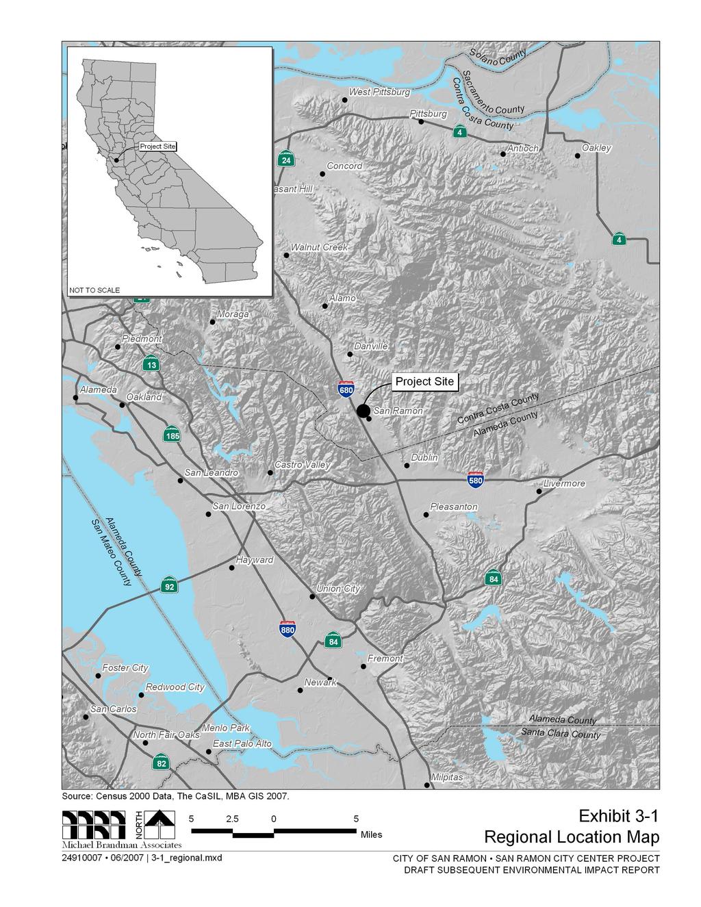
1 San Ramon City Center - City of San Ramon Draft Subsequent EIR Project Description SECTION 3: PROJECT DESCRIPTION This section describes the proposed San Ramon City Center Project (proposed project) that is evaluated in this Draft Subsequent Environmental Impact Report (DSEIR). Descriptions of the proposed project s regional and planning context, objectives, and background are included, in addition to a discussion of required project approvals and entitlements. The City of San Ramon and Sunset Development Company are the co-proponents of the proposed project, and the City is the lead agency with discretionary authority over the proposed project Project Location and Setting Location The proposed project is located within the City of San Ramon in Contra Costa County, California (Exhibit 3-1). The project site is composed of four parcels totaling acres 1 located on all four quadrants of the intersection of Bollinger Canyon Road and Camino Ramon (Exhibit 3-2). The four parcels that constitute the project site and their characteristics are summarized in Table 3-1. Table 3-1: Parcel Summary Parcel No. Acreage Existing Uses Parcel Boundaries 1A Undeveloped land; surface Bishop Ranch 1 entrance road (west), Bollinger parking area for Bishop Ranch 1 Canyon Road (north); Bishop Ranch 1 East roadway (east and south) 1B 3.52 Surface parking area for Bishop Ranch 1 Chevron Park (west), Bollinger Canyon Road (north); Bishop Ranch 1 entrance road; Bishop Ranch 1 structure (south) Bishop Ranch 2 Sunset Drive (west); Bishop Drive (north); Camino Ramon (east); Bollinger Canyon Road (south) 3A Undeveloped land Camino Ramon (west); Bishop Ranch 3 parking structure (north); Iron Horse Trail (east); Bollinger Canyon Road (south) Source: Sunset Development Company, Sunset Development Company owns the entirety of Parcels 1B and 2 and 6.71 acres of Parcel 1A; the City of San Ramon owns Parcel 3A and 7.56-acres of Parcel 1A. Sunset Development Company has an option to repurchase and develop the City-owned 7.56 acres of Parcel 1A. 1 The acres includes 4.56 acres of internal roadways and driveways; the actual developable area is acres. For the purposes of this DSEIR, acres will be used as the project site acreage; however, for the purposes of calculating Floor Area Ratio, acres will be used. Michael Brandman Associates 3-1 H:\Client (PN-JN)\2491\ \DSEIR\ _Sec03-00 Project Description.doc
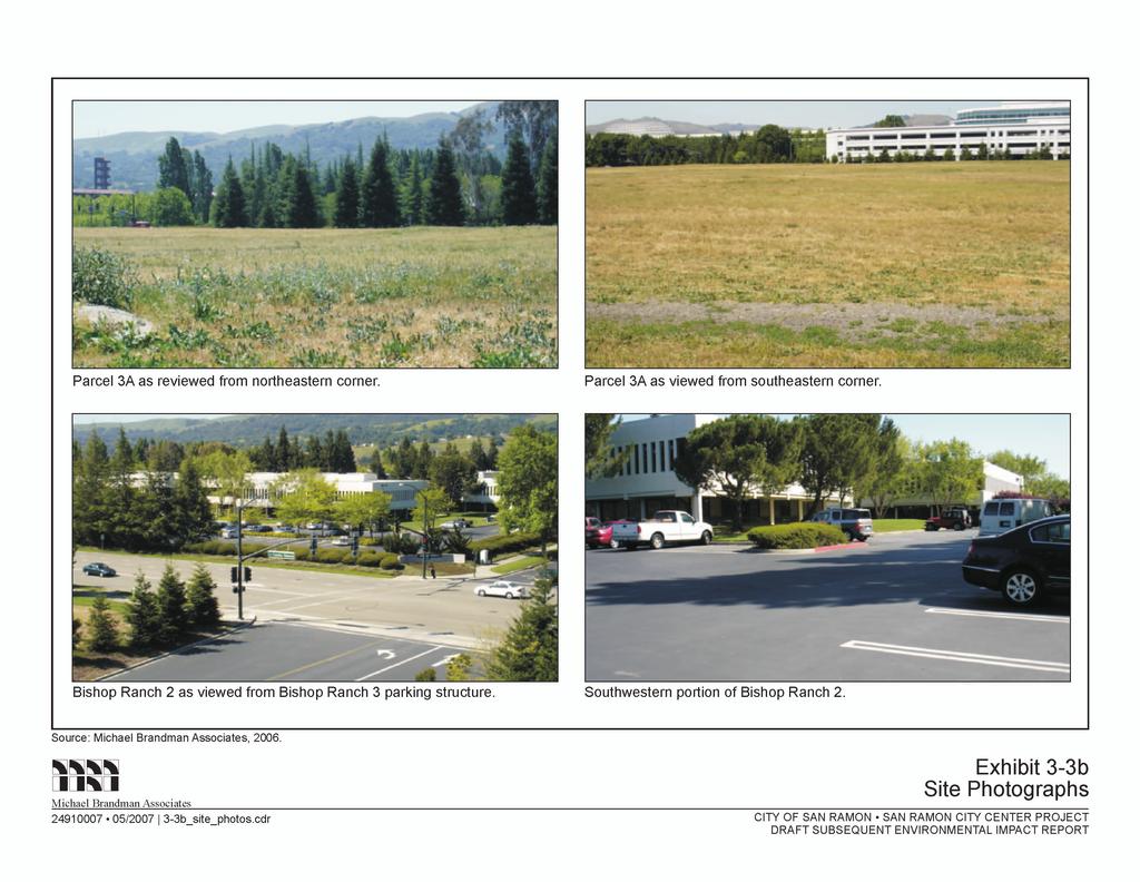
2 Project Description San Ramon City Center - City of San Ramon Draft Subsequent EIR The Assessor s Parcel Numbers for the project site are , , , - 011, -012, -013, and The project site is located on the Diablo, California, United States Geologic Survey 7.5-minute topographical map, Township 2 South, Range 1 West, Unsectioned Existing Conditions The existing conditions of each individual parcel are described below. Photographs of the use of each parcel are shown in Exhibits 3-3a through 3-3e. Parcel 1A Parcel 1A consists of acres of undeveloped land and developed parking areas associated with Bishop Ranch 1. The northern portion of Parcel 1A contains approximately 7.56 acres of undeveloped City-owned, rectangular-shaped property. This land contains ruderal vegetation, with ornamental landscaping surrounding the property on all four sides. This portion of the parcel contains fill imported from other nearby parcels that have been developed. The southern 6.71-acre portion of Parcel 1A contains parking areas associated with Bishop Ranch 1. The parking areas are characterized as at-grade, asphalt-paved with landscaped islands and freestanding lighting. Sidewalks are present along its frontages with Bollinger Canyon Road and the Bishop Ranch 1 East roadway. Sunset Development has an existing entitlement to develop its portion of Parcel 1A as a 328,220- square-foot office complex in accordance with the previously approved Chevron Park Annexation and Development Agreement. This entitlement was originally granted to Chevron Corporation, the previous owner of the property. Sunset Development subsequently acquired the entitlement when it purchased the Bishop Ranch 1 property. Parcel 1B Parcel 1B consists of approximately 3.52 acres of a developed parking area associated with Bishop Ranch 1. The parking area is characterized as at-grade, asphalt-paved with landscaped islands and freestanding lighting. Ornamental landscaping surrounds the parcel on the west, north, and east sides. Sidewalks are present along its frontages with Bollinger Canyon Road and the Bishop Ranch 1 entrance road. Parcel 2 Parcel 2 consists of the existing acre Bishop Ranch 2 office complex. Bishop Ranch 2 contains 194,652 square feet of office space spread among four multi-story office structures with an interior turf courtyard landscaped area. Parking areas are located around the perimeter of the parcel and are characterized as at-grade, asphalt-paved areas with landscaped islands and freestanding lighting. Ornamental landscaping is present along its frontages with Sunset Drive, Bishop Drive, Camino Ramon, and Bollinger Canyon Road. Sidewalks are present along its entire frontage with Sunset Drive and portion of its frontage with Bishop Drive. 3-2 Michael Brandman Associates H:\Client (PN-JN)\2491\ \DSEIR\ _Sec03-00 Project Description.doc
3
4

5
6
7
8
9
10

11
12

13
14
15
16
17 San Ramon City Center - City of San Ramon Draft Subsequent EIR Project Description Parcel 3A Parcel 3A is an undeveloped, acre, City-owned parcel containing ruderal vegetation. The parcel contains fill imported from other nearby parcels that have been developed. Ornamental landscaping is present along its frontage with Camino Ramon. Sidewalks are present along its frontages with Camino Ramon and Bollinger Canyon Road. The site is used for temporary parking and special events such as car shows and festivals Surrounding Land Uses A summary of surrounding uses for each parcel is provided in Table 3-2. Table 3-2: Surrounding Land Use Summary Parcel No. Surrounding Land Uses West North East South 1A Bishop Ranch 1 office structure and Bishop Ranch 1 entrance road; Parcel 1B Bollinger Canyon Road; Parcel 3A Iron Horse Trail; Market Place commercial uses (i.e., Marriot Residence Inn and Orchard Supply Hardware); Reflections Condominiums Bishop Ranch 1 East roadway; Bishop Ranch 1 surface parking area; single-family residential uses 1B Chevron Park Bollinger Canyon Road; Parcel 2 Bishop Ranch 1 entrance road; Parcel 1A Bishop Ranch 1 office structure; Bishop Ranch 1 surface parking areas 2 Sunset Drive; Shops at Bishop Ranch Bishop Drive; AT&T campus Camino Ramon; Parcel 3A Bollinger Canyon Road; Chevron Park; Parcel 1B 3A Camino Ramon Bishop Ranch 3 parking structure; Bishop Ranch 3 office structure Source: Michael Brandman Associates, Iron Horse Trail; Watson Canyon Drainage; Central Park Bollinger Canyon Road; Parcel 1A; Bishop Ranch 1 office structure Land Use Designations The City of San Ramon General Plan and San Ramon Zoning Ordinance govern land use on the four parcels comprising the project site. The General Plan and Zoning Ordinance designations for each parcel are summarized in Table 3-3. The existing uses of each parcel are consistent with the applicable General Plan and Zoning Ordinance designation. The Administrative Office zoning district has a height limit of 55 feet; however, the Height Overlay allows for a maximum height of 75 feet if building architecture incorporates a varying roof plane to add variation to the structure s appearance. Michael Brandman Associates 3-17 H:\Client (PN-JN)\2491\ \DSEIR\ _Sec03-00 Project Description.doc
18 Project Description San Ramon City Center - City of San Ramon Draft Subsequent EIR Table 3-3: Land Use Designation Summary 1A Parcel No. General Plan Designation Zoning Ordinance Designation 7.56 acres* Mixed Use City Center Mixed Use (CCMU) 6.71 acres** Office Administrative Office, Height Overlay (OA-H) 1B Mixed Use City Center Mixed Use (CCMU) 2 Mixed Use City Center Mixed Use (CCMU) 3A Mixed Use City Center Mixed Use (CCMU) * City-owned portion ** Sunset Development-owned portion Source: Michael Brandman Associates, Project Characteristics Project Background The concept for a City Center project dates back to the mid-1980s during the early years of the City of San Ramon. The City s first General Plan, adopted in November 1986, included what was referred to at that time as the San Ramon Downtown Specific Plan. The Downtown Specific Plan focused on the Crow Canyon Redevelopment Area, located northwest of the intersection of Crow Canyon Road and San Ramon Valley Boulevard. Both the General Plan and the Downtown Specific Plan included policies that identified the need for a downtown and called for establishing a sense of place by providing a center for daytime, nighttime and weekend activities and sustaining a profitable economic climate. Several years after adoption of the Downtown Specific Plan, the City received a proposal to redevelop a significant amount of land in the Crow Canyon Redevelopment Area. That particular proposal was a mixed-use project that included major retailers, office uses, civic/public uses, and residential uses. However, the project failed to proceed because of the lack of unanimity by the policy makers at that time, since the project would have required a significant amount of land to be assembled. In 1991, the City initiated its update to the General Plan that was adopted in That 1995 General Plan continued to include policies that referenced the need for a City Center but changed the location to the area along Bollinger Canyon Road. Sunset Development submitted a proposal to develop a City Center on approximately 40 acres of land around the intersection of Camino Ramon and Bollinger Canyon Road in early The proposed project would have provided a mixed-use development that included retail, office, civic, and cultural uses. For various reasons, that concept failed to materialize. A subsequent proposal was made and approved that resulted in the City acquiring Parcel 3A, the approximately 11-acre parcel at the northeast quadrant of Camino Ramon and Bollinger Canyon Road Michael Brandman Associates H:\Client (PN-JN)\2491\ \DSEIR\ _Sec03-00 Project Description.doc
19 San Ramon City Center - City of San Ramon Draft Subsequent EIR Project Description In 2000, the City processed and approved the development of Bishop Ranch 1, south of the intersection of Camino Ramon and Bollinger Canyon Road. As part of that approval, the City was able to acquire 7 acres of Parcel 1A at the southeastern quadrant of the intersection with the intent of developing a City Center on the site. With the acquisition of this parcel, the City had ownership of 18 acres of undeveloped land in central San Ramon on a major arterial corridor close to Interstate 680 (I- 680). The City embarked on a visioning process to create a plan for the City Center. The City hired a consultant and appointed an 18-member citizens task force to work with its staff and the consultant. After numerous public workshops and plan options, the process resulted in a new and more detailed vision for the creation of a City Center. In early 1999, the City initiated a design competition to implement this new vision. A team of architectural firms, including a construction management firm, was contracted to aid the City in implementing its new vision. Public workshops were held to solicit ideas; plan alternatives were generated; and, ultimately, a preferred plan was selected. Again, as with previous efforts, the project failed to proceed. In March 2002, City voters approved the General Plan 2020, which identified a City Center project at the intersection of Camino Ramon and Bollinger Canyon Road and set forth a number of policies reaffirming previous policies intended to guide the development of the project. Relevant policies include: Policy 2.4-I-13, which calls for the development of the City Center area as a cultural, recreational, and compatible retail center. Additional supporting language contemplates the City Center as a vital, vibrant gathering place containing civic, recreational, and commercial opportunities that would attract the community throughout the day and week Policy 4.7-I-5, which envisions the City Center has a cohesive mix of civic, compatible retail, open space uses, with an arts and entertainment focus. Additional supporting language anticipates the City Center as a vital core, with a performing arts center, library, and small scale retail Policy 4.8-I-17, which exempts the City Center project from height restrictions and set back requirements for vertical wall dimensions and upper stories. Policy 7.1-I-1, which supports the development of a City Center. Additional supporting language envisions the City Center as a civic hub containing a City Hall, community theater, and other public buildings, as well as compatible private buildings The City of San Ramon General Plan EIR considered the development of a City Center-type project containing civic and commercial uses. Shortly thereafter, the City Council hired a new architectural firm and charged it with developing plans for a project known as the City Civic Center, which, after many public workshops and the consideration of numerous plan options, ultimately ended up being primarily a civic center focused on public facilities that would have been entirely publicly financed. As formally proposed, the City Civic Center project called for a total of 276,000 square feet of Michael Brandman Associates 3-19 H:\Client (PN-JN)\2491\ \DSEIR\ _Sec03-00 Project Description.doc
20 Project Description San Ramon City Center - City of San Ramon Draft Subsequent EIR primarily civic and small scale commercial uses, including City offices, Council Chamber, a library, a children s museum, a 1,200-seat performing arts center with a smaller 300-seat theater, 40,000 square feet of retail on Parcel 3A, and an aquatic center on Parcel 1A. A project-level Draft EIR for the project was issued in September The City Council certified the Final EIR in December 2003, but did not grant entitlements for the project concept because the City would have borne a significant financial burden that was viewed as unacceptable. (As postscript to the demise of the City Civic Center project, the City and the San Ramon Valley Unified School District joined to develop a 600- seat performing arts facility and aquatics center at Dougherty Valley High School that will be available for community use during non-school hours when the school opens at the start of the academic year. Additionally, a site for the Children s Discovery Museum has been identified in the City of Dublin.) In February 2004, City staff presented options regarding the City Center as part of a budget workshop. At the end of the workshop, the City Council directed staff to explore a public-private partnership option. The consensus was that there would be more advantages than disadvantages through a partnership, particularly in terms of providing public facilities and combining resources. As part of this action, the City Council formed an oversight subcommittee to work with City staff on implementing this new direction. To realize the public-private partnership, the City determined it was necessary to make certain amendments to the General Plan and concurrently create a new zoning district: City Center Mixed Use (CCMU). The amendments included provisions that would allow for flexibility in the design of the City Center, and they were put forth before the Planning Commission and City Council in June The Planning Commission, the City Council oversight subcommittee, and the City Council approved the amendments, which were formally adopted in October During this process, City staff also discovered that there was an opportunity to include approximately 3.5 acres of additional land to the City Center Mixed Use area, which provided more flexibility and options in the design of the City Center. City staff also solicited Sunset Development s interest in participating with the City in designing a new City Center because of its ownership of property within the City Center Mixed Use area. Sunset Development showed a strong desire to work collaboratively with the City in generating concept plans. The City also conducted exploratory meetings with other nationally recognized retail developers such as Caruso Affiliated, Federal Realty Investment Trust, the DeBartolo Company, and others. The City Center project analyzed in this DSEIR is the culmination of the City and Sunset Development s joint efforts Proposed Project Overview The City of San Ramon and Sunset Development are co-applicants for the proposed mixed use project. The project consists of 2,168,466 square feet of new construction of retail, hotel, residential, 3-20 Michael Brandman Associates H:\Client (PN-JN)\2491\ \DSEIR\ _Sec03-00 Project Description.doc
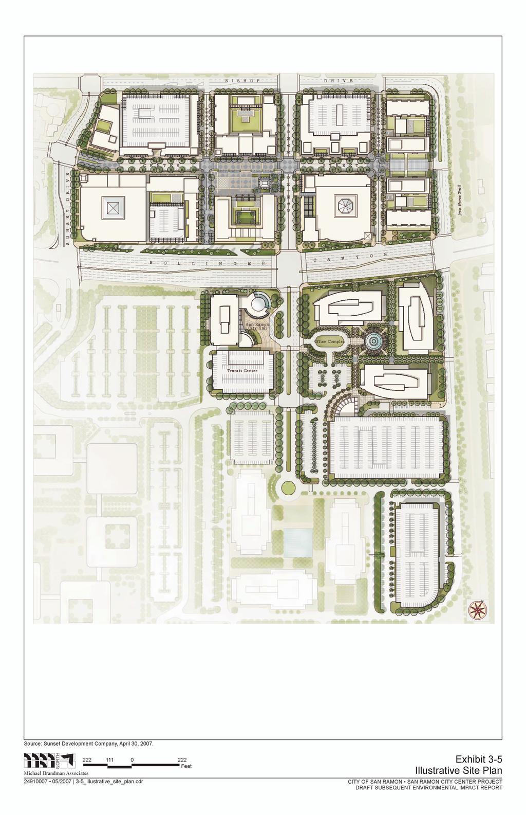
21 San Ramon City Center - City of San Ramon Draft Subsequent EIR Project Description office, and civic uses on the project site. Included in this total 194,652 square feet of existing office space will be demolished, and the project will utilize a vested un-built office entitlement of 328,220 square feet. This existing entitlement is for Parcel 1A in accordance with the terms and conditions of a Development Agreement originally granted to Chevron, and assumed by Sunset Development Company. In summary, the total square footage to be built is 2,168,466 square feet; however, the needed entitlement for the project is for a net of 1,645,594 square feet of mixed uses. The intent and design of this infill project is to create a vibrant destination and promote the use of public transportation and pedestrian and bicycle modes of transportation. The proposed project consists of three components: a Plaza District on Parcels 2 and 3A, the Bishop Ranch 1A office complex on Parcel 1A, and a City Hall and Transit Center on Parcel 1B. A summary of the project components is provided in Table 3-4. Each component is described in further detail below. A context plan for the proposed project is shown in Exhibit 3-4. An illustrative site plan for the proposed project is provided in Exhibit 3-5. The tentative parcel map for the proposed project is provided in Appendix L. Table 3-4: Project Components Component Plaza District Bishop Ranch 1A Office Complex City Hall and Transit Center Use Square Footage New Construction Subtotal 2,168,466 Notes Retail 635,042 Includes a cinema, two anchor stores, and restaurants Office 50,142 Space can developed as either office or retail (i.e. retail/office flex) Hotel 139,867 Consists of 169 rooms Residential 550,669 Consists of 487 high-density residential units Office 681,769 Three 7-story, Class A office buildings Civic 110,490 Includes a City Hall with Council Chamber, City offices, library, and police station, as well as transit center Bishop Ranch 2 (194,652) City/Sunset Annexation and Development Agreement amended to allow development of Plaza District in place of Bishop Ranch 2 Office Entitlement (328,220) Amendment to City/Chevron (Sunset Assumption) Annexation and Development Agreement amended to allow development of Bishop Ranch 1A in place of office entitlement Reductions Subtotal (522,872) Net Project Square Footage 1,645,594 Source: Sunset Development Company, Michael Brandman Associates 3-21 H:\Client (PN-JN)\2491\ \DSEIR\ _Sec03-00 Project Description.doc
22 Project Description San Ramon City Center - City of San Ramon Draft Subsequent EIR Project Components Plaza District The Plaza District would be the largest component of the proposed project, both in terms of footprint and square footage. The Plaza District would occupy Parcels 2 and 3A and would consist of seven City blocks: A, B, C, D, E, F-G, and H. Blocks A through D would be located on Parcel 2, and Blocks E through H would be located on Parcel 3A. The Plaza District would be organized around Center Street, the principal east-west roadway that would bisect the district. Three north-south streets would intersect with Center Street West Street, Camino Ramon, and East Street and would create three internal intersections in the Plaza District. In addition, the existing Bishop Drive would be extended from its current terminus at the Bishop Ranch 3 parking structure to loop around the east side of the Plaza District and intersect with Bollinger Canyon Road. With the exception of Camino Ramon, all streets would be private. The heart of the Plaza District would be centered around a large pedestrian plaza, located in front of the hotel on the south side of Center Street, between West Street and Camino Ramon. The plaza would be used for seasonal programs, such as farmer s markets during the warmer months and outdoor ice skating during the winter months. Exhibit 3-6 provides a site plan of the Plaza District. Exhibits 3-7a through 3-7h provide individual depictions of the seven blocks (A through H) within the Plaza District. Within the Plaza District would be retail, residential, office, and hotel uses. Each is discussed in detail below. Retail Retail uses within the Plaza District would total 635,042 square feet and consist of two possible anchor stores, a six-screen arts cinema, and smaller inline retail uses such shops, restaurants, and spa/fitness/wellness. Table 3-5 provides a summary of the retail square footage for each of the seven Plaza District blocks. Table 3-5: Plaza District Retail Uses Summary Block Retail Use Square Footage A Inline Retail 65,160 B Cinema/Inline Retail 79,525 C Inline Retail 25,961 D Anchor Store 1/Inline Retail 193,385 E Inline Retail 67,440 F and G Inline Retail 44,215 H Anchor Store 2/Inline Retail 159,356 Total 635,042 Source: Sunset Development Company, Michael Brandman Associates H:\Client (PN-JN)\2491\ \DSEIR\ _Sec03-00 Project Description.doc

23
24
25
Town Center (part of the Comprehensive Plan)
") Town Center (part of the Comprehensive Plan) Mercer Island Town Center Looking North (2014) In 1994, a year-long process culminated in a set of design guidelines and code requirements for the Town Center
Town Center (part of the Comprehensive Plan) Mercer Island Town Center Looking North (2014) In 1994, a year-long process culminated in a set of design guidelines and code requirements for the Town Center
The transportation system in a community is an
 7 TRANSPORTATION The transportation system in a community is an important factor contributing to the quality of life of the residents. Without a sound transportation system to bring both goods and patrons
City of Farmington. Downtown Plan. Amendment to the 1998 Master Plan Adopted October 11, 2004
 City of Farmington Amendment to the 1998 Master Plan Adopted October 11, 2004 Introduction Planning Background 1 Scope and Components of the Plan Amendment 2 Concept Introduction 3 Plan Concepts 3 Conceptual
ARLINGTON COUNTY, VIRGINIA
 ARLINGTON COUNTY, VIRGINIA County Board Agenda Item Meeting October 15, 2005 DATE: September 28, 2005 SUBJECT: Request to Advertise the adoption of the 2005 Clarendon Sector Plan C. M. RECOMMENDATION:
LOS ANGELES CITY PLANNING DEPARTMENT STAFF REPORT
 LOS ANGELES CITY PLANNING DEPARTMENT STAFF REPORT LOS ANGELES CITY PLANNING COMMISSION CASE NO: CPC 2006-9374 CRA CEQA: Exempt DATE: December 21, 2006 Location: Valley Plaza and Laurel Plaza TIME: after
3. Project Description
 3.1 PROJECT LOCATION The Platinum Triangle (herein after also referred to as the Project Area ) is located at the confluence of the Interstate 5 (I-5 Freeway) and the State Route 57 (SR-57 Freeway), in
Policies and Code Intent Sections Related to Town Center
 Policies and Code Intent Sections Related to Town Center The Town Center Vision is scattered throughout the Comprehensive Plan, development code and the 1994 Town Center Plan. What follows are sections
1INTRODUCTION. Purpose of the Truckee Railyard Master Plan
 1INTRODUCTION Purpose of the Truckee Railyard Master Plan The purpose of the Truckee Railyard Master Plan is to capture and describe the Town s vision for the Railyard Area and to guide its future redevelopment.
ARLINGTON COUNTY, VIRGINIA
 ARLINGTON COUNTY, VIRGINIA County Board Agenda Item Meeting of April 12, 2014 DATE: April 2, 2014 SUBJECT: to the Arlington County Zoning Ordinance, Article 11.1 "CP-FBC" Columbia Pike Form Based Code
2.7 ac park. TOTAL 5,403 DU 1,297,900 sf 1,105,450 sf 3.87 ac 5,563 DU 1,121,200 sf 1,105,450 sf 3.87 ac
 PLAN AMENDMENT 2013-I-B1: SEVEN CORNERS SPECIAL STUDY Summary of Pre-staffing Comments Planner: Bernard Suchicital bsuchi@fairfaxcounty.gov (703) 324-1254 Background On October 29, 2013, the Board of Supervisors
NOTICE OF AVAILABILITY (NOA) OF A DRAFT ENVIRONMENTAL IMPACT REPORT AND NOTICE OF PUBLIC HEARING 2190 Shattuck Avenue Mixed-Use Project
 OF A DRAFT ENVIRONMENTAL IMPACT REPORT AND NOTICE OF PUBLIC HEARING 2190 Shattuck Avenue Mixed-Use Project") Planning and Development Department Land Use Planning Division NOTICE OF AVAILABILITY (NOA) OF A DRAFT ENVIRONMENTAL IMPACT REPORT AND NOTICE OF PUBLIC HEARING 2190 Shattuck Avenue Mixed-Use Project Notice
Planning and Development Department Land Use Planning Division NOTICE OF AVAILABILITY (NOA) OF A DRAFT ENVIRONMENTAL IMPACT REPORT AND NOTICE OF PUBLIC HEARING 2190 Shattuck Avenue Mixed-Use Project Notice
EXHIBIT A. Tax Increment Reinvestment Zone No. 1 (Town Center) First Amended Project Plan 1
 First Amended Project Plan 1") EXHIBIT A Tax Increment Reinvestment Zone No. 1 (Town Center) First Amended Project Plan 1 1 As amended by Resolution No. 2008-02-001(TR1R) of the Tax Increment Reinvestment Zone No.1, and approved to
EXHIBIT A Tax Increment Reinvestment Zone No. 1 (Town Center) First Amended Project Plan 1 1 As amended by Resolution No. 2008-02-001(TR1R) of the Tax Increment Reinvestment Zone No.1, and approved to
A. WHAT IS A GENERAL PLAN?
 I. Introduction A. WHAT IS A GENERAL PLAN? A general plan is the planning guideline for the future of a city. It contains goals and policies which regulate urban development, the protection of the natural
Gold Line Bus Rapid Transit Transit Oriented Development (BRTOD) Helmo Station Area Plan
 Helmo Station Area Plan") Appendix F Gold Line Bus Rapid Transit Transit Oriented Development (BRTOD) Helmo Station Area Plan Introduction and Purpose of the Plan The Gold Line Bus Rapid Transit facility is an eleven-mile dedicated
Appendix F Gold Line Bus Rapid Transit Transit Oriented Development (BRTOD) Helmo Station Area Plan Introduction and Purpose of the Plan The Gold Line Bus Rapid Transit facility is an eleven-mile dedicated
DENVER DESIGN DISTRICT GDP
 DENVER DESIGN DISTRICT GDP Urban Design Standards and Guidelines November 17, 2008 Amended February 3, 2016 City and County of Denver CF Property Management, Inc. C/O Denver Design District - Starboard
A. Background Summary of Existing Challenges and Potential Possibilities. 1. Summary of Existing Assets and Potential Opportunities
 A. Background 1 A Main Street Master Plan Study was performed and completed in October of 2007. The study was initiated to review current land uses and development patterns along Main Street, from Parrish
Developer s Program. The Station at East 54
 Developer s Program The Station at East 54 Existing Conditions The Station at East 54 is proposed for a 1.12 acre site at the northeast corner of Hamilton Road and Prestwick Road, tucked between the East
KANATA CENTRUM 255 KANATA AVENUE OFFICIAL PLAN AMENDMENT ZONING BY-LAW AMENDMENT
 KANATA CENTRUM 255 KANATA AVENUE OFFICIAL PLAN AMENDMENT ZONING BY-LAW AMENDMENT JUNE 2015 PREPARED BY: FOTENN Consultants Inc. 223 Mcleod Street Ottawa, ON K2P OZ8 (613) 730-5709 PREPARED FOR: Kanata
Planning Districts INTRODUCTION
 INTRODUCTION To facilitate detailed examination of development prospects for all areas of the community, Delano has been divided into 14 planning districts. The location of these planning districts is
Olde Towne Vision Plan
 Olde Towne Vision Plan Introduction In 2016, the City of Bellevue will complete its move of City offices from Olde Towne Bellevue to its new municipal complex on Wall Street. The City intends to sell its
Carlsbad Village Redevelopment Concept Summary of Features
 Carlsbad Village Redevelopment Concept Summary of Features Calthorpe Associates November 5, 2003 The Redevelopment Concept illustrates a vision for the future of Carlsbad Village. The overall vision of
4.8 LAND USE AND PLANNING
 4.8 LAND USE AND PLANNING 4.8.1 INTRODUCTION This section describes existing and planned land uses at the Hayward campus and analyzes the impact of implementation of the proposed Master Plan on land uses
TABLE OF CONTENTS. Tables Table UC Davis Park and Open Space Resources
 TABLE OF CONTENTS 4.13 Recreation... 4.13-1 4.13.1 Environmental Setting... 4.13-1 4.13.2 Impacts and Mitigation Measures... 4.13-4 4.13.3 References... 4.13-8 Tables Table 4.13-1 UC Davis Park and Open
Lehigh Acres Land Development Regulations Community Planning Project
 Lehigh Acres Land Development Regulations Planning Effort Summary In July, 2010 Commissioner Frank Mann invited the Lehigh Acres community to start discussing how to achieve their recently adopted community
City Council Special Meeting AGENDA ITEM NO. C.
 City Council Special Meeting AGENDA ITEM NO. C. DATE: 01/04/2019 TO: Honorable Mayor and City Council Members SUBJECT: Transit Villages Specific Plan project Study Session (Development Services Director
S A C R A M E N T O C O U N T Y JACKSON HIGHWAY & GRANT LINE EAST VISIONING STUDY
 JACKSON HIGHWAY & GRANT LINE EAST S A C R A M E N T O C O U N T Y P L A N N I N G D E P A R T M E N T SUMMARY AND WORKBOOK November 19, 2008 History of the Visioning Study Sacramento County has two growth
Planning Commission Staff Report June 5, 2008
 Owner/Applicant Taylor Village Sacramento Investments Partners, LP c/o Kim Whitney 1792 Tribute Road #270 Sacramento, CA 95815 Staff Recommendation Planning Commission Staff Report Project: File: Request:
Additional information about land use types is given in Chapter 5. Design guidelines for Centers and Neighborhoods are given in Chapter 7.
 4. Place Types Introduction In Albemarle County s Development Areas, the Neighborhood is the fundamental unit of community planning. The County s Neighborhood Model, an adopted part of the Comprehensive
III. PROJECT DESCRIPTION
 III. PROJECT DESCRIPTION LOCATION AND BOUNDARIES The City of Manhattan Beach is located in the South Bay region of Los Angeles County, California, approximately 2 miles south of the Los Angeles International
Notice of Preparation and Notice of Public Scoping Meeting. At Dublin Project
 Notice of Preparation and Notice of Public Scoping Meeting Date January 17, 2018 To Project Title Project Application Number Project Location Project Applicant Contact For questions or submitting comments.
Prosperity Hucks Area Plan. Transportation and Planning Committee May 11, 2015
 Prosperity Hucks Area Plan Transportation and Planning Committee May 11, 2015 Presentation Outline 1. Background and Location 2. Community Dialog Process 3. Activity Center Recommendations 4. Wedge Recommendations
Description of Preferred Alternative
 Chapter 2 Description of Preferred Alternative 2.1 Introduction This chapter of the programmatic Sammamish Town Center Sub-area Plan Final EIS provides a more detailed description of the Preferred Alternative
3.0 URBAN DESIGN. December 6, OVERVIEW
 Urban Design 3.0 URBAN DESIGN December 6, 2007 3.1 OVERVIEW The highly urban character of Easton Place is defined by the overall design of the community. The following sections provide an overview of the
AN ORDINANCE THE COUNCIL OF THE CITY OF PHILADELPHIA HEREBY ORDAINS:
 AN ORDINANCE Amending Title 14 of The Philadelphia Code, entitled Zoning and Planning, by amending Section 14-507, entitled /CDO, Central Delaware Riverfront Overlay District, under certain terms and conditions.
HISTORIC TOWN CENTER MASTER PLAN CITY COUNCIL PRESENTATION APRIL 3, 2012
 HISTORIC TOWN CENTER MASTER PLAN CITY COUNCIL PRESENTATION APRIL 3, 2012 REQUESTED CITY COUNCIL ACTIONS Certification of the Final Program Environmental Impact Report (PEIR); and, Approval of General Plan
2035 General Plan Update and Belmont Village Specific Plan. Joint Study Session with the City Council and Planning Commission April 12, 2016
 2035 General Plan Update and Belmont Village Specific Plan Joint Study with the City Council and Planning Commission April 12, 2016 Agenda 1. Welcome and Introductions 2. General Plan Update Status of
Mark-up of the effect of the proposed Bronte Village Growth Area OPA No.18 on the text of section 24, Bronte Village, of the Livable Oakville Plan
 Mark-up of the effect of the proposed Bronte Village Growth Area OPA No.18 on the text of section 24, Bronte Village, of the Livable Oakville Plan Notes: This document is provided for information purposes
City Center Neighborhood Plan
 [1] City Center Neighborhood Plan As adopted by Ordinance No. 2014-09-049 and amended by Ordinance Nos. Formerly CBD Neighborhood as adopted by Ordinance No. 8868 and amended by Ordinance Nos. 8946, 9693,
Department of Community Development. Planning and Environmental Review Division Revised Notice of Preparation
 Department of Community Development Michael J. Penrose, Acting Director Divisions Building Permits & Inspection Code Enforcement County Engineering Economic Development & Marketing Planning & Environmental
PINE CURVE REZONING. Property does not meet criteria for open space preservation and is not a candidate for a park
 PINE CURVE REZONING BACKGROUND Purchased as two parcels in 2001 and 2002 Annexed and Zoned Greater Downtown District Historic Center September 25, 2002 and October 7, 2002 WHAT THE PROJECT IS AND IS NOT
A Vibrant Downtown. Chapter 5 Cary Public Art Opportunities 31
 A Vibrant Downtown Cary s vision for Downtown is a unique, vibrant, dynamic, pedestrian friendly location; a regional destination and a place to live, work, and recreate, according to the 2001 Town Center
EXHIBIT "A" PROJECT DESCRIPTION Vibiana Development Project
 EXHIBIT "A" PROJECT DESCRIPTION Vibiana Development Project A. PROJECT CHARACTERISTICS 228 S. Main Street, LLC, (the Applicant ) is requesting a Conditional Use Permit ( CUP ) for Floor Area Ratio Averaging
3. VISION AND GOALS. Vision Statement. Goals, Objectives and Policies
 Vision Statement Queen Creek s interconnected network of parks, trails, open spaces and recreation opportunities provide safe and diverse activities and programs that sustain its unique, small town, equestrian
DRAFT Land Use Chapter
 Stevens Creek Urban Village DRAFT 1 18 17 Land Use Chapter INTRODUCTION This Land Use Chapter describes how the Stevens Creek Urban Village will accommodate the growth that is planned for it in the Envision
ELMVALE ACRES SHOPPING CENTRE MASTER PLAN
 ELMVALE ACRES SHOPPING CENTRE MASTER PLAN Contents 1.0 INTRODUCTION... 2 2.0 LOCATION... 2 3.0 EXISTING CONTEXT... 2 4.0 VISION & GUIDING PRINCIPLES... 2 5.0 LAND USE AND BUILT FORM... 4 5.1 St. Laurent
PINE CURVE REZONING. BACKGROUND Purchased as two parcels in 2001 and 2002
 BACKGROUND Purchased as two parcels in 2001 and 2002 WHAT THE PROJECT IS AND IS NOT A Rezoning establishes the land use standards for Annexed and Zoned Greater Downtown District Historic Center September
SPECIFIC PLAN Requirements
 CITY OF LANCASTER PLANNING DEPARTMENT 44933 Fern Avenue, Lancaster, California 93534 (661) 723-6100 SPECIFIC PLAN Requirements Purpose The purpose of a specific plan is to provide for the logical development
Glenborough at Easton Land Use Master Plan
 Implementation 114 9.0 IMPLEMENTATION 9.1 OVERVIEW This chapter summarizes the administrative procedures necessary to implement the proposed land use plan, infrastructure improvements, development standards,
3.0 PROJECT DESCRIPTION
 3.0 PROJECT DESCRIPTION 3.1 BACKGROUND Under California law (Government Code Section 65300 et seq.), every city and county is required to have a general plan. The general plan is to be comprehensive and
Introduction. Chapter 1. Purpose of the Comprehensive Plan Plan Organization Planning Process & Community Input 1-1
 Chapter 1 Introduction Lakewood 2025: Moving Forward Together Purpose of the Comprehensive Plan Plan Organization Planning Process & Community Input 1-1 Purpose of the Comprehensive Plan The Comprehensive
EXISTING COMPREHENSIVE PLAN
 EXISTING COMPREHENSIVE PLAN Town Center Land Use Element: V. LAND USE POLICIES Town Center Mercer Island's business district vision as described in "Your Mercer Island Citizen-Designed Downtown" was an
Technical Appendix L, University Community Plan Town Center
 Technical Appendix L, University Community Plan Town Center Table of Contents L.1 Executive Summary L.2 Merced County University Community Plan, 2004 Findings L.2.1 Visioning L.2.2 UCP Goals, Objectives
Bourne Downtown Site Planning
 Prepared for: The Town of Bourne, MA In Cooperation with: Bourne Financial Development Corporation Prepared by:, Inc. June 24, 2009 Table of Contents Introduction and Summary... 1 Site Existing Conditions...
Executive Summary General Plan Amendment Initiation
 Executive Summary General Plan Amendment Initiation HEARING DATE: AUGUST 6, 2015 Date: July 30, 2015 Case No.: 2011.0409PCA Project Address: 925 Mission Street and various parcels (aka 5M ) Existing Zoning:
ARLINGTON COUNTY, VIRGINIA. County Board Agenda Item Meeting of February 23, 2019
 ARLINGTON COUNTY, VIRGINIA County Board Agenda Item Meeting of February 23, 2019 DATE: February 15, 2019 SUBJECT: Amendment to the Master Transportation Plan (MTP) Map to add a new section of North Kansas
Review of Opportunity Area C Draft Comprehensive Plan and Draft BOS Follow-On Motions. Special Working Group Meeting March 4, 2015
 Review of Opportunity Area C Draft Comprehensive Plan and Draft BOS Follow-On Motions Special Working Group Meeting March 4, 2015 The slides that follow identify where the draft Comprehensive Plan has
SUBJECT: Waterfront Hotel Planning Study Update TO: Planning and Development Committee FROM: Department of City Building. Recommendation: Purpose:
 Page 1 of Report PB-23-18 SUBJECT: Waterfront Hotel Planning Study Update TO: Planning and Development Committee FROM: Department of City Building Report Number: PB-23-18 Wards Affected: 2 File Numbers:
A. INTRODUCTION B. PROJECT LOCATION
 Chapter 1: Project Description A. INTRODUCTION The Lower Manhattan Development Corporation (LMDC), a subsidiary of the New York State Urban Development Corporation, doing business as the Empire State Development
SUBJECT: PREDEVELOPMENT PLAN REVIEW OF PROJECT LOCATED AT E. COLORADO BOULEVARD (PASEO COLORADO)
") TO: FROM: Honorable Mayor and City Council Planning & Community Development Department SUBJECT: PREDEVELOPMENT PLAN REVIEW OF PROJECT LOCATED AT 260-400 E. COLORADO BOULEVARD (PASEO COLORADO) RECOMMENDATION:
TO: FROM: Honorable Mayor and City Council Planning & Community Development Department SUBJECT: PREDEVELOPMENT PLAN REVIEW OF PROJECT LOCATED AT 260-400 E. COLORADO BOULEVARD (PASEO COLORADO) RECOMMENDATION:
CHARLES PUTMAN CHARLES PUTMAN AND ASSOCIATES, INC
 MEMORANDUM CHARLES PUTMAN & ASSOCIATES, INC. LAND DEVELOPMENT CONSULTANTS PLANNING ZONING PERMITTING 4722 NW Boca Raton Boulevard, Suite C-106 Boca Raton, Florida 33431 Phone: 561/994-6411 FAX: 561/994-0447
Staff Report to the North Ogden City Planning Commission
 Staff Report to the North Ogden City Planning Commission SYNOPSIS / APPLICATION INFORMATION Application Request: Concept review on a legislative application to rezone land located at approximately 1750
Public input has been an important part of the plan development process.
 Lakewood s Comprehensive Plan recognizes that transportation helps shape the community, and that the way the community provides for the safe and efficient movement of people affects the character of the
Town of Portola Valley General Plan. Nathhorst Triangle Area Plan
 Town of Portola Valley General Plan Amended December 10, 1997 Table of Contents Introduction... 1 Planning Area... 1 Objectives... 2 Principles... 2 Standards... 4 Description... 4 Community Commercial...
Ivywild On The Creek PRELIMINARY CREEK DISTRICT MASTER PLAN
 Ivywild On The Creek PRELIMINARY CREEK DISTRICT MASTER PLAN Introduction: Rejuvenating an extraordinary Creekside neighborhood THE CREEKSIDE DISTRICT The Ivywild On The Creek Neighborhood District Master
4.9 Land Use and Planning
 This section describes the regulatory framework and existing conditions related to land uses in the Project Site and vicinity, and the potential for the Project to result in environmental impacts related
5.1 Site Plan Guidelines
 5. Community Core Guidelines Development of the Community Core will take place by plan of subdivision and site plan approval. It will occur in a phased manner that will reflect the timing of residential
DATE ISSUED: March 12, 2014 REPORT NO: 101. Old Globe Way Improvements and San Diego Zoo Employee Parking Structure
 DATE ISSUED: REPORT NO: 101 ATTENTION: SUBJECT: Park and Recreation Board Agenda of March 20, 2014 Old Globe Way Improvements and San Diego Zoo Employee Parking Structure SUMMARY Issue Should the Park
Jordan Harrison, Planner III, San Francisco Recreation and Park Department
 Date December 8, 2015 To: Through: From: Subject: Recreation and Park Commission Philip A. Ginsburg, General Manager Dawn Kamalanathan, Director, Capital & Planning Division Jordan Harrison, Planner III,
Wadsworth Boulevard S TAT I O N A R E A P L A N
 Wadsworth Boulevard S TAT I O N A R E A P L A N City of Lakewood Adopted November, 2006 The Vision The City of Lakewood s overall vision is to transform the area around the light rail station into a mixed-use
CITY OF FARGO PARKING RAMP SITE EVALUATION
 CITY OF FARGO PARKING RAMP SITE EVALUATION EXECUTIVE SUMMARY Helenske Design Group (architect) and Carl Walker Inc (Parking Consultant) were retained by the City of Fargo to complete a downtown parking
2 Project Description
 Project Description 2 Project Description The proposed project would involve the demolition of the existing church and the construction of 40 twostory single family residences. The residential lots would
TEMPLE MEDICAL & EDUCATION DISTRICT
 City of Temple, Texas TEMPLE MEDICAL & EDUCATION DISTRICT 1 Description. The City of Temple joined in partnership with key public and private entities to jointly promote education and medical activities
FUTURE LAND USE ELEMENT
 FUTURE LAND USE ELEMENT GOAL I: To create and sustain a great place to live, play, and prosper Objective 1: The City of Ocala shall incorporate the principles and strategies of the Ocala 2035 Vision into
The City of Poway Creating a Town Center. Patti Brindle, AICP City Planner, City of Poway APA Luncheon September 28, 2006
 The City of Poway Creating a Town Center Patti Brindle, AICP City Planner, City of Poway APA Luncheon September 28, 2006 1 The City in the Country Population: 50,542 Area: 25,047 acres Incorporated December
PC RESOLUTION NO ARCHITECTURAL CONTROL (AC)
") PC RESOLUTION NO. 16-07-26- ARCHITECTURAL CONTROL (AC) 15-035 A RESOLUTION OF THE PLANNING COMMISSION OF THE CITY OF SAN JUAN CAPISTRANO, CALIFORNIA APPROVING ARCHITECTURAL CONTROL (AC) 15-035, INN AT
PC RESOLUTION NO. 16-07-26- ARCHITECTURAL CONTROL (AC) 15-035 A RESOLUTION OF THE PLANNING COMMISSION OF THE CITY OF SAN JUAN CAPISTRANO, CALIFORNIA APPROVING ARCHITECTURAL CONTROL (AC) 15-035, INN AT
REGIONAL ACTIVITY CENTER
 DRAFT REGIONAL ACTIVITY CENTER 70 EAST BENCH MASTER PLAN DRAFT 06 Introduction The East Bench Regional Activity center is comprised of large educational, research, medical, and employment centers. These
Land Use. Hardware Street Vendor Mixed-Use
 Land Use Definition Land Use is the way a piece of real estate is utilized. Existing, proposed, and adopted land uses all play a role in the planning process. Once a land use plan is adopted, the next
13 THORNHILL YONGE STREET STUDY IMPLEMENTATION CITY OF VAUGHAN OPA 669 AND TOWN OF MARKHAM OPA 154
 13 THORNHILL YONGE STREET STUDY IMPLEMENTATION CITY OF VAUGHAN OPA 669 AND TOWN OF MARKHAM OPA 154 The Planning and Economic Development Committee recommends the adoption of the recommendations contained
Future Proposed Development
 Future Proposed Development on and around Link light rail s Capitol Hill Station Meeting September 24, 2012 Tonight s Agenda 6:00 pm Open House 6:30 pm Introductions Richard Conlin, City of Seattle Councilmember/Sound
CRYSTAL CITY BLOCK PLAN # CCBP- G 1 DRAFT
 CRYSTAL CITY BLOCK PLAN # CCBP- G 1 DRAFT BLOCK G (Metro Market Square block) Long Range Planning Committee Meeting January 29, 2018 1 1. Introduction 2 1. LRPC Meeting Purpose Review of proposed Crystal
LAND USE AMENDMENT DOWNTOWN COMMERCIAL CORE (WARD 7) MACLEOD TRAIL SE AND 5 AVENUE SE BYLAW 254D2017
 MACLEOD TRAIL SE AND 5 AVENUE SE BYLAW 254D2017") Page 1 of 10 EXECUTIVE SUMMARY This Land Use Amendment application seeks to redesignate a full downtown block (currently the YWCA site) from a Direct Control based on the CM-2 District (Land Use Bylaw
Page 1 of 10 EXECUTIVE SUMMARY This Land Use Amendment application seeks to redesignate a full downtown block (currently the YWCA site) from a Direct Control based on the CM-2 District (Land Use Bylaw
NOTICE OF SPECIAL MEETING
 NOTICE OF SPECIAL MEETING Pursuant to Section 54956 of the Government Code of the State of California, a Special meeting of the Tracy City Council is hereby called for: Date/Time: Location: Tuesday, April
Mitchell Ranch South MPUD Application for Master Planned Unit Development Approval Project Narrative. Introduction
 Mitchell Ranch South MPUD Application for Master Planned Unit Development Approval Project Narrative Introduction Mitchell Ranch South is a proposed single family (detached) residential development on
ESTABLISH AN EFFICIENT TOWN CENTER
 ESTABLISH AN EFFICIENT TOWN CENTER 4 Overview Lisbon residents are proud of the history of Newent and at the same time recognize its current importance as a centralized location for a variety of municipal
CITY OF PUYALLUP. Background. Development Services
 CITY OF PUYALLUP Development Services 333 South Meridian Puyallup WA 98371 To: City Council From: Katie Baker, AICP, Planning Division Re: South Hill Neighborhood Plan Adoption Date: (Meeting date: February
OCEANSIDE DEVELOPER S CONFERENCE. 1. 9:30-10:30 a.m. Proposed hotel on a 12,000 sq. ft. site at the northeast corner of Topeka St. and Tremont St.
 1 AGENDA OCEANSIDE DEVELOPER S CONFERENCE Wednesday, February 1st, 2017, 9:30 a.m. City Hall South, 1 st Floor, Guajome Room 1. 9:30-10:30 a.m. Proposed hotel on a 12,000 sq. ft. site at the northeast
SUBJECT: GO Station Mobility Hubs Preferred Concepts: Aldershot GO, Burlington GO and Appleby GO. Planning and Development Committee - Public Meeting
 Page 1 of Report PB-76-17 SUBJECT: GO Station Mobility Hubs Preferred Concepts: Aldershot GO, Burlington GO and Appleby GO TO: FROM: Planning and Development Committee - Public Meeting Planning and Building
Pedestrian and Bike Bridge LOGO
 6.2.2 Pedestrian and Bike Bridge The proposed pedestrian and bike crossing re-envisions the existing bridge at Pismo Creek on Cypress Street. The bridge is currently underutilized by vehicular through
Planning Commission Report
 Planning Commission Report To: From: Subject: Planning Commission Meeting: January 6, 2016 Agenda Item: 8-B Planning Commission David Martin, Planning & Community Development Director Introduction to the
PLAN ELEMENTS WORKSHOP. April 5, 2016
 PLAN ELEMENTS WORKSHOP April 5, 2016 needs more housing. But there is no one-size fits-all solution. Every neighborhood has its own character. In some places, density is not only appropriate it is badly
Rio/29 Small Area Plan. Design Plan & Implementation Framework Open House - January 25, 2018
 Rio/29 Small Area Plan Design Plan & Implementation Framework Open House - January 25, 2018 MEETING PURPOSE PRESENTATION 1. Orient to the updated design plans 2. Introduce implementing options 3. Explain
North Oakville East Parks Facilities Distribution Plan. November, 2009
 North Oakville East November, 2009 POLICY CONTEXT 1) Purpose a) The purpose of this document is to be a guide for the location, configuration, design and development of the parks system for the North Oakville
CHAPTER 1. Ms. Guajardo s Class - Central Elementary CH 1 1
 INTRODUCTION CHAPTER 1 Ms. Guajardo s Class - Central Elementary CH 1 1 1.1 SETTING South Centre City is a linear corridor south of Downtown Escondido paralleling Centre City Parkway and South Escondido
Sheridan Boulevard S TAT I O N A R E A P L A N S H E R I D A N B O U L E VA R D S TAT I O N A R E A P L A N
 Sheridan Boulevard S TAT I O N A R E A P L A N 1 City of Lakewood Adopted November, 2006 S H E R I D A N B O U L E VA R D S TAT I O N A R E A P L A N The Vision The City of Lakewood s overall vision is
General Location Annex, Rezone & Preliminary Plat Lansdowne Addition, Unit Three
 NEWFOUNDLAND I-5 Agricultural District Subject Site SUNDANCE ANDERSON Single Family Residential CHRISTY PUD Agricultural District Highway Business General Location Annex, Rezone & Preliminary Plat Lansdowne
3.0 LAND USE PLAN. 3.1 Regional Location. 3.2 Existing Conditions Existing Uses. Exhibit Regional Location Map
 3.0 LAND USE PLAN 3.1 Regional Location The Anaheim Resort Specific Plan (ARSP) area is located in the City of Anaheim, which is 35 miles southeast of downtown Los Angeles and 7 miles northwest of Santa
MAIN STREET ECONOMIC DEVELOPMENT STRATEGY
 MAIN STREET ECONOMIC DEVELOPMENT STRATEGY A PATHWAY TO A BETTER POUGHKEEPSIE DRAFT Working Paper #2: Planning Strategies Submitted December 1 st, 2015 to the City of Poughkeepsie LAND USE LAW CENTER PACE
THAT the attached Terms of Reference for the Thornhill Centre Street Study be approved.
 COMMITTEE OF THE WHOLE AUGUST 18, 2003 THORNHILL CENTRE STREET STUDY PLANNING FILE: 15.92 Recommendation The Commissioner of Planning recommends: THAT the attached Terms of Reference for the Thornhill
Seneca Meadows. Block 4 Locate office, technology, and medical development adjacent to I Screen views of garage structures from I-270.
 Seneca Meadows Seneca Meadows has an industrial park in its southern end and a mixed-use employment area planned for the north end. The district benefits from extensive I-270 visibility, stream valley
KEIZER STATION PLAN INTRODUCTION
 KEIZER STATION PLAN INTRODUCTION Planning for this area began in 1987 when the Keizer Comprehensive Plan established the Chemawa Activity Center and McNary Activity Center. The first Chemawa Activity Center