Julianstown Written Statement
|
|
|
- Molly Warren
- 5 years ago
- Views:
Transcription
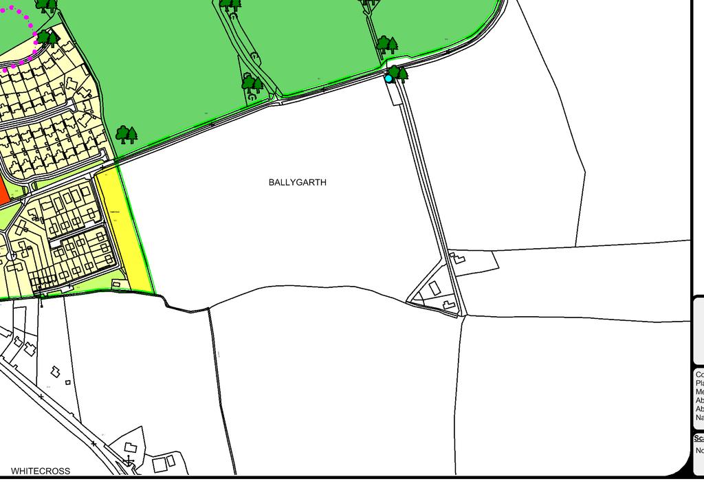
1 Settlement Julianstown Position in Settlement Hierarchy Village - Local centre for services and local enterprise development Position in Retail Strategy Level 5 retail centre Population (2011) Census 616 Committed Housing Units (Not built) 21 Household Allocation (Core Strategy) 24 No. Units Education National School Community Facilities 1 no. Church & 1 no. Community Hall. Natura 2000 sites River Nanny SPA Strategic Flood Risk Assessment No SFRA required. No lands within (SFRA) Flood zone A or B. Goal Julianstown will grow into an attractive, safe and sustainable village. Founded on its rich history and ecology, it will be home to a vibrant, creative and enterprising community, welcoming to all. 01 Village Context Julianstown Village is a designated Architectural Conservation Area within Volume I of the County Development Plan and is situated within the Slane Electoral Area, to the north east of County Meath along the R132 (former N1 National Primary Road). It is located approximately 8 kilometres to the south of Drogheda and 5 kilometres to the north of the former Mosney Holiday Camp. The village originally developed at a crossing point on the River Nanny and consisted of a cluster of mixed development at this location which included residential and commercial uses as well as a former Barracks. The National School was, and remains located to the south of the village core at Whitecross. Julianstown has become a popular location for commuters to Dublin, Drogheda and Dundalk and has seen a population increase of 46% between the years of 2002 and This has resulted in an increase in residential development to both the northeast of the village core and the southeast at Whitecross. It is an objective of the County Development Plan to curtail this form of unsustainable development as per Section and promote a more sustainable level of growth within commuter villages such as Julianstown. Development within Julianstown needs to be consolidated and growth should be directed to appropriate locations within the village envelope. The village should grow in a more sustainable manner than that experienced over the last decade in order to conserve and enhance the established natural and historical amenities of the village and its intrinsic character. In order to facilitate the delivery of the shared vision for Julianstown, land use, movement and access and natural and built heritage strategies have been identified. The land use strategy for Julianstown seeks to accommodate modest levels of population growth in accordance with the levels of growth provided for in Table 2.4 (Core Strategy) of the County Development Plan and to provide for distinctive quality driven residential development and essential local commercial and community facilities. 156
2 02 Water and Wastewater Services Julianstown is currently served by the East Meath Regional Water Supply Scheme (RWSS). The River Boyne at Roughgrange is the main source for the East Meath RWSS. The water is then treated at Staleen waterworks and is distributed to the Julianstown area via Kiltrough Tower reservoir. The commissioning of the Dunshaughlin water treatment plant in April 2012 has reduced the demand on the East Meath Regional Water Supply by c. 500cu.m/day hence freeing up capacity to help supply this area. Notwithstanding the foregoing and progress made in relation to water conservation measures, there is limited available capacity in the scheme and ensuring security of supply to Julianstown is an ongoing challenge. Waste Water is treated at Drogheda Waste Water Treatment Plant. There is an agreement in place between Louth County Council, Drogheda Borough Council and Meath County Council for the sharing of both water supply and wastewater treatment infrastructure. An upgrade of this plant provided a total capacity available to Meath County Council of 27,500 Population Equivalent (PE). There is currently an availability of 10,500 PE. All development proposals shall be considered in the context of the available waste water and water supply capacity. 03 Land Use The principal land uses in Julianstown comprise of residential development served by a limited range of local and community facilities. The lack of commercial and employment opportunities have been identified in Section 5. Residential development as outlined in Section 4 below has largely taken the form of low density residential estates, with houses being set in single plots with front and back gardens. This has caused the village to sprawl outwards from its core. New residential development has not been accompanied by the provision of the necessary employment, retail and community facilities required to serve a growing community. There is a significant need to create additional employment within Julianstown in order to reduce the level of commuting from the village and provide for a more sustainable community. Lands have been identified within the core of the village for B1 Village Centre land use zoning objective and will seek to address the lack of service and employment provision within the village, while residential need will be catered for within the sites identified in both the village core and to the south east of Whitecross National School to the east of St. Patricks Villas. The lands surrounding Ballygarth Castle have been identified with a H1 High Amenity land use zoning objective which acknowledges the special natural and built landscape features at this location. However, it shall remain an objective to develop an integrated tourism and leisure development whilst seeking to protect the special character and setting of the Castle and the other Protected Structures / attendant buildings subject to the preparation of a Design Statement and Conservation Assessment pursuant to LU OBJ. An Appropriate Assessment shall also be required having regard to the inclusion of part of the Framework Plan Area in the River Nanny Special Protection Area. 04 Residential Development Julianstown has experienced significant residential growth relative to its size in recent years as a result of its location within close proximity to the Greater Dublin Area and to Drogheda. Recent residential development consists mainly in the form of suburban semi detached and detached dwellings within medium sized housing estates. Development has occurred to both the north and south of the Village centre. Traditionally, development within the village occurred within the core at the River Nanny extending in a linear form along the approach roads. However development pressure has 157
3 resulted in the village development boundaries extending to the north of the River Nanny and to the south east of Whitecross National School. Pedestrian connectivity from these developments to the village core, sporting facilities and local school is adequate with the exception of a missing section of footpath from St. Marys Church to the National School to the north of the Ballygarth Road. The Core Strategy of the County Development Plan (Table 2.4 refers) provides a housing allocation of 24 no. units to Julianstown over the period. There is also a recent extant planning permission for 21 no. units accessed off the former R132 which is now a cul de sac 1. The Core Strategy of this County Plan seeks to permit a moderate rate of residential expansion within the village over the Plan period. Future development and growth will need to take account of the village s ability to grow in a sustainable manner without causing unacceptable impacts upon the surrounding environment. This Development Framework endeavours to facilitate well designed, sustainable new residential communities in order to promote the efficient use of land and of energy, to reduce pressure for one-off housing on rural lands, and to enhance the character of Julianstown and make provision for future community infrastructure for the village. The amount of allocated units results in a requirement for 1.2 hectares of land to be identified for residential land use purposes on the basis of 20 no. units per hectare. In the East Meath Local Area Plan (2005), a site extending to 0.85 hectares was identified for residential development to the south of the Laytown Road (R150). However, having regard to the sensitive setting of this site, it was an objective of the previous East Meath Local Area Plan to permit only one dwelling at this location. This objective is considered reasonable and shall be retained. The remaining lands which are identified for A2 New Residential and B1 Village Centre land use zoning objectives are available for development and are considered sufficient to cater for the projected number of dwellings required over the life of the County Development Plan. There is no requirement to identify an Order of Priority in relation to the release of lands for residential purposes in the Julianstown land use zoning objectives map. 05 Commercial, Economic and Retail Uses Julianstown is identified as a Level 5 retail centre in the County Retail Hierarchy. Commercial facilities in the village are limited to the existing public house (The Julianstown Inn) on the Drogheda Road (R132) which is presently closed. The Old Mill Hotel stands at the junction of the Duleek and Drogheda roads (R150 & R132 respectively) and is currently derelict following a fire. Having regard to the level of residential development in Julianstown, it is apparent that there is a significant lack of commercial and retail uses within the village to cater for the current and future population of the area. The village is served by convenience stores located on the R132 included as part of petrol filling stations. However, it is considered that there are adequate lands identified for B1 Village Centre land use zoning objective within and adjacent to the core of the village to cater for the existing and future needs of the community. The development of these key sites is also essential for the improvement of the visual amenity of the village core. 06 Community Facilities & Open Spaces Current community facilities in Julianstown include the Churches, Whitecross national school, community centre and Julianstown Golf / Pitch & Putt facility. Meath County Council will support the expansion of these facilities as necessary to serve the existing and additional population in the area. Additional land has been zoned around the Whitecross national school to allow for the extension of the school in the future should such a need arise. The school has been extended through the use of prefabricated structures in the past however there is an intention to provide a more permanent solution to the accommodation requirements for the 1 It is noted that the corresponding figure in Table 2.5 of Volume I of the County Development Plan is 12 no. units. It is considered that this is a typographical error. 158
4 school, in the near future. There are sufficient lands available within the school site to accommodate these works. The River Nanny passes through Julianstown. This area is designated as a Proposed Natural Heritage Area (pnha) and has the potential to act as an amenity space for the village. The Development Framework proposes to develop a walkway along the River subject to an ecological assessment being carried out. A significant area of land has been identified for the provision of integrated tourism / leisure facility to the east of the development boundary at Ballygarth Castle. It is an objective of this Development Framework to seek the provision of appropriately designed open spaces with any new development in the village. 07 Urban Design The first historical references to the parish of Julianstown date back to the Norman era of the 12 th Century, although evidence points to human activity dating back much further. This includes references to a battle in the year 852 involving the local Cianachta clan. The history of Julianstown is intrinsically linked to the River Nanny, both as a crossing point and a resource for industrial activity. In 1641 the village s bridge was chosen by Colonel Plunkett as the ideal location at which to ambush a contingent of government troops on their way to reinforce a besieged Drogheda. This bloody episode is now commemorated by a plaque on the current Bridge. The River Nanny is also thought to have had 14 mills located along its length. The most evident of these today is a corn mill beside the bridge, which was converted into a hotel. Further downstream, the ruins of a limekiln are also a reminder of the brickworks that once operated in the area. The village grew in close relationship with three nearby estates of Dardistown, Moymurthy and Ballygarth. It consisted of few houses and a traveller s inn along the road, then growing in the late 19 th and early 20 th centuries to include the 6 Swiss cottage style houses, Garda station and courthouse. A more recent spell of growth in the late 20 th and early 21 st centuries has resulted in the village we see today. Julianstown has experienced a significant expansion in the amount of residential dwellings in a relatively short period of time; these developments have been primarily of a suburban typology. While this new housing stock in Julianstown may be considered to be generally of a good quality, the suburban layouts are disjointed in terms of location and result in a weak urban form. This approach to residential development has created segregation between the housing estates, school and former commercial developments. Julianstown is a village with many qualities in terms of local distinctiveness and character that must be both preserved and enhanced. The redevelopment of the Old Mill Hotel site at the junction with the Duleek and Drogheda Road has the potential to make a significant contribution to the visual amenity and vitality of the village core. The redevelopment of this site is vital to the overall improvement of the visual and residential amenity of this area. A substantial amount of the village centre is located within an Architectural Conservation Area (ACA) and this recognises the special significance of the built heritage which characterises Julianstown. Care must be taken with regard to any future proposals in this area. Information on ACAs is set down in section of this County Development Plan. Further information on Julianstown ACA is detailed in the Character Statement which is available on the Council s website ( The best method of conserving historic buildings is to keep them in active use. While a degree of compromise will be required in adapting a protected structure to meet the requirements of modern living, it is important that its special interest is not damaged. 159
5 Infill and new proposals must offer high quality designs. The rooflines and elevations of new buildings should be sympathetic to traditional proportions and established patterns of roof pitch within the streetscape. Materials should also be traditional to the local area where appropriate and high quality finishes shall be insisted upon. The reversal of previous inappropriate alterations will also be encouraged. Contemporary design will be considered on a case by case basis and shall be analysed in the context of a particular site. Re-development of backland areas must be appropriate in character and scale with the village. Plot widths should respect established properties and a co-ordinated approach, should be employed to maximise the benefit of a single access. Section and the Meath Rural Design Guide set down in this County Development Plan deals with Urban Design and Architectural Features. This Development Framework aims to promote the development of a high quality, well designed, well landscaped and appropriately scaled environment that is in keeping with the existing character, amenity, environment, heritage and landscape of the village. The design of new development should be responsive to its contextual surroundings and interact appropriately between settlement and landscape always aiming to enrich the existing qualities of the village. Redevelopment of the Old Mill Hotel site should have specific regard to the setting of the terrace of Swiss Cottages to the east of the R132 which are included with the Record of Protected Structures contained within the County Development Plan. High quality design, appropriate use of materials and quality layout will be essential in order to ensure that new development contributes positively to Julianstown and helps to create an attractive and sustainable settlement. 7.1 Julianstown Village Design Statement A Village Design Statement (VDS) is a non-statutory local development framework, compiled by the local community to establish a vision for the future of their village. The Julianstown VDS was the National Pilot for the Heritage Council s National Village Design Programme II, and was community led, in collaboration with the Heritage Council and Meath County Council. Through the process of the VDS, an Action Plan was formulated, and the community is progressing a number of those actions. The analysis undertaken as part of the Julianstown VDS concluded that: Julianstown has a wealth of qualities that must be retained and enhanced. These include buildings and structures of historic or architectural significance (including the Old Mill in need of urgent action), a strong landscape character of river and valley and a combination of the above to create a unique urban form. However, analysis suggests that Julianstown is unsustainable in its present form because of a limited ability to support local amenities and employment; lack of a centre around which such amenities can be focussed; an unacceptable impact of traffic on environmental quality and safety and poor pedestrian and cycle linkages related to the above. The vision contained in the VDS emerged as a result of extensive consultation with the local residents / community groups and has been used as the vision of this Written Statement. 3 aims and a series of accompanying objectives set in place how the vision for Julianstown will be realised. They are accompanied by the Village Design Concept which provides the framework by which principles and projects are identified. 160

6 Figure 1 : Julianstown Village Design Concept Table 1: Aims and Objectives Aims Objectives 1. To protect and enhance Julianstown s distinctive identity through its buildings, structures and landscapes. Conservation / Restoration. Public Realm and Space Enhancement. Management of New Development. 2. To develop Julianstown into a sustainable village with the amenities and quality of environment its community desire. New appropriately designed housing. Comprehensively tackling traffic issues. Interconnection of parts of the village. Introduction of new amenities and facilities. 3. To bring a social and economic vitality back to Julianstown. Development of a strong, mixed use village centre. Attraction of investment and employment. 161
7 Table 2: Principles and Projects Principles 1. Define and celebrate entrance points to the village. 2. Communicate the identity of Julianstown in a co-ordinated way. 3. Reduce traffic volume and speeds. 4. Improve facilities for pedestrians and cyclist. 5. Transform the character from roads to street, via building frontages and streetscape design. Projects 1. Public art at main road entrances to village, signage to attract tourism. 2. Co-ordinate all signage after agreeing a signage strategy. 3. Develop a Julianstown brand and logo. 4. Lobby for long term by pass or another untolled exit from M1 Motorway. 5. Implement concentrated traffic calming. 6. Streetscape Implement footpaths and lighting along roads, making a central feature of the Old Bridge. 7. Explore HGV ban. It is a policy of the County Development Plan (ED POL 41 refers) to facilitate and support the implementation of Village Design Plans whilst ensuring that such plans are consistent with town or village development objectives contained in the County Development Plan. The Julianstown Village Design Statement has informed the preparation of this Development Framework and shall contain an objective seeking to implement the recommendations of the Village Design Statement. 08 Heritage Julianstown nestles in the valley of the River Nanny as the watercourse makes its way to the Irish Sea at Laytown. Much of the village s character stems from this pronounced topography, with nearby fields and the river floodplain clearly visible as the main road dips either side to meet the bridge. The character of the village is therefore intrinsically linked to its landscape setting, sense of place and cultural heritage. The area is rich in ecological and historical value with a designated proposed Natural Heritage Area within the river flood plain and numerous properties included within the Record of Protected Structures of the County Development Plan. There are also a number of archaeological monuments in the village environs which include a Souterrain (SMRS Ref: ME ) to the west of the village core and a Stone feature (SMRS Ref: ME ), Font (SMRS Ref: ME ), and church (SMRS Ref: ME ) to the north east of the Laytown Road. It is an objective of the County Development Plan Volume I to preserve and protect such features. There are no Special Areas of Conservation (SAC) within the village. The River Nanny SPA commences at Laytown coast and continues into the wetlands area of the floodplain to the north east of the village development boundary. The floodplain of this river is also a proposed Natural Heritage Area which is reflected in the zoning objective for the area. With plentiful naturalised areas, Julianstown has good ecological value and high local biodiversity. Its vegetated river banks are home to many species of bird, such as Kingfisher and Grey Wagtail, and its relatively clean waters host Mullet and Trout. As such, it is designated as a Special Area of Conservation (SAC). Julianstown contains several mature and attractive trees which define the landscape setting of the village and in particular the river flood plain. These trees are identified to be protected within the land use zoning objectives map of this Development Framework. 162
8 The natural and built heritage strategy seeks to ensure that a green edge is established surrounding the built up area of Julianstown and that the visual impact of new development is ameliorated by landscaping proposals to repair and enhance the landscape structure of the village. These proposals shall include objectives for existing and new boundary treatments. This Development Framework seeks to protect and enhance the existing built and natural heritage of the village and will seek to ensure that all Government Guidelines are adhered to when considering new forms of development. 09 Movement & Access Julianstown is situated at the cross roads of the R150 and the R132 (former N1 until the M1 Motorway opened in 2003) which are heavily trafficked commuter routes. The M1 is accessed via Junction 7 to the south of Julianstown. Traffic volume and speed is a continuing issue within Julianstown given its strategic positioning in the County. It is considered that the majority of residents in Drogheda and the coastal strip of Meath enter and exit the M1 Motorway at Junction 7 to the south of Julianstown in order to avoid payment of the toll. The village has not benefitted from the opening of the M1 Motorway to the extent which would have been expected and traffic volumes are considerable in both directions daily inclusive of a significant absolute HGV content. It is noted that the recorded Average Annual Daily Trips on the R132 south of Julianstown is 18,855 with 3.1% of HGV content. Furthermore, any future growth of Drogheda, Laytown & Bettystown will further increase the pressure on the roads which pass through the village. It is imperative that a solution is found to alleviate the extent of traffic volumes through the village and seek to transform the R132 from a roadway to an urban street. The transport vision for Julianstown is to ensure that, where necessary, the use of private vehicles is facilitated in an efficient and equitable manner whilst encouraging the use of more sustainable modes of transport including pedestrian and cycle movement. In order to achieve this vision it will be necessary to provide for the improvement in pedestrian and cycle facilities and traffic movement within the village. The provision of pedestrian and cycle links from existing residential developments to the village core will be a priority of this Development Framework. Julianstown is currently served by the 101 bus service by Bus Éireann. This service operates from Talbot Street in Dublin city centre to the Bus Station Drogheda, via Swords, Balbriggan and Julianstown. The 100 and 100X service which include access to Dublin Airport from Drogheda also serve Julianstown. Strategic Policies SP 1 SP 2 SP 3 To promote the future development of the village as a compact settlement with a pedestrian friendly environment, a legible and coherent physical form, and a variety of land uses and amenities. To protect the unique character of the village through the provision of appropriate infill development which has regard to the scale, character, topography and amenities of the village. To address traffic problems on the R132 Regional Road through Julianstown. 163
9 Policies Water and Wastewater Services WWS POL To endeavour to maintain and provide adequate potable water and wastewater treatment infrastructure that is sufficient to meet the development needs of the village within this Plan period. However, the Council acknowledges that there are significant constraints on the capacity of the existing infrastructure and may consider restricting development in circumstances where such infrastructure is inadequate. Flood Risk FR POL 1 To manage flood risk and development in Julianstown in line with policies WS 29 WS 36 inclusive in Volume I of this County Development Plan. FR POL 2 Where existing development in the village envelop is at potential risk of flooding (B1 Village Centre land use zoning objectives refer) as identified on the land use zoning objectives map, any extensions / change of use / reconstruction shall be subject to an appropriately detailed Flood Risk Assessment in line with the policies (WS POL 29-36) contained in Volume I of the County Development Plan. Commercial, Economic and Retail Uses CER POL 1 CER POL 2 To consolidate the central area of the village for commercial uses. To improve the vitality and viability of Julianstown s Village Centre area as the focus of all commercial and retail activity, in order to ensure both a mixture and variety of local shopping to serve the shopping needs of the local community. Community Facilities and Open Spaces CF POL 1 CF POL 2 To support the provision and even distribution of a range of social infrastructure facilities to meet the needs of Julianstown in liaison with other statutory, voluntary, and community groups. To protect the sites of existing facilities and support their further development and expansion. Urban Design UD POL 1 UD POL 2 UD POL 3 To preserve the character of the village by requiring that the height, scale, and design of any proposed development within the village should complement the character of the village and its open space, and not diminish its distinctiveness of place. To facilitate the creation of an urban environment of quality in a visual sense with good urban design with appropriate attention to orientation and landscaping. To enhance landmark/focal points in Julianstown by supporting the redevelopment of neglected sites and obsolete areas, and in particular the Old Mill Hotel. 164
10 UD POL 4 To improve street finishes, footpaths and the public domain. Village Design Statement VDS POL To facilitate and support the implementation of the Julianstown Village Design Plan. Heritage HER POL 1 To protect wildlife corridors including rivers, watercourses, trees and hedgerows within the development envelop. HER POL 2 To have regard to the bio-diversity value of existing trees and hedgerows in areas that are likely to be developed. Movement and Access MA POL 1 To require the provision of short-term on-street vehicle parking where appropriate. MA POL 2 To require screened parking in the village centre. MA POL 3 To require the provision of good public lighting standards on all routes and extension of footpaths and public lighting to the development boundaries on public roads in association with further development. Objectives Flood Risk FR OBJ To seek to implement the recommendations of the Fingal East Meath Flood Risk Assessment and Management Study (FEMFRAMS) as applicable to the River Nanny. Land Use LU OBJ To facilitate an Integrated Tourism/Leisure development at Ballygarth Castle and to conserve and protect the special character and setting of Ballygarth Castle, associated buildings and attendant grounds. To give effect to this objective, Meath County Council shall require the submission of the following with any application for development within lands at Ballygarth Castle: An assessment prepared by a suitably qualified conservation architect which concludes that the proposed development is sited and scaled such that it ensures that the character and integrity of this sensitive designed landscape is respected and not adversely impacted upon. It is advisable that the opinion of the Department of Arts, Heritage & The Gaeltacht is sought in advance of lodging this assessment as part of a planning application; Proposals for the accessing of lands which shall include an appropriate traffic impact assessment in adherence to the requirements of Volume I of the County Development Plan; 165
11 Proposals for piped water services; A Design Statement outlining the evolution of the design process for the proposed development. An emphasis on exemplar sustainable design and aesthetic quality shall be required. Mobility Management Plan for the development. Any development within the subject lands shall be subject to the carrying out of an Appropriate Assessment pursuant to the Habitats Directive ensuring that the proposed development will not adversely impact upon the qualifying interests of any Natura 2000 site. Heritage HER OBJ 1 To protect the following trees, woodland and hedgerow within the village as identified because of their amenity value: 1. Trees along the southern bank of the River Nanny west of the bridge. 2. Trees and hedgerow along the northern side of the Nanny valley to the rear of the existing row of houses fronting onto the old Laytown Road. 3. Woodlands to the south of the National School adjacent to the R132 (subject of Tree Preservation Order Reference in Planning Register 1/77). 4. Trees and woodlands in the Nanny Valley. 5. Trees and woodlands within the lands zoned H1 around Ballygarth Castle. HER OBJ 2 To preserve the following views from development which would adversely impact upon their setting and appreciation: 1. Views from the R150 (Laytown Road) south over the Nanny Valley towards Ballygarth Castle demesne. 2. Views from Ballygarth Manor north over the Nanny Valley to the Church of Ireland. 3. Views from the R132 east over the Nanny Valley. 4. Views from the bridge along the R132 east of the Nanny Valley. 5. Views from the bridge along the R132 west along the Nanny River. 6. Views from Ballygarth Castle north over the Nanny Valley and to the Church of Ireland. HER OBJ 3 To provide screen planting to the existing wastewater pumping station. Movement and Access MA OBJ 1 MA OBJ 2 MA OBJ 3 To investigate the effectiveness of, and if appropriate, progress the implementation of, traffic management and traffic calming options and environmental measures through Julianstown village, in conjunction with the National Roads Authority, Department of Transport, Sport and Tourism and the National Transport Authority with a view to providing an enhanced and safer environment for the village. To improve linkages along the R150 between Julianstown and Laytown including investigating the improvement of cyclist and pedestrian connectivity and facilities between both centres. To improve linkages along the R132 between Julianstown and Drogheda. MA OBJ 4 To provide and/or upgrade footpaths within the development boundary. 166
12 MA OBJ 5 To facilitate the provision of a riverside walk from the village centre to the grounds of Ballygarth Castle. All proposals are likely to require a 10m buffer zone from the river in order to protect the natural heritage. 167


13
Rathmolyon Written Statement
 Settlement Rathmolyon Position in Settlement Hierarchy Village - Local centre for services and local enterprise development Position in Retail Strategy Fourth tier retail centre Population (2011) Census
Drrumconrratth Wrriitttten Sttattementt. Position in Settlement Hierarchy Village - Local centre for services and local enterprise development
 Drrumconrratth Wrriitttten Sttattementt Settlement Drumconrath Position in Settlement Hierarchy Village - Local centre for services and local enterprise development Position in Retail Strategy Level 4
Clonard Written Statement
 Settlement Clonard Position in Settlement Hierarchy Village - Local centre for services and local enterprise development Position in Retail Strategy Fourth tier retail centre Population (2011) Census 339
Ballivor Written Statement
 Settlement Ballivor Position in Settlement Hierarchy Village - Local centre for services and local enterprise development Position in Retail Strategy Fourth tier retail centre Population (2011) Census
Kilmessan Written Statement
 Settlement Kilmessan Position in Settlement Hierarchy Village - Local centre for services and local enterprise development Position in Retail Strategy Fourth tier retail centre Population (2011) Census
Stamullen Written Statement
 Settlement Stamullen Position in Settlement Hierarchy Small Town local commuter town situated close to larger centres. Position in Retail Strategy Level 4 retail centre Population (2011) Census 3,130 Committed
Kildalkey Written Statement
 Settlement Kildalkey Position in Settlement Hierarchy Village - Local centre for services and local enterprise development Position in Retail Strategy Fourth tier retail centre Population (2011) Census
Ratthcaiirrn Wrriitttten Sttattementt
 Ratthcaiirrn Wrriitttten Sttattementt Settlement Rathcairn Position in Settlement Hierarchy Village Serve a smaller rural catchment; provide local services with some smaller scale rural enterprises in
Duleek Written Statement
 Settlement Duleek Position in Settlement Hierarchy Small Town local town situated close to larger centres in this case Drogheda. Position in Retail Strategy Level 4 Retail Centre Population (2011) Census
Summerhill Written Statement
 Settlement Summerhill Position in Settlement Hierarchy Village - Local centre for services and local enterprise development Position in Retail Strategy Fourth tier retail centre Population (2011) Census
Carlanstown Written Statement
 Settlement Carlanstown Position in Settlement Hierarchy Village - Local centre for services and local enterprise development Position in Retail Strategy Fifth tier retail centre Population (2011) Census
Longwood Written Statement
 Settlement Longwood Position in Settlement Hierarchy Village - Local centre for services and local enterprise development Position in Retail Strategy Fourth tier retail centre Population (2011) Census
Drrumcconrratth Wrriitttten Sttattementt. Position in Settlement Hierarchy Village - Local centre for services and local enterprise development
 Drrumcconrratth Wrriitttten Sttattementt Settlement Drumconrath Position in Settlement Hierarchy Village - Local centre for services and local enterprise development Position in Retail Strategy Level 4
Carnaross Written Statement
 Ca n rrnarrossss W t rriittten Sttattementt Settlement Position in Settlement Hierarchy Position in Retail Strategy Population (2011) Geodirectory (No census data available) Committed Housing Units (Not
elbridge Core Strategy
 C elbridge Core Strategy Celbridge is designated as a Moderate Growth Town in the RPGs. The County Development Plan reinforces this designation in its settlement strategy. Moderate Growth Towns within
20. Ballysadare Mini-Plan
 20. Ballysadare Mini-Plan 20. Ballysadare Mini-Plan Community facilities Ballysadare has a wide range of community facilities: a primary school, St Mary s College (secondary school), a health centre, playing
Variation No. 2 Introduction & Explanatory Document Variation made on 19th May 2014
 Meath County Development Plan 2013 2019 Variation No. 2 Introduction & Explanatory Document Variation made on 19th May 2014 1.0 INTRODUCTION The Meath County Development was adopted on 17 th December
Crossakiel Written Statement
 Crrossssakiiell Wrriittten tt Sttattementt Settlement Crossakiel Position in Settlement Hierarchy Village - Local centre for services and local enterprise development Position in Retail Strategy Third
CLOUGHJORDAN SETTLEMENT PLAN
 CLOUGHJORDAN SETTLEMENT PLAN 1.0 General Introduction and Development Context Location The market town of Cloughjordan lies close to the border with Offaly at the junction of the R490 and R491 Regional
Enfield Written Statement
 Settlement Enfield Position in Settlement Hierarchy Small Town local commuter town situated close to larger centres. Position in Retail Strategy Third tier retail centre Population (2011) Census 2,929
BORRISOKANE SETTLEMENT PLAN
 BORRISOKANE SETTLEMENT PLAN 1.0 General Introduction and Development Context Location Borrisokane is located 15km north of Nenagh on the N52. While the town is primarily residential, it acts as a market
Dunboyne/Dunboyne North/ Clonee/ Local Area Plan
 Dunboyne/Dunboyne North/ Clonee/ Local Area Plan Strategic Policy SP 1 To operate an Order of Priority for the release of residential lands in compliance with the requirements of CS OBJ 6 of the County
Meath County Development Plan. Variation No. 1 to Volume 1 Written Statement
 Meath County Development Plan 2013 2019 Variation No. 1 to Volume 1 Written Statement 2 Core Strategy Adopted Variation No. 1-04/11/2013 2.3.3 Residential Zoned Land Provision Table 2.4 details the requirement
Newcourt Masterplan. November Exeter Local Development Framework
 Newcourt Masterplan November 2010 Exeter Local Development Framework Background The Exeter Core Strategy Proposed Submission sets out the vision, objectives and strategy for the development of Exeter up
Tāhuhu whakaruruhau ā-taone The sheltering ridge pole
 B2. Tāhuhu whakaruruhau ā-taone - Urban growth and form B2.1. Issues Tāhuhu whakaruruhau ā-taone The sheltering ridge pole Auckland s growing population increases demand for housing, employment, business,
8.0 Design and Form of Development 43/
 42/ 8.0 Design and Form of Development 43/ Rothwells Farm, Golborne/ Development Statement Figure 7. Site Constraints Key 44/ Site Boundary 360 Bus Route/Stops Existing Trees Underground Water Pipe Sensitive
Ballivor Written Statement
 Settlement Ballivor Position in Settlement Hierarchy Village - Local centre for services and local enterprise development Position in Retail Strategy Fourth tier retail centre Population (2011) Census
BLETCHLEY PARK AREA - DEVELOPMENT FRAMEWORK
 ANNEX A To Item 9 REVISED TEXT: additions shown bold and underlined, deletions in (brackets and in italics). BLETCHLEY PARK AREA - DEVELOPMENT FRAMEWORK This framework sets out the key objectives and requirements
STATEMENT OF OBJECTION TO THE PROPOSED DEVELOPMENT OF LAND AT CHURCH CLIFF DRIVE FILEY
 STATEMENT OF OBJECTION TO THE PROPOSED DEVELOPMENT OF LAND AT CHURCH CLIFF DRIVE FILEY You will be aware that Scarborough borough council have adopted a new local plan that includes land at Church Cliff
6. Ballintogher Mini-Plan
 County Development Plan 2017-2023 Consolidated Draft + Adopted Amendments August 2017 Volume 2, Chapter 6 Ballintogher Mini-Plan 6. Ballintogher Mini-Plan Village profile Ballintogher is located approximately
County Development Plan Consolidated Draft + Adopted Amendments August 2017 Volume 2, Chapter 22 Easky Mini-Plan
 22. Easky Mini-Plan Village profile Easky is a coastal settlement located approximately 40 km to the west of Sligo City, in a designated Rural Area In Need of Regeneration. The nearby coastline is designated
Public Consultation. Land at Monks Farm, North Grove. Welcome
 Welcome Welcome to our public exhibition for development on Land at Monks Farm, orth Grove. Gallagher Estates and Gleeson Strategic Land are preparing an outline planning application for new homes, open
2.0 Strategic Context 4
 2.0 Strategic Context 4 2.1 The Area Action Plan is a non-statutory plan, which forms a corporate policy document, expressing particular issues and areas of concern while also providing a vision for the
30. Riverstown Mini-Plan
 County Development Plan 2017-2023 Consolidated Draft + Adopted Amendments August 2017 Volume 2, Chapter 30 Riverstown Mini-Plan 30. Riverstown Mini-Plan Village profile Riverstown is located approximately
28. Coolaney-Rockfield Mini-Plan
 28. Coolaney-Rockfield Mini-Plan 28. Coolaney-Rockfield Mini-Plan Community facilities Community facilities in Coolaney-Rockfield consist of a primary school, crèche, community centre, sports field and
KELLS DEVELOPMENT PLAN
 KELLS DEVELOPMENT PLAN 2013-2019 J Statement Outlining Compliance with Ministerial Guidelines Adopted 7th October 2013 APPENDIX J STATEMENT OUTLINING COMPLIANCE WITH MINISTERIAL GUIDELINES Under section
DUNSFOLD NEIGHBOURHOOD PLAN Site Selection Policies
 DUNSFOLD NEIGHBOURHOOD PLAN Site Selection Policies The criteria for assessing sites for future housing and business development in Dunsfold are set out below. (Development criteria, covering what it is
Kibworth Harcourt. Introduction. Introduction
 Introduction Introduction Welcome to this public exhibition on the proposals for the delivery of new homes on land at The Kibworths. The purpose of today s exhibition is to give you the opportunity to
Oldccasstle Written Statement t t t
 Oldccasstle Written Statement t t t Settlement Oldcastle Position in Settlement Hierarchy Small Town - developed on a local, independent and economically active basis under the influence of large towns
Meath County Development Plan. Proposed Draft Variation No. 1 to Volume 1 Written Statement
 Meath County Development Plan 2013 2019 Proposed Draft Variation No. 1 to Volume 1 Written Statement 2 Core Strategy Proposed Draft Variation No. 1!" #$ % & ' % $ ($ &' ) $) * (' &+( &' % $ * $ $ * %
17. Coolaney-Rockfield Mini-Plan
 County Development Plan 2017-2023 Consolidated Draft + Adopted Amendments - August 2017 17. Coolaney-Rockfield Mini-Plan Village profile Coolaney is located approximately 23 km to the south-west of Sligo
ALLERTHORPE NEIGHBOURHOOD PLAN
 Allerthorpe s Neighbourhood Plan sets out a vision for the Parish for the next 15 years (2018 2033) that builds on and reflects the opinions and views of parish residents. VISION In 2033 Allerthorpe will
Urban Design Guidelines
 Urban Design Guidelines These Urban Design Guidelines comprise the Key Design Objectives below, the Roads Design Guidelines overleaf and Neighbourhood Framework Plans. Together with Section 3: Urban Design
Kilcock Environs Written Statement
 Settlement Kilcock Environs Position in Settlement Hierarchy Moderate Sustainable Growth Town - self sufficient towns providing supporting facilities for the town and its surrounding catchment. Position
Plan Modification to Chapter B2 of the Auckland Unitary Plan(AUP) Operative in part (15 November 2016)
 Operative in part (15 November 2016)") UNITARY PLAN UPDATE REQUEST MEMORANDUM TO FROM Phill Reid Linley Wilkinson DATE 25 September 2018 SUBJECT Plan Modification to Chapter B2 of the Auckland Unitary Plan(AUP) Operative in part (15 November
UNITARY PLAN UPDATE REQUEST MEMORANDUM TO FROM Phill Reid Linley Wilkinson DATE 25 September 2018 SUBJECT Plan Modification to Chapter B2 of the Auckland Unitary Plan(AUP) Operative in part (15 November
APP/G1630/W/15/
 Appeal Decision Site visit made on 20 October 2015 by William Fieldhouse BA (Hons) MA MRTPI an Inspector appointed by the Secretary of State for Communities and Local Government Decision date: 20 November
Chapter 5 Urban Design and Public Realm
 5.1 Introduction Public realm is all areas of the urban fabric to which the public have access. It is where physical interaction takes place between people. It therefore, includes buildings and their design,
Appendix. Statement Outlining Compliance with Ministerial Guidelines
 18 Appendix Statement Outlining Compliance with Ministerial Guidelines A18 Statement Outlining Compliance with Ministerial Guidelines Under section 28 of the Planning and Development Act 2010, Meath County
Variation No 1: Dundalk & Environs Development Plan Core Strategy
 Variation No 1: Dundalk & Environs Development Plan 2009-2015 Core Strategy Adopted on 29 th August 2011 CONTENTS Page Section 1 1.0 Synopsis 1 1.1 Background Document 1 1.2 Variation of Dundalk and Environs
Woodbrook - Shanganagh
 Section 4: Key Sites Framework Strategy Woodbrook - Shanganagh Local Area Plan 2017-2023 4. Site Framework Strategies The Master Plans shall have regard to the thematic objectives under the LAP Development
Rochford District Council Allocations Development Plan Document: Discussion and Consultation Document Sustainability Appraisal
 Option SWH1 Balanced Communities Option SWH1 1 To ensure the delivery of high quality sustainable communities where people want to live and work Will it ensure the phasing of infrastructure, including
Overview Report. Proposed Development
 Overview Report Proposed Development the construction of a 1km cycle/pedestrian trail including a new footbridge, new car park and entrance road at Drumshanbo Lock and a new pedestrian/cycle road crossing,
Schedule of Planning Applications Committee Date: 23 May Reference: 06/17/0726/F Parish: Hemsby Officer: Mr J Beck Expiry Date:
 Schedule of Planning Applications Committee Date: 23 May 2018 Reference: 06/17/0726/F Parish: Hemsby Officer: Mr J Beck Expiry Date: 22-05-2018 Applicant: Proposal: Site: Mr Gillett Change of use to the
Settlement Boundaries Methodology North Northumberland Coast Neighbourhood Plan (August 2016)
") Introduction This background paper sets out a methodology for the definition of settlement boundaries in the North Northumberland Coast Neighbourhood Plan. The neighbourhood plan is planning positively
Introduction This background paper sets out a methodology for the definition of settlement boundaries in the North Northumberland Coast Neighbourhood Plan. The neighbourhood plan is planning positively
INTRODUCTION NORTH HEYBRIDGE GARDEN SUBURB
 INTRODUCTION This event is being hosted by the promoters of the proposed North Heybridge Garden Suburb who are working with Maldon District Council and other key stakeholders on the preparation of a comprehensive
WHITELEY TOWN COUNCIL NORTH WHITELEY DEVELOPMENT SEPTEMBER 2014
 WHITELEY TOWN COUNCIL NORTH WHITELEY DEVELOPMENT SEPTEMBER 2014 Dear Resident This Special Edition of the Whiteley Voice which has been prepared in conjunction with the North Whiteley Consortium is to
WELCOME GYPSY LANE. Wider Site Location plan. Proposals for the development of LAND OFF FOXLYDIATE LANE WEBHEATH. Proposals for the development of
 WELCOME The developers are preparing an outline planning application for a residential led development and need the community s views in order to develop the proposals further WHAT IS PROPOSED? A high
Carlanstown Written Statement
 Settlement Carlanstown Position in Settlement Hierarchy Village - Local centre for services and local enterprise development Position in Retail Strategy Fifth tier retail centre Population (2011) Census
Great Easton Neighbourhood Plan Statement of Basic Conditions
 Great Easton Neighbourhood Plan 2017-2031 Statement of Basic Conditions OCTOBER 2016 GREAT EASTON PARISH COUNCIL Contents 1.0 Introduction....Page 2 2.0 Summary of Submission Documents and Supporting Evidence..
Page 1 of 19 URBAN DESIGN FRAMEWORK FOR BOLTON STREET WATERFORD
 Page 1 of 19 URBAN DESIGN FRAMEWORK FOR BOLTON STREET WATERFORD 1.0 Introduction: The relocation of the City Council stores and depot from Bolton Street creates an exciting opportunity for development
Pre Draft Manager s Report Meath County Development Plan TABLE OF CONTENTS
 Pre Draft Manager s Report Meath County Development Plan 2013-2019 TABLE OF CONTENTS Section 1 Introduction and Overview of Pre Draft Consultation Report 1.1 Introduction... 1 1.2 Pre Draft Public Consultation...
Welford-on-Avon Neighbourhood Plan Consultation Event Sunday, 6 April Your name Your address
 Welford-on-Avon Neighbourhood Plan Consultation Event Sunday, 6 April 2014 Your name Your email address Please either: - complete this feedback form and put it in the box before leaving the Memorial Hall
Former Rockcliffe Airbase Community Design Plan Guiding Design Vision and Principles December 4, 2013
 APPENDIX 5 - Guiding Design Vision and Principles Former Rockcliffe Airbase Community Design Plan Guiding Design Vision and Principles December 4, 2013 Vision Statement The redevelopment of the former
The Proposed Auckland Unitary Plan (notified 30 September 2013)
") 3 Business zones Introduction There are 10 business zones in the Unitary Plan: City Centre Metropolitan Centre Town Centre Local Centre Neighbourhood Centre Mixed Use General Business Business Park Light
3 Business zones Introduction There are 10 business zones in the Unitary Plan: City Centre Metropolitan Centre Town Centre Local Centre Neighbourhood Centre Mixed Use General Business Business Park Light
Neighbourhood Planning Local Green Spaces
 Neighbourhood Planning Local Green Spaces Introduction... 2 1. Why green space is important... 4 2. Neighbourhood plans and green space... 6 3. Evidence... 8 Statutory designations... 9 Green space audit...
3.0 Policy Context. 3.1 Introduction. 3.2 National Spatial Strategy, The Role of East Meath under the NSS
 3.0 Policy Context 52 Policy Context 3.0 Policy Context 3.1 Introduction There is an extensive range of strategic guidance and policy for land use planning in Ireland. This has been fully examined in the
3.0 Area-Wide Strategies 30
 3.0 Area-Wide Strategies 30 3.6 Tourism Strategy This section of the plan aims to develop and improve the tourism potential of the area. Strategic Context The City Plan outlines the potential of Cork to
Appendix 1 Structure plan guidelines
 Appendix 1 Structure plan guidelines This appendix forms part of the regional policy statement [rps]. 1.1. Introduction Structure plans are an important method for establishing the pattern of land use
Droitwich Spa 6. Reasoned Justification
 87 Droitwich Spa 6 Reasoned Justification 6.1 Droitwich Spa is identified in the settlement hierarchy (Policy SWDP1) as a main town being the largest settlement in Wychavon District with an estimated population
Complete Neighbourhood Guidelines Review Tool
 Complete Neighbourhood Guidelines Review Tool Prepared By: City of Regina Planning Department October 2014 Page 1 of 14 Community Development Review Checklist for Secondary Plans and Concept Plans The
Site Assessment Technical Document Appendix A: Glossary
 Central Bedfordshire Council www.centralbedfordshire.gov.uk Site Assessment Technical Document Appendix A: Glossary July 2017 1.1.11-1 - ii Appendix A: Glossary Term Agricultural Land Classification AONB
Parish of Repton NEIGHBOURHOOD DEVELOPMENT PLAN
 Parish of Repton NEIGHBOURHOOD DEVELOPMENT PLAN BASIC CONDITIONS STATEMENT December 2018 CEF 4 Legal Requirements This statement has been produced by the NDP Working Group on behalf of Repton Parish Council
Colchester Northern Gateway Master Plan Vision Review Draft. July 2016
 Colchester Northern Gateway Master Plan Vision Review Draft July 2016 Contents Introduction 4 Context 8 Purpose of the Report 8 Strategic Position 9 Overview of the Process 11 2012 Master Plan Vision 12
Proposed Amendment to the
 Proposed Amendment to the Carrigaline Electoral Area Local Area Plan Amendment No 1: Carrigaline (T-02, O-02 & U-02) August 2012 Proposed Amendment to the Carriagline Electoral Area Local Area Plan 2011
The Fairfield Partnership Vision for North-East Elsenham
 The Fairfield Partnership Vision for North-East Elsenham August 2009 Frequently Asked Questions Who is The Fairfield Partnership? The Fairfield Partnership is a joint venture between Marchfield Developments
WELCOME. Land North of STEVENAGE. We would like to thank you for attending our public exhibition today.
 WELCOME We would like to thank you for attending our public exhibition today. The purpose of this event is to share our proposals and hear your thoughts on our ideas. Members of the project team are on
Derry City and Strabane District Council Planning Committee Report. Amended layout from approval A/2004/0462/F with reduction from 166 units
 Derry City and Strabane District Council Planning Committee Report COMMITTEE DATE: 1 st February 2017 APPLICATION No: APPLICATION TYPE: PROPOSAL: LOCATION: APPLICANT: AGENT: Full Planning application Amended
Design Guidance. Introduction, Approach and Design Principles. Mauritius. November Ministry of Housing and Lands. .. a
 sig evelo r D Mauritius s. Utilities.. Individu a s. er itects.to ls chpers.po e Public. T. h rban D Sc U e me Promot e h ners. A Design Guidance o.h Planne rs n w iticians r l useholde National Development
Welcome to our exhibition
 Welcome to our exhibition The Homes & Communities Agency (HCA) welcomes you to this public exhibition explaining our proposals for the redevelopment of the former Lea Castle Hospital site. About the Homes
Navan 1. Nevinstown 2. Farganstown 3. Liscarton
 Review of Economic Development Sites and Residential Lands regarding the Proposed Variation No. 3 (Phase 3b) for Meath County Council Navan Review of Economic Development Sites regarding the Proposed Variation
URBAN DEVELOPMENT QLDC PROPOSED DISTRICT PLAN [PART TWO] AUGUST 2015
![URBAN DEVELOPMENT QLDC PROPOSED DISTRICT PLAN [PART TWO] AUGUST 2015](/thumbs/80/81778199.jpg "URBAN DEVELOPMENT QLDC PROPOSED DISTRICT PLAN [PART TWO] AUGUST 2015") 4 URBAN VLOPMNT U R P QLC PROPO ITRICT PLAN [PART TWO] AUGUT 2015 4 ur b an de v elop ment QLC ITRICT PLAN [PART TWO] AUGUT 2015 4 urban development 4 2 4.1 Purpose The purpose of this Chapter is to set
4 URBAN VLOPMNT U R P QLC PROPO ITRICT PLAN [PART TWO] AUGUT 2015 4 ur b an de v elop ment QLC ITRICT PLAN [PART TWO] AUGUT 2015 4 urban development 4 2 4.1 Purpose The purpose of this Chapter is to set
MOUNT AVENUE MASTERPLAN WORKING DRAFT NOVEMBER 2006
 MOUNT AVENUE MASTERPLAN WORKING DRAFT NOVEMBER 2006 1 1. OVERALL MASTERPLAN IDENTITY: Dun Dealgan motte and bailey The Dun Dealgan motte and bailey, a national monument, is located to the north east of
REMARKABLES PARK ZONE
 .10 Remarkables Park Zone.10.1 Resources, Activities and Values The Remarkables Park Area comprises approximately 150 hectares of perimeter urban land in the vicinity of Frankton and occupies a strategic
WELCOME TO THE NEW WILTON PARK
 WELCOME TO THE NEW WILTON PARK VISION HISTORY OF WILTON PARK TOWARDS A PLANNING APPLICATION Our objective is to create a truly outstanding environment at Wilton Park. At the heart of our proposals is a
Regional Context Statement
 Regional Context Statement REGIONAL CONTEXT STATEMENT 3. REGIONAL CONTEXT STATEMENT In 1995, the Provincial Government passed into law the Growth Strategies Act. The purpose of this provincial initiative
Edenderry Local Area Plan
 Edenderry Local Area Plan 2017-2023 MATERIAL ALTERATIONS TO DRAFT EDENDERRY LOCAL AREA PLAN Public Display Document Section 1: Introduction 1.1 Introduction This report focuses on the proposed material
Copyright Nigel Deeley and licensed for reuse under this Creative Commons Licence
 1 Copyright Nigel Deeley and licensed for reuse under this Creative Commons Licence Prepared by the Neighbourhood Plan Steering Group on behalf of Garway Parish Council with assistance from 2 Table of
A VISION FOR BLAIRGOWRIE
 Welcome to the Westpark Partnership and Lidl UK GmbH Community Presentation. The purpose of this presentation is for you to view and comment upon the revised and updated proposals for the allocated development
Official Plan Review
 Official Plan Review Summary Report - The Built Environment August 2014 Part 1: Introduction Planning for a healthy, prosperous and sustainable community is an important goal for our municipality. From
LONGDEN VILLAGE DEVELOPMENT STATEMENT
 LONGDEN VILLAGE DEVELOPMENT STATEMENT 2017-2027 1 Longden Development Statement 2017-2027 15/01/18 1. Background 1.1 Longden Village Longden village is a very rural and traditional community first mentioned
CENTRAL BEDFORDSHIRE COMMITTED TO WORKING TOGETHER WITH LOCAL COMMUNITIES
 WELCOME Thank you for coming to our consultation event to find out more about our emerging proposals for Hayfield Park, a residential development jointly promoted by the Hayfield Consortium: Martin Grant
INCREMENTAL CHANGE AREA REVIEW March 2015 Page 1
 INCREMENTAL CHANGE AREA REVIEW March 2015 Page 1 Table of Contents Introduction... 3 Background to Review... 3 Comparison of the Schedules to the General Residential Zone... 7 Methodology... 7 Policy Context...
35. Gorteen Mini-Plan
 35. Gorteen Mini-Plan 35. Gorteen Mini-Plan Community facilities Community facilities in Gorteen consist of a crèche, community centre, sports field, church, burial ground and health centre. The former
Chapter 2: OUTLINE PLANNING APPLICATION PROPOSALS. A New Garden Neighbourhood Matford Barton 17
 Chapter 2: OUTLINE PLANNING APPLICATION PROPOSALS A New Garden Neighbourhood Matford Barton 17 2.1. SUMMARY AND STATUS OF THE PROPOSALS 2.1.1. The parameter plans and associated wording in this chapter
SUBMISSION TO DRAFT FINGAL COUNTY DEVELOPMENT PLAN RE: LANDS AT CASTLEKNOCK VILLAGE CENTRE
 April 2016 SUBMISSION TO DRAFT FINGAL COUNTY DEVELOPMENT PLAN 2017-2023 RE: LANDS AT CASTLEKNOCK VILLAGE CENTRE On behalf of: Lidl Ireland GmbH Submitted to: Planning & Strategic Infrastructure Department
URBAN DESIGN BRIEF URBAN DESIGN BRIEF 721 FRANKLIN BLVD, CAMBRIDGE August 2018
 URBAN DESIGN BRIEF URBAN DESIGN BRIEF 721 FRANKLIN BLVD, CAMBRIDGE August 2018 DESIGN BRIEF CONTENTS PART A 1.0 INTRODUCTION 2.0 DESCRIPTION & ANALYSIS OF SITE CONTEXT 3.0 DESIGN CONSTRAINTS AND OPPORTUNITIES
4.0 URBAN DESIGN FRAMEWORK. The vision for the future development of the plan area is to:
 4.0 The vision for the future development of the plan area is to: Create a new neighbourhood that focuses on the highly valued natural and aesthetic features of the lands and provides good quality homes,
PUBLIC REALM STUDY AREA
 WELCOME PUBLIC REALM STUDY AREA WHAT IS PUBLIC REALM? Welcome to the Ballina Town Public Realm public consultation event. Mayo Council is in the process of producing a Public Realm Strategy for Ballina
Incorporating Draft Amendment Number 1 Made on 2 nd of March 2015
 Incorporating Draft Amendment Number 1 Made on 2 nd of March 2015 Ratoath Local Area Plan CONTENTS CHAPTER 1 BACKGROUND INFORMATION 1.1 Introduction... 1 1.2 Scope of the Local Area Plan... 2 1.3 Ratoath
16. Collooney Mini-Plan
 16. Collooney Mini-Plan Village profile Collooney is located approximately 13 km to the south of Sligo City, in a designated Rural Area under Urban Influence. The village provides a range of services for