Preliminary Environmental Information Report (PEIR): Stage 1 PART 1
|
|
|
- Rudolf Hutchinson
- 5 years ago
- Views:
Transcription
: Stage 1 PART 1")
1 Rail Central Preliminary Environmental Information Report (PEIR): Stage 1 PART 1 April 2016
2 Contents 1. Introduction 3 2. Description of the Application Site and the Surrounding Area 6 3. Description of the Proposed Development Overview of Relevant Legislation, Policy and Guidance Purpose of Consultation Overview of Consultation EIA process Need and Alternative Sites Air Quality Agricultural Land Archaeology Cultural Heritage Ground Conditions Hydrology, Drainage and Flood Risk Utilities Biodiversity Landscape and Visual Noise and Vibration Highways and Transportation Rail Socio Economic Lighting 318
3 Figures Figure 2.1 Figure 3.1 Figure 9.1 Figure 11.1 Figure 11.2 Figure 11.3 Figure 12.1 Figure 15.1 Figure 16.1 Figure 17.1 Figure 17.2 Figure 17.3 Figure 17.4 Figure 17.5 Figure Figure Figure Figure Figure Figure Figure 18.1 Parameters Plan Illustrative Draft Masterplan Map of Monitoring Locations Diffusion Tube Study for Air Quality Cultural Heritage Assets within the Potential Development Area Cultural Heritage Find-Spots within the Potential Development Area Cultural Heritage Assets within 1km of the Potential Development Area Indicative Heritage Assets Plan Utilities Plan Preliminary Ecological Appraisal Landscape Policy and Designations National Landscape Character Local Landscape Character Visual Context Zone of Theoretical Visibility base on bare earth topography Viewpoint 1: Barn Lane, Milton Malsor Viewpoint 4: Footpath RD1, Blisworth Viewpoint 6: Footpath KX16 Viewpoint 8: Milton Road, Gayton Viewpoint 12: Grand Union Canal Towpath Viewpoint 13: Courteenhall Road, Blisworth Noise, Vibration and Weather Monitoring Locations Figure 18.2 Baseline Noise and Weather Monitoring Data NML 1, 5, 7 and 8 Figure 18.3 Figure 19.1 Figure 19.2 Figure 19.3 DEFRA Strategic Noise Maps Highways Study Area Local Highway Network A5/A43 Tove Roundabout improvement Scheme Figure 19.4 A43 Abthorpre Roundabout Improvement Scheme 2016 Figure 22.1 Figure 22.2 Figure 22.3 Figure 22.4 Locations of Sensitive Receptors Overview of Site Location: Day Time Panorama Overview of Site Location: Night Time Panorama Preliminary Operational External Lighting Parameters
4 1. Introduction 1.1 Ashfield Land Management Limited (The Applicant) intends to make an application to the Planning Inspectorate (PINS) for a Development Consent Order (DCO) under the Planning Act 2008 (PA 2008) for a new Strategic Rail Freight Interchange (SRFI) within the administrative boundary of South Northamptonshire Council (SNC). 1.2 An application for Development Consent is required to be made to PINS because the Rail Central project (Proposed Development) is considered to comprise a Nationally Significant Infrastructure Project (NSIP) under the terms of subsections 26(3) to (7) of the PA Within this context, and having due regard to paragraph 4.89 of the National Networks National Policy Statement (NN NPS), the Proposed Development is an NSIP because the following criteria apply: 1.3 The Proposed Development: is located within England; is in excess of 60ha in area; will be capable of handling consignments of goods from more than one consignor and to more than one consignee; will be capable of handling at least four trains per day and will be capable of increasing the number of trains handled; will be capable of handling 775m trains with appropriately configured on-site infrastructure and layout; will be part of the railway network within England; will include warehouses to which goods can be delivered from the railway network in England either directly or by means of another form of transport; and will not be part of a military establishment. Ashfield Land Management Limited 1.4 The Applicant is a UK commercial property company with a strong track record of delivering successful projects and developments. 1.5 With more than 25 years experience, the Applicant has demonstrated its capability in bringing forward successful investment, development and regeneration projects. 1.6 The Applicant is the promoter for the Proposed Development and will submit the application for Development Consent following a pre-application consultation process and preparation of the DCO application documents.
5 Preliminary Environmental Information Stage 1 Report: Document Content and Structure 1.7 The purpose of the Preliminary Environmental Information Stage 1 Report PEIR (S1) is to provide consultees with information regarding the Proposed Development and its likely environmental impacts. This PEIR (S1) should be read in conjunction with the accompanying Non-Technical Summary (NTS), which is intended to provide an accessible summary of this report, and the Statement of Community Consultation (SoCC), which describes in more detail how the Applicant proposes to consult the local community about the Proposed Development. All three documents form part of the consultation that is being undertaken with local authorities, local residents and other consultees. 1.8 Further details on the consultation process are set out in Chapters 5 and The following chapters of the PEIR (S1) provide: a description of the Proposed Development Area and its location; a description of the Proposed Development and its characteristics in so far as it is possible to do so at this stage; Overview of relevant legislation, policy and guidance; An explanation of the purpose of this document; An overview of the consultation process; Technical sections; and Conclusions Preparation of the document has been led by Turley, on behalf of the Applicant. Other expert contributions have been provided by: Table 1.1 Technical Contributors by Topic Topic Consultant Landscape and Visual Archaeology Cultural Heritage Ecology & Biodiversity Highways and Transportation Noise and Vibration Ground Conditions and Contamination Flood Risk and Drainage RSK CFA Archaeology Turley RSK Transport Planning Associates Spectrum Acoustics Hydrock Hydrock
6 Utility Infrastructure Air Quality Socio Economic Agricultural Land Climate Change Rail Consultation Construction Lighting Hydrock RPS Turley Reading Agricultural Turley Intermodality Camargue RPS Hoare Lea Lighting
7 2. Description of the Application Site and the Surrounding Area 2.1 The SRFI Proposed Development Area (PDA) is in Northamptonshire in the East Midlands region of England and is approximately 20km northwest of Milton Keynes and approximately 6km south of Northampton. Highway improvement works will also be required outside of the PDA, but the extent of the works are not sufficiently advanced to be considered within this Report. 2.2 The PDA is within the administrative boundary of South Northamptonshire Council (SNC). 2.3 The PDA, which comprises a total of approximately 250ha, is bound to the east by the Northampton Loop Line and to the south by the West Coast Main Line, beyond which lie agricultural fields and the village of Blisworth. To the north, the PDA is bound by further agricultural fields and the village of Milton Malsor. The A43 passes through the PDA to the west. Northampton Road/Towcester Road runs through the PDA from north to south. The Parameters Plan, which is enclosed at Figure 2.1 shows the extent of the PDA, which at this time only relates to the main Rail Central site. The final ES will also include any areas where highway improvements are required. 2.4 The PDA largely consists of large-scale arable farmland, with some smaller scale pastoral fields located within its north-eastern extent, just to the south of the village of Milton Malsor. Nearly three-quarters of the land is classified as moderate quality Subgrade 3b, with the remaining one-quarter classified as Best and Most Versatile land in Grades 2 and 3a. 2.5 Given the extent of the PDA and the low number of buildings, there is a limited amount of tree and hedgerow cover. Field boundaries generally have some hedgerow or intermittent tree cover, however this is limited. There are occasional belts of dense and mature deciduous tree planting beside linear infrastructure features, such as the A43 road at the western extent of the PDA and the railway line at the eastern extent of the PDA. 2.6 The Grand Union Canal crosses through the south-western corner of the PDA. 2.7 The PDA is intersected by a watercourse which is named (for the purpose of this PEIR (P1)) as the Milton Malsor Brook. The Milton Malsor Brook flows in a predominantly northerly direction through the approximate centre of the PDA before draining into a watercourse a short distance to the north of the PDA. It is believed that the watercourse is referred to locally as the Shoal Creek. Designations 2.8 There are no statutory designated sites for nature conservation within 5 km of the PDA. The closest European designated site is the Upper Nene Valley Gravel Pits Special Protection Area (SPA), which lies 5.6 km north-west of the PDA.
8 2.9 Information on the 21 non-statutory designated sites that fall within 2 km of the PDA are set out in Table 2.1. Table 2.1: Non-Statutory Sites within 2km of the PDA Boundary Site Name Designation Distance (m) Nene Valley Nature Improvement Area Nature Improvement Area Covers part of north-west of PDA The Nene Valley NIA covers an area of 41,000 hectares running through Northamptonshire to the eastern fringes of Peterborough. It includes the River Nene and its tributaries, gravel pits, reservoirs, wetlands and farmland. Unidentified site off Towcester Road No information Unidentified site on A43 embankment No information Unidentified site at Blisworth Junction No information Grand Union Canal - Northampton Arm Potential Wildlife Site Potential Wildlife Site Potential Wildlife Site Local Wildlife Site Within the PDA Adjacent to PDA Adjacent to PDA Adjacent to PDA The site qualifies as a Wildlife Site due to its diverse aquatic plant communities and bankside grassland habitats. Unidentified site off Station Road No information Potential Wildlife Site 20m Gayton Meadow Potential Wildlife Site 320m Unmanaged grassland with a mixture of wet and dry grassland species including abundant marsh thistle. Roade Cutting Potential Wildlife Site 420m No information provided on nature conservation interest Gayton Reserve Lake Local Wildlife Site 585m A small lake and associated wetland area forming a useful wildlife habitat on the edge of the Limes Caravan Park. The lake qualifies as a Wildlife Site due to its aquatic community and the wetland vegetation. Unidentified site south-east of Rothersthorpe Potential Wildlife Site 765m
9 Site Name Designation Distance (m) No information Junction 15 Grassland Potential Wildlife Site 1,050m This site holds four indicators from the neutral grassland indicators list; although a reasonable number this is not enough to qualify as a County Wildlife Site (CWS). However, with appropriate management the quality if the grassland habitat may improve sufficiently to meet the CWS selection criteria Unidentified site at Courteenhall Potential Wildlife Site 1,095m No information Collingtree Potential Wildlife Site 1,100m No information Unidentified site at The Poplars, Rothersthorpe Potential Wildlife Site 1,110m No information Collingtree Golf Course Local Wildlife Site 1,225m A stream and series of lakes and ponds through Collingtree Golf Course which provide a useful wildlife corridor and good wetland habitat. The complex qualifies as a Wildlife Site as 15 wetland indicator species were recorded alongside further aquatic and emergent species and plant communities. Unidentified site south of Rothersthorpe Potential Wildlife Site 1,240m No information Unidentified site east of Gayton Potential Wildlife Site 1,245m No information Unidentified site on Grand Union Canal Potential Wildlife Site 1,250m No information Bliswoth Rectory Farm Quarry Potential Wildlife Site 1,500m This ex-quarry and surrounding grassland has some relatively species rich neutralcalcareous grassland Unidentified site north of Gayton Potential Wildlife Site 1,540m No information Wootton Railway Embankments Local Wildlife Site 1,930m
10 Site Name Designation Distance (m) This site qualifies as a LWS because it contains a lichen listed in the Northamptonshire Red Data Book as a Northamptonshire Scarce Species. The remaining acid grassland is currently too degraded to qualify as LWS. It is under serious threat and will be lost entirely unless management is altered soon The PDA does not fall within any national, regional or local landscape designations There are three Registered Parks and Gardens within 5km of the PDA. Courteenhall is located 1km east of the PDA, Stoke Park is located approximately 4.2km south of the PDA and Easton Neston is located approximately 4.9km south, south-west of the PDA With respect to local landscape policy areas, the South Northamptonshire Tove Valley Special Landscape Area is located 3.0 km to the south of the PDA In addition to the landscape designations and policy areas identified, there are Conservation Areas located within 5km of the PDA. Conservation Areas are primarily heritage designations, however their setting is of potential relevance to this report. Conservation Areas identified are: Milton Malsor, which is located adjacent to the northern boundary of the PDA; Blisworth, which is located 0.5 km south of the PDA; Gayton, which is located 1.0 km west of the PDA; Rothersthorpe, which is located 1.0 km north-west of the PDA; Courteenhall, which is located 1.0 km east of the PDA; Stoke Bruerne, which is located 3.0 km south of the PDA; Hulcote, which is located 4.8 km south-west of the PDA; Easton Neston, which is located 5.0 km south-west of the PDA; Bugbrooke, which is located 4.5 km north-west of the PDA; and Kislingbury, which is located 4.5 km north-west of the PDA There are a number of listed buildings in the vicinity of the PDA.
11 3. Description of the Proposed Development 3.1 The Proposed Development will be limited by a series of parameters which set the maximum amount of development that can be achieved on the site. A masterplan has been prepared which shows the maximum extent of the development that could be delivered under those parameters (Figure 3.1). At this time, the description of the Proposed Development only relates to the main Rail Central site. The final ES will also include any areas where highway improvements are required. 3.2 The scheme will provide up to 8 million sq. ft. of rail-served warehousing space. Provision has been made for up to three of the larger warehouse units (around 2.3 million sq. ft.) to be capable of direct rail siding access into / alongside, whilst the remainder will be served by a common-user, open-access intermodal facility. The masterplan shows a configuration of buildings, which is the largest that could be achieved under the current parameters. This is intended to illustrate the worst case for assessment in the Environmental Impact Assessment which is being undertaken. 3.3 The scheme will take rail access from two points on the national rail network. 3.4 The majority of the anticipated rail freight services are expected to access the site via the Northampton Loop line (known historically as the Roade & Rugby New Line), which handles most of the freight and non-express passenger services at present. Trains will be able to access from either direction on the main line, with trains passing directly into or alongside the intermodal terminal to facilitate fast turnaround of trains once off the main line. Provision has been made in the track layout design to allow both diesel- and electrically-hauled trains to access the sidings. 3.5 In addition (and uniquely for a SRFI), the masterplan also makes provision for access to and from the West Coast Main Line itself (known historically as the London to Rugby Line), mainly for a smaller number of express freight services, similar to those used by the Royal Mail between London, Warrington, Glasgow and Newcastle (and more recently used by Eddie Stobart, Sainsburys and TNT). Access would again be provided from both directions of travel for diesel- and electrically-hauled express freight trains, the loop off the main line being of sufficient length to allow trains to enter and depart at higher speeds. A cross-dock platform would allow trains and goods vehicles to transfer goods quickly between modes. This facility would allow freight users to benefit from faster transits than possible with road haulage or traditional rail freight services. 3.6 The four separate main line access points (two on the Northampton Loop and two on the West Coast Main Line itself) would also be interconnected within the site, providing maximum flexibility in moving trains on and off site as directed by Network Rail. For example, when either of the two main line routes is closed for engineering works, or due to disruption, the rail layout would enable Network Rail to route services via the other main line if necessary. 3.7 The intermodal terminal would be equipped with multiple sidings capable of handling maximum length (775m) freight trains. All of the non-electrified sidings would be
12 accessible for overhead gantry crane operation, providing more efficient (and electrically-driven) interchange of containers between road and rail. The terminal operator would be able to stable or process intermodal trains in the same set of sidings, reducing the shunting time normally associated at SRFI with separate duplicated sidings for train stabling (reception) and handling. Space would be provided alongside the sidings for containers to be stored temporarily if required between road and rail interchange. The intermodal terminal would be open to all users, whether on-site or offsite, and would be open to all rail freight operating companies (FOCs) as a fully openaccess facility. Dedicated container handling vehicles (known as tugmasters or dockspotters ) would be available to occupiers on site to move containers between the intermodal terminal and individual warehouse units. The intermodal terminal would also have facilities for secure parking of HGVs awaiting entry to the handling area (typically achieving a 20-minute turnaround once inside), along with ancillary facilities including driver amenities, maintenance, administration and workshop buildings. 3.8 Additional rail formations on site would then allow for direct siding access into or alongside some of the larger warehouse units, or to provide stabling and servicing facilities for locomotives and rolling stock. This would help replace facilities (and skills) lost at the nearby historic Wolverton Railway Works to the south, which has been heavily rationalised in recent years. 3.9 The creation of the rail connections will involve creating level land, laying tracks and any necessary works for public rights of way, landscaping and drainage infrastructure Road access to the site will be taken from a new grade separated junction on the A43. This will provide access to a central spine road which will serve the entire site. A truck park facility will be provided which will remove the potential for drivers arriving early to site to park on the wider local road network The main development site will be split into two distinct areas The smaller area between the A43 and Northampton Road / Towcester Road will be split into two main development zones, to the north and south of the spine road. These will provide for several logistics buildings with a maximum height of around 18.5m. The development zones will need to be levelled. Each building will have landscaping, car parking, HGV parking, access docks and a range of ancillary development, including gatehouses, vehicle maintenance areas, vehicle washing facilities and cycle parking The larger area of the site is located to the east of the site, between Towcester Road / Northampton Road and the railway lines Access to this area will be taken via the main spine road. There are currently two options to cross Towcester Road, including a new roundabout and an underpass. The underpass option would segregate site traffic from traffic using Towcester Road and it would remove the potential for HGV s to attempt to travel through either Blisworth or Milton Malsor. This is currently the preferred option This eastern area of the site will be split into three development zones, each having buildings as described above. There will also be the proposed intermodal facility and the express freight cross dock platform located adjacent to each of the railway lines.
13 3.16 There is a further area of site available to the west of the A43, which has the potential to accommodate a range of uses to support a SRFI. This area could provide a hotel, restaurant or an office based use. The nature of supporting potential uses is open to consultation inputs Around the site, landscaping will be undertaken with the aim of integrating the development into the surrounding landscape and limiting its visibility from the surrounding area. This will incorporate earth mounding, belts of tree and shrub planting, surface water features, including landscaped balancing ponds, swales and marginal aquatic habitats. Landscaping will also be provided within the site, forming boundaries between building plots and breaking up areas of car parking. Where possible, the existing field pattern will be retained and enhanced The construction of the site will be undertaken in a phased manner. The precise phasing of works has not been determined, but it is likely that the first stage of works will be taking an initial construction access from the A43. This will most likely use the former petrol filling station access point. This will allow the establishment of a construction compound to the west of the site. Works will then start with the creation of the main site access from the A43, which will facilitate the main road based access for the construction phase A central haul road will then be created to Northampton Road, to allow works on the underpass to begin. Once complete, this will allow access to the eastern area of the site. Construction access will then be taken to the eastern boundary and another construction compound created. This will allow works to begin on creating the rail infrastructure for the intermodal terminal. These initial rail works will allow the use of rail for some construction activity, potentially including bulk deliveries or exports. The first phase of rail works is unlikely to involve the creation of the entire intermodal facility, but will provide direct rail access to the site The creation of development plateau and perimeter bunds will require bulk earth works. These will also be undertaken on a phased basis, although it is likely that this will be limited to one or two main earth work phases, providing levelled and profiled areas for the eastern and western parts of the site. Once each phase is complete, advance landscaping will be provided to maximise maturing time It is possible that the initial buildings will have a direct rail connection requirement, in which case they will be constructed in the eastern area of the site. For occupiers with an indirect rail requirement or an anticipated future rail requirement, the site location will depend on the scale of the building and the occupiers preference for location. This may involve buildings being constructed on the western area of the site As the delivery of the site will be market driven, the construction phase effects of the development may be extended over a number of years as buildings are delivered. However, as the effects will be spread over a longer period, the intensity of the construction effects will be lessened.
14 4. Overview of Relevant Legislation, Policy and Guidance 4.1 The information provided in this chapter outlines the consents framework; the key legislation and policies that have been, and will continue to be, considered through the emerging application for Development Consent. This section first summarises the legislative framework, including the PA 2008 that provides the context for the DCO process, and the Environmental Impact Assessment (EIA) framework, and then moves on to summarise relevant policy and guidance. The policy context for DCO applications is explained with regard to the importance of the National Policy Statements (NPS) framework, and the subsequent relevance of national and local level policy. Where further explanation of these matters is relevant to a particular topic, this is provided in the relevant technical chapters. Relevant Legislation Planning Act The PA 2008 received Royal Assent on 26 November 2008, and has since been amended by The Localism Act 2011, The Growth and Infrastructure Act 2013, and The Infrastructure Act The PA 2008 (as amended) is primary legislation that establishes the legal framework for applying for, examining and determining applications for Development Consent, taking account of the guidance in NPS. Currently, The Planning Inspectorate (PINS) will appoint the Examining Authority in respect of a Nationally Significant Infrastructure Project (NSIP) for which a Development Consent application is required to be made. 4.4 The relevant Secretary of State (SoS) for the type of project proposed is responsible for making the final decision on the acceptability of such applications, having regard to the recommendations of the Examining Authority, and is responsible for the issuing of the DCO that will enable the development to proceed. In this case, the relevant SoS is the SoS for Transport. The DCO will be subject to various planning requirements that restrict, direct and control the manner in which development can proceed. 4.5 Section 104(2) of the PA 2008 requires the Examining Authority to take into account the following when considering an application for a DCO: any NPS that has effect in relation to development of the type to which the application relates; any local impact report (LIR); any matters prescribed in relation to development of the description to which the application relates; and any other matters which the SoS considers are both important and relevant to its decision.
15 4.6 Section 104(3) explains that the SoS must decide applications in accordance with the relevant NPS, save in certain limited circumstances. 4.7 A particular emphasis of the PA 2008 is the need for prior consultation of a proposed development with all potentially affected stakeholders. A brief summary of the consultation process for the Proposed Development is provided in Chapter 5. The technical chapters of this report then summarise the baseline environmental information established to date and any consultation that is of particular relevance to the parameter or topic being considered. Guidance and Best Practice (PA 2008) 4.8 A series of guidance documents have been prepared by both Central Government and PINS. Under Section 50(3) of the PA 2008, project promoters must have regard to these guidance documents when complying with the provisions of the Act. 4.9 In addition to the various guidance documents related to the PA 2008, PINS has produced 17 Advice Notes that are intended to assist individuals and organisations (including local communities) to engage more effectively in the process for making, commenting or deciding upon applications for Development Consent. Other Relevant Legislation EIA Directive 4.10 The legislative framework for Environmental Impact Assessment (EIA) is provided by European Directive (the EIA Directive) 2014/52/EU (April 2014) on the assessment of the effects of certain public and private projects on the environment, which codified the earlier European Directives 85/337/EEC, 97/11/EC, 2009/31/EC and 2011/92/EU. Member States are required to bring into force the laws, regulations and administrative provisions necessary to comply with the 2014/52/EU Directive by 16 May 2017 (further information on this issue, and its relevance for the Proposed Development, is provided below) The EIA Directive requires that EIA be undertaken in support of an application for Development Consent for certain types of project. For projects which require Development Consent under the PA 2008, the requirements of the EIA Directive have been transposed into UK legislation by the Infrastructure Planning (Environmental Impact Assessment) Regulations 2009 (SI2263) (the EIA Regulations). The EIA Regulations have since been amended by the Infrastructure Planning (Environmental Impact Assessment) (Amendment) Regulations 2012, which is secondary legislation that came into force on 13 April All references to EIA Regulations should be assumed to include any subsequent statutory amendments The primary objective of the EIA process is to ensure that Member States adopt all measures necessary to ensure that projects likely to have significant effects on the environment by virtue, inter alia, of their nature, size or location, are made subject to an assessment with regard to their effects. The results of consultations and information gathered pursuant to the EIA procedure must be taken into consideration in the Development Consent procedure.
16 4.13 The EIA Regulations set out the requirements and provisions for Screening (deciding if an EIA is required), Scoping (setting out the scope for the EIA) and the submission of an Environmental Statement (ES) that reports the EIA process and its findings. The Applicant has confirmed to PINS that it proposes to undertake EIA for the Proposed Development. A Scoping request has been made by the Applicant (December 2015) and PINS has provided its formal Scoping Opinion (January 2016) in response to this exercise. The outcome of this exercise is summarised at Chapter The EIA Regulations impose procedural requirements for carrying out EIA for DCOs that fall to be considered as EIA development under the EIA Regulations. The schedules to the EIA Regulations contain the following categories of projects: Schedule 1 projects: These are always EIA development (for example, new nuclear power stations); and Schedule 2 projects: These are only EIA development if the individual project is likely to have significant effects on the environment The Proposed Development will be of a scale that falls within Schedule 2 of the EIA Regulations The EIA Regulations 2009 provide that where development of a type listed within Schedule 2 is likely to give rise to significant environmental effects, the SoS must not make an order granting Development Consent unless he/she has first taken the environmental information into consideration, and must state in his/her decision that he/she has done so In accordance with the Regulations, the ES that will be included with the DCO application shall: Include such of the information referred to in Part 1 of Schedule 4 of the EIA Regulations as is reasonably required to assess the environmental effects of the Proposed Development including any offsite highway improvement works, and any associated development and which the Applicant can, having regard in particular to current knowledge and methods of assessment, reasonably be required to compile; and Include at least the information referred to in Part 2 of Schedule 4 of the EIA Regulations (such as information on the site, design and size of the development, any measures to avoid or mitigate adverse effects, data required to assess environmental impacts, and an outline of the main alternatives considered) Environmental information will be submitted by the Applicant in support of the DCO application, and will comprise the ES and any further relevant environmental information. The Habitats and Wild Birds Directives 4.18 EC Directive 92/43/EEC on the conservation of natural habitats and of wild fauna and flora (known as the Habitats Directive) is intended to protect biodiversity by requiring Member States to take measures to maintain or restore natural habitats and wild
17 species listed in the Annexes to the Directive at a favourable conservation status. It provides for robust protection for those habitats and species of European importance EC Directive 2009/147/EC on the conservation of wild birds (known as the Birds Directive) provides a framework for the conservation and management of, and human interactions with, wild birds in Europe. It sets broad objectives for a wide range of activities In England and Wales, the Habitats Directive is implemented under the Conservation of Habitats and Species Regulations 2010 (the Habitats Regulations) and the Offshore Marine Conservation (Natural Habitats, &c.) Regulations The provisions of the Birds Directive are implemented through the Wildlife and Countryside Act 1981, the Habitats Regulations and the Offshore Marine Conservation (Natural Habitats & c.) Regulations 2007, as well as other legislation related to the uses of land and sea Under this legislation a network of protected areas (the Natura 2000 network) has been established. These are Special Areas of Conservation (SAC), for habitats and species, and Special Protection Areas (SPA), for birds. The Habitats Regulations require that, where the likelihood of a significant effect on a Natura 2000 site cannot be excluded (either alone or in combination with another plan or project), a competent authority must undertake an Appropriate Assessment as part of the Habitats Regulations Assessment (HRA) process. The Habitats Regulations state that it is the developer s responsibility to provide sufficient information to the Competent Authority to enable them to assess whether there are likely to be any significant effects and to enable them to carry out the appropriate assessment, where necessary The HRA is not formally a part of the EIA process; nevertheless the two are intrinsically linked and much of the baseline information and impact assessment is common to both. Data acquisition and assessment completed for the EIA is expected to be sufficient for informing the HRA process. Details of the HRA process for the Proposed Development are summarised as part of Chapter The Habitats Regulations provide protection for certain species of plants and animals onshore (those species listed in Schedule 2 and Schedule 5 of the Regulations respectively), referred collectively as European Protected Species (EPSs), and their breeding sites or resting places. These Regulations set out the activities that are prohibited, such as deliberate disturbance or creating damage to a breeding place. The Regulations also provide for licences to be granted for certain operations, such as proposed developments that may affect protected species, subject to there being no satisfactory alternative, and subject to the action authorised not being detrimental to the maintenance of the population of the species concerned at a favourable conservation status in their natural range If disturbance cannot be avoided then an application for an EPS licence would need to be made to Natural England. The application and granting of such a licence can be undertaken as part of the DCO consenting process, but on this occasion the applicant has decided to pursue this separately. If necessary a Letter of No Impediment (LONI) will be provided to the Planning Inspectorate to demonstrate that Natural England, the
18 licensing authority, has considered the issues relating to protected species, and to provide reassurance that there are no reasons why an EPS licence could not be granted in due course. Relevant Policy National Policy Statements 4.26 NPS have been designed to guide the decision-making process for applications for Development Consent. Sector-specific NPS are produced by the relevant Government Departments and set out national policy for NSIPs. They provide the framework within which the Examining Authority will make their recommendations to the SoS and include the Government s objectives for the development of NSIPs. The NPS define the national need for certain types of infrastructure and the issues to be considered by the Examining Authority when assessing whether a location is acceptable for the type and scale of development proposed. Each NPS therefore sets out the considerations to be taken into account when determining applications, the approach to the mitigation of impacts and the establishment of design criteria The National Networks NPS (NN NPS) is relevant to the Proposed Development and sets out the assessment principles that should be considered in the EIA. Under Section 104 of the PA 2008 (as amended) an application for a national networks infrastructure project must be considered and determined in accordance with the relevant NPS, unless to do so would: lead to the UK being in breach of its international obligations; be unlawful; lead to the Secretary of State being in breach of any duty imposed by or under any legislation; result in adverse impacts of the development outweighing its benefits; or be contrary to regulations about how the decisions are to be taken The NN NPS is the principal source of policy guidance for the Proposed Development and will form the primary basis for decision-making by the SoS. The Proposed Development will therefore be determined in accordance with the policy framework provided in the NN NPS, taking into account relevant representations made. National Networks National Policy Statement (2015) 4.29 The NN NPS was designated in accordance with Section 5(4) of the PA 2008 (as amended) on 14 January It sets out the Government s policy for the delivery of nationally significant road and rail projects in England, including the development of Strategic Rail Freight Interchange (SRFI) The NN NPS is split into five parts, as described below: 4.31 Part 1 introduces the purpose and role of the NN NPS in the planning system.
19 4.32 Part 2 establishes that there is a compelling need to improve the road and rail networks in England to support economic growth and regeneration, particularly in the most disadvantaged areas (paragraph 2.10). It makes clear that the Examining Authority should assess applications for Development Consent on the basis that the Government has demonstrated that there is an established need for road and rail infrastructure. In specific relation to SRFI, the NN NPS makes clear that there is a need for an expanded network of SRFI across the regions, but accepts that the number of suitable locations for SRFI will be limited due to specific locational requirements (paragraph 2.56). The NN NPS promotes an increase in SRFI capacity at a wide range of locations to ensure flexibility and to meet with the changing demands of the market Part 3 sets out the Government s policy context for the development of nationally significant road and rail projects. In the main, it reflects existing Government policy that is contained in the National Planning Policy Framework (NPPF), whilst also drawing upon the guidance that is set out in a number of transport related publications, including Investing in Britain s Future, Strategic Road Network and the delivery of sustainable development (Department for Transport Circular 02/2013) and Safety and Transport for Everyone: an action plan to improve accessibility for all Part 3 of the NN NPS confirms that for road and rail development to be sustainable, schemes should be designed to minimise social and environmental impacts and improve quality of life (paragraph 3.2). Notwithstanding this commitment, the NN NPS goes on to acknowledge that the nature of major infrastructure projects is such that some adverse effects may remain, even when allowing for sensitive design and mitigation (paragraph 3.4) Part 4 sets out the assessment principles for determining applications for Development Consent. In particular it states: Given the compelling need for the road and rail infrastructure covered by the NN NPS, there is a presumption in favour of granting Development Consent for national networks NSIP. That presumption applies unless specific detailed policies and protections set out in the NPS (and legal constraints set out in the PA 2008) indicate that consent should be refused. When considering any proposed development and in particular when weighing its adverse impacts against benefits, the Examining Authority and the SoS should take into account its potential benefits (including the facilitation of economic development, job creation and facilitation of any long-term or wider benefits) and its potential adverse impacts (including long-term and cumulative impacts as well as any measures to avoid, reduce or compensate for adverse impact). In this context, the Examining Authority should take into account environmental, safety, social and economic benefits and adverse impacts at national, regional and local levels. The Examining Authority and SoS is also guided to only impose requirements (in relation to a DCO) that are necessary, relevant to planning, relevant to the development to be consented and reasonable in all other respects.
20 4.36 Part 4 sets out the overarching policy in relation to a range of issues, including the following, which are of relevance to the Proposed Development: Environmental Impact Assessment; Habitats Regulations Assessment; Consideration of Alternatives; Criteria for good design for national network infrastructure; Climate change adaptation; Pollution control and other environmental protection regimes; Common law nuisance and statutory nuisance; Safety; Security considerations; Health; and SRFI In relation to the Proposed Development, the NN NPS acknowledges that SRFI projects are likely to have significant effects on the environment (paragraph 4.15). In such circumstances, applications for NSIPs must be accompanied by an ES to describe the aspects of the environment that are likely to be significantly affected. This includes consideration of direct and indirect effects. An ES will be prepared to accompany the application for Development Consent for the Proposed Development The NN NPS accepts that it may not be possible to settle all aspects of the Proposed Development in precise detail at the time of the application. In such cases the applicant is advised to set out within the ES, to the best of their knowledge, what the maximum extent of the Proposed Development would be and appraise the potential adverse impacts on this basis to ensure that the potential impacts of the project have been properly assessed (paragraph 4.19) The NN NPS makes clear that the Examining Authority should consider and ensure that likely significant effects (at all stages of the project) have been adequately assessed by the applicant. The Examining Authority should also give consideration to the cumulative effects with other development and the ES is required to provide information on the effects of the application proposal in combination with other development (both existing and consented) In terms of operational requirements, the NN NPS accepts that SRFI generally need continuous working arrangements (up to 24 hours) and involve large buildings, structures and machinery (paragraph 4.86). As such, the NN NPS stipulates that the
21 siting of SRFI must be carefully considered, particularly with regard to noise, light and other potential impacts The NN NPS gives specific attention to locational requirements of SRFI or proposed extensions to existing RFI. It confirms that it is important for SRFI to be located relative to the markets they will serve (i.e. major urban centres or groups of centres) and with adequate links to the road and rail networks Part 5 identifies a range of generic impacts which may arise from the type of infrastructure covered by the NN NPS. The generic impacts considered relevant to the Proposed Development include: Air quality; Carbon emissions; Biodiversity and ecological conservation; Waste management; Aviation; Dust and artificial light; Flood risk; Land instability; The historic environment; Landscape and visual impact; Land use (including open space, green infrastructure and green belt); Noise and vibration; Impact on transport network; and Water quality The guidance in relation to the generic impacts listed above have been used to inform the topic-specific assessments to the extent that they are relevant to the EIA, for example, where the NN NPS identifies receptors and/or attributes value to them. Important and Relevant Matters 4.44 Section 104 of the PA 2008 identifies that the SoS must have regard to relevant NPS but also matters that are important and relevant to the decision. Accordingly, other national policy, guidance, development plan policy, and topic-specific legislation,
22 guidance and best-practice methods may be a material consideration in the decision making process for an application for a DCO In principle, the following planning policy context may have relevance for the Proposed Development, and has accordingly been considered in developing the proposals: National Planning Policy Framework (2012); Planning Practice Guidance (2014); Relevant Development Plan Documents: Saved policies of the South Northamptonshire Local Plan 1997; Adopted West Northamptonshire Joint Core Strategy (December 2014); Northamptonshire County Council Minerals and Waste Local Plan (October 2014); Relevant Supplementary Planning Guidance; Relevant Supplementary Planning Documents; Transport Plans; and Strategies and other guidance 4.46 Topic-specific policy, guidance, best-practice and legislation is considered in more detail in the relevant technical chapters. National Planning Policy Framework 4.47 The National Planning Policy Framework (NPPF) was adopted on 27 March The NPPF is a key part of the government s reforms to make the planning system less complex and more accessible. It acts as guidance for local planning authorities and decision-makers, both in drawing up plans and making decisions about planning applications Paragraph 3 of the NPPF is explicit that the Framework does not contain specific policies for NSIP, which are determined in accordance with the decision-making framework set out in the Planning Act 2008 and relevant national policy statements for major infrastructure. However, matters that the decision-maker considers important and relevant when making decisions on applications for development consent are also applicable and may include the NPPF (as confirmed by Paragraph 3 of the Framework) With specific regard to transport infrastructure, Paragraph 31 of the NPPF advises that: Local authorities should work with neighbouring authorities and transport providers to develop strategies for the provision of viable infrastructure necessary to support sustainable development, including large scale facilities such as rail freight
23 interchanges, roadside facilities for motorists or transport investment necessary to support strategies for the growth of ports, airports or other major generators of travel demand in their areas 4.50 A summary of the relevant considerations of the NPPF are explored in the technical chapters. Planning Practice Guidance 4.51 On 6 March 2014 the Department for Communities and Local Government (DCLG) launched the online national Planning Practice Guidance (the PPG). This was accompanied by a Written Ministerial Statement setting out a list of the previous planning practice guidance documents cancelled when the site was launched The PPG consolidates (and revokes) guidance on the EIA process that was formally found in the following documents: Circular 02/99 Environmental Impact Assessment (1999); Environmental Impact Assessment: a Guide to Procedures (DETR, 2000); Note on Environmental Impact Assessment Directive for Local Planning Authorities (Office of the Deputy Prime Minister (ODPM), 2004); and Preparation of Environmental Statements for Planning Projects that Require Environmental Assessment A Good Practice Guide (Department of Environment (DoE), 1995). Other Guidance 4.53 The EIA process undertaken for the Proposed Development to date, has taken into account other relevant guidance, including but not limited to: Guidelines for Environmental Impact Assessment, Institute of Environmental Management and Assessment (IEMA), 2006; Environmental Impact Assessment Guide to Climate Change Resilience and Adaptation, Institute of Environmental Management and Assessment (IEMA), November 2015; The Design Manual for Roads and Bridges (DMRB) Volume 11: Environmental Assessment (and updates) (Highways Agency et al.); Guidelines for Ecological Impact Assessment in the United Kingdom (IEEM, 2006); and Guidelines for Landscape and Visual Impact Assessment 3 (Landscape Institute and IEMA, 2013) Guidance, standards and best practice that are relevant to the assessments undertaken in relation to the technical chapters is addressed within those chapters.
24 Development Plans and Emerging Local Policy 4.55 Where it is deemed relevant and important, existing and emerging local-level planning policy and guidance may carry some weight in the consideration of an application for Development Consent, according to the stage of preparation, the extent to which there are unresolved objections to relevant policies and the degree of consistency of the relevant policies to the policies in the NPPF. Nevertheless, it is the NPS that provide national policy for a DCO submission and provides the primary basis for decisionmaking under the PA In principle, the following existing and emerging local plan policy and guidance may be relevant: Adopted West Northamptonshire Joint Core Strategy Local Plan (Part 1) 4.57 The West Northamptonshire Joint Strategic Planning Committee adopted the West Northamptonshire Joint Core Strategy Local Plan (Part 1) on 15 December The adopted Joint Core Strategy covers the administrative areas of Daventry District, Northampton Borough and South Northamptonshire District. The following policies may be of relevance to the Proposed Development: Policy SA Presumption in favour of sustainable development Policy S1 The Distribution of Development Policy S10 Sustainable Development Principles Policy S11 Low Carbon and Renewable Energy Policy C1 Behaviour and Achieving Modal Shift Policy C2 New Developments Policy C3 Strategic Connections Policy C4 Connecting Urban Areas Policy E4 Daventry International Rail Freight Terminal (DIRFT) Policy E5 Silverstone Circuit Policy E8 Northampton Junction 16 Strategic Employment Site Policy BN1 Green Infrastructure Connections Policy BN2 - Biodiversity Policy BN5 The Historic Environment and Landscape Policy BN6 Weedon Depot Policy BN7A Water Supply, Quality and Wastewater Infrastructure
25 Policy BN7 Flood Risk Policy BN9 Planning for Pollution Control Policy N4 Northamptonshire West SUE Policy N5 Northampton South SUE Policy N6 Northampton South of Brackmills SUE Policy N9 Northampton Upton Park SUE Policy N9A Northampton Norwood Fran/Upton Lodge SUE Policy N12 Northampton s Transport Network Improvements Policy S8 Distribution of Jobs Policy T3 Towcester South Sustainable Urban Extension South Northamptonshire: Local Plan The Local Plan, which covered the period , was adopted in 1997 and is now considered to be largely out of date in the context of Paragraph 14 of the NPPF 4.59 Notwithstanding the above, a number of the policies and proposals contained in the Local Plan were saved by the Government Office in September Following the adoption of the JCS, several of the saved policies were replaced. Some policies, however, remain saved and those relevant to the Proposed Development are set out below. Policy E7 - sets out in what circumstances industrial and commercial development will be permitted in villages and the open countryside; Policy EV1 - sets out the design elements new development will be expected to pay attention to; Policy EV2 - protects the open countryside from development; Policy EV11 - seeks to protect conservation areas from development that may impact the setting or views of the conservation area; Policy EV21 - seeks to retain and protect landscape features; Policy EV29 - sets out the requirements for proposals which include an element of landscaping; and Policy IMP1 - seeks contributions for major development for related infrastructure Northamptonshire County Council Minerals and Waste Local Plan 4.60 The Minerals and Waste Local Plan was adopted on 1 October 2014.
26 4.61 The northern half of the PDA is within a sand and gravel safeguarding area. Policy 32 sets out requirements for development in Minerals Safeguarding Areas. A small area at the north-east of the PDA is within a buffer zone for a site allocated for sand and gravel extraction. Policy 34 seeks to prevent land use conflict in such zones An updated Minerals and Waste Plan is being progressed with a Draft Plan having been issued for consultation. South Northamptonshire: Local Plan (Part 2A) 4.63 The Issues consultation stage of the Local Plan was completed in January There are no draft policies within the Issues Paper published in October The next stage of the plan process, the Options Consultation, is currently out for consultation and will run until 10 June South Northamptonshire: Supplementary Planning Documents (SPDs) 4.65 The following SPD may be of relevance to the Proposed Development: Energy Efficiency (July 2013); Renewable Energy (July 2013); Energy Efficiency and Renewable Energy (Appendices) (not dated); and Energy and Development (March 2007). South Northamptonshire: Supplementary Planning Guidance (SPG) 4.66 SNC has a range of SPG on various topics, however, many are out of date. The following documents may be of relevance to the Proposed Development: Conservation Areas (not dated); Light Pollution (not dated); Listed Buildings (not dated); Nature Conservation (not dated); and Trees and Development Parts 1 and 2 (not dated). Northamptonshire County Council Transportation Plan 4.67 The Transportation Plan (March 2012) comprises a suite of documents, which set out Thematic Transport Strategies relating to various transportation modes. The Transportation Plan covers Northamptonshire as a whole and is a statutory requirement of the Transport Act 2000 and the Local Transport Act 2008, which requires Council s to set out plans and policies for transport and how they intend to implement them Strategic Policy 19 and 20 are set out under the heading Improving the Efficiency of Freight Movements.
27 4.69 Alongside the County Council Transportation Plan are several thematic transport strategies. The Northamptonshire Rail Strategy was published in January 2013 following adoption by Northamptonshire County Council s Cabinet in December The Rail Strategy sets out the overarching vision for rail within Northamptonshire and the following policies may be relevant to the Proposed Development: Policy RAIL 22 which supports an increase in the use of the rail network for freight; and Policy RAIL 23 which supports further developments of rail freight terminals The Northamptonshire Road Freight Strategy, another thematic transport strategy, which sits alongside the Transportation Plan, includes the following policies relevant to the Proposed Development: 4.71 One of the Overarching Objectives states: We will aim to increase the options available to freight companies when moving goods and encourage a shift to rail and water. South Northamptonshire: Transport Strategy 4.72 The latest South Northamptonshire Transport Strategy is dated 2010 and makes the following reference to the benefits of rail freight: The provision and ability to move goods by rail (and waterways where appropriate) is vital, not just for the economy but also to meet other objectives such as climate change The Strategy also confirms that SNC feel that one of the key challenges to secure sustainable economic growth is: The balance between road and rail freight and logistics for the area a major concern given the development pressure for B8 distribution in the District given its location, with which the Council has major concerns in terms of impact, increasing heavy goods traffic and the current over provision in the County as a whole (NEL: SELA 2009) South Northamptonshire: Economic Growth Strategy 4.74 This document sets out the economic development priorities for the District over a 3 year period. The latest document is the Economic Development Strategy for A new Economic Growth Strategy is currently being drafted and will be adopted by SNC in early 2016.
28 5. Purpose of Consultation 5.1 This chapter briefly summarises the purpose of consultation under the PA 2008 and sets out the role of this PEIR (S1) in the context of the wider consultation process, and with specific regard to Section 47 of the PA 2008 relating to consultation with the local community and people living in the vicinity of the land. 5.2 Section 47(2) of the PA 2008 requires the Applicant to consult relevant local authorities about the content of a Statement of Community Consultation (SoCC). The purpose of the PEIR (S1) is to provide consultees with information regarding the development and its likely environmental impacts to inform the consultation process. This document should be read in conjunction with the SoCC, which describes in more detail how the Applicant proposes to consult the local community about the proposals. The Requirement for Consultation: An Overview 5.3 Part 5 of the PA 2008 sets out statutory requirements for promoters to engage in preapplication consultation with local communities, local authorities, certain prescribed statutory consultees and those who would be directly affected by the proposals. In brief, the PA 2008 requires the Applicant to: consult the relevant local authority on what should be in the Statement of Community Consultation (SoCC), which will describe how the promoter proposes to consult the local community about the proposals; have regard to the local authority s response to that consultation in preparing the SoCC; publish notice of the SOCC in a locally circulating newspaper and carry out consultation in accordance with the SoCC; notify PINS of the proposed application; consult a range of statutory consultees; local authorities; persons with an interest in the PDA; and the local community; publicise details of the proposed application; set a deadline of at least 28 days by which responses to publicity and consultation must be received; have regard to relevant responses to publicity and consultation when preparing the application for submission; and prepare a Consultation Report and submit it to PINS. 5.4 Under section 50(3) of the PA 2008 promoters must have regard to relevant guidance when complying with the provisions of the PA 2008 in relation to the pre-application procedure. Relevant guidance in relation to consultation includes Guidance on the Pre-
29 Application Process for Major Infrastructure Projects (Department of Communities and Local Government (DCLG) January 2013 (which was last updated in March 2015) to which the Applicant has had regard. The Role of Consultation 5.5 Effective pre-application consultation can lead to applications that are better developed, and in which the important issues have been articulated and considered as far as possible in advance of submission. It also benefits communities, enabling local people to become actively involved in shaping proposals that affect their local communities at an early stage. In line with Guidance on the Pre-application Process, the Applicant considers that early engagement can bring about significant benefits for all parties, such as: to allow members of the public to influence the way the project is developed, by providing feedback on potential options; to help local people understand better what the project means for them, so that concerns resulting from potential misunderstandings are resolved early; to obtain important information about the economic, social and environmental impacts of a scheme from consultees, thus helping to identify project options that are unsuitable and it is not appropriate to consider further; to enable potential mitigating measures to be considered and, in some cases, built into the project before an application is submitted; and to identify any reasonable and appropriate ways in which the project could, support wider strategic or local objectives. 5.6 At its most simple level, a community involvement process should ensure that people: have access to information; can put forward their own ideas and feel confident that there is a process for considering ideas; have an active role in developing proposals and options to ensure local knowledge and perspectives are taken into account; can comment on and influence formal proposals; and get feedback and are informed about progress and outcomes. Consultation Stages 5.7 The principal elements of consultation that are being undertaken/shall be undertaken are as follows:
30 Non-Statutory Consultation - to raise awareness of the emerging proposals, and seek informal input and views from partners including local communities, local authorities and statutory agencies. Statutory Consultation - Section 47 of the PA duty to consult the local community - consultation with local community and people living in the vicinity of the land. Statutory Consultation - Section 42 of the PA duty to consult - consultation conducted with statutory and technical stakeholders. Statutory Consultation - Section 48 of the PA duty to publicise - publication of the intention to submit the application to PINS and to consult on what is proposed. Section Section 47 of the PA 2008 requires the promoter to consult the local community. Further information in relation to Section 47 of the PA 2008 is summarised in more detail below, as this report has been prepared as preliminary environmental information to inform consultation under Section In accordance with Section 47 the Applicant has prepared a separate statement (the SoCC) explaining how consultation will be carried out with the people who live in the vicinity of the Potential Development Area. Prior to finalising the SoCC the Applicant consulted South Northamptonshire Council (SNC), Northampton Borough Council (NBC), and Northamptonshire County Council (NCC) about what the SoCC should include The SoCC provides a consultation plan that is proportionate to the impacts of the Proposed Development in the area that it affects, takes account of the anticipated level of local interest, and takes account of the views of the local authorities. The Applicant has had due regard to responses from the local authorities about the SoCC and will carry out consultation in accordance with the SoCC Section 47 requires promoters to consult people living in the vicinity of the land. The Act uses the broad term vicinity to allow for the fact that projects will vary greatly in their size and impact on people nearby. Promoters are encouraged to view this requirement from a broad perspective, and aim to capture the views of those who work in or otherwise use the area, as well as those who live there (for example consulting small businesses, leisure users, and other groups as appropriate to the area in question) The Applicant will endeavour to strike a balance between consulting those who are significantly affected by the Proposed Development, and consulting a wider group of local people who will not be directly affected, but who would be expected to have a reasonable concern that they might be, or will have strong feelings about the Proposed Development. This second category includes: people who live in the proximity of the Proposed Development, but not close enough to be physically affected by it; people who
31 are likely to be affected by wider impacts of the development; users of, or visitors to, the area. The Consultation Report 5.13 In accordance with Section 37 of the PA 2008, the Applicant will prepare a Consultation Report detailing how the consultation requirements of Sections 42, 47 and 48 of the PA 2008 have been complied with. The Consultation Report will be submitted as part of the application for Development Consent, and will: provide a general description of the pre-application consultation process; set out specifically what the Applicant has done in compliance with the preapplication consultation requirements of the PA 2008, and relevant guidance; set out how the Applicant has taken account of any response to consultation with local authorities on what should be in the SoCC (section 47(2)); set out a summary of relevant responses to pre-application consultation (but not a complete list of responses); provide a description of how the application was influenced by those responses, outlining any changes made as a result; provide a short explanation as to why any significant relevant responses did or did not result in changes to the Proposed Development, including advice on impacts from any statutory consultees; provide an explanation for the action taken, where the Applicant has not followed the advice of the local authority, or not complied with relevant guidance; and be expressed in terms sufficient to enable PINS to fully understand how the preapplication consultation process has been undertaken, and any likely significant environmental effects considered (but this need not include full technical explanations of these matters) A summary of informal consultation undertaken to date, and an overview of the Scoping exercise, is provided at Chapters 6 and 7.
32 6. Overview of Consultation Pre-application consultation Non-statutory consultation stage (informal) 6.1 In line with the requirements of the PA 2008, the Applicant has been undertaking a structured and comprehensive programme of pre-application consultation with the local community and stakeholders. The purpose of this consultation has been to raise awareness and provide initial information on the Proposed Development and the planning process. 6.2 The Applicant has therefore carried out a series of activities to meet this objective and to ensure that people with a potential interest in the Proposed Development are well informed and aware of how and when they can get involved in the statutory consultation process. Summary of pre-application consultation 6.3 The Applicant has been in dialogue with a number of stakeholders over a period of several years as it has investigated the potential for the Proposed Development at the PDA. These discussions have taken place in order to establish basic scheme feasibility and to ensure that the Applicant could bring forward an application for Development Consent in line with the requirements of the NSIP process and the PA These discussions included: Engagement with Network Rail to assess feasibility, capacity and viability matters (the opportunity to connect into the existing rail network being a core aspect for the scheme); Early engagement with SNC and NBC; and Discussions with NCC and Highways England with regard to highways matters. 6.5 This early engagement enabled the Applicant to generate an awareness of the Proposed Development and start a dialogue, which could then continue into the formal statutory consultation stage. 6.6 In November 2015, the Applicant commenced open meetings and briefings with relevant stakeholders as part of an increasing programme of informal, non-statutory consultation, details of which are set out below. Local stakeholder briefings (2015 early 2016) 6.7 The Applicant provided informal, introductory briefings to key stakeholders in 2015/early 2016, which provided an opportunity to inform stakeholders about the Proposed Development and explain the overall approach to consultation planned for Spring Briefings were held with:
33 SNC, NBC and NCC following a sequence of meetings and other contact with officers, s were sent to relevant councillors in November 2015 to introduce them to the Proposed Development; Chris Heaton-Harris MP (Conservative, Daventry) a briefing meeting was held on 24 November 2015; Milton Malsor Parish Council a briefing meeting was held with parish councillors on 8 December 2015 (this was open to the public); Northamptonshire Enterprise Partnership a briefing meeting was held on 17 December 2015; Andrea Leadsom MP (Conservative, South Northamptonshire) a meeting was held on 17 December 2015 (with assistant only); Blisworth Parish Council a briefing meeting was held with parish councillors on 4 January 2016 (this was open to the public); and South East Midlands Local Enterprise Partnership a briefing meeting was held on 28 January In January 2016, summary telephone briefings were provided to a representative of each of the parish councils within the vicinity of the PDA: Tiffield Parish Council; Shutlanger Parish Council; Stoke Bruerne Parish Council; Collingtree Parish Council; West Hunsbury Parish Council; Hunsbury Meadows Parish Council; Rothersthorpe Parish Council; Grange Park Parish Council; Courteenhall Parish Council; Wootton & East Hunsbury Parish Council; and Easton Neston Parish Meeting Local awareness of the Proposed Development has been raised through media briefings and updates to ensure local communities are aware of the Proposed Development and the planned consultation. The relevant contact details and website
34 address have also been made available to ensure people are able to access further information on the Proposed Development The project team has provided and continues to provide regular information and comments to support local press reporting on the Proposed Development (print, broadcast and on-line media). A briefing was also provided to the Northampton Chronicle & Echo on 9 February (with reporter Nick Spoors). Engagement with local media will continue throughout the DCO process, with an expectation that media reporting and coverage will assist in making people aware of the Proposed Development and how they can participate in the planning process. Introductory project leaflet (January 2016) 6.12 A summary introductory leaflet ( An introduction to Rail Central ) was produced and issued to more than 2,500 local addresses near the site in January Recipients included Royal Mail registered postal addresses in Milton Malsor, Blisworth and Roade. The leaflet was also available via on request and published on the project website, The leaflet provided introductory information to local residents and businesses concerning the location of the PDA, the Proposed Development and the national need for SRFIs. It also explained the approach to consultation and promoted the planned consultation in the Spring. The contact details of the project team were also provided. Initial landowner and occupier briefings (January February 2016) 6.14 The Applicant is currently identifying all landowners and occupiers with an interest in the PDA. As members of the local community, these individuals and organisations will be able to participate in the Section 47 consultation and will, in due course, also be separately consulted as part of the Section 42 consultation currently planned to be undertaken in the Autumn of The Applicant has already hosted a briefing for landowners and occupiers, which was held on 3 February Additional meetings are planned for March and April 2016 and this consultation exercise will be an ongoing process. Local Liaison Group (from February 2016) 6.16 A Local Liaison Group (LLG) was established in February It is envisaged that the LLG will remain in place throughout the pre-application, submission and examination period and, if the application is granted consent, into construction and operation The following stakeholders were invited to become members of the LLG: a representative from each of the 15 local parish councils immediately surrounding the site, including Milton Malsor Parish Council, Blisworth Parish Council and Roade Parish Council, the four SNC representatives for the two wards in which the PDA is located, the NCC electoral division representative of the site, the seven NBC representatives for the four local site wards adjacent to the M1, and representatives from the community group Stop Rail Central At the initial stage, the LLG has two primary responsibilities:
35 Provide a forum for discussing detailed issues relating to the Proposed Development, enabling questions and matters to be raised with the Applicant so that answers can be provided and solutions achieved; and Provide an appropriate and effective structure through which information about the emerging Proposed Development can be shared and information coordinated An initial LLG discussion workshop was held on 16 March This was the first meeting of the LLG. The purpose of the workshop was to establish the LLG and how it will operate as well as to discuss and seek views from LLG representatives on aspects of the potential design of the Proposed Development where there is scope to adjust the design in line with feedback. Context of the consultation formal consultation stages 6.20 The Applicant will consult with the local community (defined as people living in the vicinity of the land to which the proposed application relates) in accordance with Section 47 of the Act The SoCC explains how the Applicant proposes to conduct the consultation.
36 7. EIA process 7.1 This chapter sets out in brief the EIA process that has been, and will be, applied to the Proposed Development. This section also refers to the separate Habitats Regulations work that is to be undertaken. This is followed by a summary of the topics that are proposed to be included in the ES. This chapter does not reiterate the legislative context for EIA or the Habitats Regulations, which has been provided separately as part of Chapter This chapter also provides a summary of the EIA Scoping exercise that has been undertaken by the Applicant and provides an overview of the key issues identified by PINS. Topic-specific issues are not considered here, but are summarised separately in the respective technical chapters of this report. 7.3 At this stage in the project this PEIR (P1) reports the known baseline conditions, with details provided of further work (such as surveys) expected to be undertaken. Potential impacts and mitigation and monitoring are identified where possible, but full impact assessments have not yet been undertaken: this will be reported in full as part of the ES that accompanies the application for Development Consent. EIA process 7.4 The Proposed Development will be of a scale that falls within Schedule 2 of the EIA Regulations The EIA Regulations 2009 provide that where development of a type listed within Schedule 2 is likely to give rise to significant environmental effects, the SoS must not make an order granting Development Consent unless he/she has first taken the environmental information into consideration, and must state in his/her decision that he/she has done so. Environmental information comprises the information required to be provided by the applicant in the form of an ES, including any further or other information, any representations made by specified consultees and any representations made by any other person about the environmental effects of the development. 7.5 In light of the nature, size and location and the likely significant effects on the environment of the Proposed Development, an ES will accompany the application for Development Consent. The Applicant has notified the SoS under Regulation 6(1)(b) of the EIA Regulations 2009 that it proposes to provide an ES. Therefore, in accordance with Regulation 4(2)(a) of the EIA Regulations 2009, the Proposed Development will be determined as EIA development and will comply with the requirements of the EIA process set out in the EIA Regulations The ES that will be included with the DCO application shall: Include such of the information referred to in Part 1 of Schedule 4 of the EIA Regulations 2009 as is reasonably required to assess the likely significant environmental effects of the Proposed Development including off site highway improvement works and associated development and which the Applicant can, having regard in particular to current knowledge and methods of assessment, reasonably be required to compile; and
37 Include at least the information referred to in Part 2 of Schedule 4 of the EIA Regulations 2009 (such as information on the site, design and size of the development, any measures to avoid or mitigate adverse effects, data required to assess environmental impacts, and an outline of the main alternatives considered). 7.7 The ES will also consider the matters identified by PINS and consultees in the Scoping Opinion (January 2016), an overview of which is provided separately below. Assessing impacts and effects 7.8 The potential environmental effects of the Proposed Development are currently being assessed for each relevant environmental topic, by comparing the existing and likely future environmental conditions in the absence of the project (the baseline environmental conditions) with the conditions that would prevail if the Proposed Development is constructed and operated. 7.9 The EIA Regulations 2009 require the identification of the likely adverse or beneficial significant environmental effects of the Proposed Development. This includes consideration of the likely effects during the construction, operation and decommissioning phases of the project. This process of assessment is based on consideration of the likely magnitude of the predicted impact and the sensitivity of the affected receptor. In order to appropriately consider the impacts associated with the proposed development, the ES process will consider the following: The magnitude of the impact (e.g. very high, high, moderate, low, negligible; taking account of extent, duration, frequency and severity); The sensitivity of the receptor to a given impact (e.g. very high, high, moderate, low, negligible; taking account of adaptability, tolerance, recoverability, value); The point at which the effect arises (e.g. pre-construction, construction, operation and maintenance, decommissioning; taking account of the wider temporal scope of the project, such as the time taken for traffic growth, or to allow landscaping to mature (for example)); The probability that the impact on the receptor will result in a given effect (e.g. the probability that the impact will occur and the probability that the receptor will be present); The significance of the resulting likely environmental effect (e.g. major, moderate, minor, negligible; based upon an assessment of magnitude and sensitivity, where effects may be beneficial or adverse, and also requiring consideration of: Duration of effect (e.g. short, medium, long-term) Nature of effect (e.g. permanent, temporary, direct, indirect) Extent of effect (e.g. local, regional, national, international)
38 The level of certainty in the assessment (e.g. the reliability of the data used, the absence of data, the confidence level that can be ascribed to identifying impacts, determining impact magnitude and receptor sensitivity, and in assigning significance levels to predicted effects) For instance, development may entail a predicted change in environmental conditions (e.g. increased dust) affecting either directly or indirectly (the pathway) a sensitive receptor (e.g. increased dust impacts to sensitive residential properties) that could result in either a positive or negative effect on that sensitive receptor. Each technical chapter will set out the terms to be used for the topic being assessed, and will identify which level of effect will be considered significant in EIA terms relative to that topic The approach to the assessment is based on identifying the realistic worst case from the likely development options that might be taken forward. Each impact assessment undertaken for the ES will therefore identify the option that would have the greatest impact (for example, the largest footprint or the tallest dimensions, depending on the topic under consideration). If this assessment shows that no significant effect is anticipated, then it can be assumed that other (lesser) options would also have no significant effect, provided their characteristics are similar. Cumulative and Inter-relationship effects 7.12 Consideration will be given in the ES to identifying the cumulative and inter-relationship effects of the Proposed Development. These effects can be described as follows: Cumulative effects: the effects on a receptor that may arise when the Proposed Development is considered together with other proposed developments in the area. Inter-relationship effects: the likely significant effects of the Proposed Development on the same receptor. These occur (for example) when a number of separate impacts, such as noise and air quality, affect a single receptor such as fauna In accordance with PINS Advice Note 9, developments to be considered within the cumulative assessment include those that are: Under construction; Permitted, but not yet implemented; Submitted, but not yet determined; Projects on the PINS Programme of Projects; Identified in the Development Plan (and emerging Development Plans with appropriate weight being given as they move closer to adoption) recognising that much information on any relevant proposals will be limited; and
39 Identified in other plans and programmes, as appropriate, where the plans and programmes set the framework for future development consents/approvals and where such development is reasonably likely to come forward Developments that are built and operational at the time of survey data collection are to be considered to be part of the existing baseline conditions. However, in the case of some developments which have only recently been constructed the full extent of the impacts arising from the development may not be known and therefore, these developments would be considered within the cumulative assessment The comments of South Northamptonshire Council (Appendix 3 of the PINS Scoping Opinion) regarding sites which have at this stage been requested to be considered in the ES are noted and will be considered for inclusion as part of the cumulative assessment The assessment of inter-relationships considers the likely significant effects of a proposed development on the same receptor. As set out above, these occur when a number of separate impacts affect a single receptor. These effects, where they arise, are proposed to be reported in the technical chapters and summarised at the end of the ES in order to provide a comprehensive overview (this approach may be subject to change). Mitigation and Monitoring 7.17 Appropriate mitigation measures are being explored to avoid, reduce, eliminate, or enhance (manage) any identified likely significant effects on the environment. Appropriate monitoring methods to manage any mitigation that may be required are also being investigated. Where possible, measures to avoid or mitigate likely significant effects can be designed-in and included in the proposals to form part of the Proposed Development as embedded mitigation. In addition to reducing any adverse impacts, consideration has been given to providing opportunities for environmental enhancement. It is intended that a summary of mitigation and monitoring techniques will form part of the application for Development Consent. Elements for inclusion in the ES 7.18 The ES will comprise three volumes: Volume I (Non-Technical Summary); Volume II (main technical studies); and Volume III (technical appendices) It is intended that the structure of Volume II of the ES will be presented as follows: r 1. Introduction 2. Site Description 3. Description of Proposed Development
40 4. Consideration of Alternatives 5. Relevant Legislation and Policy 6. Approach to EIA 7. Air Quality 8. Agricultural Land 9. Archaeology 10. Cultural Heritage 11. Ground Conditions 12. Hydrology, Drainage and Flood Risk 13. Utilities 14. Biodiversity 15. Landscape and Visual 16. Noise and Vibration 17. Highways and Transportation 18. Rail 19. Socio Economic 20. Lighting 21. Waste 22. Cumulative assessment summary 23. Inter-relationships assessment summary 24. Mitigation and monitoring summary 25. Conclusions and summary of key issues 7.20 The concluding summary chapters may be grouped together if this is more appropriate to enable the readers understanding For consistency, it is intended that the structure of the ES technical chapters will be as follows: Overview (of subject area to be addressed)
41 Legislation, Policy and Best Practice Assessment Methodology: Study Area Baseline Surveys Significance Criteria Baseline Conditions Measures adopted as part of the Proposed Development Assessment of Effects: Assessment of Construction Phase Effects Assessment of Operational Phase Effects Assessment of Decommissioning Phase Effects Assessment of Cumulative Effects and Inter-relationships Intra-Project Effects Inter-Project Effects Mitigation Residual Effects Monitoring Limitations and Assumptions References Glossary EIA Scoping 7.22 There is no formal requirement in the EIA Regulations to seek a Scoping Opinion or to produce a Scoping Report prior to the submission of an ES. Scoping is, however, a means of identifying and potentially gaining agreement on the content of the ES and the issues to be addressed. Regulation 8 of the EIA Regulations allows an Applicant to ask the SoS to state in writing their opinion as to the information to be provided as part of the ES. A Scoping request has been made by the Applicant (December 2015) and PINS has provided its formal Scoping Opinion (January 2016) in response to this exercise. The outcome of this exercise is summarised below.
42 7.23 The ES will refer to information indicated by the SoS in the PINS Scoping Opinion as being relevant to the assessment, and relevant information requested by consultees, with reasons provided where any such requested information is not included The following summary of the Scoping Opinion (December 2015) sets out an explanation of how the general matters raised in that Opinion will be addressed in the ES. Topic-specific matters raised by the Scoping Opinion are not provided here, and are set out in the technical chapters of this report. Consultation Responses 7.25 In accordance with the Scoping Opinion a table will be provided in the ES summarising the scoping responses from the consultation bodies and how they are, or are not, addressed in the ES. Late responses provided to the Applicant by PINS will also be considered. Description of the Site and Surroundings 7.26 The Scoping Opinion highlights that the description of the PDA and surrounding area within the Scoping Report is limited, with no overview provided. An ES chapter will be prepared to provide a detailed site description, which would identify the context of the Proposed Development and any relevant designations and sensitive receptors. It would also identify land that could be directly or indirectly affected by the Proposed Development and any associated auxiliary facilities, landscaping areas and potential offsite mitigation or compensation schemes. Further detailed baseline information will also be provided within topic-specific chapters of the ES where relevant. Consistency 7.27 The ES will ensure that the description of the PDA and surroundings is accurate and consistent throughout the ES. Relevant figures within the ES will depict the baseline environment and complement the text descriptions. As recommended in the Scoping Opinion, tables are proposed to be used in the ES to summarise key matters in a clear way. Study Areas 7.28 As recommended by the Scoping Opinion, the study areas will be defined within each technical chapter, on the basis of recognised professional guidance, where available. The study areas will also be agreed with the relevant consultees or, where this is not possible, this will be stated clearly in the ES and a reasoned justification given. The scope will also cover the breadth of the topic area and the temporal scope, and these aspects will be described and justified. Survey Work 7.29 As recommended in the Scoping Opinion, ongoing stakeholder liaison and consultation with the relevant regulatory authorities and their advisors will seek to agree the timing and relevance of survey work as well as the methodologies to be used. Approach to EIA 7.30 The ES will consider the approach to EIA, including the overarching methodology applied to the EIA process and an overarching definition of what is considered to constitute a significant effect. Where any topics depart from that the definition details would be provided in the respective technical ES topic chapters.
43 Description of Proposed Development 7.31 The description of the Proposed Development provided as part of the Scoping Report was high-level in nature. The ES will, however, provide a full detailed description of the Proposed Development in order to form a sound basis for the EIA. Where elements of the scheme have yet to be finalised reasons will be provided. A worst-case Rochdale Envelope approach will be used (the approach to setting parameters where some project details are not yet known), and the Applicant is mindful of PINS advice that scheme parameters should be clearly defined The description of development will be sufficiently certain to meet the requirements of Paragraph 17 of Schedule 4 Part 1 of the EIA Regulations The ES will separate out the different aspects of the Proposed Development (construction, operation and decommissioning stages) and will provide details of timings, and of the locations and dimensions of the permanent elements of the Proposed Development. The description of the Proposed Development will also clearly identify offsite highway improvement works and Associated Development and this will be assessed as part of the ES Careful consideration will be given to the specific suggestions made in the Scoping Opinion regarding the provision of the following information: 7.34 Construction: land use requirements, including the size and location of construction compounds; the construction programme, including phasing if appropriate; construction working hours; construction methods and activities associated with each phase (including descriptions of plant and equipment to be used); site preparation, including the movement of spoil and the need to import or export material; access routes (from the main road network and within the site); the location of any stopped up or diverted highways, footpaths or other rights of way; lighting equipment/requirements; the number of workers during construction (including whether they are full/part time, and if shift work is required), and the number, movements and parking of construction vehicles (both heavy goods vehicles (HGVs) and staff) Operation and maintenance: operational land use requirements;
44 the operational activities (e.g. the number of train, HGV and LGV movements; movements and activities associated with the service depot; the anticipated number of visitors to the hotel and pub/restaurant facilities; and anticipated maintenance requirements (e.g. maintenance of the railway tracks); the location of any stopped-up or diverted highways, footpaths or other rights of way (if permanent); the location and nature of landscaping works, including proposed finished levels across the site; the number of full/part-time jobs; the operational hours and if appropriate, shift patterns; the anticipated year of operation; and the anticipated lifespan of the proposed development; 7.36 The process and methods of decommissioning are to be considered and options presented in the ES. Consideration of Alternatives 7.37 An overview of the alternatives considered to date is provided at Chapter 8. The ES that supports the DCO will present details of alternative site locations, and design and layout, where they have been considered. Amendments to the EIA Directive 7.38 The Scoping Opinion requests that the effect of the implementation of the revised EIA Directive (2014/52/EU), which came into force on 15 May 2014, is considered with reference to the production and content of the ES The new Directive seeks to simplify the rules for assessing the potential effects of projects on the environment. The new approach pays greater attention to threats and challenges that have emerged since the original rules came into force some 25 years ago. This means more attention to areas like resource efficiency, climate change and disaster prevention, which are proposed to be better reflected in the assessment process The main amendments are as follows (as identified by the European Commission): Member States now have a mandate to simplify their different environmental assessment procedures. Timeframes are introduced for the different stages of environmental assessments: screening decisions should be taken within 90 days (although extensions are possible) and public consultations should last at least 30 days. Members States also need to ensure that final decisions are taken within a "reasonable period of time".
45 The screening procedure, determining whether an EIA is required, is simplified. Decisions must be made in the light of the updated screening criteria. EIA reports are to be made more understandable for the public, especially as regards assessments of the current state of the environment and alternatives to the proposal in question. The quality and the content of the reports will be improved. Competent authorities will also need to prove their objectivity to avoid conflicts of interest. The grounds for development consent decisions must be clear and more transparent for the public. Member States may also set timeframes for the validity of any reasoned conclusions or opinions issued as part of the EIA procedure. If projects do entail significant adverse effects on the environment, developers will be obliged to avoid, prevent or reduce such effects. These projects will need to be monitored using procedures determined by the Member States. Existing monitoring arrangements may be used to avoid duplication of monitoring and unnecessary costs Transitional provisions apply to the new Regulations, and Member States had three years to incorporate the Directive into National legislation. The new UK regulations must be in force by May Notwithstanding that the application for Development Consent will be submitted prior to the adoption of revised legislation by the UK Government, and notwithstanding that the provisions in relation to the Infrastructure Planning Environmental Impact Assessment Regulations are currently unclear, the Applicant intends to undertake a robust EIA process Many of the administrative procedures will have little to no bearing on the production of the ES for the Proposed Development. Due consideration will, however, be given to the quality and accessibility of the ES to a wide readership, and to the monitoring procedures that are proposed to manage significant effects In finalising the scope of the ES topics already identified in this report, consideration will be given to the proposed inclusion of population and human health, biodiversity, the vulnerability of the Proposed Development to risks of major accidents, and to resource efficiency and climate change resilience and adaptation. These topics are likely to be addressed as part of the topic headings already proposed, or will be scoped out with the agreement of statutory consultees At the current time, climate change and adaption is proposed to be considered in the ES, in line with recently published IEMA Guidance Climate change resilience and adaptation will be considered by each environmental discipline, and will include a concise explanation of how the project s resilience to climate change has been considered, setting out how effects related to climate change have been assessed and defining the significance of effects by taking account of the knowledge base used in the impact assessment. Where appropriate, details of the methodology and findings are to be included within the ES chapters and summarised in the Non-Technical Summary.
46 Waste 7.46 The Scoping Opinion requests that consideration be given within the ES to the types of waste to be processed and associated effects. The ES will therefore identify and describe the types and amounts of waste, control processes and any mitigation associated with storing waste on-site and transporting it off-site. Reference will be made to the comments made by South Northamptonshire Council (Appendix 3 of the Scoping Opinion). Transboundary Effects 7.47 The Scoping Opinion recommends that consideration should be given in the ES to any likely significant effects on the environment of other Member States (transboundary effects). Each technical chapter of the ES will provide information confirming whether the potential for significant transboundary impacts is likely. Matters to be Scoped Out 7.48 The SoS has not agreed to scope out any topics or matters on the basis of the information provided within the Scoping Report. However, in line with the advice in the Scoping Opinion the Applicant is seeking to agree with the relevant consultees to scope out some matters from the ES, such as: vibration assessment of rail traffic (construction and operational phases); vibration assessment of road traffic (construction and operational phases) subject to a plan being developed for inspection and remediation of public roads condition; vibration baseline monitoring; and the effect of climate change on noise and vibration impacts The ES will explain the reasoning and justify the approach taken. Habitats Regulations 7.50 The Scoping Report identified that the closest designated European site to the Proposed Development Area is the Upper Nene Valley Gravel Pits SPA, which is located 5.6km north-west of the Potential Development Area. Paragraph of the Scoping Report states that the Applicant does not anticipate an HRA will be required in support of the Proposed Development, as no European sites will be affected, directly or indirectly, by the Proposed Development The Applicant nevertheless notes the comments made by Natural England (Appendix 3 of the PINS Scoping Opinion) in relation to potential impacts on bird populations from the Upper Nene Valley Gravel Pits SPA. Natural England has commented that, although separated by some distance, there may be scope for impacts if the development site forms supporting habitat for the notified bird populations, i.e. it could be used as a feeding habitat by overwintering golden plover populations associated with the SPA Consultation is therefore proposed to be undertaken with the relevant Statutory Nature Conservation Body (SNCB) on the proposed approach to HRA. Evidence of any agreements reached with the SNCB will be submitted as part of the DCO application.
47 Further to discussions with Natural England, it is considered appropriate that an HRA Stage 1 Screening Report will be produced which outlines the baseline information and impact assessment relevant to the qualifying features of the SPA (in particular Golden Plover) The purpose of the Stage 1 Screening Report will be to examine the likely effects of the Proposed Development (alone, or in combination with other projects or plans) on the SPA and consider whether the Proposed Development is likely to have a significant effect on the integrity of the Natura 2000 site. Based on the information (field survey and desk based) collected to date, it is anticipated that the final output will be a No Significant Effects Report (NSER) which will explain why the Applicant, in consultation with Natural England, has reached the view that there are no likely significant effects and an appropriate assessment will not be required.
48 8. Need and Alternative Sites 8.1 This Assessment is the first stage of a review of alternative sites. It has been prepared to consider whether other sites are available to meet identified SRFI need. 8.2 This assessment focusses on sites which have been suggested through informal public pre-application community consultation. It also considers alternative potential Strategic Rail Freight Interchange (SRFI) locations as assessed by other SRFI promoters in their consenting submissions, as well as other known SRFI locations. 8.3 This is a strategic assessment at this stage. Its intention is to set out findings to date using known and suggested sites. This is not intended to be the complete assessment of alternatives. 8.4 A further and more detailed site search is currently being undertaken. This wider search will use a series of site selection criteria to identify potential SRFI site using a standardised set of criteria. The criteria which will be used for this future assessment will include proximity to both strategic road and rail infrastructure; environmental constraints and labour force accessibility. A minimum site size will be utilised which reflects the need for a SRFI to be of a sufficient scale to fund the costly rail infrastructure. 8.5 This future study may identify further sites which have the potential to meet the identified SRFI need. Need 8.6 This initial assessment of alternatives must be framed by a review of the need for the SRFI development. It is the need which defines the area of search and the scale of SRFI development. 8.7 There is a national need and policy drive for rail freight, which is set out in both the relevant National Policy Statements on National Networks, the Logistics Growth Review and on Strategic Rail Freight Interchanges, as supported by Network Rail s market forecasts. Current planning policy looks to shift as much road-based freight as possible onto less carbon intensive modes of transport, including rail and water transport. 8.8 Northampton is recognised by the Local Economic Partnership as having a strong market for distribution and logistics, to meet both regional and national needs, based on its central geographic location and excellent road and rail connectivity. This is evident in the considerable amount of existing warehousing floorspace in Northamptonshire and surrounding areas most of which has no prospect of rail access or use. As the population and economy continues to expand, with business and consumers demanding ever-greater product choice and availability, so the consistent upward trend in demand for warehousing is expected to grow as a consequence, with much of this growth still concentrated in the Northamptonshire area at the geographic heart of Great Britain. 8.9 The successful development of the first generation of SRFI such as DIRFT and Hams Hall reflects a rare synergy between public policy and commercial objectives. Government policy as far back as 2004 foresaw the development of SRFI as
49 encouraging more companies to locate alongside the rail network, from where to evolve their distribution activities over time to make greater use of rail; companies such as Eddie Stobart and Tesco first took occupation of warehouses at DIRFT1 when it opened in the mid-1990 s, from where a network of national rail services were then developed a decade later. Between them, the relatively small number of SRFI developed in England and Scotland to date (6 sites) have created over 30 new freight trains per day, taking more than 2,000 long-distance lorry loads off the road network every day The existing SRFI in the Midlands (DIRFT 1 and 2, Hams Hall and Birch Coppice) have each attracted occupiers and rail traffic, derived from both on-site and off-site customers, even where SRFI are co-located with each other and neighbouring SRFI (eg Hams Hall is less than 8 miles from the Birch Coppice SRFI and the Birmingham RFI). Additional SRFI and RFI developments such as Castle Donington, DIRFT3 and East Midlands Gateway will further enhance capacity and help create a wider network of inter-connected SRFI in the short to medium term However, in order to address the ongoing government policy objectives, and satisfy new market demand in the most appropriate way, a need exists for more rail served warehousing space, given the relatively small proportion of warehousing in the area which is rail served, either by intermodal terminals or directly-connected warehouses. The existing SRFI will only have a finite capacity to expand floorspace and/or rail freight interchange facilities, such that further sites such as Rail Central are needed to increase both the capacity and the catchment area of the network, bringing rail access closer to more local companies than is possible from these existing sites alone Development of Rail Central will therefore help to ensure greater opportunities to achieve further modal shift of long-distance freight from road to rail, with the associated environmental benefits, over the medium to long term. This site is therefore targeting a longer term provision of space to ensure continuity of supply There are a limited number of sites where good access to rail and road are available in the UK. The core area of demand is the golden triangle but with equally strong locational characteristics, the wider East Midlands and West Midlands both show strong demand for rail and road based accommodation. Alternatives Suggested by Local Representation 8.14 This section of the report considers sites which have been suggested as alternatives during the informal stages of public consultation. These are: Land at Junction 15 of the M1 Sites around Junction 15a of the M1 Sites at Junction 16 of the M1 Land at DIRFT (Junction 18 of the M1) 8.15 These broad suggestions have been examined and a series of sites identified and considered against a range of factors, including site history, availability of potential rail

50 connection, environmental performance (using established databases including magic.gov.uk and the environment agency datasets) and ownership The sites are considered in more detail below. Land at J15 Northampton Highgate 8.17 Northampton Highgate was been promoted for a rail freight development through the Joint Core Strategy. It was subsequently promoted through a planning application submitted on behalf of Roxhill The application sought permission for 2m sqft of distribution space targeted for occupation by Howdens. The application scheme was not rail served and did not include the strip of land running immediately adjacent to the Northampton Loop railway which bounds the west of the site The application was subsequently withdrawn. It is understood that the intended occupier is now likely to locate elsewhere. The site does not seem to be being actively pursued by the current owners. The current developer s Master plan shows no land included up to the West Coast Main Line and therefore the site is unlikely to include a rail connection The site is over the Nationally Significant Infrastructure Project (NSIP) threshold of 60Ha and as yet has not been notified to the Planning Inspectorate as an NSIP project. This suggests that there is no landowner intention to pursue a SRFI at this time The lack of current progress suggests that this site will not deliver in the foreseeable future. However, with the potential for rail access, it is a site which could deliver rail served capacity in the future, potentially alongside or after the proposal at Rail Central.

51 8.22 The site has no environmental designations and is not as risk of flooding This site is in third party land ownership and is unlikely to deliver rail served space in the foreseeable future. Sites around J15a 8.24 There are several options for further consideration available around J15a of the M1. Pineham Extension 8.25 This site has outline planning permission for an employment development. It is understood that Reserved Matters applications will soon be made for an occupier. This will significantly reduce the amount of available consented space in this location The site has no environmental constraints and is not subject to flooding The nearest possible rail access would be from the former Blisworth to Peterborough line, which was closed in 1972, which is now truncated to a disused branch from Northampton station to Brackmills. Some 5 km of railway would need to be rebuilt alongside residential areas to the south of Northampton, therefore there is little realistic prospect of connecting the site to the rail network and therefore this site could not contribute to meeting the need for rail served sites. It is also not available as it is controlled by a third party developer This site is not available and has no rail connection potential. Land to the south of J15a

52 8.29 This site is relatively flat agricultural land with good access to M1. The site has no environmental constraints and is not subject to flooding The nearest possible rail access would be from the former Blisworth to Peterborough line, which was closed in 1972, which is now truncated to a disused branch from Northampton station to Brackmills. The A5123 now occupies the route of the former railway line, including the underbridge below the M1, therefore not only would 5km of the former railway need to be rebuilt to access the site, a new underpass would be needed below the M1 and services. Therefore there is little realistic prospect of connecting the site to the rail network, and the site would not contribute to meeting the need for rail served sites.

 8.")
53 Land to the east of J15a, south of M This site is relatively flat agricultural land with good access to M1. The site has no environmental constraints and is not subject to flooding The same comments apply on rail access as for land to the south of J15a as described above. The site would therefore not contribute to meeting the need for rail served sites. Land to the east of J15a, north of M1 (Milton Ham Business Park) 8.33 In the past, this site benefitted from planning permission for employment uses. However, that permission subsequently expired. The controlling developers have applied for an

54 alternative development in order to meet the needs of Travis Perkins. That application has been refused and is now the subject of an appeal The site has no environmental constraints and is not subject to flooding. It has good access to the M The same comments apply on rail access as for land to the south of J15a as described above. The site would therefore not contribute to meeting the need for rail served sites. Land to the east of Northampton Loop, North of M The majority of this site is now allocated as the Northampton South Sustainable Urban Extension. It is therefore likely to be developed for around 1000 homes, which will generate better value for the landowners than a commercial development. The site is therefore unlikely to become available for employment development The site has no environmental constraints. The northern boundary of the site is subject to flooding, but any development of the site should be able to avoid these areas and mitigation could be employed to ensure it does not increase the risk of flooding elsewhere It would be possible to achieve rail access off the Northampton Loop, but securing access from both directions of travel on the main line would be challenging due to the relatively short rail frontage (700m). Access to strategic road infrastructure is poor. Access using existing roads would require the use of local routes through Collingtree or Milton Malsor. To achieve a motorway access, direct access off the M1 mainline would be required. This would be both expensive and would not meet current highways standards This site is in third party ownership, is not considered to be available, and does not have appropriate highway infrastructure in place.

55 Land around J16 Midway Park 8.40 This site is allocated under Policy E8 of the Joint Core Strategy for strategic employment. It is the subject of a current scoping request for an employment based planning application. A planning application is anticipated shortly The site has no environmental constraints but the southern side is in flood zones 2 and 3. It should be feasible for any development of the site to avoid this area and for suitable mitigation to be put in pace to ensure that it does not make flooding worse elsewhere in the catchment The site is controlled by a third party developer and is therefore unavailable. There is no rail connection and no potential to secure a rail connection. The site is over 2.5km from the nearest main line and would need a new crossing of the M1 motorway.


56 Midway Park Phases 2 and This site was promoted by the developer that controls Midway Park (above). However, the site was not allocated in the Joint Core Strategy. There are no environmental constraints and no flooding issues The site is controlled by a third party developer and is therefore unavailable. There is no rail connection and no potential to secure a rail connection. The site is over 2.5km from the nearest main line and would need a new crossing of the M1 motorway. Land at J18 DIRFT 3
 assumes additional rail-served warehousing in the Midlands in addition to DIRFT1/2/3. 8.")
57 8.45 This site has recently secured a Development Consent Order (DCO) for a SRFI. This is a suitable site, which will provide floorspace to meet needs in the near future. The Network Rail Freight Market Study 2013 (as referenced by the NPS) assumes additional rail-served warehousing in the Midlands in addition to DIRFT1/2/ It is considered that this site is needed in addition to Rail Central, which will provide for needs which arise in the future. Further expansion of DIRFT (DIRFT 4) 8.47 This land provides an area for a possible further extension of DIRFT. However, it has not been promoted by the owners of the site nor by the developers of DIRFT. The site has been selected based on land which appears to have potential access to rail infrastructure whilst avoiding the operational parts of the Rugby Radio Station site. The site is limited to about Ha This site is unlikely to progress until DIRFT 3 is complete, as it will compete directly with DIRFT demand. However it has potential to deliver rail served space in the future This site is considered to have potential for the phase of delivery after Rail Central, once DIRFT 3 has been delivered. This is therefore a potential future site which is not an alternative to Rail Central. It is considered that more choice of location will assist in maximising the chances of increased rail connected space being delivered. The market for rail connected space, like other business sectors, will value a choice of locations and hence concentrating supply solely at DIRFT is unlikely to be a competitive or attractive option. Conclusion 8.50 A total of 10 alternative sites have been suggested during informal consultation. None of these sites are considered to offer potential alternatives to the Rail Central Site. The majority are not rail served and have no potential to be connected to the network. These

58 would clearly not meet the identified need of providing floorspace which will encourage a move away from road to rail based freight movements There are three sites which do have the potential to secure rail access. These are: Northampton Highgate DIRFT 3 Extension to DIRFT 8.52 These sites are either not currently being promoted for rail freight, not available to the Applicant or, in the case of DIFRT are not likely to be pursued in the shorter term due to the extent of recently approved space. These sites are not therefore considered to be alternatives to Rail Central. Alternatives from Third Party Assessment Work 8.53 This section of the report is based on the alternatives assessment undertaken for the DIRFT 3 alternative site assessment. That scheme is a recently approved SRFI of a similar scale to Rail Central As DIRFT 3 undertook a detailed exercise across a similar market geography to the Rail Central catchment area, the key sites assessed by that team have been examined again in advance of being identified by the more detailed site search This section therefore reviews what are the most likely SRFI sites in the wider catchment area. Eurohub, Corby 8.56 This site is an extension to the existing Eurohub development in Corby. This site secured consent in 2007, but has not progressed.

59 8.57 The extension site is not directly rail served. The assessment undertaken by DIRFT notes that there is a lack of rail capacity in this area, limited rail gauge and wider viability issues caused by the need to pay for new rail infrastructure The developer which controls the site, Prologis, is not marketing the site as a rail served scheme. It is considered that the rail connection is unlikely to be included in any future development of this site This site is therefore not a potential alternative to Rail Central. Egginton Common (East Midlands Intermodal Park) 8.60 This site was noted in the DIRFT assessment as being a much smaller site (93,000sqm) which was likely to be taken by Toyota which manufactures cars on an adjacent site. The DIRT assessment notes that there would be a resulting focus on regional rail need, with the site serving urban areas primarily to the north The DIRFT assessment was undertaken in Since then, this site has been notified as an NSIP project and the site promoters, Goodman Shepherd has begun informal consultation on a proposed intermodal facility which could provide up to 6m sqft of florspace. This is more comparable to the scale of the DIRFT and Rail Central proposals The project was subject to informal consultation with a timeline for commencing formal consultation in May 2014, with submission of the application in Spring The development was subject to a screening request and opinion in summer 2014 and we understand work is continuing on development of a DCO application The proposals would address a more northerly market area than Rail Central, centred on an area of existing manufacturing (Toyota, JCB, Nestle, Rolls Royce, Bombardier). The site is similarly listed in the Network Rail Freight Market Study as contributing to future demand for rail-served warehousing.


60 8.64 This site will add to the regional supply of rail served space, and the choice available for rail served space in this market area. It is not considered to be an alternative to Rail Central as the market requires an element of choice in location to ensure effective competition It is considered that this site is needed in addition to Rail Central, which will provide for needs which arise in the future. East Midlands Distribution Centre (EMDC, Castle Donnington) 8.66 This site was well advanced when assessed by the DIRFT team in Marks & Spencer now occupy the largest unit on site. An intermodal rail terminal has been constructed and is expected to become operational in the next few years. The site does not provide sufficient land for development to qualify as an SRFI. East Midlands Gateway 8.67 This site has recently secured a DCO for a SRFI. This scheme will provide the next phase of rail served space to the market, alongside DIRFT 3.


61 8.68 This site will add to the regional supply of rail served space, and the choice available for rail connected space in this market area. It is not considered to be an alternative to Rail Central as the delivery timescales are likely to be different and the market requires elements of choice in location to ensure effective competition. The site is similarly listed in the Network Rail Freight Market Study as contributing to future demand for rail-served warehousing It is considered that this site is needed in addition to Rail Central, which will provide for additional SRFI need. Conclusions 8.70 There are a number of suitable rail served sites available in the wider catchment area. However, these are either experiencing viability issues with providing rail infrastructure, will shortly be fully occupied or are experiencing significant project delays for other unknown reasons The East Midlands Gateway site is clearly the most comparable scheme to Rail Central. In line with our consideration of DIRFT 3 above, we consider that effective choice in the market for rail served space is an important factor which, taken with very different delivery timescales and the extent of need for new SRFI space, suggests that these two sites are not alternatives but rather complement the proposed Rail Central development. Other SRFI Sites West Midlands Interchange, Four Ashes 8.72 This site has been announced as a possible SRFI in the West Midlands. The site is being promoted by the Four Ashes Consortium and will be an NSIP project, although it has not yet been notified to the Planning Inspectorate This site has no environmental constraints and is not subject to flooding. It has potential to connect to the West Coast Mainline.
. The site is listed in the Network Rail Freight Market Study as contributing to future demand for railserved warehousing. 8.")
62 8.74 The proposals would address a more northerly market area than Rail Central, centred on the north west of the Midlands, the southern part of the North West and mid-wales, in an area of increasing manufacturing presence (eg Land Rover at i54). The site is listed in the Network Rail Freight Market Study as contributing to future demand for railserved warehousing This site will add to the regional supply of rail served space, and the choice available for rail served space in this market area. It is not considered to be an alternative to Rail Central as the market requires an element of choice in location to ensure effective competition It is considered that this site is needed in addition to Rail Central, which will provide for needs which arise in the future. M69, Hinckley 8.77 This site has been reported in the local press as a potential rail freight development. The press report that a rail freight and housing development is proposed by db Symmetry and that early discussions have taken place with the local council. There is no further publicly available information on this site The site incorporates / is adjacent to the Burbage Woods and Aston Firs SSSI, although it should be possible for any development of this land to avoid direct impacts and to provide a suitable buffer to the SSSI. The site is not at risk of flooding This site will add to the regional supply of rail served space, and the choice available for rail served space in this market area. It is not considered to be an alternative to Rail Central as the market requires an element of choice in location to ensure effective competition. Overview and Conclusions 8.80 This report is an interim review of sites which have been suggested as potential alternatives to Rail Central. A number of sites have been identified through suggestions
63 at informal consultation events and by examining the most promising sites identified in other alternatives assessments undertaken for SRFI s in the same functional market area as Rail Central A second stage review is currently being undertaken which adopts a more rigorous approach to identifying sites using standard criteria and constraints sieving. This will be reported in due course The assessment considered the following sites, with the reasons for discounting these set out in the table below: Site Reason for Discounting Northampton Highgate (J15) Controlled by third party developer; Current masterplan removes land to achieve rail access; Planning application withdrawn No demonstrable intention from landowner to pursue rail at this time Pineham Expansion (J15a) Extant permission in place No rail connection Controlled by third party developer South West of J15a No rail connection South East of J15a No rail connection Milton Ham Business Park (J15a) Lapsed planning permission Application refused, current appeal No rail connection Controlled by third party developer Northampton South SUE Recent allocation for housing Poor road access needing major new junction on to M1 Midway Park (J16) Controlled by third party developer No rail connection Midway Park Phases 2 & 3 Controlled by third party developer
64 Site Reason for Discounting (J16) No rail connection DIRFT 3 (J18) Recent consent Needed in addition to Rail Central Provides for earlier need Expansion of DIRFT (J18) Unlikely to progress until DIRFT 3 well progressed Limits market choice of location at this time Potential to deliver in the future, after Rail central Eurohub, Corby (A43, Corby) Limited rail capacity Limited rail gauge Rail connected scheme unlikely to be viable as noted by DIRFT assessment East Midlands Intermodal Park (A38, Derby) Staled development, no progress since Potential SRFI site, but to contribute to need in the future EMDC (A50, Castle Donnington) East Midlands Gateway (J24, M1) Well advanced development. Small scale non-srfi. Recent consent Needed in addition to Rail Central Provides for earlier need
65 9. Air Quality Introduction 9.1 The key objectives of the air quality assessment are to assess: Construction Effects: to evaluate the effects from fugitive dust and exhaust emissions associated with construction activities and traffic, and to recommend appropriate mitigation measures. The effects of decommissioning activities are expected to be the same or similar to the effects from construction; and Operational Effects: to describe the significance of the potential air quality effects resulting from changes in traffic flow characteristics on the local road network due to the operation of the Proposed Development, including employee traffic. 9.2 During the construction phase, the major influences on air quality are likely to be dustgenerating activities, such as movement of plant and vehicles both on and around the PDA and construction traffic. Temporary annoyance effects could be caused by the deposition of construction dust when working near to the boundary of a large construction site of this type. 9.3 The assessment of operational effects will focus on changes in nitrogen dioxide (NO 2 ) and particulate matter (PM 10 ) concentrations associated with the proposal mainly from emissions from HGVs and staff traffic. The impact from PM 2.5 (fine particulate matter- a subset of PM 10 ) concentrations will also be considered. As the Proposed Development will progress in stages, a staged approach to the assessment will be followed, with the scenarios as follows: Opening year (with and without development). Interim scenario (with and without development), with partial development build out, and construction traffic. Future year (with and without development) currently being determined through scoping discussions with appropriate stakeholders. Statutory and policy context The Ambient Air Quality Directive and Air Quality Standards Regulations 9.4 The 2008 Ambient Air Quality Directive (2008/50/EC) aims to protect human health and the environment by avoiding, reducing or preventing harmful concentrations of air pollutants; it sets legally binding concentration-based limit values, as well as target values. There are also information and alert thresholds for reporting purposes. These are to be achieved for the main air pollutants: particulate matter (PM 10 and PM 2.5 ), nitrogen dioxide (NO 2 ), sulphur dioxide (SO 2 ), ozone (O 3 ), carbon monoxide (CO), lead (Pb) and benzene.
66 UK Air Quality Strategy 9.5 The Environment Act 1995 established the requirement for the Government and the devolved administrations to produce a National Air Quality Strategy (AQS) for improving ambient air quality. The Strategy sets UK air quality standards and objectives for the pollutants in the Air Quality Standards Regulations plus 1,3-butadiene. There is no legal requirement to meet objectives set within the UK AQS except where equivalent limit values are set within the EU Directives. 9.6 The 1995 Environment Act also established the UK system of Local Air Quality Management (LAQM), this requires local authorities to go through a process of review and assessment of air quality, identifying places where objectives are not likely to be met, and then declaring Air Quality Management Areas (AQMAs) before putting in place Air Quality Action Plans to improve air quality. These plans also contribute, at a local level, to the achievement of EU limit values. Defra is currently reviewing the LAQM process. 9.7 For the purposes of this assessment, the limit values set out in the Air Quality Standards Regulations 2010 and the objective levels specified under the current UK AQS have been used. The limit values and objectives relevant to this assessment are summarised below. Table 9.1: Summary of Relevant Air Quality Limit Values and Objectives Pollutant Averaging Period Objectives/Limit Values Not to be Exceeded More Than Target Date Nitrogen Dioxide (NO 2 ) Particulate Matter (PM 10 ) 1 hour 200µg.m times per calendar year Annual 40µg.m hour 50µg.m times per calendar year Annual 40µg.m Target of 15% reduction in concentrations at urban background locations Between 2010 and 2020 (a) Particulate Matter (PM 2.5 ) Annual Variable target of up to 20% reduction in concentrations at urban background locations (c) - Between 2010 and 2020 (b) Annual 25µg.m (a)
67 25µg.m -3 (a) Target date set in UK Air Quality Strategy (b) (b) Target date set in Air Quality Standards Regulations 2010 (c) Aim to not exceed 18 µg.m -3 by 2020 National Network National Policy Statement 9.8 The NPS NN includes guidance for an Applicant s assessment of Air Quality and Emissions. This states that: Where the project is likely to have significant air quality impacts (both on and offscheme) the applicant should undertake an assessment of the impacts of the proposed project as part of the Environmental Statement (ES). The ES should describe: existing air quality levels; a forecast of air quality at the time of opening, assuming that the scheme is not built (the future baseline ) and taking account of the impact of the scheme; and any significant air quality effects, their mitigation and any residual effects, distinguishing between the construction and operation stages and taking account of the impact of road traffic generated by the project. In addition to information on the likely significant effects of a project, the Secretary of State should be provided with a judgement on the risk as to whether the project would affect the UK's ability to comply with the Air Quality Directive. 9.9 This NPS NN refers to assessment of impacts on protected species and habitats as well as human health To address this, it is proposed to: Carry out a monitoring study to characterise existing air quality levels (as detailed in the Baseline Condition section of this chapter); Predict existing air pollution levels at locations around the PDA using the detailed dispersion model, ADMS Roads, with a view to verifying and, if necessary, adjusting model input parameters and correcting the model output; Predict future air pollution levels at existing receptors around the PDA using the ADMS Roads model in the first fully operational year, with and without the proposed development. As the Proposed Development will progress in stages, a staged approach to the assessment will be followed, with the scenarios as follows: opening year (with and without the development); interim scenario (with and without the development), with partial development build out, and construction traffic; and future year (with and without the development) currently being determined through scoping discussions with appropriate stakeholders.
68 .Predict future air pollution levels at existing receptors around the PDA using the ADMS Roads model in the first fully operational year, with the Proposed Development, with the application of proposed mitigation measures. National Planning Policy Framework 9.11 The NPPF is a material consideration for local planning authorities and decision-takers in determining applications. At the heart of the NPPF is a presumption in favour of sustainable development. For determining planning applications, this means approving development proposals if they accord with the local development plan, unless material considerations indicate otherwise. If the development plan is absent, silent or the policies are out of date, then planning permission should be granted unless any adverse impacts would significantly outweigh the benefits, or specific policies in the NPPF indicate development should be restricted The NPPF sets out 12 core land-use planning principles. The relevant core-principle in the context of this air quality assessment is that planning should contribute to conserving and enhancing the natural environment and reducing pollution. (Paragraph 17) 9.13 Under the heading Conserving and Enhancing the Natural Environment, the NPPF states: The planning system should contribute to and enhance the natural and local environment by: preventing both new and existing development from contributing to or being put at unacceptable risk from, or being adversely affected by unacceptable levels of soil, air, water or noise pollution or land instability (Paragraph 109) National Planning Practice Guidance 9.14 The NPPG was issued on-line on 6 March 2014 and is updated by Government as a live document. The Air Quality section of the NPPG describes the circumstances when air quality, odour and dust can be a planning concern, requiring assessment The NPPG advises that whether or not air quality is relevant to a planning decision will depend on the proposed development and its location. Concerns could arise if the development is likely to generate air quality impact in an area where air quality is known to be poor. They could also arise where the development is likely to adversely impact upon the implementation of air quality strategies and action plans and/or, in particular, lead to a breach of EU legislation (including that applicable to wildlife) The NPPG provides advice on how air quality impacts can be mitigated and notes Mitigation options where necessary will be locationally specific, will depend on the proposed development and should be proportionate to the likely impact. It is important therefore that local planning authorities work with applicants to consider appropriate mitigation so as to ensure the new development is appropriate for its location and
69 unacceptable risks are prevented. Planning conditions and obligations can be used to secure mitigation where the relevant tests are met. Local Policy South Northamptonshire Council 9.17 The Development Plan for South Northamptonshire comprises the adopted West Northamptonshire Joint Core Strategy (adopted 15 December 2014) and the saved policies of the South Northamptonshire Local Plan (1997). SNC are in the process of producing new Local Plan Documents which will eventually replace the South Northamptonshire Local Plan (1997) The following saved policy within the South Northamptonshire Local Plan (1997) is relevant to the Air Quality Assessment: Policy G3 Planning permission will normally be granted where the development:.. E Is neither of a hazardous nature nor likely to cause problems of pollution, noise, vibration, smell, smoke, discharge or fumes;.. All proposals for development will be considered in the light of this policy. Local Policy Northampton Borough Council 9.19 The adopted Development Plan for Northampton Borough currently comprises the following: Northampton Local Plan Saved Policies - Adopted 1997; Northampton Central Area Action Plan - Adopted 2013; West Northamptonshire Joint Core Strategy Local Plan Part 1 - Adopted 2014; and Northamptonshire Minerals and Waste Local Plan Adopted The policies within the Northampton Local Plan that are relevant to the Air Quality Assessment (E21, H13, H19 and R12) have been deleted. Relevant policies within the West Northamptonshire Joint Core Strategy Local Plan Part 1, are summarised below. Local Policy - West Northamptonshire Joint Core Strategy Local Plan (Part 1) Adopted (Dec 2014) 9.21 Decisions about the long term strategic land use planning of Northamptonshire are now focused back in the county due to the abolition of the regional planning element of the development plan system The county council is responsible for the Minerals and Waste Local Plan; the preparation of the two core strategies are each being led by the North Northamptonshire Joint Planning Unit and the West Northamptonshire Joint Planning Unit.
70 9.23 West Northamptonshire Joint Core Strategy (by the West Northamptonshire Joint Planning Unit) was adopted on 15 December 2014, and sets out the long-term vision and objectives for the whole of the area covered by Northampton Borough, Daventry District, and South Northamptonshire Councils for the plan period up to 2029, including strategic policies for steering and shaping development, together with strategic site allocations The following policies are relevant to the Air Quality Assessment: Policy S10 Sustainable Development Principles Development will: A) Achieve the highest standards of sustainable design incorporating safety and security considerations and a strong sense of place; B) Be designed to improve environmental performance, energy efficiency and adapt to changes of use and a changing climate over its lifetime; C) Make use of sustainably sourced materials; D) Minimise resource demand and the generation of waste and maximise opportunities for reuse and recycling; E) Be located where services and facilities can be easily accessed by walking, cycling or public transport; F) Maximise use of solar gain, passive heating and cooling, natural light and ventilation using site layout and building design; G) Maximise the generation of its energy needs from decentralised and renewable or low carbon sources; H) Maximise water efficiency and promote sustainable drainage; I) Protect, conserve and enhance the natural and built environment and heritage assets and their settings; J) Promote the creation of green infrastructure networks, enhance biodiversity and reduce the fragmentation of habitats; and K) Minimise pollution from noise, air and run off. Policy BN9 - Planning for Pollution Control Proposals for new development which are likely to cause pollution or likely to result in exposure to sources of pollution or risks to safety will need to demonstrate that they provide opportunities to minimise and where possible reduce pollution issues that are a barrier to achieving sustainable development and healthy communities including:
71 A) Maintaining and improving air quality, particularly in poor air quality areas, in accordance with national air quality standards and best practice;.. Policy T1 - Spatial Strategy for Towcester The role of Towcester as a rural service centre will be supported and enhanced by the following development and other proposals: E) Delivery of an A5 relief road and complementary sustainable transport measures to improve air quality and reduce congestion in the town centre;.. Consultation 9.25 This section provides a summary of consultation with SNC and NBC, and relevant issues raised within the adopted Scoping Opinion. Table 9.2: Summary of consultations undertaken Consultation and date SNC Environmental Health Officer, by 25 November 2015 Summary of consultation Purpose of consultation was to collect feedback on the proposed scope for the air quality assessment. No response was received SNC Environmental Health Officer, by 01 April 2016 Purpose of consultation was to: discuss the study area for assessment; discuss the scope of works for the air quality assessment and agree locations for baseline air quality monitoring using diffusion tubes. No response was received NBC - Environmental Health Officer, by 25 November 2015 NBC - Environmental Health Purpose of consultation was to collect feedback on the proposed scope for the air quality assessment. The council responded: With regard to the assessment have you identified roads in Northampton where you consider there might be a possible impact on air quality at all?... In terms of the impact on Northampton I have attached draft guidance which we steer potential developers to when considering air quality. Purpose of consultation was to: discuss the
72 Officer, by 23 March 2016 study area for assessment; request the latest results of local authority air quality monitoring (for 2014 and 2015); and agree locations for baseline air quality monitoring using diffusion tubes. The council responded With reference to the study roads which need to be considered are those where this is likely to be any notable changes in flow,... This would be my initial screening approach on top of existing AQMAs and whether there are any potential new receptors being created. I ve attached data for I have yet to complete 2015 at present... [re. study-specific monitoring locations] Many of the sites selected are out of Northampton so I am not as familiar with these. I have looked at their location on an OS map and most appear to be picking up sites around the development and would appear to make sense. My only observation is why monitor from April to April as the objective is annual mean based on a calendar year? Ideally monitoring should be compared with the appropriate objective The advice within the draft Air Quality & Emissions Planning Guidance provided by NBC has been considered when forming the scope for assessment. The diffusion tube data, will be annualised if sufficient data are not collected for a full calendar year (January to December). Table 9.3: Summary of Scoping Opinion Scoping Opinion section/paragraph Scoping Opinion Scoping Report Section 2/paragraph 2.35 Summary of issue raised Secretary of State The ES should identify the anticipated year of operation. This will be important for a number of the technical assessments, for example traffic and transport, and air quality impacts.
73 Scoping Opinion Scoping Report Section 8/paragraph 3.21 Scoping Opinion Scoping Report Section 8/paragraph 3.22/3.23 Scoping Opinion Scoping Report Section 8/paragraph 3.25 Scoping Opinion Scoping Report Section 8/paragraph 3.26 Scoping Opinion Scoping Report Section 8/paragraph 3.28 Scoping Opinion Scoping Report Section 8/paragraph 3.30/3.31 Secretary of State The Secretary of State welcomes the definition of the study area and recommends that this is agreed with the relevant Environment Health Officers of the local planning authorities. Secretary of State Assessment of the existing baseline [nitrogen dioxide (NO 2 ) and particulates (PM 10 and PM 2.5 ] should be informed by a comprehensive and up-to-date data set. The Secretary of State recommends that these [diffusion tube monitoring] locations are agreed with the relevant Environment Health Officers of the local planning authorities and that any such agreements are documented within the ES.. Details of the diffusion tube colocation study (referred to in paragraph 8.10 of the Scoping Report) should be provided within the ES. Secretary of State The methodology for assessing construction phase impacts should be clearly set out in the ES. Secretary of State The Secretary of State welcomes that dispersion modelling will be undertaken and notes that the input for this will be dependent on traffic data. The ES should provide clear cross referencing to where this data can be found. The ES should clearly identify the discrete receptor locations that will be assessed (as noted in paragraph 8.37 of the Scoping Report), along with their sensitivities. The ES should provide definitions for sensitivities of receptors. Secretary of State/Northampton Borough Council The Secretary of State considers that adverse change to air quality should be assessed in relation to compliance with European air quality limit values and AQMAs. It would be useful for the full extent of the AQMAs to be visually displayed on a figure within the ES.. The applicant s attention is drawn to the comments of Northampton Borough Council (see Appendix 3 of this Opinion) regarding
74 the Air Quality Management Area (AQMA) located along the M1 between Junctions 15 and 16. The Secretary of State advises that potential impacts on this AQMA are considered within the ES. Scoping Opinion Scoping Report Section 8/paragraph 3.32 Scoping Opinion Scoping Report Section 8/paragraph 3.33/3.34/3.35 Scoping Opinion Scoping Report Section APPENDIX 3 RESPONDENTS TO CONSULTATION AND COPIES OF REPLIES Scoping Opinion Scoping Report Section APPENDIX 3 RESPONDENTS TO CONSULTATION AND COPIES OF REPLIES Secretary of State/South Northamptonshire Council The Secretary of State draws the attention of the applicant to the comments made by South Northamptonshire Council (see Appendix 3 of this Opinion) in respect of local air quality and the potential effects of increased traffic flows. The Secretary of State considers that potential impacts on the A508, Roade village and the Towcester AQMA should be considered within the ES. Secretary of State Air quality and dust levels should be considered not only on site but also off site, including along access roads, local footpaths and other PROW [public rights of way]. Cross reference should be made to the Highways and Transportation chapter in relation to dust arising from traffic movements.. Consideration should be given to appropriate mitigation measures and to monitoring dust complaints. South Northamptonshire Council..The results from SNC s diffusion tubes in these locations should be used in the modelling undertaken to validate the model and predict the impact of the development. Milton Malsor Parish Council Levels of air pollution monitored at junction M1 Jt15/ A43 are already at or near AQM intervention levels. Collingtree (less than 2k from the PDA) is designated an Air Quality Management Area. Towcester also has an AQM; extra traffic on the A43 will add to its problems. The proposed local increase in rail freight traffic will add to the pollution as goods trains are predominantly powered by diesel. As will increasing traffic on the M1 where 4 lanes will soon be possible. Lorries and employee
75 cars arriving and leaving the freight terminal will contribute to the problem. Two huge new warehouses have just been completed at Jt 15 for which all access is from that junction. The Northamptonshire Major Road Strategy forecasts that by ,000 vehicles a day will use the A45 link to Jt 15, with 12% being heavy goods vehicles. During the construction stage there will be extensive earth moving; dust pollution will affect the two villages. Late Representation: Mr and Mrs Entwistle Letter dated: 16 February 2016 Re. proposals for Rail Central further to meeting on 3 February You specifically mentioned a number of points and concerns including: the need for additional SRFI capacity in this location; design and impact; traffic mitigation issues; a buffer zone with bunding and planting; management/ownership of that potential buffer zone; and air quality. We have noted these points and we will address them both by way of future correspondence with you directly and also through the information we provide as we move into the formal (and statutory) consultation process for Rail Central, as required for all Nationally Significant Infrastructure Projects (NSIPs) Modelling to predict the distribution of traffic on the local road network is not complete and it has not been possible to agree the study area with the local authority at this stage. Notwithstanding this, the following request from the Scoping Opinion (paragraph 3.32) has informed the study area for the assessment: that the A508, Roade village and the Towcester AQMA be considered within the ES. The study area is to be described in the final Environmental Statement, but will include the A43, M1, Collingtree AQMA, Towcester and Roade The diffusion tube monitoring locations and details of the colocation study were included in the consultation with SNC and NBC, and in the Scoping Report. In both cases, SNC and NBC did not comment on the detail of the diffusion tube monitoring or colocation study. Details of diffusion tube monitoring locations and the colocation study will be included in the ES. It is proposed to supplement the study monitoring locations with the results of SNC and NBC monitoring to verify the results of modelling and inform baseline (existing) conditions The ES will refer to and cross reference the traffic data used for the air quality assessment. The ES will detail the method for the construction dust assessment, discrete receptor locations, the receptor sensitivities and criteria definitions for the sensitivity of receptors. The Scoping Opinion specifies that footpaths and public rights of way are included as receptors (paragraph 3.33) and this is proposed for the ES.
76 9.30 The Scoping Opinion identifies AQMAs as being of particular concern, and a map showing the extent of AQMAs within South Northamptonshire and Northampton (as well as other AQMAs considered, where relevant) will be included in the ES. Baseline Environment Study area 9.31 The distance within which impacts from demolition, earthworks and construction activities could potentially occur is up to 350m from the PDA and junction 15a (where junction improvements are proposed as part of the scheme) (IAQM, 2014). Trackout (dust and dirt/mud deposition) may occur from roads up to 500m from large sites, as measured from the site exit (without site-specific mitigation). The impact declines with distance from the site, and trackout impacts are only considered up to 50m from the edge of the road. The study area for the assessment of construction dust impacts is, therefore, 350m from the PDA and 50m from the edge of roads up to 500m away from the PDA The Highways Agency s Design Manual for Roads and Bridges (DMRB) Volume 11, Section 3, Part 1, HA 207/07 states that, when scoping an air quality assessment Only properties and Designated Sites within 200m of roads affected by the project need be considered. The study area for the assessment of operational impacts is within 200m of roads affected by the Proposed Development during operation. The study area for the assessment of construction impacts is within 200m of roads affected by the Proposed Development during construction at the PDA, and improvements to junction 15a It will also include all potentially affected AQMAs in South Northamptonshire and Northampton Borough. Desk based research 9.33 Local authority review and assessment documents have been reviewed to identify the location of nearby AQMAs The Proposed Development lies within South Northamptonshire. SNC has designated an AQMA encompassing the A5 Watling Street, from the Saracens Head crossroads to Silverstone Brook adjacent to 131 Watling Street, due to high levels of nitrogen dioxide (NO 2 ) attributable to road traffic emissions (SNC, 2014). This AQMA is 5km to the southwest of the PDA The closest AQMA is within neighbouring Northampton. NBC has designated seven AQMAs, all of which are within 8km of the PDA. The closest AQMA is Northampton AQMA No.1, approximately 1km to the northeast of the PDA, and comprises the area of land which runs alongside the southbound carriageway of the M1 motorway within the boundaries of Northampton Borough Council. The area varies in depth from between 40 and 54 metres when measured from the central reservation on the M1 (NBC, 2016) In addition, the results of monitoring summarised in local authority review and assessment documents has been used to inform the existing air quality in the study area. Background data from Defra Maps, (Defra, 2014) which show estimated pollutant concentrations across the UK in 1km grid squares, have also been used to inform existing air quality in the area for the air quality assessment.
77 Field surveys 9.37 Monitoring of baseline air quality conditions is being undertaken for the purpose of informing background (existing) concentrations at the PDA and also to provide data to verify modelling. Monitoring commenced in April 2015 and is proposed to continue for at least 12 months The monitoring has focused on nitrogen dioxide, and uses passive diffusion tubes samplers deployed in duplicate, at ten locations. The locations for monitoring are summarised below and shown on Figure 9.1: Table 9.4: Monitoring Locations - Diffusion Tube Study for Air Quality Location ID Location X Y 1 Crematorium Depot Collingtree Road Collingtree Court Marina Fairfield Road/Station Road Canal Footpath Barn Lane St Johns Road These locations include receptors along the A43 and M1 that might be affected by traffic, and locations within the PDA The colocation study has been undertaken using continuous monitoring data from the Automatic Urban and Rural Network (AURN) monitor at Northampton Kingsthorpe, and diffusion tube results from the AURN colocation study. The AURN colocation study uses the same laboratory and tube preparation as this study, and tube changeovers are undertaken monthly according to the same schedule. The method for monitoring has been informed by AEA Report to Defra and the Devolved Administrations (Issue 1a Feb 2008): Diffusion Tubes for Ambient NO 2 Monitoring: Practical Guidance for Laboratories and Users, ED Baseline conditions Overview 9.41 In summary, existing baseline air quality conditions have been informed by the field survey, the results of local authority monitoring and Defra Background Maps.
78 Field Survey 9.42 The raw results of the first nine months of study-specific monitoring (unadjusted) are summarised below. Average measured concentrations are less than the UK Air Quality Strategy objective for NO 2 of 40µg.m -3, at all the monitoring locations. Measured average concentrations are notably greater at the Crematorium and Collingtree Court (average concentrations in excess of 30 µg.m -3 ), which is unsurprising considering these locations are close to the M1 motorway Next greatest are the average concentrations measured at the other roadside sites: Depot, Collingtree Road, Marina, Fairfield Road/ Station Road and St Johns Road(average concentrations were between 15µg.m -3 and 19µg.m -3 ). The lowest concentrations were measured at the following locations on or close to the PDA and away from busy roads: Canal, Footpath and Barn Lane (average concentrations less than 15 µg.m -3 ). Table 9.5: Results (unadjusted) - Diffusion Tube Study for Air Quality Tube ID Location NO 2 Concentration (µg.m -3 ) Month 1 May 2015 Month 2 Jun 2015 Month 3 Jul 2015 Month 4 Aug 2015 Month 5 Sept 2015 Month 6 Oct 2015 Month 7 Nov 2015 Month 8 Dec 2015 Month 9 Jan 2016 Ave. 1a Crematorium b 1 (NN4 9RN) a Depot b 2 (NN7 3AB) a Collingtree Road 13 * b 3 (NN4 0NB) 15 * a Collingtree Court b 4 (NN4 0NE) a Marina b 5 (NN7 3EF) a Fairfield/Station b 6 Road (NN7 3EB) a Canal b 7 (NN7 3DR) a Footpath b 8 (NN7 3DW) a 9 Barn Lane
79 9b (NN7 3AG) a St Johns Road b 10 (NN12 8AA) Local Authority Monitoring 9.44 Monitors at urban background locations measure concentrations away from the local influence of emission sources and are therefore broadly representative of residential areas within large conurbations. Monitoring at local urban background locations is considered an appropriate source of data for the purposes of describing baseline air quality at the PDA SNC does not carry out air quality monitoring in an urban background location. NBC monitors NO 2 and PM 2.5 at the Northampton Kingsthorpe urban background location. The most recent measured annual-mean concentrations are presented below. Table 9.6: Automatically Monitored Urban Background Annual-Mean Concentrations Local Authority Monitoring Site Name Approximate Distance to PDA (km) Pollutant Northampton Borough Council Northampton Kingsthorpe NO PM Defra Background Maps The PDA is predominantly within the grid square: , The Defra mapped concentrations for the PDA grid square and the average Defra mapped concentrations for South Northamptonshire, Northampton in 2011 and the Midlands region are summarised below. Table 9.7: Defra Mapped Annual-Mean Background Concentration Estimates (2011) Location NO 2 PM 10 PM 2.5 Proposed Development grid square (473500,254500) South Northamptonshire Northampton Midlands Region
80 Method of Assessment Overview 9.47 The approach to this air quality assessment includes the key elements listed below and is consistent with the NPS NN advice on the approach to the assessment of air quality in the case of national infrastructure networks, the NPPG together with Defra s Local Air Quality Management Technical Guidance: LAQM.TG(09), EPUK/IAQM (May 2015) Land-Use Planning & Development Control: Planning For Air Quality and Institute of Air Quality Management (IAQM) Guidance on the assessment of dust from demolition and construction: assessment of existing local air quality conditions through a review of available air quality monitoring data for the area and consideration of relevant Air Quality Review and Assessment (R&A) documents; qualitative assessment of potential construction-phase impacts on local air quality; and quantitative assessment of the impact on local air quality of changes in vehicle emissions resulting from traffic flow changes generated by the proposed development during construction and operation. Assessing significance of effect 9.48 For the construction phase, the outcome of the assessment of potential effects from fugitive dust and exhaust emissions is that the PDA is categorised as low, medium or high Dust Impact Risk. The IAQM Guidance lists mitigation measures appropriate for low, medium and high risk sites, which are designed such that when applied the residual effects are expected to be not significant For the operational phase, the significance of the effect is assessed according to guidance within the EPUK/IAQM Land-Use Planning & Development Control: Planning For Air Quality document, which advises that: The significance of the effects arising from the impacts on air quality will depend on a number of factors and will need to be considered alongside the benefits of the development in question. Development under current planning policy is required to be sustainable and the definition of this includes social and economic dimensions, as well as environmental. Development brings opportunities for reducing emissions at a wider level through the use of more efficient technologies and better designed buildings, which could well displace emissions elsewhere, even if they increase at the development site. Conversely, development can also have adverse consequences for air quality at a wider level through its effects on trip generation Professional judgement by a competent, suitably qualified professional is required to establish the significance associated with the consequence of the impacts. This judgement is likely to take into account the extent of the current and future population exposure to the impacts and the influence and/or validity of any assumptions adopted during the assessment process.
81 Magnitude of effect 9.51 For the construction phase, the magnitude of effect (the Dust Impact Risk ) for demolition, earthworks, construction and trackout is assessed using the source, pathway, receptor concept as set out in the IAQM guidance (IAQM, 2014) For the operational phase, when describing the air quality impact at a sensitive receptor, the change in magnitude of the concentration should be considered in the context of the absolute concentration at the sensitive receptor. The EPUK/IAQM approach (EPUK/IAQM 2015) for describing the air quality impacts at sensitive receptors is summarised below. Table 9.8: Impact Descriptors for Individual Sensitive Receptors Long term average concentration at receptor in assessment year % Change in concentration relative to Air Quality Assessment Level >10 75% or less of AQAL Negligible Negligible Slight Moderate 76% - 94% of AQAL Negligible Slight Moderate Moderate 95% - 102% of AQAL Slight Moderate Moderate Substantial 103% - 109% of AQAL Moderate Moderate Substantial Substantial 110% or more than AQAL Moderate Substantial Substantial Substantial Sensitivity of Receptor 9.53 The construction dust assessment uses definitions in IAQM guidance (IAQM 2014) as the basis for categorising the sensitivity of people and property, and ecological receptors, to dust and PM 10 respectively The air quality assessment for the operational phase predicts the impacts at a list of discrete receptor locations that could be sensitive to any changes, and at the monitoring locations (for the purpose of verifying the model predictions). Such sensitive human receptors are to be selected where the public is regularly present and likely to be exposed over the averaging period of the objective, as summarised in the table below (Defra, 2009). An assessment of potential impacts at ecological sites will be undertaken where designated ecological sites are within 200m of roads affected by a development during the operational or construction phases. Table 9.9: Defining Sensitivity of Receptor Averaging Period Objectives should apply at: Objectives should generally not apply at: Annual-mean All locations where members of the public might be regularly exposed. Building façades of residential Building façades of offices or other places of work where members of the public do not have regular access.
82 properties, schools, hospitals, care homes. Hotels, unless people live there as their permanent residence. Gardens of residential properties. Daily-mean All locations where the annual-mean objective would apply, together with hotels. Gardens of residential properties. Kerbside sites (as opposed to locations at the building s façades), or any other location where public exposure is expected to be short-term. Kerbside sites (as opposed to locations at the building s façade), or any other location where public exposure is expect to be short-term. Hourly-mean All locations where the annual and 24 hour mean would apply. Kerbside sites (e.g. pavements of busy shopping streets). Those parts of car parks, bus stations and railway stations etc which are not fully enclosed, where members of the public might reasonably be expected to spend one hour or more. Kerbside sites where the public would not be expected to have regular access Any outdoor locations to which the public might reasonably be expected to spend 1-hour or longer. Duration of Effect 9.55 Impacts during construction are limited to the construction phase and are short-term and localised. As the construction of the Proposed Development will be phased, some longterm effects may be expected Impacts to the local area during operation are likely to be long-term. Some short-term effects may also occur. Significance of Effect 9.57 For the construction phase, the outcome of the assessment of potential effects from fugitive dust and exhaust emissions will inform the selection of recommended sitespecific mitigation measures, which will be documented within the dust management plan for the Proposed Development. With implementation of the appropriate mitigation measures, the residual effects are expected to be not significant For the operational phases, the proposal will change the number, type and speed of vehicles using the local road network. Changes in road vehicle emissions are the most important consideration during this phase of the Proposed Development.
83 9.59 The impact descriptors (described in the preceding section Magnitude of Effect ) apply at individual receptors. Receptors where air quality objectives apply, can be considered to have high sensitivity. The EPUK/IAQM guidance (EPUK/IAQM, 2015) states that the impact descriptors are not, of themselves, a clear and unambiguous guide to reaching a conclusion on significance. These impact descriptors are intended for application at a series of individual receptors. Whilst it may be that there are slight, moderate or substantial impacts at one or more receptors, the overall effect may not necessarily be judged as being significant in some circumstances Professional judgement is required to establish the significance associated with the consequence of the impacts. This is likely to take into account the extent of the current and future population exposure to the impacts and the influence and/or validity of any assumptions adopted during the assessment process For the purposes of the ES, an overall moderate effect or greater will be considered to be a significant effect in EIA terms. Cumulative assessment 9.62 For the construction phase, potential cumulative impacts from construction within 700m (2 x 350 m) of the Proposed Development, will be assessed For the operational phase, the impacts of cumulative schemes will be included in the air quality assessment to the extent that flows from cumulative schemes are included in the traffic data for the assessment. Committed developments included in the traffic flows for the assessment will be listed in the air quality assessment report An assessment of the intra-relationship of effects with other topic areas will be undertaken. The results of the Transport Assessment influence the air quality assessment, as traffic data is a key input. Anticipated impacts and effects 9.65 For a phased development of this type, construction and operational effects will overlap During construction, there is the potential for fugitive dust and exhaust emissions from the PDA. The outcome of the assessment of potential effects from fugitive dust and exhaust emissions is a prediction of the risk of impacts during the construction phase. There are four possible levels of risk: negligible, low, medium and high. The risk will depend on the scale of demolition, earthworks and construction activities, and the number of construction vehicles The operation of the Proposed Development has the potential to change the number, type and speed of vehicles using the local road network. Changes in road vehicle emissions are the most important consideration during this phase of the development. The assessment of potential air quality effects resulting from changes in traffic flow characteristics on the local road network due to the operation of the Proposed Development predicts the significance of the impact at existing receptors as a result of the Proposed Development. There are four levels of significance: negligible, slight adverse, moderate adverse and substantial adverse. The significance of impacts
84 depends on the predicted changes in pollutant concentrations and absolute concentrations. Climate Change 9.68 There is a close connection between climate and air quality. This is reflected in the impacts of climate change on air pollution levels. However, once the broader picture is considered, it is the intention of this project to move transport from road to rail Greenhouse gas emissions from the proposed development, comparing the improved rail freight movements it offers to a business-as-usual scenario for freight transport, will be assessed. The assessment will form a technical appendix to the ES. Anticipated mitigation and monitoring 9.70 The outcome of the assessment of potential effects from fugitive dust and exhaust emissions associated with construction will inform the selection of recommended sitespecific mitigation measures for the construction phase of the Proposed Development. Whilst the construction dust assessment is not complete, the anticipated mitigation includes: damping down any stock piled loose materials, sheeting vehicles or plant moving materials around the site, appropriate routing of construction traffic and adequately maintaining plant and machinery used during construction. Proposed mitigation measures will be detailed in a dust management plan The outcome of the assessment of potential air quality effects resulting from changes in traffic flow characteristics on the local road network due to the operation of the Proposed Development will be used to inform selection of recommended site-specific mitigation measures for the operational phase of the Proposed Development. Sitespecific mitigation is likely to be required at existing receptors where a moderate adverse and substantial adverse impact is predicted. In the event the assessment recommends mitigation, the expected residual impact with mitigation applied, will be described. Whilst modelling to predict the impacts to local air quality from traffic generated by the development is not complete, anticipated mitigation measures include staff and HGV travel planning to be applied at both operational and construction phases. Further work 9.72 Further work to be undertaken includes: Baseline field survey (ongoing); Review of traffic data for assessment (Spring 2016); If possible, agree the diffusion tube monitoring locations, colocation study method, and study area with the local authority through further consultation (Spring/Summer 2016); Agreement of developments to be considered as part of the cumulative assessment with the project team and SNC (Summer 2016). For the assessment of air quality impacts due to traffic generated during construction and operation,
85 cumulative impacts are considered to the extent that traffic from other schemes is included in the do minimum scenarios; Construction dust assessment (Summer 2016); and Assessment of the impact on local air quality of changes in vehicle emissions resulting from traffic flow changes generated by the Proposed Development (Summer 2016). References AEA, (2008) Report to Defra and the Devolved Administrations (Issue 1a Feb 2008): Diffusion Tubes for Ambient NO 2 Monitoring: Practical Guidance for Laboratories and Users, ED Council Directive 2004/107/EC 4th Air Quality Daughter Directive. Council Directive 2008/50/EC ambient air quality and cleaner air for Europe. Communities and Local Government, (2012) National Planning Policy Framework. Defra, (2007) The Air Quality Strategy (AQS) for England, Scotland, Wales and Northern Ireland (Department for Environment, Food and Rural Affairs in partnership with the Scottish Executive, Welsh Assembly Government and Department of the Environment Northern Ireland). Defra, (2009) Local Air Quality Management Technical Guidance (LAQM.TG(09)). Defra, (2010) The Air Quality Standards (England) Regulations. Defra, (2014) Background Mapping data for local authorities Available on the Defra website, accessed 14 March Department for Transport, (2013) Draft National Policy Statement for National Networks. Environment Act 1995 Part IV Air Quality. Environmental Protection UK/Institute of Air Quality Management (EPUK/IAQM), (2015) Land-Use Planning & Development Control: Planning For Air Quality. Highways Agency, (2007) Highways Agency s Design Manual for Roads and Bridges (DMRB) Volume 11, Section 3, Part 1, HA 207/07. Institute of Air Quality Management (IAQM), (2014) Guidance on the assessment of dust from demolition and construction. National Planning Practice Guidance (NPPG), (2014) (issued on-line on 6th March 2014)
86 Northampton Borough Council, (2016) What areas have been declared as Air Quality Management Areas (AQMAs) in Northampton? Available on the council s website, accessed 14 March South Northamptonshire Council, (2014) 2014 Air Quality Progress Report for South Northamptonshire Council. South Northamptonshire Council South Northamptonshire Local Plan (1997), saved policies (15 December 2014). The Air Quality Standards (England) Regulations 2010, (2010).
87 10. Agricultural Land Introduction 10.1 This section considers the agricultural resources and receptors that may be affected during the construction and operation of the Proposed Development, particularly the quality of agricultural land, the nature of the soil resource and the scale and nature of the farm holdings within the PDA. Statutory and policy context Table 10.1: Relevant legislation and policy and guidance Legislation / policy / guidance Key provisions Relevant section / paragraph European Union Thematic Strategy for Soil Protection (2006) National Planning Policy Framework National Planning Policy Framework Planning Practice Guidance Planning Practice Guidance National Networks National Policy Statement Defra: Soil Strategy for England Safeguarding Our Soils Protection and sustainable use of soils in Europe Protection and enhancement of soils Development of best and most versatile agricultural land Protection and enhancement of soil Development of best and most versatile agricultural land Development of best and most versatile agricultural land Protection and sustainable use of soils 3.1 Ensuring sustainable use of soil 4. Actions and means; 4.1 Legislative proposal Paragraph 109 Paragraph 112 Paragraph 025, Reference ID: Paragraph: 026 Reference ID: Paragraphs and Chapter 1: Safeguarding our soils Chapter 2: Better protection for agricultural soils Chapter 3: Protecting and
88 Defra: Construction Code of Practice for the Sustainable Use of Soils on Construction Sites Government White Paper, The Natural Choice: Securing the Value of Nature Adopted West Northamptonshire Joint Core Strategy Local Plan Practical guide to assisting construction industry in use of soils Safeguarding soils; getting the best value from agricultural land Support for rural economy; Protection of best and most versatile land enhancing stores of soil carbon Chapter 4: Building the resilience of soils to a changing climate Chapter 6: Effective soil protection during construction and development Chapters 4 and 5 pre-construction planning and soil management during construction Chapter 2 Protecting and improving our natural environment Policy R2 Consultation 10.2 Consultation will be required with Natural England in respect of the level of detail undertaken for the existing Agricultural Land Classification (ALC) survey, and in respect of any material changes in the baseline conditions of the site. Most of the site has been surveyed at a density of one soil profile observation per 3.5 hectares which, whilst less dense than the normal recommendations for ALC surveys, is still considered to provide an accurate assessment of the quality of agricultural land within the PDA Consultation will also be undertaken with the agricultural landowners and occupiers of the site as part of the farm impact assessments to be undertaken The Scoping Report outlined the above approach to be taken to establishing the baseline agricultural conditions, which was noted and welcomed by the Secretary of State in the Scoping Opinion, particularly in the proposal to undertake new surveys as well as discuss the suitability of existing surveys with Natural England The Scoping Opinion also indicated that the area of agricultural land to be lost, including the land from within farm holdings, should be set out clearly in the ES, and that the ES should contain an assessment of the impact to agriculture and soils against the policy set out in the NPPF.
89 Table 10.2: Summary of Scoping Opinion Scoping Opinion section/paragraph Scoping Opinion 3.36 Scoping Opinion 3.37 Scoping Opinion 3.38 Scoping Opinion 3.12 Appendix 3 Natural England Appendix 3 Natural England Appendix 3 Natural England Appendix 3 South Northamptonshire Council Summary of issue raised Baseline soils and Agricultural Land Classification should be informed by a comprehensive and up-todate dataset. The ES should set out clearly the area of agricultural land to be lost, including land in farm holdings. The ES should contain an assessment of the impact to agriculture and soils against policy in the NPPF. Cumulative impacts should be assessed within each technical chapter of the ES, with reference made to the scoping comments of South Northamptonshire Council regarding sites which should be considered. Consider impacts on agricultural land in light of paragraph 112 of the NPPF; consider impact on the best and most versatile agricultural land. May require a detailed survey. Important that soil resources are protected and used sustainably; impacts on soils and the ecosystem services provided should be considered in light of paragraph 109 of the NPPF. The ES should include assessments of cumulative and in-combination effects. The ES should include assessments of cumulative and in-combination effects, with a list of sites suggested for assessment. Baseline Environment Study area 10.6 As the effects on agriculture are concerned with the permanent loss of agricultural land to the Proposed Development, and the temporary and permanent impacts on the soil resources within the PDA, the study area for this topic is confined mostly to the extent of the PDA. The exception is in the assessment of the effect on farm holdings, in which the study area needs to include land farmed by the respective holdings outside the PDA in order to assess the ongoing viability of the residual holdings. Field surveys 10.7 A soils and ALC survey of most of the PDA was undertaken by Reading Agricultural Consultants in 1999 at a semi-detailed level (i.e. at an overall observation density of one soil profile per 3.5 ha, compared with the normal density of sampling of one soil profile
90 per hectare for detailed ALC results). A detailed ALC and soil survey will be required of those parts of the PDA not previously surveyed in 1999 and, following consultation with Natural England, any areas previously surveyed that need to be surveyed in more detail Information on the existing agricultural use and circumstances within the PDA will also be requested from the existing owners and occupiers. The information requested will include a description of the existing size, location and use of farm holdings; and the existing scale and nature of agricultural and non-agricultural enterprises based on farm holdings and their associated capital and labour inputs. This will enable an assessment to be made of potential impacts on farm viability and local farm businesses affected by the Proposed Development. Baseline conditions 10.9 The survey undertaken identified four main soil parent materials, the most extensive of which occurs in the southern part of the PDA where clayey soils are developed in greyish, stoneless drift. Here, soil profiles typically comprise dark greyish brown, clayey (occasionally fine loamy) upper layers over greyish, predominantly clayey (locally silty clay), gleyed and poorly permeable lower layers On the higher ground, soil profiles are derived from Chalky Boulder Clay which contains many small chalk stones and occasional flints. Soil profiles typically comprise dark greyish brown, non-calcareous, slightly stony, heavy loamy or clayey upper layers over greyish brown and calcareous, clayey, gleyed and poorly permeable lower layers containing many chalk stones In the west of the PDA, similar but non-calcareous soil profiles occur which lack gleying features in the upper layers In the north of the PDA, the soils are derived from glaciofluvial drift. Soil profiles typically comprise dark brown, slightly stony, coarse loamy upper layers over brown and yellowish brown, slightly stony, coarse loamy and sandy lower layers The most extensive limitation to agricultural land quality is seasonal wetness which affects the land's workability and accessibility for livestock grazing. The wetness limitation derives from moderately to poorly permeable subsoils which impede drainage to different degrees of severity (depending on the depth of occurrence) and cause seasonal waterlogging of the upper soil profile layers. This constraint limits the land mainly to Subgrade 3b, but also to Subgrade 3a and Grade 2 where it is less severe There is also a slight soil droughtiness limitation from reduced soil profile moisture holding capacity on land to the north, which limits land to Grade 2. In the south, gradients of between 7 and 11 limit the land to Subgrade 3b Although the existing ALC survey will be reviewed, current indications are that about three-quarters of the PDA is moderate quality land in Subgrade 3b, with the remainder in Subgrade 3a and Grade Most of the PDA is not subject to agri-environment schemes, although parts in the east and west are within Entry Level Stewardship (ELS) which was designed to encourage large numbers of farmers to adopt simple environmental management practices. Most of
91 these agreements are now closing and may be replaced by Countryside Stewardship agreements which are more targeted than ELS agreements. Method of Assessment Overview There is a well-established methodology for classifying the quality of agricultural land, contained within guidance issued by MAFF in Agricultural land in England and Wales is graded between 1 and 5, depending on the extent to which physical or chemical characteristics impose long-term limitations on agricultural use. Grade 1 land is 'excellent quality' agricultural land with very minor or no limitations to agricultural use, and Grade 5 is 'very poor quality' land, with severe limitations due to adverse soil, relief, climate or a combination of these. Grade 3 land is subdivided into Subgrade 3a ('good quality' land) and Subgrade 3b ('moderate quality' land). The best and most versatile land is defined as Grade 1, 2 and 3a. Assessing significance of effect Magnitude of effect The magnitude of change to agricultural land is assessed according to the criteria set out in Table The thresholds for determining the magnitude of change have been derived taking into account the statutory consultation procedures with Natural England for development involving the loss of agricultural land. These require specific consultation with Natural England for non-agricultural development proposals that are not consistent with an adopted local plan and involve the loss of 20 ha or more of the best and most versatile land. Table 10.3: Defining Magnitude of Effect for Agricultural Land Magnitude High Moderate Low Negligible Definition of Magnitude The Proposed Development would directly lead to the loss of over 50ha of agricultural land The Proposed Development would directly lead to the loss of between 20ha and 50ha of agricultural land The Proposed Development would directly lead to the loss of between 5ha and 20ha of agricultural land The Proposed Development would directly lead to the loss of less than 5ha of agricultural land The magnitude of change on soil resources takes into account the continued ability of a soil to fulfil its primary functions, as set out in Table 10.4.
92 Table 10.4: Defining Magnitude of Effect for Soils Magnitude High Moderate Low Negligible Definition of Magnitude The Proposed Development would directly lead to the loss of soil or reduction in its quality so that it can no longer perform its principal social, economic or environmental service The Proposed Development would lead to the inappropriate reuse of a soil or a reduction in its quality so that its principal social, economic or environmental service is diminished The Proposed Development would lead to the reuse of the soil in a way which does not affect its principal social, economic or environmental service Soil resource remains unaffected The impacts on farm holdings relate primarily to the loss of land and other key farm infrastructure (dwellings, buildings and other structures such as irrigation reservoirs and slurry pits) and the fragmentation of land from the residually farmed area. Guideline criteria for determining the magnitude of change are presented in Table Table 10.5: Defining Magnitude of Effect for Farm Holdings Magnitude Loss of land Loss of farm infrastructure High Loss of 20% or more of all land farmed Direct loss of farm dwelling, building or structure Moderate Low 10% or more and less than 20% of all land farmed 5% or more and less than 10% of all land farmed Loss of or damage to infrastructure affecting land use Infrastructure loss/damage does not affect land use Negligible Less than 5% of all land farmed No impact on farm infrastructure Sensitivity of Receptor The sensitivity of agricultural land is assessed according to its grade within the ALC. Table 10.6: Defining Sensitivity of Agricultural Land Sensitivity High Definition Grade 1, excellent quality agricultural land
93 Moderate Low Negligible Grade 2 and Subgrade 3a, very good to good quality agricultural land Subgrade 3b and Grade 4, moderate to poor quality agricultural land Grade 5, very poor quality agricultural land The sensitivity of the soil resource reflects its textural characteristics and its susceptibility to smearing and compaction. The least sensitive soils are those with a high sand fraction (sands, loamy sands and sandy loams); the most sensitive are those with a high clay and silt fraction (clay, silty clays, heavy clay loams and heavy silty clay loams); with medium textured clay loams being of moderate sensitivity The sensitivity of farm holdings is determined by the extent to which they have the capacity to absorb or adapt to impacts, which will be determined primarily by their nature and scale. In general terms, larger farm holdings will have a greater capacity to absorb impacts and will be less sensitive. However, the scale of the land holding is reflected in the magnitude of change and the percentage land-take from the farm. For example, the loss of 100ha from a 400ha farm would be a high impact (25%) whereas the same landtake from a 1,000ha farm would be low (10%). The sensitivity criteria therefore concentrate on the nature of the receptor in order to avoid giving undue weight to the scale of operations. Table 10.7: Defining Sensitivity of Farm Holdings Sensitivity High Moderate Low Negligible Definition Farms in which the operation of the enterprise is dependent on the spatial relationship of land to key infrastructure, and where there is a requirement for frequent and regular access between the two, or dependent on the existence of the infrastructure itself, e.g. dairying, irrigated arable cropping and field-scale horticulture, and intensive livestock or horticultural production Farms in which there is a degree of flexibility in the normal course of operations, e.g. combinable arable farms and grazing livestock farms (other than dairying) Off-lying areas of commercially-farmed land Off-lying areas of agricultural land used for non-commercial purposes
94 Duration of Effect Most of the effects on agricultural land and farm holdings will take place at the start of the construction period but will be long term. The effects on soil resources that are reused for other purposes within the Proposed Development will be medium term as the soils will require time to settle. Significance of effect The significance of effect for each receptor will be determined by combining the magnitude of the likely effect with the sensitivity of the receptor, as shown in Table Table 10.8: Matrix of Assessing Significance of Effect for Agricultural Receptors Assessing Significance of Effects Magnitude of Effect Sensitivity of Receptors High Moderate Low Negligible High Major Moderate Minor Minor Medium Moderate Moderate Minor None Low Minor Minor None None Negligible Minor Negligible None None Those effects that are moderate or greater will be considered significant in EIA terms. Cumulative assessment An assessment of the likely significant cumulative effects on best and most versatile agricultural land will be undertaken, principally of the sites referred to by SNC within the Scoping Opinion that are proposed to be developed on agricultural land. An assessment will also be undertaken of any cumulative effects of these sites on the farm holdings that are within the PDA. The effects on soils are specific to each site and do not occur cumulatively An assessment of the intra-relationship of effects on individual receptors with other topic areas will be undertaken. Other environmental topic areas which may be affected by the results of this assessment could be socio-economics, in terms of the effects on existing employment, and ecology, landscape and water, in terms of the varying functions of soils. Anticipated impacts and effects The anticipated impacts will comprise the loss of best and most versatile agricultural land in Grades 2 and 3a; the potential damage to and loss of the soil resource; and the impacts on the farm holdings occupying the PDA, particularly in respect of the viability of farming the residual areas of land remaining to the farm holdings. These impacts all occur during the construction phase of the Proposed Development The potential effects to be considered during the operational phase of the Proposed Development relate to the extent to which any re-used soils on the PDA are able to
95 continue to fulfil one or more of their ecosystem functions; and any potential effects from the Proposed Development on the operations of neighbouring agricultural land. Climate Change In accordance with the provisions of European Union Directive 2014/52 and the National Networks National Policy Statement, an assessment of how the baseline environmental conditions may be affected by the projected future climate change scenario during the construction and operational life of the Proposed Development will be presented within the ES. Anticipated mitigation and monitoring It is not possible to mitigate the direct loss of agricultural land in the same location and to the same extent Mitigation measures to minimise potentially significant adverse effects on soils relate to recording (within a Soil Resources Plan) the existing soil resources of the PDA, and ensuring that they are handled, stored and replaced according to good practice as set out in the Defra Construction Code of Practice for the Sustainable Use of Soils (within a Soil Management Plan). In this way, soils that are reused on the PDA will be used for their most suitable purposes in the detailed design and will be able to continue to fulfill their various ecosystem functions Restored soils will require monitoring to ensure that they have been restored to a high standard and are able to fulfil their anticipated ecosystem functions. Further work Additional detailed soil and ALC surveys will be required, following consultation with Natural England, of both the previously unsurveyed areas within the Potential Development Area and areas previously surveyed at a semi-detailed level. Surveys (interviews) with farmers occupying the PDA will also need to be undertaken. References Department of Communities and Local Government (2012). National Planning Policy Framework Department for Communities and Local Government. Planning Practice Guidance Department for Environment, Food and Rural Affairs (2009). Soil Strategy for England Safeguarding Our Soils. Department for Environment, Food and Rural Affairs (2009), Construction Code of Practice for the Sustainable Use of Soils on Construction Sites. European Commission (2006). Communication from the Commission to the Council, the European Parliament, the European Economic and Social Committee and the
96 Committee of the Regions - Thematic Strategy for Soil Protection [SEC(2006)620] [SEC(2006)1165] HM Government (2011). The Natural Choice: securing the value of nature Ministry of Agriculture, Fisheries and Food (1988). Agricultural Land Classification of England and Wales - Revised guidelines and criteria for the grading of the quality of agricultural land. Reading Agricultural Consultants (1999). Land south of Milton Malsor, Northamptonshire: Semi-detailed Agricultural Land Classification.
97 11. Archaeology Introduction 11.1 This section of the Environmental Statement ES will consider the potential effects on archaeological sites, features and deposits (hereafter archaeological remains) identified within the PDA, resulting from the construction of the Proposed Development. The assessment would also identify measures that would be taken to mitigate any predicted significant adverse effects The potential effects of the Proposed Development on built heritage are assessed in Chapter 12. Statutory and policy context 11.3 The legislation, policy and guidance relevant to this assessment are summarised in Table Table 11.1: Relevant legislation and policy and guidance Legislation/policy/guidance Key provisions Relevant section/paragraph National Planning Statement (NPS) National Networks National Policy Statement, 2014 In determining applications, the Secretary of State should seek to identify and assess the particular significance of any heritage asset that may be affected by the proposed development. Any harmful impact on the significance of a designated heritage asset should be weighed against the public benefit of development. Where the proposed development will lead to substantial harm to or total loss of significance of a designated heritage asset, the Secretary of State should refuse consent unless it can be demonstrated that the substantial harm or loss of significance is necessary in order to deliver substantial public Paragraph Paragraph Paragraph Paragraph Paragraph 5.140
98 benefits that outweigh that loss or harm. Where the proposed development will lead to less than substantial harm to the significance of a designated heritage asset, this harm should be weighed against the public benefits of the proposal. Paragraph The National Planning Policy Framework (NPPF), 2012 Where the loss of the whole or part of a heritage asset s significance is justified, the Secretary of State should require the applicant to record and advance understanding of the significance of the heritage asset before it is lost (wholly or in part). The extent of the requirement should be proportionate to the importance and the impact. Where there is a high probability that a development site may include as yet undiscovered heritage assets with archaeological interest, the Secretary of State should consider requirements to ensure that appropriate procedures are in place for the identification and treatment of such assets discovered during construction. Local planning authorities should set out in their Local Plan a positive strategy for the conservation and enjoyment of the historic environment, including heritage assets most at risk through neglect, decay or other threats. In determining Section 12, Paragraph 126 Section 12, Paragraph 128
99 applications, local planning authorities should require an applicant to describe the significance of any heritage assets affected, including any contribution made by their setting. The level of detail should be proportionate to the assets importance no more than is sufficient to understand the potential impact of the proposal on their significance. Where a proposed development will lead to substantial harm to or total loss of significance of a designated heritage asset, local planning authorities should refuse consent, unless it can be demonstrated that the substantial harm or loss is necessary to achieve substantial public benefits that outweigh that harm or loss. Section 12, Paragraph 133 Section 12, Paragraph 134 Section, 12, Paragraph 135 Where a development proposal will lead to less than substantial harm to the significance of a designated heritage asset, this harm should be weighed against the public benefits of the proposal, including securing its optimum viable use. The effect of an application on the significance of a nondesignated heritage asset should be taken into account in determining the application. In weighing applications that affect directly or indirectly non designated heritage assets, a balanced judgement will be required having regard to the scale of any harm or
100 The Ancient Monuments and Archaeological Areas Act, 1979 The Planning (Listed Buildings and Conservation Areas) Act, 1990 loss and the significance of the heritage asset. The Secretary of State shall compile and maintain a schedule of monuments. The Act makes provision for the preservation and protection of Scheduled Monuments and requires statutory consent of the Secretary State to be granted before any works can be carried out which would have the effect of demolishing, destroying, damaging, removing, repairing, altering, adding to, flooding or covering up a Scheduled Monument. The Secretary of State shall compile lists of buildings of special architectural or historic interest. No person shall execute or cause to be executed any works for the demolition of a listed building or for its alteration or extension in any manner which would affect its character as a building of special architectural or historic interest, unless the works are authorised. In considering whether to grant planning permission for development which affects a listed building or its setting, the local planning authority or the Secretary of State shall have special regard to the desirability of preserving the building, or its setting or any features of special architectural or historic interest which it possesses. Section 1 (1) Sections (2 3 & 28) Section 1 (1) Section 7 Section 66 (1) Section 69 (1) Section 72
101 The Hedgerow Regulations, 1997 The West Northamptonshire Joint Core Strategy Local Plan (Part 1) (WNJSPC), 2014 Every local planning authority shall determine which parts of their area are areas of special architectural or historic interest the character or appearance of which it is desirable to preserve or enhance and shall designate those areas as conservation areas. With respect to any buildings or other land in a conservation area special attention shall be paid to the desirability of preserving or enhancing the character or appearance of that area. The Regulations make provision for the protection of historically important hedgerows by controlling their removal through a system of notification. Under the Regulations it is against the law to remove or destroy certain hedgerows without permission from the Local Planning Authority. Development will protect, conserve and enhance the natural built environment and heritage assets and their settings. Provision will be made for designated and nondesignated heritage assets and their settings and landscape to be conserved and enhanced in recognition of their individual and cumulative significance and contribution to West Northamptonshire s Local Distinctiveness and Sense of Place. In order to secure and enhance the significance Section A Section 5, Policy S10 Section 10, Policy BN5 Section 10, Policy BN5
102 South Northamptonshire Council Local Plan (1997) Saved Policies Conservation Principles, Policies and Guidance for the Sustainable Management of the Historic Environment, 2008 of the area s heritage assets and their settings and landscapes development shall sustain and enhance the heritage and landscape features which contribute to the character of the area; demonstrate an appreciation and understanding of the impact of the development on surrounding heritage assets and their settings in order to minimise harm to these assets, and be sympathetic to locally distinctive landscape features. There are no relevant saved policies. Changes which would harm the heritage values of a significant place should be unacceptable unless: a) the changes are demonstrably necessary either to make the place sustainable, or to meet an overriding public policy objective or need; b) there is no reasonably practicable alternative means of doing so without harm; c) that harm has been reduced to the minimum consistent with achieving the objective; d) it has been demonstrated that the predicted public benefit decisively outweighs the harm to the N/a Paragraph 15
103 values of the place, considering: its comparative significance, the impact on that significance, and the benefits to the place itself and/or the wider community or society as a whole. Consultation 11.4 A Scoping Opinion, which addresses cultural heritage issues, was received from The Planning Inspectorate in January A summary of the consultation responses relevant to this assessment is set out in Table Following on from the Scoping Opinion, further consultation was carried out (by telephone) with the NCC Archaeologist, to discuss the requirement for further evaluation works. A summary of the consultation response is provided in Table Table 11.2: Summary of Scoping Opinion Scoping Opinion section/paragraph Section 3/Paragraph 3.41 Section 3/Paragraph 3.43 & Section 10 Section 10 Section 10 Section 10 Summary of issue raised Requested that, where the assessment identified the need for detailed evaluations prior to, or during construction, a draft Written Scheme of Investigation should be submitted with the ES. Requested that cumulative impacts on heritage assets should be considered as part of the ES. Stated that important trees and hedgerows have a cultural and heritage value and must be assessed as part of the ES. Confirmed that NCC Archaeology is generally happy with the approach to the assessment. Requested that consultation be carried out with NCC Archaeology to agree any further evaluation works (geophysical survey, targeted trial trenching) which may be required as part of the assessment.
104 Table 11.3: Summary of consultations undertaken Consultation and date NCC Archaeology, (15 February 2016, telephone conversation Summary of consultation Noted that further evaluation works (such as geophysical survey, targeted trial trenching and fieldwalking) would be required to be carried out as part of the assessment and requested that a meeting be set up between NCC Archaeology and CFA to discuss the required scope of works. Baseline Environment Study Area 11.6 The study area consists of two parts: The PDA within which details of archaeological remains were gathered through desk-based assessment and field survey; and A 1km wider study area within which details on previously recorded archaeological remains were identified to inform the assessment of the potential for archaeological remains to survive within the PDA. Desk based research 11.7 Up-to-date information was obtained from appropriate sources on the locations of archaeological remains with statutory and non-statutory designations within, or within 1km of, the PDA. Details of the locations and extents of Scheduled Monuments, Listed Buildings, Historic Parks and Gardens and Historic Battlefields were downloaded from the Historic England Designation Data Download Area (Historic England 2015). Information on known archaeological remains within the PDA and a 1km buffer from the PDA, and Conservation Areas within a 1km radius from the PDA boundary was obtained from the NCC Historic Environment Record (HER). Additional information on archaeological remains was gathered from a number of sources including: Heritage Gateway, Pastscape and Images of England. Ordnance Survey 6 to 1 mile map coverage (1884 to 1953) of the Proposed Development Area was examined to provide information on sites and features of potential archaeological interest and on historic land-use development. Historic maps held in the Northamptonshire Archive were examined to obtain information on historic land-use development. Available on-line modern aerial photography (GoogleEarthTM, BingTM) was examined to provide information on current land-use.
105 Bibliographic, documentary and internet sources (including Chadwick 1999 & Morris 2008) were used to provide general historic background information on the study area, listed buildings and other heritage resources relevant to the PDA. Field surveys 11.8 A reconnaissance site visit of the PDA was undertaken on 31 March The field work was carried out in order to: assess the information previously obtained through desk-based assessment; to identify the extent and condition of any visible archaeological remains; and to assess the topography and geomorphology of the PDA. Baseline conditions 11.9 Numbers, in brackets and in bold, in the following text refer to site and feature numbers recorded in the NCC HER and/or Pastscape, and shown on Figures 11.1 to General There are no World Heritage Sites, Scheduled Monuments or Listed Buildings within the PDA and no part of the Proposed Development would lie within a Conservation Area, Registered Park and Garden or Registered Historic Battlefield. Geology and Historic Landscape Character The Proposed Development Area lies in an area of Whitby Mudstone Formation Mudstone and Marlstone Rock Formation Limestone, Ferruginous, which are sedimentary bedrocks formed approximately 176 to 190 million years ago in the Jurassic Period. The superficial geology is Alluvium deposits of clay, silt, sand and gravels that formed up to 2 million years ago in the Quaternary Period (British Geological Survey) The characteristics of the soil within the PDA are described at Paragraphs of this PEIR(P1). Archaeological Sites and Features within the Proposed Development Area Mesolithic, Neolithic and Bronze Age Two flint blades (MNN168301), which were discovered during fieldwalking investigations (Morris 2008), within the southern half of the PDA, are of possible Mesolithic date. A flint scraper (MNN149088) and worked flint flakes (MNN and MNN168302), also discovered during fieldwalking, are of possible late Neolithic/early Bronze Age date (Morris 2008) (the location of Prehistoric find-spots are shown in yellow on Figure 11.2). Iron Age and Roman Two cropmark sites (MNN and MNN129367; Figure 11.1) of possible Iron Age/Romano-British enclosed settlements lie within the PDA to the northwest and southwest, respectively, of Deveron House Several Iron Age and Romano-British artefacts have been recovered from the PDA. Roman pottery and kiln bars (MNN6131; Figure 11.2) were discovered during extraction
106 works at Asplins Gravel Pit in 1947, on the southern edge of Milton Malsor, and the Northamptonshire HER records that theses finds suggest the presence of a pottery kiln in this area. Pottery scatters (MNN168304, MNN168308, MNN , and MNN168316; Figure 11.1) of both Iron Age and Romano-British date were discovered during fieldwalking within the PDA (Morris 2008). Unstratified finds of Roman tegula tile fragments (MNN168309) and quern fragments (MNN ) (Figure 11.2) have also been discovered within the PDA. Saxon The Northamptonshire HER records that in 1947 two 4th to 5th century pottery vessels (MNN12821; Figure 11.2) were uncovered during sand extraction works at Asplins Gravel Pit on the outskirts of Milton Malsor, to the north of Deveron House, suggesting the possible presence of a Saxon cemetery in this area. Medieval The PDA is located between the villages of Milton Malsor (MNN6130) and Blisworth (MNN6161) (Figure 11.3). The village of Milton Malsor is recorded in the Domesday Book (1086) as Midleton. The Domesday Book records that there were two manors at Milton held by William Peveral and Goisfrid Alselin and that the parish contained a mix of arable, meadow and woodland. The village s name is from the Old English middel for Middle and tun meaning farm or settlement and the second part of the name appears to be from Malsoures, the name of a prominent local family. The Domesday book also notes that William Perveral held hides (old land measurement) at Blisworth indicating at least a medieval origin for the village No settlement is recorded within the PDA dating to the medieval period The remains of ridge and furrow cultivation (highlighted in light brown and light green on Figure 11.1: MNN133017, MNN and MNN13379) are visible on vertical aerial photographs (HER; GoogleEarthTM) within the PDA. These ridges and troughs were created by a system of ploughing used principally during the medieval period in Europe, although, they continued to be used until the fields were enclosed in the 17th century in some areas. Much of the former ridge and furrow cultivation within the PDA has been removed by later land improvement and ploughing, however, the faint outline of some relict ridge and furrow remains (areas highlighted in light green on Figure 11.1) are preserved overlain by the later-19th century enclosed field layout Scatters of medieval pottery (MNN and MNN ) (extent of scatter defined by blue hatched area on Figure 11.1) have been discovered during fieldwalking within the PDA (Morris 2008). The majority of the pottery was identified as local Potterspury ware which dates between the late-13th and 15th centuries. It has been suggested that the pottery distribution probably represents a by-product of manure spreading, typical of the medieval period (Morris 2008, p7). The relict ridge and furrow remains and the pottery scatters suggest that the area was being used as arable land during the medieval period High concentrations of medieval pottery have been recorded (Morris 2008) particularly within fields at the southern boundary of the PDA, during fieldwalking, and it is considered possible that they indicate the location of a small medieval site (Morris 2008, p6).
107 Post-medieval and Modern The Northamptonshire Historic Landscape Character and HER record that the majority of the fields in the PDA were enclosed under parliamentary act in Historic maps from the 18th and 19th century (Milton Malsor & Collingtree Inclosure Map (1780), Byrant s Map of Northamptonshire 1791, Ordnance Survey 1st Edition 1884) show that the same field pattern survives today, defined now by mature hedges An unnamed farmstead (location shown as a brown square on Figure 11.1) is depicted on the Ordnance Survey 1st Edition map (1884) within the PDA; the farmstead, now known as Lodge Farm, continues to be occupied today and forms part of a working farm. The HER also records the presence of a former farmstead (MNN2505) within the PDA. The farmstead, which once consisted of a rectangular building and associated enclosure, is depicted on the Ordnance Survey 1st Edition map (1884), but no upstanding remains survive; the area in which it was located now forms part of a ploughed arable field Thirteen isolated buildings, probably farm barns, some with small associated enclosures, are depicted on the Ordnance Survey 1st Edition map (1884) within the PDA (locations indicated with triangles on Figure 11.1). Some of these buildings continue to be shown on the 1952 map, although most are no longer depicted, suggesting that they were out of use by this period. Field survey indicated that upstanding remains survive of only one of these buildings (location show by a red triangle on Figure 11.1) Several ponds (former locations indicated with a blue diamond on Figure 11.1) are depicted on the Ordnance 1st Edition map (1884) principally at the edges of field boundaries and within the eastern half of the PDA. None of these survive today; the areas in which they were previously recorded now lie within improved arable fields. Given the number and distribution of these ponds, it is considered most likely that they were dew ponds to collect rainfall to water livestock, and, if so, indicates that this area was pastureland during this period The Northamptonshire HER records that a 17th or 18th century lead badge (MNN151506) and silver cufflink (MNN152601) were discovered within the PDA by metal detecting (Figure 11.2). Fieldwalking (Morris 2008) uncovered a spread of postmedieval/modern pottery (MNN168339, extent of scatter defined by black hatched area on Figure 11.1) just east of the old Towcester Road between Milton Malsor and Blisworth (MNN102926, Figure 11.3). The assemblage included pottery dating from the 16th to the 19th century, with the bulk of the artefacts dating to the 19th century, and the material is interpreted as possibly being the remnants of Victorian rubbish tipping (Morris 2008) Quarrying was carried out in the area during the 19th-20th centuries. The HER records that a former quarry site (MNN29611) was located in the northwest corner of the PDA, and a former sand pit (extent shown in grey on Figure 11.1) is depicted on the Ordnance Survey 1952 map within a field just west of Barn Lane. Neither quarry survives today, the land having been reinstated to arable farmland.
108 Miscellaneous The HER records that what may be the outline of a ditch (MNN129368, Figure 11.1) is visible as a cropmark on aerial photographic imagery. No further information is provided and its function and date are unknown. The cropmark is visible just southwest of another cropmark site of a possible Iron Age/Romano-British enclosed settlement (MNN129367) and the two sites may be associated Pastscape records that a find-spot of a stone axe (343303, Figure 11.2) was uncovered within the PDA. The exact location of the find-spot is unknown and no further information was provided. Archaeological Potential of the Proposed Development Area as a Whole Today the PDA comprises of large scale arable farmland, with some smaller scale pastoral fields located within its north eastern extent Early prehistoric activity (Mesolithic to Bronze Age) within the PDA is evidenced by findspots of worked flint artefacts and flakes; however, no specific prehistoric settlement remains have been recorded within the PDA. There is evidence for early prehistoric activity within the wider area, with the remains of a Bronze Age beaker cemetery (MNN13065) identified to the northwest of Milton Malsor, approximately 0.5km to the north of the PDA Evidence for later prehistoric/romano-british settlement within the PDA is indicated by cropmarks of two potential Iron Age/Romano-British sites, particularly concentrated in the western half along with remains of what may have been a Romano-British pottery kiln site just north of Deveron House, recorded in the 1940s. Scatters of both Iron Age and Roman-British pottery and other Roman finds such as tile and quern fragments across the PDA suggest considerable activity within the area during these periods. Within 1km of the PDA (Figure 11.3) there are several late prehistoric and Romano- British settlements, including Gayton Roman Villa/Temple (MNN9021) approximately 0.9km to the southwest of the Proposed Development Area, along with Iron Age to Romano-British settlements (MNN4134, MNN6147, and MNN103131) located to the south of the PDA around Blisworth and (MNN6134, MNN6138 and MNN6591) to the north around Milton Malsor. In addition, the remains of a possible Romano-British cemetery (MNN13066) were uncovered during sand extraction works in the 1950s immediately north of the PDA. All indicate that the area has been substantially settled from the Iron Age onwards There is no direct evidence to suggest settlement within the PDA during the Saxon period. However, evidence was found in the 1940s to suggest that a possible Saxon cemetery once survived on the outskirts of Milton Malsor, just within the PDA (approximate location indicated by blue dot on Figure 11.2). There is evidence for settlement dating to this period in the wider landscape (Figure 11.3), with a possible early Middle Saxon site recorded just east of Milton Malsor (MNN6129), approximately 0.4km to the northeast of the PDA, and further potentially late Saxon remains recorded to the east of Blisworth (MNN140656), approximately 0.4km to the south of the PDA Previous archaeological investigations within the PDA uncovered concentrations of medieval pottery which have been interpreted as potentially manuring spreads (Morris 2008) and these along with relict rig and furrow remains present across the PDA
109 suggests that the area was utilised primarily as farmland from the medieval period and this use continues today. Concentrations of medieval pottery, particularly within fields at the southern boundary of the PDA have been interpreted by Morris (2008) as potentially indicating the location of a former medieval site in this area Taking all of these factors into account, it is considered that there is a high potential for buried remains to be preserved within the PDA and that such sites could date to any era from the prehistoric onwards. Method of Assessment Overview The objective of the study is to assess the PDA, in terms of its archaeological and historic potential and significance. The archaeology chapter within the ES would: identify the archaeological baseline of the PDA; consider the PDA in terms of its archaeological and historic environment potential; assess the potential and predicted effects of the construction of the development on the baseline archaeologyical remains, within the context of relevant legislation and planning policy guidelines; and propose mitigation, where appropriate, to mitigate any predicted significant adverse effects. Assessing significance of effect The effects of the proposed development on archaeological remains would be assessed on the basis of their type (direct physical effects, cumulative effects), nature (beneficial, neutral or adverse), and longevity (reversible, short-term, medium-term or long-term; irreversible, permanent). The assessment would take into account the magnitude of effect and the assessment of sensitivity of the asset. Magnitude of effect The criteria for assessing the magnitude of direct effects are shown in Table The magnitude of change is the degree of change to the baseline condition of the archaeological remains that would result from the construction of one or more elements of the Proposed Development.
110 Table 11.4: Definition of Magnitude of Effect Level of Magnitude High Medium Low Negligible Definition A fundamental change to the baseline condition of the archaeological remains, leading to a material and complete alteration of character. A discernible change to the baseline condition of the archaeological remains, leading to a material, partial alteration of character. A slight, detectable change of the baseline condition of the archaeological remains, resulting in a partial, nonmaterial, alteration of character. A barely distinguishable change to baseline condition of the archaeological remains, resulting in a nondetectable, non-material alteration of character. Sensitivity of Receptor The heritage sensitivity of archaeological remains (Table 11.5) is dependent upon their statutory designation and a variety of perceived heritage values, as set out in Conservation Principles: Policies and Guidance (English Heritage 2008). Table 11.5: Definitions of significance of heritage assets Heritage Sensitivity High Asset type Remains recognisably of national importance, including: Scheduled Monuments, sites proposed for scheduling and site of demonstrable scheduled quality. Grade I & Grade II* Listed Buildings. Conservation Areas containing many listed buildings. Grade I& II* Registered Parks & Gardens. Well-preserved historic landscapes, exhibiting considerable coherence, time-depth or other critical factors. Medium Remains of regional/distinct context, including: Archaeological sites and areas of distinctive regional importance. Grade II Listed Buildings. Grade II Registered Parks & Gardens. Conservation Areas. Low Remains of importance in a local/parish context, including: Archaeological sites and areas of local importance. Unlisted buildings and townscapes of some historic or architectural interest. Negligible Remains of little or no importance, including: Sites of former archaeological features.
111 Unlisted buildings of little or no historic or architectural interest. Poorly preserved examples of particular types of feature. Artefact find-spots. Duration of Effect The assessment will take into consideration the duration of the effect and the following timescales will be utilised: Short-term: 0 to 5 years, including the construction period and on completion. Medium-term: 5 to 15 years, including establishment of replacement and proposed mitigation planting. Long-term: 15 years onwards for the life of the Proposed Development. Significance of effect The effect on the archaeological remains depends upon both the magnitude of effect and the sensitivity of the remains. Table 11.6 presents the matrix that will be used to inform the process. Table 11.6: Matrix of Assessing Significance of Effect Magnitude of Effect Sensitivity of Asset High Medium Low Negligible High Major Major Moderate Minor Medium Major Moderate Minor Negligible Low Minor Minor Negligible Negligible Negligible Minor Negligible Negligible Negligible Major and moderate effects are considered to be significant in the context of the EIA regulations. Minor and negligible effects are considered to be not significant. Cumulative assessment Cumulative impacts on cultural heritage assets only apply to indirect impacts (impacts on setting) and these will be dealt with in the built heritage chapter of the ES. The archaeological remains assessed in the archaeology chapter are wholly within the PDA and there would be no cumulative impacts. Agreement will be sought from SNC and HE on this approach. Anticipated impacts and effects Any ground breaking activities associated with the Proposed Development has the potential to disturb or destroy archaeological remains. Other construction activities,
112 such as vehicle movement and storage of construction materials, also have the potential to cause direct, adverse, permanent and potentially irreversible impacts on archaeological remains It is anticipated that there would be a direct impact on five archaeological remains resulting in effects that would be adverse and permanent: Cropmark site, possible enclosed settlement (MNN129367); Cropmark site, possible enclosed settlement (MNN129366); Cropmark site, possible ditch (MNN129368); One upstanding barn site (shown as red triangle on Figure 11.1); and Upstanding remains of former cultivation remains (ridge and furrow) (shown in dark green on Figure 11.1) The Proposed Development would have a direct and permanent adverse impact on any previously unknown buried archaeological remains which survive in areas of ground disturbing works Taking into consideration the archaeological remains recorded within the PDA, known archaeological remains recorded in the surrounding landscapes, together with the historic and current land-use of the Proposed Development, it is considered that there is a high potential for hitherto undiscovered archaeological remains to be preserved within the PDA. However, the density and importance of any such remains that may be present is unknown. Anticipated mitigation and monitoring In order to comply with NPS, NPPF and the Local Plan a programme of archaeological mitigation works would be carried out to offset the predicted direct effects on the archaeological remains identified in the PDA. All work would be conducted to relevant institute for Archaeologists Standard and Guidance Document (Archaeological Field Evaluation, Archaeology Evaluation and Archaeological Watching Brief) Mitigation measures would be set out in one or more Written Schemes of Investigations (WSIs) prepared in consultation with the NCC Archaeologist. The WSIs would make provision for further excavation, post-excavation analyses and dissemination of the result of the mitigation works, as well as for archiving of the project materials and records, as appropriate. Further work Discussion with the NCC Archaeologist to agree the scope of further works (see Table 11.3).
113 References Bibliographic sources Chadwick, P (1999) A43/Milton Malsor SDA: Archaeological Desk-based Assessment. CIfA (2014) By-Laws: Code of Conduct Chartered Institute for Archaeologists. CIfA (2014) Standard and Guidance for historic environment desk-based assessment. Chartered Institute for Archaeologists. Morris, S (2008) Archaeological Fieldwalking Survey on Land at Milton Malsor, South of Northampton, November Northamptonshire Archaeology Fieldwork Reports. Website resources Historic England (2015) Designation Data Download Area, available at: Heritage Gateway, available at: Pastscape, available at: Images of England, available at: British Geological Survey, available at: LandIS, available at: Cartographic resources Bryant, A (1791) Map of Northamptonshire. Ordnance Survey 1st Edition (1884) Northamptonshire, Sheet LI.NE, 6 inches to 1 mile. Ordnance Survey 1st Edition (1884) Northamptonshire, Sheet LI.SE 6 inches to 1 mile. Ordnance Survey (1900) Northamptonshire, Sheet LI.NE, 6 inches to 1 mile. Ordnance Survey (1900) Northamptonshire, Sheet LI.SE, 6 inches to 1 mile. Ordnance Survey (1952) Northamptonshire, Sheet LI.NE, 6 inches to 1 mile. Ordnance Survey (1952) Northamptonshire, Sheet LI.SE, 6 inches to 1 mile. Unknown (1780) Milton Malsor & Collingtree Inclosure Map (Map 2846) Unknown (1808) Blisworth Draft Inclosure Map (Map 2931)
114 12. Cultural Heritage Introduction 12.1 An assessment of the likely significant environmental effects to the above ground built historic environment of the PDA and surrounding area from the construction and operation of the Proposed Development will be prepared by Turley Heritage The effects of the Proposed Development on the historic built environment, and the significance of the effects, will be described in the ES. The Chapter will assess the likely significant effects of the Proposed Development to baseline conditions and the climate change influenced baseline conditions (see paragraph and for further explanation). Statutory and Policy Context 12.3 This assessment will be carried out in accordance with the legislation, policy and guidance relevant to the built historic environment. This is outlined further in Table 12.1 below. Table 12.1: Relevant legislation and policy and guidance Legislation / policy / guidance Key provisions Relevant section / paragraph Planning (Listed Buildings and Conservation Areas) Act 1990 National Networks National Policy Statement (NN NPS) 2014 National Planning Policy Framework (NPPF) 2012 Legislation Sections 66 and 72 National Policy Chapter 5, Paragraphs National Policy Chapter 12, Paragraphs Planning Practice Guidance (PPG) 2014 Historic Environment Good Practice Advice Note 2 on Managing Significance in Decision Taking in the Historic Environment (Historic England) 2015 Historic Environment Good Practice Advice Note 3 on the Setting of Heritage Assets (Historic England) 2015 Seeing the History in the View (Historic England) 2011 National Guidance Guidance Guidance Guidance Conserving and enhancing the Historic Environment n/a n/a n/a Conservation Principles, Policies and Guidance n/a
115 Guidance: Sustainable Management of the Historic Environment (Historic England) 2008 Consultation 12.4 Comments have been received from various consultees as part of the Scoping Opinion (January 2016). These comments were made in relation to the draft Cultural Heritage and Archaeology ES Scoping Chapter (dated May 2015) prepared by CFA Archaeology and are outlined in Table Table 12.2: Summary of Scoping Opinion Scoping Opinion section/paragraph Summary of issue raised Letter from Historic England, Ref: 1181 (10/01/16) HE identified the following: The proposed development has the potential to impact upon a number of designated heritage assets and their settings in the area around the site. It was recommended that there should be a close relationship between the Landscape and Visual Impact Assessment and the Heritage Assessment. Confirmation and rationale for the extent of the study area, particularly focussing on the Landscape and Visual Impact Assessment and the Zone of Theoretical Visibility was requested. Definition of a study area for non-designated archaeological remains in conjunction with the Northamptonshire County Council Archaeologist was sought. Detailed description of the assessment methodology which will be applied was requested. There was a concern that a tabular and atomised approach to the assessment of impact on individual heritage assets fails to properly engage with the nature of the significance of the assets potentially affected, any relationships they may have with each other, the surrounding topographic landscape and the nature of the historic landscape context. Noise and vibration should be considered as part of the assessment. Inclusion of long views and any specific designed or historically relevant views and vistas within historic landscapes. Provision of visual demonstrations/sufficient information for areas identified within the Heritage Assessment as having no visibility or visual impact arising from the proposals. Planning The Planning Inspectorate identified the following:
116 Inspectorate (January 2016) South Northamptonshire Council (07/01/16) Milton Malsor Parish Council (undated) Canals and Rivers Trust (11/01/16) Blisworth Parish Council (10/01/16) The study and methodology of assessment should be agreed with Historic England and the Northamptonshire County Archaeologist. With regards to figures in the ES - the full extent of conservation areas should be shown as opposed to single indicative locations. Inclusion of the Grand Union Canal Conservation Area within the assessment. No details of how the magnitude of impact will be assessed. Cross reference should be made from the chapter to the Landscape and Visual chapter of the ES. SNC identified the following: There was no reference to the Grand Union Canal Conservation Area and this should be included and assessed. Appropriate references and assessments in relation to Built Heritage should be included within the Landscape and Visual Impact assessment. Milton Malsor and Blisworth Conservation Areas should be given the same weight and level of assessment. Milton Malsor Parish Council identified that both the villages of Blisworth and Milton Malsor contain a large number of listed buildings which would lose some of their setting and historic value. The Canals and Rivers Trust identified the following: Inconsistencies as to the location of the Grand Union Canal. There was no reference to the Grand Union Canal Conservation Area and this should be included and assessed. Blisworth Parish Council identified that an increase in traffic has the potential to impact on the conservation area The above issues will be addressed through the preparation of a separate Built Heritage ES Chapter. This will include a defined and agreed study area and methodology for assessing the significance of the identified designated built heritage assets. It will include the Grand Union Canal Conservation Area. This will also be cross referenced to to the Landscape and Visual Impact ES Chapter and Archaeology ES Chapter (where relevant) Initial consultation on the scope of the proposed separate Built Heritage ES Chapter been undertaken with SNC and Historic England (HE). This is outlined further in Table 12.3.
117 Table 12.3: Summary of consultations undertaken Consultation and date Liaison with Historic England (08/03/16) Liaison with South Northamptonshire Council (10/03/16) Liaison with South Northamptonshire Council (14/03/16) to Historic England (21/03/16) Summary of consultation Telephone conversation introducing Turley Heritage and outlining the proposed separate Built Heritage ES chapter which will address the comments identified within the scoping opinion, including a study area/methodology to be agreed with Historic England. It was agreed to send across a draft scoping report on 21/03/16 for review/agreement. request to conservation officer on whether there are any formally identified non-designated heritage assets or locally listed buildings within the district following review of Historic Environment Record data received. Confirmation received from conservation officer via that the district does not currently have a list of formally identified nondesignated heritage assets within the district. It was, however, outlined that there were several significant buildings identified as part of a series of Village Design Statements undertaken in the late 1990 s. with attachment containing details on the proposed scope of the draft Built Heritage assessment for the ES requesting confirmation and agreement of the proposed methodology and the extent of study area and the heritage assets to be assessed Further consultation will be undertaken with the Conservation Officer at SNC and NBC to agree the scope of the assessment, including the proposed methodology and the extent of the Study Area and the heritage assets within the Study Area. This will also involve further liaison with the statutory consultee HE. Baseline Environment 12.8 This section describes the Study Area for which the assessment would be undertaken and provides a description of the desk based research and field surveys undertaken to date. Study Area 12.9 The Study Area, as indicated at Figure 12.1, encompasses the PDA and the surrounding area within a 2km radius from the edge of the PDA. In order to define the Study Area, a number of different factors have been considered. These include: the nature and extent of the Proposed Development; the proximity of designated built heritage assets to the Proposed Development;
118 the degree of inter-visibility between the designated built heritage assets and the PDA taking into account, for instance, changes in topography as well as interposing townscape and landscape features (informed by the Zone of Theoretical Visibility [ZTV] produced by RSK); and the sensitivity of the relevant designated built heritage assets and their setting An initial site visit and Study Area inspection was undertaken on the 15 March 2016, during which the extent of the Study Area was re-evaluated. The area surrounding the Study Area was also examined including the villages of Kislingbury, Bugbrooke, Roade, Quinton and Wootton Following onsite visual investigation and taking into consideration the proximity of designated heritage assets, their significance and setting, the nature and extent of the Proposed Development and the degree of inter-visibility, the 2km Study Area is considered appropriate All designated built heritage assets within the Study Area have been identified and these are indicatively shown on the Indicative Heritage Asset Plan, included at Figure Desk Based Research Desk based research has been compiled, including historic map regression of the PDA and the identification of heritage assets within the Study Area. The following sources have been consulted: National Monuments Record (Historic England); National Heritage List for England (Historic England); Northamptonshire County Council Historic Environment Record; Historic Ordnance Survey Mapping; Blisworth Conservation Area Character Appraisal and Management Plan (South Northamptonshire Council); Gayton Conservation Area Character Statement (South Northamptonshire Council); Milton Malsor Conservation Area Character Appraisal and Management Plan (South Northamptonshire Council); Rothesthorpe Conservation Area Character Appraisal and Management Plan (South Northamptonshire Council); Colingtree Conservation Area Character Appraisal and Management Plan (Northampton City Council); Grand Union Conservation Area Appraisal (South Northamptonshire Council); Historic Landscape Characterisation;
119 South Northamptonshire Council; and Northampton Borough Council Additional assessment work will be undertaken using a combination of desk-based study, research and site visits to identify and assess the heritage significance of the designated heritage asset receptors within the Study Area. This will also establish the way in which their settings and the PDA contribute to the heritage significance of these assets. Site Visits A suite of initial site visits have been undertaken to assess the significance of both designated heritage assets within the PDA and the Study Area. This was undertaken on 15 March 2016 by a professionally qualified Heritage Consultant from Turley Heritage, and involved an initial site inspection of the identified designated heritage assets As aforementioned at paragraph 12.13, a detailed assessment will be undertaken to assess the significance of the identified designated built heritage assets. This will involve further on-site visual investigations, assessing their architectural and historic interest, character and appearance (where applicable), together with their setting. Baseline Conditions Historic Ordnance Survey maps indicate that the PDA and much of the Study Area have always been in agricultural use and are likely to have been associated with several agricultural farmsteads The Northamptonshire Historic Landscape Character Assessment identifies that the majority of the fields in the area were enclosed under parliamentary act in Byrant s Map of Northamptonshire 1791 illustrates the PDA as consisting of a series of agricultural fields to the south of the village of Milton Malsor and to the north of Blisworth village. The Grand Union Canal, which connects London to Birmingham crossed through the PDA to the south west By the mid to late 19 th century, the London and North Western Railway were constructed to the south, west and east of the PDA and this follows a similar arrangement as found today There was little change to the PDA during the late 19 th and early 20 th century, with the exception of some amalgamation of field boundaries. In the mid to late 20 th century, incremental development in and around the villages of Milton Malsor and Blisworth occurred, together with separate developments along Northampton Road to the centre of the PDA. The former railway line to the west, near the Grand Union Canal was later replaced by the A43 in the late 20 th century From reviewing the National Heritage List for England (NHLE) there is one designated heritage asset within the PDA. This is the Railway Bridge over Northampton Road which was included on the statutory list of buildings of special architectural or historic interest a grade II on 15 March 1988.
120 12.22 There are no World Heritage Sites or Registered Battlefields within the PDA or the Study Area. The NHLE has identified 145 Listed Buildings, 7 Conservation Areas, 2 Scheduled Monuments and 1 Registered Park and Garden within the Study Area. These are as follows and are also illustrated within the Indicative Heritage Asset Plan at Figure Designated Built Heritage Assets Listed Buildings Of the 145 listed buildings with the Study Area, 132 are listed at grade II, 12 buildings at grade II* and one building at grade I. These are as follows: Aqueduct (Blisworth) - grade II listed; Barn at Manor Farm (Milton Malsor) grade II listed; Barn at north end of the village on east side of the road (Blisworth) grade II listed; Barn at Stone Works Farm (Blisworth) grade II listed; Blisworth House (Blisworth) grade II listed; Blisworth Mill, including Engine Room and Office (Blisworth) grade II listed; Blisworth War Memorial (Blisworth) grade II listed; Bridge No.44, Grand Union Canal (Gayton) grade II listed; Bridge No.45, Grand Union Canal (Gayton) grade II listed; Bridge No.47, Grand Union Canal (Gayton) grade II listed; Bridge No.5, Grand Union Canal (Rothersthorpe) grade II listed; Bridge No.6, Grand Union Canal (Rothersthorpe) grade II listed; Chest Tomb approximately 14m north of north porch of Church of St John the Baptist (Blisworth) grade II listed; Chest Tomb approximately 1m east of south chancel chapel of Church of St Pter and St Paul (Rothersthorpe) grade II listed; Chest Tomb approximately 1m south of Church of St Mary the Virgin (Roade) grade II listed; Chest Tomb approximately 22m north of North Porch of Church of St John the Baptist (Blisworth) grade II listed; Chest Tomb approximately 4m east of south east angle of south chancel chapel of Church of the Holy Cross (Milton Malsor) grade II listed;
121 Chest Tomb approximately 6m east north east of north east angle of chancel of Church of the Holy Cross (Milton Malsor) grade II listed; Chest Tomb approximately 6m east of north east angle of chancel of Church of the Holy Cross (Milton Malsor) grade II listed; Chest Tomb approximately 8m south of south west angle of south aisle of Church of the Holy Cross (Milton Malsor) grade II listed; Chest Tomb approximately 9m north of north porch of Church of St John the Baptist (Blisworth) grade II listed; Church of St Columba (Collingtree/Northampton) grade II* listed; Church of St John the Baptist (Blisworth) grade II* listed; Church of St Mary the Virgin (Gayton) grade II* listed; Church of St Mary the Virgin (Roade) grade II* listed; Church of St Peter and St Paul (Rothersthorpe) grade II* listed; Church of St Peter and St Paul (Courteenhall) grade II* listed; Church of the Holy Cross (Milton Malsor) grade II* listed; Cliff Hill Farmhouse (Blisworth) grade II listed; Courteenhall House and attached offices (Courteenhall) grade II* listed; Courteenhall House, stable block and attached coach houses (Courteenhall) grade II* listed; Dovecote at Manor House (Rothersthorpe) grade II listed; Dovecote at Manor House (Milton Malsor) grade II listed; Drawbridge immediately north of Lock No.13 (Northampton) grade II listed; Flight of steps and pair of urns 40m north east of Gayton Manor (Gayton) grade II listed; Gatepiers and gates at Gayton House (Gayton) grade II listed; Gates and gatepiers to Milton Malsor Manor House (Milton Malsor) grade II listed; Gateway between Old and New Lodges (Collingtree/Northampton) grade II listed; Gayton Manor House (Gayton) grade I listed;
122 Grafton House (Blisworth) grade II listed; Group of 3 Chest Tombs approximately 4m east of chancel of Church of St John the Baptist (Blisworth) grade II listed; Headstone approximately 3m south of south aisle of Church of the Holy Cross (Milton Malsor) grade II listed; Headstone approximately 7m east of chancel of Church of the Holy Cross (Milton Malsor) grade II listed; Headstone approximately 7m east of south chancel chapel of Church of the Holy Cross (Milton Malsor) grade II listed; Hyde Farmhouse (Roade) grade II listed; K6 Telephone Kiosk (Blisworth) grade II listed; Lock No.1, Grand Union Canal (Rothersthorpe) grade II listed; Lock No.2, Grand Union Canal (Rothersthorpe) grade II listed; Lock No.3, Grand Union Canal (Rothersthorpe) grade II listed; Lock No.4, Grand Union Canal (Rothersthorpe) grade II listed; Lock No.5, Grand Union Canal (Rothersthorpe) grade II listed; Lock No.6, Grand Union Canal (Rothersthorpe) grade II listed; Lock No.7, Grand Union Canal (Rothersthorpe) grade II listed; Lock No.8, Grand Union Canal (Rothersthorpe) grade II listed; Lock No.9, Grand Union Canal (Rothersthorpe) grade II listed; Lock No.10, Grand Union Canal (Rothersthorpe) grade II listed; Lock No.11, Grand Union Canal (Rothersthorpe) grade II listed; Lock No.12, Grand Union Canal (Rothersthorpe) grade II listed; Lock No.13, Grand Union Canal (Rothersthorpe) grade II listed; Manor House (Rothersthorpe) grade II listed; Manor House (Milton Malsor) grade II listed; Milepost beside towpath of Grand Union Canal (Gayton) grade II listed; Milton House and Manor Cottage (Milton Malsor) grade II listed;
123 Milton Malsor Baptist Church (Milton Malsor) grade II listed; Milton Malsor Manor House (Milton Malsor) grade II listed; No.1 Hartwell Road (Roade) grade II listed; No.1 Church House, Church Lane (Blisworth) grade II listed; No.1 Crieff House, Stoke Road (Blisworth) grade II listed; No.1 The Gables, Ash Lane (Collingtree/Northampton) grade II listed; No.11 Elmtree House, Courteenhall Road (Blisworth) grade II listed; No.16 Home Farmhouse, Baker Street (Gayton) grade II listed; No.17 Beech House, Deans Row (Gayton) grade II listed; No.18 Evergreen Farmhouse (Gayton) grade II listed; No.19 High Street (Collingtree/Northampton) grade II listed; No. 2 Collingtree Road (Milton Malsor) grade II listed; No.2 High Street (Blisworth) grade II listed; No.2 Manor Farmhouse, Malsor Lane (Milton Malsor) grade II listed; No.2 The Weir, High Street (Gayton) grade II listed; No.20 Studleigh Cottage, Church Street (Rothersthorpe) grade II listed; No.21 Thackstone Cottage (Blisworth) grade II listed; No.22 Stoke Road (Blisworth) grade II listed; No.22 Wendy s Cottage, High Street (Roade) grade II listed; No.24 The Retreat, High Street (Roade) grade II listed; No.26A Church Street (Rothersthorpe) grade II listed; No.28 High Street (Roade) grade II listed; No.3 Stoneacre, High Street (Blisworth) grade II listed; No.31 Stoke Road (Blisworth) grade II listed; No.31 Hobb End Cottage, High Street (Milton Malsor) grade II listed; No.31 The Old Rectory, Rectory Lane (Milton Malsor) grade II listed;
124 No.33 Mortimers, Rectory Lane (Milton Malsor) grade II listed; No.33 Church Farmhouse, Church Street (Rothersthorpe) grade II listed; No.38 Thatch End, High Street (Milton Malsor) grade II listed; No 39, Candida Cottage, High Street (Roade) grade II listed; No.4 Northampton Road (Roade) grade II listed; No.4 Memorial Green (Roade) grade II listed; No.4 Rose Cottage (Collingtree/Northampton) grade II listed; No.4 Stockwell Farmhouse, High Street (Milton Malsor) grade II listed; No.42 Lantern Cottage, Green Street (Milton Malsor) grade II listed; No.43 Holmwood, High Street (Collingtree/Northampton) grade II listed; No.44 High Street (Collingtree/Northampton) grade II listed; No.44 Peveral Cottage, High Street (Blisworth) grade II listed; No.44 The Forge and No.46 Green Street (Milton Malsor) grade II listed; No.50 High Street (Blisworth) grade II listed; No.57/59 Green Street (Milton Malsor) grade II listed; No.58 Green Street (Milton Malsor) grade II listed; No.6 Browns Lodge, Church End (Roade) grade II listed; No.6 The Grange, Collingtree Road (Milton Malsor) grade II listed; No.60 Green Street (Milton Malsor) grade II listed; No.65 The Manse, Green Street (Milton Malsor) grade II listed; No.67 Little House, Green Street (Milton Malsor) grade II listed; No.70 The Hollies, Green Street (Milton Malsor) grade II listed; No.71 Corner Cottage, Green Street (Milton Malsor) grade II listed; No.8 Bramber Cottage, Church End (Roade) grade II listed; No.83 Laburnum Cottage and No.85 Clematis Cottage (Blisworth) grade II listed; No.9 High Street (Blisworth) grade II listed;
125 Northampton Top Lock Cottage (Rothersthorpe) grade II listed; No.1 and No.3 Courteenhall Road (Blisworth) grade II listed; No.12 and No.14 High Street (Blisworth) grade II listed; No.16 and No.18 High Street (Blisworth) grade II listed; No s Stoke Road (Blisworth) grade II listed; No.21 and No.23 High Street (Collingtree/Northampton) grade II listed; No.25 and No.27 High Street, The Wooden Walls of Old England Public House (Collingtree/Northampton) grade II listed; No. 25 and No.27 Grafton Villas, Northampton Road (Blisworth) grade II listed; No.26 and 28 Stoke Road (Blisworth) grade II listed; No.4 and No.6 Barn Corner (Collingtree/Northampton) grade II listed; No.40 and No.42 High Street (Blisworth) grade II listed; No.49 and No.51 High Street (Milton Malsor) grade II listed; No.9 and No.11/13 The Old Forge, High Street (Roade) grade II listed; Old Bridge 10 yards north east of New Lodge (Collingtree/Northampton) grade II listed; Outbuilding and brewhouse approximately 15m north east of Poplars House (Rothersthorpe) grade II listed; Poplars House (Rothersthorpe) grade II* listed; Remains of Dovecote at Hyde Farm (Roade) grade II listed; Roade Baptist Church and attached school room (Roade) grade II listed; Stone Works Farmhouse and attached outbuilding (Blisworth) grade II listed; The Compass Public House (Milton Malsor) grade II listed; The Manor and attached outbuilding (Rothersthorpe) grade II* listed; The Old Rectory (Blisworth) grade II listed; The Old Rectory and attached stable block and outbuilding (Courteenhall) grade II listed; The Rectory (Collingtree/Northampton) grade II listed;
126 The Royal Oak Tavern (Blisworth) grade II listed; The School and School House (Courteenhall) grade II* listed; The Sun, Moon and Stars Public House (Blisworth) grade II listed; Tunnel Hill Farmhouse and attached outbuildings (Blisworth) grade II listed; Warehouse adjoining north of Blisworth Mill (Blisworth) grade II listed; and Woodleys Farmhouse (Roade) grade II listed. Conservation Areas There are 7 conservation areas within the Study Area. These are as follows: Blisworth Conservation Area; Collingtree Conservation Area; Courteenhall Conservation Area; Gayton Conservation Area; Grand Union Canal Conservation Area; Milton Malsor Conservation Area; and Rothesthorpe Conservation Area Registered Parks and Gardens There is 1 Registered Park and Garden within the Study Area. This is the Courteenhall Park and Garden These designated built heritage assets were also identified and confirmed through a search of the Historic Environment Record for Northamptonshire (dated 05 March 2016). Proposed Method of Assessment Overview The aim of the assessment is to: Identify all known designated and non-designated built heritage assets that may be affected by the Proposed Development and evaluate the significance/value of the heritage assets; Outline any likely environmental effects of the Proposed Development and the built heritage asset receptors likely to be affected, assessing the magnitude of impacts;
127 Assess the effects of the Proposed Development upon those built heritage asset receptors, categorising the scale of effect against significance/value; Identify, where relevant, any mitigation measures and assess the likely residual impact after such mitigation on the identified built heritage asset receptors; and Carry out an overall assessment of the cumulative impact and intra-relationship effect of the Proposed Development in association with other schemes and with other environmental disciplines and chapters (including Landscape and Visual Impact), on the overall significance of the built heritage assets There will be no direct impacts on designated built heritage assets as a result of the Proposed Development; the focus of the assessment will therefore be the impact of the Proposed Development upon the setting of the identified heritage assets. Assessing Significance of Effect In the absence of specific prescribed criteria for establishing the relative value or importance of designated built heritage asset receptors, guidance on assessing the value/ importance of heritage significance in views is taken from Historic England (HE) (Ref: 12.5). Whilst this document is aimed at the assessment of developments on views, it provides an agreed framework for determining the significance/value of heritage assets To identify the magnitude of impact on a built heritage asset, and therefore identify the significance of effect (magnitude of impact against value), an assessment will be undertaken which identifies the significance/value of the heritage asset (the sensitivity of the receptor). See paragraph for a further explanation on significance The following table (Table 12.4) is taken from that HE guidance (Ref: 10.4): Table 12.4: Value/Importance of Individual Heritage Assets Value/Importance High Medium Definition The asset will normally be a World Heritage Site, grade I or II* listed building, scheduled monument, grade I or II* historic park and garden or historic battlefield which is a central focus of the view and whose significance is well represented in the view. The Viewing Place (and/or Assessment Point) is a good place to view the asset or the only place from which to view that particular asset. The asset will normally be a grade II listed building, grade II historic park and garden, conservation area, locally listed building or other locally identified heritage resource which is a central focus of the view and whose significance is well represented in the view. The Viewing Place (and/or Assessment Point) is a good place to view the asset and may be the only place from which to view that particular asset. The asset may also be a World Heritage Site, grade I or II* listed building,
128 scheduled monument, grade I or II* historic park and garden or historic battlefield which does not form a main focus of the view but whose significance is still well represented in the view. In this case the Viewing Place (and/or Assessment Point) may be a good, but not the best or only place to view the heritage asset. Low The asset may be a grade II listed building, grade II historic park and garden, conservation area, locally listed building or other locally identified heritage resource which does not form a main focus of the view but whose significance is still well represented in the view. In this case the Viewing Place (and/or Assessment Point) may not be the best or only place to view the heritage asset. Value/Importance and Significance of Receptor The sensitivity of the designated heritage asset is defined on the basis of the above table (Table 12.1), and is also informed by an understanding and assessment of the significance of the asset, in terms of the special architectural and historic interest of the identified designated heritage assets, their character and appearance where applicable, and the contribution of setting to that significance. Guidance on the assessment of setting and contribution to significance is taken from Historic England (HE) (Ref: ). The assessment of significance of the asset informs the overall judgement on the identified value of the heritage assets but also informs the judgement on the magnitude of impact In completing the assessment of likely significant effects of the Proposed Development on the climate change influenced baseline conditions, particular attention will be given to the sensitivity of individual receptors (i.e. it may be the case that the sensitivity of a receptor may be increased or decreased by the effects of climate change). Where the sensitivity of a receptor is affected in this way, this will be noted. Magnitude of Effect The magnitude of effect of the Proposed Development in terms of scale, position in a view or design is described in accordance with Table 12.5 below, taken from HE guidance (Ref: 12.4). Table 12.5: The Magnitude of Impact of Proposals on Heritage Assets Magnitude of Impact Definition High beneficial Medium beneficial The development considerably enhances the heritage values of the heritage assets or the ability to appreciate those values. The development enhances to a clearly discernible extent the heritage values of the heritage assets or the ability to appreciate those values.
129 Low beneficial Imperceptible/None Low adverse Medium adverse High adverse The development enhances to a minor extent the heritage values of the heritage assets or the ability to appreciate those values. The development does not affect the heritage assets or the ability to appreciate those values. The development erodes to a minor extent the heritage values of the heritage assets or the ability to appreciate those values. The development erodes to a clearly discernible extent the heritage values of the heritage assets or the ability to appreciate those values. The development severely erodes the heritage values of the heritage assets or the ability to appreciate those values. Duration of Effect The duration of effects will be taken into consideration when determining the overall significance of the effects. The following timescales will be used: Short term: 0 to 5 years including the construction period and on completion; Medium term: 5 to 15 years including establishment of replacement and proposed mitigation planting; and Long term: 15 years onwards for the life of the Proposed Development. Significance of Effect The matrix shown in the Table 12.6 from HE guidance (Ref: 10.4), combines the two measures of magnitude and sensitivity to provide a measure of the significance of effect. The significance of effect will be assessed for both the construction and operation phases of the Proposed Development. Table 12.6: Magnitude of Impact against Value Value / Importance of Asset Magnitude of Impact High Medium Low Imperceptible/None High Major effect Major effect Moderate effect Imperceptible/None Medium Major effect Moderate effect Minor effect Imperceptible/None Low Moderate effect Minor effect Negligible effect Imperceptible/None
130 12.37 An effect is deemed to be significant (in EIA) terms if it has a moderate or major beneficial or moderate or major adverse effect, unless otherwise stated. There might be a significant environmental effect but this might not equate to substantial harm under the terms set in the Framework (Ref: 10.2). This is detailed further at paragraphs Identifying Harm As well as identifying the likely significant effects the Proposed Development may have on built historic environment assets, it is also important to identify the degree of harm that may be caused to an assets significance. This can be identified by considering the magnitude of change that will result from the Proposed Development against the value/importance of the asset DCLG (Ref. 12.3) states that it is the degree of harm to the asset s significance rather than the scale of the development that needs to be assessed (Ref: 12.3). The Framework (Ref: 12.2) identifies that the significance/value of a heritage asset can be harmed or lost by alteration or destruction of the asset or development within its setting The Framework (Ref: 12.2) also makes a distinction between substantial harm and less than substantial harm to designated built heritage assets at paragraphs 133 and 134. DCLG (Ref ) states that substantial harm is a high test, so it may not arise in many cases If the magnitude of impact to a designated heritage asset is high adverse, this is considered to be the equivalent to substantial harm. If the magnitude of impact to a designated heritage asset is low to medium adverse, this is considered to constitute less than substantial harm unless otherwise stated. Cumulative Assessment The Built Heritage ES Chapter will also include an assessment of the likely significant effects arising from other major developments proposed in the area. The proposed method of the inter-project cumulative effects assessment, and a preliminary review to identify other major developments that will be scoped in to the inter-project cumulative effects assessment, is set out below: Northampton Junction 16 Strategic Employment Site; Northamptonshire Joint Core Strategy; Land west of M1 Junction 15 and west of the A508, south of Collingtree; Daventry International Rail Freight Terminal (DIRFT); Northampton South SUE; Northampton South of Brackmills SUE; Towcester South SUE; Silverstone Circuit;
131 Northampton West SUE; Northampton Upton Park SUE; Northampton Norwood Farm/Upton Lodge SUE; Weedon Depot; East Midlands Gateway Strategic Rail Freight Interchange; and East Midlands Intermodal Park These were identified by SNC in January It is expected that the host local authority (South Northamptonshire Council) and the adjoining (Northampton City Council) will review the proposed method and preliminary identified projects. An assessment to identify the significance of effects arising as a result of other major developments interacting with the Proposed Development will be described in the ES. Intra-relationship effects An assessment of the intra-relationship of effects with other topic areas will be undertaken. Those likely to be of relevance to built heritage include landscape and visual effects. Anticipated impacts and effects As previously stated, there will be no direct impacts on designated heritage assets as a result of the Proposed Development. The Proposed Development has the potential to indirectly impact upon the significance of the identified designated built heritage assets through development within their setting. Climate Change Within the ES Chapter a qualitative prediction of how the baseline conditions observed in 2016 may be affected by the construction of relevant committed developments in the period between completion of the EIA / ES and the anticipated date of commencement of construction of the Proposed Development will be presented In accordance with the provisions of European Union Directive 2014/52 and the National Networks National Policy Statement (NPS NN), an assessment of how the baseline environmental conditions may be affected by climate change during the construction and operational life of the Proposed Development will also be presented within the ES. These will be known as the climate change influenced baseline conditions. In completing this prediction of the climate change influenced baseline conditions, Turley Heritage shall apply the high emissions scenario as is set out within the UK Climate Change Projections (UKCP09). Should any impacts be identified then appropriate mitigation will be considered.
132 Anticipated mitigation and monitoring Having assessed the magnitude of impact against the value of the identified heritage assets, the chapter will consider whether any mitigation measures are necessary where adverse effects have been identified and will set out any residual effects following mitigation. Further work As aforementioned, further liaison with statutory consultees and LPA s will be undertaken to ensure agreement on the extent of the study area and the methodology to be applied. Once this has been confirmed, further detailed surveys and on-site visual investigation will be undertaken to assess the significance of the identified designated built heritage assets. Proposed Assessments to be Scoped Out The full report from a search of the Historic Environment Record (HER) for Northamptonshire (dated 05 March 2016) contains 1851 records within the Study Area. These records include: Listed Buildings (146), Conservation Areas (7), Scheduled Monuments (2), Registered Parks and Gardens (1), Events (323) and Monuments (1372) The Monument records identified within the HER search include some buildings/structures, amongst other records such as PAS Find Spots. These buildings/structures are not formally identified by the LPA s as non-designated heritage assets. These buildings/monuments identified in the HER search are therefore proposed to be scoped out The significant buildings identified during consultation with South Northamptonshire Council relate to those found within the Village Design Statements. Milton Malsor is the only village within the Study Area to have a Village Design Statement and is already covered by a conservation area designation. It is proposed to assess this conservation area therefore the individual assessment of the buildings is not required and can be covered within the wider assessment. These buildings are therefore proposed to be scoped out. References 12.1 UK (1990) Planning (Listed Building and Conservation Area) Act 12.2 Department for Communities and Local Government (March 2012) National Planning Policy Framework 12.3 Department for Communities and Local Government (2014) Planning Practice Guidance 12.4 Historic England (2011) Seeing the History in the View Historic England (2015) Historic Environment Good Practice Advice Note 2 on Managing Significance in Decision Taking in the Historic Environment
133 12.6 Historic England (2015) Historic Environment Good Practice Advice Note 3 on the Setting of Heritage Assets 12.7 Historic England (2008) Conservation Principles, Policies and Guidance: Sustainable Management of the Historic Environment
134 13. Ground Conditions Introduction 13.1 This chapter will identify the existing soil and geological conditions and development constraints, evaluate the potential for contamination and assess the potential effects on ground conditions during both the construction and operational phase The potential impacts around decommissioning will be examined once more information is available about timescales and expectations and proposals for managing the PDA post-decommissioning A range of impacts associated with the design, construction, operation and decommissioning of the Proposed Development will be considered, including potential ground contamination, mineral safeguarding and impact on mineral resources, ground improvement, earthworks, foundation solutions, slope stability and associated geotechnical issues. Preliminary Assessment of Baseline Conditions (2015) Study Area 13.4 The extent of the Ground Conditions study area is the land within the PDA and the immediate surrounding area. The full extend will be agreed with SNC. Desk Based Research 13.5 A Phase 1 Desk Study has been undertaken for the PDA. This has used information from the various sources listed below to allow assessment of the Proposed Development: Environment Agency; Local Authority; Highways Agency; Landowners; British Geological Survey; Defra; and A commercial third party Environmental Database. Field Surveys 13.6 A site walkover survey has been undertaken by Hydrock. This included all accessible areas of the site, with site photographs and descriptions being incorporated in the Hydrock Phase 1 Desk Study. All areas of the PDA will be incorporated into the walkover survey when access is available.
135 13.7 The walkover has been undertaken in accordance with BS5930:2015 and BS10175:2000 and other best practice guidance as set out in later in this chapter. Consultations 13.8 Consultations have been received as part of the Scoping Opinion. This PEIR(P1) provides an update to the Scoping Report and takes account of all consultation responses received to date. Consultations will be continued during the EIA, based on the results of the Hydrock Phase II Desk Study. Baseline Conditions 13.9 The assessment will consider the potential environmental impact of the Proposed Development on the geology, soils and groundwater beneath the PDA and in the local area The Phase 1 Desk Study has indicated the PDA has remained mainly as farmland since the earliest Ordnance Survey map edition of the late 19th Century. The surrounding area has remained as farm land since the earliest map edition with the exception of a number of sand and gravel pits to the north and brick pits to the west A full description of the PDA is set out in Chapter 2 of this PEIR(P1) The Phase 1 Desk Study will form the baseline section of the EIA. From this, the EIA will assess the environmental impacts of the Proposed Development in terms of the ground conditions. The assessment involves consideration in terms of the naturally occurring geological conditions and any man-made deposits, known as Made Ground. Consideration is given to the physical nature of the rocks, soils and Made Ground, together with information on existing chemical contamination and geotechnical features arising from the former and existing uses of the PDA. The hydrogeological regime, comprising the groundwater in any permeable deposits (rock, soil or Made Ground) beneath the site, and the hydrological regime (surface water), will be described in so much as they interact with land contamination The findings of the baseline study will be summarised in the EIA and will include: Site History; Geology; Hydrogeology; Hydrology; Unexploded Ordnance; Potential Contamination Sources; and Potential Geotechnical Risks The above data will be used to collate a conceptual site model to determine the likely contaminant linkages which could give rise to environmental effects and the features that could give rise to geotechnical effects.
136 Proposed Method of Assessment Overview Environmental effects and mitigation measures identified by the EIA are intended to protect workers on, and end-users of, the Proposed Development. The EIA will also contain assessments of any potential impacts of wider extent than the PDA itself. The baseline study will be used to assess any effects as a result of the Proposed Development during the construction, operational and decommissioning phases The potential impacts to the environment arising from construction works and the new use of the PDA as an SRFI will be evaluated. If appropriate, measures will be proposed to mitigate any unacceptable adverse impacts and any residual impacts will be considered One of the requirements of the planning system is to ensure that any new development is safe. This includes the physical integrity of the new development, usually regulated by the Building Control Officer and the chemical integrity of the site, usually regulated by the Environmental Health Officer (but in conjunction with the Environment Agency where the pollution of Controlled Waters is an issue). The Environment Agency will also be consulted. The design of new developments is augmented by site investigations and risk assessments to provide assurances that the safety (fitness for purpose) condition is met This EIA will be carried out under the NSIP regime (i.e. Planning Act 2008 and EIA (Infrastructure) Regulations 2009). The EIA is integrated into the design and evaluation process of a new development to increase its sustainability by considering environmental issues, examining alternatives considered by the developer, highlighting environmental effects and proposing appropriate mitigation and monitoring measures. Environmental effects and mitigation measures intended to protect workers on, and endusers of, the new development are derived in the site investigation and risk assessment process and are appropriate to the EIA as well. The EIA also contains assessments of any wider potential impacts that those restricted to the site itself Chemical issues of development sites are normally related to contaminants remaining from previous land uses either on the site or adjacent to it. The methodology adopted for determining whether or not a site is contaminated is broadly similar to that required under Part IIA of the Environmental Protection Act 1990 and involves the concept of pollution linkages The existing soil and groundwater conditions are assessed in the baseline study by the Phase I assessment (desk study and walk-over survey), which reviews potential sourcepathway-receptor linkages. These potential source-pathway-receptor linkages are then investigated by undertaking ground investigation works (Phase II site investigation), which conforms or rejects the presence of the potential source-pathway-receptor linkages. Following the site investigation, generic and detailed risk assessments, and risk evaluations are undertaken No ground investigation has been undertaken to date. This PEIR(P1) is based on the Phase 1 Desk Study. The EIA will be based upon the Phase 2 Site Investigation.
137 13.22 Environmental issues related to ground contamination are considered by preliminary risk assessment of pollution linkages. A pollution linkage is said to exist where three conditions are satisfied: There is a source of chemical contaminant with the potential to cause harm to human health, property (including buildings) or the wider environment; There is a receptor (e.g. people, property, the environment) which might be harmed by the source of contamination; and There is a pathway by which the source can reach the receptor, so that harm can be caused On any particular site, there may be multiple sources, pathways and receptors and each source-pathway-receptor pollution linkage must be examined and the risk assessed. This is usually done in a series of stages or tiers, starting with a general, more conservative approach, but becoming more in-depth and site-specific if a more detailed approach is warranted (usually where the issues are very complex to resolve). The stages of assessment are summarised as: Hazard identification; Generic risk assessment; Detailed risk assessment; andrisk evaluation The stages of assessment are in detailed Table Table 13.1: Risk Assessment Stages Hazard Identification The potential pollution linkages are listed, and judgement is used to determine which of these can be considered plausible, i.e. there is a realistic probability that environmental damage might take place. Only the plausible linkages need be considered further, in the generic risk assessment. Generic Risk Assessment All the plausible linkages are considered in the light of ground investigation test results. The concentrations of chemicals in the ground are compared, using specified statistical techniques, with published values (Generic Assessment Criteria), which are deemed indicative of minimal risk, for example to human health, plant life or the water environment. Detailed Risk Assessment Where concentrations exceed the assessment criteria there is a need to carry out mitigation measures. Mitigation can include more detailed risk assessment using site-specific conditions rather than generic ones. Mitigation measures can also include engineering work (also known as remediation),
138 such as removal or treatment of the contaminant or severing of the pathway between the contaminant and the potential receptor, thereby breaking the linkage. It is not always possible to completely remove an environmental impact and a residual impact may remain, or some secondary impacts may be generated. Accepting a secondary or residual impact may often involve a trade-off, which must be judged to be reasonable. An example of a trade-off might be the removal of contaminated soil from a development site, but the secondary impact would be increased lorry traffic. Risk Evaluation Risk Evaluation is used frequently in the decision making process. This may involve more in-depth scientific analysis or professional judgement and local experience and can take place at any stage in the assessment process. The generic criteria are by design very conservative in terms of providing protection to health. Consequently, a moderate exceedance of a criterion does not mean a sudden change from acceptable risk to unacceptable risk. Risk Evaluation takes things like this into account. Legislation, Policy and Good Practice The development will be guided by the following national policy on transport and land use planning: Planning Act 2008 (PA 2008). National Policy Statement for National Networks 2014 (NPS NN). The National Planning Policy Framework (March 2012). Planning Practice Guidance (PPG). Part 2A of the Environmental Protection Act The Environment Agency Groundwater Protection Policy (GP3) (August 2013). The Water Resources Act 1991, as amended by the Water Act 2003, taking into account the provisions of the following Directives: Water Framework Directive (2000/60/EC and daughter directive 2006/118/EC as amended by 2013/39/EU). Waste Framework Directive (2006/12/EC). Drinking Water Quality Regulations which define clean water fit for drinking and are used in the assessment of the potential for contamination of Controlled Waters, including: The Water Supply Regulations (2010). Groundwater (England & Wales) Regulations (2009).
139 Private Water Supply Regulations (2009) Reference will also be made to the following local policy where relevant, including: Northamptonshire Minerals and Waste Development Framework (Adopted May 2010), Policy CS10: Minerals Safeguarding Areas, which indicates: Mineral resources of economic importance will be safeguarded from sterilisation by incompatible nonmineral development through the designation of Minerals Safeguarding Areas. Development of a significant nature within Minerals Safeguarding Areas will have to demonstrate that the sterilisation of proven mineral resources of economic importance will not occur as a result of the development, and that the development would not pose a serious hindrance to future extraction in the vicinity. If this cannot be demonstrated, prior extraction will be sought where practicable. Local Plan, including the West Northamptonshire Joint Core Strategy Local Plan, which includes the following relevant policies specific to this Chapter: Policy BN9 - Planning For Pollution Control Policy BN10 - Ground Instability; Supplementary Planning Documents, Supplementary Planning Guidance and Planning Briefs; South Northamptonshire Local Plan ; and Neighbourhood Planning, Planning Reform and Village Design Statements The SNC, Environmental health team provide comment with regards to the Contaminated Land Strategy in the following documents: South Northamptonshire Council Contaminated Land Strategy - This indicates that SNC adopts a suitable for use policy, which consists of three elements: (a) (b) (c) ensuring that land is suitable for its current use; ensuring that land is made suitable for any new use; and limiting requirements for remediation to the work necessary to prevent unacceptable risks to human health or the environment in relation to the current use or future use of the land for which planning permission is being sought. Contaminated Land - A Guide for Developers and their advisors - This indicates the three key components of Environmental Risk Management are: Risk Assessment; Options Appraisal; and the Implementation of the Remedial
140 Strategy. This guidance also indicates that works should be undertaken in accordance with CLR11 and the first step is a preliminary risk assessment In accordance with best practice, the following published guidance documents will also be used in the assessment: Boyle, R. and Witherington, P. January Guidance on evaluation of development proposals on sites where methane and carbon dioxide are present. Report No R01 (04). NHBC, Milton Keynes. 93pp + apps. Building Research Establishment (BRE) Concrete in aggressive ground. BRE Special Digest 1, Parts 1 to 4. BRE, Garston. British Standards Institute Investigation of potentially contaminated sites, Code of Practice. BS BSI, London. British Standards Institute Code of practice for the characterization and remediation from ground gas in affected developments. BS BSI, London. British Standards Institute Code of practice for Site Investigations. BS BSI, London. Contaminated Land Report CLR11 - Model procedures for the management of land contamination, Environment Agency/Defra. These Model Procedures are referred to throughout this report. Environment Agency Remedial Targets Methodology. Hydrogeological Risk Assessment for Land Contamination. The Environment Agency, Bristol, 123pp. Environment Agency, Model procedures for the management of land contamination. Contaminated Land Report 11, Bristol: The Environment Agency. Environment Agency, undated. Works at construction and demolition sites. Pollution Prevention Guideline 6, Bristol: The Environment Agency. Environment Agency, undated. Works in, near or liable to affect watercourses. Pollution Prevention Guideline 5, Bristol: The Environment Agency. Miles S, J. C. H., Appelton, J. D., Rees, D. M., Green, B. M. R., Adlam. K. A. M. and Myres. A. H Indicative Atlas of Radon in England and Wales. Health Protection Agency and British Geological Survey. Report HPA-RPD-033. Scivyer C Radon: Guidance on protective measures for new buildings, extensions, conversions and refurbishment (2007 edition). Building Research Establishment Report BR 211. BRE, Garston. Wilson, S., Oliver, S., Mallett, H., Hutchings, H. and Card, G Assessing risks posed by hazardous ground gases to buildings. CIRIA Report C665. CIRIA, London. 182pp.
141 Desk Based Studies The current desk study will be supplemented by an additional Walkover survey when access is possible. When finalised, the findings of the desk study will be agreed with the SNC Environmental Health Team. Field Surveys Field surveys will comprise: Supplementary walkover surveys in areas of the PDA which have been made accessible since the original walkover survey; and Site investigation works if deemed necessary following discussions with the LPA. Consultation The findings of the Hydrock Phase 1 Desk Study will be discussed with the Environmental Health Officer and the Environment Agency, with the aim of confirming the baseline assessment. Assessing Significance of Effect The potential impacts and receptors resulting from the construction and operational and decommissioning phases of the Proposed Development will be assessed based on the Preliminary Conceptual Model of geo-environmental site conditions. Beneficial and adverse impacts will then be identified and options may then be outlined for mitigating any potential adverse impacts from the scheme construction and operation allowing the final impact to be confirmed. Cumulative impacts of the Proposed Development in relation to other known proposed schemes will also be addressed where necessary. The schemes to be assessed as part of the cumulative assessment will be agreed with SNC A qualitative risk assessment will be undertaken to confirm the magnitude of the assessed impacts to identified potential receptors which are likely to include human receptors (e.g. people living and working nearby), as well as controlled waters and ecology. Magnitude of Effect The magnitude of impacts is judged on the consequences of the impact. In terms of contamination, for example, this would be the degree of exceedance of the assessment criteria and whether this takes place locally or across large areas of the PDA. However, in a Phase 1 risk assessment where there are no data to quantitatively determine the extent and level of the contamination, professional judgement is used as to estimate the likely degree of exceedance based on experience from other, similar sites (see Table 13.2). Table 13.2: Impact Magnitude Impact Type Major Moderate Minor Negligible
142 Impact Type Major Moderate Minor Negligible 1. General definition with respect to contamination impacts to human health, new planting and Controlled Waters 2. Concentrati on of contaminants is likely to (or is known from previous data to) exceed that indicative of unacceptable intake or contact i.e. much greater than required for significant harm or the significant possibility of significant harm under EPA1990 Part 2A. Concentrations are high enough to cause acute (short-term) effects. 5. Concentrati on of contaminants is likely to (or is known from previous data to) exceed that indicative of unacceptable intake or contact i.e. greater than required for significant harm or the significant possibility of significant harm under EPA1990 Part 2A. 8. Concentrati on of contaminants is likely to (or is known from previous data to) exceed that indicative of no harm but not unacceptable intake or contact i.e. greater than the GAC screening value but less than that required for significant harm or the significant possibility of significant harm under EPA1990 Part 2A. 11. Concentra tion of contaminants is likely to (or is known from previous data to) be less than that indicative of no harm i.e. less than the GAC screening value. 14. Human health impacts from chemicals in the ground. 15. Short-term (acute) effects likely to result in significant harm e.g. high concentration of cyanide on the surface of an informal recreational area. 16. Long-term (chronic) effects likely to result in significant harm e.g. high concentration of contaminants close to the surface of a development site. 17. Harm but probably not significant harm unless particularly sensitive individual within the receptor group. May be aesthetic/olfactory impacts. 18. No measurable effects. 19. New planting impacts from chemicals in the ground. 20. Complete and rapid die-back of landscaped areas. 21. Stressed or dead plants in landscaped areas Damage to plants in landscaped areas, e.g. stunted growth, discoloration. 24. No measurable effects.
143 Impact Type Major Moderate Minor Negligible 25. Controlle d Waters impacts from chemicals in the ground. 26. Short-term pollution, e.g. major spillage into controlled water Substances leaching from contaminated soil cause receiving waters to exceed surface water and groundwater quality indicators (EQS/DWS) over a large area. 29. Pollution of sensitive water resources, e.g. leaching into major or minor aquifers or rivers Substances leaching from contaminated soil cause receiving waters to exceed surface water and groundwater quality indicators (EQS/DWS) in limited areas. 32. Pollution of non-sensitive water bodies e.g. leaching into nonclassified groundwater or minor ditches Substances leaching from contaminated soil cause receiving waters to slightly exceed surface water and groundwater quality indicators (EQS/DWS) (based on professional judgement). 35. No measurable effects Substance s leaching from contaminated soil do not cause receiving waters to exceed surface water and groundwater quality indicators (EQS/DWS). 38. Ecosyst ems impacts from chemicals in the ground. 39. Short-term risk to a particular ecosystem or organism forming part of that ecosystem in a designated protected area, e.g. by contamination spillage Damage to a protected area of international significance (e.g. Ramsar site). 42. Death of species in a particular ecosystem in a designated protected area, e.g. by contamination spillage Damage to a protected area of national significance (e.g. Site of Special Scientific Interest). 45. Minor change in a particular ecosystem in a designated protected area, but not significant harm Damage to a locally important area. 48. No measurable effects Plausible pollution linkage but no important or protected area.
144 Impact Type Major Moderate Minor Negligible 51. Site workers impacts from chemicals in the ground. 52. Risk assessment required to determine required personal protective equipment (PPE) and this may involve high level of protection similar to USEPA Level A, B or C. 53. Risk assessment required to determine required personal protective equipment (PPE) and this may involve high level of protection similar to USEPA Level B, C or D. 54. Risk assessment required to determine required personal protective equipment (PPE) and this may involve moderate level of protection similar to USEPA Level C or D. 55. No measurable effects, but simple personal protective equipment (PPE) required (similar to USEPA Level D protection, i.e. overalls, boots, goggles, hard hat). 56. Building s etc. impacts from flammable ground gas. 57. Catastrophi c damage, e.g. gas explosion causing collapse. 58. Damage renders unsafe to occupy Damage to sensitive buildings etc No measurable effects. 63. Damage to building products form chemicals in the ground (e.g. sulfate attack of concrete, organic solvent decay of plastics). 64. Maximum soil concentration exceeds industry accepted trigger value over a large area. 65. Maximum soil concentration exceeds industry accepted trigger value in limited areas. 66. Maximum soil concentration slightly exceeds industry accepted trigger value in limited areas. 67. Maximum soil concentration less than industry accepted trigger value. 68. Human health impact from ground gases. Such as radon and landfill gas where exceedance of a risk-based trigger indicates the potential for harm. 69. Pollution linkage identified over a large area. 70. Pollution linkage identified in limited areas. 71. Pollution linkage uncertain. 72. Plausible pollution linkage not established.
145 Impact Type Major Moderate Minor Negligible 73. Impacts to people, property or infrastructure cause by excessive ground movements. 74. Major damage involving destruction of buildings or infrastructure, blocking of river courses and major flooding or loss of life. 75. Significant damage to property or infrastructure, minor damage to river channels, injury to people. 76. Minor damage to property or infrastructure, minor blocking of river channels. 77. Minor ground movements but no significant damage to property, infrastructure, river channels or human health. Sensitivity of Receptor The following receptors are considered in the assessment of environmental impacts from land condition: Site preparation and construction workers; Off-site population The surrounding ecosystem; End users of the Site (residents, workers, visitors etc.); Structures, and the construction materials used, in the development; Landscape planting and private gardens in the development; The groundwater environment; The surface water environment; and Mineral Resources.
146 13.36 The sensitivity of these receptors is a matter of professional judgement. With respect to human populations, the methodology of CLR11 has been followed in that the most sensitive receptors within a particular group are required to be protected. For example, a female child under the age of 6 is the critical receptor in the residential setting, which is the critical receptor for the PDA. The sensitivity of the water environment depends on whether it is used for human consumption or provides support for aquatic ecosystems The risks associated with the ground gases methane (CH4) and carbon dioxide (CO2) will be assessed using guidance provided by BS 8485:2007 which cites the guidelines published in CIRIA C665 (Wilson et al. 2007) and the available desk study information. These guidelines were written so as to be mutually consistent and are based on interpretation of the gas concentrations and the gas flow rates measured in boreholes, amongst other variables. They are compliant with the model procedures of CLR11. The risk from radon has been assessed by reference to the radon atlas and other guidance produced by the Health Protection Agency, British Geological Survey and Building Research Establishment The geotechnical risks assessed in this chapter relate to any abnormal ground conditions that might exist. For example, particular aspects such as ground instability arising from excessive ground movements In this chapter, the sensitivity is taken to be the likelihood that one of the sensitive receptors suffers the effect. This probability is based on experience as listed in Table Table 13.3: Classification of Probability (after Rudland et al 2001) Classification High likelihood Medium likelihood Low likelihood Negligible Definition There is a contaminant linkage and an event that either appears very likely in the short term and almost inevitable over the long term, or there is evidence at the receptor of harm or pollution. There is a contaminant linkage and all elements are present and in the right place, which means that it is possible that an event will occur. Circumstances are such that an event is not inevitable, but possible in the short term and likely over the long term. There is a contaminant linkage and circumstances are possible under which an event could occur. However, it is by no means certain that even over a longer period such event would take place, and is less likely in the shorter term. There is a contaminant linkage but circumstances are such that it is improbable that an event would occur even in the very long term The sensitivity of other geological receptors where the new development has the potential to destroy or deplete the amenity value, such as mineral resources or sites of geological interest, is judged according to the criteria in Table 13.4.
147 Table 13.4: Sensitivity of Geological Receptors Classification Geological Sites Mineral Resources High sensitivity Medium sensitivity Low sensitivity High quality and rarity on regional or national or international scale. Protected by international or EU legislation (e.g. World Heritage). High quality and rarity on national or local scale (e.g. SSSI). Medium quality and rarity on a local scale (e.g. Local Geological Site / RIGS). Nationally important mineral. Large resource. Medium resource. Small resource. Negligible Little or no geological interest. No mineral resource. Duration of Effect In this chapter, the duration of the effect will also be taken into consideration. The following definitions of timescales will be used be: Short-term: 0 to 5 years including the construction period and on completion; Medium-term: 5 to 15 years including establishment of replacement and proposed mitigation planting; and Long-term: 15 years onwards for the life of the Proposed Development. Significance of Effect The significance of a potential impact is based on the combination of the magnitude and sensitivity of that impact as given in the matrix in Table Note that the degree of significance is not the same as the legal definition of significant harm as defined by the Environmental Protection Act Table 13.5: Impact Significance Sensitivity High Likelihood Medium Likelihood Low Likelihood Negligible Major Major significance Major significance Moderate significance Minor significance Moderate Major significance Moderate significance Minor significance Negligible significance Magnitude Minor Negligible Moderate significance Minor significance Minor significance Negligible significance Minor significance Negligible significance Negligible significance Negligible significance
148 13.43 Any potential effect rated as moderate significance or higher is considered significant in terms of the EIA and will be considered further In addition, impacts are judged to be adverse or beneficial and temporary or permanent Tables will be presented for: Potential Significant Effects from Ground and Hazardous Substances (Construction Phase); Potential Significant Effects from Ground and Hazardous Substances (Operational Phase); and Potential Significant Effects from Ground and Hazardous Substances (Decommissioning Phase as required) These will include consideration of the likely effects of the present quality of the land within the PDA and its eventual users, and any effects the Proposed Development and new use of the PDA might have on the contamination and geotechnical status of the PDA and surrounding area (to be agreed) The tables will list all effects, including those which have been assessed to be negligible or of minor significance. This is to demonstrate that they have been considered and discounted in terms of the EIA, although certain actions will be embedded in the design of the Proposed Development and these will be mentioned in the tables. Effects deemed to be of moderate significance or above will be considered further It should be noted that the term toxic etc. is used as shorthand notation to include all likely harmful effects such as toxic, carcinogenic, mutagenic etc.; and the word artificial is used to describe the introduction of a substance to the PDA by site user/construction worker activities. Cumulative Effects Consideration will also be given to the potential for cumulative effects of the Proposed Development in combination with the schemes identified and agreed with the SNC An assessment of the intra-relationship of effects on individual receptors with other topic areas will be undertaken. Other environmental topic areas which may be affected by the results of this assessment could be ecology, agricultural land and archaeology. Climate Change In accordance with the provisions of European Union Directive 2014/52 and the National Networks National Policy Statement, an assessment of how the baseline environmental conditions may be affected by the projected future climate change scenario during the construction and operational life of the Proposed Development will be presented within the ES. Should any impacts be identified than appropriate mitigation will be considered.
149 Proposed Mitigation and Residual Effects Where necessary and appropriate mitigation measures will be identified and residual impacts assessed. It is expected that construction effects will be mitigated by means of: Construction Sequence and Programme; Construction Environmental Management Plan (CEMP) - Air, noise, dust, light, odour; Site Waste Management Plan (SWMP) - Demolition & Construction; Materials Management Plan (MMP) - Soils reuse & earthworks; Construction Code of Practice (CCoP) - Considerate construction planning. Conclusion This chapter will be written to identify the existing soil and geological conditions and development constraints, evaluate the potential for contamination and assess the potential effects on ground conditions and mineral resources during both the construction, operational and decommissioning (as required) phase A range of impacts associated with the design, construction, operational and decommissioning (as required) of the Proposed Development will be considered, including potential ground contamination, mineral resources, ground improvement, earthworks, historical quarrying, foundation solutions, slope stability and associated geotechnical issues The Chapter will be guided by national and local policy, along with recognised best practice published guidance documents The assessment will use the existing Phase 1 Desk Study to form the baseline and will assess the environmental impacts of the Proposed Development in terms of the ground conditions The potential impacts and receptors resulting from the construction and operational phases of the Proposed Development will be assessed based on a Preliminary Conceptual Model of geo-environmental site conditions A qualitative risk assessment will be undertaken to confirm the magnitude of the assessed impacts to identified potential receptors The potential impacts to the environment arising from construction works (Construction Phase), and the new use of the PDA as a commercial development (Operational Phase) along with the Decommissioning Phase (as required) will be evaluated. Measures will be proposed to mitigate any unacceptable adverse impacts where appropriate and any residual impacts will be considered In addition consideration will also be given to the potential for cumulative effects of the Proposed Development in combination with the schemes identified and agreed with the
150 LPA as well as effects on receptors arising as a result of the inter-relationship of ground conditions and other effects from the Proposed Development.
151 14. Hydrology, Drainage and Flood Risk Introduction 14.1 As part of the Proposed Development a site specific flood risk assessment is required to understand any flood related risks to the Proposed Development and the surrounding area. The assessment will provide recommendations where appropriate to mitigate flood risk and to address the potential impact of climate change on flood risk related issues The assessment will be prepared based on the national and local policy requirements including any relevant statutory searches relating to flood risk, a summary of which is provided below. Preliminary Assessment of Baseline conditions Study Area 14.3 The area of the Proposed Development is in excess of 60ha. This value has been taken from the red line boundary for the Proposed Development Area. Whilst the predominant focus of this assessment is for land within the PDA, the impact of the Proposed Development on the wider area is also considered. This is to ensure that the Proposed Development will have no adverse effect on third party land and, where required, any risk identified is addressed by suitable mitigation. Desk Based Research 14.4 This assessment has been undertaken via a desk top study. The main source of information has been via readily available flood risk data from the Environment Agency and NCC in their role as the Lead Local Flood Authority and, if required, SNC. Field Surveys 14.5 At the time of writing, no field surveys of flood risk and drainage have been undertaken. Consultation 14.6 To date consultation has been with the Environment Agency (EA) through the Development and Flood Risk department (undertaken in June 2015). This confirmed the level of flood risk detail currently available for the PDA and the immediate surrounding area. Consultation will also be required with NBC in their role as the Lead Local Flood Authority as at present the only information provided has been through a review of the Strategic Flood Risk Assessment. Whilst NCC is the Lead Local Flood authority, consultation will also be held with SNC to request any local recorded of historical flood events. Baseline conditions Study Area 14.7 At this stage of the design process it is assumed that, generally, each building unit and its associated hardstanding areas will contain storage features which will deal with their own attenuation requirements. In the majority of cases, because of the land use, the storage is likely to be provided in underground tanks beneath car park areas and other hardstandings.
152 14.8 In a number of locations there should be the opportunity to include attenuation ponds/basins which will be able to provide additional storage and deliver the ability to improve water quality before discharging to the existing watercourses within the PDA. It is also intended to include swales or similar features as conveyance systems and to provide water treatment benefits where there are areas within the layout that will permit. Water Supply 14.9 The existing potable water supply network for the area is operated and maintained by Anglian Water. Anglian Water s Water Resources Management Plan 2014 states that supplies are derived from River Welland and Nene. Water abstracted from these watercourses is pumped into storage at Rutland Water. The Water Resources Management Plan 2014 states that Anglian Water is expecting target headroom to increase. However, and to ensure there is no deficit, Anglian Water has proposed a number of options to deal with any potential increase in demand The entire Anglian region has been designated as being an area of serious water stress by the EA s map of areas of relative water stress. Serious water stress is defined as where the demand for water exceeds the available amount at certain periods or when poor quality restricts its use. Serious water stress can cause deterioration of fresh water resources in terms of quantity. Fluvial Flood Risk The PDA is shown by the EA s Flood Zone Mapping to be predominantly within Flood Zone 1 (land assessed as having a less than 1 in 1,000 annual probability of river or sea flooding in any year (<0.1%)). However, small areas of the PDA immediately adjacent to the Milton Malsor Brook are shown to be at an increased risk with some land categorised as being at medium and high risk. High risk is Flood Zone 3, which is considered to have a greater than 1 in 100 annual probability of river flooding (>1%) in any year. Medium risk is Flood Zone 2 which is land assessed as having between a 1 in 100 and 1 in 1,000 annual probability of river flooding (1% 0.1%) in any year Following discussions, the EA have confirmed that the current flood zones are based on wide area coarse modelling and the current risk to the PDA is therefore subject to confirmation through more detailed and site specific modelling of all watercourses At the time of writing no information relating to any historic flood events has been provided by the EA and this is subject to ongoing discussions. Both Milton Malsor and Blisworth Parish Councils have provided anecdotal records that indicate that the PDA has previously experienced flooding and evidence to support this is currently being sought. Evidence of any flooding within the wider area is also being sought to determine any previous issues and to identify any particular pinch points along the watercourses. Tidal Flood Risk Owing to the location of the PDA the impact of tidal flooding (including an allowance for climate change) is considered negligible. Surface Water Quality There are no licensed surface water abstractions shown along the Milton Malsor Brook or within 1km of the PDA.
153 Surface Water Flood Risk The EA s Flooding from Surface Water mapping predicts a flood extent that is shown to be similar to the extents shown on the Fluvial Flood map. As such, the lower elevated sections of the PDA that immediately border the Milton Malsor Brook are shown to be at an increased risk from this source Whilst the predicted surface water flooding extents are shown to closely match the EA s Fluvial Flood Map, two additional flow routes through the PDA are also shown. These are from the high section of land to the west with potential surface flows in an easterly direction towards the Milton Malsor Brook. These are recognised as being at low risk. Groundwater Flood Risk The British Geological Survey mapping indicates that the PDA is predominantly underlain by the Dyrham Formation and the Whitby Mudstone formation and these are both considered as being low in permeability. As such, and given the Milton Malsor Brook flows through a section of the site, it is considered that groundwater levels would be in hydraulic connectivity with normal channel water levels. As such, and in order to adopt a conservative approach, the 1 in 100 year fluvial outline is considered as being representative of the worst case groundwater flooding scenario On this basis (zone 3 being the worst case groundwater flooding) it is considered that only the lower elevated sections of the PDA that immediately border the watercourse could be at an increased risk from this source. Groundwater Quality The PDA and immediately surrounding area has not been identified as being located within a Groundwater Source Protection Zone or a Principal Aquifer No groundwater abstraction licenses have been identified within 1km of the PDA and none have been identified within the Milton Malsor catchment. An agreed catchment plan will be included within the Flood Risk Assessment that will be appended to the final ES chapter. Foul Water An Anglian Water Sewage Treatment works (also referred to as Blisworth Water Recycling Centre) is located to the immediate south of the PDA. The exact details of these works are currently unknown Anglian Water have provided sewer plans that indicate the only public sewer within the PDA is a 300mm diameter concrete foul sewer that runs from south to north through the western section of the PDA Discussions in relation to this are ongoing. However, and at the time of writing, Anglian Water have not highlighted any known issues within the existing sewer network or flooding from their assets. Whilst this is subject to further confirmation, it is considered that suitable capacity is likely to be available however this is subject to confirmation and further discussions with both the EA and Anglian Water.
154 Infrastructure Failure Flooding The PDA is currently shown as largely comprising of large-scale arable farmland with some smaller scale pastoral fields. As such, it is considered that there is only a limited engineered sewer network serving, or running through, the PDA Whilst the identification of any infrastructure within the PDA remains subject to confirmation, it is considered that in the event of a failure (as a result of a blockage or collapse of the sewer) any generated overland flows would follow the existing topography of the PDA and drain towards the Milton Malsor Brook towards the lower elevated sections of the PDA rather than causing flooding on the PDA. Any flooding as a result of any infrastructure failure would increase the flood risk but it is expected that this would only affect lower elevated areas of the PDA. Artificial Sources The EA s Flooding from Reservoir Mapping shows that the PDA is not within an area considered as being within the maximum extent of predicted flooding from artificial sources In addition no other recognised artificial sources are considered likely to impact the PDA. The closest potential artificial source of flooding is the Grand Union Canal which crosses through the south west corner of the PDA The Grand Union Canal is shown by Ordnance Survey contour mapping to be a level above sections of the PDA and therefore there is the potential for inundation of the lower elevated sections of the PDA in the event of a failure or breach of the Grand Union Canal. However, and owing to the level of maintenance undertaken by the Rivers and Canal Trust, and that the canal is shown to be below immediately surrounding ground levels, the risk of such a failure is considered minimal and therefore any risk to the PDA is considered as being residual. Characteristics of potential impacts Water Supply Based on the findings of Anglian Water s Water Resources Management plan, options for improvements are proposed to ensure that there is no long term deficit in relation to water supply. The options highlighted are proposed by Anglian Water. Fluvial Flood Risk As works are proposed to significantly alter PDA levels immediately adjacent to the watercourses along with new culverted sections, there is the potential for impact on flood risk Any proposals will include suitable mitigation measures to ensure the Proposed Development has no adverse significant effect on flood risk either within the PDA or to third party land. Surface Water Flood Risk The PDA currently largely consists of large scale arable farmland with some smaller scale pastoral fields and the Proposed Development will result in an increase in the hardstanding area and as such will result in a significant increase in both peak surface
155 water runoff and volume leaving the PDA. Whilst it is considered that this will be managed via a suitable surface water drainage strategy, this has not been worked up in sufficient detail at the time of writing the emerging strategy adopts the following principles Any surface water drainage strategy will be designed to ensure post development peak run-off rates will not increase from the existing conditions and as such will result in no increase of flooding to PDA or surrounding settlements At this stage of the design process it is proposed that each building unit and its associated hardstanding areas will contain storage features which will deal with their own attenuation requirements. In the majority of cases, because of the land use, the storage is likely to be provided in underground tanks beneath car park areas and other hardstandings In a number of locations there should be the opportunity to include attenuation ponds/basins which will be able to provide additional storage and deliver the ability to improve water quality before discharging to the existing watercourses within the site. It is also intended to include swales or similar features as conveyance systems and to provide water treatment benefits where there are areas within the layout that will permit. Groundwater Flood Risk Given the proximity of the PDA to the Milton Malsor Brook and the underlying geology, the PDA and all construction works are considered to be suitably elevated in relation to the local groundwater levels (based on assumed hydraulic link to the predicted fluvial flood levels). Foul Water Whilst the exact details of the existing sewage treatment works to the immediate south of the PDA are currently unknown it is considered that suitable management and maintenance schedules are currently in operation to minimise any risk from these works. This is subject to confirmation and discussions with Anglian Water. Infrastructure Failure Flooding As part of the Proposed Development, a new sewer network will be installed. This would increase the potential risk for infrastructure failure flooding within the PDA when compared to the baseline conditions. However, and given that any flooding from this source would be from either a blockage or collapse of any new system, this is considered as being only a residual risk. Proposed Method of Assessment Guidance Used The key guidance documents used in the preparation of this chapter include the NPPF and the accompanying PPG as referenced within the NPS NN. Particular use has also been made of the Northamptonshire Strategic Flood Risk Assessment for the PDA. Information has also been provided by the EA in relation to predicted flood risk and any known historical incidents of flooding (via their website only at this stage).
156 Legislation, Policy and Good Practice In line with current legislation and policy, the flood risk assessment will be prepared based on the documents listed below. National Table 14.1: Flood Risk and Drainage National Planning Policy National Policy National Networks National Policy Statement National Planning Policy Framework Flood and Water Management Act 2010 Land Drainage Act 1991 Key Provisions Sets out the need and government policies for nationally significant infrastructure rail and road projects for England. The flood risk and drainage section references the NPPF and PPG. Section 10 of the NPPF defines the wider aims and objectives for dealing with flooding, coastal change and climate change. This includes the requirements for strategic and site specific flood risk assessments. This is referenced as a supporting document within NPS NN. The Flood and Water Management Act places a duty on all flood risk management authorities to co-operate with each other. The Act also includes amendments to the Reservoir Act of 1975 where the volume of water classified as a reservoir has been revised down from 25,000m 3 to 10,000m 3. Consent of the internal drainage board, or unitary or county council is required to construct or alter a culvert or flow control structure (such as a weir) on any ordinary watercourse. Local Table 14.2: Flood Risk and Drainage Local Planning Policy Local Policy Northampton Borough Council Strategic Flood Risk Assessment 2009 Key Provisions The Northampton Borough Strategic Flood Risk Assessment (SFRA) provides an overarching view of flood risk issues within the area, along with recommended principles for guiding future development, in respect of flood risk, flood mitigation measures, drainage systems and the water environment. The SFRA is closely linked to the local plan and supports the sequential approach to new developments. Method of Assessment To assess the effects of the Proposed Development, a set of threshold criteria have been defined to establish the sensitivity, magnitude and significance of the impacts identified.
157 14.43 The sensitivity of receptors is a matter of professional judgement and is taken to be the likelihood that one of the sensitive receptors suffers the impact. These are judged to be: High Little ability to absorb impact without fundamentally altering baseline condition (i.e. water resources classified as over-abstracted ; Site within Flood Zone 3; no capacity within receiving surface water drainage system; Water Framework Directive overall ecological classification of high or good in surrounding watercourse(s); Site underlain by Groundwater Source Protection Zone and/or local abstractions; and, no capacity within receiving foul water drainage system). Medium Moderate capacity to absorb impact without significantly altering baseline condition (i.e. water resources classified as over-licensed / no water available ; Site within Flood Zone 2; limited capacity within receiving surface water drainage system; Water Framework Directive overall ecological classification of moderate in surrounding watercourse(s); Site underlain by Principal Aquifer; and, limited capacity within receiving foul water drainage system). Low Receptor tolerant of impact without detriment to baseline condition (i.e. water resources classified as water available ; Site within Flood Zone 1; unlimited capacity within receiving surface water drainage system; Water Framework Directive overall ecological classification of poor or bad in surrounding watercourse(s); Site underlain by Secondary Aquifer; and, unlimited capacity within receiving foul water drainage system) The magnitude of impacts is judged on the consequences of the impact, in terms of the potential magnitude of impacts broadly in accordance with the criteria below: High Results in loss of attribute and/or quality and integrity of attribute (i.e. fundamental change to: water resources available within the region; flood risk posed to the development and/or surrounding areas; capacity within receiving surface water drainage system; water quality within surrounding watercourse(s) and/or groundwater; and, capacity within receiving foul water drainage system). Medium Results in impact on integrity of attribute, or loss of part of attribute (i.e. notable change to those attributes noted above). Low Results in some measurable change in attribute s vulnerability, but of insufficient magnitude to affect use or integrity (i.e. measurable change to those attributes noted above). Negligible Results in insignificant impact on integrity of attribute (i.e. insignificant change to those attributes noted above) The significance of a potential effect is based on the combination of the sensitivity of receptor and magnitude of that impact, as given in the matrix table below.
158 Table 14.3: Significance of Effect Receptor Sensitivity Impact Magnitude High Medium Low Negligible High Severe Major Moderate Negligible Medium Major Moderate Minor Negligible Low Moderat Minor Negligible Negligible In addition, impacts are judged to be beneficial or adverse; to be on a short, medium (typically associated with the construction phase) or long (typically associated with the operational phase) term basis; and, to be on a Local, Borough, County, Regional, National or International scale. Proposed Assessment of Climate Change In accordance with the provisions of European Union Directive 2014/52 and the National Networks National Policy Statement, an assessment of how the baseline environmental conditions may be affected by the projected future climate change scenario during the construction and operational life of the Proposed Development will be presented within the ES. With regards to Flooding and Drainage it is acknowledged that the drainage strategy must accommodate an allowance for increased rainfall as a result of climate change Should any impacts be identified above that required by existing legislation than appropriate mitigation will be considered.
159 15. Utilities Introduction 15.1 This chapter covers the approach to assessing: The extent and location of existing utility services associated with the PDA; The need for any diversions to allow the development of the PDA; and The impact of any offsite utility reinforcement to allow the development of the PDA The assessment of surface and foul water are contained within Chapter 14. Assessment of Baseline Conditions Study Area 15.3 The study area for baseline conditions is currently limited to the PDA. This will be reviewed to include the extent of any off-site reinforcement which can only be determined after the utility requirements of the Proposed Development are known and further consultation with the utility providers has commenced. Desk Based Research 15.4 Asset plan requests have been made to all utility providers operating in the area of the site A coordinated existing utility plan is enclosed at Figure The plan also confirms the PDA boundary. Field Surveys 15.6 A field survey will be undertaken to verify plan information with visible services. Full site access has yet to be arranged. Consultation 15.7 All utility providers known to have an interest in the PDA have been consulted to provide baseline information. Further consultations will be made when utility requirements for the PDA are known.
160 Baseline Conditions Study Area 15.8 Those services currently identified as having the potential to be affected by the development of the site are identified below: Electricity Gas Water Pipelines Communications Other Western Power Distribution National Grid Distribution Anglian Water British Pipeline Agency (BPA) British Telecom, BskyB Telecommunications Ltd (includes Sky Networks) and Instalcom Ltd Network Rail 15.9 The assessment of surface and foul water drainage is contained within the Hydrology section of this report and will be cross referenced to this section. Characteristics of Potential Effects Infrastructure It is not anticipated that the diversion of existing utility services or the provision of new utility services will have a long term environmental effect on any identified receptors. It is anticipated that all services works would be below ground and the effect of such works would be temporary. The impact of any such works will however be reviewed when known. Proposed Method of Assessment Overview Undertake a desk based study of existing services; Undertake a visual inspection of the PDA; and Review against topographic survey data. Legislation, Policy and Good Practice PAS 128: 2014 Specification for underground utility detection, verification and location is a Publically Available Specification sponsored by the Institute of Civil Engineers; published by the British Standards Institute on and recommended by the Department for Transport (TAL 7/14).The document provides a methodology for delivering utility surveys. The document provides four levels of quality associated with the data to be acquired during the survey: A (highest) to D (lowest). The level of quality proposed for the Environmental Impact Assessment will be Type C (Site Reconnaissance). This may be increased to a Type B (Detection) in specific locations where services are very close to the site boundary.
161 Table 15.1: Buried Services Survey Quality Levels Quality Level Scope upon which results are based Accuracy Obtained Confidence in results Comment A B C D Verification using intrusive inspection Detection with EML and GPR Site reconnaissance Desktop utility records search Highest Highest Prior / during construction Medium high Medium high Prior to detailed design Medium Low Medium Low Prior to planning Lowest Lowest Prior to planning / purchase Desk Based Studies It is not proposed to undertake any further desk based studies at this stage unless the field survey identifies elements that require further enquiry. Field Surveys A visual only inspection will be made of the PDA to verify data gathered by desk based studies. Consultation No consultation will be undertaken as part of the assessment of baseline conditions. Consultations with utility providers will be undertaken in relation to any proposed diversions or off-site reinforcement. Assessing Significance of Effect The following tables are provided to confirm the framework for assessing the impact of proposed utility works in terms of magnitude of effect; sensitivity of receptor and significance of sensitivity of receptor and significance of effect The tables are based upon Highways Agency advice (DMRB Volume 11, Section 2 Part 5 HA205/08) Assessment and Management of Environmental Effects
162 Magnitude of Effect Table 15.2: Defining the magnitude of effect Value (Magnitude) Major Moderate Minor Negligible No Change Definition of Magnitude Existing utility services disrupted for prolonged periods (hours) of time Major traffic disruption for prolonged periods of time. Destruction of wildlife habitat. New above ground utility services (high level - e.g. pylons) at close proximity Existing utility services disrupted for short periods (tens of minutes) of time Major traffic disruption for short periods of time. Long term effect (15 years +) on wildlife habitats. New above ground utility services (high level - e.g. pylons) at a distance Existing utility services disrupted for very short periods (< ten minutes) of time Minor traffic disruption for prolonged periods of time. Medium term effect on wildlife habitat. New above ground utility services (low level e.g. telegraph poles) at close proximity Existing utility services disrupted with negligible effect. Minor traffic disruption for short periods of time. Short term effect (< 5 years) on wildlife habitat. New above ground utility services (low level e.g. telegraph poles) at a distance, and cabinets at street level. No disruption of existing utility services. No traffic disruption. No effect on wildlife habitats. No new above ground services.
163 Sensitivity of Receptor Table 15.3: Defining sensitivity of receptor Value (Sensitivity) Very High High Moderate Low Negligible Locations where viewers are highly attuned to their surroundings and are presented with new above ground services in close proximity Locations where viewers are highly attuned to their surroundings and are presented with new above ground services at a distance Locations where viewers have a moderate awareness of their surroundings such as motorists on rural roads and local rail passengers who are presented with views of new above ground services. Locations where viewers have a passing awareness of their surroundings such as motorists on motorways and mainline rail passengers who are presented with views of new above ground services. No direct views of new services (either buried services or shielded views of new above ground services Significance of Effect Table 15.4: Matrix of assessing significance of effect Magnitude of Effect Sensitivity of Receptors Very High High Moderate Low Negligible Major Very Large Large or Very Large Moderate or Large Slight or Moderate Slight Moderate Large or Very Large Moderate or Large Moderate Slight Neutral or Slight Minor Moderate or Large Slight or Moderate Slight Neutral or Slight Neutral or Slight Negligible Slight Slight Neutral or Slight Neutral or Slight Neutral No Change Neutral Neutral Neutral Neutral Neutral The threshold at which an effect will be considered a significant effect in EIA terms would be Large. The Highways Agency document defines effects in this category would be considered to be very important considerations and are likely to be material in the decision making process.
164 15.18 Whilst effects categorised as Moderate will be noted they are not likely to be key decision making factors. The cumulative effects of such factors may influence decisionmaking if they lead to an increase in the overall adverse effect on a particular resource or receptor. Duration of effect The durations used in the assessment will be as follows: Short term 0 to 5 years including construction Medium term 5 to 15 years Long term 15 years onwards for the life of the development Proposed Cumulative Assessment: Interrelationship of Effects A cumulative assessment of significant effects will be undertaken. This will include a separate assessment of: the effects of the Proposed Development together with other schemes; and inter-related effects as a result of combined effects of the Proposed Development on particular receptors. Proposed Assessment of Climate Change In accordance with the provisions of European Union Directive 2014/52 and the National Networks National Policy Statement, an assessment of how the baseline environmental conditions may be affected by the projected future climate change scenario during the construction and operational life of the Proposed Development will be presented within the ES. Should any impacts be identified than appropriate mitigation will be considered. Proposed Mitigation and Residual Effects Where significant environmental effects are identified, mitigation measures (in so far as they are practical) and their effectiveness will be proposed.
165 16. Biodiversity Introduction 16.1 This chapter describes the baseline information that is available to date and considers the anticipated or potential effects that the Proposed Development might have on biological, ecological and nature conservation resources including habitats, species, and individual sites of nature conservation value. It is based on the project description set out in chapter 3. It is primarily a description of the nature conservation resources within and around the PDA and cannot at this stage address effects at all stages of the project cycle, including site clearance and construction, operation, and decommissioning; nor at this stage does it look at direct or indirect impacts, or in-combination effects At present, only a limited amount of initial field data is available, as surveys will take place throughout 2016 and background data searches, consultation and literature reviews are ongoing Accordingly, this chapter presents the initial outline of an Ecological Impact Assessment (EcIA) that will be completed in full for the Environmental Statement. In this document, a description of the baseline conditions and sensitive features will be provided, along with a description of the Proposed Development, including appropriate mitigation associated with construction / operation / decommissioning. Following the identification and assessment of the likely significant impacts on ecology, consideration will be given to the availability of the measures to reduce / avoid / offset identified impacts. The EcIA process will follow the principles set out in the Guidelines for Ecological Impact Assessment published by the Chartered Institute of Ecology and Environmental Management (CIEEM 2016). The residual likely significant impacts on ecology arising from the Proposed Development will then be identified and assessed, in the ES. These have been only broadly considered at a high level in this document, based on the limited information that is available at present It is suggested that this chapter is read in conjunction with the information provided in Figure 16.1, which comprises the Preliminary Ecological Appraisal (including the Background Data Search and Phase 1 Habitat survey) As part of the EIA process, the Infrastructure Planning (Environmental Impact Assessment) Regulations 2012 (as amended) require consideration of the aspects of the environment likely to be significantly affected by the Proposed Development, including flora and fauna. Ecological features are covered by a wide variety of legislation and policy. The EIA process is intended to ensure that decision-makers are fully informed about the likely significant environmental effects of a proposed development prior to determining whether or not consent should be granted for it.
166 Statutory and Policy Context Legislation 16.6 The ecological assessment relates to wildlife legislation summarised in Table 16.1, and to national and local Biodiversity Action Plans (BAPs). Table 16.1: Wildlife legislation and policy and guidance Legislation Description Relevant section/ paragraph The Bonn Convention The 1979 Convention on the Conservation of Migratory Species of Wild Animals (also known as the Bonn Convention) aims to conserve terrestrial, marine and avian migratory species throughout their range. Appendix 1 lists migratory species threatened with extinction. Appendix 2 lists migratory species that need or would significantly benefit from international cooperation. Entirety The Bern Convention The 1982 Convention on the Conservation of European Wildlife and Natural Habitats (also known as the Bern Convention) imposes legal obligations to protect over 500 wild plant species and more than 1000 wild animal species. These obligations are implemented in the UK through the Wildlife and Countryside Act, 1981 (as amended). Entirety The Convention on Biological Diversity The Convention on Biological Diversity which came into force in 1993 has three main goals, which comprise: the conservation of biological diversity; the sustainable use of its components; and the fair and equitable sharing of the benefits arising from the use of genetic resources. Under the Convention, Contracting Parties are required to create and enforce national strategies and action plans to conserve, protect and enhance biological diversity. In 1994, the UK Government ratified the Convention, and published the UK Biodiversity Action Plan (UK BAP). Entirety The Habitats Directive/ The Birds Directive Natura 2000 comprises a network of ecologically valuable designated areas in Europe established under the terms of EU Directive 92/43/EEC on the conservation of natural habitats and of wild fauna and flora (The Habitats Directive) and EU Directive 2009/147/EC on the conservation of wild birds Entirety
167 (The Birds Directive). The main aim of the Habitats Directive is to promote the maintenance of biodiversity through the protection of habitats or species. Annex I lists habitat types for which sites should be designated, and Annex II lists species for which sites should be designated. The main aim of the Birds Directive is to provide a framework for the conservation and management of wild birds in Europe. Annex I lists habitat types to be protected, and Annex II lists species that can be hunted. Accordingly, the network comprises Special Areas of Conservation (SAC) designated under the Habitats Directive, and Special Protection Areas (SPA) designated under the Birds Directive. Furthermore, within the UK, it is a matter of policy that Ramsar sites, candidate SACs and proposed SPA are treated as designated areas. National Wildlife and Countryside Act, 1981 (as amended) The Wildlife and Countryside Act, 1981 (as amended) is the principal mechanism for wildlife protection in the UK. It was originally aimed at consolidating and amending previous legislation to implement the requirements of the Bern Convention and the Birds Directive. Under the Wildlife and Countryside Act, 1981 the main site protection measure in the UK (i.e. the statutory designation of Sites of Special Scientific Interest (SSSI) is established. It provides a range of protection relating to wild birds, other animals, and plants. Entirety - containing 4 Parts and 17 Schedules The Countryside and Rights of Way Act, 2000 The Countryside and Rights of Way Act, 2000 extends the ability of the public to enjoy the countryside whilst also providing safeguards for Land Owners / Land Occupiers. Accordingly, the Countryside and Rights of Way Act 2000: gives a statutory right of access to open country and registered common land; modernises the rights of way system; gives greater protection to SSSIs; provides better management arrangements for Areas of Outstanding Natural Beauty (AONBs); and strengthens wildlife enforcement legislation. In addition, the Countryside and Rights of Way Act, 2000 provides stricter enforcement for wildlife offences. These include increased penalties available to the courts for offences committed under the Wildlife and Specifically Part III - nature conservation and wildlife protection; Schedule 12, - amendments relating to Part I of Wildlife and Countryside Act 1981
168 Countryside Act, 1981 (as amended). The Natural Environment and Rural Communities (NERC) Act (2006) Section 41 of the Natural Environment and Rural Communities Act, 2006 requires that the Secretary of State produces a list of habitats and species of principal importance for conservation. The list is used to guide decision makers such that they have regard to the conservation of biodiversity when carrying out their normal functions. Section 41 Conservation of Habitats and Species Regulations, 2010 (as amended) The Conservation of Habitats and Species Regulations, 2010 (as amended) place a duty on planning authorities to have regard to the requirements of the Habitats Directive so far as they may be affected by the exercise of their functions. In this regard, the Conservation of Habitats and Species Regulations, 2010 (as amended) implement the relevant requirements of the Habitats Directive and provide specific protection for European Protected Species Entirety National Parks and Access to the Countryside Act 1949 This provided the framework for creating National Parks, Areas of Outstanding Natural Beauty and Local Nature Reserves. Entirety Hedgerow Regulations (1997) Important hedgerows are protected from removal (i.e. up-rooting or otherwise destroying) by The Hedgerows Regulations In this regard, various criteria are used to identify important hedgerows for wildlife, landscape or historical reasons. Accordingly, approval under the Hedgerows Regulations 1997 is required for the removal (i.e. up-rooting or otherwise destroying) of designated important hedgerows. Entirety although focusing on ecological aspects rather than heritage Species Badger Badgers (Meles meles) are protected under the Wildlife and Countryside Act, 1981 and more specifically under the Protection of Badgers Act, Under these Acts, it is an offence to wilfully take, kill, injure or ill-treat a badger, to possess a dead badger or any part of a badger or to interfere with, obstruct, destroy or damage a badger sett. Under these Acts, badgers are also protected against disturbance whilst within a sett.
169 Accordingly, badgers can only be disturbed under a Licence from Natural England. In terms of badger setts, the Protection of Badger Act, 1992 defines a badger sett as any structure or place which displays signs indicating the current use by a Badger. Natural England takes this definition to include seasonally used badger setts. Bats All species of bat and their roosts are fully protected under Schedule 5 of the Wildlife and Countryside Act, 1981 and as European Protected Species under the Conservation of Habitats and Species Regulations, It is an offence for any person to: intentionally or recklessly kill, injure or capture a bat; intentionally or recklessly disturb a bat; intentionally or recklessly damage, destroy or obstruct a bat s place of shelter (bat roost); possess or transport a bat (or any part of a bat) unless legally acquired; or sell, barter or exchange a bat (or any part of a bat). Where an offence is committed there are very limited defences available. However, no offence is committed where anything is done under and in accordance with the terms of a European Protected Species Licence (EPSL) granted by Natural England. The circumstances in which an EPSL may be granted are set out at Regulation 53 of the Conservation of Habitats and Species Regulation In addition, as a signatory to the Bonn Convention (Agreement of Bats in Europe), the UK is also required to protect bat habitat. This requires the identification and protection of important feeding areas from damage or disturbance. Under this interpretation, a bat roost is any structure or place which any bat uses for shelter or protection. As bats tend to reuse the same roosts, legal opinion is that the protection of bat roosts are considered to apply regardless of whether bats are present. However, there is currently no guidance on when a bat roost ceases to be protected if it is not used. Based on their protection under the Conservation of Habitats and Species Regulations, 2010, all species of bat are designated as a European protected species. Therefore, in order to undertake any activity which would result in any of the above offences being committed, it is necessary to obtain an EPSL. In addition to the legal protection afforded to bats, barbastelle bat, Bechstein s bat, brown long-
170 eared bat, greater horseshoe bat, lesser horseshoe bat, noctule and soprano pipistrelle are listed on the UK BAP and on Section 41 as species of principal importance. Birds All species of wild bird and their nests are fully protected under Schedule 5 of the Wildlife and Countryside Act, 1981 (as amended).it is an offence for any person to: intentionally kill, injure or capture any wild bird; intentionally damage or destroy the nest (whilst being built or in use) or eggs; or possess, transport or sell any wild birds. In addition, certain species of wild bird are given further protection by Schedule 1. For these species, it is also an offence for any person to: intentionally or recklessly disturb these species while building a nest; intentionally or recklessly disturb these species while in, on or near a nest containing eggs or young; or disturb the dependant young of these species. Therefore, clearance of vegetation during the bird breeding / nesting season could result in an offence occurring under the Wildlife and Countryside Act, 1981 (as amended). The bird breeding/nesting season can be taken to occur between March to August inclusive, although is subject to variations based on species, geographical and seasonal factors. In addition to the legal protection afforded to birds, 49 bird species are listed on the UK BAP as priority species are listed on the UK BAP and on Section 41 as species of principal importance. Great crested newts Great crested newts (Triturus cristatus) are fully protected under Schedule 5 of the Wildlife and Countryside Act, 1981 and as European protected species under the Conservation of Habitats and Species Regulations, It is illegal an offence for any person to: possess a great crested newt (alive or dead); deliberately kill, injure or capture a great crested newt; intentionally or recklessly disturb a great crested newt; or deliberately take or destroy the eggs of a great crested newt. It is also illegal to damage, destroy or intentionally or recklessly obstruct access to a breeding or resting place used by great crested newt. All life stages of great crested newt are afforded the same level of protection. Where an offence is committed there are very limited defences available. Based on their protection under the Conservation of Habitats and
171 Species Regulations, 2010, great crested newts are designated as a European protected species. Therefore, in order to undertake any activity which would result in any of the above offences being committed, it is necessary to obtain an EPSL from Natural England. The circumstances in which an EPSL may be granted are set out at Regulation 53 of the Conservation of Habitats and Species Regulations, In addition to the legal protection afforded to great crested newt, they are also listed on the UK BAP as a priority species and on Section 41 as species of principal importance. Invertebrates The following list gives details of the UK s (focusing here on England) domestic wildlife legislation, national biodiversity policies and relevant international statutes. Most of these measures aim to protect vulnerable species, but some invasive alien species are also covered by legislation: UK invertebrate species protected by international statutes i.e. The Conservation (Natural Habitats &c.) Regulations 1994 and The Conservation of Habitats and Species Regulations 2010; and The Bern Convention and Convention on International Trade in Endangered Species of Wild Fauna and Flora (CITES); invertebrate species listed on Schedule 5 of the Wildlife and Countryside Act 1981 (as amended) for England and Wales; invertebrate species listed under Section 41 of the Natural Environment and Rural Communities Act for England and under Section 42 for Wales i.e. invertebrate species of principal importance; invertebrate species endangered by trade and listed under the EU CITES Regulations; and invertebrate species listed on Schedule 9 of the Wildlife and Countryside Act 9 (as amended) i.e. invasive invertebrate species. In addition to the legal protection afforded to invertebrate species, many are listed on local BAPs. Invasive plants The Wildlife and Countryside Act, 1981 provides the primary controls on the release of non-native species into the wild in Great Britain. Under Section 14(2) this Act, it is an offence to plant or otherwise cause to grow in the wild of any plant listed on Schedule 9, Part II. Over 46 species of plant are listed on Schedule 9, Part II.
172 Reptiles (common species) In the UK, a number of reptile species are protected under the Wildlife and Countryside Act, 1981 from intentional or reckless killing/injuring. These reptile species include the: common lizard (Zootoca vivipara); slow worm (Anguis fragilis); adder (Vipera berus); and grass snake (Natrix natrix). In addition to the legal protection afforded, all species of UK reptile species are listed as priority species on the UK BAP and Section 41. Water Voles Water Voles (Arvicola amphibius) are protected under the Wildlife and Countryside Act, As such, it is an offence for any person to: Intentionally kill, injure or take any wild Water Vole; possess or control any live or dead wild Water Vole or any part of, or anything derived from, such an animal; intentionally or recklessly damage or destroy, any structure or place which any wild Water Vole uses for shelter or protection; intentionally or recklessly disturb any a wild Water Vole while it is occupying a structure or place which it uses for that purpose; intentionally or recklessly obstruct access to any structure or place which any wild Water Vole uses for shelter or protection; sell, offer or expose for sale, or have in possession or transport for the purpose of sale, any live or dead wild water vole, or any part of, or anything derived from, such an animal; or, publish or cause to be published any advertisement likely to be understood as conveying that you buy or sell, or intend to buy or sell, any of those things. In addition to the legal protection afforded to Water Voles, they are also listed on the UK BAP and Northamptonshire BAP. Table 16.2: Wildlife policy Policy Description Relevant section/paragra ph National Planning Policy Framework (NPPF) The NPPF (March 2012) replaces Planning Policy Guidance Notes (PPGs) and Planning Policy Statements (PPSs) which formerly provided national planning guidance to Local Planning Authorities (LPAs). The NPPF is a material consideration in planning decisions. It sets out the Government s planning policies for England and how these are expected to be applied. It sets out the Section 11 Conserving and Enhancing the Natural Environment
173 Government s requirements for the planning system only to the extent that it is relevant, proportionate and necessary to do so. It provides a framework within which local people and their accountable councils can produce their own distinctive local and neighbourhood plans, which reflect the needs and priorities of their communities. The planning system should contribute to and enhance the natural and local environment by minimising impacts on biodiversity and providing net gains in biodiversity where possible, contributing to the Government s commitment to halt the overall decline in biodiversity, including by establishing coherent ecological networks that are more resilient to current and future pressures. In preparing plans to meet development needs, the aim should be to minimise pollution and other adverse effects on the local and natural environment. Paragraph 109 Paragraph 110 Paragraph 111 Planning policies and decisions should encourage the effective use of land by re-using land that has been previously developed, provided that it is not of high environmental value. Paragraph 113 Local planning authorities should set criteria based policies against which proposals for any development on or affecting protected wildlife or geo-diversity sites or landscape areas will be judged. Distinctions should be made between the hierarchy of international, national and locally designated sites, so that protection is commensurate with their status and gives appropriate weight to their importance and the contribution that they make to wider ecological networks. Paragraphs Further information in paragraphs provide guidance to the Local Planning Authority on their planning polices and criteria for planning permission with regard to minimising impacts on biodiversity and geodiversity.
174 National Networks National Policy Statement (NPS) The NN NPS records the obligation on the SoS to ensure compliance with the Conservation of Habitats and Species Regulations 2010 ( Habitats Regulations ) through the process, known as the Habitat Regulations Assessment ( HRA ) to determine whether a project is likely to have a significant effect on a European site. Where the development is subject to EIA the applicant should ensure that the ES clearly sets out any effects on internationally, nationally and locally designated sites of ecological or geological conservation importance, on protected species and on habitats and other species identified as being of principal importance for the conservation of biodiversity. The applicant should show how the project has taken advantage of opportunities to conserve and enhance biodiversity and geological conservation interests. Applicants should include appropriate mitigation measures as an integral part of their proposed development, including identifying where and how these will be secured. Sections Habitats considerations Sections Biodiversity and ecological conservation Section 5.36 Biodiversity and ecological conservation West Northampton shire Joint Core Strategy Local Plan (2014) The following planning policies listed below have informed the impact assessment: Policy BN1 Green Infrastructure Connections Policy BN2 - Biodiversity Policy BN4 Upper Nene Valley Gravel Pits SPA South Northampton shire Local Plan (1997) The following planning policies listed below have informed the impact assessment: ENV21 Development proposals will be expected to retain wherever possible, or failing that to replace, trees, hedgerows, ponds or other landscape features where they make an important contribution to the character of the area. ENV24 Planning permission will only be granted for development where it will not lead to the loss of, or cause significant harm to, regionally important
175 geological and geomorphological sites and County Wildlife Sites where development is permitted the retention and protection and enhancement of such sites may be secured through planning conditions or obligations. ENV25- The Council will not permit development that would adversely affect the nature conservation, landscape or wildlife value of dismantled railways or waterway and watercourses. Northampton -shire Biodiversity Action Plan (2008) Identifies local and national priority habitats and species, and sets targets for their conservation, outlines mechanisms for achieving these. The latest Northamptonshire Biodiversity Action Plan is split into three sections: 4 General Action Plans (GAPs), 16 Habitat Action Plans (HAPs) and 2 UK Priority Species Action Plans (SAPs). In addition, there are 8 local BAP species with local significance within Northamptonshire including for example palmate newt (Triturus helveticus) and barn owl (Tyto alba). Nature Conservation Guidance 16.7 Various guidance in respect of habitats and species survey, evaluation and assessment has been or will be used in this ecological assessment. These will be referenced and described in full as part of the reports on individual survey types which will form addendums to the Environmental Statement. Consultation 16.8 Consultation with statutory and non-statutory nature conservation organisations is an important part of the ecological impact assessment process, both to acquire information about the features at the PDA and to agree the approach to the field surveys, assessment and mitigation methods. Table 16.3 below summarises the consultation that has taken place to date. Table 16.3: Summary of consultations undertaken Consultation and date Summary of consultation Natural England ( dated 14 March 2016) Golden Plover Survey and Habitat Assessment RSK consulted with Natural England regarding the potential impacts to Golden Plover which are a defining feature of the Upper Nene Valley Gravel
176 Pits SPA. NE were in agreement with the survey methodology to date and requested further surveys for Golden Plover in November to December 2016 and January 2017 to complement the surveys undertaken to date. It was agreed that the assessment method would mirror that used by the West Northamptonshire Joint Core Strategy which developed Habitat Regulation criteria for assessing land for high/medium/low suitability for golden plover. The Northamptonshire County Bird Recorder Records were provided of red and amber concern species as well as raptors and owls within a 2km radius of the site. ( dated 23 February 2016) The Wildlife Trust for Bedfordshire, Cambridgeshire, and Northamptonshire (WTBCN) ( dated 08 April 2016) The WTBCN stated that the main interest in the PDA is along the canal which is both a Local Wildlife Site as far as Blisworth Park and also a local GI corridor, creeps into the top of the PDA following the tributary of the Wootton Brook. The WTBCN report that otherwise the PDA seems a largely arable area that hasn t seen much of a focus for survey effort over the years. Improving connectivity across the landscape would be the main priority. Northamptonshire Bat Group (Bat Conservation Trust) ( dated 04 April 2016) Records of bats and bat roosts within a 2km radius of the PDA were provided. South Northamptonshire Council Contacted to discuss Scoping Opinion response in detail. [Response pending] Much of the consultation described above is ongoing. For example, discussions are ongoing with Natural England regarding survey methods and data collection and it is anticipated that the biodiversity officer from SNC will also be involved. In addition to the consultation above the following organisations will be contacted: British Trust for Ornithology (BTO) (Wetland Birds Survey (WeBS) data);
177 Buglife; Groundwork North Northamptonshire; and Butterfly Conservation Bedfordshire and Northamptonshire branch Table 16.4 below summarises comments received from the SoS in response to the Scoping Report for the Proposed Development. The issues have been summarised as far as possible, and comments have been included from organisations who were responded as part of the consultation process and whose letters were included as appendices to the Scoping Opinion. Table 16.4: Summary of Scoping Opinion Scoping Opinion section/paragraph Summary of issue raised Scoping Opinion (paras 3.78 and 3.79) The Secretary of State draws attention to the updated guidance from CIEEM for ecological impact assessment (January 2016) and new British Standard for bat surveying (October 2015). The Secretary of State noted that surveys were carried out at a sub-optimal time of year and that some areas were not accessible. They recommend that the scope of field surveys be agreed with the relevant consultees. Scoping Opinion (para 3.80) The Secretary of State notes the comments made by Natural England in relation to the potential impacts on bird populations from the Upper Nene Valley Gravel Pits SSSI and SPA and advises that an assessment of impacts on these sites and their features is presented. It is also noted that the site is partially located within Roade Cutting SSSI and that the ES should assess potential impacts on this designated site. Scoping Opinion (para 3.83) The Secretary of State would expect to see additional information presented on nondesignated sites within 2km of the PDA. Scoping Opinion (para 3.85) The Scoping Report refers to standard mitigation practices. It is advised that these should be clearly set out within the ES and should be adequately secured through the
178 draft Development Consent Order. Scoping Opinion (para 3.87 and 3.89) The Secretary of State draws attention to the comments made by Natural England and the Environment Agency in relation to green infrastructure and biodiversity enhancement, and Natural England s comments in respect of internationally and nationally designated sites, and protected species and Habitats and Species of Principal Importance. Scoping Opinion, Appendix 3 The Environment Agency (response 11 January 2016) The EA emphasised the means by which Green Infrastructure (GI) can help to enhance biodiversity and with reference to this chapter, invited consideration of habitat creation (river corridors) and referenced the Woodlands for Water project to help achieve objectives of the Water Framework Directive. BS42020:2013 Biodiversity Code of practice for planning and development should be referred to, in addition to the West Northamptonshire Water Cycle Strategy, Green Infrastructure Strategy, EU Habitat Directive and UK Regional and Local Biodiversity Action Plans. Scoping Opinion, Appendix 3 Natural England (response 11 January 2016) NE advised that the PDA is partially within Roade Cutting SSSI, notified for its geological interest. They also advised that the PDA is approximately 6km from the Upper Nene Valley Gravel Pits SSSI and SPA, which although separated by some distance could give rise to impacts if the development site forms supporting habitat for the notified bird populations i.e. it could be used as a feeding habitat by overwintering golden plover populations associated with the SPA. Scoping Opinion, Appendix 3 South Northamptonshire Council (response 7 January 2016) SNC advised that The National Biodiversity Networks Gateway indicates that there are invertebrates in this area. As such an assessment of the impacts on this group should be included in the Environmental Statement.
179 Scoping Opinion, Appendix 3 Milton Malsor Parish Council (response) The parish council expressed concern about loss of arable land and ancient hedgerows. It was advised that badgers may be within the potential development site, as well as great crested newts, and bats in the farm buildings. Scoping Opinion, Appendix 3 Canal & River Trust (response dated 11 January 2016) The Trust commented that there were inconsistencies relating to the Grand Union Canal, and whether part of the canal sits within the PDA All the comments will be addressed either by direct consultation and discussion with the relevant organisation, or in the ecology chapter of the ES and it will be made clear where in that document specific comments are addressed. Baseline Environment Study Area The study area is shown in Figure 16.1 and centres on the PDA, which is described in chapter 2. This largely corresponds to the footprint of the PDA, though small parts of the footprint lie outside these boundaries and some areas within them are excluded While potential ecological effects will mostly be contained within the PDA, sensitive sites nearby could be affected, as could ecological functioning at the landscape scale. The study area therefore extends to everywhere within 5km of the PDA boundary for the most important ecological sites (mainly statutory designated sites) and for landscape ecological systems, and to everywhere within 2km for locally important ecological sites (mainly non-statutory designated sites). The study area is extended to 6km from the site for the purposes of examining potential impacts to the Upper Nene Valley Gravel Pits SPA At this stage, this study area is considered more than sufficient to cover the Proposed Development's predicted Zone of Influence in relation to important ecological features. The Proposed Development s Zone of Influence will be discussed in detail and agreed with Natural England. Desk-based Research Data on statutory designated sites within 5km of the PDA boundary, non-statutory designated sites within 2km, and protected species within 2km were requested or gathered from the sources listed in Table Information about European designated sites has been gathered for sites up to 6km from the PDA boundary, where appropriate Publications (and documents in the public domain) consulted included:
180 The Northamptonshire Local Biodiversity Action Plan (Northamptonshire Biodiversity Partnership 2008); the vascular plant red list for England (Stroh et al. 2014); the biological red-data book for Northamptonshire (Colston et al. 1996); county Floras for Northamptonshire (Druce 1930, Gent et al. 1995); unpublished reports on Great Crested Newts; European Site Conservation Objectives: Draft Supplementary Advice on Conserving and Restoring Site Features (Upper Nene Valley Gravel Pits Special Protection Area (SPA) Site Code: UK ) February 2016; Nene Valley NIA Monitoring and Evaluation report , Years 1-3; and West Northamptonshire Joint Core Strategy (February 2010).
181 Table Data Sources Information obtained Available from Protected and noteworthy speciesrecords Northamptonshire Biodiversity Records Centre (NBRC) Statutory designated site locations and citations Natural England website: and.org.uk/ Non-statutory designated site locations and citations Northamptonshire Biodiversity Records Centre (NBRC) Designations and legal protection of noteworthy species Joint Nature Conservation Committee (JNCC) website Details of species and habitats listed on the Northamptonshire LBAP Northamptonshire Biodiversity Action Plan Information on Broad and Priority Habitats and Species Action Plans for the UK Joint Nature Conservation Committee (JNCC) website Satellite imagery Bing Maps Bird species records Northamptonshire Bird Recorder and WeBS data Bat records Bat Conservation Trust Field Surveys Phase 1 Habitat Surveys A Phase 1 Habitat Survey and Preliminary Ecological Appraisal (PEA) was carried out by RSK on a portion of the PDA (as access allowed) on 23 and 24 March This was sub-optimally early in the year, and mainly intended as a means to appraise the
182 needs for further survey. In Spring/Summer 2016 any gaps in the coverage of the 2015 Phase 1 Habitat Survey will be filled, further informing any need for additional surveys Phase 1 Habitat Surveys followed mapping methods set out in JNCC (2010) as modified for use in environmental impact assessment (Institute of Environmental Assessment 1995); and met requirements set out in guidelines for preliminary ecological appraisal set out by the Chartered Institute of Ecology and Environmental Management (CIEEM) guidelines (Guidelines for Ecological Impact Assessment in the UK and Ireland: Terrestrial, Freshwater and Coastal, 2nd Edition. 2016). It described habitat types in the study area and identified features of ecological interest; it also appraised habitat suitability for protected vertebrate animal species Specifically, a preliminary search for signs of the following protected vertebrate animal species was carried out in connection with the assessment of habitat suitability: badger; bat species (foraging and roosting) following guidance in Hundt (2012); ornithological interests (nesting birds and golden plover); great crested newt and other amphibians; reptile species; and otter and water vole Following the Phase 1 Habitat Surveys, a number of other ecological surveys were undertaken, which are described below. Golden Plover Surveys The PDA lies approximately 5.6km from the Upper Nene Valley Gravel Pits SPA. Although the distance is sufficient for activities within the PDA not to directly affect the SPA, Natural England requested that the potential for impacts to overwintering populations of Golden Plover, a defining species of the SPA, should be investigated. If appropriate, these data will also be used to inform a Habitats Regulations assessment Specific surveys for golden plover have been conducted in February and March A total of four surveys have been carried out on the following dates: 15th February 2016; 29th February 2016; 3rd March 2016; and 8th March 2016.
183 16.23 The methodology for the survey involved walking pre-determined transects of the PDA with specific viewpoint surveys to observe any golden plover flying over or roosting/feeding in fields within or immediately adjacent to the PDA The surveys were timed to coincide with dawn or dusk to ensure that the peak flight times (from roost sites to feeding sites) was covered by the survey Further surveys in November 2016, December 2016 and January 2017 are required to complete the assessment of the PDA for golden plover, which will also be informed by the WeBS data that will be provided. Breeding Bird Surveys Surveys based on the Common Bird Census methodology devised jointly by the BTO, RSPB and the Joint Nature Conservancy Council (Gilbert et al. 1998) will be undertaken. A predetermined survey-route will be walked (incorporating all features that may function as nesting bird habitat within and immediately adjacent to the site). All surveys will be undertaken early in the morning at or just after sunrise to coincide with the period of peak bird activity. All birds seen or heard will be recorded onto base maps along with notes of behaviour that may indicate breeding. Additional surveys for barn owl will be undertaken if any of the farm buildings are assessed as suitable There will be three survey visits between April and June 2016, in line with industry standard guidelines. Bats The survey protocol followed methods as described in the Bat Conservation Trust Bat Surveys for Professional Ecologists Good Practice Guidelines (Collins 2016) During the Phase 1 Habitat Survey trees were identified as having potential for roosting bats. These trees will be re-visited in 2016, and climbed if appropriate, by licenced bat ecologists, to examine them more closely for signs of roosting bats. These surveys have started and will be completed between March and May Buildings were identified during the Phase 1 Habitat Survey as having potential for roosting bats. Some of these buildings have been inspected to search for signs of roosting bats and to identify whether emergence surveys will be required. If bat droppings are collected, these may be DNA-tested to provide early identification of species to assist with planning survey methods and mitigation Three bat activity transects surveys will be carried out. The surveys involve surveyors with bat detectors walking a predetermined transect, recording and observing bats. Each transect will be surveyed once per month between May and September inclusive. In addition, each transect will have at least two static bat detectors deployed for a minimum of five days each month. Great Crested Newt Surveys Waterbodies within and up to 500m from the PDA boundary will be assessed for their potential to support great crested newts using a habitat suitability index (Oldham et al. 2000). Although the PDA has been searched for waterbodies during the Phase 1 Habitat Survey, access to all areas of the PDA was not possible. Following completion
184 of the Phase 1 Habitat survey in 2016, additional ponds may be identified which may require further assessment Presence/ absence and subsequent population surveys for great crested newt will be undertaken on all suitable waterbodies. Surveys follow good practice guidelines (English Nature, 2001) Surveys for great crested newt will be undertaken in Spring/Summer 2016 at waterbodies which have been identified as suitable for the species. Badger Consideration of badger has been taken into account during the Phase 1 Habitat Survey, during which any signs of badger were or will be noted. Further surveys for badger may be necessary if setts are identified, and these will be carried out in Spring/Summer Water Vole and Otter Watercourses within the PDA will be assessed for their potential to support otters and water voles. Surveys for signs of otter or water vole will be undertaken in Spring/Summer 2016 if appropriate The surveys will involve looking for signs including spraints, latrines, feeding signs or stations and resting places such as holts and burrows. Surveys will follow good practice guidelines (Strachan and Moorhouse 2006). Reptile Surveys Habitat suitable for reptiles was identified during the Phase 1 Habitat Surveys. Presence/ absence surveys will be undertaken using artificial refuges placed in suitable habitat. The refuges will be checked on seven occasions in suitable weather conditions throughout May, June and September, following good practice guidelines (Natural England, 2015). Hedgerow and NVC Surveys During Summer 2016 all hedgerows will be surveyed to determine their ecological value and to assess them against the ecological criteria set out in the Hedgerow Regulations Aerial photography may be used to assist this process Any areas of vegetation which are potentially significant in terms of their botanical value, including adjacent locally designated Potential Wildlife Sites, will also be surveyed using standard NVC survey methods. Baseline Conditions Valuing the Baseline The first stage of an Ecological Impact Assessment (EcIA), as set out in the CIEEM guidelines, is determining value of the ecological baseline to identify those features considered as important. CIEEM places the emphasis on identifying different aspects of ecological value including designations, biodiversity value, potential value, secondary or supporting value, social value, economic value, legal protection and multi-functional
185 features. These values are applied to the receptors within a defined geographical context and examples can be seen in Table Table Examples of feature values within a defined geographical context. Feature Value Examples International Citation features of an internationally designated site or candidate site, e.g. a Special Protection Area (SPA), SACs, Ramsar sites, Biogenetic/Biosphere Reserve, World Heritage Sites. Features of non-designated sites that unequivocally meet the standards for such designation. A population of an internationally important species, e.g. a European protected species. National Citation features of a nationally designated site, e.g. a SSSI, National Nature Reserve (NNR), Marine Nature Reserve (MNR) or a site that would meet selection criteria for such designation, e.g. SSSI selection criteria. A significant area of a priority habitat identified in the UK BAP, or smaller areas of such habitat essential to maintain wider viability. A population of a nationally important species, e.g. species with a high category of listing on UK Red Lists. Regional Sites not selected as SSSIs but of comparable value. Viable areas of key habitat identified in regional BAPs or smaller areas of habitat essential to maintain wider viability. A population of a species listed as being nationally scarce (occurring in fewer than 100 per ten km 2 but more than 15) in the UK or in a regional BAP, or a species with a medium-high category of listing on UK Red Lists. Metropolitan, County, vicecounty Sites designated by local authorities, e.g. Sites of Importance for Natural Conservation (SINC), Local Nature Reserves (LNR). A significant area of habitat identified in a county BAP. An exceptionally species-rich and well-connected hedgerow network. Semi-natural ancient woodland greater than 0.25 ha. A population of a species listed in a county BAP due to regional rarity or localisation. Local* Areas of habitat that appreciably enrich the local habitat resource (e.g. species-rich hedgerows, ponds). Sites that retain other elements of semi-natural vegetation that, due to their size, quality or the wider distribution within the local area, are not considered for the above classifications. Populations of species that appreciably
186 enrich the biodiversity resource in the local context. *It should be noted that features can still be valued as important within the project s Zone of Influence if they do not qualify as important at the Local level Overview The PDA, which comprises a total of approximately 250ha, is bound to the east by the Northampton Loop Line and to the south by the West Coast Main Line, beyond which lie agricultural fields and the village of Blisworth. To the north, the PDA is bound by further agricultural fields and the village of Milton Malsor. The A43 passes through the PDA to the west. Northampton Road/Towcester Road runs through the PDA from north to south The PDA largely consists of large-scale arable farmland, with some smaller scale pastoral fields located within its north-eastern extent, just to the south of the village of Milton Malsor. Nearly three-quarters of the land is classified as moderate quality Subgrade 3b, with the remaining one-quarter classified as Best and Most Versatile land in Grades 2 and 3a Given the extent of the PDA and the low number of buildings, there is a limited amount of tree and hedgerow cover. Field boundaries generally have some hedgerow or intermittent tree cover, however this is limited and mostly comprises species-poor hawthorn (Crataegus monogyna). There are occasional belts of dense and mature deciduous tree planting beside linear infrastructure features, such as the A43 road at the western extent of the PDA and the railway line at the eastern extent of the PDA The Grand Union Canal crosses through the south-western corner of the PDA. Protected Sites The Upper Nene Valley Gravel Pits SPA and Ramsar Site is located approximately 5.6km from the PDA. This SPA comprises a cluster of disused sand and gravel pits which extends for approximately 35 kilometres along the alluvial deposits of the River Nene floodplain from Clifford Hill on the southern outskirts of Northampton, downstream to Thorpe Waterville, north of Thrapston. They form an extensive series of shallow and deep open waters which occur in association with a wide range of marginal features, such as sparsely-vegetated islands, gravel bars and shorelines, and habitats including reedswamp, marsh, wet ditches, rush pasture, rough grassland and scattered scrub. This range of habitat and the varied topography of the lagoons provide valuable resting and feeding conditions for major inland concentrations of wintering waterbirds, especially ducks and waders There are no statutory designated sites for nature conservation within 5 km of the PDA. However there are two SSSIs designated for their geological interests which are within 5km of the PDA: Roade Cutting SSSI and Blisworth Rectory Farm Quarry SSSI. Agricultural land matters are considered in chapter 10. Though the PDA falls within risk zones for SSSIs, it is not likely that the Proposed Development would involve any of the risk-activities specified. This will be discussed in more detail with Natural England and the reasons that the operational activities are excluded will be explained within the Environmental Statement.
187 16.48 Information on the 21 non-statutory designated sites that fall within 2km of the PDA is given in Table Two are partly within the boundary of the PDA: the Nene Valley Nature Improvement Area and an unidentified site off Towcester Road. Further information about these sites will be obtained from SNC to inform suitable mitigation and/or compensation measures as appropriate. Table 16.7: Non-Statutory sites within 2km of the PDA. Site Name Designation Distance (m) Nene Valley Nature Improvement Area Nature Improvement Area Covers part of north-west of site The Nene Valley NIA covers an area of 41,000 hectares running through Northamptonshire to the eastern fringes of Peterborough. It includes the River Nene and its tributaries, gravel pits, reservoirs, wetlands and farmland. Unidentified site off Towcester Road Potential Wildlife Site Within the PDA No information Unidentified site on A43 embankment Potential Wildlife Site Adjacent to PDA No information Unidentified site at Blisworth Junction Potential Wildlife Site Adjacent to PDA No information Grand Union Canal - Northampton Arm Local Wildlife Site Adjacent to PDA The site qualifies as a Wildlife Site due to its diverse aquatic plant communities and bankside grassland habitats. Unidentified site off Station Road Potential Wildlife Site 20m
188 No information Gayton Meadow Potential Wildlife Site 320m Unmanaged grassland with a mixture of wet and dry grassland species including abundant marsh thistle. Roade Cutting Potential Wildlife Site 420m No information provided on nature conservation interest Gayton Reserve Lake Local Wildlife Site 585m A small lake and associated wetland area forming a useful wildlife habitat on the edge of the caravan site. The lake qualifies as a Wildlife Site due to its aquatic community and the wetland vegetation. Unidentified site south-east of Rothersthorpe Potential Wildlife Site 765m No information Junction 15 Grassland Potential Wildlife Site 1050m This site holds four indicators from the neutral grassland indicators list; although a reasonable number this is not enough to qualify as a CWS. However, with appropriate management the quality if the grassland habitat may improve sufficiently to meet the CWS selection criteria Unidentified site at Courteenhall Potential Wildlife Site 1095m No information Collingtree Potential Wildlife Site 1100m No information
189 Unidentified site at The Poplars, Rothersthorpe Potential Wildlife Site 1110m No information Collingtree Golf Course Local Wildlife Site 1225m A stream and series of lakes and ponds through Collingtree Golf Course which provide a useful wildlife corridor and good wetland habitat. The complex qualifies as a Wildlife Site as 15 wetland indicator species were recorded alongside further aquatic and emergent species and plant communities. Unidentified site south of Rothersthorpe Potential Wildlife Site 1240m No information Unidentified site east of Gayton Potential Wildlife Site 1245m No information Unidentified site on Grand Union Canal Potential Wildlife Site 1250m No information Bliswoth Rectory Farm Quarry Potential Wildlife Site 1500m This ex-quarry and surrounding grassland has some relatively species rich neutralcalcareous grassland Unidentified site north of Gayton Potential Wildlife Site 1540m No information Wootton Railway Embankments Local Wildlife Site 1930m
190 This site qualifies as a LWS because it contains lichen listed in the Northamptonshire Red Data Book as a Northamptonshire Scarce Species. The acid grassland is currently too degraded to qualify as LWS. It is under serious threat and will be lost entirely unless management is altered soon. Habitats and Plants The study area contains habitat types that are ubiquitous throughout lowland Britain Semi-improved agricultural grasslands in the western part of the PDA may prove to have potential nature conservation value (further botanical surveys will be completed in 2016). Various brickwork structures at the edges of the PDA support distinctive collections of plants, especially ferns. A wooded pit and a field under invasion by scrub near Towcester Road, and woodland beside the railway west of Towcester Road have not been accessed. They too could have potential nature conservation value and will be surveyed in Other features making a potential contribution to local biodiversity include: the network of hedges with ditches and small streams; ponds and field-corner patches of woodland or scrub; and mixed rough grassland and scrub at the disused service area on the A Other features of potential nature conservation value immediately adjacent to the PDA boundary include the following: canal towpaths and other features adjacent to the south-western boundaries of the PDA (though likely outside them); railway embankments (though perhaps outside boundaries); and road verges especially those along Towcester Road, along the northern edge of the PDA, and in the vicinity of Navigation Cottages Otherwise, the PDA contains broad habitat and vegetation types of local nature conservation value as follows: arable fields; improved agricultural grassland; species-poor semi-improved agricultural grassland; rough grassland; amenity-turf; recent broad-leaved plantation woodland;
191 scattered broad-leaved and coniferous trees; nettle-bed and other tall ruderal vegetation; and ephemeral vegetation Though detailed vegetation surveys have not been carried out yet, from the 2015 Phase 1 Habitat Survey it was evident that at least the following National Vegetation Classification (NVC) types are present within the PDA: in improved grassland MG7a Lolium perenne leys and related grasslands, Lolium perenne-trifolium repens leys; in semi-improved grassland MG6a Lolium perenne-cynosurus cristatus grassland, typical sub-community; in rough grassland on road verges, field margins, hedge-bottoms and ditch banks MG1a Arrhenatherum elatius grassland, Festuca rubra sub-community or where tall semi-ruderal herbs such as Urtica dioica are abundant MG1b Arrhenatherum elatius grassland, Urtica dioica sub-community. in more ruderal grasslands on road edges, trackways etc. various subcommunities of OV23 Lolium perenne-dactylis glomerata community; in diverse places on roadsides, field corners, railway linesides etc. semi-ruderal tall-herb vegetation types mostly referable to the NVC type OV24a Urtica dioica- Galium aparine community, typical sub-community or where Chamerion angustifolium (Rosebay Willowherb) is abundant mainly on railway land OV27b Epilobium angustifolium community, Urtica dioica-cirsium arvense subcommunity or where Rubus fruticosus agg. (Bramble) is abundant on railway land and transitions to scrub elsewhere (especially hedge-bottoms) OV24b Urtica dioica-galium aparine community, Arrhenatherum elatius-rubus fruticosus subcommunity; in field-corner scrub, low-growing W24a Rubus fruticosus-holcus lanatus underscrub, Cirsium arvense-cirsium vulgare sub-community or taller W21a Crataegus monogyna-hedera helix scrub, Hedera helix-urtica dioica subcommunity and more locally W22a Prunus spinosa-rubus fruticosus scrub, Hedera helix-silene dioica sub-community; in semi-ruderal scrub the proposed NVC type Sambucus nigra-urtica dioica community (Rodwell et al. 2000); and on wet ditch banks and in ditch bottoms OV26e Epilobium angustifolium community, Urtica dioica-cirsium arvense sub-community and S23 Other water margin vegetation Additional grassland, woodland and wetland NVC types may be present in areas that could not be accessed in March 2015 and will be subject to NVC surveys. Further Phase 1 Habitat Surveys in 2016 will confirm whether this is the case.
192 Protected Species Some information on protected animal species is available from the background data search and the PEA, but it is incomplete owing to restrictions on access to certain land parcels within the PDA in March 2015 and ongoing into There is also a need for surveys at particular times of the year to confirm species presence or absence. Badger No definitive evidence of badgers was recorded within the areas surveyed There is potential for badgers to be present in wooded and scrub areas in the north of the PDA which were not accessible at the time of survey. A possible sett was noted in one area of woodland to the east of Towcester Road and a sett was previously recorded to the west of Towcester Road A push-through was noted under the fence to the railway line along the southern boundary of the PDA. While there were no prints, hairs or other evidence to confirm the presence of badgers, the size of the hole and force required to push under the fence indicate that it was likely to have been created by badgers, which are likely to cross under the rail line using the culvert at this point to access the PDA occasionally for foraging Further information will be available when surveys are complete in Spring/Summer Bats Information from the Northamptonshire Bat Group (Bat Conservation Trust) has been requested Approximately 28 trees and 7 buildings within the PDA could provide Summer roosting places for bats. Surveys of these buildings and trees to look for signs of bat roosts are incomplete. To date, two buildings at Lodge Farm have been confirmed as bat roosts as scattered droppings were found. Droppings have been sent for DNA analysis to determine the bat species Hedgerows and field margins throughout the PDA could provide commuting routes and foraging areas for bats, as might railway corridors on the boundaries of the PDA. The canal corridor where it impinges on the south-western part of the PDA could be important in this respect, especially where it is lined by trees Further information will be available when surveys are complete in Spring/Summer Birds The PDA has habitat suitable for a typical assemblage of farmland birds. Given the size of the PDA there is potential for occasional rarities to occur. Some of the farm buildings may provide roost sites for barn owls and these are being investigated further Further information will be available when surveys are complete in Spring/Summer 2016.
193 Golden Plover No golden plover have been recorded on any of the surveys to date. Data from the Northamptonshire Bird Recorder showed no records of golden plover within the PDA. Wetland Bird Survey Data (WeBS) will be requested which will provide additional information about the current status of golden plover at the SPA, to inform the assessment. Recent Supplementary Advice from Natural England has stated that whilst there is natural fluctuation within the population year to year, the population trend on the SPA has been downwards since the classification of the SPA; this is thought to be due to increased levels of recreational disturbance at the key roosting site of Northamptonshire Washlands. Golden Plover use the SPA for roosting and loafing (a state of immobility that involves behaviors such as sleeping, sitting, standing, resting, preening, and defecating that occur outside the breeding territory), favouring three main roost locations at Stanwick, Earls Barton (Summer Leys) and Northamptonshire Washlands. Birds feed on the surrounding agricultural land often flying many kilometres to feed. It is not currently known where their preferred feeding grounds are and whether they remain faithful to specific fields or select fields based on crop type / food availability A habitat matrix will be produced to classify all fields within the PDA for potential importance for golden plover. The matrix used will follow the West Northamptonshire Joint Core Strategy which developed Habitat Regulation criteria for assessing land for high, medium and low suitability for golden plover. Key criteria include the size of the field, the field use (pasture / arable) and vegetation structure and height. All land within the PDA and up to a distance of 500m of the PDA will be assessed Further information will be available when surveys are complete in Winter Great Crested Newts and Other Amphibians Grassy field margins, hedgerows and field-corner patches of woodland and scrub within the PDA provide suitable terrestrial habitat for amphibians including great crested newts. The PEA identified 13 ponds inside or within 500m of the PDA that might support breeding populations of great crested newts. An isolated large population was recorded in one of these ponds 250m to the east of the PDA during surveys for another project in These are summarised in the table below Further information will be available when surveys are complete in Spring/Summer Table 16.8: Waterbodies Waterbody Number Distance from PDA Suitability Notes 1 Within PDA Below Average Survey required 2 Within PDA Average Survey required 3 Within PDA Below Average Survey required
194 4 Within PDA Average Survey required 5 65 m No access To be assessed 6 90 m Poor No survey required (poor suitability, >500 m from any other ponds except P8) 7 5 m Below Average No survey required (below average suitability, >500 m from any other ponds) 8 Within PDA Poor No survey required (poor suitability, >500 m from any other ponds except P6) 9 Within PDA Poor No survey required (poor suitability, >500 m from any other ponds) m No access No survey required (>500m from PDA) m No access Assessed as Average in published data (FPCR 2014) m No access Assessed as Below Average in published data (FPCR 2014) m No access Assessed as Excellent and supported an isolated Large population in published data (FPCR 2014) Otters and Water Voles The watercourses are not suitable to support otters regularly, although they could use it to navigate between other areas in their territory. No evidence of otters was observed. It is therefore considered unlikely that otters would be affected by development of the PDA Suitable habitats for water voles are present on streams within the PDA. A detailed bankside survey for evidence of water voles will be carried out Further information will be available when surveys are complete in Spring/Summer 2016.
195 Reptiles Suitable habitats for common reptiles, including Grass Snake, Slow Worm and Common Lizard, are present throughout the PDA in the form of field margins, hedgerows, scrub and woodland, with some areas of higher suitability present. Further surveys using the placement and checking of artificial refuges in these key areas will be undertaken to determine if any of these species are present and to inform any mitigation measures to ensure their protection within the Proposed Development Further information will be available when surveys are complete in Spring/Summer Summary Assessment of Nature Conservation Value The following table sets out the main ecological features that have been identified to date with regards to ecology within and adjacent to the PDA. Further data will be sought through consultation and survey work to be completed during Where it has not been possible to value the Ecological Feature below this has been highlighted. Table 16.9: Summary of ecological feature value Type Ecological Feature UK value inferred by Legislation and Action Plans Intrinsic value in context of development area Comments Designated Sites Nene Valley Gravel Pits SPA/Ramsar Site International The site is approximately 5.6km from the PDA. The range of habitat and the varied topography of the lagoons provide valuable resting and feeding conditions for major inland concentrations of wintering waterbirds, especially ducks and waders. Roade Cutting designated for their geological interest SSSI (designated for its geological interest) n/a in terms of ecology This site of geological interest lies to the southeast of the PDA boundary c. 470km away. Blisworth Rectory Farm Quarry SSSI (designated for its geological interest) n/a in terms of ecology This site of geological interest lies to the southeast of the PDA boundary c. 1730m away. Unidentified site off Towcester Road Potential Wildlife Site County This PWS lies within the PDA boundary (to the north). The Phase 1 Habitat surveys notes the site is unimproved neutral
196 grassland with scattered and dense scrub. Unidentified site on A43 embankment Potential Wildlife Site County This PWS lies within the PDA boundary to the south). The Phase 1 Habitat surveys notes the site is unimproved neutral grassland adjacent to the Grand Union Canal. Unidentified site at Blisworth Junction Potential Wildlife Site County This PWS lies within the PDA boundary to the south). The Phase 1 Habitat surveys notes the site is neutral grassland and scrub adjacent to the Grand Union Canal. Grand Union Canal - Northampton Arm Local Wildlife Site County The site qualifies as a Wildlife Site due to its diverse aquatic plant communities and bankside grassland habitats. The PDA is adjacent to the site boundary. Unidentified site off Station Road Potential Wildlife Site County This PWS lies adjacent to the PDA (c. 20m to the south). Further details will be sought from the local record centre about this site. Gayton Meadow Potential Wildlife Site County This PWS lies c. 250m from the PDA boundary to south. Further details will be sought from the local record centre about this site. Roade Cutting Potential Wildlife Site County This PWS lies c. 420m from the PDA boundary to southeast. Further details will be sought from the local record centre about this site. Gayton Reserve Lake Local Wildlife Site County Gayton Reserve Lake lies to the south-west c. 585m from the PDA boundary. A small lake and associated wetland area forming a useful wildlife habitat on the
197 edge of the caravan site. The lake qualifies as a Wildlife Site due to its aquatic community and the wetland vegetation. The site is adjacent to Gayton Meadow. Unidentified site southeast of Rothersthorpe Potential Wildlife Site County This PWS lies c. 765m from the PDA boundary to the north-west. Further details will be sought from the local record centre about this site. Junction 15 Grassland Potential Wildlife Site County This PWS lies c. 1050m from the PDA boundary to the west beyond the M1 motorway. This site holds four indicators from the neutral grassland indicators list; although a reasonable number this is not enough to qualify as a CWS. However, with appropriate management the quality if the grassland habitat may improve sufficiently to meet the CWS selection criteria Unidentified site at Courteenhall Potential Wildlife Site County This PWS lies c. 1095m from the PDA boundary to the west. Further details will be sought from the local record centre about this site. Collingtree Potential Wildlife Site County This PWS lies c. 1100m from the PDA boundary to the west beyond the M1 motorway. Further details will be sought from the local record centre about this site. Unidentified site at The Poplars, Rothersthorpe Potential Wildlife Site County This PWS lies c. 1110m from the PDA boundary to the north-west. Further details will be sought from the local record centre about this site.
198 Collingtree Golf Course Local Wildlife Site County This PWS lies c. 1225m from the PDA boundary to the west beyond the M1 motorway. A stream and series of lakes and ponds through Collingtree Golf Course which provide a useful wildlife corridor and good wetland habitat. The complex qualifies as a Wildlife Site as 15 wetland indicator species were recorded alongside further aquatic and emergent species and plant communities. Unidentified site south of Rothersthorpe Potential Wildlife Site County This PWS lies c. 1240m from the PDA boundary to the north-west. Further details will be sought from the local record centre about this site. Unidentified site east of Gayton Potential Wildlife Site County This PWS lies c. 1245m from the PDA boundary to the west. Further details will be sought from the local record centre about this site. Unidentified site on Grand Union Canal Potential Wildlife Site County This PWS lies c. 1250m from the PDA boundary to the north. Further details will be sought from the local record centre about this site. Blisworth Rectory Farm Quarry Potential Wildlife Site County This PWS lies c. 1500m from the PDA boundary to the south. This ex-quarry and surrounding grassland has some relatively species rich neutral-calcareous grassland. Unidentified site north of Gayton Potential Wildlife Site County This PWS lies c. 1500m from the PDA boundary to the west. Further details will be sought from the local record centre about this
199 site. Wootton Railway Embankments Local Wildlife Site County This site qualifies as a LWS because it contains a lichen listed in the Northamptonshire Red Data Book as a Northamptonshire Scarce Species. The acid grassland is currently too degraded to qualify as LWS. It is under serious threat and will be lost entirely unless management is altered soon. The site is c. 1930m north of the PDA. Habitats Grand Union Canal. Eutrophic Standing Waters is listed as a habitat of Principal Importance on the NERC Act. Up to national for best examples TBC Intrinsic value to be determined once surveys are complete. Network of hedges. Hedgerows are protected through the Hedgerow Regulations Hedgerows are listed as a habitat of Principal Importance on the NERC Act Up to national for best examples TBC Intrinsic value to be determined once surveys are complete Network of ditches and small streams Local TBC Intrinsic value to be determined once surveys are complete Ponds and field-corner patches of Up to national for best TBC Intrinsic value to be determined once surveys
200 woodland or scrub. Ponds are listed as a habitat of Principal Importance. examples are complete Railway embankments Local TBC Intrinsic value to be determined once surveys are complete Road verges Up to county for PWS TBC Intrinsic value to be determined once surveys are complete Arable. Arable field margins are listed as a habitat of Principal Importance. Up to national for best examples TBC Intrinsic value to be determined once surveys are complete Improved and species-poor semiimproved agricultural grassland Rough grassland (including mixed rough grassland and scrub at the disused service area on the A43 road) Local TBC Intrinsic value to be determined once surveys are complete Local TBC Intrinsic value to be determined once surveys are complete Amenity-turf None None Intrinsic value to be determined once surveys are complete Recent broadleaved plantation woodland Scattered broad-leaved Local TBC Intrinsic value to be determined once surveys are complete None TBC Intrinsic value to be determined once surveys
201 Protected Species and coniferous trees Nettle-bed and other tall ruderal vegetation Ephemeral vegetation Badger Bats - roosting Bats foraging are complete None TBC Intrinsic value to be determined once surveys are complete None TBC Intrinsic value to be determined once surveys are complete Badgers are protected under the Protection of Badgers Act, 1992, and are of National importance. This species has a UKwide distribution. International bats are listed as a European Protected Species in the Conservation (Natural habitats, &c.) Regulations In addition, some bat species are S41 priority species International bats are listed as a European Protected Species in TBC TBC TBC Intrinsic value to be determined once surveys have been completed Intrinsic value to be determined once surveys have been completed Intrinsic value to be determined once surveys have been completed
202 the Conservation (Natural habitats, &c.) Regulations In addition, some bat species are S41 priority species Birds Breeding County to International (dependent upon bird species and numbers). Key legislation relating to birds is the Wildlife and Countryside Act Many bird species are listed under S41 TBC Intrinsic value to be determined once surveys have been completed Golden Plover National Schedule 1Wildlife and Countryside Act TBC Intrinsic value to be determined once surveys have been completed Great Crested Newt International Great Crested Newts are listed as a European Protected Species in the Conservation (Natural habitats, &c.) Regulations Great TBC Intrinsic value to be determined once surveys have been completed
203 Crested Newt is a S41 priority species Reptiles National - The four common species of reptiles Adder, Common Lizard, Grass Snake, Slowworm are all listed Schedule 5 of the Wildlife and Countryside Act 1981 (as amended). All species of British reptiles are listed on S41. Water Vole National - Water Vole are fully protected under Section 9 of Schedule 5 of the Wildlife and Countryside Act 1981 (as amended). It is also a S41 priority species TBC TBC Intrinsic value to be determined once surveys have been completed Intrinsic value to be determined once surveys have been completed
204 Method of Assessment Overview The CIEEM guidelines (2016) approach ecological impact assessment (EcIA) by first determining the value of ecological features (species, communities, ecosystems, habitat or sites) on a geographical scale (e.g. International, National, Regional etc.). Then, using a full characterisation of the project s impacts, the significance of any resultant effects on important ecological features are assessed depending on their potential to affect the integrity or conservation status of the feature (both positively and negatively). Characterising Changes and Effects Following the identification and valuation of ecological features, the next stage of an EcIA is to predict and characterise the likely change and effect on the ecological features. It will be necessary to consider all of the following parameters: whether the change is positive or negative; the magnitude or severity of the change; the extent of the area subjected to a predicted impact; the duration the impact is expected to last prior to recovery or replacement of the resource or feature; whether the impacts are reversible, with recovery through natural regeneration, or through the implementation of mitigation measures or irreversible, when no recovery is possible within a reasonable timescale or there is no intention to reverse the impact; and the timing and frequency of the impact, i.e. conflicting with critical seasons or increasing impact through repetition The final step is to assess whether impacts and resultant effects are ecologically significant or not. In this manner, it is the significance of residual impacts (i.e. the significance of the impacts that are predicted to remain after the implementation of committed mitigation measures) which are assessed The approach described in the CIEEM guidelines requires that significance should be assessed solely on an ecological basis. There are two key aspects to this. Firstly, what constitutes a significant ecological impact is determined in relation to the concept of integrity. Secondly, it is always stated in relation to a geographical context i.e. whether the receptor is internationally, nationally, locally etc important. Thus an impact is described as significant if it affects the integrity of an ecological receptor, integrity being defined as the coherence of its ecological structure and function, across its whole area, that enables it to sustain the habitat, complex of habitats and/or the levels of populations of the species for which it was classified The significance of the residual impact is then assessed against the value of the ecological feature. As such, if the integrity of a whole SSSI is being affected, then the impact will be significant at the National level (as SSSIs are valued as being of National
205 importance). However, although affecting a feature, some impacts/effects may not affect the integrity/structure of an ecological feature as a whole (e.g. an entire protected site or a population of an important species). An impact that does not affect the integrity of a receptor may still be significant at some geographical level below that at which the receptor was deemed to be valuable, e.g. loss of common birds may not affect the integrity of an SPA valued at international level, but it may still be a significant impact at the Local level. Significance of Effect Effects will be assessed as positive (i.e. beneficial), neutral or negative (i.e. adverse). An effect is assessed as significant if it affects the integrity of an IEF, and it is further assessed as significant against the geographical level at which the integrity of the IEF is affected. Thus for example an effect on a population of a nationally important estuarine bird species may not be significant at the National level if it does not affect the integrity of the population nationally, but it may nevertheless be significant at the County level if it substantially affects the integrity of the population in the estuary. In accordance with best practice a significant effect will therefore be identified as, for example significant at the County level or significant at the Local level etc. Cumulative Assessment Cumulative effects can result from individually insignificant but collectively significant actions taking place over a period of time or concentrated in a location. Cumulative effects are particularly important in EcIA as many ecological features are already exposed to background levels of threat or pressure and may be close to critical thresholds where further impact could cause irreversible decline. Effects can also make habitats and species more vulnerable or sensitive to change Consultation with the local authority is in progress, to identify project and plans which may result in cumulative effects. Any projects or plans which are relevant will be examined and discussed in the ES. Inter-relationship of Effects The ecological assessment takes into account estimates of effects supplied by other disciplines, e.g landscape, noise and vibration, air quality, water resources, lighting, agriculture and geology and soils. Ecological considerations are unlikely to affect other disciplines, but the possibility of interactions in that direction will be considered. Anticipated Impacts and Effects The background data search and ecological baseline established in 2015 and throughout 2016 will be used to identify all important ecological features which may be affected by the Proposed Development. These will be desecribed in the Environmental Statement. All potential impacts on ecological and nature conservation resources will be discussed, and reviewed, in order to design appropriate mitigation and/or compensation measures. These measures will be implemented to minimise any adverse effects and will be considered when assessing the significance of the residual impacts.
206 16.87 At this stage, more detail is needed about the program and methods of construction and the operational activities of the Proposed Development, and so these are discussed only in outline below. Construction Effects Potential impacts on ecological features during construction may include: permanent loss of habitats and species within the PDA due to ground (e.g. vegetation clearance) and excavation works; permanent loss of habitats and species within the PDA due to the provision of services and utilities; permanent loss of habitat (vegetation clearance) and species within the PDA due to construction of hard-surfaces and structures; temporary loss of habitat through siting and subsequent removal of site offices, compounds and storage areas of construction materials, as well as final site clearance after construction; temporary and potentially permanent displacement of species from within the PDA; fragmentation of habitats or severance of ecological corridors during construction; degradation of habitats that cannot easily be recreated (e.g. important hedgerows and woodlands); disturbance of species within the PDA due to construction noise, vibration and site personnel; disturbance of species due to access and travel on and off the PDA during construction; environmental incidents and accidents (e.g. spillages, noise, fire and emissions); physical damage to watercourses and downstream impacts as a result of sediment release and pollution; disturbance/displacement of species within the PDA by an increase in artificial lighting; impacts on adjacent habitats (and the species that use them), for example through noise and visual disturbance; loss or alteration of Ecosystem Services and loss of Natural Capital; and rainwater runoff from hard-standing during construction Longer-term impacts, though more likely to be avoided or reduced through mitigation, may include modification of habitats and introduction of undesirable species (such as
207 injurious weeds or invasive alien species) as a result of traffic movements, reinstatement works and landscaping Where such impacts occur, the mitigation hierarchy will be followed in order to avoid, minimise or compensate impacts (as appropriate) with aspirations of no net loss of biodiversity (and ecological enhancements included where possible). Operational Effects Potential impacts on ecological resources during operational stage of the Proposed Development may include: disturbance of species due to increased presence of people, vehicles and typical uses and activities e.g. noise, vibration and artificial lighting; disturbance of species due to increased access and road traffic; site operation and management e.g. maintenance operations and industrial processes; and rainwater runoff from car-parks and other areas of hardstanding In addition, there are potential non-standard operations e.g. one-off incidents and accidents The potential impacts during operation will be looked at in more detail once there is more information available about site activities and patterns of working. Decommissioning Effects The potential impacts around decommissioning will be examined once more information is available about timescales and expectations and proposals for managing the PDA post-decommissioning. Protected Sites No significant effects are anticipated on statutory designated sites for nature conservation as none are located within 5km of the PDA. A separate study will be undertaken, examining the particular issue of effects on the Upper Nene Valley Gravel Pits SPA from permanent loss of farmland which may be potential golden plover feeding ground There are 21 non-statutory and proposed non-statutory designated sites within 2km of the PDA boundary. Of these, the Nene Valley NIA lies partially within the PDA and one plws lies within the PDA in a fenced area off Towcester Road. These may be lost during the Proposed Development which may have a negative effect on habitats, plants and protected species on varying geographical levels A further four non-statutory designated sites are located adjacent or within 20m of the PDA boundary. These may be directly or indirectly affected by the construction and operational phases of the Proposed Development, e.g. through noise or artificial light.
208 Habitats and Plants Habitats The survey area contains habitat types that are ubiquitous throughout lowland Britain but there are features which may make a contribution to local biodiversity including: semi-improved agricultural grassland towards the south-western part of the PDA; a wooded pit and a field under invasion by scrub on either side of Towcester Road and woodland beside the railway west of Towcester Road; brickwork structures at the edges of the PDA; several small streams and associated hedges; ponds; the disused service area on the A43; canal towpaths and other features adjacent to the south-western boundaries of the PDA; adjacent railway embankments; and road verges especially those along Towcester Road, along the northern edge of the PDA, and in the vicinity of Navigation Cottages Some hedges may also contribute to the local biodiversity though most appear to be species-poor. Whether any hedges qualify as Important under The Hedgerows Regulations 1997 will be determined by further survey These habitats may be lost during the Proposed Development and this could have a negative effect on habitats and associated plants and protected species at local, district, county or regional levels. Plants Most of the species encountered in this survey are common in lowland Britain generally and in Northamptonshire specifically. But Wild Strawberry (Fragaria vesca) is classified as Vulnerable (Vu) in the England Red List (Stroh et al. 2014) on account of decline (though it remains a moderately frequent species). Other species of modest note in the Northamptonshire context include Black Spleenwort (Asplenium adiantum-nigrum), Wall-rue (Asplenium ruta-muraria), Maidenhair Spleenwort (Asplenium trichomanes), Hart s-tongue (Asplenium scolopendrium), Musk Thistle (Carduus nutans) and Ploughman s-spikenard (Inula conyzae). However, it must be stressed that many more plant species may be discovered during the 2016 Summer Phase 1 Habitat Survey and NVC surveys The loss of these species during the Proposed Development could have a negative effect at local level.
209 Protected Species Badger No definitive evidence of badgers has been recorded within the areas surveyed to date. However, there is potential for badgers to be present in wooded and scrub areas in the north of the PDA which were not accessible at the time of survey If an active badger sett is located within the PDA then this would need to be closed under a Natural England licence and this may have a negative effect on badger populations at a local level. Active setts within 30m of the PDA boundary could be indirectly affected by the Proposed Development, e.g. though noise or artificial light. Bats The PDA incorporates a network of hedgerows and field margins around a matrix of primarily arable farmland, with features including stands of woodland and scrub, trees and ponds. These features are suitable to provide fair foraging resources for bats occurring in the local area There are a number of trees and buildings within the PDA that have potential to provide Summer roosting sites for bats The loss of foraging resources for bats during the Proposed Development may have a negative effect on bat populations. If a bat roost is found within the PDA then an European Protected Species Licence (EPSL) will be required from Natural England to disturb or destroy the roost. This disturbance or destruction may have a negative effect on bats. Nesting Birds The habitats in the PDA are suitable to support a typical assemblage of common farmland birds. Given the size of the area there is potential for occasional rarities to occur, but it is unlikely that this would make the area of particularly increased value in relation to similar habitats occurring widely in the wider landscape The loss of nesting bird habitat, particularly within the Nene Valley NIA may have a negative effect on bird populations. Amphibians including Great Crested Newts The grassy margins, hedgerows and areas of woodland and scrub provide suitable terrestrial habitat for amphibians including great crested newts. The loss of these terrestrial habitats may have a negative effect on great crested newt populations Thirteen water-bodies were identified for assessment with potential to support great crested newts. An isolated large population was recorded in one pond 250m to the east of the PDA during surveys carried out by others in Where great crested newts are present, they could use terrestrial habitats within up to 500m, including suitable habitats within the PDA. These areas could be indirectly affected by the Proposed Development, e.g. through noise or artificial light.
210 Reptiles Suitable habitats for common reptiles, including grass snake, slow worm and common lizard, are present throughout the PDA in the form of field margins, hedgerows, scrub and woodland, with some areas of higher suitability present. The loss of these habitats may have a negative effect on reptile populations. Otter and Water Vole The watercourses are not suitable to support otters regularly, although they could use it to navigate between other areas in their territory. No evidence of otters was observed. Therefore it is not anticipated that otters will be affected by the Proposed Development Suitable habitats for water voles are present on streams within the PDA. The loss of these habitats may have a negative effect on water voles. Climate Change In accordance with the provisions of European Union Directive 2014/52 and the National Networks National Policy Statement, an assessment of how the baseline environmental conditions may be affected by the projected future climate change scenario during the construction and operational life of the Proposed Development will be presented within the ES Once a complete set of survey data is available, and the ecological features are comprehensively identified. Anticipated Mitigation and Monitoring General construction practice A construction Method Statement (CMS) will be developed and implemented to manage environmental issues associated with construction. This will address the following matters that are of particular relevance to ecology: installation and maintenance of fencing at the start of construction; environmental awareness training for construction personnel; dust control; appropriate storage of fuels, lubricants and chemicals; and environmental management Fencing will be designed to prevent incursion of vehicles and personnel into wildlife habitats outside the development footprint and construction areas, and also into any areas that are not required for temporary works within the development footprint (in accordance with a management plan for construction and operation phases) Reasonable measures will be specified to minimise dispersal of dust during dry weather including damping down of roadways, and avoidance of any activities especially liable to generate dust when strong winds are forecast, e.g. concrete breaking and crushing Reasonable measures will be specified to minimise noise during construction. Noise levels will be monitored to ensure compliance with any noise limits set for adjacent areas by the CMS itself, planning consents, or agreements with interested parties.
211 Liquids that might contaminate surrounding land in the event of a spillage will be stored, and so far as possible handled, in bunded and lined enclosures designed for the containment of spills General ecological mitigation measures which might be applied include: timing works to avoid sensitive periods in species life cycles; translocations e.g. great crested newts, reptiles. covering excavations at night; limiting night-time working on site; use of directional lighting to minimise light spill into the wider environment; and targeted hand-searches and watching briefs The detailed landscape plans for the site will be drawn up wherever possible to: preserve and protect any areas of natural habitat, including trees and hedgerows within the PDA which are not subject to groundworks; create and enhance areas of natural habitat; include use of Green Infrastructure; maintain and enhance connectivity of habitat through the PDA and into the surrounding areas; and create artificial roosts for bats and birds, and hibernacula for reptiles and invertebrates If impacts cannot be mitigated or compensated for within the boundary of the PDA, consideration will be given to biodiversity offsetting and/or compensation at an off-site location. In particular, investigations into whether enhancement of adjacent habitat for wildlife could be undertaken, possibly for farmland birds, bats and barn owls if appropriate. Further Work Further work is described throughout this document where relevant. References Chartered Institute of Ecology and Environmental Management (2012). Guidelines for Preliminary Ecological Appraisal. CIEEM (2016) Guidelines for Ecological Impact Assessment in the UK and Ireland: Terrestrial, Freshwater and Coastal, 2nd edition. Chartered Institute of Ecology and Environmental Management, Winchester
212 Colston, A. et al, (1996). Northamptonshire s Red Data Book. The Wildlife Trust for Northamptonshire County. Druce, C.G. (1930). The Flora of Northamptonshire. FPCR, (2014). Great Crested Newt Report. Gent, G. Wilson, R. (1995). The Flora of Northamptonshire & the Soke of Peterborough. Hundt, (2012). Bat Surveys for Professional Ecologists Good Practice Guidelines. Bat Conservation Trust. JNCC. (2010). Handbook for Phase 1 Habitat Survey (revised 2010 edition). JNCC, Peterborough. Northamptonshire Biodiversity Partnership (2008), The Northamptonshire Local Biodiversity Action Plan. Rodwell, J.S. (2000). British Plant Communities 5: Maritime Communities and Vegetation of Open Habitats. Cambridge University Press, Cambridge. RSK (2015), Ashfield Land Management, Armtrack - Land at Milton Malsor, Preliminary Ecological Appraisal Report (855950). Stroh, P.A., Leach, S.J., August, T.A., Walker, K.J., Pearman, D.A., Rumsey, F.J., Harrower, C.A., Fay, M.F., Martin, J.P., Pankhurst, T., Preston, C.D. & Taylor, I. (2014). A Vascular Plant Red List for England. Botanical Society of Britain and Ireland, Bristol.
213 17. Landscape and Visual Introduction 17.1 This chapter sets out the key issues in relation to the landscape and visual impact assessment (LVIA) of the Proposed Development. The LVIA consists of two separate but interlinked main components: a landscape assessment; and a visual assessment. The landscape assessment considers the effects of the Proposed Development on the landscape as an environmental resource and the visual assessment considers the change to people s views (identified as residents, visitors to the area, people working in the area etc). Landscape and visual effects will be considered for all stages of the project, from construction, through to the potential decommissioning of the Proposed Development The landscape and visual assessments are underway and will be informed by a combination of desk and site-based appraisal techniques and professional judgement. At this stage the findings of the LVIA are being used to inform the design of the Proposed Development, in particular the proposed landscape infrastructure within the PDA. The end result of the LVIA process will be the production of the LVIA chapter of the ES, which will present all the findings of the process. Statutory and policy context 17.3 The most relevant sources of national and local landscape policy guidance relevant to this topic are identified within Table 17.1: Table 17.1: Key landscape related legislation, policies and guidance Legislation/Policy /Guidance Key Provisions Relevant Section/paragraph Landscape Institute (2013) Guidelines for Landscape & Visual Impact Assessment, 3 rd Edition (GLVIA3) This is the main guidance document for Entire document is landscape architects carrying out landscape relevant and visual impact assessments and is widely recognised by EIA practitioners as forming the main reference point when producing LVIAs. However, the Landscape Institute are clear that the guidance is not prescriptive in that it does not provide a detailed recipe that can be followed in every situation. The 3 rd Edition, which was published in 2013, provides an updated approach from previous editions in 1995 and 2002.
214 NN NPS The NN NPS includes a section which sets out requirements for the assessment of Landscape and Visual Impacts for nationally significant road and rail projects. This section refers to the use of the Guidelines for Landscape and Visual Impact Assessment 3 rd Edition (Landscape Institute, 2013) in relation to LVIA and a key requirement is that an LVIA should identify and report the likely significant landscape and visual effects of the development proposed. In addition, the following are key points which should be considered when preparing an LVIA for a nationally significant road or rail project: Pages 75 to 79 Landscapes which aren t designated may be highly valued locally or have a local policy designation. Where a local development document in England has policies based on landscape character assessment, these should be given particular consideration. However, local landscape designations should not be used in themselves as reasons to refuse consent, as this may unduly restrict acceptable development. Page 78, paragraph The Secretary of State s final decision on whether to permit a development should consider whether the project has been designed carefully, taking account of environmental effects on the landscape and siting, operational and other relevant constraints, to avoid adverse effects on landscape or to minimise harm to the landscape, including by reasonable mitigation. page 78, paragraph The Secretary of State s decision will take into account whether the visual effects on sensitive receptors, such as local residents, and other receptors, such as visitors to the local area, Page 78, paragraph 5.158
215 outweigh the benefits of the development. With regards to mitigating likely landscape and visual effects, the NN NPS states the following: Pages 78-79, paragraph Reducing the scale of a project or making changes to its operation can help to avoid or mitigate the visual and landscape effects of a proposed project. However, reducing the scale or otherwise amending the design or changing the operation of a proposed development may result in a significant operational constraint and reduction in function. There may be exceptional circumstances where mitigation could have a very significant benefit and warrant a small reduction in scale or function. In these circumstances, the Secretary of State may decide that the benefits of the mitigation to reduce the landscape effects outweigh the marginal loss of scale or function. The applicant should consider ways of minimising adverse landscape and visual effects through appropriate siting of infrastructure, design (including choice of materials), and landscaping schemes. It is important that materials and designs proposed for infrastructure should be given careful consideration. Page 79, paragraph Landscaping off site, i.e. away from the PDA, may be appropriate to mitigate adverse views of a proposed development, however this would have to be included within the order limits for that application. For example, filling in gaps in existing tree and hedge lines may mitigate some long range views of a proposed development. Page 79, paragraph NPPF The NPPF sets out the Governments planning objectives to contribute to and enhance the Page 25, paragraph. 109 and Page 26, paragraph
216 natural and local environment by protecting and enhancing valued landscapes (Para. 109). It also states that in planning decisions, the greatest weight should be given to conserving landscape and scenic beauty in National Parks, the Broads and Areas of Outstanding Natural Beauty (Para.115) 115 Planning Practice Guidance (PPG) PPG brings together national planning guidance and links to the NPPF by providing further detail on how the English planning system should operate. In relation to the landscape, the PPG advocates the use of landscape character assessment at a local planning level, i.e. in the preparation of local plans. This focuses the need to consider published landscape character assessments when preparing development proposals and ensuring that the design of the development takes into account the local distinctiveness of the landscape and identifies the features that give it a sense of place. Natural Environment, Paragraph 001 PPG sets out the importance of green infrastructure as being important to the delivery of high quality sustainable development and should be a consideration in local plans and planning decisions where relevant. Natural Environment, Paragraph 027 Joint Core Strategy (West Northamptonshir e Joint Planning Unit, 2014) Policy BN5 refers to the protection of designated and non-designated heritage assets, including landscapes. Given that there are Registered Parks and Gardens within the study area (refer to the subsequent Baseline Conditions section for details), this policy is of relevance to the LVIA. It states: Designated and non-designated heritage assets and their settings and landscapes will be conserved and enhanced in recognition of Policy BN5 - The Historic Environment And Landscape
217 their individual and cumulative significance and contribution to west Northamptonshire s local distinctiveness and sense of place. South Northamptonshir e Local Plan (South Northamptonshir e Council, 1997) Proposals for new development will be expected to pay particular attention to the following elements of design: (iii) the scale, density, layout, height, massing, landscape and materials in relation to the site and its surroundings; (iv) the appearance and treatment Policy EV1: Design The Tove Valley Special Landscape Area is located 3.0 km south of the PDA and Policy EV7 refers to such areas. It requires that development should not have a detrimental impact on the character and appearance of Special Landscape Areas. Policy EV7: Special Landscape Areas There are Conservation Areas within the study area and Policy EV11 requires that development should not have an adverse effect on the setting of the conservation area or on any views into or out of the Conservation Area. The nearest Conservation Areas to the site are: Milton Malsor, which is located adjacent to the northern boundary of the PDA; Blisworth, which is located 0.5 km south of the PDA; Gayton, which is located 1.0 km west of the PDA; and Rothersthorpe, which is located 1.0 km north-west of the PDA. In addition, the Grand Union Canal is located adjacent to the south-western boundary of the site and also has Conservation Area status. Policy EV11: Preservation or Enhancement of Conservation Areas Policy EV21 states that: Development proposals will be expected to retain wherever possible, or failing that to replace, trees, hedgerows, ponds or other landscape features where they make an important contribution to Policy EV21: Hedgerows, Ponds and Other Landscape Features
218 the character of the area. Policy EV25 is predominantly an ecological policy, however it is of relevance to the landscape mitigation proposals for the Proposed Development as it requires that development should not adversely affect the landscape of dismantled railways or waterways and watercourses. Policy EV25: Wildlife Corridors, Rivers and Waterways Policy EV28 requires that development should not have a seriously adverse effect on the character or setting of such areas. There are three Registered Parks and Gardens located within the study area: Courteenhall is located 1.0 km east of the PDA; Stoke Park is located approximately 4.2 km south of the PDA; and Easton Neston is located approximately 4.9km south, south-west of the PDA. Policy EV28: Historic Parks, Gardens and Battlefields Consultation 17.4 The formal scoping process can be taken as the first stage of consultation and responses were received from various statutory and non-statutory consultees in relation to the LVIA. Following the receipt of scoping responses on the LVIA, further consultation has been carried out in relation to potential viewpoint locations with the SNC. The following tables set out the key issues which have been discussed to date in relation to the LVIA. Table 17.2: Summary of consultations undertaken Consultation and date Summary of consultation South Northamptonshire Council (SNC), 1 st March 2016 A preliminary list of eleven viewpoints has been agreed with SNC. However, this is an interim position until such time that an external landscape consultant is appointed by SNC to provide consultation responses to the applicant in relation to landscape and visual issues. Table 17.3: Summary of scoping opinion
219 Scoping Opinion section/paragraph Summary of issue raised 3.90 The proposed development description should be consistent throughout the ES, and that all the elements which could give rise to significant effects are identified and assessed consistently. The LVIA will comply with this requirement The assessment methodology should be clearly and consistently detailed, in particular with consistent terminology. Further consultation will be carried out with South Northamptonshire Council and Natural England on the proposed methodology to ensure that the final LVIA methodology has been agreed with key consultees The LVIA should be based on a realistic worst case scenario to ensure that all potential significant effects are identified. Further consultation will be carried out with South Northamptonshire Council and Natural England on the realistic worst case scenario to ensure that the final assessment is robust The SoS welcomed the approach to consult with South Northamptonshire Council and Natural England in relation to the LVIA. In addition, the SoS notes the inclusion of eleven preliminary viewpoints and recommends that the locations of the final viewpoints are agreed with other relevant bodies. Further consultation will be carried out with South Northamptonshire Council and Natural England on the final list of viewpoints The SoS recommends that a Zone of Theoretical Visibility is included in the ES chapter, which the applicant agrees to do The SoS recommends that the visual effects of lighting are considered and specifically that a Lighting Assessment chapter should be included in the ES. The applicant has appointed a specialist lighting
220 consultant to carry out an assessment of the potential lighting effects of the Proposed Development and a Lighting Assessment chapter will be included in the ES. The applicant will ensure that the LVIA and Lighting Assessment chapters are developed in conjunction with each other Landscape and visual mitigation proposals should be developed in conjunction with other technical disciplines, such as the ecological and cultural heritage chapters. It is also recommended that a Landscape Masterplan is included within the ES. The EIA project team are working together to ensure that mitigation proposals align. For example, potential requirements for earth bunding around the site will be designed to ensure that it complies with, amongst others: landscape and visual; ecological; hydrological; acoustic; and cultural heritage mitigation requirements. The applicant is developing a landscape masterplan for the site which will be included in the final ES and will incorporate relevant landscape and visual mitigation. Appendix 3, Scoping response from the Canal & River Trust Further viewpoints should be considered on the Grand Union canal, particularly given that the canal has Conservation Area status. The applicant has added a further viewpoint on the Grand Union Canal since the scoping report (Table 17.4, VP12) With regards to green infrastructure, The ES should consider the West Northamptonshire Water Cycle Strategy, Green Infrastructure Strategy, the EU Habitat Directive and UK Regional and local Biodiversity Action Plans. The ES should also consider Northampton Borough Councils Green Infrastructure Plan for Northampton. Green Infrastructure will form a consideration in the development of a landscape and visual mitigation plan for the site and relevant guidance will be referred to.
221 Appendix 3, Scoping response from Natural England Natural England request that: landscape character areas are mapped and effects of the development on those areas are assessed; visual effects should be assessed; physical effects, such as landform changes should be identified. Natural England also place importance on The European Landscape Convention, which places a duty on Local Planning Authorities, including South Northamptonshire, to consider the impacts of landscape when exercising their functions. The applicant will ensure that the LVIA will incorporate the above requests into the approach to assessment. Appendix 3, Scoping response from South Northamptonshire Council SNC state in their response: South Northamptonshire Council is unable to provide full comments on the content of this section due to the limited timeframe in which to respond to this consultation which precludes the appointment of a landscape architect. As such the Council seeks contact from the applicants to agree a final list of viewpoints in accordance with paragraphs and of the Scoping Report. Section suggests that operation effects will be considered at Year 1 (opening year) and Year 15 (design year). It is South Northamptonshire Council s initial opinion that an additional consideration should take place in the intervening period (i.e. year 5, 7 or 10). The applicant acknowledges this point and is keen to consultant with SNC on the LVIA approach, including viewpoint locations and assessment methodology, as soon as a landscape consultant is appointed to support SNC. Baseline Environment Study Area 17.5 Following the findings of preliminary landscape and visual desk and site based assessments, the boundary of the study area has been defined as a 5 km radius around the PDA boundary. It is considered that the nature and form of the Proposed Development would be such that no significant landscape and visual effects would be experienced outside of this study area.
222 17.6 The 5 km study area provides a boundary to the assessment, identification of receptors and the selection of representative viewpoints and it is shown on Figure However, the preliminary assessment has identified that potential significant effects, particularly on people s views, would be located within an approximate 1.5 km radius from the PDA and the focus of the assessment, including the majority of viewpoint locations, will be within this area. The key views of the development are likely to be from the following locations within 1.5 km of the PDA: the southern extent of Milton Malsor, including properties and users of Barn Lane; residents of Railway Cottages on Northampton Road and road users along this road; footpaths within the PDA (i.e. Footpath KX 16, which is located within the western extent of the site; and Footpath KX13, which is located in the southeastern extent of the site); the eastern extent of Blisworth, including properties on Courteenhall Road and a public right of way which leads north-east from the village (Footpath RD1); users of the Grand Union Canal, particularly in the vicinity of Blisworth and Gayton marinas; residents in a small number of properties at the eastern extent of Gayton. Desk based research 17.7 Preliminary landscape and visual assessment work has made reference to the following information sources: Survey data related to the PDA, e.g. topographical and arboricultural surveys; Drawings relating to the development proposals and their construction; Ordnance Survey mapping and aerial photography; Development plans and emerging guidance containing information relating to landscape designations and landscape related policies at the local, regional and national level; Published landscape character assessments at the local and national level; and The Multi-Agency Geographical Information for the Countryside website, managed by Natural England (available at Relevant details of information gained from these reference sources will be provided subsequently in the Baseline Conditions section. Field surveys 17.9 Preliminary field surveys have been undertaken during periods of clement weather from public highways, public rights of way and publically accessible areas, including areas of public open space. The PDA and study area has been visited in relation to landscape and visual studies on: 30th April 2015; 22nd February 2016; and 2nd March Site work has involved: A corroboration of the findings of the desktop review; Gathering of additional information on landscape elements, character, views and localised screening;
223 Confirming a list of preliminary viewpoints and taking reference photographs; Preliminary identification of landscape and visual effects; and Consideration of potential landscape and visual mitigation. Baseline conditions The following summary of baseline conditions has been prepared following a desk based assessment and a field survey. Designations There are no national, regional or local landscape designations within the PDA Considering the wider study area, there are three Registered Parks and Gardens identified. Stoke Park is located approximately 4.2 km south of the PDA and Easton Neston is located approximately 4.9km south, south-west of the PDA. However, there are no views of the PDA from any of these Registered Parks and Gardens and they will not be considered further in the assessment. Courteenhall is located 1.0 km east of the PDA and is located within the zone of theoretical visibility of the Proposed Development. However intervening landform undulations and vegetation cover may screen views of the PDA from within Courteenhall. Courteenhall will be retained as a consideration within the landscape and visual assessment which is being progressed to ensure that the very limited potential for views of the proposed development is considered in the scheme design With respect to local landscape policy areas, the South Northamptonshire Tove Valley Special Landscape Area is located 3.0 km to the south of the PDA. However, views of the PDA are not possible from here due to topography and existing screening and it will not be considered further In addition to the landscape designations and policy areas identified, there are ten Conservation Areas located within the study area. Conservation Areas are primarily heritage designations, however their setting is of potential relevance to this report. Of the ten Conservation Areas which have been identified, the following four will be considered further within the LVIA as views of the PDA are possible from within their boundary, albeit each to varying extents: Milton Malsor, which is located adjacent to the northern boundary of the PDA; Blisworth, which is located 0.5 km south of the PDA; Gayton, which is located 1.0 km west of the PDA; Rothersthorpe, which is located 1.0 km north-west of the PDA; and The Grand Union Canal, which crosses through the south-western corner of the PDA and also has Conservation Area status Please refer to Figure 17.1 which illustrates the location of designations which are of relevance to this chapter.
224 Landscape Elements The PDA largely consists of large scale arable farmland, with some smaller scale pastoral fields located within its north-eastern extent, just to the south of the village of Milton Malsor. Given the extent of the PDA, its rural character and the limited number of built features, there is a relatively low level of tree and hedgerow cover. Field boundaries generally have some hedgerow or intermittent tree cover and hedgerow boundaries with occasional mature trees are a feature of views across the PDA. There are no large blocks of woodland within the PDA, only small belts and some small lines of evergreen trees which act as shelterbelts. However, there are occasional belts of dense and mature deciduous tree planting beside linear infrastructure features within the wider study area, such as the A43 road at the western extent of the PDA and the railway line at the eastern extent of the PDA and there are more extensive belts of vegetation in the vicinity of Courteenhall Park, approximately 1.0 km east of the PDA boundary There are a small number of farm buildings within the PDA, located in the eastern extent of the PDA, and there is a disused service station within the western extent of the PDA, beside the A43. Landscape Character Landscape character has been appraised from the national level to the local scale commensurate to the proposed scheme. At a national level, the site is located within National Character Area 89: Northamptonshire Vales, which is illustrated in Figure However, field based observations have identified that the PDA and study area are broadly typical of the descriptions identified within the Northamptonshire County Assessment (2006) and specifically character areas: 13b: Undulating Hills and Valleys: Bugbrooke and Daventry; and 6a: Undulating Claylands: The Tove Catchment. These areas are illustrated in Figure Following site based surveys and a review of published assessments, a summary of the landscape character of the PDA and study area can be provided in the following points: This is a gently undulating landscape. Views are often open across agricultural fields, however landform and vegetation frequently limit more extensive, panoramic views. In addition, some man-made landforms, such as road and rail embankments, provide an effective visual barrier; Land cover, particularly within the PDA, is a combination of both arable and pastoral farmland in fields of medium to large size; Woodland cover is relatively limited and consists mainly of small, predominantly broadleaved woodland copses sparsely scattered throughout. Field boundaries have intermittent tree and hedgerow cover, particularly within the PDA itself, with more extensive areas of planting being located adjacent to villages within the area and adjacent to infrastructure such as roads, railway and canals. Individual mature hedgerow trees are in evidence within hedgerows. Some evergreen shelterbelts are in evidence beside farms; The study area is largely rural and consists of small villages, the closest of which to the PDA are Milton Malsor, Blisworth and Gayton. However, part of the northern extent of the study area includes the urban form of Northampton, the
225 nearest point of which to the PDA is 2.0 km north. There are long-range views from the vicinity of the PDA of more elevated areas within Northampton, which therefore does have an influence on the character of the PDA and its immediate surroundings; There are examples of large industrial estates within the study area, which have an influence on landscape character, i.e. Grange Park, which is located approximately 1.3 km east of the PDA, and the Swan Valley Estate, which is located 1.5 km north north-east of the PDA; and The PDA is located directly adjacent to some large scale transport routes, some of which have an urbanising influence on the study area. These are: The west coast mainline, which is located directly adjacent to the southern boundary of the PDA, part of which is on embankment, raising it above the PDA; A local railway line (the Northampton Loop), which is located adjacent to the eastern boundary of the PDA and which is also located on an embankment. This line spurs off from the west coast mainline, approximately 0.5 km south-east of the PDA; The A43 road, which is crosses through the western extent of the PDA and is also on an embankment; The M1 motorway, which is located 1.0 km north of the PDA, however it does have less influence on the PDA and study area as it is within cutting and surrounded by woodland for long extents; and The Grand Union Canal, which crosses through the south-western corner of the PDA. Visual Context The existing PDA is relatively visually contained due to a combination of: natural undulations in the landform; man-made landforms, such as road embankments; and intermittent vegetation cover. A visual feature of the PDA is that its main body is located to the east of the A43 and a separate, relatively small extent is located directly to the west of the A43. The A43 provides a visual barrier between the two parts of the PDA Directly adjacent to the south-western boundary of the PDA, an embankment upon which the west coast mainline is located provides a visual barrier. Users of the west coast mainline are likely to have open views across the PDA, however it is acknowledged that views would be relatively short in duration due to the high speed of trains on this route. Slightly further south, beyond the west coast mainline, the landform rises to a ridgeline, upon which the village of Blisworth is located. Views from Blisworth are limited due to: landform undulations; the screening effect of buildings within Blisworth itself; and the screening effect of vegetation located at its northern extent. However, views of the PDA are possible from the eastern extent of Blisworth, in particular properties on Courteenhall Road which face northwards, and where gaps in the vegetation allow a view. Views of the PDA are also possible from a footpath which is
226 located on a northern facing slope just to the north of Blisworth (Footpath RD1). These views include the west coast mainline in close proximity and the entirety of the PDA A ridgeline located adjacent to the eastern boundary provides a visual barrier to views from the east. Trees and hedgerows at field boundaries and adjacent to the Northampton Loop railway line provide a further visual barrier in this direction, preventing views of the PDA from Courteenhall Registered Park and Garden and the A508 road To the north and north-east of the PDA, views are screened by a combination of landform undulations and vegetation cover. However there are close range views from some properties and publicly accessible routes in the south-eastern extent of Milton Malsor. Further north and north-west from the site there is the potential for sporadic views from high ground within Northampton, such as within the vicinity of Penvale Road, approximately 2.5 km north-east of the site. However, in the most part, views out from ground levels within the Northampton conurbation are screened by the built form and views from upper storey windows in this area would be limited by the screening effect of intervening buildings and vegetation To the west of the PDA, the embankment upon which the A43 road is located provides a screen to views of the main part of the PDA, however its elevated position and limited surrounding tree cover does allow views of the PDA from the road itself, particularly from the southbound carriageway. On higher ground further west from the A43, in the vicinity of the villages of Gayton and Rothersmere, there are potential views of the PDA from the eastern extents of these villages, however a combination of vegetation and buildings within the villages provide an effective visual screen to views of the PDA The smaller extent of the PDA, to the west of the A43, is more enclosed and demonstrates less visibility than the rest of the PDA, however views are possible from its immediate vicinity including the Grand Union Canal towpath and associated marina. A line of vegetation surrounds the PDA, however winter views are possible through the vegetation Considering visibility from The Grand Union Canal, which crosses through the southwestern corner of the main body of the PDA, a combination of mature hedgerow cover and road and rail embankments, provide an effective screen to views of the PDA. Users of the Grand Union Canal Walk would have glimpsed winter time views of the main extent of the PDA from a relatively short extent (approximately 0.6 km to the east of the A43 and 0.2 km to the west of the A43) Figure 17.5 illustrates the Zone of Theoretical Visibility of the preliminary development proposal. This demonstrates the worst-case visibility of 18.5 m high buildings on site and is based on landform data only, i.e. it does not take into account the screening effect of above ground features such as: trees; hedgerow; and buildings. Such features limit the visibility of the site within the study area, therefore Figure 17.5 can be taken as an aid to site work which is being carried out to establish an accurate visual envelope of the site and proposed development.
227 Representative Viewpoints The selection of representative viewpoints is an evolving process alongside the preliminary assessment, however the following representative viewpoints in Table 17.4 are currently being considered as part of the assessment of the Proposed Development. The position of viewpoints is illustrated on Figure Table 17.4: Representative viewpoints VP No. Name Grid ref. Direction & Reason for selection distance to PDA VP1 Barn Lane, Milton Malsor SP NE, Adjacent Representative of views from a public right of way and properties in the south-eastern extent of Milton Malsor VP2 Path to east of PDA SP E, Adjacent Representative of views from a public right of way to the east of the PDA VP3 Path to south-east of PDA SP SE, Adjacent Representative of views from a public right of way to the southeast of the PDA VP4 Blisworth SP S, 0.3 km Representative of views from a footpath that leads north-east out of Blisworth VP5 Railway Cottages, SP Northampton Road S, Adjacent Representative of views from residential receptors located directly adjacent to the PDA VP6 Footpath adjacent to the PDA SP W, Adjacent Representative of views from a public right of way VP7 A43 SP W, Adjacent Representative of users of the south-bound carriageway VP8 Gayton SP W, 1.2 km Representative of views from the eastern extent of Gayton VP9 Rothersthorpe SP NW, 1.0 km Representative of views from a footpath that leads south out of Rothersthorpe VP10 Northampton SP NNE, 2.6 km Representative of glimpsed views from residential properties in an elevated part of the southern extent of
228 Northampton VP11 Nene Way, Northampton SP NNW, 4.2 km Representative of glimpsed views from residential properties in an elevated part of the southern extent of Northampton VP12 Grand Union Canal SP N, Adjacent Representative of views from the publicly accessible towpath barges and the marina area in relation to the Grand Union Canal VP13 Courteenhall Road, Blisworth SP N, 0.5 km Representative of glimpsed views from residential properties and a publicly accessible road in the eastern extent of Blisworth Baseline photography has been carried out from six of the above viewpoints and illustrated in Figures to These viewpoints are: Viewpoint 1; Viewpoint 4; Viewpoint 6; Viewpoint 8; Viewpoint 12; and Viewpoint 13. Method of Assessment Overview The purpose of a Landscape and Visual Impact Assessment (LVIA) is to identify and describe the likely landscape and visual effects of a development and to determine whether or not they would be significant. The LVIA will consider the effects of the Proposed Development on both the landscape as an environmental resource and on people's visual amenity. The intended use of this environmental information is to inform stakeholders and to assist decision making. An LVIA is undertaken in a sequence of iterative stages: Identification of aspects of the development that may give rise to significant effects on the landscape resource or on visual amenity; Description of baseline landscape and visual conditions: for the landscape assessment this provides an understanding of the character and value of the landscape resource and for the visual assessment this identifies the people in specific locations that may be visually affected; Identification of the landscape and visual receptors that may be affected by the development and an initial assessment of the likely significant effects upon them; Identification of mitigation measures appropriate to the development and its landscape context; and
229 Assessment of the residual landscape and visual effects of the development incorporating mitigation and categorisation of their significance to decision makers The significance of the likely effects of the Proposed Development on identified landscape and visual receptors will be assessed using professional judgement. This professional judgement may take into account a number of different considerations including: the susceptibility of different receptors to the likely changes that would be associated with the scheme; the value or importance that is attached to the landscape receptor or a particular view; and the degree, geographical extent, duration and reversibility of the change that is likely to arise. The relevance and weighting of these many considerations will vary depending on the type of receptor being assessed. Project description The design of the Proposed Development is currently being developed by the Applicant in conjunction with the EIA process. The final LVIA within the ES will set out clearly the maximum parameters of the Proposed Development such as the maximum height of proposed buildings. However, prior to the completion of the final development design, the following are the key parameters which form the basis of the preliminary landscape and visual assessment: An intermodal rail interchange at the eastern extent of the site which would require a new railway line which connects to the Northampton Loop and a maximum of three gantry cranes. Gantry cranes would not exceed m AOD, however associated buildings would be slightly taller and would not exceed a height of m AOD; An express freight platform at the southern extent of the site, beside the west coast mainline; A maximum of 18 industrial (Class B) buildings, the largest of which would have a maximum footprint of 215,313m 2. The buildings would be no greater than 18.5 m above ground level (height taken as being from the ground to the top of their roof) and the buildings would not exceed a height of m AOD (above ordnance datum); Landform changes which require the levelling of six main areas within the PDA, or zones, upon which the buildings and other above ground infrastructure will be located; and An area to the west of the A43 road which would comprise associated uses, such as a hotel and restaurant. There could be a maximum of three buildings in this location with a maximum footprint of 5,275m2 and a maximum height of 20.0 m above ground level which would equate to m AOD. Guidance The assessment will be undertaken in accordance with the methods outlined in the following best practice guidance:
230 Landscape Institute and IEMA (2013) Guidelines for Landscape and Visual Impact Assessment (Third Edition) Natural England (2014) An Approach to Landscape Character Assessment; SNH and the Countryside Agency (2002) Landscape Character Assessment: Guidance for England and Scotland; and Landscape Institute (2011) Advice Note 01/2011: Photography and Photomontage in Landscape and Visual Assessment Assessing the level and significance of landscape effects The level and significance of the likely effects of the Proposed Development on identified landscape receptors will be assessed using professional judgement. This professional judgement may take into account a number of different considerations including: the susceptibility of different landscape receptors to the likely changes that would be associated with the Proposed Development; the value or importance that is attached to them; and the degree, geographical extent, duration and reversibility of the change to the landscape that is likely to arise Considerations of susceptibility and value may be both considered as the sensitivity of landscape receptors. Considerations of degree, geographical extent, duration and reversibility of landscape change, may be considered as the magnitude of landscape change that may arise due to the Proposed Development The level of landscape effect is categorised using a four point scale: major; moderate; minor; and negligible. The level of effect is assessed by combining all of the considerations and criteria set out above. This is described by GLVIA3 as an overall profile approach to combining judgements and requires that all the judgements against each of the identified criteria (i.e. susceptibility; value; degree of change; extent of change; duration of change; and reversibility of change) are utilised to allow an informed professional assessment of the overall level of landscape effect The relative weight attributed to each consideration is a matter of professional judgement and will vary depending on the specific landscape receptor being assessed. For example, susceptibility is more relevant to landscape character than to the removal of landscape elements such as tree cover, and short term reversible effects on the landscape may still be judged to be significant by the decision makers Where possible to do so with a reasonable level of professional objectivity the effects of the Proposed Development on the landscape are identified as likely to be generally considered positive (beneficial), neutral or negative (adverse).
231 17.40 The significance of landscape effects is categorised as significant or not significant. The judgement on the significance of effect is informed directly by the level of effect that is identified as follows: A major level of effect is considered to be significant; A moderate level of effect is considered to be significant; and A minor or a negligible level of effect is considered to be not significant GLVIA3 states the following with regard to the judgement of significant landscape effects: There are no hard and fast rules about what makes a significant effect, and there cannot be a standard approach since circumstances vary with the location and landscape context and with the type of proposal. At opposite ends of a spectrum it is reasonable to say that: Major loss or irreversible negative effects, over an extensive area, on elements and/or aesthetic and perceptual aspects that are key to the character of nationally valued landscapes are likely to be of the greatest significance; Reversible negative effects of short duration, over a restricted area, on elements and/or aesthetic and perceptual aspects that contribute to but are not key characteristics of the character of landscapes of community value are likely to be of the least significance and may, depending on the circumstances, be judged as not significant; Where assessments of significance place landscape effects between these extremes, judgements must be made about whether or not they are significant, with full explanations of why these conclusions have been reached. Susceptibility of Landscape Receptors to Change The susceptibility of the landscape refers to its ability to accommodate the changes likely to be brought about by the Proposed Development without undue consequences for the maintenance of the baseline situation. Table 17.5 provides a list of key characteristics and attributes that have been used in this assessment as indicators of levels of susceptibility. The table is indicative rather than prescriptive and the susceptibility of the landscape is categorised as High, Medium or Low using professional judgement. Table 17.5: Susceptibility of the landscape character to change Key characteristics Scale Attributes indicating higher susceptibility to change Small-scale landform/landcover; fine grained; enclosed; sheltered Attributes indicating lower susceptibility to change <---> Large-scale landform/land cover; coarse grained
232 Enclosure Open <---> Enclosed Landform A flat, uniform landscape <---> An undulating landscape Landcover and Pattern Engineered / Built Influences Naturalness and Tranquillity Complex, irregular or intimate landscape patterns; diverse land cover General absence of strongly engineered, built or manmade influences such as: electrical infrastructure, roads, a geometric field pattern or man-made watercourses. Predominance of traditional or historic settlements, buildings and structures Landscape with predominance of perceived natural features and forms. Sense of peace and isolation; remote and empty; little or no built development <---> Simple, regular landscape patterns; uncluttered, sweeping lines; consistent land cover <---> Engineered forms/land use pattern; frequent presence of man-made elements, brownfield or industrial landscapes; presence of contemporary built structures; electrical infrastructure; man-made watercourses; and commercial forestry <---> Non-natural landscape; busy and noisy; human activity and development; prominent movement Value of Landscape Receptors The value of a landscape may reflect communal perception at a local, regional, national or international scale and may be informed by a number of factors including scenic beauty, tranquillity, wildness, cultural associations or other conservation or recreation interests. It is also the case that a landscape with characteristics that suggest relatively low susceptibility to change may be judged to be of high value because of special values attached to it. Although landscape value or importance is usually determined by reference to statutory or local planning policy designations, an absence of such does not automatically imply a lack of value as other factors, for example scarcity, may be considered relevant. The value or importance of landscape elements is also considered. The degree of landscape value or importance is therefore a matter for reasoned professional judgement. Where relevant to the assessment, the value or importance of landscape elements, character areas or designated resources is categorised as either: High: which may refer to: an internationally designated landscape (rare cases only) e.g. World Heritage Site; or a nationally designated site, e.g. National Park, AONB, Registered Historic Park or Garden;
233 Medium: which may refer to a locally designated landscape, i.e. it has been identified by local planning authorities with a local plan policy or landscape character assessment as demonstrating a particular value; or Low: which may refer to a landscape which is valued at a local scale by local communities but has no documented evidence of value (i.e. in a policy, designation or character assessment). Degree of Landscape Change The degree of likely landscape change is assessed as High, Medium or Low by reference to the criteria set out in Table Table 17.6: Degree of landscape change criteria Degree of Change High Medium Low Negligible Definition The Proposed Development will form a prominent landscape element, or will result in a substantial alteration to key landscape characteristics. The Proposed Development will form a conspicuous landscape element, or will result in a partial loss of or alteration to key landscape characteristics. The Proposed Development will form an apparent, small landscape element, or will result in a minor alteration to key landscape characteristics. The Proposed Development will be a barely perceptible landscape element, or will not change the key landscape characteristics. Geographical Extent of Landscape Change This is based on an informed professional judgement and the extent of the change will vary depending on the nature of the proposal. The geographical extent of a landscape effect is assessed as: Extensive the change may influence an extensive area, possibly including several landscape types and/or character areas; Medium the change may influence the wider landscape type and/or character area within which the Proposed Development is located; and Localised the change may be within the PDA itself and its immediate setting. Duration of Landscape Change For this scheme the following categories of duration of landscape effect have been adopted: Short term an effect likely to last up to five years;
234 Medium term an effect likely to last between five and fifteen years; and Long term an effect likely to last longer than fifteen years. Reversibility of Landscape Change In terms of the reversibility of landscape change, the following categories have been adopted: Reversible an effect which is entirely reversible, i.e. the landscape can be restored to its original state prior to the development occurring; Partially reversible the landscape can be partially restored to its original state prior to the development occurring; and Irreversible the landscape is considered to be irreversibly altered following the occurrence of the development It should be noted however that Duration of Change and Reversibility of Change are linked considerations and where it is deemed that landscape change due to a proposed development is permanent in duration, it is not necessary to consider the reversibility of that change. Level and Significance of Visual Effects The significance of the likely visual effects of the Proposed Development on identified receptors will also be assessed using professional judgement. This professional judgement may take into account a range of considerations including: the susceptibility of people in different contexts to the likely visual changes that would be associated with the scheme; the value or importance that they are considered likely to attach to the existing view; and the degree, geographical extent, duration and reversibility of the visual change that is likely to arise As was the case for the landscape assessment approach, considerations of susceptibility and value may be considered as comprising the sensitivity of visual receptors. Considerations of degree, geographical extent, duration and reversibility of visual change, may be considered as the magnitude of visual change The significance of visual effects is categorised as significant or not significant. Significance is assessed by combining all of the considerations and criteria set out previously. The relative weight attributed to each consideration is a matter of professional judgement and will vary depending on the specific visual receptor being assessed. For example, the geographical extent of visual change is more relevant to an area or route than to a fixed viewpoint and short term reversible visual effects may still be judged to be significant to decision makers.
235 17.52 Where possible to do so with a reasonable level of professional objectivity the visual effects of the Proposed Development are identified as likely to be considered positive (beneficial), neutral or negative (adverse). Susceptibility of Visual Receptors to Change and Value Attributed to a View People s susceptibility to visual change varies depending on their purpose for being in a particular location (principally whether for residence, recreation, travel or employment). The susceptibility to change of different categories of visual receptor is assessed on a scale of High, Medium or Low and is typically defined based on the categories of viewer set out in Table Table 17.7: Susceptibility of visual receptor types to change Level of susceptibility High Typical Receptors People with a particular interest in the available view or with prolonged viewing opportunities, such as: Promoted viewpoints (often recognised by the provision of interpretation), promoted scenic drives or tourist routes; Tourist, visitor and/or heritage destinations providing a specific, important and highly valued view; Recreational hilltops and peaks; Residential locations; Ornamental parks and public open spaces; and Nationally or locally named trails and cycle routes. Medium People with a general interest in their surroundings or with transient viewing opportunities, such as: General and incidental footpaths and rights of way; Residential distributor and local road network; and General public open spaces, recreation grounds and play areas. Low People with a limited or passing interest in their surroundings, such as: Places of employment; Major highways (sensitivity may be higher in scenic locations); Commercial and industrial buildings; Indoor facilities; and Commuters.
236 17.54 An assessment of visual amenity value or importance refers to the judgement of whether any particular value or importance is likely to be attributed by people to their available views. For example, views experienced by travellers on a highway may be considered to be more highly valued due to the scenic context or views experienced by residents of a particular property may be considered to be less valued or important due to a degraded visual setting. The degree of value or importance is therefore a matter for reasoned professional judgement. Where relevant to the assessment, the value or importance of visual amenity is categorised as either: High; Medium; or Low Considerations of visual susceptibility and value overlap, which is in contrast to the equivalent landscape considerations which are more distinct. This is because indicators of landscape value are more readily available, for example documentary evidence of a designation. In the case of visual value, documentary evidence relating to views which are particularly valued exists, however value is more likely to relate to a reasoned judgement, as set out in the previous paragraph. Therefore the judgement as to whether a view is categorised as having high, medium or low value will be applied as a modifier to the judgement of susceptibility to give a combined sensitivity of high, medium or low. For example, a visual receptor may be judged as being of low susceptibility and high value. In this instance it may be appropriate to conclude that this receptor is of medium susceptibility, with the consideration of value being used to modify the original assessment of susceptibility. Degree of Visual Change The degree of likely visual change is assessed as High, Medium, Low or Negligible by reference to the criteria set out in Table Table 17.8: Degree of visual change criteria Degree of Change High Medium Low Negligible Definition The visual changes associated with the Proposed Development will form a prominent element within the view, resulting in a prominent change to the quality and character of the view. The visual changes associated with the Proposed Development will form a conspicuous element within the view, resulting in a conspicuous change to the quality and character of the view. The visual changes associated with the Proposed Development will form an apparent small element within the view, without affecting the overall quality and/or character of the view. The visual changes associated with the Proposed Development will result in a barely perceptible change in the view, or will cause no change to the existing view.
237 Geographical Extent of Visual Change The geographical extent of a visual effect is assessed as: Extensive; Medium; and Localised. This is based on an informed professional judgement and reflects the extent of the area over which the changes will be visible However, this consideration is not applicable when the assessment refers to a single visual receptor, such as a single residential property. Geographical extent would apply when assessing the visual effects on multiple users of an extent of road or groups of properties within a settlement for example. Duration of Visual Change For this scheme the following categories of duration of visual effect have been adopted: Short term an effect likely to last up to five years; Medium term an effect likely to last between five and fifteen years; and Long term an effect likely to last longer than fifteen years. Reversibility of Visual Change In terms of the reversibility of visual change, the following categories have been adopted: Reversible an effect which is entirely reversible, i.e. the view can be restored to that which was experienced prior to the occurrence of the development; Partially reversible the view can be partially restored to that which was experienced prior to the occurrence of the development; and Irreversible the view is considered to be irreversibly altered following the occurrence of the development It should be noted however that Duration of Change and Reversibility of Change are linked considerations and where it is deemed that visual change due to a proposed development is permanent in duration, it is not necessary to consider the reversibility of that change. Cumulative Assessment An assessment of likely significant landscape and visual cumulative effects will be undertaken. A list of schemes relevant to the landscape and visual assessment will be agreed in advance with SNC. However, this will comprise developments within the study area which are of a similar: size; appearance; or use. Examples of types of developments which may be considered within the cumulative assessment would be: rail developments; class B8 developments; and road infrastructure developments.
238 Inter-relationships An assessment of the inter-relationships between the LVIA and other technical disciplines will be undertaken within the final ES. However, technical consultants are currently working together to ensure that relevant parts of the scheme design, such as the development of mitigation proposals, will be consistent and comply with all technical requirements. The key disciplines which are most likely to cross-over with the LVIA are: Ecology; Lighting; and Hydrology and Flood Risk. Anticipated impacts and effects Landscape Anticipated operational landscape effects relate to: The loss of landscape features within the PDA, including agricultural fields, hedgerow and trees; Change to the landscape character of the PDA itself; and Change to the host character areas within the published Northamptonshire Landscape Character Assessment, i.e. 13b: Undulating Hills and Valleys: Bugbrooke and Daventry; and 6a: Undulating Claylands: The Tove Catchment The full landscape character assessment will consider the impact of the introduction of a large-scale built development into a predominantly agricultural landscape. However, the preliminary landscape character assessment has identified that a key consideration will be the extent to which the introduction of a large-scale built development will have an influence on landscape character. This will be influenced by such considerations as: the effectiveness of the surrounding landform to contain visibility of the Proposed Development; and the effectiveness of proposed mitigation proposals to integrate the new built form into the landscape In addition to the operational phase effects, the Proposed Development is anticipated to give rise to temporary landscape effects during the construction and decommissioning phases. Visual Anticipated operational visual effects relate to change in the visual amenity of: Receptors within the southern extent of Milton Malsor, including residential receptors and users of publicly accessible routes. People in this location are likely to experience relatively close-range views of the Proposed Development and the assessment will seek to identify opportunities to screen views; Residential receptors in the eastern extent of Blisworth, specifically on Courteenhall Road and on publicly accessible routes. Views from this location are elevated above the site and a key consideration here will relate to the existing visible skyline, which includes part of Northampton, and whether the Proposed Development will disrupt such views. However, it is noted that much of the village
239 of Blisworth would not experience views of the Proposed Development due to screening by the intervening landform and vegetation cover; Residents of Railway Cottages, Northampton Road. Residents here are likely to experience close-range views from the rear of their properties and the assessment will seek to identify opportunities to provide screening; Canal users (pedestrians and boat passengers) on the Grand Union Canal. The full LVIA will analyse the different views experienced by users of the canal. Currently views are limited across the PDA from the canal due to a strong hedgerow boundary. However, full analysis of the potential views from this receptor will be presented in the LVIA; and Road users in the eastern extent of Gayton. Gayton is located to the west of the PDA and is elevated above it. Extensive views of the PDA are not possible, due mainly to its location below the village and below the visible skyline, in addition to vegetation cover beside the village itself which screen views. However, the LVIA will consider fully the extent to which the Proposed Development may form part of the wider view across the landscape from the eastern part of the village in particular. Climate Change In accordance with the provisions of European Union Directive 2014/52 and the National Networks National Policy Statement, an assessment of how the baseline environmental conditions may be affected by the projected future climate change scenario during the construction and operational life of the Proposed Development will be presented within the ES. The ES will then identify any appropriate mitigation that may be needed as a result of these impacts. This may include the use of planning species that are tolerant to future changes in climate. Anticipated Mitigation and Monitoring The preliminary LVIA has identified potential opportunities to mitigate potential significant landscape and visual effects of the Proposed Development. Mitigation may be considered to be: embedded within the design of the Proposed Development, i.e. elements of the design which respond to the preliminary assessment of effects, for example the development of the layout to limit potential visual effects on key visual receptors; or it may be in response to identified significant effects once the design has been fixed In response to the findings of baseline studies and a preliminary assessment of potential landscape and visual effects which is being developed presently, the following potential mitigation opportunities have been identified: To set the base level of parts of the Proposed Development at a lower elevation than the current ground level, i.e. to excavate material in parts of the PDA to reduce the height of the top level of proposed buildings and subsequently limit their visibility;
240 To create earth bunds around parts of the site which would be sensitively integrated into the existing landform, providing an effective screen to some surrounding views; To include areas of tree and hedgerow planting around the perimeter of the site to create a natural screen. This may include the gapping up of existing hedgerows around the PDA; and To retain a separation of built development from Milton Malsor in particular with the intention of limiting visual effects and providing an opportunity to create an effective visual screen to views In relation to the monitoring of landscape and visual mitigation which will be set out in the final ES, the applicant will engage with SNC on the landscape mitigation to seek their comment on the detail of the proposals. The Applicant will also be required to put in place a management agreement to ensure that any planting which is implemented as part of the Proposed Development establishes and will serve the purpose for which is intended, e.g. screening and integrating the development into the landscape. The detail of the management agreement will be established at a later stage in the process. Further Work Further work on the LVIA includes: Progression of a preliminary landscape and visual assessment; Consideration of findings from the ongoing public consultation process in relation to potential areas of landscape and visual mitigation; Further input to the design of the Proposed Development following the findings of preliminary assessment work. This will include work on landscape and visual mitigation which form part of the design considerations; Further consultation with statutory consultees, in particular SNC, in relation to the LVIA. This specifically will seek: Agreement on the location of representative viewpoints Discussion on the assessment methodology, including the interpretation of the worst case assessment scenario from a landscape and visual perspective. This stage will require the completion of a design-fix for the Proposed Development Agreement on the location of photo-realistic visualisations Production of a detailed landscape and visual assessment following the completion of a fixed scheme design. References The Countryside and Rights of Way Act (2000)
241 Council of Europe (2000) European Landscape Convention, Strasbourg: Council of Europe (signed by the UK Government in 2007) Landscape Institute (2013) Guidelines for Landscape and Visual Impact Assessment, 3rd Edition, London: Routledge Swanwick, C. and Land Use Consultants (2002) Landscape Character Assessment for England and Scotland, Cheltenham: Countryside Agency and Battleby: Scottish Natural Heritage Natural England: National Character Areas (NCAs) Northamptonshire County Council (2006) Current Landscape Character Assessment The Multi-Agency Geographical Information for the Countryside website; managed by Natural England, available at
242 18. Noise and Vibration Introduction 18.1 This chapter considers the key issues relating to the noise and vibration assessment of the proposed development (PD). The noise and vibration assessment considers the effects of the PD on a range of receptors including residents, care homes, schools as well as amenity areas. The assessment will also consider the impact to ecological receptors. The assessment will consider effects from the commencement and construction phases, through operation and finally decommissioning The noise and vibration assessments are underway with some desk based research and baseline measurement surveys carried out. Information and data is being obtained to inform the assessments, for example relating to the type and noise output of sources on the Proposed Development Area (PDA). This information will be used in a noise propagation model and predictions of noise at noise sensitive receptors (NSRs) will be generated. At this stage this information is being used to inform the design of the PD, in particular the scope and extent of earth bunding whether additional acoustic barriers will be effective The end result of the noise and vibration assessment will be the production of the noise and vibration chapter of the ES which will include all the data, predictions and findings of the assessment. Statutory and policy context 18.4 The most relevant legislation, policy and good practice relating to the assessment of potential significant noise and vibration effects are included in Table Table 18.1: Relevant legislation and policy and guidance Legislation / policy / guidance Key provisions Relevant section / paragraph National Networks National Policy Statement Noise and vibration effects on human life and on wildlife and biodiversity. Paragraphs to National Planning Policy Framework Planning Practice Guidance - Noise Noise Policy Statement for England Noise and vibration effects to be considered in planning decisions. Practical advice relating to noise during the planning process Vision, policy aims and guiding principles in relation to noise in the Paragraphs 109, 123, and 144 Paragraphs 001 to 012 Whole document
243 Legislation / policy / guidance IEMA: Guidelines for Environmental Noise Impact Assessment Key provisions Relevant section / paragraph environment. Provides detailed advice on each section of a Noise Impact Assessment Chapter 3 The process of Assessing Noise Impacts. Chapter 5 Establishing the Baseline Chapter 7 Assessment Chapter 8 - Mitigation Design Manual for Roads and Bridges Calculation of Road Traffic Noise Calculation of Rail Noise Provides detailed guidance for noise and vibration impacts of road projects Describes the procedure for calculating noise from road traffic Describes the procedure for calculating noise from rail traffic Part 7 HD213/11 Noise and Vibration Whole Whole BS4142:2014 Methods for rating and assessing industrial and commercial sound Procedure for assessment noise from industrial sites. Whole BS 8233:2014 Guidance on sound insulation and noise reduction for buildings Considers assessment methods for noise from a range a range of sites and sound insulation of buildings Chapter 6 External noise sources BS5228:2009 (Parts 1 and 2) +A1:2014: Code of Practice for Noise and Vibration Control on Construction and Open Sites. Considers noise and vibration impact and effects associated with activity arising on construction sites. Part 1 Annex C and D Sound level data on site equipment. Annex E Significance of noise effects. Part 2 Chapter 6 - Neighbourhood nuisance. Annex B Significance of vibration effects. World Health Organisation Guidelines for Community Noise (1999) Research review document with guidance on the effects of noise from a range of transportation and Chapter 4.4 and Table 4.1 WHO Guideline values
244 Legislation / policy / guidance World Health Organisation Europe Night Noise Guidelines (2009) Key provisions Relevant section / paragraph industrial sources Research review document considering the effect of noise at night on human sleep and health Chapter 5 Guidelines and recommendations. Noise Insulation Regulations 1975 (as amended 1988) Noise Insulation (Railway and other Guided Transport Systems) Regulations 1996 Provides information on the circumstances when grants are available for insulating homes affected by noise from highways. Provides information on the circumstances when grants are available for insulating homes affected by noise from railways. Regulation 3 Duty to carry out insulation work or to make grants Regulation 4 Duty to carry out insulation work or to make grants Consultation 18.5 The formal scoping process is the first stage of consultation and responses have been received from various statutory and non-statutory consultees in relation to the noise and vibration assessment. A summary of the consultation responses relevant to this assessment is set out in Table Table 18.2: Summary of scoping opinion responses Scoping Opinion section/paragraph Summary of issue raised 3.18, 3.19 In relation to the initial request to have scoped out the assessment of rail traffic vibration, road traffic vibration and vibration baseline monitoring and also the effect of climate change on noise and vibration impacts, the SoS advised that at this stage, the Secretary of State does not agree that these matters can be scoped out of the EIA as insufficient information has been provided in the Scoping Report by the applicant to justify such an approach. Rail traffic vibration and road traffic vibration assessments will now be carried out. Baseline vibration monitoring is also being carried out. SNC in their stakeholder response indicated that the effect of climate change on noise and vibration need not be considered; however this matter will be addressed formally within the ES Requested that the assessment should take account of noise,
245 Scoping Opinion section/paragraph Summary of issue raised vibration and air quality (including dust) impacts, and cross reference should be made to these topics in the ES Ecology chapter Paragraph 16.3 of the Scoping Report refers to a study area of typically 700m beyond the PDA boundary. The Secretary of State recommends the study area is agreed with relevant consultees and that the ES should justify the study area and state whether it is based on any particular guidance Requested that ES should provide details of the baseline noise monitoring undertaken and clearly explain where and why departures from such guidance may have been made Requested that the methodology and choice of noise receptors are also agreed with the Environment Agency as well as SNC and that the location of the noise receptors should be identified on a plan Advises that information should be provided in the ES on the types and numbers of vehicles and plant to be used, and likely vehicle movements, during both the construction and operational phases of the proposed development. This should be used to support the claim that the noise associated with the PD will be broadly similar in character to the existing noise environment. The Secretary of State welcomes the classifications of potential receptors as proposed in paragraph of the Scoping Report. Definitions of sensitivities should be provided within the ES. Requests that the ES assesses during weekends and public holidays and all assessments should consider the impact to Grand Union Canal users and the canal infrastructure. Requests a clear statement as to the use of piling during the construction phase and a clear rationale provided for the approach taken to all potentially significant impact assessments.
246 Scoping Opinion section/paragraph Summary of issue raised Requests the noise and vibration assessment should take account of traffic movements along access routes, and as a result of any temporary roadworks and diversions, especially during the construction phase. Requests that consideration should be given to monitoring noise complaints during construction and when the development is operational. Table 18.3: Summary of consultations undertaken Consultation and date Consultation request made to SNC 16 February 2016 Summary of consultation Request related to setting up a meeting to agree baseline noise and vibration monitoring positions, sensitive receptors and scope for vibration assessments. Request acknowledged, but awaiting SNC formal agreement to a meeting 18.6 Consultation will be undertaken with officers specialising in noise within South Northamptonshire Council. This will be in the form of a meeting at which matters to be agreed will include detailed noise and vibration assessment methodologies; detailed arrangements for identifying NSRs and further baseline monitoring Formal consultation will continue following the scoping opinion, also in accordance with the SOCC and other consultation requirements required as part of the application. A summary of the issues raised during scoping and consultation will be included along with how these matters have been addressed in the assessment within the EIA. Baseline environment Studies and study areas 18.8 Studies have commenced covering the potential noise and vibration effects of various activities at various times within the operating lifetime of the PD. These are : Temporary noise impacts from construction and decommissioning activities arising on-site Temporary noise impacts during construction and decommissioning, from road and rail traffic using existing local roads and the rail network Permanent noise impacts from operations of the Proposed Development.
247 Permanent noise impacts during the operational phase, from road traffic using public roads Permanent noise impacts during the operational phase, from rail traffic on the rail network 18.9 In addition other studies are being carried out to consider: Temporary vibration impacts from activities arising on-site during the construction phase Permanent vibration impacts from increased rail operations on the rail network The study area for noise and vibration impacts arising from activities carried out within the PDA, extends 700m beyond its boundary, and includes all nearest NSRs and amenity areas. This covers the greater parts of the villages of Milton Malsor to the north and Blisworth to the south. Discussions are ongoing with SNC to agree the noise monitoring locations and NSRs. These will also be agreed with the Environment Agency (EA) For consideration of the noise and vibration impact of both road and rail traffic on local roads and the rail network, study areas will extend along routes leading in and out of the PDA. Desk based research Baseline road and rail traffic noise maps Figure 18.3 includes DEFRA Strategic Noise Maps (2012) for indicative road and rail noise levels for this area. The area (especially to the north of the site) is shown to include traffic noise components from both the M1 and A43 roads. It should be noted that these maps include noise only from the M1 and A43 roads. Noise from local roads, including the Northampton/Towcester Road linking Milton Malsor with Blisworth, is not included. Field surveys Baseline noise survey A preliminary baseline noise survey was carried out as an initial short term sample of noise levels during the daytime of 30 March and overnight 1-2 April, Measurements were short term and made in accordance with procedures given in BS 4142:2014 Methods for rating and assessing industrial and commercial sound. BS 4142 also stresses the importance of establishing baseline noise conditions over longer periods of time, and for this reason a longer term unmanned monitoring programme has now commenced to provide this information The longer term unmanned monitoring has been completed so far at four out of the planned eight Noise Monitoring Locations (NMLs) with at least three weeks of measurement data having been recorded at each location. A weather station set up temporarily has logged the meteorological conditions, in particular the wind strength and direction, so that noise levels can be evaluated in relation to wind conditions.
248 Measurements have not yet been completed at the remaining 4 NMLs as permissions for temporary location of noise monitoring equipment required formal agreements to be put in place between the Applicant and the Landowners and this delayed the commencement of this work A map of the NMLs used in the survey is included in Figure 18.1 together with photos of each NML. Baseline Vibration Survey In the scoping opinion, measured vibration baseline data was not considered necessary by SNC as the baseline levels of vibration are of no value when considering potential vibration impact during the construction phase of the project. This is because the predicted vibration impact during this phase will be compared with a situation of no impact currently. However baseline vibration levels will be of use in considering the impact of changes in the volume of rail traffic on the national rail network. For this reason a measurement of the existing baseline vibration level is being undertaken at a position representative of a NSR (house) close to the WCML and Northampton Loop. This position is shown as VML1 on the map in Figure Baseline conditions Baseline Noise The dataset for the initial four NMLs is included in Figure 18.2 and a summary of the long term results is shown in Table 18.4 with comparisons being made to levels from the initial short-term survey results of 2015 (shown alongside in parentheses). Table 18.4: Summary of Baseline long term noise monitoring results for NML 1, 5, 7 & 8 Noise Monitoring Location Mean of LAeq, 15 min Levels Day-time 07:00-19:00 Night-time 23:00-07:00 Mean of Background Sound Levels LA90, 15 min Day-time 07:00-19:00 Night-time 23:00-07:00 NML 1, Lodge Farm 53 (52) 48 (48) 46 (49) 44 (40) NML 5, Northampton Road 70 (69) 58 (59) 51 (57) 43 (40) NML 7, Arm Farm 66 (63) 59 (50) 62 (59) 47 (43) NML 8, Gayton Road 63 (-) 53 (-) 53 (-) 47 (-) The results of the long term monitoring are broadly consistent with the short samples obtained in 2015 although the positions in the long term survey have been changed as monitors had to be located on private land and secured.
249 18.18 The results exclude those reading where high wind speeds were logged at the weather monitoring station. Further analysis of this dataset is being undertaken including evaluation of the critical first two hours of the night period, 23:00-01:00, which is the time where people are falling asleep. Method of assessment Overview For each of the noise and vibration assessments, different methodologies will apply, and for each of these there is particular guidance on the appropriate methodology to be used and in some cases as to what might constitute a potential significant effect. Determining whether a particular effect is significant requires the consideration of a number of factors and the exercise of judgement Underlying a number of these assessments, and well established in the consideration of environmental impact, is the need to consider baseline environmental conditions. In the case of noise this requires carrying out an appropriate baseline noise survey at established NSRs. The assessment process may involve comparison between the noise predictions and this baseline level or may look to the change in noise level from the baseline. In considering a change in noise level, the assessment will take particular account of The Guidelines for Environmental Noise Impact Assessment - IEMA, October 2014 published by the Institute of Environmental Management, but with support from the Institute of Acoustics. This document was first published as a draft document in 2007 and has been cited in many EIA in its draft form. Assessing significance of effect General The range of potential noise and vibration impacts, both temporary and permanent, will be considered according to a range of methodologies Potential receptors will be classified in terms of their sensitivities, with hospitals, care homes and residential being classified with a high sensitivity classification The effects of the noise and vibration impacts will also depend upon other factors, including the duration of the impact; its time of day and also whether it contains any distinguishing features (time variations, frequency variations, narrow band energy components or impulsivity content) A systematic approach will be adopted in classifying both impacts and effects at NSRs. Most NSRs are residential receptors which are of high sensitivity. In classifying the magnitude of effects for each aspect of noise and vibration at residential receptors, in most cases classification of a medium magnitude of impact will correspond broadly with a potential significant adverse effect and a classification of low magnitude of impact will correspond with a potential adverse effect. Construction and Decommissioning Noise Construction activity carried out within the PDA will utilise mobile plant such as earthmoving equipment, mobile cranes and heavy goods vehicles (HGVs) as well as temporarily stationary plant such as fixed cranes, compressors and generators.
250 18.26 The method adopted for the assessment of construction and decommissioning noise is that described in section E3.2 of Annex E of BS5228, as the ABC method Construction site noise is assessed differently to noise from permanent installations as it is recognised that some degree of noise is an inevitable by-product of required works and that the construction works are a transient activity BS 5228 also provides information on the levels of noise generated by construction plant and equipment and makes recommendations on procedures and mitigation that can be adopted to reduce its impact. The magnitude of impact of construction noise is dependent upon the baseline noise levels which will vary between different NSRs. When baseline noise levels are fully established then numerical values will be able to be advised for the thresholds of significant effect. It may however be appropriate in the assessment to consider to allow slightly higher levels for short periods of time when particularly noisy equipment has to be used The degree of magnitude of impact of construction is described in Table The values for medium magnitude of impact are those included within BS5228 relating to potential significant effect. The other ranges are indicative and are based upon experience of how changing noise levels typically correlate with community response. Table 18.5: Degree of Magnitude of Impact of Construction Noise Magnitude of Impact Definition Negligible Low Medium High Construction noise is generally in the range 5-10dB below the threshold value for potential significant effect at dwellings (high sensitivity) determined according to the ABC method described within section E3.2 of Annex E of BS Construction noise is generally in the range 0-5dB below the threshold value for potential significant effect at dwellings (high sensitivity) determined according to the ABC method described within section E3.2 of Annex E of BS Construction noise is generally in the range 0-5dB above the threshold value for potential significant effect at dwellings (high sensitivity) determined according to the ABC method described within section E3.2 of Annex E of BS Construction noise is generally in the range 5-10dB above the threshold value for potential significant effect at dwellings (high sensitivity) determined according to the ABC method described within section E3.2 of Annex E of BS For noise associated with the alteration of existing public roads or the construction of new public roads, the Noise Insulation Regulations 1975 (as amended 1988) contain the power to enable insulation to properties as a result of construction noise from highway schemes.
251 18.31 For noise associated with the alteration of existing public railway lines or the construction of new public railway lines, the Noise Insulation (Railway and Other Guided Transport Systems) Regulations 1996 contain the power to enable noise insulation to properties as a result of construction noise from railway schemes. Road traffic noise Road traffic using the local road network will increase during the construction and decommissioning phases and also during the operational phase of the project Procedures for calculating and assessing road traffic noise impacts are described in the Department of Transport document: Calculation of Road Traffic Noise (CRTN 1988), and the Highways Agency advice note Design Manual for Roads and Bridges (DMRB), Vol 11 Section 3, Part 7 Noise and Vibration (February 2011) The latter document provides a procedure for measuring and predicting traffic noise levels (albeit based on CRTN) and estimating response of people to changes in traffic noise levels outside dwellings, expressed in terms of L A10,(18 hour). The procedure covers situations where existing traffic increases by 25% or more, this value corresponding to a change in calculated noise level of +1dB. 1 db is the smallest increment of noise increase that is generally regarded as being discernible The criteria listed in DMRB for the assessment of short term road traffic noise impacts have been adopted for the assessment of construction traffic noise Determination of significance of effect is based on a subjective view taking into account a number of issues, including the sensitivity of the receptors, the absolute levels of noise, and the number and type of receptors affected The degree of magnitude of impact of road traffic noise during both construction and operational phases of the project, based upon DRMB guidance, is described in Table Table 18.6: Degree of Magnitude of Impact of road traffic noise Magnitude of Impact Negligible Low Medium High Noise Change L A10 (18 hr) (db) 0.9 db or less db db 5 db or greater Determination of significance of effect is based on a subjective view taking into account a number of issues, including the sensitivity of the receptors, the absolute levels of noise, the number and type of receptors affected and whether the change is temporary or permanent The effect of changes in traffic noise will be evaluated on roads where there are residential receptors. Due to the large area the PD covers, there is a large number of
252 locations which need to be considered. General evaluation is made at each major section of road that provides access to and from the site of the proposed development Whilst the normal period for assessing road traffic noise is 18 hours, an assessment can also be made for the busiest 1 hour periods. Hourly traffic flow projections using a reference year for traffic flows, but subject to assumed growth factors, are used as a baseline. The data provided also includes an evaluation of percentage (%) HGVs There will also be the potential of noise generated by road traffic on new public highways or adopted roads if these are associated with the development. Noise will be predicted using CRTN procedures based upon traffic flow information at the base year and future years. Rail traffic noise Rail traffic using the rail network will change during the operational phase of the project and may also change during construction Noise associated with railways is predicted in accordance with the Department of Transport technical memorandum Calculation of Railway Noise (CRN). This document published in 1995 provides a standardised approach to noise assessments undertaken in connection with the Noise Insulation (Railways and Other Guided Transport Systems) Regulations The Regulations provide criteria for overall noise levels, the contribution from movements on the new or altered railway and a distance cut off of 300 m The degree of magnitude of impact noise and of rail traffic noise during both construction and operational phases of the project is similar to that for road traffic and is described in Table db is the smallest increment of noise increase that is generally regarded as being discernible. Table 18.7: Degree of Magnitude of Impact of rail traffic noise Magnitude of Impact Negligible Low Medium High Noise Change L Aeq (16 hr) (db) 0.9 db or less db db 5 db or greater Determination of significance of effect is based on a subjective view taking into account a number of issues, including the sensitivity of the receptors, the absolute levels of noise, the number and type of receptors affected and whether the change is temporary or permanent.
253 Operational noise General Noise during normal operations of the development is long term and will have the potential to generate significant impact to the surrounding community during both day and night Initial evaluation of the existing noise environment suggests that it is characterized by road traffic noise from the M1 and A43. Intermittent noise arises from rail movements on the west coast main line (WCML) and the Northampton loop The noise generated by the development will include some continuous mechanical plant and ventilation components, and on-site vehicle movements including HGV s. forklifts and tugs. There will also be some crane movements on the intermodal platform area when trains are being loaded/unloaded There are two different methodologies that can be used in order to assess the impacts of operational noise from this type of development. One considers the change in noise level and assumes the character of the noise remains broadly unchanged; the other (BS 4142) considers the difference in noise contribution from the PD against a noise baseline but uses differing noise metrics and also considers corrections to account for the character and quality of the noise from the PD It is not considered appropriate to rely on just one of these methods of assessment so both will be evaluated. The assessment of the significance of effects of operational noise will take account of both methods in drawing a conclusion. Change in noise level With the nature of the noise associated with the development being broadly similar in character to the existing noise environment, the change in noise level resulting from the development will be a factor in determining the potential adverse effect of operating noise. The baseline L Aeq, levels before the development will be compared to the levels predicted with the development in operation, for daytime, evening and night periods. Tables shown in Chapter 7 of the IEMA guidance will be considered as relevant but further justification will be given within the EIA as to why such criteria are used The degree of magnitude of impact of operating noise from sources on the PDA proposed to be adopted and based on IEMA guidance is described in Table db is the smallest increment of noise increase that is generally regarded as being discernible. Table 18.8: Degree of Magnitude of Impact of operational noise (Noise level change) Magnitude of Impact Negligible Low Medium Noise Change L Aeq,T 0.9 db or less db db
254 High 5 db or greater Determination of significance of effect is based on a subjective view taking into account a number of issues, including the sensitivity of the receptors, the absolute levels of noise, the number and type of receptors affected. BS 4142 Assessment In considering noise generated from normal operating activities carried out on the development site, including vehicle movements, reference can be made to BS 4142:2014 Methods for rating and assessing industrial and commercial sound BS4142 indicates that certain features can increase the significance of effect Where such features are present at the assessment location, a character correction should be added to the specific sound level to obtain the rating level. The subjective character corrections are summarized in Table Table 18.9: Summary of subjective corrections to be applied to specific sound levels in BS 4142 Tonality Impulsivity Other sound characteristics Intermittency +2 db just perceptible +4 db clearly perceptible +6 db highly perceptible +3 db just perceptible +6 db clearly perceptible +9 db highly perceptible Where specific sound features characteristics that are neither tonal nor impulsive, though otherwise are readily distinctive against the residual environment, a penalty of 3 db can be applied. Where specific sound has identifiable on off conditions which are readily distinctive against the residual acoustic environment, a penalty of 3 db can be applied The standard indicates that where tonal and impulsive characteristics are present within same reference period these two corrections can both be taken into account. If one feature is dominant then it might be appropriate to apply a single correction. Where both features are likely to affect perception and response, the corrections out normally be added in a linear fashion It should be noted that noise during normal operating activities will likely be continuous and unlikely to contain any strong impulsivity or tonality. However it may be necessary for a +3dB penalty to apply at some locations to reflect characteristics that are neither tonal, nor impulsive, but are otherwise readily distinctive.
255 18.57 Once the specific sound level is corrected to the rating level, the representative background sound level is subtracted from the rating level to provide an initial estimate of the impact. The greater the difference the greater the magnitude of the impact. The standard states that; A difference of around +10 db or more is likely to be an indication of a significant adverse impact, depending on the context. A difference of around +5 db is likely to be an indication of an adverse impact, depending on the context. Where the rating level does not exceed the background sound level, this is an indication of the specific sound source having a low impact, depending on the context. The lower the rating level is relative to the measured background sound level, the less likely it is that the specific sound source will have an adverse impact BS 4142 considers the situation when background sound levels and rating levels are low by advising that absolute levels might be as, or more, relevant than the margin by which the rating level exceeds the background. It states that this is especially true at night. However it doesn t quantify what levels it considers to be low The degree of magnitude of operational noise from the PDA when considered in relation to BS4142 is described in Table It should be noted that the term low impact as mentioned in BS4142 is qualified as being dependent upon context, suggesting that it is actually referring to effect. The use of low magnitude of impact in Table is not a comment on the effect. Determination of significance of effect is based on a subjective view taking into account a number of issues, including the sensitivity of the receptors, the absolute levels of noise, the number and type of receptors affected. Table 18.10: Degree of Magnitude of Impact of operational noise (BS 4142) Magnitude of Impact Negligible Low Medium High Difference between Rating and Background Sound Level L Ar,Tr L A90,T (db) 2 db or less 3-7 db 8 12 db 13 db or greater Vibration Construction phase Vibration impacts occurring during construction phases, can be assessed in accordance with Annex B of BS :2009 Code of practice for noise and vibration control on construction and open sites Part 2: Vibration. These are summarised in Table
256 Table 18.11: Effects of vibration (BS5228-2) Effect on people/building Vibration might be just perceptible in the most sensitive situations and at most vibration frequencies associated with construction. At lower frequencies, people are less sensitive to vibration. Vibration might be just perceptible in residential environments It is likely that vibration of this level in residential environments will cause complaint, but can be tolerated if prior warning and explanation has been given to residents. Vibration is likely to be intolerable for any more than a very brief exposure to this level Guide values to avoid cosmetic damage to buildings Residential buildings Guide values to avoid cosmetic damage to buildings Industrial buildings Vibration level Peak Particle Velocity (mms-1) at 4Hz increasing to 20.0 at 15Hz increasing to 50.0 at 40Hz and above 50.0 at 4Hz and above The degree of magnitude of impact of construction vibration from sources on the PDA proposed to be adopted is described in Table Table 18.12: Degree of Magnitude of Impact of construction vibration Magnitude of Impact Negligible Vibration level Peak Particle Velocity (mms-1) 0.3 or less Low Medium High 2.0 or greater Determination of significance of effect is based on a subjective view taking into account a number of issues, including the sensitivity of the receptors, the absolute levels of vibration and the number and type of receptors affected. Operational phase The assessment of vibration during operation may be undertaken in accordance with BS and is evaluated as vibration dose experienced over a period of time. Table is taken from the Standard and gives the likelihood of adverse comment as a result of exposure to vibration by people in residences at night.
257 Table 18.13: Vibration dose value ranges which might result in various probabilities of adverse comment within residential buildings, at night (from BS6742-1) Low probability of adverse comment (ms ) Adverse comment possible (ms ) Adverse comment probable (ms ) The degree of magnitude of impact of vibration from sources on the PDA during the operational phase proposed to be adopted is shown in Table It covers the most sensitive time periods for residential receptors which is at night Table 18.14: Degree of magnitude of impact of vibration at residential properties during operational phase at night 23:00 07:00. Magnitude of Impact Vibration Dose Value (ms ) Negligible Less than 0.1 Low Medium High More than Determination of significance of effect is based on a subjective view taking into account a number of issues, including the sensitivity of the receptors, the absolute levels of vibration and the number and type of receptors affected During operation of the development, vibration is unlikely to be an adverse impact because of the relatively large distances between the PDA and the NSRs. Cumulative assessment The impacts of noise and vibration from other consented or potential developments that might potentially affect the NSRs for the PD will be considered together with those from the PD and an assessment of the cumulative effects will be carried out. A list of schemes to be considered will be agreed with SNC. Inter-relationships Within the EIA, the inter-relationships between other environmental impacts and the impacts of noise and vibration will be considered and an assessment made of the cumulative effects. These will include noise, vibration and road traffic cumulative effects and also operational noise and visual effects cumulative effects.
258 Anticipated impacts and effects The initial potential impacts and effects will arise during the construction phase with noise from earthmoving equipment and then construction activity on the site. This will arise only during the daytime periods. Vibration will be unlikely to arise as distances to NSRs are relatively large. The effects will also be dependent on the duration of the construction phase Once into operation, the noise associated with the PD will likely be characterless and similar to that of the ambient noise which is predominantly distant road traffic from the M1 and A43. Ongoing noise studies are showing that there will be no dominant noise source from the site and instead will be a mixture of noise from slow moving HGVs in external yards and truck parks and continuous noise from warehouse mechanical services and cooling plant There will be a need to look at the impact of noise from the closest facilities on any nearby NSR where there is the potential for activity on one part of the site to be discernible and noticeable. Detailed noise modelling will show this potential. The presence of PA systems and vehicle sounders also may impact the community; however good detailed design principles and use of broad band rather than narrow band sounders on vehicles is highly effective at reducing potential disturbance.an area requiring particular consideration is the intermodal platform. Noise from cranes can be significant, and careful choice of unit along with effective noise reduction at source will be important. The location of the intermodal platform has been selected to be as far from the villages of Milton Malsor and Blisworth as possible Early noise modelling of the potential noise and vibration impacts are suggesting significant effects are unlikely to arise in the broad community. However, possible noise mitigation options are now being tested to establish what further reductions are possible. Climate change It is not expected that climate change will influence the noise and vibration impacts. Their response to the scoping report, SNC agreed that this aspect need not be covered within the noise and vibration assessment, however this is a matter for further consideration. Anticipated mitigation and monitoring Mitigation of noise and vibration will be developed in an iterative way following initial predictions of noise and vibration and assessment of their effects, and following discussions within the environmental and design teams and consultation with stakeholders. Mitigation will primarily be by design, which will be at source where possible including the use of optimal layout, bunding and acoustic screening, the benefits of which can all be modelled by computer With optimum noise and vibration mitigation fully developed prior to completing the EIA, it is not expected that additional mitigation over and above that already identified and proposed, will be considered necessary.
259 Further work Ongoing work on the noise and vibration assessment includes: completion of baseline noise monitoring at the four remaining positions providing 3-4 weeks data at each position; completion of baseline train vibration monitoring for one week at a location representing a residential property close to WCML and Northampton Loop; identification of additional NSRs; continuation of noise modelling for the operational phase; prediction of noise during construction and decommissioning; prediction of vibration; assessment of all noise and vibration impacts; evaluation of benefits of mitigation; additional evaluation following ongoing consultations. References Department for Transport (2014). National Policy Statement for National Networks Department for Communities and Local Government. Planning Practice Guidance- Noise Department for Communities and Local Government (2012). National Planning Policy Framework Department for Environment, Food and Rural Affairs (2010). Noise Policy Statement for England BS4142:2014 Methods for rating and assessing industrial and commercial sound BS8233:2014 Guidance on sound insulation and noise reduction for buildings BS5228:2009 (Parts 1 and 2) +A1:2014: Code of Practice for Noise and Vibration Control on Construction and Open Sites BS :2008 Guide to evaluation of human exposure to vibration in buildings. Vibration sources other than blasting. Guidelines for Community Noise (1999), World Health Organisation Europe Night Noise Guidelines (2009), World Health Organisation ISO :1996 Acoustics - Attenuation of sound during propagation outdoors.
260 Highways Agency, (2011) Design Manual for Roads and Bridges, Volume 11, Section 3, Part 7 Noise and Vibration, Calculation of Road Traffic Noise, Department of Transport and Welsh Office, (1988) Calculation of Railway Noise, Department of Transport, 1995 Guidelines for Environmental Noise Impact Assessment, IEMA, 2014 Noise Insulation Regulations 1975 (as amended 1988), HMSO Noise Insulation (Railway and other Guided Transport Systems) Regulations 1996, HMSO Department for Environment, Food and Local Government (2012) Strategic Noise Maps for England (Major Roads and Major Railways).
261 19. Highways and Transportation Introduction 19.1 This section considers the likely effects of the Proposed Development on the transport network. A full and detailed Transport Assessment (TA) and outline Travel Plan (TP) will be prepared separately in due course to support the proposed DCO application. This chapter reports on the findings at this preliminary stage of assessment. Statutory and policy context 19.2 This chapter has been prepared with reference to relevant transportation and highways legislation, policy and guidance. The list of documents referenced is provided at the end of this chapter. Consultation 19.3 Consultation is on-going with highway officers at Highways England and Northamptonshire County Council. A summary of this is presented in Table 19.1 below. Table 19.1: Summary of consultations undertaken Consultation and date Summary of consultation 14 March 2014 Preliminary meeting with Highways England (HE) (then the Highways Agency) to provide initial information on the Proposed Development including the access proposals from the A43(T) and the wider benefits for the strategic road network as a result of this scheme 5 May 2014 Preliminary meeting with Northamptonshire County Council (NCC) Highways department to discuss the scheme including access strategy and approach to assessment 1 May 2015 Meeting with NCC to provide an update on progression of the Proposed Development and to further scope transport inputs. 8 May 2015 Meeting with HE to provide an update on progression of the Proposed Development and to further scope transport inputs 9 October 2015 Scoping meeting with HE and discussion regarding approach to assessment 10 November 2015 Initial joint meeting with HE and NCC to discuss the evolution of the Proposed Development. 1 December 2015 Meeting with HE and NCC to continue dialogue
262 regarding methodology for assessment 12 January 2016 Meeting with HE and NCC to provide an updated position on the Proposed Development, including updated masterplan as well as an update on ongoing technical work on transportation aspects, including the four stage modelling approach to be adopted 8 March 2016 Meeting with HE and NCC to discuss initial results from the first fit modelling work being undertaken using NCCs SATURN model and forthcoming modelling work 5 April 2016 Meeting with HE (apologies from NCC) to discuss the results of further modelling work provided from the NCC SATURN model, forthcoming public consultation and ongoing approach to assessment 19.4 Ongoing consultation with HE and NCC is anticipated to lead to the scope of the assessment being agreed in due course. A range of matters have been agreed with HE and NCC including, but not limited to: A monthly Transport Working Group Meeting with Highways England and Northamptonshire County Council highway officers; The use of the National Strategic Transport Model (NSTM, SATURN) operated by NCC for assessing the effects of the Proposed Development; The use of the NSTM SATURN model to distribute the employee related vehicle trips onto the highway network; The use of the GB Freight Model to quantify and distribute Heavy Goods Vehicle related trips onto the highway network; A series of technical notes to be produced covering transport topic areas; Agreement in principle to the creation of a new grade separated roundabout junction with associated merge and diverge facilities onto the A43(T) to provide access into the PDA; Discounts, as appropriate, to be applied to the traffic attraction associated with the PDA to account for pass-by and diverted trips; An acceptable preliminary outline design of the access junction (by HE); The use of the four stage transport model to determine employee related trip attraction, their distribution, their mode split and route assignment; The future years of assessment, agreed with HE as 2021 and 2031 in accordance with the expectations of Circular 02/2013 and 2031 by NCC;
263 A First Principles approach to assessment of employee vehicle related traffic to be refined in due course; and The comparison of the First Principles assessment with data available for other Strategic Rail Freight Interchanges (SRFIs) Table 19.2 below summarises the principal issues relating to transport that have arisen from the adopted Scoping Opinion, including appendices. The table then identifies how it is proposed that each issue raised has been considered and will be addressed in future work. Table 19.2: Summary of Scoping Opinion Scoping Opinion section/paragraph Access Summary of issue raised Access arrangements are assumed to be two junctions, one from the A43(T), one from Towcester Road. The access arrangements are to be determined through transportation assessment work in consultation with HE, NCC and other stakeholders and interested parties through an optioneering exercise. The need for highway improvements will be considered within the technical submissions. Access 2.37 Details of the highway works required and their phasing and works should be included within the red line boundary if intended to be included within the DCO application. The transportation assessment will consider the need for, type and phasing of any mitigation works to support the Proposed Development. Mitigation requirements will be identified in discussion with HE and NCC in accordance with the NPSNN which states that the Secretary of State should ensure that the applicant has taken reasonable steps to mitigate these impacts. Highways and Transportation Liaison with HE and HCC welcomed. Transport working group meetings with HE and NCC to continue on a monthly basis. This is in accordance with the NPSNN which states that applicants should consult the relevant highway authority, and local planning authority, as appropriate, on the assessment of transport impacts.
264 Highways and Transportation Potential effects on PROWs, bridleways and byways. The Transport Assessment will consider the effects of the Proposed Development on walking and cycling routes as well as PROWs, bridleways and byways. Consideration will be given to minimising effects on them where possible. Highways and Transportation Residential areas should also be considered as a sensitive receptor The receptor indicators will include residential areas and any potential effects of the Proposed Development on existing residential areas will be assessed. These will be considered in consultation with HE and NCC. Highways and Transportation The Key Corridors should be agreed with Highways England and Northamptonshire County Council. The study area will be agreed with HE and NCC as the assessments evolve. Highways and Transportation Junction capacity modelling 2009, up-to-date data sources should be adopted data has been provided by HE for use in the initial phases of assessment. These datasets have been forecast to 2015 and other future assessment years and provide only a first fit analysis. Since the completion of the Scoping Report, further analysis has been undertaken using NCCs NSTM (SATURN). Further modelling work will be undertaken which uses an agreed data set (with HE and NCC) and in accordance with appropriate guidance. Highways and Transportation No details of construction or operational phasing provided. Where it is agreed that mitigation is required to support the development, the phasing and implementation of that mitigation would be agreed with HE and NCC. Appropriate modelling work would be provided to support the programme of works. Highways and Transportation Criteria definitions for sensitivity of receptors. These are provided at Table 19.6 of this chapter. Highways and Transportation An outline Construction Traffic Management Plan
265 needs to be provided with DCO application or within the CTMP. An outline CTMP would be provided in support of the DCO application and would be developed in consultation with HE and NCC. Highways and Transportation A Site Waste Management Plan (SWMP) needs to be provided. Project waste generated through the construction and operation of the Proposed Development will be assessed and considered within a SWMP. This would consider the number of trips and routing and potential effects. Highways and Transportation Advice on cumulative assessments required. In consultation with HE and NCC, it has been agreed that the NCC s NSTM SATURN model would be used to assess effects of the Proposed Development. The NSTM includes all allocated and committed developments. The cumulative assessments be agreed with HE and NCC and the NSTM model updated accordingly. Highways and Transportation Highways and Transportation chapter needs to be cross-referenced with other topics. Detailed cross-referencing with other specialisms will be undertaken in the ES. Highways and Transportation No specific matters identified in Proposed Assessment to be Scoped Out chapter, therefore it is considered none will be, unless justification provided. This is agreed. Page 8 of Appendix 1 Assessment of other major developments in conjunction with cumulative impacts. The NCC NSTM model will be updated, in agreement with HE and NCC to include a cumulative assessment as set out. Blisworth Parish Council - Appendix 3 Increases in traffic on the local and strategic highway network. Traffic modelling to use realistic projections at 10, 20 and 30 years time. Details of mitigation to be provided demonstrating mitigation to risk to life and reduction in amenity and quality of life.
266 Restrictions on HGV movements through settlements and contingency planning for A43/M1 gridlock situations. Evidence to support travel plan assumptions and linkages with the surrounding area. Forecasts of freight statistics. The years to be assessed in the traffic modelling work have been agreed with the HE and NCC as 2021 and 2031 for the Strategic Highway Network and 2031 for the local highway network. These assessment years are in accordance with best practice, guidance and statutory requirements. Transport mitigation works would identify the effects on traffic flows and junction operation and capacity. Access for HGV traffic to the PDA would be via a new grade separated junction off the A43(T). HGV access would not be permitted from Northampton Road unless there is an emergency. The Transport Assessment will demonstrate the routing of HGVs into the Project. Appropriate strategies would be put in place and agreed in consultation with HE and NCC. The NPSNN states that Where appropriate, the applicant should prepare a travel plan including management measures to mitigate transport impacts. An outline Travel Plan will be developed in accordance with best practice and in consultation with HE and NCC, setting out a number of initiatives and measures in order to encourage sustainable modes of travel. Please see Chapter 20 for comments on rail related matters. Canal and River Trust, Appendix 3 Highways and Transportation the canals conservation area status will need to be acknowledged as a sensitive receptor. Receptor indicator information is provided in Table 19.6 of this chapter. Highways England - Appendix 3 Transport Assessment to be carried out as described in the DfT's Guidance on Transport Assessment. Capacity assessments to be undertaken including
267 (not limited to): M1 Junction 15a, A5/A43 and A43 Abthorpe roundabout. Consultation with HE has been extensive and is to continue. It is agreed that assessments are to be undertaken at the locations identified above in accordance with the appropriate guidance. Milton Keynes Council - Appendix 3 Comprehensive assessment of the impact on the local and national road network. Links and junctions to include: M1 Junctions 13 to 15A, southbound traffic flows on A5, A43 and A508, A508/A5/A422 junction. Milton Keynes Council would expect an assessment of the impact of the development on the rail network. Ongoing consultation with HE will determine and agree the extent of assessment of the strategic road network. Other locations are to be assessed on the local highway network. The changes in traffic flows as a result of the Proposed Development would be determined in due course and would inform the extent of assessment. Please see Chapter 20 for comments on rail related matters. Milton Malsor Parish Council - Appendix 3 Congestion at Junction 15 of the M1 and the impact of the Project at that location. Traffic flows on the A5. Awkward design of M1 Junction 15a. Safety concerns and HGV sizes. Construction impacts. The transport assessment will consider the effects of the project on the M1 Junction 15, 15a, sections of the A5 and the A43. Consideration is being given to mitigation improvements to Junction 15a. A detailed assessment of the impacts of the scheme on safety would be undertaken in consultation with the statutory highway authorities. A Construction Traffic Management Plan and phasing plan is to be developed which would consider the effects of the construction of the Proposed Development and its associated mitigation.
268 National Grid Appendix 3 Construction traffic should only cross the pipeline at previously agreed locations. The construction routes would be agreed as part of the outline Construction Traffic Management Plan. Natural England - Appendix 3 Encourage people via measures to access the countryside for quiet enjoyment such as reinstating existing footpaths and creating new footpaths and bridleways. Connections to green networks should be explored. Appropriate mitigation measures should be incorporated for any adverse impacts. Linkages to existing footpaths and bridleways would be considered within the transport assessment. The need for stopping up and diversions would also be explored within the transportation submissions. Network Rail - Appendix 3 Detailed assessment of the impact of the proposal on the rail network at this early stage is crucial. Please see Chapter 20 Northamptonshire County Council - Appendix 3 Rail access and capacity analysis needs to take account of the emerging conclusions of the study work that Network Rail is undertaking looking at capacity and usage of the southern section of the West Coast Main Line once HS2 is open. Please see Chapter 20 Northants Police Appendix 3 Impact on diversionary routes such as the A5. The impact of traffic on the M1 and the events at Silverstone should be included and the area of assessment potentially widened. Demonstrate how impact of traffic on the highway network will be mitigated. The effects of the Proposed Development on diversionary routes would be assessed within the transport submissions.
269 The effects of traffic on the strategic highway network and the need for assessment and mitigation is being considered in consultation with Highways England which is the statutory authority for the network. South Northamptonshire Council - Appendix 3 A508 is regularly used by vehicles travelling to/from Milton Keynes and should be included within the Transport Assessment. ES should assess the effects of anticipated increases in traffic on the Tove and McDonalds roundabouts. Impacts on the A43 near the abandoned service station and Blisworth Arm cottages. Assurances expected that HGV traffic will not access from the A508. The NSTM SATURN modelling work being undertaken in consultation with HE and NCC would determine the changes in traffic flows associated with the Project. Once the predicted flow changes are agreed, the limits of the study area can be refined and appropriate operational assessments undertaken. The effect of the development on the A43 will be considered within the Transport Assessment along with consideration given to the routes that HGVs will take to access the Proposed Development. Baseline Environment Study area 19.6 The original study area shown on Figure 19.1 has been updated to identify junctions, which, following detailed assessment, may be subject to mitigation measures. This is currently being confirmed and refined with HE and NCC through on-going discussions. Desk based research 19.7 To inform the assessments and to develop the appropriate methodology, a number of documents have been considered. These include: National Policy Statement for National Networks (2014); Homes and Communities Agency Employment Densities Guide 3rd Edition (2015); Prologis Technical Note: Distribution Warehouses Deliver More Jobs (2015); TRICS Database;
270 2011 Census Data; DIRFT III Transport Assessment (2013); DIRFT III Rail Operations Report (2012); East Midlands Gateway SRFI Transport Assessment (2014); East Midlands Gateway SRFI Framework Travel Plan (2014); East Midlands Gateway SRFI Technical Note 4: Trip Rates and Traffic Generation (2012); Radlett SRFI Transport Assessment (2009); Radlett SRFI Travel Plan and Freight Management Plan (2009); Radlett SRFI Environmental Statement Part III, Chapters 2 &3: Social and Economic Impact Assessment (2009); Office of National Statistics: Sickness Absence in the Labour Market (2014); and Northamptonshire Transportation Plan (2012) with specific reference to the Northamptonshire Road Freight Strategy (2013) In addition, a series of guidance documents prepared by the Government have been considered. The guidance documents are set out in full at the end of this Chapter. Field surveys 19.9 Baseline conditions on the transport network within the study area have been established to date in accordance with best practice guidance through the collection of traffic flow data collected via Manual Classified Counts (MCCs) and Automatic Traffic Counts (ATCs) To date, Manual Classified Counts and Queue Length Surveys covering the 07:00 to 10:00 and 16:00 to 19:00 periods have been undertaken at the junctions set out below. The Manual Classified Counts were recorded at 15 minute intervals and the Queue Length Surveys were recorded at five minute intervals: M1 Junction 16 (18 June 2015); M1 Junction 15A (18 June 2015); M1 Junction 15 (22 October 2015); A43 (T)/Towcester Road priority junction (18 June 2015); A43(T)/A5 (T) roundabout (18 June 2015); A45 (T)/A43 grade-separated roundabout (22 October 2015); A45 (T)/A428 grade-separated roundabout (22 October 2015);
271 A45 (T)/A5076 grade-separated roundabout (18 June 2015 and 22 October 2015); A5076/Towcester Road roundabout (18 June 2015); Hunsbury Hill Avenue/A5076 roundabout (18 June 2015); A5076/A5123 roundabout (18 June 2015); Tollgate Way/A5076 roundabout (18 June 2015); Towcester Road/Gayton Road/Rectory Lane staggered junction (18 June 2015); and Northampton Road/Courteenhall Road/High Street priority junction (18 June 2015) Automatic Traffic Counts covering a one week period have been undertaken at the following junctions: A43 (T) adjacent to site frontage (17 June 2015 to 23 June 2015); Towcester Road adjacent to site frontage (17 June 2015 to 23 June 2015); Caswell Road (17 June 2015 to 23 June 2015); Landimore Road (17 June 2015 to 23 June 2015); Liliput Road (17 June 2015 to 23 June 2015) In addition to the above, 24hr Manual Classified Counts have been undertaken to determine vehicles entering and exiting the Pineham Park Industrial Estate at Swan Valley Way, north of M1 Junction 15A. These surveys will be used as part of the ongoing Transport Assessment work to determine likely vehicle arrival and departure profiles and trip rates. The surveys were carried out for a one week period between Thursday 17 March 2016 and Wednesday 23 March 2016 at the following locations: Upton Valley Way North; Upton Valley Way East; and Swan Valley Way. Baseline conditions An initial assessment of baseline operating conditions of the highway network has been carried out. This has been done by updating Highways England s validated 2007 baseline VISSIM model of the M1 between Junctions 15 and 16 and its validated 2009 baseline VISSIM model of the A43 between the M1 and A43/B4525 junctions to The M1 model has been updated to include recent improvements to the north side services link to the A43, which is now dualled. The A43 model has been updated to include the proposed site access. Both models have been subject to baseline traffic
272 flows being updated according to the outputs from NCC s Northamptonshire Strategic Transport Model (NSTM) which is a strategic SATURN model. The model flows have been updated to 2015 Base flows using TEMPRO growth factors. The base year of 2015 was used so that the model could be sense checked against the 2015 surveyed traffic flows and queue lengths The VISSIM models will ultimately be updated to 2016 validated base models, which would then be used to inform the final Transport Assessment work To inform the baseline, capacity assessments have been undertaken at the following locations set out below for 2015 utilising the traffic flow survey data: M1 Junction 15A (Individual junction assessments and VISSIM); M1 Junction 15 (Individual junction assessments and VISSIM); A5/A43 Tove Roundabout (pre-upgrading) (Individual junction assessments and VISSIM); A43/Towcester Road priority junction (Individual junction assessments and VISSIM); A45 Queen Eleanor roundabout (Individual junction assessments); A5123/A5076/Towcester Road roundabout (Individual junction assessments); Upton Way/A5076/A5123 roundabout (Individual junction assessments); A5076/Hunsbury Hill Road roundabout (Individual junction assessments); Towcester Road/Gayton Road/Rectory Lane staggered junction (Individual junction assessments); Northampton Road/Courteenhall Road priority junction (Individual junction assessments); and A5076 Upton Way/A4500 Tollgate Road roundabout (Individual junction assessments) Based on the 2015 surveyed traffic flows, the following junctions have been assessed and operate within theoretical capacity in the baseline scenario: A43/Towcester Road priority junction; Towcester Road/Gayton Road/Rectory Lane staggered junction; Upton Way/A5076/A5123 roundabout; A5123/A5076/Towcester Road roundabout; and A5076 Upton Way/A4500 Tollgate Road roundabout.
273 19.17 Based on the 2015 surveyed traffic flows, the following junctions have been assessed to exceed theoretical capacity in the baseline scenario: A5/A43 Tove roundabout; M1 Junction 15A; M1 Junction 15; A5076/Hunsbury Hill Road roundabout; Northampton Road/Courteenhall Road priority junction; and A45 Queen Eleanor roundabout. Local Highway Network The local highway network is illustrated on Figure The local roads in the vicinity of the PDA are generally subject to a 30mph speed limit throughout the villages of Milton Malsor and Blisworth. The A43, Northampton Road, Gayton Road and Collingtree Road are all subject to the national speed limit. A The A43 is part of the SRN, which provides a major route between Northampton, Towcester and Brackley. In the vicinity of the PDA, it is a dual carriageway with two lanes in each direction. Gayton Road Gayton Road bounds the PDA to the north west. It connects with Towcester Road via a priority junction arrangement at the north of the PDA. The road is approximately 6m wide in the vicinity of the PDA and is subject to the national speed limit of 60mph, changing to 30mph at Milton Malsor village. Towcester Road Towcester Road, which becomes Northampton Road approximately 500m south of the Gayton Road/Rectory Lane junction, provides a connection between the PDA and southern residential areas of Northampton. The carriageway is approximately 7m wide and is subject to a 40mph speed limit through Milton Malsor. Approximately 200m to the south of the Gayton Road/Rectory lane junction it becomes subject to the national speed limit of 60mph. Northampton Road Northampton Road connects Blisworth to the south of the PDA with Milton Malsor to the north after becoming Towcester Road approximately 1.2kms north of the PDA. The road is approximately 6m wide in the vicinity of the PDA and is subject to the national speed limit until the boundary of Blisworth village, where it changes to 30mph. M The M1 is approximately 1.5km to the north of the PDA and forms a strategic route between Leeds and London via Northampton. It connects to the A43(T) at Junction 15A.
274 It is a motorway with three lanes in each direction, and subject to the national speed limit. A The A5 is approximately 7.5km to the south of the PDA and forms a strategic route between Hertfordshire and Birmingham, including connections to Milton Keynes and Towcester. It connects to the A43 at a recently constructed signalised roundabout that is situated 6.5km south east of the PDA. It is generally a single carriageway, (with some short dualled sections). It is generally subject to 60mph speed limit, except travelling though residential areas such as Towcester where it is 30mph. A The A508 is approximately 1.5km to the east of the PDA. It provides a connection between the M1 Junction 15 and the A5 at Milton Keynes, passing through Roade village. Between the M1 and Roade village, it is subject to a 50mph speed limit, and subject to the national speed limit between Roade and the A Within the study area, there are two highway schemes of relevance that will be given consideration. These are summarised below: A5/A43 Tove Roundabout improvement scheme This scheme has recently been completed by Highways England as part of the Pinch Point Programme which is part of the UK Governments growth initiative. The works were located at the A5/A43 Towcester Roundabout and associated approaches/departures, north-west of Towcester The purposes of the scheme are identified as being: to support the creation of 3,500 jobs and 1,000 homes by 2020; support the proposed identified growth sites at Towcester and Silverstone Circuit; help to reduce daily congestion reduce journey times for the travelling public; and boost the economy The scheme layout is shown at Figure This scheme will be included within the future modelling work to be undertaken as it is on the A43 corridor. A43 Abthorpe Roundabout improvement scheme The first phase of the major improvement scheme at Abthorpe Roundabout has recently started and is expected to be complete in spring 2017 ready to start main works. The scheme comprises the development of a larger signalised roundabout which when complete will include three through lanes on both of the A43 approaches. There will also be an additional lane on the northern circulatory and a substantially longer third lane on Brackley Road. On a northbound A43 a separate fourth lane is to be introduced. This is intended to facilitate the safe stacking of road users turning right from the roundabout without impeding the through traffic.
275 19.32 The scheme layout is shown at Figure Pedestrian and Cycle Infrastructure A network of pedestrian footways is present along the local streets including Northampton Road, Towcester Road and Rectory Lane, for journeys towards Milton Malsor and Blisworth, as illustrated on Figure The pedestrian and cycle infrastructure in the vicinity of the site is set out in further detail below. Existing Public Transport Provision Existing bus stops are located within 800m walk of the Proposed Development, as shown in Figure The nearest existing bus stops to the PDA are located on Northampton Road adjacent to the PDA. Further stops are also available within Milton Malsor to the north of the PDA and Blisworth to the south of the PDA. Bus service details are summarised in Table 19.3 below and the routes are shown on Figure 19.2 Table 19.3 Summary of existing bus services for Milton Malsor and Blisworth, Northamptonshire Service Route X89 Weston Favell - Northampton - Towcester (- Brackley - Bicester) Towcester/Stony Stratford - Roade - Northampton Milton Keynes Old Startford Deanshanger - Buckingham Northampton - Blisworth - Towcester - Deanshanger - Milton Keynes Northampton - Blisworth - Towcester - Milton Keynes Operator First Bus to Depart Last Bus to Arrive Approximate Frequency (minutes) Mon Sat Daytime Mon Sat Evening SCN Uno No Service Sun No Service No Service SCN SCN (morning and midlate afternoon & evening only) SCN No Service No Service No Service Rail Services The nearest railway station to the site is Northampton Station, approximately 6km to the north of the PDA Northampton Railway Station provides cycle parking in the form of Sheffield Stands for a total of 60 cycles and a car park with space for 813 vehicles.
276 19.38 Frequent train services operate to London and Birmingham directly, which provide onward connections to Bristol, Penzance, Scotland, East Anglia, Wales, Newcastle and Manchester, among others Service details and timetable information for direct trains leaving Northampton Railway Station are summarised in Table 19.4 Table Summary of existing weekday services at Northampton Railway Station Route First Train Last Train First Train Departs Arrives Departs Arrives Northampton to Birmingham New Street 05:16 06:17 Approx. every 60 to 90 mins 22:55 00:04 next day Northampton to London Euston 04:15 05:33 Approx. every 10 to 50 mins 23:35 00:55 next day Birmingham New Street to Northampton 05:29 06:34 Approx. every 60 to 90 mins 23:10 00:05 next day London Euston to Northampton 05:34 06:56 Approx. every 10 to 50 mins 23:04 00:36 next day Northampton to Birmingham New Street 05:16 06:17 Approx. every 60 to 90 mins 22:55 00:04 next day Personal Injury Accident Analysis Up to date accident analysis is yet to be undertaken, but would be reviewed once the study area is confirmed through the on-going scoping discussions with highway officers at HE and NCC. Method of Assessment Overview It is agreed with HE and NCC that a number of transportation related assumptions will be made in the assessment work, given that the exact details of the whole project will not be available at the time the work is carried out. The assumptions will consider a range of likely possibilities. The assessment work would consider appropriate measures to mitigate effects. Scoping Scoping for the Transport Assessment work is still being carried out with the stakeholders at HE and NCC. Regular Transport Working Group meetings with them are being held in this respect and technical notes are currently being negotiated to inform the trip forecasts and modelling approaches. At this stage it is anticipated that the proposed structure of the TA work will broadly reflect the following stages, with reference to scoping with HE and NCC and with reference to the Scoping Opinion: Introduction setting out the issues;
277 Baseline highway network conditions setting out the existing form and nature of the highway network including committed highway infrastructure, Public Rights of Ways and other publically accessible routes. Non-motorised User (NMU) audits would be produced for key routes. Also setting out highway safety with reference to accident analysis. This would reference baseline trip survey and speed survey work; Baseline accessibility by all modes of travel summarising the site s relationship with existing facilities and public transport services. Also confirming base modal shares for each form of travel. It would reference survey work and other research as appropriate to set the context; Transport Policy reviewing the appropriate national and local policies and the scheme s compliance with these; Proposed Scheme Details setting out the scale and nature of the scheme and its purpose. Also confirming measures that are being proposed and why. This would include physical works and strategies that are considered to be necessary relating to Freight Movement (including road signage), parking, public transport, Travel Planning, and Traffic Management at off-site locations; Travel Plan confirming proposals directly relating to affecting non-car travel, principally for employees. This would be prepared with reference to other strategies being proposed as part of the scheme which provide the opportunity to reduce single occupancy vehicle (SOV) travel; and would set out proposed governance and SMART (Specific, Measurable, Achievable, Realistic, Targeted) objectives to encourage modal shift; Assessment methodology setting out parameters used in the assessment work through application of a Four Stage transport model approach for trip numbers, distribution, modal share and assignment. Also, explaining what modelling tools have been used and what assumptions have been included in their use; Baseline Traffic Analysis confirming baseline traffic conditions for future years. Also confirming do-something traffic conditions in order to assess the development traffic impact on links and junctions on the highway network, as identified for testing through scoping. This would be informed using the GB Freight Model for HGV attraction and assignment. It would also use strategic area-wide traffic modelling, micro-simulation traffic models and would be supported by stand-alone junction capacity testing using industry standard software; Environmental Impacts assessing the transport impacts against sensitive receptors; Mitigation Measures and Forecast Traffic Analysis confirming hard physical and soft travel planning mitigation measures and summarising their effects, through further modelling using strategic and micro-simulation traffic models as well as stand-alone junction capacity testing software. The evolution of the
278 design work would also be explained. Road Safety Audits and Designer Responses would be provided for physical scheme designs; Waste Management confirming the strategy for managing refuse vehicles, including swept path assessments as necessary. This would be derived with consideration to on-site security procedures, with potential for communal waste storage areas; Construction Traffic Management confirming the strategy for construction vehicle access to the site through the various phases of construction. This would include details of any temporary construction accesses, designated construction vehicle routes, locations of on-site compounds, and the potential for use of the railway line for construction deliveries. It would also assess the impact of both delivery vehicles and construction workers on the local highway network, with appropriate mitigation measures reviewed as appropriate; and Summary and Conclusions It is proposed that the TA work would be carried out in two sections. Each section would consider all the stages identified above as appropriate. One section would relate to a future year that considers construction impacts and partial development. The other section would relate to a later future year that considers full development The work carried out to date and the scope of work set out above has been and would continue to be undertaken with due regard to the comments raised within the Scoping Opinion. The assessments have also been undertaken as an evolving series of options, informed by the NSTM SATURN model and the VISSIM modelling. The modelling work to be undertaken in support of the Transport Assessment would be WEBTAG compliant. Assessing significance of effect Potential environment impacts are likely to be most significant for road and rights of way users, employees, plus receptors within local settlements The assessment work will refer to The Institute of Environmental Assessment (IEA) Guidelines for the Environmental Assessment of Road Traffic It would also be informed by the Transportation Assessment work to be carried out. The IEA Guidance states at paragraph 4.5 that: For many effects there are no simple rules or formulae which define the thresholds of significance and there is, therefore, a need for interpretation and judgement on the part of the assessor, backed up by data or quantified information wherever possible, and that those preparing the Environmental Statement will need to make it clear how they have defined whether a change is considered significant or not The IEA guidelines set out two rules of thumb which will be used as a starting point for threshold effects. These are as follows: Include highway links where traffic flows will increase by more than 30% (or where the number of HGVs will increase by more than 30%); and
279 Include any other specifically sensitive areas where traffic flows have increased by 10% or more Increases in traffic flow at some locations may result in a predicted increase that exceed the percentage thresholds in the IEA Guidelines. Due regard will be had in respect of overall increase in road traffic in real terms in every location To ensure a relative assessment of the increase in construction and development traffic flows in environmental terms, the following criteria set out in Diagram 19.1 and Table 19.5 and Table 19.6 will be used to determine the likely significance of environmental effects, by reference to the magnitude of impact and receptor sensitivity respectively. Significance Diagram 19.1 Significance Scale Magnitude of effect Table 19.5 Defining Magnitude of Effect Sensitivity Major Moderate Minor Negligible Definition of Magnitude Changes to peak or 24hr traffic within the study area by 30% or more Changes to peak or 24hr traffic within the study area by between 10% and 30% Changes to peak or 24hr traffic within the study area up to 10% No change (+/-) daily variation
280 Sensitivity of Receptor Table 19.6: Defining Sensitivity of Receptor Sensitivity Major Moderate Minor Negligible Definition Receptors of greatest sensitivity to traffic flows, such as schools playgrounds, accident blackspots, retirement homes, area with no footways with high pedestrian footfall. Traffic flow sensitive receptors, such as congested junctions, hospitals, shopping areas with active frontages, narrow footways, parks and recreational areas. Receptors with some sensitivity to traffic flow, such as conservation areas, listed buildings, tourist attractions, and residential areas. Receptors with low sensitivity to traffic flows, and those distant from affected roads. Duration of Effect The scale of the effect would also be dependent on the duration for which it lasts. The following timescales would be used to determine this: Short-term: 0 to 5 years including the construction period and on completion; Medium-term: 5 to 15 years including establishment of replacement and proposed mitigation planting; and Long-term: 15 years onwards for the life of the Proposed Development This is likely to be refined further once parameters of the Proposed Development, such as, employee numbers, trip attraction, construction timeframe are confirmed with the highway authorities. Significance of effect The magnitude and receptor sensitivity will be compared to determine the overall significance. The matrix for determining this is set out below in Table 19.7.
281 Table 19.7: Matrix of Assessing Significance of Effect Sensitivity of receptor Magnitude of Impact Major Moderate Minor Negligible Major Major Major Moderate Negligible Moderate Major Moderate Minor to Moderate Negligible Minor Moderate Minor to Moderate Negligible Negligible Negligible Negligible Negligible Negligible Negligible In addition to the traffic impact that is to be considered in EIA terms, consideration would be given to the significance of effect on the following: Delay Effects would be assessed in terms of the increase or decrease in delay. This could include time spent in traffic queues (either in private vehicles or public buses) or increased journey routes for pedestrians. Increases and decreases in delay can have an adverse or beneficial effect in terms of pollution, accessibility, severance and driver stress. Road Safety Changes in trips on the highway network, both in terms of the overall number of movements and the type of movements (i.e. car, HGV, pedestrian, cyclist, bus etc.) can have an effect on the safety of the road. Road safety is also a factor in terms of driver stress, intimidation and fear, and severance The Transport Assessment would provide an assessment of the quantity and likely cause of Personal Injury Accidents (PIAs) on the local highway network and identify any existing patterns or problems that may be exacerbated or require mitigation as a result of the Proposed Development. Intimidation and Fear Intimidation and Fear may result from factors such as location, highway layout, level of crime and driver stress. A Non-Motorised User (NMU) Audit may be included as part of the Transport Assessment to determine this effect. Severance The IEA s Guidelines for the Environmental Assessment of Road Traffic states that Severance is the perceived division that can occur within a community when it becomes separated by a major traffic artery. This could include situations where pedestrians are unable to cross a road due to traffic flows or a physical barrier created by the road itself, or loss of a public right of way.
282 19.59 The Transport Assessment, by way of the NMU Audit, would provide an assessment of the effect of the Proposed Development on Severance. Pedestrian Amenity The IEA guidance defines pedestrian amenity as the relative pleasantness of a journey, which is influenced by traffic flow, traffic composition, pavement width and separation from traffic. The NMU Audit would inform an assessment of the effect of the Proposed Development on pedestrian amenity, which would be carried out as part of the Transport Assessment In terms of transportation and highways any impact that is moderate to major may be considered as significant in EIA terms and mitigation may be required to reduce the impact to minor to moderate or below. Cumulative assessment An assessment of likely significant cumulative effects will be carried out with reference to a list of schemes that are agreed with NCC and HE as materially affecting traffic conditions in future years of assessment. This will be carried out using the NSTM SATURN model controlled by NCC. The cumulative effects of any sites that are not included in the SATURN model but which are identified in the Scoping Opinion will be identified and included within the assessments, as necessary, subject to discussions with HE and NCC and relevant planning authority as appropriate An assessment of the intra-relationship of effects with other topic areas is to be completed. This will also relate to the transport effects on air quality and noise. Anticipated impacts and effects A preliminary assessment of the anticipated highway impacts has been carried out for 2031 on the basis that the Proposed Development will be fully operational at this point. This is based on a current worse case trip numbers scenario for assessment work, which includes the following main project parameters that are still to be confirmed: 7.5Msq.ft GIA scheme; All vehicle access to the site would also be from A43 (this is still to be confirmed and there could be secondary access on Northampton Road); Potential underpass under Northampton Road to ensure all HGV access from A43 (this is still to be confirmed and there could be a roundabout connecting both sides); Assumed that employees would work two shift patterns (07:00 19:00 and 19:00 07:00) (this is still to be confirmed and there could be three shifts); 25 percent of employees would also be office based working a 09:00-17:00 day (this is still to be confirmed and this could be lower);
283 Employment densities assumed to be 1:95sq.m for rail connected element and 1:80sq.m for rail served; 9.4 per cent daily absenteeism rate on average; and No reduction applied for Travel Plan measures (this is still to be confirmed and could be a modal shift affected, subject to HE and NCC discussions) These parameters have been developed by reference to, and are to be reviewed further against, developments at East Midlands Gateway, DIRFT and Radlett The preliminary assessment has been carried out in quantitative terms for highway links and junctions using NCC s SATURN model, VISSIM models and individual junction capacity assessments. It has also been carried out in qualitative terms for travel by noncar modes It is anticipated that a revised worst case scenario for assessment work would be provided in due course to inform the Transportation Assessment work and that this would have a reducing effect on trip numbers and trip impact. This is because project parameters including trip assignment, shift change numbers and the number of access points which all influence trip impact - are to be confirmed in due course It is currently considered that transportation impacts could occur at the following locations: M1 Junction 15; M1 Junction 15A; A45 Queen Eleanor roundabout; A45 Barnes Meadow Interchange; A45/A43 Lumbertubs Way roundabout; A5076/Towcester Road roundabout; A5/A43 Tove roundabout; A43 Abthorpe roundabout; A5076/Upton Way roundabout; Upton Way/Tollgate Way/Weedon Road roundabout; M1; A43 (T); A45 (T); A5;
284 A5076; A508; Northampton Road (Towcester Road); Milton Malsor; Blisworth. Pedestrian and Cycle Impacts and Effects Full Non-Motorised User (NMU) Audits would be carried out as part of the final Transport Assessment to determine the existing provision for pedestrians and cyclists between the site and local settlements. Following this, improvements to the existing infrastructure will be identified and considered as appropriate in order to encourage walking and cycling in line with the anticipated Travel Plan objectives. Due regard will also be given to the existing public rights of way in the surrounding area. Public Transport Impacts and Effects At this stage, the precise number of public transport users arising from the Proposed Development is not known. However, it is anticipated that a proportion of staff would choose to travel to the PDA by public transport. Furthermore, a comprehensive Travel Plan would be in place which would aim to increase the use of public transport services Therefore, as part of the Transport Assessment, a public transport strategy will be prepared in order to detail the level of impact that the Proposed Development could have on existing services and to propose improvements or potentially new services if appropriate. Climate Change In accordance with the provisions of European Union Directive 2014/52 and the National Networks National Policy Statement, an assessment of how the baseline environmental conditions may be affected by the projected future climate change scenario during the construction and operational life of the Proposed Development will be presented within the ES. Should any impacts be identified than appropriate mitigation will be considered. Anticipated mitigation and monitoring A range of mitigation measures could be provided in order to minimise the number of vehicle trips and to reduce the impact of these on the surrounding highway network. This could include: Variable Message Signs to advise drivers of any incidents and alternative routes to the site; Vehicle booking systems HGV deliveries arranged in advance with allocated time slots so that arrivals and departures can be staggered across the day;
285 Smart GPS tracking systems advise HGV drivers of any delays and reroute or change delivery slots as necessary, or alternatively advise drivers to park in an appropriate rest area in the event of any accidents or blockages on the highway network; Integrated Fleets Route optimisation to minimise empty running of HGVs; On-site lorry park and truck stop with ancillary facilities available; and Traffic management measures in local villages such as 20mph zones, weight restrictions and controlled parking A comprehensive Travel Plan will be implemented, which will include a number of measures and initiatives aimed at minimising travel by single occupancy vehicles. Measures could include: Strong governance with a financial budget to implement measures New bus stops on Northampton Road; Improved and potential new bus services between the site and surrounding residential areas and Northampton Town Centre; Internal shuttle buses; Discounted public transport tickets; Parking passes for employees who car share and who live outside a minimum distance; Car share parking spaces close to building entrances; Secure, covered cycle parking Vouchers for purchase of walking or cycling equipment; Cycle to work scheme; and On-site showers, changing rooms and lockers for those who have walked or cycled These measures are indicative at this stage and are not exhaustive In addition to the above, a number of options for physical mitigation measures are being examined on the local and strategic highway network junction and links as identified above A preliminary assessment of residual effects, with reference to the significance effect criteria, will be carried out as part of the TA / ES once the improvement works have been progressed in further detail.
286 Further work Monthly transport working group meetings will continue with HE and NCC to further agree the scope, approach, inputs and required outputs of the transport assessment and other supporting transport submissions In consultation with HE and NCC, the access strategy will be developed further in consideration of all modes of transport, including walking, cycling, public transport, cars and HGVs. Further liaison will be undertaken in respect to the design specification of the A43 access junction with HE NCC is currently updating its NSTM SATURN model which is currently due to be completed around July Once recalibrated and validated, further modelling work to support the transport assessment may be commissioned, subject to timescales, in order to revalidate any previous conclusions. The inputs into the modelling work would be agreed with HE and NCC in the intervening months. This would include assessments of likely traffic generation, both employee and HGV. The data outputs from the SATURN model would be used in operational assessments of the highway network using VISSIM and traditional junction modelling tools. The approach to modelling assessment would be undertaken in accordance with the four stage transport model as required by HE The following work is anticipated to be carried out prior to submission of the final Transport Assessment: Briefing notes setting out Four Stage transport model to be agreed with HE and NCC; Trip rates to be applied in the new NSTM SATURN model; New VISSIM models to be produced and validated; Scheme solutions to be re-evaluated in new VISSIM models; and Agreements with HE and NCC Decommissioning will be considered as part of the future assessment. References Chartered Institution of Highways and Transportation (2010), Manual for Streets 2: Wider Application of the Principles, Chartered Institution of Highways and Transportation. Department for Communities and Local Government (2012), National Planning Policy Framework, Department for Communities and Local Government. Department for Transport and Department for Communities and Local Government (2007), Manual for Streets, Thomas Telford Publishing.
287 Department of the Environment (1995), Guide on Environmental Statements for Planning Projects that require Environmental Assessment Department of the Environment. Highways England (1992 and associated updates), Design Manual for Roads and Bridges, Highways England. Institute of Environmental Assessment (no date), Guidelines for the Environmental Assessment of Road Traffic, Institute of Environmental Assessment. Northamptonshire County Council (2012 and associated updates), Northamptonshire Transportation Plan: Fit for Purpose, Northamptonshire County Council. South Northamptonshire Council (2007 and revised 2014), South Northamptonshire Local Plan Saved Policies, South Northamptonshire Council. South Northamptonshire Council (2010), Transport Strategy: Connecting People and Places, South Northamptonshire Council. West Northamptonshire Joint Planning Unit (2014), West Northamptonshire Joint Core Strategy Local Plan (Part 1), West Northamptonshire Joint Planning Unit.
288 20. Rail Introduction 20.1 This section considers the likely effects of the Proposed Development on the national rail network. A full and detailed assessment will be prepared separately in due course to support the proposed DCO application. This chapter reports on the findings at this preliminary stage of assessment. Statutory and policy context 20.2 This chapter has been prepared with reference to relevant legislation, policy and guidance. The list of documents referenced is provided at the end of this chapter, but principally relates to the following: National Policy Statement on National Networks (2014): represents the latest iteration of national policy support for SRFI which has evolved over the last 12 years, reiterating the national strategic need for an expanded network of SRFI in England; The Logistics Growth Review - Connecting People with Goods (2011): facilitating conditions for growth in the logistics sector is critical to the Government s growth agenda, the policy seeking to target barriers to growth by creating the right conditions to leverage short term private sector investment in critical pieces of logistics infrastructure, and a longer term efficient, competitive and low carbon logistics sector, including the removal of planning barriers to sustainable logistics development, with a particular focus on SRFI; Network Rail Freight Market Study (2013): identified how the Government s policy objective to increase the mode shift of freight from road to rail could be supported by additional growth in rail-connected warehousing. The Rail Central site was identified in the quantum of projects used as the basis for forecasting the overall scale of mode shift opportunity at a national level. Consultation 20.3 The focus for consultation in the first instance has been with Network Rail (NR) as custodians of the national rail network, with engagement taking place at an early stage of the development process. Initial designs for the masterplan and main line access arrangements were discussed with NR and progressed through NR s in-house development process known as GRIP (Governance on Rail Investment Projects) to the feasibility stage (Level 2). Correspondence from NR noted that that sufficient network capacity should be available to serve the Proposed Development (alongside passenger services) and that it did not have an adverse impact on network operational performance Further discussions were then held with NR and rail freight operating companies (FOCs), feedback from which was then used to further refine the rail access and
289 interchange arrangements, expanding the range of rail freight services able to serve occupiers and other end users The proposed connections to the main line and the internal railway layout are continuing to be refined in dialogue with NR. In particular, on-going analysis will be undertaken to demonstrate that the forecast level of freight traffic can be accommodated without impacting on the level of passenger train service provision on the West Coast Main Line (WCML) (both current and that proposed following the opening of HS2) and on network operational performance As SRFI typically start with a small initial set of pilot rail freight services per week which grow as the site becomes established in the market, the immediate focus is on identifying the most suitable access arrangements and timetable paths to support the start-up phase. This reflects the fact that the ultimate level of rail freight traffic operation is unlikely to be achieved much before years from opening, which would fall outside of NR s planning horizons for the national Working Timetable (WTT) Table 20.1 below summarises the principal issues relating to transport that have arisen from the adopted Scoping Opinion, including appendices. The table then identifies how it is proposed that each issue raised has been considered and will be addressed in future work. Other transportation issues are covered in Chapter 19. Table 20.1: Summary of Scoping Opinion Scoping Opinion section/paragraph Summary of issue raised Highways and Transportation Potential effects on PROWs, bridleways and byways. The Transport Assessment will consider the effects of the Proposed Development on walking and cycling routes as well as PROWs, bridleways and byways. Consideration will be given to minimising effects on them where possible, noting that the rail infrastructure and interchange facilities will be subject to Channel Tunnel rail freight security rules which prevent unauthorised access or crossing of rail facilities. Highways and Transportation Residential areas should also be considered as a sensitive receptor The receptor indicators will include residential areas and any potential effects of the Proposed Development on existing residential areas will be assessed. These will be considered in consultation with relevant stakeholders. Highways and Transportation No details of construction or operational phasing provided. Consideration will be given as to how the initial rail
290 access could be expedited so as to support the movement of construction materials to and from the Proposed Development. Where feasible, this will be documented in the Construction Traffic Management Plan and Site Waste Management Plan Highways and Transportation An outline Construction Traffic Management Plan needs to be provided with DCO application or within the CTMP. See above. Highways and Transportation A Site Waste Management Plan (SWMP) needs to be provided. See above. Blisworth Parish Council - Appendix 3 Forecasts of freight statistics. The Proposed Development provides sufficient interchange capacity to handle in excess of 1200 HGV loads per day brought to or from the site by rail instead of road from the ports, mainland Europe and other parts of Great Britain. This would represent in excess of 3 million tonnes of long-distance freight removed from the road network, with every tonne-km moved by rail transport removing three-quarters of the emissions otherwise generated through movement by road transport. The takeup of this capacity would then be for occupiers, end users and rail freight operating companies to determine, noting that so far the six SRFI already operational now handle more than 30 trains per day between them. Further information on forecast take-up of rail freight services will be included in the DCO application based on the evidence of the existing SRFI. Milton Keynes Council - Appendix 3 Milton Keynes Council would expect an assessment of the impact of the development on the rail network. Following initial assessment by Network Rail, further detailed work is being progressed with Network Rail to consider the immediate requirements for access and rail services in the initial stages of the development, taking account of the potential role taken by HS2 in removing passenger traffic from the West Coast Main Line south of Crewe, and the options for rail access into both branches of the West Coast Main Line passing the site. Milton Malsor Parish Council - Appendix 3 The proposed local increase in rail freight traffic will add to the pollution as goods trains are
291 predominantly powered by diesel. The Proposed Development would provide access for both diesel and electrically-hauled freight trains. According to Government statistics, the use of rail transport for freight movement reduces the emissions per tonne km by three-quarters compared to movement by road. Natural England - Appendix 3 Encourage people via measures to access the countryside for quiet enjoyment such as reinstating existing footpaths and creating new footpaths and bridleways. Connections to green networks should be explored. Appropriate mitigation measures should be incorporated for any adverse impacts. Linkages to existing footpaths and bridleways would be considered within the transport assessment. The need for stopping up and diversions would also be explored within the transportation submissions (see also earlier comments on security requirements). Network Rail - Appendix 3 Detailed assessment of the impact of the proposal on the rail network at this early stage is crucial. Following initial assessment by NR, further detailed work is being progressed with Network Rail to consider the immediate requirements for access and rail services in the initial stages of the development, taking account of the potential role taken by HS2 in removing passenger traffic from the West Coast Main Line south of Crewe, and the options for rail access into both branches of the West Coast Main Line passing the site. Northamptonshire County Council - Appendix 3 Rail access and capacity analysis needs to take account of the emerging conclusions of the study work that Network Rail is undertaking looking at capacity and usage of the southern section of the West Coast Main Line once HS2 is open. See above.
292 Baseline Environment 20.8 The current real-time timetable data (i.e. including trains not listed in the WTT) shows the following levels of rail traffic passing the site: WCML London to Rugby Line (via Blisworth): 338 paths per day of which around 94% are actually used, across twin-track main line i.e. around 160 paths each way or 6 per hour; WCML Roade and Rugby New Line (via Northampton): 301 paths per per day of which around 82% are actually used, across twin-track main line i.e. around 125 paths each way or 5 per hour Method of Assessment 20.9 NR will specify the scope and methodology for the next stages of detailed timetable assessment, but this is expected to broadly adhere to the following approach Modelling will be undertaken using RailSys software, over a suitable length of both branches of the WCML to cover appropriate mandatory timing points. The infrastructure model, signalling diagrams and line speeds will be provided by NR The proposed rail access arrangements for the Proposed Development will be overlaid onto this model, including permanent way, signalling diagrams, train speeds and gradient change locations The assessment will be based on various combinations of intermodal, conventional wagon and express freight train using diesel and/or electric traction as appropriate, according to the latest RailSys Standards Anticipated impacts and effects The GRIP workstreams being progressed with NR will consider various aspects related to the design, construction and operation of the rail freight facilities and services at the Proposed Development. The objective is to refine the engineering design to optimise the main line access arrangements for the proposed level and speed of traffic anticipated to use the facilities, as well as identifying suitable white space in the WTT (pre and post HS2 as appropriate) where the initial rail freight services to and from the site might best be accommodated. References National Policy Statement on National Networks (DCLG 2014) 1 The Logistics Growth Review - Connecting People with Goods (DfT 2011) 1 Network Rail Freight Market Study (2013) 1
293 21. Socio Economic Introduction 21.1 The socio-economic assessment will determine the likely significant socio-economic effects to occur as a result of the Proposed Development. This will include identification and assessment of likely, direct and indirect effects in respect of employment (including skills, workforce availability and deprivation), expenditure and investment effects. The assessment will include consideration of the likely socio-economic effects associated with the construction and operational (post completion) phases of the Proposed Development as well as decommissioning. Statutory and policy context 21.2 The main national legislation, policy and good practice documents relevant to the assessment of socio economic effects are summarised in the table below. The key provisions are summarised, noting that this is not an exhaustive review of each documents contents. Table 21.1: Statutory and Policy Context Legislation / policy / guidance Key provisions Relevant section / paragraph National Network National Policy Statement (Ref 21.1) Identification of the need for SRFI facilities Para Confirmation of the type of economic benefits associated with SFRIs and labour force considerations Para National Planning Policy Framework (NPPF) (Ref 21.2) Commitment to sustainable development. Acknowledgement that the planning system has an economic and social role to play Para 7 Confirms role of the planning system in proactively driving and supporting sustainable economic development, including the provision of infrastructure and Para 17
294 commercial space Additionality Guide 4 th Edition (Ref 21.3) Employment Density Guide Third Edition (Ref 21.4) The document provides guidance to practitioners on the standard methodology and issues associated with assessing the additional effects of an economic intervention or development. The document provides guidance to practitioners on the standard methodology and issues associated with assessing the level of direct employment per square metre of an intervention or development Consultation 21.3 The following comments were received in the Scoping Opinion. Table 21.2: Summary of Scoping Opinion Scoping Opinion section/ paragraph Para Para Summary of issue raised The Secretary of State recommends that the types of jobs generated by the Proposed Development should be considered in the context of the available workforce in the area. This applies equally to the construction of the Proposed Development and its operation. The Secretary of State acknowledges that the Applicant anticipates that labour will need to be drawn from a wider labour force than is currently available in South Northamptonshire. The Secretary of State advises that care should be taken to consistently apply throughout the topic chapter the same definitions of the criteria used to inform the assessment.
295 Para The Secretary of State draws attention to the comments made by Milton Keynes Council (MKC) particularly in relation to the potential effects of the Proposed Development on employment opportunities. The Secretary of State recommends that such an assessment should be included within the ES The Secretary of State draws the Applicant s attention to comments made by Northamptonshire Police in relation to crime and mitigation through design of the Proposed Development. The response of MKC covers socio-economic matters and considers that the EIA should assess the employment effects of the Proposed Development, for example: The number and type of jobs created by the Proposed Development; The implications of the employment opportunities created by the Proposed Development, which may attract people to live and work locally; The effects of the proposal on commuting flows to and from the Proposed Development. MKC would like the EIA to assess what the likely effect of the Proposed Development will be on commuting flows to neighbouring authorities such as Milton Keynes as this has implications for the potential workforce of the city; and MKC expects that there should be an assessment of the amount of warehousing that exists and is either proposed or in the development pipeline along the M1 corridor. The Council wish to understand what effect the Proposed Development and other consented schemes will have on the property market for warehousing along the M1 corridor The response received from Northamptonshire Police requires the Applicant to address the issues of crime and disorder, which will arise as a result of the Proposed Development to be addressed within the socio-economic chapter. The response specifically states that: The applicant should indicate how such adverse effects will be mitigated by the application of the principles of Crime Prevention Through Environmental Design, an adherence to the key principles contained within the SPG on Planning out Crime, a willingness to develop both the site and the HGV lorry park to independently approved secure standards such as Secured by Design and Park Mark and compliance with policy S10 of the WNJCS Addressing the Issues Raised 21.5 In responding to paragraph of the Scoping Opinion, an assessment of current levels of labour force capacity has been undertaken and is contained within the baseline
296 section of this chapter. This considers labour force capacity within the local authority area of South Northamptonshire and a wider area from which the development might attract labour. The scope of this wider impact area has been informed by analysis of a case study logistics development which is proximate to the Proposed Development and within the M1 corridor and which principally draws its labour force from a wider area comprising Northampton, South Northamptonshire, Wellingborough, Coventry and Milton Keynes. Additional analysis will be completed in order to understand how the available labour force might change over time taking into account the planned supply of new homes within South Northamptonshire and the wider area. This will take into account labour force capacity which might be created in the future as a result of new homes being occupied by economically active people. This analysis will be undertaken having regard to residential allocations and extant residential planning permissions Employment impacts and the type of jobs will be assessed having regard to construction of the Proposed Development its operation and decommissioning With regard to paragraph of the Scoping Opinion and comments made by MKC the following analysis will be undertaken to examine employment effects: The number and type of jobs created by the scheme An analysis will be undertaken to profile the net additional jobs that are likely to be created by the Proposed Development during construction, operation and decommissioning, broken down into indicative occupations and types of jobs; The implications of the employment opportunities created by the Proposed Development, which may attract people to live and work locally Contextual analysis will be undertaken in order to understand the relationship between changing employment levels and in-migration at a local authority and wider impact area level. An analysis will be undertaken in order to understand the labour force capacity which currently exists and which could potentially meet the need for labour force need generated by the Proposed Development. This will be supplemented by a review of the potential future labour force that will be available within the local area and a wider area of impact taking into account residential allocations and extant permissions. The capacity of the labour force to serve the scale of employment required by the Proposed Development will be assessed. In the event that the labour force is not sufficient to meet demand, consideration will be given to the scale of requirement which might potentially need to be met through commuting and in-migration of population; The effects of the Proposed Development on commuting flows to and from the PDA An analysis will be undertaken in order to understand travel to work patterns from comparator modern logistics focused developments in the M1 corridor in order to profile travel to work patterns and the level of containment within the local area. This will (subject to reliable data availability) include assessment of flows to neighbouring local authorities; and MKC expects that there should be an assessment of the amount of warehousing that exists and is either proposed or in the development pipeline along the M1 corridor Data will be sourced in order to profile the supply of logistics floorspace derived from allocated land and extant planning
297 permissions within the M1 corridor. The extent of the corridor to be assessed will be determined having regard to functional economic areas. The total floorspace supply will be assessed against need estimates having regard to the published local evidence base such as Economic Development Needs Assessments (EDNAs), employment land studies and local economic assessments. Consideration will also be given to need as defined in national policy and guidance. The impact on the property market of the Proposed Development and consented schemes will be assessed in consultation with a range of regional and national property agents The issues raised by Northamptonshire Police will be addressed through obtaining comparable baseline data on levels of crime at sites such as DIRFT, and through the design of the Proposed Development. Northamptonshire Police s response contains a comprehensive list of principles and standards which will inform the design phase of the Proposed Development. Baseline Environment Study Area The impacts of the Proposed Development are assessed at various spatial scales, which in combination reflect the study area in its entirety. The spatial scales considered as part of the assessment are as follows: A local impact area this reflects impacts which are likely to occur on baseline conditions in the local area as defined by SNC s area; A wider impact area this impact area comprises a larger number of local authorities including SNC, from which labour is likely to be drawn to work at the Proposed Development. The scope of this wider impact area has been informed by analysis of a case study logistics development which is proximate to the Proposed Development and within the M1 corridor and which principally draws its labour force from a wider area comprising Northampton, South Northamptonshire, Wellingborough, Coventry and Milton Keynes. This is used as a proxy for the wider impact area for the Proposed Development; and National impact area a national impact area comprising England is used within the assessment. This reflects that although the impact of the Proposed Development will be largely contained within the wider impact area as defined above, there will be residual impacts at a national level. Desk Based Research The baseline socio-economic conditions are established through collation and analysis of the most up-to-date available secondary data that is nationally recognised, including: ONS UK Business: Activity, Size and Location, via Nomis (Ref 21.5); ONS Business Register and Employment Survey (BRES) (Ref 21.6); ONS Annual Survey of Hours and Earnings, via Nomis (Ref 21.7);
298 ONS Mid-year Population Estimates (Ref 21.8); ONS Annual Population Survey, via Nomis (Ref 21.9); 2011 Census data (Ref 21.10); ONS Jobseekers Allowance by Occupation, via Nomis (Ref 21.11); Experian Local Market Forecasts Quarterly (Ref 21.12); DCLG Indices of Multiple Deprivation (IMD) (Ref 21.13); and Home Office ASB Incidents, Crime and Outcomes (Ref 21.14). Field Surveys The assessment involves analysis of published secondary data, and therefore no field surveys have been undertaken. Baseline Conditions Baseline conditions have been established using the most up-to-date available secondary data relating to a full range of relevant socio-economic indicators. The baseline identifies the extent to which key indicators have changed over time, with the analysis structured to respond to both the local and wider impact areas identified earlier in this section. The results of the baseline analysis are presented in the proceeding sections. Business Base The business base has been assessed with reference to ONS UK Business Counts data on the number of enterprises in local authority areas (Ref 21.5). The following table details total business by impact area and categorises businesses by number of employees. This highlights that the local impact area is characterised by a relatively high proportion of micro scale businesses and relatively lower proportions of small to larger scale businesses compared to other impact areas Contrasting with this finding, the wider impact area contains a proportionately higher representation of medium and larger businesses when compared to England. Table 21.3: Business Enterprises by Size 2015 Total businesses Micro 0 to 9 Small 10 to 49 Medium 50 to 249 Large 250+ Local impact area 5, % 7.8% 1.1% 0.2% Wider impact area 36, % 8.8% 1.7% 0.5% England 2,116, % 9.2% 1.6% 0.4% Source: Ref Changes in the number of enterprises by size over the period 2010 to 2015 are profiled in the following table. This reveals relatively high rates of growth in numbers of small
299 and medium sized businesses at the local impact area level, coupled with a static position in terms of numbers of large businesses. At the wider impact area there has been a relatively strong rate of large business growth (18.2% compared to 8.7% across England). Micro and small sized businesses have also grown at a strong rate and relative to equivalent figures for England. Table 21.4: Change in Business Enterprises by Size Total businesses Micro 0 to 9 Small 10 to 49 Medium 50 to 249 Large 250+ Local impact area 14.5% 12.7% 37.9% 37.5% 0.0% Wider impact area 23.4% 24.2% 20.0% 6.1% 18.2% England 17.7% 17.8% 17.3% 17.8% 8.7% Source: Ref An analysis of logistics enterprises and changes in stocks of businesses that have occurred over the period 2010 to 2015 has been conducted. This reveals a relatively low level of change in logistics enterprises (10% increase) at the local impact area and compared to 154% growth at the wider impact area and 33% growth across England. The significant level of growth in logistics enterprises within the wider impact area is attributable to strong levels of growth in the local authority areas of Northampton and Coventry. Table 21.5: Change in Logistics Enterprises Change % change Local impact area % Wider impact area 960 2,445 1, % England 42,220 56,155 13, % Source: Ref 21.5 Employment Employment levels have been profiled using BRES data (Ref 21.6). This enables employment levels to be assessed for the five year period from 2009 to 2014 and levels of change to be observed at each impact area. It should be noted that BRES data is rounded to one decimal place. Table 21.6: Change in Total Employment Change % change Local impact area 29,900 32,300 2, % Wider impact area 475, ,200 35, %
300 England 24,068,100 25,151,200 1,083, % Source: Ref The BRES data highlights that the local impact area has experienced relatively strong levels of employment growth over the five year period from 2009 to 2014 with 8% growth in total employment levels generating a total of 32,300 in Employment growth at the wider impact area has also been strong over the period of analysis, with 7.5% growth achieved in the five year period of analysis, bringing total employment to approximately 500,000 by This compares to a growth of 4.5% in employment across England Given the scope of the Proposed Development, consideration has also been given to the changing profile of employment in logistics related sectors. At the local level, logistics employment has remained relatively static over the period of 2009 to 2014, with a decline of 6.7% experienced. This decline represents a change of -100 jobs over the five year period. This contrasts with the trends at the wider impact area and England levels which recorded 12% and 0.9% growth respectively over the same period. Table 21.7: Change in Logistics Employment Change % change Local impact area 1,500 1, % Wider impact area 22,500 25,200 2, % England 670, ,300 6, % Source: Ref 21.6 Productivity Productivity (expressed as gross value added or GVA) provides a measure of the total value of goods and services produced. GVA data has been sourced from Experian (Ref 21.12) for each impact area and covering a ten year period of 2004 to This analysis reveals that the local impact area has witnessed relatively strong levels of growth in total GVA (33.5% over 10 years) representing an additional 360 million in 2014 over that recorded in This compares to growth of approximately 19% in GVA levels at both the wider impact area and that of England as a whole. Table 21.8: Change in Gross Value Added ( million) Change % change Local impact area 1, , % Wider impact area 21, , , % England 1,115, ,331, , % Source: Ref 21.12
301 Population An assessment of population provides a valuable indicator of the socio-economic vitality of an area, highlighting growth or decline over the time period assessed. The age profile of the population is also an important indicator in determining the socio-economic structure of the population, and particularly the number of residents of working age (defined as 16 to 64 years) who can potentially contribute to the labour force. The local impact area of South Northamptonshire had a resident population of approximately 88,000 people in 2014, comprising approximately 9% of the total population of the wider impact area (Ref 21.8). The age profile of the local impact area is skewed towards age cohorts of 50 years and over when compared to the wider impact area and England comparators. There are notable differences in working age cohorts at the local impact area and wider impact area and England comparators. For example, the years cohort represents 9% of the local labour force compared to 12% in the wider impact area and 11% across England. These notable differences in working age profile are also apparent for the years cohort, representing 31% of the local labour force compared to 35% at the wider impact area and 34% across England It is also notable that the age profile of the local impact area in relation to younger age groups contrasts with the wider impact area. In 2014, the under 15 years cohort represented 19% of the local impact area population which compared to almost 21% at the wider impact area. Table 21.9: Population and Age Profile 2014 Total population Under to to to 64 Over 65 Local impact area 88, % 9.0% 31.3% 21.1% 19.6% Wider impact area 980, % 12.3% 35.4% 16.9% 14.7% England 54,316, % 11.4% 34.0% 18.1% 17.6% Source: Ref Changes to population levels have also been analysed for the period from 2004 to This analysis highlights that the local impact area of South Northamptonshire has seen a relatively low rate of population growth (5.8%) compared to the wider impact area (12.9%) and England (8.2%). This serves to illustrate that the wider impact area has experienced a stronger rate of population growth than the national comparator. Table 21.10: Population Change Change % change Local impact area 83,293 88,164 4, % Wider impact area 868, , , % England 50,194,600 54,316,618 4,122, % Source: Ref 21.8
302 21.24 Change in age profile is also important to consider with specific reference to working age cohorts which form the labour force. Over the same period of analysis (2004 to 2014) the local impact area has seen a significant growth of 47.8% in its population aged 65 years and over. Younger age cohorts (represented by the Under 15 years category) have declined in relative terms by 4.6%. Within the working age population, the years and years cohorts have grown, but the years cohort has declined by almost 9%, potentially limiting locally available labour force These results contrast with the wider impact area which is characterised by growth in all age cohorts at rates that are in excess of the national (England) comparators. In particular, the wider impact area has shown relatively strong levels of growth in its working age population, for example 9.9% growth in the years cohort compared to 3.7% at the national level. This pattern is repeated across all working age cohorts, for example 9.6% growth in the age group compared to 7.4% at national level and 13.7% growth in the years cohort compared to 11.2% at national level These findings indicate that at the wider impact area level, the population is growing strongly and the working age population that will potentially form part of the labour force has been particularly growing. Table 21.11: Change in Age Profile All ages Under to to to 64 Over 65 Local impact area 5.8% -4.6% 12.8% -8.7% 11.0% 47.8% Wider impact area 12.9% 13.1% 9.6% 9.9% 13.7% 22.6% England 8.2% 4.9% 7.4% 3.7% 11.2% 19.6% Source: Ref 21.8 Economic Activity A person is deemed economically active if they are either in employment, or not in employment but seeking work and ready to start within two weeks, or waiting to start a job already obtained. Local data on economic activity can be compared to national and regional benchmarks to determine whether there is a high or low rate of activity, highlighting the size of latent labour force either currently employed or available to start work immediately The Annual Population Survey (APS) provides an indicator of the number of economically active residents in the local and wider impact area (Ref 21.7). This is based on responses received during the year of September 2014 to October 2015 and considers the economic activity rate for all residents aged 16 and over. This can be compared to equivalent data for the year of September 2004 to October Table 21.12: Economic Active Residents Aged 16+ (Sep 2014 Oct 2015) Change % Change Local impact area 49,300 46,100-3, % Wider impact area 468, ,600 25, %
303 England 25,300,600 27,616,200 2,315, % Source: Ref In absolute terms, the local impact area has experienced a 3,200 reduction in economically active residents aged 16+ in the period 2004 to This represents a 6.5% reduction in economic activity. This compares to a higher level of growth of 5.5% in the economically active resident population aged 16+ in the wider impact area. Table 21.13: Change in Economic Activity Rate Aged 16+ (2004/ /15) 2004/ /15 Local impact area 74.8% 66.3% Wider impact area 68.4% 64.2% England 63.2% 63.4% Source: Ref Examining change in economically active population over the decade of analysis 2004 to 2014 it is clear that there has been a more pronounced decline in the local impact area (from 74.8% to 66.3%) than within the wider impact area (68.4% to 64.2%). This finding is consistent with the differences previously noted in the age profile of each impact area and the growth of population cohorts aged 65 years and over in the local impact area. Unemployment Analysis of unemployment levels highlights potential latent capacity in the local workforce. This is relevant to the consideration of new employment generating projects which may provide job opportunities for people that are currently unemployed The number of residents claiming Jobseekers Allowance (JSA) provides context on the number of unemployed residents (Ref 21.11), although as not all unemployed residents claim JSA, this may not capture all of the latent labour force in the impact areas. The following table shows the total number of claimants in February 2016, and this is also presented as a proportion of all economically active residents based on the APS data summarised earlier in this chapter (Ref 21.9) to illustrate the scale of unemployment relative to the overall size of the labour force. Table 21.14: JSA Claimants (February 2016) Local impact area Wider impact area England Total JSA claimants 270 9, ,395 Proportion of economically active residents 0.6% 2.0% 1.9% Source: Ref 21.9, Ref This data highlights that there is relatively limited latent capacity from unemployed people in the local labour market (270 JSA claimants in total), but at a wider impact area
304 there were almost 10,000 JSA claimants registered in February This represents 2% of economically active residents in the wider impact area, a level which is higher but broadly comparable with England (1.9%) JSA data is also broken down to identify the occupation sought by claimants, and this is summarised in the following table. It should be noted in interpreting this information that the occupation data only represents a single choice of occupation specified by JSA claimants, whereas claimants may be willing to consider a range of occupations and roles subject to the particular characteristics of these roles. Therefore the data may not provide a true representation of the availability of labour for different types of occupations in different business sectors. Table 21.15: Sought Occupation of JSA Claimants (February 2016) Local impact area Wider impact area England Occupation unknown 9.3% 5.0% 4.5% Managers, directors and senior officials 3.7% 7.3% 8.3% Professional occupations 1.9% 1.2% 0.9% Associate professional and technical 1.9% 1.5% 1.8% Administrative and secretarial 9.3% 7.9% 7.0% Skilled trades 3.7% 2.7% 3.2% Caring, leisure and other services 1.9% 1.9% 2.5% Sales and customer services 44.4% 48.5% 52.0% Process, plant and machine operatives 1.9% 2.8% 3.2% Elementary occupations 20.4% 21.3% 16.7% Source: Ref It is notable that a large proportion of JSA claimants are registered under the occupation unknown category in the local impact area (9.3% claimants which is almost double the proportion in the wider impact area). Across all areas of impact the largest categories of occupation sought are sales and customer services followed by elementary occupations and administrative and secretarial The local impact area is distinguished by the relatively large proportions of JSA claimants seeking employment in administrative and secretarial occupations (9.3% compared to 7% at national level) and elementary occupations (20.4% compared to 16.7% at national level) as well as professional occupations (1.9% compared to 0.9% at national level). The local impact area is also characterised by relatively low levels of JSA claimants seeking managerial, directors and senior officials occupations (3.7% compared to 8.3% at the national level).
305 21.37 At the wider impact area level there is a relatively high proportion of JSA claimants registering occupation unknown compared to the national level (5% compared to 4.5%) Using the standard occupation codes (SOC) that most closely match with construction trades it has been found that there are no JSA claimants recorded in the local impact area. There are approximately 200 claimants in the wider impact area seeking work in construction trades A similar assessment has been made of SOC codes most closely relating to the logistics sector and this reveals that there are 45 people seeking employment locally and 1,415 people seeking employment in the logistics sector in the wider impact area. At a national (England) level this figure rises to over 40,000 JSA claimants seeking logistics roles. Economic Inactivity Economically inactive people are not in work, but not classified as unemployed. They are people without a job who have not recently sought work, or residents who are not able to start work imminently. A person can be economically inactive if they are retired, a student, looking after their home or family or have a long-term sickness or disability. Economic inactivity can, therefore, be a measure of the number of residents not in employment, or not actively looking for employment The APS highlights the number of economically inactive residents in the local and wider impact areas, based on responses received between October 2014 and September 2015 (Ref 21.9). This data source also provides an indication of the proportion of economically inactive residents who want a job, potentially highlighting a latent labour force that might be available for employment in the future. It should be noted that the APS data compiled for the wider impact area excludes Wellingborough which, due to a small sample size, is not reported in the APS There are 23,400 economically inactive people in the local impact area of which 22.8% (or 5,335) are classified as wanting a job. The equivalent data for the wider impact area comprises 275,800 economically inactive people, a smaller proportion of which (16.6%) are recorded as wanting a job. This equates to a latent labour force of 45,782 people in the wider impact area that are inactive and who want a job The England comparator is million people recorded as being economically inactive, of which 24.2% want a job (equating to 3.85 million people). Table 21.16: Economic Inactivity (Sep 2014 Oct 2015) Economically inactive residents aged 16+ Economic inactivity rate aged 16+ % of economically inactive who want a job Local impact area 23, % 22.8% Wider impact area 275, % 16.6% England 15,929, % 24.2% Source: x.9
306 Qualifications and Skills Skills level requirements differ by business sector and occupational groups and it is therefore important to understand the baseline skills profile of the local workforce. The following qualifications and skills levels have been profiled for the impact areas. No qualifications. Level 1 qualification 1+ O level passes, 1+ CSE/GCSE any grades, NVQ level 1, or Foundation level GNVQ; Level 2 qualification 5+ O level passes, 5+ CSE (grade 1), 5+ GCSEs (grade A C), School Certificate, 1+ A levels/ AS levels, NVQ level 2, or Intermediate GNVQ; Level 3 qualification 2+ A levels, 4+ AS levels, Higher School Certificate, NVQ level 3, or Advanced GNVQ; and Level 4/5 qualification first degree, higher degree, NVQ levels 4 and 5, HNC, HND, qualified teacher, medical doctor, dentist, nurse, midwife or health visitor Data on the highest level of qualification held by residents of each area of impact is recorded in the following table, based on the 2011 Census (Ref 21.10). This illustrates that the local impact area contains a relatively low proportion of people (17.4%) with no qualifications compared to the England average of 22.5%. The wider impact area also performs relatively well against the national comparator with 21.6% of the population holding no qualifications The local impact area records relatively high Level 1 to 5 qualifications compared to national comparators, suggesting a skilled workforce particularly in relation to Level 4/5 qualifications. Conversely, apprenticeship and other qualifications are relatively low compared to both the wider impact area and national comparators. Table 21.17: Highest Level of Qualification 2011 Local impact area Wider impact area England No qualifications 17.4% 21.6% 22.5% Level % 14.6% 13.3% Level % 15.6% 15.2% Apprenticeship 4.5% 3.8% 3.6% Level % 12.7% 12.4% Level 4/5 31.1% 25.1% 27.4% Other 3.9% 6.6% 5.7%
307 Source: Ref Industry of Employment It is important to consider the profile of jobs occupied by residents of the local and wider impact areas in order to identify the type of industries that usual residents typically work in. The APS provides a breakdown of the industry of employment for residents (Ref 21.9). This is summarised in the following table, with data gaps representing where the sample size was zero or disclosive The following trends are observed in the data for the impact areas. The local impact area is characterised by relatively strong employment levels in agriculture and fishing (4% compared to 1% in England), manufacturing (13.1% compared to 9.6% in England) and transport and communications (11.1% compared to 9.2% in England). The local impact area is also characterised by a relatively low proportion of people employed in distribution, hotels and restaurants (14.6% compared to 18.3% in England) and other services (4% compared to 5.9% in England) The wider impact area also shows relatively stronger representations in the manufacturing sector (12.9%), distribution, hotels and restaurants (18.9%) and transport and communications sector (18.9%). Table 21.18: Industry of Employment (Sep 2014 Oct 2015) Local impact area Wider impact area England Agriculture and fishing 4.0% 0.5% 1.0% Energy and water - 0.9% 1.5% Manufacturing 13.1% 12.9% 9.6% Construction 6.9% 6.1% 7.3% Distribution, hotels and restaurants 14.6% 18.9% 18.3% Transport and communications 11.1% 11.1% 9.2% Banking, finance and insurance 17.1% 16.8% 17.1% Public administration, education and health 27.5% 27.3% 29.4% Other services 4.0% 4.7% 5.9% Source: Ref 21.9 Occupation Occupational profile illustrates the types of jobs worked in by residents. This is sourced from the APS (Ref 21.9) for the year from September 2014 to October 2015, with the analysis constructed based upon the nine major groups of the Standard Occupational Classifications (SOC). Table 21.19: Occupational Profile (Sep 2014 Oct 2015) Local impact Wider impact England
308 area area Managers, directors and senior officials 11.8% 8.6% 10.5% Professional occupations 24.8% 19.1% 19.9% Associate professional and technical 15.5% 13.9% 14.3% Administrative and secretarial 12.0% 11.5% 10.7% Skilled trades 13.5% 9.9% 10.5% Caring, leisure and other services 6.9% 8.6% 9.1% Sales and customer services 6.4% 8.3% 7.6% Process, plant and machine operatives 6.2% 7.5% 6.3% Elementary occupations 3.1% 12.5% 10.8% Source: Ref The occupational profile of the local impact area is skewed towards managerial and professional occupation when compared to wider and national levels. The local impact area also exhibits a relatively strong proportion of skilled trades occupations (13.5%) compared to the wider impact area (9.9%) and England (10.7%) The wider impact area is distinguished by a relatively high proportion of customer services occupations (8.3% compared to 7.6% at national level). The wider impact area also records high proportions of people working in process, plant and machine operative occupations (7.5% compared to 6.3% nationally) and elementary occupations (12.5% compared to 10.8% at a national level). Earnings Earnings can provide an indication of the strength of the local economy, given their relationship with wider economic factors such as gross value added (GVA) and productivity. Earnings levels also have a relationship with prosperity and as such the economic well being of residents Median gross annual earnings in the local impact area are recorded as 25,027, as of 2015 (Ref 21.7). This compares favourably and exceeds the England median residents earnings of 22,716. There is a variation in earnings levels across the wider impact area with median earnings in Coventry, Northampton and Wellingborough falling below the England average figure of 22,716. Median earnings in Milton Keynes, recorded as 24,990, exceed the England average. Table 21.20: Median Residents Earnings 2015 Median gross annual earnings 2015 Local impact area 25,027 Wider impact area Coventry 21,860 Milton Keynes 24,990
309 Northampton 21,347 South Northamptonshire 25,027 Wellingborough 20,532 England 22,716 Source: Ref 21.7 Deprivation An analysis of patterns of deprivation can be undertaken through the use of Indices of Multiple Deprivation (IMD), produced by ONS and calculated through consideration of such indicators as income, employment, health, education and crime (Ref 21.13). This is a national index, which enables direct and consistent comparisons to be made between all areas of England through consideration of relative levels of multiple deprivation South Northamptonshire is amongst the least deprived in England, with the district ranked 317 th of 326 local authorities in the latest 2015 Indices of Multiple Deprivation (IMD). This ranking is consistent across the income and employment deprivation domains which are both ranked 323 rd of 326 local authorities in England. The following table shows how South Northamptonshire and other authorities within the wider impact area rank within the overall IMD and specific domains relevant to the assessment of socio-economic impact. Table 21.21: Indices of Multiple Deprivation 2015 Overall IMD Rank Income Employment Local impact area Wider impact area Coventry Milton Keynes Northampton South Northamptonshire Wellingborough Source: Ref Within the wider impact area there is a wide range of deprivation experienced. This ranges from Coventry which is ranked at the 60 th most deprived local authority in England to South Northamptonshire, which as noted is ranked as 317 th most deprived. In terms of the economic characteristics of multiple deprivation, income based measures of deprivation are more significant than employment deprivation in Milton Keynes, Northampton and Coventry whereas employment deprivation is more significant in Wellingborough.
310 Method of Assessment Overview There is no overarching guidance that sets out the preferred methodology for the preparation of assessments of the likely socio-economic effects of nationally significant infrastructure development proposals. Several established methodological guides have been published to cover key elements of the assessment. These will be drawn upon as appropriate within the assessment, with the HCA Employment Densities Guide (Ref 21.4) and HCA Additionality Guide (Ref 21.3) of particular relevance In addition to the above methodological influences, the responses received in the Scoping Opinion have also directly informed the scope of assessment to be undertaken, particularly in relation to employment effects, property market effects and crime and disorder The proposed methodology consists of an assessment of socio-economic effects during both the construction and operational phases in order to estimate the net additional effects of the Proposed Development. Construction Phase The process for the modelling of effects derived from the Proposed Development during the construction phase is set out below. Employment effects In order to calculate the net full-time equivalent (FTE) employment generated through construction and decommissioning of the Proposed Development, the following methodology will be applied: In order to calculate the number of jobs generated through construction and decommissioning of the Proposed Development, total construction costs are identified and divided by the average turnover per employee in the construction sector in the East Midlands, drawn from the Business Population Estimates (BPE) 2015 (Ref 21.15), which calculates the number of employees generated directly by the implementation of the construction programme if it were to be completed in a single year. This is then divided by the length of the construction or decommissioning period to identify gross full-time equivalent (FTE) jobs. Considerations of allowances for leakage and displacement are made in line with recognised guidance (Ref 21.3) in order to calculate net FTE jobs generated by the Proposed Development, and a multiplier is applied to allow for employment indirectly generated from the Proposed Development during the construction phase, such as supply chain linkages or the value of contracts to local firms. Taking account of the Scoping Opinion, consideration will be given to the type of construction and decommissioning jobs that are likely to be created, having reference to the occupational structure of the construction industry at a national level. In order to calculate the uplift in GVA productivity generated through construction and decommissioning of the Proposed Development, the average GVA per FTE worker is calculated using Experian local market forecasts (Ref
311 21.12). This is applied to the net FTE construction jobs estimated to be generated by the Proposed Development. Operational Phase The process for the modelling of socio-economic effects over the long-term operational phase upon completion of the Proposed Development is set out below. In order to calculate the number of jobs generated through the operational phase, the maximum floorspace parameters for each use are identified to confirm the net additional floorspace, to which employment densities are applied following national guidance (Ref 21.4) to calculate the number of direct gross FTE jobs generated by the Proposed Development. Appropriate employment densities are to be selected which will reflect the likely labour intensity of activities on site. Considerations of appropriate allowances for leakage and displacement are made in line with national guidance (Ref 21.3) in order to calculate a net figure of FTE job creation. A multiplier is also applied to allow for employment generated through indirect and induced effects to be factored in to the assessment. In order to calculate the uplift in GVA productivity generated through the operational phase, the average GVA per employee is drawn from Experian local market forecasts (Ref 21.12), with this average applied to the operational phase jobs generated by the development. In order to calculate the uplift in non-domestic rates (known as business rates) through the operational phase of the Proposed Development, the net additional floorspace is disaggregated by use. The Valuation Office Agency (VOA) business rates valuation tool (Ref 21.16) is utilised to run comparable analysis of similar units and uses in the local area. The derived indicative rates are subsequently applied to estimated rateable floorspace elements within the Proposed Development, with a national multiplier applied to derive an estimated total business rate payable per annum. In order to consider the impact on deprivation the latest claimant count statistics (Ref 21.13) is utilised to establish the level of latent demand for employment within the labour force of the defined impact areas. This is cross referenced directly to the employment generating uses within the Proposed Development and the estimated level of direct employment generation. Consideration is also given to the level of economic activity and unemployment as well as latent capacity in economically inactive groups within the defined impact areas and the implications of the Proposed Development drawing upon data from the Annual Population Survey (APS) published by the ONS (Ref 21.9) Economic impact estimates will be presented as net figures with any existing uses within the PDA being considered and assessed utilising the same approach as set out above The comments received in the Scoping Opinion have directly influenced the methodology that will be implemented with regard to employment effects. Specifically the following analysis will be undertaken:
312 The implications of the employment opportunities created by the scheme which may attract people to live and work locally Contextual analysis will be undertaken in order to understand the relationship between changing employment levels and in migration at a local authority and wider impact area level. An analysis will be undertaken in order to understand the labour force capacity which currently exists and which could potentially meet the labour force need generated by the Proposed Development. This will be supplemented by a review of the potential future labour force that will be available within the local area and a wider area of impact taking into account residential allocations and extant permissions as well as published demographic data. The capacity of the labour force to serve the scale of employment required by the Proposed Development will be assessed in this context. In the event that the labour force is not sufficient to meet demand, consideration will be given to the scale of requirement which might potentially need to be met through commuting and or in-migration of population. The effects of the proposal on commuting flows to and from the Proposed Development An analysis will be undertaken in order to understand travel to work patterns from comparator modern logistics focused developments in the M1 corridor in order to profile travel to work patterns and the level of containment within the local area. This will (subject to reliable and up to date data being available) include assessment of flows to neighbouring local authorities. Assessment of the amount of warehousing that exist and is either proposed or in the development pipeline along the M1 corridor Data will be sourced in order to profile the supply of logistics floorspace derived from allocated land and extant planning permissions within the M1 corridor. The extent of the corridor to be assessed will be determined having regard to functional economic areas. The total floorspace supply will be assessed against need estimates having regard to published local evidence base such as Economic Development Needs Assessments (EDNAs), employment land studies and local economic assessments. Consideration will also be given to need as defined in national policy and guidance. The impact on the property market of the Proposed Development and consented schemes will be assessed in consultation with a range of regional and national property agents Crime and disorder effects will be addressed through obtaining comparator baseline data on levels of crime at sites such as DIRFT, and through the design of the Proposed Development. Northamptonshire Police s response contains a comprehensive list of principles and standards which will inform the design phase of the scheme to ensure effective mitigation. Assessing Significance of Effect This section describes the framework for assessment of socio-economic effects, particularly in identifying the magnitude of effect, the sensitivity of receptor and the significance of effect.
313 Magnitude of Effect The following table defines the different magnitudes of effect that may arise during the construction and operation of the Proposed Development. Table 21.22: Defining Magnitude of Effect Level of Magnitude High Medium Low Negligible Definition of Magnitude Effect will dominate over baseline conditions, or will be highly likely to affect large numbers of people and/or businesses over the long term. Considered to be a very important consideration, and likely to be material in the decision-making process. Effect can be demonstrated to change baseline conditions, and is likely to affect a moderate number of people and/or businesses over a medium duration. Effect may be important, but is not likely to be a key decision-making factor unless the cumulative effects of such factors lead to an increase in the overall effect on a particular socio-economic resource or receptor. Effect will result in a perceptible difference from baseline conditions, and is likely to affect to a small number of people and/or businesses over a short duration. Effect may be raised as a local factor, but is unlikely to be critical in decision-making process. Effect does not result in variation beyond baseline conditions, and is unlikely to measurably affect people and/or businesses In the absence of published policy or guidance, the definitions have drawn upon previous experience and professional judgement. Sensitivity of Receptor The following table provides a framework for the definition of different levels of sensitivity. Table 21.23: Defining Sensitivity of Receptor Sensitivity Very high High Moderate Definition Receptor of international importance, with little or no ability to absorb, adapt to or recover from change. Receptor of national importance, with little ability to absorb, adapt to or recover from change. Receptor of regional or local importance, with moderate ability to absorb, adapt to or recover from change.
314 Low Negligible Receptor of local importance, with some ability to absorb, adapt to or recover from change. Receptor of local importance, with ability to absorb, adapt to or recover from change In the absence of published policy or guidance, the definitions draw upon previous experience and professional judgement. Duration of Effect The duration of effects will be taken into consideration when determining the overall significance of the effects. The following timescales will be used: Short term 0 to 5 years including the construction period and on completion; Medium term 5 to 15 years including establishment of replacement and proposed mitigation planting; and Long term 15 years onwards for the life of the Proposed Development. Significance of Effect The following table provides the framework by which the overall significance of socioeconomic effects are to be assessed. In the absence of published policy or guidance, the definitions have drawn upon experience and professional judgement. Table 21.24: Matrix for Assessing Significance of Effect Assessing Significance of Effects Magnitude of Effect Sensitivity of Receptors Very high High Moderate Low Negligible High Major Major Moderate Moderate Minor Medium Major Moderate Moderate Minor None Low Moderate Moderate Minor None None Negligible Minor Minor None None None Economic impacts are based on quantitative analysis and can therefore be compared to previous performance in relevant economic indicators The significance of the impacts during the construction phase is determined based on the assumed levels of change that are expected to occur during the construction period based on past trends. The impacts of the proposed development are benchmarked against this trend going forward The significance of the impacts during the operational phase is determined based on the percentage change from latest evidence compared with annual change over the past 10 years, where such data is available and reliable. An assessment is made on the following basis:
315 If the proposed development alone generates 75% or more of the expected change over the construction period based on historic change, the impact is major; If the proposed development alone generates between 50% - 74% of the expected change over the construction period based on historic change, the impact is moderate; If the proposed development alone generates between 25% - 49% of the expected change over the construction period based on historic change, the impact is minor; and If the proposed development alone generates less than 25% of the expected change over the construction period based on historic change, the impact is negligible The level of significance determined through this process is then sense checked using professional judgement and modified where necessary For the purposes of this assessment, any effect that is moderate or above is considered to be significant in EIA terms with regard to its socio-economic effects. Cumulative Assessment The socio-economic assessment will include an assessment of the likely significant effects arising from cumulative effects from the Proposed Development in combination with other developments. The following list of sites will be assessed as part of the cumulative assessment, together with any additional sites identified and agreed with SNC: Northampton Junction 16 Strategic Employment Site Land west of M1 Junction 15 and west of the A508, south of Collinge Daventry International Rail Freight Terminal (DIRFT) Northampton South SUE Northampton South of Brackmills SUE Towcester South SUE Silverstone Circuit Northampton West SUE Northampton Upton Park SUE Northampton Norwood Farm/ Upton Lodge SUE Weedon Depot
316 East Midlands Gateway SFRI East Midlands Intermodal Park An assessment of the inter-relationship of effects with the transport topic area will be undertaken in order to understand any implications for potential labour force accessing the Proposed Development. Anticipated impacts and effects It is anticipated that the Proposed Development will create employment impacts during construction and operational phases as well as during decommissioning. Employment impacts are likely to be important in the assessment, given the baseline context of limited available labour force in South Northamptonshire and the acknowledged need to consider the availability now, and in the future, of labour within a wider impact area. It will be important to consider the availability of labour to fulfil new employment opportunities that are likely to arise as a result of the Proposed Development In the event that there is insufficient labour to fill employment opportunities the possible effects could include changes to travel to work patterns (commuting) and or the attraction of people to live in the area to take up job opportunities. The availability of new job opportunities could also potentially change economic activity rates and participation in the labour force by those that are currently inactive and who would like a job The Proposed Development is also likely to produce indirect economic impacts associated with supply chain expenditure during the construction and operational phases, and induced impacts as wages are re-spent in the economy. It is also anticipated that the Proposed Development will generate enhanced productivity levels throughout the construction and operation of the development The Proposed Development is likely to generate additional business rates revenue which will accrue to South Northamptonshire Council. After 2020 one hundred per cent of business rates revenue from the completed and occupied floorspace will accrue to South Northamptonshire Council There is likely to be an effect on levels of socio economic deprivation through the take up of employment opportunities, although the baseline data shows that South Northamptonshire is one of the least deprived local authority areas in England. Deprivation levels in the wider impact area are more significant Crime and disorder effects upon businesses could occur as a result of the Proposed Development at the construction and operational phases as well as during decommissioning. Anticipated mitigation and monitoring Where significant adverse socio-economic effects are identified, mitigation measures will be identified to avoid or minimise harm in so far as is practicable. The residual effects of the development following mitigation measures will also be confirmed.
317 21.88 In accordance with the Scoping Opinion, design and management based mitigation measures are anticipated to be required to mitigate crime and disorder effects Further mitigation measures may be required in relation to labour force skills and the requirement for such measures will be determined as part of the detailed assessment. Further work The following further work is required to complete the assessment: Analysis of labour force capacity within wider impact area taking into account future capacity arising from residential allocations and extant planning permissions Analysis of the implications of the employment opportunities created by the scheme which may attract people to live and work locally Analysis of the potential effects of the proposal on commuting flows to and from the development Assessment of the amount of warehousing that exist and is either proposed or in the development pipeline along the M1 corridor and property market impacts References 21.1 Department for Transport (2014) National Policy Statement for National Networks 21.2 Department for Communities and Local Government (2012) National Planning Policy Framework 21.3 HCA (2014) Additionality Guide (4th edition) 21.4 HCA (2015) Employment Densities Guide (3rd edition) 21.5 ONS (2014) UK Business: Activity, Size and Location 21.6 ONS via Nomis (2014) Business Register and Employment Survey 21.7 ONS via Nomis (2015) Annual Survey of Hours and Earnings 21.8 ONS via Nomis (2014) Mid-year Population Estimates 21.9 ONS via Nomis (2015) Annual Population Survey ONS (2011) Census ONS via Nomis (2015) Jobseekers Allowance by Occupation Experian (2014) Local Market Forecasts Quarterly DCLG (2015) Indices of Multiple Deprivation (IMD)
318 21.14 Home Office (2016) ASB Incidents, Crime and Outcomes Department for Business, Innovation and Skills (2015) Business Population Estimates
319 22. Lighting Introduction 22.1 This chapter considers the potential for obtrusive light effects to arise from the Proposed Development and options for mitigating potential effects. In particular, it considers the potential effects of horizontal and vertical light trespass, glare and direct sky glow to identified sensitive receptors having regard to relevant legislation, policy and guidance. Statutory and policy context 22.2 The assessment will be conducted with reference to the relevant legislation, planning policy and guidance, including: Table 22.1: Summary of specialist topic relevant legislation, policy and guidance Legislation / policy / guidance Key provisions Relevant section / paragraph Clean Neighbourhoods and Environment Act (CNEA) 2005 Empowerment to Light Roads - The Highways Act 1980 The National Network National Planning Policy Statement (NN NPS) 2014 The National Planning Policy Framework (March 2012) Legislation Part 9 section 102 and 103 Legislation Section 97 National Policy Health 4.79 to 4.82 Dust, odour, artificial light, smoke, steam 5.81 to 5.89 National Policy Paragraph 125 Planning Practice Guidance National Policy Light Pollution West Northamptonshire Joint Core Strategy Local Plan (Part 1) Adopted Dec2014 SPG -South Northamptonshire Council - Light Pollution Local Policy Local Policy Policy BN9 Planning for Pollution Control Whole publication SPG Northampton County Council - Planning Out Crime In Northamptonshire 2003 Local Policy Section 11 ILP - PLG 04 Guidance on Undertaking Environmental Lighting Impact Assessments Institute of Lighting Professionals Guidance Notes for the Reduction of Obtrusive Light GN01:2011 Guidance Guidance Whole publication Whole publication
320 CIE 150: Guide on the Limitation of the Effects of Obtrusive Light from Outdoor Lighting Installations CIE 126 (1997) Guidelines for Minimising Sky Glow CIE Technical Report Document Guide for lighting exterior work areas BS5489-1: 2013 Code of practice for the design of road lighting Part 1: Lighting of roads and public amenity areas BS EN : 2003 Road lighting Part 2: Performance requirements BS EN : 2014 Lighting of Work Places Part 2: Outdoor Work Places CIBSE LG1 The Industrial Environment : 2012 Campaign to Protect Rural England (CPRE) Night Blight in the East Midlands Bat Conservation Trust Bats and Lighting in the UK 2008 Bat Conservation Trust Artificial Lighting and Wildlife 2014 Guidance Guidance Guidance Guidance Guidance Guidance Guidance Guidance Guidance Guidance Whole publication Whole publication Whole publication Whole publication Whole publication Whole publication Whole publication Whole publication Whole publication Whole publication Consultation 22.3 Subject to continued consultation with South Northampton Council the methodology, assessment scope and mitigation proposals are to be agreed as the assessment is undertaken The following references relevant specialist topic elements of the Scoping Opinion: Table 22.2: Summary of Scoping Opinion Scoping Opinion section / paragraph Executive Summary Summary of issue raised Lighting identified as being a main potential issue
321 Construction 2.33 Landscape and Visual 3.97 Appendix 1 Presentation of the Environmental Statement, Flexibility Appendix 3 South Northamptonshire Council correspondence 7 January 2016 The ES should contain information on construction, including lighting equipment / requirements. Agreement with South Northamptonshire Council that a lighting assessment should be provided within the ES. The applicant should assess the maximum potential adverse impacts Lighting proposals should also be described. States the inclusion of obtrusive light within the EIA process. Provides specific reference, assessment and outputs required in relation to the design, control and assessment for light trespass (horizontal and vertical) and glare. Baseline Environment Extent of study area and area of influence 22.5 The PDA and nearby sensitive receptors have determined the extent of the study area for the baseline lighting survey. The study area (Figure 22.1) includes the areas surrounding / adjacent to the PDA and sensitive receptors which may have a direct view towards external lighting proposals and which may be affected during the construction and operation of the Proposed Development The approach and methodology used to assess the baseline lighting conditions on and in the immediate vicinity of the PDA involved a desk study and a baseline lighting survey. Desk study research 22.7 A desk study has been undertaken to identify relevant legislation, planning policy, good practice guidance, local designations and relevant planning policy in relation to lighting following the CIE 150:2003) and Institute of Lighting Professionals Guidance Notes for the Reduction of Obtrusive Light GN01: 2011 and CIE 150 (2003) guidance. Baseline lighting survey methodology 22.8 Light Readings (illuminance levels in Lux) were taken using a hand held Konica Minolta T-10A illuminance meter. All horizontal lux readings were taken on the ground, all vertical lux readings were taken at arm s length from a standing position; approximately 1.5m above ground Photographs were taken using a Canon 600D DSLR camera. Exposure times are variable.
322 Baseline conditions The survey was undertaken on the 12th and 19th April 2016 between the hours of approximately 15:00 and and the weather was generally dry, and the sky had partial cloud cover during the night hours The Moon was visible in the sky, however this was partially obscured by cloud cover when natural moonlight measurements were taken and were measured to be a peak of 0.10 Lux Horizontal and 0.13 Lux Vertical Much of the existing Site is unlit and can be described as being rural / natural surroundings and although localised, existing lighting elements to the developed areas surrounding the Application Site do disrupt the night scene and can be considered as contributing to a detrimental effect on the local environment (light trespass and sky glow). The main contributors being outside of the Application Site boundary and are due to highway lighting on the M1 motorway and surrounding highway junctions and roundabouts, Northampton, industrial complexes to the East of the M1, and localised lighting equipment to the village of Milton Malsor to the North Within the site boundary the lit section of highway, Northampton/Towcester Road, intersects the application site running North to South through the centre of the site boundary. Partial sections of the highway were observed as being unlit at the time of survey and this is attributed to current engineering works being undertaken by the local lighting authority. Illuminated sections are notable in terms of visibility and obtrusive light to local and abutted areas and are considered to be the installed equivalent of an S2/S3 classification. Environmental Zone Assessment of the designation, use, habitat and external lighting condition dictates the classification of Environmental Zones across the PDA and surrounding areas. The Environmental Zones prescribe limiting obtrusive light guidance values published by the Institute of Lighting Professionals ILP for obtrusive light (residential and highway) - ILP Guidance Notes for the Reduction of Obtrusive Light (2011) Although, areas surrounding the Proposed Development are considered to be lit to the equivalent of an E2 Zone classification (Rural, low district brightness Village or relatively dark outer suburban locations) there are also unlit natural areas which would fall within the E1 Zone classification. Therefore, based on a precautionary approach the Environmental Zones to the PDA and surroundings are considered to comprise a combination of: E2 Zone (Rural surroundings, low district brightness areas Village or relatively dark outer suburban locations). This is particularly relevant to the settlements of Milton Malsor to the North, and Blisworth to the South of the Proposed Development; and E1 Zone (Natural surroundings, intrinsically dark landscapes) to unlit natural environments within, and adjacent to the PDA.
323 22.16 Should the proposed lighting scheme proceed within these parameters the overall obtrusive light impact is regarded to be no greater than what is currently experienced Figures 22.2 and 22.3 provide a daytime and night-time panoramic view of the site taken from Milton Crossing Foot Bridge. Identification of Sensitive Receptors The following categories set out potential sensitive receptors which could be at risk of impact from the external lighting of the Proposed Development: Ecological (including water bodies) Potential bat roost, foraging and commuting (hedgerows, waterways and treelines); Residential Occupied and Potential Residential; Heritage; Natural Direct Sky Glow; Highway Lit and Unlit; Railway. Excluded from the Assessment SSSI, and surrounding Public Rights of Way The closest SSSI designation, Roade Cutting, is approximately 0.5km from the PDA. Therefore, due to distance, stray obtrusive light from the Proposed Development is unlikely to exceed or contribute to that already present, and as such, the SSSI will not be considered further as part of this assessment Unless ecologically designated, Public Rights of Way (PRoW) are not considered to represent a sensitive receptor due to limited frequencies and durations of night time human use and activity. As such, PRoWs will not be included as part of the assessment. Others Due to the expected type and nature of light effect, adjacent commercial, industrial and employment developments are not considered to be sensitive receptors and will therefore be excluded from the assessment. Method of Assessment Overview The objective of the study is to assess the PDA, in terms of obtrusive light impact emitted from precautionary assessment external lighting parameters in relation to published guidance limits in relation to the nature, use and sensitivity of the existing and retained receiving environment Where published guidance limits is available the following provides an overview in relation to the method of assessment for identified sensitivities.
324 Ecology Receptors (including water bodies) - Bat Activity The obtrusive light chapter will present information regarding pre and post development lighting values in locations where bats are known to be present, to inform the assessment of effects on bats which will be discussed in Chapter 13. Residential Receptors - Environmental Zone and Guideline Values For residential receptors the lighting assessment will follow the methodology outlined in CIE 126 (1997) and CIE 150 (2003) guidance. The criteria used to assess the magnitude and significance of the effects of installed lighting is derived from CIE 150 (2003), with consideration also given to the Institute of Lighting Professionals Guidance Notes for the Reduction of Obtrusive Light GN01: Here reference is made to the Environmental Zone Criteria for light nuisance into windows (measured in Lux) defined as: E0: Protected surroundings, dark landscapes UNESCO Starlight reserves, IDA Dark Sky Parks; E1: Natural surroundings, intrinsically dark landscapes - National Parks, Areas of Outstanding Natural Beauty etc.; E2: Rural surroundings, low district brightness areas Village or relatively dark outer suburban locations; E3: Suburban, moderate district brightness small town centres or suburban locations E4: Urban, high district brightness Town/city centres with high levels of nighttime activity The ILP guideline values for the environmental zones are outlined within Table Table 22.3: ILP Guidance Notes for the Reduction of Obtrusive Light (2011) Environmental Zone Sky Glow ULR (Max %) Light into Windows EV (2) Source Intensity I (cd) (3) Building Luminance L (cd/m2) Ave. before curfew (4) Pre Curfew Post Curfew Pre Curfew Post Curfew E E (1* ) E E E
325 Notes to Table 22.3: Where: ULR (Upward Waste Light Ratio) = Maximum permitted percentage of luminaire flux that goes directly into the sky. EV = Vertical Illuminance in Lux - measured flat on the glazing at the centre of the window. I = Light intensity in Candelas L = Luminance cd/m2 Curfew = The time after which stricter requirements (for the control of obtrusive light) will apply; often a condition of use of lighting applied by the local planning authority. If not otherwise stated hrs is suggested. * Permitted only from Public road lighting installations 1 - Upward Light Ratio Some lighting schemes will require the deliberate and careful use of upward light, e.g. ground recessed luminaires, ground mounted floodlights, festive lighting, to which these limits cannot apply. However, care should always be taken to minimise any upward waste light by the proper application of suitably directional luminaires and light controlling attachments. 2 - Light Intrusion (into Windows) These values are suggested maxima and need to take account of existing light intrusion at the point of measurement. In the case of road lighting on public highways where building facades are adjacent to the lit highway, these levels may not be obtainable. In such cases where a specific complaint has been received, the Highway Authority should endeavour to reduce the light intrusion into the window down to the post curfew value by fitting a shield, replacing the luminaire, or by varying the lighting level. 3 - Luminaire Intensity This applies to each luminaire in the potentially obtrusive direction, outside of the area being lit. The figures given are for general guidance only and for some sports lighting applications with limited mounting heights, may be difficult to achieve. 4 - Building Luminance This should be limited to avoid over lighting, and related to the general district brightness. In this reference building luminance is applicable to buildings directly illuminated as a night-time feature as against the illumination of a building caused by spill light from adjacent luminaires or luminaires fixed to the building but used to light an adjacent area. Natural Direct Sky Glow Receptor As per Table 22.3, the ILP Guidance Notes for the Reduction of Obtrusive Light (2011) provides limiting sky glow percentages relative to the Environmental Zone. This will be assessed across the PDA relative to the overarching Environmental Zone classification for existing artificially lit areas. Highway Receptors The threshold increment is a measure of visibility caused by disability glare. It accounts for the adaption luminance of the observer and the relative effect of the obtrusive lighting installation (the veiling luminance). The ILP guidelines provide a maximum
326 target value of 15% for adaption luminances between 0.1 and 5 cd/m2. These values refer to situations with no road lighting, secondary roads and highways. Railway Receptors BS :2013 provides guidance with respect to minimising light trespass and glare but does not state threshold limits. The following matters will influence the lighting strategy approach in the vicinity of the railway: Columns should be placed as far away as practicable from a rail bridge or the fence line of railway track; Glare should be minimized for the train driver by the use of luminaires conforming to an appropriate G class selected from BS EN :2003, Table A.1 or shielding. In the absence of published limits the ILP Guidance Notes for source intensity limits relating to the Environmental Zone are used for the assessment. (based on a peak value at 2.75m AFL - assumed typical driver eye level); Colours in a lighting scheme should not conflict or cause confusion with colours used for signal lights. Heritage Receptors In relation to the PDA, heritage receptors are located within neighbouring Milton Malsor and Blisworth. In the absence of limiting guidance these are assessed according to the thresholds for the Environmental Zone as published within Table 22.3, the ILP Guidance Notes for the Reduction of Obtrusive Light (2011) to inform the assessment of effects which will be discussed in Chapter 12 of the ES Other than these locations, due to distance, stray obtrusive light from the Proposed Development is unlikely to exceed or contribute to that already received on a local, regional or national scale, and as such, heritage receptors in other locations will not be considered further as part of the assessment. Assessment lighting parameters The following provides an overview of the external lighting parameters that will form part of this assessment. For the purposes of demonstrating a robust assessment, the following standard industry precautionary measures are to be applied to the assessment calculation: It has been assumed that all external lighting is operational simultaneously (i.e. a maximum adverse scenario); As per standard industry practice existing and proposed landscape bunding and planting / trees have not been included within the assessment calculations. Guidance is expressed in terms of the direct illuminance component. However, where landscape surfaces are relatively light in colour and typically >30% the reflected light component should be taken into account. In the case of the future assessment it is assumed that the typical landscape reflectance value is <30% and will not provide significant contribution, by reflection, to the illuminance at the measured point.
327 Construction lighting parameters Artificial lighting arising from construction activity can potentially cause detrimental light spill and glare particularly when poorly controlled and misdirected. CIE Technical Report Document Guide for lighting exterior work areas states that lighting on construction sites is typically required as part of on-site security and health and safety requirements. This publication also provides guidance relating to illuminance criteria, glare control and environmental aspects. Completed development / operational external lighting parameters External lighting parameters will be prepared for the purposes of assessing the Proposed Development. A detailed lighting design, based on these parameters and inclusive of mitigation measures identified, will be secured through the Requirements of the proposed Development Consent Order (DCO) The following provides a preliminary (not limited to) overview of the potential artificially lit uses that may be part of the Proposed Development: Storage and distribution buildings; Ancillary office accommodation; Rail infrastructure; Service depot; HGV facilities; Hotel and public house/restaurant; and Associated access, highways and accompanying infrastructure works: Pedestrian Access; Carriageway; Laybys; Barriers; Wheel wash; Weighbridge; and Roundabouts Figure 22.4 provides an overview of the preliminary external light parameters relative to these uses. Operational lighting embedded mitigation Standard and good practise industry design measures will be applied within the operational External Lighting Parameters, these include:
328 Wherever possible, ensuring the use of controlled light distribution, optimised optics (flat glass - controlled light distribution below the horizontal) and considered luminaire positioning / minimal heights are employed; Operational light levels to be designed to a minimum required for H&S and not to over light. This is to be achieved by employing a colour rendering of Ra > 60 and an S/P ratio > 1.2; Modern, LED luminaires employed throughout the site to minimise the obtrusive light spill footprint and be as energy efficient as possible; Wherever possible, adopting a light quality that minimises disruption to existing ecological systems in the form of LED light sources (<4200K CCT) which emit minimal UV and blue light. Assessing significance of effect Magnitude of effect The assessment of potential effects, as a result of the Proposed Development, will take into account both the construction and operational phases as well as decommissioning. The construction and decommissioning phases are assessed through professional judgement and the significance level attributed to each operational effect will be assessed based on the Magnitude of Effect due to the Proposed Development and the sensitivity of the affected receptor/receiving environment to change In the absence of published methodology for the evaluation of the Magnitude of Effect the following, derived by Hoare Lea, provides a basis for a quantitative evaluation relative to the nature and baseline condition of the sensitive receptor and the potential obtrusive light effect and guidance limitations. Evaluation methodology Where measured baseline conditions are available (i.e. measurable and accessible) the Magnitude of Effect relates to the percentage difference between measured baseline value to threshold guidance and resultant value to threshold guidance Where baseline conditions are not available the Magnitude of Effect is determined by the calculated percentage increase (Proposed Development only) over threshold guidance for the Environmental Zone With respect to Ecology and Heritage receptors, obtrusive light values at receptor locations will be provided for the evaluation of the Magnitude of Effect which will be discussed in Chapters 9 and 13. Sensitivity of Receptor The following provides the definition of receptor sensitivity for the different types of use contained within and surrounding the Proposed Development: Ecological (including water bodies) Bat Activity and Roost Sensitivity defined within Chapter 16;
329 Existing Residential High Sensitivity; Natural Direct Sky Glow Moderate Sensitivity; Unlit Highway Moderate Sensitivity; Lit Highway Low Sensitivity; Railway Moderate Sensitivity; Heritage Building Sensitivity defined within Chapter 12. Where: High - The receptor has little ability to absorb change without fundamentally altering its present character, or is of international or national importance; Moderate - The receptor has moderate capacity to absorb change without significantly altering its present character, or is of high importance; Low - The receptor is tolerant of change without detriment to its character, or is of low or local importance. Duration of Effect Where applicable, in determining the overall Significance of Effect distinction is made between temporary and permanent effects based on the following timescale: Short Term the effects from lighting would be of short duration and would not last more than 2 to 5 years from the commencement of the works; Moderate Term the effects from the lighting would take 5 to 15 years to be mitigated; Long Term the effects from the lighting would be reasonably mitigated over a long period of time (15 years or more) and includes permanent effects. Significance of effect The significance of an environmental effect is determined by the interaction of Magnitude of Effect and Sensitivity, whereby the effects can be beneficial or adverse The overall significance of effect at each receptor is evaluated using the Effect Significance Matrix and the factors below: The value of the resource (international, national, regional and local level importance); The impact magnitude; The duration involved; The reversibility of the effect;
330 The sensitivity of receptors. Table 22.4 Effect Significance Matrix Magnitude of Effect Sensitivity High Moderate Low High Major Major to Moderate Moderate to Minor Moderate Major to Moderate Moderate to Minoir Minor Minor Moderate to Minor Minor Minor to Negligible Negligible Negligible Negligible Negligible The following provides a definition for the varying degrees of significance: Major Beneficial: Major decrease in the levels of obtrusive light onto surrounding areas and illuminance levels at the receptor, resulting in a noticeable or major improvement in baseline conditions; Moderate Beneficial: Moderate decrease in the levels of obtrusive light onto surrounding areas and illuminance levels at the receptor, resulting in a moderate improvement in the current baseline conditions; Minor Beneficial: Minor decrease in the levels of obtrusive light onto surrounding areas and illuminance levels at the receptor, resulting in a perceptible improvement in baseline conditions; Negligible: Negligible or barely perceptible change in the levels of obtrusive light onto surrounding areas and illuminance levels at the receptor and would cause a negligible or barely discernible change to current baseline conditions; Minor Adverse: Minor increase in the levels of obtrusive light onto surrounding areas and illuminance levels at the receptor, would cause a minor perceptible change in baseline conditions; Moderate Adverse: Moderate increase in the levels of obtrusive light onto surrounding areas and illuminance levels at the receptor, and would result in a noticeable effect on baseline conditions; Major Adverse: Major increase in the levels of obtrusive light onto surrounding areas and illuminance levels at the receptor, and would result in a major effect on baseline conditions Major and moderate effects are considered to be significant in the context of the EIA regulations. Minor and negligible effects are considered to be not significant.
331 Cumulative assessment Based on professional judgement, it is unlikely that significant adverse obtrusive light conditions relating to light trespass will be experienced outside of a 50m zone of influence from the Proposed Development or in a cumulative and in-combination effect from existing and future proposed sites Therefore, regarding the sites identified by South Northamptonshire Council, based on distance from the Proposed Development and relevant sensitivities, the sole site, for cumulative assessment, is identified as Land west of M1 Junction 15 and west of the A508, south of Collingtree (J15 proposal / Howdens) - S/2014/2468/EIA. However, it is understood this application was withdrawn and is currently undergoing investigation for the future potential of this site In terms of the cumulative assessment, this will be undertaken on the basis of professional judgement in relation to the combined impact likely to be received at relevant sensitive receptors within a 50m zone of influence. Anticipated impacts and effect Construction It is anticipated that, during the decommissioning, site preparation, earthworks and construction phases, the key sources of artificial lighting are likely to include: any security lighting associated with the construction compound and site perimeter security; lighting associated with vehicles, machinery and any agreed on-going working areas and lighting arising from any temporary car parking areas or office units. These sources of light will therefore be predominant when working hours fall within the hours of darkness; however, it is anticipated that low output security lighting may be required at all times. Depending on the intensity and location of the construction activities it is considered that any effects are likely to be temporary and short term in duration at any given receptor and is likely to be related to glare and visual intrusion due to poorly aimed construction and decommissioning lighting. It is considered that with the implementation of considered mitigation this effect can be minimised. Operational Due to the site being 24 hour operation it is likely that full or part artificial lighting is needed to meet H&S requirements for night working operatives and site traffic As a result, and being particularly related to the reductions in guidance threshold limits at curfew times (suggested as being 23:00) it is anticipated that, due to poorly aimed and controlled lighting equipment, sensitive receptor locations falling within a 50m zone of influence from the Proposed Development may receive an adverse effect relating to horizontal and vertical light trespass. Similarly, and not subject to distance, glare has the potential to give rise to adverse effects at locations further afield However, from the implementation of the following mitigation measures during design and operational phases it is expected that adverse effects can be minimised accordingly.
332 Anticipated mitigation and monitoring Construction In order to reduce the effects of lighting during the decommissioning, site preparation, earthworks and construction phases on sensitive receptors, best practise measures as recommended by the CIE, ILP, CIRIA and Health and Safety Executive (HSE) will be implemented as part of a Construction Environmental Management Plan (CEMP), as follows: All luminaires used around the perimeter of the PDA should be mounted within the PDA, so that the main photometric distribution of the luminaire will be towards site works, keeping all light within the boundary of the PDA and preventing artificial light spilling outside of this; Wherever possible consideration should be given to minimise the need for lighting in areas of ecology habitat or in areas situated directly adjacent to ecology habitat. Should H&S require artificial lighting to these areas all luminaires should be directed away from the habitat area; Wherever possible and subject to landscape design, natural and solid screen perimeters should be included to reduce obtrusive light to adjacent sensitive areas and light should be extinguished when not in use; Wherever possible, all artificial lighting used during the construction phase should be directed below the horizontal to prevent unwanted upward light; When not in use all artificial lighting used for construction should be extinguished. Modern, high efficiency lamps and luminaires should be employed throughout the site to be as energy efficient as possible; Illuminance levels should be designed in accordance with BS EN : 2014 and CIE 129; the areas should not be over lit; As part of the CEMP a Lighting Management Plan should be prepared which includes periodic monitoring and makes provision for necessary remedial works, and deals with the control of lighting associated with night-time construction activities. Operational In order to minimise potential adverse effects the following best practise embedded and future mitigation should be employed and considered accordingly: Wherever possible, ensuring the use of controlled light distribution, optimised optics (flat glass - controlled light distribution below the horizontal) and considered luminaire positioning are employed; Subject to masterplan development the location of the most onerous artificial lighting elements to be located away from the perimeter of the PDA with luminaires directed toward the centre of the PDA;
333 All luminaires used around the perimeter of the PDA should be mounted within the PDA, so that the main photometric distribution of the luminaire will be towards the task area, keeping all light within the boundary of the PDA; To minimise potential obtrusive light trespass, glare and visual impact it is recommended that minimal column heights are considered in all applicable locations; Modern, LED luminaires should be employed to minimise the obtrusive light spill footprint and be as energy efficient as possible; Operational light levels to be designed to a minimum required for H&S and not to over light. This is to be achieved by employing a colour rendering of Ra > 60 and an S/P ratio > 1.2; To minimise disruption to bats, light sources utilised should employ lamps with minimal or zero ultra violet (UV) emission (insects are attracted to UV). Hence, it may be applicable to consider LED light sources (which have limited / zero UV content) rather than ceramic metal halide and other white light discharge lamps. Recent BCT Interim guidance 2014 states that LED with a CCT of lower than 4200K should be used; Adopting an appropriate control strategy for the operational lighting so that, when not required and subject to Health and Safety assessment, non-essential lighting is switched off or, wherever possible, dimmed at a pre-determined curfew time (suggested as 23:00 in accordance with ILP Guidance Notes); It is not advised that movement detectors are used as a control of operation as this often causes greater adverse visual impact (on / off / on patterns) due to ecology and other external factors affecting the sensors. Control of operation for future development should be based on automated methodologies set out within the design process; Where applicable, glare controlling louvres and light shields to be applied post installation; Column and luminaires to be of a colour and finish to blend in to the day time landscape view; The retention of existing and new proposals for perimeter tree screening, subject to the masterplan development. Further work Subject to future masterplan developments the external lighting parameters will be developed, modelled and quantitatively assessed to support the content of the Lighting Chapter.
334 References Department for Environment, Food and Rural Affairs (DEFRA) (2005) Clean Neighbourhoods and Environment Act (CNEA) 2005, HMSO, London. The Highways Act 1980, HMSO, London. Department for Transport (2014), The National Network National Planning Policy Statement, HMSO, London. Department for Communities and Local Government (2012) National Planning Policy Framework, HMSO, London. Department for Communities and Local Government (2014) National Planning Practice Guidance 2014 Light Pollution, West Northamptonshire Joint Planning Unit (2014), West Northamptonshire Joint Core Strategy Local Plan (Part 1) Adopted Dec2014, WNJPU. South Northamptonshire Council (unknown date) Light Pollution Supplementary Planning Guidance, SNC. Northamptonshire County Council (2003) Planning Out Crime in Northamptonshire Supplementary Planning Guidance. Institute of Lighting Professionals (2014) PLG 04 Guidance on Undertaking Environmental Lighting Impact Assessments, ILP, Rugby. Institute of Lighting Professionals (2011) Guidance Notes for the Reduction of Obtrusive Light GN01, ILP, Rugby. CIE International Commission on Illumination (2003) CIE Guide on the Limitation of the Effects of Obtrusive Light from Outdoor Lighting Installations, Commission Internationale De L'Eclairage, Vienna. CIE International Commission on Illumination (1997) CIE Guidelines for Minimising Sky Glow, Commission Internationale De L'Eclairage, Vienna. CIE International Commission on Illumination (1998) CIE Technical Report Guide for lighting exterior work areas, Commission Internationale De L'Eclairage, Vienna. The British Standards Institution (7th Edition, 2012) BS : 2013 Code of practice for the design of road lighting Part 1: Lighting of roads and public amenity areas, BSI Standards, London. The British Standards Institution (7th Edition, 2012) BS : 2013 Code of practice for the design of road lighting Part 1: Lighting of roads and public amenity areas, BSI Standards, London.
335 The British Standards Institution / CEN (2007) BS EN :2014 Lighting of Work Places Part 2: Outdoor work places, BSI Standards, London. CIBSE SLL (2012) Lighting Guide 1: The Industrial Environment, CIBSE, London. Campaign to Protect Rural England (CPRE) (2000) Night Blight in the East Midlands, CPRE, London. Bat Conservation Trust / ILP (Version 3) Bats and Lighting in the UK Interim Guidance, Bat Conservation Trust, London
336 Figure 2.1
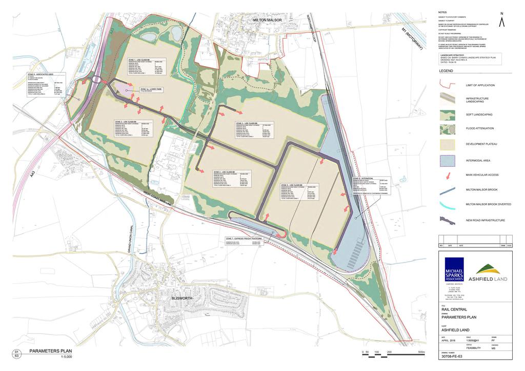
337
338 Figure 3.1
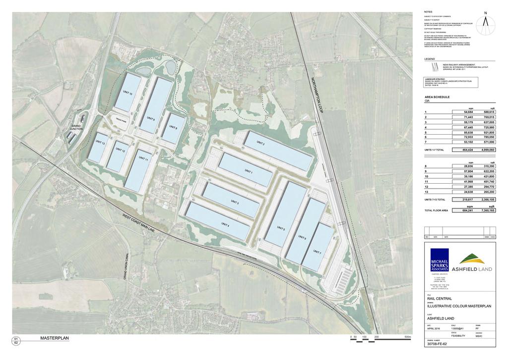
339
340 Figure 9.1


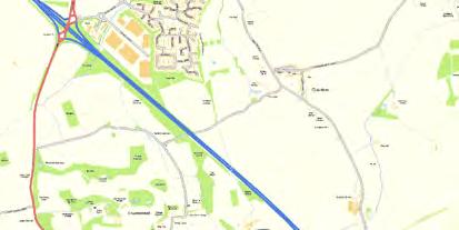

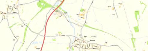

341 1 - Crematorium 2. Depot 5. Marina 3. Collingtree Road 4. Collingtree court 6. Fairfield Road/Station Road 9. Barn Lane 7. Canal 8. Footpath 10. St John s Road
342 Figure 11.1
343 Key: Proposed Development Boundary HER Site (linear) MNN29611 MNN #* Former barn sites shown on 1st Edition, no upstanding remains MNN2505 #* X Barn site shown on the 1st Edition, still existing Former ponds shown on the 1st Edition MNN ") Occupied farmstead HER Site (area) #* #* #* #* Former sand pit Romano-British Pottery Scatter (MNN168316) Medieval Pottery Scatter (MNN ) (MNN ) MNN X Post-medieval/Modern Pottery Scatter (MNN168339) Ridge and Furrow visible on modern APs #* X X #* X #* X #* X #* X X ") Ridge and Furrow still surviving as upstanding remains #* X X X X Reproduced with the permission of Ordnance Survey on behalf of The Controller of Her Majesty's Stationery Office, Crown copyright. CFA Archaeology Ltd, Old Engine House, Eskmills Park, Musselburgh EH21 7PQ AL #* X X #* X #* X Revision No: Title: Reference No: 2 MIMA 1960 Cultural Heritage Assets within the Proposed Development Area X X Project: Rail Central X Client: Turley Scale at A3: 1:8,000 Drawn by: SW Checked: MH Date: 21/03/2016 Chapter: Fig. No: The copyright in this document (including its electronic form) shall remain vested in CFA Archaeology Ltd (CFA) but the Client shall have a licence to copy and use the document for the purpose for which it was provided. CFA shall not be liable for the use by any person of this document for any purpose other than that for which the same was provided by CFA. This document shall not be reproduced in whole or in part or relied upon by third parties for any use whatsoever without the express written authority of CFA.
344 Figure 11.2
345 Key: Proposed Development Boundary!( Prehistoric Find-spots!( Romano-British Find-spots!( Saxon to Medieval Find-spots!( Post-Medieval Find-spots MNN6131!(!( MNN10587!( MNN !(!(!( MNN MNN MNN MNN MNN149088!(!(!( MNN MNN168294!(!( MNN MNN168300!( MNN MNN168332!(!(!(!( MNN MNN168299!( MNN MNN MNN168296!(!( MNN168314!( MNN168292!(!( MNN168333!(!( MNN MNN168291!(!( MNN MNN168331!(!( MNN168295!(!( MNN168293!( MNN MNN MNN168329!( MNN168330!( MNN168287!( Reproduced with the permission of Ordnance Survey on behalf of The Controller of Her Majesty's Stationery Office, Crown copyright. CFA Archaeology Ltd, Old Engine House, Eskmills Park, Musselburgh EH21 7PQ AL Revision No: Title: Project: Reference No: Cultural Heritage Find-spots within the Proposed Development Boundary Rail Central 2 MIMA 1960 MNN MNN168289!(!(!(!( MNN MNN MNN168288!( Client: Turley Scale at A3: 1:8,000 Drawn by: SW Checked: MH Date: 21/03/2016 Chapter: Fig. No: The copyright in this document (including its electronic form) shall remain vested in CFA Archaeology Ltd (CFA) but the Client shall have a licence to copy and use the document for the purpose for which it was provided. CFA shall not be liable for the use by any person of this document for any purpose other than that for which the same was provided by CFA. This document shall not be reproduced in whole or in part or relied upon by third parties for any use whatsoever without the express written authority of CFA.
346 Figure 11.3
347 Key: MNN MNN6137 MNN6138 MNN13065 MNN MNN25414 Proposed Development Boundary 1km Buffer!( HER Site (point) MNN MNN MNN6591 MNN MNN HER Site (linear) HER Site (area) MNN MNN MNN6133 MNN13066 MNN MNN MNN MNN3497 MNN MNN6129 MNN MNN13477 MNN6130 MNN13509 MNN4214 MNN MNN MNN13510 MNN MNN MNN3017 MNN MNN MNN4213 MNN9021 MNN4134 MNN17219 MNN MNN13476 MNN MNN17217 MNN6148!( MNN Reproduced with the permission of Ordnance Survey on behalf of The Controller of Her Majesty's Stationery Office, Crown copyright. CFA Archaeology Ltd, Old Engine House, Eskmills Park, Musselburgh EH21 7PQ AL Revision No: Title: Reference No: 2 MIMA 1960 Cultural Heritage Assets wtihin 1km of the Proposed Development Area MNN MNN17220 MNN MNN6161 MNN MNN13441 MNN Project: Rail Central MNN17217 MNN2141 Client: Turley MNN6147 MNN Scale at A3: 1:15,000 Drawn by: SW Checked: MH Date: 21/03/2016 Chapter: Fig. No: The copyright in this document (including its electronic form) shall remain vested in CFA Archaeology Ltd (CFA) but the Client shall have a licence to copy and use the document for the purpose for which it was provided. CFA shall not be liable for the use by any person of this document for any purpose other than that for which the same was provided by CFA. This document shall not be reproduced in whole or in part or relied upon by third parties for any use whatsoever without the express written authority of CFA.
348 Figure 12.1


349 Indicative Heritage Asset Plan Key: - Application Site - Indicative 2km Study Area - Listed Buildings - Conservation Areas - Registered Parks and Gardens
350 Figure 15.1


351
352 Figure 16.1

353 Ashfield Land Management Central Rail Project Figure 16.1 Preliminary Ecological Appraisal Report JULY 2015
354 RSK GENERAL NOTES Client Reference: Not applicable Project No.: Title: Armtrack Land at Milton Malsor Preliminary Ecological Appraisal Client: Ashfield Land Management Ltd Date: July 2015 Office: Coventry Status: Draft for Client Comment Author Richard Carter David Coote Technical reviewer Louise Denning Signature Signature Date: 21/07/2015 Date: 21/07/2015 Project manager Simon Boulter Quality reviewer Louise Denning Signature Signature Date: 21/07/2015 Date: 21/07/2015 RSK Environment (RSK) has prepared this report for the sole use of the client, showing reasonable skill and care, for the intended purposes as stated in the agreement under which this work was completed. The report may not be relied upon by any other party without the express agreement of the client and RSK. No other warranty, expressed or implied, is made as to the professional advice included in this report. Where any data supplied by the client or from other sources have been used, it has been assumed that the information is correct. No responsibility can be accepted by RSK for inaccuracies in the data supplied by any other party. The conclusions and recommendations in this report are based on the assumption that all relevant information has been supplied by those bodies from whom it was requested. No part of this report may be copied or duplicated without the express permission of RSK and the party for whom it was prepared. Where field investigations have been carried out, these have been restricted to a level of detail required to achieve the stated objectives of the work. This work has been undertaken in accordance with the quality management system of RSK Environment. Milton Malsor, Northamptonshire Preliminary Ecological Appraisal
355 CONTENTS EXECUTIVE SUMMARY INTRODUCTION Purpose of the Report Ecological Context Structure of this Report Nomenclature METHODS General Background Data Search Phase 1 Habitat Survey Habitat Assessment for Protected Vertebrates Badgers Bats Nesting Birds Great Crested Newt Reptiles Otter and Water Vole RESULTS Background Data Search Designated Sites There are no statutory designated sites for nature conservation within 5km of the site boundary (there are two SSSIs, Roade Cutting and Blisworth Rectory Farm Quarry, designated for their geological interest) Non-designated Sites Protected and Noteworthy Species Habitats General Arable Farmland Semi-improved Grassland Rough grassland and Nettle-bed Vegetation Scrub and Woodland Hedges Ditches, Streams and Ponds Other Habitats Protected Species Badger Bats Nesting Birds Amphibians including Great Crested Newts Reptiles Otter and Water Vole Milton Malsor, Northamptonshire Preliminary Ecological Appraisal
356 4 EVALUATION Designated Sites Habitats and Plants Protected Species Badger Bats Nesting Birds Amphibians including Great Crested Newts Reptiles Otter and Water Vole REFERENCES FIGURES APPENDIX A BOTANICAL TABLES APPENDIX B TARGET NOTES East of Towcester Road (the Barn Lane Area) West of or Close to Towcester Road APPENDIX C - RELEVANT LEGISLATION APPENDIX D NOTEWORTHY SPECIES RECORDS APPENDIX E ABBREVIATIONS Table 1 15 Table 2 20 Table 3 21 Table 4 23 Milton Malsor, Northamptonshire Preliminary Ecological Appraisal
357 EXECUTIVE SUMMARY 1. This report presents the results of ecological field surveys undertaken in connection with a proposed development known as Armtrack Land at Milton Malsor, Northamptonshire (Ordnance Survey Grid reference: SP ). The location and boundary of the Survey area is shown in Figure An extended Phase 1 Habitat survey including assessment for protected vertebrates was carried out on the 23 rd and 24 th March 2015 following the Guidelines for Preliminary Ecological Appraisal (CIEEM 2012). 3. Habitats on the site are arable fields, improved agricultural grassland, semiimproved or unimproved neutral agricultural grassland, rough grassland, amenityturf, broad-leaved woodland, broad-leaved semi-natural woodland, recent broadleaved plantation woodland, scrub and incipient secondary woodland, scattered broad-leaved and coniferous trees, hedgerows, nettle-bed and other tall ruderal vegetation, ephemeral vegetation, streams, ditches, dry ditches and ponds. No non-native invasive plants were recorded on the site. 4. There are habitats on site likely to support roosting, commuting and foraging bats, nesting birds, Great Crested Newts, reptiles and Water Voles. 5. A ground-level tree survey to assess tree suitability for bats was undertaken. This showed that there are 15 mature trees with features (splits, holes or flaking bark) that could accommodate roosting bats. 6. There are no statutory designated sites for nature conservation within 5km of the site boundary (there are two SSSIs, Roade Cutting and Blisworth Rectory Farm Quarry, designated for their geological interest). Milton Malsor, Northamptonshire Preliminary Ecological Appraisal
358 1 INTRODUCTION 1.1 Purpose of the Report This report presents the results of preliminary ecological surveys carried out on land south of Milton Malsor, Northamptonshire in connection with a possible future development project, the details of which are as yet unspecified. To serve broad purposes in the early stages of project option appraisal, planning and design - and also to identify potential requirements for further survey it describes the principal habitat types in the area and scopes their suitability for protected species. 1.2 Ecological Context The site occupies gently undulating land on more-or-less neutral loams south of Milton Malsor in Northamptonshire. Like the surrounding area it has an intensively farmed landscape with most fields under arable or improved grass in roughly equal proportions. A few fields in the south-western part of the site have semi-improved (or perhaps unimproved) agricultural grassland. Boundaries are mostly marked by species-poor Crataegus monogyna (Hawthorn) hedges many of which have large ditches or small streams. The village of Milton Malsor lies to the north and there are houses, commercial premises and light industrial premises along Towcester Road which bisects the site from north to south, and there is an industrial estate adjacent to the northwestern corner of the site. Otherwise there are scattered houses, farms and plant nurseries plus a disused dual-carriageway service area. Railway sidings largely bound the site to the east and south, and the A43 dual-carriageway main road does so to the east (all of these actually have some parts of the site lying beyond them). Adjacent to the south-western corner of the site is the canal and marina complex of Blisworth junction, and towpaths bound the site in some places. 1.3 Structure of this Report The remainder of this report is structured as follows: Section 2 describes the survey and assessment methods; Section 3 presents the survey results; Section 4 evaluates the results; and Section 5 lists references. Tables of botanical data are grouped together at the end of the report. Milton Malsor, Northamptonshire Preliminary Ecological Appraisal
359 1.4 Nomenclature Plant nomenclature in this report follows Stace (2010) for native and naturalised species of vascular plant, and Hill et al (2008) for mosses and liverworts. Plant names in the text are given with scientific names first, followed by the English name in brackets. Doubtful identifications are preceded by cf. placed before the specific epithet where the plant is very probably the species indicated, but it is impossible to distinguish it from similar members of the genus with certainty. The names of National Vegetation Classification (NVC) communities follow Rodwell (1991, 1992, 1995). Milton Malsor, Northamptonshire Preliminary Ecological Appraisal
360 2 METHODS 2.1 General Surveys were undertaken on the 23 rd and 24 th March Habitat mapping and botanical recording was carried out by Dr Richard Carter. He is an expert botanist with over 25 years consultancy experience, a full member of Chartered Institute of Ecology and Environmental Management (MCIEEM) and a Chartered Environmentalist. He is also a Visiting Lecturer in vegetation studies at the University of Reading and a BSBI 1 vice-county recorder and taxonomic referee. Surveys for protected terrestrial vertebrates were carried out by David Coote. He is a principal ecologist with over 11 year experience in ecological consultancy and research. 2.2 Background Data Search A search was made for reference materials relating to the ecology of the site, and a list of sources is given in Table 2.1 below. Table 2.1. Data Sources Information Obtained Protected and Noteworthy species-records Statutory designated site locations and citations Non-Statutory designated site locations and citations Designations and legal protection of noteworthy species Details of species and habitats listed on the Northamptonshire LBAP Information on Broad and Priority Habitats and Species Action Plans for the UK Satellite imagery Available From Northamptonshire Biodiversity Records Centre (NBRC) Natural England website: Northamptonshire Biodiversity Records Centre (NBRC) Joint Nature Conservation Committee (JNCC) website Northamptonshire Biodiversity Action Plan Joint Nature Conservation Committee (JNCC) website Bing Maps A search was made for information about statutory designated sites within 5km of the site boundary and non-statutory designated sites within 2km. A search was also made for records of noteworthy species within 2km of the site boundary, extending to 5km for bat records. Species included in the search parameters are: 1 Botanical Society of Britain and Ireland Milton Malsor, Northamptonshire Preliminary Ecological Appraisal
361 European protected species (listed on Schedules 2 and 4 of The Conservation of Habitats and Species (Amendment) Regulations 2012); nationally protected species under Schedules 1, 5 and 8 of The Wildlife & Countryside Act 1981 and The Protection of Badgers Act 1992; species listed as Critically Endangered, Endangered or Vulnerable on the IUCN Red List all species listed on the RSPB Birds of Conservation Concern 2009 as Red or Amber; Nationally Rare or Nationally Scarce species; Notable invertebrates; and Species of Principal Importance under The Natural Environment and Rural Communities (NERC) Act (2006). 2.3 Phase 1 Habitat Survey General The habitat survey centred on the Phase 1 Habitat Survey approach (Joint Nature Conservation Committee 2010) as extended for use in Environmental Impact Assessments (Institute of Environmental Assessment 1995). This involves the following elements. Habitat mapping using a set of standard colour codes to indicate habitat types on a Phase 1 Habitat Map (Figure 2) Description of features of possible ecological or nature conservation interest in notes relating to numbered locations on the Phase 1 Habitat Map, called Target Notes. These are provided in Appendix B. Basic Phase 1 Habitat Survey methods are described in detail in Joint Nature Conservation Committee (JNCC 2010). Limits to the achievable reliability of the method are discussed in Cherrill & McClean (1999). Surveys in May are optimal for Phase 1 Habitat surveys. A list of plant species was compiled while walking around the site. This gives an indication of the botanical character of the site, but by no means was every patch of the site visited, and the list is likely to be far from exhaustive. Subjective estimates of the relative abundance of species were added to the plant species list using a modified DAFOR scale. This ranks species according to their relative abundance in a given parcel of land as: d dominant, a abundant, f frequent, o occasional, r rare. In addition, the following prefixes are used: l locally, v very. The terms abundant and rare are used by convention, and apply only to relative-abundance within the recorded area. It does not mean that species are rare in the district or the UK at large. Milton Malsor, Northamptonshire Preliminary Ecological Appraisal
362 Constraints March is a very early time of year for recording plant species and many species may not have been in evidence, while others present only as leaves or dead remains were unidentifiable. A great many more species would be recorded in a summer survey. Many of the hedges had been recently trimmed making the woody species almost impossible to assess, at least comprehensively. Again woody species are likely to be overlooked in a March walkover survey of the Phase 1 kind (though they could be recorded in a painstaking survey). Broad conclusions about the generality of the hedges are likely to be correct, but some dismissed here as species-poor could turn out on closer inspection to be of greater nature conservation value than appeared. 2.4 Habitat Assessment for Protected Vertebrates General The site was assessed for its suitability for protected animals that are likely to occur in the area. Taking into account the location and habitats at the site, assessment was carried out for: Badger; bat species (foraging and roosting); nesting birds; Great Crested Newt (and other amphibians); reptile species; and Otter and Water Vole. Further details of the assessment methods are given below Badgers An initial assessment was carried out to identify areas that might be used by Badger (Meles meles) for commuting, foraging and sett-building. A search was made for signs of Badgers including setts, tracks, footprints, hair on barbed wire fences, feeding signs and dung pits (latrines) Bats Habitat Assessment for Bats Habitats were assessed for their suitability for foraging or commuting bats. Areas of particular interest vary between species, but generally include sheltered areas and habitats with good numbers of insects, such as woodland, scrub, hedges, watercourses, ponds, lakes and species-rich or rough grassland. Initial Bat Survey - Buildings Milton Malsor, Northamptonshire Preliminary Ecological Appraisal
363 The external features of all buildings were surveyed for characteristics that may be used by roosting bats. Potential access points into roof voids were noted as well as crevices and voids in the external structure, which could provide roosting opportunities. An internal survey was not undertaken and access to roof features using ladders and other climbing equipment was not used. This survey provided a rapid assessment of the building on which further surveys or suggestions for scheme design can be provided. The buildings were then assessed according to the following factors that influence the likelihood of bats roosting: Surrounding habitat: whether there are potential flight-lines and foraging areas for bats nearby. Construction detail: the type and construction of architectural features such as attics, soffit boxes, lead flashing and hanging tiles that could be used by roosting bats. Building condition: whether disrepair has opened potential bat-access points (especially around roofs). Potential bat-access points: whether there is flight and crawl access. Potential roosting locations: descriptions of all bat-accessible voids, cracks and crevices. The criteria shown in Table 2.2 were used to categorise the buildings according to their potential to support roosting bats. Table 2.2: Classification Criteria for Bat Roosting Potential of Buildings and Built Structures Category (potential to support roosting bats) Negligible potential Low potential Moderate potential Description Buildings with no features suitable for roosting bats. Modern, well-maintained buildings or built structures that provide few opportunities for bat access/roosting (i.e. with no cracks or crevices); composed of prefabricated steel and sheet materials; no internal loft space; high level of regular disturbance; high interior light levels and subject to large temperature fluctuations. Buildings may be surrounded by poor or sub-optimal bat foraging habitat. No evidence of bats found. Buildings with limited features to support roosting bats shallow crevices where mortar is missing between brickwork. Buildings may have large open locations subject to large temperature fluctuations. Buildings may be surrounded by poor or sub-optimal bat foraging habitat. No evidence of bats found. Buildings with some features suitable for roosting bats building usually of brick or stone construction with a small number of features suitable for roosting bats loose roof or ridge tiles, gaps in brickwork, gaps under fascia boards, and/or sealed internal loft space. No evidence of bats found. Milton Malsor, Northamptonshire Preliminary Ecological Appraisal
364 High potential Confirmed roost Buildings with a large number of features or extensive areas with potential for roosting bats. Sheltered locations with a stable temperature regime and suitable access points. Features can include: weatherboarding and/or hanging tiles with gaps, roof timbers with mortise joints, cracks, holes); poorly maintained fabric providing ready access into roofs, walls, but at the same time not being draughty and cool; large and complicated roof void with unobstructed flying spaces. No evidence of bats found. Bats or evidence of bats recorded within the building during the initial inspection surveys or during dusk/dawn surveys. A confirmed record (supplied by records centre/local bat group) would also apply. Ground-level Tree Assessment Trees were classified using the Bat Conservation Trust Good Practise Guideline categories (Hundt 2012) detailed in Table 2.3 below, which grades the likelihood of the feature (and therefore the tree) being used by roosting bats. All trees were assessed from ground level and, if required, binoculars were used to view features. The trees were cross-referenced to the Development Framework (Define DE155_002). Table 2.3: Tree Assessment Categories from Hundt (2012) Tree Category (Potential to support roosting bats) Known or Confirmed Roost Category 1* Category 1 Category 2 Category 3 Description Roost confirmed Trees with multiple, highly suitable features capable of supporting larger roosts Trees that have a high potential to support bat roosts, with fewer features than Category 1*, or potential to be used by single bats Trees with a moderate/low potential to support bat roosts. There are no obvious features, but the tree is of an age and size where an elevated survey may result in features being found. Trees with negligible potential to support bat roosts Nesting Birds The potential value of habitats within the site for use by nesting birds was assessed taking account of a range of factors including; habitat types and features present; potential food sources and nesting sites (including presence of nests); diversity and interrelations between habitats; management practices; Milton Malsor, Northamptonshire Preliminary Ecological Appraisal
365 disturbance. Habitat requirements vary widely between different species, so this assessment considered the relative potential value of habitats in relation to typical species assemblages and key species, in particular species of principal importance under The NERC Act (2006), birds of conservation concern and those protected under Schedule 1 of The Wildlife and Countryside Act (1981 as amended) Great Crested Newt Water bodies within 500m of the proposed development site (the distance which Great Crested Newts have been shown to travel away from their breeding pond (English Nature 2001) were identified by using aerial photography, maps and field-surveys. These aquatic habitats were assessed for their suitability for amphibians where access was available. Terrestrial habitat within 500m of a suitable pond was assessed during the Extended Phase 1 Habitat Survey for suitability for Great Crested Newt, along with the habitat-connectivity between suitable water bodies and suitable habitat. 17waterbodies were identified that were considered likely to hold standing water for at least part of the breeding season These water bodies were assessed for their suitability for Great Crested Newts using a Habitat Suitability Index (HSI) developed by Oldham et al. (2000), which is derived from systems developed by the US Fish and Wildlife Service. It is a numerical index, between 0 and 1, where 0 indicates unsuitable habitat and 1 represents optimal habitat. The HSI for the Great Crested Newt uses ten factors (suitability indices (SI) 1 to 10), which are thought to affect Great Crested Newts as follows: geographic location (SI 1); surface area (SI 2); hydrology (drying) (SI 3); water quality (SI 4); shade (SI 5); presence of water fowl (SI 6); presence of fish (SI 7); number of adjacent water features (SI 8); terrestrial habitat (SI 9); and macrophyte cover (SI 10). Each factor is scored using field and desk-based survey. These ten scores are then converted to SI scores using a scale from 0.01 to 1 from graphs given in Oldham et al. (2000) and a HSI result is calculated using the following formula: HSI = (SI1 SI2 SI3 SI4 SI5 SI6 SI7 SI8 SI9 SI10) 1/10 Milton Malsor, Northamptonshire Preliminary Ecological Appraisal
366 Further research by Brady (unpublished) has developed a system for using HSI scores to define pond suitability for Great Crested Newts according to the following categories: HSI <0.5= poor HSI = below average HSI = average HSI = good HSI > 0.8= excellent There is a positive correlation between HSI scores and presence and abundance of Great Crested Newts in ponds. Generally, ponds with high HSI scores are likely to support larger populations. However, the relationship is not sufficiently precise to conclude that any pond with a high HSI will support newts in high populations, or that any pond with a low score will only support low numbers of newts or no newts at all Reptiles As part of the extended Phase 1 habitat survey, areas were identified areas that are potentially suitable for one or more of the four common reptile species. Particular attention was paid to those features that provide suitable basking areas (e.g. southfacing slopes), hibernation sites (e.g. banks, walls, and piles of rotting vegetation) and opportunities for foraging (rough grassland and scrub). Specific habitat requirements differ between species. Common Lizards (Zootoca vivipara) use a variety of habitats from woodland glades to walls and pastures, although one of their favoured habitats is rough grassland. Slow-worms (Anguis fragilis) use similar habitats to Common Lizards, and are often found in rank grassland, gardens and derelict land. Grass Snakes (Natrix natrix) have broadly similar requirements to Common Lizards with a greater reliance on ponds and wetlands, where they prey on Common Frogs (Rana temporaria). Adders (Vipera berus) use a range of fairly open habitats with some cover, but are most often found in dry heath (Beebee & Griffiths 2000) Otter and Water Vole Habitat Assessment for Water Voles Habitat was assessed for Water Voles according to subjective criteria, which were then used to categorise habitat according to suitability for the species. The following habitat factors are taken into consideration: water quality; water-level regime; channel dimensions; bank type and material; vegetation for cover and food sources; Milton Malsor, Northamptonshire Preliminary Ecological Appraisal
367 shading; predation and competition; and habitat management. Classification of habitat suitability was made as follows. Suitable habitat that has all the elements required for Water Voles certainly in the summer, and probably through most winters. Suitable (Sub-optimal) habitat that has some of the habitat features that are suitable for Water Vole, but with some constraints so that suitability throughout the year is not certain. Unsuitable habitat lacking one or more crucial element for use by Water Voles. This category does not necessarily preclude the habitat being used by commuting Water Voles, but it would not be able to support a resident population. As part of the extended Phase 1 survey water vole field signs were sought including: burrows; feeding platforms and evidence of feeding; food remains; latrines and footprints. Otters An assessment of the suitability of the site for use by Otters was made during the Phase 1 Habitat Survey. Otters are largely but not exclusively dependant on aquatic habitats including rivers streams, canals, lakes and the sea. They use aquatic linear habitats such as rivers streams, canals, and ditches to access the wider environment. They are largely dependent on fish as prey but will eat a wide range of other species including anything from invertebrates such as crayfish species to birds and mammals such as Water Voles and Rabbits. Otter territories are large with male Otters ranging up to 10 km in sub-optimal habitat. Otter signs include footprints and slides, feeding remains, holts and couches (resting places) and spraint (droppings). Milton Malsor, Northamptonshire Preliminary Ecological Appraisal
368 3 RESULTS 3.1 Background Data Search Designated Sites There are no statutory designated sites for nature conservation within 5km of the site boundary (there are two SSSIs, Roade Cutting and Blisworth Rectory Farm Quarry, designated for their geological interest) Non-designated Sites There are 21 non-statutory designated sites within 2km of the site boundary. These are shown in Table 3.1. Table 3.1. Non-Statutory Sites within 2km of the site boundary Site Name Designation Distance from site boundary (m) Nene Valley Nature Improvement Area Nature Improvement Area Covers part of northwest of site The Nene Valley NIA covers an area of 41,000 hectares running through Northamptonshire to the eastern fringes of Peterborough. It includes the River Nene and its tributaries, gravel pits, reservoirs, wetlands and farmland. Unidentified site off Towcester Road Potential Wildlife Site Within the Site No information Unidentified site on A43 embankment Potential Wildlife Site Adjacent to Site No information Unidentified site at Blisworth Junction Potential Wildlife Site Adjacent to Site No information Grand Union Canal - Northampton Arm Local Wildlife Site Adjacent to Site The site qualifies as a Wildlife Site due to its diverse aquatic plant communities and bankside grassland habitats. Unidentified site off Station Road Potential Wildlife Site 20m No information Gayton Meadow Potential Wildlife Site 320m Unmanaged grassland with a mixture of wet and dry grassland species including abundant marsh thistle. Roade Cutting Potential Wildlife Site 420m No information provided on nature conservation interest Gayton Reserve Lake Local Wildlife Site 585m A small lake and associated wetland area forming a useful wildlife habitat on the edge of the caravan site. The lake qualifies as a Wildlife Site due to its aquatic community and the wetland vegetation. Unidentified site south-east of Rothersthorpe Potential Wildlife Site 765m No information Junction 15 Grassland Potential Wildlife Site 1050m Milton Malsor, Northamptonshire Preliminary Ecological Appraisal
369 Site Name Designation Distance from site boundary (m) This site holds four indicators from the neutral grassland indicators list; although a reasonable number this is not enough to qualify as a CWS. However, with appropriate management the quality if the grassland habitat may improve sufficiently to meet the CWS selection criteria Unidentified site at Courteenhall Potential Wildlife Site 1095m No information Collingtree Potential Wildlife Site 1100m No information Unidentified site at The Poplars, Rothersthorpe Potential Wildlife Site 1110m No information Collingtree Golf Course Local Wildlife Site 1225m A stream and series of lakes and ponds through Collingtree Golf Course which provide a useful wildlife corridor and good wetland habitat. The complex qualifies as a Wildlife Site as 15 wetland indicator species were recorded alongside further aquatic and emergent species and plant communities. Unidentified site south of Rothersthorpe Potential Wildlife Site 1240m No information Unidentified site east of Gayton Potential Wildlife Site 1245m No information Unidentified site on Grand Union Canal Potential Wildlife Site 1250m No information Bliswoth Rectory Farm Quarry Potential Wildlife Site 1500m This ex-quarry and surrounding grassland has some relatively species rich neutral-calcareous grassland Unidentified site north of Gayton Potential Wildlife Site 1540m No information Wootton Railway Embankments Local Wildlife Site 1930m This site qualifies as a LWS because it contains a lichen listed in the Northamptonshire Red Data Book as a Northamptonshire Scarce Species. The acid grassland is currently too degraded to qualify as LWS. It is under serious threat and will be lost entirely unless management is altered soon Protected and Noteworthy Species At least 43 noteworthy species were identified from records for places within 2km of the site boundary, extending to 5km for bat records. Of these, two are amphibians, twelve are birds, five are terrestrial mammals, one is a bony fish, one is a crustacean, eleven at butterflies or moths, nine are vascular plants and two are lichens or bryophytes. These records are summarised in Table 3.2. Table 3.2. Protected and Notable Species Records within 2 km of site. Latin Name Common Name Designation* Amphibians Milton Malsor, Northamptonshire Preliminary Ecological Appraisal
370 Latin Name Common Name Designation* Bufo bufo Common Toad NERC S.41 Triturus cristatus Great Crested Newt NERC S.41, WACA-Sch5, CHSR Birds Alcedo atthis Kingfisher Bird Amber, WACA-Sch1_part1 Anas platyrhynchos Mallard Bird Amber Falco columbarius Merlin Bird Amber, WACA-Sch1_part1 Falco subbuteo Hobby WACA-Sch1_part1 Motacilla cinerea Grey Wagtail Bird Amber Muscicapa striata Spotted Flycatcher Bird Red, NERC S.41 Parus montanus Willow Tit Bird Red, NERC S.41 Picus viridis Green Woodpecker Bird Amber Pyrrhula pyrrhula Bullfinch Bird Amber, NERC S.41 Sterna hirundo Common Tern Bird Amber Sylvia communis Whitethroat Bird Amber Tyto alba Terrestrial Mammals Barn Owl Bird Amber, LBAP 2008, WACA- Sch1_part1 Arvicola amphibius European Water Vole NERC S.41, WACA-Sch5 Erinaceus europaeus West European Hedgehog NERC S.41 Lepus europaeus Brown Hare NERC S.41 Lutra lutra European Otter NERC S.41, WACA-Sch5, CHSR Meles meles Badger Protection of Badgers Act (1992) Reptiles Natrix natrix Grass Snake NERC S.41, WACA-Sch5_sect9.1 (kill/injuring) Bony fish Anguilla anguilla Eel NERC S.41 Crustaceans Austropotamobius pallipes Freshwater Crayfish NERC S.41, WACA- Sch5_sect9.1(taking) Milton Malsor, Northamptonshire Preliminary Ecological Appraisal Insects - Lepidoptera Coenonympha pamphilus Small Heath NERC S.41, RedList_GB_post2001-NT Lasiommata megera Leptidea sinapis Wall Wood White Medium Priority, NERC S.41, RedList_GB_post2001-NT High Priority, NERC S.41, RedList_GB_post2001-EN Abraxas sylvata Clouded Magpie Very Locally Restricted Acronicta rumicis Knot Grass NERC S.41 Adscita statices Forester Locally Rare, NERC S.41 Atolmis rubricollis Red-necked Footman Locally Scarce, Medium Priority Entephria caesiata Grey Mountain Carpet NERC S.41 Eupithecia valerianata Valerian Pug Locally Scarce Synanthedon myopaeformis Red-belted Clearwing Medium Priority 16
371 Latin Name Common Name Designation* Xanthia gilvago Dusky-lemon Sallow NERC S.41 Vascular Plants Bromus racemosus Smooth Brome Locally Scarce Plants Hyacinthoides non-scripta Bluebell WACA-Sch8 Lactuca saligna 3.2 Habitats General Least Lettuce NERC S.41, NR-excludes, RedList_GB_post2001-EN, WACA- Sch8 Petroselinum segetum Corn Parsley Locally Scarce Plants Pinus sylvestris Scots Pine NS-excludes Potamogeton compressus Potamogeton praelongus Grass-Wrack Pondweed Long-Stalked Pondweed Locally Rare Plants, NERC S.41, NSexcludes, RedList_GB_post2001-EN Locally Scarce Plants, RedList_GB_post2001-NT Sagina nodosa Knotted Pearlwort Locally Scarce Plants Verbascum lychnitis White Mullein NS-excludes Lichens and Bryophytes Cladonia chlorophaea Cladonia chlorophaea NR-excludes, NS-excludes Syntrichia virescens Lesser Screw-moss NS-excludes * Details of designation abbreviations are provided in Appendix E The habitat types and target notes are mapped in Figure 2. A plant species list is given in Appendix A and the detail of the habitat description summarised here is given in the form of target notes in Appendix B. The site contains the following broad habitat and vegetation types: arable fields; improved agricultural grassland; semi-improved or perhaps unimproved neutral agricultural grassland; rough grassland; amenity-turf; broad-leaved woodland; broad-leaved semi-natural woodland, probably of plantation origin; recent broad-leaved plantation woodland; scrub and incipient secondary woodland; scattered broad-leaved and coniferous trees; hedgerows; Milton Malsor, Northamptonshire Preliminary Ecological Appraisal
372 nettle-bed and other tall ruderal vegetation; ephemeral vegetation; streams; ditches and dry ditches; and ponds Arable Farmland Arable farmland is the dominant habitat on site. There may well be arable weed vegetation types in field corners, but they were little developed in March. Improved agricultural grassland strongly dominated by the grass Lolium perenne (Perennial Rye-grass) together with Trifolium repens (White Clover) and referable to the NVC type MG7a Lolium perenne leys and related grasslands, Lolium perenne- Trifolium repens leys is widespread on the site. JNCC (2010) permits this to be mapped as arable; here it is mapped as improved grassland where the sward seems well established, and as arable where it looked recently sown at the time of the survey, but this should be interpreted with circumspection as it is very subjective, and arable and improved grassland are likely to be interchangeable crops in any given field. Amenity-turf is very scarce within the survey area, but was recorded in a few places Semi-improved Grassland Semi-improved grassland containing Lolium perenne (Perennial Rye-grass) together with other grasses including Agrostis capillaris (Common Bent), Festuca rubra (Red Fescue) and Holcus lanatus (Yorkshire-fog) and common grassland forbs including Cerastium fontanum (Common Mouse-ear), Ranunculus repens (Creeping Buttercup) and Trifolium repens (White Clover) is frequent mostly in the south-western part of the survey area (including Target Notes 64, 68, 72, 74, 77, 90, 91, 94 and 121). The swards are probably referable to the NVC type MG6a Lolium perenne-cynosurus cristatus grassland, typical sub-community but they were hard to assess in March and some lacked permission for access, so that other NVC types of greater nature conservation value could be present. In a few places such as fields at Target Notes 76 and 121 swards of this kind have grown rank and tussocky and feature grasses such as Deschampsia cespitosa (Tufted Hair-grass) and taller grassland forbs such as Centuarea debeauxii (Chalk Knapweed). Milton Malsor, Northamptonshire Preliminary Ecological Appraisal
373 3.2.4 Rough grassland and Nettle-bed Vegetation Rough grassland on road verges tends to be dominated by the grasses Arrhenatherum elatius (False Oat-grass), Dactylis glomerata (Cock s-foot) and Elytrigia repens (Common Couch) occasionally with Schedonorus arundinaceus (Tall Fescue) in the eastern part of the survey area. Grassland forbs such as Ranunculus repens (Creeping Buttercup) and Vicia sativa ssp. segetalis (Common Vetch) are scattered, while tall semi-ruderal herbs are frequent, especially Urtica dioica (Common Nettle). The swards are referable to the NVC type MG1a Arrhenatherum elatius grassland, Festuca rubra sub-community or more commonly where the tall semi-ruderal herbs rise to prominence to MG1b Arrhenatherum elatius grassland, Urtica dioica subcommunity. Where the tall semi-ruderal herbs become dominant there is a transition to nettle-bed vegetation referable to the NVC type OV24a Urtica dioica-galium aparine community, typical sub-community. These NVC types commonly occur in mosaic and transition with one another. Pure stands of Galium aparine (Cleavers) and Urtica dioica (Common Nettle) referable to OV24a often occur on their own in field corners too. In such situations they are often highly eutrophic, and then Conium maculatum (Hemlock) is often abundant. Again these stands often contain scattered Rubus fruticosus agg. (Bramble) and as this rises to prominence there is a transition from OV24a (or MG1b) to OV24b Urtica dioica- Galium aparine community, Arrhenatherum elatius-rubus fruticosus subcommunity and with further increase in the Rubus fruticosus agg. (Bramble) to the point of dominance there is an ongoing transition from OV24b to W24a Rubus fruticosus-holcus lanatus underscrub, Cirsium arvense-cirsium vulgare subcommunity. This kind of mosaic and transition is common on the railway sidings crossing and bounding the site where there may also be tall-herb vegetation containing Chamerion angustifolium (Rosebay Willowherb) referable to the NVC type OV27b Epilobium angustifolium community, Urtica dioica-cirsium arvense subcommunity which in the survey area is confined to the railways Scrub and Woodland Thorn scrub variously consisting of Crataegus monogyna (Hawthorn), Prunus spinosa (Blackthorn) and Sambucus nigra (Elder) occurs in several places, most extensively on the railway embankments, but also around field corner pits and ponds. It is mostly referable to the NVC types W21a Crataegus monogyna-hedera helix scrub, Hedera helix-urtica dioica sub-community or W22a Prunus spinosa-rubus fruticosus scrub, Hedera helix-silene dioica sub-community but more ruderal scrub may be referable to the proposed NVC type Sambucus nigra-urtica dioica community (Rodwell et al. 2000). Secondary woodland is very scarce and confined to roadside strips or areas where there was no permission for access. Such as was seen mostly consists of Acer pseudoplatanus (Sycamore) and Fraxinus excelsior (Ash) with xommon shade-tolerant plants in the field-layer. Owing to its fragmentary character its NVC affinities would be hard to assess. Milton Malsor, Northamptonshire Preliminary Ecological Appraisal
374 The banks of the A43 dual-carriageway main road have planted woodland mostly consisting of Acer campestre (Field Maple) and Salix cf. fragilis (Crack Willow) though other species are almost certainly present (hard to assess without access in March) Hedges Nearly all hedges in the survey area appear to be species-poor hedges of Crataegus monogyna (Hawthorn) with small amounts of Sambucus nigra (Elder). Only a few have other species, mainly Prunus spinosa (Blackthorn), Rosa canina (Dog-rose) and Ulmus procera (English Elm). Most of the hedges are trimmed but some have grown tall. Many have ditches but few have appreciable banks Ditches, Streams and Ponds Many hedgerows and other field boundaries have large ditches or small streams with flowing water. Where they are wooded the banks may have shade-tolerant species such as Alliaria petiolata (Garlic Mustard), Arum maculatum (Lords-and-Ladies) and Geum urbanum (Wood Avens), but more often they have rough grassland referable to the NVC type MG1b Arrhenatherum elatius grassland, Urtica dioica subcommunity or nettlebed vegetation referable to the NVC type OV24a Urtica dioica- Galium aparine community, typical sub-community or OV24b Urtica dioica- Galium aparine community, Arrhenatherum elatius-rubus fruticosus subcommunity. Where the nettle-bed vegetation includes Epilobium hirsutum (Great Willowherb) it may be referable to the NVC type OV26e Epilobium angustifolium community, Urtica dioica-cirsium arvense sub-community. Fragmentary aquatic vegetation mostly consists of rooted and emergent aquatics. Where these are relatively small species including the grass Glyceria fluitans (Floating Sweet-grass) and broad-leaved herbs including Apium nodiflorum (Fool s Water-cress), Myosotis scorpioides (Water Forget-me-not), Nasturtium officinale (Water-cress) and Veronica beccabunga (Brooklime) the vegetation may be loosely referable to the NVC type S23 Other water margin vegetation. Elsewhere taller grasses including Phalaris arundinacea (Reed Canary-grass) and Phragmites australis (Common Reed) may lead to other communities but they are fragmentary and scarce. The very few ponds in the survey area have rather similar aquatic vegetation but it tends to feature more shade-tolerant species as all the pond are surrounded by scrub Other Habitats Milton Malsor, Northamptonshire Preliminary Ecological Appraisal In a few places brick structures mainly blue-brick structures along the railways and the canals have a species-rich assemblage of plants growing from cracks. Mostly these are just outside the site boundary or part of the railway infrastructure. Species present include the ferns Asplenium adiantum-nigrum (Black Spleenwort), Asplenium rutamuraria (Wall-rue), Asplenium trichomanes (Maidenhair Spleenwort) and Asplenium 20
375 scolopendrium (Hart s-tongue). Others are the grass Poa angustifolia (Narrow-leaved Meadow-grass) and broad-leaved herbs including Fragaria vesca (Wild Strawberry) and Inula conyzae (Ploughman s-spikenard). There must be assemblages of ruderals but these would not have been well-developed in March. The disused A43 service area may be especially rich. 3.3 Protected Species Badger NBRC provided one record of a badger, dating from 2005, located approximately 2.2km north of the Site. No evidence of badger setts was recorded within the accessible areas of the site. One potential sett (AN7) was noted in woodland adjacent to the north of Towcester Road. This consisted of a hole within a steep bank, with a sizeable spoil heap. As access was not available to this area, it was not possible to inspect it to determine if the hole is used by Badgers. A previous survey of parts of the site identified a possible sett in an area of scrub and gardens to the west of Towcester Road (AN6). This area was not accessible, but no evidence, such as trackways, was seen within the adjacent accessible areas of the site. One possible push-through was recorded under the railway fence to the south of the site (AN2) at the location of a culvert under the rail line. There was no evidence of Badgers, such as hairs, prints or latrines, but the hole under the fence is of an appropriate size for a Badger and a faint trackway was present. It is possible that Badgers use the culvert to cross under the rail line to access the site for occasional foraging. Although no evidence of badgers was recorded, the habitats present are suitable to provide foraging resources, particularly seasonally where ripe grain or maize are available and more consistently in rough grass margins and areas of woodland and scrub Bats Records of bats were not available from the local bat recorder at the time of this assessment There are a number of buildings within the site. The majority of the agricultural buildings are of negligible potential for roosting bats, but there are houses and older farm buildings that have potential to support roosts, which are discussed below. The network of hedgerows and field margins on site is suitable for commuting and foraging bats, and there are a number of mature hedgerow trees that provide roosting Milton Malsor, Northamptonshire Preliminary Ecological Appraisal
376 opportunities for bats in splits, holes and under flaking bark. These habitats are all interconnected and may connect suitable habitats off-site. Buildings Where accessible, buildings within the site were subject to a preliminary assessment for potential to support roosting bats in accordance with Table 2.2. The results of this assessment are shown in Table 3.3. Table 3.3: Results of Preliminary Building Assessment for Bat Roost Potential Building No B1 B2 B3 Description of building Bat potential features Category of roosting potential Three brick barns, two with tin roofs, one with tile roof, likely to open internal construction (viewed from a distance) Lodge Farm two storey house with sagging slate roof; west wing outbuilding with new metal roof and large hole in the north wall Nursery not accessible for detailed survey. Two-storey house appears to be slate roofed, brick-tile bungalow and outbuildings. Loose/ displaced tiles may provide roosting opportunities Potential entry points under slates House may have potential entry points around roof and chimney, bungalow unlikely to have significant features, outbuildings not viewed Low Moderate Moderate B4 Manor farm not inspected. Unknown Unknown B5 B6 B7 Arm farm House with tile roof, wooden facias and lead flashing, barn with collapsing slate roof and open internal structure Navigation Cottages two-storey cottage, two with slate roofs, one with tile roof Derelict garage building with numerous missing roof tiles. False ceiling collapsing. No roof lining (beams and underside of tiles visible through holes in the false ceiling) No visible features No visible features Numerous access points, but lacking internal potential roost features Low Low Low Ground-level Tree Surveys The trees were assessed from the ground to check their suitability for bats. All trees in the site were subject to a preliminary assessment, where access allowed. A total of 15 trees were observed to have features that might be used for roosting i.e. trees with Category 1 and 2 features. The locations of these are shown on Figure 5. Each feature noted as suitable for roosting bats is individually graded and the tree has been given an overall grade that is equivalent to that of its highest graded feature. A table of the data is given in Table 3.4. Milton Malsor, Northamptonshire Preliminary Ecological Appraisal
377 Milton Malsor, Northamptonshire Preliminary Ecological Appraisal Table 3.4: Results of Preliminary Tree Assessment for Bat Roost Potential No Tree Species* Height of Feature Aspect of Feature Feature Description T1 Qr 1 m East Cavity in lower trunk T2 Fe 12 m South Knothole in upper stem 4 East Knothole in main stem, entrance facing upward Grade of Feature Overall Category Low Category 2 Low Category 2 T3 Fe 7 m South-west Large knothole Moderate Category 1 T4 Qr 2-6 m East Exposed heartwood, vertival fissures in main stem T5 (Group) T6 (Group) Qr - - No visible features but upper parts obscured Fe - - Dense ivy cover, some fairly thickstemmed, some die-back in upper crowns T7 Fe 6 E Two woodpecker holes Low 4 E Rot hole Low T8 Fe 10 N Fissure in dead branch 10 N Socket hole in dead branch T9 Fe - - Dieback in crown (viewed from a distance) T10 Fe - - Dieback in crown (viewed from a distance) T11 Fe - - Dieback in crown (viewed from a distance) T12 Qr - - Mature, but healthy tree, viewed from a distance T13 Fe 4 m South-east Large socket-hole, stem partly rotted 4 m South Split wound on branch T14 Qr? (dead) 3 m South-east Socket-hole and small socket hole T15 Qr 2.5 m North-east Socket wound with narrow aperture at base, Moderate Category 1 Low Category 2 Low Category 2 Low- Moderate Low- Moderate Low- Moderate Low- Moderate Low- Moderate Low- Moderate Category 2 Category 2 Category 2 Category 2 Category 2 Low Category 2 Low- Moderate Category 2 Low Category 2 Moderate Category 1 Moderate Category 1 23
378 No Tree Species* Height of Feature Aspect of Feature Feature Description staining below likely to be sap run, but could be due to bats T16 Fe 4-7 m East Six woodpecker holes Grade of Feature 12 m North-west Woodpecker hole Moderate 13 m South Hole Moderate Overall Category Moderate Category 1 T17 Fe 6 m North Two socket holed Moderate Category 1 T18 Fe m West Three holes in bark into dead wood below branck failure 6 m West Two socket cavities Moderate Category 1 Moderate 10 East Hole in bark Moderate 13 South-east Woodpecker hole Moderate T19 Fe 14 West Socket hole Moderate Category 1 T20 Qr 16 North-west Socket hole Low Category 2 T21 Cs 8 West Fissure Moderate Category 1 8 South-east Fissure Low 6 South Dead-wood Low T22 Pyrus? 5 West Woodpecker hole Low Category 2 T23 Qr 12 North Woodpecker hole, fissures and deadwood Moderate Category 1 *Qr = Quercus robur (Pedunculate Oak), Fe = Fraxinus excelsior (Ash), Cs = Castanea sativa (Sweet Chestnut), Nesting Birds The site consists primarily of relatively intensively farms arable fields, separated by hedgerows and grass margins. These habitats are likely to support limited diversity and relatively low densities of farmland birds, including notable species such as Skylark (Alauda arvensis) and Yellowhammer (Emberiza citrinella). Areas of woodland and scrub and high hedges provide cover for wood-edge species such as Song Thrush (Turdus philomelos), while areas of ruderal vegetation and grassland in the south of the site could provide valuable foraging resources for species such as Linnet (Carduelis cannabina) Amphibians including Great Crested Newts Milton Malsor, Northamptonshire Preliminary Ecological Appraisal Pond Scoping Assessment There are six ponds and ditches within the site boundary and seven within approximately 500m of the site boundary that were identified as having potential to 24
379 support Great Crested Newts. Other streams and ditches within the site were either flowing or dry and therefore unsuitable. The locations of these are shown on Figure 3. Habitat Suitability Assessment The results of assessment of these waterbodies for their suitability for Great Crested Newts are summarised in Table 3.5. Table 3.5: Habitat Suitability Assessment of Waterbodies for Great Crested Newts Waterbody Number Distance from site 1 Within Site 2 Within Site 3 Within Site 4 Within Site HSI Score 5 65 m No access Suitability 0.52 Below Average Notes Shallow pond approximately 6 x 7 m, overshaded with dense scrub Average Pond approximately 8 x 8 m, over-shaded by scrub, largely covered in Lemna sp. (Dukweed) Below Average Shallow pond approximately 80 m 2, mostly less than 10 cm deep, heavily shaded by dense scrub Average Shallow pond in wooded area, approximately 9 x 15 m, with scattered emergent vegetation. No access Not accessible will require further assessment m 0.42 Poor Small, shallow pond, approximately 4 x 4 m, filled with leaf litter from overhanging willow trees (assessed from public footpath). 7 5 m 0.59 Average Pond approximately 3 x 9 m, next to hedge, extensive emergent vegetation. 8 Within Site 9 Within Site m No access m No access m No access m No access 0.36 Poor Small, shallow, heavily shaded pond in hedge, approximately 2 x 4 m Poor Square tank/ structure approximately 3 x 3 m, appears to have concrete walls. Shaded with no emergent vegetation but water covered with algal scum. No access No access No access No access Not accessible will require further assessment. Not accessible will require further assessment. Assessed as Average in published data (FPCR 2014) Not accessible will require further assessment. Assessed as Below Average in published data (FPCR 2014) Not accessible will require further assessment. Assessed as Excellent and supported an isolated Large population in published data (FPCR 2014) Milton Malsor, Northamptonshire Preliminary Ecological Appraisal Terrestrial Habitats The arable farmland dominating the site provides poor habitat for great crested newts, however, suitable habitats are present in field margins, hedgerows and areas of rough grassland, scrub, woodland and ruderal vegetation. If Great Crested Newts are present 25
380 in waterbodies, it is likely that they will use suitable terrestrial habitats within up to 500m Reptiles Suitable habitats for reptiles are present throughout the site in field margins, hedgerows and areas of rough grassland, scrub, woodland and ruderal vegetation. The areas of greatest potential value for reptiles are shown on Figure 4, and summarised below. Reference R1 R2 R3 R4 R5 R6 R7 R8 R9 R10 R11 R12 R12 R13 R14 R15 R16 R17 R18 R19 R20 Details Bund covered with coarse grass and ruderal vegetation. Junk heaps and wood piles in farmyard. Margins of railway line, sparse ruderal vegetation and occasional grass areas. Works compound with piles of rubble and gravel, dead wood, ruderal vegetation and coarse sheep grazed grassland and a damp ditch to the west. West facing embankment at field edge with a mosaic of coarse and short grassland and nettles and an adjacent. Broad (c. 12m) rough grass field margin with hedge and ditch,. Broad (c. 10m) rough grass field margin with rubble pile, hedge and ditch, suitable for foraging, refuge and movement. Railway embankment with mosaic of grassland, ruderal and scrub vegetation, Gardens of the Nursery, unkempt areas with compost heaps and debris piles. Rough grass field with stands of Juncus effusus (Soft-rush). Grass field surrounded by scrub along the road embankment to the west and hedgerow and stream to the east. Area of tall grassland and ruderal vegetation enclosed by scrub and young trees, with areas of wet ground and shorter vegetation. Abandoned garage with marginal areas providing good reptile habitat in the form of a mosaic of bare ground, short and coarse grassland, scrub and ruderal vegetation and lots of detritus to provide refuges. Field corner dominated by nettles and grassy areas. Grassy field margin with band of nettles alongside stream. Scrub/ woodland area along railway embankment. Ditch/ field drain with grassy margins and stands of reeds providing potentially suitable habitat and movement corridor. Area of old garden/ orchard with mosaic of grassland and scrub (not accessible). Wood edge habitats and glades. Stream with grassy banks, ruderal vegetation and hedgerow/ scrub, plus game cover strip along field margin. Road verge and field margin, with south facing slope, varying sward height and ruderal vegetation and occasional detritus Otter and Water Vole A small stream flows north-east across the site, starting as a ditch in the south of the site and becoming more established, particularly from its confluence with another drain to the west of Towcester Road. Milton Malsor, Northamptonshire Preliminary Ecological Appraisal
381 The watercourses are not suitable to support otters regularly, although they could use them to navigate between other areas in their territory. No evidence of otters was observed. The upper reaches of the stream are largely unsuitable for water voles, being very shallow and shaded. The small tributary to the west of Towcester Road is slow flowing with some deeper pools, but is of limited suitability owing to heavy shading. The lower reaches of the stream provide good habitats for Water Voles, with varied structure and grass banks. No evidence of Water Voles was observed, however it was not possible to access all sections of the stream fully to inspect it. Milton Malsor, Northamptonshire Preliminary Ecological Appraisal
382 4 EVALUATION 4.1 Designated Sites There are no statutory designated sites for nature conservation within 5km of the Site and therefore no significant adverse effects on such sites are anticipated. There are 21 non-statutory and proposed non-statutory designated sites within 2km of the site boundary, including one Nature Improvement Area (NIA), four Local Wildlife Sites (LWS), and 16 Proposed Local Wildlife Sites (plwss). Of these, the Nene Valley NIA lies partially within the Site and one plws lies within the site in a fenced area off Towcester Road. A further four are located adjacent or within 20m of the Site. These sites could be directly and indirectly affected by the proposed development. Of the remaining sites, four are within less than 1km of the Site and eleven are between 1km and 2km. These could potentially be at risk of indirect impacts resulting from airborne or waterborne pollution arising from the proposed development if there were not adequate controls and mitigation measures in place. 4.2 Habitats and Plants Habitats The survey area contains habitat types that are ubiquitous throughout lowland Britain. Semi-improved agricultural grasslands towards the south-western part of the site may prove on closer examination to have relatively high nature conservation value, since unimproved mesotrophic grasslands have suffered exceptionally high percentage losses since 1945 (figures widely quoted are well in excess of 90%). A wooded pit and a field under invasion by scrub on either side of Towcester Road (Target Notes 121 and 122 in Figure 2) and woodland beside the railway west of Towcester Road (Target Note 95) could not be assessed owing to lack of permission for access, but they could potentially have relatively high nature conservation value. Various brickwork structures at the edges of the site support exceptional collections of plants, especially ferns. Otherwise features making a high contribution to local biodiversity include: several small streams and associated hedges, including those passing through (as reference points) Target Notes 50, 100, 106, 116 and 125 (also possibly nonaccessed areas in the vicinity of Target Note 3); ponds including those at Target Notes 25 and 60; the disused service area on the A43; Milton Malsor, Northamptonshire Preliminary Ecological Appraisal
383 canal towpaths and other features adjacent to the south-western boundaries of the site (though probably outside them); railway embankments (though perhaps outside boundaries); and road verges especially those along Towcester Road, along the northern edge of the site, and in the vicinity of Navigation Cottages. Some hedges may also contribute significantly though most appear to be species-poor. Whether any hedges qualify as Important Hedges under The Hedgerows Regulations 1997 could only be determined by further survey. Plants Most of the species encountered in this survey are common in lowland Britain generally and in Northamptonshire specifically. But Fragaria vesca (Wild Strawberry) is classified as Vulnerable (Vu) in the England Red List (Stroh et al. 2014) on account of decline (though it remains a moderately frequent species). Other species of modest note in the Northamptonshire context include Asplenium adiantum-nigrum (Black Spleenwort), Asplenium ruta-muraria (Wall-rue), Asplenium trichomanes (Maidenhair Spleenwort), Asplenium scolopendrium (Hart s-tongue), Carduus nutans (Musk Thistle) and Inula conyzae (Ploughman s-spikenard). However, it must be stressed that many more plant species might be discovered in a summer survey. 4.3 Protected Species Badger Bats No definitive evidence of badgers was recorded within the areas surveyed. There is potential for badgers to be present in wooded and scrub areas in the north of the site which were not accessible at the time of survey. A potential sett was noted in one area of woodland to the east of Towcester Road and a sett was previously recorded to the west of Towcester Road. A push-through was noted under the fence to the railway line along the southern boundary of the site. While there were no prints, hairs or other evidence to confirm the presence of badgers, the size of the hole and force required to push under the fence indicate that it was likely to have been created by badgers, which are likely to cross under the rail line using the culvert at this point to access the site occasionally for foraging. The site incorporates a network of hedgerows and field margins around a matrix of primarily arable farmland, with features including stands of woodland and scrub, trees and ponds. These features are suitable to provide fair foraging resources for bats occurring in the local area. Milton Malsor, Northamptonshire Preliminary Ecological Appraisal
384 There are a number of trees and buildings within the Site that have potential to provide summer roosting sites for bats. Further assessment of the site for bats would be required, which would include activity transects to determine the level of usage of habitats within the site and detailed roost inspections and emergence and re-entry surveys of potential roost sites. Design of the proposed development would need to take account of the presence of any roosts and the usage of the sites by bats for foraging and commuting. If proposals are likely to result in disturbance of roosts a licence may be required from Natural England to remove roosts, providing alternative roost sites and habitat features. The design of the proposed development should retain key habitats where possible and maintain connectivity of habitats through the creation of a green infrastructure network Nesting Birds The habitats in the site are suitable to support a typical assemblage of common farmland birds. Given the size of the site there is potential for occasional rarities to occur, but it is unlikely that this would make the site of particularly increased value in relation to similar habitats occurring widely in the wider landscape. Further breeding bird surveys would allow for a more detailed assessment of the value of the site for breeding birds and inform the design of the proposed development so that it can take account of the species and habitats present Amphibians including Great Crested Newts The grassy margins, hedgerows and areas of woodland and scrub provide suitable terrestrial habitat for amphibians including Great Crested Newts. Thirteen waterbodies were identified as for assessment for potential to support Great Crested Newts. An isolated Large population was recorded in one pond 250 m to the east of the site during surveys carried out in 2014 by FPCR 2. Where Great Crested Newts are present, they could use terrestrial habitats within up to 500 m, including suitable habitats within the Site. Further surveys of waterbodies within the site and within 500m of it will be required to determine whether Great Crested Newts are present and to inform the appropriate mitigation measures that would be required to ensure the protection of this species from potential effects of the development. Details of the suitability of these waterbodies to support Great Crested Newts and the requirements for further surveys are summarised in Table 4.1. Table 4.1: Summary of Assessment of Waterbodies and Further Surveys Required for Great Crested Newts Waterbody Number Distance from site Suitability Notes 1 Within Site Below Average Survey required 2 Within Site Average Survey required 3 Within Site Below Average Survey required 2 FPCR Great Crested Newt Report 2014 Milton Malsor, Northamptonshire Preliminary Ecological Appraisal
385 Waterbody Number Distance from site Suitability Notes 4 Within Site Average Survey required 5 65 m No access To be assessed 6 90 m Poor No survey required (poor suitability, >500 m from any other ponds except P8) 7 5 m Below Average No survey required (below average suitability, >500 m from any other ponds) 8 Within Site Poor No survey required (poor suitability, >500 m from any other ponds except P6) 9 Within Site Poor No survey required (poor suitability, >500 m from any other ponds) m No survey required (>500m from Site) m Assessed as Average in published data (FPCR 2014) m Assessed as Below Average in published data (FPCR 2014) m Assessed as Excellent and supported an isolated Large population in published data (FPCR 2014) Reptiles Suitable habitats for common reptiles, including Grass Snake, Slow Worm and Common Lizard, are present throughout the Site in the form of field margins, hedgerows, scrub and woodland, with some areas of higher suitability present. Further surveys using the placement and checking of artificial refuges in these key areas would be required to determine if any of these species are present and to inform any mitigation measure to ensure their protection within the proposed development Otter and Water Vole The watercourses are not suitable to support otters regularly, although they could use it to navigate between other areas in their territory. No evidence of otters was observed. It is therefore considered unlikely that otters would be affected by development of the site. Appropriate pollution prevention measures would be required to ensure pollution of the watercourses is avoided either during construction or operation of the development. Suitable habitats for water voles are present on streams within the site. A detailed bankside survey for evidence of water voles should be carried out to determine if they are present and to inform any appropriate mitigation measures. Milton Malsor, Northamptonshire Preliminary Ecological Appraisal
386 5 REFERENCES Bennett, B. (2012). Guidelines for Preliminary Ecological Appraisal. Cherrill, A. & McClean, C. (1999). Between-observer variation in the application of a standard method of habitat mapping by environmental consultants in the UK. Journal of Applied Ecology, 36, FPCR. (2014) Great Crested Newt Report Hill, M.O., Blackstock, T.H., Long, D.G. & Rothero, G.P. (2008). A Checklist and Census Catalogue of British and Irish Bryophytes. British Bryological Society, Middlewich. Institute of Environmental Assessment (IEEM). Ecological Assessment. Spon, London. (1995). Guidelines for Baseline JNCC. (2010). Handbook for Phase 1 Habitat Survey (revised 2010 edition). JNCC, Peterborough. Rodwell, J.S. (1991). British Plant Communities 1: Woodlands and Scrub. Cambridge University Press, Cambridge. Rodwell, J.S. (1992). British Plant Communities 3: Grasslands and Montane Communities. Cambridge University Press, Cambridge. Rodwell, J.S. (2000). British Plant Communities 5: Maritime Communities and Vegetation of Open Habitats. Cambridge University Press, Cambridge. Stace CA (2010). New Flora of the British Isles. Cambridge University Press; 3 rd Edition. Stroh, P.A., Leach, S.J., August, T.A., Walker, K.J., Pearman, D.A., Rumsey, F.J., Harrower, C.A., Fay, M.F., Martin, J.P., Pankhurst, T., Preston, C.D. & Taylor, I. (2014). A Vascular Plant Red List for England. Botanical Society of Britain and Ireland, Bristol. Milton Malsor, Northamptonshire Preliminary Ecological Appraisal
387 6 FIGURES Figure 1. Site Location Plan Figure 2. Phase 1 Habitat Maps (Maps 1-4)...35 Figure 3. Waterbodies Plan...39 Figure 4. Reptile Habitat Plan...40 Figure 5. Bat Features Plan...41 Milton Malsor, Northamptonshire Preliminary Ecological Appraisal
388 Figure 1. Site Location Plan Milton Malsor, Northamptonshire Preliminary Ecological Appraisal
389 Figure 2. Phase 1 Habitat Maps (Maps 1-4) Milton Malsor, Northamptonshire Preliminary Ecological Appraisal
390 Milton Malsor, Northamptonshire Preliminary Ecological Appraisal
391 Milton Malsor, Northamptonshire Preliminary Ecological Appraisal
392 Milton Malsor, Northamptonshire Preliminary Ecological Appraisal
393 Figure 3. Waterbodies Plan Milton Malsor, Northamptonshire Preliminary Ecological Appraisal
394 Figure 4. Reptile Habitat Plan Milton Malsor, Northamptonshire Preliminary Ecological Appraisal
395 Figure 5. Bat Features Plan Milton Malsor, Northamptonshire Preliminary Ecological Appraisal
396 7 APPENDIX A BOTANICAL TABLES Table 1. Vascular plant species recorded south of Milton Malsor. Column 1 east of Towcester Road; column 2 west of Towcester Road. Species DAFOR a) Trees, shrubs and woody climbers Acer pseudoplatanus (Sycamore) r o Aesculus hippocastanum (Horse-chestnut) r lf Berberis cultivars (Barberries) - vr Betula pendula (Silver Birch) r - Chamaecyparis lawsoniana (Lawson s Cypress) r - Clematis vitalba (Traveller s Joy) - vr Cotoneaster cf. watereri (Waterer s Cotoneaster) - vr Crataegus monogyna (Hawthorn) a a Fagus sylvatica (Beech) vr - Fraxinus excelsior (Ash) f f Hedera helix (Ivy) a a Ligustrum vulgare (Wild Privet) r - Mahonia cf. Charity (an Oregon-grape) - vr Malus sylvestris (Crab Apple) vr - Picea abies (Norway Spruce) - vr Populus species (Poplars) - vr Prunus spinosa (Blackthorn) f - Quercus robur (Pedunculate Oak) f - Rosa canina (Dog-rose) o - Rubus fruticosus agg. (Bramble) a a Salix caprea (Goat Willow) r vr Salix cf. cinerea ssp. oleifolia (Rusty Willow) r vr Salix cf. fragilis (Crack Willow) - vr Sambucus nigra (Elder) f f Symphoricarpos albus (Snowberry) - vr Ulmus cf. procera (English Elm) o vr b) Herbaceous species Achillea millefolium (Yarrow) r r Agrostis capillaris (Common Bent) - la Agrostis stolonifera (Creeping Bent) f - Alisma plantago-aquatica (Water-plantain) vr - Alliaria petiolata (Garlic Mustard) f f Milton Malsor, Northamptonshire Preliminary Ecological Appraisal
397 Allium vineale (Wild Onion) vr - Anthriscus sylvestris (Cow Parsley) a a Aphanes arvensis (Parsley-piert) r - Apium nodiflorum (Fool s Water-cress) - o Arrhenatherum elatius (False Oat-grass) a - Artemisia vulgaris (Mugwort) r r Arum maculatum (Lords-and-Ladies) o - Asplenium adiantum-nigrum (Black Spleenwort) vr vr Asplenium ruta-muraria (Wall-rue) vr vr Asplenium scolopendrium (Hart s-tongue) - vr Asplenium trichomanes (Maidenhair Spleenwort) - vr Atriplex prostrata (Spear-leaved Orache) r - Ballota nigra (Black Horehound) - r Bellis perennis (Daisy) - r Brachypodium sylvaticum (False Brome) - r Bromopsis ramosa (Hairy-brome) - vr Callitriche cf. stagnalis (Common Water-starwort) vr - Capsella bursa-pastoris (Shepherd s-purse) o - Cardamine hirsuta (Hairy Bitter-cress) o o Carduus nutans (Musk Thistle) - lf Carex cf. pendula (Pendulous Sedge) vr Centuarea debeauxii (Chalk Knapweed) - r Cerastium fontanum (Common Mouse-ear) o o Cerastium glomeratum (Sticky Mouse-ear) r r Cerastium cf. semidecandrum (Little Mouse-ear) - vr Chamerion angustifolium (Rosebay Willowherb) r - Cirsium arvense (Creeping Thistle) f a Cirsium vulgare (Spear Thistle) f f Conium maculatum (Hemlock) o o Convolvulus arvensis (Field Bindweed) r - Cynosurus cristatus (Crested Dog s-tail) - vr Dactylis glomerata (Cock s-foot) a a Deschampsia cespitosa (Tufted Hair-grass) - vr Dipsacus fullonum (Wild Teasel) o o Elytrigia repens (Common Couch) f f Epilobium hirsutum (Great Willowherb) f f Epilobium parviflorum (Hoary Willowherb) - r Epilobium cf. tetragonum (Square-stalked Willowherb) o o Erophila verna (Common Whitlowgrass) - r Festuca rubra (Red Fescue) f f Ficaria verna (Lesser Celandine) f f Fragaria vesca (Wild Strawberry) - vr Galium aparine (Cleavers) a a Milton Malsor, Northamptonshire Preliminary Ecological Appraisal
398 Geranium dissectum (Cut-leaved Crane s-bill) r r Geranium molle (Dove s-foot Crane s-bill) o - Geranium robertianum (Herb-Robert) r r Geum urbanum (Wood Avens) o r Glechoma hederacea (Ground-ivy) f f Glyceria fluitans (Floating Sweet-grass) r o Helianthus annuus (Sunflower) - vr Helmithotheca echioides (Bristly Oxtongue) r r Heracleum sphondylium (Hogweed) f f Holcus lanatus (Yorkshire-fog) f - Inula conyzae(ploughman s-spikenard) - r Iris foetidissima (Stinking Iris) - vr Iris pseudacorus (Yellow Iris) vr - Juncus effusus (Soft-rush) vr r Juncus inflexus (Hard Rush) r r Lactuca serriola (Prickly Lettuce) r - Lamium purpureum (Red Dead-nettle) o o Lapsana communis (Nipplewort) o o Lepidium coronopus (Swine-cress) vr - Leucanthemum vulgare (Oxeye Daisy) vr - Lolium perenne (Perennial Rye-grass) a a Malva sylvestris (Common Mallow) r - Myosotis arvensis (Field Forget-me-not) o r Myosotis cf. scorpioides (Water Forget-me-not) - r Narcissus cultivars (Daffodils) o - Nasturtium officinale (Water-cress) r - Phacelia tanacetifolia (Phacelia) - vr Phalaris arundinacea (Reed Canary-grass) - r Phragmites australis (Common Reed) - vr Plantago lanceolata (Ribwort Plantain) o o Plantago major ssp. major (Greater Plantain) o o Poa annua (Annual Meadow-grass) f f Poa trivialis (Rough Meadow-grass) o f Potentilla reptans (Creeping Cinquefoil) - r Prunella vulgaris (Selfheal) - o Ranunculus repens (Creeping Buttercup) a a Rumex acetosa (Common Sorrel) r r Rumex obtusifolius (Broad-leaved Dock) o o Rumex sanguineus (Wood Dock) o o Schedonorus arundinaceus (Tall Fescue) o - Scrophularia auriculata (Water Figwort) r o Senecio jacobaea (Common Ragwort) f f Senecio vulgaris (Groundsel) f - Milton Malsor, Northamptonshire Preliminary Ecological Appraisal
399 Silene latifolia ssp. alba (White Campion) vr - Sonchus asper (Prickly Sow-thistle) f o Stachys sylvatica (Hedge Woundwort) - vr Stellaria media (Common Chickweed) f f Symphytum orientale (White Comfrey) vr - Taraxacum species (Dandelion) a f Trifolium dubium (Lesser Trefoil) - vr Trifolium pratense (Red Clover) r - Trifolium repens (White Clover) a a Tussilago farfara (Colt s-foot) vr - Urtica dioica (Common Nettle) a a Verbascum thapsus (Great Mullein) lf - Veronica beccabunga (Brooklime) r r Veronica chamaedrys (Germander Speedwell) r - Veronica hederifolia (Ivy-leaved Speedwell) - vr Veronica persica (Common Field-speedwell) f f Veronica serpyllifolia (Thyme-leaved Speedwell) - vr Vicia sativa ssp. segetalis (Common Vetch) r - Vinca major (Greater Periwinkle) vr - Viola odorata (Sweet Violet) vr r Milton Malsor, Northamptonshire Preliminary Ecological Appraisal
400 8 APPENDIX B TARGET NOTES 8.1 East of Towcester Road (the Barn Lane Area) Target Note 1. Rough grassland on the verge of a single-track road (Barn Lane) mostly dominated by by the grasses Arrhenatherum elatius (False Oat-grass) and Dactylis glomerata (Cock s-foot) together with a few common grassland forbs and many tall semi-ruderal herbs including Anthriscus sylvestris (Cow Parsley), Ficaria verna (Lesser Celandine), Galium aparine (Cleavers), Lamium album (White Dead-nettle) and Urtica dioica (Common Nettle); there is also scattered Rubus fruticosus agg. (Bramble). The sward is loosely referable to the NVC type MG1b Arrhenatherum elatius grassland, Urtica dioica sub-community. Target Note 2. An untrimmed roadside hedge up to about 4m tall mostly consisting of Crataegus monogyna (Hawthorn) with some Acer campestre (Field Maple) and Prunus spinosa (Blackthorn) and a few mature standard trees of Quercus robur (Pedunculate Oak). A ditch at its foot had running water at the time of the survey, and species growing on its banks include Epilobium hirsutum (Great Willowherb), Ficaria verna (Lesser Celandine) and Rumex sanguineus (Wood Dock). The adjacent road verge is similar to that described in Target Note 1 though shadetolerant species are more frequent, e.g. Geum urbanum (Wood Avens). Target Note 3. Highly improved agricultural grassland strongly dominated by Lolium perenne (Perennial Rye-grass) and referable to the NVC type MG7a Lolium perenne leys and related grasslands, Lolium perenne-trifolium repens leys. Though hard to judge without access in March, it may simply be a sown short-ley of Lolium in which case the field is essentially arable. Target Note 4. A road hedge which at the time of the survey had recently been trimmed (or flailed) to a height of 1m so that the woody species could not easily be recognized, though it is mostly Crataegus monogyna (Hawthorn). Species growing beneath the hedge include Anthriscus sylvestris (Cow Parsley), Galium aparine (Cleavers), Hedera helix (Ivy) and Urtica dioica (Common Nettle). It has a dry ditch on the side nearest the road, and species growing on the banks include Ficaria verna (Lesser Celandine) and Geum urbanum (Wood Avens). The adjacent road verge supports rough grassland dominated by the grasses Arrhenatherum elatius (False Oat-grass), Dactylis glomerata (Cock s-foot), Festuca rubra (Red Fescue) and Lolium perenne (Perennial Rye-grass) together with tall semi-ruderal herbs and scramblers including Anthriscus sylvestris (Cow Parsley), Heracleum sphondylium (Hogweed), Vicia sativa ssp. segetalis (Common Vetch) and Urtica dioica (Common Nettle). Target Note 5. A roadside ditch with water at the time of the survey. Species on the banks inlcude Epilobium hirsutum (Great Willowherb), Ficaria verna (Lesser Celandine) and Urtica dioica (Common Nettle). The adjacent road verge is similar to that described in Target Note 4. Target Note 6. The grassy verges of a drive have agriculturally improved swards continuous with those of the adjacent fields, though locally there is a more species-rich sward featuring the grass Milton Malsor, Northamptonshire Preliminary Ecological Appraisal
401 Festuca rubra (Red Fescue) together with common grassland forbs including Achillea millefolium (Yarrow), Cerastium fontanum (Common Mouse-ear), Taraxacum species (Dandelion), Trifolium repens (White Clover) and Veronica chamaedrys (Germander Speedwell). There are two mature trees of Acer pseudoplatanus (Sycamore) at the entrance. Target Note 7. Nettle-bed vegetation strongly dominated by Urtica dioica (Common Nettle) and probably referable to the NVC type OV24a Urtica dioica-galium aparine community, typical sub-community on a bund at the edge of a farmyard. To the west there is a tall conifer hedge probably consisting of old trees of Chamaecyparis lawsoniana (Lawson s Cypress). There was no permission for access to inspection any of this closely. Target Note 8. Scattered ruderals and fragmentary patches of nettle-bed vegetation around buildings, outdoor farm storage, and hard-standing in a large farmyard area. A wide range of common species includes Geranium molle (Dove s-foot Crane s-bill), Lamium album (White Dead-nettle), Helmithotheca echioides (Bristly Oxtongue) and Urtica dioica (Common Nettle). Target Note 9. Rough grassland, tall semi-ruderal vegetation and bramble scrub in mosaic and transition on the embankment of an operational railway. Among the dominant species are Arrhenatherum elatius (False Oat-grass), Galium aparine (Cleavers), Rosa canina (Dog-rose), Rubus fruticosus agg. (Bramble) and Urtica dioica (Common Nettle). Several NVC types are doubtless represented in mosaic and transition including MG1b Arrhenatherum elatius grassland, Urtica dioica sub-community, OV24b Urtica dioica-galium aparine community, Arrhenatherum elatius-rubus fruticosus sub-community and perhaps W24a Rubus fruticosus-holcus lanatus underscrub, Cirsium arvense-cirsium vulgare sub-community. Target Note 10. A species-poor hedge of Crataegus monogyna (Hawthorn) trimmed to a height of about 1.5m. Additional bushes of Crataegus on the far side of a ditch at its western foot are sufficiently numerous in places to given the impression of a double hedge with a central ditch. Species present in (and characteristic of) the wet ditch-bottom include Epilobium hirsutum (Great Willowherb) and Ranunculus repens (Creeping Buttercup), while on the banks tall-herb vegetation mostly consisting of Galium aparine (Cleavers) and Urtica dioica (Common Nettle) grades at the top into adjacent agriculturally improved grassland. Target Note 11. Rough grassland and nettle-bed vegetation in a field corner grades into adjacent agriculturally improved grassland. The nearby railway embankment had been relatively recently disturbed at the time of the survey, and supported tall ruderal vegetation in which prominent species included Dipsacus fullonum (Wild Teasel), Urtica dioica (Common Nettle) and Verbascum thapsus (Great Mullein). Target Note 12. Scrub or an overgrown hedge up to about 4m high at the foot of earth bunds to the north. It mostly consists of Acer pseudoplatanus (Sycamore) saplings, Crataegus monogyna (Hawthorn), Sambucus nigra (Elder) and Ulmus procera (English Elm) with abundant Hedera helix (Ivy). A ditch at its foot had flowing water at the time of the survey but little vegetation. Milton Malsor, Northamptonshire Preliminary Ecological Appraisal
402 Target Note 13. At the time of the survey, tall ruderal vegetation on the relatively recently disturbed embankment of an operational railway included Arrhenatherum elatius (False Oatgrass), Artemisia vulgaris (Mugwort), Conium maculatum (Hemlock), Dipsacus fullonum (Wild Teasel), Rubus fruticosus agg. (Bramble), Urtica dioica (Common Nettle) and Verbascum thapsus (Great Mullein). Target Note 14. A pond about 20m by 10m with the semi-aquatic grass Glyceria fluitans (Floating Sweet-grass) in the water, while wetland plants on the water-margin include Epilobium hirsutum (Great Willowherb) and Juncus inflexus (Hard Rush). Nettle-bed vegetation on the rubble banks mostly consists of Galium aparine (Cleavers) and Urtica dioica (Common Nettle) with some Rubus fruticosus agg. (Bramble), being perhaps referable to the NVC type OV24b Urtica dioica-galium aparine community, Arrhenatherum elatius-rubus fruticosus subcommunity. Bushes of Crataegus monogyna (Hawthorn) and Sambucus nigra are frequent. Target Note 15. A species-poor hedge of Crataegus monogyna (Hawthorn) trimmed to a height of about 2m. It has no bank or ditch but does have a few mature standard trees of Fraxinus excelsior (Ash). Vegetation in the hedge bottom mostly consists of Galium aparine (Cleavers) and Urtica dioica (Common Nettle). A grassy field-edge track on the southern side has an agriculturally improved sward strongly dominated by Lolium perenne (Perennial Rye-grass) and Trifolium repens (White Clover) and referable to the NVC type MG7a Lolium perenne leys and related grasslands, Lolium perenne-trifolium repens leys. Target Note 16. A hedge similar to that described in Target Note 15. Target Note 17. A hedge similar to that described in Target Note 15 though with some Fraxinus excelsior (Ash), Prunus spinosa (Blackthorn), Rosa canina (Dog-rose) and Sambucus nigra (Elder). Target Note 18. About 25 plants of the fern Asplenium adiantum-nigrum (Black Spleenwort) on the parapet of a blue-brick railway bridge. There were also a very few plants of Asplenium rutamuraria (Wall-rue). It was not possible to view the outer (railway-side) face of the brickwork. Target Note 19. Thorn scrub dominated by Crataegus monogyna (Hawthorn) and referable to the NVC type W21a Crataegus monogyna-hedera helix scrub, Hedera helix-urtica dioica sub-community, and bramble scrub referable to the NVC types W24a Rubus fruticosus- Holcus lanatus underscrub, Cirsium arvense-cirsium vulgare sub-community and W24b Rubus fruticosus-holcus lanatus underscrub, Arrhenatherum elatius-heracleum sphondylium sub-community, and tall-herb vegetation perhaps referable to the NVC types OV24b Urtica dioica-galium aparine community, Arrhenatherum elatius-rubus fruticosus sub-community and OV27b Epilobium angustifolium community, Urtica dioica-cirsium arvense sub-community and rough grassland referable to the NVC type MG1b Arrhenatherum elatius grassland, Urtica dioica sub-community all in mosaic and transition on the cutting sides of an operational railway. The thorn scrub is dense on either side of the bridge and thins away from it giving way predominantly to rough grassland towards the southern edge of the survey area (so far as could be discerned from the bridge without access). Milton Malsor, Northamptonshire Preliminary Ecological Appraisal
403 Target Note 20. A species-poor hedge mostly consisting of Crataegus monogyna (Hawthorn) with small amounts of Sambucus nigra (Elder) and trimmed to a height of about 1.5m. It has a dry ditch but little discernible bank and few if any standard trees. Vegetation in the hedge bottom mostly consists of Rubus fruticosus agg. (Bramble) and Urtica dioica (Common Nettle). There is a strip of agriculturally improved grassland on the adjacent field edge. Target Note 21. A hedge similar to that described in Target Note 20. Target Note 22. A non-trimmed hedge mostly consisting of Crataegus monogyna (Hawthorn) and Prunus spinosa (Blackthorn) to a height of about 2.5m, though there are taller stands of Fraxinus excelsior (Ash) and Ulmus procera (English Elm) in the hedge especially towards the east. A ditch had been newly cleaned out and was devoid of vegetation at the time of the survey. Target Note 23. A species-poor road hedge of Crataegus monogyna (Hawthorn) trimmed to a height of about 1.5m. It includes a mature Fraxinus excelsior (Ash) standard tree and has a ditch which held water at the time of the survey. The adjacent road verge supports rough grassland dominated by the grass Arrhenatherum elatius (False Oat-grass) together with tall semi-ruderal herbs including Anthriscus sylvestris (Cow Parsley), Cirsium vulgare (Spear Thistle), Rumex obtusifolius (Broad-leaved Dock) and Urtica dioica (Common Nettle) so that it is referable to the NVC type MG1b Arrhenatherum elatius grassland, Urtica dioica sub-community. Target Note 24. A tall road hedge mostly consisting of Ulmus procera (English Elm) to a height of about 5m together with smaller amounts of Crataegus monogyna (Hawthorn), Fraxinus excelsior (Ash), Hedera helix (Ivy) and Prunus spinosa (Blackthorn). A ditch at its foot held water at the time of the survey and the sparsely vegetated banks had shade-tolerant species including Alliaria petiolata (Garlic Mustard) in addition to the widespread Urtica dioica (Common Nettle). Towards the road edge a sward including Lolium perenne (Perennial Rye-grass) is loosely referable to the NVC type OV23 Lolium perenne-dactylis glomerata community. Target Note 25. A pond about 20m by 10m and about 0.3m deep at the time of the survey. It is deeply shaded but relatively rich in aquatic vegetation which includes Alisma plantago-aquatica (Water-plantain), Callitriche cf. stagnalis (Common Water-starwort) and Iris pseudacorus (Yellow Iris), while plants on the water-margin include Carex cf. pendula (Pendulous Sedge), Ranunculus repens (Creeping Buttercup) and Urtica dioica (Common Nettle). Target Note 26. Secondary woodland surrounding the pond described in Target Note 25 and adjacent to the hedge described in Target Note 24. It is dominated in the canopy by Fraxinus excelsior (Ash) and Quercus robur (Pedunculate Oak), in the shrub-layer by Crataegus monogyna (Hawthorn), and in the field-layer by Rubus fruticosus agg. (Bramble) so that it is loosely referable to the NVC type W10d Quercus robur-pteridium aquilinum-rubus fruticosus woodland, Hedera helix sub-community. Target Note 27. A tall road hedge outside a plant nursery has affinities with that described in Target Note 24 but is greatly modified and includes some exotic species. Milton Malsor, Northamptonshire Preliminary Ecological Appraisal
404 Target Note 28. A road hedge trimmed to about 2m but recently trimmed or flailed at the time of the survey so that its woody-species composition was hard to assess. It probably consists mainly of Crataegus monogyna (Hawthorn) perhaps with Ulmus procera (English Elm). Shadetolerant species in the hedge bottom include Alliaria petiolata (Garlic Mustard), Galium aparine (Cleavers), Hedera helix (Ivy) and Urtica dioica (Common Nettle). A ditch at its foot held water at the time of the survey and had relatively abundant emergent aquatic vegetation mostly consisting of Apium nodiflorum (Fool s Water-cress) and Epilobium hirsutum (Great Willowherb). Species on the ditch banks include Ficaria verna (Lesser Celandine) and Rumex sanguineus (Wood Dock). The adjacent road verge has rough grassland in which the coarse grass Schedonorus arundinaceus (Tall Fescue) is relatively prominent along with more usual components of roadside rough grassland referable to the NVC type MG1b Arrhenatherum elatius grassland, Urtica dioica sub-community including Anthriscus sylvestris (Cow Parsley), Arrhenatherum elatius (False Oat-grass), Ranunculus repens (Creeping Buttercup) and Urtica dioica (Common Nettle). Towards the road edge it grades into grassland with Lolium perenne (Perennial Ryegrass) referable to the NVC type OV23 Lolium perenne-dactylis glomerata community. Target Note 29. A tall road hedge mostly consisting of Prunus cf. domestica (Wild Plum) to about 6m in height with a small amount of Fraxinus excelsior (Ash). The deeply shaded hedge bottom is carpeted by Hedera helix (Ivy) and shade-tolerant species on the adjacent road verge include Alliaria petiolata (Garlic Mustard), Anthriscus sylvestris (Cow Parsley), and Urtica dioica (Common Nettle). Target Note 30. A hedge similar to that described in Target Note 4. Target Note 31. A road hedge trimmed to about 2m but recently trimmed or flailed at the time of the survey so that its woody-species composition was hard to assess. It probably consists mainly of Crataegus monogyna (Hawthorn). Vegetation in the hedge-bottom mostly consists of Galium aparine (Cleavers), Hedera helix (Ivy) and Urtica dioica (Common Nettle). The adjacent verge had been relatively recently disturbed at the time of the survey but had typical road-verge plants including Anthriscus sylvestris (Cow Parsley), Cirsium vulgare (Spear Thistle), Galium aparine (Cleavers), Geranium robertianum (Herb-Robert), Poa trivialis (Rough Meadow-grass) and Urtica dioica (Common Nettle). Target Note 32. Rough grassland along a road-side fenceline. It is dominated by the grasses Arrhenatherum elatius (False Oat-grass), Lolium perenne (Perennial Rye-grass) and Schedonorus arundinaceus (Tall Fescue) together with tall semi-ruderal herbs including Anthriscus sylvestris (Cow Parsley) and Urtica dioica (Common Nettle). Target Note 33. A wide but species-poor hedge of Crataegus monogyna (Hawthorn) with some Ulmus procera (English Elm) trimmed to about 1.5m high over a shallow dry depression. There are occasional mature Fraxinus excelsior (Ash) and Quercus robur (Pedunculate Oak) standard trees. Vegetation in the hedge bottom mostly consists of Galium aparine (Cleavers) and Urtica dioica (Common Nettle). Milton Malsor, Northamptonshire Preliminary Ecological Appraisal
405 Target Note 34. An overgrown trackside hedge mainly consisting of Crataegus monogyna (Hawthorn) and Ulmus procera (English Elm) to about 5m high with small amounts of Rosa canina (Dog-rose). There is a dry ditch and vegetation in the hedge bottom mostly consists of Rubus fruticosus agg. (Bramble) and Urtica dioica (Common Nettle). Target Note 35. A hedge similar to that described in Target Note 34 but trimmed to about 2m high at the time of the survey. Target Note 36. A species-poor hedge mostly consisting of of Crataegus monogyna (Hawthorn) trimmed to about 1.5m high with regrowth to 2m at the time of the survey. Target Note 37. A species-poor hedge mostly consisting of of Crataegus monogyna (Hawthorn) trimmed to about 2.5m high (including regrowth at the time of the survey). A ditch at its foot contained a small amount of water at the time of the survey. To the south of the hedge is a rough grassland strip about 12m wide dominated by the grasses Arrhenatherum elatius (False Oat-grass), Holcus lanatus (Yorkshire-fog) and Poa trivialis (Rough Meadow-grass) with tall semi-ruderal herbs including Epilobium hirsutum (Great Willowherb), Rumex obtusifolius (Broadleaved Dock) and Urtica dioica (Common Nettle) plus game-cover plants including at the time of the survey a Brassica that may be Raphanus raphanistrum ssp. landra (Mediterranean Radish). Target Note 38. A dry ditch and wide grassy track along a fenceline. The sward is dominated by the grasses Arrhenatherum elatius (False Oat-grass) and Elytrigia repens (Common Couch) with grassland forbs and tall semi-ruderal herbs including Anthriscus sylvestris (Cow Parsley), Ranunculus repens (Creeping Buttercup), Rumex obtusifolius (Broad-leaved Dock), Trifolium pratense (Red Clover) and Urtica dioica (Common Nettle). It is mostly referable to the NVC type MG1a Arrhenatherum elatius grassland, Festuca rubra sub-community grading locally into MG1b Arrhenatherum elatius grassland, Urtica dioica sub-community in places where the tall herbs rise to prominence. Target Note 39. A hedge similar to that described in Target Note 36. Target Note 40. A grassy arable headland similar to that described in Target Note 37. Target Note 41. Mixed tall-herb vegetation and bramble scrub variously dominated by Rubus fruticosus agg. (Bramble) and Urtica dioica (Common Nettle) on the embankment of an operational railway. Target Note 42. Mixed railway vegetation similar to that described in Target Note 41 but with more bushes of Sambucus nigra (Elder) and saplings of Fraxinus excelsior (Ash). Target Note 43. Rough grassland in a field-edge strip about 10m wide is dominated by the grasses Arrhenatherum elatius (False Oat-grass), Holcus lanatus (Yorkshire-fog), Lolium perenne (Perennial Rye-grass) and Schedonorus arundinaceus (Tall Fescue) together with grassland forbs including Ranunculus repens (Creeping Buttercup) and Trifolium pratense (Red Clover). The rush Juncus inflexus (Hard Rush) is also scattered. Milton Malsor, Northamptonshire Preliminary Ecological Appraisal
406 Target Note 44. A wooded pit holding water only in a very small area with no wetland vegetation. The canopy mostly consists of Crataegus monogyna (Hawthorn) and Fraxinus excelsior (Ash) though there is at least one old rose-family tree, possibly a Pyrus species (Pear) but impossible to identify in March. The field-layer variously consists of Anthriscus sylvestris (Cow Parsley), Arctium minus (Lesser Burdock), Ficaria verna (Lesser Celandine), Galium aparine (Cleavers) and Urtica dioica (Common Nettle). Target Note 45. A tall hedge of large Crataegus monogyna (Hawthorn) bushes about 5m in height at about a five-metre spacing so that the hedge has gaps beneath the upper canopy. It also contains some Fraxinus excelsior (Ash). There is a dry ditch and the field-layer mostly consists of Galium aparine (Cleavers) and Urtica dioica (Common Nettle) grading into rough grassland similar to that described in Target Note 43 on an arable headland about 3m wide. Target Note 46. Dense bramble scrub loosely referable to the NVC type W24 Rubus fruticosus-holcus lanatus underscrub on the embankment of an operational railway. There are also scattered bushes of Sambucus nigra (Elder). Target Note 47. A wet ditch between bramble scrub on the adjacent railway and rough grassland on the adjacent arable field headland. The ditch has well-developed semi-aquatic vegetation that includes Epilobium hirsutum (Great Willowherb), Juncus effusus (Soft-rush), Nasturtium cf. officinale (Water-cress) and Scrophularia auriculata (Water Figwort). Target Note 48. A hedge trimmed to about 2m but recently trimmed or flailed at the time of the survey so that its woody-species composition was hard to assess. It probably consists mainly of Crataegus monogyna (Hawthorn) with Sambucus nigra (Elder) and Ulmus procera (English Elm). It has a wet ditch or small stream and several mature standard trees of Quercus robur (Pedunculate Oak). Vegetation in the hedge bottom mostly consists of Galium aparine (Cleavers), Hedera helix (Ivy), Poa trivialis (Rough Meadow-grass) and Urtica dioica (Common Nettle). Alongside the hedge and stream are narrow strips of rough grassland loosely referable to the NVC type MG1b Arrhenatherum elatius grassland, Urtica dioica sub-community. Target Note 49. A hedge similar to that described in Target Note 48 though with no stream. Target Note 50. A hedge similar to that described in Target Note 48. Target Note 51. A pond about 15m across with Lemna cf. minor (Common Duckweed) on the water surface. It is surrounded and shaded by scrub mainly consisting of Prunus spinosa (Blackthorn) with some Crataegus monogyna (Hawthorn) and Ulmus procera (English Elm), over a field-layer of Poa trivialis (Rough Meadow-grass) and Urtica dioica (Common Nettle); the scrub is perhaps loosely referable to the NVC type W22a Prunus spinosa-rubus fruticosus scrub, Hedera helix-silene dioica sub-community. On its southern edge the scrub gives way to wet nettle-bed vegetation mostly consisting of Epilobium hirsutum (Great Willowherb), Galium aparine (Cleavers) and Urtica dioica (Common Nettle) perhaps referable to the NVC type OV26e Epilobium angustifolium community, Urtica dioica-cirsium arvense sub-community. The Milton Malsor, Northamptonshire Preliminary Ecological Appraisal
407 adjacent section of the stream mentioned in Target Note 48 is relatively wide and has welldeveloped semi-aquatic vegetation that includes Apium nodiflorum (Fool s Water-cress), Glyceria fluitans (Floating Sweet-grass), Scrophularia auriculata (Water Figwort) and Veronica beccabunga (Brooklime). Target Note 52. A hedge similar to that described in Target Note 48 with scrub surrounding a pond similar to that described in Target Note 51 but much smaller at its northern end. Target Note 53. A hedge similar to that described in Target Note 48 though with no ditch. On its southern side a shallow depression is filled with nettle-bed vegetation loosely referable to the NVC type OV24a Urtica dioica-galium aparine community, typical sub-community. Target Note 54. A hedge similar to that described in Target Note 48 though it has some standard trees of Fraxinus excelsior (Ash) and the ditch contains stands of Epilobium hirsutum (Great Willowherb). Target Note 55. A field-corner patch of scrub mostly consisting of Prunus spinosa (Blackthorn) over a largely bare field-layer with scattered Urtica dioica (Common Nettle); it is probably referable to the NVC type W22a Prunus spinosa-rubus fruticosus scrub, Hedera helix- Silene dioica sub-community. There is at least one old rose-family tree, possibly a Pyrus species (Pear) but impossible to identify in March. Target Note 56. A tall hedge of large Crataegus monogyna (Hawthorn) bushes about 5m in height and well-spaced so that the hedge has gaps beneath the upper canopy. The deeplyshaded field layer is largely bare save for carpets of the moss Brachythecium rutabulum and scattered plants of Arum maculatum (Lords-and-Ladies) and Urtica dioica (Common Nettle). Target Note 57. A species-poor hedge mostly consisting of Crataegus monogyna (Hawthorn) with large gaps and a rough grassland grassland strip loosely referable to the NVC type MG1 Arrhenatherum elatius grassland alongside. Target Note 58. A hedge similar to described in Target Note 48 though with no stream. Target Note 59. A hedge similar to described in Target Note 48 though with no stream. Target Note 60. A pond about 30m by 10m surrounded by mixed scrub mostly consisting of Crataegus monogyna (Hawthorn) with some Fraxinus excelsior (Ash) and Malus sylvestris (Crab Apple). Plants in the water include Callitriche cf. stagnalis (Common Water-starwort) and Glyceria fluitans (Floating Sweet-grass). The field-layer beneath the denser parts of the scrub is largely bare, but towards the edges it gives way to bramble scrub and tall-herb vegetation mostly consisting of Rubus fruticosus agg. (Bramble) and Urtica dioica (Common Nettle) perhaps referable to the NVC type OV24b Urtica dioica-galium aparine community, Arrhenatherum elatius-rubus fruticosus sub-community. Milton Malsor, Northamptonshire Preliminary Ecological Appraisal
408 Target Note 61. A tall and diffusely wide hedge perhaps originally a double hedge now overgrown mostly consisting of Crataegus monogyna (Hawthorn) with some Fraxinus excelsior (Ash) and Rosa canina (Dog-rose) to a height of about 5m. The deeply-shaded field-layer is mostly dominated by Hedera helix (Ivy). 8.2 West of or Close to Towcester Road Target Note 62. Thorn scrub mostly consisting of Crataegus monogyna (Hawthorn) and loosely referable to the NVC type W21a Crataegus monogyna-hedera helix scrub, Hedera helix- Urtica dioica sub-community in a field corner. It contains Cotoneaster cf. watereri (Waterer s Cotoneaster), Symphoricarpos albus (Snowberry) and other ornamental species. Target Note 63. A species-poor hedge of Crataegus monogyna (Hawthorn) to a height of about 4m on a slight bank between a field and the towpath of a canal. Scattered vegetation in the hedge-bottom consists of shade-tolerant species including Alliaria petiolata (Garlic Mustard), Galium aparine (Cleavers), Glechoma hederacea (Ground-ivy) and Urtica dioica (Common Nettle). The adjacent towpath has closely mown but relatively species-rich amenity-turf dominated by the grasses Dactylis glomerata (Cock s-foot), Lolium perenne (Perennial Ryegrass) and Poa trivialis (Rough Meadow-grass) together with a wide range of common grassland forbs including Cerastium fontanum (Common Mouse-ear), Glechoma hederacea (Ground-ivy) and Ranunculus repens (Creeping Buttercup). It is probably intermediate between the NVC types MG7e Lolium perenne leys and related grasslands, Lolium perenne-plantago lanceolata grassland and OV23 Lolium perenne-dactylis glomerata community. Target Note 64. Semi-improved or perhaps unimproved agricultural grassland probably referable to the NVC type MG6a Lolium perenne-cynosurus cristatus grassland, typical subcommunity. There was no permission for access to inspect more closely. At the time of the survey parts of the sward had been cleared for surveying or construction works of some kind. Target Note 65. A hedge similar to that described in Target Note 63. Target Note 66. Relatively species-rich roadside amenity-turf outside houses. Target Note 67. A hedge a canal towpath similar to those described in Target Note 63. Target Note 68. Semi-improved or unimproved grassland similar to that described in Target Note 64 though in this case ridge-and-furrow. Target Note 69. Barely mature broad-leaved plantation woodland on the embankment of the A43 dual-carriageway main road. At this point it mostly consists Acer campestre (Field Maple) with some other species including Betula pendula (Silver Birch) but it is likely to vary in composition from place to place. The field-layer has scattered plants probably remaining from former Milton Malsor, Northamptonshire Preliminary Ecological Appraisal
409 grassland into which the trees were planted, but it is bare in places or replaced by carpets of moss. It was not accessed for closer inpection. Target Note 70. A hedge and canal towpath similar to those described in Target Note 63. Target Note 71. The brickwork buttresses of a former bridge (perhaps a railway bridge) between remaining sections of embankment support a diverse collection of plants including the ferns Asplenium adiantum-nigrum (Black Spleenwort), Asplenium trichomanes (Maidenhair Spleenwort) and Asplenium scolopendrium (Hart s-tongue) and almost certainly others, and flowering plants including Fragaria vesca (Wild Strawberry), Inula conyzae (Ploughman sspikenard) and Poa angustifolia (Narrow-leaved Meadow-grass). This collection of relatively infrequent species is likely to be of some importance in the Northamptonshire context; it could not be fully assessed in March, and other species of note may be present. Target Note 72. Semi-improved or perhaps unimproved grassland grazed by rabbits on slopes adjacent to a large embankment (probably a former railway embankment). The sward is dominated by the grasses Agrostis capillaris (Common Bent), Festuca rubra (Red Fescue) and Holcus lanatus (Yorkshire-fog) together with common grassland forbs including Ficaria verna (Lesser Celandine), Ranunculus repens (Creeping Buttercup) and Trifolium repens (White Clover) and the moss Brachythecium rutabulum. Taller herbs are scattered including Carduus nutans (Musk Thistle), Inula conyzae (Ploughman s-spikenard) and Senecio jacobaea (Common Ragwort). The sward is probably referable to the NVC type MG6a Lolium perenne-cynosurus cristatus grassland, typical sub-community but on the former railway embankment it grades into tall-herb vegetation dominated by Urtica dioica (Common Nettle) with patchy Rubus fruticosus agg. (Bramble) probably referable to the NVC type OV24b Urtica dioica-galium aparine community, Arrhenatherum elatius-rubus fruticosus sub-community. Target Note 73. A tall hedge of Crataegus monogyna (Hawthorn) bushes about 4m in height and well-spaced so that the hedge has gaps beneath the upper canopy. The adjacent agricultural continues beneath the hedge though Urtica dioica (Common Nettle) is frequent. Target Note 74. Semi-improved or perhaps unimproved mesotrophic grassland on ridge-andfurrow. The sward is dominated by the grasses Agrostis capillaris (Common Bent), Festuca rubra (Red Fescue), Holcus lanatus (Yorkshire-fog) and Lolium perenne (Perennial Rye-grass) together with common grassland forbs including Cerastium fontanum (Common Mouse-ear), Prunella vulgaris (Selfheal), Ranunculus repens (Creeping Buttercup) and Trifolium repens (White Clover). Taller herbs are scattered including Carduus nutans (Musk Thistle), Inula conyza (Ploughman s-spikenard) and Senecio jacobaea (Common Ragwort). The sward is probably referable to the NVC type MG6a Lolium perenne-cynosurus cristatus grassland, typical sub-community. Target Note 75. Planted trees of Salix fragilis (Crack Willow) and other species including Acer campestre (Field Maple) forming an open canopy on the embankment of the A43 dualcarriageway road. There are scattered bushes of Crataegus monogyna (Hawthorn) insufficient to amount to a hedge along the fenceline. A varied field-layer is dominated by Poa trivialis Milton Malsor, Northamptonshire Preliminary Ecological Appraisal
410 (Rough Meadow-grass) and Urtica dioica (Common Nettle) together with a scatter of grasses and tall herbs typical of road verges. Target Note 76. A species-poor hedge of Crataegus monogyna (Hawthorn) to a height of about 3m over a ditch holding water but no aquatic vegetation at the time of the survey. The adjacent agricultural sward extends into the foot of the hedge. Target Note 77. Semi-improved improved or perhaps unimproved ridge-and-furrow grassland similar to that described in Target Note 74 but long neglected so that it has become rank and tussocky. There are some patches of the coarse grass Deschampsia cespitosa (Tufted Hairgrass) and tall semi-ruderal herbs are scattered, especially Dipsacus fullonum (Wild Teasel) and Rumex sanguineus (Wood Dock). There is some patchy encroachment by Rubus fruticosus agg. (Bramble) especially towards the edges. Target Note 78. Barely mature plantation woodland on earth bunds mostly consists of Fraxinus excelsior (Ash) with smaller amounts of Betula pendula (Silver Birch), Crataegus monogyna (Hawthorn) and other species. The field-layer is largely bare save for a thin scatter of the Urtica dioica (Common Nettle) and similar shade-tolerant species. Target Note 79. Dense Rubus fruticosus agg. (Bramble) scrub and nettle-bed vegetation in mosaic and transition. In addition to Urtica dioica (Common Nettle), species contributing to the nettle-bed element include Cirsium arvense (Creeping Thistle), Dipsacus fullonum (Wild Teasel), Glechoma hederacea (Ground-ivy). The moss Brachythecium rutabulum forms carpets in the ground layer. Target Note 80. Scattered ruderals on the tarmac and concrete of a disused main-road service area include Cerastium fontanum (Common Mouse-ear), Cerastium cf. semidecandrum (Little Mouse-ear), Myosotis arvensis (Field Forget-me-not), Sonchus asper (Prickly Sow-thistle) and (oddly) Scrophularia auriculata (Water Figwort) among many others. In places there are patches of ornamental shrubbery mostly consisting of Berberis cultivars (Barberry), Betula cultivars (Birches) and Mahonia cf. Charity (an Oregon-grape). Target Note 81. Barely mature plantation woodland consisting of Populus species (Poplars) with a eutrophic field-layer mostly dominated by Cirsium arvense (Creeping Thistle), Poa trivialis (Rough Meadow-grass) and Urtica dioica (Common Nettle). Target Note 82. A dry ditch with grassy vegetation similar to that described in Target Note 83. Target Note 83. Rabbit-grazed semi-ruderal grassland dominated by Agrostis capillaris (Common Bent) and Arrhenatherum elatius (False Oat-grass) with a scatter of tall semi-ruderal herbs including Cirsium arvense (Creeping Thistle), Dipsacus fullonum (Wild Teasel) and Urtica dioica (Common Nettle). In wet depressions the sward is characterised by the moss Calliergonella cuspidata and the grass Cynosurus cristatus (Crested Dog s-tail). Where the tall semi-ruderal herbs rise to prominence this grassland is referable to the NVC type MG1b Arrhenatherum elatius grassland, Urtica dioica sub-community and it forms mosaic and Milton Malsor, Northamptonshire Preliminary Ecological Appraisal
411 transition with adjacent stands of nettle-bed and bramble scrub referable to the NVC types OV24b Urtica dioica-galium aparine community, Arrhenatherum elatius-rubus fruticosus sub-community or W24a Rubus fruticosus-holcus lanatus underscrub, Cirsium arvense- Cirsium vulgare sub-community. Target Note 84. A species-poor hedge of Crataegus monogyna (Hawthorn) with small amounts of Sambucus nigra (Elder) trimmed to a height of about 2m (including regrowth at the time of the survey). A ditch at its foot contains Epilobium hirsutum (Great Willowherb) and otherwise the field-layer mostly consists of Galium aparine (Cleavers) and Urtica dioica (Common Nettle). Target Note 85. A hedge similar to that described in Target Note 84 though more overgrown. Target Note 86. A hedge similar to that described in Target Note 84 with a wide grassy arable margin alongside. Target Note 87. A hedge similar to that described in Target Note 84. Target Note 88. A hedge similar to that described in Target Note 84 but grown to a height of about 4m. A wet ditch at its foot contains relatively species-rich aquatic vegetation that includes Apium nodiflorum (Fool s Water-cress), Epilobium hirsutum (Great Willowherb), Glyceria cf. fluitans (Floating Sweet-grass), Myosotis cf. scorpioides (Water Forget-me-not) and Veronica beccabunga (Brooklime). Target Note 89. A tall hedge of large Crataegus monogyna (Hawthorn) bushes about 4m to 5m in height and well-spaced so that the hedge has gaps beneath the upper canopy. There are a few old bushes of Salix cf. cinerea ssp. oleifolia (Rusty Willow) indeterminable in March. The adjacent agricultural sward continues beneath the hedge though Urtica dioica (Common Nettle) is frequent. A ditch or small stream beneath the hedge is about 0.5m wide at the water-margin and was about 0.1m deep at the time of the survey, but had little distinctive aquatic vegetation. Target Note 90. Semi-improved agricultural grassland dominated by the grasses Agrostis capillaris (Common Bent), Festuca rubra (Red Fescue), Holcus lanatus (Yorkshire-fog) and Lolium perenne (Perennial Rye-grass) together with common grassland forbs especially Cerastium fontanum (Common Mouse-ear) and Ranunculus repens (Creeping Buttercup), though broad-leaved herb cover does not generally exceed 10% to 20%. Tall semi-ruderal herbs are scattered, especially Carduus nutans (Musk Thistle), Cirsium arvense (Creeping Thistle) and Senecio jacobaea (Common Ragwort). The sward is probably referable to the NVC type MG6a Lolium perenne-cynosurus cristatus grassland, typical sub-community. Target Note 91. Less markedly improved agricultural grassland on steeper banks and ridge-andfurrow in the southern and south-eastern parts of the field described in Target Note 90. Here additional grassland forbs include Achillea millefolium (Yarrow), Prunella vulgaris (Selfheal), Rumex acetosa (Common Sorrel) and Veronica serpyllifolia (Thyme-leaved Speedwell). The species-richness of the sward could have been under-estimated in March. Milton Malsor, Northamptonshire Preliminary Ecological Appraisal
412 Target Note 92. A tall species-poor Crataegus monogyna (Hawthorn) hedge to a height of about 5m between the field described in Target Note 91 and a canal towpath. Shade-tolerant species growing at its foot include Brachypodium sylvaticum (False Brome), Galium aparine (Cleavers), Glechoma hederacea (Ground-ivy), Heracleum sphondylium (Hogweed) and Urtica dioica (Common Nettle) and there are carpets of the moss Kindbergia praelonga. Target Note 93. A hedge similar to that described in Target Note 92 though probably less species-rich in the field-layer. Target Note 94. An agricultural grassland sward probably similar to that described in Target Notes 90 and 91. There was no permission for access to inspect more closely. Target Note 95. Secondary woodland on banks near a railway seen only from a distance since there was no permission for access to intervening land. Target Note 96. Fairly extensive field-corner nettle-bed vegetation dominated by Urtica dioica (Common Nettle) together with Galium aparine (Cleavers), Heracleum sphondylium (Hogweed) and Poa trivialis (Rough Meadow-grass). It may be referable to the NVC type OV24a Urtica dioica-galium aparine community, typical sub-community but is probably rather species-rich for that community, perhaps forming transitions to other ruderal communities. Target Note 97. A hedge similar to that described in Target Note 84. Target Note 98. A patch of relatively species-rich nettle-bed vegetation variously consisting of Carduus nutans (Musk Thistle), Galium aparine (Cleavers), Poa trivialis (Rough Meadow-grass), Rumex obtusifolius (Broad-leaved Dock) and Urtica dioica (Common Nettle) among other species. Target Note 99. A hedge similar to that described in Target Note 84 though a ditch or small stream at its foot had flowing water at the time of the survey and aquatic vegetation mostly consisting of Apium nodiflorum (Fool s Water-cress). Target Note 100. A hedge similar to that described in Target Note 84 but wider and taller to a height of about 2.5m. A ditch or small stream at its foot had flowing water at the time of the survey and mixed aquatic vegetation mostly consisting of Apium nodiflorum (Fool s Water-cress, Epilobium hirsutum (Great Willowherb), Juncus effusus (Soft-rush) and Phalaris arundinacea (Reed Canary-grass). Target Note 101. A hedge and stream similar to that described in Target Note 100 though the hedge contains several standard trees of Fraxinus excelsior (Ash). There is a wide grassy arable headland alongside. Target Note 102. A hedge and stream similar to that described in Target Note 100. Milton Malsor, Northamptonshire Preliminary Ecological Appraisal
413 Target Note 103. A hedge similar to that described in Target Note 84 but with gaps in parts and a wide grassy arable headland alongside. Target Note 104. A large area of nettle-bed vegetation referable to the NVC type OV24a Urtica dioica-galium aparine community, typical sub-community and ruderal scrub mostly consisting of of Sambucus nigra (Elder) and referable to the proposed NVC type Sambucus nigra-urtica dioica community (Rodwell et al. 2000). Target Note 105. A eutrophic stream about 0.8m wide at the water-margin and about 0.2m deep at the time of the survey. It is largely lacking in distinctively aquatic vegetation. On the eastern bank there are tall bushes of Crataegus monogyna (Hawthorn) with some Sambucus nigra (Elder) and abundant Hedera helix (Ivy) all to about 5m in height. Here the sparse field-layer contains shade-tolerant plants including Alliaria petiolata (Garlic Mustard), Arum maculatum (Lords-and-Ladies) and Rumex sanguineus (Wood Dock). On the western bank there is nettlebed vegetation mostly consisting of Epilobium hirsutum (Great Willowherb) and Urtica dioica (Common Nettle) with occasional Conium maculatum (Hemlock) probably referable to the NVC type OV24a Urtica dioica-galium aparine community, typical sub-community or perhaps to OV26e Epilobium angustifolium community, Urtica dioica-cirsium arvense subcommunity. Adjacent to this there is a wide grassy track. Target Note 106. A hedge of Crataegus monogyna (Hawthorn) and Sambucus nigra (Elder) trimmed to a height of about 2m (plus about 1m of regrowth at the time of the survey) on the banks of the stream described in Target Note 105. Shade-tolerant species on the banks include Bromopsis ramosa (Hairy-brome) and Geum urbanum (Wood Avens). Target Note 107. A hedge similar to that described in Target Note 84 but with wide grassy arable headlands on either side. Locally these support rough grassland referable to the NVC type MG1b Arrhenatherum elatius grassland, Urtica dioica sub-community with the grasses Arrhenatherum elatius (False Oat-grass) and Elytrigia repens (Common Couch) and tall semiruderal herbs including Conium maculatum (Hemlock), Galium aparine (Cleavers), Heracleum sphondylium (Hogweed) and Urtica dioica (Common Nettle). Target Note 108. A hedge and stream similar to that described in Target Note 107. There was no permission for access to inspect more closely. Target Note 109. A hedge similar to that described in Target Note 84 but with no ditch and having a grassy arable headland alongside. Target Note 110. Stands of Urtica dioica (Common Nettle) along a fenceline. Target Note 111. A road hedge otherwise similar to that described in Target Note 84. The ditch has Epilobium hirsutum (Great Willowherb) and Typha latifolia (Bulrush) and shade-tolerant plants on the banks include Arum maculatum (Lords-and-Ladies) and Rumex sanguineus (Wood Dock). Milton Malsor, Northamptonshire Preliminary Ecological Appraisal
414 Target Note 112. A relatively species-rich road hedge trimmed to about 2m in height and almost equal to that in thickness. It at least contains Crataegus monogyna (Hawthorn), Fraxinus excelsior (Ash), Prunus spinosa (Blackthorn) and Rosa canina (Dog-rose). The ditch contained water at the time of the survey. The field-layer is dominated by Hedera helix (Ivy) and Galium aparine (Cleavers) and shade-tolerant species include Arum maculatum (Lords-and-Ladies). Target Note 113. A road hedge otherwise similar to that described in Target Note 84. Target Note 114. A track with grassy verges planted with Narcissus cultivars (Daffodils) conspicuous at the time of the survey, but there was no permission for access to inspect more closely. Target Note 116. Rough grassland alone marking a field boundary. There was no permission for access to inspect more closely. Target Note 116. A stream containing aquatic vegetation that includes Apium nodiflorum (Fool s Water-cress), Juncus inflexus (Hard Rush) and Scrophularia auriculata (Water Figwort). Nettlebed vegetation on the banks close to Towcester Road is dominated by Epilobium hirsutum (Great Willowherb) and Urtica dioica (Common Nettle) and other species include Arum maculatum (Lords-and-Ladies), Ballota nigra (Black Horehound) and Galium aparine (Cleavers); it is probably referable to the NVC type OV24a Urtica dioica-galium aparine community, typical sub-community or perhaps to OV26e Epilobium angustifolium community, Urtica dioica-cirsium arvense sub-community. Target Note 117. A road hedge similar to those described in Target Notes 111 and 112. Target Note 118. Amenity-turf or something very like it. There was no permission for access to inspect more closely. There is also a wide strip of amenity-turf on the adjacent road verge. Target Note 119. A species-poor road hedge of Crataegus monogyna (Hawthorn) trimmed to about 1.5m in height (plus 1m wispy regrowth at the time of the survey) on a marked bank. The field-layer mostly contains Hedera helix (Ivy) and Urtica dioica (Common Nettle). Rough grassland on the adjacent road verge is loosely referable to the NVC type MG1b Arrhenatherum elatius grassland, Urtica dioica sub-community. Target Note 120. Wooded verges on either side of Towcester Road are here dominated in the canopy by Acer pseudoplatanus (Sycamore) and Fraxinus excelsior (Ash) together with abundant Hedera helix (Ivy) other tree species are probably present. The field-layer is mostly dominated by Hedera helix (Ivy) with a relatively species-rich scatter of shade-tolerant plants including Alliaria petiolata (Garlic Mustard), Arum maculatum (Lords-and-Ladies), Ballota nigra (Black Horehound), Galium aparine (Cleavers) Iris foetidissima (Stinking Iris) and Urtica dioica (Common Nettle). Milton Malsor, Northamptonshire Preliminary Ecological Appraisal
415 Target Note 121. Neglected agricultural grassland possibly unimproved grown rank and tussocky with extensive invasion by thorn scrub especially but by no means only at the edges (perhaps about 35% scrub cover). There was no permission for access to inspect more closely. Target Note 122. A large and mostly wooded excavation up to about 5m deep. Secondary woodland on the verge of Towcester Road grades into scrub consisting of of Sambucus nigra (Elder) close to the point where it was viewed though other thorn-scrub species are likely to dominate elsewhere. The central part of the area is open with rough grassland. There was no permission for access to inspect more closely. Target Note 123. Tall bushes of Crataegus monogyna (Hawthorn) and saplings of Fraxinus excelsior (Ash) up to about 6m or 7m in height along a fenceline. A wide but dry ditch alongside contains nettle-bed vegetation referable to the NVC type OV24a Urtica dioica-galium aparine community, typical sub-community. There was at least one specimen of an old rose-family tree perhaps a Malus (Apple) or Pyrus (Pear) indeterminable in March. Target Note 124. Scattered bushes of Crataegus monogyna (Hawthorn) to a height of about 5m along a fenceline beside a stream about 1m wide at the water-margin and about 0.15m deep at the time of the survey. Aquatic vegetation in the channel mostly consists of Apium nodiflorum (Fool s Water-cress), Epilobium hirsutum (Great Willowherb), Glyceria fluitans (Floating Sweetgrass) and Phalaris arundinacea (Reed Canary-grass), while rough grassland and tall-herb vegetation on the banks variously consists of Arrhenatherum elatius (False Oat-grass), Epilobium hirsutum (Great Willowherb), Galium aparine (Cleavers) and Urtica dioica (Common Nettle). Target Note 125. A wooded stream about 1.5m wide at the water-margin and fast-flowing at about 0.15m in depth at the time of the survey (though with pools up to about 0.4m deep). Aquatic vegetation in the stream includes Apium nodiflorum (Fool s Water-cress), Epilobium hirsutum (Great Willowherb), Juncus inflexus (Hard Rush) and Myosotis cf. scorpioides (Water Forget-me-not). The eastern banks are steep and deeply shaded by large bushes of Crataegus monogyna (Hawthorn), Prunus spinosa (Blackthorn) and Sambucus nigra (Elder) and probably other species up to about 5m in height. Here the field-layer contains shade-tolerant species including Arum maculatum (Lords-and-Ladies), Brachypodium sylvaticum (False Brome) and Hedera helix (Ivy). The more open western bank has tall-herb vegetation on the banks variously consisting of Arrhenatherum elatius (False Oat-grass), Epilobium hirsutum (Great Willowherb), Galium aparine (Cleavers) and Urtica dioica (Common Nettle). Target Note 126. A tall species-poor hedge of Crataegus monogyna (Hawthorn) to about 4m in height on a slight bank with no ditch. The hedge bottom was largely grazed-out at the time of the survey. Target Note 127. A section of the stream described in Target Note 125 with large beds of Phalaris arundinacea (Reed Canary-grass) and Phragmites australis (Common Reed). Nettlebed vegetation on the western bank is slightly more ruderal in character with more Conium maculatum (Hemlock) and Poa trivialis (Rough Meadow-grass). Milton Malsor, Northamptonshire Preliminary Ecological Appraisal
416 Target Note 128. Field-edge pheasant cover consisting at the time of the survey of Helianthus annuus (Sunflower), Phacelia tanacetifolia (Phacelia) and a Brassica possibly Raphanus raphanistrum ssp. landra (Mediterranean Radish). Target Note 129. A species-poor hedge of Crataegus monogyna (Hawthorn) with some Sambucus nigra (Elder) trimmed to a height of about 2m on a slight bank with no ditch. Eutrophic tall-herb vegetation at its foot contains Conium maculatum (Hemlock) and Urtica dioica (Common Nettle). Target Note 130. A hedge similar to that described in Target Note 129. Target Note 131. A tall road hedge consisting of Crataegus monogyna (Hawthorn) and Sambucus nigra (Elder) to about 5m in height and saplings of Fraxinus excelsior (Ash) to about 10m. Rough grassland on the adjacent verge is dominated by the grasses Arrhenatherum elatius (False Oat-grass) and Dactylis glomerata (Cock s-foot) with various broad-leaved herbs including Conium maculatum (Hemlock), Galium aparine (Cleavers), Glechoma hederacea (Ground-ivy) and Urtica dioica (Common Nettle). It is loosely referable to the NVC type MG1b Arrhenatherum elatius grassland, Urtica dioica sub-community. Target Note 132. Garden fences and hedges viewed from a distance. Target Note 133. A relatively heavily wooded section of the stream described in Target Notes 125 and 127. It has Fraxinus excelsior (Ash) and Salix cf. fragilis (Crack Willow) to a height of about 10m over scrub consisting of Crataegus monogyna (Hawthorn), Prunus spinosa (Blackthorn), Salix cf. cinerea ssp. oleifolia (Rusty Willow) and Sambucus nigra (Elder). Target Note 134. Nettle-bed vegetation on roadside earth mounds is relatively species-rich and includes Arrhenatherum elatius (False Oat-grass), Conium maculatum (Hemlock) and Urtica dioica (Common Nettle). At the time of the survey Viola odorata (Sweet Violet) was conspicuous. Target Note 135. A steep road verge bank is partially shaded by adjacent mature trees of Fraxinus excelsior (Ash) and Quercus robur (Pedunculate Oak) and bushes of Crataegus monogyna (Hawthorn) and Sambucus nigra (Elder). Rough grassland and nettle-bed vegetation referable to the NVC types MG1b Arrhenatherum elatius grassland, Urtica dioica subcommunity and OV24a Urtica dioica-galium aparine community, typical sub-community (and perhaps OV24b Urtica dioica-galium aparine community, Arrhenatherum elatius- Rubus fruticosus sub-community) in mosaic and transition is variously dominated by Arrhenatherum elatius (False Oat-grass), Conium maculatum (Hemlock), Galium aparine (Cleavers), Heracleum sphondylium (Hogweed), Rubus fruticosus agg. (Bramble) and Urtica dioica (Common Nettle). Milton Malsor, Northamptonshire Preliminary Ecological Appraisal
417 Milton Malsor, Northamptonshire Preliminary Ecological Appraisal
 on 0845 543 8967 (please note calls are charged at local rates). There is further information on the planning process on the National Infrastructure Planning website at: www.infrastructure.")
418 More information For further information please visit: You can also us via or telephone our information line (Monday to Friday, 9am to 5.30pm) on (please note calls are charged at local rates). There is further information on the planning process on the National Infrastructure Planning website at: April 2016
University Park, Worcester Non Technical Summary December 2011
 University Park, Worcester Non Technical Summary December 2011 Introduction UW Wrenbridge LLP, a Joint Venture Company of the University of Worcester and Wrenbridge Land Ltd (the Applicants ) intend to
ENVIRONMENTAL ISSUES and TEN-T PROJECTS Key elements for a sustainable network development
 ENVIRONMENTAL ISSUES and TEN-T PROJECTS Key elements for a sustainable network development TEN-T Project Management Workshop 2010 George Kremlis DG ENV B4, European Commission 13 January 2010 Environmental
Environmental Impact Assessment
 Environmental Impact Assessment Environmental impact assessment (EIA) is the process of systematically drawing together an assessment of the likely significant environmental effects of a development project.
What now for home building?
 Successful Partners DELIVERING QUALITY 2017 Residential Seminar What now for home building? The post Brexit world May 2017 Successful Partners DELIVERING QUALITY 2017 Residential Seminar 30 March 2017
Strategic Environmental Assessment Screening Report. Dublin Port Masterplan Review 2017
 Strategic Environmental Assessment Screening Report Dublin Port Masterplan Review 2017 Table of Contents 1 Introduction... 1 2 Purpose of the Masterplan... 2 3 Task 1.1 Pre-Screening Check... 5 4 Task
Grantham Southern Quadrant Link Road Environmental Statement
 Grantham Southern Quadrant Link Road Environmental Statement Non Technical Summary Introduction Lincolnshire County Council (LCC) is submitting a planning application for the proposed implementation of
volume 11 environmental assessment section 2 environmental impact assessment Part 7 ha 218/08
 DESIGN MANUAL FOR ROADS AND BRIDGES volume 11 environmental assessment section 2 environmental impact assessment Part 7 ha 218/08 glossary of terms Used in DMRB Volume 11, Sections 1 and 2 SUMMARY This
Longbridge Town Centre Phase 2 Planning Application
 Longbridge Town Centre Phase 2 Planning Application Non-Technical Summary of the Environmental Statement December 2013 Introduction A full application for Planning Permission has been submitted to Birmingham
Replacement Golf Course Facilities and Residential Development, Churston. Environmental Statement Non-Technical Summary
 Replacement Golf Course Facilities and Residential Development, Churston Environmental Statement Non-Technical Summary July 2011 Reproduced from the Ordnance Survey s map with the permission of the Controller
Policy DM19: Development and Nature Conservation
 Avonmouth Wetland Habitat Project October 2010 and December 2011 (the Cresswell study). Policy Links Bristol Local Plan Core Strategy Lead Policy BCS4: Avonmouth and Bristol Port BCS9: Green Infrastructure
Welcome to our exhibition
 Welcome to our exhibition housing development A46 Wildmoor Alcester Road Canal Quarter A422 Town Centre housing development Warwickshire-based IM Properties, one of the UK s largest privately owned property
Parish of Repton NEIGHBOURHOOD DEVELOPMENT PLAN
 Parish of Repton NEIGHBOURHOOD DEVELOPMENT PLAN BASIC CONDITIONS STATEMENT December 2018 CEF 4 Legal Requirements This statement has been produced by the NDP Working Group on behalf of Repton Parish Council
ROCHFORD LOCAL DEVELOPMENT FRAMEWORK: Sustainability Appraisal/ Strategic Environmental Assessment. Rochford Core Strategy Preferred Options Document
 ROCHFORD LOCAL DEVELOPMENT FRAMEWORK: Sustainability Appraisal/ Strategic Environmental Assessment Non Technical Summary Rochford Core Strategy Preferred Options Document October 2008 SUSTAINABILITY APPRAISAL
The Town and Country Planning (Environmental Impact Assessment) (Wales) Regulations 2016, Regulation 13 Scoping Opinion
 (Wales) Regulations 2016, Regulation 13 Scoping Opinion") Mr Graham Clark Berrys Newchurch Farm Kinnersley Hereford HR3 6QQ BY EMAIL The Town and Country Planning (Environmental Impact Assessment) (Wales) Regulations 2016, Regulation 13 Scoping Opinion SC/2017/0001
Mr Graham Clark Berrys Newchurch Farm Kinnersley Hereford HR3 6QQ BY EMAIL The Town and Country Planning (Environmental Impact Assessment) (Wales) Regulations 2016, Regulation 13 Scoping Opinion SC/2017/0001
4. Overview of Consultation & Scoping
 4. Overview of Consultation & Scoping 4.1 This chapter provides an overview of the consultation that has informed this PEIR. Full details will be provided within a separate Consultation Report. 4.2 Consultation
Slough International Freight Exchange Proposals, Colnbrook+
 Welcome Welcome to this exhibition, which is being held in connection with our proposals for a new freight exchange facility on land to the north of the A4. Please take this opportunity to look at the
BREEDON NORTHERN LIMITED
 Non Technical Summary CONTENTS 1 INTRODUCTION... 1 2 SITE DESCRIPTION... 1 3 DESCRIPTION OF THE DEVELOPMENT... 6 4 NEED FOR THE DEVELOPMENT... 8 5 KEY ISSUES CONSIDERED IN THE ENVIRONMENTAL IMPACT ASSESSMENT...
CORRECTIONS WITHIN DESIGN MANUAL FOR ROADS AND BRIDGES AUGUST 2009
 DESIGN MANUAL FOR ROADS AND BRIDGES CORRECTIONS WITHIN DESIGN MANUAL FOR ROADS AND BRIDGES AUGUST 2009 SUMMARY OF CORRECTION HA 200/08 VOLUME 11, SECTION 1, PART 1 AIMS AND OBJECTIVES OF ENVIRONMENTAL
UTT/17/2075/FUL - (BERDEN) (Referred to Committee by Councillor Janice Loughlin. Reason: In the Public Interest)
 (Referred to Committee by Councillor Janice Loughlin. Reason: In the Public Interest)") UTT/17/2075/FUL - (BERDEN) (Referred to Committee by Councillor Janice Loughlin. Reason: In the Public Interest) PROPOSAL: LOCATION: APPLICANT: Amendments to the design of a scheme for a 49.99MW battery
UTT/17/2075/FUL - (BERDEN) (Referred to Committee by Councillor Janice Loughlin. Reason: In the Public Interest) PROPOSAL: LOCATION: APPLICANT: Amendments to the design of a scheme for a 49.99MW battery
Balcombe Neighbourhood Plan. Habitats Regulations Assessment Screening Report
 Balcombe Neighbourhood Plan Habitats Regulations Assessment Screening Report Produced for Regulation 14 of the Neighbourhood Planning (General) Regulations 2012 17 th July 2015 1.0 Introduction 1.1 This
Haydock Point. Welcome
 Welcome Peel Logistics Property, alongside Peel Land and Property, is preparing a planning application for Haydock Point, a high-quality logistics park east of Haydock. The purpose of this exhibition is
Barvills Solar Farm Environmental Statement Non-Technical Summary
 Barvills Solar Farm Environmental Statement Non-Technical Summary 13 March 2015 Produced for Prepared by St John s House Queen Street, Manchester M2 5JB Contents Contents... 2 1 Introduction... 3 1.1 Development
Great Easton Neighbourhood Plan Statement of Basic Conditions
 Great Easton Neighbourhood Plan 2017-2031 Statement of Basic Conditions OCTOBER 2016 GREAT EASTON PARISH COUNCIL Contents 1.0 Introduction....Page 2 2.0 Summary of Submission Documents and Supporting Evidence..
E16: MAINTENANCE OF LANDSCAPED AREAS
 HIGH SPEED TWO INFORMATION PAPER E16: MAINTENANCE OF LANDSCAPED AREAS This paper outlines the proposed approach to the maintenance of landscaped areas created for HS2 Phase One. It will be of particular
SPG 1. * the northern and western sections which are open fields used for pasture and grazing;
 SPG 1 1.0 INTRODUCTION This development brief is based on the allocation of the Priors Hall site for employment and countryside recreational purposes in the Corby Borough Local Plan. The brief is intended
Reserved Matters application for a site that straddles the boundary between CBC and BBC
 BBC APPLICATION 15/02682/MAR NUMBER CBC APPLICATION CB/15/04294/RM NUMBER LOCATION Wixams Land at former storage depot, Bedford Road, Wilstead Bedfordshire PROPOSAL Reserved Matters Application for Strategic
Welcome to the Public Consultation Exhibition
 Welcome to the Public Consultation Exhibition Today is your opportunity to: Speak to the team Learn more about the project Leave feedback on the plans The Secretary of State for Transport has recognised
LAND AT HOWES LANE, BICESTER ENVIRONMENTAL STATEMENT NON-TECHNICAL SUMMARY. March 2017 Our Ref: Q70433
 LAND AT HOWES LANE, BICESTER ENVIRONMENTAL STATEMENT NON-TECHNICAL SUMMARY March 2017 Our Ref: Q70433 Contents 1 INTRODUCTION AND SITE DESCRIPTION... 1 2 EIA METHODOLOGY... 5 3 ALTERNATIVES... 6 4 DESCRIPTION
Newcourt Masterplan. November Exeter Local Development Framework
 Newcourt Masterplan November 2010 Exeter Local Development Framework Background The Exeter Core Strategy Proposed Submission sets out the vision, objectives and strategy for the development of Exeter up
Perth and Kinross Council Development Management Committee 8 June Pre-Application Report by Development Quality Manager
 Perth and Kinross Council Development Management Committee 8 June 2016 5(3)(i) 16/259 Pre-Application Report by Development Quality Manager Residential development at St Martins Road, Land 120 metres West
Ebbsfleet Development Corporation
 Title of Paper Planning and Housing Delivery Report September 2018 Presented by Sub-Committee Mark Pullin, Chief Planning Officer Planning Committee Purpose of Paper and Executive Summary This paper provides
PANSHANGER QUARRY, Hertfordshire
 PANSHANGER QUARRY, Hertfordshire Proposed enhanced restoration of Phases F & H Briefing Note 1 March 2015 INERT (INACTIVE) RESTORATION MATERIALS, CONTROLS AND OPERATIONS 1 Introduction This briefing note
NON-TECHNICAL SUMMARY
 Proposed Sand and Gravel Extraction and Associated Processing Operations with Restoration to a Mixture of Agriculture and Nature Conservation including Areas of Shallow Water at Hedgeley, Northumberland
National Policy Statement for National Networks (NPSNN), (Dept for Transport, Dec 2014)
, (Dept for Transport, Dec 2014)") 11 EXTERNAL LIGHTING 11.1 INTRODUCTION 11.1.1 This chapter sets out the approach to assessing any likely significant effects of the Proposed Development in terms of external lighting. It describes the
11 EXTERNAL LIGHTING 11.1 INTRODUCTION 11.1.1 This chapter sets out the approach to assessing any likely significant effects of the Proposed Development in terms of external lighting. It describes the
TOWN AND COUNTRY PLANNING ACT 1990 (AS AMENDED).
.") FAO: D. Williams Isle of Anglesey County Council Council Offices Llangefni Anglesey LL77 7TW 16 November 2017 DCRM Ref. No: WN0904-QUD-OS-LET-00002_English Dear Mr Williams TOWN AND COUNTRY PLANNING ACT
FAO: D. Williams Isle of Anglesey County Council Council Offices Llangefni Anglesey LL77 7TW 16 November 2017 DCRM Ref. No: WN0904-QUD-OS-LET-00002_English Dear Mr Williams TOWN AND COUNTRY PLANNING ACT
Ref: A073350/SM/sm Date: 13 September 2013
 Ref: A073350/SM/sm Date: 13 September 2013 Ian Parkinson Development Control Team Leader Planning Portsmouth City Council Civic Offices Guildhall Square Portsmouth PO1 2AY Dear Ian LIGHT & GLEAVE VILLA
EVALUATION OF MASTER PLAN ALTERNATIVES
 7 The Environmental Report is required to identify, describe and evaluate reasonable alternatives, taking into account the objectives and geographical scope of the Master Plan 2008. Three plan alternatives
Assessing the impact of smallscale wind energy proposals on the natural heritage
 Scottish Natural Heritage Assessing the impact of smallscale wind energy proposals on the natural heritage Guidance March 2016 Version 3 1 Contents 1. Introduction. 3 2. Encouraging a spatial approach
Appropriate Assessment in relation to County Donegal Draft Heritage Plan
 Appendix 12 - Consultation Response a) Sinead Harkin Central Planning Unit Donegal County Council County House Lifford County Donegal Dear Ms Harkin, Appropriate Assessment in relation to County Donegal
Rooley Moor Neighbourhood Development Plan
 Rooley Moor Neighbourhood Development Plan Strategic Environmental Assessment (SEA) and Habitats Regulations Assessment (HRA) Screening Report September 2018 1 Contents: 1. Introduction 3 2. Legislative
Sustainability Statement. Whitby Business Park Area Action Plan
 Sustainability Statement Whitby Business Park Area Action Plan November 2014 Contents Page 1. Introduction 1 2. Scoping 3 3. Sustainability Appraisal of Options 6 4. Assessment of Draft Area Action Plan
HS2 Interchange Station Design
 Working on behalf of HS2 Interchange Station Design October 2018 www.hs2.org.uk 1 Interchange Station, Solihull Introduction In February 2018, HS2 Ltd appointed Arup to take forward the design of Interchange
APPROPRIATE ASSESSMENT SCREENING IN ACCORDANCE WITH THE REQUIREMENTS OF ARTICLE 6(3) OF THE EU HABITATS DIRECTIVE FOR THE PROPOSED VARIATION OF THE
 OF THE EU HABITATS DIRECTIVE FOR THE PROPOSED VARIATION OF THE") APPROPRIATE ASSESSMENT SCREENING IN ACCORDANCE WITH THE REQUIREMENTS OF ARTICLE 6(3) OF THE EU HABITATS DIRECTIVE FOR THE PROPOSED VARIATION OF THE DUBLIN CITY DEVELOPMENT PLAN 2011-2017 RANELAGH AVENUE,
APPROPRIATE ASSESSMENT SCREENING IN ACCORDANCE WITH THE REQUIREMENTS OF ARTICLE 6(3) OF THE EU HABITATS DIRECTIVE FOR THE PROPOSED VARIATION OF THE DUBLIN CITY DEVELOPMENT PLAN 2011-2017 RANELAGH AVENUE,
Request for a Scoping Opinion by Provectus. Proposed Surface Mining of Coal on Land west off the A61, Hill Top Farm, Clay Cross, Derbyshire
 Request for a Scoping Opinion by Provectus Proposed Surface Mining of Coal on Land west off the A61, Hill Top Farm, Clay Cross, Derbyshire January 2012 Contents 1 Introduction & Background... 1 2 Site
Cotswolds AONB Landscape Strategy and Guidelines. June 2016
 Cotswolds AONB Landscape Strategy and Guidelines June 2016 Cotswolds AONB Landscape Strategy and Guidelines Introduction The evolution of the landscape of the Cotswolds AONB is a result of the interaction
Wildlife and Planning Guidance: Local Plans
 Wildlife and Planning Guidance: Local Plans This Leaflet is one of a series of 4 Wildlife and Planning Guidance Leaflets and is intended to provide useful information to assist you to campaign effectively
3. Neighbourhood Plans and Strategic Environmental Assessment
 1. Introduction This report sets out a draft Screening Determination for the Preston Parish Council s Neighbourhood Plan and has been prepared by rth Hertfordshire District Council. The purpose of the
Watford Local Plan Part 2 Publication Stage Environmental Report. Appendix 3: Consultation Comments
 Watford Local Plan Part 2 Publication Stage Environmental Report Appendix 3: Consultation Comments August 2016 Appendix 3 - Responses to Consultation of the Local Plan Part 2 As required by the SEA Directive,
Frequently Asked Questions
 1. Where is Aylesbury Woodlands? Frequently Asked Questions Aylesbury Woodlands lies to the east of Aylesbury. It is bounded to the south by the A41. To the north is the Aylesbury Arm of the Grand Union
Welcome to our exhibition
 Welcome to our exhibition The Homes & Communities Agency (HCA) welcomes you to this public exhibition explaining our proposals for the redevelopment of the former Lea Castle Hospital site. About the Homes
Public Consultation. Land at Monks Farm, North Grove. Welcome
 Welcome Welcome to our public exhibition for development on Land at Monks Farm, orth Grove. Gallagher Estates and Gleeson Strategic Land are preparing an outline planning application for new homes, open
Case Officer: Sarah Kay File No: CHE/14/00515/REM Tel. No: (01246) Plot No: 2/6132 Ctte Date: 15 th September 2014 ITEM 1
 Plot No: 2/6132 Ctte Date: 15 th September 2014 ITEM 1") Case Officer: Sarah Kay File No: CHE/14/00515/REM Tel. No: (01246) 345786 Plot No: 2/6132 Ctte Date: 15 th September 2014 ITEM 1 APPROVAL OF RESERVED MATTERS FROM APPLICATION CHE/12/00234/OUT (1) LAYOUT,
Case Officer: Sarah Kay File No: CHE/14/00515/REM Tel. No: (01246) 345786 Plot No: 2/6132 Ctte Date: 15 th September 2014 ITEM 1 APPROVAL OF RESERVED MATTERS FROM APPLICATION CHE/12/00234/OUT (1) LAYOUT,
Kier Infrastructure and Overseas Limited Greenburn Surface Mine, Dalgig Farm Site
 Kier Infrastructure and Overseas Limited Greenburn Surface Mine, Dalgig Farm Site Planning application pursuant to s.42 Town and Country Planning (Scotland) Act 1997 to amend the restoration scheme Volume
BEDFORD BOROUGH COUNCIL PLAN IMPLEMENTATION MONITORING REPORT
 BEDFORD BOROUGH COUNCIL PLAN IMPLEMENTATION MONITORING REPORT 2017-18 Summary 1 Progress on local development documents 1 Local development documents adopted in the monitoring period 1st April 2017 31st
Statement of Community Involvement LAND OFF SOUTHDOWN ROAD HORNDEAN, HAMPSHIRE
 LAND OFF SOUTHDOWN ROAD HORNDEAN, HAMPSHIRE CONTENTS Page 1. Introduction 3 2. Pre-application Discussions 4 3. The Consultation Process 5 4. Consultation Feedback 7 5. Responses to Consultation Feedback
1.0 INTRODUCTION. Brantham Industrial Area Regeneration - Factory Lane - Brantham
 1.0 INTRODUCTION Welcome to this exhibition of our proposals for the regeneration of the Brantham Industrial Area located off Factory Lane in Brantham. This presentation will give you an opportunity to
NON TECHNICAL SUMMARY
 CONTENTS Introduction...1 Site Setting and Description...3 Proposed Development...3 Proposed Time Extension...4 Proposed Lateral Extension...4 Improvement of the main access road (Downs Lane)...4 Restoration
Neighbourhood Planning Local Green Spaces
 Neighbourhood Planning Local Green Spaces Introduction... 2 1. Why green space is important... 4 2. Neighbourhood plans and green space... 6 3. Evidence... 8 Statutory designations... 9 Green space audit...
The Place Solar Farm
 The Place Solar Farm Environmental Statement Non-Technical Summary 28 August 2014 Produced for Prepared by St John s House Queen Street, Manchester M2 5JB Contents Contents... 2 1 Introduction... 3 1.1
Policy and Resources Committee 10 th October Green Infrastructure Supplementary Planning Document (SPD) Summary. Title
 Summary. Title") Policy and Resources Committee 10 th October 2017 Title Report of Wards Status Urgent Key Enclosures Officer Contact Details Green Infrastructure Supplementary Planning Document (SPD) Deputy Chief Executive
Policy and Resources Committee 10 th October 2017 Title Report of Wards Status Urgent Key Enclosures Officer Contact Details Green Infrastructure Supplementary Planning Document (SPD) Deputy Chief Executive
Circular L8/08 2 September Water Services Investment and Rural Water Programmes Protection of Natural Heritage and National Monuments
 Circular L8/08 2 September 2008 Water Services Investment and Rural Water Programmes Protection of Natural Heritage and National Monuments 1. The purpose of this Circular is to provide local authorities
SOUTH CAMBRIDGESHIRE DISTRICT COUNCIL. Planning and New Communities Director
 SOUTH CAMBRIDGESHIRE DISTRICT COUNCIL REPORT TO: Planning Committee 9 January 2013 AUTHOR/S: Planning and New Communities Director S/2270/12/FL FEN DRAYTON 850m long flood defence embankment ranging in
SHORELINE, FLOOD AND COASTAL DEFENCE MANAGEMENT PLANS
 These plans may provide opportunities as well as concern for recreational boating. They are currently being revised and consulted on. This document explains how we can engage in the process. Shoreline,
CA//17/02777/FUL. Scale 1:1,250. Planning Services Canterbury City Council Military Road Canterbury Kent CT1 1YW
 O CA//17/02777/FUL Scale 1:1,250 Map Dated: 15/03/2018 Planning Services Canterbury City Council Military Road Canterbury Kent CT1 1YW AGENDA ITEM NO 16 PLANNING COMMITTEE APPLICATION NUMBER: SITE LOCATION:
Rochford District Council Allocations Development Plan Document: Discussion and Consultation Document Sustainability Appraisal
 Option SWH1 Balanced Communities Option SWH1 1 To ensure the delivery of high quality sustainable communities where people want to live and work Will it ensure the phasing of infrastructure, including
Town and Country Planning (Environmental Impact Assessment Regulations) 2011 SCOPING OPINION
 2011 SCOPING OPINION") Town and Country Planning (Environmental Impact Assessment Regulations) 2011 SCOPING OPINION Application Site and Description of Development Proposed new quarry at Culham, Oxfordshire Land and Mineral
Town and Country Planning (Environmental Impact Assessment Regulations) 2011 SCOPING OPINION Application Site and Description of Development Proposed new quarry at Culham, Oxfordshire Land and Mineral
Peter Brett Associates LLP (PBA) act on behalf of db symmetry ltd in respect of the proposed symmetry park, Kettering development (the Site).
 act on behalf of db symmetry ltd in respect of the proposed symmetry park, Kettering development (the Site).") Our ref: 30062 2 nd August 2017 Kettering Borough Council Planning Department Municipal Offices Bowling Green Rd Kettering NN15 7QX 61 Oxford Street Manchester M1 6EQ T: +44 (0)161 245 8900 E: manchester@peterbrett.com
Our ref: 30062 2 nd August 2017 Kettering Borough Council Planning Department Municipal Offices Bowling Green Rd Kettering NN15 7QX 61 Oxford Street Manchester M1 6EQ T: +44 (0)161 245 8900 E: manchester@peterbrett.com
HS2 Environment. Protecting the environment
 HS2 Environment Protecting the environment Approach to mitigation EIA Regulations require an ES to include a description of the measures envisaged in order to avoid, reduce and, if possible, remedy significant
Local Development Scheme
 Local Development Scheme 2012 2016 The Local Development Scheme (LDS) is a project plan that outlines how and when the Authority will update its planning policies and other associated documents. It ensures
Planning and Regulatory Committee 20 May Applicant Local Councillor Purpose of Report
 Planning and Regulatory Committee 20 May 2014 7. APPLICATION FOR PLANNING PERMISSION FOR THE CARRYING-OUT OF DEVELOPMENT PURSUANT TO PLANNING PERMISSION REFERENCE NUMBER 603451 DATED 28 FEBRUARY 2007 WITHOUT
Perth and Kinross Council Development Management Committee 20 February 2013 Report of Handling by Development Quality Manager
 Perth and Kinross Council Development Management Committee 20 February 2013 Report of Handling by Development Quality Manager 4(4)(iii) 13/81 Erection of sports hall, associated changing facilities, offices
Plumpton Neighbourhood Development Plan Revised Pre Submission Document - Regulation 14 Consultation
 REPRESENTATIONS... Plumpton Parish Council Plumpton Neighbourhood Development Plan Revised Pre Submission Document - Regulation 14 Consultation Representations submitted on behalf of: Cala Homes (South
Site Assessment Technical Document Appendix A: Glossary
 Central Bedfordshire Council www.centralbedfordshire.gov.uk Site Assessment Technical Document Appendix A: Glossary July 2017 1.1.11-1 - ii Appendix A: Glossary Term Agricultural Land Classification AONB
Kibworth Harcourt. Introduction. Introduction
 Introduction Introduction Welcome to this public exhibition on the proposals for the delivery of new homes on land at The Kibworths. The purpose of today s exhibition is to give you the opportunity to
PLANNING COMMITTEE DATE: 07/09/2015 REPORT OF THE SENIOR MANAGER PLANNING AND ENVIRONMENT SERVICE CAERNARFON. Number: 4
 Number: 4 Application Number: C15/0034/37/LL Date Registered: 21/05/2015 Application Type: Full - Planning Community: Llanaelhaearn Ward: Llanaelhaearn Proposal: Location: Summary of the Recommendation:
High Speed Rail (London- West Midlands)
") High Speed Rail (London- West Midlands) Draft Environmental Minimum Requirements Annex 3: Draft Heritage Memorandum November 2013 ESA 4.4 High Speed Rail (London- West Midlands) Draft Environmental Minimum
High Speed Rail (London- West Midlands) Draft Environmental Minimum Requirements Annex 3: Draft Heritage Memorandum November 2013 ESA 4.4 High Speed Rail (London- West Midlands) Draft Environmental Minimum
Former North Works, Lickey Road, Longbridge, Birmingham
 Committee Date: 14/11/2013 Application Number: 2013/06431/PA Accepted: 27/08/2013 Application Type: Full Planning Target Date: 26/11/2013 Ward: Longbridge Former North Works, Lickey Road, Longbridge, Birmingham
Schedule of Planning Applications Committee Date: 23 May Reference: 06/17/0726/F Parish: Hemsby Officer: Mr J Beck Expiry Date:
 Schedule of Planning Applications Committee Date: 23 May 2018 Reference: 06/17/0726/F Parish: Hemsby Officer: Mr J Beck Expiry Date: 22-05-2018 Applicant: Proposal: Site: Mr Gillett Change of use to the
Definition of Cumulative Landscape and Visual Effects
 SECTION 5: GUIDANCE FOR ASSESSING CUMULATIVE LANDSCAPE AND VISUAL EFFECTS 5.1 Although this landscape sensitivity and capacity study has identified that parts of the National Park may be able to accommodate
HRA PLANNING Chartered Town Planning and Environmental Consultants
 HRA PLANNING Chartered Town Planning and Environmental Consultants Screening Statement for the Purposes of Determining the need for Appropriate Assessment Proposed development of 74 no. residential units
Derry City and Strabane District Council Planning Committee Report. Amended layout from approval A/2004/0462/F with reduction from 166 units
 Derry City and Strabane District Council Planning Committee Report COMMITTEE DATE: 1 st February 2017 APPLICATION No: APPLICATION TYPE: PROPOSAL: LOCATION: APPLICANT: AGENT: Full Planning application Amended
Moat Lane Regeneration Project Environmental Statement
 AECOM Environment Towcester Regeneration Ltd. October 2012 Moat Lane Regeneration Project Environmental Statement Non-Technical Summary Prepared by:... Checked by:... Sophie Collins Scott Wilson Environmental
Development in the setting of the Cotswolds AONB
 COTSWOLDS CONSERVATION BOARD POSITION STATEMENT Development in the setting of the Cotswolds AONB.1. Introduction Areas of Outstanding Natural Beauty (AONBs) are designated by the Government for the purpose
Habitat Regulations Assessment (HRA) Screening Determination. May 2017
 Screening Determination. May 2017") Cholsey Parish Council Cholsey Neighbourhood Plan Habitat Regulations Assessment (HRA) Screening Determination May 2017 Cholsey Neighbourhood Plan Page! 1 of! 10 SASR - HRA v1.1 Page Left Intentionally
Cholsey Parish Council Cholsey Neighbourhood Plan Habitat Regulations Assessment (HRA) Screening Determination May 2017 Cholsey Neighbourhood Plan Page! 1 of! 10 SASR - HRA v1.1 Page Left Intentionally
Test Valley Borough Council Southern Area Planning Committee 8 January 2019
 ITEM 11 APPLICATION NO. 18/02218/FULLS APPLICATION TYPE FULL APPLICATION - SOUTH REGISTERED 23.08.2018 APPLICANT Rugby Football Union SITE The Trojans Club, Stoneham Lane, Eastleigh, SO50 9HT, CHILWORTH
Rannoch 132 / 33 kv Substation Extension
 Who we are Scottish and Southern Energy Power Distribution is part of the SSE plc group of companies. We own, maintain and invest in the networks in the north of Scotland the electricity transmission network
PLANNING FOR THE SUPPLY OF BUILDING AND ROOFING STONE The Planning Officers Society 2008
 PLANNING FOR THE SUPPLY OF BUILDING AND ROOFING STONE The Planning Officers Society 2008 Extraction of minerals, including building and roofing stone, from the land requires planning permission under the
HS2 Hybrid Bill Petitioning. Summary of SMBC Asks 23/09/13. Background
 Summary of SMBC Asks 23/09/13 Background The Council has a developed a significant number of asks and propositions for consideration by HS2 Ltd and Government throughout further development of the HS2
Interim Advice Note 76 / 06 ASSESSMENT PART 1 AIMS AND OBJECTIVES OF ENVIRONMENTAL ASSESSMENT. Contents
 Interim Advice Note 76 / 06 VOLUME 11 SECTION 1: ENVIRONMENTAL ASSESSMENT INTRODUCTION PART 1 AIMS AND OBJECTIVES OF ENVIRONMENTAL ASSESSMENT Contents 1. Introduction and Application 2. Aims and Objectives
Welcome to our Public Consultation
 About our development This exhibition gives you the chance to view and comment on our emerging plans for a proposed residential development located on land to the West of Alwyn Road, Rugby. Welcome to
Aebhin Cawley (Scott Cawley Ltd.) Appropriate Assessment in Practice A Consultant s Perspective
 Appropriate Assessment in Practice A Consultant s Perspective") Aebhin Cawley (Scott Cawley Ltd.) Appropriate Assessment in Practice A Consultant s Perspective Natura 2000 sites in Ireland 423 SACs (including 4 Marine) 153 SPAs Habitats Directive Article 6 (3) Any
Aebhin Cawley (Scott Cawley Ltd.) Appropriate Assessment in Practice A Consultant s Perspective Natura 2000 sites in Ireland 423 SACs (including 4 Marine) 153 SPAs Habitats Directive Article 6 (3) Any
Perth and Kinross Council Development Management Committee 24 April 2013 Report of Handling by Development Quality Manager
 Perth and Kinross Council Development Management Committee 24 April 2013 Report of Handling by Development Quality Manager Alterations,Carpenter House, Carpenter Street, Perth, PH1 5GB Ref. No: 13/00303/FLL
LAND AT WEST YELLAND. Environmental Statement Non-Technical Summary Welbeck Strategic Land LLP
 LAND AT WEST YELLAND Environmental Statement Non-Technical Summary Welbeck Strategic Land LLP May 2014 Quality Management Issue/revision Issue 1 Revision 1 Revision 2 Revision 3 Remarks Draft FINAL Date
DONCASTER METROPOLITAN BOROUGH COUNCIL. PLANNING COMMITTEE - 15th October Expiry Date:
 DONCASTER METROPOLITAN BOROUGH COUNCIL PLANNING COMMITTEE - 15th October 2013 Application 3 Application Number: 13/01158/FUL Application Expiry Date: 31st July 2013 Application Type: Full Application Proposal
ABBEY MANOR GROUP/SAINSBURY S SUPERMARKETS LTD
 ABBEY MANOR GROUP/SAINSBURY S SUPERMARKETS LTD Mixed Use Development including Business Park and Foodstore Land at Bunford Park, Bunford Lane, Yeovil Environmental Statement: Non-Technical Report June
INTRODUCTION NORTH HEYBRIDGE GARDEN SUBURB
 INTRODUCTION This event is being hosted by the promoters of the proposed North Heybridge Garden Suburb who are working with Maldon District Council and other key stakeholders on the preparation of a comprehensive
Comments on the proposed scope are requested from WCC/NBBC officers to be provided to SLC Rail by 25 th March 2016 and sent to
 Introduction WCC have indicated that in advance of the surveys and assessments being undertaken consultation should be undertaken with technical officers of both Warwickshire CC and Nuneaton and Bedworth
Meridian Water Phase 1 Application
 Meridian Water Phase 1 Application MW11 Environmental Statement Non-Technical Summary London Borough of Enfield March 2016 Contents 1 Introduction 1 2 The proposed development 2 3 Evolution of the proposed
Brookside Walk Children's Play Area, London, NW4
 LOCATION: Brookside Walk Children's Play Area, London, NW4 REFERENCE: H/05584/13 Received: 26 November 2013 Accepted: 11 December 2013 WARD(S): Hendon Expiry: 05 February 2014 Final Revisions: APPLICANT:
Land at Rampton Road. Cottenham
 Land at Rampton Road Cottenham Introduction TEP is preparing an outline planning application for 54 dwellings on 6.9 hectares of land adjacent to Rampton Road, Cottenham on behalf of the owners Cambridgeshire