TOWNSHIP REPLANNING: THE CASE OF INK CASE STUDY
|
|
|
- Prosper O’Connor’
- 5 years ago
- Views:
Transcription

1 TOWNSHIP REPLANNING: THE CASE OF INK CASE STUDY
2 OVERVIEW Background Origins of the INK project Local context Problem statement Intervention logic City scale spatial planning context Results Lessons learned

3 BACKGROUND The former townships of Inanda, Ntuzuma and KwaMashu (INK) are 25km north of the Durban city centre Home to people (18% of Durban s population) in households INK is one of the largest concentrations of low-income households in SA: Only 27% employed 77% of households earn less than R1 600 per month 43% do not have formal houses Population density of 6,325 people/ha
4 ORIGINS OF THE INK PROJECT INK was included in metro during the local government restructuring of the mid-1990s Municipal focus fell on northern townships more affected by 1980s political violence, therefore less developed 1999: KwaMashu Town Centre project started 2001: Inanda/Ntuzuma and KwaMashu identified as URP nodes 2003: INK identified as one of five ethekwini Area-Based Management (ABM) learning areas INK is therefore a URP node and an ABM focus area
5 LOCAL CONTEXT 95% speak isizulu as a first language 70% under the age of 35 73% unemployed 75% earn less than R9 600/annum 12% have no schooling, 7% have completed primary school, 26% have matric or higher, only 4% have a tertiary qualification High levels of crime Inadequate formal housing and services Lack of public space and recreational opportunities Low levels of access to public services
6 PROBLEM STATEMENT (1) Township scale problems: Spatially marginalised at the edge of the city Fragmented and isolated because of hilly terrain and green buffer zones No high-order economic activities within INK, so a strong focus on the city centre Little development at commuter interchanges Unsatisfactory public transport: fragmented and un-coordinated unidirectional transport system designed for access to city centre no services to emerging northern nodes e.g. Gateway and Riverhorse underutilised (rail only used by 2% of commuters) unsafe and costly
7 PROBLEM STATEMENT (2) Intra-township level problems: Movement and transport within INK difficult and expensive Few economic and employment opportunities(most shops destroyed in 1980s violence) Little clustering of facilities and public space Unsafe public spaces Low-density housing typology coupled with overcrowding Little sense of neighbourhood price and sense of place Loss of upwardly mobile residents: better housing, employment, recreation and education opportunities in the city/town the suburbs are safer
8 INTERVENTION LOGIC (1) Aims of the INK ABM/URP programme: Integrate, co-ordinate and align service delivery Enhance the ability of residents to take charge of their own lives Impact areas: Integrated governance Living environment improvements Income enhancement Infrastructure investment
9 INTERVENTION LOGIC (2) Physical structure interventions to deal with township scale problems: Regionalising INK integrating it functionally into the city and the emerging northern nodes Improving transport networks Reducing the isolating effect of buffers and physical barriers Highlighting INK as an area of unique interest through the Inanda Heritage Route
10 INTERVENTION LOGIC (3) Physical interventions to deal with intra-township level problems: Establishing a hierarchy of nodes within INK, linked by activity corridors Retaining a mix of income groups by providing a range of housing, recreational and employment opportunities, and improving schools Improving intra-ink mobility by improving roads Making improvements at neighbourhood/local level

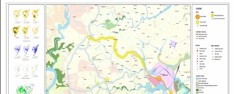
11 ethekwini Spatial Development Framework
12 City-scale spatial planning context ethekwini plans to develop infrastructure and public transport inside the urban edge: INK falls inside the urban edge INK is well located with regard to rapidly growing northern investment corridor: Umhlanga node Gateway River Horse Valley Proposed Dube Tradeport Proposed new airport
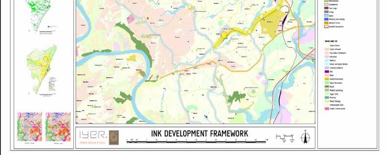
13 INK Development Framework
14 RESULTS (1) Roads and public transport : Improving city-scale linkages: the P577 provincial road was extended to link INK to Pinetown and New Germany Nandi Drive now links INK directly with the N2 highway negotiations with province to improve MR93 and P138 roads Internal road improvements: main access road to KwaMashu upgraded (Malandela Rd) Ubhejane Rd extended to link INK to the Bridge City site other local improvements and pedestrian walkways Public transport improvements: new taxi interchange built at Emtshebheni multimodal transport interchange being built at Bridge City railway to be extended to Bridge City


15 Nodes and corridors with road and place overlay EMTSHEBHENI P138 P138 DUBE VILLAGE BRIDGE CITY LINDELANI KWAMASHU TOWN CENTRE UBHEJANE UBHEJANE RD RD MR93 MR93 MALANDELA RD P577 & NTUZUMA MAIN P577 NANDI DRIVE N2 N2
16 RESULTS (2) Establishing a hierarchy of nodes (1) KwaMashu Town Centre developed as a node since 1999 (covered in separate presentation) Bridge City node a regional-scale public-private joint venture on 60ha of land between Phoenix and Inanda that will, on completion in ten years time, house: a 40,000m 2 regional-scale shopping centre (in the first phase) about 4,500 sectional title apartments a 450-bed provincial hospital a 13,000m 2 regional magistrate s court a 21,000m 2 regional services hub a 300m 2 end-of-line railway station a 12,000m 2 municipal multimodal transport interchange 250,000m 2 of business space aimed at commercial business and SMEs -

17 Bridge City artist s impression
18 RESULTS (3) Establishing a hierarchy of nodes (2) Other planned nodes within INK: Inception reports, development perspectives, assessment reports and urban design plans have been completed for: Emtshebheni (new taxi interchange already built) Dube Village (existing node with shopping centre) KwaNozaza Lindelani P577 & Ntuzuma Main Road node Nandi Drive

19 Aerial pic: Emtshebheni node (example)
20 RESULTS (4) Activity corridors Ubhejane Rd: spans the Piesangs river and links KMTC to the Bridge City site and Phoenix Industrial Park Malandela Rd: provides access from KwaMashu to Durban city centre via Newlands; will be on P577 link to Pinetown MR93/P138 corridor/inanda Heritage Route: an INK anchor project
21 RESULTS (5) Neighbourhood centres Examples of activities to regenerate neighbourhoods: Newtown A mini taxi rank and business area built Negotiations on rates arrears to encourage rebuilding of businesses destroyed in 1980s violence Building of sidewalks and pedestrian access Building of recreation facilities, e.g. swimming pools Rubbish removal for all except some informal settlements where rubbish truck cannot gain access Street lighting Poles installed for closed circuit television security system Landscaping of public space Information and communications technology centre in Inanda Events in local area facilities, e.g. SMME Fair at John Dube Stadium Projects with DEAT to improve the natural environment
22 RESULTS (6) Providing a range of housing options No high-density or mixed-use residential development: most housing in KwaMashu and Ntuzuma are standard two- and fourroomed township houses some hostel upgrading into family units in KwaMashu some residential infill development: mainly freestanding 30m 2 subsidised houses or freestanding developer-built middle income housing Steps are being taken to increase residential density, including: land for multi-storey and mixed-use residential development, e.g. in KwaMashu Town Centre. land identified in KwaNozaza for mixed-use commercial and social housing. about 4,500 upmarket apartments to be built at Bridge City
23 LESSONS LEARNED (1) Look for linkages and synergies across functional silos: a key aim of area-based management Deal with land issues as soon as possible to avoid later delays e.g. tenure upgrading in KwaMashu Take careful steps to manage stakeholder relations: including traditional authorities where appropriate Clarify institutional roles and responsibilities: because INK has a coordinating role and all physical work is done by line departments, project sponsors within departments meet regularly in a technical planning forum
24 LESSONS LEARNED (2) Ensure appropriate technology is used: INK s hilly topography means alternative infrastructure, e.g. septic tanks, may be the best solution Link capital expenditure to social goals: exploit potential for employment, skills transfer, economic growth and potential for improved quality of life A hierarchy of nodes is important, but nodes may compete: competition, especially between larger nodes (Bridge City and KwaMashu Town Centre) may threaten the workability of a hierarchy of nodes
township renewal ink CASE STUDY
 township renewal ink CASE STUDY township renewal ink CASE STUDY Acknowledgements This case study has relied to a great extent on first-hand knowledge and materials produced by S busiso Dlamini and Linda
MODULE 3 RESTRUCTURING THE ENVIRONMENT
 MODULE 3 RESTRUCTURING THE TOWNSHIP PHYSICAL ENVIRONMENT FOCUS OF THE MODULE The physical and spatial (locational) characteristics that prevent townships from developing Levels of intervention: Things
MAYFIELD WEST SECONDARY PLAN PHASE 2
 MAYFIELD WEST SECONDARY PLAN PHASE 2 Public Open House #3 February 25, 2010 Draft Preferred Land Use Scenario TOWN OF CALEDON PLANNING & DEVELOPMENT DEPARTMENT Open House Agenda TOWN OF CALEDON 1. Welcome
PLACE WORKSHOP REPORT. A+DS SNH sustainable placemaking programme
 PLACE briefing WORKSHOP REPORT A+DS SNH sustainable placemaking programme INTRODUCTION This report summarises the outcome of a Scottish Natural Heritage workshop on placemaking which was held on Wednesday
UDF PLANS AND GUIDELINES
 UDF PLANS AND GUIDELINES 5 Land Use Land Use Development Plan Plan no. 3 Land Use Development Mixed Use Retail / Leisure Residential Civic and Institutional Proposed Zoning Table Development Edges Plan
Commercial, Retail and Tourism Executive Summary December 2018
 Town of Wasaga Beach Official Plan Review, Retail and Executive Summary December 2018 1 An Official Plan directs where and how to grow The preparation of a new Official Plan for Wasaga Beach is an opportunity
CORNUBIA RETAIL PARK- PLANNING REPORT REVERT 3
 CORNUBIA RETAIL PARK- PLANNING REPORT 19.04.2013 REVERT 3 1 FOR: BY: 28 DEVONSHIRE AVENUE GLENWOOD DURBAN 4001 P.O. BOX 17390 CONGELLA 4013 T +27 31 202 9550 F +27 31 202 9551 1st FLOOR THE MEDIA MILL
Chapter 03 Planning framework
 Vauxhall Nine Elms Battersea Opportunity Area Planning Framework Chapter 03 Planning framework Mayor of London 25 preferred option - 16,000 residential units 20,000-25,000 jobs northern line extension
MAYFIELD WEST SECONDARY PLAN PHASE 2
 MAYFIELD WEST SECONDARY PLAN PHASE 2 Council Information Workshop February 16, 2010 Draft Preferred Land Use Plan TOWN OF CALEDON PLANNING & DEVELOPMENT DEPARTMENT Workshop Agenda TOWN OF CALEDON 1. Welcome
Submission to the Kildare County Council Development Plan North Kildare Chamber. Executive Summary
 ` 28 th May 2015 Submission to the Kildare County Council Development Plan 2017-2023 North Kildare Chamber Executive Summary North Kildare Chamber s mission is to work with businesses, community groups,
3.3. Urban Structure Defining a New Hierarchy of Routes and Spaces >Images
 Section 3.0 I The Masterplan Framework 18 >Images Examples of high quality routes and spaces 3.3. Urban Structure The success of any masterplan lies in a clear definition of the future urban structure
Outline of Presentation
 LUSAKA CITY COUNCIL 2 nd Annual IGC Cities Conference Making Cities work for growth London School of Economics (LSE) United Kingdom. 28 th 29 th January 2016 Presenter: Alex Mwansa Town Clerk Lusaka City
14.5 HOPEFIELD: (REFER PLAN 39 AND PLAN 40)
") URBAN DYNAMICS WESTERN CAPE INC. 248 14.5 HOPEFIELD: (REFER PLAN 39 AND PLAN 40) FIGURE 83: LOCALITY - HOPEFIELD Within the context of the Saldanha Bay Municipal area, Hopefield, an historical agricultural
URBAN DYNAMICS WESTERN CAPE INC. 248 14.5 HOPEFIELD: (REFER PLAN 39 AND PLAN 40) FIGURE 83: LOCALITY - HOPEFIELD Within the context of the Saldanha Bay Municipal area, Hopefield, an historical agricultural
SOCIO-ECONOMIC MOVEMENT ENVIRONMENT INFRASTRUCTURE TOWN PLANNING
 Table 7: SWOT Analysis SWOT ANALYSIS SOCIO-ECONOMIC MOVEMENT ENVIRONMENT INFRASTRUCTURE TOWN PLANNING STRENGTHS HIGH COMMUTER POPULATION DENSITY MAJORITY OF POPULATION BETWEEN AGE OF 15 & 34 LARGE AVAILABLE
PUBLIC OPEN HOUSE SEPTEMBER 8 TH, 2010 CITY OF LETHBRIDGE DEVELOPMENT SERVICES
 PUBLIC OPEN HOUSE SEPTEMBER 8 TH, 2010 CITY OF LETHBRIDGE DEVELOPMENT SERVICES INTRODUCTION Why is the City creating the West Lethbridge Employment Centre Area Structure Plan? West Lethbridge Urbanization
Niagara GO Hub and Transit Stations Study
 Niagara GO Hub and Transit Stations Study Public Open House #2 June 2017 Study Purpose The purpose of this study is to prepare four key deliverables for each station area: 1. Work with Metrolinx to provide
SUSTAINABLE URBAN DEVELOPMENT AND COHESION POLICY EUROPEAN COMMISSION. Urban Policy within the framework of EU Cohesion Policy
 Urban Policy within the framework of EU Cohesion Policy 2007-2013 16/09/2007 SUSTAINABLE URBAN DEVELOPMENT AND COHESION POLICY 2007-2013 Marco Orani European Commission Directorate General for 1 SUSTAINABLE
Local Development Plan for Glasgow
 Local Development Plan for Glasgow Forbes Barron Head of Planning & Building Control Services Context and Process for LDP NPF 3 Principles An 80% reduction in emissions by 2050. Achieving the aims of the
Making the case for Sustainable Transport Project Potential
 Making the case for Sustainable Transport Project Potential The Structural Investment Fund (SIF) Strategy for Greater Lincolnshire identifies the barriers to growth identified by having poor transport
St. Clair Avenue West Area Transportation Master Plan
 1 (Between Keele Street and Old Weston Road) Public Information Centre 1 December 2, 2015 2 Welcome Welcome to the first Public Information Centre for the St. Clair Avenue West Area. The panels will present
Official Plan Review
 Official Plan Review Summary Report - The Built Environment August 2014 Part 1: Introduction Planning for a healthy, prosperous and sustainable community is an important goal for our municipality. From
Newcourt Masterplan. November Exeter Local Development Framework
 Newcourt Masterplan November 2010 Exeter Local Development Framework Background The Exeter Core Strategy Proposed Submission sets out the vision, objectives and strategy for the development of Exeter up
Municipal Development Plan Update Urban Service Area and Hamlets
 ENCLOSURE 1 Municipal Development Plan Update Urban Service Area and Hamlets Priorities Committee January 24, 2017 MUNICIPAL DEVELOPMENT PLAN UPDATE SHAPING OUR FUTURE MDP Update - Agenda MDP Update Public
[PLANNING RATIONALE] For Site Plan Control and Lifting of Holding Zone By-Law 101 Champagne Avenue. May 23, 2014
![[PLANNING RATIONALE] For Site Plan Control and Lifting of Holding Zone By-Law 101 Champagne Avenue. May 23, 2014](/thumbs/75/71599615.jpg "[PLANNING RATIONALE] For Site Plan Control and Lifting of Holding Zone By-Law 101 Champagne Avenue. May 23, 2014") [PLANNING RATIONALE] For Site Plan Control and Lifting of Holding Zone By-Law 101 Champagne Avenue May 23, 2014 Contents 1.0 Introduction... 2 2.0 Site Context... 2 2.1 Adjacent Uses... 2 Figure 1: Site
[PLANNING RATIONALE] For Site Plan Control and Lifting of Holding Zone By-Law 101 Champagne Avenue May 23, 2014 Contents 1.0 Introduction... 2 2.0 Site Context... 2 2.1 Adjacent Uses... 2 Figure 1: Site
page 258 THE OLIFANTS RIVER VALLEY
 page 258 THE OLIFANTS RIVER VALLEY page 259 page 260 5.10 VREDENDAL (population: ± 20 400) (IDP 2012-2017) 5.10.1 SPATIAL ANALYSIS, see Figures 5.101.1 Sub-regional location Vredendal is located at the
Inspiring Technovation
 1 2 Table of content List of table and figures... Executive summary... 1. Introduction... 2. Material and methods... 3. Results... 3.1 Today s facts about Versailles: a diagnostic approach... 3.1 Vision
6 Growth Management Challenges and Opportunities
 6 Growth Management Challenges and Opportunities The Town has established a goal of attaining a 50% participation rate with respect to employment opportunities versus residential population. The Town s
The Tonsley Park Sustainable. Precinct
 Planning Institute of Australia Economic Development Australia The Tonsley Park Sustainable Technologies Employment Precinct Len Piro 5 August 2010 Project Overview The Site SA Government, through the
YONGE STEELES CORRIDOR SECONDARY PLAN. Young + Wright / IBI Group Architects Dillon Consulting Ltd. GHK International (Canada) Ltd.
 Ltd.") PART A: PREAMBLE 1.0 PURPOSE The purpose of this Secondary Plan is to provide a development framework for intensification of the Yonge/ Steeles corridor including the north side of Steeles Avenue West
PART A: PREAMBLE 1.0 PURPOSE The purpose of this Secondary Plan is to provide a development framework for intensification of the Yonge/ Steeles corridor including the north side of Steeles Avenue West
Urban planning and Public Transport
 Urban planning and Public Transport MOJCA SASEK DIVJAK Urban Planning Institute of the Republic of Slovenia Trnovski pristan 2, 1000 Ljubljana SLOVENIA e-mail: mojca.sasek@uirs.si; http://www.uirs.si Abstract:
THE TOWN OF WASAGA BEACH
 THE TOWN OF WASAGA BEACH Downtown Development Master Plan Committee of the Whole Presentation January 26 th 2017 Uses within this designation should reflect a dependence on tourism as opposed to the permanent
Tauranga City Centre Spatial Framework
 Tauranga City Centre Spatial Framework Stakeholder Engagement Workshop 15 October 2015 Project Design Team Beca & LandLAB Our team Henry Crothers (LandLab) Landscape Architect/Urban Designer Urban and
Former Rockcliffe Airbase Community Design Plan Guiding Design Vision and Principles December 4, 2013
 APPENDIX 5 - Guiding Design Vision and Principles Former Rockcliffe Airbase Community Design Plan Guiding Design Vision and Principles December 4, 2013 Vision Statement The redevelopment of the former
MILTON HEIGHTS COMMUNITY January 2006 Revised February 2015 Revised November 2015
 REVISED DRAFT MILTON HEIGHTS COMMUNITY January 2006 Revised February 2015 Revised November 2015 Urban Design Guidelines Milton Heights Landowners Group This page has been intentionally left blank. Contents
Turcot: For a sustainable and active future
 Turcot: For a sustainable and active future Turcot: Pour un site actif et un développent durable This site offers one of largest undeveloped open space near a CBD in the country. Currently the location
Complete Neighbourhood Guidelines Review Tool
 Complete Neighbourhood Guidelines Review Tool Prepared By: City of Regina Planning Department October 2014 Page 1 of 14 Community Development Review Checklist for Secondary Plans and Concept Plans The
MOUNT PLEASANT SECONDARY PLAN & VILLAGE BLOCK PLAN. Wednesday, March 5, 2008 Informal Public Open House
 MOUNT PLEASANT SECONDARY PLAN & VILLAGE BLOCK PLAN Wednesday, March 5, 2008 Informal Public Open House 1. Welcome & Introductions 2. Highlights of Provincial Growth Plan 3. Overview and Status Update -
PUBLIC OPEN HOUSE HURONTARIO-MAIN CORRIDOR SECONDARY PLAN
 PUBLIC OPEN HOUSE HURONTARIO-MAIN CORRIDOR SECONDARY PLAN Tuesday, February 28, 2012 6pm 9pm 1 st Floor Atrium, City Hall 2 Wellington Street West, Brampton 1 POLICY FRAMEWORK The 2006 Provincial Growth
TORONTO COMPLETE STREETS GUIDELINES
 TORONTO COMPLETE STREETS GUIDELINES Presentation by Fiona Chapman, Manager, Pedestrian Projects Public Realm Section, Transportation Services, City of Toronto June 2017 PURPOSE OF THE PROJECT To develop
CITY OF LANGLEY OFFICIAL COMMUNITY PLAN BYLAW, 2005, NO APPENDIX II - REGIONAL CONTEXT MAP
 CITY OF LANGLEY OFFICIAL COMMUNITY PLAN BYLAW, 2005, NO. 2600 APPENDIX II - REGIONAL CONTEXT MAP ± Legend Agricultural Mixed Employment Industrial Conservation & Recreation Regional City Centre Urban Containment
Session 4 New Urban Regions and Major Urban Extensions. Tackling Western Sydney s Urban Growth
 Session 4 New Urban Regions and Major Urban Extensions Tackling Western Sydney s Urban Growth Stephanie Barker Rohan Dickson & Associates and consultant to NSW Growth Centres Commission Friday 8 February
The Integrated Transport Plan: Non-motorised Transport in the City of Cape Town (1979) 1
 1") Integrating the Bicycle in Comprehensive Policies The Integrated Transport Plan: Non-motorised Transport in the City of Cape Town (1979) 1 The 1980-1985 Transport Plan for Cape Town Metropolitan Transport
Integrating the Bicycle in Comprehensive Policies The Integrated Transport Plan: Non-motorised Transport in the City of Cape Town (1979) 1 The 1980-1985 Transport Plan for Cape Town Metropolitan Transport
RE-THINKING URBAN UPGRADING. The urban NEXUS approach to promote green and inclusive settlements
 RE-THINKING URBAN UPGRADING The urban NEXUS approach to promote green and inclusive settlements OUTLINE OF THE PRESENTATION: PROBLEM STATEMENT Chronology of the Habitat Agenda Highlight urban challenges
1120 Haist Street - Pelham Arena Community Co-Design Recommendation Report Haist Street - Pelham Arena Community Co-Design Recommendation Report
 1120 Haist Street - Pelham Arena Community Co-Design Executive Summary: In May, 2017 the Town retained the services of The Planning Partnership to undertake a community design charrette process to determine
Welcome to the Oakridge Centre Open House
 Welcome to the Oakridge Centre Open House Why is the City hosting this event? This open house is to inform you of a rezoning application submitted to the City of Vancouver to amend the existing CD-1 (Comprehensive
CHAPTER 7: Transportation, Mobility and Circulation
 AGLE AREA COMMUNITY Plan CHAPTER 7 CHAPTER 7: Transportation, Mobility and Circulation Transportation, Mobility and Circulation The purpose of the Transportation, Mobility and Circulation Chapter is to
TOD 101 CREATING LIVABLE COMMUNITIES WITH TRANSIT
 1 CREATING LIVABLE COMMUNITIES WITH TRANSIT What are transit Centered Communities? Benefits of Partnerships to Support and Implement What You Will Learn Portland s Pearl District Your Trainers Today Catherine
Rio de Janeiro - Brazil. Urban Regeneration & Climate Change
 Rio de Janeiro - Brazil Urban Regeneration & Climate Change 2017 Rio de Janeiro - Brazil introduction slide 1 BRASIL 204.5 million inhabitants RIO DE JANEIRO STATE 16.5 million inhabitants RIO DE JANEIRO
Visioning Statement and Guiding Principles
 Visioning Statement and Guiding Principles Planning for the Future The General Plan The General Plan represents Woodland's shared vision of the future and defines a path to lead the community toward its
TEHRAN LONG TERM URBAN RAIL PLAN
 TEHRAN LONG TERM URBAN RAIL PLAN Introduction and Methodology Introduction Greater Tehran is currently one of the most populated mega cities in the world with an estimated population of 14 million inhabitants
Chapter 3 Core Strategy
 Chapter 3 Core Strategy 3.0 Introduction The core strategy sets out how the development objectives in the Development Plan are consistent with the National Spatial Strategy and the Regional Planning Guidelines.
section 3: Vision, Values and Goals
 Vision, Values and Goals 3 2041 Vision: Victoria is an urban sustainability leader inspiring innovation, pride and progress towards greater ecological integrity, livability, economic vitality, and community
Derry Green Corporate Business Park
 Town of Milton Derry Green Corporate Business Park Urban Design Guidelines BMI/Pace - June 2010 Draft 3 Prepared by: Brook McIlroy Planning + Urban Design / Pace Architects Suite 300-51 Camden Street Toronto,
This page has been intentionally left blank.
 This page has been intentionally left blank. Chapter 3 3-2 3. Employment 3.A Niagara Economic Gateway 3.A.1 General The Niagara Economic Gateway comprises: a) The Gateway Economic Zone which includes all
The River Hub: NEW BUILDINGS
 Summary The River Hub includes 6 municipalities that all boarder the Fraser River. Combined, they are expected to double in population over the next 50 years. To accommodate this new population, 138,831
Expert Group Meeting. NUP Framework for A Rapid Diagnostic. Mainstreaming Climate Change into National Urban Policies. Themba R.
 Expert Group Meeting Mainstreaming Climate Change into National Urban Policies Themba R. Phakathi NUP Framework for A Rapid Diagnostic United Nations Conference Centre, Bangkok, Thailand, 17-18 March 2015
SWLP 42: Worcester City Centre
 SWLP 42: Worcester City Centre A. The following sites are allocated for retail development (as shown on the Proposals Map): Policy Reference SWDP7/1 SWDP7/2 SWDP7/3 Sites allocated for retail development
3. Endorse the LRT vision in transforming Surrey into Connected-Complete-Livable communities, and more specifically, the official vision statement:
 CORPORATE REPORT NO: R038 COUNCIL DATE: February 20, 2017 REGULAR COUNCIL TO: Mayor & Council DATE: February 16, 2017 FROM: General Manager, Engineering FILE: 8740-01 SUBJECT: Surrey Light Rail Transit
Recent UN and EU Sustainable Development Policies (Post 2015): What challenges for city planning and governance
: What challenges for city planning and governance") Recent UN and EU Sustainable Development Policies (Post 2015): What challenges for city planning and governance Europe at a crossroads: the challenge for future sustainable development 20 July 2016 Roudaina
Recent UN and EU Sustainable Development Policies (Post 2015): What challenges for city planning and governance Europe at a crossroads: the challenge for future sustainable development 20 July 2016 Roudaina
Stakeholders Advisory Working Groups (SAWGs) Smart Growth and TOD Land Use (#11) SAWG Meeting
 Smart Growth and TOD Land Use (#11) SAWG Meeting") Presentation - Part II Tappan Zee Bridge/I-287 Corridor Project July 21, 2010 Slide 1. David Kooris (Regional Plan Association) welcomed members of the Land Use Stakeholders Advisory Working Groups (SAWGs)
Presentation - Part II Tappan Zee Bridge/I-287 Corridor Project July 21, 2010 Slide 1. David Kooris (Regional Plan Association) welcomed members of the Land Use Stakeholders Advisory Working Groups (SAWGs)
heuston gateway: sections heuston gateway: regeneration strategy and development framework plan
 B B1 A B1 B C A heuston gateway: sections B B1 C 117 4.3.3 Zoning The station is the central hub of the area and this function must be preserved and developed. However large areas of the Heuston Station
Integrated Multi Modal Public Transit Hub
 Leaders Programme in Urban Transport Planning and Management Integrated Multi Modal Public Transit Hub at Central Business District- Ahmedabad Neela Munshi (Senior Town Planner) Deepa Dave (AM Urban Planner)
495/MetroWest Development Compact Plan Citizen Planner Training Collaborative Conference. March 17, 2012
 495/MetroWest Development Compact Plan Citizen Planner Training Collaborative Conference March 17, 2012 Project Process Local and Regional Priority Areas Growth Scenarios Transportation Investment Categories
Tāhuhu whakaruruhau ā-taone The sheltering ridge pole
 B2. Tāhuhu whakaruruhau ā-taone - Urban growth and form B2.1. Issues Tāhuhu whakaruruhau ā-taone The sheltering ridge pole Auckland s growing population increases demand for housing, employment, business,
1.0 Purpose of a Secondary Plan for the Masonville Transit Village
 Report to Planning and Environment Committee To: Chair and Members Planning & Environment Committee From: John M. Fleming Managing Director, Planning and City Planner Subject: Masonville Transit Village
Master Environmental Servicing Plan & Secondary Plan
 1 East Side Lands Stage 2 Master Environmental Servicing Plan & Secondary Plan Public Consultation Centre #4 March 20, 2018 Welcome! Today s Agenda Please sign in at the registration table. 6:00 pm 6:30
WITNESS STATEMENT Of. Ronald Blake. On behalf of the Intervenor The Corporation of the City of Markham
 Filed: 2013-06028 EB-2012-0451 Exhibit L.EGD.COM.2 Page 1 of 7 WITNESS STATEMENT Of Ronald Blake On behalf of the Intervenor The Corporation of the City of Markham In the matter of an application by Enbridge
Sustainable Urban Development
 Sustainable Urban Development Cork City s experience of the Designated Urban Centre Grant Scheme Ann Doherty Chief Executive, Cork City Council 27 th March 2018 Southern and Eastern Regional Operational
PSRC REVIEW REPORT & CERTIFICATION RECOMMENDATION
 PSRC REVIEW REPORT & CERTIFICATION RECOMMENDATION KITSAP COUNTY COUNTYWIDE PLANNING POLICIES July 2, 2012 BACKGROUND A major emphasis of the Washington State Growth Management Act (GMA) is the need to
THE CITY OF VAUGHAN BY-LAW BY-LAW NUMBER A By-law to adopt Amendment Number 1 to the Official Plan of the Vaughan Planning Area.
 THE CITY OF VAUGHAN BY-LAW BY-LAW NUMBER 015-2014 A By-law to adopt Amendment Number 1 to the Official Plan of the Vaughan Planning Area. NOW THEREFORE the Council of the Corporation of the City of Vaughan
Downtown Dubuque...it s a great time.
 Downtown Dubuque...it s a great time. Your timing could not be better to invest in Downtown. With hundreds of millions in public and private investment occurring on the City s downtown waterfront, millions
The Illinois Department of Transportation and Lake County Division of Transportation. Route 173, including the Millburn Bypass
 The Illinois Department of Transportation and Lake County Division of Transportation welcome you to this Public Hearing for U.S. Route 45 from Illinois Route 132 to Illinois Route 173, including the Millburn
Trafalgar Road Corridor Planning Study Open House
 Trafalgar Road Corridor Planning Study Open House June 24, 2013 6:30-8:30 p.m. Oakville & Trafalgar Rooms Overview The Livable Oakville Plan identifies the lands along Trafalgar Road, between the QEW and
9 CITY OF VAUGHAN OFFICIAL PLAN AMENDMENT NO BOCA EAST INVESTMENTS LIMITED
 9 CITY OF VAUGHAN OFFICIAL PLAN AMENDMENT NO. 631 - BOCA EAST INVESTMENTS LIMITED The Planning and Economic Development Committee recommends the adoption of the recommendations contained in the following
Transforming Saint John s Urban Heart -
 Transforming Saint John s Urban Heart - How Innovative Community Engagement Inspires a Bold Municipal Plan for a More Sustainable and Compact Saint John 2012 NNECAPA Conference - Brunswick, ME October
Shift Rapid Transit Public Participation Meeting May 3, 2017
 Shift Rapid Transit Public Participation Meeting May 3, 2017 Shift Rapid Transit Initiative Largest infrastructure project in the city s history. Rapid Transit initiative will transform London s public
Corridors. Re-vitalize our Corridors and Gateways
 Corridors Re-vitalize our Corridors and Gateways Artist s rendering from the 287 Strategic Plan, 2015 Corridors are the major throughways of Loveland but they also provide important commercial, community
PUBLIC REALM STRATEGY
 CONSULTATION DRAFT PUBLIC REALM STRATEGY Trenchard Street & Frogmore Street City Design Group Place Directorate Public Realm Strategy Trenchard Street & Frogmore Street Contents 1. Introduction 2. Understanding
20. Ballysadare Mini-Plan
 20. Ballysadare Mini-Plan 20. Ballysadare Mini-Plan Community facilities Ballysadare has a wide range of community facilities: a primary school, St Mary s College (secondary school), a health centre, playing
PRESENTATION ON JOHANNESBURG S BIODIVERSITY PROGRAMME
 PRESENTATION ON JOHANNESBURG S BIODIVERSITY PROGRAMME Member of Mayoral Committee: Cllr Prema Naidoo Environmental Management & Johannesburg City Parks PRESENTATION OVERVIEW Jo burg Overview & Context
The transportation system in a community is an
 7 TRANSPORTATION The transportation system in a community is an important factor contributing to the quality of life of the residents. Without a sound transportation system to bring both goods and patrons
Regional Context Statement
 Regional Context Statement REGIONAL CONTEXT STATEMENT 3. REGIONAL CONTEXT STATEMENT In 1995, the Provincial Government passed into law the Growth Strategies Act. The purpose of this provincial initiative
Mobility Hub Guidelines: Tools for Achieving Successful Station Areas
 Mobility Hub Guidelines: Tools for Achieving Successful Station Areas This paper introduces Metrolinx s recently released Mobility Hub Guidelines and highlights two key aspects of the document: the importance
What Does It Take To Create A Town Center?
 What Does It Take To Create A Town Center? Context, Design, and Process The Prince Frederick Master Plan Update 1 Background and Overview A Brief History of Town Centers in Calvert County 2 Background
CITY OF CHARLOTTESVILLE, VIRGINIA CITY COUNCIL AGENDA
 CITY OF CHARLOTTESVILLE, VIRGINIA CITY COUNCIL AGENDA Agenda Date: December 16, 2013 Action Required: Adoption of Resolution Presenter: Staff Contacts: Title: James E. Tolbert, AICP, Director of NDS James
SCARBOROUGH SUBWAY EXTENSION. Scarborough Subway Extension. Final Terms of Reference
 Scarborough Subway Extension Final Terms of Reference 1 1.0 Introduction and Background 1.1 Introduction Toronto City Council recently confirmed support for an extension of the Bloor-Danforth Subway from
BERTRAMS PRIORITY BLOCK. Dra support documentation to the recommendations to SAHRA for the Priority Block, Bertrams, Johannesburg OCTOBER 2008
 BERTRAMS PRIORITY BLOCK Dra support documentation to the recommendations to SAHRA for the Priority Block, Bertrams, Johannesburg OCTOBER 2008 CONTENTS 1. Execu ve Summary 2. Report Structure 3. Background
Official Plan Review: Draft Built Form Policies
 PG.30.1 REPORT FOR ACTION Official Plan Review: Draft Built Form Policies Date: May 15, 2018 To: Planning and Growth Management Committee From: Chief Planner and Executive Director, City Planning Division
Local Growth Planning in North Central Green Line Communities
 2018 April 30 Page 1 of 6 EXECUTIVE SUMMARY This report outlines a high-level scope for local growth planning for north central Green Line communities. The catalyst for this review is the significant investments
The role of urban mobility in (re)shaping cities
shaping cities") The role of urban mobility in (re)shaping cities Mr. Andre Dzikus Urban Basic Services Branch Coordinator www.unhabitat.org Structure 1) Urbanisation - Challenges 2) Mobility shaping the city 3) Mobility
The role of urban mobility in (re)shaping cities Mr. Andre Dzikus Urban Basic Services Branch Coordinator www.unhabitat.org Structure 1) Urbanisation - Challenges 2) Mobility shaping the city 3) Mobility
GOLDEN MILE SECONDARY PLAN. Community Consultation Meeting #3 June 26, 2018
 GOLDEN MILE SECONDARY PLAN Community Consultation Meeting #3 June 26, 2018 Meeting Overview 1. Introduction 2. Principles + Vision 3. Street + Block Alternatives 4. Parks + Open Space Alternatives 5. Land
Guidelines for Planning Authorities and Part V of the Planning and Development Act 2000: December 2000
 Slide 1 Slide 2 Slide 3 Slide 4 As a planner in practice, whether within the Local Authority, private practice or An Bord Pleanala, due regard must be given to the guidance provided by the Department in
Transit Oriented Development. Overview
 Trammell Crow Residential Sean G. Hyatt, Managing Director Transit Oriented Development What is TOD? TOD in King County TOD Characteristics and Examples Veloce (Alexan Redmond TOD) About Trammell Crow
178 Carruthers Properties Inc.
 178 Carruthers Properties Inc. Planning Rationale for 178 Carruthers Avenue Site Plan Control Application June 2014 Table of Contents 1.0 Introduction 2.0 Overview of Subject Property 3.0 Current Zoning
Report to: Development Services Committee Report Date: April 24, 2017
 SUBJECT: Cornell Rouge National Urban Park Gateway - Report on Design Charrette and Next Steps PREPARED BY: Lilli Duoba, MES, MCIP, RPP, Manager, Natural Heritage (ext. 7925) REVIEWED BY: Marg Wouters,
12/9/2013. HOLLYWOOD/PINES CORRIDOR PROJECT AMPO 2013 Annual Conference October 24, Our Perspective. Broward.
 HOLLYWOOD/PINES CORRIDOR PROJECT AMPO 2013 Annual Conference October 24, 2013 Our Perspective Broward Fort Lauderdale 1 Broward Metropolitan Planning Organization Fort Lauderdale Fort Lauderdale Skyline
PLANNING AND URBAN DESIGN RATIONALE REPORT. Hunters Pointe Golf Course Redevelopment 289 Daimler Parkway Prepared For: Ontario Ltd.
 PLANNING AND URBAN DESIGN RATIONALE REPORT Hunters Pointe Golf Course Redevelopment 289 Daimler Parkway Prepared For: 2599587 Ontario Ltd. February 2018 Redevelopment of Hunters Pointe Golf Course, Welland
PROJECT FEATURE CORNUBIA MALL
 PROJECT FEATURE CORNUBIA MALL CLIENT Investec Property ARCHITECTS Bentel Associates International PROJECT MANAGERS SIP Project Managers QUANTITY SURVEYORS Brian Heineberg & Associates STRUCTURAL ENGINEERS
Chapter 1. Community Context. Vision Statement Population and Housing Trends Legislative Context Regional Context Statement
 Chapter 1 Community Context Vision Statement Population and Housing Trends Legislative Context Regional Context Statement 1.1 VISION STATEMENT CORPORATE MISSION STATEMENT To promote a safe and livable
Key Themes and Responses May 2016
 King and Victoria Transit Hub and Waterloo Street Pedestrian Access Key Themes and Responses May 2016 The following summarizes what Regional staff heard about the King Victoria Transit Hub and Waterloo