Curly-leaf Pondweed and Full Warm Water Point/Intercept Macrophyte Surveys Fawn Lake Spider Chain (WBIC: ) Sawyer County, Wisconsin
|
|
|
- Myra Miller
- 5 years ago
- Views:
Transcription
 Sawyer County, Wisconsin Fawn Lake")
 Project Initiated by: Spider Chain of Lakes Association, Short")
 * Fawn")

1 Curly-leaf Pondweed and Full Warm Water Point/Intercept Macrophyte Surveys Fawn Lake Spider Chain (WBIC: ) Sawyer County, Wisconsin Fawn Lake aerial photo (2010) Emergent vegetation in the Fawn Lake Inlet from North Lake (Berg 2012) Project Initiated by: Spider Chain of Lakes Association, Short Elliot Hendrickson Inc., and the Wisconsin Department of Natural Resources (Grant AEPP ) * Fawn Lake South shoreline of Fawn Lake (Berg 2012) Survey Conducted by and Report Prepared by: Endangered Resource Services, LLC Matthew S. Berg, Research Biologist St. Croix Falls, Wisconsin April 21, May 28, and August 11, 2012
2 TABLE OF CONTENTS Page ABSTRACT.. LIST OF FIGURES LIST OF TABLES. ii iii iv INTRODUCTION METHODS DATA ANALYSIS RESULTS Cold Water Curly-leaf Pondweed Surveys... 6 August Full Point Intercept Macrophyte Survey... 6 Fawn Lake Plant Community... 9 Exotic Species Filamentous and Blue-green Algae DISCUSSSION AND CONSIDERATIONS FOR MANAGEMENT LITERATURE CITED APPENDIXES I: Fawn Lake Survey Sample Points II: Boat and Vegetative Survey Data Sheets.. 25 III: CLP Survey Map IV: Habitat Variable Maps V: Native Species Richness and Total Rake Fullness Maps.. 34 VI: Spider Chain Plant Species Accounts VII: Fawn Lake P/I Density and Distribution Maps VIII: Aquatic Exotic Invasive Plant Species Information. 88 IX: Glossary of Biological Terms X: Raw Data Spreadsheets i
3 ABSTRACT Fawn Lake (WBIC ) is a 28-acre stratified drainage lake located in north-central Sawyer County, WI. It is mesotrophic bordering on eutrophic in nature with Secchi readings from averaging 9.1ft, and a littoral zone that extended to 12.0ft in A desire to determine if exotic species like Curly-leaf pondweed (Potamogeton crispus) or Eurasian water milfoil (Myriophyllum spicatum) had invaded the lake, and to establish baseline data on the richness, diversity, abundance and distribution of other native aquatic plant populations prompted members of the Spider Chain of Lakes Association, Short, Elliot and Hendrickson, Inc., and the WDNR to authorize a CLP density survey on April 21, a CLP bed mapping survey on May 28, and a full lake point intercept survey on August 11, None of these surveys found evidence of CLP, EWM, or any other exotic species. The August survey found macrophytes at 38 of the 94 survey points (40.4%)/43 littoral points (88.4%), produced an exceptionally high Simpson s Diversity Index of 0.94, and had a moderately high average rake fullness rating of We identified a total of 37 plants growing in and immediately adjacent to the lake. Spatterdock (Nuphar variegata), Watershield (Brasenia schreberi), Coontail (Ceratophyllum demersum), and White water lily (Nymphaea odorata) were the most common species being found at 52.63%, 50.00%, 47.37%, and 39.47% of survey points with vegetation. The 30 native index species found in the rake produced an average mean Coefficient of Conservatism of 6.7 and a Floristic Quality Index of 36.7 that was much above the median value for this part of the state. Future management considerations include maintaining the lake s native plant communities; working to improve water clarity by reducing nutrient inputs along the lakeshore by such things as avoiding motor startups in shallow water, maintaining buffer strips of native vegetation, eliminating fertilizer applications, bagging grass clippings, removing pet waste, and disposing of fire pit ash away from the lake; conducting at least annual lake-wide meandering littoral zone surveys to monitor for new Aquatic Invasive Species like Purple loosestrife (Lythrum salicaria); supporting ongoing AIS prevention and control throughout the Spider Chain of Lakes; and developing an Aquatic Plant Management Plan that clarifies a response if a new AIS is introduced into the lake. ii
4 LIST OF FIGURES Page # Figure 1: Fawn Lake Bathymetric Map Figure 2: Rake Fullness Ratings... 2 Figure 3: April 21, 2012 CLP Survey Figure 4: Fawn Lake Survey Points and Lake Depth.. 7 Figure 5: Bottom Substrate and Littoral Zone Figure 6: Native Species Richness and Total Rake Fullness Figure 7: Fawn Lake s Most Common Macrophyte Species Figure 8: Filamentous Algae Density and Distribution/Blue-green Algae (Planktothrix isothrix) Blobs in the North Channel 18 Figure 9: Natural Shoreline vs. Mowing Down to the Shoreline Figure 10: Purple Loosestrife and Galerucella Beetles.. 20 iii
5 LIST OF TABLES Page # Table 1: Aquatic Macrophyte P/I Survey Summary Statistics Fawn Lake, Sawyer County August 11, Table 2: Frequencies and Mean Rake Sample of Aquatic Macrophytes Fawn Lake, Sawyer County August 11, Table 3: Floristic Quality Index of Aquatic Macrophytes Fawn Lake, Sawyer County August 11, iv
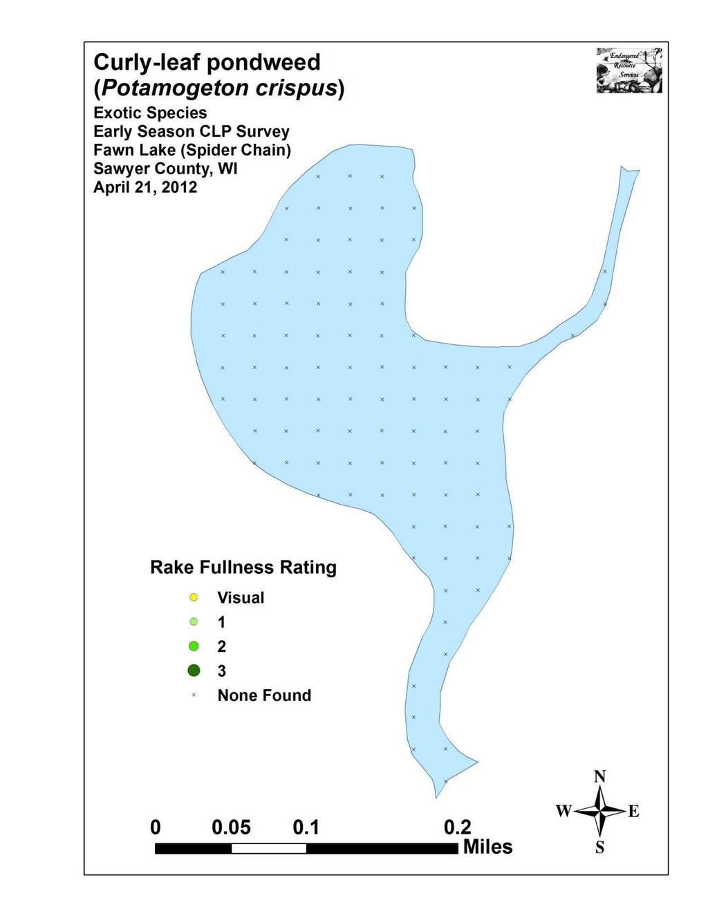
6 INTRODUCTION: Fawn Lake (WBIC ) is a 28-acre, stratified, drainage lake located in the Town of Spider Lake in north-central Sawyer County (T42N R7W S14/15, 22/23). The lake reaches a maximum depth of 35ft on the south side of the central basin and has an average depth of approximately 15ft. The lake is bordered by several Tamarack bogs, and the tannins they produce stain the water brown. This resulted in Secchi values at the time of the survey of 7ft, and a littoral zone that reached approximately 12.0ft. This fair water clarity was on the low end of Secchi readings from that averaged 9.1ft, and classified the lake as mesotrophic (WDNR 2012). Bottom substrate is predominantly nutrient rich organic muck with the exception of the sand-bottomed shoreline that extends out from the resort in the north bay (Figure 1) (Roth et al. 1969). Figure 1: Fawn Lake Bathymetric Map In 2012, the Spider Chain of Lakes Association (SCLA), Short Elliot Hendrickson, Inc. (SEH), and the Wisconsin Department of Natural Resources (WDNR) authorized a series of full lake plant surveys on Fawn Lake prior to developing an Aquatic Plant Management Plan for the lake. On April 21 st, we completed a cold water Curly-leaf pondweed (Potamogeton crispus) (CLP) point intercept survey. This was followed by a CLP bed mapping survey on May 28 th, and a warm water point intercept survey of all aquatic macrophytes on August 11 th. All of these surveys used the WDNR s statewide guidelines for conducting systematic point intercept macrophyte sampling. These methods ensure that all surveys in the state will be conducted in the same manner, thus allowing data to be compared across time and space. The immediate goals of the surveys were to determine if CLP or Eurasian water milfoil (Myriophyllum spicatum) had invaded the lake, and to establish data on the richness, diversity, abundance and distribution of other native aquatic plant populations. These data provide a baseline for long-term monitoring of the lake s macrophyte community as well as a way to measure any impacts on the lake s plants if an AIS is introduced or if active management occurs in the future. 1
7 METHODS: Cold Water Curly-leaf Pondweed Point Intercept Survey: Using a standard formula that takes into account the shoreline shape and distance, water clarity, depth and total acreage, Michelle Nault (WDNR) generated a 94 point sampling grid for Fawn Lake (Appendix I). Using this grid, we completed a density survey where we sampled for CLP at each point on the grid. We located each survey point using a handheld mapping GPS unit (Garmin 76CSx) and used a rake to sample an approximately 2.5ft section of the bottom. CLP was assigned a rake fullness value of 1-3 as an estimation of abundance (Figure 2). We also recorded visual sightings of CLP within six feet of the sample point. Figure 2: Rake Fullness Ratings (UWEX 2010) CLP Bed Mapping Survey: Following the CLP point intercept survey, we used a meandering littoral zone search to locate and delineate all significant beds of CLP on the lake. We defined a bed based on the following two criteria: CLP plants made up greater than 50% of all aquatic plants in the area, and the CLP had canopied at the surface or was close enough to the surface that it would likely interfere with normal boat traffic. Upon finding a bed, we circled around the perimeter and used a GPS unit to record waypoints at regular intervals. We then uploaded these points into ArcMap 9.3.1, created bed shapefiles using the WDNR Forestry Tools Extension, and determined the total acreage of the beds to the nearest hundredth of an acre. August Full Point Intercept Macrophyte Survey: Prior to beginning the August point intercept survey, we conducted a general boat survey of the lake to gain familiarity with the species present (Appendix II). All plants found were identified (Voss 1996, Boreman et al. 1997; Chadde 2002; Crow and Hellquist 2006; Skawinski 2011), and two vouchers were pressed and mounted for herbarium specimens one to be retained by the SCLA, and one to be sent to the state herbarium in 2
8 Stevens Point for identification confirmation. We again located each survey point with a GPS, recorded a depth reading with a Polar Vision hand held sonar unit, and took a rake sample. All plants on the rake, as well as any that were dislodged by the rake, were identified and assigned a rake fullness value of 1-3 as an estimation of abundance (Figure 2). We also recorded visual sightings of plants within six feet of the sample point not found in the rake. In addition to a rake rating for each species, a total rake fullness rating was also noted. Substrate (lake bottom) type was assigned at each site where the bottom was visible or it could be reliably determined using the rake. DATA ANALYSIS: We entered all data collected into the standard APM spreadsheet (Appendix II) (UWEX, 2010). From this, we calculated the following: Total number of sites visited: This included the total number of points on the lake that were accessible to be surveyed by boat. Total number of sites with vegetation: These included all sites where we found vegetation after doing a rake sample. For example, if 20% of all sample sites have vegetation, it suggests that 20% of the lake has plant coverage. Total number of sites shallower than the maximum depth of plants: This is the number of sites that are in the littoral zone. Because not all sites that are within the littoral zone actually have vegetation, we use this value to estimate how prevalent vegetation is throughout the littoral zone. For example, if 60% of the sites shallower than the maximum depth of plants have vegetation, then we estimate that 60% of the lake s littoral zone has plants. Frequency of occurrence: The frequency of all plants (or individual species) is generally reported as a percentage of occurrences within the littoral zone. It can also be reported as a percentage of occurrences at sample points with vegetation. Frequency of occurrence example: Plant A is sampled at 70 out of 700 total littoral points = 70/700 =.10 = 10% This means that Plant A s frequency of occurrence = 10% when considering the entire littoral zone. Plant A is sampled at 70 out of 350 total points with vegetation = 70/350 =.20 = 20% This means that Plant A s frequency of occurrence = 20% when only considering the sites in the littoral zone that have vegetation. From these frequencies, we can estimate how common each species was at depths where plants were able to grow, and at points where plants actually were growing. Note the second value will be greater as not all the points (in this example, only ½) had plants growing at them. 3
9 Simpson s Diversity Index: A diversity index allows the entire plant community at one location to be compared to the entire plant community at another location. It also allows the plant community at a single location to be compared over time thus allowing a measure of community degradation or restoration at that site. With Simpson s Diversity Index, the index value represents the probability that two individual plants (randomly selected) will be different species. The index values range from 0-1 where 0 indicates that all the plants sampled are the same species to 1 where none of the plants sampled are the same species. The greater the index value, the higher the diversity in a given location. Although many natural variables like lake size, depth, dissolved minerals, water clarity, mean temperature, etc. can affect diversity, in general, a more diverse lake indicates a healthier ecosystem. Perhaps most importantly, plant communities with high diversity also tend to be more resistant to invasion by exotic species. Maximum depth of plants: This indicates the deepest point that vegetation was sampled. In clear lakes, plants may be found at depths of over 20ft, while in stained or turbid locations, they may only be found in a few feet of water. While some species can tolerate very low light conditions, others are only found near the surface. In general, the diversity of the plant community decreases with increased depth. Mean and median depth of plants: The mean depth of plants indicates the average depth in the water column where plants were sampled. Because a few samples in deep water can skew this data, median depth is also calculated. This tells us that half of the plants sampled were in water shallower than this value, and half were in water deeper than this value. Number of sites sampled using rope/pole rake: This indicates which rake type was used to take a sample. As is standard protocol, we used a 15ft pole rake and a 25ft rope rake for sampling. Average number of species per site: This value is reported using four different considerations. 1) shallower than maximum depth of plants indicates the average number of plant species at all sites in the littoral zone. 2) vegetative sites only indicate the average number of plants at all sites where plants were found. 3) native species shallower than maximum depth of plants and 4) native species at vegetative sites only excludes exotic species from consideration. Species richness: This value indicates the number of different plant species found in and directly adjacent to (on the waterline) the lake. Species richness alone only counts those plants found in the rake survey. The other two values include those seen at a sample point during the survey but not found in the rake, and those that were only seen during the initial boat survey or inter-point. Note: Per DNR protocol, filamentous algae, freshwater sponges, aquatic moss and the aquatic liverworts Riccia fluitans and Ricciocarpus natans are excluded from these totals. Average rake fullness: This value is the average rake fullness of all species in the rake. It only takes into account those sites with vegetation (Table 1). 4
10 Relative frequency: This value shows a species frequency relative to all other species. It is expressed as a percentage, and the total of all species relative frequency will add up to 100%. Organizing species from highest to lowest relative frequency value gives us an idea of which species are most important within the macrophyte community (Table 2). Relative frequency example: Suppose that we sample 100 points and found 5 species of plants with the following results: Plant A was located at 70 sites. Its frequency of occurrence is thus 70/100 = 70% Plant B was located at 50 sites. Its frequency of occurrence is thus 50/100 = 50% Plant C was located at 20 sites. Its frequency of occurrence is thus 20/100 = 20% Plant D was located at 10 sites. Its frequency of occurrence is thus 10/100 = 10% To calculate an individual species relative frequency, we divide the number of sites a plant is sampled at by the total number of times all plants were sampled. In our example that would be 150 samples ( ). Plant A = 70/150 =.4667 or 46.67% Plant B = 50/150 =.3333 or 33.33% Plant C = 20/150 =.1333 or 13.33% Plant D = 10/150 =.0667 or 6.67% This value tells us that 46.67% of all plants sampled were Plant A. Floristic Quality Index (FQI): This index measures the impact of human development on a lake s aquatic plants. The 124 species in the index are assigned a Coefficient of Conservatism (C) which ranges from The higher the value assigned, the more likely the plant is to be negatively impacted by human activities relating to water quality or habitat modifications. Plants with low values are tolerant of human habitat modifications, and they often exploit these changes to the point where they may crowd out other species. The FQI is calculated by averaging the conservatism value for each native index species found in the lake during the point intercept survey**, and multiplying it by the square root of the total number of plant species (N) in the lake (FQI=(Σ(c1+c2+c3+ cn)/n)* N). Statistically speaking, the higher the index value, the healthier the lake s macrophyte community is assumed to be. Nichols (1999) identified four eco-regions in Wisconsin: Northern Lakes and Forests, Northern Central Hardwood Forests, Driftless Area and Southeastern Wisconsin Till Plain. He recommended making comparisons of lakes within ecoregions to determine the target lake s relative diversity and health. Fawn Lake is in the Northern Lakes and Forests Ecoregion (Table 3). ** Species that were only recorded as visuals or during the boat survey, and species found in the rake that are not included in the index are excluded from FQI analysis. 5
11 RESULTS: Cold Water Curly-leaf pondweed Surveys: On April 21 st, we surveyed Fawn Lake for the presence and abundance of Curly-leaf pondweed. We rake sampled all points in the lake, but did not find any evidence of CLP at or between points or during the meandering boat survey we conducted of the lake s visible littoral zone (Figure 3) (Appendix III). We also did not find any CLP when we returned on May 28 th to look for plants that should have topped out by this point in the growing season. Figure 3: April 21, 2012 CLP Survey August Full Point Intercept Macrophyte Survey: Depth soundings taken at Fawn Lake s 94 points showed the lake was essentially a crescent-shaped basin with two deep bowls one in the north bay that bottomed out at 25ft+, and one southwest of the North Lake Channel that extended to 35ft. In general, the lake dropped off rapidly from the shoreline into 10ft+ of water. Besides the shallow channels into/out of the lake, the only notable exception to this rule was in the northwest bay. Here, a 7ft flat extended more than 100yrds to the northeast. At the time of the survey, a large muck bog had broken free of the bottom in the center of this flat. This bog was either floating at the surface or slightly submerged. In these areas, we either took depths from holes in the bog, or forced the bog back to the bottom to get a true depth reading (Figure 4) (Appendix IV). 6
12 Figure 4: Fawn Lake Survey Points and Lake Depth Nutrient rich organic muck dominated the lake bottom covering 100% of the survey points where we could reliably determine substrate. The only sandy areas we saw were in the north bay in front of the resort and off the midlake point on the eastern shoreline (Figure 5). We found plants growing at 38 sites or approximately 40.4% of the entire lake bottom, and in 88.4% of the 12.0ft littoral zone (Figure 5) (Table 1) (Appendix IV). The lake s overall diversity was exceptionally high with a Simpson Diversity Index value of Species richness was also very high for such a small lake with 31 species found in the rake during the survey. This total jumped to 37 when including visuals and plants found during the boat survey. We documented an exceptionally high 5.16 species at sites with vegetation, and this dropped only slightly to 4.56 species per site when considering the entire littoral zone. The total rake fullness was moderately high averaging 2.34 at sites with vegetation. Although the littoral zone extended to 12.0ft, few sites beyond 10ft had plants, and species richness in general declined rapidly at sites over 8ft (Figure 6). These few deep water sites skewed the mean depth of plant growth to 4.9ft, while the median depth was only 4.0ft (Appendix V). 7
13 Figure 5: Bottom Substrate and Littoral Zone Table 1: Aquatic Macrophyte P/I Survey Summary Statistics Fawn Lake, Sawyer County August 11, 2012 Summary Statistics: Total number of points sampled 94 Total number of sites with vegetation 38 Total number of sites shallower than the maximum depth of plants 43 Frequency of occurrence at sites shallower than maximum depth of plants Simpson Diversity Index 0.94 Maximum depth of plants (ft) 12.0 Mean depth of plants (ft) 4.9 Median depth of plants (ft) 4.0 Number of sites sampled using rope rake (R) 33 Number of sites sampled using pole rake (P) 54 Average number of all species per site (shallower than max depth) 4.56 Average number of all species per site (veg. sites only) 5.16 Average number of native species per site (shallower than max depth) 4.56 Average number of native species per site (veg. sites only) 5.16 Species Richness 31 Species Richness (including visuals) 33 Species Richness (including visuals and boat survey) 37 Average rake fullness (veg. sites only)
14 Figure 6: Native Species Richness and Total Rake Fullness Fawn Lake Plant Community: The Fawn Lake ecosystem is home to a rich and diverse plant community which can be subdivided into four distinct zones (emergent, floating-leaf, shallow submergent, and deep submergent) with each zone having its own characteristic functions in the lake ecosystem. Depending on the local bottom type (rock, sand, or muck), these zones often had somewhat different species present. In shallow areas, beds of emergent plants stabilize the lakeshore, break up wave action, provide a nursery for baitfish and juvenile gamefish, offer shelter for amphibians, and give waterfowl and predatory wading birds like herons a place to hunt. These areas also provide important habitat for invertebrates like dragonflies and mayflies. Especially near the channel inlet and outlet, we documented beds of Pickerelweed (Pontederia cordata), Creeping spikerush (Eleocharis palustris), Water bulrush (Schoenoplectus subterminalis), and Short-stemmed bur-reed (Sparganium emersum), with lesser numbers of Water horsetail (Equisetum fluviatile) established over sand and firm muck in water generally <2.5ft deep. Along the shoreline and growing on floating muck bogs, we found limited numbers of Bottle brush sedge (Carex comosa), Threeway sedge (Dulichium arundinaceum), Common arrowhead (Sagittaria latifolia), and Broad-leaved cattail (Typha latifolia). In areas adjacent to the tamarack bogs, Narrow-leaved woolly sedge (Carex lasiocarpa) dominated the lakeshore. 9

 Pickerelweed")


 Water horsetail")


15 Emergent community along the North Lake Channel Inlet (Berg 2012) Pickerelweed (Wright 2012) Creeping spikerush (Crelins 2009) Short-stemmed bur-reed (Sullman 2010) Water horsetail (Elliot 2007) Bottle brush sedge (Reznicek 2011) Common arrowhead (Young 2006) Narrow-leaved woolly sedge (O Brien 2011) 10
, Slender")


,")
, and Illinois pondweed (Potamogeton illinoensis).")
16 Shallow sand and sandy muck areas were the rarest habitat on the lake. In these areas, in water from 2-5ft deep, we found very limited numbers of Water star-grass (Heteranthera dubia), Slender naiad (Najas flexilis), Wild celery (Vallisneria americana), and Variable pondweed (Potamogeton gramineus). The roots, shoots, and seeds of these plants are heavily utilized by waterfowl for food. They also provide important habitat for the lake s fish throughout their lifecycles, as well as a myriad of invertebrates like scuds, dragonfly and mayfly nymphs, and snails. Water star-grass (Fewless 2005) Slender naiad (Apipp 2009) Wild celery (Dalvi 2009) Variable pondweed (Koshere 2002) In shallow areas that had more nutrient rich muck, we found floating-leaf species like White-water lily (Nymphaea odorata), Spatterdock (Nuphar variegata), Watershield (Brasenia schreberi), Large-leaf pondweed (Potamogeton amplifolius), Ribbon-leaf pondweed (Potamogeton epihydrus), and Illinois pondweed (Potamogeton illinoensis). The protective canopy cover these species provide is often utilized by panfish and bass, and mature gamefish are often found prowling around the edges of these beds. Spatterdock and White water lily (Falkner 2009) Watershield (Gmelin 2009) 11

, Leafy pondweed (Potamogeton foliosus), and a host")
, Flat-leaf bladderwort (Utricularia intermedia), Small")
.")

 Flat-leaf bladderwort (Koshere 2002)")
17 Large-leaf pondweed (Fewless 2010) Ribbon-leaf pondweed (Petroglyph 2007) Growing among the floating-leaf canopy, we also frequently encountered Northern water milfoil (Myriophyllum sibiricum), Fries pondweed (Potamogeton friesii), Leafy pondweed (Potamogeton foliosus), and a host of carnivorous bladderworts species including Creeping bladderwort (Utricularia gibba), Flat-leaf bladderwort (Utricularia intermedia), Small bladderwort (Utricularia minor), and Common bladderwort (Utricularia vulgaris). Rather than drawing nutrients up through roots like other plants, bladderworts trap zooplankton and minute insects in their bladders, digest their prey, and use the nutrients to further their growth. Northern water milfoil (Berg 2006) Flat-leaf bladderwort (Koshere 2002) Common bladderwort flowers among lilypads (Hunt 2010) Bladders for catching plankton and insect larvae (Wontolla 2007) 12

, Common waterweed (Elodea")
.")
 were")

 White-stem pondweed (Fewless")
18 Deeper areas from 5-8ft over thicker muck were generally dominated by broader-leaved species such as Large-leaf pondweed, White-stem pondweed (Potamogeton praelongus), Fern pondweed (Potamogeton robbinsii), Common waterweed (Elodea canadensis), Illinois pondweed (Potamogeton illinoensis), and Small pondweed (Potamogeton pusillus). At depths greater than 8ft, Coontail (Ceratophyllum demersum) and Flat-stem pondweed (Potamogeton zosteriformis) were normally the only species found. All of these plants offer prime habitat for mature gamefish like muskies. Large-leaf pondweed (Martin 2002) White-stem pondweed (Fewless 2005) Fern pondweed (Apipp 2011) Common waterweed (Fischer 2011) Coontail (Hassler 2011) Flat-stem pondweed (Fewless 2004) 13
19 Species Table 2: Frequencies and Mean Rake Sample of Aquatic Macrophytes Fawn Lake, Sawyer County August 11, 2012 Common Name Total Sites Relative Freq. Freq. in Veg. Freq. in Lit. Mean Rake Visual Sightings Nuphar variegata Spatterdock Brasenia schreberi Watershield Ceratophyllum demersum Coontail Nymphaea odorata White water lily Utricularia gibba Creeping bladderwort Chara sp. Muskgrass Potamogeton zosteriformis Flat-stem pondweed Elodea canadensis Common waterweed Sparganium emersum Short-stemmed bur-reed Pontederia cordata Pickerelweed Utricularia vulgaris Common bladderwort Myriophyllum sibiricum Northern water-milfoil Najas flexilis Slender naiad Potamogeton illinoensis Illinois pondweed Potamogeton robbinsii Fern pondweed Potamogeton amplifolius Large-leaf pondweed Potamogeton pusillus Small pondweed Filamentous algae 4 * Eleocharis palustris Creeping spikerush Heteranthera dubia Water star-grass Potamogeton foliosus Leafy pondweed Schoenoplectus subterminalis Water bulrush * Excluded from Rel. Freq. Calc. 14
20 Species Table 2 (cont ): Frequencies and Mean Rake Sample of Aquatic Macrophytes Fawn Lake, Sawyer County August 11, 2012 Common Name Total Sites Relative Freq. Freq. in Veg. Freq. in Lit. Mean Rake Visual Sightings Vallisneria americana Wild celery Potamogeton epihydrus Ribbon-leaf pondweed Utricularia minor Small bladderwort Bidens beckii Water marigold Carex lasiocarpa Narrow-leaved woolly sedge Potamogeton friesii Fries' pondweed Potamogeton gramineus Variable pondweed Potamogeton praelongus White-stem pondweed Typha latifolia Broad-leaved cattail Utricularia intermedia Flat-leaf bladderwort Dulichium arundinaceum Three-way sedge ** ** ** ** ** 1 Sagittaria latifolia Common arrowhead ** ** ** ** ** 1 Carex comosa Bottle brush sedge *** *** *** *** *** *** Equisetum fluviatile Water horsetail *** *** *** *** *** *** Potamogeton strictifolius Stiff pondweed *** *** *** *** *** *** Scirpus cyperinus Woolgrass *** *** *** *** *** *** ** Visual Only *** Boat Survey Only 15
21 Spatterdock, Watershield, Coontail, and White water lily were the most common macrophyte species being found at 52.63%, 50.00%, 47.37%, and 39.47% of survey points with vegetation (Table 2) (Figure 7). Together, they combined for an exceptionally low 36.73% of the total relative frequency (Typically, the top four species account for >50%). This suggests the plant community is very even with no species dominating at the expense of others. Creeping bladderwort (7.14), Muskgrass (6.12), Flat-stem pondweed (5.10), Common waterweed (4.59), and Northern water milfoil (4.08) were the only other species with a relative frequency over 4.0 (Species accounts and maps for all species are located in Appendixes VI and VII). Figure 7: Fawn Lake s Most Common Macrophyte Species 16
22 Table 3: Floristic Quality Index of Aquatic Macrophytes Fawn Lake, Sawyer County August 11, 2012 Species Common Name C Bidens beckii Water marigold 8 Brasenia schreberi Watershield 6 Ceratophyllum demersum Coontail 3 Chara sp. Muskgrass 7 Eleocharis palustris Creeping spikerush 6 Elodea canadensis Common waterweed 3 Heteranthera dubia Water star-grass 6 Myriophyllum sibiricum Northern water-milfoil 6 Najas flexilis Slender naiad 6 Nuphar variegata Spatterdock 6 Nymphaea odorata White water lily 6 Pontederia cordata Pickerelweed 8 Potamogeton amplifolius Large-leaf pondweed 7 Potamogeton epihydrus Ribbon-leaf pondweed 8 Potamogeton foliosus Leafy pondweed 6 Potamogeton friesii Fries' pondweed 8 Potamogeton gramineus Variable pondweed 7 Potamogeton illinoensis Illinois pondweed 6 Potamogeton praelongus White-stem pondweed 8 Potamogeton pusillus Small pondweed 7 Potamogeton robbinsii Fern pondweed 8 Potamogeton zosteriformis Flat-stem pondweed 6 Schoenoplectus subterminalis Water bulrush 9 Sparganium emersum Short-stemmed bur-reed 8 Typha latifolia Broad-leaved cattail 1 Utricularia gibba Creeping bladderwort 9 Utricularia intermedia Flat-leaf bladderwort 9 Utricularia minor Small bladderwort 10 Utricularia vulgaris Common bladderwort 7 Vallisneria americana Wild celery 6 N 30 Mean C 6.7 FQI 36.7 We identified a total of 30 native index plants on the rake during the point intercept survey. They produced a mean Coefficient of Conservatism of 6.7 and a Floristic Quality Index of 36.7 (Table 3). Nichols (1999) reported an average mean C for the Northern Lakes and Forest Region of 6.7 putting Fawn Lake exactly average for this part of the state. The FQI was, however, well above the median FQI of 24.3 for the Northern Lakes and Forest Region (Nichols 1999). Contributing to these high values were four exceptionally sensitive/high value species of note. They included Water bulrush (C=9), Creeping bladderwort (C=9), Flat-leaf bladderwort (C=9), and Small bladderwort (C=10). 17
.")
23 Exotic Species: As in the May survey, we did NOT find any evidence of Eurasian water milfoil, Curly-leaf pondweed, Purple loosestrife (Lythrum salicaria), or any other exotic species. By all accounts, Fawn Lake appears to be in ecologically pristine condition (For more information on aquatic exotic invasive plant species, see Appendix VIII). Filamentous and Blue-green Algae: We located filamentous algae at 4 sites in Fawn Lake. It was present at 10.53% of sites with vegetation and had an average rake fullness value of We also found a very few blobs of Blue-green algae that were identified as belonging to the genus Planktothrix (Gina LaLiberte/Craig Roesler, WDNR Phycologists personal communication) (Figure 8). These algae normally proliferate when there are excessive nutrients in the water column. Figure 8: Filamentous Algae Density and Distribution/ Blue-green Algae (Planktothrix isothrix) Blobs in the North Channel 18


24 DISCUSSION AND CONSIDERATIONS FOR MANAGEMENT: The Role of Native Macrophytes: Like trees in a forest, a lake s rooted plants are the basis of the aquatic ecosystem. They capture the sun s energy and turn it into usable food, clean the water of excess nutrients, and provide habitat for other organisms like the lake s fish populations. Because of this, preserving them is critical to maintaining a lake s overall health. Fawn Lake currently has a diverse native plant community that is typical of pristine bog lakes in northern Wisconsin and includes many sensitive high-value species. However, due to the lake s small size, the population numbers of any one of these species are likely quite low making them vulnerable to lakewide extinction. Ultimately, maintaining these small populations into the future will require continuing the lake s apparent history of good water quality and lakeshore owner stewardship. Water Clarity and Algae Filamentous and Blue-green algae were uncommon to rare in Fawn Lake, and there was no correlation between our data and residences on the lake. This suggests that the nutrients that are feeding this algal growth are more likely from a natural source like nutrient recycling from sediments. Although a comprehensive nutrient study would be required to confirm this, the presence of large amounts of decomposing plants that were at the end of their natural yearly life cycle is anecdotal evidence that these blooms are a natural event. During our time on the lake, we noted that the majority of property owners were practicing sound shoreline conservation; however, there is always room for improvement. Because excess nutrients in the water column promote algal growth and can lead to declines in both water clarity and quality, residents should evaluate how their shoreline practices may be impacting the lake. Simple things like establishing a buffer strip of native vegetation along the lake shore to prevent erosion, bagging grass clippings, switching to a phosphorus-free fertilizer or eliminating fertilizer near the lake altogether, collecting pet waste, and disposing of the ash from fire pits away from the lakeshore can all significantly reduce nutrients entering the lake (Figure 9). Figure 9: Natural Shoreline vs. Mowing Down to the Shoreline Ultimately, regardless of the cause of these algal blooms, the lake s residents should be mindful to provide their pets with fresh water and shower both their pets and themselves if they go swimming in this or any other lake in Wisconsin. As Gina LaLiberte, WDNR stated, residents and their pets are unlikely to see any negative issues with the algae if they take these common sense precautions to prevent ingesting or prolonged skin contact with the algae. 19


25 Figure 10: Purple loosestrife and Galerucella Beetles Purple Loosestrife: Although we didn t find any Purple Loosestrife on the borders of Fawn Lake, it is scattered around East Bay in Big Spider and on the western shoreline of Clear Lake. Because of this, it could conceivably show up here in the future. With this in mind, residents should be on the lookout for the plant s bright fuchsia candle-shaped flower spikes which appear in August and last through September. If found, the location should be reported to the SCLA so Galerucella beetles can be released on the plants. The plants, if few in number, could also be removed by hand, bagged to prevent seed dispersal, and disposed of away from the lake. As the plants have an extensive root system, care should be taken to remove the entire plant as even small root fragments can survive and produce new plants the following year (Figure 10). Aquatic Invasive Species Prevention: Aquatic Invasive Species (AIS) such as Eurasian water milfoil are an increasing problem in the lakes of northern Wisconsin in general, and several nearby lakes in Sawyer County in particular. Although Fawn Lake has no public access, any exotic species that find their way into one member of the Spider Chain are likely to ultimately spread to all members. Besides supporting the landing monitoring on Clear Lake and other efforts to control exotic species in the Spider Chain, Fawn Lake residents should consider conducting at least one annual meandering survey of the lake s entire visible littoral zone as these surveys can result in early detection if a new AIS is introduced into the lake. The sooner a new infestation is detected, the greater the chances it can be successfully and economically controlled. Finally, developing an Aquatic Plant Management Plan prior to an infestation would help streamline an appropriate response if/when an infestation of EWM or some other AIS occurs. 20
26 Management Considerations Summary: Preserve Fawn Lake s native plants and the critical habitat they provide for the entire lake ecosystem. Work to maintain or even improve water clarity and reduce algal growth by limiting nutrient inputs. Specifically, avoid mowing down to the lakeshore and reduce or, if possible, eliminate grass clippings runoff, fertilizer applications, and other sources of nutrients like pet waste and fire pit ashes near the lakeshore. Encourage shoreline restoration and the establishment of native vegetation buffer strips along the lakeshore to further prevent runoff and erosion. Monitor for Purple loosestrife in August and September, and report any plants to the SCLA so Galerucella beetles can be released on them/they can be removed by hand. Consider carrying out at least one annual meandering shoreline surveys of the lake s littoral zone to look for new AIS. Complete an Aquatic Plant Management Plan that clarifies a potential response to a new AIS, such as Eurasian water milfoil, if one becomes established in the lake. 21
27 LITERATURE CITED Borman, S., R. Korth, and J. Temte Through the Looking Glass A Field Guide to Aquatic Plants. Wisconsin Lakes Partnership. DNR publication FH Chadde, Steve W A Great Lakes Wetland Flora: A complete guide to the aquatic and wetland plants of the Upper Midwest. Pocketflora Press; 2nd edition Crow, G. E., C. B. Hellquist Aquatic and Wetland Plants of Northeastern North America, Volume I + II: A Revised and Enlarged Edition of Norman C. Fassett's A Manual of Aquatic Plants. University of Wisconsin Press. Nichols, Stanley A Floristic Quality Assessment of Wisconsin Lake Plant communities with Example Applications. Journal of Lake and Reservoir Management 15 (2): Roth, J., C. Busch, C. Belter, and S. Johannes. [online] Fawn Lake Bathymetric Map. (2012, December). Skawinski, Paul Aquatic Plants of the Upper Midwest: A photographic field guide to our underwater forests. Wausau, WI. Sullman, Josh. [online] Sparganium of Wisconsin Identification Key and Description. Available from University of Wisconsin-Madison on.htm (2012, August). UWEX Lakes Program. [online] Aquatic Plant Management in Wisconsin. Available from (2012, August). Voss, Edward G Michigan Flora Vol I-III. Cranbrook Institute of Science and University of Michigan Herbarium. WDNR. [online] Curly-leaf pondweed fact sheet. (2012, August). WDNR. [online] Eurasian water milfoil fact sheet. (2012, August). WDNR. [online] Purple loosestrife fact sheet. (2012, August). WDNR. [online] Reed canary grass fact sheet. (2012, August). WDNR. [online] Wisconsin Lake Citizen Monitoring Data for Fawn Lake. Available from (2012, December). 22
28 Appendix I: Fawn Lake Survey Sample Points 23
29 24
30 Appendix II: Boat and Vegetative Survey Data Sheets 25
31 Boat Survey Lake Name County WBIC Date of Survey (mm/dd/yy) workers Nearest Point Species seen, habitat information 26
32 Observers for this lake: names and hours worked by each: Lake: WBIC County Date: Site # Depth (ft) Muck (M), Sand (S), Rock (R) Rake pole (P) or rake rope (R) Total Rake Fullness EWM CLP
33 Appendix III: CLP Survey Map 28
34 29
35 Appendix IV: Habitat Variable Maps 30
36 31
37 32
38 33
39 Appendix V: Native Species Richness and Total Rake Fullness Maps 34
40 35
41 36
42 Appendix VI: Spider Chain Plant Species Accounts 37
43 County/State: Sawyer County, Wisconsin Date: 8/7/12 Species: (Bidens beckii) Water marigold Specimen Location: Clear Lake; N , W Also found in: Spider, North, and Fawn Lakes Collected/Identified by: Matthew S. Berg Col. #: MSB Habitat/Distribution: Muck bottom in meters of water. Widely scattered throughout all four lakes; especially common in Spider s north and north east bays. Common Associates: (Potamogeton robbinsii) Fern pondweed, (Potamogeton amplifolius) Large-leaf pondweed, (Potamogeton praelongus) White-stem pondweed, (Potamogeton pusillus) Small pondweed, (Elodea canadensis) Common waterweed County/State: Sawyer County, Wisconsin Date: 8/7/12 Species: (Brasenia schreberi) Watershield Specimen Location: Clear Lake; N , W Also found in: Spider, North, and Fawn Lakes Collected/Identified by: Matthew S. Berg Col. #: MSB Habitat/Distribution: Muck and mucky sand bottom in meters. Common to abundant in nutrient rich organic muck bottom bays. Common Associates: (Nuphar variegata) Spatterdock, (Nymphaea odorata) White water lily, (Potamogeton natans) Floating-leaf pondweed, (Pontederia cordata) Pickerelweed, (Utricularia vulgaris) Common bladderwort, (Utricularia gibba) Creeping bladderwort County/State: Sawyer County, Wisconsin Date: 8/7/12 Species: (Calamagrostis canadensis) Blue joint Specimen Location: Clear Lake; N , W Also found in: Spider Lake Collected/Identified by: Matthew S. Berg Col. #: MSB Habitat/Distribution: Muck and mucky sand bottom at the shoreline. Relatively common and widely distributed in open canopy shoreline areas. Common Associates: (Phalaris arundinacea) Reed canary grass, (Sagittaria latifolia) Common arrowhead, (Juncus effusus) Common rush, (Carex comosa) Bottlebrush sedge County/State: Sawyer County, Wisconsin Date: 8/7/12 Species: (Calla palustris) Wild calla Specimen Location: Clear Lake; N , W Collected/Identified by: Matthew S. Berg Col. #: MSB Habitat/Distribution: Muck soil at the shoreline. Plants were growing on/near the bogs in the north bays of Clear Lake. Common Associates: (Carex lasiocarpa) Narrow-leaved woolly sedge, (Comarum palustre) Marsh cinquefoil, (Brasenia schreberi) Watershield State: Sawyer County, Wisconsin Date: 8/8/12 Species: (Carex atherodes) Hairy-leaved lake sedge Specimen Location: Spider Lake; N , W Collected/Identified by: Matthew S. Berg Col. #: MSB Habitat/Distribution: Sandy muck at the shoreline. A large bed occurred near the Spider Creek Outlet/South boat landing on the west shoreline. A single individual was found in fruit at this late date, and it was sent to the herbarium. Common Associates: (Pontederia cordata) Pickerelweed, (Schoenoplectus acutus) Hardstem bulrush 38
44 State: Sawyer County, Wisconsin Date: 8/7/12 Species: (Carex comosa) Bottle brush sedge Specimen Location: Clear Lake; N , W Also found in: North and Fawn Lakes Collected/Identified by: Matthew S. Berg Col. #: MSB Habitat/Distribution: Muck and mucky sand bottom at the shoreline. Relatively common and widely distributed in open canopy shoreline areas. Common Associates: (Phalaris arundinacea) Reed canary grass, (Sagittaria latifolia) Common arrowhead, (Juncus effusus) Common rush, (Calamagrostis canadensis) Blue joint State: Sawyer County, Wisconsin Date: 8/7/12 Species: (Carex lasiocarpa) Narrow-leaved woolly sedge Specimen Location: Clear Lake; N , W Also found in: Spider, North, and Fawn Lakes Collected/Identified by: Matthew S. Berg Col. #: MSB Habitat/Distribution: Muck soil at the shoreline. Plants were common to abundant in bog margins of all four lakes. Common Associates: (Nymphaea odorata) White water lily, (Comarum palustre) Marsh cinquefoil, (Brasenia schreberi) Watershield, (Calla palustris) Water calla, (Schoenoplectus subterminalis) Water bulrush, (Eleocharis robbinsii) Robbins spikerush State: Sawyer County, Wisconsin Date: 8/7/12 Species: (Carex utriculata) Common yellow lake sedge Specimen Location: Clear Lake; N , W Collected/Identified by: Matthew S. Berg Col. #: MSB Habitat/Distribution: Muck bottom along the shoreline. Fairly common on the west and southwest shorelines near the public boat landing. Common Associates: (Typha latifolia) Broad-leaved cattail, (Lythrum salicaria) Purple loosestrife, (Carex lasiocarpa) Narrow-leaved woolly sedge, (Sagittaria latifolia) Common arrowhead County/State: Sawyer County, Wisconsin Date: 8/8/12 Species: (Ceratophyllum demersum) Coontail Specimen Location: Spider Lake; N , W Also found in: North and Fawn Lakes Collected/Identified by: Matthew S. Berg Col. #: MSB Habitat/Distribution: Muck bottom in 0-5+ meters. Common and widely distributed in all three lakes although seldom abundant or monotypic. Common Associates: (Potamogeton pusillus) Small pondweed, (Potamogeton robbinsii) Fern pondweed, (Nymphaea odorata) White water lily, (Elodea canadensis) Common waterweed, (Myriophyllum sibiricum) Northern water milfoil County/State: Sawyer County, Wisconsin Date: 8/7/12 Species: (Chara sp.) Muskgrass Specimen Location: Clear Lake; N , W Also found in: Spider, North, and Fawn Lakes Collected/Identified by: Matthew S. Berg/Paul M. Skawinski Col. #: MSB Habitat/Distribution: C. vulgaris was most common in sand/rock bottom areas (especially on exposed points), while C. braunii (North Lake only) and C. globularis were more common over muck. The later in water from 0 5+ meters deep. Common Associates: (Eleocharis acicularis) Needle spikerush, (Potamogeton gramineus) Variable pondweed, (Najas flexilis) Slender naiad, (Elodea canadensis) Common waterweed, (Ceratophyllum demersum) Coontail, (Nitella sp.) Nitella 39
45 County/State: Sawyer County, Wisconsin Date: 8/7/12 Species: (Dulichium arundinaceum) Three-way sedge Specimen Location: Clear Lake; N , W Also found in: Fawn Lake Collected/Identified by: Matthew S. Berg Col. #: MSB Habitat/Distribution: Located at the edge of the water in mucky soil. Scattered locations on the edges of boggy areas. Common Associates: (Nymphaea odorata) White water lily, (Eleocharis palustris) Creeping spikerush, (Brasenia schreberi) Watershield, (Pontederia cordata) Pickerelweed, (Schoenoplectus subterminalis) Water bulrush, (Equisetum fluviatile) Water horsetail County/State: Sawyer County, Wisconsin Date: 8/7/12 Species: (Elatine minima) Waterwort Specimen Location: Clear Lake; N , W Collected/Identified by: Matthew S. Berg Col. #: MSB Habitat/Distribution: Rare; only plants were found in Clear Lake, and almost all of them were on the south and west side of Butternut island. Plants were growing over sand/gravel in water <1m deep. Common Associates: (Chara sp.) Muskgrass, (Potamogeton gramineus) Variable pondweed, (Utricularia resupinata) Small purple bladderwort, (Najas flexilis) Slender naiad, (Myriophyllum tenellum) Dwarf water milfoil, (Juncus pelocarpus) Brown-fruited rush, (Eleocharis acicularis) Needle spikerush County/State: Sawyer County, Wisconsin Date: 8/7/12 Species: (Eleocharis acicularis) Needle spikerush Specimen Location: Clear Lake; N , W Also found in: Spider and North Lakes Collected/Identified by: Matthew S. Berg Col. #: MSB Habitat/Distribution: Common in sand/rock bottom areas usually in water from 0 2 meters deep. Widespread in Clear and Spider, but rare in North where it primarily grew as an emergent on floating muck mats. Common Associates: (Chara sp.) Muskgrass, (Potamogeton gramineus) Variable pondweed, (Ranunculus flammula) Creeping spearwort, (Najas flexilis) Slender naiad, (Myriophyllum tenellum) Dwarf water milfoil, (Juncus pelocarpus) Brown-fruited rush, (Utricularia resupinata) Small purple bladderwort County/State: Sawyer County, Wisconsin Date: 8/8/12 Species: (Eleocharis robbinsii) Robbins spikerush Specimen Location: Spider Lake; N , W Collected/Identified by: Matthew S. Berg Col. #: MSB Habitat/Distribution: Thick muck bottom in meters of water. Plants were abundant in the spring inlet found in the southwest corner of the southwest bay of Little Spider. Common Associates: (Nuphar variegata) Spatterdock, (Nymphaea odorata) White water lily, (Potamogeton natans) Floating-leaf pondweed, (Pontederia cordata) Pickerelweed, (Brasenia schreberi) Watershield, (Utricularia vulgaris) Common bladderwort, (Utricularia gibba) Creeping bladderwort, (Utricularia intermedia) Flat-leaf bladderwort County/State: Sawyer County, Wisconsin Date: 8/7/12 Species: (Eleocharis palustris) Creeping spikerush Specimen Location: Clear Lake; N , W Also found in: Spider, North, and Fawn Lakes Collected/Identified by: Matthew S. Berg Col. #: MSB Habitat/Distribution: Firm, rocky bottoms in 0-1 meter of water. Scattered individuals were found growing in Hardstem bulrush beds or in larger monotypic stands. Common Associates: (Schoenoplectus acutus) Hardstem bulrush, (Eleocharis palustris) Creeping spikerush, (Equisetum fluviatile) Water horsetail, (Chara sp.) Muskgrass, (Potamogeton gramineus) Variable pondweed 40
46 County/State: Sawyer County, Wisconsin Date: 8/7/12 Species: (Elodea canadensis) Common waterweed Specimen Location: Clear Lake; N , W Also found in: Spider, North, and Fawn Lakes Collected/Identified by: Matthew S. Berg Col. #: MSB Habitat/Distribution: Muck bottom in 0-6 meters of water. Common and widespread, but only abundant in the north and northeast bays of Big Spider. Common Associates: (Potamogeton crispus) Curly-leaf pondweed, (Potamogeton zosteriformis) Flatstem pondweed, (Ceratophyllum demersum) Coontail, (Potamogeton amplifolius) Large-leaf pondweed, (Vallisneria americana) Wild celery County/State: Sawyer County, Wisconsin Date: 8/7/12 Species: (Equisetum fluviatile) Water horsetail Specimen Location: Clear Lake; N , W Also found in: Spider, North, and Fawn Lakes Collected/Identified by: Matthew S. Berg Col. #: MSB Habitat/Distribution: Sandy and firm muck bottoms in 0-.5m of water. Widely scattered locations throughout all four lakes. Most plants were found on exposed points or next to bogs. Common Associates: (Eleocharis acicularis) Needle spikerush, (Schoenoplectus acutus) Hardstem bulrush, (Najas flexilis) Slender naiad, (Potamogeton gramineus) Variable pondweed, (Eleocharis palustris) Creeping spikerush County/State: Sawyer County, Wisconsin Date: 8/7/12 Species: (Eriocaulon aquaticum) Pipewort Specimen Location: Clear Lake; N , W Also found in: Spider Lake Collected/Identified by: Matthew S. Berg Col. #: MSB Habitat/Distribution: Firm sand and sandy muck bottoms in water <1.5m deep. Common and widespread in Clear, but largely restricted to the southern bays in Little Spider. Common Associates: (Najas flexilis) Slender naiad, (Potamogeton gramineus) Variable pondweed, (Eleocharis acicularis) Needle spikerush, (Utricularia resupinata) Small purple bladderwort County/State: Sawyer County, Wisconsin Date: 8/9/12 Species: (Heteranthera dubia) Water star-grass Specimen Location: Spider Lake; N , W Also found in: North and Fawn Lake Collected/Identified by: Matthew S. Berg Col. #: MSB Habitat/Distribution: Firm nutrient rich organic muck and sand bottoms in water up to 4m. Widespread and common throughout Big Spider; scattered in Fawn and North; absent from the marl/muck of Little Spider and Clear. Common Associates: (Najas flexilis) Slender naiad, (Potamogeton zosteriformis) Flat-stem pondweed, (Elodea canadensis) Common waterweed, (Potamogeton richardsonii) Clasping-leaf pondweed, (Potamogeton robbinsii) Fern pondweed County/State: Sawyer County, Wisconsin Date: 8/11/12 Species: (Isoetes echinospora) Spiny-spored quillwort Specimen Location: Spider Lake; N , W Collected/Identified by: Matthew S. Berg Col. #: MSB Habitat/Distribution: Firm sand bottoms in water <1m deep. Only plants found were at the point. Common Associates: (Najas flexilis) Slender naiad, (Potamogeton gramineus) Variable pondweed, (Eleocharis acicularis) Needle spikerush 41
47 County/State: Sawyer County, Wisconsin Date: 8/7/12 Species: (Isoetes lacustris) Lake quillwort Specimen Location: Clear Lake; N , W Collected/Identified by: Matthew S. Berg Col. #: MSB Habitat/Distribution: Sandy muck bottom in water <1.5m deep. A single plant was found at the point. Common Associates: (Najas flexilis) Slender naiad, (Potamogeton gramineus) Variable pondweed, (Utricularia resupinata) Small purple bladderwort County/State: Sawyer County, Wisconsin Date: 8/7/12 Species: (Juncus effusus) Common rush Specimen Location: Clear Lake; N , W Collected/Identified by: Matthew S. Berg Col. #: MSB Habitat/Distribution: Rocky to sandy bottoms at the shoreline. Plants were scattered along the western shoreline north of the boat landing. Common Associates: (Lythrum salicaria) Purple loosestrife, (Typha latifolia) Broad-leaved cattail, (Phalaris arundinacea) Reed canary grass, (Sagittaria latifolia) Common arrowhead County/State: Sawyer County, Wisconsin Date: 8/7/12 Species: (Juncus pelocarpus) Brown-fruited rush Specimen Location: Clear Lake; N , W Also found in: Spider Lake Collected/Identified by: Matthew S. Berg Col. #: MSB Habitat/Distribution: Rocky to sandy bottoms in < 1 meter of water. Common throughout Clear; widely scattered throughout Spider. Common Associates: (Eleocharis acicularis) Needle spikerush, (Myriophyllum tenellum) Dwarf water milfoil, (Elatine minima) Waterwort, (Ranunculus flammula) Creeping spearwort, (Najas flexilis) Slender naiad, (Potamogeton gramineus) Variable pondweed, (Chara sp.) Muskgrass, (Littorella uniflora) Littorella, (Utricularia resupinata) Small purple bladderwort County/State: Sawyer County, Wisconsin Date: 8/10/12 Species: (Leersia oryzoides) Rice cut-grass Specimen Location: Spider Lake; N , W Collected/Identified by: Matthew S. Berg Col. #: MSB Habitat/Distribution: Located at the shoreline over sand and firm sandy muck. Common Associates: (Typha latifolia) Broad-leaved cattail, (Pontederia cordata) Pickerelweed County/State: Sawyer County, Wisconsin Date: 8/11/12 Species: (Lemna minor) Small duckweed Specimen Location: Spider Lake; N , W Collected/Identified by: Matthew S. Berg Col. #: MSB Habitat/Distribution: Located floating at or just under the surface in sheltered areas. Only plants found were at the point. Common Associates: (Pontederia cordata) Pickerelweed, (Utricularia gibba) Creeping bladderwort, (Brasenia schreberi) Watershield County/State: Sawyer County, Wisconsin Date: 8/10/12 Species: (Littorella uniflora) Littorella Specimen Location: Spider Lake; N , W Collected/Identified by: Matthew S. Berg Col. #: MSB Habitat/Distribution: Only plants found were around the point where a small bed (few 1,000 s of plants max) was established on the south shore of the island in water <1m deep. Common Associates: (Ranunculus flammula) Creeping spearwort, (Juncus pelocarpus) Brown-fruited rush 42
48 County/State: Sawyer County, Wisconsin Date: 8/7/12 Species: (Lythrum salicaria) Purple loosestrife Specimen Location: Clear Lake; N , W Also found in: Spider Lake Collected/Identified by: Matthew S. Berg Col. #: MSB Habitat/Distribution: Most plants were located near the Clear Lake boat landing. Another handful of plants were found in Spider on the north shoreline of the northeast bay. Common Associates: (Juncus effusus) Common rush, (Typha latifolia) Broad-leaved cattail, (Carex lasiocarpa) Narrow-leaved woolly sedge, (Phalaris arundinacea) Reed canary grass County/State: Sawyer County, Wisconsin Date: 8/7/12 Species: (Myriophyllum sibiricum) Northern water milfoil Specimen Location: Clear Lake; N , W Also found in: Spider, North, and Fawn Lakes Collected/Identified by: Matthew S. Berg Col. #: MSB Habitat/Distribution: Nutrient rich organic muck bottoms in water up to 4 meters deep. Widespread and common throughout Big Spider and Clear; scattered in Fawn; absent or rare in the marl/nutrient poor muck of Little Spider and Clear. Common Associates: (Najas flexilis) Slender naiad, (Potamogeton zosteriformis) Flat-stem pondweed, (Elodea canadensis) Common waterweed, (Potamogeton richardsonii) Clasping-leaf pondweed, (Potamogeton robbinsii) Fern pondweed, (Potamogeton pusillus) Small pondweed, (Vallisneria americana) Wild celery, (Heteranthera dubia) Water star-grass County/State: Sawyer County, Wisconsin Date: 8/7/12 Species: (Myriophyllum tenellum) Dwarf water milfoil Specimen Location: Clear Lake; N , W Also found in: Spider Lake Collected/Identified by: Matthew S. Berg Col. #: MSB Habitat/Distribution: Rocky to sandy bottoms in 0-2 meters of water. Common and widely distributed in Clear, but rare in Big Spider on exposed island points and shorelines. Common Associates: (Eleocharis acicularis) Needle spikerush, (Juncus pelocarpus) Brown-fruited rush, (Elatine minima) Waterwort, (Ranunculus flammula) Creeping spearwort, (Utricularia resupinata) Small purple bladderwort County/State: Sawyer County, Wisconsin Date: 8/11/12 Species: (Myriophyllum verticillatum) Whorled water-milfoil Specimen Location: North Lake; N , W Collected/Identified by: Matthew S. Berg Col. #: MSB Habitat/Distribution: Mucky bottoms in 0-1 meter of water. Rare; Restricted to the southeast end of the east bay where it was abundant among the many small muck bogs that were floating to the surface. Common Associates: (Zizania palustris) Northern wild rice, (Sparganium emersum) Short-stemmed burreed, (Utricularia intermedia) Flat-leaf bladderwort, (Utricularia vulgaris) Common bladderwort, (Brasenia schreberi) Watershield County/State: Sawyer County, Wisconsin Date: 8/7/12 Species: (Najas flexilis) Slender naiad Specimen Location: Clear Lake; N , W Also found in: Spider, North, and Fawn Lakes Collected/Identified by: Matthew S. Berg Col. #: MSB Habitat/Distribution: Found in almost any bottom conditions in meters of water. Widely distributed and common throughout. Common Associates: (Chara sp.) Muskgrass, (Potamogeton gramineus) Variable pondweed, (Vallisneria americana) Wild celery, (Eleocharis acicularis) Needle spikerush, (Juncus pelocarpus) Brown-fruited rush, (Najas guadalupensis) Southern naiad 43
49 County/State: Sawyer County, Wisconsin Date: 8/7/12 Species: (Najas guadalupensis var. olivacea) Southern naiad Specimen Location: Clear Lake; N , W Also found in: Spider Lake Collected/Identified by: Matthew S. Berg/Dr. Donald Les, UCONN Col. #: MSB Habitat/Distribution: Abundant over marl and muck bottoms in meters of water at the point. Told from N. flexilis by the dark green color, brittle nature of stems, and blunt leaf tips that don t taper. Plants dominated many areas in the bays and shallow flats of Little Spider and Clear Lake. Common Associates: (Potamogeton gramineus) Variable pondweed, (Sagittaria cristata) Crested arrowhead, (Najas flexilis) Slender naiad, (Potamogeton illinoensis) Illinois pondweed, (Potamogeton amplifolius) Large-leaf pondweed, (Potamogeton robbinsii) Fern pondweed County/State: Sawyer County, Wisconsin Date: 8/7/12 Species: (Nitella sp.) Nitella Specimen Location: Spider Lake; N , W Also found in: North Lake Collected/Identified by: Matthew S. Berg/Paul M. Skawinski Col. #: MSB Habitat/Distribution: Muck bottom area in water generally from 3-5 meters. N. flexilis dominated the bottom in the northeast finger bay of Big Spider while N. acuminata? was common scattered throughout North Lake. Common Associates: (Potamogeton pusillus) Small pondweed, (Ceratophyllum demersum) Coontail, (Potamogeton zosteriformis) Flat-stem pondweed, (Potamogeton robbinsii) Fern pondweed, (Elodea canadensis) Common waterweed County/State: Sawyer County, Wisconsin Date: 8/7/12 Species: (Nuphar variegata) Spatterdock Specimen Location: Clear Lake; N , W Also found in: Spider, North, and Fawn Lakes Collected/Identified by: Matthew S. Berg Col. #: MSB Habitat/Distribution: Muck/Marl/Sand bottoms in meters of water where it often forms dense canopies. Less common than White water lily in muck bays and along sheltered shorelines. Common Associates: (Nymphaea odorata) White water lily, (Potamogeton natans) Floating-leaf pondweed, (Pontederia cordata) Pickerelweed, (Brasenia schreberi) Watershield County/State: Sawyer County, Wisconsin Date: 8/7/12 Species: (Nymphaea odorata) White water lily Specimen Location: Clear Lake; N , W Also found in: Spider, North, and Fawn Lakes Collected/Identified by: Matthew S. Berg Col. #: MSB Habitat/Distribution: Muck bottom in 0-2 meters where it often formed dense canopies with other floating-leaf species. Common to abundant in calm water bays throughout all four lakes. Common Associates: (Nuphar variegata) Spatterdock, (Brasenia schreberi) Watershield, (Ceratophyllum demersum) Coontail, (Potamogeton zosteriformis) Flatstem pondweed, (Utricularia vulgaris) Common bladderwort, (Pontederia cordata) Pickerelweed County/State: Sawyer County, Wisconsin Date: 8/7/12 Species: (Nymphaea odorata) White water lily pink morph Specimen Location: Spider Lake; N , W Collected/Identified by: Matthew S. Berg Col. #: MSB Habitat/Distribution: Muck bottom in meters where a few hundred bright pink flowers/dark maroon lilypads was found scattered with normal White water lilies. Restricted to shoreline southwest of the North Star Boy Camp in Little Spider. Common Associates: (Nuphar variegata) Spatterdock, (Elodea canadensis) Common waterweed, (Ceratophyllum demersum) Coontail, (Potamogeton amplifolius) Large-leaf pondweed, (Utricularia vulgaris) Common bladderwort 44
50 County/State: Sawyer County, Wisconsin Date: 8/9/12 Species: (Polygonum amphibium) Water smartweed Specimen Location: Spider Lake; N , W Collected/Identified by: Matthew S. Berg Col. #: MSB Habitat/Distribution: Rare; A few clusters of plants were located over rock and sand near the shore in 1meter of water in Big Spider. Common Associates: (Eleocharis acicularis) Needle spikerush, (Potamogeton gramineus) Variable pondweed, (Najas flexilis) Slender naiad, (Ranunculus flammula) Creeping spearwort County/State: Sawyer County, Wisconsin Date: 8/7/12 Species: (Pontederia cordata) Pickerelweed Specimen Location: Clear Lake; N , W Also found in: Spider, North, and Fawn Lakes Collected/Identified by: Matthew S. Berg Col. #: MSB Habitat/Distribution: Silt to muck bottom over firm substrate in meters of water. Common in emergent beds throughout all four lakes; especially in sheltered bays. Common Associates: (Brasenia schreberi) Watershield, (Nymphaea odorata) White water lily, (Nuphar variegata) Spatterdock, (Eleocharis palustris) Creeping spikerush County/State: Sawyer County, Wisconsin Date: 8/7/12 Species: (Potamogeton amplifolius) Large-leaf pondweed Specimen Location: Clear Lake; N , W Also found in: Spider, North, and Fawn Lakes Collected/Identified by: Matthew S. Berg Col. #: MSB Habitat/Distribution: Found in most muck bottom areas in water from 1-5m deep. Common and widely distributed throughout all four lakes; especially common over marl/muck areas in Little Spider and Clear. Common Associates: (Potamogeton pusillus) Small pondweed, (Potamogeton robbinsii) Fern pondweed, (Potamogeton zosteriformis) Flat-stem pondweed, (Potamogeton praelongus) White-stem pondweed, (Ceratophyllum demersum) Coontail, (Najas guadalupensis) Southern naiad County/State: Sawyer County, Wisconsin Date: 8/7/12 Species: (Potamogeton crispus) Curly-leaf pondweed Specimen Location: Spider Lake; N , W Collected/Identified by: Matthew S. Berg Col. #: MSB Habitat/Distribution: Widely distributed throughout Big Spider/represented by a handful of plants in Little Spider. Seldom invasive, CLP occupied a fairly narrow ecological niche in 8-12ft of water over thick organic rich muck. Common Associates: (Elodea canadensis) Common waterweed, (Ceratophyllum demersum) Coontail, (Potamogeton zosteriformis) Flat-stem pondweed, (Potamogeton robbinsii) Fern pondweed, (Heteranthera dubia) Water stargrass County/State: Sawyer County, Wisconsin Date: 8/7/12 Species: (Potamogeton epihydrus) Ribbon-leaf pondweed Specimen Location: Clear Lake; N , W Also found in: Spider, North, and Fawn Lakes Collected/Identified by: Matthew S. Berg Col. #: MSB Habitat/Distribution: Found in mucky bottom conditions in water from meters deep. Uncommon to rare, but widely distributed. Common Associates: (Nuphar variegata) Spatterdock, (Najas flexilis) Slender naiad, (Myriophyllum sibiricum) Northern water milfoil, (Potamogeton zosteriformis) Flat-stem pondweed 45
51 County/State: Sawyer County, Wisconsin Date: 8/7/12 Species: (Potamogeton foliosus) Leafy pondweed Specimen Location: Spider Lake; N , W Also found in: Fawn Lake Collected/Identified by: Matthew S. Berg Col. #: MSB Habitat/Distribution: Rare in 1-3.5m over muck; a few individuals were found in Big Spider and Fawn. Common Associates: (Najas flexilis) Slender naiad, (Potamogeton pusillus) Small pondweed, (Nymphaea odorata) White water lily, (Brasenia schreberi) Watershield County/State: Sawyer County, Wisconsin Date: 8/9/12 Species: (Potamogeton friesii) Fries pondweed Specimen Location: Spider Lake; N , W Also found in: North and Fawn Lakes Collected/Identified by: Matthew S. Berg Col. #: MSB Habitat/Distribution: Uncommon over muck in water 1-3 meters deep. All location represented by a few plants. This early maturing species may have been more common earlier in the growing season. Common Associates: (Najas flexilis) Slender naiad, (Vallisneria americana) Wild celery, (Potamogeton zosteriformis) Flat-stem pondweed, (Elodea canadensis) Common waterweed, (Potamogeton robbinsii) Fern Pondweed County/State: Sawyer County, Wisconsin Date: 8/7/12 Species: (Potamogeton gramineus) Variable pondweed Specimen Location: Clear Lake; N , W Also found in: Spider, North, and Fawn Lakes Collected/Identified by: Matthew S. Berg Col. #: MSB Habitat/Distribution: Compact morph most common in sandy/muck/marl bottom conditions in shallow water meter deep, with the larger morph found to 4 meters. Deeper water specimens merged morphologically with P. illinoensis, and it seems likely there may be some gene flow between the two species on the lake. Abundant in Clear and Spider; rare in North and Fawn. Common Associates: (Najas flexilis) Slender naiad, (Potamogeton praelongus) White-stem pondweed, (Potamogeton richardsonii) Clasping-leaf pondweed, (Chara sp.) Muskgrass, (Elodea canadensis) Common waterweed, (Najas guadalupensis) Southern naiad, (Sagittaria cristata) Crested arrowhead County/State: Sawyer County, Wisconsin Date: 8/9/12 Species: (Potamogeton illinoensis) Illinois pondweed Specimen Location: Clear Lake; N , W Also found in: Spider and Fawn Lakes Collected/Identified by: Matthew S. Berg Col. #: MSB Habitat/Distribution: Muck, sand and rock bottom in 0.5-4m of water. Most common in more nutrient rich organic muck area in Big Spider and Fern. Also found on rock bars in the upper 1/3 rd of Little Spider. Submerged leaves had veins on most leaves, and plants had large keeled stipules. Morphology was continuous with deep water P. gramineus, and it seems there is likely some gene flow between the species. Common Associates: (Najas flexilis) Slender naiad, (Vallisneria americana) Wild celery, (Potamogeton zosteriformis) Flat-stem pondweed, (Elodea canadensis) Common waterweed, (Potamogeton robbinsii) Fern Pondweed, (Potamogeton strictifolius) Stiff Pondweed County/State: Sawyer County, Wisconsin Date: 8/7/12 Species: (Potamogeton natans) Floating-leaf pondweed Specimen Location: Clear Lake; N , W Also found in: Spider and North Lakes Collected/Identified by: Matthew S. Berg Col. #: MSB Habitat/Distribution: Muck and sand bottoms in <1.5meters of water. Scattered beds occurred in all three lakes; especially common near floating muck bogs in North Lake. Common Associates: (Brasenia schreberi) Watershield, (Nymphaea odorata) White water lily, (Nuphar variegata) Spatterdock, (Utricularia vulgaris) Common bladderwort, (Potamogeton zosteriformis) Flatstem pondweed, (Pontederia cordata) Pickerelweed 46
52 County/State: Sawyer County, Wisconsin Date: 8/7/12 Species: (Potamogeton praelongus) White-stem pondweed Specimen Location: Clear Lake; N , W Also found in: Spider, North, and Fawn Lakes Collected/Identified by: Matthew S. Berg Col. #: MSB Habitat/Distribution: Muck and marl bottom in <4.5meters of water. Common and widespread in all four lakes. Common Associates: (Potamogeton pusillus) Small pondweed, (Potamogeton robbinsii) Fern pondweed, (Potamogeton zosteriformis) Flat-stem pondweed, (Potamogeton amplifolius) Large-leaf pondweed, (Najas flexilis) Slender naiad, (Najas guadalupensis) Southern naiad, (Potamogeton praelongus) White-stem pondweed County/State: Sawyer County, Wisconsin Date: 8/7/12 Species: (Potamogeton pusillus) Small pondweed Specimen Location: Clear Lake; N , W Also found in: Spider, North, and Fawn Lakes Collected/Identified by: Matthew S. Berg Col. #: MSB Habitat/Distribution: Nutrient rich organic muck bottoms in 1-6 meters of water. A single cluster was seen in Clear Lake and it was rare in Little Spider, but plants were common and widely distributed in Big Spider, Fawn and North Lakes. Common Associates: (Ceratophyllum demersum) Coontail, (Potamogeton zosteriformis) Flat-stem pondweed, (Elodea canadensis) Common waterweed, (Najas flexilis) Slender naiad, (Myriophyllum sibiricum) Northern water milfoil County/State: Sawyer County, Wisconsin Date: 8/7/12 Species: (Potamogeton richardsonii) Clasping-leaf pondweed Specimen Location: Clear Lake; N , W Also found in: Spider and North Lakes Collected/Identified by: Matthew S. Berg Col. #: MSB Habitat/Distribution: Found in sand and muck bottom conditions in water meters deep. Common and widespread in North and Big Spider; Uncommon and local in Fawn, Little Spider and Clear Lakes. Common Associates: (Potamogeton amplifolius) Large-leaf pondweed, (Najas flexilis) Slender naiad, (Myriophyllum sibiricum) Northern water milfoil, (Potamogeton zosteriformis) Flat-stem pondweed, (Potamogeton robbinsii) Fern pondweed, (Elodea canadensis) Common waterweed County/State: Sawyer County, Wisconsin Date: 8/7/12 Species: (Potamogeton robbinsii) Fern pondweed Specimen Location: Clear Lake; N , W Also found in: Spider, North, and Fawn Lakes Collected/Identified by: Matthew S. Berg Col. #: MSB Habitat/Distribution: Often dominant in its preferred habitat of organic muck in 2-4 meters of water found from 1-6m. Plants were abundant in the deep hole in Clear and throughout Little Spider, and common in the boggy north/northeast bays of Big Spider and throughout Fawn and North Lakes. Common Associates: (Potamogeton amplifolius) Large-leaf pondweed, (Potamogeton praelongus) White-stem pondweed, (Potamogeton crispus) Curly-leaf pondweed, (Ceratophyllum demersum) Coontail, (Elodea canadensis) Common waterweed, (Myriophyllum sibiricum) Northern water milfoil 47
53 County/State: Sawyer County, Wisconsin Date: 8/9/12 Species: (Potamogeton strictifolius) Stiff pondweed Specimen Location: Spider Lake; N , W Also found in: Fawn Lake Collected/Identified by: Matthew S. Berg Col. #: MSB Habitat/Distribution: Uncommon over thin muck and rock in 1-3.5m of water. Most plants were most common in the northeast bay of Big Spider, but were also regularly encountered in the shallow flats and rock bars in the north and northeast bays of Little Spider. A single cluster was found in Fawn Lake. Common Associates: (Potamogeton illinoensis) Illinois pondweed, (Potamogeton zosteriformis) Flatstem pondweed, (Najas flexilis) Slender naiad, (Elodea canadensis) Common waterweed, (Potamogeton gramineus) Variable pondweed, (Vallisneria americana) Wild celery, (Myriophyllum sibiricum) Northern water milfoil County/State: Sawyer County, Wisconsin Date: 8/7/12 Species: (Potamogeton zosteriformis) Flat-stem pondweed Specimen Location: Clear Lake; N , W Also found in: Spider, North, and Fawn Lakes Collected/Identified by: Matthew S. Berg Col. #: MSB Habitat/Distribution: Thick nutrient rich organic muck bottom areas in water from 1-5.5m deep. Widely distributed and common in North, Fawn, and Big Spider; uncommon to rare in Little Spider and Clear Lakes. Common Associates: (Ceratophyllum demersum) Coontail, (Nymphaea odorata) White water lily, (Nuphar variegata) Spatterdock, (Elodea canadensis) Common waterweed, (Potamogeton amplifolius) Large-leaf pondweed, (Potamogeton praelongus) White-stem pondweed, (Najas flexilis) Slender naiad, (Myriophyllum sibiricum) Northern water milfoil County/State: Sawyer County, Wisconsin Date: 8/9/12 Species: (Ranunculus aquatilis) White water crowfoot Specimen Location: Spider Lake; N , W Collected/Identified by: Matthew S. Berg Col. #: MSB Habitat/Distribution: Rare; plants were scattered along rock/gravel bars and exposed points in water <1.5. Located at only four points in Big Spider. Common Associates: (Schoenoplectus acutus) Hardstem bulrush, (Najas flexilis) Slender naiad, (Potamogeton gramineus) Variable pondweed, (Chara sp.) Muskgrass County/State: Sawyer County, Wisconsin Date: 8/7/12 Species: (Ranunculus flammula) Creeping spearwort Specimen Location: Clear Lake; N , W Also found in: Spider Lake Collected/Identified by: Matthew S. Berg Col. #: MSB Habitat/Distribution: Sand and sandy muck along undeveloped shorelines in water <1m deep. Scattered locations in both lakes; especially common along islands. Common Associates: (Eleocharis acicularis) Needle spikerush, (Myriophyllum tenellum) Dwarf water milfoil, (Elatine minima) Waterwort, (Utricularia resupinata) Small purple bladderwort, (Najas flexilis) Slender naiad, (Potamogeton gramineus) Variable pondweed, (Chara sp.) Muskgrass, (Littorella uniflora) Littorella, (Juncus pelocarpus) Brown-fruited rush 48
54 County/State: Sawyer County, Wisconsin Date: 8/7/12 Species: (Sagittaria cristata) Crested arrowhead Specimen Location: Clear Lake; N , W Also found in: Spider Lake Collected/Identified by: Matthew S. Berg Col. #: MSB Habitat/Distribution: Marl and muck in water <2m deep. Plants were common in Clear Lake and the marl bottomed southern bays of Little Spider. In many areas of these broad sterile flats, S. cristata was the only plant present. Common Associates: (Potamogeton gramineus) Variable pondweed, (Najas guadalupensis) Southern naiad, (Najas flexilis) Slender naiad, (Potamogeton illinoensis) Illinois pondweed, (Potamogeton amplifolius) Large-leaf pondweed, (Potamogeton robbinsii) Fern pondweed County/State: Sawyer County, Wisconsin Date: 8/7/12 Species: (Sagittaria latifolia) Common arrowhead Specimen Location: Clear Lake; N , W Also found in: Fawn Lake Collected/Identified by: Matthew S. Berg Col. #: MSB Habitat/Distribution: Relatively common in undeveloped shoreline areas with firm muck bottom in m of water. Common Associates: (Typha latifolia) Broad-leaved cattail, (Phalaris arundinacea) Reed canary grass, (Dulichium arundinaceum) Three-way sedge, (Lythrum salicaria) Purple loosestrife, (Carex comosa) Bottle brush sedge County/State: Sawyer County, Wisconsin Date: 8/9/12 Species: (Schoenoplectus acutus) Hardstem bulrush Specimen Location: Spider Lake; N , W Also found in: North Lake Collected/Identified by: Matthew S. Berg Col. #: MSB Habitat/Distribution: Rocky and sandy bottoms in meters of water. Common in scattered reed beds on rock bars/shallow sunken islands and along shore; especially on exposed points of Big Spider. Common Associates: (Eleocharis palustris) Creeping spikerush, (Eleocharis acicularis) Needle spikerush, (Chara sp.) Muskgrass, (Pontederia cordata) Pickerelweed County/State: Sawyer County, Wisconsin Date: 8/7/12 Species: (Schoenoplectus subterminalis) Water bulrush Specimen Location: Clear Lake; N , W Also found in: Spider, North, and Fawn Lakes Collected/Identified by: Matthew S. Berg Col. #: MSB Habitat/Distribution: Muck bottoms in <1.5m of water. Uncommon in boggy bays and near/on floating muck mats on Spider, North and Clear; however, plants were abundant in the outlet channel to Spider from Fawn. Common Associates: (Nymphaea odorata) White water lily, (Nuphar variegata) Spatterdock, (Brasenia schreberi) Watershield, (Utricularia gibba) Creeping bladderwort, (Pontederia cordata) Pickerelweed, (Potamogeton gramineus) Variable pondweed County/State: Sawyer County, Wisconsin Date: 8/7/12 Species: (Schoenoplectus tabernaemontani) Softstem bulrush Specimen Location: Clear Lake; N , W Also found in: North Lake Collected/Identified by: Matthew S. Berg Col. #: MSB Habitat/Distribution: Firm muck bottoms in meter of water. Scattered individuals were located on the northeast end of the eastern side of Butternut island. Common Associates: (Calamagrostis canadensis) Blue joint, (Eleocharis palustris) Creeping spikerush, (Dulichium arundinaceum) Three-way sedge 49
55 County/State: Sawyer County, Wisconsin Date: 8/11/12 Species: (Scirpus cyperinus) Woolgrass Specimen Location: Fawn Lake; N , W Collected/Identified by: Matthew S. Berg Col. #: MSB Habitat/Distribution: Firm muck bottoms in meter of water. Scattered individuals were located on the western shore of Fawn. Common Associates: (Typha latifolia) Broad-leaved cattail, (Sparganium emersum) Short-stemmed burreed, (Sagittaria latifolia) Common arrowhead, (Dulichium arundinaceum) Three-way sedge, (Carex lasiocarpa) Narrow-leaved woolly sedge County/State: Sawyer County, Wisconsin Date: 8/7/12 Species: (Sparganium angustifolium) Narrow-leaved bur-reed Specimen Location: Clear Lake; N , W Also found in: Spider Lake Collected/Identified by: Matthew S. Berg Col. #: MSB Habitat/Distribution: Sand and sandy muck in water <1.5m. More common than the survey indicated in Clear Lake where small beds were encountered in many shoreline areas; especially on the western shoreline. In Big Spider, it was rare being only seen at three locations. Common Associates: (Nymphaea odorata) White water lily, (Nuphar variegata) Spatterdock, (Najas flexilis) Slender naiad, (Utricularia gibba) Creeping bladderwort County/State: Sawyer County, Wisconsin Date: 8/10/12 Species: (Sparganium emersum) Short-stemmed bur-reed Specimen Location: Spider Lake; N , W Also found in: North and Fawn Lakes Collected/Identified by: Matthew S. Berg Col. #: MSB Habitat/Distribution: Firm muck in water <1m deep. Plants were common in the creek inlet on the far northeast end of the north bay on Big Spider, the channels entering/exiting Fawn, and mixed with rice in the eastern bay of North Lake. Common Associates: (Nymphaea odorata) White water lily, (Nuphar variegata) Spatterdock, (Zizania palustris) Northern wild rice, (Utricularia vulgaris) Common bladderwort, (Myriophyllum verticillatum) Whorled water milfoil County/State: Sawyer County, Wisconsin Date: 8/10/12 Species: (Sparganium fluctuans) Floating-leaf bur-reed Specimen Location: Spider Lake; N , W Collected/Identified by: Matthew S. Berg Col. #: MSB Habitat/Distribution: Firm muck bottoms in water from 1-1.5m. Beds were scattered throughout Big Spider s northeast and northwest bays. Common Associates: (Nuphar variegata) Spatterdock, (Brasenia schreberi) Watershield, (Nymphaea odorata) White water lily, (Utricularia gibba) Creeping bladderwort, (Chara sp.) Muskgrass, (Heteranthera dubia) Water star-grass County/State: Sawyer County, Wisconsin Date: 8/7/12 Species: (Typha latifolia) Broad-leaved cattail Specimen Location: Clear Lake; N , W Also found in: Spider, North, and Fawn Lakes Collected/Identified by: Matthew S. Berg Col. #: MSB Habitat/Distribution: Thick muck soil in and out of water <0.25 meter deep. Uncommon in scattered undeveloped shoreline areas throughout. Common Associates: (Lythrum salicaria) Purple loosestrife, (Phalaris arundinacea) Reed canary grass, (Leersia oryzoides) Rice cut-grass, (Schoenoplectus tabernaemontani) Softstem bulrush 50
56 County/State: Sawyer County, Wisconsin Date: 8/8/12 Species: (Utricularia gibba) Creeping bladderwort Specimen Location: Spider Lake; N , W Also found in: North and Fawn Lakes Collected/Identified by: Matthew S. Berg Col. #: MSB Habitat/Distribution: Muck bottom in 0-3m of water. Plants were especially common in North Lake where they were often found interspersed/wrapped around the stems of other plants. Common Associates: (Utricularia vulgaris) Common bladderwort, (Brasenia schreberi) Watershield, (Nymphaea odorata) White water lily, (Utricularia minor) Small bladderwort, (Utricularia intermedia) Flat-leaf bladderwort County/State: Sawyer County, Wisconsin Date: 8/8/12 Species: (Utricularia intermedia) Flat-leaf bladderwort Specimen Location: Spider Lake; N , W Also found in: North and Fawn Lakes Collected/Identified by: Matthew S. Berg Col. #: MSB Habitat/Distribution: Muck bottom in shallow water meters deep. Relatively common in boggy bays throughout all three lakes. Common Associates: (Utricularia vulgaris) Common bladderwort, (Brasenia schreberi) Watershield, (Nymphaea odorata) White water lily, (Utricularia gibba) Creeping bladderwort, (Zizania palustris) Northern wild rice, (Sparganium emersum) Short-stemmed bur-reed County/State: Sawyer County, Wisconsin Date: 8/7/12 Species: (Utricularia resupinata) Small purple bladderwort Specimen Location: Clear Lake; N , W Collected/Identified by: Matthew S. Berg Col. #: MSB Habitat/Distribution: Sand and sandy muck bottom in shallow water meters deep. Relatively common throughout Clear where it often carpeted the bottom with other isoetids. Surprisingly absent from other similar looking habitat in Little Spider. Common Associates: (Eleocharis acicularis) Needle spikerush, (Myriophyllum tenellum) Dwarf water milfoil, (Elatine minima) Waterwort, (Ranunculus flammula) Creeping spearwort, (Najas flexilis) Slender naiad, (Potamogeton gramineus) Variable pondweed, (Chara sp.) Muskgrass, (Juncus pelocarpus) Brownfruited rush County/State: Sawyer County, Wisconsin Date: 8/8/12 Species: (Utricularia minor) Small bladderwort Specimen Location: Spider Lake; N , W Also found in: North and Fawn Lakes Collected/Identified by: Matthew S. Berg Col. #: MSB Habitat/Distribution: Muck bottoms in shallow water meters deep. Relatively common in boggy bays in all three lakes. Common Associates: (Utricularia vulgaris) Common bladderwort, (Brasenia schreberi) Watershield, (Nymphaea odorata) White water lily, (Utricularia gibba) Creeping bladderwort, (Utricularia intermedia) Flat-leaf bladderwort County/State: Sawyer County, Wisconsin Date: 8/7/12 Species: (Utricularia vulgaris) Common bladderwort Specimen Location: Clear Lake; N , W Also found in: Spider, North, and Fawn Lakes Collected/Identified by: Matthew S. Berg Col. #: MSB Habitat/Distribution: Muck bottoms in shallow water meters deep. Relatively common in boggy bays in all four lakes. Common Associates: (Nuphar variegata) Spatterdock, (Brasenia schreberi) Watershield, (Nymphaea odorata) White water lily, (Utricularia gibba) Creeping bladderwort, (Utricularia intermedia) Flat-leaf bladderwort 51
57 County/State: Sawyer County, Wisconsin Date: 8/7/12 Species: (Vallisneria americana) Wild celery Specimen Location: Clear Lake; N , W Also found in: Spider, North, and Fawn Lakes Collected/Identified by: Matthew S. Berg Col. #: MSB Habitat/Distribution: Found in meters of water in almost any bottom conditions. Most plants were in sandy to sand/muck bottoms. Relatively common and widely distributed throughout all four lakes. Common Associates: (Potamogeton pusillus) Small pondweed, (Potamogeton richardsonii) Clasping-leaf pondweed, (Ceratophyllum demersum) Coontail, (Najas flexilis) Slender naiad, (Elodea canadensis) Common waterweed, (Heteranthera dubia) Water star-grass County/State: Sawyer County, Wisconsin Date: 8/7/12 Species: (Zizania palustris) Northern wild rice Specimen Location: North Lake; N , W Collected/Identified by: Matthew S. Berg Col. #: MSB Habitat/Distribution: Found in water <1m deep over thick organic muck. Uncommon; scattered individuals were interspersed between the lilypads in the eastern bay south of the peninsula on North Lake. Not seen anywhere else in the chain. Common Associates: (Nymphaea odorata) White water lily, (Nuphar variegata) Spatterdock, (Utricularia vulgaris) Common bladderwort, (Sparganium emersum) Short-stemmed bur-reed, (Utricularia gibba) Creeping bladderwort 52
58 Appendix VII: Fawn Lake P/I Density and Distribution Maps 53
59 54
60 55
61 56
62 57
63 58
64 59
65 60
66 61
67 62
68 63
69 64
70 65
71 66
72 67
73 68
74 69
75 70
76 71
77 72
78 73
79 74
80 75
81 76
82 77
83 78
84 79
85 80
86 81
87 82
88 83
89 84
90 85
91 86
92 87
93 Appendix VIII: Aquatic Exotic Invasive Plant Species Information 88

94 Curly-leaf pondweed DESCRIPTION: Curly-leaf pondweed is an invasive aquatic perennial that is native to Eurasia, Africa, and Australia. It was accidentally introduced to United States waters in the mid-1880s by hobbyists who used it as an aquarium plant. The leaves are reddishgreen, oblong, and about 3 inches long, with distinct wavy edges that are finely toothed. The stem of the plant is flat, reddish-brown and grows from 1 to 3 feet long. The plant usually drops to the lake bottom by early August DISTRIBUTION AND HABITAT: Curly-leaf pondweed is commonly found in alkaline and high nutrient waters, preferring soft substrate and shallow water depths. It tolerates low light and low water temperatures. It has been reported in all states but Maine LIFE HISTORY AND EFFECTS OF INVASION: Curly-leaf pondweed spreads through burr-like winter buds (turions), which are moved among waterways. These plants can also reproduce by seed, but this plays a relatively small role compared to the vegetative reproduction through turions. New plants form under the ice in winter, making curly-leaf pondweed one of the first nuisance aquatic plants to emerge in the spring. It becomes invasive in some areas because of its tolerance for low light and low water temperatures. These tolerances allow it to get a head start on and out compete native plants in the spring. In mid-summer, when most aquatic plants are growing, curly-leaf pondweed plants are dying off. Plant die-offs may result in a critical loss of dissolved oxygen. Furthermore, the decaying plants can increase nutrients which contribute to algal blooms, as well as create unpleasant stinking messes on beaches. Curly-leaf pondweed forms surface mats that interfere with aquatic recreation. (Taken in its entirety from WDNR,

95 Eurasian water milfoil DESCRIPTION: Eurasian water milfoil is a submersed aquatic plant native to Europe, Asia, and northern Africa. It is the only non-native milfoil in Wisconsin. Like the native milfoils, the Eurasian variety has slender stems whorled by submersed feathery leaves and tiny flowers produced above the water surface. The flowers are located in the axils of the floral bracts, and are either four-petaled or without petals. The leaves are threadlike, typically uniform in diameter, and aggregated into a submersed terminal spike. The stem thickens below the inflorescence and doubles its width further down, often curving to lie parallel with the water surface. The fruits are four-jointed nut-like bodies. Without flowers or fruits, Eurasian water milfoil is nearly impossible to distinguish from Northern water milfoil. Eurasian water milfoil has 9-21 pairs of leaflets per leaf, while Northern milfoil typically has 7-11 pairs of leaflets. Coontail is often mistaken for the milfoils, but does not have individual leaflets. DISTRIBUTION AND HABITAT: Eurasian milfoil first arrived in Wisconsin in the 1960's. During the 1980's, it began to move from several counties in southern Wisconsin to lakes and waterways in the northern half of the state. As of 1993, Eurasian milfoil was common in 39 Wisconsin counties (54%) and at least 75 of its lakes, including shallow bays in Lakes Michigan and Superior and Mississippi River pools. Eurasian water milfoil grows best in fertile, fine-textured, inorganic sediments. In less productive lakes, it is restricted to areas of nutrient-rich sediments. It has a history of becoming dominant in eutrophic, nutrient-rich lakes, although this pattern is not universal. It is an opportunistic species that prefers highly disturbed lake beds, lakes receiving nitrogen and phosphorous-laden runoff, and heavily used lakes. Optimal growth occurs in alkaline systems with a high concentration of dissolved inorganic carbon. High water temperatures promote multiple periods of flowering and fragmentation. 90
96 LIFE HISTORY AND EFFECTS OF INVASION: Unlike many other plants, Eurasian water milfoil does not rely on seed for reproduction. Its seeds germinate poorly under natural conditions. It reproduces vegetatively by fragmentation, allowing it to disperse over long distances. The plant produces fragments after fruiting once or twice during the summer. These shoots may then be carried downstream by water currents or inadvertently picked up by boaters. Milfoil is readily dispersed by boats, motors, trailers, bilges, live wells, or bait buckets, and can stay alive for weeks if kept moist. Once established in an aquatic community, milfoil reproduces from shoot fragments and stolons (runners that creep along the lake bed). As an opportunistic species, Eurasian water milfoil is adapted for rapid growth early in spring. Stolons, lower stems, and roots persist over winter and store the carbohydrates that help milfoil claim the water column early in spring, photosynthesize, divide, and form a dense leaf canopy that shades out native aquatic plants. Its ability to spread rapidly by fragmentation and effectively block out sunlight needed for native plant growth often results in monotypic stands. Monotypic stands of Eurasian milfoil provide only a single habitat, and threaten the integrity of aquatic communities in a number of ways; for example, dense stands disrupt predatorprey relationships by fencing out larger fish, and reducing the number of nutrient-rich native plants available for waterfowl. Dense stands of Eurasian water milfoil also inhibit recreational uses like swimming, boating, and fishing. Some stands have been dense enough to obstruct industrial and power generation water intakes. The visual impact that greets the lake user on milfoildominated lakes is the flat yellow-green of matted vegetation, often prompting the perception that the lake is "infested" or "dead". Cycling of nutrients from sediments to the water column by Eurasian water milfoil may lead to deteriorating water quality and algae blooms of infested lakes. (Taken in its entirety from WDNR,

97 Reed canary grass DESCRIPTION: Reed canary grass is a large, coarse grass that reaches 2 to 9 feet in height. It has an erect, hairless stem with gradually tapering leaf blades 3 1/2 to 10 inches long and 1/4 to 3/4 inch in width. Blades are flat and have a rough texture on both surfaces. The lead ligule is membranous and long. The compact panicles are erect or slightly spreading (depending on the plant's reproductive stage), and range from 3 to 16 inches long with branches 2 to 12 inches in length. Single flowers occur in dense clusters in May to mid-june. They are green to purple at first and change to beige over time. This grass is one of the first to sprout in spring, and forms a thick rhizome system that dominates the subsurface soil. Seeds are shiny brown in color. Both Eurasian and native ecotypes of reed canary grass are thought to exist in the U.S. The Eurasian variety is considered more aggressive, but no reliable method exists to tell the ecotypes apart. It is believed that the vast majority of our reed canary grass is derived from the Eurasian ecotype. Agricultural cultivars of the grass are widely planted. Reed canary grass also resembles non-native orchard grass (Dactylis glomerata), but can be distinguished by its wider blades, narrower, more pointed inflorescence, and the lack of hairs on glumes and lemmas (the spikelet scales). Additionally, bluejoint grass (Calamagrostis canadensis) may be mistaken for reed canary in areas where orchard grass is rare, especially in the spring. The highly transparent ligule on reed canary grass is helpful in distinguishing it from the others. Ensure positive identification before attempting control. 92
98 DISTRIBUTION AND HABITAT: Reed canary grass is a cool-season, sod-forming, perennial wetland grass native to temperate regions of Europe, Asia, and North America. The Eurasian ecotype has been selected for its vigor and has been planted throughout the U.S. since the 1800's for forage and erosion control. It has become naturalized in much of the northern half of the U.S., and is still being planted on steep slopes and banks of ponds and created wetlands. Reed canary grass can grow on dry soils in upland habitats and in the partial shade of oak woodlands, but does best on fertile, moist organic soils in full sun. This species can invade most types of wetlands, including marshes, wet prairies, sedge meadows, fens, stream banks, and seasonally wet areas; it also grows in disturbed areas such as bergs and spoil piles. LIFE HISTORY AND EFFECTS OF INVASION: Reed canary grass reproduces by seed or creeping rhizomes. It spreads aggressively. The plant produces leaves and flower stalks for 5 to 7 weeks after germination in early spring, then spreads laterally. Growth peaks in mid-june and declines in mid-august. A second growth spurt occurs in the fall. The shoots collapse in mid to late summer, forming a dense, impenetrable mat of stems and leaves. The seeds ripen in late June and shatter when ripe. Seeds may be dispersed from one wetland to another by waterways, animals, humans, or machines. This species prefers disturbed areas, but can easily move into native wetlands. Reed canary grass can invade a disturbed wetland in less than twelve years. Invasion is associated with disturbances including ditching of wetlands, stream channelization, deforestation of swamp forests, sedimentation, and intentional planting. The difficulty of selective control makes reed canary grass invasion of particular concern. Over time, it forms large, monotypic stands that harbor few other plant species and are subsequently of little use to wildlife. Once established, reed canary grass dominates an area by building up a tremendous seed bank that can eventually erupt, germinate, and recolonize treated sites. (Taken in its entirety from WDNR,

99 Purple loosestrife (Photo Courtesy Brian M. Collins) DESCRIPTION: Purple loosestrife is a perennial herb 3-7 feet tall with a dense bushy growth of 1-50 stems. The stems, which range from green to purple, die back each year. Showy flowers vary from purple to magenta, possess 5-6 petals aggregated into numerous long spikes, and bloom from August to September. Leaves are opposite, nearly linear, and attached to four-sided stems without stalks. It has a large, woody taproot with fibrous rhizomes that form a dense mat. This species may be confused with the native wing-angled loosestrife (Lythrum alatum) found in moist prairies or wet meadows. The latter has a winged, square stem and solitary paired flowers in the leaf axils. It is generally a smaller plant than the Eurasian loosestrife. By law, purple loosestrife is a nuisance species in Wisconsin. It is illegal to sell, distribute, or cultivate the plants or seeds, including any of its cultivars. Distribution and Habitat: Purple loosestrife is a wetland herb that was introduced as a garden perennial from Europe during the 1800's. It is still promoted by some horticulturists for its beauty as a landscape plant, and by beekeepers for its nectarproducing capability. Currently, about 24 states have laws prohibiting its importation or distribution because of its aggressively invasive characteristics. It has since extended its range to include most temperate parts of the United States and Canada. The plant's reproductive success across North America can be attributed to its wide tolerance of physical and chemical conditions characteristic of disturbed habitats, and its ability to reproduce prolifically by both seed dispersal and vegetative propagation. The absence of natural predators, like European species of herbivorous beetles that feed on the plant's roots and leaves, also contributes to its proliferation in North America. 94
To whom it may concern:
 State of Wisconsin DEPARTMENT OF NATURAL RESOURCES 2801 Progress Rd. Madison WI 53716 Scott Walker, Governor Cathy Stepp, Secretary December 16, 2012 To whom it may concern: This summer you requested information
Aquatic Macrophyte Survey for Lower Turtle Lake Barron County, Wisconsin WBIC:
 Aquatic Macrophyte Survey for Lower Turtle Lake Barron County, Wisconsin WBIC: 2692900 White Water Lily Project Sponsored by: The Lower Turtle Lake Management District * Lower Turtle Lake Wild Celery in
Project Initiated by: Burnett County Land and Water Conservation Department, Wisconsin Department of Natural Resources, and the Ham Lake Association
 Warm Water Point Intercept Aquatic Macrophyte and Fall EWM (Myriophyllum spicatum) Bed Mapping Surveys Ham Lake (WBIC: 2467700) Burnett County, Wisconsin Project Initiated by: Burnett County Land and Water
2015 Aquatic Plant Surveys
 Lake Puckaway 2015 Aquatic Plant Survey Results June 13, 2016 Shallow Lakes are Special Clear State Turbid State Brenton Butterfield Tim Hoyman Paul Garrison Aquatic Plants are Incredibly Important Shallow
memo Project Name Spider Lake Point Intercept Survey 2017 Date 9/5/17 To / Contact info Jerry Spetzman Cc / Contact info Greg Graske, PE
 memo Project Name Spider Lake Point Intercept Survey 2017 Date 9/5/17 To / Contact info Cc / Contact info From / Contact info Regarding Jerry Spetzman Greg Graske, PE Joe Pallardy, Mike Majeski Spider
Cold Water Curly-leaf Pondweed and Full Warm Water Point-Intercept Aquatic Macrophyte Surveys Kirby Lake (WBIC: ) Barron County, Wisconsin
 Barron County, Wisconsin") Cold Water Curly-leaf Pondweed and Full Warm Water Point-Intercept Aquatic Macrophyte Surveys Kirby Lake (WBIC: 1858200) Barron County, Wisconsin Watershield and Purple bladderwort on Kirby Lake (Berg
Cold Water Curly-leaf Pondweed and Full Warm Water Point-Intercept Aquatic Macrophyte Surveys Kirby Lake (WBIC: 1858200) Barron County, Wisconsin Watershield and Purple bladderwort on Kirby Lake (Berg
Lake Mansfield 2012 Aquatic Vegetation Survey
 Final Project Report: September 13, 2012 Lake Mansfield 2012 Aquatic Vegetation Survey ======== Prepared For: Town of Great Barrington Attn: Amanda Sewall, Conservation Agent Town Hall, 334 Main Street
Designation of Critical Habitat Areas Bear Lake, Portage County. Wisconsin Department of Natural Resources Eau Claire, WI
 Designation of Critical Habitat Areas Bear Lake, Portage County Wisconsin Department of Natural Resources Eau Claire, WI March 2007 Critical Habitat Area Designation Bear Lake, Portage County I. INTRODUCTION
memo Project Name Little Lake Point Intercept Survey 2017 Date 9/5/17 To / Contact info Jerry Spetzman Cc / Contact info Greg Graske, PE
 memo Project Name Little Lake Point Intercept Survey 2017 Date 9/5/17 To / Contact info Cc / Contact info From / Contact info Regarding Jerry Spetzman Greg Graske, PE Joe Pallardy, Mike Majeski Little
Aquatic Macrophyte Survey of the St. Croix/Gordon Flowage Douglas County, Wisconsin JANUARY 2008
 Aquatic Macrophyte Survey of the St. Croix/Gordon Flowage Douglas County, Wisconsin JANUARY 2008 Prepared By UW-Stevens Point, Center for Watershed Science and Education B. Swenson, K. Homan, N. Turyk
WELCOME. Scott Provost Water Resources Specialist - WDNR Wisconsin Rapids, WI
 WELCOME Scott Provost Water Resources Specialist - WDNR Wisconsin Rapids, WI 715.421.7881 Water Level Flux to Control AIS and Restore Impoundments WHY? Restore natural ebb and flow Restore natural rhythm
Aquatic vegetation of Cross Lake
 Aquatic vegetation of Cross Lake June and July, 2010 ID# 18-0312-00 Crow Wing County, Minnesota Cross Lake 2010. COPYRIGHT Minnesota Department of Natural Resources 2010 Report by: Stephanie Simon, Aquatic
Upper South Long Lake (ID # ) and Lower South Long Lake (ID # )
 and Lower South Long Lake (ID # )") Aquatic Vegetation Survey of Upper South Long Lake (ID #18-0096-00) and Lower South Long Lake (ID #18-0136-00) Crow Wing County, Minnesota 2009 Great Blue Heron on Upper South Long Lake, June 2009. COPYRIGHT
Aquatic Vegetation Survey of Upper South Long Lake (ID #18-0096-00) and Lower South Long Lake (ID #18-0136-00) Crow Wing County, Minnesota 2009 Great Blue Heron on Upper South Long Lake, June 2009. COPYRIGHT
Aquatic Vegetation of Edward Lake Crow Wing County, Minnesota (DOW ) July 8, 9, 14, 26; August 2, 2004
 July 8, 9, 14, 26; August 2, 2004") Aquatic Vegetation of Edward Lake Crow Wing County, Minnesota (DOW 18-0305-00) July 8, 9, 14, 26; August 2, 2004 Report by: Donna Perleberg Minnesota Department of Natural Resources Division of Ecological
Aquatic Vegetation of Edward Lake Crow Wing County, Minnesota (DOW 18-0305-00) July 8, 9, 14, 26; August 2, 2004 Report by: Donna Perleberg Minnesota Department of Natural Resources Division of Ecological
Farm Island Lake (DOW # )
") Aquatic Vegetation Survey of Farm Island Lake (DOW #01-0159-00) Aitkin County, Minnesota 2009 Farm Island Lake, June 2009. COPYRIGHT Minnesota Department of Natural Resources 2009 Lake survey conducted
Aquatic Vegetation Survey of Farm Island Lake (DOW #01-0159-00) Aitkin County, Minnesota 2009 Farm Island Lake, June 2009. COPYRIGHT Minnesota Department of Natural Resources 2009 Lake survey conducted
Fish Trap Lake (ID # )
") Aquatic Vegetation Surveys of Fish Trap Lake (ID #49-0137-00) Morrison County, Minnesota 2005 and 2009 Fish Trap Lake 2009. COPYRIGHT Minnesota Department of Natural Resources 2009 Report by: Donna Perleberg,
Aquatic Vegetation Surveys of Fish Trap Lake (ID #49-0137-00) Morrison County, Minnesota 2005 and 2009 Fish Trap Lake 2009. COPYRIGHT Minnesota Department of Natural Resources 2009 Report by: Donna Perleberg,
Aquatic vegetation of Roemhildts Lake
 Aquatic vegetation of Roemhildts Lake 2004 and 2011 ID# 40-0039-00 Le Sueur County, Minnesota White waterlilies, bulrush and cattails in Roemhildts Lake, June 2011. COPYRIGHT Minnesota Department of Natural
Aquatic Vegetation of Ten Mile Lake (DOW ) Cass County, Minnesota June 2006
 Cass County, Minnesota June 2006") Aquatic Vegetation of Ten Mile Lake (DOW 11-0413-00) Cass County, Minnesota June 2006 Ten Mile Lake, Cass County, MN. June 19, 2006 Report by: Donna Perleberg Minnesota Department of Natural Resources
Aquatic Vegetation of Ten Mile Lake (DOW 11-0413-00) Cass County, Minnesota June 2006 Ten Mile Lake, Cass County, MN. June 19, 2006 Report by: Donna Perleberg Minnesota Department of Natural Resources
Aquatic Vegetation of Big Pine Lake
 Aquatic Vegetation of Big Pine Lake Three-square bulrush stands in Big Pine Lake, August 2013. August, 2013 Big Pine Lake, ID# 01-0157-00 Aitkin County, Minnesota COPYRIGHT Minnesota Department of Natural
Aquatic vegetation of Grand Lake
 Aquatic vegetation of Grand Lake July and August, 2010 ID# 73-0055-00 Stearns County, Minnesota Wild rice bed, south shore of Grand Lake 2010. COPYRIGHT Minnesota Department of Natural Resources 2011 Report
Aquatic Vegetation of Ban Lake St. Louis County, Minnesota (DOW ) August 3-4, 2004
 August 3-4, 2004") Aquatic Vegetation of Ban Lake St. Louis County, Minnesota (DOW 69-0742-00) August 3-4, 2004 Report by: Donna Perleberg Minnesota Department of Natural Resources Division of Ecological Services 1601 Minnesota
Aquatic Vegetation of Ban Lake St. Louis County, Minnesota (DOW 69-0742-00) August 3-4, 2004 Report by: Donna Perleberg Minnesota Department of Natural Resources Division of Ecological Services 1601 Minnesota
Aquatic Vegetation of Round Lake
 Aquatic Vegetation of Round Lake August and September, 2013 Round Lake, ID# 01-0204-00 Aitkin County, Minnesota Pickerelweed and waterlilies along the west shore of Round Lake, July 2013 COPYRIGHT Minnesota
Serpent Lake (DOW # )
") Aquatic Vegetation Survey of Serpent Lake (DOW #18-0090-00) Crow Wing County, Minnesota 2009 Loons on Serpent Lake, May 2009. COPYRIGHT Minnesota Department of Natural Resources 2009 Report by: Donna Perleberg,
Aquatic Vegetation Survey of Serpent Lake (DOW #18-0090-00) Crow Wing County, Minnesota 2009 Loons on Serpent Lake, May 2009. COPYRIGHT Minnesota Department of Natural Resources 2009 Report by: Donna Perleberg,
Aquatic Vegetation of Little Sand Lake ( ) and Sand Lake ( ) Cass County, Minnesota July 11-12, 2006
 and Sand Lake ( ) Cass County, Minnesota July 11-12, 2006") Aquatic Vegetation of Little Sand Lake (11-0275-00) and Sand Lake (11-0279-00) Cass County, Minnesota July 11-12, 2006 Report by: Donna Perleberg Minnesota Department of Natural Resources Division of Ecological
Aquatic Vegetation of Little Sand Lake (11-0275-00) and Sand Lake (11-0279-00) Cass County, Minnesota July 11-12, 2006 Report by: Donna Perleberg Minnesota Department of Natural Resources Division of Ecological
Aquatic Vegetation of George Lake
 Aquatic Vegetation of George Lake July and September, 2013 George Lake, ID# 02-0091-00 Anoka County, Minnesota Bulrush stands along the shoreline of George Lake, July, 2013. COPYRIGHT Minnesota Department
2017 Assessment of Native Plants in Treatment Plots
 15771 Creekside Lane Osseo, MN 55369 james@freshwatersci.com (651) 336-8696 2017 Assessment of Native Plants in Treatment Plots Lake John (# 86-0288) Wright County, MN Surveyed June 8, 2017 Survey, Analysis,
Aquatic vegetation of Whitefish Lake
 Aquatic vegetation of Whitefish Lake June, July, August, 2011 Whitefish Lake, ID# 18-0310-00 Crow Wing County, Minnesota Emergent and floating-leaf aquatic plants in Willow Creek Bay, Whitefish Lake, August
Aquatic Vegetation of Big Swan Lake Todd County, Minnesota (DOW ) June 3, 4, 15, 2004
 June 3, 4, 15, 2004") Aquatic Vegetation of Big Swan Lake Todd County, Minnesota (DOW 77-0023-00) June 3, 4, 15, 2004 N 200 0 200 400 Meters Report by: Donna Perleberg Minnesota Department of Natural Resources Division of Ecological
Aquatic Vegetation of Big Swan Lake Todd County, Minnesota (DOW 77-0023-00) June 3, 4, 15, 2004 N 200 0 200 400 Meters Report by: Donna Perleberg Minnesota Department of Natural Resources Division of Ecological
Saugus River Watershed Invasive Aquatic Vegetation Assessment
 Saugus River Watershed Invasive Aquatic Vegetation Assessment ================================== DECEMBER 2008 Prepared For: Saugus River Watershed Council c/o Joan LeBlanc, Executive Director P.O. Box
Aquatic vegetation of Pelican Lake
 Aquatic vegetation of Pelican Lake June and July, 2010 ID# 18-0308-00 Crow Wing County, Minnesota Emergent plants in Crey Bay, northwest shore of Pelican Lake, 2010. COPYRIGHT Minnesota Department of Natural
Wycamp Lake Aquatic Plant Survey 2006 by Tip of the Mitt Watershed Council
 Wycamp Lake Aquatic Plant Survey 2006 by Tip of the Mitt Watershed Council Completed by Kevin L. Cronk July 19, 2007 Table of Contents Page List of Tables and Figures...iii Summary......... 1 Introduction....2
Aquatic Vegetation Surveys of Pleasant Lake (DOW ) Cass County, Minnesota
 Cass County, Minnesota") Aquatic Vegetation Surveys of Pleasant Lake OW 11-0383-00) Cass County, Minnesota 2007-2008 Green Heron on waterlily bed in Pleasant Lake, August 2007. COPYRIGHT Minnesota epartment of Natural Resources
Aquatic Vegetation Surveys of Pleasant Lake OW 11-0383-00) Cass County, Minnesota 2007-2008 Green Heron on waterlily bed in Pleasant Lake, August 2007. COPYRIGHT Minnesota epartment of Natural Resources
Designation of Critical Habitat Areas Jacqueline Lake, Portage County. Wisconsin Department of Natural Resources Eau Claire, WI
 Designation of Critical Habitat Areas Jacqueline Lake, Portage County Wisconsin Department of Natural Resources Eau Claire, WI 2006 Critical Habitat Area Designation Jacqueline Lake, Portage County I.
Aquatic Vegetation of Borden Lake
 Aquatic Vegetation of Borden Lake July, August, September, 2013 Borden Lake, ID# 18-0020-00 Crow Wing County, Minnesota COPYRIGHT Minnesota Department of Natural Resources (MNDNR) 2015 Report by: Stephanie
Aquatic Vegetation of Norway Lake (DOW ) Cass County, Minnesota May 27 and 28, 2008
 Cass County, Minnesota May 27 and 28, 2008") Aquatic Vegetation of Norway Lake (DOW 11-0307-00) Cass County, Minnesota May 27 and 28, 2008 Pelicans in Norway Lake, Cass County, MN. May 28, 2008. COPYRIGHT Minnesota Department of Natural Resources
Aquatic Vegetation of Norway Lake (DOW 11-0307-00) Cass County, Minnesota May 27 and 28, 2008 Pelicans in Norway Lake, Cass County, MN. May 28, 2008. COPYRIGHT Minnesota Department of Natural Resources
Aquatic Vegetation of Grace Lake (DOW ) Hubbard County, Minnesota July 24 and 25, 2006
 Hubbard County, Minnesota July 24 and 25, 2006") Aquatic Vegetation of Grace Lake (DOW 29-0071-00) Hubbard County, Minnesota July 24 and 25, 2006 Grace Lake, Hubbard County, MN. 2006 COPYRIGHT Minnesota Department of Natural Resources 2006 Report by:
Aquatic Vegetation of Grace Lake (DOW 29-0071-00) Hubbard County, Minnesota July 24 and 25, 2006 Grace Lake, Hubbard County, MN. 2006 COPYRIGHT Minnesota Department of Natural Resources 2006 Report by:
Latimer Lake (DOW # )
") Aquatic Vegetation Survey of Latimer Lake (DOW #77-0105-00) Todd County, Minnesota Spring, 2009 Matted curly-leaf pondweed along south shore of Latimer Lake, June 2009. COPYRIGHT Minnesota Department of
Aquatic Vegetation Survey of Latimer Lake (DOW #77-0105-00) Todd County, Minnesota Spring, 2009 Matted curly-leaf pondweed along south shore of Latimer Lake, June 2009. COPYRIGHT Minnesota Department of
Trout Lake (DOW # )
") Aquatic Vegetation Survey of Trout Lake OW #31-0216-00) Itasca County, Minnesota 2005 Trout Lake. 2005 COPYRIGHT Minnesota epartment of Natural Resources 2009 Report by: onna Perleberg Aquatic Plant cologist)
Aquatic Vegetation Survey of Trout Lake OW #31-0216-00) Itasca County, Minnesota 2005 Trout Lake. 2005 COPYRIGHT Minnesota epartment of Natural Resources 2009 Report by: onna Perleberg Aquatic Plant cologist)
Aquatic Vegetation Survey of Upper, Middle and Lower Cullen Lakes Crow Wing County, Minnesota 2007
 Aquatic Vegetation Survey of Upper, Middle and Lower Cullen Lakes Crow Wing County, Minnesota 2007 Upper Cullen (DOW 18-0376-00) Middle Cullen (DOW 18-0377-00) Lower Cullen (DOW 18-0403-00) Loon in bulrush
Aquatic Vegetation Survey of Boy Lake (DOW ) Cass County, Minnesota
 Cass County, Minnesota") Aquatic Vegetation Survey of Boy Lake (OW 11-0143-00) Cass County, Minnesota 2008 Boy Lake, Cass County, MN. 2008. COPYRIGHT Minnesota epartment of Natural Resources 2008 P Aquatic Vegetation Survey of
Aquatic Vegetation Survey of Boy Lake (OW 11-0143-00) Cass County, Minnesota 2008 Boy Lake, Cass County, MN. 2008. COPYRIGHT Minnesota epartment of Natural Resources 2008 P Aquatic Vegetation Survey of
APPENDIX E AQUATIC WEED CONTROL. Revision 5
 APPENDIX E AQUATIC WEED CONTROL Revision 5 July 10 2015 ROANOKE RAPIDS AND GASTON SHORELINE MANAGEMENT PLAN APPENDIX E AQUATIC WEED CONTROL July 10, 2015 1.0 Overview The accidental introduction of exotic
2015 Report. Adirondack Aquatic Regional Response Team. Adirondack Watershed Institute Paul Smith s College P.O. Box 265 Paul Smiths, NY 12970
 2015 Report Adirondack Aquatic Regional Response Team Adirondack Watershed Institute Paul Smith s College P.O. Box 265 Paul Smiths, NY 12970 1 2015 Report Acknowledgements The Adirondack Park Invasive
Public Information Meeting on Aquatic Plant Management: Lakes Mendota, Monona, Wingra, Waubesa, and Kegonsa. October 2 and 9, :00-8:30 p.m.
 Public Information Meeting on Aquatic Plant Management: Lakes Mendota, Monona, Wingra, Waubesa, and Kegonsa October 2 and 9, 2017 7:00-8:30 p.m. Agenda Welcome and introductions Overview of aquatic plant
Quantitative Plant Surveys: Arcadia and Metacomet Lakes
 Quantitative Plant Surveys: Arcadia and Metacomet Lakes Mark June-Wells, Ph.D. Director, Water Resource Services All Habitat Services LLC. NALMS Certified Lake Manager Non-native Aquatic Plant Species
Natural Shorelines. for Inland Lakes. A Landowner s Guide to using. to STABLIZE SHORELINES, Michigan s inland lakeshore.
 Natural Shorelines for Inland Lakes A Landowner s Guide to using NATURAL MATERIALS to STABLIZE SHORELINES, IMPROVE WATER QUALITY and ENHANCE WILDLIFE HABITAT along Michigan s inland lakeshore. Natural
Brick Pond 7/16/04 5:00
 MN WHEP VEGETATION SURVEY FIELD SHEET: SITE INFORMATION Site Name: Team Leader/Observer: Robert Orleans Local Sponsor: Dakota Co. Date/Time: Team Name: Eagan County: Dakota Brick Pond 7/6/04 :00 Location
Identification and Control of Common Invasive and Nuisance Vegetation in Stormwater Management Systems
 Identification and Control of Common Invasive and Nuisance Vegetation in Stormwater Management Systems J. Wesley Allen Environmental Scientist Territory Leader Restoring Balance. Enhancing Beauty. November
Aquatic Plant Surveys in the Bureau of Land Management, Medford District,
 Portland State University PDScholar Center for Lakes and Reservoirs Publications and Presentations Center for Lakes and Reservoirs 12-2011 Aquatic Plant Surveys in the Bureau of Land Management, Medford
RappFLOW Pond Workshop
 Algae and Nuisance Aquatic Vegetation for RappFLOW Pond Workshop Shannon Junior, Aquatic Ecologist VIRGINIA LAKE MANAGEMENT P.O. BOX 969 VIRGINIA BEACH, VIRGINIA 23451 Definition Q: What is nuisance aquatic
Final Coastal Lakes Aquatic Plant Survey Report
 Portland State University PDXScholar Center for Lakes and Reservoirs Publications and Presentations Center for Lakes and Reservoirs 1-1-2013 Final Report Mary Pfauth Portland State University Mark Sytsma
Fact Sheet Series Potamogeton crispus 1 CURLY LEAF PONDWEED. An Invasive Plant heading towards Manitoba: Potomogeton crispus
 Fact Sheet Series Potamogeton crispus 1 Alien Invasive Aquatic and Wetland Plants CURLY LEAF PONDWEED An Invasive Plant heading towards Manitoba: Potomogeton crispus Some suggest that curly leaf pondweed
Eleanor Burkett. Smart Landscaping to prevent spread of AIS
 Eleanor Burkett Smart Landscaping to prevent spread of AIS Do not transplant non-native plants into lakes, streams, wetlands or storm water ponds intentionally or unintentionally! Non-native plants can
Plant Propagation Protocol for Potamogeton amplifolius ESRM 412 Native Plant Production
 Plant Propagation Protocol for Potamogeton amplifolius ESRM 412 Native Plant Production Edward G. Voss. USDA NRCS. 1995. Northeast wetland flora: Field office guide to plant species. Northeast National
Maintaining Your Sparkle. Maintenance Issues. by Kathy Danforth
 Maintaining Your Sparkle Maintenance Issues by Kathy Danforth Whether it s a natural feature or a constructed retention pond, many communities are endowed with bodies of water for which they are the caretakers.
Living in a Pond. Pre-Visit Lesson. Summary: Students will classify pond organisms into appropriate pond habitats and then draw it on a pond diagram.
 Living in a Pond Grade Level: 3-4 Teaching Methods: Analysis, Classification, Discussion, Drawing, Observation, Reading, Small Group Time: Preparation Time: 30 minutes Activity Time: 40 minutes Materials:
PLANTS FOR LAKEFRONT REVEGETATION
 PLANTS FOR LAKEFRONT REVEGETATION Prepared by John A. Rodgers Florida Fish and Wildlife Conservation Commission Invasive Plant Management Section 3900 Commonwealth Boulevard, MS 705 Tallahassee, FL 32399
Table 1. Physical Characteristics of Your Lake.
 The lake assessments are created in partnership with Hillsborough County and the Florida Center for Community Design and Research LAKE ASSESSMENT DOCUMENT Lake Virginia /23/98 Watershed: Rocky/ Brushy
Service Learning Project. Bender Park
 Service Learning Project Bender Park Spencer Walesh & Tyler Pletz Milwaukee County Parks 4/29/2009 Pletz, Walesh 2 Pletz, Walesh 3 Pletz, Walesh 4 Spencer Walesh & Tyler Pletz Geography 125 DIS 603 Service
Lakefront Revegetation
 Florida Department of Environmental Protection Bureau of Invasive Plant Management Circular 4 Plants For Lakefront Revegetation By: John Rodgers Bureau of Invasive Plant Management South Gulf Office 8302
NEIGHBORHOOD WATER RESOURCES ENHANCEMENT GRANT OPPORTUNITIES
 VEGETATED BUFFER STRIPS A vegetated buffer strip is defined as an area of undisturbed vegetation abutting a pond, lake or wetland that is not mowed, cut or fertilized. It is left undisturbed to prevent
Tamarack Nature Preserve
 Dana Boyle Tamarack Nature Preserve A basic Field Guide to a rare rich fen and its surrounding woodland trails, located in Woodbury, Minnesota By Dana Boyle This unique wetland nature preserve, located
Module 1 ~ Silent Invaders (MS/HS) Emersed Plants Reading Activity
 Emersed Plants Reading Activity") Name: Class Period: Date: Directions: Read the passage and use the information you ve learned to answer the questions below using complete sentences. Emersed plants are rooted in shallow water with much
Name: Class Period: Date: Directions: Read the passage and use the information you ve learned to answer the questions below using complete sentences. Emersed plants are rooted in shallow water with much
Meadowbrook Condominium Association c/o Mr. Scott Locke 7868 Ashbrook Drive Haslett, MI
 July 21, 2010 P.O. Box 100 Holt, Michigan 48842 Phone: 517-898-9018 Fax: 517-913-5959 Stuart Kogge Vice President Technical Services skogge@jfnew.com Corporate Office: Walkerton, Indiana Chicago, Illinois
Healthy Living Strategy: Shorelines
 Healthy Living Strategy: Shorelines Shoreline Vegetation in Muskoka The basis of a natural ecosystem is a complex combination of vegetation that forms canopy, understory, and herbaceous layers. It is easier
A Cooperative Effort Between:
 Lake Shamineau Shoreline Assessment August 2007 A Cooperative Effort Between: Morrison County Planning and Zoning Morrison Soil and Water Conservation District Minnesota Department of Natural Resources
BACKYARD POND. Backyard Pond. A pond or water garden will likely become the focal point for all your backyard conservation.
 BACKYARD POND Backyard Pond Pond Ecosystem. Source: Fairfax County Parks Authority A pond or water garden will likely become the focal point for all your backyard conservation. In Your Backyard Backyard
2012 Lake Puckaway EPS Planting Report Andrew Sabai November 2012
 2012 Lake Puckaway EPS Planting Report Andrew Sabai November 2012 Prior to the construction of the Princeton Dam circa 1899, the primary habitat on Lake Puckaway was emergent vegetation. Emergent vegetation
Ponds of. Ballantrae
 Ponds of Ballantrae December 2012 Assessments & Recommendations for Pond Management Assessments and Recommendations for management of each pond were made to the CDD Board by its district engineer and pond
Draft Mayflower Lake Management Plan. Goal: Reach a balance between high quality, unimpeded recreation and a healthy, balanced aquatic plant community
 Overall Vision for the Lake: Draft Mayflower Lake Management Plan Aquatic Plants Goal: Reach a balance between high quality, unimpeded recreation and a healthy, balanced aquatic plant community Objectives:
Lake Nokomis Shoreline Enhancement Project
 Lake Nokomis Shoreline Enhancement Project Community Meeting 2 February 13, 2018 Agenda Current Problems Project Goals Project Status Existing Conditions Community Input Draft Schematic Design Long-term
The scope of the plan will focus on the Prospect Heights Slough and Hillcrest Lake as one entity.
 Plan for Prospect Heights Natural Resources Commission Plan for Improved Public Access and Enjoyment of the Prospect Heights Slough and Hillcrest Lake July 23, 2018 The City Council has requested the Natural
A Field Guide to Common Aquatic Plants of Pennsylvania
 A Field Guide to Common Aquatic Plants of Pennsylvania College of Agricultural Sciences CONTENTS Introduction... 2 Algae... 8 Emergent... 20 Submerged... 48 Floating... 82 Index... 102 INTRODUCTION Pennsylvania
Flowering Rush (Butomus umbellatus)
") Flowering Rush (Butomus umbellatus) Designation: Proposed Provincial Noxious Weed; Regional Category 1 a b c d Figure 1: a) Root Rhizomes and Bulbils, b) Site Infestation, c) Flower, d) Submersed plant
Flowering Rush (Butomus umbellatus) Designation: Proposed Provincial Noxious Weed; Regional Category 1 a b c d Figure 1: a) Root Rhizomes and Bulbils, b) Site Infestation, c) Flower, d) Submersed plant
Deep Emergent Marsh. Summary. Protection Not listed in New York State, not listed federally. Rarity G5, S5
 Deep Emergent Marsh Deep emergent marsh illustration. System Subsystem Palustrine Open Mineral Soil Wetlands Photo credits: Darcy P. May Did you know? A characteristic species found in deep emergent marshes
Please find the latest bioassessment for your lake below. Key highlights of this update include:
 Greetings Bear Lake, Little Bear Lake and Cub Lake residents! Please find the latest bioassessment for your lake below. Key highlights of this update include: Fertilizer Ordinance update Submersed Aquatic
Polpis Bike Path. General Impacts: 1.47 acres forested, marsh, shrub swamp
 Polpis Bike Path File No.: 199201570 City and State: Nantucket, MA General Impacts: 1.47 acres forested, marsh, shrub swamp Functions and Values Lost: (from EA/SOF) Floodflow Alteration Groundwater Discharge
Salix Coir Rolls. Building with Nature
 Salix Coir Rolls Building with Nature Description Salix produce a wide range of preestablished Coir Rolls planted with high quality native plant species. We plant our Coir Rolls at a high density and grow
Natural Shoreline Landscapes on Michigan Inland Lakes. Introduction. Workshop for Property Owners. Photo by Jane Herbert
 Natural Shoreline Landscapes on Michigan Inland Lakes Workshop for Property Owners Introduction Photo by Jane Herbert MSU is an affirmative action, equalopportunity employer. Michigan State University
Site Preparation. What to Look for in a Vegetation Implementation Plan. Plant Community Goals (restoration checklist) Plant Community Goals
 Plant Community Goals") What to Look for in a Vegetation Implementation Plan Plant Community Goals (restoration checklist) Defining Project Goals Goals Site Preparation Mixes and Plant ing/planting Zone Map ing/planting Methods
What to Look for in a Vegetation Implementation Plan Plant Community Goals (restoration checklist) Defining Project Goals Goals Site Preparation Mixes and Plant ing/planting Zone Map ing/planting Methods
NW SE 42 wetland
 The following document contains lists, database excerpts, graphics, and maps that show the location of aquatic invasive species in Itasca County Minnesota. These data show KNOWN locations of these invasive
Problem aquatic plants
 What s the submerged water plant that s filling my pond? There are around 90 species of submerged water plants in Britain but only a handful commonly fill ponds (see table below). Some are native plants;
LH NYSFOLA July 24, Chris Doyle, CLM Allied Biological, Inc. 580 Rockport Road Hackettstown, NJ
 LH NYSFOLA July 24, 2015 Chris Doyle, CLM Allied Biological, Inc. 580 Rockport Road Hackettstown, NJ 07840 908 850 0303 An Excellent Reference Through the Looking Glass A Field Guide to Aquatic Plants
THE EDGE. Helping fish and wildlife on your waterfront property
 THE EDGE Helping fish and wildlife on your waterfront property 2 Shoreline habitat Shoreline habitat T he water s edge is a busy place. Northern pike, bluegills, bass, and other fish spawn in the shallow
Wisconsin Dept. of Transportation November 2017
 Wisconsin Dept. of Transportation November 2017 Jennifer Gibson WisDOT Environmental Coordinator Mike Helmrick WisDOT Environmental Coordinator Background on compensatory wetland mitigation Site purpose
Purple Loosestrife: identification and control of this wetland noxious weed
 : identification and control of this wetland noxious weed Ben Peterson King County NWCP, WA State J. Andreas, WSU Extension talk outline Plant identification and history Distribution and impacts Control
Lake Ogallala Bathometric Project
 THE CENTRAL NEBRASKA PUBLIC POWER AND IRRIGATION DISTRICT Lake Ogallala Bathometric Project Mitigation Area Vegetation Monitoring Year 2 Mark Peyton 9/20/2012 Lake Ogallala Bathometric Project Mitigation
Aquatic Weed Management: Control Methods
 Southern Regional Aquaculture Center SRAC Publication No. 360 April 2014 Revision PR VI Aquatic Weed Management: Control Methods Lyn A. Gettys 1 Water is a valuable resource that we rely on for drinking,
Syfeld Keene Associates
 Syfeld Keene Associates File No.: 198100675 City and State: Keene, NH General Impacts: 9.8 acres PSS/PFO/PEM (permit states most of 13 acre site ) Functions and Values Lost: Floodflow alteration (only
1l1nt"erett~of ltoronto Stubtee 16fologfcaI senee, ne. 39
 1l1nt"erett~of ltoronto Stubtee 16fologfcaI senee, ne. 39 THE HIGHER AQ.UATIC PLANTS OF SHAKESPEARE ISLAND LAKE, ONTARIO By ANDREW L. PRITCHARD (FROM THE DEPAR.TMENT OF BIOLOGY UNIVE,RSITY OF TORONTO)
Phase 1 Habitat Replacement & Reconstruction
 Phase 1 Habitat Replacement & Reconstruction Marc Greenberg, USEPA greenberg.marc@epa.gov Hudson River EPA s Expectation of Habitat Reconstruction & Replacement provides diverse habitats Plants, plankton,
Gregory J. Bugbee Connecticut Agricultural Experiment Station Department of Environmental Sciences Invasive Aquatic Plant Program
 Gregory J. Bugbee Connecticut Agricultural Experiment Station Department of Environmental Sciences Invasive Aquatic Plant Program Connecticut s Invasive or Potentially Invasive Aquatic Plants CT State
Rangeland Health (Rangeland only)
") Chapter 20 Rangeland Health (Rangeland only) 20.1 Overview This chapter covers data elements relating to Rangeland Health. Rills Infiltration and Runoff Waterflow patterns Compaction Layer Pedestals and/or
Chapter 20 Rangeland Health (Rangeland only) 20.1 Overview This chapter covers data elements relating to Rangeland Health. Rills Infiltration and Runoff Waterflow patterns Compaction Layer Pedestals and/or
Mosquito Control Guidelines
 Appendix F Mosquito Control Guidelines This appendix presents guidance from the Countywide Program s Vector Control Plan for designing and maintaining stormwater treatment measures to control mosquitoes.
BEST MANAGEMENT PRACTICES Spurge Laurel(Daphne laureola) (Family Thymelaeaceae Daphne Family)
 (Family Thymelaeaceae Daphne Family)") JEFFERSON COUNTY NOXIOUS WEED CONTROL BOARD 380 Jefferson Street, Port Townsend WA 98368 360 379-5610 Ext. 205 noxiousweeds@co.jefferson.wa.us BEST MANAGEMENT PRACTICES Spurge Laurel(Daphne laureola) (Family
JEFFERSON COUNTY NOXIOUS WEED CONTROL BOARD 380 Jefferson Street, Port Townsend WA 98368 360 379-5610 Ext. 205 noxiousweeds@co.jefferson.wa.us BEST MANAGEMENT PRACTICES Spurge Laurel(Daphne laureola) (Family
BGxh3 BUNCHGRASS VERY DRY HOT SUBZONE FRASER VARIANT
 BGh3 BGh3 BUNCHGRASS VERY DRY HOT SUBZONE FRASER VARIANT The BGh3 is a relatively small (269 km 2 ) variant located almost entirely within the Cariboo Forest Region. It includes the lower slopes and terraces
Green Roofs for Urban Biodiversity: Latornell Symposium. Gavin Miller TRCA Flora Biologist November 2010
 Green Roofs for Urban Biodiversity: Latornell Symposium Gavin Miller TRCA Flora Biologist November 2010 Green Roof Research to Date Hydrology storm water quantity attenuation storm water quality improvement
Benefits of Native Vegetation. Presented by: Mary Beth Falsey DuPage County Senior Wetland Technician
 Benefits of Native Vegetation Presented by: Mary Beth Falsey DuPage County Senior Wetland Technician Turf to Prairie-why would I do that? Improved water quality Soil stabilization and absorption Goose
Stormwater Systems in Your Neighborhood
 SOUTHWEST FLORIDA WATER MANAGEMENT DISTRICT Stormwater Systems in Your Neighborhood Maintaining, landscaping and improving stormwater The Southwest Florida Water Management District (District) is the agency
Myriophyllum aquaticum. Parrot feather milfoil
 Myriophyllum aquaticum Parrot feather milfoil Parrotfeather (Myriophyllum aquaticum) is an exotic invasive water weed from South America. It is becoming a problem in a number of places globally. Like many
Wetland Types. Grade Level: Basic. Duration: 30 minutes. Setting: Classroom
 Wetland Types Adapted from: An original Creek Connections activity created by Cassandra Hamilton. Creek Connections, Box E, Allegheny College, Meadville, PA 16335 http://creekconnections.allegheny.edu