Project Initiated by: Burnett County Land and Water Conservation Department, Wisconsin Department of Natural Resources, and the Ham Lake Association
|
|
|
- Madeline Robinson
- 5 years ago
- Views:
Transcription
 Bed Mapping Surveys Ham Lake (WBIC:")


1 Warm Water Point Intercept Aquatic Macrophyte and Fall EWM (Myriophyllum spicatum) Bed Mapping Surveys Ham Lake (WBIC: ) Burnett County, Wisconsin Project Initiated by: Burnett County Land and Water Conservation Department, Wisconsin Department of Natural Resources, and the Ham Lake Association * Ham Lake Surveys Conducted by BCLWC, WDNR, and ERS Report Prepared by: Endangered Resource Services, LLC Matthew S. Berg, Research Biologist St. Croix Falls, Wisconsin July and September 24, 26, 2009
2 TABLE OF CONTENTS ABSTRACT LIST OF FIGURES. LIST OF TABLES.. Page ii iii iv INTRODUCTION PLANT SURVEY METHODS.. 2 DATA ANALYSIS RESULTS DISCUSSION AND CONSIDERATIONS FOR MANAGEMENT LITERATURE CITED APPENDICES I: Ham Lake Map with Survey Sample Points 17 II: Boat Survey Data Sheet. 19 III: Vegetative Survey Data Sheet IV: Habitat Variable Maps V: Native Species Richness and Total Rake Fullness Maps.. 27 VI: Plant Species Accounts VII: Point Intercept Plant Species Distribution Maps 37 VIII: Fall Eurasian Water Milfoil Maps IX: Glossary of Biological Terms X: Aquatic Exotic Invasive Species Information XI: Raw Data Spreadsheets i
3 ABSTRACT Ham Lake (WBIC ) is a 324-acre, oligotrophic seepage lake located in north-central Burnett County. The lake s average depth is 9ft, and the bottom substrate is predominantly sand and sandy/muck. Water clarity is good with summer Secchi values averaging 13ft. In 2009, the Ham Lake Association, BCLWC, and WDNR commissioned a point intercept macrophyte survey in preparation for developing an Aquatic Plant Management Plan for the lake. The resulting survey found macrophytes at 426 of the 443 total survey sites. A total of 22 native plants were identified to species during the July survey. They had a mean Coefficient of Conservatism of 6.9 which produced a high Floristic Quality Index of An additional nine species of plants were visuals or identified during the boat survey. Other than EWM, no other exotic species were located. Robbins (Fern) pondweed, Large-leaf pondweed, Common waterweed, and Nitella were the most common species being found at 69.48%, 35.92%, 18.54% and 18.08% of survey points. EWM was found at only seven sites during the July survey, but we documented 359 separate locations during the fall bed mapping survey. Six small beds of milfoil totaling <.01 acres were mapped. An additional seven areas totaling just over 40 acres that contained most of the lake s EWM plants were also mapped for future management. The current method of spot herbicide treatment appears to be effective in controlling the lake s EWM infestation. In the future, SCUBA/snorkeling hand removal of EWM could be considered as an alternative control method in areas where herbicides could threaten rare or sensitive native plants, were EWM is widely scattered, or if this method is just as effective, but more cost efficient. Lakeshore owners can help prevent the spread of EWM by refraining from removing native plants from the lake, by reducing or eliminating fertilizer applications near the water, and by working to restore shorelines with buffer strips of native vegetation to prevent erosion and runoff. ii
4 LIST OF FIGURES Page # Figure 1: Ham Lake Bathymetric Map.. 1 Figure 2: Rake Fullness Ratings.. 2 Figure 3: Ham Lake Survey Points and Lake Depth... 6 Figure 4: Ham Lake Bottom Substrate and Littoral Zone. 6 Figure 5: Native Species Richness and Total Rake Fullness Rating.. 7 Figure 6: EWM Distribution July 14-16, Figure 7: Ham Lake s Most Common Species Figure 8: Ham Lake Fall EWM Plants and Highest Density Areas.. 13 iii
5 LIST OF TABLES Page # Table 1: Aquatic Macrophyte P/I Survey Summary Statistics Ham Lake, Burnett County July 14-16, Table 2: Frequencies and Mean Rake Sample of Aquatic Macrophytes Ham Lake, Burnett County July 14-16, Table 3: Floristic Quality Index of Aquatic Macrophytes Ham Lake, Burnett County July 14-16, Table 4: Fall Eurasian water-milfoil High Density Areas Ham Lake, Burnett County September 24, 26, iv
 lakes data website reported a maximum depth of 29ft on the northeast side of the central basin, but the surveyors found a nearby spot went to 43ft.")
6 INTRODUCTION: Ham Lake (WBIC ) is a 324-acre, oligotrophic seepage lake located in northcentral Burnett County, Wisconsin in the Town of Jackson (T40N R15W S07 NW SE) (Figure 1). The Wisconsin Department of Natural Resources (WDNR) lakes data website reported a maximum depth of 29ft on the northeast side of the central basin, but the surveyors found a nearby spot went to 43ft. The lake has an overall average depth of approximately 9ft. The bottom is predominately sand and sandy muck in the central basin and north/northwest flat and organic muck in the northeast and south bays. Water clarity is good with summer Secchi values ranging from 9 to 22ft with an average of 13.3ft (WDNR 2009). Figure 1: Ham Lake Bathymetric Map (Miller et al. 1965) Eurasian water milfoil (Myriophyllum spicatum) was first discovered in Ham Lake in Since that time, spot herbicide treatment has been used to control this exotic invasive species. A desire to better understand the effectiveness of these treatment and what, if any, impact they may be having on the lake s native vegetation prompted members of the Ham Lake Association (HLA), the Burnett County Land and Water Conservation Department (BCLWC) and the WDNR to authorized a survey of the lake s macrophyte community in the summer of Using the WDNR statewide guidelines for conducting systematic point intercept macrophyte surveys, biologists from the WDNR and BCLWC sampled the lake s plants from July The standardized methods of this survey ensure that all sampling in the state will be conducted in the same manner, thus allowing data to be compared across time and space. Endangered Resource Services, LLC (ERS) biologists also conducted a meandering EWM bed mapping survey on September 24 th and 26 th. This report represents the summary analysis of the data collected during these surveys. The primary goals of the project were to determine summer EWM as well as native plant density and distribution, establish baseline data on EWM fall acreage so plans can be made for spring herbicide treatment, and provide this data to a third party that will help develop an appropriate Aquatic Plant Management Plan (APMP) for the HLA as they work to manage their resource moving forward. 1
7 PLANT SURVEY METHODS: July Warm Water Full Point/Intercept Survey: Using a standard formula that takes into account the shoreline shape and distance, water clarity, depth and total lake acres, Michelle Naulte (WDNR) generated a sampling grid for Ham Lake (Appendix I). Prior to beginning the July point intercept survey, BCLWC/WDR biologists conducted a general boat survey of Ham Lake to gain familiarity with the species present (Appendix II). All plants found were identified (Voss 1996, Boreman et al. 1997; Chadde 2002; Crow and Hellquist 2006), and two vouchers were pressed and mounted for herbarium specimens one to be retained by the Ham Lake Association, and one to be sent to the state herbarium in Stevens Point for identification confirmation. During the point intercept survey, they located each survey point using a handheld mapping GPS unit. At each point, they recorded a depth reading with a boat mounted depth finder. Following the establishment of the littoral zone at a maximum of 28ft, they sampled for plants within the depth range of plant growth. At each of these points, they used a rake to sample an approximately 2.5ft. section of the bottom. All plants on the rake, as well as any that were dislodged by the rake were identified and assigned a rake fullness value of 1-3 as an estimation of abundance (Figure 2). They also recorded visual sightings of plants within six feet of the sample point. In addition to a rake rating for each species, a total rake fullness rating was also noted. Substrate (lake bottom) type was assigned at each site where the bottom was visible or it could be reliably determined using the rake (Brad Morris, personal communication). Figure 2: Rake Fullness Ratings (UWEX, 2009) Fall Eurasian Water Milfoil Bed Mapping: During the last week in September, we mapped all known beds of EWM on the lake. A bed was determined to be any area where we visually estimated that EWM made up >50% of the area s plants and was continuous with clearly defined borders. After we located a bed, we motored around the perimeter of the area, took GPS coordinates at regular intervals, and estimated the average rakefull rating of EWM within the bed. In addition to beds, we logged a GPS coordinate for each plant or cluster of plants we found. These data were then mapped and total acreage was determined using ArcMap
8 DATA ANALYSIS: We entered all data collected into the standard APM spreadsheet (Appendix III) (UWEX, 2009). From this, we calculated the following: Total number of points sampled: This included the total number of points on the lake coverage that were within the littoral zone (0-maximum depth where plants are found) Initially, we continued to sample points whose depth were several feet beyond the littoral zone, but once we established this maximum depth with confidence, most points beyond this depth were not rake sampled. Total number of sites with vegetation: These included all sites where we found vegetation after doing a rake sample. For example, if 20% of all sample sites have vegetation, it suggests that 20% of the lake has plant coverage. Total number of sites shallower than the maximum depth of plants: This is the number of sites that are in the littoral zone. Because not all sites that are within the littoral zone actually have vegetation, we use this value to estimate how prevalent vegetation is throughout the littoral zone. For example, if 60% of the sites shallower than the maximum depth of plants have vegetation, then we estimate that 60% of the lake s littoral zone has plants. Frequency of occurrence: The frequency of all plants (or individual species) is generally reported as a percentage of occurrences at all sample points. It can also be reported as a percentage of occurrences at sample points within the littoral zone. Frequency of occurrence example: Plant A is sampled at 70 out of 700 total points = 70/700 =.10 = 10% This means that Plant A s frequency of occurrence = 10% considering the entire lake sample. Plant A is sampled at 70 out of 350 total points in the littoral zone = 70/350 =.20 = 20% This means that Plant A s frequency of occurrence = 20% when only considering the littoral zone. From these frequencies, we can estimate how common each species was throughout the lake, and how common the species was at depths where plants were able to grow. Note the second value will be greater as not all the points (in this example, only ½) occur at depths shallow enough for plant growth. 3
9 Simpson s diversity index: A diversity index allows the entire plant community at one location to be compared to the entire plant community at another location. It also allows the plant community at a single location to be compared over time thus allowing a measure of community degradation or restoration at that site. With Simpson s diversity index, the index value represents the probability that two individuals (randomly selected) will be different species. The index values range from 0-1 where 0 indicates that all the plants sampled are the same species to 1 where none of the plants sampled are the same species. The greater the index value, the higher the diversity in a given location. Although many natural variables like lake size, depth, dissolved minerals, water clarity, mean temperature, etc. can affect diversity, in general, a more diverse lake indicates a healthier ecosystem. Perhaps most importantly, plant communities with high diversity also tend to be more resistant to invasion by exotic species. Maximum depth of plants: This indicates the deepest point that vegetation was sampled. In clear lakes, plants may be found at depths of over 20ft, while in stained or turbid locations, they may only be found in a few feet of water. While some species can tolerate very low light conditions, others are only found near the surface. In general, the diversity of the plant community decreases with increased depth. Number of sites sampled using rope/pole rake: This indicates which rake type was used to take a sample. Protocol suggests a 15ft pole rake, and a 25ft rope rake for sampling. However, because of the lack of space in the boat with three people and the difficulty of using the pole rake without hitting someone, a rope rake was used for most points in this study (Brad Morris personal communication). Average number of species per site: This value is reported using four different considerations. 1) shallower than maximum depth of plants indicates the average number of plant species at all sites in the littoral zone. 2) vegetative sites only indicate the average number of plants at all sites where plants were found. 3) native species shallower than maximum depth of plants and 4) native species at vegetative sites only excludes exotic species from consideration. Species richness: This value indicates the number of different plant species found in and directly adjacent to (on the waterline) the lake. Species richness alone only counts those plants found in the rake survey. The other two values include those seen during the point intercept survey and the initial boat survey. Mean and median depth of plants: The mean depth of plants indicates the average depth in the water column where plants were sampled. Because a few samples in deep water can skew this data, median depth is also calculated. This tells us that half of the plants sampled were in water shallower than this value, and half were in water deeper than this value. 4
10 Relative frequency: This value shows a species frequency relative to all other species. It is expressed as a percentage, and the total of all species relative frequency will add up to 100%. Organizing species from highest to lowest relative frequency value (Table 2) gives us an idea of which species are most important within the macrophyte community. Relative frequency example: Suppose that we sample 100 points and found 5 species of plants with the following results: Plant A was located at 70 sites. Its frequency of occurrence is thus 70/100 = 70% Plant B was located at 50 sites. Its frequency of occurrence is thus 50/100 = 50% Plant C was located at 20 sites. Its frequency of occurrence is thus 20/100 = 20% Plant D was located at 10 sites. Its frequency of occurrence is thus 10/100 = 10% To calculate an individual species relative frequency, we divide the number of sites a plant is sampled at by the total number of times all plants were sampled. In our example that would be 150 samples ( ). Plant A = 70/150 =.4667 or 46.67% Plant B = 50/150 =.3333 or 33.33% Plant C = 20/150 =.1333 or 13.33% Plant D = 10/150 =.0667 or 6.67% This value tells us that 46.67% of all plants sampled were Plant A. Floristic Quality Index (FQI): This index measures the impact of human development on a lake s aquatic plants. Species in the index are assigned a Coefficient of Conservatism (C) which ranges from The higher the value assigned, the more likely the plant is to be negatively impacted by human activities relating to water quality or habitat modifications. Plants with low values are tolerant of human habitat modifications, and often exploit these changes to the point where they may crowd out other species. The FQI is calculated by averaging the conservatism value for each species found in the lake during the point intercept and boat surveys, and multiplying it by the square root of the total number of plant species (N) in the lake (FQI=(Σ(c1+c2+c3+ cn)/n)* N). Statistically speaking, the higher the index value, the healthier the lake s macrophyte community is assumed to be. Nichols (1999) identified four eco-regions in Wisconsin: Northern Lakes and Forests, Northern Central Hardwood Forests, Driftless Area and Southeastern Wisconsin Till Plain. He recommended making comparisons of lakes within ecoregions to determine the target lake s relative diversity and health. Ham Lake is in the Northern Lakes and Forests Ecoregion. 5
 that had depths of 28.")
11 RESULTS: July Warm Water Full Point/Intercept Survey: The Ham Lake survey grid contained 493 points. Because of low water, fifty of these points were land locked so the survey ultimately included only 443 points. They located 435 points (98.2%) that had depths of 28.0ft or less (Figure 3), and thus could support plant growth (littoral zone). The shoreline areas of the lake were predominantly sand that transitioned to sandy muck in the central basin and north/northwest flat. Boggy areas in the northeast and south bays had thicker, more organic muck (Figure 4) (Appendix IV). Figure 3: Ham Lake Survey Points and Lake Depth Figure 4: Ham Lake Bottom Substrate and Littoral Zone 6
12 Shallow, sandy shoreline areas consistently supported the highest native species richness, but these local isoetid communities tended to have low total biomass. Conversely, deep areas over muck were dominated by thick underwater forests of Nitella (Nitella sp.) and Robbins (Fern) pondweed (Potamogeton robbinsii) (Figure 5) (Appendix V). Figure 5: Native Species Richness and Total Rake Fullness Rating Table 1: Aquatic Macrophyte P/I Survey Summary Statistics Ham Lake, Burnett County July 14-16, 2009 Summary Statistics: Total number of points sampled 443 Total number of sites with vegetation 426 Total number of sites shallower than the maximum depth of plants 435 Frequency of occurrence at sites shallower than maximum depth of plants 97.9 Simpson Diversity Index 0.83 Maximum depth of plants (ft) 28.0 Number of sites sampled using rope rake (R) 366 Number of sites sampled using pole rake (P) 62 Average number of all species per site (shallower than max depth) 2.01 Average number of all species per site (veg. sites only) 2.06 Average number of native species per site (shallower than max depth) 2.00 Average number of native species per site (veg. sites only) 2.04 Species Richness 24 Species Richness (including visuals) 29 Species Richness (including visuals and boat survey) 31 Mean depth of plants (ft) 10.6 Median depth of plants (ft) 8.0 7
.")
13 They found plants growing on approximately 96.2% of the entire lake bottom, and in 97.9% of the littoral zone (Table 1). Diversity was high with a Simpson Diversity Index value of Species richness was also high with 31 total species found growing in and immediately adjacent to the lake (Appendix VI and VII). Figure 6: EWM Distribution July 14-16, 2009 Eurasian water milfoil was found in the rake at only seven survey points for a low relative frequency of None of these samples had a rake fullness of three, and only one was a two. This resulted in a low mean rake fullness of However, they did record EWM as a visual at an additional 35 sites primarily in the northwest/north flat where it was widely distributed, but apparently not abundant. 8
14 Species Table 2: Frequencies and Mean Rake Sample of Aquatic Macrophytes Ham Lake, Burnett County July 14-16, 2009 Common Name Total Sites Relative Freq. Freq. in Veg. Freq. in Lit. Mean Rake Potamogeton robbinsii Robbins (Fern) pondweed Potamogeton amplifolius Large-leaf pondweed Elodea canadensis Common waterweed Nitella sp. Nitella Chara sp. Muskgrass Najas flexilis Bushy pondweed Vallisneria americana Wild celery Potamogeton gramineus Variable pondweed Eleocharis acicularis Needle spikerush Myriophyllum tenellum Dwarf water milfoil Juncus pelocarpus f. submersus Brown-fruited rush Brasenia schreberi Watershield Sagittaria sp. Arrowhead Myriophyllum spicatum Eurasian water milfoil Ceratophyllum demersum Coontail Potamogeton praelongus White-stem pondweed Utricularia purpurea Large purple bladderwort Nymphaea odorata White water lily Schoenoplectus acutus Hardstem bulrush Nuphar variegata Spatterdock Potamogeton pusillus Small pondweed Elatine minima Waterwort Eriocaulon aquaticum Pipewort Isoetes echinospora Spiny-spored quillwort
15 Table 2 (cont ): Frequencies and Mean Rake Sample of Aquatic Macrophytes Ham Lake, Burnett County July 14-16, 2009 Species Common Name Total Sites Relative Freq. Freq. in Veg. Freq. in Lit. Filamentous algae ** ** ** ** ** Eleocharis palustris Creeping spikerush ** ** ** ** ** Polygonum amphibium Water smartweed ** ** ** ** ** Pontederia cordata Pickerelweed ** ** ** ** ** Typha latifolia X angustifolia Hybrid cattail ** ** ** ** ** Potamogeton spirillus Spiral-fruited pondweed *** *** *** *** *** Ranunculus flammula Creeping spearwort *** *** *** *** *** ** Visual Only *** Boat Survey Only Mean Rake 10
16 Robbins (Fern) pondweed, Large-leaf pondweed (Potamogeton amplifolius), Common waterweed (Elodea canadensis), and Nitella (Nitella sp.) were the most common species (Table 2). They were found at 69.48%, 35.92%, 18.54% and 18.08% of survey points with vegetation respectively (Figure 7). The first three were widely distributed throughout the lake over muck bottoms. Showing almost perfect inverse correlation, Robbins pondweed dominated the lake in water <17 while Nitella dominated deep areas >17ft. At 12.68%, Muskgrass (Chara sp.) was the only other species with a littoral zone frequency of greater than 10%. Figure 7: Ham Lake s Most Common Species 11
17 Table 3: Floristic Quality Index of Aquatic Macrophytes Ham Lake, Burnett County July 14-16, 2009 Species Common Name C Brasenia schreberi Watershield 7 Ceratophyllum demersum Coontail 3 Chara sp. Muskgrass 7 Elatine minima Waterwort 9 Eleocharis acicularis Needle spikerush 5 Elodea canadensis Common waterweed 3 Eriocaulon aquaticum Pipewort 9 Isoetes echinospora Spiny-spored quillwort 8 Juncus pelocarpus f. submersus Brown-fruited rush 8 Myriophyllum tenellum Dwarf water milfoil 10 Najas flexilis Bushy pondweed 6 Nitella sp. Nitella 7 Nuphar variegata Spatterdock 6 Nymphaea odorata White water lily 6 Potamogeton amplifolius Large-leaf pondweed 7 Potamogeton gramineus Variable pondweed 7 Potamogeton praelongus White-stem pondweed 8 Potamogeton pusillus Small pondweed 7 Potamogeton robbinsii Robbins (fern) pondweed 8 Schoenoplectus acutus Hardstem bulrush 5 Utricularia purpurea Large purple bladderwort 9 Vallisneria americana Wild celery 6 N 22 mean C 6.9 FQI 32.2 Surveyors identified a total of 22 native plants to species during the point intercept survey (Arrowhead was not identified to species so it was excluded from this analysis). They produced a mean Coefficient of Conservatism of 6.9 and a Floristic Quality Index of 32.2 (Table 3). Nichols (1999) reported an Average mean C for the Northern Lakes and Forest Region of 6.7 putting Ham Lake slightly above average for this part of the state. The FQI was significantly above the mean FQI of 24.3 for the Northern Lakes and Forest Region (Nichols 1999). This high FQI is likely a result of Ham Lake's variable substrate, excellent clarity and numbers of sensitive species that are found in seepage lakes like Ham. All of these factors create a variety of microhabitats which offer a variety of plants suitable growing conditions. 12
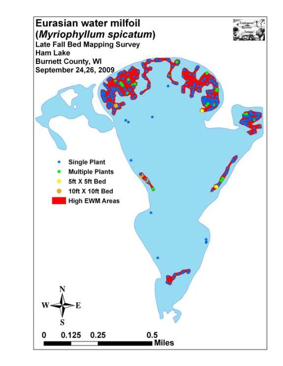
18 Fall Eurasian Water Milfoil Bed Mapping: We found EWM at 359 points on the lake, but there are no areas of EWM that are greater than one acre that meet the criteria of being canopied and composing >50% or even >25% of the plants in an area. Only six areas met the criteria of a true bed, and they were all so small that the margin of error on the GPS was greater than the diameter of the bed forcing us to simply log a point at the center of the bed. The total area of these true beds approximated to 375ft 2 which is only.009 acres. Throughout the rest of the lake, we identified and mapped seven areas covering approximately 40 acres where we found EWM as a regular member of the macrophyte community (Figure 8) (Table 4) (Appendix VIII). Outside of these areas, EWM was extremely rare. Figure 8: Ham Lake Fall EWM Plants and Highest Density Areas Area Number Table 4: Fall Eurasian water-milfoil High Density Areas Ham Lake, Burnett County September 24, 26, 2009 Area in Acres Estimated Mean Rakefull Bed Characteristics <1-2 Small area, but has two solid 10X10ft beds <1-1 Regular clusters of EWM; especially on SW end of area <1 Widely scattered EWM except narrow ribbon on N shoreline <1-1 Regular clusters of EWM; especially on SE end of area <1-1 Regular single clusters of EWM throughout bay <1 A narrow ribbon parallel to shore; widely scattered plants <1 Widely scattered EWM within the polygon. Total
19 DISCUSSION AND CONSIDERATIONS FOR MANAGEMENT: Ham Lake has an abundant, diverse and rare plant community that is typical of sand bottomed, seepage lakes. Unfortunately, Eurasian water-milfoil will pose a continued threat to that diversity and the resource as a whole moving forward as it is unlikely that EWM will ever be totally eliminated from the lake. The lake s native plant communities are the base of the aquatic food pyramid, provide habitat for fish and other aquatic organisms, are important food sources for waterfowl and other wildlife, stabilize the shoreline, and work to improve water clarity by absorbing excess nutrients from the water. To minimize EWM s impact on the lake s native plants, every effort should be made to maintain it at or further reduce it from its current low levels. After completing the fall bed mapping survey and analyzing the data from the July survey, we feel that there are three positive factors currently in the lake s favor as it works to control EWM: 1.) Ham Lake appears to offer only marginal habitat for EWM. Plants were thin and spindly, appeared nutrient starved based on their unusually light lime green color, and were absent from large areas of the lake that had pure sand/sandy muck substrate. This impaired growth rate appears to result in a reduced number of stems per plant compared to what we have observed in other lakes with EWM. Fewer stems ultimately mean fewer fragments/vegetative propagation thus slowing dispersal and establishment elsewhere. 2.) EWM is easy to identify as there are no other native species of milfoil in the lake to confuse it with (Dwarf water milfoil (Myriophyllum tenellum) is present, but is hard to recognize as a milfoil and doesn t look anything like EWM as it has no leaflets). Coontail (Ceratophyllum demersum) is the only other species with fine leaves in a whorl around the stem, but its forked leaflets, tendency to be very dark green and relative rarity in the lake makes it unlikely to be confused with EWM. 3.) The current management of EWM using spot herbicide application appears to be highly effective at controlling the infestation. The lake s good water clarity coupled with the previously mentioned point make finding EWM throughout its normal depth preference of 5-10ft relatively easy. Using low doses of herbicide in small areas is also likely minimally harmful to native vegetation. Because the current management strategy seems to be meeting the supposed objective of keeping EWM at a low level, maintaining the status quo would certainly seem to be an acceptable option. That said, we believe Seiben Bay in the northeast corner of the lake is an excellent candidate for hand removal of plants using SCUBA/snorkeling. This method is highly effective when clarity is good, plants are scattered, and native vegetation that is sensitive to herbicides are present. The bay qualifies on all accounts. Using this area as a pilot wouldn t stake the lake's entire control program on untested methods, but, if successful, would provide the lake with an additional, potentially more cost effective option that could have less of an impact on the environment. 14
20 Lakeshore owners can help prevent the spread of EWM by refraining from unnecessary removal of native plants (either manually or with herbicide) from the lake as these patches of barren substrate provide an easy place for invasive plants like EWM to take root and become established. Reducing or eliminating fertilizer applications near the water will not only contribute to improved water quality, but also deny minerals to plants like EWM that thrive in nutrient rich waters. Where possible, shoreline restoration and buffer strips of native vegetation would also enhance water quality by preventing erosion and runoff as well as improve the natural aesthetic value of highly developed shoreline areas. Completing an Aquatic Plant Management Plan (APMP) will help the lake clarify a management plan moving forward. A team approach that uses all available data from this report and the lake usership surveys coupled with open and frank communication between the BCLWC, WDNR, interested citizens and the plan manager will be critical in formulating the best APMP possible for the lake. MANAGEMENT RECOMMENDATIONS SUMMARY: Preserve the lake s diverse and rare plant community by continuing to maintain/reduce Eurasian water milfoil at/from its current low rates. Continue spot herbicide applications and consider hand removal using SCUBA/snorkeling to control EWM in sensitive and low density areas. Whenever possible, refrain from unnecessary removal of native plants from the lake manually or with herbicides as this provides a place for exotic species like EWM to more easily establish and colonize. Reduce and, wherever possible, eliminate fertilizer applications as their runoff encourages excessive plant growth. Encourage shoreline restoration that establishes native vegetation buffer strips along the lakeshore to help prevent runoff. Complete an Aquatic Plant Management Plan (APMP) to guide the management of EWM and the lake s native plants moving forward. 15
21 LITERATURE CITED Borman, S., R. Korth, and J. Temte Through the Looking Glass A Field Guide to Aquatic Plants. Wisconsin Lakes Partnership. DNR publication FH Chadde, Steve W A Great Lakes Wetland Flora: A complete guide to the aquatic and wetland plants of the Upper Midwest. Pocketflora Press; 2nd edition Crow, G. E., C. B. Hellquist Aquatic and Wetland Plants of Northeastern North America, Volume I + II: A Revised and Enlarged Edition of Norman C. Fassett's A Manual of Aquatic Plants. University of Wisconsin Press. Miller, G., M. Perkins, L. Sather, and J. Roth. Bathymetric Sounding Map for Ham Lake, Burnett County. WDNR available from (2009, October). Nichols, Stanley A Floristic Quality Assessment of Wisconsin Lake Plant communities with Example Applications. Journal of Lake and Reservoir Management 15 (2): UWEX Lakes Program. [online] Aquatic Plant Management in Wisconsin. Available from (2009, September). Voss, Edward G Michigan Flora Vol I-III. Cranbrook Institute of Science and University of Michigan Herbarium. WDNR. [online] Citizen Monitoring Lake Water Quality Database. Available from 9 (2009, October). WDNR. [online] Curly-leaf pondweed fact sheet. (2009, September). WDNR. [online] Eurasian water milfoil fact sheet. (2009, October). WDNR. [online] Purple loosestrife fact sheet. (2009, October). WDNR. [online] Reed canary grass. (2009, October). 16
22 Appendix I: Ham Lake Map with Sample Points 17
23 18
24 Appendix II: Boat Survey Data Sheet 19
25 Boat Survey Lake Name County WBIC Date of Survey (mm/dd/yy) workers Nearest Point Species seen, habitat information 20
26 Appendix III: Vegetative Survey Data Sheet 21
27 Observers for this lake: names and hours worked by each: Lake: WBIC County Date: Site # Depth (ft) Muck (M), Sand (S), Rock (R) Rake pole (P) or rake rope (R) Total Rake Fullness EWM CLP
28 Appendix IV: Habitat Variable Maps 23
29 24
30 25
31 26
32 Appendix V: Native Species Richness and Total Rake Fullness Maps 27
33 28
34 29
35 Appendix VI: Plant Species Accounts 30
36 County/State: Burnett County, Wisconsin Date: 7/15/09 Species: (Brasenia schreberi) Watershield Specimen Location: Ham Lake; T.40N-R.15W, SEC. 7 & 18 Collected/Identified by: Bradley W. Morris Col. #: BWM Habitat/Distribution: Muck and mucky sand bottom in 1-2m. Common to abundant in muck bays throughout Ham Lake. Common Associates: (Nuphar variegata) Spatterdock, (Nymphaea odorata) White water lily, (Pontederia cordata) Pickerelweed County/State: Burnett County, Wisconsin Date: 7/15/09 Species: (Ceratophyllum demersum) Coontail Specimen Location: Ham Lake; T.40N-R.15W, SEC. 7 & 18 Collected/Identified by: Bradley W. Morris Col. #: BWM Habitat/Distribution: Muck bottom in 0-5 meters. Rare in Ham Lake being found at only a couple of locations. Common Associates: (Potamogeton robbinsii) Robbins (fern) pondweed, (Nuphar variegata) Spatterdock, (Nymphaea odorata) White water lily, (Elodea canadensis) Common waterweed County/State: Burnett County, Wisconsin Date: 7/15/09 Species: (Chara sp.) Muskgrass Specimen Location: Ham Lake; T.40N-R.15W, SEC. 7 & 18 Collected/Identified by: Bradley W. Morris Col. #: BWM Habitat/Distribution: Most common in depths of 4-7 meters. Scattered locations throughout Ham Lake. Common Associates: (Potamogeton robbinsii) Fern pondweed County/State: Burnett County, Wisconsin Date: 7/15/09 Species: (Elatine minima) Waterwort Specimen Location: Ham Lake; T.40N-R.15W, SEC. 7 & 18 Collected/Identified by: Bradley W. Morris Col. #: BWM Habitat/Distribution: Primarily found in sandy bottoms in meters of water. Rare at scattered locations in Ham Lake. Common Associates: (Eleocharis acicularis) Needle spikerush, (Myriophyllum tenellum) Dwarf water milfoil, (Juncus pelocarpus) Brown-fruited rush County/State: Burnett County, Wisconsin Date: 7/15/09 Species: (Eleocharis acicularis) Needle spikerush Specimen Location: Ham Lake; T.40N-R.15W, SEC. 7 & 18 Collected/Identified by: Bradley W. Morris Col. #: BWM Habitat/Distribution: Most common in sand/silt/rock bottom areas in water from 0 1 meter deep. Common Associates: (Chara sp.) Muskgrass, (Potamogeton gramineus) Variable pondweed, (Isoetes echinospora) Spiny-spored quillwort, (Najas flexilis) Bushy pondweed 31
37 County/State: Burnett County, Wisconsin Date: 7/15/09 Species: (Eleocharis palustris) Creeping spikerush Specimen Location: Ham Lake; T.40N-R.15W, SEC. 7 & 18 Collected/Identified by: Bradley W. Morris Col. #: BWM X Habitat/Distribution: Mucky to firm bottoms in meters of water. Scattered individuals found growing along the shoreline throughout Ham Lake. Common Associates: (Typha latifolia X angustifolia) Hybrid cattail, (Pontederia cordata) Pickerelweed, (Eleocharis acicularis) Needle spikerush, (Myriophyllum tenellum) Dwarf water milfoil, (Elatine minima) Waterwort County/State: Burnett County, Wisconsin Date: 7/15/09 Species: (Elodea canadensis) Common waterweed Specimen Location: Ham Lake; T.40N-R.15W, SEC. 7 & 18 Collected/Identified by: Bradley W. Morris Col. #: BWM Habitat/Distribution: Muck bottom in 0-4 meters of water. Abundant throughout Ham Lake. Common Associates: Robbins (fern) pondweed, (Ceratophyllum demersum) Coontail, (Potamogeton amplifolius) Large-leaf pondweed County/State: Burnett County, Wisconsin Date: 7/15/09 Species: (Eriocaulon aquaticum) Pipewort Specimen Location: Ham Lake; T.40N-R.15W, SEC. 7 & 18 Collected/Identified by: Bradley W. Morris Col. #: BWM Habitat/Distribution: Sandy bottoms in meter of water. Found scattered throughout Ham Lake. Common Associates: (Eleocharis acicularis) Needle spikerush, (Juncus pelocarpus) Brown-fruited rush, (Elatine minima) Waterwort County/State: Burnett County, Wisconsin Date: 7/15/09 Species: (Isoetes echinospora) Spiny-spored quillwort Specimen Location: Ham Lake; T.40N-R.15W, SEC. 7 & 18 Collected/Identified by: Bradley W. Morris Col. #: BWM Habitat/Distribution: Sandy bottoms in meter of water. Found scattered throughout Ham Lake. Common Associates: (Eleocharis acicularis) Needle spikerush, (Juncus pelocarpus) Brown-fruited rush, (Elatine minima) Waterwort County/State: Burnett County, Wisconsin Date: 7/15/09 Species: (Juncus pelocarpus) Brown-fruited rush Specimen Location: Ham Lake; T.40N-R.15W, SEC. 7 & 18 Collected/Identified by: Bradley W. Morris Col. #: BWM Habitat/Distribution: Rocky to sandy bottoms in meters of water. Uncommon being found at only widely scattered locations on Ham Lake. Common Associates: (Eleocharis acicularis) Needle spikerush, (Myriophyllum tenellum) Dwarf water milfoil, (Elatine minima) Waterwort 32
38 County/State: Burnett County, Wisconsin Date: 7/15/09 Species: (Myriophyllum tenellum) Dwarf water milfoil Specimen Location: Ham Lake; T.40N-R.15W, SEC. 7 & 18 Collected/Identified by: Bradley W. Morris Col. #: BWM Habitat/Distribution: Rocky to sandy bottoms in meter of water. Found scattered throughout Ham Lake. Common Associates: (Eleocharis acicularis) Needle spikerush, (Juncus pelocarpus) Brown-fruited rush, (Elatine minima) Waterwort County/State: Burnett County, Wisconsin Date: 7/15/09 Species: (Myriophyllum spicatum) Eurasian water milfoil Specimen Location: Ham Lake; T.40N-R.15W, SEC. 7 & 18 Collected/Identified by: Bradley W. Morris Col. #: BWM Habitat/Distribution: Muck to sand bottom in water up to 4 meters. Found scattered around the lake, but primarily at the north and south ends of Ham Lake. Common Associates: (Potamogeton praelongus) White-stem pondweed, (Ceratophyllum demersum) Coontail County/State: Burnett County, Wisconsin Date: 7/15/09 Species: (Najas flexilis) Bushy pondweed Specimen Location: Ham Lake; T.40N-R.15W, SEC. 7 & 18 Collected/Identified by: Bradley W. Morris Col. #: BWM Habitat/Distribution: Found primarily in sand bottoms in meters of water. Relatively common and widely distributed throughout the lake. Common Associates: (Chara sp.) Muskgrass, (Potamogeton gramineus) Variable pondweed, (Vallisneria americana) Wild celery County/State: Burnett County, Wisconsin Date: 7/15/09 Species: (Nitella sp.) Nitella Specimen Location: Ham Lake; T.40N-R.15W, SEC. 7 & 18 Collected/Identified by: Bradley W. Morris Col. #: BWM Habitat/Distribution: Muck bottom area in water generally greater than 3 meters deep. Common Associates: (Potamogeton robbinsii) Robbins (fern) pondweed, (Chara sp.) Muskgrass County/State: Burnett County, Wisconsin Date: 7/15/09 Species: (Nuphar variegata) Spatterdock Specimen Location: Ham Lake; T.40N-R.15W, SEC. 7 & 18 Collected/Identified by: Bradley W. Morris Col. #: BWM Habitat/Distribution: Muck bottom in 0-2 meters of water where it often forms dense canopies. Relatively common in muck bays and sheltered shoreline areas. It prefers a firmer bottom than (Nymphaea odorata). Common Associates: (Nymphaea odorata) White water lily, (Pontederia cordata) Pickerelweed, (Brasenia schreberi) Watershield 33
39 County/State: Burnett County, Wisconsin Date: 7/15/09 Species: (Nymphaea odorata) White water lily Specimen Location: Ham Lake; T.40N-R.15W, SEC. 7 & 18 Collected/Identified by: Bradley W. Morris Col. #: BWM Habitat/Distribution: Muck bottom in 0-2 meters where it forms dense canopies with other floating leaf species. Common in calm water bays. Common Associates: (Nuphar variegata) Spatterdock, (Elodea canadensis) (Brasenia schreberi) Watershield, Common waterweed, (Potamogeton robbinsii) Fern pondweed County/State: Burnett County, Wisconsin Date: 7/15/09 Species: (Polygonum amphibium) Water smartweed Specimen Location: Ham Lake; T.40N-R.15W, SEC. 7 & 18 Collected/Identified by: Bradley W. Morris Col. #: BWM Habitat/Distribution: Rare, found at two locations in sandy bottom in 0-2 meters. Common Associates: (Chara sp.) Muskgrass, (Potamogeton gramineus) Variable pondweed, (Isoetes echinospora) Spiny-spored quillwort, (Najas flexilis) Bushy pondweed, (Elatine minima) Waterwort County/State: Burnett County, Wisconsin Date: 7/15/09 Species: (Pontederia cordata) Pickerelweed Specimen Location: Ham Lake; T.40N-R.15W, SEC. 7 & 18 Collected/Identified by: Bradley W. Morris Col. #: BWM Habitat/Distribution: Silt to muck bottom over firm substrate in meters of water. Common in emergent beds throughout Ham Lake; especially in sheltered bays. Common Associates: (Brasenia schreberi) Watershield, (Nymphaea odorata) White water lily, (Nuphar variegata) Spatterdock County/State: Burnett County, Wisconsin Date: 7/15/09 Species: (Potamogeton amplifolius) Large-leaf pondweed Specimen Location: Ham Lake; T.40N-R.15W, SEC. 7 & 18 Collected/Identified by: Bradley W. Morris Col. #: BWM Habitat/Distribution: Found in most mucky bottom areas in water from 1-4.5m deep. Common and widely distributed throughout Ham Lake. Common Associates: (Potamogeton robbinsii) Fern pondweed, (Potamogeton praelongus) White-stem pondweed County/State: Burnett County, Wisconsin Date: 7/15/09 Species: (Potamogeton gramineus) Variable pondweed Specimen Location: Ham Lake; T.40N-R.15W, SEC. 7 & 18 Collected/Identified by: Bradley W. Morris Col. #: BWM Habitat/Distribution: Most common in sandy/muck bottom conditions in shallow water meter deep. Fairly common throughout Ham Lake. Common Associates: (Potamogeton robbinsii) Fern pondweed, (Najas flexilis) Bushy pondweed 34
40 County/State: Burnett County, Wisconsin Date: 7/15/09 Species: (Potamogeton praelongus) White-stem pondweed Specimen Location: Ham Lake; T.40N-R.15W, SEC. 7 & 18 Collected/Identified by: Bradley W. Morris Col. #: BWM Habitat/Distribution: Variable substrate in 1-4 meters of water. Found in several locations, but not that common. Common Associates: (Potamogeton gramineus) Variable pondweed, (Potamogeton amplifolius) Large-leaf pondweed (Potamogeton robbinsii) Fern pondweed County/State: Burnett County, Wisconsin Date: 7/15/09 Species: (Potamogeton pusillus) Small pondweed Specimen Location: Ham Lake; T.40N-R.15W, SEC. 7 & 18 Collected/Identified by: Bradley W. Morris Col. #: BWM Habitat/Distribution: Found at only one location in mucky bottom 0-1 meter of water. Common Associates: (Vallisneria americana) Wild celery, (Ceratophyllum demersum) Coontail, (Elodea canadensis) Common waterweed County/State: Burnett County, Wisconsin Date: 7/15/09 Species: (Potamogeton robbinsii) Robbins (fern) pondweed Specimen Location: Ham Lake; T.40N-R.15W, SEC. 7 & 18 Collected/Identified by: Bradley W. Morris Col. #: BWM Habitat/Distribution: Found in variable substrate bottoms, but becomes dominant to the point of excluding all other species in its preferred substrate of organic muck. Grows in 0-5 meters of water, but prefers Widespread and abundant throughout. Common Associates: (Potamogeton amplifolius) Large-leaf pondweed, (Potamogeton gramineus) Variable pondweed, (Chara sp.) Muskgrass County/State: Burnett County, Wisconsin Date: 7/15/09 Species: (Potamogeton spirillus) Spiral-fruited pondweed Specimen Location: Ham Lake; T.40N-R.15W, SEC. 7 & 18 Collected/Identified by: Bradley W. Morris Col. #: BWM Habitat/Distribution: Found in almost any bottom conditions, but grows best in rock/ sand bottoms in meters of water. Rare in Ham Lake were it occurred in only one bay. Common Associates: (Isoetes echinospora) Spiny-spored quillwort, (Vallisneria americana) Wild celery County/State: Burnett County, Wisconsin Date: 7/15/09 Species: (Ranunculus flammula) Creeping spearwort Specimen Location: Ham Lake; T.40N-R.15W, SEC. 7 & 18 Collected/Identified by: Bradley W. Morris Col. #: BWM Habitat/Distribution: Sandy bottoms in meter of water. Rare in Ham Lake. Common Associates: (Eleocharis acicularis) Needle spikerush, (Juncus pelocarpus) Brown-fruited rush, (Elatine minima) Waterwort 35
41 County/State: Burnett County, Wisconsin Date: 7/15/09 Species: (Sagittaria sp.) Arrowhead sp. Specimen Location: Ham Lake; T.40N-R.15W, SEC. 7 & 18 Collected/Identified by: Bradley W. Morris Col. #: BWM Habitat/Distribution: Uncommon in scattered mucky shoreline locations. Common Associates: (Typha latifolia X angustifolia) Hybrid cattail, (Pontederia cordata) Pickerelweed, (Eleocharis acicularis) Needle spikerush, (Myriophyllum tenellum) Dwarf water milfoil, (Elatine minima) Waterwort County/State: Burnett County, Wisconsin Date: 7/15/09 Species: (Schoenoplectus acutus) Hardstem bulrush Specimen Location: Ham Lake; T.40N-R.15W, SEC. 7 & 18 Collected/Identified by: Bradley W. Morris Col. #: BWM Habitat/Distribution: Uncommon in scattered mucky to sandy shoreline locations in Ham Lake. Common Associates: (Typha latifolia X angustifolia) Hybrid cattail, (Pontederia cordata) Pickerelweed, (Eleocharis acicularis) Needle spikerush, (Myriophyllum tenellum) Dwarf water milfoil, (Elatine minima) Waterwort County/State: Burnett County, Wisconsin Date: 7/15/09 Species: (Typha latifolia X angustifolia) Hybrid cattail Specimen Location: Ham Lake; T.40N-R.15W, SEC. 7 & 18 Collected/Identified by: Bradley W. Morris Col. #: BWM Habitat/Distribution: Uncommon in scattered mucky shoreline locations in Ham Lake. Common Associates: (Pontederia cordata) Pickerelweed, (Eleocharis acicularis) Needle spikerush, (Myriophyllum tenellum) Dwarf water milfoil, (Elatine minima) Waterwort County/State: Burnett County, Wisconsin Date: 7/15/09 Species: (Utricularia purpurea) Large purple bladderwort Specimen Location: Ham Lake; T.40N-R.15W, SEC. 7 & 18 Collected/Identified by: Bradley W. Morris Col. #: BWM Habitat/Distribution: Muck bottom in 0-2 meters of water. Found scattered throughout Ham Lake. Common Associates: Potamogeton robbinsii) Fern pondweed, (Potamogeton praelongus) White-stem pondweed County/State: Burnett County, Wisconsin Date: 7/15/09 Species: (Vallisneria americana) Wild celery Specimen Location: Ham Lake; T.40N-R.15W, SEC. 7 & 18 Collected/Identified by: Bradley W. Morris Col. #: BWM Habitat/Distribution: Found in almost any bottom conditions, but grows best in sandy to sand/muck bottoms in meters of water. Common Associates: (Clasping-leaf pondweed, (Potamogeton gramineus) Variable pondweed, (Chara sp.) Muskgrass 36
42 Appendix VII: Point Intercept Plant Species Distribution Maps 37
43 38
44 39
45 40
46 41
47 42
48 43
49 44
50 45
51 46
52 47
53 48
54 49
55 50
56 51
57 52
58 53
59 54
60 55
61 56
62 57
63 58
64 59
65 60
66 61
67 62
68 63
69 64
70 65
71 66
72 VIII: Fall Eurasian Water Milfoil Maps 67
73 68
74 69
75 Appendix IX: Glossary of Biological Terms (Adapted from UWEX 2009) 70
76 Aquatic: organisms that live in or frequent water. Cultural Eutrophication: accelerated eutrophication that occurs as a result of human activities in the watershed that increase nutrient loads in runoff water that drains into lakes. Dissolved Oxygen (DO): the amount of free oxygen absorbed by the water and available to aquatic organisms for respiration; amount of oxygen dissolved in a certain amount of water at a particular temperature and pressure, often expressed as a concentration in parts of oxygen per million parts of water. Diversity: number and evenness of species in a particular community or habitat. Drainage lakes: Lakes fed primarily by streams and with outlets into streams or rivers. They are more subject to surface runoff problems but generally have shorter residence times than seepage lakes. Watershed protection is usually needed to manage lake water quality. Ecosystem: a system formed by the interaction of a community of organisms with each other and with the chemical and physical factors making up their environment. Eutrophication: the process by which lakes and streams are enriched by nutrients, and the resulting increase in plant and algae growth. This process includes physical, chemical, and biological changes that take place after a lake receives inputs for plant nutrients--mostly nitrates and phosphates--from natural erosion and runoff from the surrounding land basin. The extent to which this process has occurred is reflected in a lake's trophic classification: oligotrophic (nutrient poor), mesotrophic (moderately productive), and eutrophic (very productive and fertile). Exotic: a non-native species of plant or animal that has been introduced. Habitat: the place where an organism lives that provides an organism's needs for water, food, and shelter. It includes all living and non-living components with which the organism interacts. Limnology: the study of inland lakes and waters. 71
77 Littoral: the near shore shallow water zone of a lake, where aquatic plants grow. Macrophytes: Refers to higher (multi-celled) plants growing in or near water. Macrophytes are beneficial to lakes because they produce oxygen and provide substrate for fish habitat and aquatic insects. Overabundance of such plants, especially problem species, is related to shallow water depth and high nutrient levels. Nutrients: elements or substances such as nitrogen and phosphorus that are necessary for plant growth. Large amounts of these substances can become a nuisance by promoting excessive aquatic plant growth. Organic Matter: elements or material containing carbon, a basic component of all living matter. Photosynthesis: the process by which green plants convert carbon dioxide (CO2) dissolved in water to sugar and oxygen using sunlight for energy. Photosynthesis is essential in producing a lake's food base, and is an important source of oxygen for many lakes. Phytoplankton: microscopic plants found in the water. Algae or one-celled (phytoplankton) or multicellular plants either suspended in water (Plankton) or attached to rocks and other substrates (periphyton). Their abundance, as measured by the amount of chlorophyll a (green pigment) in an open water sample, is commonly used to classify the trophic status of a lake. Numerous species occur. Algae are an essential part of the lake ecosystem and provides the food base for most lake organisms, including fish. Phytoplankton populations vary widely from day to day, as life cycles are short. Plankton: small plant organisms (phytoplankton and nanoplankton) and animal organisms (zooplankton) that float or swim weakly though the water. ppm: parts per million; units per equivalent million units; equal to milligrams per liter (mg/l) 72
78 Richness: number of species in a particular community or habitat. Rooted Aquatic Plants: (macrophytes) Refers to higher (multi-celled) plants growing in or near water. Macrophytes are beneficial to lakes because they produce oxygen and provide substrate for fish habitat and aquatic insects. Overabundance of such plants, especially problem species, is related to shallow water depth and high nutrient levels. Runoff: water that flows over the surface of the land because the ground surface is impermeable or unable to absorb the water. Secchi Disc: An 8-inch diameter plate with alternating quadrants painted black and white that is used to measure water clarity (light penetration). The disc is lowered into water until it disappears from view. It is then raised until just visible. An average of the two depths, taken from the shaded side of the boat, is recorded as the Secchi disc reading. For best results, the readings should be taken on sunny, calm days. Seepage lakes: Lakes without a significant inlet or outlet, fed by rainfall and groundwater. Seepage lakes lose water through evaporation and groundwater moving on a down gradient. Lakes with little groundwater inflow tend to be naturally acidic and most susceptible to the effects of acid rain. Seepage lakes often have long,residence times. and lake levels fluctuate with local groundwater levels. Water quality is affected by groundwater quality and the use of land on the shoreline. Turbidity: degree to which light is blocked because water is muddy or cloudy. Watershed: the land area draining into a specific stream, river, lake or other body of water. These areas are divided by ridges of high land. Zooplankton: Microscopic or barely visible animals that eat algae. These suspended plankton are an important component of the lake food chain and ecosystem. For many fish, they are the primary source of food. 73
79 Appendix X: Aquatic Exotic Invasive Species Information 74

80 Curly-leaf pondweed DESCRIPTION: Curly-leaf pondweed is an invasive aquatic perennial that is native to Eurasia, Africa, and Australia. It was accidentally introduced to United States waters in the mid-1880s by hobbyists who used it as an aquarium plant. The leaves are reddishgreen, oblong, and about 3 inches long, with distinct wavy edges that are finely toothed. The stem of the plant is flat, reddish-brown and grows from 1 to 3 feet long. The plant usually drops to the lake bottom by early July DISTRIBUTION AND HABITAT: Curly-leaf pondweed is commonly found in alkaline and high nutrient waters, preferring soft substrate and shallow water depths. It tolerates low light and low water temperatures. It has been reported in all states but Maine LIFE HISTORY AND EFFECTS OF INVASION: Curly-leaf pondweed spreads through burr-like winter buds (turions), which are moved among waterways. These plants can also reproduce by seed, but this plays a relatively small role compared to the vegetative reproduction through turions. New plants form under the ice in winter, making curly-leaf pondweed one of the first nuisance aquatic plants to emerge in the spring. It becomes invasive in some areas because of its tolerance for low light and low water temperatures. These tolerances allow it to get a head start on and out compete native plants in the spring. In mid-summer, when most aquatic plants are growing, curly-leaf pondweed plants are dying off. Plant die-offs may result in a critical loss of dissolved oxygen. Furthermore, the decaying plants can increase nutrients which contribute to algal blooms, as well as create unpleasant stinking messes on beaches. Curly-leaf pondweed forms surface mats that interfere with aquatic recreation. (Taken in its entirety from WDNR,

81 Eurasian water milfoil DESCRIPTION: Eurasian water milfoil is a submersed aquatic plant native to Europe, Asia, and northern Africa. It is the only non-native milfoil in Wisconsin. Like the native milfoils, the Eurasian variety has slender stems whorled by submersed feathery leaves and tiny flowers produced above the water surface. The flowers are located in the axils of the floral bracts, and are either four-petaled or without petals. The leaves are threadlike, typically uniform in diameter, and aggregated into a submersed terminal spike. The stem thickens below the inflorescence and doubles its width further down, often curving to lie parallel with the water surface. The fruits are four-jointed nut-like bodies. Without flowers or fruits, Eurasian water milfoil is nearly impossible to distinguish from Northern water milfoil. Eurasian water milfoil has 9-21 pairs of leaflets per leaf, while Northern milfoil typically has 7-11 pairs of leaflets. Coontail is often mistaken for the milfoils, but does not have individual leaflets. DISTRIBUTION AND HABITAT: Eurasian milfoil first arrived in Wisconsin in the 1960's. During the 1980's, it began to move from several counties in southern Wisconsin to lakes and waterways in the northern half of the state. As of 1993, Eurasian milfoil was common in 39 Wisconsin counties (54%) and at least 75 of its lakes, including shallow bays in Lakes Michigan and Superior and Mississippi River pools. Eurasian water milfoil grows best in fertile, fine-textured, inorganic sediments. In less productive lakes, it is restricted to areas of nutrient-rich sediments. It has a history of becoming dominant in eutrophic, nutrient-rich lakes, although this pattern is not universal. It is an opportunistic species that prefers highly disturbed lake beds, lakes receiving nitrogen and phosphorous-laden runoff, and heavily used lakes. Optimal growth occurs in alkaline systems with a high concentration of dissolved inorganic carbon. High water temperatures promote multiple periods of flowering and fragmentation. 76
82 LIFE HISTORY AND EFFECTS OF INVASION: Unlike many other plants, Eurasian water milfoil does not rely on seed for reproduction. Its seeds germinate poorly under natural conditions. It reproduces vegetatively by fragmentation, allowing it to disperse over long distances. The plant produces fragments after fruiting once or twice during the summer. These shoots may then be carried downstream by water currents or inadvertently picked up by boaters. Milfoil is readily dispersed by boats, motors, trailers, bilges, live wells, or bait buckets, and can stay alive for weeks if kept moist. Once established in an aquatic community, milfoil reproduces from shoot fragments and stolons (runners that creep along the lake bed). As an opportunistic species, Eurasian water milfoil is adapted for rapid growth early in spring. Stolons, lower stems, and roots persist over winter and store the carbohydrates that help milfoil claim the water column early in spring, photosynthesize, divide, and form a dense leaf canopy that shades out native aquatic plants. Its ability to spread rapidly by fragmentation and effectively block out sunlight needed for native plant growth often results in monotypic stands. Monotypic stands of Eurasian milfoil provide only a single habitat, and threaten the integrity of aquatic communities in a number of ways; for example, dense stands disrupt predatorprey relationships by fencing out larger fish, and reducing the number of nutrient-rich native plants available for waterfowl. Dense stands of Eurasian water milfoil also inhibit recreational uses like swimming, boating, and fishing. Some stands have been dense enough to obstruct industrial and power generation water intakes. The visual impact that greets the lake user on milfoildominated lakes is the flat yellow-green of matted vegetation, often prompting the perception that the lake is "infested" or "dead". Cycling of nutrients from sediments to the water column by Eurasian water milfoil may lead to deteriorating water quality and algae blooms of infested lakes. (Taken in its entirety from WDNR,

83 Reed canary grass DESCRIPTION: Reed canary grass is a large, coarse grass that reaches 2 to 9 feet in height. It has an erect, hairless stem with gradually tapering leaf blades 3 1/2 to 10 inches long and 1/4 to 3/4 inch in width. Blades are flat and have a rough texture on both surfaces. The lead ligule is membranous and long. The compact panicles are erect or slightly spreading (depending on the plant's reproductive stage), and range from 3 to 16 inches long with branches 2 to 12 inches in length. Single flowers occur in dense clusters in May to mid-june. They are green to purple at first and change to beige over time. This grass is one of the first to sprout in spring, and forms a thick rhizome system that dominates the subsurface soil. Seeds are shiny brown in color. Both Eurasian and native ecotypes of reed canary grass are thought to exist in the U.S. The Eurasian variety is considered more aggressive, but no reliable method exists to tell the ecotypes apart. It is believed that the vast majority of our reed canary grass is derived from the Eurasian ecotype. Agricultural cultivars of the grass are widely planted. Reed canary grass also resembles non-native orchard grass (Dactylis glomerata), but can be distinguished by its wider blades, narrower, more pointed inflorescence, and the lack of hairs on glumes and lemmas (the spikelet scales). Additionally, bluejoint grass (Calamagrostis canadensis) may be mistaken for reed canary in areas where orchard grass is rare, especially in the spring. The highly transparent ligule on reed canary grass is helpful in distinguishing it from the others. Ensure positive identification before attempting control. 78
84 DISTRIBUTION AND HABITAT: Reed canary grass is a cool-season, sod-forming, perennial wetland grass native to temperate regions of Europe, Asia, and North America. The Eurasian ecotype has been selected for its vigor and has been planted throughout the U.S. since the 1800's for forage and erosion control. It has become naturalized in much of the northern half of the U.S., and is still being planted on steep slopes and banks of ponds and created wetlands. Reed canary grass can grow on dry soils in upland habitats and in the partial shade of oak woodlands, but does best on fertile, moist organic soils in full sun. This species can invade most types of wetlands, including marshes, wet prairies, sedge meadows, fens, stream banks, and seasonally wet areas; it also grows in disturbed areas such as bergs and spoil piles. LIFE HISTORY AND EFFECTS OF INVASION: Reed canary grass reproduces by seed or creeping rhizomes. It spreads aggressively. The plant produces leaves and flower stalks for 5 to 7 weeks after germination in early spring, then spreads laterally. Growth peaks in mid-june and declines in mid-august. A second growth spurt occurs in the fall. The shoots collapse in mid to late summer, forming a dense, impenetrable mat of stems and leaves. The seeds ripen in late June and shatter when ripe. Seeds may be dispersed from one wetland to another by waterways, animals, humans, or machines. This species prefers disturbed areas, but can easily move into native wetlands. Reed canary grass can invade a disturbed wetland in less than twelve years. Invasion is associated with disturbances including ditching of wetlands, stream channelization, deforestation of swamp forests, sedimentation, and intentional planting. The difficulty of selective control makes reed canary grass invasion of particular concern. Over time, it forms large, monotypic stands that harbor few other plant species and are subsequently of little use to wildlife. Once established, reed canary grass dominates an area by building up a tremendous seed bank that can eventually erupt, germinate, and recolonize treated sites. (Taken in its entirety from WDNR,

85 Purple loosestrife DESCRIPTION: Purple loosestrife is a perennial herb 3-7 feet tall with a dense bushy growth of 1-50 stems. The stems, which range from green to purple, die back each year. Showy flowers vary from purple to magenta, possess 5-6 petals aggregated into numerous long spikes, and bloom from July to September. Leaves are opposite, nearly linear, and attached to four-sided stems without stalks. It has a large, woody taproot with fibrous rhizomes that form a dense mat. This species may be confused with the native wing-angled loosestrife (Lythrum alatum) found in moist prairies or wet meadows. The latter has a winged, square stem and solitary paired flowers in the leaf axils. It is generally a smaller plant than the Eurasian loosestrife. By law, purple loosestrife is a nuisance species in Wisconsin. It is illegal to sell, distribute, or cultivate the plants or seeds, including any of its cultivars. Distribution and Habitat: Purple loosestrife is a wetland herb that was introduced as a garden perennial from Europe during the 1800's. It is still promoted by some horticulturists for its beauty as a landscape plant, and by beekeepers for its nectarproducing capability. Currently, about 24 states have laws prohibiting its importation or distribution because of its aggressively invasive characteristics. It has since extended its range to include most temperate parts of the United States and Canada. The plant's reproductive success across North America can be attributed to its wide tolerance of physical and chemical conditions characteristic of disturbed habitats, and its ability to 80
To whom it may concern:
 State of Wisconsin DEPARTMENT OF NATURAL RESOURCES 2801 Progress Rd. Madison WI 53716 Scott Walker, Governor Cathy Stepp, Secretary December 16, 2012 To whom it may concern: This summer you requested information
Aquatic Macrophyte Survey for Lower Turtle Lake Barron County, Wisconsin WBIC:
 Aquatic Macrophyte Survey for Lower Turtle Lake Barron County, Wisconsin WBIC: 2692900 White Water Lily Project Sponsored by: The Lower Turtle Lake Management District * Lower Turtle Lake Wild Celery in
memo Project Name Spider Lake Point Intercept Survey 2017 Date 9/5/17 To / Contact info Jerry Spetzman Cc / Contact info Greg Graske, PE
 memo Project Name Spider Lake Point Intercept Survey 2017 Date 9/5/17 To / Contact info Cc / Contact info From / Contact info Regarding Jerry Spetzman Greg Graske, PE Joe Pallardy, Mike Majeski Spider
2015 Aquatic Plant Surveys
 Lake Puckaway 2015 Aquatic Plant Survey Results June 13, 2016 Shallow Lakes are Special Clear State Turbid State Brenton Butterfield Tim Hoyman Paul Garrison Aquatic Plants are Incredibly Important Shallow
Curly-leaf Pondweed and Full Warm Water Point/Intercept Macrophyte Surveys Fawn Lake Spider Chain (WBIC: ) Sawyer County, Wisconsin
 Sawyer County, Wisconsin") Curly-leaf Pondweed and Full Warm Water Point/Intercept Macrophyte Surveys Fawn Lake Spider Chain (WBIC: 2435900) Sawyer County, Wisconsin Fawn Lake aerial photo (2010) Emergent vegetation in the Fawn
Curly-leaf Pondweed and Full Warm Water Point/Intercept Macrophyte Surveys Fawn Lake Spider Chain (WBIC: 2435900) Sawyer County, Wisconsin Fawn Lake aerial photo (2010) Emergent vegetation in the Fawn
Lake Mansfield 2012 Aquatic Vegetation Survey
 Final Project Report: September 13, 2012 Lake Mansfield 2012 Aquatic Vegetation Survey ======== Prepared For: Town of Great Barrington Attn: Amanda Sewall, Conservation Agent Town Hall, 334 Main Street
Cold Water Curly-leaf Pondweed and Full Warm Water Point-Intercept Aquatic Macrophyte Surveys Kirby Lake (WBIC: ) Barron County, Wisconsin
 Barron County, Wisconsin") Cold Water Curly-leaf Pondweed and Full Warm Water Point-Intercept Aquatic Macrophyte Surveys Kirby Lake (WBIC: 1858200) Barron County, Wisconsin Watershield and Purple bladderwort on Kirby Lake (Berg
Cold Water Curly-leaf Pondweed and Full Warm Water Point-Intercept Aquatic Macrophyte Surveys Kirby Lake (WBIC: 1858200) Barron County, Wisconsin Watershield and Purple bladderwort on Kirby Lake (Berg
Designation of Critical Habitat Areas Bear Lake, Portage County. Wisconsin Department of Natural Resources Eau Claire, WI
 Designation of Critical Habitat Areas Bear Lake, Portage County Wisconsin Department of Natural Resources Eau Claire, WI March 2007 Critical Habitat Area Designation Bear Lake, Portage County I. INTRODUCTION
memo Project Name Little Lake Point Intercept Survey 2017 Date 9/5/17 To / Contact info Jerry Spetzman Cc / Contact info Greg Graske, PE
 memo Project Name Little Lake Point Intercept Survey 2017 Date 9/5/17 To / Contact info Cc / Contact info From / Contact info Regarding Jerry Spetzman Greg Graske, PE Joe Pallardy, Mike Majeski Little
Aquatic Vegetation of Edward Lake Crow Wing County, Minnesota (DOW ) July 8, 9, 14, 26; August 2, 2004
 July 8, 9, 14, 26; August 2, 2004") Aquatic Vegetation of Edward Lake Crow Wing County, Minnesota (DOW 18-0305-00) July 8, 9, 14, 26; August 2, 2004 Report by: Donna Perleberg Minnesota Department of Natural Resources Division of Ecological
Aquatic Vegetation of Edward Lake Crow Wing County, Minnesota (DOW 18-0305-00) July 8, 9, 14, 26; August 2, 2004 Report by: Donna Perleberg Minnesota Department of Natural Resources Division of Ecological
Aquatic Vegetation of Little Sand Lake ( ) and Sand Lake ( ) Cass County, Minnesota July 11-12, 2006
 and Sand Lake ( ) Cass County, Minnesota July 11-12, 2006") Aquatic Vegetation of Little Sand Lake (11-0275-00) and Sand Lake (11-0279-00) Cass County, Minnesota July 11-12, 2006 Report by: Donna Perleberg Minnesota Department of Natural Resources Division of Ecological
Aquatic Vegetation of Little Sand Lake (11-0275-00) and Sand Lake (11-0279-00) Cass County, Minnesota July 11-12, 2006 Report by: Donna Perleberg Minnesota Department of Natural Resources Division of Ecological
Farm Island Lake (DOW # )
") Aquatic Vegetation Survey of Farm Island Lake (DOW #01-0159-00) Aitkin County, Minnesota 2009 Farm Island Lake, June 2009. COPYRIGHT Minnesota Department of Natural Resources 2009 Lake survey conducted
Aquatic Vegetation Survey of Farm Island Lake (DOW #01-0159-00) Aitkin County, Minnesota 2009 Farm Island Lake, June 2009. COPYRIGHT Minnesota Department of Natural Resources 2009 Lake survey conducted
Aquatic vegetation of Cross Lake
 Aquatic vegetation of Cross Lake June and July, 2010 ID# 18-0312-00 Crow Wing County, Minnesota Cross Lake 2010. COPYRIGHT Minnesota Department of Natural Resources 2010 Report by: Stephanie Simon, Aquatic
Aquatic Vegetation of Ten Mile Lake (DOW ) Cass County, Minnesota June 2006
 Cass County, Minnesota June 2006") Aquatic Vegetation of Ten Mile Lake (DOW 11-0413-00) Cass County, Minnesota June 2006 Ten Mile Lake, Cass County, MN. June 19, 2006 Report by: Donna Perleberg Minnesota Department of Natural Resources
Aquatic Vegetation of Ten Mile Lake (DOW 11-0413-00) Cass County, Minnesota June 2006 Ten Mile Lake, Cass County, MN. June 19, 2006 Report by: Donna Perleberg Minnesota Department of Natural Resources
WELCOME. Scott Provost Water Resources Specialist - WDNR Wisconsin Rapids, WI
 WELCOME Scott Provost Water Resources Specialist - WDNR Wisconsin Rapids, WI 715.421.7881 Water Level Flux to Control AIS and Restore Impoundments WHY? Restore natural ebb and flow Restore natural rhythm
Serpent Lake (DOW # )
") Aquatic Vegetation Survey of Serpent Lake (DOW #18-0090-00) Crow Wing County, Minnesota 2009 Loons on Serpent Lake, May 2009. COPYRIGHT Minnesota Department of Natural Resources 2009 Report by: Donna Perleberg,
Aquatic Vegetation Survey of Serpent Lake (DOW #18-0090-00) Crow Wing County, Minnesota 2009 Loons on Serpent Lake, May 2009. COPYRIGHT Minnesota Department of Natural Resources 2009 Report by: Donna Perleberg,
Aquatic Vegetation of Big Pine Lake
 Aquatic Vegetation of Big Pine Lake Three-square bulrush stands in Big Pine Lake, August 2013. August, 2013 Big Pine Lake, ID# 01-0157-00 Aitkin County, Minnesota COPYRIGHT Minnesota Department of Natural
Aquatic vegetation of Roemhildts Lake
 Aquatic vegetation of Roemhildts Lake 2004 and 2011 ID# 40-0039-00 Le Sueur County, Minnesota White waterlilies, bulrush and cattails in Roemhildts Lake, June 2011. COPYRIGHT Minnesota Department of Natural
Fish Trap Lake (ID # )
") Aquatic Vegetation Surveys of Fish Trap Lake (ID #49-0137-00) Morrison County, Minnesota 2005 and 2009 Fish Trap Lake 2009. COPYRIGHT Minnesota Department of Natural Resources 2009 Report by: Donna Perleberg,
Aquatic Vegetation Surveys of Fish Trap Lake (ID #49-0137-00) Morrison County, Minnesota 2005 and 2009 Fish Trap Lake 2009. COPYRIGHT Minnesota Department of Natural Resources 2009 Report by: Donna Perleberg,
Upper South Long Lake (ID # ) and Lower South Long Lake (ID # )
 and Lower South Long Lake (ID # )") Aquatic Vegetation Survey of Upper South Long Lake (ID #18-0096-00) and Lower South Long Lake (ID #18-0136-00) Crow Wing County, Minnesota 2009 Great Blue Heron on Upper South Long Lake, June 2009. COPYRIGHT
Aquatic Vegetation Survey of Upper South Long Lake (ID #18-0096-00) and Lower South Long Lake (ID #18-0136-00) Crow Wing County, Minnesota 2009 Great Blue Heron on Upper South Long Lake, June 2009. COPYRIGHT
Aquatic Macrophyte Survey of the St. Croix/Gordon Flowage Douglas County, Wisconsin JANUARY 2008
 Aquatic Macrophyte Survey of the St. Croix/Gordon Flowage Douglas County, Wisconsin JANUARY 2008 Prepared By UW-Stevens Point, Center for Watershed Science and Education B. Swenson, K. Homan, N. Turyk
2017 Assessment of Native Plants in Treatment Plots
 15771 Creekside Lane Osseo, MN 55369 james@freshwatersci.com (651) 336-8696 2017 Assessment of Native Plants in Treatment Plots Lake John (# 86-0288) Wright County, MN Surveyed June 8, 2017 Survey, Analysis,
Designation of Critical Habitat Areas Jacqueline Lake, Portage County. Wisconsin Department of Natural Resources Eau Claire, WI
 Designation of Critical Habitat Areas Jacqueline Lake, Portage County Wisconsin Department of Natural Resources Eau Claire, WI 2006 Critical Habitat Area Designation Jacqueline Lake, Portage County I.
Quantitative Plant Surveys: Arcadia and Metacomet Lakes
 Quantitative Plant Surveys: Arcadia and Metacomet Lakes Mark June-Wells, Ph.D. Director, Water Resource Services All Habitat Services LLC. NALMS Certified Lake Manager Non-native Aquatic Plant Species
Aquatic Vegetation of Grace Lake (DOW ) Hubbard County, Minnesota July 24 and 25, 2006
 Hubbard County, Minnesota July 24 and 25, 2006") Aquatic Vegetation of Grace Lake (DOW 29-0071-00) Hubbard County, Minnesota July 24 and 25, 2006 Grace Lake, Hubbard County, MN. 2006 COPYRIGHT Minnesota Department of Natural Resources 2006 Report by:
Aquatic Vegetation of Grace Lake (DOW 29-0071-00) Hubbard County, Minnesota July 24 and 25, 2006 Grace Lake, Hubbard County, MN. 2006 COPYRIGHT Minnesota Department of Natural Resources 2006 Report by:
Aquatic vegetation of Grand Lake
 Aquatic vegetation of Grand Lake July and August, 2010 ID# 73-0055-00 Stearns County, Minnesota Wild rice bed, south shore of Grand Lake 2010. COPYRIGHT Minnesota Department of Natural Resources 2011 Report
Aquatic Vegetation of George Lake
 Aquatic Vegetation of George Lake July and September, 2013 George Lake, ID# 02-0091-00 Anoka County, Minnesota Bulrush stands along the shoreline of George Lake, July, 2013. COPYRIGHT Minnesota Department
Aquatic Vegetation of Ban Lake St. Louis County, Minnesota (DOW ) August 3-4, 2004
 August 3-4, 2004") Aquatic Vegetation of Ban Lake St. Louis County, Minnesota (DOW 69-0742-00) August 3-4, 2004 Report by: Donna Perleberg Minnesota Department of Natural Resources Division of Ecological Services 1601 Minnesota
Aquatic Vegetation of Ban Lake St. Louis County, Minnesota (DOW 69-0742-00) August 3-4, 2004 Report by: Donna Perleberg Minnesota Department of Natural Resources Division of Ecological Services 1601 Minnesota
Aquatic vegetation of Whitefish Lake
 Aquatic vegetation of Whitefish Lake June, July, August, 2011 Whitefish Lake, ID# 18-0310-00 Crow Wing County, Minnesota Emergent and floating-leaf aquatic plants in Willow Creek Bay, Whitefish Lake, August
Saugus River Watershed Invasive Aquatic Vegetation Assessment
 Saugus River Watershed Invasive Aquatic Vegetation Assessment ================================== DECEMBER 2008 Prepared For: Saugus River Watershed Council c/o Joan LeBlanc, Executive Director P.O. Box
Aquatic Vegetation of Round Lake
 Aquatic Vegetation of Round Lake August and September, 2013 Round Lake, ID# 01-0204-00 Aitkin County, Minnesota Pickerelweed and waterlilies along the west shore of Round Lake, July 2013 COPYRIGHT Minnesota
Aquatic Vegetation of Norway Lake (DOW ) Cass County, Minnesota May 27 and 28, 2008
 Cass County, Minnesota May 27 and 28, 2008") Aquatic Vegetation of Norway Lake (DOW 11-0307-00) Cass County, Minnesota May 27 and 28, 2008 Pelicans in Norway Lake, Cass County, MN. May 28, 2008. COPYRIGHT Minnesota Department of Natural Resources
Aquatic Vegetation of Norway Lake (DOW 11-0307-00) Cass County, Minnesota May 27 and 28, 2008 Pelicans in Norway Lake, Cass County, MN. May 28, 2008. COPYRIGHT Minnesota Department of Natural Resources
Aquatic Vegetation Surveys of Pleasant Lake (DOW ) Cass County, Minnesota
 Cass County, Minnesota") Aquatic Vegetation Surveys of Pleasant Lake OW 11-0383-00) Cass County, Minnesota 2007-2008 Green Heron on waterlily bed in Pleasant Lake, August 2007. COPYRIGHT Minnesota epartment of Natural Resources
Aquatic Vegetation Surveys of Pleasant Lake OW 11-0383-00) Cass County, Minnesota 2007-2008 Green Heron on waterlily bed in Pleasant Lake, August 2007. COPYRIGHT Minnesota epartment of Natural Resources
Wycamp Lake Aquatic Plant Survey 2006 by Tip of the Mitt Watershed Council
 Wycamp Lake Aquatic Plant Survey 2006 by Tip of the Mitt Watershed Council Completed by Kevin L. Cronk July 19, 2007 Table of Contents Page List of Tables and Figures...iii Summary......... 1 Introduction....2
Identification and Control of Common Invasive and Nuisance Vegetation in Stormwater Management Systems
 Identification and Control of Common Invasive and Nuisance Vegetation in Stormwater Management Systems J. Wesley Allen Environmental Scientist Territory Leader Restoring Balance. Enhancing Beauty. November
Aquatic Vegetation of Big Swan Lake Todd County, Minnesota (DOW ) June 3, 4, 15, 2004
 June 3, 4, 15, 2004") Aquatic Vegetation of Big Swan Lake Todd County, Minnesota (DOW 77-0023-00) June 3, 4, 15, 2004 N 200 0 200 400 Meters Report by: Donna Perleberg Minnesota Department of Natural Resources Division of Ecological
Aquatic Vegetation of Big Swan Lake Todd County, Minnesota (DOW 77-0023-00) June 3, 4, 15, 2004 N 200 0 200 400 Meters Report by: Donna Perleberg Minnesota Department of Natural Resources Division of Ecological
Latimer Lake (DOW # )
") Aquatic Vegetation Survey of Latimer Lake (DOW #77-0105-00) Todd County, Minnesota Spring, 2009 Matted curly-leaf pondweed along south shore of Latimer Lake, June 2009. COPYRIGHT Minnesota Department of
Aquatic Vegetation Survey of Latimer Lake (DOW #77-0105-00) Todd County, Minnesota Spring, 2009 Matted curly-leaf pondweed along south shore of Latimer Lake, June 2009. COPYRIGHT Minnesota Department of
Aquatic Vegetation of Borden Lake
 Aquatic Vegetation of Borden Lake July, August, September, 2013 Borden Lake, ID# 18-0020-00 Crow Wing County, Minnesota COPYRIGHT Minnesota Department of Natural Resources (MNDNR) 2015 Report by: Stephanie
RappFLOW Pond Workshop
 Algae and Nuisance Aquatic Vegetation for RappFLOW Pond Workshop Shannon Junior, Aquatic Ecologist VIRGINIA LAKE MANAGEMENT P.O. BOX 969 VIRGINIA BEACH, VIRGINIA 23451 Definition Q: What is nuisance aquatic
Aquatic Vegetation Survey of Upper, Middle and Lower Cullen Lakes Crow Wing County, Minnesota 2007
 Aquatic Vegetation Survey of Upper, Middle and Lower Cullen Lakes Crow Wing County, Minnesota 2007 Upper Cullen (DOW 18-0376-00) Middle Cullen (DOW 18-0377-00) Lower Cullen (DOW 18-0403-00) Loon in bulrush
Aquatic vegetation of Pelican Lake
 Aquatic vegetation of Pelican Lake June and July, 2010 ID# 18-0308-00 Crow Wing County, Minnesota Emergent plants in Crey Bay, northwest shore of Pelican Lake, 2010. COPYRIGHT Minnesota Department of Natural
Aquatic Vegetation Survey of Boy Lake (DOW ) Cass County, Minnesota
 Cass County, Minnesota") Aquatic Vegetation Survey of Boy Lake (OW 11-0143-00) Cass County, Minnesota 2008 Boy Lake, Cass County, MN. 2008. COPYRIGHT Minnesota epartment of Natural Resources 2008 P Aquatic Vegetation Survey of
Aquatic Vegetation Survey of Boy Lake (OW 11-0143-00) Cass County, Minnesota 2008 Boy Lake, Cass County, MN. 2008. COPYRIGHT Minnesota epartment of Natural Resources 2008 P Aquatic Vegetation Survey of
APPENDIX E AQUATIC WEED CONTROL. Revision 5
 APPENDIX E AQUATIC WEED CONTROL Revision 5 July 10 2015 ROANOKE RAPIDS AND GASTON SHORELINE MANAGEMENT PLAN APPENDIX E AQUATIC WEED CONTROL July 10, 2015 1.0 Overview The accidental introduction of exotic
Natural Shorelines. for Inland Lakes. A Landowner s Guide to using. to STABLIZE SHORELINES, Michigan s inland lakeshore.
 Natural Shorelines for Inland Lakes A Landowner s Guide to using NATURAL MATERIALS to STABLIZE SHORELINES, IMPROVE WATER QUALITY and ENHANCE WILDLIFE HABITAT along Michigan s inland lakeshore. Natural
2015 Report. Adirondack Aquatic Regional Response Team. Adirondack Watershed Institute Paul Smith s College P.O. Box 265 Paul Smiths, NY 12970
 2015 Report Adirondack Aquatic Regional Response Team Adirondack Watershed Institute Paul Smith s College P.O. Box 265 Paul Smiths, NY 12970 1 2015 Report Acknowledgements The Adirondack Park Invasive
Trout Lake (DOW # )
") Aquatic Vegetation Survey of Trout Lake OW #31-0216-00) Itasca County, Minnesota 2005 Trout Lake. 2005 COPYRIGHT Minnesota epartment of Natural Resources 2009 Report by: onna Perleberg Aquatic Plant cologist)
Aquatic Vegetation Survey of Trout Lake OW #31-0216-00) Itasca County, Minnesota 2005 Trout Lake. 2005 COPYRIGHT Minnesota epartment of Natural Resources 2009 Report by: onna Perleberg Aquatic Plant cologist)
Public Information Meeting on Aquatic Plant Management: Lakes Mendota, Monona, Wingra, Waubesa, and Kegonsa. October 2 and 9, :00-8:30 p.m.
 Public Information Meeting on Aquatic Plant Management: Lakes Mendota, Monona, Wingra, Waubesa, and Kegonsa October 2 and 9, 2017 7:00-8:30 p.m. Agenda Welcome and introductions Overview of aquatic plant
Plant Propagation Protocol for Potamogeton amplifolius ESRM 412 Native Plant Production
 Plant Propagation Protocol for Potamogeton amplifolius ESRM 412 Native Plant Production Edward G. Voss. USDA NRCS. 1995. Northeast wetland flora: Field office guide to plant species. Northeast National
Eleanor Burkett. Smart Landscaping to prevent spread of AIS
 Eleanor Burkett Smart Landscaping to prevent spread of AIS Do not transplant non-native plants into lakes, streams, wetlands or storm water ponds intentionally or unintentionally! Non-native plants can
Myriophyllum aquaticum. Parrot feather milfoil
 Myriophyllum aquaticum Parrot feather milfoil Parrotfeather (Myriophyllum aquaticum) is an exotic invasive water weed from South America. It is becoming a problem in a number of places globally. Like many
Table 1. Physical Characteristics of Your Lake.
 The lake assessments are created in partnership with Hillsborough County and the Florida Center for Community Design and Research LAKE ASSESSMENT DOCUMENT Lake Virginia /23/98 Watershed: Rocky/ Brushy
Maintaining Your Sparkle. Maintenance Issues. by Kathy Danforth
 Maintaining Your Sparkle Maintenance Issues by Kathy Danforth Whether it s a natural feature or a constructed retention pond, many communities are endowed with bodies of water for which they are the caretakers.
Draft Mayflower Lake Management Plan. Goal: Reach a balance between high quality, unimpeded recreation and a healthy, balanced aquatic plant community
 Overall Vision for the Lake: Draft Mayflower Lake Management Plan Aquatic Plants Goal: Reach a balance between high quality, unimpeded recreation and a healthy, balanced aquatic plant community Objectives:
Final Coastal Lakes Aquatic Plant Survey Report
 Portland State University PDXScholar Center for Lakes and Reservoirs Publications and Presentations Center for Lakes and Reservoirs 1-1-2013 Final Report Mary Pfauth Portland State University Mark Sytsma
The Effects of the Contact Herbicide Diquat on Mixed Stands of Flowering Rush and Hardstem Bulrush in Lake Sallie, Minnesota 2015
 The Effects of the Contact Herbicide Diquat on Mixed Stands of Flowering Rush and Hardstem Bulrush in Lake Sallie, Minnesota 2015 Gray Turnage 1, Brent Alcott 2, and Tera Guetter 2 1 Geosystems Research
Aquatic Plant Surveys in the Bureau of Land Management, Medford District,
 Portland State University PDScholar Center for Lakes and Reservoirs Publications and Presentations Center for Lakes and Reservoirs 12-2011 Aquatic Plant Surveys in the Bureau of Land Management, Medford
The scope of the plan will focus on the Prospect Heights Slough and Hillcrest Lake as one entity.
 Plan for Prospect Heights Natural Resources Commission Plan for Improved Public Access and Enjoyment of the Prospect Heights Slough and Hillcrest Lake July 23, 2018 The City Council has requested the Natural
Wisconsin NRCS Direct Volume Method Bank Recession Rate Categorizations
 2 Executive Summary The City of Ramsey contracted the Anoka Conservation District to complete an inventory of riverbank condition along the entire 5.8 miles of City that border the Mississippi River. The
PLANTS FOR LAKEFRONT REVEGETATION
 PLANTS FOR LAKEFRONT REVEGETATION Prepared by John A. Rodgers Florida Fish and Wildlife Conservation Commission Invasive Plant Management Section 3900 Commonwealth Boulevard, MS 705 Tallahassee, FL 32399
Problem aquatic plants
 What s the submerged water plant that s filling my pond? There are around 90 species of submerged water plants in Britain but only a handful commonly fill ponds (see table below). Some are native plants;
NEIGHBORHOOD WATER RESOURCES ENHANCEMENT GRANT OPPORTUNITIES
 VEGETATED BUFFER STRIPS A vegetated buffer strip is defined as an area of undisturbed vegetation abutting a pond, lake or wetland that is not mowed, cut or fertilized. It is left undisturbed to prevent
Natural Shoreline Landscapes on Michigan Inland Lakes. Introduction. Workshop for Property Owners. Photo by Jane Herbert
 Natural Shoreline Landscapes on Michigan Inland Lakes Workshop for Property Owners Introduction Photo by Jane Herbert MSU is an affirmative action, equalopportunity employer. Michigan State University
A Field Guide to Common Aquatic Plants of Pennsylvania
 A Field Guide to Common Aquatic Plants of Pennsylvania College of Agricultural Sciences CONTENTS Introduction... 2 Algae... 8 Emergent... 20 Submerged... 48 Floating... 82 Index... 102 INTRODUCTION Pennsylvania
Ponds of. Ballantrae
 Ponds of Ballantrae December 2012 Assessments & Recommendations for Pond Management Assessments and Recommendations for management of each pond were made to the CDD Board by its district engineer and pond
Lakefront Revegetation
 Florida Department of Environmental Protection Bureau of Invasive Plant Management Circular 4 Plants For Lakefront Revegetation By: John Rodgers Bureau of Invasive Plant Management South Gulf Office 8302
Healthy Living Strategy: Shorelines
 Healthy Living Strategy: Shorelines Shoreline Vegetation in Muskoka The basis of a natural ecosystem is a complex combination of vegetation that forms canopy, understory, and herbaceous layers. It is easier
NW SE 42 wetland
 The following document contains lists, database excerpts, graphics, and maps that show the location of aquatic invasive species in Itasca County Minnesota. These data show KNOWN locations of these invasive
Fact Sheet Series Potamogeton crispus 1 CURLY LEAF PONDWEED. An Invasive Plant heading towards Manitoba: Potomogeton crispus
 Fact Sheet Series Potamogeton crispus 1 Alien Invasive Aquatic and Wetland Plants CURLY LEAF PONDWEED An Invasive Plant heading towards Manitoba: Potomogeton crispus Some suggest that curly leaf pondweed
A Cooperative Effort Between:
 Lake Shamineau Shoreline Assessment August 2007 A Cooperative Effort Between: Morrison County Planning and Zoning Morrison Soil and Water Conservation District Minnesota Department of Natural Resources
Section 3 Non-Structural BMPs
 3.1 Stream Buffers A stream buffer or stream setback is a designated area around a stream, lake, or wetland left in a natural, densely vegetated state so as to protect the receiving water quality and provide
Green Roofs for Urban Biodiversity: Latornell Symposium. Gavin Miller TRCA Flora Biologist November 2010
 Green Roofs for Urban Biodiversity: Latornell Symposium Gavin Miller TRCA Flora Biologist November 2010 Green Roof Research to Date Hydrology storm water quantity attenuation storm water quality improvement
Lake Nokomis Shoreline Enhancement Project
 Lake Nokomis Shoreline Enhancement Project Community Meeting 2 February 13, 2018 Agenda Current Problems Project Goals Project Status Existing Conditions Community Input Draft Schematic Design Long-term
LH NYSFOLA July 24, Chris Doyle, CLM Allied Biological, Inc. 580 Rockport Road Hackettstown, NJ
 LH NYSFOLA July 24, 2015 Chris Doyle, CLM Allied Biological, Inc. 580 Rockport Road Hackettstown, NJ 07840 908 850 0303 An Excellent Reference Through the Looking Glass A Field Guide to Aquatic Plants
Lawn and Yard Care Choices
 SYSTEM (n) Interacting and interdependent parts that form a whole. Whether you choose an exceptional lawn, low input lawn, conversion of lawn, or a combination of types Lawn and Yard Care Choices Thank
Aquatic Weed Management: Control Methods
 Southern Regional Aquaculture Center SRAC Publication No. 360 April 2014 Revision PR VI Aquatic Weed Management: Control Methods Lyn A. Gettys 1 Water is a valuable resource that we rely on for drinking,
Whether you have a water garden, decorative pond, stock tank, golf course pond or lake...you probably have had slimy green water or scum on them!
 What is pond algae? Whether you have a water garden, decorative pond, stock tank, golf course pond or lake...you probably have had slimy green water or scum on them! What are Algae? One alga is microscopic;
Common Name: KRAL S WATER-PLANTAIN. Scientific Name: Sagittaria secundifolia Kral. Other Commonly Used Names: Little River water-plantain
 Common Name: KRAL S WATER-PLANTAIN Scientific Name: Sagittaria secundifolia Kral Other Commonly Used Names: Little River water-plantain Previously Used Scientific Names: none Family: Alismataceae (water-plantain)
Service Learning Project. Bender Park
 Service Learning Project Bender Park Spencer Walesh & Tyler Pletz Milwaukee County Parks 4/29/2009 Pletz, Walesh 2 Pletz, Walesh 3 Pletz, Walesh 4 Spencer Walesh & Tyler Pletz Geography 125 DIS 603 Service
Stormwater Systems in Your Neighborhood
 SOUTHWEST FLORIDA WATER MANAGEMENT DISTRICT Stormwater Systems in Your Neighborhood Maintaining, landscaping and improving stormwater The Southwest Florida Water Management District (District) is the agency
Rangeland Health (Rangeland only)
") Chapter 20 Rangeland Health (Rangeland only) 20.1 Overview This chapter covers data elements relating to Rangeland Health. Rills Infiltration and Runoff Waterflow patterns Compaction Layer Pedestals and/or
Chapter 20 Rangeland Health (Rangeland only) 20.1 Overview This chapter covers data elements relating to Rangeland Health. Rills Infiltration and Runoff Waterflow patterns Compaction Layer Pedestals and/or
Module 1 ~ Silent Invaders (MS/HS) Emersed Plants Reading Activity
 Emersed Plants Reading Activity") Name: Class Period: Date: Directions: Read the passage and use the information you ve learned to answer the questions below using complete sentences. Emersed plants are rooted in shallow water with much
Name: Class Period: Date: Directions: Read the passage and use the information you ve learned to answer the questions below using complete sentences. Emersed plants are rooted in shallow water with much
Best Management Practices
 Best Management Practices Urban Areas Aquatic Areas Natural Areas Best Management Practices Urban Areas Green Industry Best Management Practices Fertilizer Label Nitrogen Applications Phosphorous Applications
Please find the latest bioassessment for your lake below. Key highlights of this update include:
 Greetings Bear Lake, Little Bear Lake and Cub Lake residents! Please find the latest bioassessment for your lake below. Key highlights of this update include: Fertilizer Ordinance update Submersed Aquatic
Meadowbrook Condominium Association c/o Mr. Scott Locke 7868 Ashbrook Drive Haslett, MI
 July 21, 2010 P.O. Box 100 Holt, Michigan 48842 Phone: 517-898-9018 Fax: 517-913-5959 Stuart Kogge Vice President Technical Services skogge@jfnew.com Corporate Office: Walkerton, Indiana Chicago, Illinois
Lesson 1: Recognizing the Characteristics of Soils and the Soil Requirements for Fruit and Nut Crops
 Lesson 1: Recognizing the Characteristics of Soils and the Soil Requirements for Fruit and Nut Crops 1 Mineral matter Organic matter Pore spaces Tilth Hygroscopic water Soil aeration 22 I. Soil is a layer
Living in a Pond. Pre-Visit Lesson. Summary: Students will classify pond organisms into appropriate pond habitats and then draw it on a pond diagram.
 Living in a Pond Grade Level: 3-4 Teaching Methods: Analysis, Classification, Discussion, Drawing, Observation, Reading, Small Group Time: Preparation Time: 30 minutes Activity Time: 40 minutes Materials:
Background Report. "We know less about life in the earth under our feet than we do about the far side
 Background Report "We know less about life in the earth under our feet than we do about the far side of the moon" (Discovery School, 2002). Knowledge about soil and the organisms living in it has been
Brick Pond 7/16/04 5:00
 MN WHEP VEGETATION SURVEY FIELD SHEET: SITE INFORMATION Site Name: Team Leader/Observer: Robert Orleans Local Sponsor: Dakota Co. Date/Time: Team Name: Eagan County: Dakota Brick Pond 7/6/04 :00 Location
List of Equipment, Tools, Supplies, and Facilities:
 Unit A: Principles of Soil Lesson 4: Formation of Soil Student Learning Objectives: Instruction in this lesson should result in the students achieving the following objectives: 1. Identify 5 factors involved
2012 Lake Puckaway EPS Planting Report Andrew Sabai November 2012
 2012 Lake Puckaway EPS Planting Report Andrew Sabai November 2012 Prior to the construction of the Princeton Dam circa 1899, the primary habitat on Lake Puckaway was emergent vegetation. Emergent vegetation
Healthy Watershed Practices
 Healthy Watershed Practices Summit County Soil and Water Conservation District Mission Statement: To provide local leadership and technical assistance for innovative programs to conserve soil, improve
Environmental Laboratory. Propagation and Establishment of Native Plants for Vegetative Restoration of Aquatic Ecosystems ERDC/EL TR-13-9
 ERDC/EL TR-13-9 Ecosystem Management and Restoration Research Program Propagation and Establishment of Native Plants for Vegetative Restoration of Aquatic Ecosystems Gary O. Dick, R. Michael Smart, and
BACKYARD POND. Backyard Pond. A pond or water garden will likely become the focal point for all your backyard conservation.
 BACKYARD POND Backyard Pond Pond Ecosystem. Source: Fairfax County Parks Authority A pond or water garden will likely become the focal point for all your backyard conservation. In Your Backyard Backyard
Principles for Ecological Landscape Design in Brownfield Business Parks
 Principles for Ecological Landscape Design in Brownfield Business Parks Part of USDA Forest Service research project # 00-JV-11231300-033: Aligning Social and Ecological Drivers of Urban Landscape Change
Guidelines for Designing Wildlife Friendly Ponds
 Guidelines for Designing Wildlife Friendly Ponds A wildlife pond is an effective way to add habitat, beauty and value to a property. Whether a pond is designed for a residence, subdivision or commercial
Lake Ogallala Bathometric Project
 THE CENTRAL NEBRASKA PUBLIC POWER AND IRRIGATION DISTRICT Lake Ogallala Bathometric Project Mitigation Area Vegetation Monitoring Year 2 Mark Peyton 9/20/2012 Lake Ogallala Bathometric Project Mitigation
Common Name: POOL SPRITE
 Common Name: POOL SPRITE Scientific Name: Amphianthus pusillus Torrey Other Commonly Used Names: snorkelwort Previously Used Scientific Names: none Family: Scrophulariaceae (snapdragon) or Plantaginaceae
Phase 1 Habitat Replacement & Reconstruction
 Phase 1 Habitat Replacement & Reconstruction Marc Greenberg, USEPA greenberg.marc@epa.gov Hudson River EPA s Expectation of Habitat Reconstruction & Replacement provides diverse habitats Plants, plankton,
Bioengineering Shoreline Protection
 Insert Company Logo Here (first slide only) Bioengineering Shoreline Protection Agrecol LLC Evansville WI rob.walker@agrecol.com A little about Agrecol 1,100 acres in production in SC WI Produce 3.5 million
Dam Management. Must be managed No trees allowed
 Bank Management Vegetation managed or wild? Watch out for: multiflora rose, Russian olive, Japanese knotweed, honeysuckle, Purple loosestrife in particular Ky 31 fescue and lespedezas are considered invasive