Cold Water Curly-leaf Pondweed and Full Warm Water Point-Intercept Aquatic Macrophyte Surveys Kirby Lake (WBIC: ) Barron County, Wisconsin
|
|
|
- Hollie Gallagher
- 5 years ago
- Views:
Transcription
 Barron County, Wisconsin")
 Project Initiated by: The Kirby Lake Management")


1 Cold Water Curly-leaf Pondweed and Full Warm Water Point-Intercept Aquatic Macrophyte Surveys Kirby Lake (WBIC: ) Barron County, Wisconsin Watershield and Purple bladderwort on Kirby Lake (Berg 2012) Kirby Lake Aerial Photo (2008) Project Initiated by: The Kirby Lake Management District, Short, Elliot, Hendrickson Inc., and the Wisconsin Department of Natural Resources * Kirby Lake Surveys Conducted by and Report Prepared by: Endangered Resource Services, LLC Matthew S. Berg, Research Biologist St. Croix Falls, Wisconsin May and July 29, 31, 2012 Kirby Lake s southwest bay (Berg 2012)
2 TABLE OF CONTENTS Page ABSTRACT LIST OF FIGURES LIST OF TABLES.. ii iii iv INTRODUCTION METHODS DATA ANALYSIS RESULTS Cold Water Curly-leaf Pondweed Survey. 6 Warm Water Full Point/Intercept Macrophyte Survey.. 7 Exotic Species Comparison of the 2006 and 2012 Surveys DISCUSSION AND CONSIDERATIONS FOR MANAGEMENT MANAGEMENT CONSIDERATIONS SUMMARY LITERATURE CITED APPENDIXES I: Kirby Lake Survey Sample Points II: Boat and Vegetative Survey Data Sheets III: Curly-leaf Pondweed Survey Map IV: Habitat Variable Maps V: Native Species Richness and Total Rake Fullness Maps VI: Kirby Lake Plant Species Accounts.. 44 VII: 2012 Plant Species Density and Distribution Maps VIII: Aquatic Exotic Invasive Plant Species Information. 96 IX: 2006 Plant Species Density and Distribution Maps X: Glossary of Biological Terms XI: Raw Data Spreadsheets i
3 ABSTRACT Kirby Lake (WBIC ) is a 98 acre mesotrophic seepage lake in northwest Barron County, Wisconsin. The lake s average depth is 8ft, and the bottom substrate is predominantly organic muck and sand. The lake s tannic stained water produced fair clarity with Secchi values averaging 6.1ft over the past 20 years, and a littoral zone that extended to10.0ft in In preparation for developing an Aquatic Plant Management Plan, the Kirby Lake Management District, Short, Elliot, and Hendrickson, Inc., and the Wisconsin Department of Natural Resources authorized a cold water Curly-leaf pondweed survey and a warm water full point intercept macrophyte survey in The May survey found no evidence of CLP in the lake. The July 29, 31 survey found 49 species of macrophytes in and around the lake, and at 184 of the 315 total survey points. The 35 species found in the rake produced a Simpson Diversity Index Value of Plant growth was very high with a mean total rake fullness value at vegetative sites of Watershield (Brasenia schreberi), Large-purple bladderwort (Utricularia purpurea), Small pondweed (Potamogeton pusillus), and Creeping bladderwort (Utricularia gibba) were the most common species being found at 62.50%, 62.50%, 50.54%, and 40.76% of survey points with vegetation respectively. Collectively, they accounted for 54.90% of the total relative frequency. A total of 31 native index species produced a much above average mean Coefficient of Conservatism of 7.5 and a Floristic Quality Index of 41.8 that was double the median value for the Northern Central Hardwood Forests Ecoregion. Reed canary grass (Phalaris arundinacea) was the only exotic species found. Future management considerations include preserving the lake s unique, rare, and sensitive plant community which provides important habitat for the lake s fish and other aquatic organisms; providing navigation impairment relief to promote human enjoyment and utilization of the lake, but doing so in a way that minimizes environmental impacts; working to reduce plant and algal growth by limiting nutrient input into the lake from the nearshore area by such things as avoiding mowing down to the lake, bagging grass clippings, disposing of pet waste and fire pit ashes away from the lake, and eliminating fertilizer applications; minimizing soil erosion by restoring shorelines and maintaining native vegetation buffer strips; avoiding motor start-ups in shallow water; brightening the current signage at the public boat landing; considering transect monitoring for AIS near the boat landing; and developing a planned response in the new Aquatic Plant Management Plan to streamline control efforts if a new AIS is discovered. ii
4 LIST OF FIGURES Page # Figure 1: Kirby Lake Bathymetric Map Figure 2: Rake Fullness Ratings Figure 3: May 18-19, 2012 CLP Survey Figure 4: Survey Points and Lake Depth... 7 Figure 5: Bottom Substrate and Littoral Zone.. 8 Figure 6: Native Species Richness and Total Rake Fullness Rating. 9 Figure 7: Kirby Lake s Most Common Vascular Species in Figure 8: Reed Canary Grass Density and Distribution July 29, 31, Figure 9: Kirby Lake s Most Common Species in Figure 10: Macrophyte Changes Figure 11: Mat of Watershield and Large Purple Bladderwort Figure 12: Nearly Inaccessible Shoreline on Kirby Lake Figure 13: Current Signage at the Kirby Lake Public Landing iii
5 LIST OF TABLES Page # Table 1: Aquatic Macrophyte P/I Survey Summary Statistics Kirby Lake, Barron County July 26, 2006 and July 29, 31, Table 2: Frequencies and Mean Rake Sample of Aquatic Macrophytes Kirby Lake, Barron County July 29, 31, Table 3: Floristic Quality Index of Aquatic Macrophytes Kirby Lake, Barron County July 29, 31, Table 4: Frequencies and Mean Rake Sample of Aquatic Macrophytes Kirby Lake, Barron County July 26, Table 5: Floristic Quality Index of Aquatic Macrophytes Kirby Lake, Barron County July 26, iv
.")
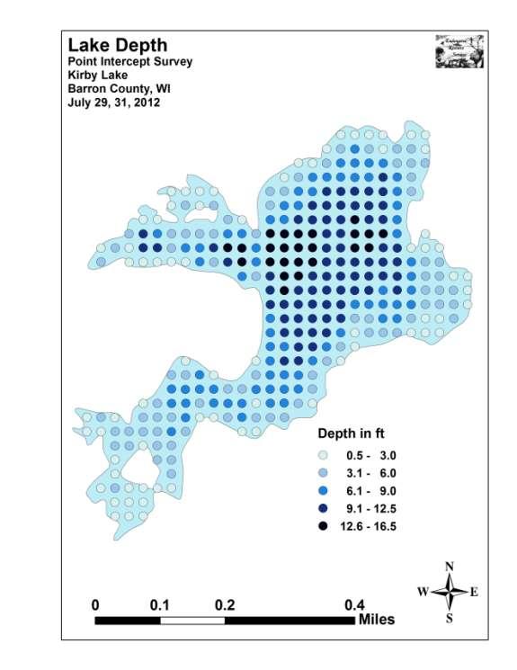
6 INTRODUCTION: Kirby Lake (WBIC ) is a 98 acre seepage lake in northwestern Barron County, Wisconsin in the Town of Maple Plain (T36N R14W S14). It reaches a maximum depth of 19ft on the west side of the central basin and has an average depth of approximately 8ft (WDNR 2012). The lake is mesotrophic bordering on eutrophic in nature with Secchi readings from ranging from 4-8ft and averaging 6.1ft (WDNR 2012). Kirby Lake s tannic stained water produced a littoral zone that extended to 10.0ft during the July 2012 survey. The bottom substrate is predominately muck with scattered sand and rock along the shoreline (Figure 1). Figure 1: Kirby Lake Bathymetric Map The Kirby Lake Management District (KLMD), Short Elliot Hendrickson, Inc. (SEH), and the Wisconsin Department of Natural Resources (WDNR) authorized a series of full lake plant surveys on Kirby Lake in 2012 prior to developing an Aquatic Plant Management Plan for the lake. On May 18 th and 19 th, we completed a cold water Curlyleaf pondweed (Potamogeton crispus) (CLP) survey. This was followed by a warm water survey of all aquatic macrophytes on July 29 th and 31 st. Both of these surveys used the WDNR s statewide guidelines for conducting systematic point-intercept macrophyte sampling. These methods ensure that all surveys in the state will be conducted in the same manner, thus allowing data to be compared across time and space. The immediate goals of the surveys were to determine if CLP or Eurasian water milfoil (Myriophyllum spicatum) had invaded the lake, to establish data on the richness, diversity, abundance and distribution of the lake s native aquatic plant populations, and to identify areas of concern where plants may be limiting access and usage of the lake. These data provide a baseline for long-term monitoring of the lake s macrophyte community as well as a way to measure any impacts on the lake s plants if active management occurs in the future. 1
7 METHODS: Cold Water Curly-leaf pondweed Survey: Using a standard formula that takes into account the shoreline shape and distance, islands, water clarity, depth and total acreage, Jennifer Hauxwell (WDNR) generated a 315 point sampling grid for Kirby Lake (Appendix I). Using this grid, we completed a density survey where we sampled for CLP at each point on the grid. We located each survey point using a handheld mapping GPS unit (Garmin 76CSx), and used a rake to sample an approximately 2.5ft section of the bottom. CLP was assigned a rake fullness value of 1-3 as an estimation of abundance (Figure 2). We also recorded visual sightings of CLP within six feet of the sample point. Figure 2: Rake Fullness Ratings (UWEX, 2010) Warm Water Full Point-Intercept Macrophyte Survey: Prior to beginning the July point-intercept survey, we conducted a general boat survey of the lake to gain familiarity with the species present (Appendix II). All plants found were identified (Voss 1996, Boreman et al. 1997; Chadde 2002; Crow and Hellquist 2006; Skawinski 2011), and two vouchers were pressed and mounted for herbarium specimens one to be retained by the KLMD, and one to be sent to the state herbarium in Stevens Point for identification confirmation. We again located each survey point with a GPS, recorded a depth reading using a metered rake or a hand held sonar unit (Vexilar LPS-1), and took a rake sample. All plants on the rake, as well as any that were dislodged by the rake were identified and assigned a rake fullness value of 1-3 as an estimation of abundance (Figure 2). We also recorded visual sightings of all plants within six feet of the sample point not found in the rake. In addition to a rake rating for each species, a total rake fullness rating was also noted. Substrate (lake bottom) type was assigned at each site where the bottom was visible or it could be reliably determined using the rake. 2
8 DATA ANALYSIS: We entered all data collected into the standard APM spreadsheet (Appendix II) (UWEX 2010). From this, we calculated the following: Total number of sites visited: This included the total number of points that were accessible to be surveyed by boat. Total number of sites with vegetation: These included all sites where vegetation was found after doing a rake sample. For example, if 20% of all sample sites have vegetation, it suggests that 20% of the lake has plant coverage. Total number of sites shallower than the maximum depth of plants: This is the number of sites that are in the littoral zone. Because not all sites that are within the littoral zone actually have vegetation, this value is used to estimate how prevalent vegetation is throughout the littoral zone. For example, if 60% of the sites shallower than the maximum depth of plants have vegetation, then we estimate that 60% of the lake s littoral zone has plants. Frequency of occurrence: The frequency of all plants (or individual species) is generally reported as a percentage of occurrences within the littoral zone. It can also be reported as a percentage of occurrences at sample points with vegetation. Frequency of occurrence example: Plant A is sampled at 70 out of 700 total littoral points = 70/700 =.10 = 10% This means that Plant A s frequency of occurrence = 10% when considering the entire littoral zone. Plant A is sampled at 70 out of 350 total points with vegetation = 70/350 =.20 = 20% This means that Plant A s frequency of occurrence = 20% when only considering the sites in the littoral zone that have vegetation. From these frequencies, we can estimate how common each species was at depths where plants were able to grow, and at points where plants actually were growing. Note the second value will be greater as not all the points (in this example, only ½) had plants growing at them. 3
9 Simpson s Diversity Index: A diversity index allows the entire plant community at one location to be compared to the entire plant community at another location. It also allows the plant community at a single location to be compared over time thus allowing a measure of community degradation or restoration at that site. With Simpson s Diversity Index, the index value represents the probability that two individuals (randomly selected) will be different species. The index values range from 0-1 where 0 indicates that all the plants sampled are the same species to 1 where none of the plants sampled are the same species. The greater the index value, the higher the diversity in a given location. Although many natural variables like lake size, depth, dissolved minerals, water clarity, mean temperature, etc. can affect diversity, in general, a more diverse lake indicates a healthier ecosystem. Perhaps most importantly, plant communities with high diversity also tend to be more resistant to invasion by exotic species. Maximum depth of plants: This indicates the deepest point that vegetation was sampled. In clear lakes, plants may be found at depths of over 20ft, while in stained or turbid locations, they may only be found in a few feet of water. While some species can tolerate very low light conditions, others are only found near the surface. In general, the diversity of the plant community decreases with increased depth. Average number of species per site: This value is reported using four different considerations. 1) shallower than the maximum depth of plants indicates the average number of plant species at all sites in the littoral zone. 2) vegetative sites only indicate the average number of plants at all sites where plants were found. 3) native species shallower than the maximum depth of plants and 4) native species at vegetative sites only excludes exotic species from consideration. Species richness: This value indicates the number of different plant species found in and directly adjacent to (on the waterline) the lake. Species richness alone only counts those plants found in the rake survey. The other two values include additional species seen at a point but not found in the rake, and additional species that were only found during the initial boat survey or between survey points. Note: Per WDNR protocol, filamentous algae, freshwater sponges, aquatic moss and the aquatic liverworts Riccia fluitans and Ricciocarpus natans are excluded from these totals. Mean and median depth of plants: The mean depth of plants indicates the average depth in the water column where plants were sampled. Because a few samples in deep water can skew this data, median depth is also calculated. This tells us that half of the plants sampled were in water shallower than this value, and half were in water deeper than this value (Table 1). 4
10 Relative frequency: This value shows species frequency relative to all other species. It is expressed as a percentage, and the total of all species relative frequency will add up to 100%. Organizing species from highest to lowest relative frequency value gives us an idea of which species are most important within the macrophyte community (Table 2). Relative frequency example: Suppose that we sample 100 points and found 5 species of plants with the following results: Plant A was located at 70 sites. Its frequency of occurrence is thus 70/100 = 70% Plant B was located at 50 sites. Its frequency of occurrence is thus 50/100 = 50% Plant C was located at 20 sites. Its frequency of occurrence is thus 20/100 = 20% Plant D was located at 10 sites. Its frequency of occurrence is thus 10/100 = 10% To calculate an individual species relative frequency, we divide the number of sites a plant is sampled at by the total number of times all plants were sampled. In our example that would be 150 samples ( ). Plant A = 70/150 =.4667 or 46.67% Plant B = 50/150 =.3333 or 33.33% Plant C = 20/150 =.1333 or 13.33% Plant D = 10/150 =.0667 or 6.67% This value tells us that 46.67% of all plants sampled were Plant A. Floristic Quality Index (FQI): This index measures the impact of human development on an area s aquatic plants. The 124 species in the index are assigned a Coefficient of Conservatism (C) which ranges from The higher the value assigned, the more likely the plant is to be negatively impacted by human activities relating to water quality or habitat modifications. Plants with low values are tolerant of human habitat modifications, and they often exploit these changes to the point where they may crowd out other species. The FQI is calculated by averaging the conservatism value for each native index species found in the lake during the point intercept survey, and multiplying it by the square root of the total number of plant species (N) in the lake (FQI=(Σ(c1+c2+c3+ cn)/n)* N). Statistically speaking, the higher the index value, the healthier the lake s macrophyte community is assumed to be. Nichols (1999) identified four ecoregions in Wisconsin: Northern Lakes and Forests, Northern Central Hardwood Forests, Driftless Area and Southeastern Wisconsin Till Plain. He recommended making comparisons of lakes within ecoregions to determine the target lake s relative diversity and health. Kirby Lake is in the Northern Central Harwood Forests Ecoregion (Table 3). ** Species that were only recorded as visuals or during the boat survey, and species found in the rake that are not included in the index are excluded from FQI analysis. 5
11 Comparison to Past Surveys: We compared data from the 2006 WDNR survey conducted on July 26 th (Tables 4 and 5) with our survey results to see if there were any significant changes in the lake s vegetation. Using the WDNR Pre/Post Survey Sheet, we determined 2006/2012 differences to be significant at p <.05, moderately significant at p <.01 and highly significant at p<.005 (UWEX 2010). As the WDNR surveyors were unable to access very shallow water and consequently did not survey 65 points, we used the number of points with vegetation (162 in 2006 and 184 in 2012) as the comparative values. As many species found in 2012 were only found in very shallow water, significant differences should only be viewed as informative. RESULTS: Cold Water Curly-leaf pondweed Survey: On May 18 th and 19 th, we surveyed Kirby Lake for the presence and abundance of Curlyleaf pondweed. We rake sampled all points in the lake, but did not find any evidence of CLP at or between points, or during the meandering boat survey we conducted of the lake s visible littoral zone (Figure 3) (Appendix III). Figure 3: May 18-19, 2012 CLP Survey 6

12 Warm Water Full Point-Intercept Macrophyte Survey: Depth soundings taken at Kirby Lake s 315 survey points revealed a varied underwater topography. The bays on the shoreline side of the lake s two islands were never deeper than 4ft while the lake s numerous shallow side bays generally dropped-off gradually into 5ft+ of water before joining the main basin. The exception to this was the western finger bay which contained two small 10ft+ potholes. The main basin also contained two separate holes that bottomed out at over 15ft. Other notable features included a rocky 8ft saddle that ran from the boat landing due north to the point, and a small rock bar midlake at the pinch point entrance to the southwest bay (Figure 4) (Appendix IV). Figure 4: Survey Points and Lake Depth Sand dominated the majority of the nearshore lake bottom as well around the islands while the most exposed points on the lake had gravel or rock substrate (Figure 5). Away from the shoreline, the majority of these areas quickly transitioned to nutrient rich organic muck. Lakewide, we categorized the bottom as 82.5% muck, 14.6% sand, and the remaining 2.9% rock and gravel (Appendix IV). At the time of the survey, Secchi disc readings were in the 6.5ft range. This fair water clarity produced a littoral zone that extended to 10.0ft (Figure 5) although the majority of plants were found in water <8ft deep as the mean and median depths of plants were a similar 4.2ft and 4.0ft respectively (Table 1). Plants were somewhat patchy in distribution as only 58.4% of the total lake bottom and 73.0% of the littoral zone were colonized. Diversity was very high with a Simpson Index Value of Species richness was also moderately high for such a small lake with 35 species found in the rake. When including plants that were visuals and those found during the boat survey, this total jumped to an impressive 49 species. Both of these values were up from the 2006 survey that produced a Simpson Index Value of 0.87 and found 30 species in and adjacent to the lake. 7
13 Figure 5: Bottom Substrate and Littoral Zone Table 1: Aquatic Macrophyte P/I Survey Summary Statistics Kirby Lake, Barron County July 26, 2006 and July 29, 31, 2012 Summary Statistics: Total number of points sampled Total number of sites with vegetation Total number of sites shallower than the maximum depth of plants Frequency of occurrence at sites shallower than maximum depth of plants Simpson Diversity Index Maximum depth of plants (ft) Mean depth of plants (ft) Median depth of plants (ft) Average number of all species per site (shallower than max depth) Average number of all species per site (veg. sites only) Average number of native species per site (shallower than max depth) Average number of native species per site (veg. sites only) Species richness Species richness (including visuals) Species richness (including visuals and boat survey) Mean total rake fullness (veg. sites only) Not measured
14 Lakewide, 100 of the 184 sites with vegetation had four or more native species present in the rake, and the average at sites with vegetation was 3.87 native species. Overall plant density was very high with a mean rake fullness of 2.65 at sites with vegetation (Figure 6) (Appendix V). Figure 6: Native Species Richness and Total Rake Fullness Rating Kirby Lake is home to an abundant plant community that is characterized by sensitive and rare species typical of pristine, low nutrient, soft water, acidic lakes. This community can be subdivided into four distinct zones (emergent, shallow submergent, floating-leaf, and deep submergent) with each zone having its own characteristic functions in the lake ecosystem. Depending on the local bottom type (sand, rock, sandy muck or nutrient rich organic muck), these zones often had somewhat different species present. In shallow areas, beds of emergent plants prevent erosion by stabilizing the lakeshore, break up wave action, provide a nursery for baitfish and juvenile gamefish, offer shelter for amphibians, and give waterfowl and predatory wading birds like herons a place to hunt. These areas also provide important habitat for insects like dragonflies and mayflies. Over sand and rock, Reed canary grass (Phalaris arundinacea) and Creeping spikerush (Eleocharis palustris) dominated the lakeshore. In sandy muck and firm organic muck areas in water up to 2ft deep, we found Woolgrass (Scirpus cyperinus), Common arrowhead (Sagittaria latifolia), Water smartweed (Polygonum amphibium), Branched burreed (Sparganium androcladum), Three-way sedge (Dulichium arundinaceum), and small numbers of Hardstem bulrush (Schoenoplectus acutus). We also documented Broad-leaved cattails (Typha latifolia), Bald spikerush (Eleocharis erythropoda), Pursh s bulrush (Schoenoplectus purshianus), and Blunt spikerush (Eleocharis obtusa) in shoreline and floating bog areas of the southwest bay. 9
 Woolgrass (Colby 2012) Branched bur-reed (Sullman 2008) Blunt spikerush")


, Spiny-spored quillwort (Isoetes echinospora),")
, Pipewort (Eriocaulon aquaticum), Crested arrowhead")

15 Typical Kirby Shoreline Emergent Community (Berg 2012) Creeping spikerush (Crelins 2009) Woolgrass (Colby 2012) Branched bur-reed (Sullman 2008) Blunt spikerush (Cameron 2012) Broad-leaved cattail (Raymond 2011) Despite being the rarest habitat on the lake, shallow sugar sand areas tended to have the greatest species richness. They also tended to have low total biomass as these nutrient poor substrates provided habitat most suited to fine leaved isoetid turf forming species like Golden hedge hyssop (Gratiola aurea), Waterwort (Elatine minima), Needle spikerush (Eleocharis acicularis), Spiny-spored quillwort (Isoetes echinospora), Brown-fruited rush (Juncus pelocarpus), False pimpernel (Lindernia dubia), Creeping spearwort (Ranunculus flammula), Pipewort (Eriocaulon aquaticum), Crested arrowhead (Sagittaria cristata), and Dwarf water milfoil (Myriophyllum tenellum). These shallow submergent species, along with the emergents, work to stabilize the bottom and prevent wave action erosion. 10
 Brown-fruited rush (Koshere 2002) Crested arrowhead (Fewless 2004)")

, Ribbon-leaf pondweed (Potamogeton epihydrus), Floating-leaf")
, Large-leaf pondweed (Potamogeton amplifolius),")


16 Waterwort (Fewless 2005) Needle spikerush (Fewless 2005) Spiny-spored quillwort (Haines 2012) Brown-fruited rush (Koshere 2002) Crested arrowhead (Fewless 2004) Dwarf water milfoil (Koshere 2002) We found that shallow organic muck bottomed areas were dominated by floating leaf species like Watershield (Brasenia schreberi), Water smartweed, White-water lily (Nymphaea odorata), Spatterdock (Nuphar variegata), Ribbon-leaf pondweed (Potamogeton epihydrus), Floating-leaf pondweed (Potamogeton natans), Oakes pondweed (Potamogeton oakesianus), Variable pondweed (Potamogeton gramineus), Large-leaf pondweed (Potamogeton amplifolius), and Floating-leaf bur-reed (Sparganium fluctuans). Elsewhere, more nutrient poor sandy muck provided habitat for Snail-seed pondweed (Potamogeton bicupulatus) and Northern manna-grass (Glyceria borealis). The protective canopy cover these species provide is often utilized by panfish and bass, and mature gamefish are often found prowling around the edges of these beds. 11
 Spatterdock and White water lily (Falkner 2009) Ribbon-leaf")
 Growing in gaps in the floating-leaf canopy, we")
 and Farwell s water milfoil (Myriophyllum farwellii).")
, and a very few Slender waterweed (Elodea")
.")

17 Watershield with gelatinous anti-insect coating (Berg 2012) Water smartweed (Someya 2009) Spatterdock and White water lily (Falkner 2009) Ribbon-leaf pondweed (Petroglyph 2007) Snail-seed pondweed (Haines 2012) Northern manna-grass (Fewless 2010) Growing in gaps in the floating-leaf canopy, we found large numbers of Small pondweed (Potamogeton pusillus pusillus and pusillus tenuissimus) and Farwell s water milfoil (Myriophyllum farwellii). We also documented Robbins spikerush (Eleocharis robbinsii), Water bulrush (Schoenoplectus subterminalis), and a very few Slender waterweed (Elodea nuttallii), Northern naiad (Najas gracillima), Nitella (Nitella flexilis), and Spiny hornwort (Ceratophyllum echinatum). The roots, shoots, and seeds of these species are heavily utilized by waterfowl for food, and they also provide important habitat for the lake s fish, as well as a myriad of invertebrates like scuds, dragonfly and mayfly nymphs, and snails. 12
 Slender waterweed (Fischer 2011)")
, Large purple")
, Flat-leaf bladderwort (Utricularia")


18 Small pondweed (Villa 2011) Farwell s water milfoil on Kirby s east side (Berg 2012) Slender waterweed (Fischer 2011) Nitella Floating among these species, we also encountered Creeping bladderwort (Utricularia gibba), Large purple bladderwort (Utricularia purpurea), Common bladderwort (Utricularia vulgaris), Flat-leaf bladderwort (Utricularia intermedia), and Small bladderwort (Utricularia minor). Rather than drawing nutrients up through roots like other plants, these carnivores trap zooplankton and minute insects in their bladders, digest their prey, and use the nutrients to further their growth. Tangle of Creeping bladderworts among Watershield (Berg 2012) Purple bladderworts growing among Watershield (Berg 2012) 13
 Purple bladderwort flower (BSA 2010) 5X Magnified aquatic moss leaves (Kleinman 2010) Floating-leaf and")


19 Common bladderwort flowers among lilypads (Hunt 2010) Bladders for catching plankton and insect larvae (Wontolla 2007) Purple bladderwort flower (BSA 2010) 5X Magnified aquatic moss leaves (Kleinman 2010) Floating-leaf and shallow submergent species generally disappeared on Kirby Lake in water over 5ft deep. Beyond this, Small pondweed and Large-leaf pondweed were generally the only rooted plants found. Aquatic moss, which was present throughout the littoral zone, became the dominant plant in the 6-10ft range before replacing all other species beyond 10ft. Although we only found moss to 16ft***, it is likely that it occurred throughout the deepest areas of the lake albeit at very low densities. ***Because it is non-vascular, DNR protocol excludes Aquatic moss from all statistical calculations including species richness, relative frequency, and establishment of the lake s littoral zone. 14
20 When considering the lake as a whole, Watershield, Large purple bladderwort, Small pondweed, and Creeping bladderwort were the most common vascular species (Table 2). They were found at 62.50%, 62.50%, 50.54%, and 40.76% of survey points with vegetation respectively. Collectively, they accounted for 54.90% of the total relative frequency (Figure 7). White water lily (9.93), Flat-leaf bladderwort (7.45), Common bladderwort (6.90), and Farwell s water milfoil (4.41) were the only other species that had relative frequencies over 3%. Aquatic moss, a non-vascular plant, was actually the most common macrophyte being found at 66.30% of vegetative sites (Species accounts and distribution maps for all plants found are located in Appendixes VI and VII). Figure 7: Kirby Lake s Most Common Vascular Species in
21 Table 2: Frequencies and Mean Rake Sample of Aquatic Macrophytes Kirby Lake, Barron County July 29, 31, 2012 Total Relative Freq. in Freq. in Mean Species Common Name Sites Freq. Veg. Lit. Rake Visual Sight. Aquatic moss 122 * Brasenia schreberi Watershield Utricularia purpurea Large purple bladderwort Potamogeton pusillus Small pondweed Utricularia gibba Creeping bladderwort Nymphaea odorata White water lily Utricularia intermedia Flat-leaf bladderwort Utricularia vulgaris Common bladderwort Myriophyllum farwellii Farwell's water-milfoil Eleocharis palustris Creeping spikerush Phalaris arundinacea Reed canary grass Glyceria borealis Northern manna grass Utricularia minor Small bladderwort Dulichium arundinaceum Three-way sedge Eleocharis robbinsii Robbins' spikerush Nuphar variegata Spatterdock Potamogeton amplifolius Large-leaf pondweed Potamogeton gramineus Variable pondweed Sparganium androcladum Branched bur-reed Polygonum amphibium Water smartweed Potamogeton bicupulatus Snail-seed pondweed Potamogeton epihydrus Ribbon-leaf pondweed Potamogeton natans Floating-leaf pondweed Schoenoplectus subterminalis Water bulrush Nitella sp. Nitella * Excluded from the Relative Frequency Calculation 16
22 Table 2 (cont ): Frequencies and Mean Rake Sample of Aquatic Macrophytes Kirby Lake, Barron County July 29, 31, 2012 Total Relative Freq. in Freq. in Mean Species Common Name Sites Freq. Veg. Lit. Rake Visual Sight. Potamogeton oakesianus Oakes' pondweed Eleocharis erythropoda Bald spikerush Elodea nuttallii Slender waterweed Gratiola aurea Golden hedge-hyssop Sagittaria cristata Crested arrowhead Ceratophyllum echinatum Spiny hornwort Lindernia dubia False pimpernel Sagittaria latifolia Common arrowhead Schoenoplectus acutus Hardstem bulrush Schoenoplectus purshianus Pursh s bulrush Sparganium fluctuans Floating-leaf bur-reed Gallium sp. Bedstraw ** ** ** ** ** 1 Najas gracillima Northern naiad ** ** ** ** ** 1 Scirpus cyperinus Woolgrass ** ** ** ** ** 2 Elatine minima Waterwort *** *** *** *** *** *** Eleocharis acicularis Needle spikerush *** *** *** *** *** *** Eleocharis obtusa Blunt spikerush *** *** *** *** *** *** Eriocaulon aquaticum Pipewort *** *** *** *** *** *** Isoetes echinospora Spiny-spored quillwort *** *** *** *** *** *** Juncus pelocarpus Brown-fruited rush *** *** *** *** *** *** Juncus tenuis Path rush *** *** *** *** *** *** Myriophyllum tenellum Dwarf water milfoil *** *** *** *** *** *** Potamogeton robbinsii Fern pondweed *** *** *** *** *** *** Ranunculus flammula Creeping spearwort *** *** *** *** *** *** Typha latifolia Broad-leaved cattail *** *** *** *** *** *** ** Visual Only *** Boat Survey Only 17
23 Table 3: Floristic Quality Index of Aquatic Macrophytes Kirby Lake, Barron County July 29, 31, 2012 Species Common Name C Brasenia schreberi Watershield 6 Ceratophyllum echinatum Spiny hornwort 10 Dulichium arundinaceum Three-way sedge 9 Eleocharis erythropoda Bald spikerush 3 Eleocharis palustris Creeping spikerush 6 Elodea nuttallii Slender waterweed 7 Glyceria borealis Northern manna grass 8 Gratiola aurea Golden hedge-hyssop 10 Myriophyllum farwellii Farwell's water-milfoil 8 Nitella sp. Nitella 7 Nuphar variegata Spatterdock 6 Nymphaea odorata White water lily 6 Polygonum amphibium Water smartweed 5 Potamogeton amplifolius Large-leaf pondweed 7 Potamogeton bicupulatus Snail-seed pondweed 9 Potamogeton epihydrus Ribbon-leaf pondweed 8 Potamogeton gramineus Variable pondweed 7 Potamogeton natans Floating-leaf pondweed 5 Potamogeton oakesianus Oakes' pondweed 10 Potamogeton pusillus Small pondweed 7 Sagittaria cristata Crested arrowhead 9 Sagittaria latifolia Common arrowhead 3 Schoenoplectus acutus Hardstem bulrush 6 Schoenoplectus subterminalis Water bulrush 9 Sparganium androcladum Branched bur-reed 8 Sparganium fluctuans Floating-leaf bur-reed 10 Utricularia gibba Creeping bladderwort 9 Utricularia intermedia Flat-leaf bladderwort 9 Utricularia minor Small bladderwort 10 Utricularia purpurea Large purple bladderwort 9 Utricularia vulgaris Common bladderwort 7 N 31 Mean C 7.5 FQI 41.8 We identified a total of 31 native index species in the rake during the point intercept survey. They produced a mean Coefficient of Conservatism of 7.5 and a Floristic Quality Index of 41.8 (Table 3). Nichols (1999) reported an average Mean C for the Northern Central Hardwood Forests Region of 5.6 putting Kirby Lake well above average for this part of the state. The FQI was also exactly double the median FQI of 20.9 for the Northern Central Hardwood Forests Region (Nichols 1999). These high values are likely the result of the many pristine shoreline areas on the lake and the conservation measures residents have afforded over the years. Specifically, exceptionally high value index plants like Spiny hornwort (C = 10), 18
, Small bladderwort (C = 10), Large-purple bladderwort (C = 9), and the State Species of Special Concern ** Snail-seed pondweed (C = 9) and Robbins spikerush (C = 10)")
24 Three-way sedge (C = 9), Golden-hedge hyssop (C = 10), Oakes pondweed (C = 10), Crested arrowhead (C = 9), Floating-leaf bur-reed (C = 10), Water bulrush (C = 9), Creeping bladderwort (C = 9), Flat-leaf bladderwort (C = 9), Small bladderwort (C = 10), Large-purple bladderwort (C = 9), and the State Species of Special Concern ** Snail-seed pondweed (C = 9) and Robbins spikerush (C = 10) would not be present if Kirby Lake had not enjoyed a history of apparent good water clarity and quality. Four other high value species of note including Waterwort (C = 9), Pipewort (C = 9), Dwarf water milfoil (C = 10), and Creeping spearwort (C = 9), were observed during the boat survey in sandy shoreline areas. ** Special Concern species are those species about which some problem of abundance or distribution is suspected but not yet proved. The main purpose of this category is to focus attention on certain species before they become threatened or endangered. Exotic Species: We did NOT find any evidence of Eurasian water milfoil or Curly-leaf pondweed in Kirby Lake during either of our surveys. However, Reed canary grass (Phalaris arundinacea), another exotic invasive species, has taken over large areas of the lakes shoreline and dominates surrounding wetlands (Figure 8). (For more information on aquatic exotic invasive plant species, see Appendix VIII). Figure 8: Reed Canary Grass Density and Distribution July 29, 31,
25 Comparison of the 2006 and 2012 Surveys: The July 26, 2006 WDNR PI survey found Small pondweed, Large purple bladderwort, Common waterweed (Elodea canadensis), and Common bladderwort to be the most common species in the lake (Table 4). They were found at 61.11%, 56.79%, 35.80%, and 32.72% of survey points with vegetation respectively. Collectively, they accounted for 62.01% of the total relative frequency (Figure 9). Watershield (8.62), Farwell s water milfoil (8.42), and Creeping bladderwort (8.01) were the only other species with a relative frequency over 2.0 (Maps for all species found in 2006 can be found in Appendix IX). Figure 9: Kirby Lake s Most Common Species in
26 Species Table 4: Frequencies and Mean Rake Sample of Aquatic Macrophytes Kirby Lake, Barron County July 26, 2006 Common Name Total Sites Relative Freq. Freq. in Veg. Freq. in Lit. Mean Rake Visual Sight. Potamogeton pusillus + Small pondweed Utricularia purpurea Large purple bladderwort Elodea canadensis Common waterweed Utricularia vulgaris ++ Common bladderwort Brasenia schreberi Watershield Myriophyllum farwellii Farwell's water-milfoil Utricularia gibba Creeping bladderwort Potamogeton amplifolius Large-leaf pondweed Nuphar variegata Spatterdock Aquatic moss 13 * Freshwater sponge 8 * Nymphaea odorata White water lily Nitella sp. Nitella Sagittaria sp. Arrowhead Schoenoplectus subterminalis Water bulrush Juncus pelocarpus Brown-fruited rush Myriophyllum tenellum Dwarf water-milfoil Filamentous algae 2 * Chara sp. Muskgrass Eriocaulon aquaticum Pipewort Gratiola aurea Golden hedge-hyssop Najas flexilis Slender naiad Potamogeton bicupulatus Snail-seed pondweed * Excluded from the Relative Frequency Calculation 21
27 Table 4 (cont.): Frequencies and Mean Rake Sample of Aquatic Macrophytes Kirby Lake, Barron County July 26, 2006 Species Common Name Total Sites Relative Freq. Freq. in Veg. Freq. in Lit. Mean Rake Visual Sight. Potamogeton bicupulatus Snail-seed pondweed Schoenoplectus tabernaemontani Softstem bulrush Sparganium fluctuans +++ Floating-leaf bur-reed Elatine minima Waterwort ** ** ** ** ** 3 Eleocharis palustris Creeping spikerush ** ** ** ** ** 2 Potamogeton oakesianus Oakes' pondweed ** ** ** ** ** 2 Vallisneria americana Wild celery ** ** ** ** ** 1 Dulichium arundinaceum Threeway sedge *** *** *** *** *** *** Eleocharis acicularis Needle spikerush *** *** *** *** *** *** Polygonum amphibium Water smartweed *** *** *** *** *** *** Sparganium androcladum Branched bur-reed *** *** *** *** *** *** * Excluded from the Relative Frequency Calculation ** Visual Only *** Boat Survey Only +In 2006, Small pondweed was originally identified as Stiff pondweed (Potamogeton strictifolius - this species is not normally found in bog lakes as it prefers hard water) and Leafy pondweed (Potamogeton foliosus - no plants with diagnostic keeled nutlets were ever found in 2012). Based on the specimens we collected in 2012 which were confirmed by R. Freckmann, and P. Skaminski, UWSP, we assume these two species were almost certainly P. pusillus pusillus and P. pusillus tenuissimus which the WDNR currently lumps together under Small pondweed. ++Common bladderwort originally contained 17 locations that included Twin-stem bladderwort (Utricularia geminiscapa). We believe these individuals were all actually young U. vulgaris as no voucher of U. geminiscapa exists, and Michelle Nault (WDNR surveyor) said it was likely a misidentification (personal comm.). +++This specimen was originally left at the genus level (Sparganium sp.). We feel confident calling it Floating-leaf pondweed as the plants were in 5ft of water directly next to an area where beds of S. fluctuans occurred in the 2012 survey. As S. androcladum was the only other bur-reed on the lake, and they never produce floating leaves, we feel confident concluding it was this species. 22
28 # of Sites *** +*** Differences for All Species Kirby Lake, Barron County July 26, 2006 and July 29, 31, * 80 +*** +*** 60 -*** +*** * -* -** -** +*** +*** +** +** +* +* +* +* 0 Significant differences = * p <. 05, ** p <. 01, *** p <. 005 Figure 10: Macrophyte Changes 23
29 Comparing the two surveys found highly significant increases in Watershield, Creeping bladderwort, Aquatic moss, White water lily, Flat-leaf bladderwort, Creeping spikerush, and Reed canary grass; moderately significant increases in Northern manna-grass and Small bladderwort; and significant increases in Threeway sedge, Robbins spikerush, Variable pondweed, and Branched bur-reed (Figure 10). We believe the majority of these differences are simply explained by the previous survey not accessing shallow water. Less easy to explain is the highly significant decline/complete disappearance of Common waterweed; the moderately significant declines in Sponges and Arrowheads; and the significant declines in Small pondweed, Large-leaf pondweed, and Spatterdock (Figure 10). Perhaps the extended drought has changed the lake s water chemistry making growing conditions less favorable for these species. Table 5: Floristic Quality Index of Aquatic Macrophytes Kirby Lake, Barron County July 26, 2006 Species Common Name C Brasenia schreberi Watershield 6 Chara sp. Muskgrass 7 Elodea canadensis Common waterweed 3 Eriocaulon aquaticum Pipewort 9 Gratiola aurea Golden hedge-hyssop 10 Juncus pelocarpus Brown-fruited rush 8 Myriophyllum farwellii Farwell's water-milfoil 8 Myriophyllum tenellum Dwarf water-milfoil 10 Najas flexilis Slender naiad 6 Nitella sp. Nitella 7 Nuphar variegata Spatterdock 6 Nymphaea odorata White water lily 6 Potamogeton amplifolius Large-leaf pondweed 7 Potamogeton bicupulatus Snail-seed pondweed 9 Potamogeton pusillus Small pondweed 7 Schoenoplectus subterminalis Water bulrush 9 Schoenoplectus tabernaemontani Softstem bulrush 4 Sparganium fluctuans Floating-leaf bur-reed 10 Utricularia gibba Creeping bladderwort 9 Utricularia purpurea Large purple bladderwort 9 Utricularia vulgaris Common bladderwort 7 N 21 Mean C 7.5 FQI 34.3 In 2006, WDNR surveyors identified a total of 21 native index species in the rake during the point intercept survey. They produced a mean Coefficient of Conservatism of 7.5 and a Floristic Quality Index of Both the number of plants in the index and the FQI were lower than the 2012 totals although this is again likely at least partially due to the abbreviated nature of this initial survey. 24

30 DISCUSSION AND CONSIDERATIONS FOR MANAGEMENT: Uniqueness of the Lake s Native Plant Community: Aquatic plants are the basis of a lake s ecosystem and are as important to the aquatic environment as trees are to a forest. They provide habitat for fish and other aquatic organisms, serve as food sources for waterfowl and other wildlife, stabilize the shoreline, and work to improve clarity by absorbing excess nutrients from the water. Because of this, maintaining this community is critical to maintaining a healthy lake. Kirby Lake s plant community is also the most sensitive we have ever found. This tiny lake unexpectedly boasts 17 extremely high value species (C value of 9 or 10). Unfortunately, many of them were very limited in both numbers and distribution making them vulnerable to lake-wide extinction. The water clarity and quality these fine-leaved species depend on for survival also makes them dependent on continued landowner stewardship to maintain the lake s nearly pristine conditions. Challenges with the Lake s Plant Community: Kirby Lake s soft acidic water and shallow depths provide Watershield, Large purple bladderwort, and White water lily with ideal growing conditions. As the lake s bays have grown shallower over time, these species especially has been able to expand their range on the lake to the point where they now dominate most areas in less than five feet of water (Figure 11). Figure 11: Mat of Watershield and Large Purple Bladderwort One of the impetuses for completing the lake s aquatic plant management plan was to assess the impact plants are having on property owners. As we quickly found out during the survey, many, if not the majority of owners that live in the lake s bays, are likely having significant difficulty getting to and from their docks after June 1 st when plants have topped out (Figure 12). Because of this, some form of plant control is likely necessary to relieve navigation impairment. As the lake has such a rare and sensitive community, harvesting rather than blanket herbicide treatment may provide the best compromise between maintaining the environment and promoting human enjoyment of the lake. 25


31 Figure 12: Nearly Inaccessible Shoreline on Kirby Lake Nutrient Impacts on the Lake s Plant Community: Nutrients, especially Phosphorus, promote both rooted plant and algal growth. Such things as internal loading from sediments, failed septic systems, soil erosion, and lawn and field fertilizer runoff are common causes of excess nutrients in surface water. Currently, Kirby Lake s property owners are to be commended for their generally good shoreline conservation, and the lake has many residences that could serve as a model for how to minimize human impacts on a lakeshore. Educating all lake residents about reducing nutrient input directly along the lake is one of the easiest ways to help limit plant and algal growth and maintain or even improve water clarity and quality. Not mowing down to the lakeshore, bagging grass clippings, disposing of pet waste and fire pit ashes away from the lake, and switching to a phosphorus-free fertilizer or eliminating fertilizer altogether would all be positive steps to this end. Wherever possible, restoring shorelines, building rain gardens, and establishing buffer strips of native vegetation would also enhance water clarity/quality by preventing erosion and runoff. Away from the immediate shoreline, disturbing nutrient rich muck bottoms with motor start-ups in shallow water, anchor dragging, and the grounding of personal watercraft can also be a significant contributor to suspended nutrients in the water column. To prevent this, residents are encouraged to use lifts for their watercraft whenever possible, and to try to avoid starting their motors in water less than 5ft in depth. Finally, distributing a simple self evaluation lake care checklist with rational for best practices is a non-confrontational way to help people understand how they may be impacting the lake. Hopefully, a greater understanding of how individual property owners can have lake-wide impacts will result in more people taking appropriate conservation actions to help limit plant growth and promote improved water quality for all. 26

32 Aquatic Invasive Species Prevention: Aquatic Invasive Species (AIS) such as Eurasian water milfoil are an increasing problem in the lakes of northern Wisconsin in general, and several nearby lakes in the Cumberland area in particular. Preventing their introduction into Kirby Lake with proactive measures is strongly encouraged. Improving the current signage at the boat landing to something that is brighter and less easily ignored is also encouraged. The current green sign is almost camouflaged into the storage shed (Figure 13). When Clean Boats/Clean Waters volunteers aren t on duty, this sign must serve as the lake s guardian against AIS by providing education, reeducation, and continual reminders of the dangers/impacts of aquatic invasive species to lake owners and visitors alike. Making it more noticeable will increase the chances that people will both read it and consider their actions before launching. Figure 13: Current Signage at the Kirby Lake Public Landing Conducting monthly transect surveys parallel to the shore near the landing throughout the growing season and at least one annual meandering shoreline survey of the entire lake are further suggestions to consider as these surveys can result in early detection if an AIS is introduced into the lake. The sooner an infestation is detected, the greater the chances it can be successfully and economically controlled. Finally, developing a planned response to a new AIS in the updated Aquatic Plant Management Plan would help streamline an appropriate response if/when an infestation of EWM or some other AIS occurs. 27
33 Management Considerations Summary: Preserve Kirby Lake s unique and extremely sensitive native plant communities as they serve as the basis of the entire aquatic ecosystem. Provide navigation impairment relief to promote human enjoyment and utilization of the lake, but do so in a way that minimizes environmental impacts. Encourage all property owners to help limit plant growth and maintain or improve water clarity and quality by identifying and then reducing potential sources of nutrient input near the lakeshore. Specifically, avoid mowing down to the lake shore, bag grass clippings, dispose of pet waste and fire pit ashes away from the lake, and avoid fertilizing near the lake. Reduce erosion by restoring shorelines, building rain gardens and maintaining native vegetation buffer strips along the lakeshore. Avoid beaching watercraft and shallow water motor start-ups as these practices release nutrients into the water column and promote algal blooms. Brighten the current signage at the boat landing to make it more noticeable as it needs to educate lake users about Aquatic Invasive Species like Eurasian water milfoil when CB/CW volunteers aren t on duty. Consider transect monitoring for invasive species at the lake s boat landing at least once a month and a meandering shoreline survey of the entire lake at least once during the summer growing season. Include a planned response to new AIS in the updated Aquatic Plant Management Plan that would outline a course of action if EWM or some other invasive species is introduced into the lake. 28
34 LITERATURE CITED Borman, S., R. Korth, and J. Temte Through the Looking Glass A Field Guide to Aquatic Plants. Wisconsin Lakes Partnership. DNR publication FH Busch, C, C Olson, L. Sather, and J. Roth. [online] Kirby Lake Bathymetric Map. (2012, August). Chadde, Steve W A Great Lakes Wetland Flora: A complete guide to the aquatic and wetland plants of the Upper Midwest. Pocketflora Press; 2nd edition Crow, G. E., C. B. Hellquist Aquatic and Wetland Plants of Northeastern North America, Volume I + II: A Revised and Enlarged Edition of Norman C. Fassett's A Manual of Aquatic Plants. University of Wisconsin Press. Nichols, Stanley A Floristic Quality Assessment of Wisconsin Lake Plant communities with Example Applications. Journal of Lake and Reservoir Management 15 (2): Skawinski, Paul Aquatic Plants of the Upper Midwest: A photographic field guide to our underwater forests. Wausau, WI. Sullman, Josh. [online] Sparganium of Wisconsin Identification Key and Description. Available from University of Wisconsin-Madison on.htm (2012, August). UWEX Lakes Program. [online] Aquatic Plant Management in Wisconsin. Available from (2012, August). Voss, Edward G Michigan Flora Vol I-III. Cranbrook Institute of Science and University of Michigan Herbarium. WDNR. [online] Curly-leaf pondweed fact sheet. (2012, August). WDNR. [online] Eurasian water milfoil fact sheet. (2012, August). WDNR. [online] Purple loosestrife fact sheet. (2012, August). WDNR. [online] Reed canary grass fact sheet. (2012, August). WDNR. [online] Wisconsin Lake Citizen Monitoring Data for Kirby Lake Barron County. Available from (2012, December). WDNR. [online] Wisconsin Lakes Information. (2012, August). 29
35 Appendix I: Kirby Lake Survey Sample Points 30
36 31
37 Appendix II: Boat and Vegetative Survey Data Sheets 32
38 Boat Survey Lake Name County WBIC Date of Survey (mm/dd/yy) workers Nearest Point Species seen, habitat information 33
39 Observers for this lake: names and hours worked by each: Lake: WBIC County Date: Site # Depth (ft) Muck (M), Sand (S), Rock (R) Rake pole (P) or rake rope (R) Total Rake Fullness EWM CLP
40 Appendix III: Curly-leaf pondweed Survey Map 35
41 36
42 Appendix IV: Habitat Variable Maps 37
43 38
44 39
45 40
46 Appendix V: Native Species Richness and Total Rake Fullness Maps 41
47 42
48 43
49 Appendix VI: Kirby Lake Plant Species Accounts 44
50 County/State: Barron County, Wisconsin Date: 7/29/12 Species: Aquatic moss Specimen Location: Kirby Lake; N , W Collected/Identified by: Matthew S. Berg Col. #: MSB Habitat/Distribution: Muck bottoms in 0-5 meters of water. Common, but seldom abundant, moss was the deepest growing macrophyte in the lake although it occurred at very low densities at depths over 3m. Common Associates: (Utricularia gibba) Creeping bladderwort, (Potamogeton amplifolius) Large-leaf pondweed County/State: Barron County, Wisconsin Date: 7/29/12 Species: (Brasenia schreberi) Watershield Specimen Location: Kirby Lake; N , W Collected/Identified by: Matthew S. Berg Col. #: MSB Habitat/Distribution: Muck and mucky sand bottom in meters. Abundant to the point of restricting boat traffic in many bays of the lake where it formed solid canopies. Common Associates: (Utricularia purpurea) Large purple bladderwort, (Nymphaea odorata) White water lily, (Nuphar variegata) Spatterdock, (Potamogeton pusillus) Small pondweed, (Utricularia intermedia) Flat-leaf bladderwort County/State: Barron County, Wisconsin Date: 7/29/12 Species: (Ceratophyllum echinatum) Spiny hornwort Specimen Location: Kirby Lake; N , W Collected/Identified by: Matthew S. Berg Col. #: MSB Habitat/Distribution: Muck bottom in 2 meters of water. A single plant was the only specimen found on the entire lake. Common Associates: (Brasenia schreberi) Watershield, (Utricularia purpurea) Large purple bladderwort, (Myriophyllum farwellii) Farwell s water milfoil, (Elodea nuttallii) Slender waterweed County/State: Barron County, Wisconsin Date: 7/29/12 Species: (Dulichium arundinaceum) Three-way sedge Specimen Location: Kirby Lake; N , W Collected/Identified by: Matthew S. Berg Col. #: MSB Habitat/Distribution: Located at the edge of the water in mucky and sandy soil. Common in scattered locations throughout. Common Associates: (Typha latifolia) Broad-leaved cattail, (Schoenoplectus acutus) Hardstem bulrush, (Sagittaria latifolia) Common arrowhead, (Eleocharis palustris) Creeping spikerush, (Phalaris arundinacea) Reed canary grass, (Sparganium androcladum) Branched bur-reed County/State: Barron County, Wisconsin Date: 7/29/12 Species: (Elatine minima) Waterwort Specimen Location: Kirby Lake; N , W Collected/Identified by: Matthew S. Berg Col. #: MSB Habitat/Distribution: Sand/rock bottom in 0-.25m of water. A few individuals were found near the point. Only found at a few other locations on the lake. Common Associates: (Grateola aurea) Golden-hedge hyssop, (Isoetes echinospora) Spinyspored quillwort, (Eleocharis acicularis) Needle spikerush, (Myriophyllum tenellum) Dwarf water milfoil, (Juncus pelocarpus) Brown-fruited rush 45
51 County/State: Barron County, Wisconsin Date: 7/29/12 Species: (Eleocharis acicularis) Needle spikerush Specimen Location: Kirby Lake; N , W Collected/Identified by: Matthew S. Berg Col. #: MSB Habitat/Distribution: Sand/rock bottom in 0-.25m of water. A few individuals were growing in and out of the water near the point. Only found at a few other locations on the lake. Common Associates: (Grateola aurea) Golden-hedge hyssop, (Isoetes echinospora) Spinyspored quillwort, (Eriocaulon aquaticum) Pipewort, (Myriophyllum tenellum) Dwarf water milfoil, (Juncus pelocarpus) Brown-fruited rush County/State: Barron County, Wisconsin Date: 7/29/12 Species: (Eleocharis erythropoda) Bald spikerush Specimen Location: Kirby Lake; N , W Collected/Identified by: Matthew S. Berg Col. #: MSB Habitat/Distribution: A few dense patches of plants occurred on floating bogs in the small western side bay west/northwest of the island in the southwest bay. Common Associates: (Schoenoplectus purshianus) Pursh s bulrush, (Typha latifolia) Broadleaved cattail, (Phalaris arundinacea) Reed canary grass, (Sagittaria latifolia) Common arrowhead, (Dulichium arundinaceum) Three-way sedge County/State: Barron County, Wisconsin Date: 7/29/12 Species: (Eleocharis obtusa) Blunt spikerush Specimen Location: Kirby Lake; N , W Collected/Identified by: Matthew S. Berg Col. #: MSB Habitat/Distribution: Rare; only plants found were on floating bogs in the lake s far southwest bay. Common Associates: (Typha latifolia) Broad-leaved cattail, (Eleocharis erythropoda) Bald spikerush, (Sagittaria latifolia) Common arrowhead, (Dulichium arundinaceum) Three-way sedge, (Phalaris arundinacea) Reed canary grass County/State: Barron County, Wisconsin Date: 7/29/12 Species: (Eleocharis palustris) Creeping spikerush Specimen Location: Kirby Lake; N , W Collected/Identified by: Matthew S. Berg Col. #: MSB Habitat/Distribution: Located at the edge of the water in sandy soil and on rocky points. Common in scattered locations throughout. Common Associates: (Schoenoplectus acutus) Hardstem bulrush, (Sagittaria latifolia) Common arrowhead, (Dulichium arundinaceum) Three-way sedge, (Phalaris arundinacea) Reed canary grass, (Sparganium androcladum) Branched bur-reed County/State: Barron County, Wisconsin Date: 7/29/12 Species: (Eleocharis robbinsii) Robbins spikerush Specimen Location: Kirby Lake; N , W Collected/Identified by: Matthew S. Berg Col. #: MSB Habitat/Distribution: Firm muck and rock bottoms in 1-2 meters of water. Uncommon, but scattered individuals where found throughout the lake unfortunately, no individuals were in flower/fruit. Common Associates: (Brasenia schreberi) Watershield, (Utricularia purpurea) Large purple bladderwort, (Myriophyllum farwellii) Farwell s water milfoil, (Eleocharis palustris) Creeping spikerush 46
52 County/State: Barron County, Wisconsin Date: 7/29/12 Species: (Elodea nuttallii) Slender waterweed Specimen Location: Kirby Lake; N , W Collected/Identified by: Matthew S. Berg Col. #: MSB Habitat/Distribution: Muck bottom in meters of water. A single plant was found at each of two locations. Common Associates: (Brasenia schreberi) Watershield, (Utricularia purpurea) Large purple bladderwort, (Myriophyllum farwellii) Farwell s water milfoil, (Ceratophyllum echinatum) Spiny hornwort County/State: Barron County, Wisconsin Date: 7/29/12 Species: (Eriocaulon aquaticum) Pipewort Specimen Location: Kirby Lake; N , W Collected/Identified by: Matthew S. Berg Col. #: MSB Habitat/Distribution: Sand/rock bottom in 0-.25m of water. A few individuals were growing in and out of the water near the point. Only found at a few other locations on the lake. Common Associates: (Grateola aurea) Golden-hedge hyssop, (Isoetes echinospora) Spinyspored quillwort, (Eleocharis acicularis) Needle spikerush, (Myriophyllum tenellum) Dwarf water milfoil, (Juncus pelocarpus) Brown-fruited rush County/State: Barron County, Wisconsin Date: 7/29/12 Species: (Gallium sp.) Bedstraw Specimen Location: Kirby Lake; N , W Collected/Identified by: Matthew S. Berg Col. #: MSB Habitat/Distribution: Sandy to sandy muck bottoms in 0-0.5m of water. Scattered individuals were found growing along the shoreline near the point. Not found anywhere else. Common Associates: (Brasenia schreberi) Watershield, (Utricularia purpurea) Large purple bladderwort, (Myriophyllum farwellii) Farwell s water milfoil, (Glyceria borealis) Northern manna-grass County/State: Barron County, Wisconsin Date: 7/29/12 Species: (Glyceria borealis) Northern manna-grass Specimen Location: Kirby Lake; N , W Collected/Identified by: Matthew S. Berg Col. #: MSB Habitat/Distribution: Sandy to sandy muck bottoms in 0-0.5m of water. Plants were common in shoreline areas throughout where they often mixed with Phalaris. Common Associates: (Brasenia schreberi) Watershield, (Sagittaria latifolia) Common arrowhead, (Dulichium arundinaceum) Three-way sedge, (Phalaris arundinacea) Reed canary grass, (Sparganium androcladum) Branched bur-reed County/State: Barron County, Wisconsin Date: 7/29/12 Species: (Grateola aurea) Golden hedge-hyssop Specimen Location: Kirby Lake; N , W Collected/Identified by: Matthew S. Berg Col. #: MSB Habitat/Distribution: Sandy to sandy muck bottoms in m of water. A few individuals were growing in and out of the water near the point. Only found at a few other locations on the lake. Common Associates: (Eriocaulon aquaticum) Pipewort, (Isoetes echinospora) Spiny-spored quillwort, (Eleocharis acicularis) Needle spikerush, (Myriophyllum tenellum) Dwarf water milfoil, (Juncus pelocarpus) Brown-fruited rush 47
53 County/State: Barron County, Wisconsin Date: 7/29/12 Species: (Isoetes echinospora) Spiny-spored quillwort Specimen Location: Kirby Lake; N , W Collected/Identified by: Matthew S. Berg Col. #: MSB Habitat/Distribution: Sand/rock bottom in 0-.25m of water. A few individuals were growing near the point. Not found anywhere else. Common Associates: (Grateola aurea) Golden-hedge hyssop, (Eleocharis acicularis) Needle spikerush, (Myriophyllum tenellum) Dwarf water milfoil, (Elatine minima) Waterwort, (Sagittaria cristata) Crested arrowhead, (Juncus pelocarpus) Brown-fruited rush County/State: Barron County, Wisconsin Date: 7/29/12 Species: (Juncus pelocarpus) Brown-fruited rush Specimen Location: Kirby Lake; N , W Collected/Identified by: Matthew S. Berg Col. #: MSB Habitat/Distribution: Sand/rock bottom in 0-.25m of water. A few individuals were growing in and out of the water near the point. Not found anywhere else. Common Associates: (Grateola aurea) Golden-hedge hyssop, (Isoetes echinospora) Spinyspored quillwort, (Eleocharis acicularis) Needle spikerush, (Myriophyllum tenellum) Dwarf water milfoil, (Elatine minima) Waterwort, (Sagittaria cristata) Crested arrowhead County/State: Barron County, Wisconsin Date: 7/29/12 Species: (Juncus tenuis) Path rush Specimen Location: Kirby Lake; N , W Collected/Identified by: Matthew S. Berg Col. #: MSB Habitat/Distribution: Firm muck at the shoreline. A few plants were located at the boat landing. Common Associates: (Phalaris arundinacea) Reed canary grass County/State: Barron County, Wisconsin Date: 7/29/12 Species: (Lindernia dubia) False pimpernel Specimen Location: Kirby Lake; N , W Collected/Identified by: Matthew S. Berg Col. #: MSB Habitat/Distribution: Sandy to sandy muck bottoms in m of water. A few individuals were growing in and out of the water near the point. Only found at a few other locations on the lake. Common Associates: (Grateola aurea) Golden-hedge hyssop, (Isoetes echinospora) Spinyspored quillwort, (Eleocharis acicularis) Needle spikerush, (Myriophyllum tenellum) Dwarf water milfoil, (Juncus pelocarpus) Brown-fruited rush County/State: Barron County, Wisconsin Date: 7/29/12 Species: (Myriophyllum farwellii) Farwell s water milfoil Specimen Location: Kirby Lake; N , W Collected/Identified by: Matthew S. Berg Col. #: MSB Habitat/Distribution: Muck bottom areas in water up to 1.5m. Widespread and common to locally abundant. Common Associates: (Nymphaea odorata) White water lily, (Utricularia purpurea) Large purple bladderwort, (Utricularia intermedia) Flat-leaf bladderwort, (Utricularia gibba) Creeping bladderwort, (Utricularia minor) Small bladderwort, (Eleocharis palustris) Creeping spikerush, (Potamogeton pusillus) Small pondweed 48
54 County/State: Barron County, Wisconsin Date: 7/29/12 Species: (Myriophyllum tenellum) Dwarf water milfoil Specimen Location: Kirby Lake; N , W Collected/Identified by: Matthew S. Berg Col. #: MSB Habitat/Distribution: Sandy to sandy muck bottoms in 0-.25m of water. A few individuals were growing at the point. Only found at a few other locations on the lake. Common Associates: (Grateola aurea) Golden-hedge hyssop, (Isoetes echinospora) Spinyspored quillwort, (Eleocharis acicularis) Needle spikerush, (Eriocaulon aquaticum) Pipewort, (Juncus pelocarpus) Brown-fruited rush County/State: Barron County, Wisconsin Date: 7/29/12 Species: (Najas gracillima) Northern naiad Specimen Location: Kirby Lake; N , W Collected/Identified by: Matthew S. Berg Col. #: MSB Habitat/Distribution: Rare; a few plants were found at the point and in the east bay inter-point. Common Associates: (Brasenia schreberi) Watershield, (Utricularia purpurea) Large purple bladderwort, (Myriophyllum farwellii) Farwell s water milfoil, (Glyceria borealis) Northern manna-grass County/State: Barron County, Wisconsin Date: 7/29/12 Species: (Nitella flexilis) Nitella Specimen Location: Kirby Lake; N , W Collected/Identified by: Matthew S. Berg/Paul M. Skawinski Col. #: MSB Habitat/Distribution: Muck bottom in 2 meters. Plants were only found at two points in the entire lake. Common Associates: Aquatic moss County/State: Barron County, Wisconsin Date: 7/29/12 Species: (Nuphar variegata) Spatterdock Specimen Location: Kirby Lake; N , W Collected/Identified by: Matthew S. Berg Col. #: MSB Habitat/Distribution: Firm muck bottoms in 0-2 meters of water. Much less common than Nymphaea in the lake. Most plants were in sheltered areas of bays and growing off rocky/sandy points. Common Associates: (Nymphaea odorata) White water lily, (Utricularia purpurea) Large purple bladderwort, (Utricularia gibba) Creeping bladderwort, (Brasenia schreberi) Watershield County/State: Barron County, Wisconsin Date: 7/29/12 Species: (Nymphaea odorata) White water lily Specimen Location: Kirby Lake; N , W Collected/Identified by: Matthew S. Berg Col. #: MSB Habitat/Distribution: Muck bottom in 0-2 meters. Plants were abundant and widely distributed throughout. Common Associates: (Nuphar variegata) Spatterdock, (Utricularia purpurea) Large purple bladderwort, (Utricularia gibba) Creeping bladderwort, (Sparganium fluctuans) Floating-leaf bur-reed, (Brasenia schreberi) Watershield 49
55 County/State: Barron County, Wisconsin Date: 7/29/12 Species: (Phalaris arundinacea) Reed canary grass Specimen Location: Kirby Lake; N , W Collected/Identified by: Matthew S. Berg Col. #: MSB Habitat/Distribution: Prefers thick muck soil in and out of water <0.5 meters. Common to abundant throughout and highly invasive in many shoreline areas. Common Associates: (Typha latifolia) Broad-leaved cattail, (Sagittaria latifolia) Common arrowhead, (Dulichium arundinaceum) Three-way sedge, (Sparganium androcladum) Branched bur-reed County/State: Barron County, Wisconsin Date: 7/29/12 Species: (Polygonum amphibium) Water smartweed Specimen Location: Kirby Lake; N , W Collected/Identified by: Matthew S. Berg Col. #: MSB Habitat/Distribution: Silt to muck bottom over firm substrate in 0-1 meter of water. Common in both its emergent and floating growth form along undeveloped shorelines throughout the lake. Common Associates: (Phalaris arundinacea) Reed canary grass, (Nymphaea odorata) White water lily, (Sparganium androcladum) Branched bur-reed, (Brasenia schreberi) Watershield, (Eleocharis palustris) Creeping spikerush, (Sagittaria latifolia) Common arrowhead County/State: Barron County, Wisconsin Date: 7/29/12 Species: (Potamogeton amplifolius) Large-leaf pondweed Specimen Location: Kirby Lake; N , W Collected/Identified by: Matthew S. Berg Col. #: MSB Habitat/Distribution: Mucky bottom areas in water from 1-3m deep. Widely distributed, but uncommon except in the pinch point/entrance to the southwest bay. Common Associates: (Brasenia schreberi) Watershield, (Utricularia purpurea) Large purple bladderwort, (Potamogeton pusillus) Small pondweed, Aquatic moss County/State: Barron County, Wisconsin Date: 7/29/12 Species: (Potamogeton bicupulatus) Snail-seed pondweed Specimen Location: Kirby Lake; N , W Collected/Identified by: Matthew S. Berg Col. #: MSB Habitat/Distribution: More common than the survey indicated. Plants occupied a fairly narrow habitat niche in water 0.5-1m deep over sand and rock in open canopy areas not dominated by Brasenia. Common Associates: (Eleocharis palustris) Creeping spikerush, (Grateola aurea) Golden hedge hyssop, (Myriophyllum farwellii) Farwell s water milfoil, (Potamogeton robbinsii) Fern pondweed, (Glyceria borealis) Northern manna grass County/State: Barron County, Wisconsin Date: 7/29/12 Species: (Potamogeton epihydrus) Ribbon-leaf pondweed Specimen Location: Kirby Lake; N , W Collected/Identified by: Matthew S. Berg Col. #: MSB Habitat/Distribution: Found in muck and sand bottom conditions in shallow water meters deep. Uncommon with scattered locations throughout; especially common on the west side of the southwest bay s island. Common Associates: (Potamogeton bicupulatus) Snail-seed pondweed, (Brasenia schreberi) Watershield, (Nymphaea odorata) White water lily, (Utricularia vulgaris) Common bladderwort, (Utricularia purpurea) Large purple bladderwort, (Potamogeton pusillus) Small pondweed, (Potamogeton oakesianus) Oakes pondweed, (Potamogeton gramineus) Variable pondweed 50
56 County/State: Barron County, Wisconsin Date: 7/29/12 Species: (Potamogeton gramineus) Variable pondweed Specimen Location: Kirby Lake; N , W Collected/Identified by: Matthew S. Berg Col. #: MSB Habitat/Distribution: Uncommon in m of water over organic muck. Stipules/branching thin submerged leaves differentiated this species from the very similar looking P. oakesianus that was often found growing nearby. Common Associates: (Brasenia schreberi) Watershield, (Nymphaea odorata) White water lily, (Utricularia vulgaris) Common bladderwort, (Utricularia purpurea) Large purple bladderwort, (Potamogeton pusillus) Small pondweed, (Potamogeton epihydrus) Ribbon-leaf pondweed, (Potamogeton natans) Floating-leaf pondweed, (Potamogeton oakesianus) Oakes pondweed, (Nuphar variegata) Spatterdock County/State: Barron County, Wisconsin Date: 7/29/12 Species: (Potamogeton natans) Floating-leaf pondweed Specimen Location: Kirby Lake; N , W Collected/Identified by: Matthew S. Berg Col. #: MSB Habitat/Distribution: Most plants were growing over firm sand and sandy muck in meters of water. Uncommon; most plants were located in the eastern bay, and north of the island northeast of the boat landing. Common Associates: (Brasenia schreberi) Watershield, (Nymphaea odorata) White water lily, (Utricularia vulgaris) Common bladderwort, (Utricularia purpurea) Large purple bladderwort, (Potamogeton pusillus) Small pondweed, (Potamogeton epihydrus) Ribbon-leaf pondweed, (Potamogeton gramineus) Variable pondweed, (Potamogeton oakesianus) Oakes pondweed, (Nuphar variegata) Spatterdock County/State: Barron County, Wisconsin Date: 7/29/12 Species: (Potamogeton oakesianus) Oakes pondweed Specimen Location: Kirby Lake; N , W Collected/Identified by: Matthew S. Berg Col. #: MSB Habitat/Distribution: Uncommon in meters of water over organic muck. Bright red spots on the stem and a lack of stipules/branching thin leaves differentiated them from the very similar looking P. gramineus morph that was often found growing near this species. Common Associates: (Brasenia schreberi) Watershield, (Nymphaea odorata) White water lily, (Utricularia vulgaris) Common bladderwort, (Utricularia purpurea) Large purple bladderwort, (Potamogeton pusillus) Small pondweed, (Potamogeton epihydrus) Ribbon-leaf pondweed, (Potamogeton gramineus) Variable pondweed County/State: Barron County, Wisconsin Date: 7/29/12 Species: (Potamogeton pusillus pusillus) Small pondweed Specimen Location: Kirby Lake; N , W Collected/Identified by: Matthew S. Berg/Paul Skawinski Col. #: MSB Habitat/Distribution: Most plants were growing over muck in meters of water. Widely distributed, this species was found in low densities in most submergent beds. Plants had clear to green membranous stipules, and distinct nodal glands. Leaves were <1mm wide, dull/lime green and had little tissue other than the midrib. Stems were dark and thread-like. Nutlets found were immature, but appeared to be on interrupted inflorescences that were terminal. Common Associates: (Potamogeton pusillus tenuissimus) Small pondweed, (Utricularia gibba) Creeping bladderwort, (Myriophyllum farwellii) Farwell s water milfoil, (Potamogeton bicupulatus) Snail-seed pondweed, Aquatic moss 51
57 County/State: Barron County, Wisconsin Date: 7/29/12 Species: (Potamogeton pusillus tenuissimus) Small pondweed Specimen Location: Kirby Lake; N , W Collected/Identified by: Matthew S. Berg/Paul Skawinski Col. #: MSB Habitat/Distribution: Most plants were growing over muck in meters of water. Widely distributed, this species was often abundant at the edge of the Brasenia beds. Plants had clear membranous stipules that had mostly broken off, and small or no nodal glands. Leaves were 2mm wide, bright green and had lacunar bands. Stems were green and up to 1mm wide. Nutlets were in uninterrupted inflorescences and often on peduncles. Common Associates: (Potamogeton pusillus pusillus) Small pondweed, (Utricularia gibba) Creeping bladderwort, (Myriophyllum farwellii) Farwell s water milfoil, (Potamogeton bicupulatus) Snail-seed pondweed, Aquatic moss County/State: Barron County, Wisconsin Date: 7/29/12 Species: (Potamogeton robbinsii) Fern pondweed Specimen Location: Kirby Lake; N , W Collected/Identified by: Matthew S. Berg Col. #: MSB Habitat/Distribution: Firm muck over sand at the shoreline. A single plant was found floating at the boat landing. Common Associates: (Potamogeton bicupulatus) Snail-seed pondweed, Aquatic moss County/State: Barron County, Wisconsin Date: 7/29/12 Species: (Ranunculus flammula) Creeping spearwort Specimen Location: Kirby Lake; N , W Collected/Identified by: Matthew S. Berg Col. #: MSB Habitat/Distribution: Sandy to sandy muck bottoms in m of water. A few individuals were growing in and out of the water near the point. Not found anywhere else on the lake. Common Associates: (Grateola aurea) Golden-hedge hyssop, (Isoetes echinospora) Spinyspored quillwort, (Eleocharis acicularis) Needle spikerush, (Myriophyllum tenellum) Dwarf water milfoil, (Juncus pelocarpus) Brown-fruited rush County/State: Barron County, Wisconsin Date: 7/29/12 Species: (Sagittaria cristata) Crested arrowhead Specimen Location: Kirby Lake; N , W Collected/Identified by: Matthew S. Berg Col. #: MSB Habitat/Distribution: Uncommon at the shoreline over sand; scattered individuals were found around the main basin. Common Associates: (Myriophyllum tenellum) Dwarf water milfoil, (Juncus pelocarpus) Brown-fruited rush, (Eleocharis acicularis) Needle spikerush, (Elatine minima) Waterwort, (Eriocaulon aquaticum) Pipewort County/State: Barron County, Wisconsin Date: 7/29/12 Species: (Sagittaria latifolia) Common arrowhead Specimen Location: Kirby Lake; N , W Collected/Identified by: Matthew S. Berg Col. #: MSB Habitat/Distribution: Relatively common in undeveloped shoreline areas with firm muck bottom in m of water. Common Associates: (Typha latifolia) Broad-leaved cattail, (Phalaris arundinacea) Reed canary grass, (Dulichium arundinaceum) Three-way sedge, (Polygonum amphibium) Water smartweed, (Sparganium androcladum) Branched bur-reed 52
58 County/State: Barron County, Wisconsin Date: 7/29/12 Species: (Schoenoplectus acutus) Hardstem bulrush Specimen Location: Kirby Lake; N , W Collected/Identified by: Matthew S. Berg Col. #: MSB Habitat/Distribution: Firm muck bottoms in meter of water. Scattered plants occurred around the point in the northeast bay not found anywhere else on the lake. Common Associates: (Scirpus cyperinus) Woolgrass, (Phalaris arundinacea) Reed canary grass, (Sagittaria latifolia) Common arrowhead, (Dulichium arundinaceum) Three-way sedge, (Sparganium androcladum) Branched bur-reed County/State: Barron County, Wisconsin Date: 7/29/12 Species: (Schoenoplectus purshianus) Pursh s bulrush Specimen Location: Kirby Lake; N , W Collected/Identified by: Matthew S. Berg Col. #: MSB Habitat/Distribution: Firm muck bottoms in meter of water. A few dense patches of plants occurred on floating bogs in the small side bay west/northwest of the island in the southwest bay. Common Associates: (Typha latifolia) Broad-leaved cattail, (Phalaris arundinacea) Reed canary grass, (Sagittaria latifolia) Common arrowhead, (Dulichium arundinaceum) Three-way sedge, (Eleocharis erythropoda) Bald spikerush County/State: Barron County, Wisconsin Date: 7/29/12 Species: (Schoenoplectus subterminalis) Water bulrush Specimen Location: Kirby Lake; N , W Collected/Identified by: Matthew S. Berg Col. #: MSB Habitat/Distribution: Firm muck bottoms in 1-2 meters of water. A few widely scattered patches were found throughout the lake. Common Associates: (Brasenia schreberi) Watershield, (Nymphaea odorata) White water lily, (Utricularia vulgaris) Common bladderwort, (Utricularia purpurea) Large purple bladderwort, (Potamogeton pusillus) Small pondweed County/State: Barron County, Wisconsin Date: 7/29/12 Species: (Scirpus cyperinus) Woolgrass Specimen Location: Kirby Lake; N , W Collected/Identified by: Matthew S. Berg Col. #: MSB Habitat/Distribution: Firm muck bottoms in meter of water. Most plants occurred around the point in the northeast bay, and in the south end of the southwest bay. Common Associates: (Schoenoplectus acutus) Hardstem bulrush, (Phalaris arundinacea) Reed canary grass, (Sagittaria latifolia) Common arrowhead, (Dulichium arundinaceum) Three-way sedge, (Sparganium androcladum) Branched bur-reed County/State: Barron County, Wisconsin Date: 7/29/12 Species: (Sparganium androcladum) Branched bur-reed Specimen Location: Kirby Lake; N , W Collected/Identified by: Matthew S. Berg Col. #: MSB Habitat/Distribution: Firm muck bottoms at the shoreline to 0.25m of water. Plants were common in emergent beds in undeveloped areas around the lake. Common Associates: (Polygonum amphibium) Water smartweed, (Phalaris arundinacea) Reed canary grass, (Sagittaria latifolia) Common arrowhead, (Dulichium arundinaceum) Three-way sedge, (Scirpus cyperinus) Woolgrass, (Eleocharis palustris) Creeping spikerush 53
59 County/State: Barron County, Wisconsin Date: 7/29/12 Species: (Sparganium fluctuans) Floating-leaf bur-reed Specimen Location: Kirby Lake; N , W Collected/Identified by: Matthew S. Berg Col. #: MSB Habitat/Distribution: Soft muck in <1.5m of water. A few small beds were located north and west of the public boat landing. Common Associates: (Brasenia schreberi) Watershield, (Nymphaea odorata) White water lily, (Utricularia vulgaris) Common bladderwort, (Utricularia purpurea) Large purple bladderwort, (Potamogeton pusillus) Small pondweed County/State: Barron County, Wisconsin Date: 7/29/12 Species: (Typha latifolia) Broad-leaved cattail Specimen Location: Kirby Lake; N , W Collected/Identified by: Matthew S. Berg Col. #: MSB Habitat/Distribution: Thick muck soil in and out of water <0.25 meters. Uncommon in undeveloped shoreline areas. Phalaris appears to have excluded it from large areas where it formerly occurred based on the 1968 WDNR lake mapping survey. Common Associates: (Phalaris arundinacea) Reed canary grass, (Sagittaria latifolia) Common arrowhead, (Dulichium arundinaceum) Three-way sedge, (Sparganium androcladum) Branched bur-reed County/State: Barron County, Wisconsin Date: 7/29/12 Species: (Utricularia gibba) Creeping bladderwort Specimen Location: Kirby Lake; N , W Collected/Identified by: Matthew S. Berg Col. #: MSB Habitat/Distribution: Thick organic muck bottom in shallow water <2.5m deep. Plants were common and widely distributed. Common Associates: (Brasenia schreberi) Watershield, (Nymphaea odorata) White water lily, (Utricularia vulgaris) Common bladderwort, (Utricularia minor) Small bladderwort, (Utricularia purpurea) Large purple bladderwort, (Utricularia intermedia) Flat-leaf bladderwort, (Potamogeton pusillus) Small pondweed County/State: Barron County, Wisconsin Date: 7/29/12 Species: (Utricularia intermedia) Flat-leaf bladderwort Specimen Location: Kirby Lake; N , W Collected/Identified by: Matthew S. Berg Col. #: MSB Habitat/Distribution: Thick organic muck bottom in water <2.0m deep. Plants were common and widely distributed throughout. Common Associates: (Brasenia schreberi) Watershield, (Nymphaea odorata) White water lily, (Utricularia gibba) Creeping bladderwort, (Utricularia minor) Small bladderwort, (Utricularia vulgaris) Common bladderwort, (Utricularia intermedia) Flat-leaf bladderwort County/State: Barron County, Wisconsin Date: 7/29/12 Species: (Utricularia minor) Small bladderwort Specimen Location: Kirby Lake; N , W Collected/Identified by: Matthew S. Berg Col. #: MSB Habitat/Distribution: Sand and muck bottoms in <2m of water. Much less common than the other bladderworts, minor was largely restricted to the far ends of bays. Common Associates: (Brasenia schreberi) Watershield, (Nymphaea odorata) White water lily, (Utricularia gibba) Creeping bladderwort, (Utricularia vulgaris) Common bladderwort 54
60 County/State: Barron County, Wisconsin Date: 7/29/12 Species: (Utricularia purpurea) Large purple bladderwort Specimen Location: Kirby Lake; N , W Collected/Identified by: Matthew S. Berg Col. #: MSB Habitat/Distribution: Thick organic muck bottom in water <2.5m deep. Plants were abundant and distributed throughout the lake. Common Associates: (Brasenia schreberi) Watershield, (Nymphaea odorata) White water lily, (Utricularia gibba) Creeping bladderwort, (Utricularia minor) Small bladderwort, (Utricularia vulgaris) Common bladderwort, (Utricularia intermedia) Flat-leaf bladderwort County/State: Barron County, Wisconsin Date: 7/29/12 Species: (Utricularia vulgaris) Common bladderwort Specimen Location: Kirby Lake; N , W Collected/Identified by: Matthew S. Berg Col. #: MSB Habitat/Distribution: Thick organic muck bottom in shallow water <1m deep. Plants were common and widespread throughout. Common Associates: (Nymphaea odorata) White water lily, (Utricularia purpurea) Large purple bladderwort, (Brasenia schreberi) Watershield, (Utricularia gibba) Creeping bladderwort, (Utricularia minor) Small bladderwort, (Utricularia intermedia) Flat-leaf bladderwort 55
61 Appendix VII: 2012 Plant Species Density and Distribution Maps 56
62 57
63 58
64 59
65 60
66 61
67 62
68 63
69 64
70 65
71 66
72 67
73 68
74 69
75 70
76 71
77 72
78 73
79 74
80 75
81 76
82 77
83 78
84 79
85 80
86 81
87 82
88 83
89 84
90 85
91 86
92 87
93 88
94 89
95 90
96 91
97 92
98 93
99 94
100 95
101 Appendix VIII: Aquatic Exotic Invasive Plant Species Information 96

102 Eurasian water milfoil DESCRIPTION: Eurasian water milfoil is a submersed aquatic plant native to Europe, Asia, and northern Africa. It is the only non-native milfoil in Wisconsin. Like the native milfoils, the Eurasian variety has slender stems whorled by submersed feathery leaves and tiny flowers produced above the water surface. The flowers are located in the axils of the floral bracts, and are either four-petaled or without petals. The leaves are threadlike, typically uniform in diameter, and aggregated into a submersed terminal spike. The stem thickens below the inflorescence and doubles its width further down, often curving to lie parallel with the water surface. The fruits are four-jointed nut-like bodies. Without flowers or fruits, Eurasian water milfoil is nearly impossible to distinguish from Northern water milfoil. Eurasian water milfoil has 9-21 pairs of leaflets per leaf, while Northern milfoil typically has 7-11 pairs of leaflets. Coontail is often mistaken for the milfoils, but does not have individual leaflets. DISTRIBUTION AND HABITAT: Eurasian milfoil first arrived in Wisconsin in the 1960's. During the 1980's, it began to move from several counties in southern Wisconsin to lakes and waterways in the northern half of the state. As of 1993, Eurasian milfoil was common in 39 Wisconsin counties (54%) and at least 75 of its lakes, including shallow bays in Lakes Michigan and Superior and Mississippi River pools. Eurasian water milfoil grows best in fertile, fine-textured, inorganic sediments. In less productive lakes, it is restricted to areas of nutrient-rich sediments. It has a history of becoming dominant in eutrophic, nutrient-rich lakes, although this pattern is not universal. It is an opportunistic species that prefers highly disturbed lake beds, lakes receiving nitrogen and phosphorous-laden runoff, and heavily used lakes. Optimal growth occurs in alkaline systems with a high concentration of dissolved inorganic carbon. High water temperatures promote multiple periods of flowering and fragmentation. 97
103 LIFE HISTORY AND EFFECTS OF INVASION: Unlike many other plants, Eurasian water milfoil does not rely on seed for reproduction. Its seeds germinate poorly under natural conditions. It reproduces vegetatively by fragmentation, allowing it to disperse over long distances. The plant produces fragments after fruiting once or twice during the summer. These shoots may then be carried downstream by water currents or inadvertently picked up by boaters. Milfoil is readily dispersed by boats, motors, trailers, bilges, live wells, or bait buckets, and can stay alive for weeks if kept moist. Once established in an aquatic community, milfoil reproduces from shoot fragments and stolons (runners that creep along the lake bed). As an opportunistic species, Eurasian water milfoil is adapted for rapid growth early in spring. Stolons, lower stems, and roots persist over winter and store the carbohydrates that help milfoil claim the water column early in spring, photosynthesize, divide, and form a dense leaf canopy that shades out native aquatic plants. Its ability to spread rapidly by fragmentation and effectively block out sunlight needed for native plant growth often results in monotypic stands. Monotypic stands of Eurasian milfoil provide only a single habitat, and threaten the integrity of aquatic communities in a number of ways; for example, dense stands disrupt predatorprey relationships by fencing out larger fish, and reducing the number of nutrient-rich native plants available for waterfowl. Dense stands of Eurasian water milfoil also inhibit recreational uses like swimming, boating, and fishing. Some stands have been dense enough to obstruct industrial and power generation water intakes. The visual impact that greets the lake user on milfoildominated lakes is the flat yellow-green of matted vegetation, often prompting the perception that the lake is "infested" or "dead". Cycling of nutrients from sediments to the water column by Eurasian water milfoil may lead to deteriorating water quality and algae blooms of infested lakes. (Taken in its entirety from WDNR,

104 Curly-leaf pondweed DESCRIPTION: Curly-leaf pondweed is an invasive aquatic perennial that is native to Eurasia, Africa, and Australia. It was accidentally introduced to United States waters in the mid-1880s by hobbyists who used it as an aquarium plant. The leaves are reddishgreen, oblong, and about 3 inches long, with distinct wavy edges that are finely toothed. The stem of the plant is flat, reddish-brown and grows from 1 to 3 feet long. The plant usually drops to the lake bottom by early August DISTRIBUTION AND HABITAT: Curly-leaf pondweed is commonly found in alkaline and high nutrient waters, preferring soft substrate and shallow water depths. It tolerates low light and low water temperatures. It has been reported in all states but Maine LIFE HISTORY AND EFFECTS OF INVASION: Curly-leaf pondweed spreads through burr-like winter buds (turions), which are moved among waterways. These plants can also reproduce by seed, but this plays a relatively small role compared to the vegetative reproduction through turions. New plants form under the ice in winter, making curly-leaf pondweed one of the first nuisance aquatic plants to emerge in the spring. It becomes invasive in some areas because of its tolerance for low light and low water temperatures. These tolerances allow it to get a head start on and out compete native plants in the spring. In mid-summer, when most aquatic plants are growing, curly-leaf pondweed plants are dying off. Plant die-offs may result in a critical loss of dissolved oxygen. Furthermore, the decaying plants can increase nutrients which contribute to algal blooms, as well as create unpleasant stinking messes on beaches. Curly-leaf pondweed forms surface mats that interfere with aquatic recreation. (Taken in its entirety from WDNR,

105 Reed canary grass DESCRIPTION: Reed canary grass is a large, coarse grass that reaches 2 to 9 feet in height. It has an erect, hairless stem with gradually tapering leaf blades 3 1/2 to 10 inches long and 1/4 to 3/4 inch in width. Blades are flat and have a rough texture on both surfaces. The lead ligule is membranous and long. The compact panicles are erect or slightly spreading (depending on the plant's reproductive stage), and range from 3 to 16 inches long with branches 2 to 12 inches in length. Single flowers occur in dense clusters in May to mid-june. They are green to purple at first and change to beige over time. This grass is one of the first to sprout in spring, and forms a thick rhizome system that dominates the subsurface soil. Seeds are shiny brown in color. Both Eurasian and native ecotypes of reed canary grass are thought to exist in the U.S. The Eurasian variety is considered more aggressive, but no reliable method exists to tell the ecotypes apart. It is believed that the vast majority of our reed canary grass is derived from the Eurasian ecotype. Agricultural cultivars of the grass are widely planted. Reed canary grass also resembles non-native orchard grass (Dactylis glomerata), but can be distinguished by its wider blades, narrower, more pointed inflorescence, and the lack of hairs on glumes and lemmas (the spikelet scales). Additionally, bluejoint grass (Calamagrostis canadensis) may be mistaken for reed canary in areas where orchard grass is rare, especially in the spring. The highly transparent ligule on reed canary grass is helpful in distinguishing it from the others. Ensure positive identification before attempting control. 100
106 DISTRIBUTION AND HABITAT: Reed canary grass is a cool-season, sod-forming, perennial wetland grass native to temperate regions of Europe, Asia, and North America. The Eurasian ecotype has been selected for its vigor and has been planted throughout the U.S. since the 1800's for forage and erosion control. It has become naturalized in much of the northern half of the U.S., and is still being planted on steep slopes and banks of ponds and created wetlands. Reed canary grass can grow on dry soils in upland habitats and in the partial shade of oak woodlands, but does best on fertile, moist organic soils in full sun. This species can invade most types of wetlands, including marshes, wet prairies, sedge meadows, fens, stream banks, and seasonally wet areas; it also grows in disturbed areas such as bergs and spoil piles. LIFE HISTORY AND EFFECTS OF INVASION: Reed canary grass reproduces by seed or creeping rhizomes. It spreads aggressively. The plant produces leaves and flower stalks for 5 to 7 weeks after germination in early spring, then spreads laterally. Growth peaks in mid-june and declines in mid-august. A second growth spurt occurs in the fall. The shoots collapse in mid to late summer, forming a dense, impenetrable mat of stems and leaves. The seeds ripen in late June and shatter when ripe. Seeds may be dispersed from one wetland to another by waterways, animals, humans, or machines. This species prefers disturbed areas, but can easily move into native wetlands. Reed canary grass can invade a disturbed wetland in less than twelve years. Invasion is associated with disturbances including ditching of wetlands, stream channelization, deforestation of swamp forests, sedimentation, and intentional planting. The difficulty of selective control makes reed canary grass invasion of particular concern. Over time, it forms large, monotypic stands that harbor few other plant species and are subsequently of little use to wildlife. Once established, reed canary grass dominates an area by building up a tremendous seed bank that can eventually erupt, germinate, and recolonize treated sites. (Taken in its entirety from WDNR,

107 Purple loosestrife (Photo Courtesy Brian M. Collins) DESCRIPTION: Purple loosestrife is a perennial herb 3-7 feet tall with a dense bushy growth of 1-50 stems. The stems, which range from green to purple, die back each year. Showy flowers vary from purple to magenta, possess 5-6 petals aggregated into numerous long spikes, and bloom from August to September. Leaves are opposite, nearly linear, and attached to four-sided stems without stalks. It has a large, woody taproot with fibrous rhizomes that form a dense mat. This species may be confused with the native wing-angled loosestrife (Lythrum alatum) found in moist prairies or wet meadows. The latter has a winged, square stem and solitary paired flowers in the leaf axils. It is generally a smaller plant than the Eurasian loosestrife. By law, purple loosestrife is a nuisance species in Wisconsin. It is illegal to sell, distribute, or cultivate the plants or seeds, including any of its cultivars. 102
To whom it may concern:
 State of Wisconsin DEPARTMENT OF NATURAL RESOURCES 2801 Progress Rd. Madison WI 53716 Scott Walker, Governor Cathy Stepp, Secretary December 16, 2012 To whom it may concern: This summer you requested information
Project Initiated by: Burnett County Land and Water Conservation Department, Wisconsin Department of Natural Resources, and the Ham Lake Association
 Warm Water Point Intercept Aquatic Macrophyte and Fall EWM (Myriophyllum spicatum) Bed Mapping Surveys Ham Lake (WBIC: 2467700) Burnett County, Wisconsin Project Initiated by: Burnett County Land and Water
2015 Aquatic Plant Surveys
 Lake Puckaway 2015 Aquatic Plant Survey Results June 13, 2016 Shallow Lakes are Special Clear State Turbid State Brenton Butterfield Tim Hoyman Paul Garrison Aquatic Plants are Incredibly Important Shallow
Aquatic Macrophyte Survey for Lower Turtle Lake Barron County, Wisconsin WBIC:
 Aquatic Macrophyte Survey for Lower Turtle Lake Barron County, Wisconsin WBIC: 2692900 White Water Lily Project Sponsored by: The Lower Turtle Lake Management District * Lower Turtle Lake Wild Celery in
memo Project Name Spider Lake Point Intercept Survey 2017 Date 9/5/17 To / Contact info Jerry Spetzman Cc / Contact info Greg Graske, PE
 memo Project Name Spider Lake Point Intercept Survey 2017 Date 9/5/17 To / Contact info Cc / Contact info From / Contact info Regarding Jerry Spetzman Greg Graske, PE Joe Pallardy, Mike Majeski Spider
Curly-leaf Pondweed and Full Warm Water Point/Intercept Macrophyte Surveys Fawn Lake Spider Chain (WBIC: ) Sawyer County, Wisconsin
 Sawyer County, Wisconsin") Curly-leaf Pondweed and Full Warm Water Point/Intercept Macrophyte Surveys Fawn Lake Spider Chain (WBIC: 2435900) Sawyer County, Wisconsin Fawn Lake aerial photo (2010) Emergent vegetation in the Fawn
Curly-leaf Pondweed and Full Warm Water Point/Intercept Macrophyte Surveys Fawn Lake Spider Chain (WBIC: 2435900) Sawyer County, Wisconsin Fawn Lake aerial photo (2010) Emergent vegetation in the Fawn
Designation of Critical Habitat Areas Bear Lake, Portage County. Wisconsin Department of Natural Resources Eau Claire, WI
 Designation of Critical Habitat Areas Bear Lake, Portage County Wisconsin Department of Natural Resources Eau Claire, WI March 2007 Critical Habitat Area Designation Bear Lake, Portage County I. INTRODUCTION
Lake Mansfield 2012 Aquatic Vegetation Survey
 Final Project Report: September 13, 2012 Lake Mansfield 2012 Aquatic Vegetation Survey ======== Prepared For: Town of Great Barrington Attn: Amanda Sewall, Conservation Agent Town Hall, 334 Main Street
Aquatic Macrophyte Survey of the St. Croix/Gordon Flowage Douglas County, Wisconsin JANUARY 2008
 Aquatic Macrophyte Survey of the St. Croix/Gordon Flowage Douglas County, Wisconsin JANUARY 2008 Prepared By UW-Stevens Point, Center for Watershed Science and Education B. Swenson, K. Homan, N. Turyk
memo Project Name Little Lake Point Intercept Survey 2017 Date 9/5/17 To / Contact info Jerry Spetzman Cc / Contact info Greg Graske, PE
 memo Project Name Little Lake Point Intercept Survey 2017 Date 9/5/17 To / Contact info Cc / Contact info From / Contact info Regarding Jerry Spetzman Greg Graske, PE Joe Pallardy, Mike Majeski Little
WELCOME. Scott Provost Water Resources Specialist - WDNR Wisconsin Rapids, WI
 WELCOME Scott Provost Water Resources Specialist - WDNR Wisconsin Rapids, WI 715.421.7881 Water Level Flux to Control AIS and Restore Impoundments WHY? Restore natural ebb and flow Restore natural rhythm
Designation of Critical Habitat Areas Jacqueline Lake, Portage County. Wisconsin Department of Natural Resources Eau Claire, WI
 Designation of Critical Habitat Areas Jacqueline Lake, Portage County Wisconsin Department of Natural Resources Eau Claire, WI 2006 Critical Habitat Area Designation Jacqueline Lake, Portage County I.
Aquatic Vegetation of Little Sand Lake ( ) and Sand Lake ( ) Cass County, Minnesota July 11-12, 2006
 and Sand Lake ( ) Cass County, Minnesota July 11-12, 2006") Aquatic Vegetation of Little Sand Lake (11-0275-00) and Sand Lake (11-0279-00) Cass County, Minnesota July 11-12, 2006 Report by: Donna Perleberg Minnesota Department of Natural Resources Division of Ecological
Aquatic Vegetation of Little Sand Lake (11-0275-00) and Sand Lake (11-0279-00) Cass County, Minnesota July 11-12, 2006 Report by: Donna Perleberg Minnesota Department of Natural Resources Division of Ecological
Farm Island Lake (DOW # )
") Aquatic Vegetation Survey of Farm Island Lake (DOW #01-0159-00) Aitkin County, Minnesota 2009 Farm Island Lake, June 2009. COPYRIGHT Minnesota Department of Natural Resources 2009 Lake survey conducted
Aquatic Vegetation Survey of Farm Island Lake (DOW #01-0159-00) Aitkin County, Minnesota 2009 Farm Island Lake, June 2009. COPYRIGHT Minnesota Department of Natural Resources 2009 Lake survey conducted
Aquatic Vegetation of Ten Mile Lake (DOW ) Cass County, Minnesota June 2006
 Cass County, Minnesota June 2006") Aquatic Vegetation of Ten Mile Lake (DOW 11-0413-00) Cass County, Minnesota June 2006 Ten Mile Lake, Cass County, MN. June 19, 2006 Report by: Donna Perleberg Minnesota Department of Natural Resources
Aquatic Vegetation of Ten Mile Lake (DOW 11-0413-00) Cass County, Minnesota June 2006 Ten Mile Lake, Cass County, MN. June 19, 2006 Report by: Donna Perleberg Minnesota Department of Natural Resources
Aquatic Vegetation of Edward Lake Crow Wing County, Minnesota (DOW ) July 8, 9, 14, 26; August 2, 2004
 July 8, 9, 14, 26; August 2, 2004") Aquatic Vegetation of Edward Lake Crow Wing County, Minnesota (DOW 18-0305-00) July 8, 9, 14, 26; August 2, 2004 Report by: Donna Perleberg Minnesota Department of Natural Resources Division of Ecological
Aquatic Vegetation of Edward Lake Crow Wing County, Minnesota (DOW 18-0305-00) July 8, 9, 14, 26; August 2, 2004 Report by: Donna Perleberg Minnesota Department of Natural Resources Division of Ecological
Aquatic Vegetation of Ban Lake St. Louis County, Minnesota (DOW ) August 3-4, 2004
 August 3-4, 2004") Aquatic Vegetation of Ban Lake St. Louis County, Minnesota (DOW 69-0742-00) August 3-4, 2004 Report by: Donna Perleberg Minnesota Department of Natural Resources Division of Ecological Services 1601 Minnesota
Aquatic Vegetation of Ban Lake St. Louis County, Minnesota (DOW 69-0742-00) August 3-4, 2004 Report by: Donna Perleberg Minnesota Department of Natural Resources Division of Ecological Services 1601 Minnesota
Aquatic vegetation of Cross Lake
 Aquatic vegetation of Cross Lake June and July, 2010 ID# 18-0312-00 Crow Wing County, Minnesota Cross Lake 2010. COPYRIGHT Minnesota Department of Natural Resources 2010 Report by: Stephanie Simon, Aquatic
Upper South Long Lake (ID # ) and Lower South Long Lake (ID # )
 and Lower South Long Lake (ID # )") Aquatic Vegetation Survey of Upper South Long Lake (ID #18-0096-00) and Lower South Long Lake (ID #18-0136-00) Crow Wing County, Minnesota 2009 Great Blue Heron on Upper South Long Lake, June 2009. COPYRIGHT
Aquatic Vegetation Survey of Upper South Long Lake (ID #18-0096-00) and Lower South Long Lake (ID #18-0136-00) Crow Wing County, Minnesota 2009 Great Blue Heron on Upper South Long Lake, June 2009. COPYRIGHT
Aquatic vegetation of Grand Lake
 Aquatic vegetation of Grand Lake July and August, 2010 ID# 73-0055-00 Stearns County, Minnesota Wild rice bed, south shore of Grand Lake 2010. COPYRIGHT Minnesota Department of Natural Resources 2011 Report
Aquatic Vegetation of Big Pine Lake
 Aquatic Vegetation of Big Pine Lake Three-square bulrush stands in Big Pine Lake, August 2013. August, 2013 Big Pine Lake, ID# 01-0157-00 Aitkin County, Minnesota COPYRIGHT Minnesota Department of Natural
Aquatic Vegetation of George Lake
 Aquatic Vegetation of George Lake July and September, 2013 George Lake, ID# 02-0091-00 Anoka County, Minnesota Bulrush stands along the shoreline of George Lake, July, 2013. COPYRIGHT Minnesota Department
Fish Trap Lake (ID # )
") Aquatic Vegetation Surveys of Fish Trap Lake (ID #49-0137-00) Morrison County, Minnesota 2005 and 2009 Fish Trap Lake 2009. COPYRIGHT Minnesota Department of Natural Resources 2009 Report by: Donna Perleberg,
Aquatic Vegetation Surveys of Fish Trap Lake (ID #49-0137-00) Morrison County, Minnesota 2005 and 2009 Fish Trap Lake 2009. COPYRIGHT Minnesota Department of Natural Resources 2009 Report by: Donna Perleberg,
Saugus River Watershed Invasive Aquatic Vegetation Assessment
 Saugus River Watershed Invasive Aquatic Vegetation Assessment ================================== DECEMBER 2008 Prepared For: Saugus River Watershed Council c/o Joan LeBlanc, Executive Director P.O. Box
Quantitative Plant Surveys: Arcadia and Metacomet Lakes
 Quantitative Plant Surveys: Arcadia and Metacomet Lakes Mark June-Wells, Ph.D. Director, Water Resource Services All Habitat Services LLC. NALMS Certified Lake Manager Non-native Aquatic Plant Species
Aquatic vegetation of Whitefish Lake
 Aquatic vegetation of Whitefish Lake June, July, August, 2011 Whitefish Lake, ID# 18-0310-00 Crow Wing County, Minnesota Emergent and floating-leaf aquatic plants in Willow Creek Bay, Whitefish Lake, August
Aquatic vegetation of Roemhildts Lake
 Aquatic vegetation of Roemhildts Lake 2004 and 2011 ID# 40-0039-00 Le Sueur County, Minnesota White waterlilies, bulrush and cattails in Roemhildts Lake, June 2011. COPYRIGHT Minnesota Department of Natural
Aquatic Vegetation Surveys of Pleasant Lake (DOW ) Cass County, Minnesota
 Cass County, Minnesota") Aquatic Vegetation Surveys of Pleasant Lake OW 11-0383-00) Cass County, Minnesota 2007-2008 Green Heron on waterlily bed in Pleasant Lake, August 2007. COPYRIGHT Minnesota epartment of Natural Resources
Aquatic Vegetation Surveys of Pleasant Lake OW 11-0383-00) Cass County, Minnesota 2007-2008 Green Heron on waterlily bed in Pleasant Lake, August 2007. COPYRIGHT Minnesota epartment of Natural Resources
2017 Assessment of Native Plants in Treatment Plots
 15771 Creekside Lane Osseo, MN 55369 james@freshwatersci.com (651) 336-8696 2017 Assessment of Native Plants in Treatment Plots Lake John (# 86-0288) Wright County, MN Surveyed June 8, 2017 Survey, Analysis,
Serpent Lake (DOW # )
") Aquatic Vegetation Survey of Serpent Lake (DOW #18-0090-00) Crow Wing County, Minnesota 2009 Loons on Serpent Lake, May 2009. COPYRIGHT Minnesota Department of Natural Resources 2009 Report by: Donna Perleberg,
Aquatic Vegetation Survey of Serpent Lake (DOW #18-0090-00) Crow Wing County, Minnesota 2009 Loons on Serpent Lake, May 2009. COPYRIGHT Minnesota Department of Natural Resources 2009 Report by: Donna Perleberg,
Aquatic Vegetation of Round Lake
 Aquatic Vegetation of Round Lake August and September, 2013 Round Lake, ID# 01-0204-00 Aitkin County, Minnesota Pickerelweed and waterlilies along the west shore of Round Lake, July 2013 COPYRIGHT Minnesota
2015 Report. Adirondack Aquatic Regional Response Team. Adirondack Watershed Institute Paul Smith s College P.O. Box 265 Paul Smiths, NY 12970
 2015 Report Adirondack Aquatic Regional Response Team Adirondack Watershed Institute Paul Smith s College P.O. Box 265 Paul Smiths, NY 12970 1 2015 Report Acknowledgements The Adirondack Park Invasive
Wycamp Lake Aquatic Plant Survey 2006 by Tip of the Mitt Watershed Council
 Wycamp Lake Aquatic Plant Survey 2006 by Tip of the Mitt Watershed Council Completed by Kevin L. Cronk July 19, 2007 Table of Contents Page List of Tables and Figures...iii Summary......... 1 Introduction....2
Aquatic Vegetation of Borden Lake
 Aquatic Vegetation of Borden Lake July, August, September, 2013 Borden Lake, ID# 18-0020-00 Crow Wing County, Minnesota COPYRIGHT Minnesota Department of Natural Resources (MNDNR) 2015 Report by: Stephanie
Aquatic Vegetation of Big Swan Lake Todd County, Minnesota (DOW ) June 3, 4, 15, 2004
 June 3, 4, 15, 2004") Aquatic Vegetation of Big Swan Lake Todd County, Minnesota (DOW 77-0023-00) June 3, 4, 15, 2004 N 200 0 200 400 Meters Report by: Donna Perleberg Minnesota Department of Natural Resources Division of Ecological
Aquatic Vegetation of Big Swan Lake Todd County, Minnesota (DOW 77-0023-00) June 3, 4, 15, 2004 N 200 0 200 400 Meters Report by: Donna Perleberg Minnesota Department of Natural Resources Division of Ecological
Aquatic vegetation of Pelican Lake
 Aquatic vegetation of Pelican Lake June and July, 2010 ID# 18-0308-00 Crow Wing County, Minnesota Emergent plants in Crey Bay, northwest shore of Pelican Lake, 2010. COPYRIGHT Minnesota Department of Natural
Aquatic Vegetation of Norway Lake (DOW ) Cass County, Minnesota May 27 and 28, 2008
 Cass County, Minnesota May 27 and 28, 2008") Aquatic Vegetation of Norway Lake (DOW 11-0307-00) Cass County, Minnesota May 27 and 28, 2008 Pelicans in Norway Lake, Cass County, MN. May 28, 2008. COPYRIGHT Minnesota Department of Natural Resources
Aquatic Vegetation of Norway Lake (DOW 11-0307-00) Cass County, Minnesota May 27 and 28, 2008 Pelicans in Norway Lake, Cass County, MN. May 28, 2008. COPYRIGHT Minnesota Department of Natural Resources
Aquatic Vegetation of Grace Lake (DOW ) Hubbard County, Minnesota July 24 and 25, 2006
 Hubbard County, Minnesota July 24 and 25, 2006") Aquatic Vegetation of Grace Lake (DOW 29-0071-00) Hubbard County, Minnesota July 24 and 25, 2006 Grace Lake, Hubbard County, MN. 2006 COPYRIGHT Minnesota Department of Natural Resources 2006 Report by:
Aquatic Vegetation of Grace Lake (DOW 29-0071-00) Hubbard County, Minnesota July 24 and 25, 2006 Grace Lake, Hubbard County, MN. 2006 COPYRIGHT Minnesota Department of Natural Resources 2006 Report by:
APPENDIX E AQUATIC WEED CONTROL. Revision 5
 APPENDIX E AQUATIC WEED CONTROL Revision 5 July 10 2015 ROANOKE RAPIDS AND GASTON SHORELINE MANAGEMENT PLAN APPENDIX E AQUATIC WEED CONTROL July 10, 2015 1.0 Overview The accidental introduction of exotic
Natural Shorelines. for Inland Lakes. A Landowner s Guide to using. to STABLIZE SHORELINES, Michigan s inland lakeshore.
 Natural Shorelines for Inland Lakes A Landowner s Guide to using NATURAL MATERIALS to STABLIZE SHORELINES, IMPROVE WATER QUALITY and ENHANCE WILDLIFE HABITAT along Michigan s inland lakeshore. Natural
Aquatic Vegetation Survey of Boy Lake (DOW ) Cass County, Minnesota
 Cass County, Minnesota") Aquatic Vegetation Survey of Boy Lake (OW 11-0143-00) Cass County, Minnesota 2008 Boy Lake, Cass County, MN. 2008. COPYRIGHT Minnesota epartment of Natural Resources 2008 P Aquatic Vegetation Survey of
Aquatic Vegetation Survey of Boy Lake (OW 11-0143-00) Cass County, Minnesota 2008 Boy Lake, Cass County, MN. 2008. COPYRIGHT Minnesota epartment of Natural Resources 2008 P Aquatic Vegetation Survey of
Aquatic Vegetation Survey of Upper, Middle and Lower Cullen Lakes Crow Wing County, Minnesota 2007
 Aquatic Vegetation Survey of Upper, Middle and Lower Cullen Lakes Crow Wing County, Minnesota 2007 Upper Cullen (DOW 18-0376-00) Middle Cullen (DOW 18-0377-00) Lower Cullen (DOW 18-0403-00) Loon in bulrush
Latimer Lake (DOW # )
") Aquatic Vegetation Survey of Latimer Lake (DOW #77-0105-00) Todd County, Minnesota Spring, 2009 Matted curly-leaf pondweed along south shore of Latimer Lake, June 2009. COPYRIGHT Minnesota Department of
Aquatic Vegetation Survey of Latimer Lake (DOW #77-0105-00) Todd County, Minnesota Spring, 2009 Matted curly-leaf pondweed along south shore of Latimer Lake, June 2009. COPYRIGHT Minnesota Department of
Public Information Meeting on Aquatic Plant Management: Lakes Mendota, Monona, Wingra, Waubesa, and Kegonsa. October 2 and 9, :00-8:30 p.m.
 Public Information Meeting on Aquatic Plant Management: Lakes Mendota, Monona, Wingra, Waubesa, and Kegonsa October 2 and 9, 2017 7:00-8:30 p.m. Agenda Welcome and introductions Overview of aquatic plant
RappFLOW Pond Workshop
 Algae and Nuisance Aquatic Vegetation for RappFLOW Pond Workshop Shannon Junior, Aquatic Ecologist VIRGINIA LAKE MANAGEMENT P.O. BOX 969 VIRGINIA BEACH, VIRGINIA 23451 Definition Q: What is nuisance aquatic
Identification and Control of Common Invasive and Nuisance Vegetation in Stormwater Management Systems
 Identification and Control of Common Invasive and Nuisance Vegetation in Stormwater Management Systems J. Wesley Allen Environmental Scientist Territory Leader Restoring Balance. Enhancing Beauty. November
Trout Lake (DOW # )
") Aquatic Vegetation Survey of Trout Lake OW #31-0216-00) Itasca County, Minnesota 2005 Trout Lake. 2005 COPYRIGHT Minnesota epartment of Natural Resources 2009 Report by: onna Perleberg Aquatic Plant cologist)
Aquatic Vegetation Survey of Trout Lake OW #31-0216-00) Itasca County, Minnesota 2005 Trout Lake. 2005 COPYRIGHT Minnesota epartment of Natural Resources 2009 Report by: onna Perleberg Aquatic Plant cologist)
Final Coastal Lakes Aquatic Plant Survey Report
 Portland State University PDXScholar Center for Lakes and Reservoirs Publications and Presentations Center for Lakes and Reservoirs 1-1-2013 Final Report Mary Pfauth Portland State University Mark Sytsma
Aquatic Plant Surveys in the Bureau of Land Management, Medford District,
 Portland State University PDScholar Center for Lakes and Reservoirs Publications and Presentations Center for Lakes and Reservoirs 12-2011 Aquatic Plant Surveys in the Bureau of Land Management, Medford
The scope of the plan will focus on the Prospect Heights Slough and Hillcrest Lake as one entity.
 Plan for Prospect Heights Natural Resources Commission Plan for Improved Public Access and Enjoyment of the Prospect Heights Slough and Hillcrest Lake July 23, 2018 The City Council has requested the Natural
Maintaining Your Sparkle. Maintenance Issues. by Kathy Danforth
 Maintaining Your Sparkle Maintenance Issues by Kathy Danforth Whether it s a natural feature or a constructed retention pond, many communities are endowed with bodies of water for which they are the caretakers.
Lake Nokomis Shoreline Enhancement Project
 Lake Nokomis Shoreline Enhancement Project Community Meeting 2 February 13, 2018 Agenda Current Problems Project Goals Project Status Existing Conditions Community Input Draft Schematic Design Long-term
A Cooperative Effort Between:
 Lake Shamineau Shoreline Assessment August 2007 A Cooperative Effort Between: Morrison County Planning and Zoning Morrison Soil and Water Conservation District Minnesota Department of Natural Resources
Fact Sheet Series Potamogeton crispus 1 CURLY LEAF PONDWEED. An Invasive Plant heading towards Manitoba: Potomogeton crispus
 Fact Sheet Series Potamogeton crispus 1 Alien Invasive Aquatic and Wetland Plants CURLY LEAF PONDWEED An Invasive Plant heading towards Manitoba: Potomogeton crispus Some suggest that curly leaf pondweed
Draft Mayflower Lake Management Plan. Goal: Reach a balance between high quality, unimpeded recreation and a healthy, balanced aquatic plant community
 Overall Vision for the Lake: Draft Mayflower Lake Management Plan Aquatic Plants Goal: Reach a balance between high quality, unimpeded recreation and a healthy, balanced aquatic plant community Objectives:
Brick Pond 7/16/04 5:00
 MN WHEP VEGETATION SURVEY FIELD SHEET: SITE INFORMATION Site Name: Team Leader/Observer: Robert Orleans Local Sponsor: Dakota Co. Date/Time: Team Name: Eagan County: Dakota Brick Pond 7/6/04 :00 Location
NEIGHBORHOOD WATER RESOURCES ENHANCEMENT GRANT OPPORTUNITIES
 VEGETATED BUFFER STRIPS A vegetated buffer strip is defined as an area of undisturbed vegetation abutting a pond, lake or wetland that is not mowed, cut or fertilized. It is left undisturbed to prevent
Natural Shoreline Landscapes on Michigan Inland Lakes. Introduction. Workshop for Property Owners. Photo by Jane Herbert
 Natural Shoreline Landscapes on Michigan Inland Lakes Workshop for Property Owners Introduction Photo by Jane Herbert MSU is an affirmative action, equalopportunity employer. Michigan State University
Module 1 ~ Silent Invaders (MS/HS) Emersed Plants Reading Activity
 Emersed Plants Reading Activity") Name: Class Period: Date: Directions: Read the passage and use the information you ve learned to answer the questions below using complete sentences. Emersed plants are rooted in shallow water with much
Name: Class Period: Date: Directions: Read the passage and use the information you ve learned to answer the questions below using complete sentences. Emersed plants are rooted in shallow water with much
2012 Lake Puckaway EPS Planting Report Andrew Sabai November 2012
 2012 Lake Puckaway EPS Planting Report Andrew Sabai November 2012 Prior to the construction of the Princeton Dam circa 1899, the primary habitat on Lake Puckaway was emergent vegetation. Emergent vegetation
Table 1. Physical Characteristics of Your Lake.
 The lake assessments are created in partnership with Hillsborough County and the Florida Center for Community Design and Research LAKE ASSESSMENT DOCUMENT Lake Virginia /23/98 Watershed: Rocky/ Brushy
THE EDGE. Helping fish and wildlife on your waterfront property
 THE EDGE Helping fish and wildlife on your waterfront property 2 Shoreline habitat Shoreline habitat T he water s edge is a busy place. Northern pike, bluegills, bass, and other fish spawn in the shallow
BEST MANAGEMENT PRACTICES Spurge Laurel(Daphne laureola) (Family Thymelaeaceae Daphne Family)
 (Family Thymelaeaceae Daphne Family)") JEFFERSON COUNTY NOXIOUS WEED CONTROL BOARD 380 Jefferson Street, Port Townsend WA 98368 360 379-5610 Ext. 205 noxiousweeds@co.jefferson.wa.us BEST MANAGEMENT PRACTICES Spurge Laurel(Daphne laureola) (Family
JEFFERSON COUNTY NOXIOUS WEED CONTROL BOARD 380 Jefferson Street, Port Townsend WA 98368 360 379-5610 Ext. 205 noxiousweeds@co.jefferson.wa.us BEST MANAGEMENT PRACTICES Spurge Laurel(Daphne laureola) (Family
Problem aquatic plants
 What s the submerged water plant that s filling my pond? There are around 90 species of submerged water plants in Britain but only a handful commonly fill ponds (see table below). Some are native plants;
Wisconsin NRCS Direct Volume Method Bank Recession Rate Categorizations
 2 Executive Summary The City of Ramsey contracted the Anoka Conservation District to complete an inventory of riverbank condition along the entire 5.8 miles of City that border the Mississippi River. The
Service Learning Project. Bender Park
 Service Learning Project Bender Park Spencer Walesh & Tyler Pletz Milwaukee County Parks 4/29/2009 Pletz, Walesh 2 Pletz, Walesh 3 Pletz, Walesh 4 Spencer Walesh & Tyler Pletz Geography 125 DIS 603 Service
Eleanor Burkett. Smart Landscaping to prevent spread of AIS
 Eleanor Burkett Smart Landscaping to prevent spread of AIS Do not transplant non-native plants into lakes, streams, wetlands or storm water ponds intentionally or unintentionally! Non-native plants can
PLANTS FOR LAKEFRONT REVEGETATION
 PLANTS FOR LAKEFRONT REVEGETATION Prepared by John A. Rodgers Florida Fish and Wildlife Conservation Commission Invasive Plant Management Section 3900 Commonwealth Boulevard, MS 705 Tallahassee, FL 32399
Please find the latest bioassessment for your lake below. Key highlights of this update include:
 Greetings Bear Lake, Little Bear Lake and Cub Lake residents! Please find the latest bioassessment for your lake below. Key highlights of this update include: Fertilizer Ordinance update Submersed Aquatic
Living in a Pond. Pre-Visit Lesson. Summary: Students will classify pond organisms into appropriate pond habitats and then draw it on a pond diagram.
 Living in a Pond Grade Level: 3-4 Teaching Methods: Analysis, Classification, Discussion, Drawing, Observation, Reading, Small Group Time: Preparation Time: 30 minutes Activity Time: 40 minutes Materials:
Lakefront Revegetation
 Florida Department of Environmental Protection Bureau of Invasive Plant Management Circular 4 Plants For Lakefront Revegetation By: John Rodgers Bureau of Invasive Plant Management South Gulf Office 8302
Phase 1 Habitat Replacement & Reconstruction
 Phase 1 Habitat Replacement & Reconstruction Marc Greenberg, USEPA greenberg.marc@epa.gov Hudson River EPA s Expectation of Habitat Reconstruction & Replacement provides diverse habitats Plants, plankton,
Meadowbrook Condominium Association c/o Mr. Scott Locke 7868 Ashbrook Drive Haslett, MI
 July 21, 2010 P.O. Box 100 Holt, Michigan 48842 Phone: 517-898-9018 Fax: 517-913-5959 Stuart Kogge Vice President Technical Services skogge@jfnew.com Corporate Office: Walkerton, Indiana Chicago, Illinois
Ponds of. Ballantrae
 Ponds of Ballantrae December 2012 Assessments & Recommendations for Pond Management Assessments and Recommendations for management of each pond were made to the CDD Board by its district engineer and pond
Wetland Types. Grade Level: Basic. Duration: 30 minutes. Setting: Classroom
 Wetland Types Adapted from: An original Creek Connections activity created by Cassandra Hamilton. Creek Connections, Box E, Allegheny College, Meadville, PA 16335 http://creekconnections.allegheny.edu
Lake Ogallala Bathometric Project
 THE CENTRAL NEBRASKA PUBLIC POWER AND IRRIGATION DISTRICT Lake Ogallala Bathometric Project Mitigation Area Vegetation Monitoring Year 2 Mark Peyton 9/20/2012 Lake Ogallala Bathometric Project Mitigation
Habitat Improvements to the Motor Island Shoreline in the Upper Niagara River, NY: A Collaborative Approach
 Habitat Improvements to the Motor Island Shoreline in the Upper Niagara River, NY: A Collaborative Approach Edward Alkiewicz 1, Stephen Schoenwiesner 1, Jeff Gerlach 1, Morris Perot 2, Scott Ault 2, Mark
A Field Guide to Common Aquatic Plants of Pennsylvania
 A Field Guide to Common Aquatic Plants of Pennsylvania College of Agricultural Sciences CONTENTS Introduction... 2 Algae... 8 Emergent... 20 Submerged... 48 Floating... 82 Index... 102 INTRODUCTION Pennsylvania
Plant Propagation Protocol for Potamogeton amplifolius ESRM 412 Native Plant Production
 Plant Propagation Protocol for Potamogeton amplifolius ESRM 412 Native Plant Production Edward G. Voss. USDA NRCS. 1995. Northeast wetland flora: Field office guide to plant species. Northeast National
A Landowner s Guide to Creating Woodland Pools for Amphibians and Other Wildlife
 Cornell Department of Natural Resources Conservation Education Program Fact Sheet Kristi L. Sullivan and Stephen J. Morreale A Landowner s Guide to Creating Woodland Pools for Amphibians and Other Wildlife
Gregory J. Bugbee Connecticut Agricultural Experiment Station Department of Environmental Sciences Invasive Aquatic Plant Program
 Gregory J. Bugbee Connecticut Agricultural Experiment Station Department of Environmental Sciences Invasive Aquatic Plant Program Connecticut s Invasive or Potentially Invasive Aquatic Plants CT State
BACKYARD POND. Backyard Pond. A pond or water garden will likely become the focal point for all your backyard conservation.
 BACKYARD POND Backyard Pond Pond Ecosystem. Source: Fairfax County Parks Authority A pond or water garden will likely become the focal point for all your backyard conservation. In Your Backyard Backyard
NW SE 42 wetland
 The following document contains lists, database excerpts, graphics, and maps that show the location of aquatic invasive species in Itasca County Minnesota. These data show KNOWN locations of these invasive
Polpis Bike Path. General Impacts: 1.47 acres forested, marsh, shrub swamp
 Polpis Bike Path File No.: 199201570 City and State: Nantucket, MA General Impacts: 1.47 acres forested, marsh, shrub swamp Functions and Values Lost: (from EA/SOF) Floodflow Alteration Groundwater Discharge
Green Roofs for Urban Biodiversity: Latornell Symposium. Gavin Miller TRCA Flora Biologist November 2010
 Green Roofs for Urban Biodiversity: Latornell Symposium Gavin Miller TRCA Flora Biologist November 2010 Green Roof Research to Date Hydrology storm water quantity attenuation storm water quality improvement
Myriophyllum aquaticum. Parrot feather milfoil
 Myriophyllum aquaticum Parrot feather milfoil Parrotfeather (Myriophyllum aquaticum) is an exotic invasive water weed from South America. It is becoming a problem in a number of places globally. Like many
Aquatic Weed Management: Control Methods
 Southern Regional Aquaculture Center SRAC Publication No. 360 April 2014 Revision PR VI Aquatic Weed Management: Control Methods Lyn A. Gettys 1 Water is a valuable resource that we rely on for drinking,
The Effects of the Contact Herbicide Diquat on Mixed Stands of Flowering Rush and Hardstem Bulrush in Lake Sallie, Minnesota 2015
 The Effects of the Contact Herbicide Diquat on Mixed Stands of Flowering Rush and Hardstem Bulrush in Lake Sallie, Minnesota 2015 Gray Turnage 1, Brent Alcott 2, and Tera Guetter 2 1 Geosystems Research
Survey of Aquatic Invasive Species in Selected Umpqua National Forest Lakes and Ponds
 Portland State University PDXScholar Center for Lakes and Reservoirs Publications and Presentations Center for Lakes and Reservoirs 1-2012 Survey of Aquatic Invasive Species in Selected Umpqua National
Dam Management. Must be managed No trees allowed
 Bank Management Vegetation managed or wild? Watch out for: multiflora rose, Russian olive, Japanese knotweed, honeysuckle, Purple loosestrife in particular Ky 31 fescue and lespedezas are considered invasive
Benefits of Native Vegetation. Presented by: Mary Beth Falsey DuPage County Senior Wetland Technician
 Benefits of Native Vegetation Presented by: Mary Beth Falsey DuPage County Senior Wetland Technician Turf to Prairie-why would I do that? Improved water quality Soil stabilization and absorption Goose
Best Management Practices
 Best Management Practices Urban Areas Aquatic Areas Natural Areas Best Management Practices Urban Areas Green Industry Best Management Practices Fertilizer Label Nitrogen Applications Phosphorous Applications
BEST MANAGEMENT PRACTICES Herb Robert (Geranium robertianum) (Family Geraniaceae Geranium Family)
 (Family Geraniaceae Geranium Family)") JEFFERSON COUNTY NOXIOUS WEED CONTROL BOARD 380 Jefferson Street Port Townsend WA 98368 360 379-5610 Ext. 205 noxiousweeds@co.jefferson.wa.us BEST MANAGEMENT PRACTICES Herb Robert (Geranium robertianum)
JEFFERSON COUNTY NOXIOUS WEED CONTROL BOARD 380 Jefferson Street Port Townsend WA 98368 360 379-5610 Ext. 205 noxiousweeds@co.jefferson.wa.us BEST MANAGEMENT PRACTICES Herb Robert (Geranium robertianum)
Single most pervasive problem: Polluted runoff from watershed development
 What are Some Potential Threats to Maine s Lakes Acid rain Mercury contamination Aquatic Invaders: The Milfoil threat Loss of critical habitat Global climate change Single most pervasive problem: Polluted
Stormwater Systems in Your Neighborhood
 SOUTHWEST FLORIDA WATER MANAGEMENT DISTRICT Stormwater Systems in Your Neighborhood Maintaining, landscaping and improving stormwater The Southwest Florida Water Management District (District) is the agency
McArthur Swamp Planning Unit. Fish, Plant, and Wildlife Habitat MCARTHUR SWAMP PLANNING UNIT
 McArthur Swamp Planning Unit Fish, Plant, and Wildlife Habitat Conduct surveys of the planning unit to identify biological resources and enable their protection. Most of the McArthur Swamp land acreage
Healthy Living Strategy: Shorelines
 Healthy Living Strategy: Shorelines Shoreline Vegetation in Muskoka The basis of a natural ecosystem is a complex combination of vegetation that forms canopy, understory, and herbaceous layers. It is easier
As a homeowner in the Pacific Northwest, you
 Archival Copy. For current information, see the OSU Extension Catalog:https://catalog.extension.oregonstate.edu Taking Care of streams in Eastern Washington, A Homeowner s Guide to Riparian Areas PNW 557
Mosquito Control Guidelines
 Appendix F Mosquito Control Guidelines This appendix presents guidance from the Countywide Program s Vector Control Plan for designing and maintaining stormwater treatment measures to control mosquitoes.
Ben Powell, Clemson Extension
 Ben Powell, Clemson Extension The Nuts and Bolts Identify the need Define stormwater, BMPs, management concerns Describe the solutions BMPs (structural and behavioral) Improving efficiency and reducing