Development History DON MILLS & EGLINTON
|
|
|
- Buck Kelley
- 5 years ago
- Views:
Transcription

1 1 Development History DON MILLS & EGLINTON
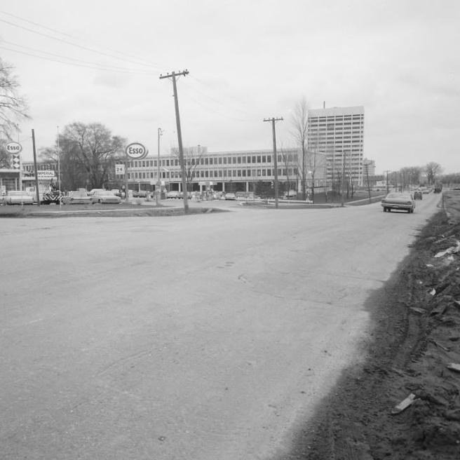
2 Prepared by: Corinna Prior Completed in partial fullfillment of a Master of Urban Planning Degree, Ryerson University, Stratigic Initiatives, Policy & Analysis City Planning Division City of Toronto Cover Photo: IBM Plant at Don Mills Road and Eglinton Avenue, looking north. Construction sign reads: Eglinton Avenue Crosstown Highway, Built by the Province of Ontario and Metropolitan Toronto,1956 (Toronto Archives).
3 Contents Summary 5 Study Area 6 Historical Timeline 7 Early Development 8 Road Infrastructure 10 Don Mills Industrial District 12 Flemingdon Business Park 14 Don Mills and Eglinton in Transition 16 Conclusion 19 Key Map 20 Bibliography 22
4
5 Summary 5 Built in the post-war era, the Don Mills and Eglinton area was developed as the employment sector of two early planned suburban communities of the 1950s: Don Mills to the north and Flemingdon Park to the south. Designed to be accessed primarily by private automobile, the development of the area coincided with major transportation infrastructure investments by Metropolitan Toronto, which led to the extension of Eglinton Avenue and the development of the Don Valley Parkway. The unique design of these new modernist communities combined with easy access to Toronto s downtown core by means of the expressway made this area highly desirable as a location for regional and international company headquarters. By the end of the 1960s, the majority of the development in the area was complete as scenic drives, such as Wynford Drive, connected showcase low-density modernist industrial buildings with the surrounding residential lands. Just as the development of arterial roads and highway infrastructure for automobiles defined the first wave of development within the area, the recent investment in public transit along Eglinton Avenue in the form of the Eglinton Crosstown LRT will serve to transition the area to become more pedestrian-oriented in scale. Figure 1: Photograph of automotive culture at Don Mills Road and Wynford Drive in 1960, facing south (Toronto Archives).

6 Study Area and Methods CPR Wynford Dr. Don Mills Road Eglinton Avenue East Don Valley Parkway Figure 2: Map of the study area of influence discussed within this report. The study area disscussed in this report is bounded by the CPR coridor to the north, Concorde Place and the Don Valley Parkway to the east, the Flemingdon hydro corridor to the south, and the western branch of the Don River to the west (see Figure 2). This perimetre expands upon the focus area mentioned in the EglintonConnects study (2014) which looked specifically at the four corners of the Don Mills Road and Eglinton Avenue West intersection. A content analysis of all policy documents from the former municipality of North York and Metropolitan Toronto pertaining to this study area were consulted ( ), as well as Official Plan and Zoning By-Law amendments for properties in the area from
7 Historical Timeline Overview 1951 International Business Machines (IBM) builds the first manufacturing plant in the area at the intersection of Don Mills Road and the CPR corridor Don Mills Developments hires Macklin Hancock to design a complete neighbourhood north of the CPR corridor, including residential, commercial, and industrial uses Eglinton Avenue extension is completed, connecting Leaside with Scarborough First phase of Flemingdon Park is complete consisting of residential buildings south of Eglinton Ave Olympia and York take over the development of Flemingdon Park, including an industrial park north of Eglinton Ave. along Wynford Drive. Many office headquarters are constructed at this time Don Valley Parkway is completed with a full clover-leaf interchange at Eglinton Ave A few additional office towers are built along the Don Valley Parkway corridor at this time The development of Concorde Place is complete, including an entrance and exit ramp onto the Don Valley Parkway from Wynford Drive New commercial and residential uses begin to be permitted along Eglinton Ave. at this time through the demolition or repurposing of previous buildings. This includes a Loblaws Superstore, the Tribeca condominiums, and the Graywood townhouse development at Ferrand Dr Bata Internation Headquarters is demolished in order to begin development on the Aga Khan Museum Metrolinx is awarded contract to construct the Eglinton Crosstown LRT.

8 Early Development The Don Mills and Eglinton area began to transform from agricultural land into an industrial centre in the early 1950s. At that time, the area was largely cut off from the surrounding communities of Leaside and Scarborough by its geographical situation between the steep valleys of the eastern and western branches of the Don River. The site was only accessible from the north and south by Don Mills Road and by a Canadian Pacific Railway (CPR) corridor running along the northern boundary of the area. The Toronto Industrial Commission was a semi-public organization that played a role in establishing industry along the CPR corridor at Don Mills Road. Overseen by the Mayor of Toronto alongside representatives from the Board of Trade, the Canadian Manufacturers Association, the Harbor Commission, Toronto Hydro, and the Toronto Transit Commission, the Commission urged the rezoning of large areas of land with access to railway and municipal services, for industrial use in early 1950s (Globe and Mail, 1952). With the assistance of the Commission, International Business Machines (IBM) was the first company to establish a plant on a 24-acre site at the intersection of the CPR line and Don Mills Road in 1951 (Globe and Mail, 1949; Globe and Mail, 1952; see cover photo). The commission was a semi-public board that was made up of the Mayor, representatives from the Toronto Board of Trade, the Canadian Manufacturers Association, Harbor Commission, Toronto Hydro, the Toronto Transportation Commisson, and the Canadian National Exhibition (Globe and Mail, 1952). Following the development of the new plant, two planned communities were developed along Don Mills that both sought to bring residential and employment land uses together in order to create new complete communities for the second half of the twentieth century. Figure 3: Photograph of the Ortho-Pharmaceutical building in 1956, designed by John B. Parkin and Associates (Toronto Archives). North of the CPR corridor, E.P. Taylor was in the midst of planning a new integrated neighbourhood centred around Lawrence Avenue and Don Mills Road (Don Mills Developments Ltd., 1954). Taylor s company expanded the industrial development of the lands adjacent to the CPR rail line and came to an agreement with the former Township of North York to finance and construct all required water and sewage infrastructure with the understanding that the municipality would repay the loan over the course of fifteen years (Don Mills Development Ltd, 1954; Rynnimeri, 1997). An advertisement intended to attract employers noted that the Don Mills community was a unique industrial
.")
. Eglinton Ave.")
9 9 site, located within a 100-mile radius of one-third of the the total buying power of Canada that featured harmonious architectural design in the form of low-rise buildings, surrounded by surface-level parking and ample green space (Don Mills Developments, 1954). Among these early modernist buildings located along the railroad corridor was the Ortho Pharmaceutical building, which was completed in 1955 and designed by John B. Parkin and Associates (19 Green Belt Dr.; see Figure 3). Eglinton Ave. Don Mills Road CPR South of the CPR corridor on the Estate of Lydia Fleming, Metropolitan Toronto s expropriation of land for the construction of both the Eglinton extension and the Don Valley Parkway in the mid 1950s served as a catalyst for the redevelopment of the area into Flemingdon Park (Metropolitan Toronto, 1958, 696 and 795; Metropolitan Toronto, 1959, ). Influenced by the design of the Don Mills community to the north, Webb and Knapp undertook the development of the site in 1958 which was considered at the time to be the largest undeveloped tract in Metropolitan Toronto (Globe and Mail, 1965). Designed by Irving Grossman, this planned community was also intended to be complete in the sense that it would mix dense residential land with industrial and commercial lands within the same neighbourhood (Stewart, 2008). By the end of the 1950s, however, the company was facing financial constraints due to having overextended itself and overestimated profits from residential sales (Business Week, 1997, 64). As a result, the industrial portion of the community that was intended to flank either side of Eglinton Avenue was left vacant until the mid 1960s, when Olympia and York bought the remaining holdings of Webb and Knapp in the Don Mills area (Globe and Mail, 1965; Globe and Mail, 1966). Legend Kilometres 1:15,000 Figure 4: Map showing the development of the Don Mills and Eglinton intersection at the end of the 1950s. Figure 5: Aerial photograph of the Don Mills and Eglinton area in 1953 before the completion of the Eglinton Avenue extension. The Internation Business Machines (IBM) plant is present, however, the southern addition has not yet been built (Toronto Archives). N
10 Road Infrastructure Beyond access to the rail corridor, the industrial lands in the Don Mills and Eglinton area were increasingly attractive properties to manufacturing companies due to transportation initiatives undertaken in the 1950s. The redevelopment of the Don Mills and Eglinton area into an industrial centre coincided with the formation of Metropolitan Toronto and that municipality s initial desire to improve arterial roads and the freeway network throughout the region (Canadian Urban Institute, 2011, 20). Within the study area, these investments led to the extension of Eglinton Avenue and the construction of the Don Valley Parkway. was built at Eglinton Avenue within the study area. The fact that the area was adjacent to both a CPR rail corridor and an interchange of the Don Valley Parkway led the Planning Board to target the area as a location for a large industrial concentration in anticipation of developments which were expected to occur in the 1960s (see Figure 3; Metropolitan Toronto Planning Board, 1959, 90). With access to transportation infrastructure and public transit, Metropolitan Toronto intended these industrial zones to become an economic base for the former township of North York. In 1955, the Eglinton Avenue extension was built to connect Laird Drive in Leaside with Victoria Park Avenue in Scarborough in order to relieve traffic on Kingston Road and O Connor Road (see Figure 6). This extension was intended to eventually become a six-lane highway and consequently the former municipality secured a 30-meter road width (100 feet) with a 15-meter setback (50 feet) on either side of the highway (see Figure 2; Metropolitan Toronto, 1954, 886). Upon the completion of the expansion, a new bus service from Brimley Road to the subway terminus at Eglinton Avenue and Yonge Street made the area first accessible by public transit in 1957 (Globe and Mail, Aug. 10, 1957). By the end of the decade, Metropolitan Toronto built the Don Valley Parkway to facilitate vehicular movement along a north-south corridor from Highway 401 to downtown Toronto (see Figure 7; Metropolitan Toronto Planning Board, 1955, 69). A full clover-leaf interchange
.")

11 11 Figure 6: Eglinton Extention under construction in 1956, facing east possibly at Wynford Drive (Toronto Archives). Figure 7: Don Valley Parkway at Eglinton Avenue facing south in 1961 with Flemingdon Park residential buildings in the distance (Toronto Archives).

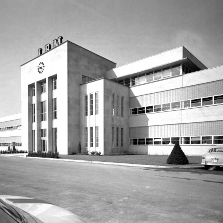
12 Don Mills Industrial District These initial investments in road infrastructure made the Don Mills and Eglinton area attractive for businesses in the 1960s. Proximity to the new freeways meant that employees could easily commute to work by automobile and new buildings generally were surrounded by expansive surface-level parking. Metropolitan Toronto anticipated that the Don Mills industrial centre (including the Don Mills and York Mills area as well as Don Mills and Eglinton) would facilitate 18,000 jobs by 1980 (Metropolitan Toronto Planning Board, 1959, plate 29). Figure 8: Ontario Regional Headquarters of Imperial Oil building located on the northeastern corner of Don Mills and Eglinton (now demolished) in 1964 (Moffatt, 2013). During the 1960s, the majority of the existing road network and industrial buildings were constructed (see Figures 9 & 10). When Olympia and York took over the development of Flemingdon Park in 1965, they designed a ring road that would link the new Olympia Square plaza south of Eglinton Avenue with the prestige industrial area on the north side of the arterial road (Globe and Mail, 1965). The Wynford Drive and St. Dennis Drive loop that emerged epitomized the automobile culture of the area, simultaneously linking industrial lands on either side of the Don Valley Parkway and Eglinton Avenue through a scenic winding drive interspersed with short, culde-sacs and looped roads. Many of the properties lining Wynford Drive still reflect the significant modernist architecture of this early development period, including the Texaco Canada building (90 Wynford Drive), the Bell Canada building (100 Wynford Drive), the Brookfield Building (39 Wynford Drive) and the Japanese Canadian Cultural Centre (123 Wynford Drive; see Moffatt, 2013). Three prominent modernist office headquarters were also constructed at this time along the north side of Eglinton Avenue. At the western end of the study area, John b. Parkin and Associates designed the fortress-like IBM Canada Headquarters which was completed in 1967 (1150 Eglinton Avenue; Moffat, 2010). The two other prominent buildings of this era of development were the Ontario regional headquarters of Imperial Oil (see Figure 8; 825 Don Mills Road) and the Bata International Headquarters (59 Wynford Drive; Moffatt, 2013). Though the majority of these buildings were developed in conjunction with Olympia and York, the properties themselves were privately owned by the organizations and manufacturing companies who used them.

 as")
13 13 The south side of the Don Mills and Eglinton intersection was slower to develop. Whereas the first phase of the residential portion of Flemingdon Park was opened in 1961, the industrial lands south of Eglinton Avenue remained vacant until the Olympia Square complex was built in the latter half of the decade (789 and 797 Don Mills Road, now called Foresters and Tribeca). Located at the southeastern corner of the intersection, this two-tower square initially housed the head office of North American Life and Casualty Company (later called the Mony Life building) as well as the head office of the Independent Order of Foresters. With the completion of the development of the Ontario Science Centre in 1969 on the southwestern corner of the Don Mills and Eglinton intersection as well as the development of the office towers on Ferrand Drive in the early 1970s, the development footprint of the area was substantially complete. Legend v Eglinton Ave. Don Mills Rd. DVP CPR Wynford Drive. St. Dennis Dr Kilometres 1:15,000 Figure 9: Map showing the development of the Don Mills and Eglinton intersection at the end of the 1960s. N Figure 10: Aerial photograph of the Don Mills and Eglinton intersection at the end of the 1960s. Wynford Dr and St. Dennis Dr. are complete (Toronto Archives).

14 Flemingdon Business Park In the later parts of the 1970s and early 1980s, development interest in the area slowed with the exception of the construction of Concord Place east of the Don Valley Parkway, north of Wynford Drive. This significant project introduced one million square feet of office space and 1,050 new residential units in the area immediately adjacent to the Flemingdon Business Park (see Figure 11; Globe and Mail, 1984). Furthermore, the former municipality of Metropolitan Toronto reinforced the automotive nature of the area by securing financing from Concorde Square to build an additional on-ramp to the Don Valley Parkway, directly servicing additional traffic from both the Flemingdon Business Park and Concord Place. The three office towers of the Concord Corporate Centre are owned by Crown Realty Partners and currently leased to several prominent tenants including Home Depot, ESRI, and Deloitte LLP (1-12 Concorde Gate; Artis Reit, 2016). This pattern of ownership marks a significant change from the early pattern of company-owned low-rise buildings to the leasing of space within office towers. Until the amalgamation of the City of Toronto, the study area continued to be identified as Flemingdon Business Park. The former municipality of North York further underscored urban design criteria through policies that encouraged extensive landscaping along street fronts in order to reduce nuisance impacts and ensure that views were visually attractive (North York, 2000, C8-23). This was most notably to be achieved through the planting of Figure 11: Photograph of the entrance to Concorde Place, facing north at the intersection of Wynford Dr. and Concord Pl. (Google Maps).

15 15 street trees and the encouragement of shared parking facilities. In 1972, the former municipality of North York released a District Plan that reflected the changes that had occurred to the area throughout the 1960s. A land use map from the Plan indicates that the areas surrounding the Eglinton Avenue corridor would continue to have a major industrial use and these industries were encouraged to locate on parcels situated adjacent to arterial roads and expressways (North York Planning Board, 1972, 24). Although a number of major corporate headquarter office buildings had been constructed in the 1960s, policy continued to speak of the area as an industrial center until the 1980s when the Don Mills and Eglinton area was rebranded first as an Office Park and then subsequently as Flemingdon Business Park (Municipality of Metropolitan Toronto, 1980, 29; Municipality of North York, 1988, map C.8.2). These new areas were identified in policy documents by the former municipality as areas containing mixed office and industrial uses, and were intended to be highly automobile oriented; have a plentiful supply of parking; relatively immediate access to expressways, and be developed at low density (see Figures 12 & 13; Municipality of Metropolitan Toronto, 1980, 28). Some commercial uses began to be provided for at this time. Legend Eglinton Ave. Don Mills Rd DVP CPR Kilometres 1:15,000 Figure 12: Map showing the development of the Don Mills and Eglinton intersection at the end of the 1980s. N Figure 13: Aerial photograph of the Don Mills and Eglinton intersection from 1992 (Toronto Archives).
.")
16 Don Mills and Eglinton in Transition A recent study by the Canadian Urban Institute identifies that the Don Mills and Eglinton employment area experienced significant growth in response to the construction of the Don Valley Parkway, but since that time has largely stalled (Canadian Urban Institute, 2011, 4). A staff report from the early 2000s notes that Flemingdon Park was one of the areas hardest hit by the recession of the early 1990s, during which time many companies left the area (City of Toronto, Midtown Community Council, Report 7, No. 28). Certainly since the completion of Concorde Place in the 1980s, few office or manufacturing developments were undertaken in the Don Mills and Eglinton area. While employment uses continue to be significant and the number of jobs in the area even grew 28.3% in 2015, other residential and commercial uses have begun to receive approval from City Council on a caseby-case basis, particularly along the Eglinton Avenue corridor (Toronto Employment Survey, 2015). The first redevelopment that took place within the area occurred on the southeast side of the Don Mills and Eglinton area. In 1998, T.W.S. Developments Ltd. and Graywood Developments Ltd. both obtained Official Plan and Zoning By-Law amendments that allowed for the conversion of the Mony Life office building (797 Don Mills Rd.) into a residential condominium (Tribeca) as well as approval for the construction of 195 low-rise residential dwelling units on the vacant lands bounded by Ferrand Drive and Rochefort Drive (see Figure 14; City of Toronto, 1998, UDOZ-94-34; City of Toronto, 1998, UDZ-97-52). The first commercial redevelopment that took place within the area occurred on the northeast corner of Don Mills Figure 14: Photograph of streetview facing east at Don Mills Rd. and Eglinton Avenue. Graywood townhouse development is visible to the right (Google Maps).

17 Don Mills Rd. 17 and Eglinton, where the former site of the Ontario Regional Headquarters of Imperial Oil had stood vacant since the mid-1990s. In 2001, Loblaws was successful in obtaining an Official Plan and Zoning By-Law amendments to demolish the modernist structure and build a large format retail building in its place (City of Toronto, 2001). The final staff report on the development recommended this decision citing former City of North York Official Plan policies that provided for certain retail uses on arterial roads in industrial areas and concluded that future office use of the site was unlikely. Eglinton Ave. DVP CPR Finally, in 2007, Toronto City Council approved the demolition of the Bata International Headquarters building (59 Wynford Drive) in order to make way for the Aga Khan Museum (see Figure 16). The introduction of residential, commercial, and further institutional uses along the Eglinton Avenue corridor have played a significant role in diversifying the character of the area and suggest that new policies are needed in order to guide future development. Legend Kilometres 1:15,000 Figure 15: Map showing the development of the Don Mills and Eglinton intersection up to N Figure 16: Photograph of the Aga Khan Museum (2015).
18
19 Conclusion 19 The Don Mills and Eglinton area is a unique part of the industrial fabric of the the City of Toronto. Designed to showcase the latest innovations in architectural design, the low-rise, concrete, modernist structures that line the CPR corridor and Wynford Drive speak to an era in which developers were experimenting with new types of complete neighbourhoods for a rapidly expanding city. Built as an integrated part of the planned communities at Don Mills and Flemington Park, it was transportation infrastructure that drove the development of the area throughout the 1950s and 1960s. The construction of automobile-oriented infrastructure through the extension of Eglinton Avenue as well as the Don Valley Parkway made Don Mills and Eglinton a highly accessible area in close proximity to the downtown core. Despite the fact that the area was easy to access, however, its car-centric design and poor connections to the surrounding neighbourhoods mean that it has only ever really been populated throughout the working day. With the approval of the Eglinton Crosstown LRT in 2009, a new wave of transportation infrastructure centred on the transit line will once again transform the area for the next generation of use. Increased pedestrian traffic means that there is an opportunity in future planning policy to address a broad range of considerations related to public realm, built form, improved connectivity, and pedestrian amenities. It is likewise important to draw out the unique modernist aspect of the area and once again make it a focal point within the City of Toronto. By leveraging the existing architectural features present in the Don Mills and Eglinton area and integrating them with future investments, the vision of modernist progression and prosperity that existed in the 1960s can resonate within the next generation of development. Figure 17: Photograph of the southern extension of the Internation Business Machines (IBM) building located at 844 Don Mills Road (Panda and Associates, 1954).
20 Key Map 2 CPR Green Belt Dr. 3 7 Don Valley Parkway 10 Wynford Dr Eglinton Avenue East 11 Don Mills Road 5 St. Dennis Dr. 4 9 Buildings within Study Area Buildings outside Study Area
21 21 1 Original IBM/Celestica Manufacturing Plant (844 Don Mills Rd.) 2 Don Mills, Planned Community 3 Janssen-Ortho Pharmaceutical Building (19 Green Belt Dr.) 4 Flemingdon Park, Planned Community 5 Olympia Square (789 Don MIlls Rd. and 797 Don MIlls Rd.) 6 Former IBM Office Headquarters Building (1150 Eglinton Ave. E.) 7 Former C.C.H. Canadian Building, now Japanese Cultural Centre (6 Garamond Ct.) 8 Former Japanese Cultural Centre, now Noor Centre (123 Wynford Dr.) 9 Ontario Science Centre (770 Don Mills Rd.) 10 Concorde Place 11 Greywood Townhouse Developments (Ferrand Dr.) 12 Aga Khan Museum (77 Wynford Dr.)
22 Bibliography Artis Reit. (2016). Concorde Corporate Centre. Our Portfolio. Retrieved from Bonnell, J. (2014). Metro Toronto and the Don Valley Parkway. In Reclaiming the Don: An Environmental History of Toronto s Don River Valley. Toronto: University of Toronto Press. Canadian Urban Institute. (2011). The New Geography of Office Location and the Consequences of Business as Usual in the GTA. Retrieved from City of North York. (1980). Official Plan. Former City of North York: Planning Department. City of North York. (1988). North York Official Plan Amendment No Offices, Commerce and Industry Policy. Former Municipality of North York. City of North York. (1991). Official Plan. Former City of North York: Planning Department. City of North York. (2000). Official Plan. Former City of North York: Planning Department. City of Toronto. (1998). North York Community Council Report No. 7. Retrieved from cc980708/ny7rpt.htm City of Toronto. (1998). Zoning Amendement and Subdivision Applications, UDZ and UDSB-1235, Graywood Developments Limited, Block Bounded by Rochefort Drive and Ferrand Drive, Don Parkway. Retrieved from cc981125/ny13rpt/cl021.htm City of Toronto. (2001). Final Report Application to Amend the Official Plan and Zoning By-Law North-East Corner of Don Mills Road and Eglinton Avenue East Vincent Planning Consultants on Behalf of Loblaw Properties Ltd. Retrieved from agendas/council/cc011002/ey7rpt/cl028.pdf City of Toronto. (2013). EglintonConnects. Don Mills Focus Area. City of Toronto. (2013). EglintonConnects. Volume 1: Appendices. City of Toronto. (2015). Toronto Employment Survey Toronto: Planning Department. Dobson, I., et al. (2013). Strategic Regional Research. A Region in Transition. E.R.A. Architects Inc. (2010). North York s Modernist Architecture. Metropolitan Toronto. (1958). Minutes of the Council of the Municipality of Metropolitan Toronto. Toronto: The Carswell Company. Metropolitan Toronto. (1959). Minutes of the Council of the Municipality of Metropolitan Toronto. Toronto: The Carswell Company. Metropolitan Toronto Planning Board. (1959). The Official Plan of the Metropolitan Toronto Planning Area. Metropolitan Toronto. (1966). Metropolitan Plan for the Metropolitan Toronto Planning Area. Toronto: Metropolitan Toronto Planning Board.
23 23 Metropolitan Toronto. (1976). MetroPlan. Concept and Objectives. Toronto: Planning Department. Metropolitan Toronto. (1980). Official Plan for the Urban Structure. Toronto: Office of the Chairman. McClelland, M., and Steward, G. (2007). Concrete Toronto. A Guidebook to Concrete Architecture from the Fifties to the Seventies. Toronto: Coach House Books. Moffatt, R. (2013). Mod Toronto: Imperial Oil s Parthenon of Petroleum. Spacing Toronto. Retrieved from Moffatt, R. (2010). A Hilltop Fortress for IBM. Toronto Modern. Retrieved from North York Planning Board. (1972). North York District 4-5 Plan. Rynnimeri, V. (1997). A Plan for Don Mills: Design and the Creation of the Canadian Corporate Suburb (M.A. Thesis). University of Guelph, Guelph. Sewell, J. (1993). The Shape of the City. Toronto Struggles with Modern Planning. Toronto: University of Toronto Press. Stewart, G. (2008). Flemingdon Park: North America s First High-Rise Newtown. Retrieved from Township of North York. ( ). Policy on the Official Plan: Original Official Plan of the Township of North York.
24
PROFILE DECEMBER 2016
 PROFILE DECEMBER 2016 Prepared by: City of Toronto City Planning Division Strategic Initiatives, Policy & Analysis www.toronto.ca/donmillscrossing December 2016 PROFILE This Profile provides an introduction
CREATE A VIBRANT MIXED-USE COMMUNITY
 CREATE A VIBRANT MIXED-USE COMMUNITY Land Use Public Realm Plan Built Form Heritage Tell us what you think! Place a sticky note here or leave us a comment form LAND USE The land use framework of this Secondary
Don Mills Crossing Study and Celestica Lands Development Application Community Meeting, Open House, and Breakout Discussions
 Consultation Summary Don Mills Crossing Study and Celestica Lands Development Application Community Meeting, Open House, and Breakout Discussions This report is not intended to provide a verbatim transcript
13 THORNHILL YONGE STREET STUDY IMPLEMENTATION CITY OF VAUGHAN OPA 669 AND TOWN OF MARKHAM OPA 154
 13 THORNHILL YONGE STREET STUDY IMPLEMENTATION CITY OF VAUGHAN OPA 669 AND TOWN OF MARKHAM OPA 154 The Planning and Economic Development Committee recommends the adoption of the recommendations contained
Intention to Designate under Part IV, Section 29 of the Ontario Heritage Act 844 Don Mills Road and 1150 Eglinton Avenue East
 STAFF REPORT ACTION REQUIRED Intention to Designate under Part IV, Section 29 of the Ontario Heritage Act 844 Don Mills Road and 1150 Eglinton Avenue East Date: September 7, 2016 To: From: Toronto Preservation
City of Toronto Official Plan Indicators
 City of Toronto Official Plan Indicators Attachment 1 2017 Gladki Planning Associates in association with Hemson Consulting & Studio Jaywall City of Toronto Official Plan Indicators 1 Introduction What
844 Don Mills Road & 1150 Eglinton Avenue East - Official Plan Amendment Application - Preliminary Report
 STAFF REPORT ACTION REQUIRED 844 Don Mills Road & 1150 Eglinton Avenue East - Official Plan Amendment Application - Preliminary Report Date: July 10, 2014 To: From: Wards: Reference Number: Planning and
Eglinton Avenue East & 50 Thermos Road - Official Plan Amendment Application Preliminary Report
 STAFF REPORT ACTION REQUIRED 1966 2050 Eglinton Avenue East & 50 Thermos Road - Official Plan Amendment Application Preliminary Report Date: March 15, 2016 To: From: Wards: Reference Number: Scarborough
Big Plans in Store for the Transformation of Don Mills & Eglinton
 Big Plans in Store for the Transformation of Don Mills & Eglinton The construction of Toronto's Crosstown LRT is bringing sweeping transformation to Eglinton Avenue, as the imminent arrival of new rapid
The West Vaughan Employment Area Secondary Plan Policies
 Part 2: The West Vaughan Employment Area Secondary Plan Policies 2.1 General Policies It is the policy of Council: 2.1.1. That the West Vaughan Employment Area (the WVEA), identified on Schedule 1, will
POCKET COMMUNITY PLAN
 POCKET COMMUNITY PLAN Part Three : COMMUNITY PLAN AREAS AND SPECIAL STUDY AREAS CONTENTS Community Location... 3-P-3 Community Vision... 3-P-4 Community Profile... 3-P-4 Community Issues... 3-P-6 Land
1.0 PLANNING MARKHAM S FUTURE CONTENTS
 1-1 Planning Markham s Future 1.0 PLANNING MARKHAM S FUTURE CONTENTS 1.1 THE PURPOSE OF THE OFFICIAL PLAN 1.2 THE MARKHAM CONTEXT 1.3 THE REGULATORY CONTEXT 1.3.1 Province of Ontario 1.3.2 York Region
Reshaping The City: New Visions for Urban Transport. Trent Lethco, Associate Principal Allison Davis, Senior Planner Vicent Risica, Planner Arup
 Reshaping The City: New Visions for Urban Transport Trent Lethco, Associate Principal Allison Davis, Senior Planner Vicent Risica, Planner Arup Agenda Where are we now? Rethinking infrastructure? Cities
Director, Community Planning, Toronto and East York District
 Lower Yonge Precinct Plan Update STAFF REPORT ACTION REQUIRED Date: October 16, 2012 To: From: Wards: Reference Number: Toronto and East York Community Council Director, Community Planning, Toronto and
LAND PARK COMMUNITY PLAN
 LAND PARK Community Plan Part Three : COMMUNITY PLAN AREAS AND SPECIAL STUDY AREAS SACRAMENTO 2030 GENERAL PLAN Contents Community Location...3-LP-3 Community Vision...3-LP-4 Community Profile...3-LP-4
This report presents the draft Don Mills Crossing Secondary Plan for public consultation.
 PG30.6 REPORT FOR ACTION Don Mills Crossing - Proposals Report Date: May 17, 2018 To: Planning and Growth Management Committee From: Chief Planner and Executive Director, City Planning Division Wards:
YONGE STEELES CORRIDOR SECONDARY PLAN. Young + Wright / IBI Group Architects Dillon Consulting Ltd. GHK International (Canada) Ltd.
 Ltd.") PART A: PREAMBLE 1.0 PURPOSE The purpose of this Secondary Plan is to provide a development framework for intensification of the Yonge/ Steeles corridor including the north side of Steeles Avenue West
PART A: PREAMBLE 1.0 PURPOSE The purpose of this Secondary Plan is to provide a development framework for intensification of the Yonge/ Steeles corridor including the north side of Steeles Avenue West
1.3 TRANSIT VISION 2040 FROM VISION TO ACTION THEME 1: PUTTING TRANSIT AT THE CENTRE OF COMMUNITIES. Fully integrate transit with community planning
 TRANSIT VISION 2040 FROM VISION TO ACTION TRANSIT VISION 2040 defines a future in which public transit maximizes its contribution to quality of life with benefits that support a vibrant and equitable society,
URBAN DESIGN BRIEF URBAN DESIGN BRIEF 721 FRANKLIN BLVD, CAMBRIDGE August 2018
 URBAN DESIGN BRIEF URBAN DESIGN BRIEF 721 FRANKLIN BLVD, CAMBRIDGE August 2018 DESIGN BRIEF CONTENTS PART A 1.0 INTRODUCTION 2.0 DESCRIPTION & ANALYSIS OF SITE CONTEXT 3.0 DESIGN CONSTRAINTS AND OPPORTUNITIES
Eglinton West LRT Update
 Eglinton West LRT Update Community Consultation Update May 16, 2016 Background Rapid transit along Eglinton Ave between Kennedy Station and Pearson Airport was included in the Metrolinx Regional Transportation
5 TOWN OF MARKHAM OFFICIAL PLAN AMENDMENT NO. 144 MILLIKEN MAIN STREET SECONDARY PLAN
 5 TOWN OF MARKHAM OFFICIAL PLAN AMENDMENT NO. 144 MILLIKEN MAIN STREET SECONDARY PLAN The Planning and Economic Development Committee recommends the following: 1. The communication from Brendan O Callaghan,
4780 Eglinton Avenue West - Zoning By-law Amendment and Draft Plan of Subdivision Applications - Preliminary Report
 STAFF REPORT ACTION REQUIRED 4780 Eglinton Avenue West - Zoning By-law Amendment and Draft Plan of Subdivision Applications - Preliminary Report Date: May 29, 2014 To: From: Wards: Reference Number: Etobicoke
MALL REVITALIZATION CASE STUDIES
 MALL REVITALIZATION CASE STUDIES DECEMBER 9, 2012 MALL REVITALIZATION OVERVIEW Introduction Sample Case Studies prepared for Lacey Woodland District Steering Committee as it considers strategies to revitalize
Finch Avenue West and Sheppard Avenue East Corridors - Planning Study Approach. Planning and Growth Management Committee
 PG8.9 STAFF REPORT ACTION REQUIRED Finch Avenue West and Sheppard Avenue East Corridors - Planning Study Approach Date: October 13, 2015 To: From: Planning and Growth Management Committee Chief Planner
URBAN DESIGN BRIEF 305, 309, & 315 SOUTHDALE ROAD WEST LONDON ONTARIO
 URBAN DESIGN BRIEF 305, 309, & 315 SOUTHDALE ROAD WEST LONDON ONTARIO CARVEST PROPERTIES LTD. December 2013 Section 1 - Land Use Planning Context 1.1 Subject Lands The subject lands are located immediately
178 Carruthers Properties Inc.
 178 Carruthers Properties Inc. Planning Rationale for 178 Carruthers Avenue Site Plan Control Application June 2014 Table of Contents 1.0 Introduction 2.0 Overview of Subject Property 3.0 Current Zoning
12 AMENDMENT NO. 149, TOWN OF MARKHAM HIGHWAY 404 NORTH SECONDARY PLAN
 12 AMENDMENT NO. 149, TOWN OF MARKHAM HIGHWAY 404 NORTH SECONDARY PLAN The Planning and Economic Development Committee recommends the adoption of the recommendation contained in the following report August
Commercial Development Proposal Tenth Line Road. Planning Rationale Report. Minto Developments Inc.
 Commercial Development Proposal 2168 Tenth Line Road Report September 2015 Prepared for Minto Developments Inc. Paquette Planning Associates Ltd. 56 Hutchison Avenue Ottawa, Ontario K1Y 4A3 PH: 613-722-7217
Derry Green Corporate Business Park
 Town of Milton Derry Green Corporate Business Park Urban Design Guidelines BMI/Pace - June 2010 Draft 3 Prepared by: Brook McIlroy Planning + Urban Design / Pace Architects Suite 300-51 Camden Street Toronto,
WELCOME. The Yonge-Eglinton area has experienced significant growth and change in the last decade.
 WELCOME DID YOU KNOW? MIDTOWN IS REPRESENTED BY 3 CITY COUNCILLORS: WARD 16 EGLINTON-LAWRENCE WARD 22 ST. PAUL S WARD 25 DON VALLEY WEST Midtown in Focus: Building a Livable Yonge-Eglinton The Yonge-Eglinton
770 Don Mills Road and 805 Don Mills Road - Official Plan Amendment and Zoning By-law Amendment Application Preliminary Report
 REPORT FOR ACTION 770 Don Mills Road and 805 Don Mills Road - Official Plan Amendment and Zoning By-law Amendment Application Preliminary Report Date: To: From: Wards: June 22, 2018 North York Community
C. Westerly Creek Village & The Montview Corridor
 C. Westerly Creek Village & The VISION Community Vision When the goals of the city are achieved Westerly Creek Village, a distinctive community defined by Montview Boulevard and Westerly Creek, is a strong
PILLAR FOUR INTEGRATE LAND USE & TRANSPORTATION
 PILLAR FOUR INTEGRATE LAND USE & TRANSPORTATION 8 Scarborough Centre on the Move Transportation Master Plan 123 8 Transportation Pillar Four Integrate Land Use & The fourth pillar focuses on the relationship
Trafalgar Road Corridor Planning Study Open House
 Trafalgar Road Corridor Planning Study Open House June 24, 2013 6:30-8:30 p.m. Oakville & Trafalgar Rooms Overview The Livable Oakville Plan identifies the lands along Trafalgar Road, between the QEW and
Edward R. Sajecki Commissioner of Planning and Building
 Corporate Report Clerk s Files Originator s Files CD.03.POR DATE: TO: FROM: SUBJECT: Chair and Members of Planning and Development Committee Meeting Date: February 27, 2012 Edward R. Sajecki Commissioner
Regency Developments. Urban Design Brief. Holyrood DC2 Rezoning
 Regency Developments Urban Design Brief Holyrood DC2 Rezoning Stantec Consulting Ltd. 7-31-2017 1. Overview Regency Developments intends to rezone the lands located at 8510 and 8511 93 Avenue, within the
Urban Design Brief December 23, 2015 Southside Construction Group Official Plan & Zoning By-Law Amendment
 Urban Design Brief Proposed Official Plan & Zoning By-Law Amendment 3244, 3263 and 3274 Wonderland Road South Southside Group December 23, 2015 TABLE OF CONTENTS Page No. INTRODUCTION... 1 SECTION 1 LAND
9 CITY OF VAUGHAN OFFICIAL PLAN AMENDMENT NO BOCA EAST INVESTMENTS LIMITED
 9 CITY OF VAUGHAN OFFICIAL PLAN AMENDMENT NO. 631 - BOCA EAST INVESTMENTS LIMITED The Planning and Economic Development Committee recommends the adoption of the recommendations contained in the following
Corridor Vision. 1Pursue Minnehaha-Hiawatha Community Works Project. Mission of Hennepin County Community Works Program
 1Pursue Minnehaha-Hiawatha Community Works Project Minnehaha-Hiawatha Community Works is a project within the Hennepin Community Works (HCW) program. The mission of the HCW program is to enhance how the
2136 & 2148 Trafalgar Road Town of Oakville Region of Halton
 PLANNING JUSTIFICATION REPORT 2136 & 2148 Trafalgar Road Town of Oakville Region of Halton Zoning By-Law Amendment Application 2500674 Ontario Inc. November 2016 Table of Contents Page 1.0 Location/Summary
WITNESS STATEMENT Of. Ronald Blake. On behalf of the Intervenor The Corporation of the City of Markham
 Filed: 2013-06028 EB-2012-0451 Exhibit L.EGD.COM.2 Page 1 of 7 WITNESS STATEMENT Of Ronald Blake On behalf of the Intervenor The Corporation of the City of Markham In the matter of an application by Enbridge
SECTION ONE: INTRODUCTION. introduction
 introduction 1 INTRODUCTION Since it was first established in 1843 as a trading post for the Hudson s Bay Company, Victoria has evolved into a Provincial capital city that is recognized across Canada and
Outer Congress Street Land Use
 Outer Congress Street Land Use Outer Congress Street, with its historic residential district, natural resource and open space amenities, trail network, and proximity to major transportation infrastructure
GO Station Mobility Hubs: Draft Precinct Plans. Committee of the Whole July 12, 2018
 GO Station Mobility Hubs: Draft Precinct Plans Committee of the Whole July 12, 2018 Purpose of this Workshop Present Draft Precinct Plans for the 3 GO Station Mobility Hubs Continue the conversations that
PORT WHITBY COMMUNITY
 PORT WHITBY COMMUNITY SECONDARY PLAN UPDATE COMMUNITY IMPROVEMENT PLAN URBAN DESIGN GUIDELINES September 2015 DRAFT PROPOSED AMENDMENT NUMBER # to the Whitby Official Plan PURPOSE: The intent of this Amendment
Land Use Amendment in Southwood (Ward 11) at and Elbow Drive SW, LOC
 at and Elbow Drive SW, LOC") 2018 November 15 Page 1 of 10 EXECUTIVE SUMMARY This land use amendment application was submitted by Rick Balbi Architect on 2017 August 31 on behalf of Sable Developments Ltd, and with authorization from
2018 November 15 Page 1 of 10 EXECUTIVE SUMMARY This land use amendment application was submitted by Rick Balbi Architect on 2017 August 31 on behalf of Sable Developments Ltd, and with authorization from
Figure 1- Site Plan Concept
 Figure 1- Site Plan Concept Parking will be provided underground on three levels at rate of 1.0 space/ unit; this rate includes all visitors parking. MMM Group has prepared a parking assessment (April,
PARKWAY FOREST RE-URBANIZATION: EMERALD CITY
 PARKWAY FOREST RE-URBANIZATION: EMERALD CITY PUBLIC ART PLAN El-Ad Group (Canada) Inc. Prepared by: Public Art Management For Presentation to the Toronto Public Art Commission, February 2010 1 1.0 Introduction
8 & 10 Donalda Crescent Official Plan & Rezoning Application Final Report
 STAFF REPORT ACTION REQUIRED 8 & 10 Donalda Crescent Official Plan & Rezoning Application Final Report Date: July 26, 2010 To: From: Wards: Reference Number: Scarborough Community Council Director, Community
Background Summary Report
 Background Summary Report May 2014 Submitted by Macaulay Shiomi Howson Ltd. In association with AMEC MMM Group Brook McIlroy Inc. Hemson Consulting Ltd. Table of Contents 1. Introduction... 1 2. Why is
TABLE OF CONTENTS 1.0 INTRODUCTION... 3
 TABLE OF CONTENTS 1.0 INTRODUCTION... 3 1.1. BACKGROUND... 3 1.2. THE PROPOSAL... 5 2.0 EXISTING POLICY FRAMEWORK... 5 2.1. PROVINCIAL POLICY STATEMENT (PPS)... 5 2.2. CITY OF LONDON OFFICIAL PLAN (OP)...
Welcome. Walk Around. Talk to Us. Write Down Your Comments
 Welcome This is an information meeting introducing the applications for proposed redevelopment of the Yorkdale Shopping Centre site at 3401 Dufferin Street and 1 Yorkdale Road over the next 20+ years,
North York Community Council. Director, Community Planning, North York District. Ward No. 26, Don Valley West
 STAFF REPORT ACTION REQUIRED 85 Laird Drive Zoning Application - Final Report Date: December 18, 2007 To: From: Wards: Reference Number: North York Community Council Director, Community Planning, North
Official Plan Review
 Official Plan Review Summary Report - The Built Environment August 2014 Part 1: Introduction Planning for a healthy, prosperous and sustainable community is an important goal for our municipality. From
SUBJECT: GO Station Mobility Hubs Preferred Concepts: Aldershot GO, Burlington GO and Appleby GO. Planning and Development Committee - Public Meeting
 Page 1 of Report PB-76-17 SUBJECT: GO Station Mobility Hubs Preferred Concepts: Aldershot GO, Burlington GO and Appleby GO TO: FROM: Planning and Development Committee - Public Meeting Planning and Building
URBAN DESIGN BRIEF NORTHVIEW FUNERAL HOME HIGHBURY AVE N, LONDON, ON
 URBAN DESIGN BRIEF NORTHVIEW FUNERAL HOME - 1490 HIGHBURY AVE N, LONDON, ON 1.1Purpose The intent of the following report is to identify an opportunity for redevelopment of two residential properties within
Page 1 of 19 URBAN DESIGN FRAMEWORK FOR BOLTON STREET WATERFORD
 Page 1 of 19 URBAN DESIGN FRAMEWORK FOR BOLTON STREET WATERFORD 1.0 Introduction: The relocation of the City Council stores and depot from Bolton Street creates an exciting opportunity for development
ONTARIO MUNICIPAL BOARD
 PL 120483 ONTARIO MUNICIPAL BOARD Applicant/Appellant: 2124123 Ontario Limited Subject: OPA, Rezoning and Draft Plan of Subdivision Municipal Address: 3940 Highway 7 East Municipality: City of Markham
1071 King Street West Zoning Amendment Application - Preliminary Report
 STAFF REPORT ACTION REQUIRED 1071 King Street West Zoning Amendment Application - Preliminary Report Date: August 9, 2012 To: From: Wards: Reference Number: Toronto and East York Community Council Director,
Strategic Growth Area #1 Northampton Boulevard Corridor Area
 Strategic Growth Area #1 Northampton Boulevard Corridor Area Description Strategic Growth Area #1 has established itself as a major employment center in Southside Hampton Roads. Opportunities exist to
ELMVALE ACRES SHOPPING CENTRE MASTER PLAN
 ELMVALE ACRES SHOPPING CENTRE MASTER PLAN Contents 1.0 INTRODUCTION... 2 2.0 LOCATION... 2 3.0 EXISTING CONTEXT... 2 4.0 VISION & GUIDING PRINCIPLES... 2 5.0 LAND USE AND BUILT FORM... 4 5.1 St. Laurent
MOBILITY HUB GUIDELINES 2012 TAC Sustainable Urban Transportation Award Submission BACKGROUND MOBILITY HUB GUIDELINES
 MOBILITY HUB GUIDELINES 2012 TAC Sustainable Urban Transportation Award Submission BACKGROUND Rapid population growth, increasing congestion, and years of under investment in transit in the Greater Toronto
URBAN DESIGN BRIEF. 2136&2148 Trafalgar Road. Town of Oakville
 URBAN DESIGN BRIEF 2136&2148 Trafalgar Road Town of Oakville Prepared By: METROPOLITAN CONSULTING INC For 2500674 Ontario Inc November 2016 TABLE OF CONTENTS Page No. 1.0 Introduction/Description of Subject
Official Plan Review: Draft Built Form Policies
 PG.30.1 REPORT FOR ACTION Official Plan Review: Draft Built Form Policies Date: May 15, 2018 To: Planning and Growth Management Committee From: Chief Planner and Executive Director, City Planning Division
GOLDEN MILE SECONDARY PLAN STUDY BACKGROUND REPORT. January 22, 2018
 GOLDEN MILE SECONDARY PLAN STUDY BACKGROUND REPORT January 22, 2018 GOLDEN MILE SECONDARY PLAN STUDY GOLDEN MILE SECONDARY PLAN STUDY BACKGROUND REPORT Version Control Version: Final Reviewed by: Jason
Elliot Park 2. Neighborhood Master Plan. Historical Perspective
 Elliot Park 2 Neighborhood Master Plan Historical Perspective August 2002 Early History Development patterns and the growth of Minneapolis largely grew out of the city s historical response to its geography.
Urban Design Brief. Watson Parkway North & Watson Road North Guelph, Ontario. Prepared by Coletara Development
 Urban Design Brief Watson Parkway North & Watson Road North Guelph, Ontario Prepared by Coletara Development December, 2013 Urban Design Brief, Coletara Development 1 Introduction This Urban Design Brief
John M. Fleming Managing Director, Planning and City Planner. Old East Village Dundas Street Corridor Secondary Plan Draft Terms of Reference
 Report to Planning and Environment Committee To: From: Subject: Chair and Members Planning & Environment Committee John M. Fleming Managing Director, Planning and City Planner Old East Village Dundas Street
THE CITY OF VAUGHAN BY-LAW BY-LAW NUMBER A By-law to adopt Amendment Number 1 to the Official Plan of the Vaughan Planning Area.
 THE CITY OF VAUGHAN BY-LAW BY-LAW NUMBER 015-2014 A By-law to adopt Amendment Number 1 to the Official Plan of the Vaughan Planning Area. NOW THEREFORE the Council of the Corporation of the City of Vaughan
2900 Steeles Avenue East at Don Mills Road in the Town of Markham
 STAFF REPORT INFORMATION ONLY 2900 Steeles Avenue East at Don Mills Road in the Town of Markham Date: January 23, 2008 To: From: Wards: Reference Number: North York Community Council Director, Community
K. SMART ASSOCIATES LIMITED
 Planning Justification Report Zoning By-Law Amendment 185 King Street North Waterloo, Ontario April 7th, 2017 Project Reference Number 16-245 K. SMART ASSOCIATES LIMITED CONSULTING ENGINEERS AND PLANNERS
8 Oak Street - Official Plan and Zoning By-law Amendment Application - Preliminary Report
 STAFF REPORT ACTION REQUIRED 8 Oak Street - Official Plan and Zoning By-law Amendment Application - Preliminary Report Date: March 17, 2014 To: From: Wards: Reference Number: Planning and Growth Management
SCHEDULE 'A' TO BY-LAW as Amended by AMENDMENT NO. 90 TO THE WHITBY OFFICIAL PLAN
 SCHEDULE 'A' TO BY-LAW 6413-10 as Amended by 6553-11 AMENDMENT NO. 90 TO THE WHITBY OFFICIAL PLAN SECTION A: GROWTH PLAN CONFORMITY PURPOSE: LOCATION: BASIS: The purpose of this Amendment is to: conform
[PLANNING RATIONALE] For Site Plan Control and Lifting of Holding Zone By-Law 101 Champagne Avenue. May 23, 2014
![[PLANNING RATIONALE] For Site Plan Control and Lifting of Holding Zone By-Law 101 Champagne Avenue. May 23, 2014](/thumbs/75/71599615.jpg "[PLANNING RATIONALE] For Site Plan Control and Lifting of Holding Zone By-Law 101 Champagne Avenue. May 23, 2014") [PLANNING RATIONALE] For Site Plan Control and Lifting of Holding Zone By-Law 101 Champagne Avenue May 23, 2014 Contents 1.0 Introduction... 2 2.0 Site Context... 2 2.1 Adjacent Uses... 2 Figure 1: Site
[PLANNING RATIONALE] For Site Plan Control and Lifting of Holding Zone By-Law 101 Champagne Avenue May 23, 2014 Contents 1.0 Introduction... 2 2.0 Site Context... 2 2.1 Adjacent Uses... 2 Figure 1: Site
Planning Districts INTRODUCTION
 INTRODUCTION To facilitate detailed examination of development prospects for all areas of the community, Delano has been divided into 14 planning districts. The location of these planning districts is
Speers Road Corridor Study. Livable Oakville (Official Plan) Council Sub Committee March 20, 2017
 Council Sub Committee March 20, 2017") Speers Road Corridor Study Livable Oakville (Official Plan) Council Sub Committee March 20, 2017 Overview 1) Study Purpose & Background 2) Study Area 3) Policy Context and Plan Review 4) Speers Road Corridor
Speers Road Corridor Study Livable Oakville (Official Plan) Council Sub Committee March 20, 2017 Overview 1) Study Purpose & Background 2) Study Area 3) Policy Context and Plan Review 4) Speers Road Corridor
FORMER CANADIAN FORCES BASE (CFB) ROCKCLIFFE SECONDARY PLAN. Official Plan Amendment XX to the Official Plan for the City of Ottawa
 ROCKCLIFFE SECONDARY PLAN. Official Plan Amendment XX to the Official Plan for the City of Ottawa") FORMER CANADIAN FORCES BASE (CFB) ROCKCLIFFE SECONDARY PLAN Official Plan Amendment XX to the Official Plan for the City of Ottawa 1 INDEX THE STATEMENT OF COMPONENTS PART A THE PREAMBLE PAGE Purpose...
FORMER CANADIAN FORCES BASE (CFB) ROCKCLIFFE SECONDARY PLAN Official Plan Amendment XX to the Official Plan for the City of Ottawa 1 INDEX THE STATEMENT OF COMPONENTS PART A THE PREAMBLE PAGE Purpose...
AGINCOURT SECONDARY PLAN
 1 AGINCOURT SECONDARY PLAN 1. AGINCOURT SECONDARY PLAN The following policies and principles apply to the area herein referred to as Agincourt, as outlined on Map 1-1. 1. GENERAL POLICIES 1.1 This Secondary
NOTE: PLEASE REFER TO MISSISSAUGA PLAN FOR ADDITIONAL CITY-WIDE POLICIES WHICH APPLY TO THIS DISTRICT.
 NOTE: THE POLICIES IN THIS DOCUMENT ARE SPECIFIC TO THE FAIRVIEW PLANNING DISTRICT OF, AND MUST BE READ IN CONJUNCTION WITH ALL THE POLICIES OF PLEASE REFER TO FOR ADDITIONAL CITY-WIDE POLICIES WHICH APPLY
Laird in Focus Community Information Session
 Laird in Focus Community Information Session Tuesday, December 5, 2017 St. Anslem Catholic School, 182 Bessborough Drive Session 1: 5:30 pm - Presentation and Question and Answer Period 6:15 pm - Breakout
UTSC SECONDARY PLAN COMMUNITY OPEN HOUSE
 WELCOME TO THE UTSC SECONDARY PLAN COMMUNITY OPEN HOUSE 1 Welcome to the first Community Open House for the UTSC Secondary Plan. Hosted by the University of Toronto Scarborough (UTSC), the following panels
CITY OF VAUGHAN D R A F T YONGE STREET STUDY. June 2008 YOUNG + WRIGHT /IBI GROUP ARCHITECTS DILLON CONSULTING LTD.
 CITY OF VAUGHAN June 2008 YOUNG + WRIGHT /IBI GROUP ARCHITECTS GHK SUSTAINABILITY INTERNATIONAL + LIVABILITY (CANADA) LTD. = COMMUNITY VALUE DILLON CONSULTING LTD. Public Open House Tonight s Meeting WELCOME
GOLDEN MILE SECONDARY PLAN. Community Consultation Meeting #3 June 26, 2018
 GOLDEN MILE SECONDARY PLAN Community Consultation Meeting #3 June 26, 2018 Meeting Overview 1. Introduction 2. Principles + Vision 3. Street + Block Alternatives 4. Parks + Open Space Alternatives 5. Land
Field trip report. Field trip transport planning, , 2 ECTS, 2017S
 Field trip report Field trip transport planning, 231.043, 2 ECTS, 2017S Transit-Oriented Development (TOD) initiated by private railway companies in Japan The example of Utsukushigaoka on the Tama Den-en
The transportation system in a community is an
 7 TRANSPORTATION The transportation system in a community is an important factor contributing to the quality of life of the residents. Without a sound transportation system to bring both goods and patrons
REZONING GUIDE. Zone Map Amendment (Rezoning) - Application. Rezoning Application Page 1 of 3. Return completed form to
 - Application. Rezoning Application Page 1 of 3. Return completed form to") Zone Map Amendment (Rezoning) - Application COMMUNITY PLANNING & DEVELOPMENT REZONING GUIDE Rezoning Application Page 1 of 3 PROPERTY OWNER INFORMATION* CHECK IF POINT OF CONTACT FOR APPLICATION Property
Zone Map Amendment (Rezoning) - Application COMMUNITY PLANNING & DEVELOPMENT REZONING GUIDE Rezoning Application Page 1 of 3 PROPERTY OWNER INFORMATION* CHECK IF POINT OF CONTACT FOR APPLICATION Property
Clairtrell Area Context Plan
 Clairtrell Area Context Plan March 2005 Urban Development Services City Planning Contents 1. Introduction... 4 2. Development Structure... 6 2.1 Streets... 7 2.1.1 Sheppard Avenue and Bayview Avenue...
3. Endorse the LRT vision in transforming Surrey into Connected-Complete-Livable communities, and more specifically, the official vision statement:
 CORPORATE REPORT NO: R038 COUNCIL DATE: February 20, 2017 REGULAR COUNCIL TO: Mayor & Council DATE: February 16, 2017 FROM: General Manager, Engineering FILE: 8740-01 SUBJECT: Surrey Light Rail Transit
A P P E N D I X B - O P P O R T U N I T Y S I T E S
 A P P E N D I X B - O P P O R T U N I T Y S I T E S OPPORTUNITY SITES As listed in the Land Use Element, the City has identified 15 Opportunity Sites expected to be the focus of change and revitalization
11.4 Highway 400 North Employment Lands Secondary Plan APPROVED BY THE ONTARIO MUNICIPAL BOARD ON NOVEMBER 21, 2011
 11.4 Highway 400 North Employment Lands Secondary Plan APPROVED BY THE ONTARIO MUNICIPAL BOARD ON NOVEMBER 21, 2011 11.4.1 General 11.4.1.1. as approved by the Ontario Municipal Board on November 21, 2011,
Comprehensive Development Guide
 INDUSTRIAL ELEMENT Comprehensive Development Guide 1 Industrial Element 7.1 Hardin County Industrial Overview BG PKWY Fort Knox Industrial Corridor Comprised of 11 parcels totaling 720 acres of land 68
EXHIBIT A. Tax Increment Reinvestment Zone No. 1 (Town Center) First Amended Project Plan 1
 First Amended Project Plan 1") EXHIBIT A Tax Increment Reinvestment Zone No. 1 (Town Center) First Amended Project Plan 1 1 As amended by Resolution No. 2008-02-001(TR1R) of the Tax Increment Reinvestment Zone No.1, and approved to
EXHIBIT A Tax Increment Reinvestment Zone No. 1 (Town Center) First Amended Project Plan 1 1 As amended by Resolution No. 2008-02-001(TR1R) of the Tax Increment Reinvestment Zone No.1, and approved to
Former Rockcliffe Airbase Community Design Plan Guiding Design Vision and Principles December 4, 2013
 APPENDIX 5 - Guiding Design Vision and Principles Former Rockcliffe Airbase Community Design Plan Guiding Design Vision and Principles December 4, 2013 Vision Statement The redevelopment of the former
CHAPTER 5: GUIDING PRINCIPLES
 CHAPTER 5: GUIDING PRINCIPLES The following 10 principles were developed based on public consultation, planning policy and the background analysis conducted during Phase 1. The Guiding Principles significantly
Urban Design Brief Woodland Cemetery Funeral Home 493 Springbank Drive
 Urban Design Brief Woodland Cemetery Funeral Home The Incorporated Synod of the Diocese of Huron April 15, 2016 Urban Design Brief April 15, 2016 TABLE OF CONTENTS Page No. INTRODUCTION... 1 SECTION 1
Transit-supportive development and city-building
 Photo: Michael Hiemstra (CC BY 2.0) Transit-supportive development and city-building Brief 3: Tools for building infrastructure and policy conditions Building the policy and infrastructure conditions Municipalities
HEMSON IV EMPLOYMENT LAND CONVERSION
 28 IV EMPLOYMENT LAND CONVERSION The appropriateness of permitting changes to the City s employment land supply is considered within the context of the adequacy of the supply to accommodate growth projected
PUBLIC OPEN HOUSE SEPTEMBER 8 TH, 2010 CITY OF LETHBRIDGE DEVELOPMENT SERVICES
 PUBLIC OPEN HOUSE SEPTEMBER 8 TH, 2010 CITY OF LETHBRIDGE DEVELOPMENT SERVICES INTRODUCTION Why is the City creating the West Lethbridge Employment Centre Area Structure Plan? West Lethbridge Urbanization
APPENDIX D: BACKGROUND AND VISION
 APPENDIX D: BACKGROUND AND VISION BACKGROUND A. Specific Plan Location Jordan Downs is located at 9800 Grape Street in Los Angeles, California, 90002. The Jordan Downs Urban Village Specific Plan area
Planning and Growth Management Committee. Chief Planner and Executive Director, City Planning Division. Pg12013 (File No NNY 34 OZ)
") 865 York Mills Road Official Plan Amendment Application Preliminary Report STAFF REPORT ACTION REQUIRED Date: February 28, 2012 To: From: Wards: Reference Number: Planning and Growth Management Committee
865 York Mills Road Official Plan Amendment Application Preliminary Report STAFF REPORT ACTION REQUIRED Date: February 28, 2012 To: From: Wards: Reference Number: Planning and Growth Management Committee