Hartest river corridor survey
|
|
|
- Pamela Logan
- 5 years ago
- Views:
Transcription
1 Hartest river corridor survey Project no. Report Date 56/15 Final 21st September 2015 Prepared by Penny Hemphill BSc. Hons Checked by Simone Bullion BSc. Hons, PhD., MCIEEM SWT Trading Ltd Suffolk Wildlife Trust Brooke House Ashbocking, Ipswich Suffolk IP6 9JY Ralph Carpenter Fosters, Hartest Suffolk
2 SUMMARY Hartest Parish Council commissioned SWT Trading Ltd: Ecological Consultants to undertake an ecological survey of the river which flows through the village. The river is a reactive water-course with fluctuating water levels reflecting rainfall patterns. Otter are using the river and will find an adequate food resource in the signal crayfish present. The river is too shaded by bankside trees to have high floristic diversity but the stones and gravels of the river bed provide good habitat for fish such as bullhead. Himalayan balsam occurs frequently along this section of river and it is recommended that it is controlled. Adjacent habitat is dominated by gardens and where possible, if a buffer of bankside vegetation is left uncut in future, this will enhance the river habitat and increase the overall biodiversity 1
3 CONTENTS 1 INTRODUCTION 3 2 SITE ASSESSMENT 3 3 METHODOLOGY 3 4 RESULTS 3 5 RECOMMENDATIONS 4 6 CONCLUSION 5 7 APPENDICES 6 Map 6 Photographs 7 page 2
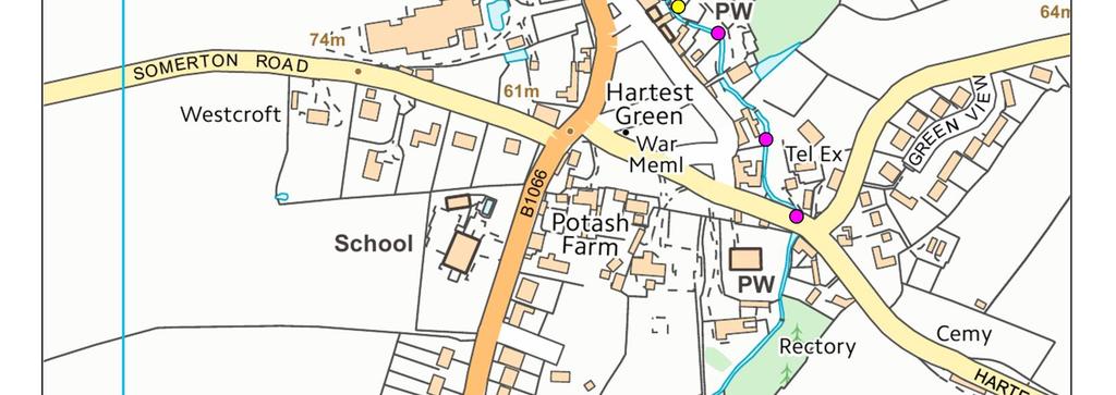
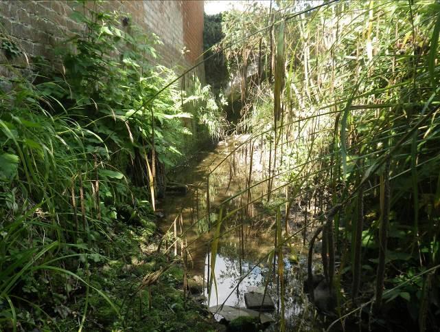
4 1 INTRODUCTION Hartest Parish Council commissioned SWT Trading Ltd: Ecological Consultants to undertake an ecological survey of the river and provide recommendations to enhance the channel and adjacent habitat. The information gathered from the survey will help inform the parish Neighbourhood Plan. 2 SITE ASSESSMENT The river is a tributary of the River Glem, part of the Stour river catchment which is the county boundary between Suffolk and Essex. This is a reactive water-course which will take water from the surrounding arable ditches and as a result will have fluctuating water levels and is likely to be virtually dry in summer months. The stretch of river included in the survey is from north-west of the road bridge at TL to the southern end of the village at TL The river has steep banks up to four metres in height in places which are sometimes vertical with earth cliffs and bankside tree roots scoured out by high winter water levels. The northern section of the water-course flows behind buildings and through gardens. Most of the banks along this section are either walls or have been reinforced so there is little natural habitat. Trees are frequent along the banks which shade the channel and the river bed is stones, boulders and gravel with sand and occasional silt. As a result there is no aquatic vegetation. The southern section from Hartest Hill road bridge to the southern end of the village is steep banked, with a wider channel up to 4m wide in places. This section is more natural with vertical earth cliff banks, trees and scrub dominating each bank and shading the channel. Where the river flows through gardens towards southern end, the channel has been narrowed and the banks reinforced. In places particularly some gardens, there are fewer trees and the channel is more open and less shaded. 3 METHODOLOGY A site visit was made on 11 th September 2015 by Penny Hemphill on a warm sunny day. Water levels were low allowing the survey to be conducted from the channel where access was possible. The river was assessed for fauna and flora particularly protected species including otter and water vole. 4 RESULTS The results are shown on Map 1 and are summarised as follows: Otter activity was recorded along the northern stretch. Footprints in soft mud on the left bank and a spraint was located on a boulder under a bridge. The spraint was full of signal crayfish shell. Scrub habitat and occasional mature trees provide potential otter holt sites along the southern section particularly on the left bank where there are no gardens but a belt of trees and scrub between the river and adjacent arable land. Signal crayfish burrows recorded on the southern section of the river low down along the bank at water level. The river bed is ideal for this species which live under stones and 3
5 boulders and it is known that the River Glem has a high population of this non-native species. Floristically the river is devoid of aquatic plants due to the shaded conditions and stone dominated channel. Willowherb, bramble and nettles occurred on the banks most frequently along with Himalayan balsam a non-native species which was recorded generally as single plants throughout the survey section. Ferns and liverworts thrive in the shaded conditions afforded by the bankside trees - ferns were recorded growing out of walls and liverworts covering stones and boulders in the northern section. There was a short stretch of more open water along the northern section where water parsnip dominated the channel. The habitat is not suitable for water vole and no field signs were recorded. Water vole thrive in areas where the channel is not shaded and where there is an abundance of emergent bankside vegetation so could be present upstream of the northern road bridge where the habitat appeared from observation to be more suitable. Fish fry were seen along the channel and it is likely that bullhead is present under the stones in the river bed where water levels allow. Kingfisher burrows were recorded high up on a sand cliff along the left bank in the southern section. A toad was recorded crossing the river. Evidence of the river being used as a compost heap by residents was recorded and at one point a load of rubble had been deposited in the channel. The various methods of reinforcing the river banks are inventive and effective, however in some instances have reduced the ecological value of the channel. The section of river by the rectory was inaccessible. From observation from the public footbridge it appears the water levels are held up by a weir creating habitat more suitable for water vole. 5 RECOMMENDATIONS The river is of high ecological value and acts as a corridor for otter: a European protected species. The nature of the river makes it difficult to make any improvements to the adjacent habitat as much of it consists of private gardens. The tree and scrub habitat on the left bank along the southern section is ideal habitat for otter and there are occasional mature trees which are suitable holts sites for the animals. This habitat should remain undisturbed. Himalayan balsam is an invasive species which will eventually become the dominant plant along the river if not controlled. The seeds are dispersed by an explosive action when touched, so it is important to pull the plant when it is in flower and before it has set seed to avoid further dispersal of the seeds. Either the residents could be encouraged to pull the plant along their section of river, or Suffolk Wildlife Trust could assist through their Water for Wildlife Project. Any work along this river could be hazardous due to the steep banks, so that must be taken into account before any work in the channel is attempted. The current impact from signal crayfish on the channel is minimal however they will affect the invertebrate and fish populations of the river and can cause bank erosion through burrowing. If residents wish to remove them from the river it is necessary to apply for a trapping licence from the Environment Agency to do so. Co-ordinated trapping is not recommended, as this results in the removal of the largest crayfish and this has been shown to have an adverse effect on fish and aquatic invertebrate populations. This is because the 4
6 larger crayfish prey on the smaller crayfish and to some extent this reduces the impact on this non-native species. Although water vole was not recorded on this stretch of river, they may be present further upstream where the habitat is more suitable. It is possible that mink travel along the river and if any residents would be interested in having a mink raft to monitor any mink activity, Suffolk Wildlife Trust can lend rafts and traps and give the necessary training. In general the gardens do not impact on the river corridor itself. However, it is recommended that residents are encouraged not to put garden waste or rubble in the river. Where the lawns meet the river, it is recommended that a 1m strip of bankside vegetation is left uncut. This will provide habitat for invertebrates and small mammals and enhance the habitat for water vole by providing suitable cover if the animals are passing through. 6 CONCLUSION The survey found that the river which flows through Hartest is of high ecological value and acts as a wildlife corridor for species such as otter. The river is a reactive water-course with fluctuating water levels reflecting rainfall patterns. Otter are using the river and will find an adequate food resource in the signal crayfish present. The river is too shaded by bankside trees to have high floristic diversity but the stones and gravels of the river bed provide good habitat for fish such as bullhead. Himalayan balsam occurs frequently along this section of river and it is recommended that it is controlled. Adjacent habitat is dominated by gardens and where possible if a buffer of grass is left uncut this will enhance the river habitat and increase the overall biodiversity. 5

7 7 APPENDICES 6


8 Photographs Steep sided river channel Himalayan balsam Earth cliff & tree roots scoured out by high flow Kingfisher burrows in top of cliff Signal crayfish burrows Stones and boulders on river bed suitable for crayfish 7


9 Otter footprints recorded on muddy ledge right bank Otter footprints Otter spraint on boulder, river channel dry Good otter habitat on both banks southern section Ferns & liverworts in shaded channel northern section Liverworts covering boulder 8


10 Hartest Parish Council 2015 Various methods of bank reinforcement along the channel 9
Basic Habitat Survey Tabernacle Gardens, Pembroke
 Basic Habitat Survey Tabernacle Gardens, Pembroke Produced by The Wildlife Trust of South and West Wales Contact Ecologist: Position: Nathan Walton Wildlife Trust Officer Registered Office: Wildlife Trust
Water Vole (Arvicola terrestris)
") Water Vole (Arvicola terrestris) The Water Vole was formerly common along the banks of rivers, streams, ditches, dykes, lakes and ponds throughout mainland Britain. Its decline is thought to be largely
Water Vole (Arvicola terrestris) The Water Vole was formerly common along the banks of rivers, streams, ditches, dykes, lakes and ponds throughout mainland Britain. Its decline is thought to be largely
Bourn Brook Water Vole and Invasive Plants Survey
 Bourn Brook Water Vole and Invasive Plants Survey Spring 2017 Ruth Hawksley, Becky Lockyer, Russell Waldron, Karen Hunt, Siân Williams Supported by: Report prepared by Ruth Hawksley Report checked by Martin
Bramford Meadows Management Plan. Bramford Meadows. Management Plan Bramford Open Spaces. Protect Conserve Improve
 Bramford Meadows Management Plan 2012-2017 Bramford Open Spaces Protect Conserve Improve Bramford Open Spaces Ltd Page 1 Issue 2 10 th June 2013 Issue Control Issue No. Change Details Issue Date Updated
Streams and Ponds. A few facts A vital resource. Changing environment. Globally rare. Flood plains. Watery wildlife. Water power
 Streams and Ponds With a varied landscape and temperate climate, Dorset has a good network of rivers, streams and ditches, all set within a wider floodplain landscape. Ponds, lakes, fens and marsh give
NON-TECHNICAL SUMMARY
 NON-TECHNICAL SUMMARY THE HIDE, BISHOP AUCKLAND PROPOSED ECO CHALET DEVELOPMENT NON-TECHNICAL SUMMARY 1 Introduction 1.1.1 This non-technical summary for the (ES) prepared in relation to the proposed eco-chalet
Creating ponds for water voles
 Creating ponds for water voles A 50-YEAR PROJECT TO CREATE A NETWORK OF CLEAN WATER PONDS FOR FRESHWATER WILDLIFE 1. Introduction Water voles have suffered a catastrophic decline in Britain over the last
Upper Dean Landscape Character Area: A1 Landscape Character Type: River Valley
 Upper Dean Landscape Character Area: A1 Landscape Character Type: River Valley Key characteristics A well wooded river valley landscape Strong human influence with urban development and sections of engineered
17 NOVEMBER 2015 PLANNING COMMITTEE. on Cttee Day: 73/73. Land To The Rear Of Brook Farm Rickford Worplesdon, Bagshot Road, Woking, Surrey
 5l 14/0218 Reg d: 27.06.14 Expires:20.11.15 Ward: BR Nei. 17.07.14 BVPI Con. Target: 18 Exp: Number of Weeks On Target? on Cttee Day: 73/73 Y LOCATION: PROPOSAL: TYPE: Land To The Rear Of Brook Farm Rickford
The Duke s River: Revitalising the link between the River Crane and the River Thames
 The Duke s River: Revitalising the link between the River Crane and the River Thames The project The eastern section of the Duke of Northumberland s River runs for approximately four kilometres, from where
Planning Application 13/00952/FULLS at Ampfield Hill, Romsey, Test Valley: Great Crested Newt Survey Following on From Ecological Assessment
 10 June 2014 Mr Allan Clark esq Ampfield Parish Council Blue Haze Ampfield Hill Ampfield Romsey SO51 9BD By email only Our Ref: P13/46 Dear Mr Clark Planning Application 13/00952/FULLS at Ampfield Hill,
APPENDIX 4. 5 ST AGNES LOCAL LANDSCAPE CHARACTER ASSESSMENT TABLE ST AGNES BEACON
 APPENDIX 4. 5 ST AGNES LOCAL LANDSCAPE CHARACTER ASSESSMENT TABLE ST AGNES BEACON CHARACTER AREA: ST AGNES BEACON DATE OF ASSESSMENT May 2016 Character Attribute Landscape reference guide ST AGNES BEACON
Juneau Watershed Partnership
 Juneau Watershed Partnership Native Plant Resource Center Final Report A Partners for Fish and Wildlife Project Prepared for: U.S. Fish and Wildlife Service For Grant #F11C00552 Prepared by: The Juneau
Grass Verge Management
 Grass Verge Management Ecology Technical Information Note No. 02 October 2011 About Sustrans Sustrans makes smarter travel choices possible, desirable and inevitable. We re a leading UK charity enabling
Land at Whiteditch Lane, Newport, Essex
 Land at Whiteditch Lane, Newport, Essex Ecology Report Produced for Sworders Agricultural By March 2013 Document Control: Version Date Version Details Prepared by Checked by Approved by 0.1 01.03.2013
Stormwater Standards. Clackamas County Service District No. 1. Planting Guide for Buffers
 Stormwater Standards Clackamas County Service District No. 1 APPENDIX B Planting Guide for Buffers Table of Contents Appendix B - Planting Guide for Buffers... Page B.1 General... 1 B.1.1 Introduction...
SECTION 5: REACH RECOMMENDATIONS/MAPS
 SECTION 5: REACH RECOMMENDATIONS/MAPS This section describes areas of concern and provides specific recommendations for each project reach. Locations of stormwater drains were from GIS coverage supplied
Lake and Stream Restoration Project
 Pre-project Fact Sheet May 2012 Toledo Botanical Garden (TBG) is a 60 acre public garden visited by more than 120,000 people annually. It is located in Toledo, Ohio in the Ottawa River watershed within
since commonly we use all manner of deleterious products on lawns that don t belong in streams.
 Riparian Buffers River conservation groups like CU Maurice River focus their efforts on greenways along with general environmental awareness. A greenway is a strip of undeveloped land near urban areas,
Ponds. Key points. Farm ponds are very important wildlife habitats. Good water quality and shallow banks are especially important
 Common toad nutmeg66 CC BY NC ND 2.0 Ponds Ponds are an extremely valuable habitat for wildlife on farmland. Species such as frogs, toads, and dragonflies rely on ponds for at least part of their life
Control and eradication of Invasive Non Native Plant Species in the UK
 Control and eradication of Invasive Non Native Plant Species in the UK Paul Sims N.D.H. Native Landscapes Brief Introduction Invasive Weed Control Giant Hogweed Japanese Knotweed Himalayan Balsam Swamp
Wild about Bolnore. Welcome to Bolnore Village, situated in the beautiful West Sussex countryside. ResIDENTS INFORMATION GUIDE
 Wild about Bolnore Welcome to Bolnore Village, situated in the beautiful West Sussex countryside. Sustainability has been a key factor in the development of the village and considerable effort has been
2011 ASLA Design Awards. Coyote Gulch Honor Award and Land Stewardship Designation Valerian LLC. Environmental Restoration and Reclamation
 2011 ASLA Design Awards Honor Award and Land Stewardship Designation Valerian LLC Environmental Restoration and Reclamation Project Name: Category : Project Location: 5 2011 Environmental Restoration and
Bradford Beck River Restoration. Preliminary Options Appraisal. January Waterman Transport & Development Limited
 Preliminary Options Appraisal January 2013 Waterman Transport & Development Limited Pickfords Wharf, Clink Street, London SE1 9DG, www.watermangroup.com Client Name: Aire Rivers Trust Quality Assurance
Natural Shorelines. for Inland Lakes. A Landowner s Guide to using. to STABLIZE SHORELINES, Michigan s inland lakeshore.
 Natural Shorelines for Inland Lakes A Landowner s Guide to using NATURAL MATERIALS to STABLIZE SHORELINES, IMPROVE WATER QUALITY and ENHANCE WILDLIFE HABITAT along Michigan s inland lakeshore. Natural
HUNGERFORD SOLAR FARM
 HUNGERFORD SOLAR FARM Key Facts The site comprises approximately 26 acres/10.6 hectares of Grade 3 and 4 agricultural land, currently in arable use. It will have a generation capacity of approximately
Andrea Griffiths BSc HONS Partnership Officer Medway Valley Countryside Partnership. Medway Valley Countryside Partnership
 Medway Valley Countryside Partnership Giant Hogweed and Invasive Non Native Plant Project Medway Catchment and River Cray 2013/2014 Report Andrea Griffiths BSc HONS Partnership Officer Medway Valley Countryside
Lake Nokomis Shoreline Enhancement Project
 Lake Nokomis Shoreline Enhancement Project Community Meeting 2 February 13, 2018 Agenda Current Problems Project Goals Project Status Existing Conditions Community Input Draft Schematic Design Long-term
Preliminary Ecological Appraisal
 Preliminary Ecological Appraisal Seminar Outline What is Preliminary Ecological Appraisal (PEA)? What are the main objectives of PEA? Methods of PEA Wildlife legislation and planning policy Examples of
Note on Habitat Management for Pool Frog Reintroduction Thompson Common
 Note on Habitat Management for Pool Frog Reintroduction Thompson Common Contents 1. INTRODUCTION AND BACKGROUND... 1 1.1. Contractual background... 1 2. MANAGEMENT WORK... 2 2.1. Ongoing habitat restoration
NON-TECHNICAL SUMMARY
 Proposed Sand and Gravel Extraction and Associated Processing Operations with Restoration to a Mixture of Agriculture and Nature Conservation including Areas of Shallow Water at Hedgeley, Northumberland
Tandridge Local Plan Assessing the Ecological Suitability of 183 sites considered for development Tandridge District Council, Surrey
 Tandridge Local Plan Assessing the Ecological Suitability of 183 sites considered for development Tandridge District Council, Surrey PLANNING I DESIGN I ENVIRONMENT 1.0 INTRODUCTION TEP conducted Site
Pike River Restoration Adaptive Design: Restoring Structure and Function in an Urban Floodplain - from cabbages to cordgrass
 Pike River Restoration Adaptive Design: Restoring Structure and Function in an Urban Floodplain - from cabbages to cordgrass Alice Thompson, PWS & Heather Patti, PWS Pike River Re-imaginedfrom Cabbage
Section 3 Non-Structural BMPs
 3.1 Stream Buffers A stream buffer or stream setback is a designated area around a stream, lake, or wetland left in a natural, densely vegetated state so as to protect the receiving water quality and provide
Priors Farm Estate SuDS Retrofitting Project, Cheltenham
 Priors Farm Estate SuDS Retrofitting Project, Cheltenham SuDS used Detention basins Bioretention Planters Rain Gardens Benefits Reduction of surface water flooding 1. Location Priors Farm Estate, Oakley,
Effects of Erosion. Grades 6-8
 Effects of Erosion Grades 6-8 This activity was designed as a companion for the song Don t Treat Mother Earth Like Dirt. Background The song Don t Treat Mother Earth Like Dirt is all about respecting and
Legend. Pennsylvania Fields, Sedbury. River Wye. Aust Cliff. Severn Estuary. Cattybrook Brickpit Three Brooks. Severn Estuary
 Pennsylvania Fields, Sedbury River Wye Legend Other DCO Land Cooling Water Pipeline Corridor Electrical Connection & Utilities Corridor 10km buffer of Ramsar Severn Estuary Aust Cliff Local Nature Reserve
Town of Essex Small Site Erosion Control Guide
 Town of Essex Small Site Erosion Control Guide Why do we need to protect against erosion? Water Quality: Erosion and the transport of sediment and pollutants impacts the water quality of nearby streams
Banking on Natural Fibers Products made from coir and jute play a key role in stabilizing a restored stream for a commercial stream mitigation bank.
 Banking on Natural Fibers Products made from coir and jute play a key role in stabilizing a restored stream for a commercial stream mitigation bank. By Greg Northcutt When White Creek Mitigation, LLC,
Landscape Guidelines. Landscape type: Valley Pasture Character areas: Frome Valley Pasture Stour Valley Pasture. Landscape change
 Landscape type: Valley Pasture Character areas: Frome Valley Pasture Stour Valley Pasture The valley pasture landscape type is found along the lower reaches of the Stour and Frome, formed from alluvial
Hopwood Motorway Service Area, Worcestershire
 Hopwood Motorway Service Area, Worcestershire SuDS used Grass filter strip Stone collector trench Spillage basin Grass swale Balancing ponds Wetland ditch Wetland treatment Sub-surface collector trench
ADDENDUM TO BIOLOGICAL SCOPING SURVEY REPORT, BOTANICAL SURVEY AND WETLAND DELINEATION
 ADDENDUM TO BIOLOGICAL SCOPING SURVEY REPORT, BOTANICAL SURVEY AND WETLAND DELINEATION FOR AVALON INN (APN 069-241-27 & -04) 1201 & 1211 NORTH MAIN STREET FORT BRAGG, CA MENDOCINO COUNTY prepared for:
Proposed Residential Development at Church Stile Farm in Cradley, Herefordshire. Hazel Dormouse Surveys
 Proposed Residential Development at Church Stile Farm in Cradley, Herefordshire A report to: Terra Strategic BSL Strategic Ltd. 2 The Courtyard 707 Warwick Road Solihull B91 3DA By: Udall-Martin Associates
Worksheet #14 Water Runoff Management
 Water Runoff Management Use this worksheet to assess how well your property minimizes the potential for water runoff and property damage.. Why should you be concerned? What can you do? Rural runoff, also
How to Create a Streamside Vegetative Buffer Garden
 How to Create a Streamside Vegetative Buffer Garden Vegetative buffers help stabilize stream and pond banks, prevent erosion, slow runoff, and provide food and shelter for a wide array of wildlife. Buffers
Low Gradient Velocity Control Short Term Steep Gradient [1] Channel Lining Medium-Long Term Outlet Control Soil Treatment Permanent
![Low Gradient Velocity Control Short Term Steep Gradient [1] Channel Lining Medium-Long Term Outlet Control Soil Treatment Permanent](/thumbs/77/74849271.jpg "Low Gradient Velocity Control Short Term Steep Gradient [1] Channel Lining Medium-Long Term Outlet Control Soil Treatment Permanent") Grass Linings DRAINAGE CONTROL TECHNIQUE Low Gradient Velocity Control Short Term Steep Gradient [1] Channel Lining Medium-Long Term Outlet Control Soil Treatment Permanent [1] May be used on short, steep
Grass Linings DRAINAGE CONTROL TECHNIQUE Low Gradient Velocity Control Short Term Steep Gradient [1] Channel Lining Medium-Long Term Outlet Control Soil Treatment Permanent [1] May be used on short, steep
Historic England Advice Report 26 August 2016
 Case Name: Kingsland Castle Case Number: 1435892 Background Historic England has been asked to review the scheduling for Kingsland Castle. The land on which the monument lies is understood to be for sale.
STILL CREEK CD-1 GUIDELINES (BY-LAW NO. 6654) Adopted by City Council April 24, 1990
 Adopted by City Council April 24, 1990") $2 City of Vancouver Land Use and Development Policies and Guidelines Community Services, 453 W. 12th Ave Vancouver, BC V5Y 1V4 F 604.873.7344 fax 873.7060 planning@city.vancouver.bc.ca STILL CREEK CD-1
$2 City of Vancouver Land Use and Development Policies and Guidelines Community Services, 453 W. 12th Ave Vancouver, BC V5Y 1V4 F 604.873.7344 fax 873.7060 planning@city.vancouver.bc.ca STILL CREEK CD-1
Guide to Naturalizing a Lakefront Shoreline. September 2010
 Guide to Naturalizing a Lakefront Shoreline September 2010 Retaining walls and non-vegetated shorelines are a very common sight on shore-line properties in Alberta. These urbanized shorelines have a huge
A Landowner s Guide to Creating Woodland Pools for Amphibians and Other Wildlife
 Cornell Department of Natural Resources Conservation Education Program Fact Sheet Kristi L. Sullivan and Stephen J. Morreale A Landowner s Guide to Creating Woodland Pools for Amphibians and Other Wildlife
Invasive non-native aquatic weeds: an often underestimated problem
 Invasive non-native aquatic weeds: an often underestimated problem Property Care Association - Invasive Weed Control Conference 23 rd Nov 2017 By Alex Brook Ebsford Environmental Ltd alexbrook@ebsford.co.uk
Once Upon a Gravel Pit: Reconnecting Floodplain through Aggregate Extraction
 Once Upon a Gravel Pit: Reconnecting Floodplain through Aggregate Extraction 5 th International Conference on Natural Channel Systems September 26, 2016 1 The Story of Snyder s Flats Historical influences
Landowner's Guide to the Lower St. Croix Riverway. Protect. Restore. Celebrate. stcroixriverassociation.org
 Landowner's Guide to the Lower St. Croix Riverway Protect. Restore. Celebrate. stcroixriverassociation.org Cover and page spread photographs by Craig Blacklock. For more information on how to be a river
Vinca major control in an endangered plant population on Santa Cruz Island, California
 Vinca major control in an endangered plant population on Santa Cruz Island, California Presenter Ken Owen Channel Islands Restoration Project Collaborators: Kathryn McEachern, Katie Chess U.S. Geological
PERMANENT SEEDING. Overview of Sedimentation and Erosion Control Practices. Practice no. 6.11
 Overview of Sedimentation and Erosion Control Practices Practice no. 6.11 PERMANENT SEEDING Permanent vegetation controls erosion by physically protecting a bare soil surface from raindrop impact, flowing
Water Sensitive Urban Design Site Development Guidelines and Practice Notes. Appendix
 Water Sensitive Urban Design Site Development Guidelines and Practice Notes Appendix 108 Appendix A Water sensitive developments involve simple design and management practices that take natural site features
GLOUCESTERSHIRE CONSERVATION ROAD VERGES SITE REGISTER
 GLOUCESTERSHIRE CONSERVATION ROAD VERGES SITE REGISTER Gloucestershire County Council in partnership with Gloucestershire Wildlife Trust and Gloucestershire Centre for Environmental Records Conservation
Land at Porch Farm, Kingsclere Ecology Briefing Paper, April 2016 C_EDP3343_01a
 C_EDP3343_01a Introduction 1.1 This Ecology Briefing Paper has been prepared by The Environmental Dimension Partnership Ltd (EDP) on behalf of Linden Homes. This briefing paper considers the ecological
MILL POND OVERLOOK. A project of the Town of Oyster Bay. Prepared by Cameron Engineering & Associates, LLP
 MILL POND OVERLOOK A project of the Town of Oyster Bay Prepared by Cameron Engineering & Associates, LLP Funded in part through an EPF grant from the NYS Department of State Project Goals & Advisory Committee
Community Conservation Workshop. Lake Placid
 Community Conservation Workshop Lake Placid 2 Community Conservation Program Welcome! We have designed a Community Conservation Program that listens to the needs of community members. We are conducting
East Harptree Landscape & Character Assessment
 East Harptree Landscape & Character Assessment Produced by East Harptree Parish Council in consultation with local residents September 2014 Contents The Parish of East Harptree: Objective Introduction
Raingardens. Conserving and Protecting Water L
 L-5482 08-08 Raingardens Justin Mechell, Extension Assistant, and Bruce Lesikar, Extension Program Leader for Biological and Agricultural Engineering,The Texas A&M University System A raingarden is an
SOUTHERN GRAMPIANS WETLANDS INFORMATION DAY Sunday 23 rd November 2014
 SOUTHERN GRAMPIANS WETLANDS INFORMATION DAY Sunday 23 rd November 2014 Progress of wetland restoration trials at Walker, Gooseneck and Brady Swamps Mark Bachmann, Nature Glenelg Trust (NGT) The Walker,
Boeckman Road Extension
 Boeckman Road Extension Providing Safe Passage for Wildlife and Maintaining Habitat Connectivity By Kerry Rappold, City of Wilsonville Leslie Bliss-Ketchum, Portland State University October 20, 2008 Presentation
E16: MAINTENANCE OF LANDSCAPED AREAS
 HIGH SPEED TWO INFORMATION PAPER E16: MAINTENANCE OF LANDSCAPED AREAS This paper outlines the proposed approach to the maintenance of landscaped areas created for HS2 Phase One. It will be of particular
St. Asaph Flood Risk Management Scheme Case Study KS2/3
 St. Asaph Flood Risk Management Scheme Case Study KS2/3 St. Asaph Awarded city status 2012, St Asaph is a small city in North Wales, situated in the Vale of Clwyd between Denbigh and the coastal resort
Community Conservation Workshop. Saranac River Basin Communities
 Community Conservation Workshop Saranac River Basin Communities 2 Community Conservation Program Welcome! We have designed a Community Conservation Program that listens to the needs of community members.
BREEDON NORTHERN LIMITED
 Non Technical Summary CONTENTS 1 INTRODUCTION... 1 2 SITE DESCRIPTION... 1 3 DESCRIPTION OF THE DEVELOPMENT... 6 4 NEED FOR THE DEVELOPMENT... 8 5 KEY ISSUES CONSIDERED IN THE ENVIRONMENTAL IMPACT ASSESSMENT...
Zoning Ordinance Article 3
 Article 3 Natural Resources Protection Section 301 Natural Resources Protection 301.1. Purpose - The following natural resources protection standards are established to protect the public health, safety
Section 12C Subdivision in the Rural Residential Zone
 Section 12C 12C Subdivision in the Rural Residential Zone The Rural Residential Zone provides part of the range of residential opportunities within the City. Land zoned rural residential is considered
Archaeological evaluation at Willowdene, Chelmsford Road, Felsted, Essex
 Archaeological evaluation at Willowdene, Chelmsford Road, Felsted, Essex August 2013 report prepared by Ben Holloway on behalf of Mr Anthony McGurren Planning reference: UTT/13/0235 CAT project ref.: 13/07g
Point-No-Point Tide-Gate & Outfall Replacement Project. Briefing Memo 2013
 Point-No-Point Tide-Gate & Outfall Replacement Project Briefing Memo 2013 This memo provides an initial outline of the proposed Point-No-Point (PNP) Tide-Gate and Outfall replacement project. The current
As a homeowner in the Pacific Northwest, you
 Archival Copy. For current information, see the OSU Extension Catalog:https://catalog.extension.oregonstate.edu Taking Care of streams in Eastern Washington, A Homeowner s Guide to Riparian Areas PNW 557
MOWING AND WILDLIFE: MANAGING OPEN SPACE FOR WILDLIFE SPECIES
 PENNSYLVANIA GAME COMMISSION MOWING AND WILDLIFE: MANAGING OPEN SPACE FOR WILDLIFE SPECIES Many property owners want clean-cut, attractive lawns or fields. However, what appears to be a healthy lawn to
Slough International Freight Exchange Proposals, Colnbrook+
 Welcome Welcome to this exhibition, which is being held in connection with our proposals for a new freight exchange facility on land to the north of the A4. Please take this opportunity to look at the
Module 1 ~ Silent Invaders (MS/HS) Emersed Plants Reading Activity
 Emersed Plants Reading Activity") Name: Class Period: Date: Directions: Read the passage and use the information you ve learned to answer the questions below using complete sentences. Emersed plants are rooted in shallow water with much
Name: Class Period: Date: Directions: Read the passage and use the information you ve learned to answer the questions below using complete sentences. Emersed plants are rooted in shallow water with much
How to Update a Storm Water Management Program (SWMP) to Incorporate Total Maximum Daily Load (TMDL) BMPs
 to Incorporate Total Maximum Daily Load (TMDL) BMPs") How to Update a Storm Water Management Program (SWMP) to Incorporate Total Maximum Daily Load (TMDL) BMPs Janine Rybka Cuyahoga Soil & Water Conservation District About Habitat Habitats are the places
How to Update a Storm Water Management Program (SWMP) to Incorporate Total Maximum Daily Load (TMDL) BMPs Janine Rybka Cuyahoga Soil & Water Conservation District About Habitat Habitats are the places
Control of Floating Pennywort on the River Waveney Native Landscapes (Contractor) - Final Report. Paul Sims
 - Final Report. Paul Sims") Control of Floating Pennywort on the River Waveney 2010 Native Landscapes (Contractor) - Final Report Paul Sims Contents: Foreword 2 Introduction 3 2010 Overall Summary 4 Conclusion / Recommendations 4
Control of Floating Pennywort on the River Waveney 2010 Native Landscapes (Contractor) - Final Report Paul Sims Contents: Foreword 2 Introduction 3 2010 Overall Summary 4 Conclusion / Recommendations 4
AGRICULTURAL LAND CLASSIFICATION
 AGRICULTURAL LAND CLASSIFICATION GOOLE/HOOK LOCAL PLAN SITES SURVEYED FOR BOOTHFERRY BOROUGH COUNCIL'S INDUSTRIAL LAND SUITABILITY STUDY ADAS February 1991 Leeds Regional Office 2FCS 5205 CONTENTS 1. Introduction
To secure a Green Belt around Cambridge whose boundaries are clearly defined and which will endure for the plan period and beyond.
 4. GREEN BELT OBJECTIVES GB/a GB/b GB/c GB/d To secure a Green Belt around Cambridge whose boundaries are clearly defined and which will endure for the plan period and beyond. To maintain the purposes
Habitat Regulations Assessment (HRA) Screening Determination. May 2017
 Screening Determination. May 2017") Cholsey Parish Council Cholsey Neighbourhood Plan Habitat Regulations Assessment (HRA) Screening Determination May 2017 Cholsey Neighbourhood Plan Page! 1 of! 10 SASR - HRA v1.1 Page Left Intentionally
Cholsey Parish Council Cholsey Neighbourhood Plan Habitat Regulations Assessment (HRA) Screening Determination May 2017 Cholsey Neighbourhood Plan Page! 1 of! 10 SASR - HRA v1.1 Page Left Intentionally
Working with nature to manage your stream
 Working with nature to manage your stream Issued by Auckland Council March 2013 If you have any questions about this information sheet please contact Auckland Council on 09 301 0101 A stream in a property
7. Biodiversity & Conservation Areas
 7. & Conservation Areas 7.1. Objectives The objectives of biodiversity and conservation areas are founded on the need to recognise the importance of biodiversity and acknowledge the need to protect, restore
Archaeological Monitoring of Land at 29 Royal Pier Road, Gravesend, Kent
 Archaeological Monitoring of Land at 29 Royal Pier Road, Gravesend, Kent Site Code ROY/WB/15 Report for Dr Maxted Date of report 06/10/2015 SWAT ARCHAEOLOGY Swale and Thames Archaeological Survey Company
CLACKMANNANSHIRE COUNCIL STIRLING - ALLOA - KINCARDINE RAILWAY (ROUTE RE- OPENING) AND LINKED IMPROVEMENTS (SCOTLAND) BILL
 AND LINKED IMPROVEMENTS (SCOTLAND) BILL") CLACKMANNANSHIRE COUNCIL STIRLING - ALLOA - KINCARDINE RAILWAY (ROUTE RE- OPENING) AND LINKED IMPROVEMENTS (SCOTLAND) BILL GREAT CRESTED NEWT SURVEY REPORT JUNE 2003 Scott Wilson (Scotland) Ltd Contact:
CLACKMANNANSHIRE COUNCIL STIRLING - ALLOA - KINCARDINE RAILWAY (ROUTE RE- OPENING) AND LINKED IMPROVEMENTS (SCOTLAND) BILL GREAT CRESTED NEWT SURVEY REPORT JUNE 2003 Scott Wilson (Scotland) Ltd Contact:
ANIMAL EVIDENCE. What am I? Burrow (Hole) Tracks. Feather. Nibbled Acorn. Scat (Droppings) Web. Shells. Nest CORE NATURAL CULTURAL RECREATION SERVICE
 Tracks. Feather. Nibbled Acorn. Scat (Droppings) Web. Shells. Nest CORE NATURAL CULTURAL RECREATION SERVICE") 7 CORE NATURAL CULTURAL RECREATION SERVICE ANIMAL EVIDENCE Name Date Park When you visit a park you are visiting the homes of hundreds of other animals. You might not always see the animals, however they
7 CORE NATURAL CULTURAL RECREATION SERVICE ANIMAL EVIDENCE Name Date Park When you visit a park you are visiting the homes of hundreds of other animals. You might not always see the animals, however they
Urban Conservation Practice Physical Effects ESTABLISHMENT, GROWTH, AND HARVEST NUTRIENT MANAGEMENT
 NOT WELL 800 - Urban Stormwater Wetlands A constructed system of shallow pools that create growing conditions for wetland plants to lessen the impacts of stormwater quality and quantity in urban areas.
18 South of St Pegas Rd including west of Foxcovert Rd, south of Werrington parkway and east to the Car Dyke
 18 South of St Pegas Rd including west of Foxcovert Rd, south of Werrington parkway and east to the Car Dyke Information reviewed Historical background: SAJ ver2 June 2016 Classification Comments NCA 75
DANE COUNTY COMPREHENSIVE PLAN 5-YEAR UPDATE. Madison Area Surveyors March 12, 2014 Resource Protection Corridors
 DANE COUNTY COMPREHENSIVE PLAN 5-YEAR UPDATE Madison Area Surveyors March 12, 2014 Resource Protection Corridors Resource Protection Corridors Part 1: Purposes and Concepts Resource Protection Corridors
APPENDIX 1: SCOPED ENVIRONMENTAL IMPACT STATEMENT (EIS) FORM
 FORM") APPENDIX 1: SCOPED ENVIRONMENTAL IMPACT STATEMENT (EIS) FORM This form is intended for use by applicants (primarily private landowners) who need to conduct a Scoped EIS in support of minor development
APPENDIX 1: SCOPED ENVIRONMENTAL IMPACT STATEMENT (EIS) FORM This form is intended for use by applicants (primarily private landowners) who need to conduct a Scoped EIS in support of minor development
Draft Submission of Chilcompton Parish Council to Mendip Local Plan
 Draft Submission of Chilcompton Parish Council to Mendip Local Plan Note: This is a draft for consultation. The Parish Council urges all villagers and other stakeholders to send comments to: parishclerk@chilcompton.org.
Big Thompson River Restoration Master Plan. Stakeholder Kick off Meeting and Workshop April 12, 2014
 Big Thompson River Restoration Master Plan Stakeholder Kick off Meeting and Workshop April 12, 2014 AGENDA 1:30 to 2:10 Information 2:10 to 2:35 Questions 245t 2:45 to 4:00 400 Worksession in Cafeteria
Rain Gardens. A Welcome Addition to Your Landscape
 Rain Gardens A Welcome Addition to Your Landscape Where Does The Rainwater Go? Naturally, forests provide a way for rainwater to percolate into the soil, filtering pollutants while trees are allowed to
Meeting Agenda. City of Guelph. River Systems Advisory Committee. Agenda Items. Item 1, 2 and 3. Item 4 Ward to Downtown Pedestrian Bridge
 Meeting Agenda City of Guelph River Systems Advisory Committee September 19, 2018 City Hall, Meeting Room B From 4:00 to 6:00 p.m. Meeting Chair: Mariette Pushkar Agenda Items Welcome to all Item 1, 2
Lincolnshire ADA Branch Environment Committee. Quick Wins. Biodiversity Manual, 2017
 Lincolnshire ADA Branch Environment Committee Quick Wins Biodiversity Manual, 2017 Samantha Ireland ADA Lincolnshire Branch Environment Committee Secretary 01.04.17 Contents Industry Challenges... 3 Purpose
Morro Shoulderband Snail Protocol Survey Report for the Parcel at 3093 Beachcomber Drive, Morro Bay, San Luis Obispo County, California
 Morro Shoulderband Snail Protocol Survey Report for the Parcel at 3093 Beachcomber Drive, Morro Bay, San Luis Obispo County, California Prepared for: John K. Construction Inc. Prepared by: SWCA Environmental
Stonebridge Meadows management plan Adopted January 2018
 1 Stonebridge Meadows management plan Adopted January 2018 Marlborough Town Council (MTC) and Action for the River Kennet (ARK) own and manage Stonebridge Meadow, a 15 acre water meadow to the east of
The scope of the plan will focus on the Prospect Heights Slough and Hillcrest Lake as one entity.
 Plan for Prospect Heights Natural Resources Commission Plan for Improved Public Access and Enjoyment of the Prospect Heights Slough and Hillcrest Lake July 23, 2018 The City Council has requested the Natural
East Montpelier SWMP Preliminary BMP Summary Sheet BMP ID #: 1 Site name: U-32 High School. Current site type
 East Montpelier SWMP Preliminary BMP Summary Sheet BMP ID #: 1 Site name: U-32 High School 930 Gallison Hill Rd, East Montpelier, VT Filter Berm, Sand Filter, Cistern / Rain Barrel, Gravel Wetland, Check
BEST MANAGEMENT PRACTICES Herb Robert (Geranium robertianum) (Family Geraniaceae Geranium Family)
 (Family Geraniaceae Geranium Family)") JEFFERSON COUNTY NOXIOUS WEED CONTROL BOARD 380 Jefferson Street Port Townsend WA 98368 360 379-5610 Ext. 205 noxiousweeds@co.jefferson.wa.us BEST MANAGEMENT PRACTICES Herb Robert (Geranium robertianum)
JEFFERSON COUNTY NOXIOUS WEED CONTROL BOARD 380 Jefferson Street Port Townsend WA 98368 360 379-5610 Ext. 205 noxiousweeds@co.jefferson.wa.us BEST MANAGEMENT PRACTICES Herb Robert (Geranium robertianum)