Boeckman Road Extension
|
|
|
- Kory Beasley
- 5 years ago
- Views:
Transcription
1 Boeckman Road Extension Providing Safe Passage for Wildlife and Maintaining Habitat Connectivity By Kerry Rappold, City of Wilsonville Leslie Bliss-Ketchum, Portland State University October 20, 2008
2 Presentation Outline Introduction Background & Project Goals Environmental Conditions Green Street Design Elements Wildlife Passage Objectives & Features Wildlife Monitoring

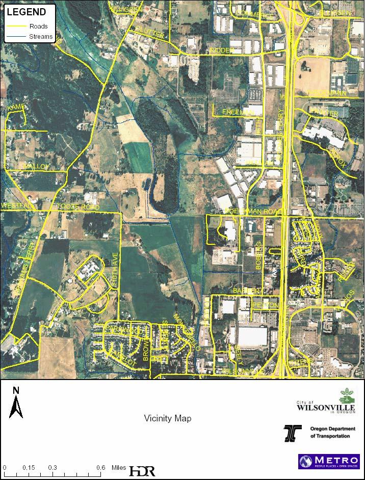
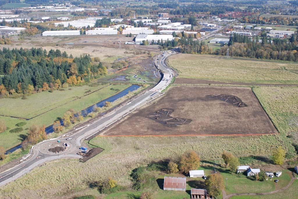
3 Project Location
4 Project Summary Provide enhanced east-west connectivity between residential and employment areas in and around the northern portion of the City of Wilsonville (Villebois Project) Reduce traffic at Wilsonville Road and Elligsen Road 3 Lane road with sidewalks and bike lanes 2 Lane road across wetlands Constructed in two phases

5 Phase 1 Phase 2 Commuter Rail

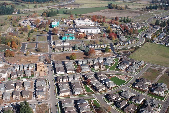
6 Villebois Project
7 Project Goals and Objectives Preserve natural resources, including the Coffee Lake wetlands complex. Provide a context-sensitive design (i.e. low impact development) that accounts for the existing natural resources and aesthetics, as well as the planned uses, of the area. Consider transit service in the development of improvement alternatives. Accommodate multiple modes of travel, including bicyclists and pedestrians. Consider how transportation improvements would affect and augment the Washington County Commuter Rail service and station site in Wilsonville.
8 Natural History and Environmental Conditions Tonquin Scablands unique geologic features (e.g. basalt hummocks, kolk ponds, etc.) formed by the Missoula floods 17,000 to 12,000 years ago Coffee Lake wetlands and floodplain scrub/shrub and emergent wetlands; peat soils; dominated by invasive species, such as reed canarygrass; wildlife habitat and corridor Coffee Lake Creek tributary of Willamette River; fed by springs, seeps, and smaller tributaries Alteration of wetlands and floodplain Seely ditch (1850s); other ditches and drain tile systems; cropped wetlands
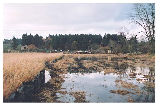
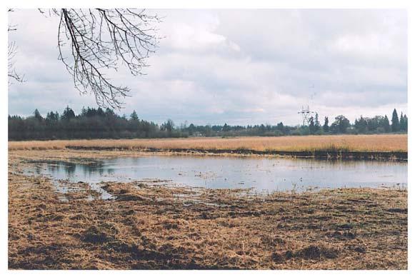
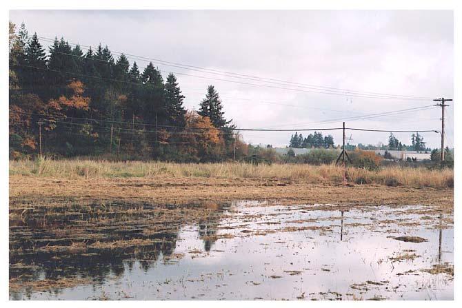
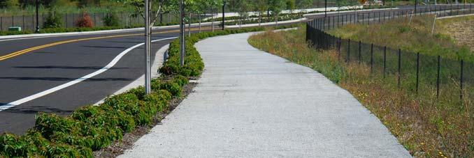
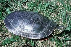
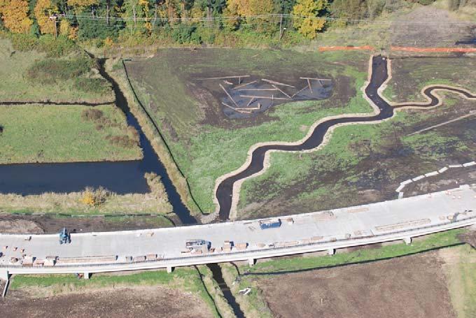
9 Pre-Construction Photos (11/2006)


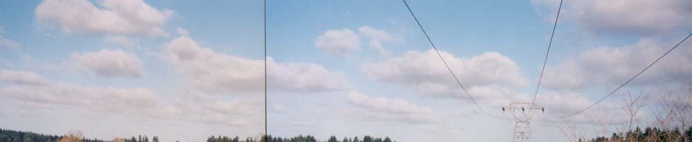
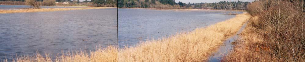
10 Coffee Lake Creek Wetlands & Flood of 1996

11 Boeckman Road
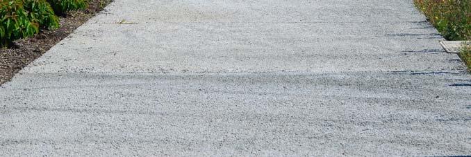
12 Green Street Elements Restore hydrology to wetlands Minimize impact to floodplain and Coffee Lake Creek Reduce impervious area (porous concrete sidewalks) Roadside bio-swales

13 Wetland Mitigation Site

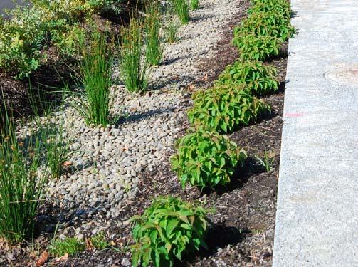
14 Green Street Elements


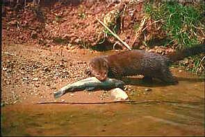
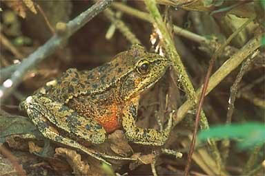
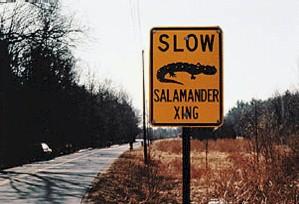
15 Wildlife Passage
16 Wildlife Passage Objectives Maintain habitat connectivity Provide passage for a wide range of species Enhance habitat Monitoring and evaluation
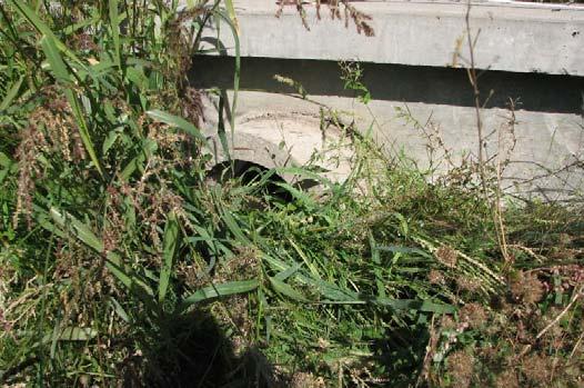
17 Wildlife Crossings Amphibian/reptile wall and mammal fence Culvert crossings (12 total) 9 x 4 box culverts (2) 18 culverts (6) 24 culverts (4) All of the culverts are countersunk, contain natural material and include daylight inlets Bridge (400 in length with a maximum clearance of 7.8 )
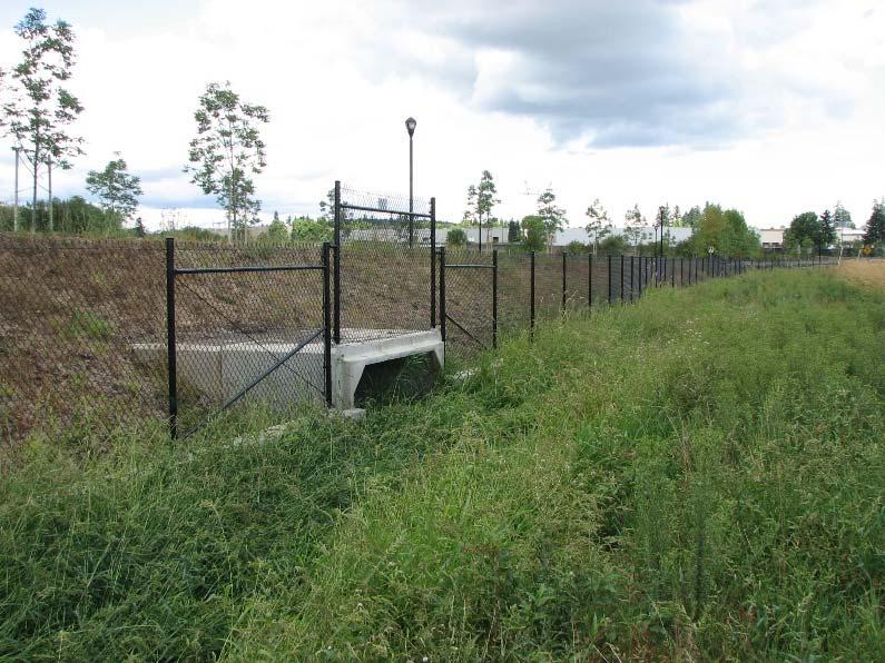
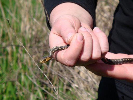
18 Amphibian/Reptile Wall
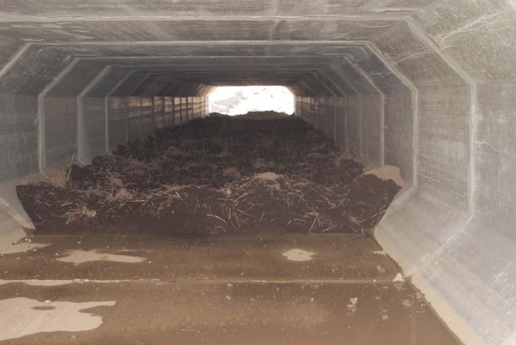
19 Culverts
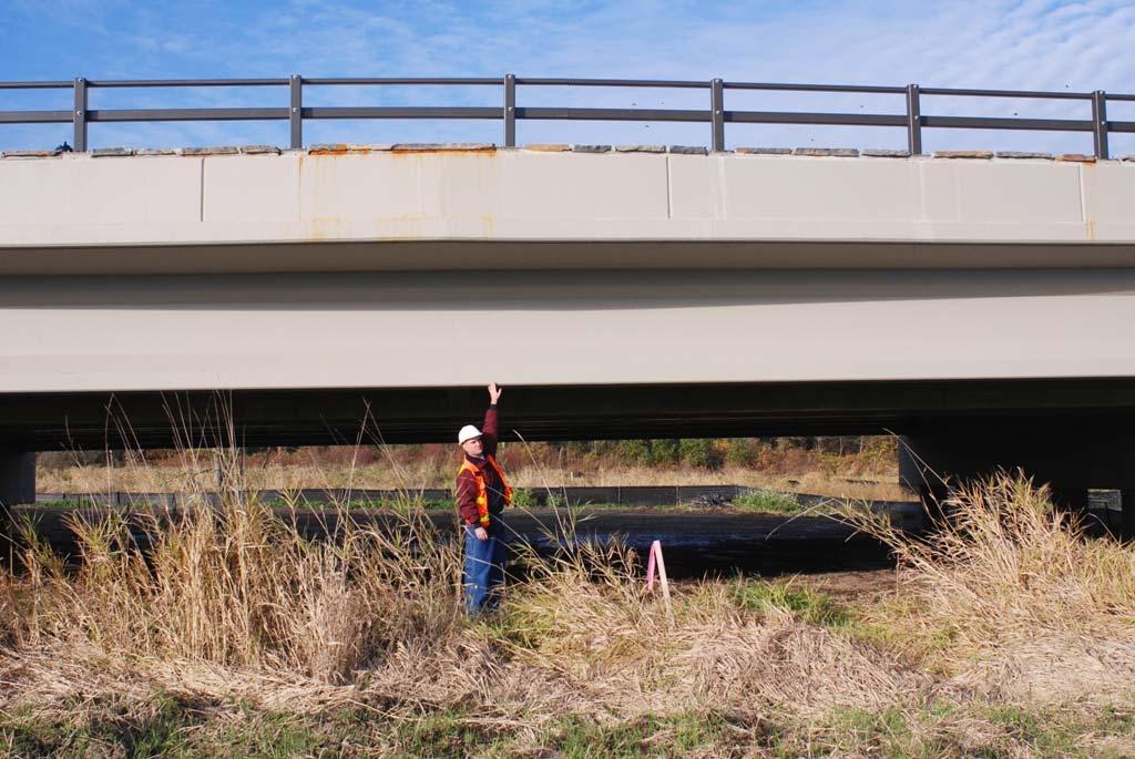
20 Bridge

 Pitfall")
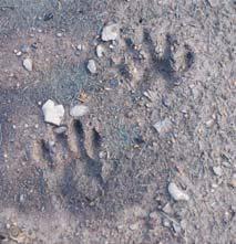
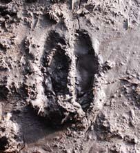
21 Are Animals Using Passage Structures/Fencing as Designed? Passages will be monitored using: Motion detection cameras Tracking (sand) Pitfall traps Roadkill surveys Direct Observations

22 Are the Numbers of Animals Using Passage Structures Representative? Transects at 25m & 100m parallel to the road Cameras & sand tracking Pitfall trap arrays Grids of small rodent live traps

23 Do Light & Vegetation Influence Species Use of Passage? Light levels within passage Addition of artificial light Blocking natural light Vegetation Vegetation Site Assessment Seasonally

24 Do Correlations Exist between Passage Use and Habitat Conditions? Traffic volume Within Passage: Temperature Humidity Vibration Airflow Standing water Erosion or Sediment Deposition

25 Data Collection Sand track data from the bridge, 9x4, 24 & 18 Motion detect photos from the bridge and both 9x4 s
26 Preliminary Results
27 Questions?
28 Contact Information Leslie Bliss-Ketchum Kerry Rappold
Better Cycling. The City will update the cycling master plan (London ON Bikes) based on the approved BRT network.
 based on the approved BRT network.") Better Cycling Dedicated bike facilities will be constructed along BRT corridors where space is available. Nearby bike routes will also be upgraded to ensure a complete network is available for cyclists.
Better Cycling Dedicated bike facilities will be constructed along BRT corridors where space is available. Nearby bike routes will also be upgraded to ensure a complete network is available for cyclists.
Welcome to the. Open House
 Welcome to the 5th Street to Kinsman Road Open House November 14 5:30 7:00 p.m. Please sign in Project Overview In December 2016, City Council adopted SW 5th Street as the preferred alignment to connect
WELCOME! 8 8:30 6: TH STREET IMPROVEMENTS. Open House. Presentation & Q&A
 WELCOME! 168 TH STREET IMPROVEMENTS 6:30 Open House 7 8 Presentation & Q&A 8 8:30 Open House WELCOME Todd Pfitzer City of Omaha Engineer Bob Stubbe City of Omaha Public Works Director Jon Meyer Project
Level 1 Downstream Analysis
 Level 1 Downstream Analysis Newcastle Way Apartments Newcastle, Washington King County April 14, 2014 Revised July 10, 2014 Prepared by: Dean A. Furr, P.E. Reviewed by: Donald Scarberry, P.E. Coffman Engineering,
East Montpelier SWMP Preliminary BMP Summary Sheet BMP ID #: 1 Site name: U-32 High School. Current site type
 East Montpelier SWMP Preliminary BMP Summary Sheet BMP ID #: 1 Site name: U-32 High School 930 Gallison Hill Rd, East Montpelier, VT Filter Berm, Sand Filter, Cistern / Rain Barrel, Gravel Wetland, Check
5. LOW IMPACT DEVELOPMENT DESIGN STANDARDS
 5. LOW IMPACT DEVELOPMENT DESIGN STANDARDS Low Impact Development (LID) requires a shift in stormwater management away from conveying runoff to a small number of downstream points through hydraulically
Yadkin River Greenway Feasibility Study Fact Sheet Village of Clemmons, Town of Lewisville, Town of Bermuda Run
 Fact Sheet Village of Clemmons, Town of Lewisville, Town of Bermuda Run Project Background The Yadkin River Greenway Feasibility Study is a joint project with the Village of Clemmons, the Town of Bermuda
7.0 SOCIAL, ECONOMIC, AND ENVIRONMENTAL ISSUES
 7.0 SOCIAL, ECONOMIC, AND ENVIRONMENTAL ISSUES The following list of social, economic, and environmental issues have been identified based on a preliminary inventory of resources in the project area, an
OVERMOUNTAIN VICTORY TRAIL BURKE CALDELL CORRIDOR FEASIBLITY STUDY REQUEST FOR QUALIFICATIONS CALDWELL COUNTY PATHWAYS
 OVERMOUNTAIN VICTORY TRAIL BURKE CALDELL CORRIDOR FEASIBLITY STUDY REQUEST FOR QUALIFICATIONS CALDWELL COUNTY PATHWAYS Caldwell County Pathways along with our co-partners City of Lenoir, Town of Gamewell,
Response to Comments (July 28, 2010 Oregon City Determination of Application Completeness Memo)
") Environmental Science & Assessment, LLC MEMORANDUM DATE: August 13, 2010 TO: Oregon City Planning CC: Jill Long Lane Powell FROM: RE: Jack Dalton Response to Comments (July 28, 2010 Oregon City Determination
Environmental Science & Assessment, LLC MEMORANDUM DATE: August 13, 2010 TO: Oregon City Planning CC: Jill Long Lane Powell FROM: RE: Jack Dalton Response to Comments (July 28, 2010 Oregon City Determination
ENBRIDGE GAS DISTRIBUTION INC. Proposed Relocation for Ninth Line, Markham and Whitchurch-Stouffville. Environmental Screening Report
 Page 1 of 18 ENBRIDGE GAS DISTRIBUTION INC. Proposed Relocation for Ninth Line, Markham and Whitchurch-Stouffville Environmental Screening Report July 2011 Page 2 of 18 Table of Contents 1.0 INTRODUCTION
Northern Branch Corridor SDEIS March 2017
 14. Water Quality 14.1. Chapter Overview 14.1.1. Introduction This section discusses changes to the potential for activities associated with the development and operation of the Preferred Alternative to
Green Streets An Innovative Street Design Approach
 Green Streets An Innovative Street Design Approach Great streets do not just happen. Overwhelmingly, the best streets derive from a conscious act of conception and creation of the street as a whole. The
Section 3 Non-Structural BMPs
 3.1 Stream Buffers A stream buffer or stream setback is a designated area around a stream, lake, or wetland left in a natural, densely vegetated state so as to protect the receiving water quality and provide
When planning stormwater management facilities, the following principles shall be applied where possible.
 2.0 Principles When planning stormwater management facilities, the following principles shall be applied where possible. 2.0.1 Drainage is a regional phenomenon that does not respect the boundaries between
Overall Map. Chicago. St. Louis. Summit. Joliet. Dwight. Pontiac. Bloomington-Normal Lincoln. Springfield. Carlinville. Alton EXPERIENCE IT YOURSELF.
 Overall Map Summit Chicago Bloomington-Normal Lincoln New Station Planned New Station Planned Dwight Pontiac Joliet Pedestrian overpass and second platform planned Higher speed service began in this section
Existing Conditions and Environmental Consequences Floodplains
 3.9 Environmental Consequences 3.8 3.8.1 WHAT ARE FLOODPLAINS? are low-lying areas adjacent to rivers, streams, and other waterbodies that are susceptible to inundation (flooding) during rain events. These
Tentatively Selected Plan within Harlem River, East River and Western Long Island Sound Planning Region. First Level Costs. Federal Non-Federal Total
 HARLEM RIVER, EAST RIVER AND WESTERN LONG ISLAND SOUND PLANNING REGION Flushing Bay and Creek Ecosystem Restoration Source Feasibility Study Background Study Resolution (1994), Reconnaissance Report (1996),
A larger version of this map is located on the last page of this PDF.
 MAP Committee Input McLoughlin Area Draft Vision Map A larger version of this map is located on the last page of this PDF. 1. The map above is intended to portray a vision for the McLoughlin area. It highlights
City of Waco Stormwater Management Regulations
 1.0 Applicability: City of Waco Stormwater Management Regulations These regulations apply to all development within the limits of the City of Waco as well as to any subdivisions within the extra territorial
The Napa River Flood Protection Project
 The Napa River Flood Protection Project Creating Flood Protection and Restoring Geomorphic and Biological Processes Jeremy Sarrow, Napa County Flood Control & Water Conservation District June 2, 2014.
Technical Memorandum 5
 Technical Memorandum 5 Environmental Resources August 2015 PREPARED BY AECOM Table of Contents Introduction... 3 Natural Features... 6 Watersheds... 6 Rivers, Lakes, Creeks... 6 Wetlands... 8 Floodplains...
SUNBRIDGE PARKWAY PRELIMINARY DESIGN STUDY. November 30, 2017
 SUNBRIDGE PARKWAY PRELIMINARY DESIGN STUDY November 30, 2017 Agenda Introductions and Overview Study Purpose Study Approach Key Analysis Components Study Context Existing Conditions Corridor Constraints
Caledon Villas Corp. c/o Mr. John Spina 55 Blue Willow Drive Woodbridge, ON L4L 9E8 May 14, Floodplain Characteristics, Old Church Road
 Caledon Villas Corp. c/o Mr. John Spina 55 Blue Willow Drive Woodbridge, ON L4L 9E8 May 14, 2013 Re: Floodplain Characteristics, Old Church Road This letter serves to confirm that I, Linda Sober, have
Potential Green Infrastructure Strategies May 6, 2015 Workshop
 Potential Green Infrastructure Strategies May 6, 2015 Workshop Background The City of Cortland is developing the Tioughnioga Urban Headwaters Green Infrastructure Action Plan with funding from the National
Post Construction BMPs
 Post Construction BMPs Why are Post Construction BMPs important? With increased development brings the increase of impervious cover Parking lots, rooftops, driveways Storm water runoff volume increases
include playgrounds, sports fields, community gardens and picnic areas.
 DEVELOPMENT PLAN OPEN SPACE SYSTEM OPEN SPACE SYSTEM The neighborhood provides for a range of open space types. The Village Square is an important open space in the neighborhood. It serves as a gathering
River Corridor Overlay Zone (RCOZ) Article 5
 Article 5") River Corridor Overlay Zone (RCOZ) Article 5 The site is in one of two designated districts. The first is the CBD (central business district) River District, which recognizes the urban character and unique
River Corridor Overlay Zone (RCOZ) Article 5 The site is in one of two designated districts. The first is the CBD (central business district) River District, which recognizes the urban character and unique
CONFORMED AGREEMENT INCORPORATED REVISIONS PER AMENDMENT DATED: APRIL 2, 2013 FOR REFERENCE
 CONFORMED AGREEMENT INCORPORATED REVISIONS PER AMENDMENT DATED: APRIL 2, 2013 FOR REFERENCE CITY STREETS AS PART OF STATE HIGHWAYS GUIDELINES REACHED BY THE WASHINGTON STATE DEPARTMENT OF TRANSPORTATION
Improving Communities Through the Arroyo Seco Sustainability Campaign and Watershed Assessment
 Improving Communities Through the Arroyo Seco Sustainability Campaign and Watershed Assessment Arroyo Seco Headwaters in the San Gabriel Mountains Major tributary to the Los Angeles River 44 square mile
Biodiversity Conservation
 Biodiversity Conservation and Site Plan Review Biodiversity conservation principles Threats to biodiversity Location of development Reviewing site plans Lunch Reviewing site plans (continued) LEED and
PART 1: PROJECT SUMMARY. The application is Attachment A. The site plan is Attachment B.
 Belleterre Subdivision Sketch Plan Town Board 8.7.17 Belleterre Subdivision Sketch Plan PART 1: PROJECT SUMMARY Applicant: Bowman Development Project Size: +/- 20.85 acres Parcel Number: 01115104 and 01115121
Highway 427 Industrial Secondary Plan Area 47 Schedule C Class Environmental Assessment For Arterial Roadways
 Welcome to Pubic Information Centre #1 Highway 427 Industrial Secondary Plan Area 47 Schedule C Class Environmental Assessment For Arterial Roadways Welcome to Open House # 1 Tonight, we invite you to.
WELCOME TO OPEN HOUSE # 3
 Bayview Avenue Class Environmental Assessment Study Steeles Avenue to Elgin Mills Road WELCOME TO OPEN HOUSE # 3 Please sign in and join our mailing list Why Are We Here Tonight? Study Process and Purpose
CAPITAL LINE SOUTH LRT EXTENSION INTRODUCTION
 INTRODUCTION What: The 2010 preliminary design for the Capital Line South LRT Extension will run from the Century Park Station to Ellerslie Road. It will connect to the Heritage Valley Park and Ride located
STREAM BANK STABILIZATION THORPS MORTIMER RECREATION AREA Grandfather Ranger District SITE LOCATION & DRAINAGE AREA
 STREAM BANK STABILIZATION THORPS CREEK @ MORTIMER RECREATION AREA SITE LOCATION & DRAINAGE AREA SITE LOCATION Drainage Area = 1.14 sq. miles STREAM BANK STABILIZATION THORPS CREEK @ MORTIMER RECREATION
Public Meeting May 20, 2014
 Public Meeting May 20, 2014 Overview Study Purpose Study Area Overview Strategies Potential Opportunities Implementation and Discussion Skeo Solutions Raleigh Walkable Watershed Pilot 2 Purpose Develop
Bostwick Road. Municipal Class Environmental Assessment. October 13, City of London. Bostwick Road Municipal Class Environmental Assessment
 Bostwick Road Municipal Class Environmental Assessment October 13, 2016 Welcome! Welcome to the first Public Information Centre for the Bostwick Road Municipal Class Environmental Assessment. Representatives
Green Infrastructure The Indianapolis Greenways Connection
 Green Infrastructure The Indianapolis Greenways Connection Fewer things in the transportation industry today make better since than combining the needs for pedestrian and bike trails with the need to locate,
Roads and Ecological Integrity. Best Management Practices. September 2016: Version 1.1
 Roads and Ecological Integrity Best Management Practices September 2016: Introduction Most of the pressures on the ecological integrity of provincial parks can be linked to, or are made worse by roads.
SECTION 5: REACH RECOMMENDATIONS/MAPS
 SECTION 5: REACH RECOMMENDATIONS/MAPS This section describes areas of concern and provides specific recommendations for each project reach. Locations of stormwater drains were from GIS coverage supplied
Urban Stormwater: Best Practice Environmental Management Guidelines. CSIRO This electronic edition published by CSIRO PUBLISHING, 2006.
 Urban Stormwater: Best Practice Environmental Management Guidelines. Chapter 5 Water Sensitive Urban Design Key references Department of Planning, 1993, Better Drainage: Guidelines for the Multiple Use
Asbury Chapel Subdivision Sketch Plan
 Asbury Chapel Subdivision Sketch Plan PART 1: PROJECT SUMMARY Applicant: NVR Inc. Project Size: +/- 76.13 acres Parcel Numbers: 02101112,02116101,02116112, 02116113 Current Zoning: Transitional Residential
Welcome & Introduction
 Welcome & Introduction Sports Field Public Information Session Public feedback is critical to planning a successful park! Please review the boards and provide your comments and ideas Tell us what you like,
WELCOME TO OPEN HOUSE TWO November 28, 2018
 Langstaff Road Weston Road to Highway 7 Class Environmental Assessment Study WELCOME TO OPEN HOUSE TWO November 28, 2018 Please sign in and join our mailing list Study Overview York Region is conducting
St. Croix County Shoreland Overlay Zoning Districts. Public Hearing Community Development Committee December 19, 2013
 St. Croix County Shoreland Overlay Zoning Districts Public Hearing Community Development Committee December 19, 2013 Timeline CDC Review October 17 Public Information Meeting October 29 (6:00-8:00 pm)
Rapid Transit Implementation Working Group September 14, 2017
 Rapid Transit Implementation Working Group September 14, 2017 BACKGROUND Council approved the Rapid Transit Master Plan and Updated Business Case on July 25, 2017. Approval of the RTMP confirmed the BRT
Gold Line Bus Rapid Transit Transit Oriented Development (BRTOD) Helmo Station Area Plan
 Helmo Station Area Plan") Appendix F Gold Line Bus Rapid Transit Transit Oriented Development (BRTOD) Helmo Station Area Plan Introduction and Purpose of the Plan The Gold Line Bus Rapid Transit facility is an eleven-mile dedicated
Appendix F Gold Line Bus Rapid Transit Transit Oriented Development (BRTOD) Helmo Station Area Plan Introduction and Purpose of the Plan The Gold Line Bus Rapid Transit facility is an eleven-mile dedicated
Pennsylvania Stormwater Best Management Practices Manual
 Pennsylvania Stormwater Best Management Practices Manual DRAFT - JANUARY 2005 Section 4 Comprehensive Stormwater Management: Integrating Site Design, Non-Structural, and Structural BMP's This page intentionally
Poisoned Park? How Exide s Lead Contamination Risks Frisco s Grand Park
 Frisco City Hall has big plans to transform Stewart Creek into a Grand Park with lots of water features for kids to play in. Poisoned Park? How Exide s Lead Contamination Risks Frisco s Grand Park But
Kankakee River Bridge & Track Improvements Supplemental Environmental Assessment. May 5, 2016
 Kankakee River Bridge & Track Improvements Supplemental Environmental Assessment May 5, 2016 1 History: Chicago-St. Louis Corridor Since 1980 s IDOT has been looking at this corridor for high-speed service
HAZARD MITIGATION GOALS AND OBJECTIVES
 SEWRPC Community Assistance Planning Report No. 282, 2nd Edition CITY OF MILWAUKEE ALL HAZARDS MITIGATION PLAN UPDATE Chapter IV HAZARD MITIGATION GOALS AND OBJECTIVES [NOTE: Throughout this plan update
Street Flooding Mitigation Plan KYOVA Interstate Planning Commission. Presented to AMPO National Conference October 18, 2017
 Street Flooding Mitigation Plan KYOVA Interstate Planning Commission Presented to AMPO National Conference October 18, 2017 Saleem Salameh, Ph.D., P.E., M.ASCE Chet Parsons, AICP CTP Agenda: Background
Gather information from online resources covering the following topics:
 Assignment #1: Regional Analysis Project Site Location: Greater Boston Area What comprises a region? The many elements within a region comprise the region as a whole. Natural as well as manmade environmental
Urban Conservation Practice Physical Effects ESTABLISHMENT, GROWTH, AND HARVEST NUTRIENT MANAGEMENT
 NOT WELL 800 - Urban Stormwater Wetlands A constructed system of shallow pools that create growing conditions for wetland plants to lessen the impacts of stormwater quality and quantity in urban areas.
Agenda. Introductions and Overview Study Purpose Study Approach Key Analysis Components Study Context Development Activity ( )
") October 5, 2017 Agenda Introductions and Overview Study Purpose Study Approach Key Analysis Components Study Context Development Activity (2005-2017) Existing Conditions Alternatives Public Engagement
October 5, 2017 Agenda Introductions and Overview Study Purpose Study Approach Key Analysis Components Study Context Development Activity (2005-2017) Existing Conditions Alternatives Public Engagement
319 Grant: Baker Creek & Centenary Creek Restoration Initiative
 319 Grant: Baker Creek & Centenary Creek Restoration Initiative Objectives: Overview of Watershed Characteristics: Discussion of Project Tasks: Discussion of Watershed Management Plan: Presented by: Erich
Northeast Anthony Henday Drive Manning Freeway to Whitemud Drive Welcome to this Construction Information Session
 Manning Freeway to Whitemud Drive Welcome to this Construction Information Session Purpose To inform interested residents and businesses about the plans accommodation. Background: The Government of Alberta
LID. Low Impact Development: Protecting Oregon s waters as we grow
 LID Low Impact Development: Protecting Oregon s waters as we grow LID Low Impact Development (LID) is an approach to land development that preserves natural resources and mimics natural systems for managing
Complete Neighbourhood Guidelines Review Tool
 Complete Neighbourhood Guidelines Review Tool Prepared By: City of Regina Planning Department October 2014 Page 1 of 14 Community Development Review Checklist for Secondary Plans and Concept Plans The
Derby-Shelton Bridge Pedestrian and Bicyclist Enhancements [1]
![Derby-Shelton Bridge Pedestrian and Bicyclist Enhancements [1]](/thumbs/96/128011958.jpg "Derby-Shelton Bridge Pedestrian and Bicyclist Enhancements [1]") nhancements [1] STATUS OF PROJECT: The project has recently moved from the Preliminary Design Phase to the Final Design Phase following the most recent Public Involvement Meeting held on January 9, 2019
nhancements [1] STATUS OF PROJECT: The project has recently moved from the Preliminary Design Phase to the Final Design Phase following the most recent Public Involvement Meeting held on January 9, 2019
Conservation Plan. I. Property Information. II. Objectives. Natural Resource Objectives. Sustainability in Practice (SIP) Certified
 Certified") Conservation Plan Sustainability in Practice (SIP) Certified I. Property Information Vineyard Name and Establishment Date: Location: Map (attach showing blocks and acres): II. Objectives Natural Resource
Conservation Plan Sustainability in Practice (SIP) Certified I. Property Information Vineyard Name and Establishment Date: Location: Map (attach showing blocks and acres): II. Objectives Natural Resource
Route 347. New York State Department of Transportation Region 10, Long Island. THE GREENING of ROUTE 347
 The GREENING of Route 347 The Greening of Route 347 The Greening of Route 347: History 3 The Greening of Route 347 4 The Greening of Route 347 5 The Greening of Route 347 Smith Haven Mall 6 The Greening
The Residences at Alewife Station
 The Residences at Alewife Station 195 & 211 Concord Turnpike Community Meeting Peabody School November 10, 2016 Site Context Special District 4 Special District 4 Restored Planned Development Special District
Edgeley Pond + Park Public Meeting
 Edgeley Pond + Park Public Meeting February 21, 2017 Purpose of the meeting This Public Meeting is an opportunity for you to review the project background, process and provide input. City of Vaughan staff
Designing for Sustainability: A Consultant s Perspective
 Session 462 Asphalt Pavement Sustainability Designing for Sustainability: A Consultant s Perspective Timothy A. Bevan, P.E. / CH2M HILL Transportation Research Board 87th Annual Meeting January 13-17,
Local roads, regional impact: Tracking mammals across roads in Western MA to connect the Appalachians
 Local roads, regional impact: Tracking mammals across roads in Western MA to connect the Appalachians Sept. 22, 2014 Photos Meredyth Babcock Photo Meredyth Babcock Riitters et al. 2000. http://www.consecol.org/vol4/iss2/art3/
UBC URBAN STUDIO, FALL 2002 PEDESTRIAN ORIENTED
 SECTION B PEDESTRIAN ORIENTED PATTERN: CITY OF VANCOUVER B.1 Vision Overview Regional Framework Energy 50% of all energy used within the Region to be produced by the Region. Energy production methods to
Boca Raton II Tri-Rail Station PD&E Study and 30% Documents Public Kick-Off Meeting. August 29, 2017 Spanish River Library
 Boca Raton II Tri-Rail Station PD&E Study and 30% Documents Public Kick-Off Meeting August 29, 2017 Spanish River Library Introductions 2 Partner Stakeholder Agencies FDOT District Four Palm Beach Metropolitan
Draft Rhode Island Stormwater Design and Installation Standards Manual
 Draft Rhode Island Stormwater Design and Installation Standards Manual Summary The May 2009 Public Review Draft version of the RI Stormwater Design and Installation Standards Manual consists of approximately
Chapter 4 - Preparation of Stormwater Site Plans
 Chapter 4 - Preparation of Stormwater Site Plans The Stormwater Site Plan is the comprehensive report containing all of the technical information and analysis necessary for the City to evaluate a proposed
Los Angeles River-Arroyo Seco Confluence Restoration Vision Plan. Professor Meredith McKenzie, JD Urban & Regional Planning Dept Cal Poly Pomona
 Los Angeles River-Arroyo Seco Confluence Restoration Vision Plan Professor Meredith McKenzie, JD Urban & Regional Planning Dept Cal Poly Pomona The Los Angeles River Watershed Arroyo Seco Watershed Map
Information for File # MHK
 Information for File #2014-03555-MHK Applicant: Corps Contact: Wimmer Communities Marie Kopka Address: 250 N. Sunnyslope Road, Suite 296 Brookfield, Wisconsin 53005 E-Mail: Marie.H.Kopka@usace.army.mil
Retrofitting Low Impact Development (LID) for Stormwater at Sacramento State. City of Sacramento Sacramento State Facilities Management
 for Stormwater at Sacramento State. City of Sacramento Sacramento State Facilities Management") Retrofitting Low Impact Development (LID) for Stormwater at Sacramento State City of Sacramento Sacramento State Facilities Management Project Background Campus Storm Drain System Drain Inlet - Campus
Retrofitting Low Impact Development (LID) for Stormwater at Sacramento State City of Sacramento Sacramento State Facilities Management Project Background Campus Storm Drain System Drain Inlet - Campus
APPENDIX C NATURAL RESOURCES MANAGEMENT PLAN: ACTIONS AND PRIORITIES
 APPENDIX C NATURAL RESOURCES MANAGEMENT PLAN: ACTIONS AND PRIORITIES TABLE C-1: Resource Actions and Priorities GOAL NRM-4 Objective 4.1: Restore Natural floodplain functions. Objective 4.2: Define and
NORTHEAST RIVER CROSSING FUNCTIONAL PLANNING STUDY
 WELCOME Northeast River Crossing Functional Planning Study Phase 2 Public Meeting 4 to 8 PM Informal drop-in format and discussion tables Meeting Purpose Introduce the Northeast River Crossing Functional
East River Waterfront Esplanade and Piers New York, New York Draft Environmental Impact Statement
 East River Waterfront Esplanade and Piers New York, New York Draft Environmental Impact Statement October 12, 2006 CEQR No.: TO COME ULURP Nos.: TO COME Lead Agency: Lower Manhattan Development Corporation
Downtown Denver Morrison. Located 30 minutes from downtown Denver behind the hogback
 Downtown Denver Morrison Located 30 minutes from downtown Denver behind the hogback Founded in 1874 as a passageway gold mines to the west. Morrison is the gateway to the Bear Creek Canyon. Surrounded
STORMWATER SITE PLAN INSTRUCTIONS AND SUBMITTAL TEMPLATE Medium and Large Projects
 DEPARTMENT OF COMMUNITY DEVELOPMENT 621 Sheridan Street, Port Townsend, WA 98368 Tel: 360.379.4450 Fax: 360.379.4451 Web: www.co.jefferson.wa.us/communitydevelopment E-mail: dcd@co.jefferson.wa.us STORMWATER
Project Description WOO/LUC-SR /0.00. Waterville Bridge Replacement
 Ohio Department of Transportation District 2 317 East Poe Rd. Bowling Green, Ohio 43402 (419) 353-8131 John R. Kasich, Governor Jerry Wray, Director Todd Audet, P.E., District Deputy Director Project Description
Creating Complete Roadway Corridors:
 Creating Complete Roadway Corridors: The AASHTO Guide to Transportation Landscape Architecture and Environmental Design NCHRP Project 15-33 Status Report AASHTO Standing Committee on Design Technical Committee
ADDENDUM TO BIOLOGICAL SCOPING SURVEY REPORT, BOTANICAL SURVEY AND WETLAND DELINEATION
 ADDENDUM TO BIOLOGICAL SCOPING SURVEY REPORT, BOTANICAL SURVEY AND WETLAND DELINEATION FOR AVALON INN (APN 069-241-27 & -04) 1201 & 1211 NORTH MAIN STREET FORT BRAGG, CA MENDOCINO COUNTY prepared for:
APPENDIX K WINDSOR OFFICIAL PLAN
 CEAA ENVIRONMENTAL ENVIRONMENTAL IMPACT ASSESSMENT AMBASSADOR BRIDGE ENHANCEMENT PROJECT Replacement Span and Plaza Expansion APPENDIX K WINDSOR OFFICIAL PLAN Avalon Consulting Professionals of Ontario,
Leduc Industrial Outline Plan SE W4
 Leduc Industrial Outline Plan SE 1-50-25-W4 Within the North Leduc Industrial ASP Prepared for: Leduc Energy Park Ltd. Prepared by: Stantec Consulting Ltd. File No. 1161 104655 V5 Table of Contents 1.0
Holland Country Club Golf Course to Wetlands
 Holland Country Club Golf Course to Wetlands John Scholtz, Director Ottawa County Parks & Recreation Commission Amy A. Berry, Project Manager Niswander Environmental, LLC OTTAWA COUNTY PARKS: Focusing
Rainwater Management Landscape-Based Solutions. The Corporation of Delta Showcasing Innovation Series September 21, 2007
 Rainwater Management Landscape-Based Solutions The Corporation of Delta Showcasing Innovation Series September 21, 2007 Municipal Rain Water Management Objectives To increase permeable surfaces throughout
The River Hub: NEW BUILDINGS
 Summary The River Hub includes 6 municipalities that all boarder the Fraser River. Combined, they are expected to double in population over the next 50 years. To accommodate this new population, 138,831
McDaniel Creek Master Plan
 McDaniel Creek Master Plan UNIVERSITY AVE., PITTSBURGH NEIGHBORHOOD AND THE MCDANIEL CREEK WATERSHED 60 ANSLEY MALL AND THE CLEAR CREEK GREENWAY 61 INTRODUCTION The BeltLine Subarea 6 site lies within
Lincoln 270. City of Lincoln. Stormwater Management Plan. April 2, 2013
 Lincoln 270 City of Lincoln Stormwater Management Plan April 2, 2013 # 2005.48 Prepared By: Civil Engineering Solutions, Inc. 590 E Street Lincoln, Ca 95648 (916) 645 5700 1.0 Background: The project site
Alternatives Development Three conceptual alternatives were developed for the Race Road/Jessup Village Planning Study and are described below:
 Race Road/Jessup Village Planning Study (H550601) Project Newsletter Spring 2015 Project Description The Study Team, consisting of staff from Anne Arundel County (Department of Public Works and Department
The Benefits and Challenges Associated with Green Infrastructure Practices
 The Benefits and Challenges Associated with Green Infrastructure Practices Thomas M. Evans ASLA, LEED AP Regional Green Infrastructure Design Services Director OWEA Technical Conference, June 20, 2013
Lower Don River West Remedial Flood Protection Project TABLE OF CONTENTS. Page. Executive Summary
 TABLE OF CONTENTS Page Executive Summary 1.0 INTRODUCTION...1-1 1.1 Purpose of the Undertaking...1-1 1.2 Study Area Description...1-1 1.3 Description of the Undertaking...1-1 1.4 Rationale for the Undertaking...1-2
Recreational Pathway Crossing of Richmond Street Municipal Class Environmental Assessment. Public Information Centre #2 April 22, 2015
 Recreational Pathway Crossing of Richmond Street Municipal Class Environmental Assessment Public Information Centre #2 April 22, 2015 1. Study Process PHASE 1 PHASE 2 PHASE 3 PHASE 1 : Problem/Opportunity
Stream Corridor Management Plan
 Stream Corridor Management Plan A unified and comprehensive approach to protecting, restoring and managing the Upper Delaware River Graydon Dutcher Delaware County Soil and Water Conservation District
Kingswood Site Development Preliminary Site Evaluation Report March 23, 2015
 By: Burgess & Niple, Inc. For: Deerfield Township Trustees Purpose: Kingswood Site Development Preliminary Site Evaluation Report March 23, 2015 This report will review the critical site issues that will
7th Avenue Creek Master Plan Development Project. City of St. Charles, IL. IAFSM CONFERENCE March 14, 2018 MARKET
 7th Avenue Creek Master Plan Development Project MARKET City of St. Charles, IL IAFSM CONFERENCE March 14, 2018 7 TH AVENUE CREEK PROJECT AREA 2 2008 RAIN EVENT 3 RESIDENTIAL STRUCTURE FLOODING COMMERCIAL
Southwest Fleetwood Enclave
 Southwest Fleetwood Enclave Development Concept Plan Southwest Fleetwood Enclave 1 st Land Owners Meeting April 30 th, 2012 Presentation Overview Why the Plan? ; Overview & Purpose of Study; Constraints
Kittson Parkway / Watershed Park Parking Lot
 Kittson Parkway / Watershed Park Parking Lot Date Constructed: Summer 2005 Site Location / Description: Kittson Parkway, North Delta, British Columbia. Permeable parking lot adjacent to Watershed Park;
Guiding Landowners in Stream Restoration. The Science, Practice & Art of Restoring Native Ecosystems 2015
 Guiding Landowners in Stream Restoration The Science, Practice & Art of Restoring Native Ecosystems 2015 January 24, 2015 Guiding Landowners in Stream Restoration January 24, 2015 Agenda 1Watershed Planning
Green Infrastructure. NYS Department of Environmental Conservation
 Green Infrastructure Green infrastructure is an interconnected network of natural areas and open spaces that sustains ecosystems. Benedict, M.A. and E.T. McMahon. 2006. Green Infrastructure Linking Landscapes