Local roads, regional impact: Tracking mammals across roads in Western MA to connect the Appalachians
|
|
|
- Cordelia Freeman
- 6 years ago
- Views:
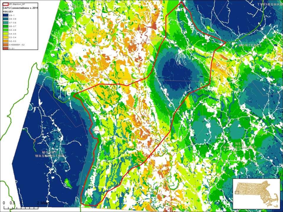
Transcription

1 Local roads, regional impact: Tracking mammals across roads in Western MA to connect the Appalachians Sept. 22, 2014

2


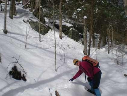
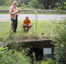
3 Photos Meredyth Babcock

4

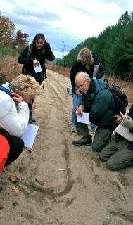
5 Photo Meredyth Babcock
6

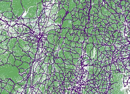
7 Riitters et al

8 Woods Hole NBCD dataset

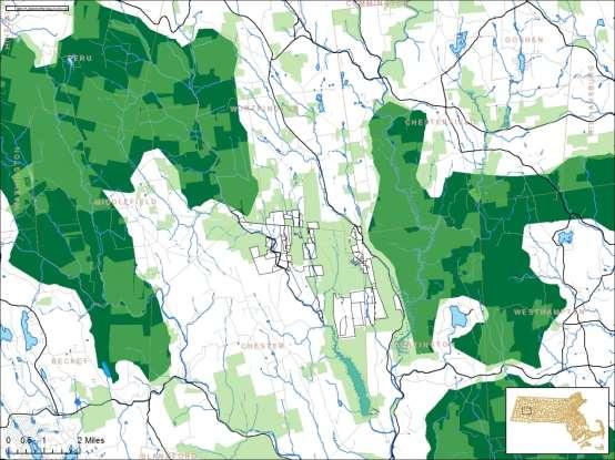
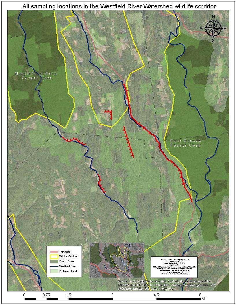
9 Berkshire Wildlife Linkage
10

11
12

13


14
15 Site selection
16


17
18
19
20

21


22

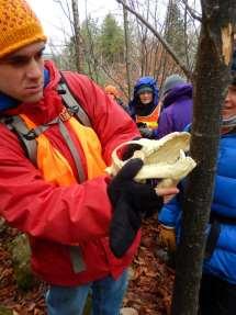
23
24


25 Methods and Results Tracking Roadkill Surveys Cameras Passage Assessment


26 Tracking: Design Help and Advice from -MassDOT -Wildlife Biologists -UMASS Landscape Ecology Lab Strong Experimental Design -topographic feasibility -landowner permission -both sides of road -and 100m perpendiculars


27 Tracking: Trackers

28 Tracking: How When: Between hours after snowfall (>2in) Where: Over 30 miles of transects in w.mass Targets: Mammal species


29 Roadkill Surveys

30 Trail Cams: Great tool for public outreach Enhanced tracking
31 Tracking Results: Route 23
 bobcat Lynx rufus 4.3 1.")


32 Species List- Route 23 Route 23 species list and activity levels, based on 6 tracking surveys Common name Latin name Average intercepts/km Relative frequency (%) bobcat Lynx rufus cottontail Sylvilagus floridanus 5 3% 1% coyote Canis latrans deer Odocoileus virginianus % % fisher Martes pennanti % gray fox Urocyon cinereoargenteus mink Neovision vision % 9.5 opossum Didelphis virginiana % red fox Vulpes vulpes 6.3 1% 14.6 turkey Meleagris g. silvestris 1 4% 19% weasel Mustela erminea or Mustela frenata canid canid coyote deer fisher red fox gray fox porcupine weasel mink bobcat cottontail turkey opossum
33 Species Crossing- Route 23

34 Average Crossings- Route 23


35 WEST: Preferred crossing and no protected land -Widen AT corridor -Maintain connection Route 23 DCR AT -Work with landowners to enhance -Plant native species for cover -Don t build new fenceline EAST: preferred crossing and protected land

36 Tracking Results: Route 112


37 Tracking Results: Route 7

38 Northern AT Corridor Route 7 Native species for cover Maintain connection Fences Crossing Infrastructure AG AT
39 Passage Assessment System Road Stream Crossings since 2004 X culverts surveyed X miles of road surveyed Transition to Jane for Case Study
40
41 Jane Winn

42


43
44

45

46
47
48

49
50

51

52
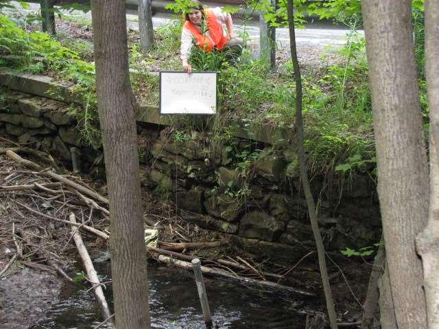
53
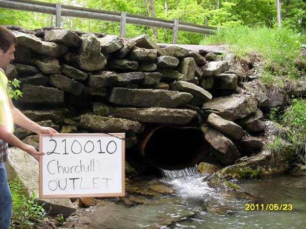
54

55
56

57

58

59

60

61 Hancock Road - Inlet

62 Hancock Road - Outlet

63
64
65 What we did Used best available science to define corridors between large habitats in western MA Tracked mammals along 3 roads, finding mixed answers to the question Can animals get from forest core habitat to forest core habitat? Tracking our tracking results helped to calibrate models like CAPS and Critical Linkages. Models and tracking agreed: Route 7 in the S. Berkshires is largely impermeable, route 23 is patchy with some good and bad spots, route 112 is permeable throughout Models + tracking + cameras + passage assessment combined suggest that we need additional land protection, road infrastructure work, and landowner stewardship/engagement in these areas.
66 This study was an incredible tool for engaging landowners, esp. but not solely cameras Evidence: Essay Land donation; timber harvest change. Volunteers self-organized to re-survey transects once next year Parcel-level maps of wildlife Request for additional presentations
67 Next steps Define N/S corridor MassDOT/PVPC/BRPC Landowners YOU (here)
68 Next steps Connect with YOU Define the most critical corridor through the center of the Berkshire Wildlife Linkage what is our must keep pathway between the Green Mts. And Hudson R. valley? Meet again with MassDOT to identify upcoming road projects that could further enhance wildlife connectivity, discuss road right-ofway management, and identify the next culvert projects Meet regional planning agencies to ask for their continued help in looking at both conservation and development projects within the north-south corridor more closely Maintain landowner interest and support landowners who want to restore vegetation or otherwise manage their roadsides for wildlife
69 If you remember just one takehome: Whether talking about otters or our drinking water, both need large protected areas connected by areas that they can pass through. What is around the road is as important as the road itself.

70 Q & A Laura Marx lmarx@tnc.org Jane Winn jane@thebeatnews.org Elia del Molino elia@thebeatnews.org
NJ Habitat Connectivity Initiative
 NJ Habitat Connectivity Initiative Full Working Group Update #1 Spotted Salamander Crossing Road in Northern NJ Wildlife Habitat Connectivity Initiative A strategic plan to reconnect New Jersey s landscape
Boeckman Road Extension
 Boeckman Road Extension Providing Safe Passage for Wildlife and Maintaining Habitat Connectivity By Kerry Rappold, City of Wilsonville Leslie Bliss-Ketchum, Portland State University October 20, 2008 Presentation
Identifying the Best Locations to Provide Safe Highway Crossing Opportunities for Wildlife, Sarah Barnum...246
 Click on the paper title below to link directly to it. Habitat Connectivity: Placement of Crossing Structures Conservation Strategies in the Florida Keys: Formula for Success, R. Lopez, N. Silvy, C. Owen
KITT PEAK LINKAGE WILDLIFE CONNECTIVITY: WILDLIFE OVERPASSES AND FENCING. State Route 86
 KITT PEAK LINKAGE WILDLIFE CONNECTIVITY: WILDLIFE OVERPASSES AND FENCING State Route 86 Tohono O odham Nation Department of Natural Resources Wildlife and Vegetation Management Program In partnership with
THE USE OF COLLABORATION, MONITORING, ADAPTIVE MANAGEMENT, AND PHASED CONSTRUCTION ON STATE HIGHWAY 9, COLORADO
 PROCEEDINGS OF THE 2017 INTERNATIONAL CONFERENCE ON ECOLOGY AND TRANSPORTATION THE USE OF COLLABORATION, MONITORING, ADAPTIVE MANAGEMENT, AND PHASED CONSTRUCTION ON STATE HIGHWAY 9, COLORADO Julia Kintsch
Planning Considerations for Wildlife Passage in Urban Environments. (Prepared by Tony Clevenger, PhD)
") Scope Planning Considerations for Wildlife Passage in Urban Environments. (Prepared by Tony Clevenger, PhD) As urban populations grow and expand into rural areas there are changes in land use patterns
Scope Planning Considerations for Wildlife Passage in Urban Environments. (Prepared by Tony Clevenger, PhD) As urban populations grow and expand into rural areas there are changes in land use patterns
Conservation Corridor Base and Thematic Maps
 Conservation Corridor Base and Thematic Maps August 20, 2010 This project is funded in part by the Virginia Coastal Zone Management Program at the Department of Environmental Quality through Grant #NAO9NOS4190163
Wildlife Linkages within the San Diego County Preserve System.
 Wildlife Linkages within the San Diego County Preserve System. Data Summary Prepared for: San Diego Association of Governments U.S. DEPARTMENT OF THE INTERIOR U.S. GEOLOGICAL SURVEY WESTERN ECOLOGICAL
Twin Peaks Road Wildlife Linkages Research Project Rattlesnake Pass, Marana, Arizona
 Twin Peaks Road Wildlife Linkages Research Project Rattlesnake Pass, Marana, Arizona Town of Marana Environmental Engineering Division Division Manager Jennifer Christelman Prepared by: Shawn F. Lowery,
Conservation Corridor Planning and Green Infrastructure Themes
 Conservation Corridor Planning and Green Infrastructure Themes Prepared by the Green Infrastructure Center Inc. and the Northern Virginia Regional Commission February 22, 2011 Brief Overview Project Background
Local Wildlife Sites in Leicestershire and Rutland
 Local Wildlife Sites in Leicestershire and Rutland What are Local Wildlife Sites? From mystical ancient woodlands to quiet churchyards and bustling flower-rich roadsides; and from field-bordering hedgerows
The West Vaughan Employment Area Secondary Plan Policies
 Part 2: The West Vaughan Employment Area Secondary Plan Policies 2.1 General Policies It is the policy of Council: 2.1.1. That the West Vaughan Employment Area (the WVEA), identified on Schedule 1, will
Landscape Strategies for Promotion of Urban Biodiversity Involvement of Ecologists Maryann Harris Past-President Irish Landscape Institute
 Landscape Strategies for Promotion of Urban Biodiversity Involvement of Ecologists Maryann Harris Past-President Irish Landscape Institute Parks and Landscape Services Dublin City Council 従って我々はについて何を話している?
Portage County Parks, Trails and Greenways Plan
 Portage County Parks, Trails and Greenways Plan Agenda for Local Planning Meeting Introductory Presentation Why we need a Plan Plan project goals and process Benefits Overview of local planning region
SUSTAINABILITY PLAN OTTAWA COUNTY PARKS AND RECREATION COMMISSION FALL 2017
 SUSTAINABILITY PLAN OTTAWA COUNTY PARKS AND RECREATION COMMISSION FALL 2017 Table of Contents Introduction Natural Resources Quality of Life Community Continuing the Mission Sustainability Measuring Sustainability
Habitat Connectivity and Wildlife Corridor Stakeholder Meeting
 Habitat Connectivity and Wildlife Corridor Stakeholder Meeting VENTURA COUNTY PLANNING DIVISION JUNE 8, 2017 Agenda Introductions, Meeting Goal, and Format January 2017 Board Action Current Project Phasing
Rocky Areas Project Guidance HABITAT
 Rocky Areas Project Guidance HABITAT Introduction Rocky habitats are surface areas dominated by exposed rock, such as mountain peaks, inland cliffs, buttes and rocky outcrops. In many cases, rocky areas
Harbor Boulevard Wildlife Underpass, Los Angeles County, California
 Harbor Boulevard Wildlife Underpass, Los Angeles County, California INTRODUCTION Wildlife in the Los Angeles Basin now can cross between open space areas on either side of a busy boulevard due to a collaborative
Map Development 5/15/2012. New Virginia Modeling Tools
 Regional Green Infrastructure Base Map Development 5/15/2012 RRRC Land Use & Environment Committee New Virginia Modeling Tools VA Natural Landscape Assessment Forest Habitats Cultural Model Historic Resources
PEOPLE, WATER, AND WILDLIFE: BLUE PRINCIPLES FOR RIVER DESIGN
 PEOPLE, WATER, AND WILDLIFE: BLUE PRINCIPLES FOR RIVER DESIGN Category One: People Protecting and Enhancing the Quality of Life Role of the Chicago River People and the River For many, the connection between
Aquatic, Terrestrial and Landscape Conservation Design Tools and Products of the North Atlantic LCC
 Aquatic, Terrestrial and Landscape Conservation Design Tools and Products of the North Atlantic LCC Scott Schwenk Science Coordinator, North Atlantic LCC Chesapeake Bay FWS Partners Meeting Annapolis,
Evaluation of Measures to Reduce Wildlife-Vehicle Collisions and Promote Connectivity in a Sonoran Desert Environment State Route 77
 Progress Report Evaluation of Measures to Reduce Wildlife-Vehicle Collisions and Promote Connectivity in a Sonoran Desert Environment State Route 77 Santa Catalina Tortolita Mountain Corridor Presented
A Landowner s Guide to Creating Woodland Pools for Amphibians and Other Wildlife
 Cornell Department of Natural Resources Conservation Education Program Fact Sheet Kristi L. Sullivan and Stephen J. Morreale A Landowner s Guide to Creating Woodland Pools for Amphibians and Other Wildlife
Los Angeles River-Arroyo Seco Confluence Restoration Vision Plan. Professor Meredith McKenzie, JD Urban & Regional Planning Dept Cal Poly Pomona
 Los Angeles River-Arroyo Seco Confluence Restoration Vision Plan Professor Meredith McKenzie, JD Urban & Regional Planning Dept Cal Poly Pomona The Los Angeles River Watershed Arroyo Seco Watershed Map
RECREATION, OPEN SPACE AND GREENWAYS ELEMENT GOALS, OBJECTIVES, AND POLICIES
 RECREATION, OPEN SPACE AND GREENWAYS ELEMENT GOALS, OBJECTIVES, AND POLICIES GOAL R-1: DEVELOP A RECREATION, OPEN SPACE AND GREENWAYS SYSTEM AS AN INTEGRAL COMPONENT OF AN OVERALL, COUNTY-WIDE ECONOMIC
EXECUTIVE SUMMARY. Introduction
 EXECUTIVE SUMMARY Introduction State Route 68 is a designated scenic route that connects the world-renowned Monterey Peninsula to US Highway 101 and the Salinas Valley. SR 68 is a key route for bicycle,
Wildlife Connections 101: Confronting the Challenge of Habitat Fragmentation
 Wildlife Connections 101: Confronting the Challenge of Habitat Fragmentation Dr. Raymond M. Sauvajot U.S. National Park Service Santa Monica Mountains National Recreation Area Habitat Fragmentation and
Blue/Green Infrastructure Study Accomack County, VA
 Blue/Green Infrastructure Study Accomack County, VA Draft Asset Maps March 8-9, 2010 Green Infrastructure Center, Inc. 2 Overview What is Green and Blue Infrastructure Project Timeline & Tasks Literature
Open Space, Natural Areas, Parks, and Recreation
 Open Space, Natural Areas, Parks, and Recreation WHAT ARE THE CITY S CURRENT VALUES? This section addresses open spaces, natural areas, parks and recreation, and stormwater multi-use projects under separate
Arkansas River Corridor
 Planning for Access Welcome to the Access Project. This project is a recreational planning effort in response to an interest by regional communities along the Arkansas River corridor. The project plan
DRAFT FOR PUBLIC REVIEW. Game Plan for a Healthy City
 DRAFT FOR PUBLIC REVIEW 2018 Game Plan for a Healthy City 2 Denveright. Parks & Recreation Game Plan Draft for Public Review Draft for Public Review Executive Summary Game Plan Overview Executive Summary
Green Infrastructure Policies and Ordinances
 Green Infrastructure Policies and Ordinances October 23, 2013 By Karen Firehock, Green Infrastructure Center 2013 Georgia Urban Forest Council s 23 rd Annual Conference The mission of the nonprofit Green
Community Conservation Workshop. Lake Placid
 Community Conservation Workshop Lake Placid 2 Community Conservation Program Welcome! We have designed a Community Conservation Program that listens to the needs of community members. We are conducting
Central Lake Ontario Conservation Conservation Lands Master Plan
 Conservation Lands Master Plan Top 13 Frequently Asked Questions 1. What are conservation lands? Where are these conservation lands located in the Central Lake Ontario Conservation watershed? Conservation
Welcome to our exhibition
 Welcome to our exhibition housing development A46 Wildmoor Alcester Road Canal Quarter A422 Town Centre housing development Warwickshire-based IM Properties, one of the UK s largest privately owned property
San Francisco Bay Area Upland Habitat Goals Project
 San Francisco Bay Area Habitat Preserving Biological Diversity for Future Generations A of the Bay Area Open Space Council funding provided by: California State Coastal Conservancy Gordon and Betty Moore
Conserving Large Landscapes One Highway at a Time
 Conserving Large Landscapes One Highway at a Time Alex Taylor Tony Clevenger Western Transportation Institute Montana State University T Clevenger Content 1. Conserving Large Landscapes - Challenges 2.
Milwaukee River Watershed Fish Passage Program. Making Connections Across Our Watershed
 Milwaukee River Watershed Fish Passage Program Making Connections Across Our Watershed 2 71 st Annual Upper Midwest Fish & Wildlife Conference Wednesday, December 15, 2010 Milwaukee River Watershed Fish
The Benefits and Challenges Associated with Green Infrastructure Practices
 The Benefits and Challenges Associated with Green Infrastructure Practices Thomas M. Evans ASLA, LEED AP Regional Green Infrastructure Design Services Director OWEA Technical Conference, June 20, 2013
Wildlife in urban natural areas. Mark Jordan Seattle University, Biology Department
 Wildlife in urban natural areas Mark Jordan Seattle University, Biology Department How does urbanization affect ecological processes? Urbanization and ecological processes 1. Who lives here? Urbanization
Landcare on the Mornington Peninsula. Jacqui Salter Landcare Facilitator
 Landcare on the Mornington Peninsula Jacqui Salter Landcare Facilitator The Mornington Peninsula Most biodiverse 750km 2 in Victoria New landholders no previous land management experience Habitat loss
SECTION 9 PUBLIC FORUM DRAFT 5/31/2017 SEVEN YEAR ACTION PLAN
 SECTION 9 SEVEN YEAR ACTION PLAN The Seven-Year Action Plan addresses the objectives of the Open Space and Recreation Plan and identifies actions to meet these objectives. While the Open Space and Recreation
Streams and Ponds. A few facts A vital resource. Changing environment. Globally rare. Flood plains. Watery wildlife. Water power
 Streams and Ponds With a varied landscape and temperate climate, Dorset has a good network of rivers, streams and ditches, all set within a wider floodplain landscape. Ponds, lakes, fens and marsh give
Greenways as an alternative to traditional infrastructure. Green Infrastructure
 Greenways as an alternative to traditional infrastructure Green Infrastructure What is a Greenway? Little (1990) - A linear open space along a natural or human made corridor. Fabos - linked corridors nature
Wildlife Ecology Internship at Point Reyes National Seashore
 Wildlife Ecology Internship at Point Reyes National Seashore guidance of the Wildlife Program of the Integrated Resources Division at Point Reyes National Seashore and assist in documenting and assessing
Preface. Erie. Scranton. Allentown. Pittsburgh. Harrisburg. Philadelphia
 The Southern Alleghenies Region The Southern Alleghenies Region spans the Laurel Highlands and Allegheny Front in the west across the Appalachians to the east. It is comprised of Blair, Bedford, Cambria,
Urban runoff in my neighborhood (Capitol Hill) is heavy with trash and other debris.
 is heavy with trash and other debris.") South Platte River Meeting Comments & s #1 I am a huge fan of river areas and would love the Platte and surrounding waterways to improve to allow habitat for wildlife and recreation opportunities for citizens.
South Platte River Meeting Comments & s #1 I am a huge fan of river areas and would love the Platte and surrounding waterways to improve to allow habitat for wildlife and recreation opportunities for citizens.
Weston Conservation Commission
 Weston Conservation Commission Commission Roles and Responsibilities Laws that protect Wetlands What residents can do to protect wetlands and open space 1 Conservation Commission Made up of 7 volunteer
Wetland Restoration In Altered Landscapes
 Wetland Restoration In Altered Landscapes Mike McClure, Wetland Service Biologist, MO Dept. of Conservation Wetland Restoration In Altered Landscapes Do s, Don ts and Things To Think About Assessing the
Edgeley Pond + Park Public Meeting
 Edgeley Pond + Park Public Meeting February 21, 2017 Purpose of the meeting This Public Meeting is an opportunity for you to review the project background, process and provide input. City of Vaughan staff
Core Strategy Settlement Classification. 0.61ha. For sale
 Coleford NDP site assessment 15 1 4 MARSHES LORDS HILL SITE ASSESSMENT FORM A: BASELINE INFORMATION Settlement Name Coleford Core Strategy Settlement Classification Town Site Name / Address Gross area
Shaping Water Sensitive Cities
 Shaping Water Sensitive Cities Outline CRC for Water Sensitive Cities Urban Water Management Phases CRC program - Transitioning to Water Sensitive Cities Benchmarking City Shaping Delivery This is not
Hedgerows Grow West. Surveying a hedgerow Workbook to help explore a hedgerow
 Hedgerows Grow West Surveying a hedgerow Workbook to help explore a hedgerow Hedgerows Grow West is a partnership project across eleven councils in Northern Ireland that aims to restore and enhance hedgerows
UNIVERSITY TOWN NEIGHBOURHOODS 5.2 ECO-CORRIDOR MELBOURNE CAMPUS MASTER PLAN 2014
 5.2 ECO-CORRIDOR 37 ECO-CORRIDOR EXISTING CONDITIONS & VISION NEIGHBOURHOOD VISION Investment in the Eco-corridor Neighbourhood will signify the University s commitment to supporting local ecology and
Public Workshop Minutes Agenda Project Review
 Public Workshop Minutes Walden Passage Feasibility Study Public Workshop 3: Recommendations June 2, 2007, 2-5 pm Concord Peabody Middle School, Concord, Massachusetts Agenda This was the final of three
Countywide Green Infrastructure
 Montgomery County s Countywide Green Infrastructure F U N C T I O N A L M A S T E R P L A N The Maryland National Capital Park and Planning Commission INFRASTRUCTURE An underlying base or foundation especially
A Joined-up Regional Landscape: A Roadmap to connect the parts
 Breaking the Barriers: Engineering Solutions to Ecological Problems A Joined-up Regional Landscape: A Roadmap to connect the parts Associate Professor Darryl Low Choy Urban Research Program Outline Nature
Biodiversity Action Plan Background Information for discussion purposes
 Biodiversity Action Plan Background Information for discussion purposes Our commitment As directed by Council, The City of Calgary has agreed to sign the Durban Commitment, an international agreement on
Resiliency Initiative (based on TNC Terrestrial Resilience) Open Space Institute - - March; webinar
 Open Space Institute - - March; webinar") HOUSEKEEPING Notes Recent/upcoming meetings related to connectivity: DEP Commissioner update - - March Division of Fish and Wildlife regional meetings - - March NJ Land Conservation Rally - - March Resiliency
HOUSEKEEPING Notes Recent/upcoming meetings related to connectivity: DEP Commissioner update - - March Division of Fish and Wildlife regional meetings - - March NJ Land Conservation Rally - - March Resiliency
Huron Pines AmeriCorps
 POSITION TITLE: PRIMARY SERVICE LOCATION: RESPONSIBLE TO: Grand Traverse Regional Land Conservancy Huron Pines AmeriCorps Position Description Stewardship Technician Traverse City, Michigan Jon Throop,
Surrey Ecosystem Management Study
 Surrey Ecosystem Management Study Green Infrastructure Network Opportunities Public Open House & Information Session June 24 th, 2010 EMS Process Ecological Inventory Ecological Assessment Management Policy
Oakland County s Green Infrastructure Vision. L. Brooks Patterson Oakland County Executive
 Oakland County s Green Infrastructure Vision L. Brooks Patterson Oakland County Executive Southeast Michigan 20 miles northwest of Detroit Consists of 910 square miles Population of 1.2 million More than
California State Parks
 California State Parks State Parks and Natural Resources 94% of land base is un-developed 31% of the state s endangered, threatened or rare species 19 units with national or international recognition
October 28, May 25, 2010
 October 28, 2009 May 25, 2010 Jim Farr Staff Director, Acquisition and Restoration Council Office of Environmental Services Division of State Lands Florida Department of Environmental Protection 3900 Commonwealth
WHITE HOUSE FARM FOUNDATION 1917 Kauffmans Mill Rd. Luray, VA Summary Report 2016
 WHITE HOUSE FARM FOUNDATION 1917 Kauffmans Mill Rd. Luray, VA 22835 www.whfarmfoundation.org Summary Report 2016 Mission Statement: To enrich individuals with knowledge of and involvement with our natural
COMMUNITY SUSTAINABILITY AND ENVIRONMENTAL MASTER PLAN IMPLEMENTATION UPDATE
 Attachment 1 COMMUNITY SUSTAINABILITY AND ENVIRONMENTAL MASTER PLAN IMPLEMENTATION UPDATE Priorities and Key Initiatives Committee May 2013 Page E-1 How we grow Goal 2: To ensure sustainable development
Whitemarsh Comprehensive Plan Update: Housing & Land Use. Public Workshop #3: September 20, 2018
 Whitemarsh Comprehensive Plan Update: Housing & Land Use Public Workshop #3: September 20, 2018 Agenda Welcome Process Recap What We ve Heard The Plan Framework Review of Recommended Actions Land Use Housing
Trail Feasibility and Planning Project for Northern Dutchess County, New York
 for Northern Dutchess County, New York Funded in Part by Grants from the Hudson River Valley Greenway, Land Trust Alliance Conservation Partnership Program and the Thomas Thompson Trust 1 STEERING COMMITTEE
ADDENDUM TO BIOLOGICAL SCOPING SURVEY REPORT, BOTANICAL SURVEY AND WETLAND DELINEATION
 ADDENDUM TO BIOLOGICAL SCOPING SURVEY REPORT, BOTANICAL SURVEY AND WETLAND DELINEATION FOR AVALON INN (APN 069-241-27 & -04) 1201 & 1211 NORTH MAIN STREET FORT BRAGG, CA MENDOCINO COUNTY prepared for:
An Ambitious Plan: Transforming the blighted South Platte River and surrounding environment into Denver s greatest natural resource.
 CONNECTING THE PEOPLE TO THEIR RIVER SOUTH PLATTE RIVER VISION IMPLEMENTATION PROGRAM: GRANT-FRONTIER PARK TO OVERLAND POND PARK REACH The South Platte River Vision Implementation Program (River Vision)
Southwest Fleetwood Enclave
 Southwest Fleetwood Enclave Development Concept Plan Southwest Fleetwood Enclave 1 st Land Owners Meeting April 30 th, 2012 Presentation Overview Why the Plan? ; Overview & Purpose of Study; Constraints
7. Biodiversity & Conservation Areas
 7. & Conservation Areas 7.1. Objectives The objectives of biodiversity and conservation areas are founded on the need to recognise the importance of biodiversity and acknowledge the need to protect, restore
Million Pollinator Garden Challenge. Toolkit. Help Us P lant One Million Gardens
 Million Pollinator Garden Challenge Toolkit Help Us P lant One Million Gardens THANKS FOR JOINING THE MILLION POLLINATOR GARDEN CHALLENGE WE ARE GLAD TO HAVE YOU INVOLVED. The Million Pollinator Garden
March 14, Will Allen Director of Strategic Conservation Planning
 New Frontiers in Land Conservation: Green Infrastructure for Urban Vacant and Underutilized Lands 23 rd Annual RMLUI Conference March 14, 2014 Will Allen Director of Strategic Conservation Planning Special
5.0 WEST PROJECT BOUNDARY MODIFICATIONS AT HMEP
 5.0 WEST PROJECT BOUNDARY MODIFICATIONS AT HMEP 5.1 Context The proposed west project boundary modifications at Henrietta Muir Edwards Park (HMEP) are the result of further planning at a finer scale that
Woodland Conservation and the Master Plan
 1 WHAT IS A MASTER PLAN? A Vision for the Future of Your Community Woodland Conservation and the Master Plan Goals Objectives Strategies 2 How Will Your Community Look? TREE PRESERVATION AND THE MASTER
GREEN STREETS & INFRASTRUCTURE: A COUNTY APPROACH. Mimicking Nature to Manage Stormwater in Developed Areas
 GREEN STREETS & INFRASTRUCTURE: A COUNTY APPROACH Mimicking Nature to Manage Stormwater in Developed Areas Jennifer Gonzalez, Environmental Planner Passaic County Depar tment of Planning & Economic Development
APPENDIX I Presentations
 APPENDIX I Presentations Workshop Summary Report 11 Peel Region Official Plan Review May 5, 2010 Compatible Active Recreation Workshop July 29, 2010 Components of PROPR Sustainability Planning Tools/Updates
Baylands Segment J. Bay between the Golden Gate and Segment J. Coyote Point. of For managed ponds. included habitat enhancement.
 Baylands Segment J Crissy Field Alameda Naval Air Station Heron's Head Park COLMA CREEK SFO Millbrae San Mateo BAYLANDS 2009 SAN FRANCISCO AREA san francisco area Western side of central San Francisco
Northeast Conservation
 Northeast Conservation Framework What is it and why do we need it? National LCC Workshop Denver CO March 2012 Northeast Conservation Framework History Context Future NA Landscape Conservation Cooperative
2011 ASLA Design Awards
 2011 ASLA Design Awards Interstate 70 Mountain Corridor Aesthetic Guidance Honor Award Design Workshop, Aspen / THK Associates, Inc. / CH2MHill Planning and Urban Design Project Title: Interstate70 Mountain
Resiliency Initiative (based on TNC Terrestrial Resilience) Open Space Institute - - March; webinar
 Open Space Institute - - March; webinar") HOUSEKEEPING Notes Recent/upcoming meetings related to connectivity: DEP Commissioner update - - March Division of Fish and Wildlife regional meetings - - March NJ Land Conservation Rally --March Resiliency
HOUSEKEEPING Notes Recent/upcoming meetings related to connectivity: DEP Commissioner update - - March Division of Fish and Wildlife regional meetings - - March NJ Land Conservation Rally --March Resiliency
Pequotsepos Brook Preserve
 AVALONIA LAND CONSERVANCY, Inc. P.O. Box 49, Old Mystic, CT 06372 Pequotsepos Brook Preserve Property Management Plan Maritime Drive Mystic, New London County, Connecticut Stonington Town Committee is
Biodiversity and Urban Streets
 Biodiversity and Urban Streets Urban Street Design for Engineers CPD Session 3 Constituent Elements Engineers Ireland Maryann Harris BSLA MSc Dip Law Past-President, Irish Landscape Institute Parks Services
Pittsfield Action Plan (West Branch of the Housatonic River)
") An initiative of the Massachusetts Executive Office of Energy and Environmental Affairs in partnership with the City of Pittsfield Pittsfield Action Plan (West Branch of the Housatonic River) The spring
An initiative of the Massachusetts Executive Office of Energy and Environmental Affairs in partnership with the City of Pittsfield Pittsfield Action Plan (West Branch of the Housatonic River) The spring
2040 LUP is a part of the Comprehensive Plan and carries the same legal authority. Economic Challenges
 1.1. Guiding Anchorage s Growth Where will new residents settle over the next two decades? Where will people work, shop, and play? Will there be enough room to grow? How will Anchorage look? Will growth
Key Elements of Successful Conservation Planning. John Paskus October 17, 2013 Pierce Cedar Creek Institute Michigan Natural Features Inventory
 Key Elements of Successful Conservation Planning John Paskus October 17, 2013 Pierce Cedar Creek Institute Michigan Natural Features Inventory What is Conservation Planning? Pressey et al (2008): The process
Working with nature to manage your stream
 Working with nature to manage your stream Issued by Auckland Council March 2013 If you have any questions about this information sheet please contact Auckland Council on 09 301 0101 A stream in a property
Photo by Carlton Ward Jr. Executive Summary
 Photo by Carlton Ward Jr. Executive Summary The Cooperative Conservation Blueprint (Blueprint) is a multi-partner strategic conservation process developed by the Florida Fish and Wildlife Commission (FWC)
WILLIAM STREET STORM SEWER OUTFALL. PUBLIC INFORMATION CENTRE March 23, 2017
 WILLIAM STREET STORM SEWER OUTFALL Municipal Class Environmental Assessment PUBLIC INFORMATION CENTRE March 23, 2017 ACCESSIBILITY Under the Accessibility Standards 2015 for Customer Service Regulation
Biodiversity: My Hotel in Action
 Biodiversity: My Hotel in Action Hotel Manager s Checklist This checklist is designed to guide you in evaluating how many of the practices recommended in this guide have been implemented in your hotel.
6Natural. Environment Development Permit Guidelines
 6Natural Bylaw 2600-2016, being "Official Community Plan Bylaw, 2016" Schedule "A" CITY OF ABBOTSFORD OFFICIAL COMMUNITY PLAN Environment Development Permit Guidelines Part V - 6-1 Area Subdivision or
The Landscape Project. New Jersey Department of Environmental Protection Division of Fish and Wildlife Endangered and Nongame Species Program
 The Landscape Project New Jersey Department of Environmental Protection Division of Fish and Wildlife Endangered and Nongame Species Program New Jersey is One of the smallest states in the country Yet
New Jersey Habitat Connectivity Project
 Mapping Core Team Meeting Two January 25 th, 10 am - noon Assunpink Wildlife Management Area, Main Office Meeting attendees: Patrick Carr, Margaret Conroy, Karl Figueiredo, Gretchen Fowles, Gylla MacGregor,
4. What are the goals of the Kawarthas, Naturally Connected project? 7. What are watersheds and why are they being used as the project boundaries?
 Frequently Asked Questions (FAQs) 1. What are Natural Heritage Systems (NHS)? 2. Why are they important? 3. Which areas of the province have undertaken NHS projects? 4. What are the goals of the Kawarthas,
AGENDA Pony Barn Recreation Area Working Group
 AGENDA Pony Barn Recreation Area Working Group Monday, December 15, 2014, 6:30 pm Meeting Purpose: The Working Group has been established to develop and review potential changes to the Pony Barn Recreation
Innovative Land Use Techniques
 Innovative Land Use Techniques A Handbook for Sustainable Development Eric Williams, Assistant Administrator, NHDES Carolyn Russell, Principal Planner, NHDES Cliff Sinnott, Executive Director, RPC Jill
Biodiversity Standard
 14 Sustainability Service + This is a controlled document whilst viewed at https://universityofleeds.myeqms.com/login/login.aspx. Once downloaded or printed it becomes an uncontrolled copy. Please check
Green Infrastructure. NYS Department of Environmental Conservation
 Green Infrastructure Green infrastructure is an interconnected network of natural areas and open spaces that sustains ecosystems. Benedict, M.A. and E.T. McMahon. 2006. Green Infrastructure Linking Landscapes
RZC Public View Corridors and Gateways
 RZC 21.42 Public View Corridors and Gateways 21.42.010 Purpose 21.42.020 Scope and Authority 21.42.030 Administration 21.42.040 Gateways Design 21.42.050 Unidentified Public Views 21.42.060 Identification