KITT PEAK LINKAGE WILDLIFE CONNECTIVITY: WILDLIFE OVERPASSES AND FENCING. State Route 86
|
|
|
- Prudence Barton
- 5 years ago
- Views:
Transcription


1 KITT PEAK LINKAGE WILDLIFE CONNECTIVITY: WILDLIFE OVERPASSES AND FENCING State Route 86 Tohono O odham Nation Department of Natural Resources Wildlife and Vegetation Management Program In partnership with the: Arizona Department of Transportation Environmental Services Tucson District Urban Project Management
2 PRESENTATION GOALS Present current status of RTA-funded wildlife connectivity efforts along the Kitt Peak Linkage of State Route 86
3 PRESENTATION GOALS Present current status of RTA-funded wildlife connectivity efforts along the Kitt Peak Linkage of State Route 86 Describe the importance of the Kitt Peak Linkage and why continued RTA funding is justified Priority status in Arizona s Wildlife Linkage Assessment Biological importance for wildlife connectivity Resolution of a wildlife-vehicle collision hot spot ADOT project of opportunity

4 PRESENTATION GOALS Present current status of RTA-funded wildlife connectivity efforts along the Kitt Peak Linkage of State Route 86 Describe the importance of the Kitt Peak Linkage and why continued RTA funding is justified Priority status in Arizona s Wildlife Linkage Assessment Biological importance for wildlife connectivity Resolution of a wildlife-vehicle collision hot spot Present proposal to the RTA for funding of two wildlife overpasses and fencing along the Kitt Peak Linkage of SR 86 Prior commitment for one overpass and fencing on Kitt Peak and Santa Rosa Ranch segments Second overpass and fencing on San Isidro Segment

5 IMPORTANCE OF THE KITT PEAK LINKAGE


6 Milepost State Route 86


7 KITT PEAK LINKAGE One of the top 28 statewide priorities (of 152)


8 Includes the San Isidro Segment EXPANDED KITT PEAK LINKAGE IN THE PIMA COUNTY CONNECTIVITY ASSESSMENT
9 KITT PEAK LINKAGE At the northern end of the Baboquivari Mountain Range Strategically located landscape bridge between sky islands extending from Mexico northward


10 KITT PEAK LINKAGE Kitt Peak Linkage State Route 86 Mileposts Santa Rosa Segment Kitt Peak Segment Figure


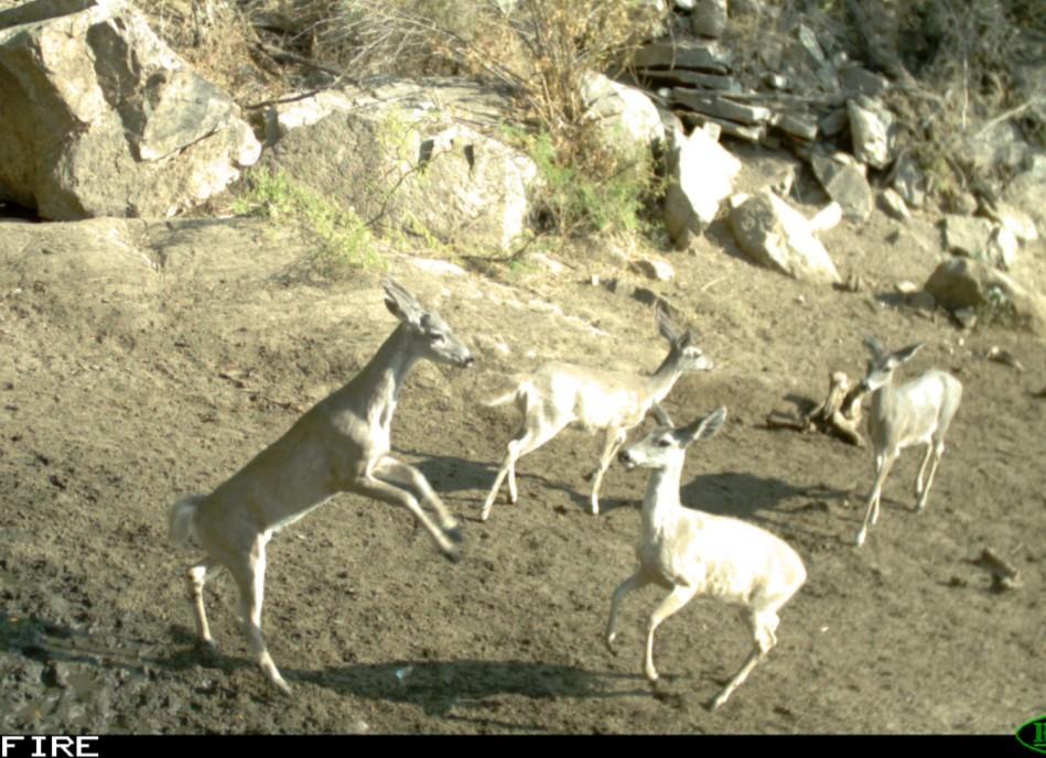
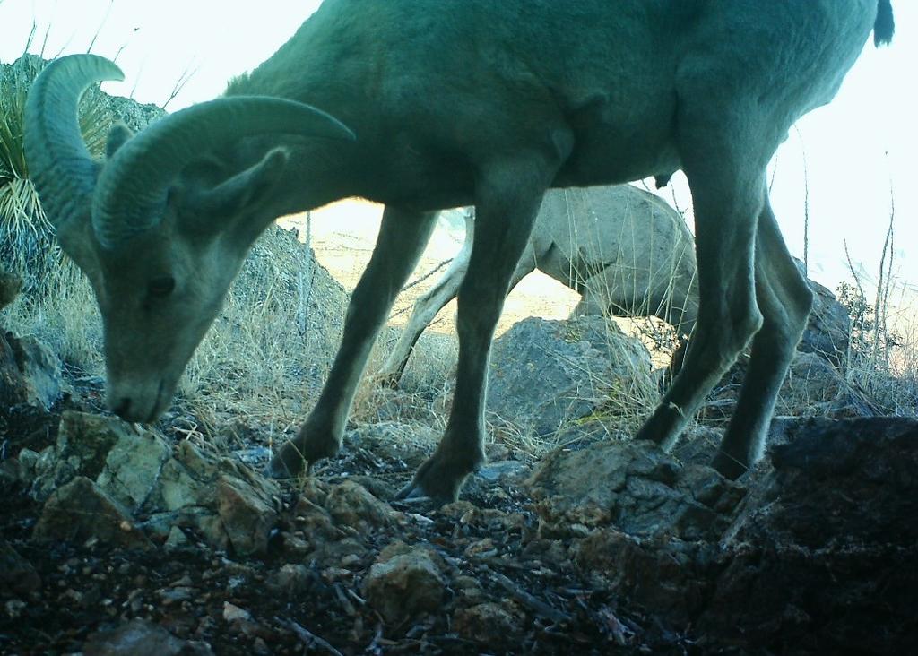
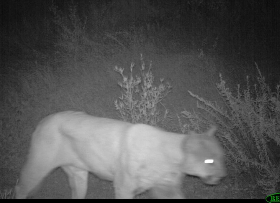
11 KITT PEAK LINKAGE CONNECTIVITY FOR HIGHLY MOBILE WILDLIFE SPECIES Desert bighorn sheep Mule deer Mountain lion


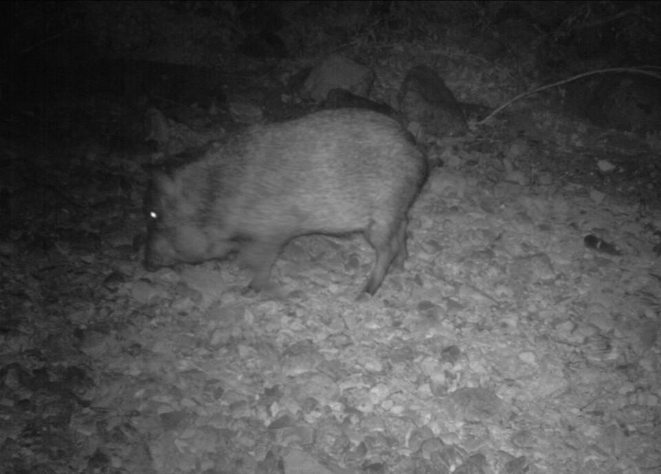
12 KITT PEAK LINKAGE PERMEABILITY FOR LOWER MOBILITY WILDLIFE SPECIES Javelina Spotted whiptail lizard Leaf-nosed snake Desert tortoise
13


14 KITT PEAK LINKAGE SPECIES CAPTURED ON EXISTING CAMERAS SOUTH OF UNDERPASSES Opossum Spotted skunk Ringtail


15 RECENT JAGUAR CRITICAL HABITAT DESIGNATION with Conservation Agreement designation for Tohono O odham Nation Kitt Peak Linkage


16 No. wildlife-vehicle collisions STATE ROUTE 86 WILDLIFE-VEHICLE COLLISIONS (Milepost ; ) KITT PEAK LINKAGE Wildlife-Vehicle Collision Hot Spot Milepost Source: ADOT

17 CURRENT STATUS OF RTA-FUNDED KITT PEAK LINKAGE PROJECT


18 WIDENING PROJECT ALONG KITT PEAK LINKAGE PROJECT OF OPPORTUNITY Kitt Peak & Santa Rosa projects presented an opportunity to address wildlife connectivity needs integrated with widening in a cost-effective manner Future reconstruction projects likely will not occur in next 20+ years Failure to seize this opportunity will forego addressing a priority linkage Culvert extension 30-foot safety clear zone Paved shoulder Examples from ongoing San Pedro Segment construction State Route 86
 8 miles of Wildlife Fence and 8 Escape Ramps (green")
19 INITIAL 2011 KITT PEAK CONNECTIVITY PROPOSAL REQUESTED ELEMENTS: 3 Passage Structures (2-3 underpasses and/or 1-2 overpasses) 8 miles of Wildlife Fence and 8 Escape Ramps (green above)
 RTA COMMITMENT TO: 1 Overpass to be built at a later date as a separate project (yellow above) 8 miles of wildlife fence and 8")
20 INITIAL 2011 KITT PEAK CONNECTIVITY PROPOSAL REQUESTED ELEMENTS: 3 Passage Structures (2-3 underpasses and/or 1-2 overpasses 8 miles of wildlife fence and 8 escape ramps RTA-APPROVED ELEMENTS: 2 Underpasses for implementation during widening project (red above) RTA COMMITMENT TO: 1 Overpass to be built at a later date as a separate project (yellow above) 8 miles of wildlife fence and 8 escape ramps (green above)
21 RTA- FUNDED PROJECT STATUS Both precast arch underpasses implemented awaiting final grading No wildlife fence funded will LIMIT effectiveness in meeting connectivity and highway safety objectives (based on AGFD research) Monitoring cameras (8) to be installed by June 2014 Santa Rosa Underpass MP Kitt Peak Underpass MP 134.9

")


22 RTA- FUNDED PROJECT STATUS Both precast arch underpasses implemented awaiting final grading No wildlife fence approved will LIMIT effectiveness in meeting connectivity and highway safety objectives (based on AGFD research) Monitoring cameras (8) to be installed by June 2014 RTA provided approximately $900,000 toward underpass cost ADOT underwrote cost for design, traffic control, and other indirect costs Santa Rosa Underpass MP Kitt Peak Underpass MP 134.9
23 CURRENT KITT PEAK LINKAGE PROPOSAL San Isidro Segment Evaluated the San Isidro widening project for connectivity options


24 Identified no underpass sites, but did identify a viable overpass site at MP CURRENT KITT PEAK LINKAGE PROPOSAL Looking southwest Looking northeast
25 Viable site at MP for construction of a bridged overpass CURRENT KITT PEAK LINKAGE PROPOSAL Looking southwest Looking northeast
26 Construct prior approved but unfunded Kitt Peak and Santa Rosa segment elements: Overpass at MP (orange dot) 43,360 LF of wildlife fence (green line) 8 escape ramps and 2 cattle guard extensions

 43,360 LF of wildlife fence")

 46,417LF of wildlife fence")
27 Construct prior approved but unfunded Kitt Peak and Santa Rosa segment elements: Overpass at MP (orange dot) 43,360 LF of wildlife fence (green line) 8 escape ramps and 2 cattle guard extensions Construct San Isidro Segment elements: Overpass at MP (yellow dot) 46,417LF of wildlife fence (green line) 8 escape ramps, and 1 cattle guard extension
28 CURRENT KITT PEAK LINKAGE PROPOSAL Spacing between Passage Structures Average passage structure spacing for all segments = 2.5 miles Several large concrete box culverts will accommodate passage for smaller animals State Route 86 Mileposts by Construction Project Segment Wildlife Passage Measure San Isidro Segment Santa Rosa Segment Wildlife Fencing MP Underpass Overpass 130 Kitt Peak Segment MP MP (4.3 miles) 134 MP MP MP (4.2 miles)

29 CURRENT KITT PEAK LINKAGE PROPOSAL Wildlife-Vehicle Collision Reduction Fenced Corridor Passage structures and wildlife fence should reduce MP wildlife-vehicle collisions by 80%
30 KITT PEAK LINKAGE RTA FUNDING REQUEST SINGLE OVERPASS OPTION* (Kitt Peak Segment only) Overpass, fencing, escape ramps, and cattle $1,662,440 guard extension construction costs Survey and clearances $225,000 Final Design $332,480 Construction mobilization, traffic control, $1,105,498 contingencies, and administration (RTA & ADOT) TOTAL RTA REQUEST** $3,383,636 *Reflects 2011 commitment made by RTA Wildlife Linkage Committee **Cost estimates developed by ADOT engineers and reviewed by RTA with eye to ensuring adequate funding to accomplish work
31 KITT PEAK LINKAGE RTA FUNDING REQUEST TWO OVERPASS OPTION Overpass, fencing, escape ramps, and cattle $3,314,393 guard extension construction costs Survey and clearances $450,000 Final Design $565,328 Construction mobilization, traffic control, $2,320,075 contingencies, and administration (RTA & ADOT) TOTAL RTA REQUEST* $6,649,796 *Cost estimates developed by ADOT engineers and reviewed by RTA with eye to ensuring adequate funding to accomplish work
32 PHASED IMPLEMENTATION APPROACH* PHASE 1 - Near-Term (6-12 months) Expedite design and construction of wildlife fence, escape ramps and cattle guard extensions on Kitt Peak and Santa Rosa segments Cost: $946,565 (both overpass options) PHASE 2 - Mid-Term (12-18 months) PHASE 3 - Long-Term (24-48 months) *Allows RTA to address current cash flow limitations and funding of other projects
33 PHASED IMPLEMENTATION APPROACH PHASE 1 - Near-Term (6-12 months) Expedite design and construction of wildlife fence, escape ramps and cattle guard extensions on Kitt Peak and Santa Rosa segments Cost: $946,565 (both overpass options) PHASE 2 - Mid-Term (12-18 months) Engineering, design and survey of overpass(es) and San Isidro Segment wildlife fence, escape ramps, and cattle guard extensions if approved Cost: $457,840 (single overpass option) $915,680 (two overpass option) PHASE 3 - Long-Term (24-48 months) Engineering, design and survey of overpass(es) and San Isidro Segment wildlife fence, escape ramps, and cattle guard extensions if approved Cost: $457,840 (single overpass option) $915,680 (two overpass option)
34 PHASED IMPLEMENTATION APPROACH PHASE 1 - Near-Term (6-12 months) Expedite design and construction of wildlife fence, escape ramps and cattle guard extensions on Kitt Peak and Santa Rosa segments Cost: $946,565 (both overpass options) PHASE 2 - Mid-Term (12-18 months) Engineering, design and survey of overpass(es) and San Isidro Segment wildlife fence, escape ramps, and cattle guard extensions if approved Cost: $457,840 (single overpass option) $915,680 (two overpass option) PHASE 3 - Long-Term (24-48 months) Construct overpass(es) and San Isidro Segment wildlife fencing, escape ramps, and cattle guard extensions Cost: $1,979,140 (single overpass option) $4,787,460 (two overpass option)

35 EFFECTIVENESS MONITORING Tohono O odham Nation and ADOT Environmental Services will cooperate on monitoring of overpass and underpass structure use by wildlife *Nation awarded US Fish & Wildlife Service Tribal Wildlife Grant funding to enhance/supplement wildlife connectivity projects on SR86*
36 THANK YOU!
KITT PEAK LINKAGE WILDLIFE CONNECTIVITY: WILDLIFE OVERPASSES AND FENCING State Route 86
 Pima County RTA Wildlife Connectivity Proposal KITT PEAK LINKAGE WILDLIFE CONNECTIVITY: WILDLIFE OVERPASSES AND FENCING State Route 86 Submitted by the: Tohono O odham Nation Department of Natural Resources
VISIONARY CONSERVATION PLANNING AND COMMUNITY SUPPORT BRING $45 MILLION IN ASSURED FUNDING TO WILDLIFE LINKAGE INFRASTRUCTURE IN PIMA COUNTY, ARIZONA
 Proceedings of the 2013 International Conference on Ecology and Transportation (ICOET 2013) VISIONARY CONSERVATION PLANNING AND COMMUNITY SUPPORT BRING $45 MILLION IN ASSURED FUNDING TO WILDLIFE LINKAGE
THE USE OF COLLABORATION, MONITORING, ADAPTIVE MANAGEMENT, AND PHASED CONSTRUCTION ON STATE HIGHWAY 9, COLORADO
 PROCEEDINGS OF THE 2017 INTERNATIONAL CONFERENCE ON ECOLOGY AND TRANSPORTATION THE USE OF COLLABORATION, MONITORING, ADAPTIVE MANAGEMENT, AND PHASED CONSTRUCTION ON STATE HIGHWAY 9, COLORADO Julia Kintsch
PANEL SESSION PRESENTATION A DECADE OF PROACTIVE PROGRESS IN RESOLVING ARIZONA HIGHWAY-WIDLIFE CONFLICTS
 Proceedings of the 2013 International Conference on Ecology and Transportation (ICOET 2013) PANEL SESSION PRESENTATION A DECADE OF PROACTIVE PROGRESS IN RESOLVING ARIZONA HIGHWAY-WIDLIFE CONFLICTS Norris
Evaluation of Measures to Reduce Wildlife-Vehicle Collisions and Promote Connectivity in a Sonoran Desert Environment State Route 77
 Progress Report Evaluation of Measures to Reduce Wildlife-Vehicle Collisions and Promote Connectivity in a Sonoran Desert Environment State Route 77 Santa Catalina Tortolita Mountain Corridor Presented
Southern Gateway Project and Public Green
 Southern Gateway Project and Public Green Transportation and Trinity River Project Committee May 23, 2016 Purpose of Presentation Provide the history and an overview of the Southern Gateway Project (SGP)
Guidelines for Bridge Construction or Maintenance to Accommodate Fish & Wildlife Movement and Passage
 Guidelines for Bridge Construction or Maintenance to Accommodate Fish & Wildlife Movement and Passage Arizona Game and Fish Department, Habitat Branch November 2008 Introduction/Background General Recommendations
The Pinal County Wildlife Connectivity Assessment: Report on Stakeholder Input
 The Pinal County Wildlife Connectivity Assessment: Report on Stakeholder Input April 2013 Bighorn sheep on highway in Arizona, photo by George Andrejko Arizona Game and Fish Department In partnership with
Office of Greenways & Trails Providing Statewide Leadership and Coordination. Southeast Greenways and Trails Summit October 1-3, 2017
 Office of Greenways & Trails Providing Statewide Leadership and Coordination Southeast Greenways and Trails Summit October 1-3, 2017 1 Office of Greenways and Trails The Office of Greenways and Trails
Wildlife Connections 101: Confronting the Challenge of Habitat Fragmentation
 Wildlife Connections 101: Confronting the Challenge of Habitat Fragmentation Dr. Raymond M. Sauvajot U.S. National Park Service Santa Monica Mountains National Recreation Area Habitat Fragmentation and
Executive Summary. Essential Connectivity Map (Figure ES-1)
") Executive Summary The California Department of Transportation (Caltrans) and California Department of Fish and Game (CDFG) commissioned the because a functional network of connected wildlands is essential
Executive Summary The California Department of Transportation (Caltrans) and California Department of Fish and Game (CDFG) commissioned the because a functional network of connected wildlands is essential
EXECUTIVE SUMMARY. Introduction
 EXECUTIVE SUMMARY Introduction State Route 68 is a designated scenic route that connects the world-renowned Monterey Peninsula to US Highway 101 and the Salinas Valley. SR 68 is a key route for bicycle,
APPENDIX C Agency Scoping Meeting Materials
 I-11 Corridor Tier 1 EIS Scoping Summary Report Final APPENDIX C Agency Scoping Meeting Materials Agency Scoping Meeting Agendas Agency Scoping Meeting Presentation Agency Scoping Meeting Boards Agency
Transportation Enhancements TE-2012-US Fish and Wildlife Service Quality of Life. Type of Improvement
 Transportation Enhancements 2012 Quality_of_Life Type of Improvement Infrastructure Bikeway Pedestrian Safety Quality of Life Purpose Primary project purpose is for constructing new bikeways (e.g. bike
COASTAL CONSERVANCY. Staff Recommendation March 25, 2004 LOS ANGELES GREEN VISION PLAN. File No.: Project Manager: Marc Beyeler
 COASTAL CONSERVANCY Staff Recommendation March 25, 2004 File No.: 04-014 Project Manager: Marc Beyeler RECOMMENDED ACTION: Authorization to disburse up to $50,000 to the University of Southern California
US 24 & SR 66 Interchange Modification and Corridor Improvement Project Public Involvement Meeting December 5, 2007
 US 24 & SR 66 Interchange Modification and Corridor Improvement Project Public Involvement Meeting December 5, 2007 Sponsored by: The Ohio Department of Transportation and The City of Defiance Project
Longmeadow Parkway Fox River Bridge Corridor. August 6, 2015
 Longmeadow Parkway Fox River Bridge Corridor August 6, 2015 Longmeadow Parkway Bridge Corridor 5.6 miles from Huntley Road to IL 62 Unique municipal/county/state/federal partnership Links Randall Road
Corridor Enhancements
 Corridor Enhancements Safety is MoDOT s first priority in widening and rebuilding I-70 across the state of Missouri. MoDOT also understands that the interstate - and its interchanges and overpasses - are
Appendix C Example Infrastructure Designs, Costs, and Schedules
 Appendix C Example Infrastructure Designs, Costs, and Schedules There is extensive scientific literature on the effectiveness and economic benefits of various infrastructure designs as mitigation for wildlife
Twin Peaks Road Wildlife Linkages Research Project Rattlesnake Pass, Marana, Arizona
 Twin Peaks Road Wildlife Linkages Research Project Rattlesnake Pass, Marana, Arizona Town of Marana Environmental Engineering Division Division Manager Jennifer Christelman Prepared by: Shawn F. Lowery,
Pinellas County Greenways
 Pinellas County Greenways USING GREENWAYS TO LINK OPEN SPACES The Florida Greenways Commission has defined a greenway as...a corridor of protected open space that is managed for conservation and/or recreation.
Proposed FY 2004 TRANSPORTATION CAPITAL PROGRAM New Jersey Department of Transportation Projects
 Carteret Industrial Road 98547 This project will address the upgrade of Carteret Industrial Road. The federal Transportation Equity Act for the 21st Century (TEA-21) provided funding for this project under
Integration of Planning & Environmental Analysis in Transportation
 Integration of Planning & Environmental Analysis in Transportation How Natural Resources Conservation Fits into SAFETEA-LU Planning Rules Transportation Research Board Annual Meeting January 2008 Jeff
INFRASTRUCTURE EXISTING INFRASTRUCTURE A. Circulation B. Signals C. Drainage D. Utilities
 7.01. EXISTING INFRASTRUCTURE A. Circulation B. Signals C. Drainage D. Utilities 7.02. PROPOSED INFRASTRUCTURE A. Overall Concept B. Circulation C. Signals D. Drainage 7.03. INFRASTRUCTURE MAP A. Key Infrastructure
Pinal Regional Transportation Plan
 Pinal Regional Transportation Plan Central Arizona Governments 1075 S. Idaho Road, Suite 300 Apache Junction, AZ 85119 June 2017 INTRODUCTION The Regional Transportation Plan for Pinal County, overseen
PARTF Scoring System for Grants
 PARTF Scoring System for Grants The members of the N.C. Parks and Recreation Authority use the PARTF scoring system as one of several tools to select grant recipients. Please provide all of the information
SAN MARTIN BOULEVARD OVER RIVIERA BAY PROJECT DEVELOPMENT & ENVIRONMENT (PD&E) STUDY
 STUDY") KICK-OFF PRESENTATION SAN MARTIN BOULEVARD OVER RIVIERA BAY PROJECT DEVELOPMENT & ENVIRONMENT (PD&E) STUDY PROJECT IDENTIFICATION NUMBER (PID): #001036A May 13, 2015 1 2 PROJECT LOCATION PROJECT HISTORY
KICK-OFF PRESENTATION SAN MARTIN BOULEVARD OVER RIVIERA BAY PROJECT DEVELOPMENT & ENVIRONMENT (PD&E) STUDY PROJECT IDENTIFICATION NUMBER (PID): #001036A May 13, 2015 1 2 PROJECT LOCATION PROJECT HISTORY
GREEN STREETS & INFRASTRUCTURE: A COUNTY APPROACH. Mimicking Nature to Manage Stormwater in Developed Areas
 GREEN STREETS & INFRASTRUCTURE: A COUNTY APPROACH Mimicking Nature to Manage Stormwater in Developed Areas Jennifer Gonzalez, Environmental Planner Passaic County Depar tment of Planning & Economic Development
GREEN SHEET ENVIRONMENTAL COMMITMENTS FOR THE IOWA HIGHWAY 100 EXTENSION
 County: Linn County, IA GREEN SHEET Location: IA 100, from its terminus at Edgewood Rd. to US 30 southwest of Cedar Rapids Route: IA 100 Extension Project No.: NHS-100-1(36) 19-57 OLE Project Managers:
Town of Yucca Valley Capital Improvement Projects Report July 24, 2014
 Town of Yucca Valley Capital Improvement Projects Report July 24, 2014 SR 62 Traffic and Pedestrian Improvements from Apache Trail to Palm Avenue (PLHD) The project includes construction of curbs, gutters,
2017 General Obligation Bond
 2017 General Obligation Bond Presentation of Public and Council Projects to the Transportation & Mobility Stakeholder Committee April 13, 2017 Agenda Deferred Maintenance Project Development Process Projects
1.0 Circulation Element
 5/9/18 1.0 Circulation Element 1.1 Introduction As growth and development occur in Apache County, enhancements to its circulation system will be necessary. With time, more roads will be paved and air and
NJ Habitat Connectivity Initiative
 NJ Habitat Connectivity Initiative Full Working Group Update #1 Spotted Salamander Crossing Road in Northern NJ Wildlife Habitat Connectivity Initiative A strategic plan to reconnect New Jersey s landscape
Project Study Report Equivalent The Old Road Widening SIX FLAGS MAGIC MOUNTAIN. On Street The Old Road Between Magic Mountain Pkwy And Turnberry Lane
 Project Study Report Equivalent The Old Road Widening SIX FLAGS MAGIC MOUNTAIN On Street The Old Road Between Magic Mountain Pkwy And Turnberry Lane On Street Henry Mayo Drive Between The Old Road And
Support for Walnut Creek Watershed Council. Adopt resolution of support for the newly formed Walnut Creek Watershed Council.
 CITY OF MARTINEZ CITY COUNCIL AGENDA March 6, 2013 TO: FROM: SUBJECT: DATE: Mayor and City Council Tim Tucker, City Engineer Support for Walnut Creek Watershed Council March 1, 2013 RECOMMENDATION: Adopt
Habitat Connectivity and Wildlife Corridor Stakeholder Meeting
 Habitat Connectivity and Wildlife Corridor Stakeholder Meeting VENTURA COUNTY PLANNING DIVISION JUNE 8, 2017 Agenda Introductions, Meeting Goal, and Format January 2017 Board Action Current Project Phasing
Public Review Draft Oceanside Subarea Habitat Conservation Plan/ Natural Communities Conservation Plan
 Oceanside Subarea Habitat Conservation Plan/ Natural Communities Conservation Plan Prepared for City of Oceanside Planning Department 300 N. Coast Highway Oceanside, CA 92054 Prepared by Ogden Environmental
Wildlife Linkages within the San Diego County Preserve System.
 Wildlife Linkages within the San Diego County Preserve System. Data Summary Prepared for: San Diego Association of Governments U.S. DEPARTMENT OF THE INTERIOR U.S. GEOLOGICAL SURVEY WESTERN ECOLOGICAL
Draft Working Paper 3 Corridor Needs, Performance and Feasibility
 Draft Working Paper 3 Corridor Needs, Performance and Feasibility Pima Association of Governments: State Transportation System Mobility and Regional Circulation Needs Feasibility Study (Loop Road Study)
SUNBRIDGE PARKWAY PRELIMINARY DESIGN STUDY. Board of County Commissioners Public Hearing
 SUNBRIDGE PARKWAY PRELIMINARY DESIGN STUDY Board of County Commissioners Public Hearing March 20, 2018 Presentation Overview Study Overview Existing Conditions Project Development Plan Public Involvement
Ventura County Planning Division. Roads and Biodiversity Project: Guidelines for Safe Wildlife Passage
 Ventura County Planning Division Roads and Biodiversity Project: Guidelines for Safe Wildlife Passage A project funded by the Southern California Association of Governments This project was a joint effort
CTH C RESURFACING Douglas County, Wisconsin
 Krech Ojard s Civil Group provides full range design and construction management services for municipal transportation and utility projects, as well as a variety of private developments. With a staff possessing
US 95 Phase 2B/5 Open House
 US 95 Phase 2B/5 Open House www.us95nw.com Wednesday, Mountain Crest Community Center 4701 N Durango Drive Las Vegas, NV 89129 Brian Sandoval Governor Rudy Malfabon Director Nevada Department of Transportation
Potential Solutions to Transportation-Wildlife Conflicts An Overview. Tony Clevenger WTI Montana State University
 Potential Solutions to Transportation-Wildlife Conflicts An Overview Tony Clevenger WTI Montana State University Effects on wildlife Habitat loss Wildlife mortality Decrease habitat quality Habitat fragmentation
Harbor Boulevard Wildlife Underpass, Los Angeles County, California
 Harbor Boulevard Wildlife Underpass, Los Angeles County, California INTRODUCTION Wildlife in the Los Angeles Basin now can cross between open space areas on either side of a busy boulevard due to a collaborative
TENNESSEE STATE ROUTE 109 CORRIDOR MANAGEMENT AGREEMENT MEMORANDUM OF UNDERSTANDING CORRIDOR MANAGEMENT ALONG STATE ROUTE 109
 TENNESSEE STATE ROUTE 109 CORRIDOR MANAGEMENT AGREEMENT MEMORANDUM OF UNDERSTANDING CORRIDOR MANAGEMENT ALONG STATE ROUTE 109 I. Purpose The purpose of this Agreement is to provide a framework for the
Irvington to Kino 138 kv Transmission Line Project April 2018
 EXHIBIT H: EXISTING PLANS To the extent applicant is able to determine, state the existing plans of the state, local government and private entities for other developments at or in the vicinity of the
Local roads, regional impact: Tracking mammals across roads in Western MA to connect the Appalachians
 Local roads, regional impact: Tracking mammals across roads in Western MA to connect the Appalachians Sept. 22, 2014 Photos Meredyth Babcock Photo Meredyth Babcock Riitters et al. 2000. http://www.consecol.org/vol4/iss2/art3/
Municipality of Anchorage. Community Council Survey Capital Projects Needs Ranking Survey (ALPHABETICAL) Airport Heights
 Airport Heights") ANCHORAGE PARKS & RECREATION Nichols Park Design and improve neighborhood park 2008 Challenge Grant applicant. 2008 $500K State Grant for Neighborhood Parks. Tikishla Park Lighting, paved parking, hockey
ANCHORAGE PARKS & RECREATION Nichols Park Design and improve neighborhood park 2008 Challenge Grant applicant. 2008 $500K State Grant for Neighborhood Parks. Tikishla Park Lighting, paved parking, hockey
July 12, Columbus City Council City Hall 90 West Broad Street Columbus, OH RE: I-70/71 Columbus Crossroads Project
 OHIO DEPARTMENT OF TRANSPORTATION DISTRICT 6 400 EAST WILLIAM STREET DELAWARE, OHIO 43015 800.372.7714 Columbus City Council City Hall 90 West Broad Street Columbus, OH 43215-9015 RE: I-70/71 Columbus
FY STATEWIDE TRANSPORTATION IMPROVEMENT PROGRAM New Jersey Department of Transportation Projects
 ROUTE/ Project ID No. TIP No. Burlington County Computerized Signal Control, IV D9911 D9911 This ITS project will be a traffic responsive signal system, consisting of 24 intersections--9 on CR 607, 4 on
RED LODGE CREEK SHANE RIDGE RANCH
 RED LODGE CREEK SHANE RIDGE RANCH Roberts, Montana 59070 For additional details, contact: SCOTT R. GROSSKOPF Broker / Owner Member Landmark of Billings 1925 Grand Avenue, Ste. 144, Billings, MT 59102 Office:
Memorandum CITY OF DALLAS
 Memorandum DATE September 23, 2016 CITY OF DALLAS TO The Honorable Members of the Transportation and Trinity River Project Committee: Lee M. Kleinman (Chair), Deputy Mayor Pro Tem Erik Wilson (Vice-Chair),
Issues Requiring Future Study
 Issues Requiring Future Study Transportation planning is an ongoing process that tends to identify new issues as it finds solutions for others. Some issues are so complex that a solution to one problem
Mead Mier, Watershed Planning Lead Pima Association of Governments
 Mead Mier, Watershed Planning Lead Pima Association of Governments Community Support Stormwater Management Transportation Policy Landscape Connectivity & Preservation Water Resource Strategies A.Inventory
Potential Green Infrastructure Strategies May 6, 2015 Workshop
 Potential Green Infrastructure Strategies May 6, 2015 Workshop Background The City of Cortland is developing the Tioughnioga Urban Headwaters Green Infrastructure Action Plan with funding from the National
Member Service Plan Sierra Nevada AmeriCorps Partnership
 Member Service Plan Sierra Nevada AmeriCorps Partnership Service plans lay the framework for what each Member will be doing during their service. Service plans detail the major projects and expected results
PUBLIC MEETING NO. 4 OCTOBER 29, 2013
 PUBLIC MEETING NO. 4 OCTOBER 29, 2013 Arizona Canal Multi-use Path Public Process Current Design Process Public Meeting #1 - December 6, 2012 Public Meeting #2 - May 1, 2013 Public Meeting #3 September
TRANSPORTATION COMMITTEE
 TRANSPORTATION COMMITTEE CITY OF OTTAWA Ministry of Transportation Detailed Design Assignment G.W.P.# 4058-01-00 Highway 417 (Ottawa Queensway) Widening & Rehabilitation from Maitland Avenue to Island
3.0 Cumulative Scenario and Methodology. 3.0 Cumulative Scenario and Methodology
 3.0 Cumulative Scenario and Methodology Under the CEQA Guidelines, a cumulative impact consists of an impact which is created as a result of the combination of the project evaluated in the environmental
TRANSPORTATION ELEMENT GOALS, OBJECTIVES, AND POLICIES
 TRANSPORTATION ELEMENT GOALS, OBJECTIVES, AND POLICIES GOAL 2 The City shall provide a safe, convenient, effective, and energy efficient multimodal transportation system which is coordinated with the Future
FHWA INVEST. And the Harbor Bridge Project
 FHWA INVEST And the Harbor Bridge Project FHWA s Sustainable Highways Initiative The Sustainable Highways Initiative supports programs and activities conducted across the Federal Highway Administration
Arizona's On-line Environmental Review Tool Search ID: Project Name: Sands Ranch 1 Date: 11/17/2008 3:57:05 PM.
 Project Location The Department appreciates the opportunity to provide in-depth comments and project review when additional information or environmental documentation becomes available. Special Status
October 28, May 25, 2010
 October 28, 2009 May 25, 2010 Jim Farr Staff Director, Acquisition and Restoration Council Office of Environmental Services Division of State Lands Florida Department of Environmental Protection 3900 Commonwealth
Preliminary Sea Level Rise Case Study: Navarre Beach, FL
 Preliminary Sea Level Rise Case Study: Navarre Beach, FL This publication was funded in part, through a grant agreement from the Florida Department of Environmental Protection, Florida Coastal Management
Construction Engineering & Inspection
 Construction Engineering & Inspection Serving Florida for 20 Years CEI Engineering Planning Landscape Architecture Urban Design Construction Engineering & Inspection (CEI) I N T R O D U C T I O N Over
Overall Map. Chicago. St. Louis. Summit. Joliet. Dwight. Pontiac. Bloomington-Normal Lincoln. Springfield. Carlinville. Alton EXPERIENCE IT YOURSELF.
 Overall Map Summit Chicago Bloomington-Normal Lincoln New Station Planned New Station Planned Dwight Pontiac Joliet Pedestrian overpass and second platform planned Higher speed service began in this section
SOUTHWEST CORRIDOR EXTENSION. Environmental Evaluation and Basic Engineering Results PUBLIC MEETING/OPEN HOUSE November 18, 2009
 SOUTHWEST CORRIDOR EXTENSION Environmental Evaluation and Basic Engineering Results PUBLIC MEETING/OPEN HOUSE November 18, 2009 AGENDA I. Welcome/Introductions II. Project Review and Status III. Environmental
N E W S R E L E A S E. Embargoed Until Tuesday, December 14, 2010
 N E W S R E L E A S E Embargoed Until Tuesday, December 14, 2010 From UA College of Engineering Communications by Pete Brown, Director of Communications, UA College of Engineering UA Engineering Tests
SUNBRIDGE PARKWAY PRELIMINARY DESIGN STUDY. November 30, 2017
 SUNBRIDGE PARKWAY PRELIMINARY DESIGN STUDY November 30, 2017 Agenda Introductions and Overview Study Purpose Study Approach Key Analysis Components Study Context Existing Conditions Corridor Constraints
1.16 million KM 2 5 States, 2 Provinces Integrated Partnerships with neighboring LCCs, NW and NC Climate Science Centers, PNW
 GNLCC Goal: Coordinate, facilitate, promote and add value to large landscape conservation to build resource resilience in the face of climate change and other landscape level stressors through: Support
How does the Program Work?
 Is your school interested in participating in a dynamic program that supports the development of a Schoolyard Habitat program at your school in association with a local National Wildlife Refuge? If so,
Dumbarton Transportation Corridor Study
 Dumbarton Transportation Corridor Study SPD&S Committee August 2, 2017 Agenda Item # 4 Two Bridges 2 Complex Corridor 3 Headlines Corridor requires phased improvements Solutions require consensus, other
4.1 Build Alternative 1 Construction Phasing
 SECTION 4 Implementation Plan This section discusses potential segmentation of the build alternatives into multiple projects for implementation of improvements to the NSH from Rabbit Creek Road to 36th
Dumbarton Transportation Corridor Study. Stakeholder/Public Meetings August 16, 2017
 Dumbarton Transportation Corridor Study Stakeholder/Public Meetings August 16, 2017 Two Bridges 2 Complex Corridor 3 Headlines Corridor requires phased improvements Solutions require consensus, other approvals
ARLINGTON COUNTY, VIRGINIA. County Board Agenda Item Meeting of January 28, 2017 SUPPLEMENTAL REPORT-2
 ARLINGTON COUNTY, VIRGINIA County Board Agenda Item Meeting of January 28, 2017 SUPPLEMENTAL REPORT-2 DATE: January 27, 2017 SUBJECT: The Virginia Department of Transportation s Transform I-66 Inside the
Right-of-Way Acquisitions and Relocations Technical Memorandum
 Right-of-Way Acquisitions and Relocations Technical Memorandum Southeast Extension Project Lincoln Station to RidgeGate Parkway Prepared for: Federal Transit Administration Prepared by: Denver Regional
Ventura County Planning Division. Roads and Biodiversity Project: Guidelines for Safe Wildlife Passage
 Ventura County Planning Division Roads and Biodiversity Project: Guidelines for Safe Wildlife Passage A project funded by the Southern California Association of Governments This project was a joint effort
Port of Seattle Street Vacations Summary April, 2016
 Port of Seattle Street Vacations Summary April, 2016 Since the question of street vacations provided to the Port was raised at the April 19 Sustainability and Transportation Committee, the Port is providing
The Benefits and Challenges Associated with Green Infrastructure Practices
 The Benefits and Challenges Associated with Green Infrastructure Practices Thomas M. Evans ASLA, LEED AP Regional Green Infrastructure Design Services Director OWEA Technical Conference, June 20, 2013
WELCOME TO OPEN HOUSE TWO November 28, 2018
 Langstaff Road Weston Road to Highway 7 Class Environmental Assessment Study WELCOME TO OPEN HOUSE TWO November 28, 2018 Please sign in and join our mailing list Study Overview York Region is conducting
ROAD CONSTRUCTION. 36 June 2014 ROADS&BRIDGES
 ROAD CONSTRUCTION 36 June 2014 ROADS&BRIDGES Young is full of life Recent expansion completes continuous, multilane arterial By Donald Hammack, P.E. Contributing Author The Florida Department of Transportation
Farmers Investment Co. (FICO) Sahuarita Farms Specific Plan & Minor General Plan Amendment Community Meeting July 1, 2014
 Sahuarita Farms Specific Plan & Minor General Plan Amendment Community Meeting July 1, 2014") Farmers Investment Co. (FICO) Sahuarita Farms Specific Plan & Minor General Plan Amendment Community Meeting July 1, 2014 FICO / Property Overview FICO Properties 7,000 Acres Total 5,900 Acres in Town
Farmers Investment Co. (FICO) Sahuarita Farms Specific Plan & Minor General Plan Amendment Community Meeting July 1, 2014 FICO / Property Overview FICO Properties 7,000 Acres Total 5,900 Acres in Town
Conserving Large Landscapes One Highway at a Time
 Conserving Large Landscapes One Highway at a Time Alex Taylor Tony Clevenger Western Transportation Institute Montana State University T Clevenger Content 1. Conserving Large Landscapes - Challenges 2.
Welcome. Northern Segment of Hwy 100 I-90 to South of Madison Street Meeting Goals:
 Welcome Northern Segment of Hwy 100 I-90 to South of Madison Street Meeting Goals: - Review Environmental Assessment - Share Preferred Alternative -Receive Public Comments 2003 EA Preferred Alternative
North Carolina Department of Transportation Project Development and Environmental Analysis Branch
 North Carolina Department of Transportation Project Development and Environmental Analysis Branch Citizens Informational Workshop I-85, from I-485 to NC 73 Mecklenburg and Cabarrus Counties October 30,
Capital Projects in and near Odenton Town Center
 Capital Projects in and near Odenton Town Center Map ID Anne Arundel County Department of Public Works This project provides for the design, right of way acquisition, and construction of approximately
SUMMARY Downtown Malabar Meeting on July 30, 2013 State Road (SR) 514 (Malabar Road) Project Development and Environment (PD&E) Study
 514 (Malabar Road) Project Development and Environment (PD&E) Study") SUMMARY Downtown Malabar Meeting on July 30, 2013 State Road (SR) 514 (Malabar Road) Project Development and Environment (PD&E) Study www.sr514malabar.com LOCATION: TIME: ATTENDEES: Malabar Town Hall 2725
SUMMARY Downtown Malabar Meeting on July 30, 2013 State Road (SR) 514 (Malabar Road) Project Development and Environment (PD&E) Study www.sr514malabar.com LOCATION: TIME: ATTENDEES: Malabar Town Hall 2725
Proposed FY 2004 TRANSPORTATION CAPITAL PROGRAM New Jersey Department of Transportation Projects
 30 130 Collingswood/Pennsauken ( B) 155C Vicinity of Cooper River Bridge at Park Drive to 200 feet north of PATCO Railroad Bridge This project may provide for the construction of a proposed new bridge
TABLE OF CONTENTS LIST OF FIGURES
 TABLE OF CONTENTS INTRODUCTION... 1 HYDRAULIC EVALUATION... 7 TRAFFIC EVALUATION & RECOMMENDATION... 8 UTILITIES... 13 GEOTECHNICAL EVALUATION... 14 ENVIRONMENTAL OVERVIEW... 15 AESTHETICS, WILDLIFE, AND
Meeting Purpose: Date and Time: Location: Attendance: Handouts:
 Meeting Purpose: Date and Time: Location: Attendance: Handouts: PA Turnpike / I-95 Interchange Project Design Advisory Committee (DAC)/Public Officials Meeting #8 April 12, 2012 at 1:30 p.m. Project Office,
I-90 Mississippi River Bridge & Interchange Project
 I-90 Mississippi River Bridge & Interchange Project Presentation Outline I. Background: Context & Need for Project II. Preferred Alternative Overview III. Project Development IV. Project Management Tools
SUMMARY. Support the Southeast Arkansas Regional Intermodal Facility.
 SUMMARY THE I-69 LOCATION STUDY The proposed I-69 Location Study from El Dorado to McGehee, Arkansas, represents one section (Section of Independent Utility No. 13) of the nationally designated I-69 Corridor
FY STATEWIDE TRANSPORTATION IMPROVEMENT PROGRAM New Jersey Department of Transportation Projects
 69th Street Bridge 02311 02311 A grade separation at 69th Street would eliminate the current at-grade crossing which causes frequent automobile delays due to long freight trains moving through this area.
Table of Contents TABLE OF CONTENTS SECTION TITLE PAGE
 TABLE OF CONTENTS SECTION TITLE PAGE 1 INTRODUCTION AND OVERVIEW 1-1 1.1 Purpose and Need 1-1 1.2 Goals and Objectives 1-3 1.3 Overview of the Planning Process 1-5 1.4 Federal and State Requirements and
3.1 Survey Monument Preservation Guidelines for New and Reconstruction Projects. B. After construction and prior to recording Notice of Completion:
 3.0 SURVEY 3.1 Survey Monument Preservation Guidelines for New and Reconstruction Projects A. Prior to construction: 1. Public survey records are to be researched for the location of all possible survey
Fall 2017 Construction Update
 Fall 2017 Construction Update Ward 4 Southeast Engineering Department Riverwalk Red Multi-Use Trail Bridge Rehabilitation The Riverwalk Red Multi Use Trail Bridge was awarded to Cramer and Associates,
The Illinois Department of Transportation and Lake County Division of Transportation. Route 173, including the Millburn Bypass
 The Illinois Department of Transportation and Lake County Division of Transportation welcome you to this Public Hearing for U.S. Route 45 from Illinois Route 132 to Illinois Route 173, including the Millburn
3. VISION AND GOALS. Vision Statement. Goals, Objectives and Policies
 Vision Statement Queen Creek s interconnected network of parks, trails, open spaces and recreation opportunities provide safe and diverse activities and programs that sustain its unique, small town, equestrian
NORTH-SOUTH CORRIDOR STUDY EXECUTIVE SUMMARY. Executive Summary
 Executive Summary Background As congestion continues to affect mobility in the region, the Ozarks Transportation Organization (OTO) is particularly concerned with traffic movement. The North-South Corridor