From Marine Pollution to Inland. Wildfire Mapping
|
|
|
- Edwina Leonard
- 5 years ago
- Views:
Transcription


 in support of the Fort")


1 From Marine Pollution to Inland Louis Armstrong Wildfire Mapping The Mobilization of the National Aerial Surveillance Program (NASP) in support of the Fort McMurray Wildfires TC Chief, Intelligence, Surveillance and Reconnaissance Kim Pearce MSc. Expert Technologist, MART Pacific Canadian Ice Service, Meteorological Service of Canada Environment and Climate Change Canada Tel: / Cel. :

2 Overview What is the NASP? Capabilities of the NASP Support of Fort McMurray Wildfires R&D and Potential application 2

3 National Aerial Surveillance Program Coast Guard pollution patrols commenced over the Great Lakes in 1968 Coast Guard expanded aerial surveillance operations in 1991 to cover Atlantic and Pacific coasts, thus creating the NASP. In 2003, the NASP moved to Transport Canada. In 2005, acquired remote sensor suite The NASP is Transport Canada s primary method for detecting illegal discharges at sea. Current partnership between TC Marine Safety and Security, TC ASD and Environment Canada (EC) Marine Aerial Reconnaissance Team (MART) allows for multitasking and shared costs.

4 Marine Aerial Reconnaissance Team (MART) Group of Environment and Climate Change Canada Canadian Ice Service employees who conduct the mission planning and execution on board TC NASP aircraft Created 2006 when the MSS-6000 was installed on the first Dash8 MART role: observe, analyze, record and report primarily maritime, but also land-based phenomena, from an aerial platform. 4


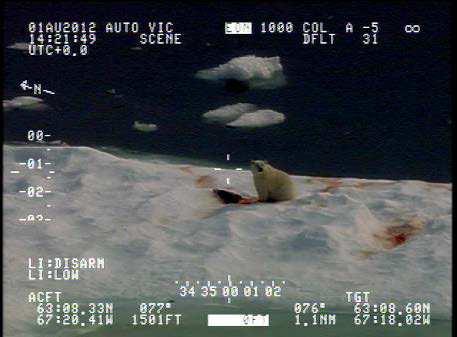
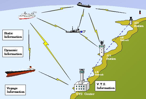
5 Why does TC Conduct Surveillance? Accidental or intentional discharges of oil Increase in AIS traffic The prevention of oiled wildlife Identification of vessels in marine protected areas Our department s role in maritime security Ensure public confidence in Canada s Transportation System 5


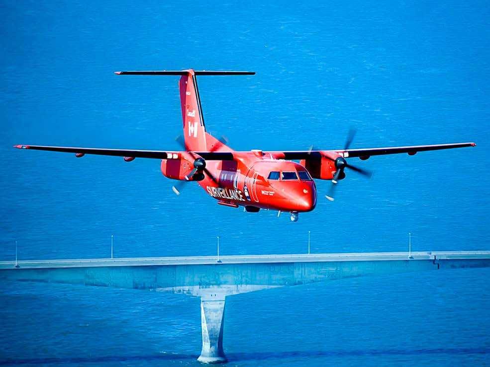
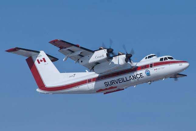
6 Program Resources 3 TC Aircraft 3 teams that cover Canada s 3 Oceans ~ 40 People across Canada + Private Industry contract aircraft Provincial Airlines (PAL) Surveillance in Newfoundland and Labrador 6
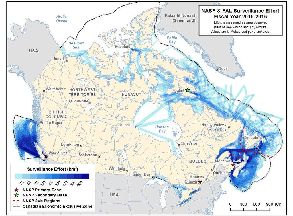
7


8 NASP Activities Search & Rescue / Search & Assist Detection of Illegal Discharges Emergency Response Ice Reconnaissance Participation In Exercises NATIONAL AERIAL SURVEILLANCE PROGRAM Marine Security Science Fisheries Patrol Air Quality Monitoring Wildlife Monitoring


9 Marine and land-based SAR support as secondary resource Search for downed Russian helicopter in Davis Strait provided ice data to response vessels Search for downed aircraft in northern Quebec
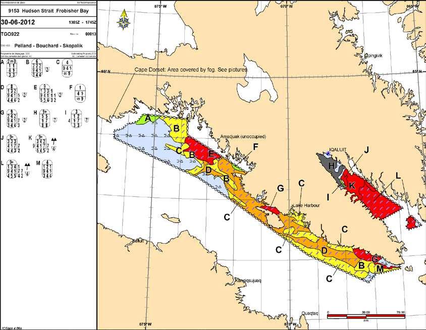
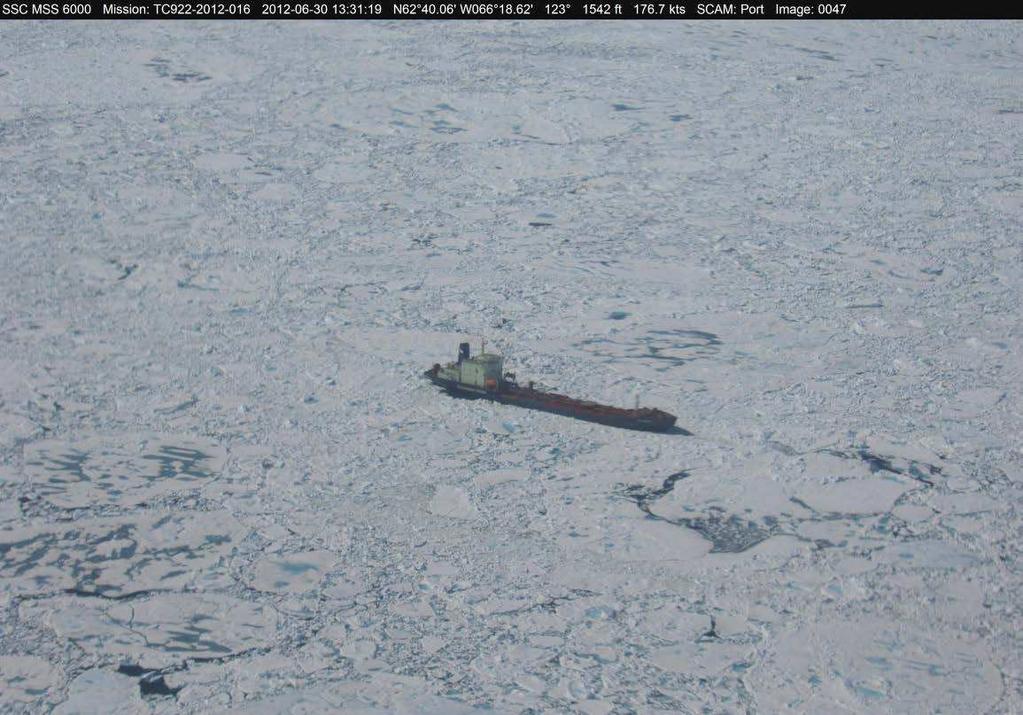
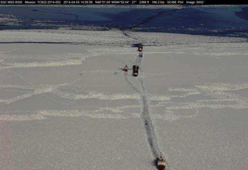
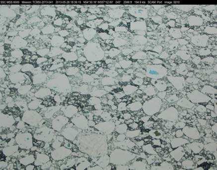
10 Ice Reconnaissance 10


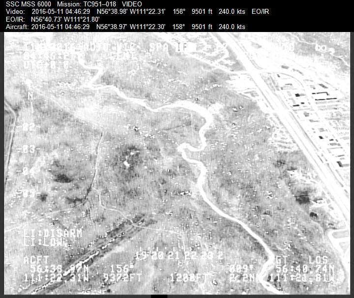
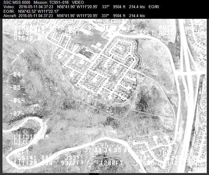
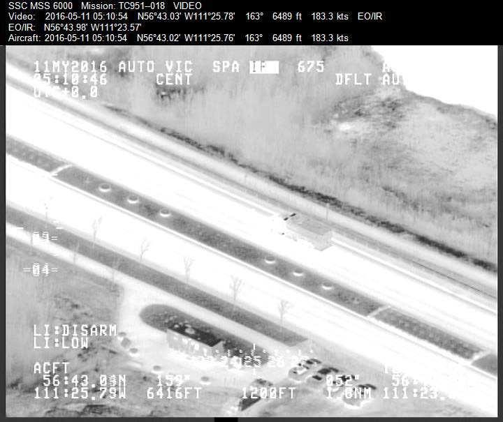
11 Support During Emergency Response Situations May include events such as: Public Safety Ships stuck in ice Marine Casualties Floods Support to OGDs Response to Pollution Incidents Wildfires The MX-15 camera and the live streaming video were vital with this operation 11


12 Support during Environmental Emergencies Lac Mégantic rail incident Gogama train derailment


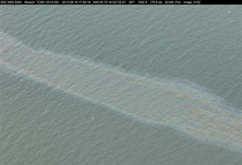
13 Providing support during emergency response Mapping the total spatial extent of surface oil over large areas like this example from


14 Marine Security Migrant Vessels Verifying that vessels inbound to Canada appear on an approved list Identifying suspicious vessels 14
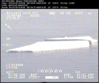
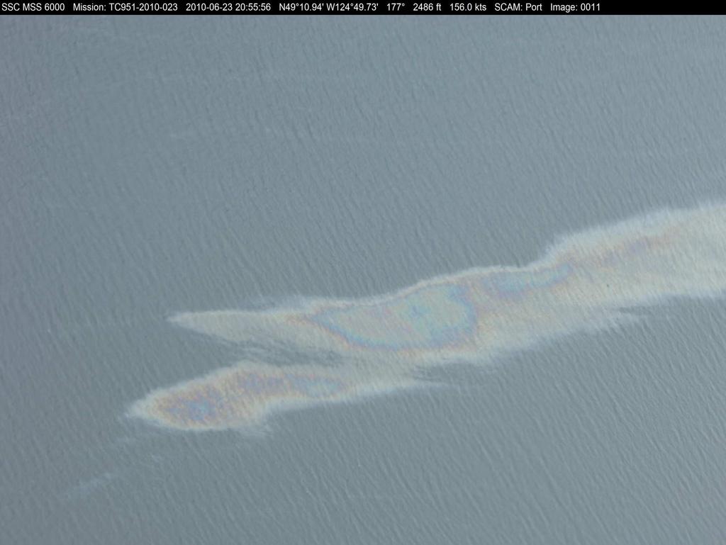
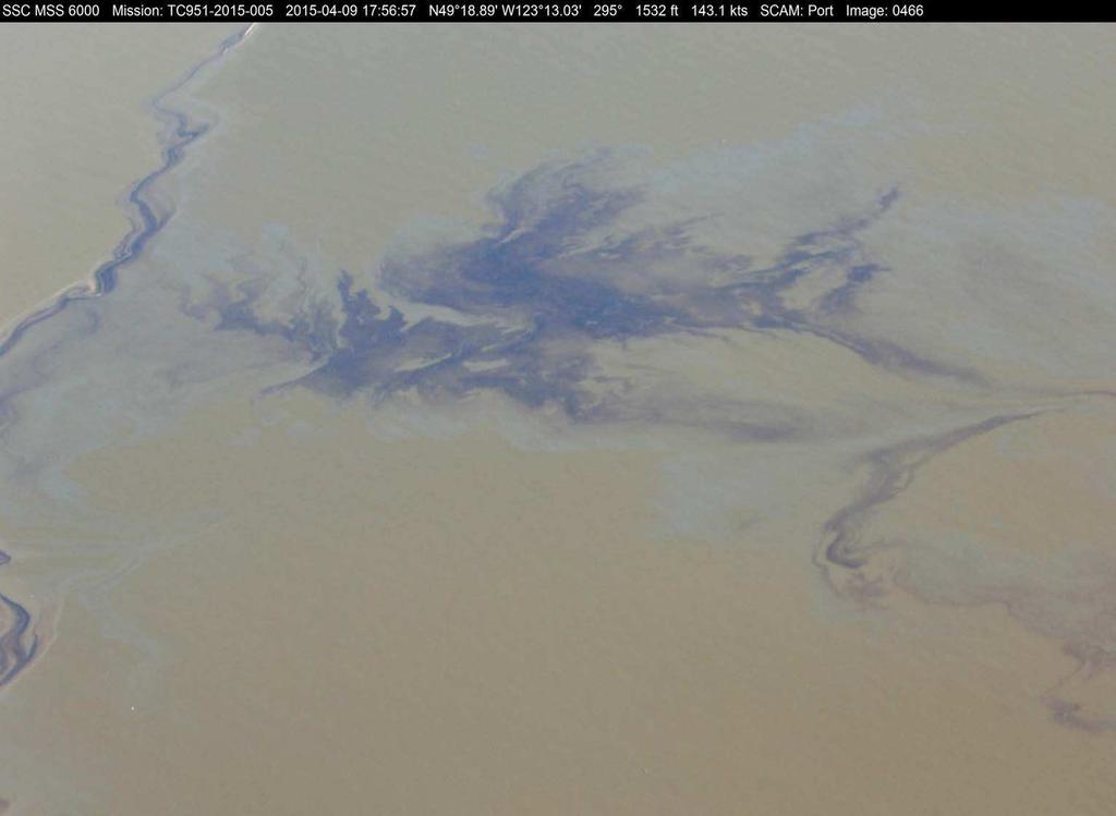
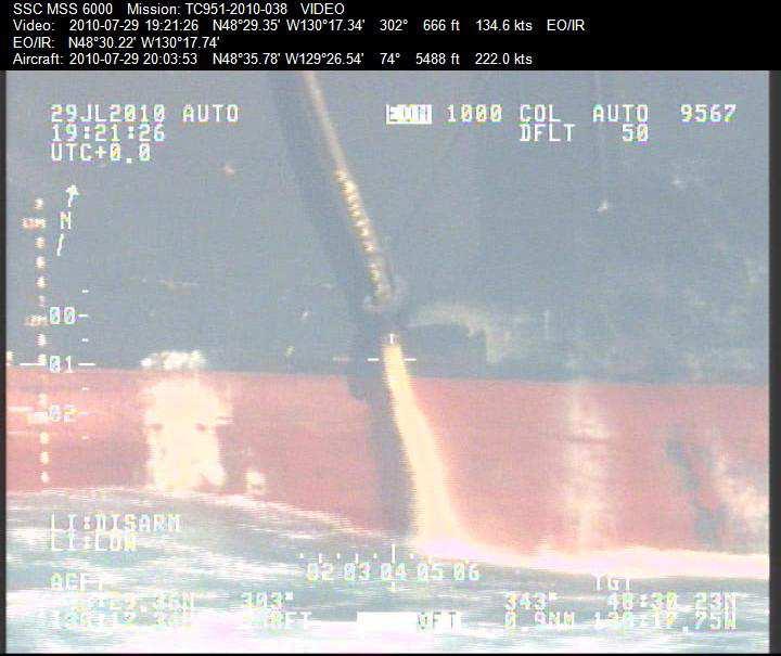
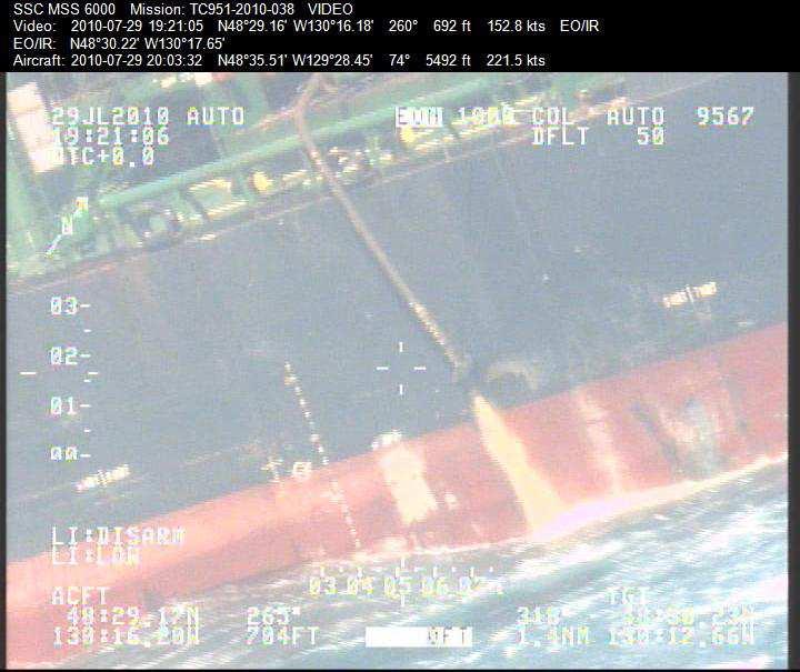
15 The Integrated Satellite Tracking of Pollution (ISTOP) Program June 17, 2012 Incident 15
16 The Integrated Satellite Tracking of Pollution (ISTOP) Program Category 1A ISTOP detected an anomaly originating from the Hibernia platform 306 litre spill confirmed by the aircraft the next day. June 17, 2012 Incident 16


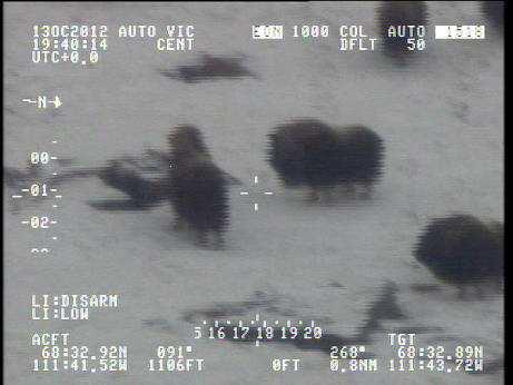
17 Arctic Fisheries and Wildlife Monitoring


18 Marine Mammal Surveys Whale Researches on board conducting transects to determine populations and Red = fin whale Orange = large unidentified whale or like fin whale or unidentified baleen whale Yellow = humpback Blue stars = blue whale Smaller yellow star = baird s beaked whale Purple = sperm whale Grey = Risso s dolphin, pacific white sided dolphin, northern right whale dolphin and all other dolphin/porpoise Black - killer whale Lime green = grey whale White = Cuvier s beaked whale 18


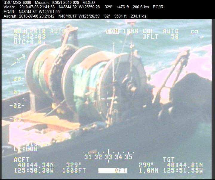
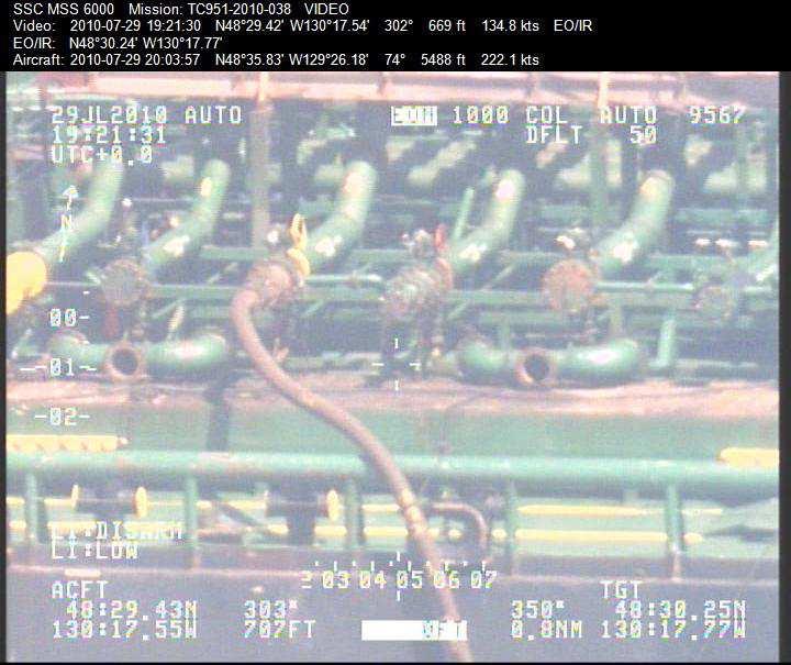
19 MSS-6000 and MX-15 Capabilities of the NASP with the Surveillance System
20 NASP Surveillance System Components SLAR AIS SATCOM EO/IR IR/UV Cameras
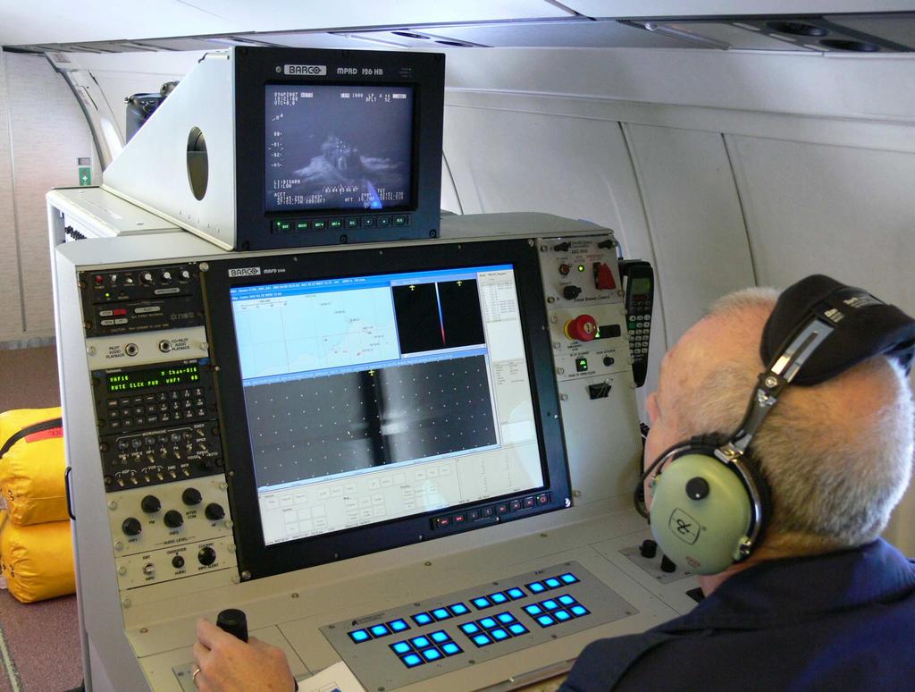
21

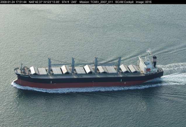
22 Digital Still & Video Camera Systems GPS Annotated Data: Mission #: TC951_2010_086 Date: Time: 16:41:25 Latitude: N Longitude: W Altitude: 1489 ft Speed: kts Image #: 0026


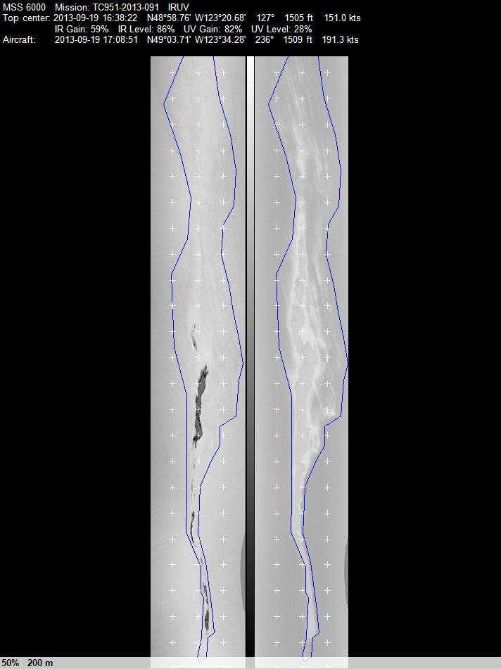
23 Documenting Hydrocarbons on the Water DISTINCTIVE RAINBOW COLOUR PATTERN COLOURS BECOME MORE TERRA-COTTA AND TURQUOISE AS THICKNESS INCREASES 23
24
25


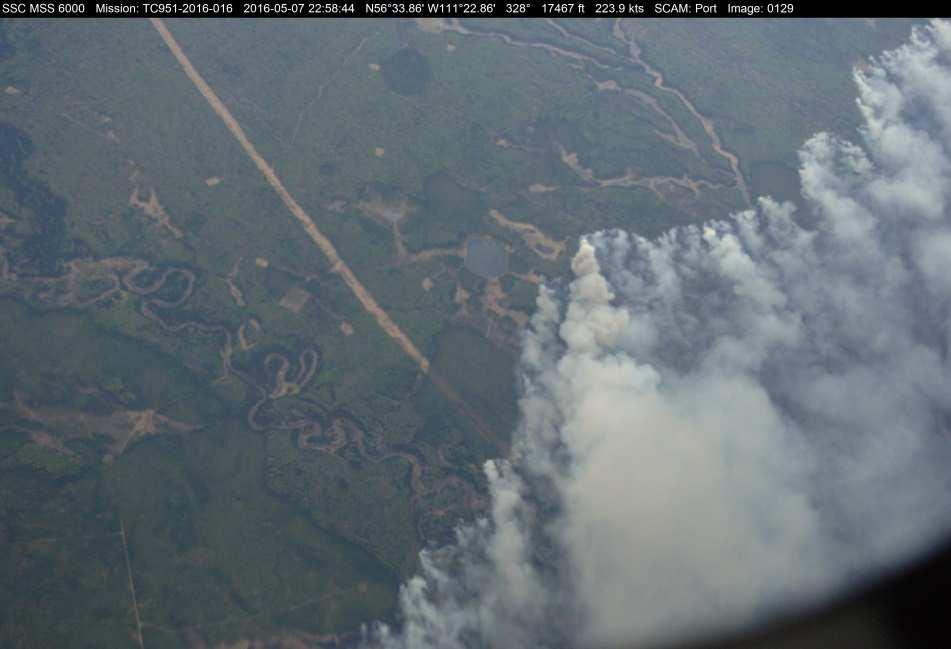
26 Images for Wildfire support 26

27 Wildfire Support Damage Assessment 27
 Dual Channel Spotter Lens Fixed focal length (Daylight Camera & Low Light Camera) (EON) Laser illuminated Night Spotter (Illuminates the target in total")
28 Electro Optical Infrared (EO/IR) WESCAM MX 15 EO/IR 4 sensors Infrared Camera w/ high magnification 4 step zoom Colour Daylight Camera with continuous Zoom Lens (EOW) Dual Channel Spotter Lens Fixed focal length (Daylight Camera & Low Light Camera) (EON) Laser illuminated Night Spotter (Illuminates the target in total darkness)
 targets for the records, both day and night, & during conditions of reduced visibility.")
29 Electro Optical Infrared (EO/IR) Primary use: Identification and analysis of targets from far away. Secondary use: To document (stored frames or video clips) targets for the records, both day and night, & during conditions of reduced visibility. Covert Operation: Positive subject identification (ship names) in total darkness Images from this system can be live streamed, recorded and still images taken
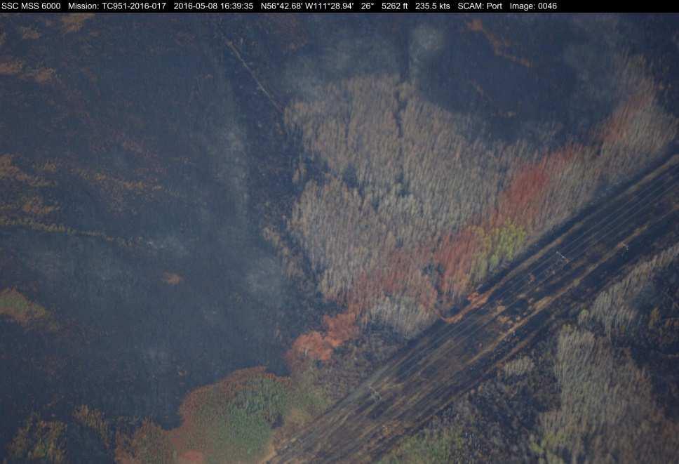
30
31 31
32 32
33

34 Tasking to Support Wood Buffalo Wildfire 34


35 Live Streaming Video See what crew see while they are overhead Available to select TC and OGD staff Not secure Stream only when required as it is expensive Requires small software package to be installed on computer or ipad 35
 - thicker sections (UV) - extent of oil spill Data are georeferenced Used to map spatial extent of oil spills and get area of coverage")
36 IR/UV Line Scanner IR UV Detects oil on surface. (IR) - thicker sections (UV) - extent of oil spill Data are georeferenced Used to map spatial extent of oil spills and get area of coverage Draw polygon around the oil Assists in determining where are the heaviest concentrations of oil
37
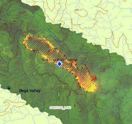
38

39
40 NASP IR imagery Night time fire mapping 40
41 Side Looking Aerial Radar (SLAR) Microwave energy is reflected by microscopic waves on the ocean surface when enough wind is present. The lack of wind and these capillary waves prevents backscatter from returning to the SLAR antennas, thus creating a darker appearance on the display. Swath width with visual surveillance (Naked Eye) - 4 nm (2 nm each side) Swath width using SLAR - 90 nm (45 nm each side) vessels - 30 nm (15 nm each side) oil detection - 80 nm (40 nm each side) strip map ice Increases effectiveness by expanding window of opportunity for Surveillance. Can be used during conditions of reduced visibility.

42 SLAR anomaly/oil slick SLAR target - Outbound tanker
43 SLAR anomaly/oil SLAR target - Outbound tanker
44 SLAR anomaly/oil SLAR target - Outbound tanker

")
 gathered video, still images")
45 Wood Buffalo Fire Support Day 1 Vancouver to Edmonton picked up Dr. Josh Johnston (Forest Fire Research Scientist, Natural Resources Canada) Conducted early evening overflight (daylight) gathered video, still images and some IR legs converted to GEOTIFFs 45

 Gathered video, still")


46 Wood Buffalo Fire Support Day 2 Conducted early evening overflight of Fort McMurray for IR scanning (daylight) Gathered video, still images and IR data converted to GEOTIFFs. Procedures needed to be refined to enhance data and also image resolution needed to be addressed. 46

47 Wood Buffalo Fire Support Day 3 Tasking Received 47


48 Tasking results Hot spot mapping IR Line scans 48
49 Hotspot map made inflight 49


50 Hotspot map made inflight 50
51 51

 or")
52 Tasking Expectations What data are expected? What format? Raw data versus processed data Inflight (near real time) or post-processed 52
53 53
54 54


55 Wood Buffalo Fire Support Day 4-5 Tasking 55

56 Raw, unprocessed IR imagery 56

57 How does NASP get here? 57

58 NASP Capability - IR Night time fire mapping 58
59 Process imagery 59

60 Process imagery 60

61 Processed imagery 61

62 NASP IR imagery Day time fire mapping 62

63 Composite Image with GIS layers 63
64 Fire Progression Mapping 64


65 Fire Progression Mapping 1 Hour later ~750 m advance/1 hr 65
66 Fire mapping Process, orthorectify and mask raw imagery Determine and run cell classification Build maps of active fire burning Provide products useable to command centre and responders in a timely fashion. Hot Spot mapping Georeference hot spots Associate spots to images Create maps and image catalogue / database for easy reference by command or responders 66
67 Tasking Fire mapping Process, orthorectify and mask raw imagery Determine and run cell classification Build maps of active fire burning Provide products useable to command centre and responders in a timely fashion. Hot Spot mapping Georeference hot spots Associate spots to images Create maps and image catalogue / database for easy reference by command or responders 67

68 Tasking Client Need? Fire mapping Process, orthorectify and mask raw imagery Determine and run cell classification Build maps of active fire burning Provide products useable to command centre and responders in a timely fashion. Hot Spot mapping Georeference hot spots Associate spots to images Create maps and image catalogue / database for easy reference by command or responders 68
69 R&D Tasking Client Need? Fire mapping Process, orthorectify and mask raw imagery Determine and run cell classification Build maps of active fire burning Provide products useable to command centre and responders in a timely fashion. Hot Spot mapping Georeference hot spots Associate spots to images Create maps and image catalogue / database for easy reference by command or responders 69
70 What we have what we need Have: Deployable aircraft with crew IR/UV linescanner EO/IR camera Can get raw remote sensed data Need to: Gauge stakeholders (clients) interest What can we do above and beyond private industry R&D to process files and streamline for operational use Need to develop SOPs and training for operators in data acquisition and processing 70

")
71 Future Initiatives If this resource is of interest for wildfire support: Seek funding for R&D Possibly upgrade equipment (MX-15 and/or linescanner) 71

")
 666-3927 Cell: (604) 787-2046 Joshua M.")

72 Thank You Louis Armstrong Transport Canada Chief, Intelligence, Surveillance and Reconnaissance Cell: (613) Kim Pearce MSc. Expert Technologist, Marine Aerial Reconnaissance Team (MART) Environment and Climate Change Canada Office: (604) Cell: (604) Joshua M. Johnston, PhD Forest Fire Research Scientist, Natural Resources Canada Canadian Forest Service, Great Lakes Forestry Centre Office: (705)
73 73
74 Mission Planning for Wildfire - IR/UV Scanner Altitude Swath Pixel Resolution 1500ft ~ 750 m 3 x 3 m 8000ft ~ 4km 14 x 14 m 74
ALBERTA FOREST PROTECTION THERMAL INFRARED PROGRAM
 ALBERTA FOREST PROTECTION THERMAL INFRARED PROGRAM Eleventh Biennial USDA Forest Service Remote Sensing Applications Conference Salt Lake City, Utah April 25 Ken Dutchak, P. Biol. Reconnaissance and Remote
National Infrared Operations (NIROPS) Program Overview. Tom Mellin National Infrared Program Manager
 Program Overview. Tom Mellin National Infrared Program Manager") National Infrared Operations (NIROPS) Program Overview Tom Mellin National Infrared Program Manager Topics NIROPS organization Phoenix imaging system Aircraft Data delivery to infrared interpreters IRIN
National Infrared Operations (NIROPS) Program Overview Tom Mellin National Infrared Program Manager Topics NIROPS organization Phoenix imaging system Aircraft Data delivery to infrared interpreters IRIN
Ocean Visuals early warning of oil spills and environmental monitoring
 Ocean Visuals early warning of oil spills and environmental monitoring Christian Testman Chief Executive Officer Achilles JQS Qualified Content 1. Application areas 2. About us 3. Technology 4. Product
LVSS FLIR LIGHTWEIGHT VEHICLE SURVEILLANCE SYSTEM
 LVSS FLIR TM LIGHTWEIGHT VEHICLE SURVEILLANCE SYSTEM SINGLE OPERATOR. FAST DEPLOYMENT. ANYWHERE. Protecting vast and remote borders, shorelines, and forward-operating bases requires speed, mobility and
Automating Wide Area Surveillance with Radar, AIS, and GPS. Dan Flynn Honeywell July 19, 2007
 Automating Wide Area Surveillance with Radar, AIS, and GPS Dan Flynn Honeywell July 19, 2007 Agenda Typical System Architecture Detection Sensors Automation System Responses System Performance and Limitations
Standoff CWA/TIC Detection. Innovation with Integrity. Toxic Gas/Vapour Threat Mitigation RAPIDplus CBRNE
 Standoff CWA/TIC Detection Toxic Gas/Vapour Threat Mitigation RAPIDplus Innovation with Integrity CBRNE Choose Innovation Choose Bruker Toxic Gas Threat Mitigation: RAPIDplus Bruker is recognised as the
1.1. SYSTEM MODELING
 1 INTRODUCTION Electro-optical imaging system analysis is a mathematical construct that provides an optimum design through appropriate trade studies. A comprehensive model includes the target, background,
Methane to Markets Oil and Natural Gas Technology Transfer Workshop
 Methane to Markets Oil and Natural Gas Technology Transfer Workshop Detection and Measurement of Fugitive Emissions Using Airborne Differential Absorption Lidar (DIAL) Daniel Brake ANGEL Service ITT Space
UNCOOLED THERMAL SYSTEM
 DEFENSE AND SECURITY UNCOOLED THERMAL SYSTEM Advanced observation and aiming for armoured vehicles indracompany.com MVT-075-OP UNCOOLED THERMAL SYSTEM Thermal sensor The MVT-075-OP uncooled thermal system
CleanSeaNet First Generation. 16 April January 2011
 CleanSeaNet First Generation 16 April 2007-31 January 2011 Cover photo credits: European Space Agency (http://www.esa.int) All maps and tables generated by EMSA based on CleanSeaNet data CleanSeaNet First
DETECTION AND MONITORING OF ACTIVE FIRES USING REMOTE SENSING TECHNIQUES
 DETECTION AND MONITORING OF ACTIVE FIRES USING REMOTE SENSING TECHNIQUES Source: Unknown n.d., http://www.hotrodsandclassics.net/featuredpictures/featurepictures2.htm. by Claire Riddell DETECTION AND MONITORING
DFPC s Toolbox. Colorado Fire Prediction System (CO-FPS)
") DFPC s Toolbox Colorado Fire Prediction System (CO-FPS) Wildfire in Colorado 68% of Colorado s forested lands are under federal jurisdiction The Wildland-Urban Interface in Colorado is currently 1.1 million
DFPC s Toolbox Colorado Fire Prediction System (CO-FPS) Wildfire in Colorado 68% of Colorado s forested lands are under federal jurisdiction The Wildland-Urban Interface in Colorado is currently 1.1 million
Bringing Smarts to Methane Emissions Detection
 Bringing Smarts to Methane Emissions Detection An Update on the DOE Smart Methane Emissions Project Maria Araujo Manager R&D Southwest Research Institute Background Fugitive emissions from compressors
Optech Thermal IR Sensing Solutions Expanding the Industry
 Optech Thermal IR Sensing Solutions Expanding the Industry Optech Overview Strategic Growth through acquisitions of camera manufacturers 20 Years of Patented & Proven Camera System Experience Broader Imaging
Guidance on Video Smoke Detection Technology (VSD)
") Guidance Note Guidance on Video Smoke Detection Technology (VSD) Guidance on Video Smoke Detection Technology (VSD) SCOPE... 3 INTRODUCTION... 4 WHAT IS VSD?... 5 STANDARDS... 7 GENERAL GUIDANCE ON THE
Guidance Note Guidance on Video Smoke Detection Technology (VSD) Guidance on Video Smoke Detection Technology (VSD) SCOPE... 3 INTRODUCTION... 4 WHAT IS VSD?... 5 STANDARDS... 7 GENERAL GUIDANCE ON THE
R O EARLY DETECTION SYSTEM FOR OIL ON WATER
 R O EARLY DETECTION SYSTEM FOR OIL ON WATER REMOTE OPTICAL WATCHER ROW DETECTS: motor oils, turbine oils, vegetable oils, fuel oils, marine diesel oils, crude oils, heating oils, gas oils, jet fuels, lube
Colonel Paul Hargrove
 Colonel Paul Hargrove 1 PAST- MAFFS - Why was the Program Established? 1) MAFFS Program was established by Congress in 1970 after the Laguna Fire burned in San Diego County - Caused by downed power lines
Aetos Overview. Mistras Internal and External Customers 03/27/2017 R1.4 D E L I V E R I N G A S S E T P R OT EC T I O N S O LU T I O N S GLO BALLY
 Aetos Overview Mistras Internal and External Customers 03/27/2017 R1.4 D E L I V E R I N G A S S E T P R OT EC T I O N S O LU T I O N S GLO BALLY OUR MISSION Cost effectively reduce or eliminate the need
Interim evaluation of the New IR Sensor Technology (NIRST) as a wildfire monitoring tool
 as a wildfire monitoring tool") Interim evaluation of the New IR Sensor Technology (NIRST) as a wildfire monitoring tool Joshua Johnston Forest Fire Analyst Canadian Forest Service Great Lakes Forestry Centre Sault Ste. Marie, Ontario
Interim evaluation of the New IR Sensor Technology (NIRST) as a wildfire monitoring tool Joshua Johnston Forest Fire Analyst Canadian Forest Service Great Lakes Forestry Centre Sault Ste. Marie, Ontario
Chem-Bio Protection Without Chem- Bio Sensors:
 Chem-Bio Protection Without Chem- Bio Sensors: Low Cost, Dual Use, Alternative Sensor and Information Architectures Steven S. Streetman ENSCO, Inc. October 24, 2005 Overview / Disclaimer Current Sensor
Equipment Based on NDT Technique and Used in Security and Safety Provision Systems
 18th World Conference on Nondestructive Testing, 16-20 April 2012, Durban, South Africa Equipment Based on NDT Technique and Used in Security and Safety Provision Systems Alexey A. Kovalev 1, Alexey V.
Base and Deployable Automated Video Surveillance Systems
 Base and Deployable Automated Video Surveillance Systems Automated Video Surveillance test Detects & Tracks Activity Processes Video Data Compares to a User Defined Alarm Map Security Breach? A Force Multiplier
Threat Warning System
 Threat Warning System Objective Install an effective system to provide security monitoring and detection for borders, pipelines and critical infrastructure. The system must be: Proven Robust State of the
ONDULUS IR SIMULATION MATERIALIZE. CUSTOMIZE. SIMULATE
 SIMULATION ONDULUS IR MATERIALIZE. CUSTOMIZE. SIMULATE Ondulus IR gives simulations and training scenarios a critical component: physics-based infrared sensors. By adding real-time, high-quality materials-based
Fire FY Performance Plan
 I. Mission Statement In partnership with our community, we will; Be prepared Respond quickly Solve problems Be nice Get home safely Fire II. Department Overview The Marin County Fire Department was established
2015 NEW PRODUCTS. NOW EXPORTING THE UTAC-STS! THERMAL CLIP-ON WEAPON SIGHT WITH AN IR LASER POINTER.
 2015 2015 NEW PRODUCTS NOW EXPORTING THE UTAC-STS! THERMAL CLIP-ON WEAPON SIGHT WITH AN IR LASER POINTER. NEW DOD GUIDELINES ALLOW EXPORT OF THE NVAG-9 AVIATION GOGGLE WITH AUTOGATING TECHNOLOGY. NEW!
Development of a Canadian Wildland Fire Monitoring Sensor (CWFMS)
") Unclassified Development of a Canadian Wildland Fire Monitoring Sensor (CWFMS) Helena (Marleen) van Mierlo 1 Linh Ngo Phong 1 Steeve Montminy 1 Joshua M. Johnston 2 Denis Dufour 3 (1) Canadian Space Agency
Unclassified Development of a Canadian Wildland Fire Monitoring Sensor (CWFMS) Helena (Marleen) van Mierlo 1 Linh Ngo Phong 1 Steeve Montminy 1 Joshua M. Johnston 2 Denis Dufour 3 (1) Canadian Space Agency
Totally Wireless Video Security
 Totally Wireless Video Security Traditional Video Surveillance ($50,000+) vs. Event-Based Videofied Solution ($2,500) Executive Summary: Totally Wireless Video Security has been effective but cost and
Strategic Research Agenda for. High-Altitude Aircraft and Airship. Remote Sensing Applications
 Strategic Research Agenda for USE HAAS High-Altitude Aircraft and Airship Remote Sensing Applications Christian Barbier (CSL, B), Bavo Delauré (VITO, B), Arie Lavie (CTI, Is) 1 OUTLINE 1. The USE HAAS
Light Detection and Ranging LiDAR and the FAA FAA Review and Reclassification of LiDAR systems
 Light Detection and Ranging LiDAR and the FAA FAA Review and Reclassification of LiDAR systems February 2014 What is MAPPS? + The national professional association of private sector geospatial firms in
SUPERYACHT SAFETY & SECURITY 360 AIR, SURFACE & UNDERWATER PROTECTION
 SUPERYACHT SAFETY & SECURITY 360 AIR, SURFACE & PROTECTION NIDAR PROTECTS SUPERYACHTS AND PRIVACY BY BUILDING A LONG-RANGE 360 AWARENESS PICTURE AND PERIMETER SECURITY SHIELD AROUND A YACHT. Operating
4.13 Security and System Safety
 4.13 4.13.1 Introduction This section describes the affected environment and environmental consequences related to security and system safety from operations of the NEPA Alternatives. Information regarding
Polaris Sensor Technologies, Inc. Visible - Limited Detection Thermal - No Detection Polarization - Robust Detection etherm - Ultimate Detection
 Polaris Sensor Technologies, Inc. DETECTION OF OIL AND DIESEL ON WATER - Limited Detection - No Detection - Robust Detection etherm - Ultimate Detection Pyxis Features: Day or night real-time sensing Platform
Security & Monitoring Services
 Security & Monitoring Services 2 The Quadrant Green Lane Heywood OL10 1NG T 01706 621722 E info@bluegrainuk.com W www.bluegrainuk.com About us Bluegrain is a UK based integrated security and remote CCTV
VIDEO SURVEILLANCE. for more safety in operation FOR OPERATION YOUR TASK. OUR CHALLANGE. Safety management without compromises.
 YOUR TASK. OUR CHALLANGE. Safety management without compromises. Product line VIDEO SURVEILLANCE for more safety in operation LEAVE NOTHING TO CHANGE IN OPERATION. Use the product system for the processing
Coal Pile Fire Monitoring System
 Coal Pile Fire Monitoring System Land Instruments International Over 60 years experience Specialists in Infrared Temperature Measurement Combustion Efficiency & Environmental Emissions Monitoring Joined
A Cost Effective Multi-Spectral Scanner for Natural Gas Detection
 A Cost Effective Multi-Spectral Scanner for Natural Gas Detection Semi-Annual Progress Report No. 1 Reporting Period Start Date: October 1, 2003 Reporting Period End Date: March 31, 2004 Principal Authors:
Vision Protection From Lasers Overview for Dr. Beagley, Australia
 DISTRIBUTION A: Approved for public release; Distribution is Unlimited. Vision Protection From Lasers Overview for Dr. Beagley, Australia DISTRIBUTION STATEMENT A: Unlimited distribution. Approved for
OSI radiation mapping techniques used during the Integrated Field Exercise IFE14. Outline 10/29/2015
 OSI radiation mapping techniques used during the Integrated Field Exercise IFE14 Blanchard Xavier & Gheddou Hakim On-Site Inspection and International Data Centre Divisions Preparatory Commission for the
Module multisensor system for strategic objects protection
 Data Mining X 123 Module multisensor system for strategic objects protection M. Życzkowski, M. Szustakowski, M. Kastek, W. Ciurapiński & T. Sosnowski Institute of Optoelectronics, Military University of
Border Security: Preventative Rad/Nuc Detection PRND
 (FEMA Region VI) Arkansas Louisiana - New Mexico Oklahoma Texas Border Security: Preventative Rad/Nuc Detection PRND Charles Cox Joint Analysis Center Domestic Nuclear Detection Office Department of Homeland
Workflow Performance Assurance
 HONEYWELL REPAIR SERVICES Workflow Performance Assurance With Honeywell Repair Services, it s easy to get the level of repair coverage and protection that makes the most sense for your business. Honeywell
BULLARD T4MAX THERMAL IMAGER CAMERA
 BULLARD T4MAX THERMAL IMAGER CAMERA OBJECTIVES IDENTIFY ALL COMPONENTS & FEATURES OF BULLARD T4MAX DEMONSTRATE USES AND APPLICATIONS DISCUSS CARE AND MAINTENANCE DISCUSS OPERATIONAL CAPABILITIES & LIMITATIONS
.2 Section Waste Management and Disposal..4 Section Electrical General Requirements.
 Issued 2005/06/01 Section 13704 Video Surveillance Page 1 of 10 PART 1 GENERAL 1.1 SECTION INCLUDES.1 Video cameras..2 Video handling..3 Recording devices..4 Transmission methods. 1.2 RELATED SECTIONS.1
L o u i s N o r i e g a A u tomated Po r t S o l u t i o n s P hy s i ca l S e c u r i t y Te c h n o l o g y C o n s u l ta nt
 American Association of Port Authorities 2012 Port Security Seminar & Exhibition The Future of Security in the I.T. World The good news is that there are available and emerging technologies that can enhance
There are various resources and toolkits available to perform this task.
 Hands-On Exercise: Wildfires in Chile, January 2017 Task description Imagine you are analyst that has been assigned to the fire Las Maquinas burning in the vicinity of Constitución, in the Maule region
LYNX CE CENTRAL CONTROL FOR OSMAC. General Specifications
 LYNX CE CENTRAL CONTROL FOR OSMAC General Specifications Number of satellites: Up to 255 Number of satellite stations: up to 16,320 Number of Courses: 3 Number of holes per course: 48 Number of holes per
PART 4.1 COAL HARBOUR
 PART 4.1 COAL HARBOUR 4.1.1 Overview Coal Harbour is located on Quatsino Sound which has access to the Pacific Ocean on the west coast of Vancouver Island. Population is approximately 225. Emergency Services:
STATION RISK PROFILE 2018 EWYAS HAROLD
 COMMUNITY RISK MANAGEMENT PLAN 2014-2020 Mid-Point Review 2017-18 STATION RISK PROFILE 2018 EWYAS HAROLD Station Risk Profile 2018 Contents 1 Introduction 3 2 Fire Station Overview 4 3 Incident Overview
ELECTRONICS & DEFENSE NEW EUROFLIR TM 410. Extend your mission, Reveal the unseen
 ELECTRONICS & DEFENSE NEW EUROFLIR TM 410 Extend your mission, Reveal the unseen SAFRAN ELECTRONICS & DEFENSE, A SAFRAN HIGH-TECH COMPANY, holds world or European leadership positions in optronics, avionics,
WG Container & Cargo X-Ray Scanning Portal
 Telephone : +44 (01295 756300 Fax : +44 (0)1295 756302 E-Mail : info@wi-ltd.com Website : www.wi-ltd.com WG Container & Cargo X-Ray Scanning Portal The WG Container & Cargo X-Ray Scanning Portal is a relocatable
Observations of the Coulson Martin Mars and FireWatch 76 Operations on the 2011 Wildfires in Mexico. Jim Thomasson Contract Report CR-TBD
 Wildfire Operations Research 1176 Switzer Drive Hinton, AB T7V 1V3 Observations of the Coulson Martin Mars and FireWatch 76 Operations on the 2011 Wildfires in Mexico Jim Thomasson 2011 Contract Report
Leak Detection. Ron Threlfall Manager, Leak Detection, Maintenance and Integration
 Leak Detection Ron Threlfall Manager, Leak Detection, Maintenance and Integration 1 Introduction Enbridge Liquids Pipeline Energy Transportation Map Operates world s longest liquids pipeline and Canada
The system can be easily relocated by a standard container truck., and re-commissioned by trained engineers typically within a 72-hour period
 Telephone : +44 (01295 756300 Fax : +44 (0)1295 756302 E-Mail : info@wi-ltd.com Website : www.wi-ltd.com WG Entire Truck & Cargo X-Ray Scanning Portal The WG Entire Truck and Cargo X-Ray Scanning Portal
THE NORTHSTAR SYSTEM: A NEW ERA IN EARTH OBSERVATION
 THE NORTHSTAR SYSTEM: A NEW ERA IN EARTH OBSERVATION Daniel O Connell 1, Derek R. Peddle 2, 6, Stewart Bain 3, Douglas W. Bancroft 4, Kjell Stakkestad 5,7 NorthStar, Montréal, Québec, Canada. http://www.northstar-data.com
WG Entire Truck & Cargo X-Ray Scanning Portal
 2B2B2B2B2B2B2B WI CODE : 11812 Telephone : +44 (01295 756300 Fax : +44 (0)1295 756302 E-Mail : info@wi-ltd.com Website : www.wi-ltd.com WG Entire Truck & Cargo X-Ray Scanning Portal 0B0B0B0B0B0B0B0B0BOWG
AVALANCHE RADAR
 AVALANCHE RADAR Automatic avalanche detection with radar technology in all-weather and at any time of the day. Real-time detection with alarm option for automatic traffic control. GEOPRÆVENT AG Technoparkstrasse
Being Prepared and Providing Situational Awareness, through the use of Web GIS
 Being Prepared and Providing Situational Awareness, through the use of Web GIS Captain Michael Brady, Commanding Officer GIS Unit, Fire Department City of New York Who We Are 11,198 Firefighters and Fire
Dräger UCF 7000 Thermal Imaging Camera
 Dräger UCF 7000 Thermal Imaging Camera Today, any call could potentially bring you into a hazardous area. The Dräger UCF 7000 thermal imaging camera is intrinsically safe and offers new levels of security
About IntraLogic. In Business since 2004 Over 55 Full time employees
 Security Services In Business since 2004 Over 55 Full time employees About IntraLogic National & State Contracts including OGS / GSA Our sales & system design team all have security backgrounds Clients
As agreed to by the members of the Routt County Multi-Agency Coordinating (MAC) Advisory and Policy Groups on March 15, 2018.
 Advisory and Policy Groups on March 15, 2018.") As agreed to by the members of the Routt County Multi-Agency Coordinating (MAC) Advisory and Policy Groups on March 15, 2018. Remember the 10 STANDARD FIRE ORDERS and the 18 situations that shout WATCH
As agreed to by the members of the Routt County Multi-Agency Coordinating (MAC) Advisory and Policy Groups on March 15, 2018. Remember the 10 STANDARD FIRE ORDERS and the 18 situations that shout WATCH
Demands on Electro-optical Cameras for Sensing and Mapping
 Claus 37 Demands on Electro-optical Cameras for Sensing and Mapping MICHAEL CLAUS, Oberkochen ABSTRACT Electro-optical cameras installed in satellites circling the globe at altitudes of several 100 kilometers
About HGH Systemes Infrarouges About HGH
 www.hgh.fr About HGH Systemes Infrarouges About HGH More than 30 years old - started in 1982 Rene Houis Gilbert Gaussorgues Francois Hubert Headquartered at IGNY-PARIS, France Global presence & installations
Sensor Grand Challenges: An NVESD Perspective
 Approved for public release; distribution is unlimited Sensor Grand Challenges: An NVESD Perspective James D. Howe U. S. Army NVESD 23 February 1999 Form SF298 Citation Data Report Date ("DD MON YYYY")
DEVELOPMENT OF THE INFRARED INSTRUMENT FOR GAS DETECTION
 DEVELOPMENT OF THE INFRARED INSTRUMENT FOR GAS DETECTION Ching-Wei Chen 1, Chia-Ray Chen 1 1 National Space Organization, National Applied Research Laboratories ABSTRACT MWIR (Mid-Wave Infrared) spectroscopy
I am Rick Jeffress and I handle sales for Fike Video Image Detection. We thank the AFAA for coordinating the venue for this presentation, and we
 I am Rick Jeffress and I handle sales for Fike Video Image Detection. We thank the AFAA for coordinating the venue for this presentation, and we appreciate your taking the time to learn more about this
Naval Surface Warfare Center. Two Band Imaging System US Patent # 6,969,856. Mini Market Study. August 17, 2011
 Naval Surface Warfare Center Two Band Imaging System US Patent # 6,969,856 Mini Market Study August 17, 2011 Prepared for: NSWC-Crane Division John Dement, ORTA/Technology Transfer Joe Gaines, Chief Technology
Content INTELLIGENT VEHICLE MONITORING SYSTEM CENTRAL MONITORING SOFTWARE MOBILE CENTRAL MONITORING SOFTWARE PLAY BACK SOFTWARE F-1
 MDVR Software Content INTELLIGENT VEHICLE MONITORING SYSTEM F-2 CENTRAL MONITORING SOFTWARE F-4 MOBILE CENTRAL MONITORING SOFTWARE F-9 PLAY BACK SOFTWARE F-11 F-1 IVMS (Intelligent Vehicle Monitoring System)
Developing Geofence Tools to Address Community Concerns about Large Vessel Traffic. Aaron Poe Aleutian & Bering Sea Islands LCC (ABSI)
") Developing Geofence Tools to Address Community Concerns about Large Vessel Traffic Aaron Poe Aleutian & Bering Sea Islands LCC (ABSI) We develop science, information, and partnerships to tackle unprecedented
Developing Geofence Tools to Address Community Concerns about Large Vessel Traffic Aaron Poe Aleutian & Bering Sea Islands LCC (ABSI) We develop science, information, and partnerships to tackle unprecedented
LSN (LifeSafetyNow ) Perimeter Protection Systems
 Perimeter Protection Systems") LSN (LifeSafetyNow ) Perimeter Protection Systems LSN (LifeSafetyNow) Early Warning Perimeter Protection System In 1979, David M. Zutler along with his brother Michael founded Westec Security in Aspen,
LSN (LifeSafetyNow ) Perimeter Protection Systems LSN (LifeSafetyNow) Early Warning Perimeter Protection System In 1979, David M. Zutler along with his brother Michael founded Westec Security in Aspen,
Wildfire detection in western Canada: trends and innovations
 FINAL REPORT March 2014 Wildfire detection in western Canada: trends and innovations Ray Ault Wildfire Operations Research INTRODUCTION The Government of the rthwest Territories (GNWT) asked FPInnovations
G4S Investor Presentation John Kenning, Regional CEO, North America. NYC December 2017
 G4S Investor Presentation John Kenning, Regional CEO, North America NYC December 2017 G4S Transformation G4S Today Leading global security company: Secure and Cash Solutions Advantages of global scale
Technology Today. Raytheon s Command, Control, Communications and Intelligence Core Market Delivering Operational Advantages for Our Customers
 Technology Today HIGHLIGHTING RAYTHEON S TECHNOLOGY 2007 Issue 3 Raytheon s Command, Control, Communications and Intelligence Core Market Delivering Operational Advantages for Our Customers The Perimeter
Vision for Optoelectronics in the Automobile Thomas M. Forest General Motors Research & Development
 Vision for Optoelectronics in the Automobile Thomas M. Forest General Motors Research & Development Outline Optoelectronic Communications Intra-Vehicle Extra-Vehicle Object Detection (LIDAR) Optoelectronic
Aviation Solutions. Why Tyco for airports? Our systems help protect over 110 airports. Secures over 80% of UK Airports and more than 60 US Airports
 Aviation Solutions Why Tyco for airports? Our systems help protect over 110 airports Secures over 80% of UK Airports and more than 60 US Airports Tyco has the only dedicated airport specific access control
TRX SENTINEL. Introduction. Conclusion
 TRX SENTINEL Introduction Technical Discussion Conclusion TRX Team We are committed to building a reasonably price tracking system for firefighters! About TRX Systems, Inc TRX s mission is to provide first
RADAR BASED AUTOMATIC INCIDENT DETECTION FOR HIGHWAYS
 TM RADAR BASED AUTOMATIC INCIDENT DETECTION FOR HIGHWAYS Innovative Radar Solutions that Drive Safety, Security and Efficiency Improves Safety and Traffic Flow All Weather and Light Detection Reduces Secondary
Airmux Market. Airmux Family Sept 2013 Slide1
 Airmux Market Airmux Family Sept 2013 Slide1 Airmux Verticals Market Video Surveillance Oil & Gas and Utilities Public Safety Networks Mining Transportation Perimeter & Border Security Airmux Family Sept
CCTV, HOW DOES IT WORK?
 August 25, 2005 CCTV FLAME DETECTION Video flame detection is an attractive concept. We ve all heard the adage, seeing is believing. In short, we trust our eyes to deliver accurate information. New designs
Commercial use of small UAVs in transportation and infrastructure
 Commercial use of small UAVs in transportation and infrastructure The problem the UAV solution Potential users across many industries want to employ UAS into their operations, however, technology, certification,
Passive Infrared Perimeter Monitoring Alarm System
 Passive Infrared Perimeter Monitoring Alarm System Digital Dynamic Tesfayohnes Woldselassi Jonathan Applewhite Brittany Jackson Overview Background Problem Formulation Design Requirements Current Status
Powered by HERE IS THE SOLUTION FOR YOUR NEEDS TRANSPORT SECURITY SOLUTIONS
 Powered by HERE IS THE SOLUTION FOR YOUR NEEDS TRANSPORT SECURITY SOLUTIONS Objective To secure perimeter from unauthorize intruders Monitor driver behaviour Track all vehicles through a centralised monitoring
Z-GROUP 3 Business Units Until end 2011
 Z-SYSTEMS CokingCom Canada 2012 Z-GROUP 3 Business Units Until end 2011 81 million $ Revenue 812 Employees Total operational shutdown safety management Coordination and supply of trained & certified safety
LYNX SE CENTRAL CONTROL FOR NETWORK GDC. General Specifications
 LYNX SE CENTRAL CONTROL FOR NETWORK GDC General Specifications Number of Gateways: Up to 4, each with up to 2 Station Groups Number of decoder stations: up to 500 Number of Courses: 1 Number of holes per
ISO/TC 211 GEOGRAPHIC INFORMATION AND GEOMATICS A FRAMEWORK AND REFERENCE MODEL
 ISO/TC 211 GEOGRAPHIC INFORMATION AND GEOMATICS A FRAMEWORK AND REFERENCE MODEL Kian FADAIE Canada Centre for Remote Sensing Natural Resources Canada Fadaie@nrcan.gc.ca Paper number 1734 KEY WORDS: ISO/TC211,
WIRELESS CCTV. Utility Site Security & Surveillance.
 WIRELESS CCTV Utility Site Security & Surveillance Wireless CCTV WCCTV is the UK s leading provider of site security systems for utilities and critical national infrastructure sites, including power stations,
PROGRAM. Innovations for the future; learning from the past. November 2-4, 2010 Hinton Training Centre, Hinton, Alberta, Canada
 PROGRAM 3 rd International Wildland Fire Detection Workshop Innovations for the future; learning from the past November 2-4, 2010 Hinton Training Centre, Hinton, Alberta, Canada WELCOME to the 2010 Wildland
Automated Infrared Thermography Complete Solutions from a Single Source
 Automated Infrared Thermography Complete Solutions from a Single Source Temperature monitoring of processes Automatic surveying of thermal marks Early fire detection and site security www.infratec.eu Innovative
Pebble Beach Community Services District
 Pebble Beach Community Services District 2012 Achievements and 2013 Goals General Government Completed preliminary engineering studies and environmental review for undergrounding overhead utilities program
PERIMETER DEFENCE. Panorama Intruder Detection System Long Range, Day & Night, Automatic Panorama Intruder Detection
 PERIMETER DEFENCE Panorama Intruder Detection System Long Range, Day & Night, Automatic Panorama Intruder Detection Rapid and Cedar are Real Time Advanced Panoramic Intruder Detection Systems that automatically
Unattended d Ground Sensor. Memphis Center for Advanced d Sensors. Alfredo Ramirez Eddie L. Jacobs
 Unattended d Ground Sensor Testing at the University of Memphis Center for Advanced d Sensors William E. White Alfredo Ramirez Eddie L. Jacobs Presentation Overview Introduction Center for Advanced Sensors
Overview. Executive Summary. Solution Description CHAPTER
 CHAPTER 1 Executive Summary In large and complex urban environments, it is critical for decision makers to reduce the time from detection of an incident to response by first responders. Additionally, it
Presented By. BEI Security
 Presented By BEI Security Fiber Optic Perimeter Intrusion Detection Systems BEI Security 30 years of experience in security and surveillance Fiber optic perimeter detection Video motion detection Covert
Global fire hotspots detected by NASA satellite to help United Nations
 Global fire hotspots detected by NASA satellite to help United Nations Published on 24 Sep 2010 is Image NASA's not found Moderate or type unknown Resolution Imaging Spectroradiometer (MODIS), an instrument
* A person would be visible from a greater distance at nighttime than during daytime. At nighttime their heat / IR signature would be greater than
 RIO HONDO TRUCK ACADEMY THERMAL IMAGER ORIENTATION & USE What is Thermal Imaging? Thermal Imaging is : the detection of Infrared Radiation the translation of the detected energy levels into a viewable
Laser Guide Star Operations in Astronomy
 Laser Guide Star Operations in Astronomy Gustavo Rahmer Laser Systems Engineer / LSO Large Binocular Telescope Observatory University of Arizona grahmer@lbto.org Page 1 Atmospheric Blurring: The killer
HESAI. HS-5000 Drone-Mounted Natural Gas Surveillance System
 HESAI HS-5000 Drone-Mounted Natural Gas Surveillance System Introduction HESAI Hesai partnered with DJI to build the world first drone-mounted natural gas surveillance system HS-5000. This intelligent
Eelgrass Distribution in the Great Bay Estuary and Piscataqua River for 2013
 University of New Hampshire University of New Hampshire Scholars' Repository PREP Publications Institute for the Study of Earth, Oceans, and Space (EOS) 5-17-2014 Eelgrass Distribution in the Great Bay
Welcome to Shenzhen Keweitai Enterprise Development Co,.ltd. Safety, Professional, Easy, Long endurance, Long distance
 Welcome to Shenzhen Keweitai Enterprise Development Co,.ltd Safety, Professional, Easy, Long endurance, Long distance Preface About us UAV applications UAV design and features About us Keweitai, found
Laser Analyzers for NH3 Safety Monitoring and Leak Detection
 Laser Analyzers for NH3 Safety Monitoring and Leak Detection Boreal s Worldwide Clients Over 450 systems in 42 Countries Holland Belgium France Germany Italy England Scotland Norway Iceland Canada United