EROSION & SEDIMENTATION CONTROL NARRATIVE AND CALCULATIONS
|
|
|
- Percival Dawson
- 5 years ago
- Views:
Transcription

1 EROSION & SEDIMENTATION CONTROL NARRATIVE AND CALCULATIONS SR 1026, SECTION C01 BRIDGE REPLACEMENT WEST PIKELAND TOWNSHIP CHESTER COUNTY, PENNSYLVANIA April 3, 2006 TPD PROJECT #PA06.I Prepared For: Prepared By: Chester County Conservation District Traffic Planning and Design, Inc. 688 Unionville Road, Suite East High Street, Suite 650 Kennett Square, PA Pottstown, PA 19464
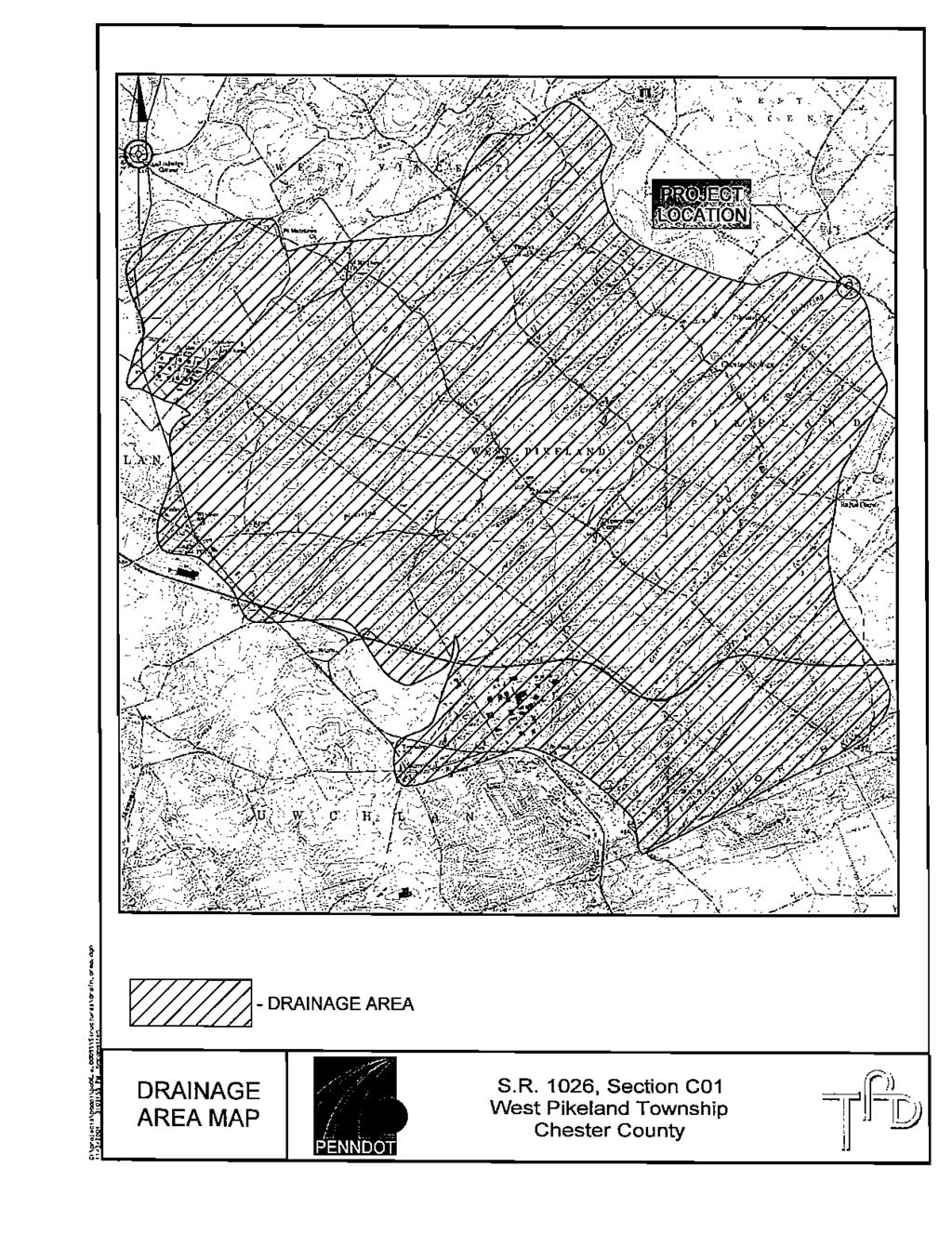
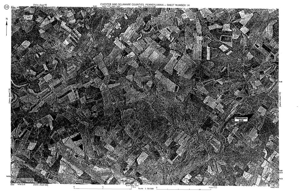
2 TABLE OF CONTENTS PAGE # INTRODUCTION AND PURPOSE... 1 PLAN PREPARATION AND DEVELOPMENT... 1 SOIL CLASSIFICATIONS AND LIMITATIONS... 2 TABLE 1: DESCRIPTION OF SOILS... 2 TABLE 2: ENGINEERING PROPERTIES OF SOILS... 3 TABLE 3: SOIL LIMITATIONS... 4 ACCELERATED EROSION CONTROL MEASURES... 5 SEDIMENTATION CONTROL... 5 TEMPORARY CONTROL MEASURES... 5 PERMANENT CONTROL MEASURES... 6 RECOMMENDED STAGING OF CONSTRUCTION ACTIVITIES... 8 CONSTRUCTION SEQUENCE... 9 MAINTENANCE OF CONTROL STRUCTURES GENERAL NOTES APPENDIX A- LOCATION MAP APPENDIX B- DEP WORKSHEETS APPENDIX C- USGS 7.5-MINUTE QUADRANGLE DRAINAGE AREA APPENDIX D- HYDRAULIC & HYDROLOGIC REPORT (Available Upon Request) APPENDIX E- SOIL SURVEY MAP APPENDIX F- ROADWAY TYPICALS, PLAN VIEWS, AND PROFILES
3 INTRODUCTION AND PURPOSE The attached Erosion and Sediment Pollution Control Plan is for the Clover Mill Road Bridge Replacement. The bridge carries S.R. 1026, Section C01 over Pickering Creek. The project is located in West Pikeland Township, Chester County. This structure is being replaced due to the substandard condition of the existing bridge, which has a posted weight limit of 17 tons (24 tons combination). The existing structure is a two-span steel plate girder bridge, with each span having a clear span of approximately This structure, which includes a wooden deck with asphalt overlay and stone abutments, is currently in poor structural condition. The bridge exhibits various geometric and safety issues that do not meet current regulations and is currently posted for a 17-ton (24-ton combination) weight limit. In addition, the approach roadways are substandard with a steep vertical approach north of the bridge, which does not meet current design standards. Therefore, the decision was made to perform a full structure replacement, which considered various roadway profiles. Various requirements such as roadway design, right-of-way impacts, structure costs and hydraulic design were all considered and weighed to determine the most appropriate structure replacement with the least amount of impacts. Various preliminary structural designs and hydraulic runs were performed to narrow the list of potential structures. After review of the advantages and disadvantages of each alternative, it was determined that the single span prestressed adjacent box beam bridge should be the recommended alternative for this bridge replacement. Preliminary discussions with DEP and the District have verified that these slight increases in flood flow water surfaces associated with this option will not be significant enough to prevent approval nor should it trigger additional design work in the preparation of a conditional letter of map revision (CLOMR). The purpose of the Erosion and Sedimentation Control design is to minimize the volume of sediment leaving the construction area via stormwater runoff while maintaining the structural integrity of all disturbed and undisturbed soil areas within the subject property boundary. Supporting narrative, calculations and details are contained herein and on the Erosion and Sedimentation Control Plan (Plan). PLAN PREPARATION AND DEVELOPMENT The Erosion and Sedimentation Control Plan has been prepared by Traffic Planning and Design, Inc, 2500 East High Street, Suite 650, Pottstown, PA The Plan has been developed in accordance with the requirements and suggestions as outlined by the Pennsylvania Department of Environmental Protection (DEP), PENNDOT, and other acceptable engineering standards and practices. 1
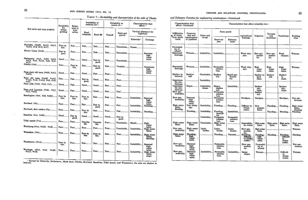
4 SOIL CLASSIFICATIONS AND LIMITATIONS The Chester County Area Soil Survey prepared by the United States Department of Agriculture identifies five (5) types of underlying soils as Glenelg channery silt loam (3%-8% slopes, moderately eroded), Glenelg channery silt loam (8%-15% slopes, severely eroded), Glenville silt loam (3%-8% slopes, moderately eroded), Wehadkee silt loam, Worsham silt loam (0%-3% slopes). The descriptions and engineering properties of these soils can be found in the following table. TABLE 1: DESCRIPTION OF SOILS Glenelg channery silt loam, 3%-8% slopes, moderately eroded (GeB2) Glenelg channery silt loam, 8%-15% slopes, severely eroded (GeC3) Glenville silt loam, 3%-8% slopes, moderately eroded (GnB2) Wehadkee silt loam (We) Worsham silt loam, 0%-3% slopes (WoA) Typically these soils range from 18 to 34 inches in depth, but they are predominantly 20 to 30 inches deep. Their subsoil ranges from silt loam to silty clay loam in texture and from yellowish brown to reddish brown in color. Typically these soils range from 18 to 34 inches in depth, but they are predominantly 20 to 30 inches deep. Their subsoil ranges from silt loam to silty clay loam in texture and from yellowish brown to reddish brown in color. Typically the surface layer is very dark brown or dark grayish brown. The subsoil is yellowish brown or strongbrown, mottled silty clay loam or heavy silt loam. In a few places the texture of the subsoil is silty clay laom throughout the profile. Depth to bedrock ranges from 3 to 6 feet. Mottling is at a depth ranging from 15 to 30 inches. In some places there is a weak claypan in the subsoil. The dominant parent materials are mica schist and gneiss, but a few areas are underlain by granite. In these areas the texture of the subsoil is generally more clayey than that in the typical profile. The surface layer is dark grayish-brown silt loam. The subsoil is yellowish-brown silty clay loam that is mottled with various shades of grey. In most places stratified layers of sand and silt occur in these soils. The texture of the different horizons ranges from sandy loam to silty clay loam. The thickness and arrangement of the layers vary with the frequency of overflow from the streams and the kind of sediments deposited. Mottling is at or near the surface. The surface layer is generally silt loam, but if a few areas is silty clay loam. The subsoil ranges from silty clay loam to clay loam in texture. Depth of bedrock ranges from 5 to 10 feet. The surface layer in some place is thicker than normal because colluvial materials have been washed onto areas from adjacent higher areas. 2
5 TABLE 2: ENGINEERING PROPERTIES OF SOILS Soil Type Glenelg channery silt loam (3%-8% slopes, moderately eroded) (GeB2) Glenelg channery silt loam (8%-15% slopes, severely eroded) (GeC3) Glenville silt loam (3%-8% slopes, moderately eroded) (GnB2) Unified Classification SM, GM, ML SM, GM, ML ML, ML- CL, MH Depth To Bedrock 3-5 ft. 3-5 ft. 3-6 ft. Permeability in/hr in/hr in/hr Liquid Limit Plasticity Index Shrink-Swell Potential LOW LOW LOW Wehadkee silt loam (We) ML 5-8 ft in/hr - - LOW Worsham silt loam (0%-3% slopes) (WoA) ML, MH 3-5 ft in/hr - - LOW 3
6 Glenelg channery silt loam (3%-8% slopes, moderately eroded) (GeB2) TABLE 3: SOIL LIMITATIONS Glenelg channery silt loam (8%-15% slopes, severely eroded) (GeC3) Glenville silt loam (3%-8% slopes, moderately eroded) (GnB2) Wehadkee silt loam (We) Worsham silt loam (0%-3% slopes) (WoA) Suitability for winter grading Good Fair Fair Poor Poor Suit. Source of topsoil Good Very poor Good Fair Fair Suit. Source of sand and gravel Unsuitable Unsuitable Unsuitable Poor Poor Suit. Source of road fill Fair to good. Fair Poor Poor to fair Poor Highway location - - Const. and maint. of pipelines Seasonal high water table. - - Fluctuating water table. Instability; high water table; flooding. Flooding; high water table. Instability; high water table; seeps. Seasonal high water table. Impoundments- Res. area Permeable substratum Permeable substratum Variable substratum. Flooding Permeable substratum. Impoundmentsembankment Permeability Permeability - Variable Instability Agriculture drainage - - High water table; seeps. Irrigation - Low water holding. Restricted drainage. Flooding; difficult to obtain outlet. Flooding; high water table. Seeps; slopes. Wetness Terraces, diversions, waterways - Shallow soil; highly erodible - Flooding - 4
7 ACCELERATED EROSION CONTROL MEASURES A combination of erosion control measures will be implemented during and after construction to stabilize or prevent advanced erosion from critical areas. Temporary vegetation shall be established on all slopes, on stockpiled topsoil, and on all disturbed areas. Disturbed areas are to be stabilized immediately. Course aggregate subbase material will be placed on all proposed roadways and parking areas, as soon as practical, in order to reduce erosion and soil disturbance associated with construction traffic. During construction, the amount of disturbed soils shall be kept to a minimum and, whenever possible, a suitable vegetative buffer will be maintained around all construction areas. SEDIMENTATION CONTROL Several measures will be used to remove sediment from stormwater leaving the construction site. Silt barrier fence will be installed down slope of all excavated areas in order to prevent sediment laden stormwater from entering local waterways, adjacent properties and roadways. Seeding and supplements along with straw mulch will be placed on the roadway embankment side slopes to prevent erosion. A stabilized construction entrance shall be properly maintained in order to prevent the migration of fines through the aggregate. TEMPORARY CONTROL MEASURES During construction, the contractor shall keep the site well drained at all times. Any waste material accumulated during construction, which will not be reused in later construction, shall be removed from the site and disposed of in a responsible and legal manner. All unstabilized soil stockpiled temporarily shall be covered with a tarp or other suitable stabilization (seeded) in order to prevent washoff when precipitation is imminent. Temporary seeding shall consist of a modified Formula E - Lolium Multiflorum 100% pure live seed (pls), or equivalent, and shall be placed at the rate of 28 pounds per acre. Temporary seeding shall be applied to those areas that are a potential erosion problem during construction. Disturbed areas that are to be stabilized immediately. If conditions do not permit temporary seeding, mulching shall be employed. Additionally, commercial fertilizer ( ) at pounds per acre, agricultural lime at 1.94 tons per acre, and straw mulch at 2.9 tons per acre. 5
8 Silt barrier fence shall be placed at critical erosion areas, as shown on the Plan, in order to prevent sediment from entering onto public roadways, adjacent properties and waterways. Stabilized construction entrances shall be placed at the point of construction ingress and egress. This structure will prevent tracking and flowing of sediment onto the public roadway. The entrance shall remain functional for the duration of the project. Where dust or wind erosion is a problem, the unstable surface(s) shall be sprinkled with water or other suitable dust suppressor. Any water pumped from sanitary, storm, or utility trenches, for any reason, shall be directed through a sediment filter bag (dirt bag) conforming to Pennsylvania Department of Transportation Specifications. The contractor shall employ measures during construction to prevent spills of fuels or lubricants. If a spill occurs, it shall be controlled immediately to prevent its entry into nearby waterways. All earthmoving activities shall be carried out in such a manner as to minimize the amount of disturbed area. Responsibility for implementing erosion and sedimentation control shall be designated to a minimum of one individual who will be present at the project site daily. When the Engineer, Municipal Official, or County Representative determines that erosion control measures are necessary, that were not foreseen in the design stage, said official shall estimate the erosion potential and select measures on the basis of both cost effectiveness and the consequences of the erosion. Any temporary erosion control measure applied to exposed soil surfaces shall remain functional until vegetation cover is sufficiently established. All temporary erosion and sedimentation control measures shall be subject to applicable regulations of the Department of Transportation Form 408 Specifications, most recent edition. PERMANENT CONTROL MEASURES 1. Permanent soil protection will be completed as early as practical. 2. Permanent seeding and mulching will be incorporated into the construction phase during the approved planting season. 6
9 1. All areas disturbed by construction, other than those receiving rip-rap, landscaping or paving (including gravel) shall be stabilized by applying a seed mixture to establish an erosion resistant stand of vegetation. The following is recommended for lawn type applications: a. Seeding [Formula D] (1) Festuca arundinacea - 70% total lbs/acre (2) Festuca rubra - 30% total lbs/acre b. Fertilizer: (Ureaform) fertilizer lbs/acre (Commercial) fertilizer lbs/acre c. Mulching: Straw with Net 2.9 tons/acre The following is recommended for steep slope (steeper than 3:1) type applications: a. Seeding [Formula C Native Alternate] (1) Panicum virgatum - 14% total 4 lbs/acre (2) Elymus canadensis - 11% total 3 lbs/acre (3) Elymus villosus 53.5% total 15 lbs/acre (4) Sporobulus asper 3.5% total 1 lb/acre (5) Lolium multiflorum 18% total 5 lbs/acre b. Fertilizer: (Commercial) fertilizer lbs/acre c. Mulching: Straw with Net 2.9 tons/acre Temporary wetland impacts shall be restored with the following: a. Seeding [Wetland Seed Mix] (1) Poa palustris - 23% total 10 lbs/acre (2) Elymus virginicus - 23% total 10 lbs/acre 7
10 (3) Carex lurida 4.5% total 2 lbs/acre (4) Scirpus atrovirens 2% total 1 lb/acre (5) Verbena hastate 1% total 0.5 lb/acre (6) Chelone glabra 1% total 0.5 lb/acre (7) Avena sativa 45.5% total 20 lbs/acre b. Fertilizer: (Ureaform) fertilizer lbs/acre (Commercial) fertilizer lbs/acre c. Mulching: Straw with Net 2.9 tons/acre 2. All erosion and sedimentation controls shall be implemented in accordance with the Erosion and Sedimentation Control Handbook and the Chester County Conservation District, where applicable. RECOMMENDED STAGING OF CONSTRUCTION ACTIVITIES All earth disturbance activities shall proceed in accordance with the following sequence. Each stage shall be completed in compliance with Chapter 102 regulations before any following stage is initiated. At least 7 days before starting any earth disturbance activities, the operator shall invite all contractors involved in those activities, the landowner, all appropriate municipal officials, the erosion and sedimentation control plan preparer, and a representative of the Chester County Conservation District to schedule an on-site pre-construction meeting. Also, at least 3 days before starting any earth disturbance activities, all contractors involved in those activities shall notify the Pennsylvania One Call System Inc. at for buried utilities location. Before implementing any revisions to the approved erosion and sediment control plan or revisions to other plans which may affect the effectiveness of the approved E&S control plan, the operator must receive approval of the revisions from the Chester County Conservation District. The operator shall remove from the site, recycle or dispose of all building materials and waste in accordance with the Department s Solid Waste Management Regulations at 25 PA Code e. seq. and et seq. 8
11 Before disposing of spoil or receiving borrow for the site, the operator must assure that each spoil or borrow area has an erosion and sediment control plan approved by the Chester County Conservation District, and which is being implemented and maintained according to Chapter 102 regulations. Stabilization uniform erosion resistant perennial vegetation is established to the point where the surface soil is capable of resisting erosion during runoff events. The standard for this vegetative cover will be a uniform coverage density of 70% across the disturbed area. Upon completion of an earth disturbance activity, the operator shall stabilize immediately the disturbed areas to protect from accelerated erosion. During nongerminating periods, mulch must be applied at the specified rates. Disturbed areas which are not at finished grade and which will be redisturbed within 1 year may be stabilized in accordance with temporary seeding specifications. Disturbed areas, which are either at finished grade or will not be redisturbed within 1 year, must be stabilized in accordance with permanent seeding specifications. Until the site has achieved final stabilization, the owner and /or contractor shall properly implement, operate and maintain all the best management practices. Maintenance shall include inspections of all erosion and sedimentation control after each runoff event and on a weekly basis. All preventative and remedial maintenance work, including clean out, repair, replacement, regrading, reseeding, remulching, and renetting, must be performed immediately. CONSTRUCTION SEQUENCE The Clover Mill Road Bridge and roadway will be under construction for approximately 140 working days. The area under construction will be closed to through traffic and a detour will be in place to direct traffic. Stage 1 - Start to Day 140 Place 18-inch and 30-inch silt fence in the areas shown on the Erosion and Sedimentation Control Plans, Sheet 3 before any construction may proceed (Day 1). The silt fence shall be constructed as per the DEP Erosion and Sedimentation Pollution Control Program Manual, March 2000, Worksheet #2 (Appendix B) or Pennsylvania Department of Transportation, Publication 72, RC-70M, Sheet 2 of 5 (detailed on plan sheet 2 of 3). The flow in the stream will be maintained as shown in the DEP Erosion and Sedimentation Pollution Control Program Manual, March 2000, Figure 35a: In-Stream Cofferdam Diversion (Appendix B). The sandbag cofferdams shall be constructed as shown on the Erosion and Sedimentation Control Plans, Sheets 3 of 3. Upon completion of the erosion and sedimentation control device installation, remove the existing structure and install the bridge. Upon the completion of the new structure and the roadway improvements, seed and mulch the entire disturbed area including wetland disturbance in 9
12 accordance with Pennsylvania Department of Transportation, Publication 408, Section 804 and Section 805 of DEP Erosion and Sedimentation Control Plan, August 1994, Worksheet #8. After the roadway embankments slopes are seeded erosion control blankets should be placed in order to stabilize the slopes. Upon completion of the construction, the flow in the stream shall be returned to its pre-construction condition and the rest of the erosion and sedimentation control devices shall be removed. MAINTENANCE OF CONTROL STRUCTURES The erosion and sedimentation control for the subject property requires no detailed maintenance. However, certain periodic duties shall be performed by the contractor in order to assure proper control. Any debris accumulated at silt barriers will be removed and properly disposed of in a responsible manner. Barriers shall be checked and realigned or reset as required. Any debris or solid waste material accumulated from construction activities shall be removed from the site and disposed of in an approved landfill. Construction waste shall not be buried on the subject site. Vegetative stabilization will be periodically inspected for proper growth. Any areas not responding will be promptly reseeded. Areas, which show signs of erosion prior to stabilization shall be graded, reseeded, and remulched immediately. The stabilized construction entrance shall be cleaned and redressed when voids become choked with mud and sediment. Miscellaneous adjustments and corrections shall be made to any erosion control structure as deemed necessary by the Engineer, Municipal Official, or County Representative in order to correct unforeseen problems caused by a storm prior to stabilization. GENERAL NOTES 1. Only limited disturbance will be permitted to provide access to sediment control facilities for grading and acquiring borrow to construct those controls. 2. Erosion and sedimentation controls must be constructed, stabilized, and functional before site disturbance within the tributary areas of those controls. 3. After final site stabilization has been achieved, temporary erosion and sedimentation controls must be removed. Areas disturbed during removal of the controls must be stabilized immediately. 4. Vehicles may neither enter directly to nor exit directly from project site onto SR At the end of each working day, any sediment tracked or conveyed onto a public roadway will be removed and redeposited onto the construction site. Removal can be completed through use of mechanical or hand tools, but must never be washed off the road by use of water. 10
13 6. Sediment removed from E&SPC controls and facilities shall be disposed of in landscaped areas outside of steep slopes, wetlands, floodplains or drainage swales and immediately stabilized, or placed in topsoil stockpiles. 7. All pumping of sediment laden water shall be through a dirt bag filtration device, or equivalent sediment removal facility, over non-disturbed vegetated areas. Discharge points should be established to provide for maximum distance to active waterways. 8. Should unforeseen erosive conditions develop during construction, the contractor shall take action to remedy such conditions and prevent damage to adjacent properties as a result of increased runoff and/or sediment displacement. Stockpiles of wood chips, hay bales, crushed stone and other mulches shall be held in readiness to deal immediately with emergency problems of erosion. 9. The contractor is advised to become thoroughly familiar with the provisions of the Appendix 64, Erosion Control Rules and Regulations, Title 25, Part1, Department of Environmental Protection, Subpart C, Protection of Natural Resources, Article III, Water Resources, Chapter 102, Erosion Control. 10. A copy of this erosion and sedimentation control report and plans must be posted at the construction site. 11. Stockpile heights must not exceed 35. Stockpile slopes must be 2:1 or flatter. 12. Mulch with mulch control netting or erosion control blankets must be installed on all slopes greater than 3:1. 11
14 S.R. 1026, Sec. C01 January 2006 RECORD OF TRAINING AND EXPERIENCE IN EROSION AND SEDIMENT CONTROL METHODS AND TECHNIQUES NAME OF PLAN PREPARER: BRIAN Z. MCANALLEN FORMAL EDUCATION: Name of College or Technical Institute: Curriculum or Program: DREXEL UNIVERSITY CIVIL ENGINEERING OTHER TRAINING: Dates of Attendance: From: 1997 To: 2002 Degree received: BACHELOR OF CIVIL ENGINEERING Name of training: Presented by: Date: N/A EMPLOYMENT HISTORY: Current Employer: TRAFFIC PLANNING AND DESIGN, INC. Telephone: (610) RECENT EROSION AND SEDIMENT CONTROL PLANS PREPARED: Name of Project: S.R (Fagleysville Road Bridge Replacement) S.R (Yellow Springs Road Bridge Replacement) County: Montgomery Chester Municipality New Hanover Twp. West Pikeland Twp. Permit number: (If Applicable) Montgomery County Chester County Approving Agcy: Conservation District Conservation District 14
15
16
17
18
19
20 STANDARD WORKSHEET #7 Temporary And Permanent Stabilization Specifications PROJECT NAME: LOCATION: PREPARED BY: CHECKED BY: Clover Mill Road Bridge Replacement Clover Mill Road over Pickering Creek TAS BZM DATE: DATE: 4/3/2006 4/4/2006 SPECIFICATIONS: The Department recommends the use of the Penn State publication "EROSION CONTROL & Conservation Plantings on Noncropland" as the standard to use for the selection of species, seed specifications, mixtures, liming and fertilizing, time of seeding, and seeding methods. Specifications for these items may also be obtained from Penn DOT's Publication # 408, Section 804 or by contacting the applicable county conservation district. Upon selection of a reference, that reference must be used to provide all specifications for seeding, mulching, and soil amendments. The following specification will be used for this project: (TEMPORARY - UPLAND) SPECIES: % PURE LIVE SEED: Lolium multiflorum 100 % APPLICATION RATE: 48.4 LB./ACRE FERTILIZER TYPE: (X-X-X) FERTILIZER APPL. RATE: LB./ACRE LIMING RATE: 1.0 T./ACRE MULCH TYPE: MULCHING RATE: Straw with Net 2.90 T./ACRE (PERMANENT) SPECIES: % PURE LIVE SEED: Festuca arundinacea / Festuca rubra 70 / 30 % APPLICATION RATE: 72.6 / LB./ACRE FERTILIZER TYPE: / (X-X-X) FERTILIZER APPL. RATE: / LB./ACRE LIMING RATE: 1.9 T./ACRE MULCH TYPE: MULCHING RATE: Straw with Net 2.90 T./ACRE ANCHOR MATERIAL: ANCHORING METHOD: RATE OF ANCHOR MATERIAL APPL.: N/A N/A N/A LB./ACRE SEEDING SEASON DATES: March 15 to June 1& August 1 to October15 (PERMANENT - STEEP SLOPE) SPECIES: Panicum virgatum/elymus canadensis/elymus villosus/sporobulus asper/lolium multiflorum % PURE LIVE SEED: 14/11/53.5/3.5/18 % APPLICATION RATE: 4/3/15/1/5 LB./ACRE FERTILIZER TYPE: (X-X-X) FERTILIZER APPL. RATE: LB./ACRE LIMING RATE: 1.9 T./ACRE MULCH TYPE: MULCHING RATE: Straw with Net 2.90 T./ACRE ANCHOR MATERIAL: ANCHORING METHOD: RATE OF ANCHOR MATERIAL APPL.: Plastic Mulch Control Netting Metal Pins LB./ACRE SEEDING SEASON DATES: Anytime except Sept. & Oct. / March 1 to October / March 13, 2000 / Page 151
21 STANDARD WORKSHEET #7 Temporary And Permanent Stabilization Specifications PROJECT NAME: LOCATION: PREPARED BY: CHECKED BY: Clover Mill Road Bridge Replacement Clover Mill Road over Pickering Creek TAS BZM DATE: DATE: 4/3/2006 4/4/2006 SPECIFICATIONS: The Department recommends the use of the Penn State publication "EROSION CONTROL & Conservation Plantings on Noncropland" as the standard to use for the selection of species, seed specifications, mixtures, liming and fertilizing, time of seeding, and seeding methods. Specifications for these items may also be obtained from Penn DOT's Publication # 408, Section 804 or by contacting the applicable county conservation district. Upon selection of a reference, that reference must be used to provide all specifications for seeding, mulching, and soil amendments. The following specification will be used for this project: Poa palustris/elymus virginicus/carex lurida/scirpus (WETLAND SEED MIX) SPECIES: atrovirens/verbena hastate/chelone glabra/avena sativa % PURE LIVE SEED: 23/23/4.5/2/1/1/45.5 % APPLICATION RATE: 10/10/2/1/0.5/0.5/20 LB./ACRE FERTILIZER TYPE: / (X-X-X) FERTILIZER APPL. RATE: 242.0/677.6 LB./ACRE LIMING RATE: 1.90 T./ACRE MULCH TYPE: MULCHING RATE: Wood Fiber 2.90 T./ACRE ANCHOR MATERIAL: ANCHORING METHOD: RATE OF ANCHOR MATERIAL APPL.: N/A N/A N/A LB./ACRE SEEDING SEASON DATES: March 15 to June 15 * If more than one species is used, indicate application rate for each species. Note: Show information from this sheet on plan drawings / March 13, 2000 / Page 151
22
23
24
25
26

27
28
29
30

31
City of Stoughton Erosion Control Permit Application (effective 2/6/2018)
") City of Stoughton Erosion Control Permit Application (effective 2/6/2018) Incomplete applications will not be accepted Project Name: Address of subject property: Landowner Name(s): Applicant Name: Landowner
City of Stoughton Erosion Control Permit Application (effective 2/6/2018) Incomplete applications will not be accepted Project Name: Address of subject property: Landowner Name(s): Applicant Name: Landowner
June Pennsylvania Department of Transportation Engineering District Herr Street Harrisburg, PA 17103
 EROSION & SEDIMENT CONTROL REPORT FOR S.R. 0462 BOX CULVERT REPLACEMENT OVER TRIBUTARY TO STRICKLER RUN WEST HEMPFIELD TWP., LANCASTER CO. Prepared for: June 2006 Pennsylvania Department of Transportation
Project: Developer/Designer: Reviewer: I. Narrative: 1. Project Description: Describes the nature and purpose of the land disturbing activity.
 City of Charlottesville, Virginia Erosion and Sediment Control Plan Review Checklist 610 East Market Street, Charlottesville, VA 22902 Telephone 434-970-3182; Fax 434-970-3359 Project: Developer/Designer:
EROSION & SEDIMENT CONTROL
 EROSION & SEDIMENT CONTROL Surface Water Protection During Well Site Construction Kelly Kees, PE WVDEP, Office of Oil and Gas SEDIMENT & EROSION CONTROL PLANS Per West Virginia State Code 22-6-6(d) 22-6A-7(c),
Plan Review Checklist
 Plan Review Checklist FOR EROSION AND SEDIMENT CONTROL PLANS _ Minimum Standards - All applicable Minimum Standards must be addressed. All minimum Standards must be adhered to during the entire project
Urban Conservation Practice Physical Effects ESTABLISHMENT, GROWTH, AND HARVEST NUTRIENT MANAGEMENT
 NOT WELL 800 - Urban Stormwater Wetlands A constructed system of shallow pools that create growing conditions for wetland plants to lessen the impacts of stormwater quality and quantity in urban areas.
Town of Essex Small Site Erosion Control Guide
 Town of Essex Small Site Erosion Control Guide Why do we need to protect against erosion? Water Quality: Erosion and the transport of sediment and pollutants impacts the water quality of nearby streams
Gloucester County PLAN SUBMITTER'S CHECKLIST
 Page 1 of 9 Gloucester County PLAN SUBMITTER'S CHECKLIST FOR EROSION AND SEDIMENT CONTROL PLANS Please fill in all blanks and please reference the plan sheets/pages where the information may be found,
Erosion Control for Home Builders in the. City of Jacksonville
 Erosion Control for Home Builders in the City of Jacksonville Eroding construction sites are a leading cause of water quality problems in Jacksonville. For every acre under construction, about a dump truck
SUPPORTING DOCUMENT STORMWATER POLLUTION PREVENTION PLAN (SWPPP) NARRATIVE
 NARRATIVE") SUPPORTING DOCUMENT STORMWATER POLLUTION PREVENTION PLAN (SWPPP) NARRATIVE Please complete this narrative form and submit with your SWPPP drawings. Refer to Kitsap County Stormwater Design Manual Vol.
SUPPORTING DOCUMENT STORMWATER POLLUTION PREVENTION PLAN (SWPPP) NARRATIVE Please complete this narrative form and submit with your SWPPP drawings. Refer to Kitsap County Stormwater Design Manual Vol.
PLAN SUBMITTER'S CHECKLIST
 Page 1 of 8 PLAN SUBMITTER'S CHECKLIST FOR EROSION AND SEDIMENT CONTROL PLANS Please fill in all blanks and reference the plan sheets/pages where the information may be found, where appropriate, or write
SOIL EROSION AND SEDIMENT CONTROL
 SOIL EROSION AND SEDIMENT CONTROL SECTION 1: AUTHORITY, TITLE AND PURPOSE 11. STATUTORY AUTHORIZATION This ordinance is adopted pursuant to the provisions of the Federal Water Pollution Control Act 86
The proper use of erosion and sediment controls will allow the following objectives to be met:
 Chapter 5 5.0 Introduction During construction activities, soil is typically moved or disturbed in a way that affects stormwater drainage. The use of Best Management Practices (BMPs) during construction
Soil Erosion & Sediment Control Plan Requirements for Submittal to the Cape Atlantic Conservation District
 Soil Erosion & Sediment Control Plan Requirements for Submittal to the Cape Atlantic Conservation District The following is a list of the minimum requirements required on Soil Erosion and Sediment Control
PERMANENT SEEDING. Overview of Sedimentation and Erosion Control Practices. Practice no. 6.11
 Overview of Sedimentation and Erosion Control Practices Practice no. 6.11 PERMANENT SEEDING Permanent vegetation controls erosion by physically protecting a bare soil surface from raindrop impact, flowing
Wisconsin Contractors Institute Continuing Education
 Wisconsin Contractors Institute Continuing Education Erosion & Sediment Control Course # 12775 2 hours Wisconsin Contractors Institute N27 W23953 Paul Road, Suite 203 Pewaukee, WI 53072 Website: www.wicontractorsinstitute.com
Using the Updated RI Soil Erosion and Sediment Control Handbook. The Introductory Workshop for RIDEM/CRMC Staff January 23, 2015
 Using the Updated RI Soil Erosion and Sediment Control Handbook The Introductory Workshop for RIDEM/CRMC Staff January 23, 2015 URI Cooperative Extension NEMO URI Cooperative Extension NEMO White Oak,
Shelbyville, KY Stormwater Best Management Practices. Section 2 EROSION PREVENTION AND SEDIMENT CONTROL PLAN
 Section 2 EROSION PREVENTION AND SEDIMENT CONTROL PLAN 2.1 Requirements The City of Shelbyville, KY will require an Erosion Prevention and Sediment Control (EPSC) Plan for most types of development construction.
Vegetated Filter Strips and Buffers
 3.15 Sediment Control Description: Buffer strips (existing vegetation) and filter strips (planted vegetation) are sections of vegetated land adjacent to disturbed areas. They are designed with low slopes
SECTION 900 TURF ESTABLISHMENT
 SECTION 900 901.0 DESCRIPTION This section covers the furnishing of all labor, materials, tools, equipment and performances of all work and services necessary or incidental to turf restoration as indicated
Vegetated Filter Strips and Buffers
 3.15 Sediment Control Description: Buffer strips (existing vegetation) and filter strips (planted vegetation) are sections of vegetated land adjacent to disturbed areas. They are designed with low slopes
Section 9 Landscaping and Street Trees
 Section 9 Landscaping and Street Trees GENERAL REQUIREMENTS...9-1 I. MATERIALS...9-1 9.1 GRASS...9-1 9.2 STREET TREES...9-1 A. General...9-1 B. Species...9-2 C. Design Standards...9-2 9.3 LANDSCAPING...9-3
STANDARD SPECIFICATIONS SECTION TEMPORARY EROSION AND SEDIMENT CONTROL
 STANDARD SPECIFICATIONS SECTION 01570 TEMPORARY EROSION AND SEDIMENT CONTROL PART 1 GENERAL 1.1 DESCRIPTION A. Section includes requirements, procedures, and methods related to responsibilities for providing
Urban Planning and Land Use
 Urban Planning and Land Use 701 North 7 th Street, Room 423 Phone: (913) 573-5750 Kansas City, Kansas 66101 Fax: (913) 573-5796 Email: planninginfo@wycokck.org www.wycokck.org/planning To: From: City Planning
A. Install all temporary erosion control measures (in accordance with MNDOT General Conditions 2573) prior to site disturbance.
 prior to site disturbance.") The language provided in these specifications is meant to serve as a reminder and provide a generic example of the type of language that should be provided in final construction documents. This language
The language provided in these specifications is meant to serve as a reminder and provide a generic example of the type of language that should be provided in final construction documents. This language
CHAPTER 4. SPECIAL CONDITION EROSION CONTROL MEASURES
 CHAPTER 4. SPECIAL CONDITION EROSION CONTROL MEASURES 4.1 INFILTRATION BASIN AND TRENCH Figure 4.1. Infiltration basin and trench (Source: Department of Civil, Construction, and Environmental Engineering,
RAIN GARDEN ILLINOIS URBAN MANUAL PRACTICE STANDARD. (feet) CODE 897 DEFINITION
 CODE 897 DEFINITION") ILLINOIS URBAN MANUAL PRACTICE STANDARD RAIN GARDEN (feet) CODE 897 Source: Kendall County Soil and Water Conservation District DEFINITION Rain gardens are small, shallow, flat bottomed depressions constructed
ILLINOIS URBAN MANUAL PRACTICE STANDARD RAIN GARDEN (feet) CODE 897 Source: Kendall County Soil and Water Conservation District DEFINITION Rain gardens are small, shallow, flat bottomed depressions constructed
Iowa FFA Soil Career Development Event 2008
 Iowa FFA Soil Career Development Event 2008 1. In Iowa, corn suitability ratings for soil mapping units specifies a. natural weather conditions b. surface and subsurface drainage installed where needed
Soil Erosion and Sediment Control
 PDHonline Course C188 (3 PDH) Soil Erosion and Sediment Control Instructor: John Poullain, PE 2012 PDH Online PDH Center 5272 Meadow Estates Drive Fairfax, VA 22030-6658 Phone & Fax: 703-988-0088 www.pdhonline.org
POST CONSTRUCTION STORMWATER MANAGEMENT FOR "WHITE OAK SEWER INTERCEPTOR"
 POST CONSTRUCTION STORMWATER MANAGEMENT PLAN FOR "WHITE OAK SEWER INTERCEPTOR" Located in Newberry Township, York County March 21, 2008 Prepared by: Mellott Engineering, Inc. 7500 Devonshire Heights Road
a. Site Topography and Relationship to Surrounding Topography
 C. Topography and Slopes 1. Existing Conditions a. Site Topography and Relationship to Surrounding Topography The Site is gently rolling, as is the surrounding topography (Figure I.A-8). The Property is
The following general requirements will be met for all planter box installations:
 Greenville County Technical Specification for: WQ-25 PLANTER BOX 1.0 Planter Box 1.1 Description Planter boxes are designed to capture and temporarily store stormwater runoff. Planter Boxes are intended
Information for File # JTF
 Information for File # 2013-04665-JTF Applicant Corps Contact Enbridge Energy, Limited Partnership Josh Fitzpatrick Address 1554 Highway 2, Suite 2, Two Harbors, MN 55616 E-Mail joshua.t.fitzpatrick@usace.army.mil
The Low Risk Site Handbook
 The Low Risk Site Handbook for Erosion Prevention and Sediment Control The content of this Handbook is adapted from the New York State Standards and Specifications for Erosion and Sediment Control-August
All materials in this presentation are taken from materials produced by:
 1 PART I 2 All materials in this presentation are taken from materials produced by: Georgia Soil and Water Conservation Commission 4310 Lexington Road P.O. Box 8024 Athens, GA 30603 706-542-3065 Fax 706-542-4242
Construction Site Erosion Control
 Construction Site Erosion Control Site: New Residence Halls for the Board of Trustees of the University of Alabama, Tuscaloosa Location North of UA Campus: North of 2nd Street (north of AIME and Bevill
Project Applicant Checklist for NPDES Permit Requirements SAN MATEO COUNTYWIDE STORMWATER POLLUTION PREVENTION PROGRAM
 Project Applicant Checklist for NPDES Permit Requirements SAN MATEO COUNTYWIDE STORMWATER POLLUTION PREVENTION PROGRAM I. PROJECT DATA Project Name Bay Meadows Development Phase II Project Address 2600
MARBLE RIVER WIND POWER PROJECT Agricultural Protection Measures
 MARBLE RIVER WIND POWER PROJECT Siting Considerations 1. Locate access roads and, to the extent allowed by local laws, wetlands and topography, individual wind turbines and other structures along field
IOWA FFA STATE SOILS CDE SATURDAY, OCTOBER 13, 2007 AMES, IOWA
 IOWA FFA STATE SOILS CDE SATURDAY, OCTOBER 13, 2007 AMES, IOWA 1. Moderately sloping has what percent slope: a. 9-14% b. 2-5% c. 5-9% d. over 14% 2. Which of the following horizons is the loose underlying
General Information. Site Conditions. 9b 9b. 9a 1b. Best Management Practices Illustration
 Model Construction SWPPP Planning & Development Services 1800 Continental Place Mount Vernon WA 98273 voice 360-416-1320 inspections 360-416-1330 www.skagitcounty.net/stormwaterpermitting Permit #: General
Checklists. Project Name: Location: File Number: Date of Submittal: Reviewer: Date: Applicant: Contact Name: Phone Number:
 Applicant: Contact Name: Phone Number: Email: Project Name: Location: File Number: Date of Submittal: Reviewer: Date: Concept Plan Requirements: I. General Project Information 1. Address or parcel number
STREAM ALTERATION PRACTICES
 STREAM ALTERATION PRACTICES Stream Diversion Channel SDC DEFINITION A temporary channel constructed to convey stream flow around in-stream construction. PURPOSE Stream diversion channels are used to allow
EROSION & SEDIMENT POLLUTION CONTROL NARRATIVE SOUTH MAIN ST
 EROSION & SEDIMENT POLLUTION CONTROL NARRATIVE SOUTH MAIN ST S.R. 2071, SECTION CS2 MAIN STREET DRAINAGE IMPROVEMENTS YARDLEY BOROUGH, BUCKS COUNTY, PENNSYLVANIA PREPARED FOR: PENNSYLVANIA DEPARTMENT OF
Volume 2, Chapter 12 - Revegetation
 Volume 2, Chapter 12 - Revegetation Users Guidance: If a UDFCD Section number in this chapter is skipped: It was adopted as is; please refer to that Section in the corresponding UDFCD Manual, Volume, Chapter
UPLAND EROSION CONTROL, REVEGETATION, AND MAINTENANCE PLAN
 UPLAND EROSION CONTROL, REVEGETATION, AND MAINTENANCE PLAN 01/17/2003 VERSION UPLAND EROSION CONTROL, REVEGETATION, AND MAINTENANCE PLAN TABLE OF CONTENTS I. APPLICABILITY... 1 II. SUPERVISION AND INSPECTION...
CHARLES SOIL CONSERVATION DISTRICT PLAN SUBMITTAL GUIDELINES
 CHARLES SOIL CONSERVATION DISTRICT PLAN SUBMITTAL GUIDELINES CharlesSCD.com January 2013 1 SEDIMENT AND EROSION CONTROL APPROVAL 2 CHARLES SOIL CONSERVATION DISTRICT TRANSMITTAL LETTER TO: CHARLES SOIL
2.1.4 Roof Downspout Rain Gardens
 2008 SWMM, 2010 Revision City of Tacoma 2.1.4 Roof Downspout Rain Gardens Purpose and Definition Bioretention areas are shallow stormwater retention facilities designed to mimic forested systems by controlling
State of Rhode Island Stormwater Management Guidance for Individual Single-Family Residential Lot Development
 State of Rhode Island Stormwater Management Guidance for Individual Single-Family Residential Lot Development Section 300.6 of the RI Coastal Resources Management Program (RICRMP) and Rule 7.12 of the
APPENDIX A SIMPLIFIED APPROACH TO STORMWATER MANAGEMENT FOR SMALL PROJECTS. In West Sadsbury Township, Chester County, Pennsylvania
 APPENDIX A SIMPLIFIED APPROACH TO STORMWATER MANAGEMENT FOR SMALL PROJECTS In West Sadsbury Township, Chester County, Pennsylvania TABLE OF CONTENTS I. Introduction 3 II. Importance of Stormwater Management
Erosion & Sediment Control Plan Application Form & Checklist
 Erosion & Sediment Control Plan Application Form & Checklist GENERAL INFORMATION Application Date: Project Address: Tax Map / Parcel Number(s): PROPERTY OWNER / DEVELOPER Firm Name: Contact Person: Title:
5/15/2013. Basin Area. Vegetation. Rainfall & Runoff. Soil Type. Topics. Factors Influencing Erosion. Factors Influencing Erosion
 Topics Erosion, TESC and Construction sequencing Procedures and timing Remedies for failing sites Curtis Hinman WSU Extension and Bio Systems Eng. Faculty Low Impact Development Specialist chinman@wsu.edu
2012 FINAL SOILS AREA 2 Envirothon Questions Answer KEY
 2012 FINAL SOILS AREA 2 Envirothon Questions Answer KEY Questions 1-6 to be answered at the soil pit: 1. Soil scientists categorize soils by drainage classes. What is the drainage class of the soil at
Draft Rhode Island Stormwater Design and Installation Standards Manual
 Draft Rhode Island Stormwater Design and Installation Standards Manual Summary The May 2009 Public Review Draft version of the RI Stormwater Design and Installation Standards Manual consists of approximately
Pits 1 & 3 Questions. 7. Subsurface: Texture (5 pts) A. Coarse B. Moderately course C. Medium D. Fine E. Very Fine
 A. Coarse B. Moderately course C. Medium D. Fine E. Very Fine") Minnesota Soils Scorecard Questions for Pits 1-4 Scantron # 105481 Use your soils scorecard to fill out the answers on your scantron Bubble in the front side of the sheet for Pit 1 (# 1-45) and Pit 2 (#51-95)
Minnesota Soils Scorecard Questions for Pits 1-4 Scantron # 105481 Use your soils scorecard to fill out the answers on your scantron Bubble in the front side of the sheet for Pit 1 (# 1-45) and Pit 2 (#51-95)
DO YOU KNOW YOUR SOILS? (Rev. 10/11)
") DO YOU KNOW YOUR SOILS? (Rev. 10/11) Circle all the correct answers. 1. What is the layer normally present on the surface of the soil in cropped fields? a. O c. Ap e. B g. R b. A d. E f. C 2. Available
DO YOU KNOW YOUR SOILS? (Rev. 10/11) Circle all the correct answers. 1. What is the layer normally present on the surface of the soil in cropped fields? a. O c. Ap e. B g. R b. A d. E f. C 2. Available
CHAPTER 9 STORM DRAINAGE. Minimum Requirements for New Development and Redevelopment
 CHAPTER 9 STORM DRAINAGE 9.01 General The standards established by this chapter are intended to represent the minimum standards for the design and construction of storm drainage facilities. 9.02 Design
C-10. Disconnected Impervious Surface
 C-10. Disconnected Impervious Surface Design Objective Disconnected Impervious Surface (DIS) is the practice of directing stormwater runoff from built-upon areas to properly sized, sloped and vegetated
2018 Iowa FFA Soil Judging CDE Exam 1. Landscape positions characterizes the location of the soil on the landscape and identifies potential risks.
 2018 Iowa FFA Soil Judging CDE Exam 1. Landscape positions characterizes the location of the soil on the landscape and identifies potential risks. Which landscape position is considered the floodplain
Alternative Names: Erosion Control Matting, Erosion Control Netting, Rolled Erosion Control Products (RECP)
") 4.5-s EROSION CONTROL BLANKET SYSTEM Alternative Names: Erosion Control Matting, Erosion Control Netting, Rolled Erosion Control Products (RECP) DESCRIPTION Erosion control blanket systems are woven or
4.5-s EROSION CONTROL BLANKET SYSTEM Alternative Names: Erosion Control Matting, Erosion Control Netting, Rolled Erosion Control Products (RECP) DESCRIPTION Erosion control blanket systems are woven or
Soil Reclamation and Site Reinstatement
 APPENDIX 6 Soil Reclamation and Site Reinstatement Purpose To undertake soil reclamation, erosion protection, Site restoration and reinstatement, taking into account natural processes, operational requirements
SILT FENCE MACHINE SLICED ERO-1A STEEL FENCE POST (T-POST), MINIMUM 5' LONG, 6' MAXIMUM SPACING.
, MINIMUM 5' LONG, 6' MAXIMUM SPACING.") STEEL FENCE POST (T-POST), MINIMUM 5' LONG, 6' MAXIMUM SPACING. ATTACH FABRIC TO POSTS WITH MINIMUM 3 ZIP TIES (50 LB. TENSILE) PER POST IN TOP 8" OF FABRIC. MONOFILAMENT GEOTEXTILE FABRIC PER MNDOT TABLE
STEEL FENCE POST (T-POST), MINIMUM 5' LONG, 6' MAXIMUM SPACING. ATTACH FABRIC TO POSTS WITH MINIMUM 3 ZIP TIES (50 LB. TENSILE) PER POST IN TOP 8" OF FABRIC. MONOFILAMENT GEOTEXTILE FABRIC PER MNDOT TABLE
Buffer Zone (BZ) Stream Protection. The width and plant composition of a buffer zone will determine its effectiveness.
 Stream Protection. The width and plant composition of a buffer zone will determine its effectiveness.") Buffer Zone (BZ) Figure BZ-1 Buffer Zone in Agricultural Area Practice Description A buffer zone is a strip of plants adjacent to land-disturbing sites or bordering streams, lakes, and wetlands that provides
Buffer Zone (BZ) Figure BZ-1 Buffer Zone in Agricultural Area Practice Description A buffer zone is a strip of plants adjacent to land-disturbing sites or bordering streams, lakes, and wetlands that provides
CITY OF TUMWATER 555 ISRAEL RD. SW, TUMWATER, WA (360) (360) (FAX)
 (360) (FAX)") CITY OF TUMWATER 555 ISRAEL RD. SW, TUMWATER, WA 98501 (360) 754-4180 (360) 754-4126 (FAX) Email: cdd@ci.tumwater.wa.us APPENDIX II-C SHORT FORM CONSTRUCTION STORMWATER POLLUTION PREVENTION PLAN (SWPPP)
CITY OF TUMWATER 555 ISRAEL RD. SW, TUMWATER, WA 98501 (360) 754-4180 (360) 754-4126 (FAX) Email: cdd@ci.tumwater.wa.us APPENDIX II-C SHORT FORM CONSTRUCTION STORMWATER POLLUTION PREVENTION PLAN (SWPPP)
ST. MARY S SOIL CONSERVATION DISTRICT (SMSCD) AND DPW&T CONCEPT EROSION AND SEDIMENT CONTROL AND STORMWATER MANAGEMENT GUIDELINES AND CHECKLIST
 AND DPW&T CONCEPT EROSION AND SEDIMENT CONTROL AND STORMWATER MANAGEMENT GUIDELINES AND CHECKLIST") St. Mary s Soil Conservation District 26737 Radio Station Way, Suite B Leonardtown, MD 20650 Phone: 301-475-8402 ext. 3 Fax: 301-475-8391 www.stmarysscd.com St. Mary s County Government Department of Public
St. Mary s Soil Conservation District 26737 Radio Station Way, Suite B Leonardtown, MD 20650 Phone: 301-475-8402 ext. 3 Fax: 301-475-8391 www.stmarysscd.com St. Mary s County Government Department of Public
Soil Health Practices in the Landscape
 Soil Health Practices in the Landscape Salvatore Mangiafico Rutgers Cooperative Extension Environmental and Resource Management Agent In this session... Benefits of healthy soils in the landscape Plant
Rule D Wetland and Creek Buffers
 Rule D Wetland and Creek Buffers 1 Policy It is the policy of the Board of Managers to ensure the preservation of the natural resources, recreational, habitat, water treatment and water storage functions
EROSION PREVENTION BMP SUGGESTED USES MATRIX
 EROSION PREVENTION SUGGESTED USES MATRIX Processed Based Tools Software Aids Slope Waterway Surface Concentrated Flows Large Flat Stock Pile Borrow Adjacent Property Impacts Erosion Prevention Measures
SOP 6: Erosion and Sedimentation Control SOP 6: EROSION AND SEDIMENTATION CONTROL
 Standard Operating Procedures Central Massachusetts Regional Stormwater Coalition SOP 6: Erosion and Sedimentation Control SOP 6: EROSION AND SEDIMENTATION CONTROL Erosion and sedimentation from land-disturbing
Urban Soils Career Development Event
 Urban Soils Career Development Event Effective August 1, 2014 Important Note: Please thoroughly read the Introduction and General Rules Section at the beginning of this handbook for complete rules and
Low Flow Rates Low Filtration Sandy Soils Medium Flow Rates Medium Filtration Clayey Soils [1] High Flow Rates High Filtration Polluted Soils
![Low Flow Rates Low Filtration Sandy Soils Medium Flow Rates Medium Filtration Clayey Soils [1] High Flow Rates High Filtration Polluted Soils](/thumbs/82/86978219.jpg "Low Flow Rates Low Filtration Sandy Soils Medium Flow Rates Medium Filtration Clayey Soils [1] High Flow Rates High Filtration Polluted Soils") Filter Ponds DE-WATERING SEDIMENT CONTROL TECHNIQUE Low Flow Rates Low Filtration Sandy Soils Medium Flow Rates Medium Filtration Clayey Soils [1] High Flow Rates High Filtration Polluted Soils [1] Capture
Filter Ponds DE-WATERING SEDIMENT CONTROL TECHNIQUE Low Flow Rates Low Filtration Sandy Soils Medium Flow Rates Medium Filtration Clayey Soils [1] High Flow Rates High Filtration Polluted Soils [1] Capture
Team number Page 1 of Canon Envirothon Soils Station Test. Soils and Climate Change
 Team number Page 1 of 9 2006 Canon Envirothon Soils Station Test Soils and Climate Change There are many kinds of soil on the surface of the earth. The kind of soil that is present at a given location
2014 Iowa FFA Soil Judging CDE Exam
 2014 Iowa FFA Soil Judging CDE Exam 1. Landscape position is one aspect of evaluating the surface features of a certain tract of land. Identifying the correct landscape position will indicate: a. If the
A. Install all temporary erosion control measures (in accordance with MNDOT General Conditions 2573) prior to site disturbance.
 prior to site disturbance.") The language provided in these specifications is meant to serve as a reminder and provide a generic example of the type of language that should be provided in final construction documents. This language
The language provided in these specifications is meant to serve as a reminder and provide a generic example of the type of language that should be provided in final construction documents. This language
Section 3 Non-Structural BMPs
 3.1 Stream Buffers A stream buffer or stream setback is a designated area around a stream, lake, or wetland left in a natural, densely vegetated state so as to protect the receiving water quality and provide
Appendices: Glossary. General Terms. Specific Terms. Low Impact Development Approaches Handbook
 67 67 General Terms Specific Terms 66 Low Impact Development Approaches Handbook The vocabulary of low impact development is evolving, and many terms are used interchangeably and to describe the same or
Storm Water Basics for Construction Sites Presented by Representatives from the City of Grass Valley and Nevada County
 September 22nd, 2015 3:30PM Sign up at: www.stormwaterawareness.org Workshop is free! Nevada County Contractor s Association 149 Crown Point Ct. Grass Valley, CA 95945 Storm Water Basics for Construction
Methods, approaches, and procedures to minimize active agricultural land impacts during pipeline construction, surface restoration, and pipeline
 Agricultural Impact Minimization Plan Methods, approaches, and procedures to minimize active agricultural land impacts during pipeline construction, surface restoration, and pipeline operation. PennEast
Structural Storm Water Best Management Practices (BMPs)
") Structural Storm Water Best Management Practices (BMPs) Storm Water Permitting: The SWPPP Revealed By Deron Austin, PE January 11, 2006 3:30-5:00 PM Orlando, Florida Presentation Outline Preface About
Structural Storm Water Best Management Practices (BMPs) Storm Water Permitting: The SWPPP Revealed By Deron Austin, PE January 11, 2006 3:30-5:00 PM Orlando, Florida Presentation Outline Preface About
Land Capability Classifications
 Land Capability Classifications Unit: Soil Science Problem Area: Basic Principles of Soil Science Student Learning Objectives. Instruction in this lesson should result in students achieving the following
2016 Area 3 Envirothon Muskingum County Soils Test ANSWER KEY
 2016 Area 3 Envirothon Muskingum County Soils Test ANSWER KEY 1. The majority of the bedrock in Muskingum County is. a. sedimentary bedrock b. glacial bedrock c. igneous bedrock d. metamorphic bedrock
2016 Iowa FFA Soils Evaluation CDE Exam
 2016 Iowa FFA Soils Evaluation CDE Exam 1. Which of the following is true regarding soil horizons? a. A horizon is darker in color and has more organic matter b. B horizon is darker in color and has more
TOWNSHIP OF LOGAN SOIL & FILL IMPORTATION AND PLACEMENT APPLICATION SUBMITTAL CHECKLIST
 TOWNSHIP OF LOGAN SOIL & FILL IMPORTATION AND PLACEMENT APPLICATION SUBMITTAL CHECKLIST Applications: 5 copies of application - Applicant will reproduce the copies at his/her costs. The Township Clerk
Public Works Department 104 W. Magnolia Street, Suite 109 Bellingham, WA (360)
") Public Works Department 104 W. Magnolia Street, Suite 109 Bellingham, WA 98225 (360) 778-7900 STORMWATER PERMIT SUBMITTAL REQUIREMENTS Most development within the City of Bellingham that involves disruption
Public Works Department 104 W. Magnolia Street, Suite 109 Bellingham, WA 98225 (360) 778-7900 STORMWATER PERMIT SUBMITTAL REQUIREMENTS Most development within the City of Bellingham that involves disruption
New Development Stormwater Guidelines
 New Development Stormwater Guidelines CITY OF MOUNTLAKE TERRACE Table of Contents Introduction... 2 Ecology s Minimum Requirements for stormwater management... 2 Description of the 9 Minimum Requirements...
ARTICLE VI: SITE PLAN REVIEW
 Section 6.01 - Site Plan Review (All Districts) ARTICLE VI: SITE PLAN REVIEW Site plans give the Planning commission an opportunity to review development proposals in a concise and consistent manner. The
Bioretention cell schematic key
 Bioretention Cells Bioretention cell schematic key 1 3 Hardwood mulch 2 Curb cut 3 18-30 Modified soil 4 Stone aggregate choker layer 5 Stone aggregate base layer 6 Subdrain 7 Undisturbed soil 8 Overflow/Cleanout
4.6. Low Impact and Retentive Grading
 4.6. Low Impact and Retentive Grading Low Impact Grading techniques focus on utilizing existing topography during Site layout to minimize cost. Proposing structures, roads, and other impervious surfaces
APPENDIX J PERFORMANCE STANDARDS FOR GRAVEL MINE, PIT MINE, OR QUARRY
 APPENDIX J PERFORMANCE STANDARDS FOR GRAVEL MINE, PIT MINE, OR QUARRY A. Purpose: 1. Regulatory Requirement and Use Mitigation: The purpose of this appendix is to provide a regulatory context (standards)
PAVING PARKING AREAS AND ROADS DESCRIPTION. Alternate Names: Pavement Practices, Impervious Paving
 4.2-i PAVING PARKING AREAS AND ROADS Alternate Names: Pavement Practices, Impervious Paving DESCRIPTION All roads, driveways, and parking lots proposed for year-round use shall be paved with a hard plowable
SECTION 6. Routine Maintenance Activity Details
 SECTION 6 Routine Maintenance Activity Details 80. DEBRIS REMOVAL When Deadfall, and other objects, such as shopping carts, tires, appliances, and mattresses have accumulated in the drain. Why To prevent
2017 Iowa FFA Soil Judging CDE Exam
 2017 Iowa FFA Soil Judging CDE Exam 1. Landscape positions vary in soil composition and makeup. What landscape position would be characterized by having strata and lenses of different textures in the profile:
Sustainable Sites. hblanarc.ca. RDN Workshop June 25, David Reid, FCSLA, Landscape Architect, Environmental Designer
 Sustainable Sites RDN Workshop June 25, 2011 David Reid, FCSLA, Landscape Architect, Environmental Designer hblanarc.ca Surrey ESA Networks & linear corridors ESA Network: Develop with Care SITE Hub >10
STATE TAX COMMISSION OF MISSOURI ASSESSOR MANUAL
 STATE TAX COMMISSION OF MISSOURI ASSESSOR MANUAL CHAPTER: REVISION DATE: 10/1/2008 Page 1 of 18 7.3 The purpose of this section of the Assessor s Manual is to supplement the State Tax Commission s published
STORMWATER SITE PLAN INSTRUCTIONS AND SUBMITTAL TEMPLATE Medium and Large Projects
 DEPARTMENT OF COMMUNITY DEVELOPMENT 621 Sheridan Street, Port Townsend, WA 98368 Tel: 360.379.4450 Fax: 360.379.4451 Web: www.co.jefferson.wa.us/communitydevelopment E-mail: dcd@co.jefferson.wa.us STORMWATER
ACT 167 STORMWATER CONSISTENCY VERIFICATION REPORT FOR CHESTER COUNTY 1.0 INTRODUCTION
 ACT 167 STORMWATER CONSISTENCY VERIFICATION REPORT FOR CHESTER COUNTY 1.0 INTRODUCTION Tetra Tech, Inc. (Tt) has prepared this Act 167 Stormwater Consistency Verification Report. The report verifies consistency
A. INTRODUCTION AND SUMMARY OF FINDINGS B. EXISTING CONDITIONS. Table 10-1 Adjacent Storm Drains
 Chapter 10: Stormwater Management A. INTRODUCTION AND SUMMARY OF FINDINGS This chapter describes existing and proposed stormwater management on the Site. Potential impacts to stormwater infrastructure
Project Name: Project Address or Location: Principal Designer Name and Company: Principal Designer Phone Number:
 SECTION 1: GENERAL INFORMATION Plan Submission Date: Total Disturbed Acreage: _ Project Name: Project Address or Location: Principal Designer Name and Company: Principal Designer Phone Number: email: SECTION
Department of Agriculture. Conservation Service. United States. Natural Resources REVISED 8/26/16
 GENERAL NOTES: SYMBOL LEGEND 1. All work shall comply with the constriction specifications, drawings, project-specific quality assurance plan and other contract requirements. 2. All notes on the drawings
Huntington Stormwater Utility
 Huntington Stormwater Utility Stormwater Management & Sediment and Erosion Control Requirements for Construction Sites Authorized by Huntington City Code Articles: 971, 970, 930, 935, 955, Revised April
1.6 IMPLEMENTATION GUIDELINES
 1.6 IMPLEMENTATION GUIDELINES Planning Planning is necessary if effective solutions are to be provided for erosion and sediment control on construction sites. Plans can guide development and prevent waste.