Technical Memorandum: Cultural Resource Assessment Survey of Proposed Improvements to
|
|
|
- Clyde Thomas
- 5 years ago
- Views:
Transcription
 Polk County (16320) HNTB Corporation 610 Crescent Executive Court Suite 400 Lake Mary, FL 32746 March 2016 SEARCH 1515 W.")
1 Technical Memorandum: Cultural Resource Assessment Survey of Proposed Improvements to Segment 5: State Road 400 (SR 400)/Interstate 4 (I 4) from West of SR 25/US 27 to West of CR 532 (Polk/Osceola County Line) Polk County (16320) HNTB Corporation 610 Crescent Executive Court Suite 400 Lake Mary, FL March 2016 SEARCH 1515 W. Smith Street Orlando, FL 32804
2 This page intentionally left blank. SR 400 (I 4) Project Development and Environment (PD&E) Study FM No.:
3 Table of Contents TABLE OF CONTENTS List of Figures... 4 List of Tables Introduction Location and Modern Conditions Paleoenvironment Regional Prehistory and History Historic Map and Aerial Review Florida Master Site File Review Research Design Project Goals NRHP Criteria Cultural Resource Potential Survey Methodology Archaeological Field Methods Architectural Field Methods Laboratory Methods Curation Procedures to Address Unexpected Discoveries Survey Results Archaeology Results Architectural Survey Results Conclusions and Recommendations References Cited Attachment 1: Previous Cultural Resource Surveys Conducted within One Mile of the I 4 Segment 5 APE Attachment 2: FMSF Resource Forms Attachment 3: FMSF Survey Log Sheet SR 400 (I 4) Project Development and Environment (PD&E) Study FM No.:
4 List of Figures LIST OF FIGURES Figure 1 Project location in Polk County, Florida... 8 Figure 2 I 4 Segment 5 APE Figure 3 Soil drainage characteristics within the I 4 Segment 5 APE Figure 4 Representative views of modern land use within the I 4 Segment 5 APE Figure 5 Combined 1848 and 1849 General Land Office maps showing the I 4 Segment 5 APE in yellow Figure Florida State Road Department map showing the I 4 Segment 5 APE in yellow Figure and 1952 USDA Aerial Photograph maps showing the I 4 Segment 5 APE in yellow Figure USDA Aerial Photograph map showing the I 4 Segment 5 APE in yellow Figure Florida State Road Department map showing the I 4 Segment 1 APE in yellow Figure 10 Previously recorded resources within one mile of the I 4 Segment 5 APE Figure 11 Shovel test locations within the I 4 Segment 5 Ponds. Map 1 of Figure 12 Shovel test locations within the I 4 Segment 5 Ponds. Map 2 of Figure 13 Shovel test locations within the I 4 Segment 5 Ponds. Map 3 of Figure 14 Shovel test locations within the I 4 Segment 5 Ponds. Map 4 of Figure 15 Cultural resources recorded within the I 4 Segment 5 APE Figure 16 Historic resources recorded within the I 4 Segment 5 APE Figure 17 Resource 8PO07962, facing west Figure 18 Resource 8PO07963, facing west Figure 19 Resource 8PO07989, facing north SR 400 (I 4) Project Development and Environment (PD&E) Study FM No.:
5 List of Tables LIST OF TABLES Table 1 Previously Recorded Cultural Resources within the I 4 Segment 5 APE Table 2 Results of Phase I Archaeological Survey of the 19 Proposed and Existing Ponds for the I 4 Segment 5 APE Table 3 Historic Resources Recorded within the I 4 Segment 5 APE Table 4 Parcels along the I 4 Segment 5 APE that Contain Resources Constructed between 1971 and SR 400 (I 4) Project Development and Environment (PD&E) Study FM No.:
6 This page intentionally left blank. SR 400 (I 4) Project Development and Environment (PD&E) Study FM No.:
7 1.0 Introduction 1.0 Introduction This technical memorandum details the results of a Cultural Resource Assessment Survey (CRAS) in support of proposed improvements to I 4 from west of State Road (SR) 25/US 27 to west of the Polk/Osceola County Line, in Polk County, Florida (Figure 1). The overall I 4 Beyond the Ultimate PD&E project is divided into five segments; this approximately 4.5 mile portion of the corridor is referred to as I 4 Segment 5 throughout this document. The proposed improvements include the addition or modification of 17 pond and floodplain compensation (FPC) sites along the corridor (Figure 1). FPC 506 is at the south end of Segment 5, beginning approximately 2.1 miles south of SR 25/US 27 on the northwest side of I 4. Pond 506 is on the northwest side of I 4, approximately one mile south of SR 25/US 27. Pond 500 is located on the northwest side of I 4, approximately 0.3 miles northeast of Pond 506. Ponds 503A, 503B, 503C, and 503D are located on the southeast side of the interchange between I 4 and SR 25/US 27. Ponds 501A, 501B and 501C are located on the northwest side of the interchange between I 4 and SR 25/US 27. FPC 500D, Pond 505 A3, Regional Pond 1 and Regional Pond 2 are located approximately 0.8 miles northeast of SR 25/US 27 on the northwest side of I 4. FPC 500C is located approximately 0.8 miles northwest of SR 25/US 27 on the southeast side of I 4. Pond 505 B2 is approximately 0.45 miles northeast of FPC 500C on the southeast side of I 4. Pond 100 is at the northern end of the Segment approximately 0.2 miles southwest of the Osceola/Polk County Line. An additional two ponds (502 and 504) shown in Figure 1 are existing ponds and will not be modified. This technical memorandum serves as an addendum to the 1995 report by Archaeological Consultants, Inc. (ACI) titled Cultural Resource Assessment Survey Interstate 4 Project Development and Environment Study, Polk County, Florida (Florida Master Site File [FMSF] Survey No. 4249) (ACI 1995). The regional prehistory and history of the current project area are consistent with those described in the previous report and are not repeated here. The project right of way (ROW), as defined in 1995, is unchanged (ACI 1995). The purpose of this survey is to update the previous I 4 corridor studies, which involves locating, identifying, and bounding archaeological resources within proposed pond locations and updating the inventory of historic structures and potential districts within the project Area of Potential Effect (APE). Previously undocumented resources identified in the APE were assessed for their potential for listing in the National Register of Historic Places (NRHP). The APE is defined as the area within which the roadway improvements and subsequent maintenance may have physical, visual, audible, or atmospheric effects on historic properties. The APE as defined for this project includes the existing and proposed ROW along I 4 and was extended to the back or side property lines of parcels adjacent to the corridor, limited to a distance of no more than 100 meters (330 feet) from the ROW. The APE also includes the proposed pond footprints plus a 100 foot buffer. Archaeological survey was conducted within the proposed pond footprints, and the architectural study included the entire APE. This investigation was conducted to comply with Section 106 of the National Historic Preservation Act (as amended) and its implementing regulation 36 CFR Part 800 (Protection of Historic Properties). All work was performed in accordance with Part 2, Chapter 12, of the Florida Department of Transportation (FDOT) PD&E Manual (revised January 1999) and the SR 400 (I 4) Project Development and Environment (PD&E) Study FM No.:
 Project Development and Environment (PD&E) Study FM No.")
8 1.0 Introduction Figure 1 Project location in Polk County, Florida. SR 400 (I 4) Project Development and Environment (PD&E) Study FM No.:
9 2.0 Location and Modern Conditions Cultural Resource Management Handbook (revised November 2004) and is consistent with the Florida Division of Historical Resources (FDHR) recommendations for such projects as stipulated in the FDHR s Cultural Resource Management Standards & Operations Manual, Module Three: Guidelines for Use by Historic Preservation Professionals. This study also complies with Chapter 267 of the Florida Statutes and Rule Chapter 1A 46, Florida Administrative Code. Melissa Dye, MA, RPA, served as the Principal Investigator for this project; Benjamin Roberts, MHP, served as Architectural Historian. The report was written by Ms. Dye and Mr. Roberts. The archaeological fieldwork was conducted by Melissa Dye, Blue Nelson, MA, Kyle Lent, MA, Kyle Coxen, MA, Carla Bocangel, BA, Francis McCormick, MA, Rockie Jarvis, BA, and Beatriz Molina Pol, MA. The architectural survey was done by Benjamin Roberts, Laurel Bartlett, MSHP, and Ryan VanDyke, MA. Field and report graphics were prepared by Angela Matusik, MA. Elizabeth Chambless, MS, conducted the quality control reviews, and Katy Harris, MS, and Rasha Slepow, BS, edited and produced the document. 2.0 Location and Modern Conditions The I 4 Segment 5 APE is within Sections 4, 5, 6, 7, 8, 9, and 18 of Township 26 South, Range 27 East and Sections 1, 12, 13, 14, 23, and 24 of Township 26 South, Range 26 East, as shown on the 1980 Lake Louisa SW, 1980 Intercession City, 1980 Davenport, and 1985 Gum Lake US Geological Survey (USGS) topographic quadrangles (Figure 2). The APE is within the Central Lakes physiographic district (Brooks 1981). The Central Lakes district is characterized as an area of sand hills with many solution depressions and lakes. Within the APE, soils are generally excessively to moderately well drained, with poorly to very poorly drained soils concentrated around the lakes and depression features (Figure 3). Vegetation changes with elevation: marsh and wet prairies occur near the lakes, while stands of longleaf pine and turkey oak are associated with the ridges and hills over 100 feet above mean sea level (amsl) (Brooks 1981). Modern land use within the APE consists of residential and commercial development as well as small parcels of undeveloped land. Figure 4 provides representative views of modern conditions within the APE. 2.1 Paleoenvironment Florida was much cooler and drier than today ca. 15,000 to 10,000 BC and became warmer and wetter over the next three millennia. By ca BC, the warmer climates of the Holocene were dominant. These changes were more dramatic in northern Florida and southern Georgia than in southern Florida, where the peninsular effect and a more tropically influenced climate tempered the effects of the continental glaciers that were melting far to the north (Watts 1969, 1971, 1975, 1980). Melting of the continental ice sheets led to an approximately 120 meter rise in global sea level (summarized by Rohling et al. 1998) beginning ca. 16,000 BC. The rise was initially slow while glacial conditions prevailed at high latitudes, but became increasingly rapid in the latest Pleistocene and earliest Holocene. By ca to 3000 BC, sea level had risen to about 3 5 meters lower than the present day. As a generalization, the climate, water levels, and plant communities of Florida and southern Georgia attained essentially modern conditions by 2000 BC during the Late Archaic period and have been fairly stable since. SR 400 (I 4) Project Development and Environment (PD&E) Study FM No.:


")


10 2.0 Location and Modern Conditions Figure 2 I 4 Segment 5 APE. SR 400 (I 4) Project Development and Environment (PD&E) Study FM No.:


")

11 2.0 Location and Modern Conditions Figure 3 Soil drainage characteristics within the I 4 Segment 5 APE. SR 400 (I 4) Project Development and Environment (PD&E) Study FM No.:
.")
, Milanich and Fairbanks (1980), and Tebeau (1971). 4.")
 532 (Polk Osceola County Line) in Polk County.")

12 3.0 Regional Prehistory and History Figure 4 Representative views of modern land use within the I 4 Segment 5 APE. 3.0 Regional Prehistory and History As previously stated, this technical memorandum serves as an addendum to a previous report (ACI 1995). The regional prehistory and history are consistent with those described in the previous report and are not repeated here. For further information, readers are referred to Milanich (1994, 1996), Milanich and Fairbanks (1980), and Tebeau (1971). 4.0 Historic Map and Aerial Review Historic maps and aerial photographs were examined in order to identify past land use in the vicinity of the I 4 Segment 5 APE, running northeast from west of SR 25/US 27 to west of County Road (CR) 532 (Polk Osceola County Line) in Polk County. The earliest detailed maps consulted were the General Land Office (GLO) survey maps. The GLO are early maps created by government land surveyors during the nineteenth century as part of the surveying, platting, and selling of public lands dictated by the Land Ordinance of In Florida, these maps characteristically show landscape features such as vegetation, bodies of water, roads, and Spanish land grants. The level of detail in GLO maps varies, with some also depicting structures, Indian villages, railroads, and agricultural fields. The GLO first created maps of the project area in the SR 400 (I 4) Project Development and Environment (PD&E) Study FM No.:
13 4.0 Historic Map and Aerial Review 1840s. Combined GLO maps from 1848 and 1849 depict a wooded and undeveloped landscape consisting primarily of swamps and marshland (GLO 1848; 1849) (Figure 5). The northeastern portion of the APE crosses several swamps, while the southwestern end is void of any landscape features or other indications of development. Nineteenth century and early twentieth century maps provide an overview of development in the region, but they do not show the current project area in detail. Polk County was established in 1861 from a segment of Hillsborough County and named after President James K. Polk. Maps of early Polk County depict Fort Davenport, located just south of the APE, as the only sign of development in the area (Martenet 1873). An 1886 map of Polk County depicts several railroads, including one running south from Kissimmee; however, the railroads and associated branches run to the east and west of the APE (Cram 1886). The APE crosses through the northeast corner of Polk County, which in 1888, is depicted as a marsh filled area with no development (Rand McNally 1888). Approaching the twentieth century, county maps show greater detail and development of several towns and communities to the south, east, and west of the APE (Cram 1893). By 1890, the communities of Davenport, Lake Locke, and Emmanton, nearest to the APE, are depicted to the south (Norton 1890). The community of Loughman, which is located directly southeast of the project area, appeared in the context of the arrival of timber and naval stores interests. An 1880 map shows a proposed railroad station called Lake Locke in the vicinity of what became Loughman (Colton and Company 1880). By 1895, Lake Locke had postal service. This fact suggests that there was a community at this location, but local histories do not provide any additional detail about Lake Locke (Bradbury and Hallock 1962:45, 49). Loughman appears on a map from 1898 in roughly the same location as the former Lake Locke community and continues to be listed in its place on subsequent maps (Rand McNally 1898). As the twentieth century progressed, development was slow in northeast Polk County. A Florida State Road Department map from 1936 depicts little growth within the project area (Florida State Road Department 1936) (Figure 6). By this time, the road system had been established, and SR 25 (modern US 27) is visible traveling northwest to southeast through the southern portion of the APE (Florida State Road Department 1936). The northern section of the project area intersects with modern Loughman Road/Ronald Reagan Parkway, although the road is unnamed on the map. To the east and the south of the APE, several structures and a more developed road grid are depicted; however, there are no structures or other signs of development indicated within the APE itself. Beginning in the 1930s, the US Department of Agriculture (USDA) took aerial photographs of Florida. The area within the APE is predominately rural and minimal in development with only US 27 and Loughman Road/Ronald Reagan Parkway visible as the major features in aerial photographs from 1944 (USDA 1944) (Figure 7). The northern half of the APE remains relatively marshy and wooded, and several secondary dirt roads are visible crossing the APE running to the east. The southern portion of the APE is dominated by orange groves. The groves are present to the west of US 27 and along the eastern extent of the APE. Aside from the groves, development is minimal with only a few scattered residences near the APE. The surrounding area is primarily undeveloped with scattered tree cover. Through the 1940s and 1950s, the APE and the surrounding area remained relatively unchanged. By 1958, Polk County development near the APE is centered on agriculture with the expansion of multiple groves to the west and south. Additionally, numerous citrus groves dominate the landscape further north, outside of the APE, coinciding with the SR 400 (I 4) Project Development and Environment (PD&E) Study FM No.:


 Project")
")
14 4.0 Historic Map and Aerial Review Figure 5 Combined 1848 and 1849 General Land Office maps showing the I 4 Segment 5 APE in yellow. SR 400 (I 4) Project Development and Environment (PD&E) Study FM No.:
 Project Development and Environment (PD&E) Study FM No.")
15 4.0 Historic Map and Aerial Review Figure Florida State Road Department map showing the I 4 Segment 5 APE in yellow. SR 400 (I 4) Project Development and Environment (PD&E) Study FM No.:
 Project Development and Environment (PD&E) Study FM No.")
16 4.0 Historic Map and Aerial Review Figure and 1952 USDA Aerial Photograph maps showing the I 4 Segment 5 APE in yellow. SR 400 (I 4) Project Development and Environment (PD&E) Study FM No.:
17 4.0 Historic Map and Aerial Review expansion of the citrus industry in central Florida during the mid twentieth century. The area to the northeast is still marsh filled and appears unchanged with minimal residential or commercial development. By the 1960s, aerial photographs of the project area depict I 4 and associated interchanges traveling the length of the APE (USDA 1968) (Figure 8). The development of I 4 has bisected several groves, but it has not been a catalyst for commercial and residential development as seen in areas further to the north like Vineland that grew in conjunction with the construction and growth of Walt Disney World and Lake Buena Vista. While it is difficult to discern individual structures, the construction of exit and entrance ramps at the intersection of I 4 and US 27 has spurred some commercial development along US 27. A 1971 Florida State Road Department map completes the look into the development of I 4, which is depicted as wellestablished, crossing over Dean Still Road (later CR 54 and modern Loughman Road/Ronald Reagan Parkway) in the northern portion of the APE (Florida State Road Department 1971) (Figure 9). Some commercial development is visible near the intersection with US 27, but it is minimal. A church and several structures are depicted along the north side of US 27 and the Holly Triangulation Station. A fixed geodetic surveying station and several businesses are present along the south side of US 27 and east of I 4. Additionally, there are groupings of multiple storage tanks, likely for agricultural use, to the east of I 4. A sparse road grid system has developed around the southern half of the project area, but primarily the area continues to be undeveloped. Development is generally relegated to areas further north and outside of the APE. Continuing through the 1970s, residential development grew to the southeast of the APE and along the southern portion of US 27 with the majority of development continuing outside of the APE near Loughman (USDA 1974). SR 400 (I 4) Project Development and Environment (PD&E) Study FM No.:


 Project")
")
18 4.0 Historic Map and Aerial Review Figure USDA Aerial Photograph map showing the I 4 Segment 5 APE in yellow. SR 400 (I 4) Project Development and Environment (PD&E) Study FM No.:
 Project Development and Environment (PD&E) Study FM No.")
19 4.0 Historic Map and Aerial Review Figure Florida State Road Department map showing the I 4 Segment 5 APE in yellow. SR 400 (I 4) Project Development and Environment (PD&E) Study FM No.:
20 5.0 Florida Master Site File Review 5.0 Florida Master Site File Review Current data from the Florida Master Site File (FMSF) were reviewed in order to identify previous surveys and recorded cultural resources within one mile of the I 4 Segment 5 APE. According to the FMSF, 44 cultural resources surveys have been conducted within one mile (Attachment 1); including 26 within the current project APE. These surveys resulted in the recordation of seven archaeological sites within the I 4 Segment 5 APE (Table 1). In addition to the resources presented in Table 1, the FMSF indicates that 30 archaeological sites and one cemetery have been recorded within one mile of the APE (Figure 10). Table 1 presents the previously recorded archaeological sites within the boundaries of the APE, all of which have been determined ineligible for the NRHP by the Florida State Historic Preservation Officer (SHPO). While all of these resources are located within the project APE, none of them overlap the proposed pond footprints. Table 1 Previously Recorded Cultural Resources within the I 4 Segment 5 APE. Archaeological Sites FMSF No. Name Time Period Surveyor Evaluation SHPO Evaluation 8PO00986 Circus World Prehistoric lacking pottery Ineligible for NRHP Ineligible for NRHP 8PO04696 I 4 Pond #1 (ALT 3) St. Johns, 700 BC AD 1500 Ineligible for NRHP Ineligible for NRHP 8PO04095 George s Sherd Prehistoric with pottery Ineligible for NRHP Ineligible for NRHP 8PO04119 Lost and Found Sherd Prehistoric with pottery Ineligible for NRHP Ineligible for NRHP 8PO05432 Grove Edge Prehistoric lacking pottery Ineligible for NRHP Ineligible for NRHP 8PO05433 Lonely Flake Prehistoric lacking pottery Ineligible for NRHP Ineligible for NRHP 8PO06848 Blissful Meadows St. Johns II, AD Ineligible for NRHP Ineligible for NRHP SR 400 (I 4) Project Development and Environment (PD&E) Study FM No.:


 Study FM No.")
21 5.0 Florida Master Site File Review Figure 10 Previously recorded resources within one mile of the I 4 Segment 5 APE. SR 400 (I 4) Project Development and Environment (PD&E) Study FM No.:
22 6.0 Research Design 6.0 Research Design 6.1 Project Goals A research design is a plan to coordinate the cultural resource investigation from inception to the completion of the project. This plan should minimally account for three things: (1) it should make explicit the goals and intentions of the research, (2) it should define the sequence of events to be undertaken in pursuit of the research goals, and (3) it should provide a basis for evaluating the findings and conclusions drawn from the investigation. The purpose of this survey is to update the previous I 4 corridor study, which involves locating, identifying, and bounding archaeological resources within proposed pond locations and updating the inventory of historic structures and potential districts within the project APE. Previously undocumented resources identified in the APE were assessed for their potential for listing in the NRHP. The research strategy was composed of background investigation, a historical document search, and field survey. The background investigation involved examination of relevant archaeological literature and producing a summary of previous archaeological work undertaken near the project area. The FMSF was checked for previously recorded sites within the project corridor, which provided an indication of prehistoric settlement and land use patterns for the region. Current soil surveys, vegetation maps, and relevant literature were consulted to provide a description of the physiographic and geological region of which the project area is a part. These data were used in combination to develop expectations regarding the types of archaeological sites that may be present and their likely locations (site probability areas). The historical document search involved a review of primary and secondary historic sources as well as a review of the FMSF for any previously recorded historic structures. The original township plat maps, early aerial photographs, and other relevant sources were checked for information pertaining to the existence of historic structures, sites of historic events, and historically occupied or noted aboriginal settlements within the project limits. 6.2 NRHP Criteria Cultural resources identified within the project APE were evaluated according to the criteria for listing in the NRHP. As defined by the National Park Service, the quality of significance in American history, architecture, archaeology, engineering, and culture is present in districts, sites, buildings, structures, and objects that possess integrity of location, design, setting, materials, workmanship, feeling, and association, and: A. that are associated with events or activities that have made a significant contribution to the broad patterns of our history; or B. that are associated with the lives of persons significant in our past; or C. that embody the distinctive characteristics of a type, period, or method of construction, or that represent the work of a master, or that possess high artistic values, or that represent a significant and distinguishable entity whose components may lack individual distinction; or D. that have yielded, or may be likely to yield, information important in prehistory or history. SR 400 (I 4) Project Development and Environment (PD&E) Study FM No.:
23 7.0 Survey Methodology NRHP eligible districts must possess a significant concentration, linkage, or continuity of sites, buildings, structures, or objects united historically or aesthetically by plan or physical development. NRHP eligible districts and buildings must also possess historical significance, historical integrity, and historical context. 6.3 Cultural Resource Potential Based on the review of previously recorded resources coupled with an examination of environmental variables (soil drainage, topography, nearness to water or wetland resources), the potential for archaeological sites to be present within the project area was considered generally low to moderate. According to the FMSF, the most common types of archaeological sites in the APE are small, low density prehistoric artifact scatters. These sites typically represent small campsites used by Native American hunting and gathering parties. The most likely locales for campsites are the betterdrained sand ridges and knolls in proximity to an exploitable resource, such as flowing water or wetlands. The potential for archaeological deposits in all ponds was considered to be low to moderate. Most of the I 4 Segment 5 APE exhibited low potential for the occurrence of historic structures. This potential is based on several lines of evidence, including searches of the FMSF for previously recorded historic properties within the project area, the Polk County Property Appraiser s database, USGS quadrangle maps, and historic aerial photographs. In addition, the potential for historic debris relating to the use of the project area for agricultural purposes over the last century was considered low. 7.0 Survey Methodology 7.1 Archaeological Field Methods The pond locations were visually examined via pedestrian survey for the presence of exposed artifacts and above ground features (e.g., structural remains, prehistoric mounds). Shovel tests measuring approximately 50 centimeters (20 inches) in diameter were excavated to a minimum depth of 100 centimeters below surface (cmbs) (39 inches) unless prevented by groundwater inundation or impenetrable zones such as rubble/fill, limestone, or clay. Shovel tests were placed at an interval determined by a project probability. In areas of high, moderate, or low probability, tests were placed at 25, 50, or 100 meter intervals respectively. Excavated soil was screened through 6.4 millimeter (1/4 inch) mesh hardware cloth. The location of each shovel test was marked on aerial photographs of the project area. Global Positioning System (GPS) coordinates were taken of each shovel test with handheld units that used the Wide Area Augmentation System (WAAS). The cultural content, soil strata, and environmental setting of each shovel test were recorded in field notebooks. The remainder of the project corridor was adequately tested during a previous cultural resource investigation (ACI 1995); consequently, no shovel testing was conducted outside the pond footprints. 7.2 Architectural Field Methods The architectural survey for the project utilized standard procedures for the location, investigation, and recording of historic properties. In addition to a search of the FMSF for any previously recorded historic structures within the project APE, older USGS quadrangle maps and historic aerial photographs were reviewed for structures that were built during or before These sources indicated that there were few structures present within the APE dating to the mid twentieth century. Visual inspection of the project area was undertaken to confirm the presence of these resources and to document their conditions. SR 400 (I 4) Project Development and Environment (PD&E) Study FM No.:
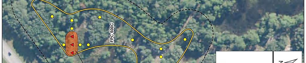
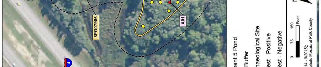
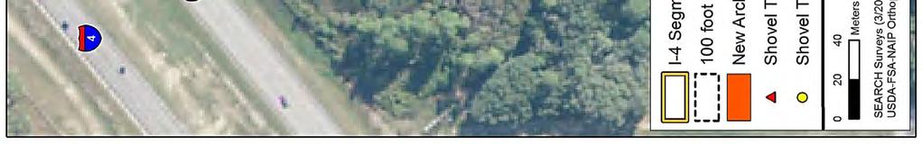
24 8.0 Survey Results 7.3 Laboratory Methods All artifacts recovered during the archaeological survey were returned to the laboratory facilities at the SEARCH office in Newberry, Florida for cleaning and processing. Artifacts were washed clean of sand and dirt and allowed to air dry. Materials were then rebagged and organized by provenience and artifact class. All artifacts were weighed. Field specimen numbers were assigned in the lab. Recovered artifacts included Native American pottery. Prehistoric ceramics were analyzed by temper, surface decoration, and vessel morphology. 7.4 Curation The recovered artifacts, original maps and field notes will be turned over to FDOT, District 1 upon completion of the project; copies of field documents will be retained at the Newberry office of SEARCH. 7.5 Procedures to Address Unexpected Discoveries Every reasonable effort has been made during this investigation to identify and evaluate possible locations of prehistoric and historic archaeological sites; however, the possibility exists that evidence of cultural resources may yet be encountered within the project limits. Should any evidence of unrecorded cultural resources be discovered during construction activities, all work in that portion of the project area must stop. Evidence of cultural resources includes aboriginal or historic pottery, prehistoric stone tools, bone or shell tools, historic trash pits, and historic building foundations. Should questionable materials be uncovered during the excavation of the project area, representatives of FDOT, District 1 will assist in the identification and preliminary assessment of the materials. If such evidence is found, the FDHR will be notified within two working days. In the unlikely event that human skeletal remains or associated burial artifacts are uncovered within the project area, all work in that area must stop. The FDOT, District 1 Cultural Resources Coordinator must be contacted. The discovery must be reported to local law enforcement who will in turn contact the medical examiner. The medical examiner will determine whether or not the State Archaeologist should be contacted per the requirements of Chapter , Florida Statutes. 8.0 Survey Results 8.1 Archaeology Results During the cultural resource survey of the I 4 Segment 5 ponds, pedestrian survey was combined with 62 subsurface shovel tests placed at 50 and 25 meter (164 and 82 foot) intervals, and judgmentally, throughout nine of the proposed or modified pond footprints. Figures 11 through 14 show the locations of shovel tests as recorded with handheld GPS units. One archaeological site (8PO07986) was recorded, and one archaeological occurrence (AO1) was identified (Figure 11). A FMSF form for 8PO07986 has been provided in Attachment 2. Table 2 summarizes the results of the field investigation. An FMSF survey log sheet was prepared and is provided in Attachment 3. SR 400 (I 4) Project Development and Environment (PD&E) Study FM No.:
 Project Development and Environment (PD&E) Study FM No.")
25 8.0 Survey Results Figure 11 Shovel test locations within the I 4 Segment 5 Ponds. Map 1 of 4. SR 400 (I 4) Project Development and Environment (PD&E) Study FM No.:
 Project Development and Environment (PD&E) Study FM No.")
26 8.0 Survey Results Figure 12 Shovel test locations within the I 4 Segment 5 Ponds. Map 2 of 4. SR 400 (I 4) Project Development and Environment (PD&E) Study FM No.:
 Project Development and Environment (PD&E) Study FM No.")
27 8.0 Survey Results Figure 13 Shovel test locations within the I 4 Segment 5 Ponds. Map 3 of 4. SR 400 (I 4) Project Development and Environment (PD&E) Study FM No.:
 Project Development and Environment (PD&E) Study FM No.")
28 8.0 Survey Results Figure 14 Shovel test locations within the I 4 Segment 5 Ponds. Map 4 of 4. SR 400 (I 4) Project Development and Environment (PD&E) Study FM No.:
29 8.0 Survey Results Table 2 Results of Phase I Archaeological Survey of the 19 Proposed and Existing Ponds for the I 4 Segment 5 APE. Pond Acreage Shovel Tests Comment/Condition Results Existing/Expanded No archaeological sites or cultural material Existing/Regraded No archaeological sites or cultural material Regional Pond New Pond: NW side of I 4 No archaeological sites or cultural material Regional Pond New Pond: NW side of I 4 No archaeological sites or cultural material FPC 500C New Pond: SE side of I 4 One archaeological site recorded (8PO07986); one archaeological occurrence identified FPC 500D New Pond: NW side of I 4 No archaeological sites or cultural material 501A Existing/Reduced and regraded No archaeological sites or cultural material 501B Existing/Enlarged and regraded No archaeological sites or cultural material 501C Existing/Regraded No archaeological sites or cultural material Existing/No modification No archaeological sites or cultural material 503A Existing/Reduced and regraded No archaeological sites or cultural material 503B Existing pond on SE side of I 4 to be expanded/regraded No archaeological sites or cultural material 503C Existing/Split into two ponds No archaeological sites or cultural material 503D Existing/Split into two ponds No archaeological sites or cultural material Existing/No modification No archaeological sites or cultural material 505 A New Pond: NW side of I 4 No archaeological sites or cultural material 505 B New pond: SE side of I 4 No archaeological sites or cultural material New pond: NW side of I 4 No archaeological sites or cultural material FPC New pond: NW side of I 4 No archaeological sites or cultural material Total Newly Recorded Site 8PO07986 Location: T26S, R27E, Section 8. Setting: Upland mixed forest. Vegetation consists of live oak, pine, palmetto, and grass. Soils: Tavares fine sands, moderately well drained. Soils consist of gray to grayish brown sand, 0 20 cmbs (0 8 inches), and yellowish brown sand, cmbs (8 39 inches). Survey Methods: Shovel testing at 12.5 meter and 25 meter (41 foot and 82 foot) intervals; three positive shovel tests. Site Type: Prehistoric ceramic scatter. Site Size: Site measures 300 square meters. Site boundaries were identified by negative shovel tests 12.5 and 25 meters to the north, east, and south. Depth of Deposits: cmbs (4 39 inches). Chronology: Unknown. Artifacts: Five plain sand tempered sherds. Comments: 8PO07986 was recorded to be a low density prehistoric ceramic scatter located 65 meters southeast of I 4 (Figure 15). The temporal period associated with the prehistoric ceramics is unknown. SEARCH archaeologists excavated three shovel tests which were positive (STs 13, 28, and 30) for ceramic artifacts. Additional bounding shovel tests to the north, east, and south were negative for cultural material. SR 400 (I 4) Project Development and Environment (PD&E) Study FM No.:
 Project Development and Environment (PD&E) Study FM No.")
30 8.0 Survey Results Figure 15 Cultural resources recorded within the I 4 Segment 5 APE. SR 400 (I 4) Project Development and Environment (PD&E) Study FM No.:
31 8.0 Survey Results Evaluation: Considering the paucity of cultural materials, the unremarkable artifact assemblage, and the absence of subsurface features, the portion of 8PO07986 located within the I 4 Segment 5 APE does not demonstrate potential to yield important information regarding the prehistory or history of the region. Therefore, it is the opinion of the Principal Investigator that the portion of 8PO07986 located within the I 4 Segment 5 APE is not eligible for listing in the NRHP. No further work is recommended. Archaeological Occurrence (AO) Archaeological occurrences (AOs) are isolated shovel tests that contain one or two non diagnostic artifacts with no additional positive shovel tests in close proximity. They are not considered archaeological sites and are not eligible for listing in the NRHP. One isolated archaeological occurrence (AO1) was discovered during the survey. AO1 AO1 is located approximately 140 meters south of site 8PO07986 (see Figure 15) and consists of a total of one prehistoric plain sand tempered sherd from Shovel Test 016. The pottery was located within Stratum III at a depth of 70 to 80 cmbs. The shovel test consisted of three strata, which included Stratum I (0 3 cmbs), dark brown humic sand; Stratum II (3 10 cmbs), yellow brown sand; Stratum III ( cmbs), medium gray brown sand. AO1 is not eligible for NRHP listing, and no further work is recommended. 8.2 Architectural Survey Results The architectural survey resulted in the identification of three historic structures constructed before 1971 located within the I 4 Segment 5 APE: US Highway 27 (8PO07962), US Highway 27 (8PO07963), and US Highway 27 (8PO07989) (Table 3; Figure 16). The identified historic resources were evaluated to determine their significance and potential for listing in the NRHP. The resources are described below. The historic resources within the I 4 Segment 5 APE lack the architectural distinction and significant historical associations necessary to be considered for listing in the NRHP and are recommended ineligible. No potential NRHP districts were identified due to the lack of concentration of historic structures. FMSF forms were completed for each of the architectural resources and are provided in Attachment 2. The survey log sheet is provided in Attachment 3. Table 3 Historic Resources Recorded within the I 4 Segment 5 APE. FMSF No. Original/ Update Figure Location Address Architectural Style Build Date NRHP Status 8PO07962 Original US Highway 27 Masonry Vernacular ca Not eligible 8PO07963 Original US Highway 27 Masonry Vernacular ca Not eligible 8PO07989 Original US Highway 27 Masonry Vernacular 1970 Not eligible SR 400 (I 4) Project Development and Environment (PD&E) Study FM No.:


32 8.0 Survey Results Figure 16 Historic resources recorded within the I 4 Segment 5 APE. SR 400 (I 4) Project Development and Environment (PD&E) Study FM No.:
.")
33 8.0 Survey Results SEARCH also examined the Polk County Property Appraiser s records, which indicated that six parcels containing 15 structures that date from 1971 to 1974 are located within the APE (Table 4). Using data from the Property Appraisers records, as well as examination of photographs from desktop resources, SEARCH Architectural Historians made preliminary evaluations of these buildings. If the project progresses slowly, it will be necessary to develop a historic context that addresses the development of hotels and other tourist related resources in Central Florida that were spurred by the construction of Walt Disney World. These resources would also need to be documented (FMSF resource forms completed) and assessed for their NRHP eligibility. Table 4 Parcels along the I 4 Segment 5 APE that Contain Resources Constructed between 1971 and Preliminary Evaluation Parcel Number Address Date Based on Desktop Analysis US Highway Not eligible US Highway (x5) Not eligible US Highway Not eligible US Highway (x3) Not eligible US Highway (x4) Not eligible US Highway Not eligible Standing Structures 8PO07962, US Highway 27 8PO07962 is a newly recorded structure located at US Highway 27 within the I 4 Segment 5 APE in Section 7 of Township 26 South, Range 27 East, as shown on the 1985 Gum Lake, Fla. USGS quadrangle map (see Figure 16). The ca building currently functions as a gas station and is situated near the center of an irregular shaped parcel that fronts US Highway 27. Resource 8PO07962 is a one story, rectangular plan Masonry Vernacular building set on a poured concrete slab foundation (Figure 17). The roof is a built up, front gable design that features T1 11 plywood siding, brick, and stucco in the gable ends. The exterior fabric is a combination of concrete block and brick. The windows on the building are not arranged in a particular pattern but consist of clerestory windows on the west façade and commercial fixed sash metal Figure 17 Resource 8PO07962, facing west. window set in groupings of two and three on the east and north facades. The main entry is on the east façade and features paired fixed sash glass and metal doors with a one light transom. A one story, rectangular shaped addition is attached to the west façade; and a wooden shed with paired, outward swinging doors is attached to the west façade of the addition. A pump canopy consisting of four pumps and supported by four concrete columns is located to the east. Resource 8PO07962 is a Masonry Vernacular building that represents a highly prevalent approach to commercial architectural design in Florida, as well as the United States in general. Based on the historic context, it is the opinion of the SR 400 (I 4) Project Development and Environment (PD&E) Study FM No.:

34 8.0 Survey Results Principal Investigator that the building is not significant under NRHP Criterion A because it is not indicative of a particular era and is not associated with any significant period, event, or theme. Resource 8PO07962 is part of commercial infill along I 4 and US 27. The building was constructed for commercial use and has no known role or significant association with the development of interstate tourism in central Florida. Furthermore, the resource is not eligible under Criterion B because it lacks association with any person(s) significant in history. Also, the resource is not eligible under Criterion C due to its lack of architectural distinction. The overall design of Resource 8PO07962 does not represent or embody the distinctive characteristics of a type of construction, and it does not possess high artistic value. Beginning in the 1920s, gas station architecture consciously developed around styles to attract customers via place product packaging (Jakle and Sculle 1999:163). With franchising and the placement of gas stations near the interstate system, gas station design became more utilitarian. In the latter half of the twentieth century, this design transitioned to oblong boxes stripped of ornamentation with multiple bays and pump canopies (Jakle and Sculle 1999: ). 8PO07962 is one of many examples of this utilitarian style of mid century gas station. Finally, the building is not significant under Criterion D because it lacks the potential to yield further information of historical importance. It is the opinion of the Principal Investigator that 8PO07962 does not meet the minimum criteria for listing in the NRHP, either individually or as a contributing resource to a historic district. 8PO07963, US Highway 27 8PO07963 is a newly recorded structure located at US Highway 27 within Segment 5 of the I 4 APE in Section 7 of Township 26 South, Range 27 East, as shown on the 1985 Gum Lake, Fla. USGS quadrangle map (see Figure 16). The ca building currently functions as a gas station and auto service center. The building is situated near the center of a rectangular shaped parcel that fronts US Highway 27. Resource 8PO07963 is a one story, rectangular plan Masonry Vernacular building set on a poured concrete slab foundation (Figure 18). The roof is a built up, flat roof design that features an aluminum clad overhang surrounding the building. The exterior fabric is T1 11 plywood over concrete block. The windows on the building are not arranged in a particular pattern but consist of metal industrial windows with four rows of nine, fixed sash lights on the north façade and commercial fixed sash metal windows in a grouping of three on the east facade. The main entry is on the east façade and features a fixed sash glass and metal door with a one light transom. Two single bay roll up garage doors pierce the east façade, offset north. A one story, rectangular shaped concrete block addition is attached to the west façade. A pump canopy consisting of four pumps and supported by four concrete columns is located to the east. Resource 8PO07963 is a Masonry Vernacular building that represents a highly prevalent approach to commercial architectural design in Florida, as well as the United States in general. Based on the historic context, it is the opinion of the Principal Investigator that the building is not significant under NRHP Criterion A because it is not indicative of a particular era and is not associated with any significant period, event, or theme. Resource 8PO07963 is part of commercial infill along I 4 and US 27. The building was constructed for commercial use and has no known role or significant association with the development of interstate tourism in central Florida. Figure 18 Resource 8PO07963, facing west. SR 400 (I 4) Project Development and Environment (PD&E) Study FM No.:
35 8.0 Survey Results Furthermore, the resource is not eligible under Criterion B because it lacks association with any person(s) significant in history. Also, the resource is not eligible under Criterion C due to its lack of architectural distinction. The overall design of Resource 8PO07963 does not represent or embody the distinctive characteristics of a type of construction, and it does not possess high artistic value. Beginning in the 1920s, gas station architecture consciously developed around styles to attract customers via place product packaging (Jakle and Sculle 1999:163). With franchising and the placement of gas stations near the interstate system, gas station design became more utilitarian. In the latter half of the twentieth century, this design transitioned to oblong boxes stripped of ornamentation with multiple bays and pump canopies (Jakle and Sculle 1999: ). 8PO07963 is one of many examples of this utilitarian style of mid century gas station. Finally, the building is not significant under Criterion D because it lacks the potential to yield further information of historical importance. It is the opinion of the Principal Investigator that 8PO07963 does not meet the minimum criteria for listing in the NRHP, either individually or as a contributing resource to a historic district. 8PO07989, US Highway 27 8PO07989 is a newly recorded structure located at US Highway 27 within Segment 5 of the I 4 APE in Section 7 of Township 26 South, Range 27 East, as shown on the 1985 Gum Lake, Fla. USGS quadrangle map (see Figure 16). The ca building currently functions as a storage facility. The building is situated near the center of a rectangular shaped parcel that fronts US Highway 27. Resource 8PO07989 is a one story, rectangular plan Masonry Vernacular building set on a poured concrete slab foundation (Figure 19). The flat roof design features a wood shingle clad overhang in a mansard style surrounding the building. The construction and structural Figure 19 Resource 8PO07989, facing north. system is concrete block. The windows on the building are not arranged in a particular pattern but consist of metal awning windows. A flat metal roof supported by two posts extends from the southwest façade and covers mechanical equipment. The resource is surrounded by a chain link fence with plastic infill and barbed wire at the top. A double leaf gate opens on the west side of the fence. Resource 8PO07989 is a Masonry Vernacular building that represents a highly prevalent approach to industrial architectural design in Florida, as well as the United States in general. Based on the historic context, it is the opinion of the Principal Investigator that the building is not significant under NRHP Criterion A because it is not indicative of a particular era and is not associated with any significant period, event, or theme. Resource 8PO07989 is part of commercial and industrial infill along I 4 and US 27. The building was constructed for industrial use and has no known role or significant association with the development of central Florida. Furthermore, the resource is not eligible under Criterion B because it lacks association with any person(s) significant in history. Also, the resource is not eligible under Criterion C due to its lack of architectural distinction. The overall design of Resource 8PO07989 does not represent or embody the distinctive characteristics of a type of construction, and it does not possess high artistic value. Finally, the building is not significant under Criterion D because it lacks the potential to yield further information of historical importance. It is the opinion of the Principal Investigator that 8PO07989 does not meet the minimum criteria for listing in the NRHP, either individually or as a contributing resource to a historic district. SR 400 (I 4) Project Development and Environment (PD&E) Study FM No.:
36 9.0 Conclusions and Recommendations 9.0 Conclusions and Recommendations This technical memorandum details the results of a CRAS conducted in support of proposed improvements of I 4 from west of SR 25/US 27 to west of CR 532 in Polk County, Florida. The document serves as an addendum to a previous report (ACI 1995). The regional prehistory and history of the current project area are consistent with those described in the previous report and are not repeated here. Archaeological survey was conducted within the footprints of eight proposed new ponds and the modification to one existing pond, and architectural survey included the entire APE. SEARCH s field investigations consisted of pedestrian surface inspection and the excavation of 62 shovel tests. Five prehistoric ceramic artifacts were recovered from three shovel tests within FPC 500C, representing a newly identified archaeological site (8PO07986). It is unlikely that additional research of 8PO07986 would yield information important to the prehistory of central Florida. It is the opinion of SEARCH that 8PO07986 is ineligible for the NRHP. One archaeological occurrence (AO1) was also identified in FPC 500C. This AO does not meet the criteria for significance required for inclusion in the NRHP. No further archaeological survey is recommended for the proposed ponds. The architectural survey resulted in the identification of three historic structures constructed before 1971 located within Segment 5 of the I 4 APE: US Highway 27 (8PO07962), US Highway 27 (8PO07963), and US Highway 27 (8PO07989). The identified historic resources were evaluated to determine their significance and potential for listing in the NRHP. The historic resources within the I 4 Segment 5 APE lack the architectural distinction and significant historical associations necessary to be considered for listing in the NRHP and are recommended ineligible. No potential NRHP districts were identified due to the lack of concentration of historic structures. In addition to the aforementioned historic resources constructed before 1971, SEARCH examined the Polk County Property Appraiser s records, which indicated that 15 structures are located within the APE that date from 1971 to Depending on the progression of the project (i.e., how much time elapses between the current study and the eventual design/construction of the project), it may become necessary to inventory and assess these resources. It is recommended that the project design team make a commitment to document any structures that reach historic status prior to project construction as part of a supplemental CRAS. SEARCH will commit to a follow up discussion with the design team as part of a supplemental review upon request. SR 400 (I 4) Project Development and Environment (PD&E) Study FM No.:
37 10.0 References Cited 10.0 References Cited Archaeological Consultants, Inc. (ACI) 1995 Cultural Resource Assessment Survey, Interstate 4 Project Development and Environment Study, Polk County, Florida. Florida Master Site File Survey No On file, Florida Division of Historical Resources, Tallahassee. Bradbury, Alford G. and E. Story Hallock 1962 A Chronology of Florida Post Office. Florida Federation of Stamp Clubs, Vero Beach. Brooks, H. K Guide to the Physiographic Divisions of Florida. Florida Cooperative Extension Service. University of Florida, Gainesville. Colton and Company 1880 Colton s New Sectional Map of the Eastern Portion of Florida. G.W. and C.B. Colton and Company, New York. Electronic Document, accessed September 16, Cram, George Franklin 1886 Cram s Atlas. George F. Cram, Chicago. Electronic Document, accessed September 16, Cram s Atlas. George F. Cram, Chicago. Electronic Document, accessed September 16, Endonino, Jon C The Thornhill Lake Archaeological Research Project: Report of Investigations, Laboratory of Southeastern Archaeology, University of Florida, Gainesville. On file, Florida Division of Historical Resources, Tallahassee. Florida State Road Department 1936 General Highway Map of Polk County. Florida Department of Transportation, Tallahassee. Electronic document, accessed September 16, General Highway Map of Polk County. Florida Department of Transportation, Tallahassee. Electronic document, accessed September 16, General Land Office (GLO) 1848 Township 26 South, Range 26 East. Electronic document, accessed September 16, Township 26 South, Range 26 East. Electronic document, accessed September 16, Jakle, John A. and Keith A. Sculle 1999 Fast Food: Roadside Restaurants in the Automobile Age. Johns Hopkins University Press, Baltimore. SR 400 (I 4) Project Development and Environment (PD&E) Study FM No.:
38 10.0 References Cited Martenet, Simon J New Topographical Atlas of the State of Ohio. Stedman, Brown & Lyon/H.H. Lloyd and Co. Electronic Document, accessed September 16, Milanich, Jerald T Archaeology of Precolumbian Florida. University Press of Florida, Gainesville Original Inhabitants. In The New History of Florida, edited by Michael Gannon, pp University Press of Florida, Gainesville. Milanich, Jerald T., and Charles H. Fairbanks 1980 Florida Archaeology. Academic Press, New York. Norton, Charles Ledyard 1890 A Handbook of Florida. Longmans, Green, & Co., New York. Electronic Document, accessed September 16, Rand McNally and Co Map of Polk County. In Atlas of the World. Rand McNally and Co., Chicago. Electronic document, accessed September 16, Map of Florida. Rand McNally and Co., Buffalo. Electronic document, accessed September 16, Rohling, E. J., M. Fenton, F. J. Jorissen, P. Bertrant, G. Ganssen, and J. P. Caulet 1998 Magnitudes of Sea Level Lowstands of the Past 500,000 Years. Nature 394: Sullivan, A. P., III, and K. C. Rozen 1985 Debitage Analysis and Archaeological Interpretation. American Antiquity 50: Tebeau, Charlton W A History of Florida. Rev University of Miami Press, Coral Gables. Upchurch, Sam B., R. N. Storm, and M. G. Nuckels 1982 Methods of Provenance Determination of Florida Cherts. Manuscript on file, Geology Department, University of South Florida. US Department of Agriculture (USDA) 1944 Aerial Photographs: Polk County. Florida Aerial Photography, University of Florida Digital Collection. Electronic document, accessed September 16, Aerial Photographs: Polk County. Florida Aerial Photography, University of Florida Digital Collection. Electronic document, accessed September 16, Aerial Photographs: Polk County. Florida Aerial Photography, University of Florida Digital Collection. Electronic document, accessed September 16, SR 400 (I 4) Project Development and Environment (PD&E) Study FM No.:
39 10.0 References Cited US Department of the Interior 1997 National Register Bulletin 15: How to Apply the National Register Criteria for Evaluation. US Department of the Interior, National Park Service, Cultural Resources. US Government Printing Office, Washington, DC. US Geological Survey (USGS) 1980 Davenport, Fla. topographic quadrangle. US Geological Survey, Reston, Virginia Lake Louisa SW, Fla. topographic quadrangle. US Geological Survey, Reston, Virginia Intercession City, Fla. topographic quadrangle. US Geological Survey, Reston, Virginia Gum Lake, Fla. topographic quadrangle. US Geological Survey, Reston, Virginia. Watts, W. A A Pollen Diagram from Mud Lake, Marion County, North Central Florida. Geological Society of America Bulletin 80: Postglacial and Interglacial Vegetation History of Southern Georgia and Central Florida. Ecology 52: A Late Quaternary Record of Vegetation from Lake Annie, South Central Florida. Geology 3: The Late Quaternary Vegetation History of the Southeastern United States. Annual Reviews of Ecology and Systematics 11: SR 400 (I 4) Project Development and Environment (PD&E) Study FM No.:
40 10.0 References Cited This page intentionally left blank. SR 400 (I 4) Project Development and Environment (PD&E) Study FM No.:
41 Attachment 1: Previous Surveys Attachment 1 Previous Cultural Resource Surveys Conducted within One Mile of the I 4 Segment 5 APE SR 400 (I 4) Project Development and Environment (PD&E) Study FM No.:
42 Attachment 1: Previous Surveys This page intentionally left blank. SR 400 (I 4) Project Development and Environment (PD&E) Study FM No.:
43 Attachment 1: Previous Surveys Previous Cultural Resource Surveys Conducted within One Mile of the I 4 Segment 5 APE. FMSF No. Title Date Author 640 Culture Resources Survey of Ridgewood Lakes (aka Edgehill Development) Cultural resource assessment survey of the City of Kissimmee's proposed wastewater disposal site, Osceola County, Florida Piper Archaeological Research, Inc. Piper Archaeological Research, Inc An archaeological survey of the proposed Osceola Pointe DRI 1988 Rollins College A Cultural Resource Assessment Survey of the Interstate 4 County Road 532 Interchange Expansion, Osceola and Polk County, Florida A Cultural Resource Assessment Survey of Four Bifurcated Median Areas within Interstate 4 (State Road 400), Polk County, Florida. Cultural resource assessment survey of the proposed Hexagon Center development site, Osceola County, Florida A Cultural Resource Assessment Survey of the Heidrich Community DRI Project Area, Osceola County, Florida Cultural Resource Assessment of the Bishop & Buttrey, Inc. Proposed Borrow Pit #45, Osceola County, Florida A Cultural Resource Assessment Survey, Interstate 4 PD&E Study, Polk County, Florida 4251 Cultural Resource Assessment of the B & B Borrow Pit #22 Polk County, Florida Cultural Resource Assessment Survey, Sixteen Proposed Pond Sites on I 4, East of SR 557 to West of US 27, Polk County, Florida; WPI , SPN Cultural Resource Assessment of the B@B Borrow Pit #46 Property, Polk County, Florida 4639 Cultural Resource Assessment of the B & B Borrow Pit #39, Polk County, Florida Cultural Resource Assessment Survey of the Interstate 4 (SR 400) Project Development and Environment (PD&E) Study Six Laning from US 27 (SR 25) to US 192 (SR 530) in Polk and Osceola Counties, Florida Cultural Resource Survey and Assessment Bridgewater Crossing Phase III, Polk County, Florida Cultural Resource Assessment Survey for US Highway 27 (State Road 25) from SR 544 to CR 547 and from CR 547 to SR 400 (I 4) in Polk County, Florida I 4 (S.R. 400) Project Development and Environmental Study from C.R. 532 (Osceola Polk Line Road) to S.R. 528 (Beeline Expressway) in Osceola and Orange Counties, Florida Archaeological/Historical Resource Assessment Survey Update Report for Stormwater Pond Siting, Interstate 4/U.S. 27 Interchange, Polk County, Florida Cultural Resources Assessment Survey of the Proposed Buccaneer Gas Pipeline, Florida [Volume 1: Final Report of Findings; Volume 2: Appendices] Cultural Resource Assessment Survey for the Interstate 4 (State Road 400), Segment 7 Storm Water Management Facilities from US Highway 27 to the Polk/Osceola County Line, Polk County, Florida Piper Archaeological Research, Inc. Piper Archaeological Research, Inc. Piper Archaeological Research, Inc. Janus Research/Piper Archaeological Research, Inc. University of South Florida Archaeological Consultants, Inc. University of South Florida Archaeological Consultants, Inc. University of South Florida University of South Florida 1997 Janus Research 1999 SouthArc, Inc Janus Research 1998 Environmental Services, Inc HDR Engineering Inc Panamerican Consultants, Inc Janus Research 6297 Gulfstream Cultural Resources Supplemental Report Janus Research 6332 Gulfstream Natural Gas System Cultural Resources Supplemental Report Janus Research SR 400 (I 4) Project Development and Environment (PD&E) Study FM No.:
44 Attachment 1: Previous Surveys Previous Cultural Resource Surveys Conducted within One Mile of the I 4 Segment 5 APE. FMSF No. Title Date Author Cultural Resource Follow up Surveys for Lines 500 and 600 (Supplemental Report 5) Cultural Resource Assessment Survey for Gulfstream Monitor and Control System: 2002 In Service (Supplemental Report 8) An Archaeological and Historical Survey of the Stoneybrook South Project area in Osceola and Polk Counties, Florida A Phase 1 Cultural Resource Survey of the Oakmont Development Project Area, Polk County, Florida A Phase 1 Cultural Resource Survey of the MDC Project Area, Polk County, Florida Cultural Resources Assessment Technical Memorandum, Attenuated Roadside Swales, SR 25 (US 27) from Holly Hill Grove Road 1 to North of Deer Creek Boulevard, Polk County, Florida An Archaeological and Historical Survey of the Four Corners Town Center Property in Polk County, Florida Cultural Resource Survey and Assessment Tuscana Retention Pond, Osceola County, Florida 2002 Janus Research 2002 Janus Research 2003 Panamerican Consultants, Inc SEARCH, Inc SEARCH, Inc Archaeological Consultants, Inc. Panamerican Consultants, Inc SouthArc, Inc A Phase 1 Cultural Resources Survey of the Meadows PUD, Polk County, Florida 2005 SEARCH, Inc Cultural Resource Assessment Survey Report Florida High Speed Rail Authority Project Development and Environment (PD&E) Study from Tampa to Orlando Hillsborough, Polk, Osceola, and Orange Counties, Florida A Phase I Cultural Resources Assessment of the Ernie Caldwell Boulevard Corridor and Associated Ponds and Conservation Mitigation Areas, Polk County, Florida Assessment and Documentation of Cultural Resources on the Hilochee Wildlife Management Area in units in Lake and Polk Counties, Florida Cultural Resource Survey of the Tramonto Estates Property, Polk County, Florida Cultural Resource Assessment Survey US 27 Project Development and Environment (PD&E) Study from I 4 to US 192 Polk County, Florida Addendum: A Phase I Cultural Resources Assessment of Additions and Expansions to the Ernie Caldwell Boulevard and the Pine Tree Trail Project Corridors, Polk County, Florida Cultural Resource Assessment Survey, Project Development and Environment Study, Central Polk Parkway from S.R. 60 to Polk Parkway (S.R. 570) and from S.R. 60 to I 4, Polk County, Florida Cultural Resources Survey and Assessment, Champions Gate Sports Complex, Polk County, Florida Cultural Resource Survey of Six Segments along the OUC Lakeland Taft 23kV Transmission Line, Polk and Osceola Counties, Florida Cultural Resource Assessment Survey, One Roadway Transfer Section, Northwest Access Road Located at the Northwest Corner of I 4 and US 27 from SR 25/US 27 to South End of Pavement, Polk County, Florida 2003 Archaeological Consultants, Inc PBS&J, Inc Bureau of Archaeological Research Suncoast Archaeological Consultants, Inc. Archaeological Consultants, Inc PBS&J, Inc Archaeological Consultants, Inc SouthArc, Inc SEARCH, Inc Archaeological Consultants, Inc. SR 400 (I 4) Project Development and Environment (PD&E) Study FM No.:
45 Attachment 1: Previous Surveys Previous Cultural Resource Surveys Conducted within One Mile of the I 4 Segment 5 APE. FMSF No. Title Date Author Cultural Resource Survey and Assessment, Champions Gate Village, Polk and Osceola Counties, Florida Cultural Resource Research Design/Probability Assessment, Central Polk Parkway PD&E Study, S.R. 60 to the Polk Parkway (S.R. 570) and S. R. 60 to I 4, Polk County, Florida; Financial Project ID: Cultural Resource Assessment Survey, Ronald Reagan Parkway Property, Polk County, Florida 2014 SouthArc, Inc Archaeological Consultants, Inc. Archaeological Consultants, Inc. SR 400 (I 4) Project Development and Environment (PD&E) Study FM No.:
46 Attachment 2: FMSF Resource Forms This page intentionally left blank. SR 400 (I 4) Project Development and Environment (PD&E) Study FM No.:
47 Attachment 2: FMSF Resource Forms Attachment 2 FMSF Resource Forms SR 400 (I 4) Project Development and Environment (PD&E) Study FM No.:
48 Attachment 2: FMSF Resource Forms This page intentionally left blank. SR 400 (I 4) Project Development and Environment (PD&E) Study FM No.:
49 Page 1 Original Update ARCHAEOLOGICAL SITE FORM FLORIDA MASTER SITE FILE Version 4.0 1/07 Consult Guide to Archaeological Site Form for detailed instructions Site #8 PO07986 Field Date Form Date Recorder # Site Name(s) SEARCH 1 Multiple Listing (DHR only) Project Name CRAS of I-4, Segment 5 Survey # (DHR only) Ownership: private-profit private-nonprofit private-individual private-nonspecific city county state federal Native American foreign unknown LOCATION & MAPPING USGS 7.5 Map Name GUM LAKE USGS Date 1985 Plat or Other Map City/Town (within 3 miles) Intercession City In City Limits? yes no unknown County Polk Township 26S Range 27E Section 8 ¼ section: NW SW SE NE Irregular-name: Township Range Section ¼ section: NW SW SE NE Landgrant Tax Parcel # UTM Coordinates: Zone Easting Northing Other Coordinates: X: Y: Coordinate System & Datum Address / Vicinity / Route to: Approximately 0.9 miles northeast of US 27, on southeast side of I-4. _ Name of Public Tract (e.g., park) TYPE OF SITE (select all that apply) SETTING STRUCTURES OR FEATURES FUNCTION Land (terrestrial) Wetland (palustrine) log boat fort road segment campsite Lake/Pond (lacustrine) usually flooded agric/farm building midden shell midden extractive site River/Stream/Creek (riverine) usually dry burial mound mill shell mound habitation (prehistoric) Tidal (estuarine) Cave/Sink (subterranean) building remains mission shipwreck homestead (historic) Saltwater (marine) terrestrial cemetery/grave mound, nonspecific subsurface features farmstead aquatic dump/refuse plantation surface scatter village (prehistoric) Other Features or Functions (Choose from the list or type a response.) earthworks (historic) platform mound well town (historic) quarry CULTURE PERIODS (select all that apply) ABORIGINAL Englewood Manasota St. Johns (nonspecific) Swift Creek (nonspecific) NON-ABORIGINAL Alachua Fort Walton Mississippian St. Johns I Swift Creek, Early First Spanish Archaic (nonspecific) Glades (nonspecific) Mount Taylor St. Johns II Swift Creek, Late First Spanish Archaic, Early Glades I Norwood Santa Rosa Transitional First Spanish Archaic, Middle Glades II Orange Santa Rosa-Swift Creek Weeden Island (nonspecific) First Spanish (nonspecific) Archaic, Late Glades III Paleoindian Seminole (nonspecific) Weeden Island I British Belle Glade Hickory Pond Pensacola Seminole: Colonization Weeden Island II Second Spanish Cades Pond Leon-Jefferson Perico Island Seminole: 1st War To 2nd Prehistoric (nonspecific) American Territorial Caloosahatchee Malabar I Safety Harbor Seminole: 2nd War To 3rd Prehistoric non-ceramic American Civil War Deptford Malabar II St. Augustine Seminole: 3rd War & After Prehistoric ceramic American 19th Century Other Cultures (Choose from the list or type a response. For historic sites, give specific dates.) OPINION OF RESOURCE SIGNIFICANCE American 20th Century American (nonspecific) African-American Potentially eligible individually for National Register of Historic Places? yes no insufficient information Potentially eligible as contributor to a National Register district? yes no insufficient information Explanation of Evaluation (required if evaluated; use separate sheet if needed) Low density prehistoric ceramics. The artifacts _ represented types common to the area and not presenting a significant contribution to the understanding of _ regional history. Recommendations for Owner or SHPO Action no further action is recommended _ DHR USE ONLY OFFICIAL EVALUATION DHR USE ONLY NR List Date SHPO Appears to meet criteria for NR listing: yes no insufficient info Date Init. KEEPER Determined eligible: yes no Date Owner Objection NR Criteria for Evaluation: a b c d (see National Register Bulletin 15, p. 2) HR6E045R0107 Florida Master Site File / Div. of Historical Resources / R. A. Gray Bldg / 500 S Bronough St., Tallahassee, FL Phone (850) / Fax (850) / SiteFile@dos.state.fl.us
50 Page 2 ARCHAEOLOGICAL SITE FORM Site #8 PO07986 FIELD METHODS (select all that apply) SITE DETECTION SITE BOUNDARY no field check exposed ground screened shovel bounds unknown remote sensing unscreened shovel literature search posthole tests screened shovel-1/4 none by recorder exposed ground screened shovel informant report auger tests screened shovel-1/8 literature search posthole tests block excavations remote sensing unscreened shovel screened shovel-1/16 informant report auger tests estimate or guess Other methods; number, size, depth, pattern of units; screen size (attach site plan) Shovel testing at 12.5 and 25-meter intervals until two negatives or the project boundary was identified. Eight shovel tests were excavated, resulting in 3 positives. SITE DESCRIPTION Extent Size (m 2 ) 300 Depth/stratigraphy of cultural deposit Soils consist of gray to grayish brown sand, 0 to 20 cmbs, and yellowish brown sand, 2 to 100 cmbs. Temporal Interpretation - Components (check one): single component multiple component uncertain Describe each occupation in plan (refer to attached large scale map) and stratigraphically. Discuss temporal and functional interpretations: Artifacts located between cmbs. Integrity - Overall disturbance: none seen minor substantial major redeposited destroyed-document! unknown Disturbances / threats / protective measures Surface collection: area collected 0 m 2 # collection units Excavation: # noncontiguous blocks ARTIFACTS Total Artifacts # 5 count estimate Surface # 0 Subsurface # 5 COLLECTION SELECTIVITY ARTIFACT CATEGORIES and DISPOSITIONS select a disposition from the list below for unknown unselective (all artifacts) A - Aboriginal ceramics each artifact category selected at left selective (some artifacts) - mixed selectivity - A - category always collected SPATIAL CONTROL - S - some items in category collected uncollected general (not by subarea) - O - observed first hand, but not collected unknown controlled (by subarea) - R - collected and subsequently left at site variable spatial control - I - informant reported category present other (describe in comments below) - U - unknown Artifact Comments Plain sand tempered sherds. DIAGNOSTICS (type or mode, and frequency: e.g., Suwanee ppk, heat-treated chert, Deptford Check-stamped, ironstone/whiteware) 1. N= 4. N= 7. N= 2. N= 5. N= 8. N= 3. N= 6. N= 9. N= ENVIRONMENT Nearest fresh water: Type Wetland Name unknown Distance from site (m) 10 Natural community Topography Hill Elevation: Min m 10 Max m 10 Local vegetation Pine, oak, palmetto, grass Present land use Wooded SCS soil series Tavares fine sand Soil association Tavares DOCUMENTATION Accessible Documentation Not Filed with the Site File - including field notes, analysis notes, photos, plans and other important documents Document type Field notes Maintaining organization Southeastern Archaeological Research 1) Document description File or accession # s Document type Field maps Maintaining organization Southeastern Archaeological Research 2) Document description File or accession # s RECORDER & INFORMANT INFORMATION Informant Information: Name n/a Address / Phone / Melissa Dye SEARCH Address / Phone / San Jose Blvd, Suite 204, Jacksonville, FL 32223/ /melissa@searchinc.com Recorder Information: Name Affiliation Required Attachments PHOTOCOPY OF 7.5 USGS QUAD MAP WITH SITE BOUNDARIES MARKED and SITE PLAN Plan at 1:3,600 or larger. Show boundaries, scale, north arrow, test/collection units, landmarks and date.


,")
,")

51 % I-4 Segment 5 APE 8PO07986 A01 I-4 Segment 5 APE New Archaeological Site ,180 Meters SEARCH Surveys (9/2014); ± Feet USGS Quad Maps #28081-B6, Gum Lake (1985), #28081-C6, Lake Louisa SW (1980), #28081-C5, Intercession City (1980), and #28081-B5, Davenport (1980)
52
53 Page 1 Original Update HISTORICAL STRUCTURE FORM FLORIDA MASTER SITE FILE Version 4.0 1/07 Shaded Fields represent the minimum acceptable level of documentation. Consult the Guide to Historical Structure Forms for detailed instructions. Site #8 PO07962 Field Date Form Date Recorder # Site Name(s) (address if none) US Highway 27 Multiple Listing (DHR only) Survey Project Name CRAS of Improvements to I-4 Survey # (DHR only) National Register Category (please check one) building structure district site object Ownership: private-profit private-nonprofit private-individual private-nonspecific city county state federal Native American foreign unknown LOCATION & MAPPING Street Number Direction Street Name Street Type Suffix Direction Address: US Highway 27 _ Cross Streets (nearest / between) US Hwy 27/I-4/Frontage Road USGS 7.5 Map Name GUM LAKE USGS Date 1985 Plat or Other Map City / Town (within 3 miles) Davenport In City Limits? yes no unknown County Polk Township 26S Range 27E Section 7 ¼ section: NW SW SE NE Irregular-name: Tax Parcel # Landgrant Subdivision Name Block Lot UTM Coordinates: Zone Easting Northing Other Coordinates: X: Y: Coordinate System & Datum Name of Public Tract (e.g., park) HISTORY Construction Year: 1967 approximately year listed or earlier year listed or later Original Use Gas station From (year): 1967 To (year): 2014 Current Use Gas station From (year): 1967 To (year): 2014 Other Use From (year): To (year): Moves: yes no unknown Date: Original address Alterations: yes no unknown Date: Nature Replacement windows & doors Additions: yes no unknown Date: Nature Addition to the west facade Architect (last name first): Builder (last name first): Ownership History (especially original owner, dates, profession, etc.) Is the Resource Affected by a Local Preservation Ordinance? yes no unknown Describe DESCRIPTION Style Masonry Vernacular Exterior Plan Rectangular Number of Stories 1 Exterior Fabric(s) 1. Concrete block 2. Brick 3. Roof Type(s) 1. Gable Roof Material(s) 1. Built-up Roof secondary strucs. (dormers etc.) Windows (types, materials, etc.) Includes clerestory windows and commercial fixed-sash metal windows in groupings of two and three Distinguishing Architectural Features (exterior or interior ornaments) T1-11 siding, brick, and stucco in the gable ends; pump canopy Ancillary Features / Outbuildings (record outbuildings, major landscape features; use continuation sheet if needed.) DHR USE ONLY OFFICIAL EVALUATION DHR USE ONLY NR List Date SHPO Appears to meet criteria for NR listing: yes no insufficient info Date Init. KEEPER Determined eligible: yes no Date Owner Objection NR Criteria for Evaluation: a b c d (see National Register Bulletin 15, p. 2) HR6E046R0107 Florida Master Site File / Division of Historical Resources / R. A. Gray Building / 500 South Bronough Street, Tallahassee, FL Phone (850) / Fax (850) / SiteFile@dos.state.fl.us
54 Page 2 HISTORICAL STRUCTURE FORM Site #8 PO07962 DESCRIPTION (continued) Chimney: No. Chimney Material(s): Structural System(s): 1. Concrete block Foundation Type(s): 1. Slab 2. Foundation Material(s): 1. Poured Concrete Footing 2. Main Entrance (stylistic details) Main entry on east facade features paired fixed-sash glass and metal doors w/ a onelight transom Porch Descriptions (types, locations, roof types, etc.) Condition (overall resource condition): excellent good fair deteriorated ruinous Narrative Description of Resource One-story, rectangular plan Masonry Vernacular building set on a poured concrete slab foundation. One-story, rectangular addition to the west facade w/ a wooden shed attached to the west facade of the addition. Pump canopy w/ four pumps to the east. Archaeological Remains Check if Archaeological Form Completed RESEARCH METHODS (check all that apply) FMSF record search (sites/surveys) library research building permits Sanborn maps FL State Archives/photo collection city directory occupant/owner interview plat maps property appraiser / tax records newspaper files neighbor interview Public Lands Survey (DEP) cultural resource survey (CRAS) historic photos interior inspection HABS/HAER record search other methods (describe) Bibliographic References (give FMSF manuscript # if relevant, use continuation sheet if needed) OPINION OF RESOURCE SIGNIFICANCE Appears to meet the criteria for National Register listing individually? yes no insufficient information Appears to meet the criteria for National Register listing as part of a district? yes no insufficient information Explanation of Evaluation (required, whether significant or not; use separate sheet if needed) Due to lack of sufficient historical significance and architectural distinction, 8PO07962 is ineligible for listing in the NRHP, either individually or as a contributing resource within a potential or existing historic district. Area(s) of Historical Significance (see National Register Bulletin 15, p. 8 for categories: e.g. architecture, ethnic heritage, community planning & development, etc.) DOCUMENTATION Accessible Documentation Not Filed with the Site File - including field notes, analysis notes, photos, plans and other important documents Document type All materials at one location Maintaining organization Southeastern Archaeological Research 1) Document description photos, maps, field notes, aerials File or accession # s T Document type Maintaining organization 2) Document description File or accession # s RECORDER INFORMATION Recorder Name Bartlett, Laurel Affiliation Southeastern Archaeological Research Recorder Contact Information 315 NW 138th Terr, Newberry, FL 32669/ / /laurel@searchinc.com (address / phone / fax / ) Required Attachments USGS 7.5 MAP WITH STRUCTURE LOCATION PINPOINTED IN RED LARGE SCALE STREET, PLAT OR PARCEL MAP (available from most property appraiser web sites) PHOTO OF MAIN FACADE, ARCHIVAL B&W PRINT OR DIGITAL IMAGE FILE If submitting an image file, it must be included on disk or CD AND in hard copy format (plain paper is acceptable). Digital image must be at least 1600 x 1200 pixels, 24-bit color, jpeg or tiff.


55 8PO07962_a Facing Southwest 8PO07962_b Facing Southwest 8PO07962_c Facing Southwest 8PO07962_d Facing West 8PO07962_e Facing North
56
57
58
59 Page 1 Original Update HISTORICAL STRUCTURE FORM FLORIDA MASTER SITE FILE Version 4.0 1/07 Shaded Fields represent the minimum acceptable level of documentation. Consult the Guide to Historical Structure Forms for detailed instructions. Site #8 PO07963 Field Date Form Date Recorder # Site Name(s) (address if none) US Highway 27 Multiple Listing (DHR only) Survey Project Name CRAS of Improvements to I-4 Survey # (DHR only) National Register Category (please check one) building structure district site object Ownership: private-profit private-nonprofit private-individual private-nonspecific city county state federal Native American foreign unknown LOCATION & MAPPING Street Number Direction Street Name Street Type Suffix Direction Address: US Highway 27 _ Cross Streets (nearest / between) US Hwy 27/I-4/Frontage Road USGS 7.5 Map Name GUM LAKE USGS Date 1985 Plat or Other Map City / Town (within 3 miles) Davenport In City Limits? yes no unknown County Polk Township 26S Range 27E Section 7 ¼ section: NW SW SE NE Irregular-name: Tax Parcel # Landgrant Subdivision Name Block Lot UTM Coordinates: Zone Easting Northing Other Coordinates: X: Y: Coordinate System & Datum Name of Public Tract (e.g., park) HISTORY Construction Year: 1964 approximately year listed or earlier year listed or later Original Use Gas station From (year): 1964 To (year): 2014 Current Use Gas station From (year): 1964 To (year): 2014 Other Use From (year): To (year): Moves: yes no unknown Date: Original address Alterations: yes no unknown Date: Nature Replacement windows & doors Additions: yes no unknown Date: Nature Addition to the west facade Architect (last name first): Builder (last name first): Ownership History (especially original owner, dates, profession, etc.) Is the Resource Affected by a Local Preservation Ordinance? yes no unknown Describe DESCRIPTION Style Masonry Vernacular Exterior Plan Rectangular Number of Stories 1 Exterior Fabric(s) 1. Concrete block 2. Wood/Plywood 3. Roof Type(s) 1. Flat Roof Material(s) 1. Built-up Roof secondary strucs. (dormers etc.) Windows (types, materials, etc.) Includes metal industrial windows w/ four rows of 9 fixed-sash lights and commercial fixed-sash metal windows Distinguishing Architectural Features (exterior or interior ornaments) Aluminum clad overhang; pump canopy Ancillary Features / Outbuildings (record outbuildings, major landscape features; use continuation sheet if needed.) DHR USE ONLY OFFICIAL EVALUATION DHR USE ONLY NR List Date SHPO Appears to meet criteria for NR listing: yes no insufficient info Date Init. KEEPER Determined eligible: yes no Date Owner Objection NR Criteria for Evaluation: a b c d (see National Register Bulletin 15, p. 2) HR6E046R0107 Florida Master Site File / Division of Historical Resources / R. A. Gray Building / 500 South Bronough Street, Tallahassee, FL Phone (850) / Fax (850) / SiteFile@dos.state.fl.us
60 Page 2 HISTORICAL STRUCTURE FORM Site #8 PO07963 DESCRIPTION (continued) Chimney: No. Chimney Material(s): Structural System(s): 1. Concrete block Foundation Type(s): 1. Slab 2. Foundation Material(s): 1. Poured Concrete Footing 2. Main Entrance (stylistic details) Main entry on east facade features a fixed-sash glass and metal door w/ a one-light transom. Porch Descriptions (types, locations, roof types, etc.) Condition (overall resource condition): excellent good fair deteriorated ruinous Narrative Description of Resource One-story, rectangular plan Masonry Vernacular building set on a poured concrete slab foundation. One-story, rectangular addition to the west facade. Two single-bay, roll-up garage doors pierce the east facade, offset north. Pump canopy to the east. Archaeological Remains Check if Archaeological Form Completed RESEARCH METHODS (check all that apply) FMSF record search (sites/surveys) library research building permits Sanborn maps FL State Archives/photo collection city directory occupant/owner interview plat maps property appraiser / tax records newspaper files neighbor interview Public Lands Survey (DEP) cultural resource survey (CRAS) historic photos interior inspection HABS/HAER record search other methods (describe) Bibliographic References (give FMSF manuscript # if relevant, use continuation sheet if needed) OPINION OF RESOURCE SIGNIFICANCE Appears to meet the criteria for National Register listing individually? yes no insufficient information Appears to meet the criteria for National Register listing as part of a district? yes no insufficient information Explanation of Evaluation (required, whether significant or not; use separate sheet if needed) Due to lack of sufficient historical significance and architectural distinction, 8PO07963 is ineligible for listing in the NRHP, either individually or as a contributing resource within a potential or existing historic district. Area(s) of Historical Significance (see National Register Bulletin 15, p. 8 for categories: e.g. architecture, ethnic heritage, community planning & development, etc.) DOCUMENTATION Accessible Documentation Not Filed with the Site File - including field notes, analysis notes, photos, plans and other important documents Document type All materials at one location Maintaining organization Southeastern Archaeological Research 1) Document description photos, maps, field notes, aerials File or accession # s T Document type Maintaining organization 2) Document description File or accession # s RECORDER INFORMATION Recorder Name Bartlett, Laurel Affiliation Southeastern Archaeological Research Recorder Contact Information 315 NW 138th Terr, Newberry, FL 32669/ / /laurel@searchinc.com (address / phone / fax / ) Required Attachments USGS 7.5 MAP WITH STRUCTURE LOCATION PINPOINTED IN RED LARGE SCALE STREET, PLAT OR PARCEL MAP (available from most property appraiser web sites) PHOTO OF MAIN FACADE, ARCHIVAL B&W PRINT OR DIGITAL IMAGE FILE If submitting an image file, it must be included on disk or CD AND in hard copy format (plain paper is acceptable). Digital image must be at least 1600 x 1200 pixels, 24-bit color, jpeg or tiff.


61 8PO07963_a Facing West 8PO07963_b Facing Northwest 8PO07963_c Facing Northwest 8PO07963_d Facing West 8PO07963_e Facing Southwest 8PO07963_f Facing South
62
63
64

65 Page 1 Original Update HISTORICAL STRUCTURE FORM FLORIDA MASTER SITE FILE Version 4.0 1/07 Shaded Fields represent the minimum acceptable level of documentation. Consult the Guide to Historical Structure Forms for detailed instructions. Site #8 PO07989 Field Date Form Date Recorder # Site Name(s) (address if none) Hwy 27 Multiple Listing (DHR only) Survey Project Name CRAS for Improvements to I-4 Highway. Survey # (DHR only) National Register Category (please check one) building structure district site object Ownership: private-profit private-nonprofit private-individual private-nonspecific city county state federal Native American foreign unknown LOCATION & MAPPING Street Number Direction Street Name Street Type Suffix Direction Address: Highway 27 Highway Cross Streets (nearest / between) USGS 7.5 Map Name GUM LAKE USGS Date 2012 Plat or Other Map City / Town (within 3 miles) Davenport In City Limits? yes no unknown County Polk Township 26S Range 27E Section 7 ¼ section: NW SW SE NE Irregular-name: Tax Parcel # Landgrant Subdivision Name Block Lot UTM Coordinates: Zone Easting Northing Other Coordinates: X: Y: Coordinate System & Datum Name of Public Tract (e.g., park) HISTORY Construction Year: 1970 approximately year listed or earlier year listed or later Original Use Storage building From (year): 1970 To (year): 2015 Current Use Storage building From (year): 1970 To (year): 2015 Other Use From (year): To (year): Moves: yes no unknown Date: Original address Alterations: yes no unknown Date: Nature Additions: yes no unknown Date: Nature Metal porch added Architect (last name first): Builder (last name first): Ownership History (especially original owner, dates, profession, etc.) Is the Resource Affected by a Local Preservation Ordinance? yes no unknown Describe DESCRIPTION Style Masonry Vernacular Exterior Plan Rectangular Number of Stories 1 Exterior Fabric(s) 1. Stucco Roof Type(s) 1. Flat Roof Material(s) 1. Wood shingles Roof secondary strucs. (dormers etc.) Windows (types, materials, etc.) Single Pane awning windows with metal frame Distinguishing Architectural Features (exterior or interior ornaments) Flat roof with steep slopes down sides giving illusion of a mansard roof. Wood shingled along steep sloped on sides. Ancillary Features / Outbuildings (record outbuildings, major landscape features; use continuation sheet if needed.) Wire fence surrounding structure DHR USE ONLY OFFICIAL EVALUATION DHR USE ONLY NR List Date SHPO Appears to meet criteria for NR listing: yes no insufficient info Date Init. KEEPER Determined eligible: yes no Date Owner Objection NR Criteria for Evaluation: a b c d (see National Register Bulletin 15, p. 2) HR6E046R0107 Florida Master Site File / Division of Historical Resources / R. A. Gray Building / 500 South Bronough Street, Tallahassee, FL Phone (850) / Fax (850) / SiteFile@dos.state.fl.us
66 Page 2 HISTORICAL STRUCTURE FORM Site #8 PO07989 DESCRIPTION (continued) Chimney: No. 0 Chimney Material(s): Structural System(s): 1. Concrete block Foundation Type(s): 1. Unknown 2. Foundation Material(s): 1. Other 2. Main Entrance (stylistic details) Vented Metal double doors with push bars, no porch or entryway Porch Descriptions (types, locations, roof types, etc.) None Condition (overall resource condition): excellent good fair deteriorated ruinous Narrative Description of Resource Building is a small storage shed with concrete block walls and a steeply pitched roof with a flat top. Wooden shingles adorn the sloped sides of the roof. The doors are metal with vents and the windows are single-pane awning style with metal frame Archaeological Remains Check if Archaeological Form Completed RESEARCH METHODS (check all that apply) FMSF record search (sites/surveys) library research building permits Sanborn maps FL State Archives/photo collection city directory occupant/owner interview plat maps property appraiser / tax records newspaper files neighbor interview Public Lands Survey (DEP) cultural resource survey (CRAS) historic photos interior inspection HABS/HAER record search other methods (describe) Bibliographic References (give FMSF manuscript # if relevant, use continuation sheet if needed) OPINION OF RESOURCE SIGNIFICANCE Appears to meet the criteria for National Register listing individually? yes no insufficient information Appears to meet the criteria for National Register listing as part of a district? yes no insufficient information Explanation of Evaluation (required, whether significant or not; use separate sheet if needed) Structure has no outstanding architectural features and does not appear to meet the criteria for the NRHP. Area(s) of Historical Significance (see National Register Bulletin 15, p. 8 for categories: e.g. architecture, ethnic heritage, community planning & development, etc.) DOCUMENTATION Accessible Documentation Not Filed with the Site File - including field notes, analysis notes, photos, plans and other important documents Document type All materials at one location Maintaining organization Southeastern Archaeological Research 1) Document description Photos, Maps, Notes, Research File or accession # s Document type Maintaining organization 2) Document description File or accession # s RECORDER INFORMATION Recorder Name Drew Cothran Affiliation Southeastern Archaeological Research Recorder Contact Information 315 NW 138th Terrace, Newberry, FL 32669/ /dcothran@searchinc.com (address / phone / fax / ) Required Attachments USGS 7.5 MAP WITH STRUCTURE LOCATION PINPOINTED IN RED LARGE SCALE STREET, PLAT OR PARCEL MAP (available from most property appraiser web sites) PHOTO OF MAIN FACADE, ARCHIVAL B&W PRINT OR DIGITAL IMAGE FILE If submitting an image file, it must be included on disk or CD AND in hard copy format (plain paper is acceptable). Digital image must be at least 1600 x 1200 pixels, 24-bit color, jpeg or tiff.


67 8PO07989_a Facing South.jpg 8PO07989_b Facing Southeast.jpg 8PO07989_c Facing North.jpg 8PO07989_d Facing Northwest.jpg
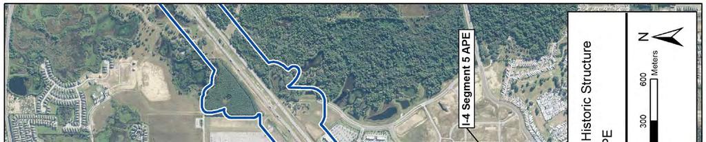
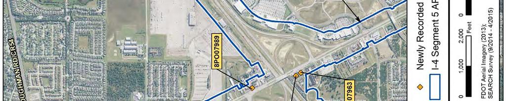
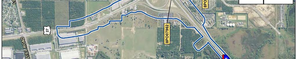
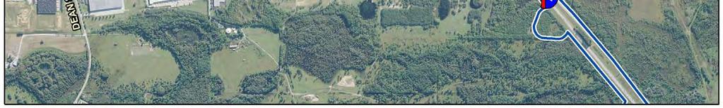
68
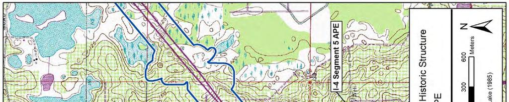
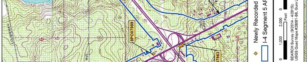
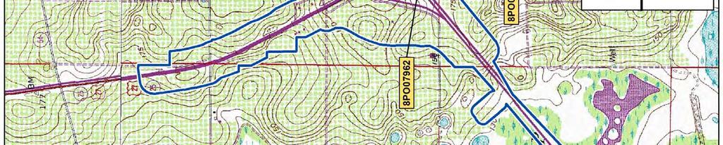
69
70
71 Attachment 3: FMSF Survey Log Sheet Attachment 3 FMSF Survey Log Sheet SR 400 (I 4) Project Development and Environment (PD&E) Study FM No.:
72 Attachment 3: FMSF Survey Log Sheet This page intentionally left blank. SR 400 (I 4) Project Development and Environment (PD&E) Study FM No.:
73 CRAS of Proposed Improvements to I-4 from West of SR 25/US 27 to West of Polk/Osceola County Line, Polk Co. Florida Technical Memorandum: Cultural Resource Assessment Survey of Proposed Improvements to Segment 5: SR 400 (I-4) from West of SR 25/US 27 to West of CR 532 (Polk/Osceola County Line), Polk County, Florida. Dye, Melissa.. Roberts, Benjamin On File at SEARCH, Newberry. FDOT FM No SEARCH project no Melissa Dye Southeastern Archaeological Research Jacksonville. SR HNTB, Inc... Melissa Dye, RPA Polk LAKE LOUISA SW GUM LAKE INTERCESSION CITY DAVENPORT
74 . 62 shovel tests were dug at 25- and 50-m intervals within the 9 proposed pond sites. Shovel tests were 50cm in diameter and 100cm deep, and sediment was screened through 1-4" hardware cloth. Pedestrian survey of historic resources was conducted PO07962, PO07963, PO07986, PO
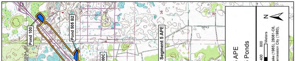
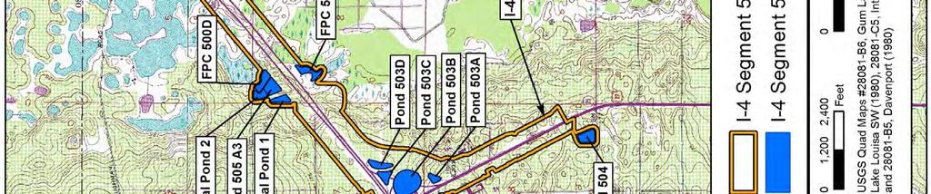
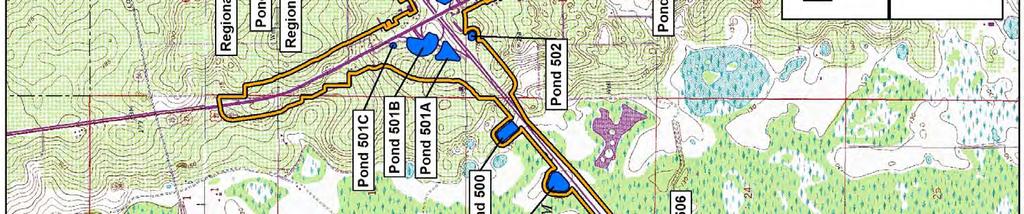
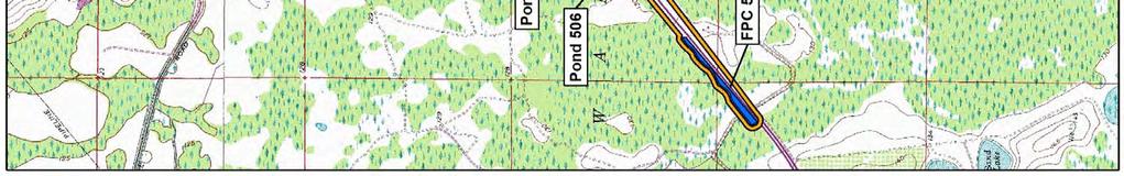
75
Florida Department of TRANSPORTATION. Technical Memorandum Cultural Resource Assessment Survey of the Proposed VE Pond
 Florida Department of TRANSPORTATION Technical Memorandum Cultural Resource Assessment Survey of the Proposed VE Pond Malabar Road (SR 514) PD&E Study From East of Babcock Street (SR 507) to US 1 Brevard
Architectural Inventory Form
 COLORADO CULTURAL RESOURCE SURVEY Page 1 of 8 Official Eligibility Determination (OAHP use only) Rev. 9/98 OAHP1403 Date Initials Determined Eligible National Register Determined Not Eligible National
Architectural Inventory Form
 COLORADO CULTURAL RESOURCE SURVEY Page 1 of 8 Official Eligibility Determination (OAHP use only) Rev. 9/98 OAHP1403 Date Initials Determined Eligible National Register Determined Not Eligible National
Phase One Archaeological Investigation Results, James Madison Park Master Development Plan Project, City of Madison, Dane County, Wisconsin
 Phase One Archaeological Investigation Results, James Madison Park Master Development Plan Project, City of Madison, Dane County, Wisconsin Prepared for the City of Madison Parks Department 28 January
Architectural Inventory Form
 COLORADO CULTURAL RESOURCE SURVEY Page 1 of 8 Official Eligibility Determination (OAHP use only) Rev. 9/98 OAHP1403 Date Initials Determined Eligible National Register Determined Not Eligible National
IMPORTANT NOTICE. Architectural Inventory Form COLORADO CULTURAL RESOURCE SURVEY I. IDENTIFICATION th Street 5WL.5601
 IMPORTANT NOTICE OAHP1403 Rev. 9/98 COLORADO CULTURAL RESOURCE SURVEY Architectural Inventory Form Page 1 This survey form represents an UNOFFICIAL COPY and is provided for informational purposes only.
Architectural Inventory Form (page 1 of 5)
") OAHP1403 Rev. 9/98 COLORADO CULTURAL RESOURCE SURVEY (page 1 of 5) I. IDENTIFICATION 1. Resource number 5RT-2050 2. Temporary resource number: 145008005 3. County: Routt County 4. City: Steamboat Springs
OAHP1403 Rev. 9/98 COLORADO CULTURAL RESOURCE SURVEY (page 1 of 5) I. IDENTIFICATION 1. Resource number 5RT-2050 2. Temporary resource number: 145008005 3. County: Routt County 4. City: Steamboat Springs
Architectural Inventory Form
 OAHP1403 Rev. 9/98 COLORADO CULTURAL RESOURCE SURVEY Architectural Inventory Form Official eligibility determination (OAHP use only) Date Initials Determined Eligible- NR Determined Not Eligible- NR Determined
Architectural Inventory Form
 IMPORTANT NOTICE OAHP1403 Rev. 9/98 COLORADO CULTURAL RESOURCE SURVEY Page 1 This survey form represents a only. All information, particularly determinations of eligibility for the National Register, the
Architectural Inventory Form (page 1 of 5)
") OAHP1403 Rev. 9/98 COLORADO CULTURAL RESOURCE SURVEY (page 1 of 5) Official eligibility determination (OAHP use only) Date Initials Determined Eligible- NR Determined Not Eligible- NR Determined Eligible-
OAHP1403 Rev. 9/98 COLORADO CULTURAL RESOURCE SURVEY (page 1 of 5) Official eligibility determination (OAHP use only) Date Initials Determined Eligible- NR Determined Not Eligible- NR Determined Eligible-
Appendix E Memorandum of Agreement between FHWA and the SHPO
 Appendix E between FHWA and the SHPO MEMORANDUM OF AGREEMENT BETWEEN THE FEDERAL HIGHWAY ADMINISTRATION AND THE FLORIDA STATE HISTORIC PRESERVATION OFFICER PURSUANT TO 36 CFR PART 800 REGARDING THE WEKIVA
STAGE 1 ARCHAEOLOGICAL ASSESSMENT OF RATHBURN ROAD, FROM DUKE OF YORK BOULEVARD TO SHIPP DRIVE, CITY OF MISSISSAUGA. Submitted to:
 STAGE 1 ARCHAEOLOGICAL ASSESSMENT OF RATHBURN ROAD, FROM DUKE OF YORK BOULEVARD TO SHIPP DRIVE, CITY OF MISSISSAUGA Submitted to: McCormick Rankin Corporation 2655 North Sheridan Way, Suite 280 Mississauga,
2.1.8 Cultural Resources Regulatory Setting. Affected Environment, Environmental
 REVISED DRAFT ENVIRONMENTAL IMPACT REPORT/ Affected Environment, Environmental 2.1.8 Cultural Resources This section evaluates the potential for historical and archaeological resources within the proposed
AN ARCHAEOLOGICAL SURVEY FOR THE NAVIDAD RESOURCES, LLC FERGUSON STATE PRISON FARM UNIT PROJECT IN MADISON COUNTY, TEXAS
 AN ARCHAEOLOGICAL SURVEY FOR THE NAVIDAD RESOURCES, LLC FERGUSON STATE PRISON FARM UNIT PROJECT IN MADISON COUNTY, TEXAS Antiquities Permit 5714 By William E. Moore Brazos Valley Research Associates Contract
Architectural Inventory Form
 COLORADO CULTURAL RESOURCE SURVEY Page 1 of 7 Official Eligibility Determination (OAHP use only) Rev. 9/98 OAHP1403 Date Initials Determined Eligible National Register Determined Not Eligible National
Architectural Inventory Form
 IMPORTANT NOTICE OAHP1403 Rev. 9/98 COLORADO CULTURAL RESOURCE SURVEY Page 1 This survey form represents a only. All information, particularly determinations of eligibility for the National Register, the
THE CITY OF LAKE FOREST HISTORIC PRESERVATION COMMISSION LOCAL LANDMARK NOMINATION INSTRUCTIONS
 THE CITY OF LAKE FOREST HISTORIC PRESERVATION COMMISSION LOCAL LANDMARK NOMINATION INSTRUCTIONS This application is for the nomination of individual properties as Local Historic Landmarks within the City
Chapter 8: BEACH SOUTH OF ATLANTIC AVENUE NEIGHBORHOOD PLANNING AREA ANALYSIS
 Chapter 8: BEACH SOUTH OF ATLANTIC AVENUE NEIGHBORHOOD PLANNING AREA ANALYSIS The Beach South of Atlantic Avenue Neighborhood Planning Area includes the parcels adjacent to S Fletcher Avenue from Atlantic
PennDOT. single spann lanes and 3- mayy need to be to accommodate. any bridge. addition to III. Date: CRP 07/27/2015 CRP.
 (10/27/14) PennDOT Section 106 Field Assessments and Finding Combined Early tification/finding? Yes Concurrence required or requested: Yes MPMS: 51507 ER# (if consultation with PHMC required) ): County:
Architectural Inventory Form
 COLORADO CULTURAL RESOURCE SURVEY Page 1 Official eligibility determination (OAHP use only) Date Initials Determined Eligible- NR Determined Not Eligible- NR Determined Eligible- SR Determined Not Eligible-
I 5 South Multimodal Corridor Study. Appendix F. I 5 South Multimodal Corridor Study Cultural Resources Constraints Analysis (February 8, 2010)
") I 5 South Multimodal Corridor Study Appendix F I 5 South Multimodal Corridor Study Cultural Resources Constraints Analysis (February 8, 2010) 847 Jamacha Road, El Cajon, California 92019-3206 tel: (619)
I 5 South Multimodal Corridor Study Appendix F I 5 South Multimodal Corridor Study Cultural Resources Constraints Analysis (February 8, 2010) 847 Jamacha Road, El Cajon, California 92019-3206 tel: (619)
Architectural Inventory Form
 COLORADO CULTURAL RESOURCE SURVEY Page 1 of 3 Official Eligibility Determination (OAHP use only) Rev. 9/98 OAHP1403 Date Initials Determined Eligible National Register Determined Not Eligible National
2.0 AREA PLANS. Lakeside Business District. Lakeside Business District Land Use Categories:
 Lakeside Business District Lakeside Business District Land Use Categories: Campus Commercial Campus Commercial means a mixture of uses which includes corporate offices, office parks, hotels, commercial,
Summary of Other State Archeological Guidelines
 Summary of Other State Archeological Guidelines This is a summary all guidelines for archeology from 17 other states. This information was gathered in order to see what type of guidelines other states
AN ARCHAEOLOGICAL SURVEY FOR THE RICHARDS, TEXAS FARM-TO-MARKET ROAD 149 FIBER OPTIC CABLE PROJECT IN MONTGOMERY COUNTY, TEXAS
 AN ARCHAEOLOGICAL SURVEY FOR THE RICHARDS, TEXAS FARM-TO-MARKET ROAD 149 FIBER OPTIC CABLE PROJECT IN MONTGOMERY COUNTY, TEXAS Antiquities Permit 6097 By William E. Moore Brazos Valley Research Associates
Appendix 1: Site Inventory Form
 Appendix 1: Site Inventory Form Wapsi Valley Archaeology, Inc. Anamosa, IA 56 X Cemetery Washington 83 24 2 NE X 1 5 approx. 200 approx. 201 unknown unknown Historic Resources Evaluation: 07A: Cemetery
Architectural Inventory Form
 COLORADO CULTURAL RESOURCE SURVEY Page 1 of 8 Official Eligibility Determination (OAHP use only) Rev. 9/98 OAHP1403 Date Initials Determined Eligible National Register Determined Not Eligible National
CULTURAL RESOURCE ASSESSMENT SURVEY TECHNICAL MEMORANDUM
 CULTURAL RESOURCE ASSESSMENT SURVEY TECHNICAL MEMORANDUM INTERCHANGE RECONSTRUCTION I-75 AT FRUITVILLE ROAD (SR 780) INTERCHANGE SARASOTA COUNTY, FLORIDA Financial Project ID No.: 420613-2-52-01 The environmental
STATE OF VERMONT PUBLIC SERVICE BOARD
 STATE OF VERMONT PUBLIC SERVICE BOARD Petition of Champlain VT, LLC d/b/a TDI New England ) for a Certificate of Public Good, pursuant to 0 V.S.A., ) authorizing the installation and operation of a high
IMPORTANT NOTICE. Architectural Inventory Form COLORADO CULTURAL RESOURCE SURVEY I. IDENTIFICATION. 655 Bryan Avenue 5BL.10460
 IMPORTANT NOTICE OAHP1403 Rev. 9/98 COLORADO CULTURAL RESOURCE SURVEY Architectural Inventory Form Page 1 This survey form represents an UNOFFICIAL COPY and is provided for informational purposes only.
SITE SUMMARY REPORT Arlington Dump NONCD Yadkin County
 SITE SUMMARY REPORT Arlington Dump NONCD 0000644 Yadkin County Hurricane Recovery Act of 2005 State of North Carolina State Contract N06009S Schnabel Project No. 06210002.15 July 31, 2009 Prepared for:
M E M O R A N D U M PLANNING AND COMMUNITY DEVELOPMENT DEPARTMENT CITY OF SANTA MONICA PLANNING DIVISION
 M E M O R A N D U M 10-B PLANNING AND COMMUNITY DEVELOPMENT DEPARTMENT CITY OF SANTA MONICA PLANNING DIVISION DATE: April 9, 2018 TO: FROM: SUBJECT: The Honorable Landmarks Commission Planning Staff 133
Submitted: July 23, 2009
 Stage I and II Archaeological Assessment Jock River Estates Phase 2 PML Project No. 0801-01 Client: 773804 Ontario Inc. Lot 21, Concession 2 Geographic Township of Goulbourn City of Ottawa Submitted: July
Architectural Inventory Form
 OAHP1403 Rev. 9/98 COLORADO CULTURAL RESOURCE SURVEY Architectural Inventory Form Official eligibility determination (OAHP use only) Date Initials Determined Eligible- NR Determined Not Eligible- NR Determined
3.10 LAND USE SETTING PROJECT SITE EXISTING LAND USE DESIGNATIONS AND ZONING. General Plan Land Use Designations.
 This section of the Draft EIR addresses the existing land uses on and adjacent to the project site and discusses the potential impacts of the proposed project on existing land uses. Key issues addressed
Chapter 19: Cultural Resources
 Chapter 19: Cultural Resources Introduction and Setting Traditionally the term "cultural resources" has been used rather narrowly to refer to archaeological remains and to historical structures. Archaeologists,
FIRST COCONUT GROVE SCHOOLHOUSE
 FIRST COCONUT GROVE SCHOOLHOUSE 3429 DEVON ROAD Designation Report City of Miami REPORT OF THE CITY OF MIAMI PLANNING DEPARTMENT TO THE HERITAGE CONSERVATION BOARD ON THE POTENTIAL DESIGNATION OF THE FIRST
buildings sites structures objects 0 Total Number of contributing resources previously listed in the National Register : 0
 NPS Form 10-900 (Rev. 8-86) OMB No. 1024-0018 United States Department of the Interior National Park Service NATIONAL REGISTER OF HISTORIC PLACES REGISTRATION FORM other name/site number: 2. Location street
PRIMARY RECORD Trinomial # NRHP Status Code 3S, 3CS, 5S3 Other Listings Review Code Reviewer Date
 PRIMARY RECORD # NRHP Status Code 3S, 3CS, 5S3 Other Listings Review Code Reviewer Date Page 1 of 6 1252 *Resource Name or # (Assigned by recorder) Old Topanga Canyon Road P1. Other Identifier: *P2. Location:
REQUEST FOR PROPOSALS. Preparation of National Register of Historic Places. Nominations for the following:
 REQUEST FOR PROPOSALS Preparation of National Register of Historic Places Nominations for the following: The Conner Swales Site, The Baumann Village Site, The Bird Point Heaven Village Site, The Wise Village
CHAPTER 2: HISTORIC BACKGROUND
 CHAPTER 2: HISTORIC BACKGROUND The historic town of Eastlake was created on June 22, 1911 when the Eastlake Subdivision was recorded at the Adams County Clerk and Recorder s Office. The Eastlake Investment
Centre for Archaeological Fieldwork Evaluation/Monitoring Report No Monitoring Report No. 201
 Monitoring Report No. 201 Land adjacent to 58 Drumreagh Road Drumreagh Ballygowan Co. Down LICENCE NO.: AE/10/91E BRIAN SLOAN 1 Site Specific Information Site Name: Land adjacent to 58 Drumreagh Road,
HISTORIC RESOURCES INVENTORY - BUILDING AND STRUCTURES. Please send completed form to: National Register and State Register Coordinator,
 HISTORIC RESOURCES INVENTORY - BUILDING AND STRUCTURES Please send completed form to: National Register and State Register Coordinator, Connecticut Commission State Historic on Culture Preservation & Tourism,
Meales Farm, Sulhamstead, West Berkshire
 Meales Farm, Sulhamstead, West Berkshire An Archaeological Watching Brief For Mr. Robert Astor by Steve Ford Thames Valley Archaeological Services Ltd Site Code CHH02/29 May 2002 Summary Site name: Meales
Trinomial NRHP Status Code Other Listings Review Code Reviewer Date
 PRIMARY RECORD Page 1 of 6 *Resource Name or #: (Assigned by recorder) Woolsey Building P1. Other Identifier: None NRHP Status Code Other Listings Review Code Reviewer Date *P2. Location: Not for Publication
A Historical Context of the Turpentine (Naval Stores) Industry in the Atlantic and Gulf Coastal Plains of Georgia, South Carolina, and Florida
 Industry in the Atlantic and Gulf Coastal Plains of Georgia, South Carolina, and Florida") A Historical Context of the Turpentine (Naval Stores) Industry in the Atlantic and Gulf Coastal Plains of Georgia, South Carolina, and Florida APPENDIX A NAVAL STORES INDUSTRY RELATED ARCHAEOLOGICAL SITES
A Historical Context of the Turpentine (Naval Stores) Industry in the Atlantic and Gulf Coastal Plains of Georgia, South Carolina, and Florida APPENDIX A NAVAL STORES INDUSTRY RELATED ARCHAEOLOGICAL SITES
COMBINED PHASE I ARCHAEOLOGICAL SURVEY BUILDING/LANDSCAPE AND ARCHAEOLOGICAL ASSESSMENT PLAN
 COMBINED PHASE I ARCHAEOLOGICAL SURVEY BUILDING/LANDSCAPE AND ARCHAEOLOGICAL ASSESSMENT PLAN ST. ELIZABETHS HOSPITAL - WEST CAMPUS 2700 MARTIN LUTHER KING, JR. AVENUE, SE DISTRICT OF COLUMBIA [SITE NUMBER
STAFF REPORT FOR STANDARD COASTAL DEVELOPMENT PERMIT #CDP FEBRUARY 26, 2015 CPA - 1 PO BOX 238 APTOS, CA 94001
 STAFF REPORT FOR STANDARD COASTAL DEVELOPMENT PERMIT #CDP 2014-0030 FEBRUARY 26, 2015 CPA - 1 OWNER/APPLICANT: AGENT: REQUEST: HANS HEIM PO BOX 238 APTOS, CA 94001 JAMES HAY PO BOX 762 MENDOCINO, CA 95460
HISTORIC SITE FORM - HISTORIC SITES INVENTORY PARK CITY MUNICIPAL CORPORATION (10-08) 1 IDENTIFICATION
 1 IDENTIFICATION") HISTORIC SITE FORM - HISTORIC SITES INVENTORY PARK CITY MUNICIPAL CORPORATION (10-08) 1 IDENTIFICATION Name of Property: Address: 158 Main Street City, County: Park City, Summit County, Utah AKA: Tax Number:
HISTORIC SITE FORM - HISTORIC SITES INVENTORY PARK CITY MUNICIPAL CORPORATION (10-08) 1 IDENTIFICATION Name of Property: Address: 158 Main Street City, County: Park City, Summit County, Utah AKA: Tax Number:
Revised License Report
 STAGE 1 2 ARCHAEOLOGICAL ASSESSMENT OF THE EGLINTON CROSSTOWN LIGHT RAIL TRANSIT CORRIDOR, EGLINTON AVENUE FROM JANE STREET TO BRICKNELL STREET, CONCESSION 5, LOT 11, CONCESSION 6, LOT 41, YORK TOWNSHIP,
Selected Area Study. Vision Plan Draft
 East Polk County Selected Area Study Draft 10.30.08 Contents Guiding Principles...4 Context Conclusions...5 Current Context...8 Scenarios...9 Scenario: Status Quo...10 Scenario: Connected & Directed Growth...12
Mitchell Ranch South MPUD Application for Master Planned Unit Development Approval Project Narrative. Introduction
 Mitchell Ranch South MPUD Application for Master Planned Unit Development Approval Project Narrative Introduction Mitchell Ranch South is a proposed single family (detached) residential development on
IMPORTANT NOTICE. Architectural Inventory Form COLORADO CULTURAL RESOURCE SURVEY I. IDENTIFICATION Eldorado Avenue 5BL.10487
 IMPORTANT NOTICE OAHP1403 Rev. 9/98 COLORADO CULTURAL RESOURCE SURVEY Architectural Inventory Form Page 1 This survey form represents an UNOFFICIAL COPY and is provided for informational purposes only.
APPENDIX 'D' Archaeological Investigation
 City of Peterborough Lansdowne Street West Our File: 6552 ENVIRONMENTAL STUDY REPORT ADDENDUM APPENDIX 'D' Archaeological Investigation March 2008 Lansdowne Street West Widening / Reconstruction Class
Morgan s Subdivision Historic District Character-defining Features
 Morgan s Subdivision Historic District Character-defining Features DISTRICT DESCRIPTION This small addition, designed as a neighborhood for those wishing to move east from Capitol Hill, was predominantly
ARCHAEOLOGICAL INVESTIGATIONS FOR THE OLD DAVIS ROAD REALIGNMENT PROJECT ON THE UNIVERSITY OF CALIFORNIA, DAVIS CAMPUS YOLO COUNTY, CALIFORNIA
 Cultural Resources Consultants ARCHAEOLOGICAL INVESTIGATIONS FOR THE OLD DAVIS ROAD REALIGNMENT PROJECT ON THE UNIVERSITY OF CALIFORNIA, DAVIS CAMPUS YOLO COUNTY, CALIFORNIA Prepared for: Matt Dulcich,
DRAFT MAP AMENDMENT FLU 04-4
 DRAFT MAP AMENDMENT FLU 04-4 SW 24 TH AVENUE ROADWAY CORRIDOR The University of Florida participates with the Metropolitan Transportation Planning Organization (MTPO) in its responsibilities for the continuing,
HISTORIC SITE FORM - HISTORIC SITES INVENTORY PARK CITY MUNICIPAL CORPORATION (10-08) 1 IDENTIFICATION
 1 IDENTIFICATION") HISTORIC SITE FORM - HISTORIC SITES INVENTORY PARK CITY MUNICIPAL CORPORATION (10-08) 1 IDENTIFICATION Name of Property: Address: 164 Sandridge Road AKA: City, County: Park City, Summit County, Utah Tax
HISTORIC SITE FORM - HISTORIC SITES INVENTORY PARK CITY MUNICIPAL CORPORATION (10-08) 1 IDENTIFICATION Name of Property: Address: 164 Sandridge Road AKA: City, County: Park City, Summit County, Utah Tax
STAGE 1 ARCHAEOLOGICAL ASSESSMENT OF THE MISSISSAUGA BRT (EAST), CITY OF MISSISSAUGA. Submitted to:
, CITY OF MISSISSAUGA. Submitted to:") STAGE 1 ARCHAEOLOGICAL ASSESSMENT OF THE MISSISSAUGA BRT (EAST), CITY OF MISSISSAUGA Submitted to: Ecoplans Limited 2655 North Sheridan Way, Suite 280 Mississauga, Ontario L5K 2P8 Telephone (905) 823-4988
STAGE 1 ARCHAEOLOGICAL ASSESSMENT OF THE MISSISSAUGA BRT (EAST), CITY OF MISSISSAUGA Submitted to: Ecoplans Limited 2655 North Sheridan Way, Suite 280 Mississauga, Ontario L5K 2P8 Telephone (905) 823-4988
Maryland Historical Trust Inventory No. PG: 85B-007 Maryland Inventory of Historic Properties Form
 Maryland Historical Trust Inventory No. PG: 85B-007 Maryland Inventory of 1. Name of Property (indicate preferred name) historic other 2. Location street and number Cedarville State Forest Road, Cedarville
Calvert Hills (66-037)
") Calvert Hills (66-037) Calvert Hills, a cohesive neighborhood in northwestern Prince George s County, is an excellent illustration of the residential development on the outskirts of Washington, D.C., in
Calvert Hills (66-037) Calvert Hills, a cohesive neighborhood in northwestern Prince George s County, is an excellent illustration of the residential development on the outskirts of Washington, D.C., in
STAGE 1 2 ARCHAEOLOGICAL ASSESSMENT OF YONGE STREET SUBWAY EXTENSION, LOTS 37-41, CONCESSION EYS, TOWNSHIP OF MARKHAM, CITY OF TORONTO, YORK COUNTY
 STAGE 1 2 ARCHAEOLOGICAL ASSESSMENT OF YONGE STREET SUBWAY EXTENSION, LOTS 37-41, CONCESSION EYS, TOWNSHIP OF MARKHAM, CITY OF TORONTO, YORK COUNTY Original License Report Submitted to: Ecoplans Limited
HISTORIC RESOURCES INVENTORY - BUILDING AND STRUCTURES
 HISTORIC RESOURCES INVENTORY - BUILDING AND STRUCTURES * Note: Please attach any additional or expanded information on a separate sheet. GENERAL INFORMATION Building Name (Common) Neighborhood Music School
TAKANINI STRUCTURE PLAN AREAS 6A & 6B: ARCHAEOLOGICAL ASSESSMENT
 TAKANINI STRUCTURE PLAN AREAS 6A & 6B: ARCHAEOLOGICAL ASSESSMENT Report prepared for Hosken & Associates Ltd By Barry Baquie (MA) Rod Clough (PhD) April 2006 Clough & Associates Ltd heritage@clough.co.nz
HISTORIC SITE FORM - HISTORIC SITES INVENTORY PARK CITY MUNICIPAL CORPORATION (10-08) 1 IDENTIFICATION
 1 IDENTIFICATION") HISTORIC SITE FORM - HISTORIC SITES INVENTORY PARK CITY MUNICIPAL CORPORATION (10-08) 1 IDENTIFICATION Name of Property: William Tretheway House Address: 335 Woodside Avenue AKA: City, County: Park City,
HISTORIC SITE FORM - HISTORIC SITES INVENTORY PARK CITY MUNICIPAL CORPORATION (10-08) 1 IDENTIFICATION Name of Property: William Tretheway House Address: 335 Woodside Avenue AKA: City, County: Park City,
Final Initial Study. Chalice Unitarian Universalist Congregation Conditional Use Permit
 5 Final Initial Study Chalice Unitarian Universalist Congregation Conditional Use Permit Appendix B Chalice Unitarian Universalist Congregation Cultural Resources Memorandum TRC 9685 Research Drive Irvine,
BOULEVARD AND PARKWAY STANDARDS
 88-323 BOULEVARD AND PARKWAY STANDARDS 88-323-01 PURPOSE Considerable public and private investment exists and is expected to occur adjacent to boulevards and parkways within the city. The following standards
Appendix E Section 4(f) Evaluation
 Evaluation") Appendix E Section 4(f) Evaluation Appendix E Draft Section 4(f) Evaluation E.1 Introduction This appendix addresses a federal regulation known as Section 4(f), which protects parks, recreation areas,
Appendix E Section 4(f) Evaluation Appendix E Draft Section 4(f) Evaluation E.1 Introduction This appendix addresses a federal regulation known as Section 4(f), which protects parks, recreation areas,
HISTORIC SITE FORM - HISTORIC SITES INVENTORY PARK CITY MUNICIPAL CORPORATION (10-08) 1 IDENTIFICATION
 1 IDENTIFICATION") HISTORIC SITE FORM - HISTORIC SITES INVENTORY PARK CITY MUNICIPAL CORPORATION (10-08) 1 IDENTIFICATION Name of Property: The New Park Hotel Address: 573 MAIN ST AKA: City, County: Park City, Summit County,
HISTORIC SITE FORM - HISTORIC SITES INVENTORY PARK CITY MUNICIPAL CORPORATION (10-08) 1 IDENTIFICATION Name of Property: The New Park Hotel Address: 573 MAIN ST AKA: City, County: Park City, Summit County,
The Maryland-National Capital Park and Planning Commission Prince George's County Planning Department Development Review Division
 The Maryland-National Capital Park and Planning Commission Prince George's County Planning Department Development Review Division 301-952-3530 Note: Staff reports can be accessed at www.mncppc.org/pgco/planning/plan.htm.
An Archaeological Evaluation at Granta Cottages, Newmarket Road, Great Chesterford, Essex. August 2015
 An Archaeological Evaluation at Granta Cottages, Newmarket Road, Great Chesterford, Essex August 2015 by Pip Parmenter and Ben Holloway on behalf of Mr G Elmer and Mrs L King CAT project ref.: 15/06a NGR:
MIDTOWN MIXED-USE VILLAGE. TECHNICAL DATA SHEET COMPONENT C-1 FOR PUBLIC HEARING - PETITION NUMBER Project No RZ1.1. Issued.
 N MIDTOWN MIXED-USE VILLAGE TECHNICAL DATA SHEET COMPONENT C- FOR PUBLIC HEARING - PETITION NUMBER 04-00 Project No. 496 Issued Revised SCALE: " = 0' N 0 0 0 40 RZ. c GENERAL PROVISIONS: a. SITE LOCATION.
Figure 5. Previously Identified Viable Corridors
 OVERVIEW The Central Florida Expressway Authority (CFX) is evaluating the potential to expand SR 408 from its current eastern terminus along SR 50 to SR 520 in northeastern Orange County, Fl. This new
MEMORANDUM OF BOG TURTLE HABITAT INVESTIGATION
 MEMORANDUM OF BOG TURTLE HABITAT INVESTIGATION 410-728-2900 Fax: 410-728-3160 www.rkk.com To: From: CC: U.S. Fish and Wildlife Service, Pennsylvania Fish and Boat Commission Jennifer A Ottenberg Miller,
ARCHITECTURAL SURVEY. PREPARED BY: JENNIFER B. STEWART and LORETTA LAUTZENHEISER, RPA PRINCIPAL INVESTIGATOR
 REEVALUATION FOR COALFIELDS EXPRESSWAY, SECTION I: POUND BYPASS FROM U. S. ROUTE 23 TO VIRGINIA ROUTE 83 WISE COUNTY, VIRGINIA State Project No. 0121-013-772, PE-101; UPC 85126 VDHR FILE # 1997-0950 ARCHITECTURAL
Archaeological Survey Report
 Archaeological Survey Report for UNION STREET RAILROAD BRIDGE (Trail Connection Project) Key No. 11085 ODOT, Region 2 Local Agency On-Call ATA 23456 WOC 1 City of Salem, Urban Development HDR Project No.
R E S O L U T I O N. 2. Development Data Summary:
 R E S O L U T I O N WHEREAS, the Prince George s County Planning Board has reviewed Departure from Design Standards DDS-631 requesting a departure to allow the loading space and the driveway to the loading
City of Grande Prairie Development Services Department
 City of Grande Prairie Development Services Department ROYAL OAKS NORTH OUTLINE PLAN OP-07-03 NW 35-71-6 W6M May 7, 2007 Royal Oaks North Outline Plan TABLE OF CONTENTS 1.0 INTRODUCTION........ 3 1.1 Purpose
DESIGN REVIEW COMMITTEE AGENDA ITEM
 DESIGN REVIEW COMMITTEE AGENDA ITEM AGENDA DATE: AUGUST 2, 2017 TO: THRU: FROM: SUBJECT: Chair Imboden and Members of the Design Review Committee Anna Pehoushek, Assistant Community Development Director
APPENDIX 9: Archaeological Assessment by Ken Phillips
 APPENDIX 9: Archaeological Assessment by Ken Phillips ARCHAEOLOGICAL ASSESSMENT PROPOSED SERVICE STATION DEVELOPMENT BRUCE ROAD, PAPAMOA TAURANGA Prepared by KEN PHILLIPS (MA HONS) MARCH 2016 ARCHAEOLOGY
Resolution : Exhibit A. Downtown District Design Guidelines March 2003
 Resolution 03-011: Exhibit A Downtown District Design Guidelines March 2003 DOWNTOWN DISTRICT DESIGN GUIDELINES CITY OF SOUTHLAKE, TEXAS Adopted March 2003 1 DOWNTOWN DISTRICT DESIGN GUIDELINES Adopted
Northern Branch Corridor SDEIS March 2017
 Northern Branch Corridor SDEIS March 2017 15. 15.1. Chapter Overview 15.1.1. Introduction This chapter discusses changes to the Preferred Alternative resulting in the potential for project improvements
Original License Report. Submitted to: New Horizon Development Inc. 69 John Street South, Suite 304 Hamilton, Ontario L8N 2B9 Phone (905)
") STAGE 1 ARCHAEOLOGICAL ASSESSMENT OF 2480-2496 OLD BRONTE ROAD, PART OF LOT 31, CONCESSION 1 SOUTH OF DUNDAS STREET, GEOGRAPHIC TOWNSHIP OF TRAFALGAR, TOWN OF OAKVILLE, REGIONAL MUNICPALITY OF HALTON Original
STAGE 1 ARCHAEOLOGICAL ASSESSMENT OF 2480-2496 OLD BRONTE ROAD, PART OF LOT 31, CONCESSION 1 SOUTH OF DUNDAS STREET, GEOGRAPHIC TOWNSHIP OF TRAFALGAR, TOWN OF OAKVILLE, REGIONAL MUNICPALITY OF HALTON Original
TOWN OF AURORA HERITAGE IMPACT ASSESSMENTS AND CONSERVATION PLANS GUIDE
 PLANNING AND DEVELOPMENT SERVICES Development Planning Division Heritage Planning Section Phone: 905-727-3123 ext. 4226 Fax: 905-726-4736 Email: planning@aurora.ca Town of Aurora 100 John West Way, Box
17.1 INTRODUCTION CONTEXT CONCLUSIONS
 CHAPTER 17. FLOODPLAIN 17.1 INTRODUCTION 17.1.1 CONTEXT A floodplain is part of an extensive drainage and filtration system and water cycle that serves to contain flood waters from storms. Floodplain areas
Analysis of Environs of 1000 New York Street, German Methodist Episcopal Church
 Item No. 3: L-14-00028 p.1 Analysis of Environs of New York Street, German Methodist Episcopal Church Step One Historical Significance and Context According to the application for Historic Landmark Designation,
12 January 12, 2011 Public Hearing APPLICANT: TAILWIND DEVELOPMENT GROUP,LLC PROPERTY OWNER: CITY OF VIRGINIA BEACH
 12 January 12, 2011 Public Hearing APPLICANT: TAILWIND DEVELOPMENT GROUP,LLC PROPERTY OWNER: CITY OF VIRGINIA BEACH STAFF PLANNER: Faith Christie REQUEST: Conditional Change of Zoning (from PD-H1 Planned
NOTICE OF PREPARATION
 Date: June 30, 2017 CITY OF CITRUS HEIGHTS COMMUNITY & ECONOMIC DEVELOPMENT DEPARTMENT, PLANNING DIVISION 6360 Fountain Square Drive, Citrus Heights, CA 95621 (916) 727-4740 NOTICE OF PREPARATION To: Subject:
W.H. Bonner Associates
 15619 Ogram Avenu Gardena, CA 90249-444 W.H. Bonner Associates Archaeofaunal Studies Archaeological Surveys Historical & Genealogical Research (310) 675-274 E-mail: whbonner@aol.com April 21, 2014 Wendy
Request Modification of Conditions of a Conditional Use Permit approved October 14, Staff Recommendation Approval. Staff Planner Stephen White
 Applicant Property Owner Public Hearing September 13, 2017 City Council Election District Lynnhaven Agenda Item 3 Request Modification of Conditions of a Conditional Use Permit approved October 14, 2003.
for THE PADDOCKS ON JARVIS CREEK
 ARCHITECTURAL GUIDELINES for THE PADDOCKS ON JARVIS CREEK BEAUFORT COUNTY S O U T H C A R O L I N A design guidelines FOR JARVIS CREEK DEVELOPMENT General Design control within Jarvis Creek Development
PUBLIC HEARING. Thursday, December 14, 2017 FDOT Urban Office 2198 Edison Avenue Jacksonville, FL 32204
 DISTRICT TWO PUBLIC HEARING I 10 (SR 8) from I 295 to I 95 Project Development & Environment Study Duval County, Florida Financial Project Number 213326 2 22 01 Efficient Transportation Decision Making
920 BAYSWATER AVENUE PROJECT
 920 BAYSWATER AVENUE PROJECT VISUAL ASSESSMENT Prepared for the City of Burlingame Prepared by Circlepoint 46 S First Street, San Jose, CA 95113 June 2018 This page intentionally left blank. 920 Bayswater
APPENDIX G. Historical Resources Overview Documentation
 APPENDIX G Historical Resources Overview Documentation Statement of Justification for Historical Resources Act Requirements for projects other than small-scale oil and gas This document contains sensitive
Small Scale Comprehensive Plan Amendment Staff Report CPAS-09(07) Harvey Little/Arevee Road FUTURE LAND USE AMENDMENT FROM RES-9 TO COM
 Harvey Little/Arevee Road FUTURE LAND USE AMENDMENT FROM RES-9 TO COM") Small Scale Comprehensive Plan Amendment CPAS-09(07) Harvey Little/Arevee Road FUTURE LAND USE AMENDMENT FROM RES-9 TO COM PROPTY OWNS AGENTS PROPTY SIZE DCH Groves LLC King Helie and Barbara Wilhite,
Small Scale Comprehensive Plan Amendment CPAS-09(07) Harvey Little/Arevee Road FUTURE LAND USE AMENDMENT FROM RES-9 TO COM PROPTY OWNS AGENTS PROPTY SIZE DCH Groves LLC King Helie and Barbara Wilhite,
2.1 Decision Making Matrix
 2.1 Decision Making Matrix The following decision-making matrix merges the elements of architectural and historical significance and current condition within the over-arching treatment recommendation of
D1 September 11, 2013 Public Hearing APPLICANT:
 D1 September 11, 2013 Public Hearing APPLICANT: BEACH MUNICIPAL FEDERAL CREDIT UNION PROPERTY OWNER: SISTERS II, LLC STAFF PLANNER: Karen Prochilo REQUEST: Conditional Change of Zoning (AG-2 Agriculture
Historic England Advice Report 26 August 2016
 Case Name: Kingsland Castle Case Number: 1435892 Background Historic England has been asked to review the scheduling for Kingsland Castle. The land on which the monument lies is understood to be for sale.
EVALUATION REPORT No. 300
 EVALUATION REPORT No. 300 Southwest of 2A Cloughey Road, Portaferry, Co. Down Licence No.: AE/135/85E Sapphire Mussen Report Date: 14 th May 2015 Site Specific Information Site Name: [Southwest of 2a]
CHAPTER 3 DOWNTOWN COMMERCIAL DISTRICT CHARACTER AREA
 CHAPTER 3 DOWNTOWN COMMERCIAL DISTRICT CHARACTER AREA 3.1 INTRODUCTION The Downtown Commercial District Character Area of Grass Valley comprises all of the city's core historic commercial district, including