SUBJECT: SEE BELOW DATE: January 7, 2016 TRANSMITTAL
|
|
|
- Jessica Washington
- 5 years ago
- Views:
Transcription
1 COUNCIL AGENDA: 01/26/16 ITEM: 11.3 TO: HONORABLE MAYOR AND CITY COUNCIL FROM: Harry Freitas SUBJECT: SEE BELOW DATE: January 7, 2016 TRANSMITTAL COUNCIL DISTRICT: 4 SUBJECT: FILE NO. PDC PLANNED DEVELOPMENT REZONING FROM THE IP(PD) PLANNED DEVELOPMENT ZONING DISTRICT TO THE IP(PD) PLANNED DEVELOPMENT ZONING DISTRICT FOR THE PURPOSES OF AMENDING THE DEVELOPMENT STANDARDS TO ELIMINATE THE 105-FOOT HEIGHT REQUIREMENT ON NORTH FIRST STREET, FOR UP TO 2.8 MILLION SQUARE FEET OF INDUSTRIAL USES ON A 43.0 GROSS ACRE SITE LOCATED ON BOTH SIDES OF COMPONENT DRIVE BETWEEN N. FIRST STREET AND ORCHARD PARKWAY FILE NO. PD MASTER PLANNED DEVELOPMENT PERMIT TO EFFECTUATE THE PLANNED DEVELOPMENT ZONING (FILE NO. PDC15-056) FOR UP TO 2.8 MILLION SQUARE FEET OF INDUSTRIAL USES REASON FOR TRANSMITTAL The Planning Commission will hear this project on January 13, The memorandum with Planning Commission recommendations will be submitted under different cover. We hope the submittal of this staff report is of assistance in your review of this project. /s/ HARRY FREITAS, DIRECTOR Planning, Building and Code Enforcement For questions please contact Planning Official, Steve McHarris, at
 Planned Development Proposed Zoning IP(PD) Planned Development Council District 4 Historic Resource")
2 PC AGENDA: ITEM: 4.b.4.5. PLANNING COMMISSION STAFF REPORT File No. PDC and PD Applicant: Apple Inc. Location West side of North First Street, on both sides of Component Drive Existing Zoning IP(PD) Planned Development Proposed Zoning IP(PD) Planned Development Council District 4 Historic Resource No Annexation Date February 1, 1971 and April 26, 1977 CEQA Addendum to the North San Jose Development Policies EIR, Envision San Jose 2040 General Plan EIR, and BEA Development Project EIR APPLICATION SUMMARY: File No. PDC15-056: Planned Development Rezoning from the IP(PD) Planned Development Zoning District to the IP(PD) Planned Development Zoning District for the purposes of amending the development standards to eliminate the 105-foot minimum height requirement on North 1st Street, for up to 2.8 million square feet of industrial uses on a 43.0-gross acre site. File No. PD15-052: Master Planned Development Permit to effectuate the Planned Development Zoning (File No. PDC15-056) for up to 2.8 million square feet of industrial uses on a 43.0-gross acre site. RECOMMENDATION: Planning staff recommends that the Planning Commission recommend approval of the subject Planned Development Rezoning and Planned Development Permit to the City Council for the reasons stated in this staff report. PROJECT DATA 2020 GENERAL PLAN CONSISTENCY 2020 General Plan Land Use/Transportation Diagram Designation Consistent Policies 2, 12 Inconsistent Policies None Industrial Park Consistent Inconsistent
3 2040 GENERAL PLAN CONSISTENCY 2020 General Plan Land Transit Employment Center Use/Transportation Diagram Consistent Inconsistent Designation Consistent Policies LU-1.6, IE-1.2 Inconsistent Policies None File Nos. PDC and PD Page 2 of 8 SURROUNDING USES General Plan Land Use Zoning Existing Use North Transit Employment IP(PD) Planned Industrial development Center Development South Transit Employment IP Industrial Park Industrial development Center East Transit Employment IP(PD) Planned Industrial development Center Development West Industrial Park IP(PD) Planned Development Undeveloped land RELATED APPROVALS Date Action 6/15/2004 Planned Development Rezoning from IP(PD) Zoning District to the IP(PD) Zoning District to allow up to 2,800,000 square feet of research and development/office uses (File No. PDC04-002) 10/22/2004 Planned Development Permit to allow master grading for future research and development/office development (File No. PD04-059) 3/28/2008 Master Planned Development Permit for R&D office and retail uses, including the construction of 705,847 square feet of office and retail uses, and a freestanding parking structure on an gross acre portion of the 39.8 gross acre site (File No. PD07-087) 3/24/2009 Master Planned Development Permit to facilitate the grading and subdivision of the subject site (File No. PD08-064) 6/7/2012 Master Planned Development Permit to establish conceptual site layout and architectural character for up to 2,800,000 square feet of office, R&D, retail uses and amenities, and up to 8,050 freestanding structured parking spaces to be developed in phases upon approval of subsequent Planned Development Permits (File No. PD12-024) 12/4/2013 Planned Development Permit to allow construction of two six-story R&D/office buildings totaling 438,605 square feet, one two-story 11,842-square foot amenity building, and surface parking on a acre portion of a the 43.0 acre site (File No. PD13-007)

4 File Nos. PDC and PD Page 3 of 8 PROJECT DESCRIPTION On October 22, 2015, the applicant applied for a Planned Development Rezoning and Master Planned Development Permit to rezone the property from the IP(PD) Planned Development Zoning District to the IP(PD) Planned Development Zoning District for the purposes of amending the development standards to eliminate the 105-foot height requirement on North 1st Street, for up to 2.8 million square feet of industrial uses on the 43.0-gross acre site. The current zoning s (File No. PDC04-002) development standard for height requires a minimum building height of 105 feet and a maximum building height of up to 210 feet for primary buildings located adjacent and oriented toward North First Street. The applicant proposes to remove the minimum height standard for primary buildings located adjacent and oriented toward North First Street. All other aspects of the current zoning, including allowed uses, intensity of uses, maximum square footage, and all other development standards (i.e. setbacks, maximum height) would remain the same. The Master Planned Development Permit would effectuate the entire zoning, allowing the uses of the conventional IP Industrial Park Zoning District. Subsequent Planned Development Permits would be required for site and building design. The subject Planned Development Zoning and Planned Development Permit would be heard concurrently with a proposed Development Agreement (DA) (File No. DA15-002) between Apple Inc. and the City of San Jose to amend and restate a Development Agreement previously entered into between BEA Systems, Inc. and the City of San Jose with respect to a 41.0-gross acre site formerly owned by BEA and to incorporate additional adjacent sites of approximately acres within the scope of the Development Agreement. The proposed amended and restated Development Agreement will vest entitlements for 15 years to develop up to 4,151,350 square feet of industrial development, including office, research and development, manufacturing, and other related and supporting uses consistent with the North San Jose Area Development Policy, San Jose 2020 General Plan, and Envision San Jose 2040 General Plan on an approximately gross acre site located west of Orchard Parkway on both sides of Atmel Way and east of Orchard Parkway on both sides of Component Drive. The subject Planned Development Zoning and Planned Development Permit apply only to the site covered by the original BEA Development Agreement. If approved, the zoning and permit would be vested under the amended and restated Development Agreement. Site Location The project site is located on the west side of North First Street on both sides of Component Drive (see Figure 1) and is currently undeveloped. The Component Light Rail Station is located along the project s frontage on North 1 st Street. Figure 1: Aerial of the site
5 Background File Nos. PDC and PD Page 4 of 8 In 2004, the City approved Planned Development (PD) Zoning File No. PDC to allow up to 2,800,000 square feet of research and development/office uses consistent with the IP Industrial Park Zoning District. A Development Agreement (DA) between the City and the prior owners of the property, BEA Systems, was also approved in The BEA DA allowed for the development of up to 2.8 million square-feet of Industrial Park development on the subject site through the allocation of 1,378,568 square feet of transferable floor area from the pool under North San Jose Area Development Policy. The pool is a square footage bank established when buildings in the policy area were demolished or when properties designated for a certain square footage of industrial uses by the policy were developed with non-industrial uses. The BEA DA vested certain elements, including the 2020 San José General Plan land use designation of Industrial Park as shown on the San José 2020 General Plan Land Use/Transportation Diagram, the North San José Area Development Policy then in effect (prior to the 2005 major amendment), the Rincon de Los Esteros Redevelopment Plan, the Planned Development Zoning (File No. PDC04-002), and the Industrial Design Guidelines in effect as of the effective date of the BEA DA in The current zoning (File No. PDC04-002) was effectuated through a series of Planned Development Permits. Most recently, a Master Planned Development (File No. PD12-024) was approved to establish conceptual site layout and architectural character for up to 2,800,000 square feet of office, R&D, retail uses and amenities, and up to 8,050 freestanding structured parking spaces. A subsequent Planned Development Permit was approved (File No. PD13-007) to allow construction of two (2) six-story R&D/office buildings totaling 438,605 square feet, one (1) two-story 11,842-square foot amenity building, and surface parking on a acre portion of the 43.0 acre site. Building permits were not obtained and the project has not been constructed. ANALYSIS The proposed project was analyzed for conformance with: 1) the San José 2020 General Plan, 2) North San Jose Area Development Policy, 3) the Industrial Design Guidelines, as in effect in 2004 on the effective date of the BEA DA and 4) the Envision San Jose 2040 General Plan. The proposed project was also analyzed for Planned Development Permit conformance with the Planned Development Zoning, and project conformance with the California Environmental Quality Act (CEQA). San José 2020 General Plan Conformance As noted above, the project site s San Jose 2020 General Plan Industrial Park designation was vested by the DA approved in The proposed project conforms to the City of San José's adopted San José 2020 General Plan Land Use/Transportation Diagram. The Industrial Park designation was intended for a wide variety of industrial users such as research and development, manufacturing, assembly, testing and offices. Industrial uses are consistent with this designation insofar as any functional or operational characteristics of a hazardous or nuisance nature can be mitigated through design controls. Areas designated as Industrial Park also allow for a limited amount of commercial support uses, when those uses are of a scale and design providing support only to the needs of businesses and their employees in the immediate industrial area. The proposed project is in conformance with the General Plan 2020 Urban Design Policies, which stipulates the maximum building height for the subject site at 210 feet above grade. The project is also consistent with the following Industrial Land Use Policies:
6 File Nos. PDC and PD Page 5 of 8 Industrial Land Use Policy 2: The City should encourage the development of new industrial areas and the redevelopment of existing older or marginal industrial areas, particularly in locations which facilitate efficient commute patterns. Industrial Land Use Policy 12: Employee intensive uses should be encouraged to locate near transit facilities. Analysis: The proposed project would fully and densely develop an existing industrial area which is currently vacant. In accordance with the Policies, the Component Light Rail Station is directly adjacent to the project s frontage on North First Street, which would encourage employees to utilize alternative transportation methods to access the site. Envision San Jose 2040 General Plan The proposed rezoning of the subject site to the TEC Transit Employment Commercial Zoning District conforms to the Envision San Jose 2040 General Plan Land Use/Transportation Diagram s designation of Transit Employment Commercial. The Transit Employment Commercial designation is applied to areas planned for intensive job growth because of their importance as employment districts to the City and high degree of access to transit and other facilities and services. Employment Centers are to be located along transit corridors and within identified Growth Areas. Uses allowed in the Industrial Park designation are appropriate in the Transit Employment Center designation, consistent with the project site s San Jose 2020 General Plan Industrial Park designation, as discussed above. The proposed project is also consistent with the following Envision San Jose 2040 General Plan policies: Innovative Economy Policy IE-1.2: As part of the intensification of commercial, Village, Industrial Park and Employment Center job Growth Areas, create complete, mixedemployment areas that include business support uses, public and private amenities, child care, restaurants and retail goods and services that serve employees of these businesses and nearby businesses. Analysis: The proposed project would fully and densely develop an existing industrial area which is currently vacant in a Growth Area and would allow mixed-employment with a variety of uses. Land Use Policy LU-1.6: Locate employee-intensive commercial and industrial uses within walking distance of transit stops. Encourage public transit providers to provide or increase services to areas with high concentrations of residents, workers, or visitors. Analysis: This proposed employee-intensive industrial use is located within walking distance to local and regional transportation infrastructure, including bus lines and light rail stations. North San Jose Area Development Policy and Design Guidelines North San Jose Area Development Policy The Rincon de los Esteros Redevelopment Area and related policies were established to promote industrial growth in this northerly area of the City. Due to regional traffic concerns identified in the mid-1980 s, the City adopted policies that restricted the development intensity within the North San José area through a Floor Area Ratio (FAR) cap. In conjunction with the Golden Triangle Task Force, the City established limits to development in North San Jose, and on March 1, 1988 adopted the North San Jose Area Development Policy, which includes the project site. In the year 2000 the
7 File Nos. PDC and PD Page 6 of 8 overall average FAR for North San José industrial development was Consequently, North San José industrial park development is typically low density. The proposed Floor Area Ratio of 1.57 conforms to the North San Jose Area Development Policy, as in effect in The Policy provides for bonus FAR from 0.35 to 0.40 where land use intensity and transit proximity, in combination with other factors, make increased transit ridership very likely. Additionally, the Policy establishes a pool of transferable floor area, drawing from a number of sources including transferring industrial FAR intensity from designated housing sites within the policy area. Individual projects are assessed for suitability to receive an allocation of transferable floor area using a variety of criteria. Pre-approved development is considered in the background of the current policy and is not subject to the policy s requirements. North San Jose Area Design Guidelines The North San Jose Area Design Guidelines were accepted by the City Council in June 2010 and provide North San Jose-specific guidance to assist with the implementation of the North San Jose Development Policy. The Guidelines promote denser, urban development than what has historically occurred in North San Jose, with respect to the design, orientation and placement of buildings, streets, parks, plazas, and trails. The guidelines were updated in December 2013 in response to direction from the City Council. Language was added to the guidelines allowing substantial flexibility in application of the guidelines recognizing the need for campus style development in North San Jose and demands that specific tenants may have for build to suit development. The subject Planned Development Zoning and Permit conform to the revised North San Jose Area Design Guidelines. Allowing for the elimination of the 105-foot building height minimum along North 1 st Street will allow the applicant flexibility in developing the campus to suit their needs. Industrial Design Guidelines As noted above, the previously approved DA and proposed DA vests certain elements, including the Industrial Design Guidelines, in effect as of the effective date of the original DA in The development standards proposed in the Planned Development Zoning are consistent with the Industrial Design Guidelines in terms of setbacks, height, and parking. Setbacks The existing rezoning provides for a number of minor setback deviations from the conventional IP Industrial Park Zoning District. Primary among these is a maximum front setback along North First Street, which requires a maximum building setback of 30 feet from North First Street for significant building elements and precludes any surface parking and/or parking structures to be located between North First Street and the future primary buildings proposed along North First Street. This maximum front setback is intended to achieve a higher density and more urban development adjacent to an existing light rail station. The minimum front setback is 15 feet, consistent with the conventional IP Zoning District. These setbacks in the existing zoning would remain the same in the proposed rezoning. Height The maximum building height of 210 feet in the proposed rezoning is consistent with previous approvals for the site and is within the upper-limit maximum height for the site consistent with the General Plan height limit for this specific site. However, due to the project site s proximity to the flight paths for the Norman Y. Mineta International Airport, development is subject to height limits under the Federal Aviation Regulations. Under these regulations, any proposed
8 File Nos. PDC and PD Page 7 of 8 structure that would exceed an FAA imaginary surface restriction, or which stands at least 200 feet above ground level, is required to be reviewed by the FAA for an airspace safety evaluation. The project proponent will be required to obtain a Determination of No Hazard by the FAA prior to issuance of any development permits. Parking The parking requirements stipulated in the Zoning Ordinance requires that a research and development use provide a minimum of one (1) off-street parking space per 350 square feet of net floor area. At this ratio the subject project would require a total of 6,800 off-street parking spaces. The general development standards also allow for parking reductions consistent with the Zoning Ordinance. Given the project s proximity to the Component Light Rail Station, the project may qualify for a reduction in the required number of off-street parking spaces of up to 50% based on the parking reductions in the Zoning Ordinance. This determination would be made through subsequent Planned Development Permits and Permit Amendments and would be dependent on the development of a transit demand management (TDM) program. Planned Development Permit Conformance with the Planned Development Zoning The proposed Master Planned Development Permit would effectuate the Planned Development Zoning for up to 2.8 million square feet of industrial uses. This is consistent with the proposed zoning, which would allow 2.8 million square of development consistent with the IP Zoning District. Subsequent Planned Development Permits would be required for detailed site planning and building design. Each permit would be analyzed for consistency with the approved PD Zoning development standards in terms of use, height, and setbacks. CALIFORNIA ENVIRONMENTAL QUALITY ACT (CEQA) An Addendum to the North San Jose Development Policies Environmental Impact Report (EIR) (Resolution No ), Envision San Jose 2040 General Plan EIR (Resolution No ), and BEA Development Project EIR (Resolution No ), was prepared for the project under the provisions of the environmental review requirements the California Environmental Quality Act of 1970, as amended (CEQA), including the state and local implementing regulations. The Addendum is available for review at The CEQA Guidelines Section states that when an EIR has been certified, no subsequent EIR shall be prepared for that project unless the lead agency determines that either (1) substantial changes are proposed to the project which will require major revisions to the previous EIR due to new or substantially more severe significant effects, (2) substantial changes have occurred with respect to the circumstances under which the project is undertaken which will require major revisions of the previous EIR due to new or substantially more severe significant effects, or (3) new information of substantial importance that was not known and could not have been known previously with the exercise of reasonable diligence shows that the project will have one or more significant effect or substantially more severe effect than disclosed in the previous EIR, or a mitigation measure or alternative that is new or is now feasible, when previously found infeasible, would substantially reduce a significant effect and the project proponent declines to adopt it. An addendum to a previously certified EIR shall be prepared if some changes or additions are needed to the EIR but none of the conditions described in Section have occurred.
9
10 Development Standards (File No. PDC15-056) These development standards are intended to integrate this development into the established or planned development pattern of its surrounding in order to promote a cohesive area character. DEVELOPMENT REGULATIONS Development standards for this (PD) Zoning shall be the same as for the IP Zoning District unless otherwise stipulated herein and/or in an applicable development agreement. PERMITTED USES All permitted uses in the IP-Zoning District, including, without limitation, research and development, industrial, manufacturing and office use. Commercial Support Uses. Commercial support uses are limited to 10,000 square feet per primary office building and/or such square footage may be consolidated into a single freestanding building and not to occupy more than 85% of such building. Such commercial support uses are limited to those stipulated in Section of the Zoning Ordinance, as amended. Facilities intended for use by on-site employees are considered separate from these commercial support uses and are not intended to be limited in size. Conditional uses in the IP-Zoning District will also be permitted, subject to the issuance of a Planned Development Permit or Permit Amendment for such uses. BUILDING HEIGHT Maximum height for buildings shall be defined by the airspace requirements of the San Jose International Airport as determined by the Federal Aviation Administration (FAA) up to a maximum of two-hundred and ten (210) feet for areas designated on the Land Use Plan. LOT COVERAGE Maximum lot coverage shall be 85%, including surface and structured parking. MINIMUM LOT AREA The minimum lot area shall be 10,000 square feet. SETBACK REGULATIONS Minimum building setback from North First Street is 15 feet. The minimum off-street parking setback is 15 feet (including parking abutting a public street). No surface parking shall be located between North
11 First Street and buildings fronting North First Street, unless required by ADA or other building code. Adjacent/interior property line setbacks: 7.5 feet Loading and circulation areas: 25 feet PARKING Parking is required per the Zoning Ordinance, as amended. A reduction in the required off-street parking spaces of up to 50% may be permitted in accordance with the Zoning Ordinance, as amended. LIGHTING All lighting or illumination shall conform with City Council adopted lighting policies at the time of a development permit. LANDSCAPING The following landscaping requirements shall apply: 1. Setback areas exclusive of permitted off-street parking areas and private egress or circulation shall be landscaped. 2. Designated landscaped area shall be reasonably maintained, and all dead materials replaced with viable plant materials in conformance with an approved permit. General Notes Irrigation is to be installed in accordance with Part 4 of Chapter of Title 15 of the San Jose Municipal Code, Water Efficient Landscape Standards for New and Rehabilitated Landscaping and the City of San Jose Landscape and Irrigation Guidelines. The irrigation system on the Project site will include purple pipe(s) for connection to the City s recycle water line when it is extended to the Project area in the future. Until such time as the recycled water becomes available, the site will be irrigated with the regular water supply that already serves the site. ARCHITECTURAL & DESIGN PRINCIPLES The development s master plan will provide for convenient pedestrian access to the adjacent light rail station. PRIVATE INFRASTRUCTURE All private infrastructure (e.g., storm and sewer lines, gas lines, electrical lines, etc.) shall be constructed to meet or exceed City of San Jose public improvement standards. NATIONAL POLLUTION DISCHARGE ELEMINATION SYSTEM PERMIT
12 Prior to commencement of construction activities, including, but not limited to grading, the project developer shall file for and obtain a National Pollutant Discharge Elimination System (NPDES) Permit from the State Water Resource Control Board. ENVIRONMENTAL MITIGATION Implement the applicable mitigation measures identified in the adopted Addendum (File Nos. DA15-002, PDC15-056, PD15-052) to North San Jose Development Policies Update Final Program EIR (Reso. No ), Envision San Jose 2040 General Plan Final EIR (Reso. No ) and BEA Development Project Final EIR (Reso. No ), together with said EIR(s), and the adopted Mitigation Monitoring and Reporting Program, as amended.
13 File No. PDC ORDINANCE NO. DRAFT AN ORDINANCE OF THE CITY OF SAN JOSE REZONING CERTAIN REAL PROPERTY OF APPROXIMATELY GROSS ACRES SITUATED ON THE WEST SIDE OF NORTH FIRST STREET ON BOTH SIDES OF COMPONENT DRIVE, FROM THE IP(PD) PLANNED DEVELOPMENT ZONING DISTRICT TO THE IP(PD) PLANNED DEVELOPMENT ZONING DISTRICT WHEREAS, all rezoning proceedings required under the provisions of Chapter of Title 20 of the San José Municipal Code have been duly had and taken with respect to the real property hereinafter described ( Subject Property ); and WHEREAS, the area encompassed by the subject proposed Planned Development rezoning was the subject of an Environmental Impact Report (referred to herein as the BEA Development Project EIR) prepared, and adopted by the City Council by Resolution No on June 15, 2004, all in conformance with the California Environmental Quality Act (CEQA), for the currently in effect Planned Development rezoning (File No. PDC04-002) for the Subject Property; and WHEREAS, an Addendum to the North San José Development Policies Environmental Impact Report (Resolution No ), Envision San José 2040 General Plan Environmental Impact Report (Resolution No ), and BEA Development Project Environmental Impact Report (Resolution No ), was prepared and approved in conformance with CEQA, as amended, for the Orchard Parkway Properties development on a gross-acre site which includes the Subject Property and the subject rezoning (the Addendum ); and 1 T / doc Item No.: DRAFT Contact the Office of the City Clerk at (408) or CityClerk@sanjoseca.gov for final document.
14 File No. PDC WHEREAS, on January 27, 2015, 2015, the Planning Commission conducted a duly noticed public hearing, considered the Addendum, together with the EIRs, and the rezoning of the Subject Property, and recommended approval of the rezoning of the Subject Property to the City Council; and WHEREAS, the City Council of the City of San José is the decision-making body for the proposed subject rezoning to IP(PD) Planned Development Zoning District; and WHEREAS, the City Council of the City of San José has considered and approves the information contained in the EIRs and Addendum, and the application and use of said documents as the appropriate environmental clearance for this proposed rezoning prior to taking any approval actions on the rezoning project; NOW, THEREFORE, BE IT ORDAINED BY THE COUNCIL OF THE CITY OF SAN JOSE: SECTION 1. The recitals above are incorporated herein as findings. SECTION 2. All that real property hereinafter described in this section, hereinafter referred to as "subject property," is hereby rezoned as IP(PD) Planned Development. The base district zoning of the subject property shall be the IP Industrial Park Zoning District. The Planned Development Zoning of the subject property shall be that development plan for the subject property entitled, "Land Use Plan North First Campus," dated October 22, 2015 ( General Development Plan ). Said General Development Plan is on file in the office of the Director of Planning and is available for inspection by anyone interested therein, and said General Development 2 T / doc Item No.: DRAFT Contact the Office of the City Clerk at (408) or CityClerk@sanjoseca.gov for final document.
15 File No. PDC Plan is by this reference adopted and incorporated herein the same as if it were fully set forth herein. The subject property referred to in this section is all that real property situated in the County of Santa Clara, State of California, described in Exhibit A attached hereto and incorporated herein by this reference. SECTION 3. The district map of the City is hereby amended accordingly. SECTION 4. The land development approval that is the subject of City File No. PDC is subject to the operation of Part 2.75 of Chapter of Title 15 of the San José Municipal Code. The applicant for or recipient of such land use approval hereby acknowledges receipt of notice that the issuance of a building permit to implement such land development approval may be suspended, conditioned or denied where the City Manager has determined that such action is necessary to remain within the aggregate operational capacity of the sanitary sewer system available to the City of San José or to meet the discharge standards of the sanitary sewer system imposed by the California Regional Water Quality Control Board for the San Francisco Bay Region. 3 T / doc Item No.: DRAFT Contact the Office of the City Clerk at (408) or CityClerk@sanjoseca.gov for final document.
16 File No. PDC PASSED FOR PUBLICATION of title this day of, 2016 by the following vote: AYES: NOES: ABSENT: DISQUALIFIED: ATTEST: SAM LICCARDO Mayor TONI J. TABER, CMC City Clerk 4 T / doc Item No.: DRAFT Contact the Office of the City Clerk at (408) or CityClerk@sanjoseca.gov for final document.
17 RESOLUTION NO. A RESOLUTION OF THE COUNCIL OF THE CITY OF SAN JOSE APPROVING A MASTER PLANNED DEVELOPMENT PERMIT, SUBJECT TO CONDITIONS, TO EFFECTUATE THE PLANNED DEVELOPMENT ZONING (FILE NO. PDC15-056) TO ALLOW UP TO 2.8 MILLION SQUARE FEET OF INDUSTRIAL USES ON A 43.0-GROSS ACRE SITE, LOCATED ON THE WEST SIDE OF NORTH FIRST STREET ON BOTH SIDES OF COMPONENT DRIVE (APN ) FILE NO. PD WHEREAS, pursuant to the provisions of Chapter of Title 20 of the San José Municipal Code, on October 22, 2015 an application (File No. PD15-052) was filed with the City of San José for a Planned Development Permit to effectuate the Planned Development Zoning (File No. PDC15-056) to allow up to 2.8 million square feet of industrial uses on a 43.0-gross acre site, on the certain real property situated in the IP(PD) Planned Development Zoning District and located on the west side of North First Street on both sides of Component Drive (APN ), San José, which real property is sometimes referred to as the subject property ); and WHEREAS, the subject property is all that real property more particularly described in Exhibit "A", entitled Legal Description, which is attached hereto and made a part hereof by this reference as if fully set forth herein; and WHEREAS, pursuant to and in accordance with Chapter of Title 20 of the San José Municipal Code, the Planning Commission conducted a hearing on said application on November 18, 2015, notice of which was duly given; and WHEREAS, at said hearing, the Planning Commission gave all persons full opportunity to be heard and to present evidence and testimony respecting said matter; and 1 T / doc Item No.: DRAFT Contact the Office of the City Clerk at (408) or CityClerk@sanjoseca.gov for final document.
18 WHEREAS, at said hearing, the Planning Commission considered the Addendum to the North San José Development Policies EIR (Resolution No ), Envision San José 2040 General Plan EIR (Resolution No ), and BEA Development Project EIR (Resolution No ), for the Project and recommended to the City Council to consider the Addendum in compliance with CEQA and state and local guidelines implementing CEQA; and WHEREAS, at said hearing, the Planning Commission made a recommendation to the City Council respecting said matter based on the evidence and testimony; and WHEREAS, pursuant to and in accordance with Chapter of Title 20 of the San José Municipal Code, this City Council conducted a hearing on said application, notice of which was duly given; and WHEREAS, at said hearing, this City Council gave all persons full opportunity to be heard and to present evidence and testimony respecting said matter; and WHEREAS, at said hearing this City Council received and considered the reports and recommendation of the City s Planning Commission and the City s Director of Planning, Building and Code Enforcement; and WHEREAS, at said hearing, this City Council received in evidence a development plan for the subject property entitled Planned Development Rezoning for Apple Inc., last revised October 22, 2015, said plan is on file in the Department of Planning, Building and Code Enforcement and is available for inspection by anyone interested herein, and said development plan is incorporated herein by this reference, the same as if it were fully set forth herein; and 2 T / doc Item No.: DRAFT Contact the Office of the City Clerk at (408) or CityClerk@sanjoseca.gov for final document.
19 WHEREAS, said public hearing before the City Council was conducted in all respects as required by the San José Municipal Code and the rules of this City Council; NOW, THEREFORE, BE IT RESOLVED BY THE CITY COUNCIL OF THE CITY OF SAN JOSE THAT: After considering all of the evidence presented at the Public Hearing, the City Council finds that the following are the relevant facts regarding this proposed project: 1) Site Description and Surrounding Uses. The project site is located on the west side of North First Street on both sides of Component Drive, and is currently undeveloped. The subject site is surrounded by industrial development to the north, south, and east, and undeveloped land to the west. The Component Light Rail Station is located along the project s frontage on North First Street. 2) Project Description. The proposed Master Planned Development Permit would effectuate the Planned Development Zoning (File No. PDC15-056) and allow up to 2.8 million square feet of industrial uses on the subject 43.0-gross acre site. No construction is included as part of this approval. 3) General Plan and Specific Plan Conformance. The project site s San José 2020 General Plan Industrial Park designation was vested by the Development Agreement By and Between the City of San José and BEA Systems, Inc. entered into September 13, The Industrial Park designation was intended for a wide variety of industrial users such as research and development, manufacturing, assembly, testing and offices. Industrial uses are consistent with this designation insofar as any functional or operational characteristics of a hazardous or nuisance nature can be mitigated through design controls. Areas designated as Industrial Park also allow for a limited amount of commercial support uses, when those uses are of a scale and design providing support only to the needs of businesses and their employees in the immediate industrial area. Therefore, this project conforms to this designation. The proposed project is in conformance with the General Plan 2020 Urban Design Policies, which stipulates the maximum building height for the subject site at 210 feet above grade. In addition, consistent with Industrial Land Use Polices 2 and 12, the proposed project would fully and densely develop an existing industrial area which is currently vacant. In accordance with the Urban Design Policies, the Component Light Rail Station is directly adjacent to the project s frontage on North First Street, which would encourage employees to utilize alternative transportation to access the site. There is no specific plan in effect in the project area. However, the North San Jose area in which the project site is located is subject to the North San Jose Area 3 T / doc Item No.: DRAFT Contact the Office of the City Clerk at (408) or CityClerk@sanjoseca.gov for final document.
20 Development Policy (NSJADP), which was substantially updated in 2005 and last revised in The 2004 Development Agreement vested the applicability of the NSJADP in effect prior to the 2005 major update. 4) General Development Plan Conformance. The proposed project conforms to the approved General Development Plan, dated October 22, 2015 in the following manner: This Master Planned Development Permit effectuates the Planned Development Zoning for up to 2.8 million square feet of industrial uses. Subsequent Planned Development Permits shall be required for detailed site planning and building design. Each permit shall be analyzed for consistency with the approved PD Zoning development standards in terms of use, height, and setbacks. 5) Environmental Review. The environmental impacts of the project have been analyzed and disclosed in compliance with the California Environmental Quality Act (CEQA). An Addendum to the North San José Development Policies Environmental Impact Report (EIR) (Resolution No ), Envision San José 2040 General Plan EIR (Resolution No ), and BEA Development Project EIR (Resolution No ), was prepared for the project under the provisions of the environmental review requirements the California Environmental Quality Act of 1970, as amended (CEQA), including the state and local implementing regulations. As part of the Addendum s scope, both the Planned Development Rezoning and the subject Master Planned Development Permit were analyzed and found to be consistent with the North San José Development Policy Update EIR, Envision San José 2040 EIR, and the BEA Development Project EIR and would not result in any new environmental impacts not previously disclosed or substantially more severe impacts than previously disclosed. The City Council has considered the Addendum together with the respective EIRs and approves of the information and analysis in said documents and their applicability to this project. 6) Planned Development Permit Findings. Chapter of Title 20 of the San José Municipal Code establishes required findings for issuance of a Planned Development Permit. a) The Planned Development Permit, as issued, furthers the policies of the general plan in that the project is consistent with the project site s San José 2020 General Plan Industrial Park designation vested by the Development Agreement that is in effect and conforms with the General Plan 2020 Urban Design Policies, all as discussed in more detail in Section 3 (General Plan and Specific Plan Conformance), above. b) The Planned Development Permit, as issued, conforms in all respects to the Planned Development Zoning of the property in that the proposed project conforms to the approved General Development Plan, dated October 22, T / doc Item No.: DRAFT Contact the Office of the City Clerk at (408) or CityClerk@sanjoseca.gov for final document.
21 This Master Planned Development Permit effectuates the Planned Development Zoning for up to 2.8 million square feet of industrial uses. Subsequent Planned Development Permits shall be required for detailed site planning and building design. Each permit shall be analyzed for consistency with the approved PD Zoning development standards in terms of use, height, and setbacks. c) The interrelationship between the orientation, location, mass and scale of building volumes, and elevations of proposed buildings, structures and other uses on-site are appropriate, compatible and aesthetically harmonious in that the site is currently undeveloped and the subject Planned Development Permit does not allow the construction of any buildings. d) The environmental impacts of the project, including, but not limited to noise, vibration, dust, drainage, erosion, storm water runoff, and odor which, even if insignificant for purposes of the California Environmental Quality Act (CEQA), will not have an unacceptable negative effect on adjacent property or properties in that the subject permit does not include any new construction, but effectuates the Planned Development Zoning (File No. PDC15-056) of the site. In accordance with the findings set forth above, a Master Planned Development Permit to use the subject property for said purpose specified herein and subject to each and all of the conditions hereinafter set forth is hereby approved. This City Council expressly declares that it would not have granted this permit and determination except upon and subject to each and all of said conditions, each and all of which conditions shall run with the land and be binding upon the owner and all subsequent owners of the subject property, and all persons who use the subject property for the use permitted hereby. CONDITIONS 1. Permit Expiration. This Permit shall automatically expire 15 years from and after the date of issuance hereof by said Director, if within such time period, a Building Permit has not been obtained or the use, if no Building Permit is required, has not commenced, pursuant to and in accordance with the provision of this Permit. The date of issuance is the date this Permit is approved by the Director of Planning. However, the Director of Planning may approve a Permit Adjustment/Amendment to extend the validity of this Permit in accordance with Title 20. The Permit Adjustment/Amendment must be approved prior to the expiration of this Permit. 2. Sewage Treatment Demand. Chapter of Title 15 of the San José Municipal Code requires that all land development approvals and applications for such approvals in the City of San José shall provide notice to the applicant for, or recipient of, such approval that no vested right to a Building Permit shall accrue as the result of the 5 T / doc Item No.: DRAFT Contact the Office of the City Clerk at (408) or CityClerk@sanjoseca.gov for final document.
22 granting of such approval when and if the City Manager makes a determination that the cumulative sewage treatment demand of the San José-Santa Clara Regional Wastewater Facility represented by approved land uses in the area served by said Plant will cause the total sewage treatment demand to meet or exceed the capacity of San José-Santa Clara Regional Wastewater Facility to treat such sewage adequately and within the discharge standards imposed on the City by the State of California Regional Water Quality Control Board for the San Francisco Bay Region. Substantive conditions designed to decrease sanitary sewage associated with any land use approval may be imposed by the approval authority. 3. Conformance to Plans. The development of the site shall conform to the approved Planned Development Permit plans entitled, North First Campus Planned Development Permit dated October 22, 2015 on file with the Department of Planning, Building and Code Enforcement, as may be amended subject to City s approval, and to the San José Building Code (San José Municipal Code, Title 24), as amended. The plans are referred to herein as the approved plans or the Approved Plan Set.. 4. California Environmental Quality Act Mitigation Measures. The project sponsor shall implement the following mitigation measures and comply with the adopted mitigation monitoring and reporting program (MMRP) to reduce the identified potentially significant effects to a less than significant level. I. AESTHETICS Impact AE-1: Implementation of the proposed project could create a significant glare impact on automobiles traveling on North First Street and Orchard Parkway. Mitigation Measure AE-1: The exterior of the proposed buildings shall be constructed of materials such as high-performance tinted non-mirrored glass, painted metal panels, and pre-cast concrete or fabricated wall surfaces. II. AIR QUALITY. Impact AIR-1: Implementation of the proposed project would have significant impacts on the regional air pollutant levels. Mitigation Measure AIR-1: The proposed project shall implement and maintain a Transportation Demand Management (TDM) program for the project site with a goal of a 15 percent reduction in daily vehicle trips. One or more of the following measures, identified by BAAQMD as appropriate for a project of this type, shall be incorporated into the TDM: 6 T / doc Item No.: DRAFT Contact the Office of the City Clerk at (408) or CityClerk@sanjoseca.gov for final document.
23 Implement a carpool/vanpool program e.g., carpool ridematching for employees, assistance with vanpool formation, provision of vanpool vehicles, etc. Provide on-site services for employees, such as a cafeteria, ATM, dry cleaners, etc. Contribute to off-site child care within walking distance of the project site. Provide shuttle service to multimodal transit centers. Implement parking charges for non-visitors with a reduction in parking supply. Provide preferential parking for electric or alternately-fuel vehicles. Implement a parking cash-out program for employees (non-driving employees receive a transportation allowance equivalent to value of subsidized parking). Design and locate buildings to facilitate transit use. The Municipal Code provides additional TDM measures not listed above. Additional measures that may be used include: Develop a transit use incentive program for employees, such as on-site distribution of passes or subsidized transit passes for local transit system (participation in the region-wide Clipper Card or VTA EcoPass system will satisfy this requirement. Provide a guaranteed ride home program. Implement telecommuting and flexible work schedules. Implement public information elements such as designation of an onsite TDM manager and education for employees regarding alternative transportation options. Make available transportation during the day for emergency use by employees who commute on alternative transportation. (This service may be provided by access to company vehicles for private errands during the workday and/or combined with contractual or pre-paid use of taxicabs, shuttles, or other privately provided transportation. Provide shuttle access to Caltrain stations. Provide on-sit showers and lockers. Provide a bicycle-share program or free use of bicycles on-site that is available to all tenants of the site. 7 T / doc Item No.: DRAFT Contact the Office of the City Clerk at (408) or CityClerk@sanjoseca.gov for final document.
24 Unbundled parking. Impact AIR-2: Construction activities would have a significant impact on adjacent properties. Mitigation Measure AIR-2: During construction the following actions shall be implemented: Water all active construction areas at least twice daily. Water or cover stockpiles of debris, soil, sand, and other materials that can be blown by the wind. Cover all trucks hauling soil, sand, and other loose materials or require all trucks to maintain at least two feet of freeboard. Pave, apply water three times daily, or apply (non-toxic) soil stabilizers on all unpaved access roads, parking areas, and staging areas at construction sites. Sweep daily (preferable with water sweepers) all paved access roads, parking areas, and staging areas at construction sites. Sweep streets daily (preferable with water sweepers) if visible soil material is carried onto adjacent public streets. Hydroseed or apply non-toxic soil stabilizers to inactive construction areas. Enclose, cover, water twice daily, or apply non-toxic soil binders to exposed stockpiles (dirt, sand, ect.). Limit traffic speeds on unpaved roads to 15 mph. Install sandbags or other erosion control measures to prevent silt runoff to public roadways. Replant vegetation in disturbed areas as quickly as possible. III. Biological Resources. Impact BIO-1: The project would result in a significant loss of Burrowing Owl foraging habitat. Impact BIO-2: The project could result in the abandonment of active owl burrows or direct mortality to owls through disturbances caused by construction. 8 T / doc Item No.: DRAFT Contact the Office of the City Clerk at (408) or CityClerk@sanjoseca.gov for final document.
25 Mitigation Measure BIO-1: In order to avoid direct impacts to burrowing owl, a preconstruction survey and avoidance measures shall be implemented over the entire site, in accordance with Condition 15 of the SCVHP, as summarized below: Prior to any ground disturbance related to covered activities, a qualified biologist shall conduct preconstruction surveys in all suitable habitat areas to document the presence or absence of burrowing owls, particularly in areas within 250 feet of construction activity. Surveys shall conclude no more than two (2) calendar days prior to construction. If evidence of western burrowing owls is found during the breeding season (February 1-August 31), the project proponent shall avoid all nest sites that could be disturbed during the remainder of the breeding season or while the nest is occupied by adults or young (occupation includes individuals or family groups foraging on or near the site following fledging). Avoidance shall include establishment of a 250- foot non-disturbance buffer zone around nests. Construction may occur outside of the 250-foot non-disturbance buffer zone. Construction may occur inside of the 250-foot non-disturbance buffer during the breeding season if: 1) The nest is not disturbed; 2) The project proponent develops an avoidance, minimization, and monitoring plan that shall be reviewed by the Implementing Entity and the Wildlife Agencies prior to project construction. During the non-breeding season (September 1-January 31), the project proponent shall establish a 250-foot non-disturbance buffer around occupied burrows. Construction activities outside of this 250-foot buffer are allowed. Construction activities within the non-disturbance buffer are allowed if monitoring criteria are met to prevent owls from abandoning important overwintering sites. All elements of Condition 15 of the SCVHP shall be followed. Passive relocation of burrowing owls would not be allowed until positive growth trend described in Section of the SCVHP is achieved. An application for exemption to this prohibition can be requested and shall be reviewed by the Implementing Entity on a case by case basis. IV. Cultural Resources. Impact CUL-1: Implementation of the proposed project could have a significant impact on subsurface cultural resources. 9 T / doc Item No.: DRAFT Contact the Office of the City Clerk at (408) or CityClerk@sanjoseca.gov for final document.
26 Mitigation Measure CUL-1: During construction activities, subsurface monitoring of all excavation work shall be conducted by a qualified archaeologist. The frequency and duration of the monitoring shall be determined by the archaeologist. A monitoring plan shall be submitted for review and approval to the Supervising Environmental Planner prior to ground disturbance activities. In the event that significant prehistoric and/or historic materials are found, all construction within a 50-foot radius shall halt, the Director of Planning, Building and Code Enforcement ( Director of PBCE) shall be notified, and the archaeologist shall examine the find and make appropriate recommendations regarding the significance of the find and any necessary mitigation measures. Mitigation Measures shall be implemented by the project applicant with review and approval by the Supervising Environmental Planner. In the event that human skeletal remains are encountered, all construction shall stop within a 50-foot radius of the find and the Santa Clara County Coroner shall immediately be notified. The County Coroner shall make a determination as to whether the remains are of Native American origin or whether an investigation into the cause of the death is required. Upon determination by the County Coroner that the remains are Native American, the coroner shall contact the California Native American Heritage Commission (NAHC) and the County Coordinator of Indian Affairs. No further disturbance of the site may be made except as authorized by the County Coordinator of Indian Affairs in accordance with the provisions of State law and the Health and Safety Code. Once NAHC identifies the most likely descendants, the descendants will make recommendations regarding proper burial. Where the following conditions occur, the landowner or his authorized representative shall rebury the Native American human remains and associated grave goods with dignity on the property in a location not subject to further subsurface disturbance. The Native American Heritage Commission is unable to identify a most likely descendant or the most likely descendant failed to make a recommendation within 24 hours after being notified by the commission; The descendant identified fails to make a recommendation; or The landowner or his authorized representative rejects the recommendation of the descendant, and the mediation by the Native American Heritage Commission fails to provide measures acceptable to the landowner. 10 T / doc Item No.: DRAFT Contact the Office of the City Clerk at (408) or CityClerk@sanjoseca.gov for final document.
27 A final report shall be prepared by the project archaeologist when a find is determined to be a significant archaeological resource, and/or when Native American remains are found. The final report shall include background information on the completed work, a description and list of identified resources, the disposition and curation of these resources, any testing, other recovered information, and conclusions, and shall be submitted to the Director of PBCE and the appropriate cultural resources information center. V. Geology and Soils. Impact GEO-1: The Implementation of the proposed project would result in increased soil erosion. Mitigation Measure GEO-1: All excavation and grading work shall be scheduled in dry weather months, or the construction site shall be weatherized to withstand or avoid erosion. Stockpiles of excavated soils shall be covered with secured tars of plastic sheeting. Existing vegetation shall be removed only when it is absolutely necessary. Ditches shall be installed, if necessary, to divert runoff around excavations and runoff areas. Impact GEO-2: Implementation of the proposed project could expose people or buildings to significant risk due to seismic activity. Mitigation Measure GEO-2: All buildings shall conform to the Uniform Building Code for Seismic Zone 4, and to the design recommendations of project specific geotechnical studies. A detailed geotechnical investigation report shall be prepared prior to the issuance of building permits to provide recommendations for building foundations, earthwork, any geologic hazard mitigation that may be required based on the report findings. A detailed liquefaction investigation shall be performed for each proposed building, pursuant to the state Seismic Hazards Map Act prior to the issuance of building permits and a report shall be prepared based on the findings that provide recommendations for mitigation that may be required based on the report findings. VI. Hazards and Hazardous Materials 11 T / doc Item No.: DRAFT Contact the Office of the City Clerk at (408) or CityClerk@sanjoseca.gov for final document.
28 Impact HAZ-1: Implementation of the proposed project could expose construction workers to hazardous materials. Mitigation Measure HAZ-1: A site specific Health and Safety Plan which meets the requirements of Cal-OSHA shall be submitted to the Supervising Environmental Planner for approval and adopted prior to the issuance of a grading permit, to address the potential hazards (arsenic/pesticides/others) that are identified in the Phase I Environmental Site Assessment. The Health and Safety Plan shall include recommendations for proper clothing and dust control techniques, such as watering the site during construction activities to reduce air-borne soil particulates. All recommendations shall be submitted to the Supervising Senior Planner for approval and shall be implemented by the project applicant. VII. Hydrology. Impact HYD-1: Implementation of the proposed project would increase the pollutant load flowing into the storm drainage system. Mitigation Measure HYD-1: During construction the following measures shall be executed: Burlap bags filled with drain rock shall be installed around the storm drains to route sediment and other debris away from the drains. Earthmoving or other dust producing activities shall be suspended during high winds. All exposed or disturbed soil surfaces shall be watered at least twice daily to control dust as necessary. All trucks hauling soil, sand, and other loose materials shall be covered and/or all trucks shall be required to maintain at least two feet of freeboard. All paved access roads, parking areas, staging areas, and residential streets adjacent to the construction sites shall be swept daily with water sweepers. Vegetation in disturbed areas shall be replanted as quickly as possible. Mitigation Measure HYD-2: The applicant shall file a Notice of Intent (NOI) to comply with the General Permit administered by the Regional Board and shall prepare a Storm Water Pollution Prevention Plan (SWPP) that shall be submitted to the City of San Jose for review prior to construction. The SWPP 12 T / doc Item No.: DRAFT Contact the Office of the City Clerk at (408) or CityClerk@sanjoseca.gov for final document.
29 shall be posted at the project site and updated to reflect current site conditions. The SWPP shall contain the following measures: Preclude non-storm water discharges to the storm water system. Effective, site specific Best Management Practices for erosion and sediment control during the construction and post-construction periods. Coverage of soil, equipment, and supplies that could contribute nonvisible pollution prior to rainfall events or perform monitoring of runoff and perform monitoring of discharges to the storm water system. Mitigation Measure HYD-3: The applicant shall complete a Notice of Termination (NOT) for the General Permit of Construction and shall file the notice with the Regional Water Quality Control Board and the City of San Jose once the construction phase is complete. Mitigation Measure HYD-4: The project shall implement regular maintenance activities (i.e. sweeping, cleaning storm water inlet filters, fossil filters, litter control, and other activities as specified by the City) at the site to prevent soil, grease, and litter from accumulating at the project site and contaminating surface runoff. Storm water catch basins shall be stenciled to discourage illegal dumping. Mitigation Measure HYD-5: Landscape designs for stormwater treatments that meet the requirements of the City s National Pollutant Discharge Elimination System (NPDES) permit shall be submitted with the Development Permit application or site plans and approved by the Director of PBCE prior to issuance of building permits. The landscape design shall include bio-swales, as specified in previously approved PD Permits. VIII. Land Use Impact LU-1: High-rise structures on the project site could create a significant airspace safety impact on the Norman Y. Mineta San Jose International Airport. Mitigation Measure LU-1: Proposed development requiring notification to the FAA must receive Determination of No Hazard prior to approval of the development permit. In addition, conditions of the development permit approval shall include incorporation of any FAA requirements specified in the Determination of No Hazard as well as dedication of aviation easements to the City for development on the project site. IX. Transportation 13 T / doc Item No.: DRAFT Contact the Office of the City Clerk at (408) or CityClerk@sanjoseca.gov for final document.
30 Impact TRAN-1: The proposed project would result in impacts to transportation and traffic. Mitigation Measure TRAN-1: Guadalupe Parkway and Orchard Parkway/O Nel Drive Southbound approach: Convert the existing right-turn lane (southbound Orchard Parkway at Guadalupe Parkway) to a free right-turn lane (the latter has a westbound receiving lane into which vehicles can turn without conflict with the westbound through movement). The southbound approach would thereby provide a free right-turn, one through lane, and two left-turn lanes. This improvement shall require shifting the northern curb on westbound/southbound Guadalupe Parkway west of Orchard Parkway approximately 10 feet north over a distance of about 300 feet, plus an additional 120-foot transition taper. North First Street and Component Drive: Add a second eastbound left-turn lane and modify the signal phasing from permitted left turns to split phase on the east and west approaches. Restripe the westbound approach from a single lane (though not striped as such, it functions as a shared through-left-turn lane and a separate right-turn lane) to a separate left-turn lane and shared through-right-turn lane, and modify the signal phasing from split phase to protected left turns on the east and west approaches. These improvements shall require shifting the curb on the south side of Component Drive east of North First Street several feet south over a distance of several hundred feet to align the eastbound lanes through the intersection. 5. Aesthetics Standard Project Condition. All development shall conform to the City s Title 20 Zoning Ordinance, Commercial Design Guidelines, City s Outdoor Lighting Policies (4-2 and 4-3), and Industrial Design Guidelines, as applicable. 6. Pre-Construction Bird Survey. a. Construction shall be scheduled to avoid the nesting season to the extent feasible. The nesting season for most birds, including nesting raptors in the San Francisco Bay area, extends from February 1 through August 31. Similarly, any trees or shrubs in or adjacent to the project area that are proposed for removal and could be used as nesting sites should be removed during the non-breeding season (September 1 through January 31). 14 T / doc Item No.: DRAFT Contact the Office of the City Clerk at (408) or CityClerk@sanjoseca.gov for final document.
31 b. If the clearing of vegetation and the initiation of construction cannot be done during the non-breeding season (September 1 through January 31), a qualified biologist shall perform pre-construction breeding bird surveys prior to issuance of any grading permit and within 14 days immediately prior to the onset of construction or clearing of vegetation. The survey area shall encompass the project area and the areas within a 100-foot buffer. If active nests or behavior indicative of nests are encountered, those areas plus a 50-foot buffer for small songbirds and 150-foot buffer for larger birds (e.g., raptors) designated by the biologist shall be avoided until the nests have vacated. If the work areas are left unattended for more than one week following the initial surveys, additional surveys shall be completed within 14 days prior to resuming construction or vegetation removal activities. 7. Nuisance. The use shall be operated in a manner which does not create a public or private nuisance. Any such nuisance must be abated immediately upon notice by the City. 8. Compliance with Laws. The subject use shall be conducted in full compliance with all local, state, and federal laws and regulations. No part of this approval shall be construed to permit a violation of any part of the San José Municipal Code. The Permit shall be subject to revocation if the subject use is conducted in such a manner as to cause a nuisance, as defined above. 9. Discretionary Review. The Director of Planning, Building and Code Enforcement maintains the right of discretionary review of requests to alter or amend conditions or restrictions of this Permit incorporated by reference in accordance with Chapter of the San José Municipal Code. 10. Utilities. All new on-site telephone, electrical, and other overhead service facilities shall be placed underground. 11. Anti-Litter. The site and surrounding area shall be maintained free of litter, refuse, and debris. Cleaning shall include keeping all publicly used areas free of litter, trash, cigarette butts and garbage. 12. Property Maintenance. The property owner or management company shall maintain the property in good visual and functional condition. This shall include, but not be limited to all elements of the site such as, signs, lighting and landscaping. 13. Generators. This permit does not include the approval of any stand-by/backup electrical power generation facility. Any future stand-by/backup generators shall secure appropriate permits and shall conform to the regulations of Title 20 of the Municipal Code. 15 T / doc Item No.: DRAFT Contact the Office of the City Clerk at (408) or CityClerk@sanjoseca.gov for final document.
32 14. Public Works Clearance for Building Permit(s) or Map Approval: Prior to the approval of the Tract or Parcel Map (if applicable) by the Director of Public Works, or the issuance of Building permits, whichever occurs first, the applicant shall be required to have satisfied all of the Public Works conditions listed below. The applicant is strongly advised to apply for any necessary Public Works permits prior to applying for Building permits. Standard review timelines and submittal instructions for Public Works permits may be found at the following: a. Construction Agreement: The public improvements conditioned as part of this permit require the execution of a Construction Agreement that guarantees the completion of the public improvements to the satisfaction of the Director of Public Works. This agreement includes privately engineered plans, bonds, insurance, a completion deposit, and engineering and inspection fees. b. Transportation: This project received zoning approval (PDC04-002) for 2.8 million square foot of industrial use in Based on the approved zoning, a fee of $0.57 per square foot will be collected for 1,421,390 square feet of development on the site. The remaining square footage (1,378,610 square feet) proposed will be subject to a fee of $362 per peak hour trip c. Grading/Geology: i. A grading permit is required prior to the issuance of a Public Works Clearance. ii. All on-site storm drainage conveyance facilities and earth retaining structures 4 foot in height or greater (top of wall to bottom of footing) or is being surcharged (slope of 3:1 or greater abutting the wall) shall be reviewed and approved under Public Works grading and drainage permit prior to the issuance of Public Works Clearance. The drainage plan should include all underground pipes, building drains, area drains and inlets. The project shall provide storm drainage calculations that adhere to the 2010 California Plumbing Code or submit a stamped and signed alternate engineered design for Public Works discretionary approval and should be designed to convey a 10 year storm event. iii. If the project proposes to haul more than 10,000 cubic yards of cut/fill to or from the project site, a haul route permit is required. Prior to issuance of a grading permit, contact the Department of Transportation at (408) for more information concerning the requirements for obtaining this permit. iv. Because this project involves a land disturbance of one or more acres, the applicant is required to submit a Notice of Intent to the State Water Resources Control Board and to prepare a Storm Water Pollution Prevention Plan (SWPPP) for controlling storm water discharges associated with 16 T / doc Item No.: DRAFT Contact the Office of the City Clerk at (408) or CityClerk@sanjoseca.gov for final document.
33 construction activity. Copies of these documents must be submitted to the City Project Engineer prior to issuance of a grading permit. v. The Project site is within the State of California Seismic Hazard Zone. A geotechnical investigation report addressing the potential hazard of liquefaction must be submitted to, reviewed and approved by the City Geologist prior to issuance of a grading permit or Public Works Clearance. The investigation should be consistent with the guidelines published by the State of California (CGS Special Publication 117A) and the Southern California Earthquake Center (SCEC, 1999). A recommended depth of 50 feet should be explored and evaluated in the investigation. d. Stormwater Runoff Pollution Control Measures: This project must comply with the City s Post-Construction Urban Runoff Management Policy (Policy 6-29) which requires implementation of Best Management Practices (BMPs) which includes site design measures, source controls and numerically-sized Low Impact Development (LID) stormwater treatment measures to minimize stormwater pollutant discharges. i. The project is required to submit Stormwater Control Plans with numeric sizing calculations through subsequent Planned Development Permit(s) or Planned Development Amendment permit(s) from the Planning, Building and Code Enforcement Department. ii. The project s Stormwater Control Plan and numeric sizing calculations will be reviewed for conformance with City Policy iii. Final inspection and maintenance information on the post-construction treatment control measures must be submitted prior to issuance of a Public Works Clearance. e. Stormwater Peak Flow Control Measures: The project is located in a non- Hydromodification Management area and is not required to comply with the City s Post-Construction Hydromodification Management Policy (Council Policy 8-14). f. Flood: Majority in Zone X, portions in Zone AH, Elevation North American Vertical Datum (NAVD 88) i. The project site is designated as Flood Zone AH, Elevation NAVD 1988, effective February 19, ii. The project site is also within the 1987 North San Jose Floodplain Management Study (NSJFMS) area. The NSJFMS has been updated to reflect the completed Downtown and Lower Guadalupe River Flood Protection Projects and to show the resulting blockage requirements for applicable projects in North San Jose. 17 T / doc Item No.: DRAFT Contact the Office of the City Clerk at (408) or CityClerk@sanjoseca.gov for final document.
34 1) Based on the Final NSJFMS Update, a portion of the project site will be required to have an ultimate blockage not to exceed 90% of the site perpendicular to flow of flood waters. 2) The minimum design elevation ranging from 28 to 32 NAVD 1988 shown on the Final NSJFMS Update for this project will supersede the lower flood elevation shown on the February 19, 2014 flood map. iii. The following requirements apply to proposed non-residential buildings: 1) Elevate the lowest floor above the applicable NSJFMS design elevation ranging from 28 to 32 NAVD 1988 or floodproof to the same elevation. 2) An Elevation Certificate (FEMA Form ), for each proposed structure, based on construction drawings is required prior to issuance of a building permit. Consequently, an Elevation Certificate, for each proposed structure, based on finished construction is required prior to issuance of an occupancy permit. 3) If the Structure is to be floodproofed, a Floodproofing Certificate (FEMA For ), floodproofing details, and if applicable, a Flood Emergency Operation Plan and an Inspection & Maintenance Plan are required prior to the issuance of a Public Works Clearance. 4) Building support utility systems such as HVAC, electrical, plumbing, air conditioning equipment, including ductwork, and other service facilities must be elevated above the base flood elevation or protected from flood damage. iv. Additional requirements may apply based upon the review of future Planned Development Permits. g. Sewage Fees: In accordance with City Ordinance all storm sewer area fees, sanitary sewer connection fees, and sewage treatment plant connection fees, less previous credits, are due and payable. h. Municipal Water: In accordance with City Ordinance #23975, Major Water Facilities Fee is due and payable. Contact Muni Water at (408) for further information. i. Street Improvements: i. A 60-foot grid street is identified along the southerly property line of the south parcel connecting Orchard Parkway to North First Street as an extension of Atmel Way, as identified in the North San Jose Urban Design Guidelines. The development is required to dedicate a 40-foot public street easement and construct the grid street to City standards. 18 T / doc Item No.: DRAFT Contact the Office of the City Clerk at (408) or CityClerk@sanjoseca.gov for final document.
35 1) However, should this development be maintained as a single parcel for a single corporate campus user, the grid street is not required under the condition that the 40-feet adjacent to the southerly property line be kept free and clear of any structures such that a grid street may be implemented in the future, thereby 2) At any time in the future, if the southerly property is proposed for subdivision; prior to subdivision, the owner is required to: (a) Dedicate a 40-foot public street easement (b) Construct the grid street to City standards (c) Construct a signal at the intersection of Atmel Way and Orchard Parkway ii. On Eastbound Component Drive at North First Street, add a second eastbound left-turn lane and modify the signal phasing from permitted left turns to split phase on the east and west approaches. Restripe the westbound approach from a single lane (though not striped as such, it functions as a shared through-left-turn lane and a separate right-turn lane) to a separate left-turn lane and shared through-right-turn lane, and modify the signal phasing from split phase to protected left turns on the east and west approaches. These improvements will entail shifting the curb several feet south over a distance of several hundred feet on the south side of Component Drive east of North First Street, in order to align the eastbound lanes through the intersection. iii. Remove existing corner island at southwest corner of First Street and Component Drive. A signal modification will be required. iv. Remove existing corner island at southeast corner of Orchard Parkway and Component Drive. A signal modification will be required. v. On southbound Orchard Parkway, convert the existing right-turn lane to a free right-turn lane (the latter has a westbound receiving lane into which vehicles can turn without conflict with the westbound through movement). The southbound approach would thereby provide a free right-turn, one through lane, and two left-turn lanes. This improvement would entail shifting the northern curb approximately ten feet north over a distance of about 300 feet, plus an additional 120-foot transition taper, on westbound/southbound Guadalupe Parkway west of Orchard Parkway. vi. Close the median opening on Orchard Parkway, approximately 300 north of Charcot Avenue. 19 T / doc Item No.: DRAFT Contact the Office of the City Clerk at (408) or CityClerk@sanjoseca.gov for final document.
36 vii. If the project proposes to utilize the fourth leg of Atmel Way and Orchard Parkway intersection as an access point to the site, a new traffic signal is required. viii. Remove and replace sidewalk along North First Street frontage to provide a 12 attached sidewalk with tree wells. Dedication for street purposes will be required to accomplish this requirement. ix. Remove and replace broken or uplifted curb, gutter and sidewalk along Orchard Parkway. x. Proposed driveway width to be 26'. xi. Install handicap ramps at all public intersection returns to meet City and ADA standards. xii. Repair, overlay, or reconstruction of asphalt pavement may be required. The existing pavement will be evaluated with the street improvement plans and any necessary pavement restoration will be included as part of the final street improvement plans. j. Sanitary: i. Submit a conceptive sanitary sewer plan at subsequent PD permit stages. ii. The project is required to submit plan and profile of the private sewer mains with lateral locations for final review and comment prior to construction. 15. Electrical: Existing electroliers along the project frontage will be evaluated at the public improvement stage and any street lighting requirements will be included on the public improvement plans. 16. Street Trees: Install street trees within public right-of-way along entire project street frontage per City standards; refer to the current Guidelines for Planning, Design, and Construction of City Streetscape Projects. Street trees shall be installed in cut-outs at the back of curb. Contact the City Arborist at (408) for the designated street tree. 17. Construction Noise. Consistent with the Municipal Code and General Plan Policy EC-1.7, the proposed project will be required to implement the following measures during all phases of construction on the project site: Demolition and construction activities on- or off-site, within 200 feet of adjacent offices or 500 feet of residential development, shall be restricted to the hours of 7 AM to 7 PM Monday through Friday, non-holidays only. Staging areas and construction material areas shall be located as far away as possible from adjacent land uses. All internal combustion engines for construction equipment used on the site shall 20 T / doc Item No.: DRAFT Contact the Office of the City Clerk at (408) or CityClerk@sanjoseca.gov for final document.
37 be properly muffled and maintained. All unnecessary idling of internal combustion engines is prohibited. Construct solid plywood fences around the construction site where it is adjacent to operational businesses, residences, or noise-sensitive land uses. A temporary noise control blanket barrier shall be erected, if necessary, along building facades facing the construction site. This would be at the discretion of the Director of Planning, Building and Code Enforcement should conflicts arise during construction. All stationary, noise-generating construction equipment, such as air compressors and portable power generators, shall be located as far as practical from existing residences and businesses. If pile driving is necessary, pre-drill founding pile holes to minimize the number of impacts required to seat the piles. Residential neighborhoods proximately located to the project site shall be notified in writing by the developer of the construction schedule at least seven days prior to the start of construction. A noise disturbance coordinator shall be designated who is responsible for responding to complaints about construction noise. The telephone number of the disturbance coordinator shall be posted in a conspicuous place visible to the public at the construction site and shall also be included in the notice sent to neighbors and the Director of Planning, Building and Code Enforcement regarding the schedule. 18. Revocation, Suspension, Modification. This Planned Development Permit may be revoked, suspended or modified by the Planning Director, or by the Planning Commission on appeal, at any time regardless of who is the owner of the subject property or who has the right to possession thereof or who is using the same at such time, whenever, after a noticed hearing in accordance with Part 2, Chapter , Title 20 of the San José Municipal Code it finds: a. A violation of any conditions of the Planned Development Permit was not abated, corrected or rectified within the time specified on the notice of violation; or b. A violation of any City ordinance or State law was not abated, corrected or rectified within the time specified on the notice of violation; or c. The use as presently conducted creates a nuisance. 21 T / doc Item No.: DRAFT Contact the Office of the City Clerk at (408) or CityClerk@sanjoseca.gov for final document.
38 In accordance with the findings set forth above, a Master Planned Development Permit to use the subject property for said purpose specified above is hereby approved. EFFECTIVE DATE The effective date of this Master Planned Development Permit shall be the effective date of the Planned Development Zoning Ordinance for File No. PDC adopted on (the Planned Development Zoning Ordinance ) and shall be no earlier than the effective date of said Planned Development Zoning Ordinance. ADOPTED this day of, 2016, by the following vote: AYES: NOES: ABSENT: DISQUALIFIED: ATTEST: SAM LICCARDO Mayor TONI J. TABER, CMC City Clerk 22 T / doc Item No.: DRAFT Contact the Office of the City Clerk at (408) or CityClerk@sanjoseca.gov for final document.
39
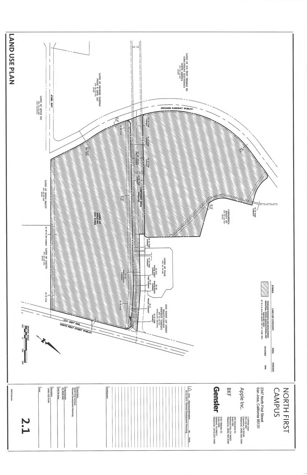
40
RESOLUTION NO. WHEREAS, the Planning Commission of the City certified said General Plan Update FPEIR, which certification was not appealed; and
 RESOLUTION NO. A RESOLUTION OF THE COUNCIL OF THE CITY OF SAN JOSE APPROVING THE MONTGOMERY 7 PROPOSED RESIDENTIAL AND RETAIL PROJECT 565 LORRAINE AVENUE ADDENDUM TO THE DIRIDON STATION AREA PLAN FINAL
RD:VMT:JMD 10/14/2015 RESOLUTION NO.
 RD:VMT:JMD 10/14/2015 RESOLUTION NO. A RESOLUTION OF THE COUNCIL OF THE CITY OF SAN JOSE ADOPTING THE EDENVALE AVENUE PLANNED DEVELOPMENT REZONING PROJECT MITIGATED NEGATIVE DECLARATION, FOR WHICH AN INITIAL
On May 11, 2016, the Planning Commission voted (Commissioner Bit-Badal opposed) to recommend that the City Council:
 to recommend that the City Council:") COUNCIL AGENDA: 6/14/16 ITEM: 11.4 TO: HONORABLE MAYOR AND CITY COUNCIL FROM: Planning Commission SUBJECT: SEE BELOW DATE: May 23, 2016 COUNCIL DISTRICT: 3 SUBJECT: FILE NOS. PDC15-038 & PD15-042. PLANNED
COUNCIL AGENDA: 6/14/16 ITEM: 11.4 TO: HONORABLE MAYOR AND CITY COUNCIL FROM: Planning Commission SUBJECT: SEE BELOW DATE: May 23, 2016 COUNCIL DISTRICT: 3 SUBJECT: FILE NOS. PDC15-038 & PD15-042. PLANNED
CITY COUNCIL STAFF REPORT
 COUNCIL AGENDA: 04/11/17 ITEM: W\0^ CITY OF e: :SS SAN JOSE CAPITAL OF SILICON VALLEY CITY COUNCIL STAFF REPORT File No. C16-030 Applicant: Alex Rubashevsky Location Northwest corner of Oakland Road and
Planning Commission Staff Report June 5, 2008
 Owner/Applicant Taylor Village Sacramento Investments Partners, LP c/o Kim Whitney 1792 Tribute Road #270 Sacramento, CA 95815 Staff Recommendation Planning Commission Staff Report Project: File: Request:
Glenborough at Easton Land Use Master Plan
 Implementation 114 9.0 IMPLEMENTATION 9.1 OVERVIEW This chapter summarizes the administrative procedures necessary to implement the proposed land use plan, infrastructure improvements, development standards,
STAFF REPORT TO THE CITY COUNCIL. Conduct Public Hearing to vacate certain public right of way adjacent to Sycamore Avenue and San Pablo Avenue
 STAFF REPORT TO THE CITY COUNCIL DATE: Adjourned Regular Meeting of December 16, 2014 TO: SUBMITTED BY: SUBJECT: Mayor and Members of the City Council Holly Smyth, Planning Director Conduct Public Hearing
CITY OF CYPRESS 5275 Orange Avenue Cypress, California (714) DESIGN REVIEW COMMITTEE PERMIT PROCESS
 DESIGN REVIEW COMMITTEE PERMIT PROCESS") CITY OF CYPRESS 5275 Orange Avenue Cypress, California 90630 (714) 229-6720 DESIGN REVIEW COMMITTEE PERMIT PROCESS 1. Discuss project with Planning staff to determine zoning regulations, any unusual characteristics
CITY OF CYPRESS 5275 Orange Avenue Cypress, California 90630 (714) 229-6720 DESIGN REVIEW COMMITTEE PERMIT PROCESS 1. Discuss project with Planning staff to determine zoning regulations, any unusual characteristics
PLANNING COMMISSION RESOLUTION NO GREEN LINE MIXED USE SPECIFIC PLAN
 PLANNING COMMISSION RESOLUTION NO. 2017-16 GREEN LINE MIXED USE SPECIFIC PLAN A RESOLUTION OF THE PLANNING COMMISSION OF THE CITY OF HAWTHORNE RECOMMENDING THAT THE CITY COUNCIL OF THE CITY OF HAWTHORNE,
CITY OF ALAMEDA PLANNING BOARD Draft RESOLUTION
 CITY OF ALAMEDA PLANNING BOARD Draft RESOLUTION A RESOLUTION OF THE PLANNING BOARD OF THE CITY OF ALAMEDA APPROVING DESIGN REVIEW AND DEVELOPMENT PLAN AMENDMENT APPLICATION PLN13-0157 TO CONSTRUCT ELEVEN
ORDINANCE WHEREAS, this Ordinance is consistent with the City of Winter Garden Comprehensive Plan; and
 ORDINANCE 17-06 AN ORDINANCE OF THE CITY COMMISSION OF THE CITY OF WINTER GARDEN, FLORIDA, CREATING ARTICLE XIV OF CHAPTER 118 OF THE CITY OF WINTER GARDEN CODE OF ORDINANCES PROVIDING FOR THE EAST PLANT
ORDINANCE NO
 ATTACHMENT CC-1 ORDINANCE NO. 13-2113 AN ORDINANCE OF THE CUPERTINO CITY COUNCIL APPROVING THE REZONING OF AN APPROXIMATELY 1.1 ACRE AREA FROM PARK AND RECREATION (PR) TO PLANNED INDUSTRIAL PARK (P(MP))
Chapter Master Planned Communities (MPC) District
 District") Sections 14.53.010 Purpose and Intent 14.53.020 Applicability 14.53.030 Procedure 14.53.040 MPC Standards 14.53.050 Required Findings 14.53.010 Purpose and Intent Chapter 14.53 Master Planned Communities
Sections 14.53.010 Purpose and Intent 14.53.020 Applicability 14.53.030 Procedure 14.53.040 MPC Standards 14.53.050 Required Findings 14.53.010 Purpose and Intent Chapter 14.53 Master Planned Communities
CITY OF VACAVILLE PLANNING COMMISSION Agenda Item No. G. 1 STAFF REPORT August 4, Staff Contact: Tricia Shortridge (707)
") CITY OF VACAVILLE PLANNING COMMISSION Agenda Item No. G. 1 STAFF REPORT August 4, 2009 Staff Contact: Tricia Shortridge (707) 449-5140 TITLE: REQUEST: LONGS / CVS DRIVE-THRU PHARMACY & REMODEL TIME EXTENSION
CITY OF VACAVILLE PLANNING COMMISSION Agenda Item No. G. 1 STAFF REPORT August 4, 2009 Staff Contact: Tricia Shortridge (707) 449-5140 TITLE: REQUEST: LONGS / CVS DRIVE-THRU PHARMACY & REMODEL TIME EXTENSION
RESOLUTION NO. WHEREAS, the proposed Master Plan for Villa Esperanza (VE), located at 2116
, located at 2116") RESOLUTION NO. A RESOLUTION OF THE CITY COUNCIL OF THE CITY OF PASADENA APPROVING A MASTER PLAN FOR VILLA ESPERANZA WHEREAS, the proposed Master Plan for Villa Esperanza (VE), located at 2116 Villa Street
RESOLUTION NO. A RESOLUTION OF THE CITY COUNCIL OF THE CITY OF PASADENA APPROVING A MASTER PLAN FOR VILLA ESPERANZA WHEREAS, the proposed Master Plan for Villa Esperanza (VE), located at 2116 Villa Street
ORDINANCE NO. 430 REGARDING WATER CONSERVATION
 ORDINANCE NO. XXXX AN ORDINANCE OF THE TOWN COUNCIL OF THE TOWN OF TIBURON AMENDING TITLE IV, CHAPTER 13E (WATER EFFICIENT LANDSCAPE) OF THE MUNICIPAL CODE AND ADOPTING BY REFERENCE MARIN MUNICIPAL WATER
MEMORANDUM. TERESA McCLISH, COMMUNITY DEVELOPMENT DIRECTOR
 MEMORANDUM TO: FROM: BY: CITY COUNCIL TERESA McCLISH, COMMUNITY DEVELOPMENT DIRECTOR KELLY HEFFERNON, ASSOCIATE PLANNER SUBJECT: CONSIDERATION OF ADOPTION OF AN ORDINANCE AMENDING CHAPTER 16.84 OF THE
SAN FRANCISCO MUNICIPAL TRANSPORTATION AGENCY
 THIS PRINT COVERS CALENDAR ITEM NO. : 10.3 DIVISION: Sustainable Streets BRIEF DESCRIPTION: SAN FRANCISCO MUNICIPAL TRANSPORTATION AGENCY Approving the removal of Municipal Railway bus zones at various
A RESOLUTION OF THE PLANNING COMMISSION OF THE CITY
 RESOLUTION NO. A RESOLUTION OF THE PLANNING COMMISSION OF THE CITY OF SIGNAL HILL, CALIFORNIA, RECOMMENDING CITY COUNCIL ADOPTION OF ZONING ORDINANCE AMENDMENT 16-03, A REQUEST TO AMEND THE OFFICIAL ZONING
THE CITY OF VAUGHAN BY-LAW BY-LAW NUMBER
 THE CITY OF VAUGHAN BY-LAW BY-LAW NUMBER 123-2013 A By-law to designate the whole of the City of Vaughan as a Site Plan Control Area, and to adopt site development guidelines and rules of procedure for
3.10 LAND USE SETTING PROJECT SITE EXISTING LAND USE DESIGNATIONS AND ZONING. General Plan Land Use Designations.
 This section of the Draft EIR addresses the existing land uses on and adjacent to the project site and discusses the potential impacts of the proposed project on existing land uses. Key issues addressed
NOTICE OF SPECIAL MEETING
 NOTICE OF SPECIAL MEETING Pursuant to Section 54956 of the Government Code of the State of California, a Special meeting of the Tracy City Council is hereby called for: Date/Time: Location: Tuesday, April
North San José Area Development Policy
 North San José Area Development Policy City of San José Table of Contents 1. Background...3 Policy Area Boundaries...4 Participating Agencies...4 2. Vision and Purpose...4 Core Area...5 Transit/Employment
GENERAL INFORMATIONaaaaaaaaaaaaaaaaaaaaaaaaaaaaaaaa
 To: Planning and Zoning Commission From: City Staff Date: November 15, 2016 Re: Case #16026 Raymore Activity Center Site Plan GENERAL INFORMATIONaaaaaaaaaaaaaaaaaaaaaaaaaaaaaaaa Applicant/ Property Owner:
Memorandum. 5"f(* ((b SAN IPSE TO: HONORABLE MAYOR AND CITY COUNCIL. FROM: Harry Freitas SUBJECT: SEE BELOW. DATE: May 5, 2016 COUNCIL DISTRICT: 3
 mm CITY OF SAN IPSE CAPITAL OF SILICON VALLEY COUNCIL AGENDA: 05/17/16 ITEM: H2. Memorandum TO: HONORABLE MAYOR AND CITY COUNCIL SUBJECT: SEE BELOW FROM: Harry Freitas DATE: Approved Date 5"f(* ((b COUNCIL
CITY OF SAN MATEO ORDINANCE NO
 CITY OF SAN MATEO ORDINANCE NO. 2012-4 AMENDING SECTION 27.38.090, OPEN SPACE REQUIREMENTS, OF CHAPTER 27.38, CBD DISTRICTS-CENTRAL BUSINESS DISTRICT, SECTION 27.64.023, PARKING PROHIBITED ON LAWNS, FLOWERS,
ARTICLE 17 SITE PLAN REVIEW
 ARTICLE 17 SITE PLAN REVIEW 17.01 INTENT AND PURPOSE The intent of this section is to provide for consultation and cooperation between the applicant and the township planning commission so that the applicant
PC RESOLUTION NO
 PC RESOLUTION NO. 14-01-14-02 TENTATIVE TRACT MAP fttm) 17441. REZONE {RZ) 13-003, ARCHITECTURAL CONTROL (AC) 13-003, TREE REMOVAL PERMIT (TRP) 13-052. GRADING PLAN MODIFICATION (GPM) 13-002. CONDITIONAL
Prepared by: Casey Kempenaar, Senior Planner
 CITY OF CITRUS HEIGHTS PLANNING DIVISION STAFF REPORT PLANNING COMMISSION MEETING September 13, 2017 Prepared by: Casey Kempenaar, Senior Planner REQUEST The applicant requests a Design Review Permit Modification
OFFICE CONSOLIDATION SECONDARY PLAN AREA 22 THE BRAMALEA SOUTH INDUSTRIAL SECONDARY PLAN
 OFFICE CONSOLIDATION SECONDARY PLAN AREA 22 THE BRAMALEA SOUTH INDUSTRIAL SECONDARY PLAN November 2010 EXPLANATORY NOTES (Secondary Plan Area 22) General (pertaining to all secondary plan office consolidations)
MONTGOMERY COUNTY PLANNING DEPARTMENT THE MARYLAND-NATIONAL CAPITAL PARK AND PLANNING COMMISSION
 MONTGOMERY COUNTY PLANNING DEPARTMENT THE MARYLAND-NATIONAL CAPITAL PARK AND PLANNING COMMISSION MCPB Item No. Date: 3.10.2016 Site Plan 820160040 Nora School Parker Smith, Planning Technician, Area 1,
Design Review Commission Report
 City of Beverly Hills Planning Division 455 N. Rexford Drive Beverly Hills, CA 90210 TEL. (310) 285-1141 FAX. (310) 858-5966 Design Review Commission Report Meeting Date: Thursday, March 2, 2017 Subject:
12 January 12, 2011 Public Hearing APPLICANT: TAILWIND DEVELOPMENT GROUP,LLC PROPERTY OWNER: CITY OF VIRGINIA BEACH
 12 January 12, 2011 Public Hearing APPLICANT: TAILWIND DEVELOPMENT GROUP,LLC PROPERTY OWNER: CITY OF VIRGINIA BEACH STAFF PLANNER: Faith Christie REQUEST: Conditional Change of Zoning (from PD-H1 Planned
AWH REPORT OF THE PLANNING AND DEVELOPMENT DEPARTMENT FOR APPLICATION FOR REZONING ORDINANCE TO PLANNED UNIT DEVELOPMENT
 AWH REPORT OF THE PLANNING AND DEVELOPMENT DEPARTMENT FOR APPLICATION FOR REZONING ORDINANCE TO PLANNED UNIT DEVELOPMENT MAY 8, 2014 The Planning and Development Department hereby forwards to the Planning
SUBJECT: PREDEVELOPMENT PLAN REVIEW OF PROJECT LOCATED AT 2632 EAST WASHINGTON BOULEVARD ('ST. LUKE MEDICAL CENTER')
") TO: FROM: Honorable Mayor and City Council Planning & Community Development Department SUBJECT: PREDEVELOPMENT PLAN REVIEW OF PROJECT LOCATED AT 2632 EAST WASHINGTON BOULEVARD ('ST. LUKE MEDICAL CENTER')
TO: FROM: Honorable Mayor and City Council Planning & Community Development Department SUBJECT: PREDEVELOPMENT PLAN REVIEW OF PROJECT LOCATED AT 2632 EAST WASHINGTON BOULEVARD ('ST. LUKE MEDICAL CENTER')
SPECIFIC PLAN Requirements
 CITY OF LANCASTER PLANNING DEPARTMENT 44933 Fern Avenue, Lancaster, California 93534 (661) 723-6100 SPECIFIC PLAN Requirements Purpose The purpose of a specific plan is to provide for the logical development
Department of Community Development. Planning and Environmental Review Division Revised Notice of Preparation
 Department of Community Development Michael J. Penrose, Acting Director Divisions Building Permits & Inspection Code Enforcement County Engineering Economic Development & Marketing Planning & Environmental
ORDINANCE NO. City of Bellingham City Attorney 210 Lottie Street Bellingham, Washington INFILL HOUSING ORDINANCE Page 1
 ORDINANCE NO. AN ORDINANCE RELATING TO LAND USE PLANNING AND ZONING, CREATING A NEW BMC CHAPTER 20.28 INFILL HOUSING, AND NEW SUBSECTION BMC 20.12.030.E, GREEN FACTOR LANDSCAPING STANDARDS, AND AMENDING
Historic Preservation Commission Motion No Certificate of Appropriateness
 Historic Preservation Commission Motion No. 0200 Certificate of Appropriateness HEARING DATE: JUNE 5, 2013 Filing Date: January 23, 2013 Case No.: 2013.0080A Project Address: Historic Landmark: Zoning:
RESOLUTION NO. PC
 RESOLUTION NO. PC 2018-14 A RESOLUTION OF THE CITY OF ENCINITAS PLANNING COMMISSION RECOMMENDING CITY COUNCIL ADOPTION OF ORDINANCE NO. 2018-05, ADOPTING AMENDMENTS TO THE LOCAL COASTAL PLAN, NORTH 101
Planning Commission Staff Report March 15, 2007
 Planning Commission Staff Report Project: Request: Madeira East Tentative Subdivision Map, Design Review for Subdivision Layout & Abandonment of Easements Location: Phase IV of the Laguna Ridge Specific
AGENDA ITEM NO. 17. Interim City Manager: Arnold Shadbehr Dir. Of Planning: Brian James
 AGENDA ITEM NO. 17 CITY OF HAWTHORNE CITY COUNCIL AGENDA BILL For the meeting of October 23, 2018 Originating Department: Planning and Community Development Interim City Manager: Arnold Shadbehr Dir. Of
REPORT TO PLANNING COMMISSION
 CITY OF Meeting Date: October 25, 2011 Agenda Item: Community Development Department Planning Division P. O. Box 151560, San Rafael, CA 94915-1560 PHONE: (415) 485-3085/FAX: (415) 485-3184 Case Numbers:
that the Town Board of the Town of East Greenbush will hold a public hearing on April 11,
 TOWN OF EAST GREENBUSH NOTICE OF PUBLIC HEARING PLEASE TAKE NOTICE that the Town Board of the Town of East Greenbush will hold a public hearing on April 11, 2018, at 5:45 p.m. at the East Greenbush Town
EXHIBIT A. Tax Increment Reinvestment Zone No. 1 (Town Center) First Amended Project Plan 1
 First Amended Project Plan 1") EXHIBIT A Tax Increment Reinvestment Zone No. 1 (Town Center) First Amended Project Plan 1 1 As amended by Resolution No. 2008-02-001(TR1R) of the Tax Increment Reinvestment Zone No.1, and approved to
EXHIBIT A Tax Increment Reinvestment Zone No. 1 (Town Center) First Amended Project Plan 1 1 As amended by Resolution No. 2008-02-001(TR1R) of the Tax Increment Reinvestment Zone No.1, and approved to
TO: CITY COUNCIL DATE: MARCH 23,2009
 Report TO: CITY COUNCIL DATE: MARCH 23,2009 FROM: CITY MANAGER SUBJECT: MASTER DEVELOPMENT PLAN AMENDMENT FOR PASADENA CHRISTIAN SCHOOL AT 1515 NORTH LOS ROBLES AVENUE AND GENERAL PLAN AMENDMENT AND ZONE
RESOLUTION NO
 RESOLUTION NO. 2018- RESOLUTION OF THE PLANNING COMMISSION OF THE CITY OF BELMONT APPROVING A SINGLE-FAMILY DESIGN REVIEW AND TREE REMOVAL PERMIT FOR A VACANT LOT ON LOWER LOCK AVENUE (APN: 043-042-750,
Gold Line Bus Rapid Transit Transit Oriented Development (BRTOD) Helmo Station Area Plan
 Helmo Station Area Plan") Appendix F Gold Line Bus Rapid Transit Transit Oriented Development (BRTOD) Helmo Station Area Plan Introduction and Purpose of the Plan The Gold Line Bus Rapid Transit facility is an eleven-mile dedicated
Appendix F Gold Line Bus Rapid Transit Transit Oriented Development (BRTOD) Helmo Station Area Plan Introduction and Purpose of the Plan The Gold Line Bus Rapid Transit facility is an eleven-mile dedicated
PLANNING REPORT CITY OF EAGAN. APPLICANT: Cedar Grove Hospitality, LLC HEARING DATE: December 18, 2014
 PLANNING REPORT CITY OF EAGAN REPORT DATE: December 8, 2014 CASE: 19-PA-11-11-14 APPLICANT: Cedar Grove Hospitality, LLC HEARING DATE: PROPERTY OWNER: The Flats at Cedar APPLICATION DATE: Nov. 21, 2014
D1 September 11, 2013 Public Hearing APPLICANT:
 D1 September 11, 2013 Public Hearing APPLICANT: BEACH MUNICIPAL FEDERAL CREDIT UNION PROPERTY OWNER: SISTERS II, LLC STAFF PLANNER: Karen Prochilo REQUEST: Conditional Change of Zoning (AG-2 Agriculture
The maximum amounts shown in the Engineer s Report for each of those categories for FY 2008/09 are as follows (per house/per year):
:") Agenda Item No. August 28, 2007 TO: FROM: SUBJECT: Honorable Mayor and City Council Attention: David J. Van Kirk, City Manager Dale I. Pfeiffer, Director of Public Works RESOLUTION INITIATING PROCEEDINGS,
Agenda Item No. August 28, 2007 TO: FROM: SUBJECT: Honorable Mayor and City Council Attention: David J. Van Kirk, City Manager Dale I. Pfeiffer, Director of Public Works RESOLUTION INITIATING PROCEEDINGS,
CITY OF VACAVILLE PLANNING COMMISSION Agenda Item No. G.3 STAFF REPORT August 18, 2015 Staff Contact: Peyman Behvand (707)
") CITY OF VACAVILLE PLANNING COMMISSION Agenda Item No. G.3 STAFF REPORT August 18, 2015 Staff Contact: Peyman Behvand (707) 449-5140 TITLE: REQUEST: VISTA CROSSINGS PLANNED SIGN PROGRAM AMENDMENT PLANNED
CITY OF VACAVILLE PLANNING COMMISSION Agenda Item No. G.3 STAFF REPORT August 18, 2015 Staff Contact: Peyman Behvand (707) 449-5140 TITLE: REQUEST: VISTA CROSSINGS PLANNED SIGN PROGRAM AMENDMENT PLANNED
COUNCIL COMMUNICATION
 Meeting Date: August 23, 2016 COUNCIL COMMUNICATION Agenda Item: Agenda Location: Public Hearing Work Plan # N/A Legal Review: X 1 st Reading 2 nd Reading Subject: A public hearing regarding a Conceptual
PLANNING COMMISSION STAFF REPORT
 OFFICE OF COMMUNITY DEVELOPMENT CITY HALL 10300 TORRE AVENUE CUPERTINO, CA 95014-3255 (408) 777-3308 FAX (408) 777-3333 planning@cupertino.org PLANNING COMMISSION STAFF REPORT Agenda Item No. Agenda Date:
Executive Summary General Plan Amendment Initiation
 Executive Summary General Plan Amendment Initiation HEARING DATE: AUGUST 6, 2015 Date: July 30, 2015 Case No.: 2011.0409PCA Project Address: 925 Mission Street and various parcels (aka 5M ) Existing Zoning:
PROJECT SUMMARY. University of California, Irvine Humanities Building. Project No FINAL INITIAL STUDY/MITIGATED NEGATIVE DECLARATION
 PROJECT SUMMARY University of California, Irvine Humanities Building Project No. 991077 FINAL INITIAL STUDY/MITIGATED NEGATIVE DECLARATION State Clearinghouse No. 2007011035 March 2007 Humanities Building
CITY OF MALIBU PLANNING COMMISSION RESOLUTION NO
 CITY OF MALIBU PLANNING COMMISSION RESOLUTION NO. 16-54 A RESOLUTION OF THE PLANNING COMMISSION OF THE CITY OF MALIBU, CONSIDERING AN ADDENDUM TO THE CERTIFIED CRUMMER SITE SUBDIVISION FINAL EIR AND MAKING
City of Larkspur. Notice of Mitigated Negative Declaration for the 285
 Notice of Mitigated Negative Declaration for the 285 Magnolia Avenue Mixed-Use Project Date: December 2, 2013 Responsible Agency: Project Title: 285 Magnolia Avenue Mixed-Use Project Project Address: 285
Planning Commission Staff Report February 5, 2015
 Planning Commission Staff Report Project: 99 Cents Only Store File: EG-14-018 Request: General Plan Amendment, Rezone, and Design Review Location: 8945 Brown Road; northeast corner of Elk Grove-Florin
and services The protection and conservation of environmentally significant and sensitive natural heritage features and functions.
 6. Land Use 6.0 Preamble A healthy and livable city is one in which people can enjoy a vibrant economy and a sustainable healthy environment in safe, caring and diverse neighbourhoods. In order to ensure
LU Encourage schools, institutions, and other community facilities that serve rural residents to locate in neighboring cities and towns.
 Application No. 891627: Comprehensive Plan Text Amendment - Rural School Policies - Amend policies consistent with State Legislation allowing schools in the rural area and extension of sewer service to
DRAFT Land Use Chapter
 Stevens Creek Urban Village DRAFT 1 18 17 Land Use Chapter INTRODUCTION This Land Use Chapter describes how the Stevens Creek Urban Village will accommodate the growth that is planned for it in the Envision
ARLINGTON COUNTY, VIRGINIA
 ARLINGTON COUNTY, VIRGINIA County Board Agenda Item Meeting of April 23, 2019 DATE: April 12, 2019 SUBJECT: SP #413 SITE PLAN AMENDMENT to permit a fixed bar in a private outdoor café space with associated
6 November 13, 2013 Public Hearing APPLICANT: CAH HOLDINGS, LLC
 6 November 13, 2013 Public Hearing APPLICANT:, LLC PROPERTY OWNER: LC REALTY, LLC STAFF PLANNER: Kevin Kemp REQUEST: Conditional Use Permit (Automated Car Wash) ADDRESS / DESCRIPTION: 3565 Holland Road
PC RESOLUTION NO GRADING PLAN MODIFICATION (GPM)
") PC RESOLUTION NO. 16-07-26- GRADING PLAN MODIFICATION (GPM) 16-006 A RESOLUTION OF THE PLANNING COMMISSION OF THE CITY OF SAN JUAN CAPISTRANO, CALIFORNIA APPROVING GRADING PLAN MODIFICATION (GPM) 16-006,
PC RESOLUTION NO. 16-07-26- GRADING PLAN MODIFICATION (GPM) 16-006 A RESOLUTION OF THE PLANNING COMMISSION OF THE CITY OF SAN JUAN CAPISTRANO, CALIFORNIA APPROVING GRADING PLAN MODIFICATION (GPM) 16-006,
SDOT DPD. SDOT Director s Rule DPD Director s Rule DCLU DR SED DR of 7 CITY OF SEATTLE
 SDOT SDOT Director s Rule 2-07 DPD Applicant: CITY OF SEATTLE Page 1 of 7 Supersedes: DCLU DR 11-93 SED DR 93-4 Seattle Department of Transportation (SDOT) Department of Planning and Development (DPD)
RESIDENTIAL DISTRICTS
 RESIDENTIAL DISTRICTS The residential district standards have been revised to reflect on-the-ground conditions, while continuing to respect the use patterns established within the neighborhoods. This will
MONTGOMERY COUNTY PLANNING DEPARTMENT
 MONTGOMERY COUNTY PLANNING DEPARTMENT THE MARYLAND-NATIONAL CAPITAL PARK AND PLANNING COMMISSION MCPB Item No.: Date: 5-03-18 Pike and Rose, Phase I: Site Plan Amendment No. 82012002D Rhoda Hersson-Ringskog,
ARTICLE VI: SITE PLAN REVIEW
 Section 6.01 - Site Plan Review (All Districts) ARTICLE VI: SITE PLAN REVIEW Site plans give the Planning commission an opportunity to review development proposals in a concise and consistent manner. The
VILLAGE OF CLEMMONS PLANNING BOARD DRAFT STAFF REPORT
 VILLAGE OF CLEMMONS PLANNING BOARD DRAFT STAFF REPORT PETITION INFORMATION Docket # C-226 Staff Megan Ledbetter Petitioner(s) JBJH Properties, LLC Owner(s) JBJH Properties, LLC Subject Property 5892-49-1766
PLANNED UNIT DEVELOPMENT Date: April 5, 2018
 PLANNED UNIT DEVELOPMENT Date: April 5, 2018 DEVELOPMENT NAME SUBDIVISION NAME LOCATION Robert Myers Robert Myers 2955 and 2989 Dauphin Street (Southeast corner of Dauphin Street and Sage Avenue) CITY
D3 January 14, 2015 Public Hearing
 D3 January 14, 2015 Public Hearing APPLICANT: DONALD J. BOUCHER, JR. PROPERTY OWNER: D.J.B. SERVICE CENTER, LLC STAFF PLANNER: Kristine Gay REQUEST: A. Conditional Change of Zoning (I-1 to B-2) B. Conditional
MINUTES OF THE TOWN COUNCIL MEETING SEPTEMBER 1, 2016
 MINUTES OF THE TOWN COUNCIL MEETING SEPTEMBER 1, 2016 Town Council Meeting 09/20/16 Item #1 The Town Council of the Town of Los Gatos conducted a Special Meeting on Thursday, September 1, 2016, at 6:00
KEIZER STATION PLAN INTRODUCTION
 KEIZER STATION PLAN INTRODUCTION Planning for this area began in 1987 when the Keizer Comprehensive Plan established the Chemawa Activity Center and McNary Activity Center. The first Chemawa Activity Center
CHAPTER 2 SUMMARY 1. PROJECT SUMMARY DATA
 CHAPTER 2 SUMMARY This is an Initial Study format used to determine, pursuant to CEQA Guidelines Section 15177, whether a project 1) is within the scope of a Master EIR (MEIR), 2) may result in additional
SAN FRANCISCO CITY PLANNING COMMISSION MOTION NO
 Page 1 SAN FRANCISCO CITY PLANNING COMMISSION MOTION NO. 15003 ADOPTING FINDINGS RELATING TO APPROVAL OF A DETERMINATION OF COMPLIANCE UNDER PLANNING CODE SECTION 309 FOR A PROPOSED PROJECT CONTAINING
Procedures IV. V. Rural Road Design Option
 i IV. Procedures A. All applicants required to prepare a Conservation Design Subdivision shall provide the Planning Board with a conceptual conventional subdivision design as well as a proposed layout
10 San Jose Light Rail
 10 San Jose Light Rail OVERVIEW: TRANSIT SYSTEM CHARACTERISTICS The Santa Clara Valley Transportation Authority (VTA) operates the Guadalupe Corridor light rail line, which spans much of the City of San
CITY OF CHARLOTTESVILLE, VIRGINIA CITY COUNCIL AGENDA
 CITY OF CHARLOTTESVILLE, VIRGINIA CITY COUNCIL AGENDA Agenda Date: December 16, 2013 Action Required: Adoption of Resolution Presenter: Staff Contacts: Title: James E. Tolbert, AICP, Director of NDS James
COMMUNITY DEVELOPMENT SERVICES PLANNING AND BUILDING DEPARTMENT PLACERVILLE OFFICE:
 COMMUNITY DEVELOPMENT SERVICES PLANNING AND BUILDING DEPARTMENT http://www.edcgov.us/devservices/ PLACERVILLE OFFICE: LAKE TAHOE OFFICE: 2850 Fair Lane Court, Placerville, CA 95667 924 B Emerald Bay Rd.
Draft Planning Commission Resolution Proposed Commission Policy and Planning Code Amendment
 Draft Planning Commission Resolution Proposed Commission Policy and Planning Code Amendment HEARING DATE: JULY 14, 2011 Project Name: Case Number: Staff Contact: Reviewed by: Recommendation: Standards
4 January 11, 2012 Public Hearing APPLICANT:
 . 4 January 11, 2012 Public Hearing APPLICANT: MID-ATLANTIC AUTO PROPERTY OWNER: DZR, LLC STAFF PLANNER: Leslie Bonilla REQUEST: Conditional Use Permit (truck rental, automobile service, and automotive/bulk
PLANNED DEVELOPMENT (MASTER PLAN & UNIT PLAN)
") Central Permit Center 555 Santa Clara Street Vallejo CA 94590 Business License Building Fire Prevention Planning Public Works 707.648.4310 707.648.4374 707.648.4565 707.648.4326 707.651.7151 PLANNED DEVELOPMENT
Central Permit Center 555 Santa Clara Street Vallejo CA 94590 Business License Building Fire Prevention Planning Public Works 707.648.4310 707.648.4374 707.648.4565 707.648.4326 707.651.7151 PLANNED DEVELOPMENT
At Your Disposal CUP Amendment, Lot 20, Village Service Commercial, at 128 Bastille Dr. (PLN17-208)
") MEMORANDUM Archuleta County Development Services Planning Department 1122 HWY 84 P. O. Box 1507 Pagosa Springs, Colorado 81147 970-264-1390 Fax 970-264-3338 TO: Archuleta County Planning Commission FROM:
MEMORANDUM Archuleta County Development Services Planning Department 1122 HWY 84 P. O. Box 1507 Pagosa Springs, Colorado 81147 970-264-1390 Fax 970-264-3338 TO: Archuleta County Planning Commission FROM:
PC RESOLUTION NO ARCHITECTURAL CONTROL (AC)
") PC RESOLUTION NO. 16-07-26- ARCHITECTURAL CONTROL (AC) 15-035 A RESOLUTION OF THE PLANNING COMMISSION OF THE CITY OF SAN JUAN CAPISTRANO, CALIFORNIA APPROVING ARCHITECTURAL CONTROL (AC) 15-035, INN AT
PC RESOLUTION NO. 16-07-26- ARCHITECTURAL CONTROL (AC) 15-035 A RESOLUTION OF THE PLANNING COMMISSION OF THE CITY OF SAN JUAN CAPISTRANO, CALIFORNIA APPROVING ARCHITECTURAL CONTROL (AC) 15-035, INN AT
ORDINANCE AN ORDINANCE TO ADD A NEW SECTION 4.N. IN THE ZONING CODE FOR THE TOWN OF MIDDLETOWN, RELATING TO MIXED-USE DEVELOPMENT
 Introduced: November 5, 2018 Approved: ORDINANCE 18-11-01 AN ORDINANCE TO ADD A NEW SECTION 4.N. IN THE ZONING CODE FOR THE TOWN OF MIDDLETOWN, RELATING TO MIXED-USE DEVELOPMENT BE IT ENACTED BY THE MAYOR
The Corporation of the TOWN OF MILTON
 Report to: From: Chair & Members of the Administration & Planning Standing Committee W.F. Mann, Director of Planning and Development Date: April 16, 2012 PD 022-12 (Z19/11) Subject: Technical Report Proposed
CITY OF SIMI VALLEY MEMORANDUM
 CITY OF SIMI VALLEY MEMORANDUM AGENDA ITEM NO. Consent (10) November 14, 2016 TO: FROM: City Council Department of Environmental Services SUBJECT: ADOPTION OF A RESOLUTION TO RATIFY VENTURA COUNTY FIRE
K. SMART ASSOCIATES LIMITED
 Planning Justification Report Zoning By-Law Amendment 185 King Street North Waterloo, Ontario April 7th, 2017 Project Reference Number 16-245 K. SMART ASSOCIATES LIMITED CONSULTING ENGINEERS AND PLANNERS
City of San Mateo General Plan Circulation Element. Adopted October 18, 2010
 City of San Mateo General Plan Circulation Element. Adopted October 18, 2010 TRANSIT (pp III-20 to III-21) Exhibit A - Item 20 Excerpt from 2010 Downtown Plan Update and enacting Resolution C 3.4: Hillsdale
Planned Development Review Revisions (Project No. PLNPCM )
") Planned Development Review Revisions (Project No. PLNPCM2014-00139) Standard residential development Planned Development Example: Smaller lot sizes than what is allowed to create open space amenity. What
Planned Development Review Revisions (Project No. PLNPCM2014-00139) Standard residential development Planned Development Example: Smaller lot sizes than what is allowed to create open space amenity. What
Commercial Development Proposal Tenth Line Road. Planning Rationale Report. Minto Developments Inc.
 Commercial Development Proposal 2168 Tenth Line Road Report September 2015 Prepared for Minto Developments Inc. Paquette Planning Associates Ltd. 56 Hutchison Avenue Ottawa, Ontario K1Y 4A3 PH: 613-722-7217
RESOLUTION NO. WHEREAS, the City of San José (City ) owns and operates the Norman Y. Mineta San José International Airport ( Airport ); and
 owns and operates the Norman Y. Mineta San José International Airport ( Airport ); and") RESOLUTION NO. A RESOLUTION OF THE COUNCIL OF THE CITY OF SAN JOSE AUTHORIZING THE NORMAN Y. MINETA SAN JOSE AIRPORT TO SOLE-SOURCE CERTAIN PRODUCTS AND/OR SERVICES AS PART OF ANY FUTURE CAPITAL IMPROVEMENT
RESOLUTION NO. A RESOLUTION OF THE COUNCIL OF THE CITY OF SAN JOSE AUTHORIZING THE NORMAN Y. MINETA SAN JOSE AIRPORT TO SOLE-SOURCE CERTAIN PRODUCTS AND/OR SERVICES AS PART OF ANY FUTURE CAPITAL IMPROVEMENT
Notice of Preparation and Notice of Public Scoping Meeting. At Dublin Project
 Notice of Preparation and Notice of Public Scoping Meeting Date January 17, 2018 To Project Title Project Application Number Project Location Project Applicant Contact For questions or submitting comments.
The full agenda including staff reports and supporting materials are available at City Hall.
 Date: February 28, 2018 Time: 6:00 p.m. Place: City Council Chambers 350 North Valencia Blvd. Woodlake, CA 93286 In compliance with the Americans with Disabilities Act and the California Ralph M. Brown
City of San Luis Obispo
 City of San Luis Obispo ACCESS AND PARKING MANAGEMENT PLAN Amended November, 2011 CITY OF SAN LUIS OBISPO PUBLIC WORKS DEPARTMENT, PARKING SERVICES 1260 Chorro Street, Suite B, San Luis Obispo, California
CHAPTER SPECIAL PURPOSE AND OVERLAY ZONING DISTRICTS
 Special Purpose and Overlay Zoning Districts 106.28.010 CHAPTER 106.28 - SPECIAL PURPOSE AND OVERLAY ZONING DISTRICTS SPECIAL PURPOSE AND OVERLAY ZONING DISTRICTS Sections: 106.28.010 - Purpose 106.28.020
City of Yelm. Tahoma Terra Final Master Plan Development Guidelines. Table of Contents
 City of Yelm Tahoma Terra Final Master Plan Development Guidelines Table of Contents Table of Contents... 1 Purpose... 2 Low Density Residential (R4-6)... 3 Moderate Density Residential (R6-10)... 5 Neighborhood
Chapter 4. Linking Land Use with Transportation. Chapter 4
 Chapter 4 Linking Land Use with Transportation Chapter 4 59 Chapter 4 Linking Land Use with Transportation Community Design and Transportation Program Introduction Since the 1950s, the predominant development
open public hearing and allow public comment request to continue LPA public hearing to January 16, 2014 at 10:30 am
 TODAY S AGENDA Work Session LPA Transmittal Public Hearing open public hearing and allow public comment request to continue LPA public hearing to January 16, 2014 at 10:30 am staff will issue a recommendation