South Lodge Courtyard, Merton College, Oxford
|
|
|
- Gavin Robbins
- 5 years ago
- Views:
Transcription
1 South Lodge Courtyard, Merton College, Oxford An Archaeological Desk-Based Assessment for Merton College by Steve Preston Thames Valley Archaeological Services Ltd Site Code MCO08/24 April 2008
2 Summary Site name: South Lodge Courtyard, Merton College, Oxford Grid reference: SP Site activity: Desk-based assessment Project manager: Steve Ford Site supervisor: Steve Preston Site code: MCO04/24 Area of site: c. 400 sq m Summary of results: The site lies just outside the medieval city walls, in a location likely to have been favoured for settlement from prehistoric times onwards. Saxon and medieval settlement remains have been found close by and a medieval grange barn is also considered probably to have been located nearby. A small area of the site to be developed has previously been built upon but most has always been gardens within its recorded history. The site therefore has considerable general and specific archaeological potential. It will be necessary to provide more information from field observations in order to devise a scheme to mitigate the impact of the proposal on any archaeological remains that may be present. This report may be copied for bona fide research or planning purposes without the explicit permission of the copyright holder Report edited/checked by: Steve Ford Joanna Pine i
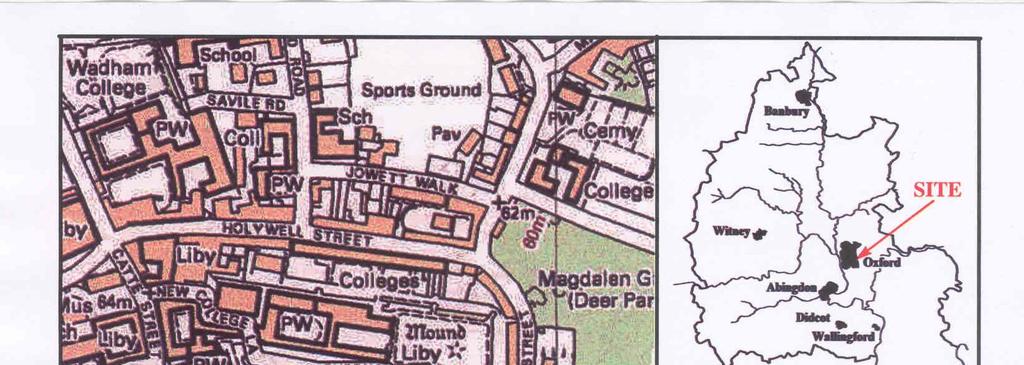
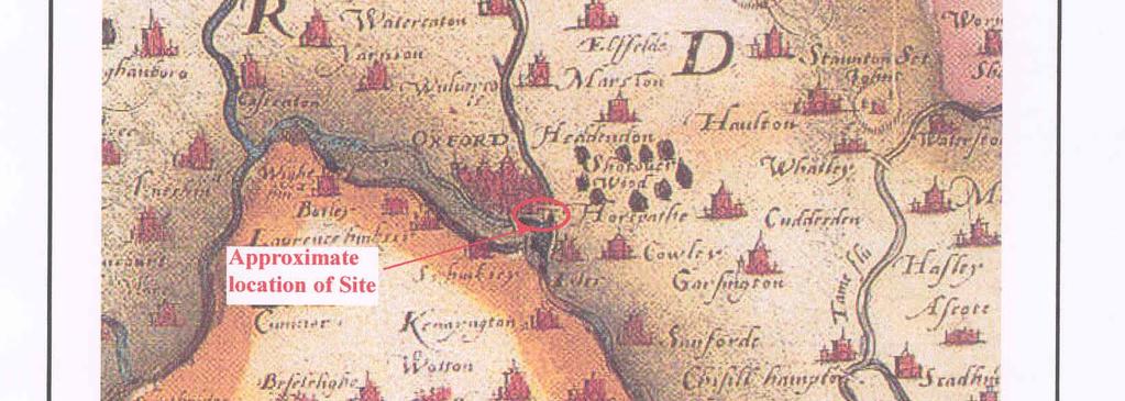
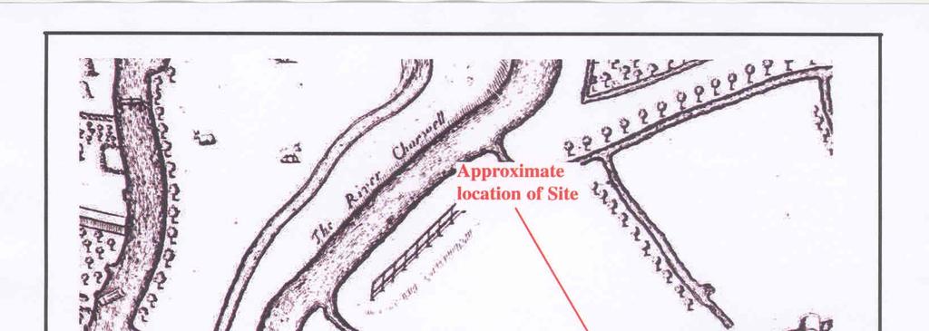
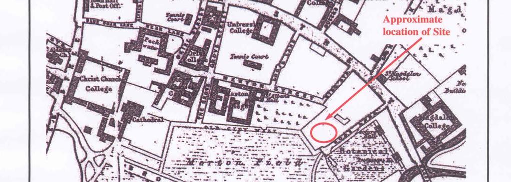
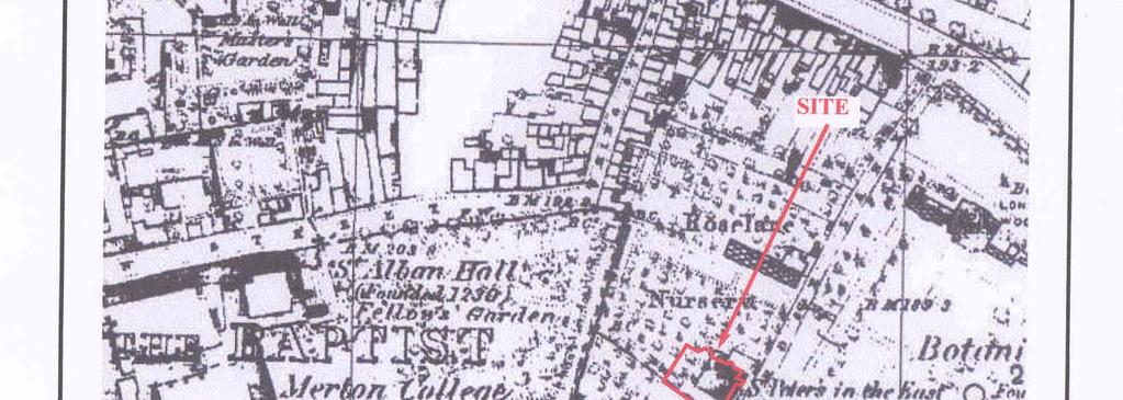
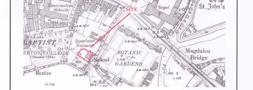
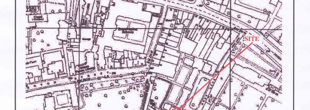
3 South Lodge Courtyard, Merton College, Oxford An Archaeological Desk-Based Assessment by Steve Preston Report 08/24 Introduction This desk-based study is an assessment of the archaeological potential of a plot of land of around 400 sq m located off Rose Lane in Oxford (SP ) (Fig. 1) and comprises the first stage of a process to determine the presence/absence, extent, character, quality and date of any archaeological remains which may be affected by redevelopment of the area. The project was commissioned by Mr Jolyon Price of Ridge and Partners LLP, The Cowyards, Blenheim Park, Oxford Road, Woodstock, OX20 1QR on behalf of Merton College, Oxford. Planning permission is to be sought for the construction of a new lecture theatre on the site. In light of the possibility of archaeological remains being present which might be affected by the proposed development, this report has been requested to accompany the application, in order to inform the planning process with regard to potential archaeological implications. This report will provide a basis on which to formulate a strategy to mitigate the effects of the development on any archaeological remains that might be present. Site description, location and geology The site comprises a small irregularly-shaped parcel of land in central Oxford, between South Lodge and Meadow Cottages, to the west of Rose Lane and south of High Street, facing the Botanic Gardens and backing onto Merton College. It includes part of the college s Rose Lane building, which is stepped slightly above the surrounding ground level. A wall of Merton College, which also formed part of the medieval city wall forms the western boundary of the plot, but is not included within the area to be developed: it does not appear that any of this wall is original in this location. The site lies at around 57m above Ordnance Datum on the floodplain of the River Cherwell just north of its confluence with the Thames, in an area where both rivers are extensively braided. The site s geology is mapped as being on the First Terrace (floodplain) gravels (BGS 1982), very close to the boundary with the alluvium of the valley of the Cherwell. 1
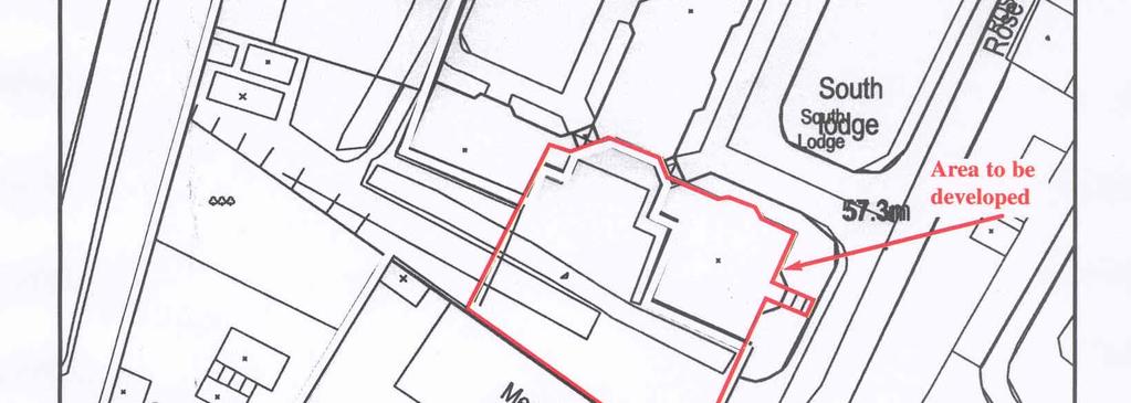
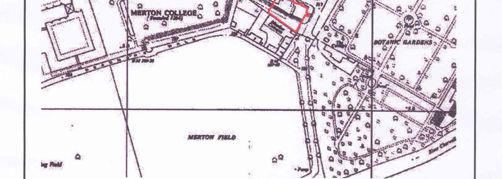
4 Planning background and development proposals Planning permission is to be sought for the construction of a new lecture theatre on the site; the development will affect only around 400 sq m of the 1400 sq m plot (Fig. 2). Archaeology and Planning (PPG ) provides guidance relating to archaeology within the planning process. It points out that where a desk-based assessment has shown that there is a strong possibility of significant archaeological deposits in a development area it is reasonable to provide more detailed information from a field evaluation so that an appropriate strategy to mitigate the effects of development on archaeology can be devised: Paragraph 21 states: Where early discussions with local planning authorities or the developer s own research indicate that important archaeological remains may exist, it is reasonable for the planning authority to request the prospective developer to arrange for an archaeological field evaluation to be carried out... Should the presence of archaeological deposits be confirmed further guidance is provided. Archaeology and Planning stresses preservation in situ of archaeological deposits as a first consideration as in paragraphs 8 and 18. Paragraph 8 states:...where nationally important archaeological remains, whether scheduled or not, and their settings, are affected by proposed development there should be a presumption in favour of their physical preservation... Paragraph 18 states: The desirability of preserving an ancient monument and its setting is a material consideration in determining planning applications whether that monument is scheduled or unscheduled... However, for archaeological deposits that are not of such significance it is appropriate for them to be preserved by record (i.e., fully excavated and recorded by a competent archaeological contractor) prior to their destruction or damage. Paragraph 25 states: Where planning authorities decide that the physical preservation in situ of archaeological remains is not justified in the circumstances of the development and that development resulting in the destruction of the archaeological remains should proceed, it would be entirely reasonable for the planning authority to satisfy itself... that the developer has made appropriate and satisfactory provision for the excavation and recording of remains. The Oxfordshire Structure Plan (OCC 1998) follows a similar line: Policy EN10: 2
5 There will be a presumption in favour of physically preserving nationally important archaeological remains, whether scheduled or not, and their settings. Where development affecting other archaeological remains is allowed it should include appropriate measures to secure their preservation in situ or where this is not feasible, recording of archaeological features before development. Similarly, the Oxford Local Plan (OCyC 2005), includes several relevant policies: Policy HE1 Nationally Important Monuments Planning permission will not be granted for any development that would have an unacceptable effect on a nationally important monument (whether or not it is scheduled) or its setting. Policy HE2 Archaeology: Where archaeological deposits that are potentially significant to the historic environment of Oxford are known or suspected to exist anywhere in Oxford but in particular the City centre Archaeological Area, planning applications should incorporate sufficient information to define the character and extent of such deposits as far as reasonably practicable, including, where appropriate: a. the results of an evaluation by fieldwork; and b. an assessment of the effect of the proposals on the deposits or their setting. If the existence and significance of deposits is confirmed, planning permission will only be granted where the proposal includes: c. provision to preserve the archaeological remains in situ, so far as reasonably practicable, by sensitive layout and design (particularly foundations, drainage and hard landscaping); and d. provision for the investigation and recording of any archaeological remains that cannot be preserved, including the publication of results, in accordance with a detailed scheme approved before the start of the development. Policy HE3 Listed Buildings Planning permission will be granted for the re-use of redundant or unused listed buildings for new purposes compatible with their character, architectural integrity and setting. Planning permission will not be granted for proposals involving demolition of a statutory listed building. Planning permission will only be granted for works involving an alteration or extension to a listed building that is sympathetic to and respects its history, character and setting. Planning permission will only be granted for development which is appropriate in terms of its scale and location and which uses materials and colours that respect the character of the surroundings, and have due regard to the setting of any listed building. Policy HE6 Buildings of Local Interest. Planning permission will only be granted for development that involves the demolition of a Building of Local Interest, or that would have an adverse impact on the building or its setting, if: a. the applicant can justify why the existing building cannot be retained or altered to form part of the redevelopment; and b. the development will make a more positive contribution to the character and appearance of the area. The proposal area is within the City centre Archaeological Area and a conservation area. The Local Plan outlines specific requirements within this area The Proposals Map identifies the City centre Archaeological Area. The City Council will require an archaeological assessment, which may include field evaluation, as part of any planning 3
6 application that involves significant breaking of the ground in the City centre Archaeological Area, regardless of previous archaeological information on the application site. In addition, there are known concentrations of past human activity elsewhere in Oxford and the City Council is also likely to require an archaeological assessment in these areas. Archaeological remains should be protected or investigated scientifically before development so that the information can become the base for new understanding. The City Council will seek the preservation of deposits or remains through the modification of designs, including sitting and location of foundations to mitigate adverse effects. Where preservation of deposits is not possible or feasible, archaeological investigation and recording may be an acceptable alternative. Planning conditions and/or a planning obligation may be used to ensure that the applicant makes satisfactory provision for archaeological investigation and recording prior to the start of the development. In areas where there is evidence that archaeological deposits or remains may exist, but where the extent and importance of these remains or deposits is unknown, applicants will be requested to arrange an archaeological field assessment before a planning application is determined and where appropriate, secure the archiving of the results. The site is also next to two Registered Park or Gardens. Policy HE.8 - Important Parks And Gardens Planning permission will not be granted for any development that will adversely affect the visual, historical or horticultural character of an historic park or garden or its setting, whether or not it is included on the statutory register. Planning permission will be granted for development that avoids the loss of key features, retains the essential character of the site and assists with the protection, management and restoration of important parks and gardens. Methodology The assessment of the site was carried out by the examination of pre-existing information from a number of sources recommended by the Institute of Field Archaeologists paper Standards in British Archaeology covering desk-based studies. These sources include historic and modern maps, the Oxford City Urban Archaeological Database, geological maps and any relevant publications or reports. Archaeological background General background Oxford City as a whole has a rich and varied archaeological heritage, with a long and distinguished history of research (Hassall 1986). From the general area, a small number of findspots of Palaeolithic and Mesolithic tools are the earliest evidence. Later prehistoric sites and finds are more numerous and include evidence from cropmarks visible from the air, chance finds and formal archaeological investigations. Neolithic finds have been concentrated in the area of modern Christ Church, suggesting a possible major settlement. Evidence for the Bronze Age comes from various locations within Oxford, and includes round barrows, bronze tools and pottery. Iron Age cropmarks and enclosures have also been identified (Ashdown and Hassall 1975; Hassall 1986) and numerous Iron Age coins have been found. 4
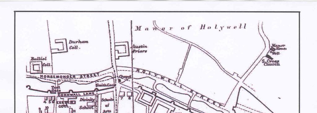
7 Port Meadow from the air shows evidence of small enclosures of a type comparable to those at Farmoor and typically Iron Age (Henig and Booth 2000, 11). Roman activity in the Oxford area is reasonably well recognized, with a settlement in the Barton area located along the route of the Alchester to Dorchester road, and a major pottery industry concentrated around the south and east margins of the city. However, it seems that the city itself had no, or little, Roman settlement, certainly no town and no villa of note, despite (perhaps) two major river crossings in the area (Henig and Booth 2000, 50). Rather, settlement seems to have spread along the gravel terrace with quite a density of sites, perhaps one every kilometre or so. The Roman roads and their river crossings seem to have been a major influence on Saxon settlement however (Blair 1994, 87 91). A burh was formally founded by at latest around AD 900, but earlier settlement certainly existed in the area, even if no early Saxon traces have yet been found within the modern city centre. The concentration of Saxon churches (St Aldate, St Ebbe, St Frideswide and up to a dozen more) alone indicates as much. Headington may have been the focus of Saxon activity prior to the establishment of the burh by Alfred (or earlier: Blair 1994, ). By the 8th century the town formed part of a royal estate, centred on modern Headington. The evolution of the Saxon town, possibly from a deliberately planned origin (Salter 1936), can be traced through the development of the street systems and the town defences (Hassall 1986, ). The High Street seems to have existed in its current form, already extensively built up, by the 11th century at latest (Dodd 2003), and although it has been argued that the Saxon defences extended no further east than the Church of St Mary the Virgin and Oriel Street (Hassall 1975), what has been thought to be a Saxon bank marks the same line as the medieval walls within Merton College, and either an extension, or the main line of defences can now be placed on the same line as the medieval wall (Dodd 2003, fig.. 2.4). This argument can be supported by the evidence of the earliest street surfaces which continue well east from Oriel Street, although the dating of these is uncertain (Munby 2003). Early Norman Oxford seems to have suffered from initial neglect or decline. It has been suggested that this was due to over-taxation (attested by Domesday Book) and the unsubtle imposition of Robert d Oilly s castle (Blair 1994, 177) but if so, the decline was short-lived and Oxford was again one of the country s major towns by the early 12th century. Abbeys, friaries and monastic colleges were drawn to the city in droves and the University cemented its importance. Stone walls were built by the 13th century; these seem to have followed the line of earlier earthworks wherever the latter have been observed (Dodd 2003, 23). It was not long before medieval Oxford over spilt its walls (Hassall 1986, 124), indeed even at the time of Domesday Book houses outside the walls are mentioned. As yet there is no solid evidence for expansion beyond the Eastgate (as there is 5
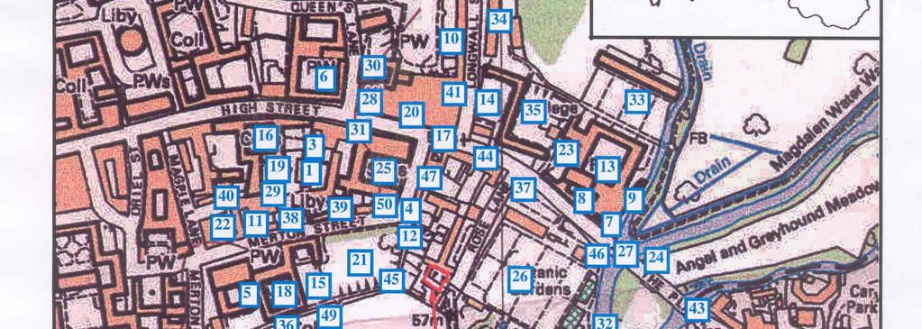
8 to the west and south), but there was at least St John s Hospital by the late 12th century next to Magdalen Bridge, and the Trinitarian priory closer to the walls (Salter 1936; 1969). Magdalen Bridge may stand on the site of an earlier ford (Hassall 1986, 119), explaining the curve of High Street to meet it. St Frideswide s minster and priory, on the site that is now Christ Church, date from the late Saxon period, perhaps as early as the 8th century, and were certainly in existence before AD1004 (Blair 1994, 61): it was refounded as an Augustinian house in AD1122 and owned extensive property. Its grange barn (see cartographic sources below) would thus have been a substantial and economically important building. The site is on the First Terrace river gravels, at or very close to the junction with the alluvium of the floodplain of the Cherwell. In such a location, the possibility of waterlogged deposits must also be raised. Should any waterlogged deposits survive, or even non-waterlogged fluvial silts, as might reasonably be expected in such a location, these would present the possibility of a significant sequence of organic survival and offer the prospect of detailed palaeoenvironmental reconstruction. Waterlogged remains of considerable interest were recovered from recent excavations in Merton Street (to the west) (Pelling 2007). Oxfordshire Sites and Monuments Record and Oxford City Urban Archaeological Database A search was made of the Oxford City Urban Archaeological Database (UAD) on 7th April 2008 for a radius of 250m around the proposal site. This revealed 124 entries for this area, not including several duplicates. These entries are summarized as Appendix 1 and their locations plotted on Figure 1. Oxford, naturally, has not only a long history, but specifically a long history of antiquarian and archaeological investigation and recording, and this is reflected in the number of entries from such a small area. Many of these entries are records of observations made in the 19th century (and many of these were collated by Herbert Hurst (e.g., Hurst 1899). Although many of these are recorded as excavations this term should not necessarily be taken to imply archaeological recording as understood today. Prehistoric Just three entries are certainly for prehistoric evidence. What may be Bronze Age ring ditches were discovered at Logic Lane in [Fig. 1: 1]. One of these contained a sherd of a collared urn, a type of Bronze Age pottery which is most often associated with burials. A lone Palaeolithic hand axe and a Bronze axe (presumably Bronze Age) came from 19th-century excavations at what is now the Examination Schools [25], whilst part of a polished 6
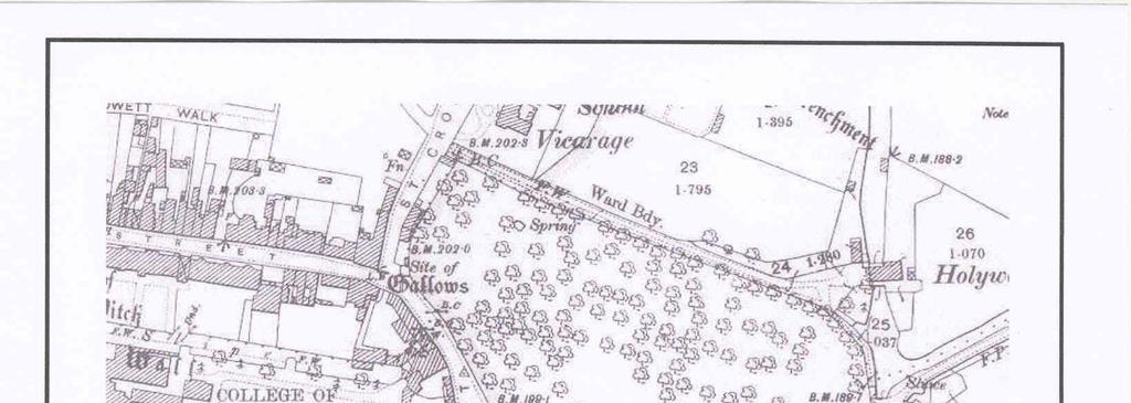
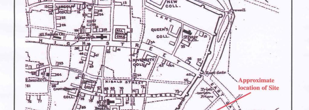
9 stone axe was found at St Edmund Hall in the 1930s [30]. Other finds, typically known only from vague 19thcentury records, and listed as undated, might also be prehistoric [e.g., 23, 24]. Roman The only entries for this period are for stray finds: a small Roman ceramic bowl, and glass vessels (perhaps also Roman) were dredged up from the Cherwell in [2]. River finds are of limited value for assessing the development of the area where they were found, as they may have come top that spot from anywhere upstream. Other finds are limited to odd sherds of pottery [1, 7]. Normally an absence of evidence cannot be taken as tremendously significant in archaeology, but in an area with such a long history of observations as here, and for a period normally so prolific in material remains, the absence of Roman finds can be taken reasonably confidently as evidence that there was no Roman occupation in this area. Saxon Saxon evidence is also rather limited; for this period that is not so significant, as Saxon pottery does not survive well, and other Saxon artefacts are rare except from cemeteries. Saxon post holes and pits indicate occupation at Logic Lane [1]. Also in Logic Lane, Late Saxon pottery was found in 1936 [3], along with three skeletons: it is not clear if the pottery and the bone were associated, but it is at least possible that they were. What may be a Saxon bank, along the same line as the later medieval city wall, was recorded at Merton College in [4]. If true, this extends the Saxon defences considerably further east than usually supposed (Hassall 1973; 1986), but the evidence here seems scant. Residual early Saxon pottery has also been found at Magdalen College [7]. Early Saxon pottery and a gold ring came from 19th-century excavations at what is now the Examination Schools [25]. Finds dredged from the Cherwell include Viking-type stirrups and have been thought to come from a grave of this period (Seaby and Woodfield 1980) [32]. 7,25, For the medieval period, the evidence is much more widespread. The High Street was certainly in place and built up before the Norman Conquest and most of the side streets in place by the 12th century. City defences may date from the time of Alfred, but the line of the walls as currently known (here, along Longwall Street and Merton Street, turning along Deadman s Walk) is medieval. Several of the entries are for observations on the wall or its accompanying ditch [4, 10, 12, 15, 36, 41, 45, 49]. Most significant for the present study is the observation [4] that the section of wall between High Street and the south-eastern corner of the city has been entirely destroyed as far as the summer-house in Merton College garden; two bastions have also been removed. Part of the wall close to the site was resurfaced in 1971 [12]. 7
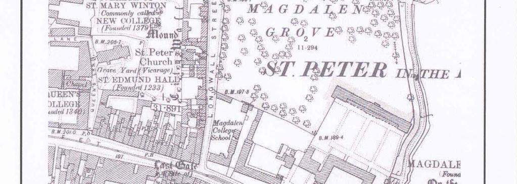
10 Other medieval evidence abounds. There are numerous references to old street surfaces, at various depths below modern ground level [4, 6, 14, 47]: presumably at least some of these will have been medieval although they are rarely datable in this area. The medieval elements of the various college buildings have been variously surveyed and recorded [5, 7, 8, 9, 11, 13, 15, 16]. finds including coins, pottery, tile, metal and glass vessels, are reported from several locations [5, 6, 9, 13, 14, 16, 18, 19, 20, 21, 25], and clearly datable medieval sub-surface features are also recorded [1, 7, 9, 11, 22, 34]. Despite the intensity of landuse in the area over many centuries, recent work has shown that extensive medieval remains can survive [22] (Poore et al. 2007). Human remains have been found in several places [8, 17, 32, 36, 46]: this, at first sight surprisingly wide, distribution must reflect the medieval ecclesiastical origins of the colleges (and other institutions, such as hospitals). There is also known to have been a Jewish cemetery near the east gate. Even where not dated, most of these burials can probably safely be assumed to be medieval. finds and remains of various sorts come from throughout the search radius. Of note are a building with a bone floor (something of an Oxford specialty, these are generally 17th- or 18th-century: Armitage 1989) recorded by Hurst [1]; an underground chamber and a tunnel that seems to have been bricked up in the 18th century found after subsidence in 1940 [3]; there is an early real tennis court on Merton Street and the noted historian Anthony Wood lived at Postmasters Hall [11]; a note of the demolition of the East Gate in 1772 [17]; and the Botanic Gardens, founded in 1621, although its layout and surrounding walls were not completed until the 1650s [26]. Negative and undated Very few investigations in the search area have produced no archaeological evidence whatsoever. An excavation at 84 High Street in 1971 [31] and a watching brief in 1963 seem to be the only instances [5]. However, undated discoveries of various sorts are reported from almost all the locations marked on Figure 1. Scheduled Ancient Monuments Surviving sections of the medieval City Wall are Scheduled. This includes the section that forms the wall to Merton Gardens, along the western edge of the site. However, the proposed development is to be sited far enough from the wall as not to create any additional adverse impact on it. 8
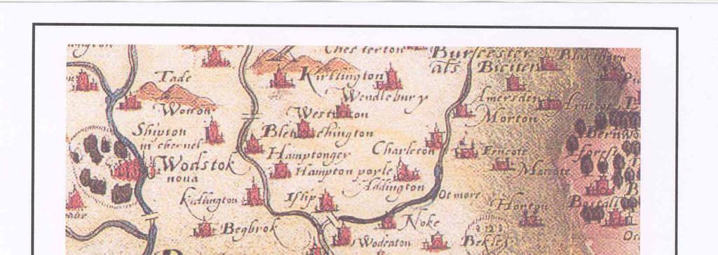
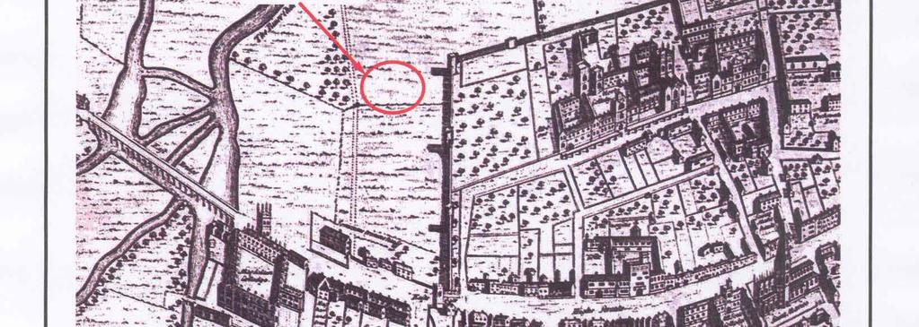
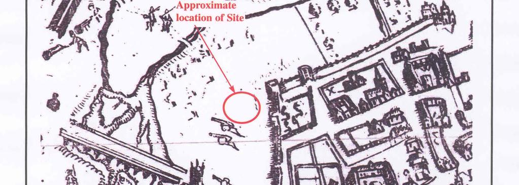
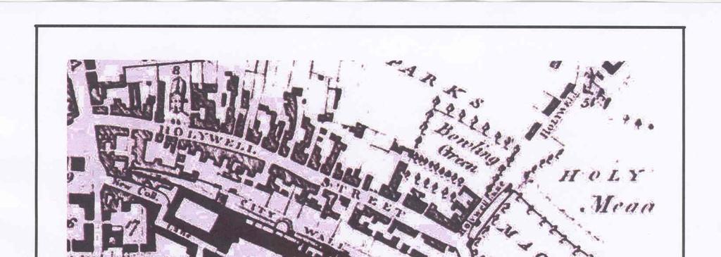
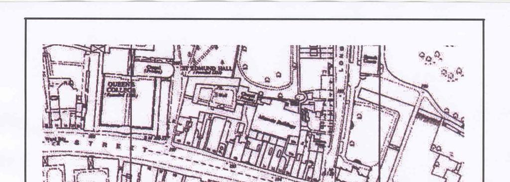
11 Cartographic and documentary sources Oxford is an Old English (Anglo-Saxon) place name, first recorded in AD911 as Oxnaforda ( ford used by oxen ) (Mills 1998, 265). The proposal area is on the edge of the historic core of Oxford. Already by the time of Domesday Book (AD1086) Oxford (Oxeneford) was a major centre, a walled town of over 700 houses (although a large number of these were lying waste at the time of the survey) and was worth 60 to the King (Williams and Martin, 2002). The Oxford Domesday entry is complex and self-contradictory, and the total number of households may be as high as 1018 (VCH 1939, 390). For comparison, York is listed at some 1400 messuages (house-plots), of which only around 400 were inhabited, yielding 100 to the King. Subsequent development of the city has been well documented, aided by the concentration of historians within its walls (e.g., Clark ; for a summary, see Hassall 1986). Nonetheless, archaeology continues to add new information almost continuously (e.g., Munby 2007; Dodd 2003). However, little in detail is known about the eastern suburb (the proposal site lies just outside the east gate of the medieval town), nor indeed was much known about the area just inside the eastern wall until very recently (Poore et al 2007, 213). In , Walter de Merton (former Chancellor of Henry III) had established eight of his nephews at the University, with provision to add other scholars, not his relations (VCH 1954, 103). Merton acquired land from Reading Abbey, west of St John s church, south of St John s Street, initially extending south almost to the city wall, and later right up to it, in He added the church itself in St John s Street is now Merton Street, and the church stood close to the site of the college chapel. Accounts for college buildings begin in 1287, but the college will have occupied existing buildings before then. More land was acquired in the mid 14th century, land within the walls being cheap on account of the depopulation caused by the Black Death (VCH 1954, 97 9). The current site, outside the walls, is a much more recent acquisition. A range of Ordnance Survey and other historical maps of the area were consulted at the Centre for Oxfordshire Studies in order to ascertain what activity had been taking place throughout the site s later history and whether this may have affected any possible archaeological deposits within the proposal area (Appendix 2). The earliest map available of the area is Saxton s (1574) county map. This shows no detail beyond the impressive pictogram of Oxford itself (Fig. 3). Oxford is particularly well-served by early cartographers. Ralph Agas produced a detailed map as early as 1578 (Fig. 4). The site is shown as open field just beyond the city wall. Wood s rendering of the civil war defences in 1644 is more of a sketch (Fig. 5) and perhaps should not be relied on in detail, but suggests the site may have been on or close to one of the batteries covering the bridge. 9
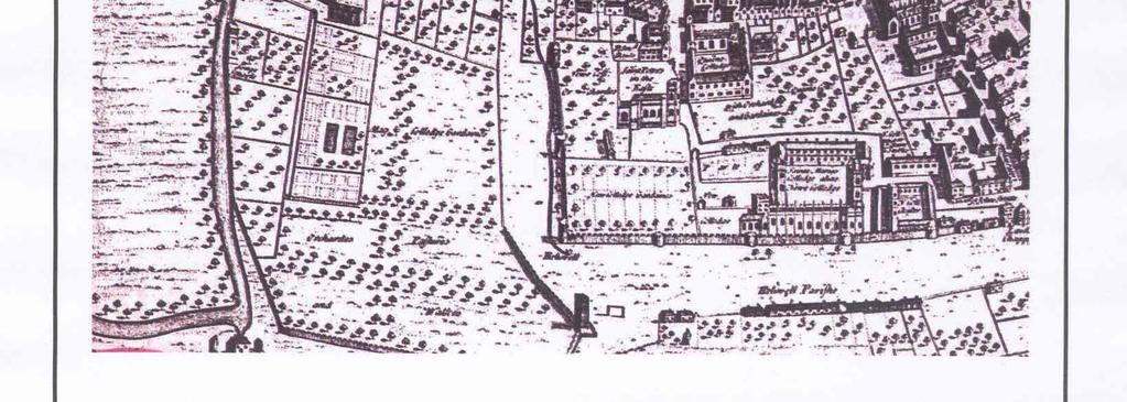
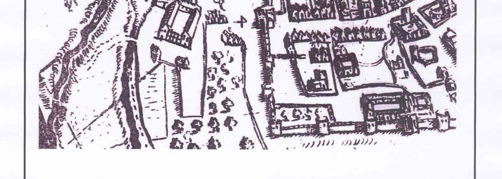
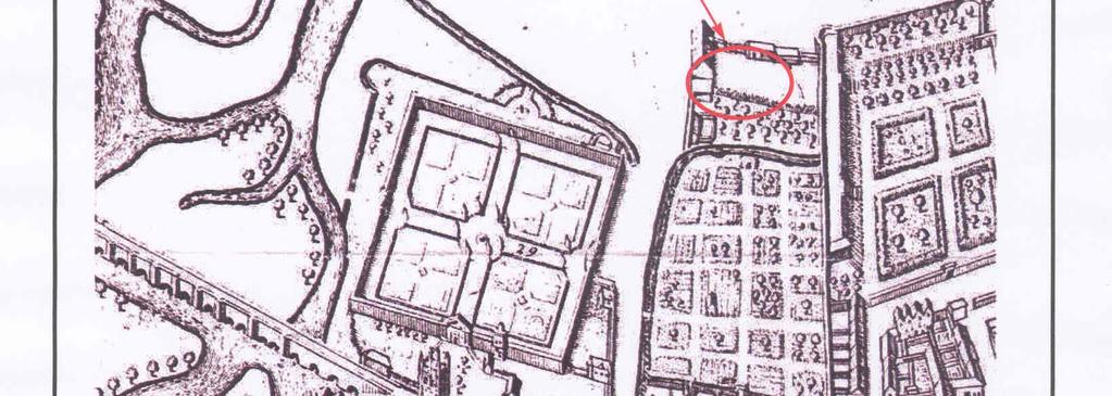
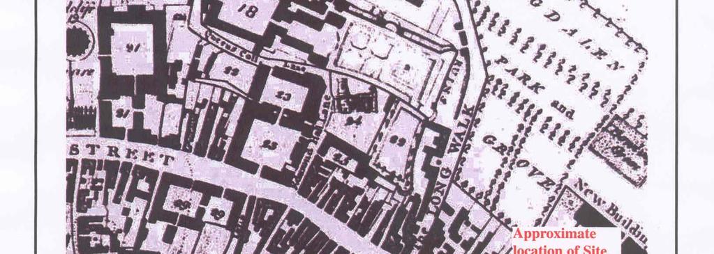
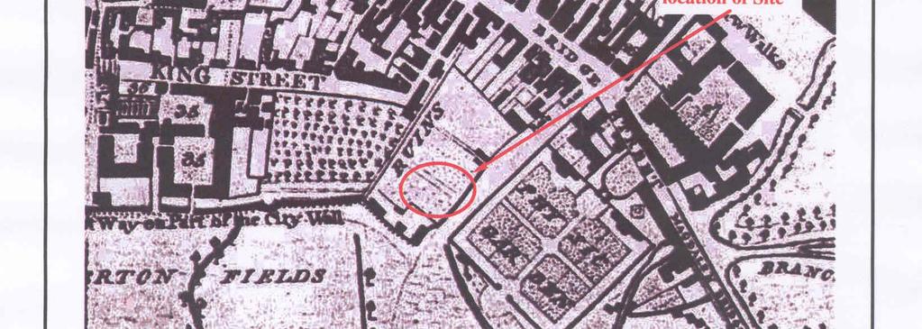
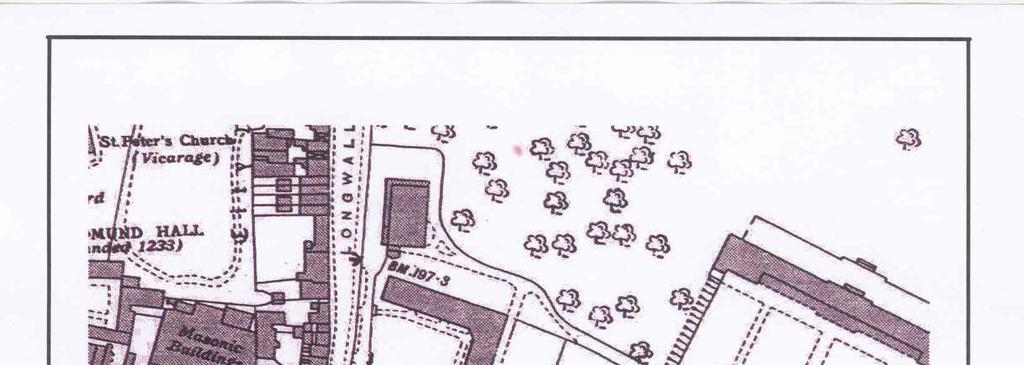
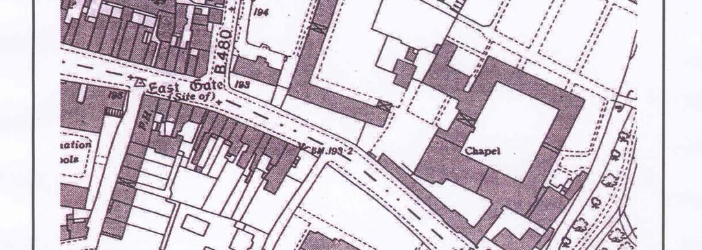
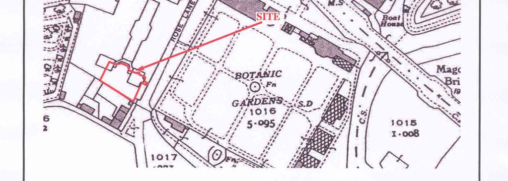
12 The first signs of development on the site come from Loggan s Ichnography of 1675, when the basic layout of the area is already taking on close to its present form. The east side of the site is lined with quite substantial buildings and the interior seems to be laid out to gardens (Fig. 6); further buildings are shown in the positions now occupied by Meadow Cottages. There is an internal subdivision of the larger block of land into an orchard at the north and open space to the south, in the area of the proposal site. What will become the present University Botanical Garden has by now been established, Hortus Botanicus, facing the site. Williams map of 1733 adds no detail for this area other than to name the lane Trinity Lane (not illustrated). On Longmate s plan of 1773 (Fig. 7), the buildings on the east (Rose Lane) frontage are not shown, those along the southern margins are quite small and quite closely resemble their current configuration. It is possible these are already the buildings currently present. The interior of the site appears to be orchard or formal gardens. The Botanical Garden is now named as a Physic Garden. This map also shows surviving parts of the medieval city wall (west of the site) and marks the stretch along the western boundary of the site as ruins. As the Eastgate was pulled down in 1771, it is tempting to wonder if this stretch of wall was also removed at that time. Most 19th-century maps show less detail or changes only in the style of depiction. For example, the plan by Haywood from 1870 (Fig. 8) appears to show the site completely cleared, but this is misleading as this plan does not offer detail of individual buildings other than the colleges and major structures. The state of the city wall is also far from clear on this depiction. The Botanical Gardens are now so named. The more authoritative mapping of the Ordnance Survey allows the site s boundaries to be located precisely. The First Edition (1876) shows the site within Rose Lane nursery, with the buildings of St Peter s in the East School occupying the north-east corner of the site (Fig. 9). By the Second Edition of 1898, the building in the north-east of the proposal area is still shown as a school, and those to the south are clearly cottages (Fig. 10). There is no new development on the site itself, which appears to be fully within the school grounds rather than part of the nursery, although this is not definite. By 1939 the site is shown almost identical to today (Fig. 11). The school has been removed. The buildings now standing along the north side of the site are the Merton College Rose Lane Buildings, by Sir Hubert Worthington, newly built. Sherwood and Pevsner (1974, 164) describe them as Palladian, timid but at least has some panache. There is no change on subsequent mapping from the 1950s (Fig. 12) to 1970s, except that the 1957 map shows the Rose Lane Buildings are raised above the ground level to the south and west (as confirmed by site inspection). 10
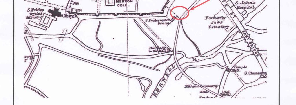
13 Finally, mention must be made of a map published by Herbert Hurst in 1899 showing the known and conjectured positions of ecclesiastical and academical buildings in Oxford at AD1440 (Fig. 13). This shows the position of St Frideswide s Grange conjectured where Meadow Cottages now stand. This location cannot be relied on in detail (the hached buildings are conjectured, the open ones known), but presumably the location given for the grange will have been based on documentary references to its being just beyond the south-eastern corner of the city walls, in relation to the parish boundary, or to known buildings such as the Trinitiarian friary; so it should be taken as no more than a suggestion that the site of the grange may lie near the proposal site. Listed buildings Numerous buildings in the vicinity are listed; none is on the site itself nor will any listed building be affected by the proposed development. The settings of listed buildings and the general historic character of the conservation area, however, will be material considerations in the planning process. Registered Parks and Gardens; Registered Battlefields There are no registered battlefields within 250m of the proposal area. Both the Botanic Garden and Merton Gardens are Registered. Aerial Photographs The site area lies within an urban area which has been developed since before the advent of aerial photography. No air-photographic collections have therefore been consulted. Discussion In considering the archaeological potential of the study area, various factors must be taken into account, including previously recorded archaeological sites, previous land-use and disturbance and future land-use including the proposed development (Fig. 2). The site is immediately outside the medieval city wall, and in an area thought to have been defended by artillery emplacements during the 17th-century Civil War. The conjectured location of the medieval grange of St Fridewide s priory would place it on, or very close to the site; this must be regarded as a possibility requiring investigation. Even if this specific building is not on the site, medieval extra-mural occupation of some sort 11
14 would not be unusual: Oxford overspilled its medieval city walls almost as soon as they were built. The location is also one likely to have been favoured for settlement from the earliest prehistoric times. The site thus has both generalized and specific potential to contain archaeological remains, which are likely to be of local importance if present. Cartographic review shows that only a small area of the site not currently occupied by buildings, has previously been developed while the rest seems to have been gardens since the 16th century. Thus any archaeological deposits that might have existed on the site may be expected to have survived reasonably intact, except under the 1930s buildings and the small additional area of the east edge of the site that was previously a school. Even below the footprints of these buildings, it is perhaps not safe to assume necessarily total destruction of archaeological levels, as the ground level seems to have been raised to set the modern buildings on a slight platform relative to the natural surface level. The site s topographical setting also gives rise to the possibility that any remains present may be exceptionally preserved by waterlogging, increasing their potential information value. It remains to determine whether any relevant deposits do in fact exist. It will be necessary to provide further information on the potential of the site from field evaluation by means of trial trenching in order to provide sufficient information with which to devise a scheme to mitigate the impact of development on any below-ground archaeological deposits if necessary. A scheme for this evaluation will need to be drawn up and approved by the archaeological adviser to the City and implemented by a competent archaeological contractor, such as an organization registered with the Institute of Field Archaeologists. References Armitage, P, 1989, Gazetteer of sites with animal bone used as building material, in (eds) D Sarjeantson and T Waldron, Diet and crafts in towns, Brit Archaeol Rep (Brit Ser) 199, Oxford, BGS, 1982, British Geological Survey, Solid and Drift Edition, 1:50,000, Sheet 236, Keyworth Blair, J, 1994, Anglo-Saxon Oxfordshire, Stroud Clark, A, (ed), , Survey of the Antiquities of the City of Oxford composed by Anthony Wood, (3 vols), Oxford Hist Soc, Oxford Dodd, A, (ed), 2003, Oxford before the University, Thames Valley Landscapes Monogr 17, Oxford Hassall, T, 1973, s at Oxford, 1972: Fifth interim report, Oxoniensia, 28, Hassall, T, 1975, Topography of pre-university Oxford, in C Smith and D Scargill (eds), Oxford and its region, Oxford, Hassall, T, 1986, Archaeology of Oxford City, in G Briggs, J Cook, and T Rowley, (eds), The Archaeology of the Oxford Region, , Oxford Univ Dept of External Studies, Oxford Henig, M and Booth, P, 2000, Roman Oxfordshire, Stroud Hurst, H, 1899, Oxford Topography; an essay, Oxford Hist Soc vol 39, Oxford Mills, A D, 1998, Dictionary of English Place-Names, Oxford 12
15 Munby, J, 2003, The eastern extension, in (ed) A Dodd, Oxford before the University, Thames Valley Landscapes Monogr 17, Oxford, 24 5 Munby, J, 2007, The Archaeology and History of Oxford s West Suburb, Oxoniensia, 71 (for 2006), OCC, 1998, Oxfordshire Structure Plan to 2011 deposit draft (adopted 1998), Oxfordshire County Council OCyC, 2005, Adopted Oxford Local Plan (November 2005), Oxford City Council Pelling, R, 2007, Charred and waterlogged plant remains, in D Poore, D Score and A Dodd, s at No. 4A Merton St., Merton College, Oxford: The Evolution of a stone house and tenement and an early college property, Oxoniensia 71, (for 2006), Poore, D, Score, D and Dodd, A, 2007, s at No. 4A Merton St., Merton College, Oxford: The Evolution of a stone house and tenement and an early college property, Oxoniensia 71, (for 2006), PPG16, 1990, Dept of the Environment Planning Policy Guidance 16, Archaeology and Planning, HMSO Salter, H E, 1936, Oxford, Oxford Hist Soc vol 100, Oxford Salter, H E, 1969, Survey of Oxford Seaby, W A and Woodfield, P, 1980, Viking stirrups from England and their background, Archaeol 24, Sherwood, J and Pevsner, N, 1974, Buildings of England, Oxfordshire, London VCH, 1939, Victoria History of the Counties of England: Oxfordshire, vol i, Oxford VCH, 1954, Victoria History of the Counties of England: Oxfordshire, vol iii, Oxford Williams, A and Martin, G, H, 2002, Domesday Book: A complete Translation, London 13
16 APPENDIX 1: Oxford City Urban Archaeological Database records within a 250m search radius of the development site. No UAD Ref Grid Ref (SP) Type Period Comment Observation Prehistoric Roman Saxon Logic Lane, Prehistoric ditches, one containing a sherd of collared urn, may be ring ditches. Roman pottery. Saxon post holes and pits. pits and walls. Bronze tokens were found in Hurst records a building with a bone floor Findspot Roman A small Roman ceramic bowl was found. Glass bottles were also recovered during dredging the River Cherwell at the Botanic Gardens in Observation Observation Watching brief Findspot Observation Saxon Saxon Roman Saxon Logic Lane Late Saxon pottery was found, with three skeletons. 18th-century underground chamber found after subsidence, interpreted as sump pit. Merton College, Footings of the City Wall. Within the wall lay a deposit of soil, possibly a late Saxon bank along the same line. The section of wall between High Street and the SE angle of the city has been entirely destroyed as far as the summer-house in Merton College garden; in this part were formerly two bastions, Nos 17 and 18. According to Hurst there was an old road surface about 2m down at the angle of Merton Street and King Street. Hurst recorded a fragment of carved stone found in a sewer in Merton Street Merton College, excavation An early building and medieval pottery were found. Chapel roof, 13th century. 1885, Undated brass token, an iron knife, a dagger and a key were found. Watching brief 1963 uncovered the natural undisturbed gravel 0.75m below surface., During drainage work the brick-lined pit containing the stone foundations seen in the 1922 excavations was reopened. An inscription on glass and a mural painting were sketched by Hurst, Queen's College, 1940s. paving tiles from the old chapel were found. Hurst records that an old road surface was found outside Queen's College in 1896 Findspot Watching brief Magdalen College, The stone kitchen was one of the last surviving structures from the medieval Hospital of St John the Baptist, Pottery included residual Roman and early Saxon sherds as well as a sequence from early medieval to post medieval. finds included bone, tile, glass and metalwork Magdalen College, Burials related to the Hospital of St John and arches in 13th century stonework. Chapel and hall roofs, both later replacements of 15th century originals. Professor Rolleston acquired the skulls of two individuals in 1874, perhaps from the Jewish cemetery. Magdalen College, Floor layers and possible oven. Kitchen contains traces of 13th or 14th century work Watching brief Bodicote House, City Wall Watching brief Photograph Observation Undated Merton College, Extensive medieval deposits were found in the geotechnical pits. Two undated pits. and later stone wall footings. Beam Hall, Merton Street, is a late 15th century hall. Merton College Stables, medieval origin. gilded metal vessel found Real Tennis Court, Merton Street, 17th century. Postmaster's Hall, Merton Street, c Hurst records that part of the Postmaster s hall was demolished in Watching brief Merton College, 1975 watching brief on rebuilding the collapsed medieval garden wall. Re-facing of City Wall in Findspot Observation Observation The rim of a 15th century green glazed pot was found in Magdalen College was founded in Hurst recorded various features at Magdalen College in , including the elevation of the President's House. Magdalen College, excavation A tile dating from the reign of Edward III was found. A view of 14
17 No UAD Ref Grid Ref (SP) Type Period Comment Perrot's House was recorded from the gravel walk in 1890s. An old stone-paved road surface found in Merton College founded by Walter de Merton, later Bishop of Rochester, in 1264 and moved to Oxford in This section of the city wall is the S wall of Merton College. The SE angle-bastion, No 19, has been completely demolished. Bastion No 20 opposite Merton College has been extensively patched and rebuilt; Bastion 21 is similar but larger; there is a blocked postern of 14th or 15th century date Evaluation Listed Building Findspot Observation University College, 1249 (or earlier?)., An early English jug and a halberd head were found. Chapel of Holy Trinity was above the East Gate in the early medieval period., High Street, Three graves were found. In the 13th century the area was probably part of the Jewish cemetery, passing to the Hospital of St John in Evaluation a Eastgate Hotel, Post medieval garden features were uncovered, including walls and pits High Street 18th century Listed Building. The East Gate was demolished in : a ditch may be the city ditch Edward II groat was found with rubbish in Merton College c 1872 Survey of Staircase 5 in the Fellows' Quadrangle dating from A number of real tennis balls were recovered from a putlog hole at Merton College Chapel in pottery, including jugs, was found in University College kitchen in Survey of Hall, Kitchen and Buttery and post-medieval pottery and bottles and medieval lamp found at the Masonic Hall, 50a High Street, included 13th or 14th century jugs and a medieval lamp. window tracery from the former White Hall was found at 47 High Street in High Street, Pottery was found. No 48 was photographed before work was carried out An early medieval glass oinochoe was found in Merton Gardens c Watching brief revealed the remains of two buildings. In the southern part of the site a cellar was found provisionally dated to c1200. A second building was probably 13th century; Extensive pits and wells from 11th to 18th century Findspot A quartzite hammerstone Findspot A bronze axe and sword were found in the River Cherwell near Magdalen Bridge in Findspot Palaeolithic?Bronze Age Roman Saxon Angel Inn, now the Examination Schools, 1870s. A number of pits had been cut into the gravel, possibly Saxon? The earliest find was a Palaeolithic handaxe. Bonze axe. Early Roman coin and quern fragment. Late Saxon pottery and a gold ring. pottery. In 1882 an 11th century carved tomb slab was found. Iron arrowheads and blades and two undated iron axe blades. A Bellarmine (Bartmann) jug was found in A pottery candlestick was recovered from the old City Ditch in Merton Street in Botanic Gardens, 1954: early 17th century well. The Botanic Garden was founded by Henry Danvers, Earl of Danby, in The gateway and enclosing wall were not finished until A clay pipe dated to was recovered from the Botanic gardens in 1851; and another in Magdalen Bridge, A deep culvert was covered by a stone arch and blocked at both ends Observation Watching brief High Street, excavation A wine bottle and pottery High Street and 2 Queen's Lane are probably 16th century High Street is c Hurst recorded the former Link Lodgings before they were pulled down at 42a High Street in A building assessment and recording University College, A stone-lined cess pit. 15
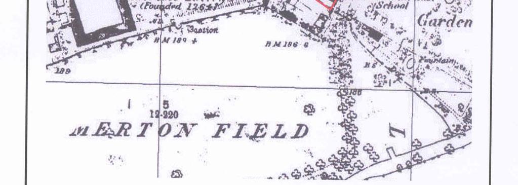
18 No UAD Ref Grid Ref (SP) Type Period Comment Observation Undated Queen's Lane (St Edmund Hall) excavation in Early street levels and a pit recorded but no dating evidence retrieved. A 17th century ceramic candlestick was found in Bellarmine (Bartmann) jugs from the 16th or 17th century were recovered in Part of a polished stone axe was also found. St Edmund Hall recorded. Hurst recorded two pieces of worked stone incorporated into the wall of the chapel, Findspot Negative Findspot Saxon 84 High Street, 1971, negative. 85 High Street, late 17th or early 18th century early 17th century. A fragment of regency wallpaper from the Angel Inn, was retrieved from 83 High Street in Undisturbed gravel was found outside 86-7 High Street in The line of the High Street begins to curve at that point, supposedly due to the presence of a mound. Human and horse bones, three stirrups, a prick spur, a horseshoe, all 10th or 11th century, found in dredging work, apparently from a Viking grave. Also late medieval horseshoe Geophysical survey? Resistivity Survey in Magdalen College Gardens in 1996, appeared to locate gardens and fish ponds of St John s hospital Magdalen College, Early medieval ditch parallel to Longwall Street. A building encroached on the ditch which was later recut. Three gravel surfaces were identified in the upper fills. It is not clear whether the ditch was the City Ditch or lined an extramural street. 12th to 13th century gully and plough furrows The overlying soil contained 13th to 15th century material. Intercutting, rubbish pits for properties fronting onto the High Street. Some evidence of garden paths and a possible college wall were also found Watching brief Watching brief Findspot Undated Magdalen College, coursed stone block wall, bonded into the north boundary wall. Undated bronze thimble was found in excavation in Merton College, A layer of pitched stones set in yellow mortar, may be the remains of the medieval City Wall. Above this was a narrower post medieval stone wall., perhaps after It is possible that there was an earlier postern. No sign of any rampart from the late Saxon period was seen either below or behind the wall. Hurst records that inhumations were found close to Merton College chapel. At least one had a stone coffin (the chapel was previously the parish church) Watching brief 61 High Street, Early floor levels recorded Watching brief Observation Merton Street, Deep pits cut into ballast, above natural gravel. Hurst made sketches and plans of the front and quadrangle at St Albans Hall, Merton Street, in Photograph Watching brief Evaluation Watching brief 13, 14, 15, 17 Merton Street all late 16th or early 17th century. An iron key was found at 9 Merton Street in Grove House, 2 Kybald Street, 17th century, Photograph of rear gateway to University College Monitoring of geo technical test pits revealed a stone built cellar or basement butting an earlier wall, possibly a tenement boundary. Both may date to 11th to 12th centuries. Ceramics from the 11th to 19th centuries. Plentiful animal bone, a small number of human bones. 1 4, 8 Longwall Street all late 17th century. An undated iron key was found in excavation on Longwall Street in s c Hurst records that a wall was found at 1m down. Blackish mud lay below to 2m. A trench behind No 5 Longwall Street revealed deposits infilling the city ditch, including a stone-lined culvert. a watching brief below the floors of No 5 revealed deposits of 16-17th centuries Merton Field, Stained glass in a metal frame was recovered. No dating was possible. Ceramic jars were also found When Magdalen Bridge was widened in 1882, workmen 16
19 No UAD Ref Grid Ref (SP) Type Period Comment uncovered 18th century coins, gibbet irons, a pair of spectacles and the foundation stone from High Street c A ditch running E W and c4.5 m wide and 1.5 m deep lay c3 m below the surface extending under the road Observation Hurst recorded inserted pieces in the city wall parapet at Merton College in 1890s s near the Botanic Gardens and Magdalen Bridge in When the sewer was put in skeletons were found. They might be from the Jews' Burial Ground Observation Observations in Merton Street in A road surface was seen 1m below the surface. Alongside it were traces of old pools Cartographic William's Map of Oxford, Dead Man's Walk, Trenches were dug at the foot of the wall near the bastion. An earlier foundation built on relieving arches was found Documentary The Nag's Head, King Street (now Merton Street), operated between 1783 to
20 APPENDIX 2: Historic and modern maps consulted 1574 Saxton s map of Oxfordshire, Buckinghamshire and Berkshire (Fig. 3) 1578 Agas s map (as re-engraved 1825) (Fig. 4) 1644 Wood s plan of Oxford Fortified (Fig. 5) 1675 Loggan s New and Highly Accurate Ichnography of the most famous university and city of Oxford (Fig. 6) 1733 Williams Map of Oxford 1773 Longmate s Plan of Oxford (Fig. 7) 1817 Pearson s New Map of the University and City of Oxford 1842 Map from Barclay s Directory 1850 Heggaw s map of Oxford 1870 Haywood s plan (Fig. 8) 1876 First Edition Ordnance Survey 25 inch Sheet xxxiii.15 (Fig. 9) 1889 Map from Kelly s Directory 1898 Second Edition Ordnance Survey 25 inch Sheet xxxiii.15 (Fig. 10) 1899 Oxford Ecclesiastical and Academical, AD1440, from Hurst s Oxford Topography (Fig. 13) 1921 Ordnance Survey revision 25 inch Sheet xxxiii Ordnance Survey revision (Fig. 11) 1957 Ordnance Survey (Fig. 12) 1972 Ordnance Survey 18

21

22

23

24
25

26
27
28
29
30
31
32
33
Meales Farm, Sulhamstead, West Berkshire
 Meales Farm, Sulhamstead, West Berkshire An Archaeological Watching Brief For Mr. Robert Astor by Steve Ford Thames Valley Archaeological Services Ltd Site Code CHH02/29 May 2002 Summary Site name: Meales
Ivol Buildings, Woodcote Road, South Stoke, Oxfordshire
 Ivol Buildings, Woodcote Road, South Stoke, Oxfordshire An Archaeological Watching Brief For Christ Church, Oxford by Pamela Jenkins Thames Valley Archaeological Services Ltd Site Code IBSS 04/03 March
Garage Site, Foots Cray High Street, Sidcup, Kent, London Borough of Bexley
 Garage Site, Foots Cray High Street, Sidcup, Kent, London Borough of Bexley An Archaeological Evaluation for Mizen Design Build by Andy Taylor Thames Valley Archaeological Services Ltd FOC 07 September
New Swimming Pool,West Meon House, West Meon, Hampshire
 New Swimming Pool,West Meon House, West Meon, Hampshire An Archaeological watching brief and building recording for Mr and Mrs Younger by Danielle Milbank Thames Valley Archaeological Services Ltd Site
Appletree, Thames Street, Sonning Berkshire
 Appletree, Thames Street, Sonning Berkshire An Archaeological Watching Brief for Mr and Mrs A Popham by Sian Anthony Thames Valley Archaeological Services Ltd Site Code ATS 02/83 October 2002 Summary Site
Epsom Water Works, East Street, Epsom, Surrey
 Epsom Water Works, East Street, Epsom, Surrey An Archaeological Desk-Based Assessment for St James Homes Ltd by Steve Ford Thames Valley Archaeological Services Site Code ESE99/85 December 1999 Epsom Water
New horse training area, Manor Farm, Great Kimble, Buckinghamshire
 New horse training area, Manor Farm, Great Kimble, Buckinghamshire An Archaeological Watching Brief For Redwing Structures (Marlow) Limited by Andy Taylor Thames Valley Archaeological Services Ltd Site
Northbury Farm, Castle End Road, Ruscombe, Berkshire
 Northbury Farm, Castle End Road, Ruscombe, Berkshire An Archaeological Watching Brief For Sir Colin and Lady Southgate by Danielle Milbank Thames Valley Archaeological Services Ltd Site Code NFR 07/120
Land at Downsview Avenue, Storrington, West Sussex
 Land at Downsview Avenue, Storrington, West Sussex An Archaeological Evaluation for Bellwinch Homes Limited by Andy Taylor Thames Valley Archaeological Services Ltd Site Code DAS 04/21 March 2004 Summary
Bridge House, Ham Island, Old Windsor, Berkshire
 Bridge House, Ham Island, Old Windsor, Berkshire An Archaeological Watching Brief for Mr A Chadwick by Alan Ford Thames Valley Archaeological Services Site Code BHHI98/55 August 1998 Bridge House, Ham
6A St John s Road, Wallingford Oxfordshire
 6A St John s Road, Wallingford Oxfordshire An Archaeological Evaluation Stage 2 for Spearcliff Estates Ltd by Steve Ford Thames Valley Archaeological Services Ltd Site SJW03/116 January 2004 Summary Site
Chitty Farmhouse Extension, Wall Lane, Silchester, Hampshire
 Chitty Farmhouse Extension, Wall Lane, Silchester, Hampshire An Archaeological Watching Brief For In Touch by Andrew Mundin Thames Valley Archaeological Services Ltd Site Code CFS 08/52 May 2008 Summary
Merrowdene, Earleydene, Sunninghill, Berkshire
 Merrowdene, Earleydene, Sunninghill, Berkshire An Archaeological Watching Brief For Mr and Mrs Jackson by Andy Taylor Thames Valley Archaeological Services Ltd Site Code MES 05/88 January 2006 Summary
ARCHAEOLOGICAL S E R V I C E S. Manor Farm, Launton, Bicester, Oxfordshire. Archaeological Watching Brief. by Aiji Castle. Site Code: LBO13/220
 T H A M E S V A L L E Y ARCHAEOLOGICAL S E R V I C E S Manor Farm, Launton, Bicester, Oxfordshire Archaeological Watching Brief by Aiji Castle Site Code: LBO13/220 (SP 6035 2285) Manor Farm, Launton, Bicester,
Land adjacent to Dingle Dock, Front Street, East Garston
 Land adjacent to Dingle Dock, Front Street, East Garston An Archaeological Watching Brief for Dr J Davies by Jo Pine Thames Valley Archaeological Services Site Code DEG99/82 January 2000 Summary Site name:
Old Town Hall, Market Place, Faringdon, Oxfordshire
 Old Town Hall, Market Place, Faringdon, Oxfordshire Building Recording and Archaeological Watching Brief for Great Faringdon War Memorial Trust by Jamie Preston and Steve Ford Thames Valley Archaeological
ARCHAEOLOGICAL S E R V I C E S. Hurley Manor, High Street, Hurley, Berkshire. Archaeological Evaluation. by James McNicoll-Norbury
 T H A M E S V A L L E Y ARCHAEOLOGICAL S E R V I C E S Hurley Manor, High Street, Hurley, Berkshire Archaeological Evaluation by James McNicoll-Norbury Site Code: HMH14/51 (SU 8252 8378) Hurley Manor,
New Media Building, Goldsmiths College, New Cross, London Borough of Lewisham
 New Media Building, Goldsmiths College, New Cross, London Borough of Lewisham An Archaeological Evaluation for Willmott Dixon Construction by Andy Taylor Thames Valley Archaeological Services Ltd Site
T H A M E S V A L L E Y S E R V I C E S. Flood Compensation Area, Riverside Park, Wallingford, Oxfordshire. Archaeological Watching Brief
 T H A M E S V A L L E Y ARCHAEOLOGICAL S E R V I C E S Flood Compensation Area, Riverside Park, Wallingford, Oxfordshire Archaeological Watching Brief by Jacqueline Pitt Site Code: RPW10/72 (SU 6112 8934)
Oak Tree Fields, Spine Road, South Cerney, Gloucestershire
 Oak Tree Fields, Spine Road, South Cerney, Gloucestershire An Archaeological Desk-Based Assessment for Hills Minerals & Waste by Steve Ford Thames Valley Archaeological Services Ltd Site Code OTF04/73
Pinnocks Wood Equestrian Centre, Burchett s Green, Maidenhead, Berkshire
 Pinnocks Wood Equestrian Centre, Burchett s Green, Maidenhead, Berkshire An Archaeological Watching Brief For Mr David Eyles by Andrew Mundin Thames Valley Archaeological Services Ltd Site Code POB 08/69
Newcombe House & Kensington Church Street
 Newcombe House & Kensington Church Street Archaeological Evaluation September 2017 Summary Site name: Newcombe House, Kensington Church Street, Notting Hill, London Grid reference: TQ 25318 80372 Site
ARCHAEOLOGICAL S E R V I C E S. Becks, Park Lane, North Newington, Banbury, Oxfordshire. Archaeological Watching Brief.
 T H A M E S V A L L E Y ARCHAEOLOGICAL S E R V I C E S Becks, Park Lane, North Newington, Banbury, Oxfordshire Archaeological Watching Brief by Andy Mundin Site Code: BPN16/105 (SP 4207 3978) Becks, Park
ARCHAEOLOGICAL S E R V I C E S. Land north of Orchard Close, Hallow, Worcestershire. Archaeological Evaluation. by Kyle Beaverstock
 T H A M E S V A L L E Y ARCHAEOLOGICAL S E R V I C E S Land north of Orchard Close, Hallow, Worcestershire Archaeological Evaluation by Kyle Beaverstock Site Code: OCW15/224 (SO 8285 5848) Land north of
30 48 Castle Street, High Wycombe, Buckinghamshire
 30 48 Castle Street, High Wycombe, Buckinghamshire An Archaeological Desk-Based Assessment for George Wimpey (West London) Ltd by Jennifer Lowe Thames Valley Archaeological Services Ltd Site Code CHW07/20
Bridge Road, Maidenhead, Berkshire
 Bridge Road, Maidenhead, Berkshire An Archaeological Desk-Based Assessment for Salmon Harvester Properties Ltd by Steve Ford Thames Valley Archaeological Services Ltd Site Code BRM04/56 June 2004 Summary
Archaeological Investigation in advance of Development at 2 Palace Cottages, Charing Palace, Charing, Kent
 Archaeological Investigation in advance of Development at 2 Palace Cottages, Charing Palace, Charing, Kent Site Code CHAR-EV-14 NGR 95412 49439 Date of Report 18/12/2014 Swale and Thames Archaeological
An Archaeological Evaluation at Granta Cottages, Newmarket Road, Great Chesterford, Essex. August 2015
 An Archaeological Evaluation at Granta Cottages, Newmarket Road, Great Chesterford, Essex August 2015 by Pip Parmenter and Ben Holloway on behalf of Mr G Elmer and Mrs L King CAT project ref.: 15/06a NGR:
Archaeological evaluation at Willowdene, Chelmsford Road, Felsted, Essex
 Archaeological evaluation at Willowdene, Chelmsford Road, Felsted, Essex August 2013 report prepared by Ben Holloway on behalf of Mr Anthony McGurren Planning reference: UTT/13/0235 CAT project ref.: 13/07g
Archaeology and Planning in Greater London. A Charter for the Greater London Archaeology Advisory Service
 Archaeology and Planning in Greater London A Charter for the Greater London Archaeology Advisory Service THE PURPOSE OF THE CHARTER This Charter sets out how English Heritage will provide archaeological
Archaeological evaluation at Stables, Hatch Farm, Fen Lane, Bulphan, Essex, RM14 3RL
 Archaeological evaluation at Stables, Hatch Farm, Fen Lane, Bulphan, Essex, RM14 3RL November-December 2016 by Laura Pooley figures by Ben Holloway and Emma Holloway fieldwork by Ben Holloway and Alec
Bedwell Park, Essendon, Hatfield, Hertfordshire
 Bedwell Park, Essendon, Hatfield, Hertfordshire An Archaeological Desk-Based Assessment for Millgate Homes by Steve Preston Thames Valley Archaeological Services Ltd Site Code BPE06/34 March 2006 Summary
CHESHIRE HISTORIC TOWNS SURVEY
 CHESHIRE HISTORIC TOWNS SURVEY Frodsham Archaeological Strategy 2003 CHESHIRE HISTORIC TOWNS SURVEY Frodsham Archaeological Strategy 2003 Environmental Planning Cheshire County Council Backford Hall Backford
Archaeological Evaluation and Assessment of Land at Kent Cottage, 19 Chapel Street, Hythe, Kent
 Archaeological Evaluation and Assessment of Land at Kent Cottage, 19 Chapel Street, Hythe, Kent Planning Application Y13/0463/SH Date of Report: 29/04/2015 Report for Marc Carney SWAT. ARCHAEOLOGY Swale
Stanwick Neighbourhood Plan
 Stanwick Neighbourhood Plan Heritage Audit Stanwick Neighbourhood Plan Steering Group August 2015 Purpose of the Heritage Audit It is a core planning principle within National Planning Policy Framework
Archaeological Evaluation and Assessment of Land at Minnis Beeches, Canterbury Road, Swingfield, Dover, Kent
 Archaeological Evaluation and Assessment of Land at Minnis Beeches, Canterbury Road, Swingfield, Dover, Kent NGR: TQ 6307 1545 Site Code: MB-EV-10 (Planning Consent Y10/0311/SH) Report for Thorndene Ltd.
Historic England Advice Report 26 August 2016
 Case Name: Kingsland Castle Case Number: 1435892 Background Historic England has been asked to review the scheduling for Kingsland Castle. The land on which the monument lies is understood to be for sale.
Gryme s Dyke, Stanway Green
 Gryme s Dyke, Stanway Green A short assessment of the archaeological impact of contractor s groundworks at the southern end of the Gryme s Dyke Middle earthwork February 2000 Archive report on behalf of
Archaeological evaluation on land at Mersea Fleet Way, Chelmer Road, Braintree, Essex, CM7 3PZ
 Archaeological evaluation on land at Mersea Fleet Way, Chelmer Road, Braintree, Essex, CM7 3PZ by Laura Pooley figures by Ben Holloway and Emma Holloway fieldwork by Ben Holloway, Robin Mathieson, Nigel
ARCHAEOLOGICAL S E R V I C E S. Land at The Elms, Thame, Oxfordshire. Desk-based Archaeological Assessment. by Tim Dawson. Site Code: TET 13/100
 T H A M E S V A L L E Y ARCHAEOLOGICAL S E R V I C E S Land at The Elms, Thame, Oxfordshire Desk-based Archaeological Assessment by Tim Dawson Site Code: TET 13/100 (SP 7085 0555) Land at The Elms, Thame,
Greater London. Greater London 6/42 (D.01.M001) TQ
 TQ") Authority 6/42 (D.01.M001) TQ 54207390 ST. JAME'S INVESTMENTS, LOWFIELD STREET AND MARKET STREET, DARTFORD Environmental Statement. Archaeology. Volume 9 of 10 AOC Archaeology Group Twickenham : AOC Archaeology
Authority 6/42 (D.01.M001) TQ 54207390 ST. JAME'S INVESTMENTS, LOWFIELD STREET AND MARKET STREET, DARTFORD Environmental Statement. Archaeology. Volume 9 of 10 AOC Archaeology Group Twickenham : AOC Archaeology
Archaeological trial-trenching evaluation: New Hall School, The Avenue, Boreham, Essex. July 2015
 Archaeological trial-trenching evaluation: New Hall School, The Avenue, Boreham, Essex report prepared by Ben Holloway on behalf of New Hall School Planning reference: 14/01846/FUL CAT project ref.: 15/04i
Archaeological evaluation: land to the rear of Clare Road, Braintree, Essex
 Archaeological evaluation: land to the rear of 41-45 Clare Road, Braintree, Essex March 2014 commissioned by Mr Mark Plummer report prepared by Ben Holloway and Howard Brooks Planning reference: 13/000585/FUL,
Archaeological Monitoring of Land at 29 Royal Pier Road, Gravesend, Kent
 Archaeological Monitoring of Land at 29 Royal Pier Road, Gravesend, Kent Site Code ROY/WB/15 Report for Dr Maxted Date of report 06/10/2015 SWAT ARCHAEOLOGY Swale and Thames Archaeological Survey Company
North East Region TYNE & WEAR 1 /315 (B ) NZ
 NZ") TYNE & WEAR Newcastle Upon Tyne 1 /315 (B.05.6311) NZ 28016514 138 FOSSWAY, WALKER An Archaeological Desk-Based Assessment for a Proposed Development at 138 Fossway, Walker GeoQuest Associates Consett
TYNE & WEAR Newcastle Upon Tyne 1 /315 (B.05.6311) NZ 28016514 138 FOSSWAY, WALKER An Archaeological Desk-Based Assessment for a Proposed Development at 138 Fossway, Walker GeoQuest Associates Consett
Archaeological evaluation at Redbank, Bury Water Lane, Newport, Essex, CB11 3TZ
 Archaeological evaluation at Redbank, Bury Water Lane, Newport, Essex, CB11 3TZ March 2017 by Laura Pooley figures by Ben Holloway and Emma Holloway fieldwork by Ben Holloway with Harvey Furniss and Elliott
Downton Manor, Downton, near Lymington, Hampshire
 Downton Manor, Downton, near Lymington, Hampshire An Archaeological Evaluation for New Milton Sand and Gravel by Sian Anthony Thames Valley Archaeological Services Ltd Site Code DMD03/20 May 2003 Summary
13.0 ARCHAEOLOGY AND CULTURAL HERITAGE
 13.0 ARCHAEOLOGY AND CULTURAL HERITAGE Introduction 13.1 This chapter of the ES assesses the likely significant effects of the Overall Development in terms of archaeology and cultural heritage and is supported
Centre for Archaeological Fieldwork Evaluation/Monitoring Report No Monitoring Report No. 201
 Monitoring Report No. 201 Land adjacent to 58 Drumreagh Road Drumreagh Ballygowan Co. Down LICENCE NO.: AE/10/91E BRIAN SLOAN 1 Site Specific Information Site Name: Land adjacent to 58 Drumreagh Road,
6. Bermondsey 6.1. Bermondsey Area Vision
 6. 6.1. Area Vision 6.1.1. is: An inner-london neighbourhood characterised by modest worker ho associated with the historic Rotherhithe docks and local manufacturing industries such as biscuits, jam, vinegar
Archaeological evaluation at New Hall School, The Avenue, Boreham, Chelmsford, Essex, CM3 3HS
 Archaeological evaluation at New Hall School, The Avenue, Boreham, Chelmsford, Essex, CM3 3HS December 2016 by Laura Pooley with contributions by Stephen Benfield figures by Ben Holloway and Emma Holloway
Elm Park, Station Road, Ardleigh, Essex, CO7 7RT: archaeological watching brief on installation of new water pipe
 Elm Park, Station Road, Ardleigh, Essex, CO7 7RT: archaeological watching brief on installation of new water pipe November 2015 report prepared by Howard Brooks BA FSA MCIfA on behalf of Partnerships in
Archaeological monitoring at Clintons, Bury Green, Little Hadham, Hertfordshire April 2008
 Archaeological monitoring at Clintons, Bury Green, Little Hadham, Hertfordshire April 2008 report prepared by Ben Holloway on behalf of Charles Britton Equestrian Construction CAT project ref.: 08/3b NGR:
National Character Area 70 Melbourne Parklands
 Summary The are a landscape of rolling farmland, parkland and woodland on the northern flanks of the ridge between Burton upon Trent and Swadlincote. The land slopes down to the River Trent, which borders
MONITORING REPORT: No. 283
 MONITORING REPORT: No. 283 Dunluce Castle Visitor Centre Option Site D Magheracross Co. Antrim AE/14/109E Dermot Redmond List of Contents Site Specific Information 1 Account of the Monitoring 2 Discussion
Lancaster Conservation Area Appraisal. Character Area 8. Cathedral
 Lancaster Conservation Area Appraisal Character Area 8. Cathedral March 2013 118 3.8 Character Area 8. Cathedral 3.8.1. Definition of Special Interest "This character area is distinctive for the fine group
Centre for Archaeological Fieldwork, School of Archaeology and Palaeoecology, Queen s University Belfast.
 Centre for Archaeological Fieldwork, School of Archaeology and Palaeoecology, Queen s University Belfast. Monitoring Report No. 04 Duneight Motte and Bailey, May 2004. On behalf of Monitoring Report: Duneight
ARCHAEOLOGICAL EVALUATION AT THE FORMER WATTON GARDEN CENTRE, NORWICH ROAD, WATTON, NORFOLK OCTOBER 2003 (Accession number WAT)
") NORTHAMPTONSHIRE ARCHAEOLOGY NORTHAMPTONSHIRE COUNTY COUNCIL NOVEMBER 2003 (Planning Application No: 3PL/1997/048/0 ARCHAEOLOGICAL EVALUATION AT THE FORMER WATTON GARDEN CENTRE, NORWICH ROAD, WATTON, NORFOLK
NORTHAMPTONSHIRE ARCHAEOLOGY NORTHAMPTONSHIRE COUNTY COUNCIL NOVEMBER 2003 (Planning Application No: 3PL/1997/048/0 ARCHAEOLOGICAL EVALUATION AT THE FORMER WATTON GARDEN CENTRE, NORWICH ROAD, WATTON, NORFOLK
Proposed Retirement Village Cole Green Way, Hertford. Archaeology Statement
 RETIREMENT LIVING MADE BETTER Proposed Retirement Village Cole Green Way, Hertford Archaeology Statement Woodlands Retirement Village RETIREMENT LIVING MADE BETTER Retirement Living Made Better Archaeology
Malden Green Farm, Worcester Park, Surrey, Royal Borough of Kingston
 Malden Green Farm, Worcester Park, Surrey, Royal Borough of Kingston An Archaeological Evaluation and Desk-Based Assessment for Bewley Homes by Steve Ford Thames Valley Archaeological Services Site Code
7.1 Area 1: Haslemere Conservation Area
 7.1 Area 1: Haslemere Conservation Area Detailed map of Haslemere Town Conservation Area as of 2006 Crown copyright and database right 2011 Ordnance Survey LA100025451 27 The Conservation Area is characterised
INTRODUCTION CURRENT APPLICATION
 05/01805/FUL & 05/01807/LBC ERECTION OF A SINGLE DWELLING HOUSE WITH ANCILLARY ACCOMMODATION AT Flamingo Zoological Gardens, Olney Road, Weston Underwood FOR Mr A J Crowther (as amended by letter dated
LYTTELTON GRAVING DOCK PUMPHOUSE (M36/327), CYRUS WILLIAMS QUAY, LYTTELTON: REPORT ON ARCHAEOLOGICAL MONITORING
, CYRUS WILLIAMS QUAY, LYTTELTON: REPORT ON ARCHAEOLOGICAL MONITORING") LYTTELTON GRAVING DOCK PUMPHOUSE (M36/327), CYRUS WILLIAMS QUAY, LYTTELTON: REPORT ON ARCHAEOLOGICAL MONITORING HNZ AUTHORITY 2016/248EQ LUKE TREMLETT AND ANNTHALINA GIBSON UNDERGROUND OVERGROUND ARCHAEOLOGY
LYTTELTON GRAVING DOCK PUMPHOUSE (M36/327), CYRUS WILLIAMS QUAY, LYTTELTON: REPORT ON ARCHAEOLOGICAL MONITORING HNZ AUTHORITY 2016/248EQ LUKE TREMLETT AND ANNTHALINA GIBSON UNDERGROUND OVERGROUND ARCHAEOLOGY
700 Bath Road, Cranford, London Borough of Hounslow
 700 Bath Road, Cranford, London Borough of Hounslow An Archaeological Desk-Based Assessment for Janson Properties by Steve Preston Thames Valley Archaeological Services Ltd Site Code BRH06/99 September
Land South-West of Mill Co age, Gidding Road, Sawtry, Cambridgeshire Evalua on Report
 Land South-West of Mill Coage, Gidding Road, Sawtry, Cambridgeshire Evaluaon Report August 2017 Client: CgMs Consulng Issue No: 1 OA East Report No: 2080 NGR: TL 1623 8329 Oxford Archaeology Ltd i 3 August
Interim Statement on Archaeological Evaluation on land immediately to the east of the Manor Lodge, Manor Lane, Sheffield, South Yorkshire
 Archaeological Research & Consultancy at the University of Sheffield Research School of Archaeology West Court 2 Mappin Street Sheffield S1 4DT Phone 0114 2225106 Fax 0114 2797158 Interim Statement 1107.2
Public Consultation. Land at Monks Farm, North Grove. Welcome
 Welcome Welcome to our public exhibition for development on Land at Monks Farm, orth Grove. Gallagher Estates and Gleeson Strategic Land are preparing an outline planning application for new homes, open
WANSFORD. Village Design Statement. Supplementary Planning Guidance adopted by Peterborough City Council on 22 nd August 2003
 WANSFORD Village Design Statement 2003 Supplementary Planning Guidance adopted by Peterborough City Council on 22 nd August 2003 Prospect of Wansford Bridge, St. Mary s Church and Bridge End, c.1902 Conceived,
Glue Pot Farm, Edwards Lane, Bramfield, Suffolk. BMF 024
 Glue Pot Farm, Edwards Lane, Bramfield, Suffolk. BMF 024 Archaeological Evaluation Report SCCAS Report No. 2013/107 Client: Keith Frost Architectural Design Services Author: Linzi Everett August 2013 SCCAS
APPENDIX 9: Archaeological Assessment by Ken Phillips
 APPENDIX 9: Archaeological Assessment by Ken Phillips ARCHAEOLOGICAL ASSESSMENT PROPOSED SERVICE STATION DEVELOPMENT BRUCE ROAD, PAPAMOA TAURANGA Prepared by KEN PHILLIPS (MA HONS) MARCH 2016 ARCHAEOLOGY
Ponds of Historical Interest
 Frequently Asked Questions Ponds of Historical Interest We have a pond that may be of Historic Interest how do we go about researching and restoring it? Box 1. Some historical and cultural uses of ponds
What is fieldwalking?
 Cambridge Archaeology Field Group May 2012 What is fieldwalking? Archaeological fieldwalking (or Surface Artefact Collection as it is sometimes known) is the systematic recovery and recording of artefacts
Faversham Society Archaeological Research Group. The Davington Mysteries
 1 Faversham Society Archaeological Research Group The Davington Mysteries Report for Keyhole Excavation 71B at 4, Stephens Close, Davington, Faversham, Kent Grid Reference: TR 00969 61658 2 Introduction
XSW11, Plumstead Portal worksites, Interim Statement for NLBH. 1 Introduction Site Methodology and fieldwork objectives...4
 Contents 1 Introduction...4 2 Site Methodology and fieldwork objectives...4 2.1 NLBH Methodology... 4 2.2 NLBH Fieldwork Objectives... 5 3 Provisional Results...6 3.1 NLBH various features... 6 3.2 Shelter
Archaeological Watching Brief
 Barrack Block Drainage Hampton Court Palace Archaeological Watching Brief Report May 2012 Client: Historic Royal Palces Issue No: 1 OA Job No: 5329 NGR: TQ 15485 168587 Archaeological Watching Brief Archaeological
Monitoring Report No. 166
 Monitoring Report No. 166 No. 2a Loughadian Road Poyntzpass County Down AE/08/189 Nick Beer Site Specific Information Site Address: 2a Loughadian Road, Poyntzpass. Townland: Loughadian SMR No.: DOW 033:034
Useful Studio 1st Floor, The Clove Building 4 Maguire Street, Butler s Wharf London SE1 2NQ
 Ms M Barlow Useful Studio 1st Floor, The Clove Building 4 Maguire Street, Butler s Wharf London SE1 2NQ Our ref: PL00049085 By email: michelle.b@usefulstudio.co.uk 12 th December 2016 Dear Ms Barlow, Re:
1. Listed Building and Conservation Area considerations 2. Protection of Known Archaeological Remains 3. Parking
 08/01222/FUL ERECTION OF SINGLE STOREY SIDE EXTENSION TO CHURCH TO PROVIDE FOR PARISH HALL (RESUBMISSION OF 08/00206/FUL) AT St Mary And St Giles Church, Church Street, Stony Stratford FOR Rev R Northing
EVALUATION REPORT No. 300
 EVALUATION REPORT No. 300 Southwest of 2A Cloughey Road, Portaferry, Co. Down Licence No.: AE/135/85E Sapphire Mussen Report Date: 14 th May 2015 Site Specific Information Site Name: [Southwest of 2a]
Conistone Keld/Well/Troughs Project
 CONISTONE KELD PROJECT 2018 Conistone Keld/Well/Troughs Project Location Conistone Keld is the local name for an area where a spring feeds into three troughs.(the name derives from the Viking word Kelda
Evaluation/monitoring Report No. 241 KING S CASTLE NURSING HOME ARDGLASS CO. DOWN AE/12/19 SARAH GORMLEY
 Evaluation/monitoring Report No. 241 KING S CASTLE NURSING HOME ARDGLASS CO. DOWN AE/12/19 SARAH GORMLEY 1 Site Specific Information Site Name: Townland: King s Castle Ardglass SMR No. : DOW 045:024 Status:
Oxford Green Belt Study. Summary of Final Report Prepared by LUC October 2015
 Oxford Green Belt Study Summary of Final Report Prepared by LUC October 2015 Project Title: Oxford Green Belt Study Client: Oxfordshire County Council Version Date Version Details Prepared by Checked by
Archaeological monitoring and recording at 54 Wellesley Road, Colchester, Essex, CO3 3HF
 Archaeological monitoring and recording at 54 Wellesley Road, Colchester, Essex, CO3 3HF October 2015 by Laura Pooley on behalf of Mr Wright Planning reference: 145409 CAT project ref.: 14/12d NGR: TL
Windsor Berkshire. Archaeological Watching Brief. King Edward VII Car Park Extension. Archaeological Watching Brief Report
 King Edward VII Car Park Extension Windsor Berkshire Archaeological Watching Brief Report March 202 Client: Royal Borough of Windsor and Maidenhead Issue No: OA Job No: 5242 NGR: SU 972 779 Archaeological
Archaeological evaluation on land at Unit 1, Waltham Hall, Bambers Green Road, Takeley, Essex, CM22 6PF
 Archaeological evaluation on land at Unit 1, Waltham Hall, Bambers Green Road, Takeley, Essex, CM22 6PF by Laura Pooley figures by Ben Holloway and Emma Holloway fieldwork by Ben Holloway with Jane Roberts
CGT visit to Godolphin 11 th May 2016
 CGT visit to Godolphin 11 th May 2016 The garden at Godolphin Is one of Cornwall s most important medieval gardens and is on the national Register of Parks and Gardens as II*. The Register summary states
Archaeological monitoring and recording at 24 St Peter's Road, West Mersea, Essex, CO5 8LJ
 Archaeological monitoring and recording at 24 St Peter's Road, West Mersea, Essex, CO5 8LJ April 2017 by Dr Elliott Hicks figures by S Carter fieldwork by Adam Wightman on behalf of Brett Lord NGR: TM
Examination of South Cambridgeshire Local Plan
 Matter SC6A - Policy SS/5 Waterbeach New Town Historic England( formerly English Heritage) 874 Rep Nos 59748, 60250, 60253 Examination of South Cambridgeshire Local Plan Historic England, Hearing Statement
High Speed Rail (London- West Midlands)
") High Speed Rail (London- West Midlands) Draft Environmental Minimum Requirements Annex 3: Draft Heritage Memorandum November 2013 ESA 4.4 High Speed Rail (London- West Midlands) Draft Environmental Minimum
High Speed Rail (London- West Midlands) Draft Environmental Minimum Requirements Annex 3: Draft Heritage Memorandum November 2013 ESA 4.4 High Speed Rail (London- West Midlands) Draft Environmental Minimum
White Cliffs Business Park, Dover, Kent
 White Cliffs Business Park, Dover, Kent Archaeological Desk-Based Assessment Report Project Code: WCBP-DA-15 Planning Ref: Pre-application NGR: 631378 144379 Report No: 2016/4 Archive No: 3671 July 2016
Archaeological monitoring and recording at 20 St Peter's Road, West Mersea, Essex, CO5 8LJ
 Archaeological monitoring and recording at 20 St Peter's Road, West Mersea, Essex, CO5 8LJ November 2016 by Laura Pooley figures by Ben Holloway and Emma Holloway fieldwork by Ben Holloway on behalf of
Plaistow and Ifold Neighbourhood Plan Pre-Submission Consultation Draft
 Mrs Beverley Weddell Clerk to Plaistow And Ifold Parish Council Lock House Lodge Knightons Lane Dunsfold, GU8 4NU. Dear Mrs Weddell, Our ref: Your ref: Telephone Fax HD/P5402/ 01483 252040 18 th October
FORMER CANDLE STORE TO R/O 17 HIGH STREET, CHRISTCHURCH, DORSET
 FORMER CANDLE STORE TO R/O 17 HIGH STREET, CHRISTCHURCH, DORSET Heritage Appraisal A statement to inform potential future development at the former Candle Store to the rear of No.17 High Street, Christchurch
COMBINED PHASE I ARCHAEOLOGICAL SURVEY BUILDING/LANDSCAPE AND ARCHAEOLOGICAL ASSESSMENT PLAN
 COMBINED PHASE I ARCHAEOLOGICAL SURVEY BUILDING/LANDSCAPE AND ARCHAEOLOGICAL ASSESSMENT PLAN ST. ELIZABETHS HOSPITAL - WEST CAMPUS 2700 MARTIN LUTHER KING, JR. AVENUE, SE DISTRICT OF COLUMBIA [SITE NUMBER
Replacement Golf Course Facilities and Residential Development, Churston. Environmental Statement Non-Technical Summary
 Replacement Golf Course Facilities and Residential Development, Churston Environmental Statement Non-Technical Summary July 2011 Reproduced from the Ordnance Survey s map with the permission of the Controller
NAA SITE REF: HG2-22 CHURCH STREET, BOSTON SPA LEEDS LDF SITE ALLOCATIONS PLAN PRE-SUBMISSION CHANGES (FEBRUARY 2017) HERITAGE REPRESENTATIONS
 HERITAGE REPRESENTATIONS") NAA LEEDS LDF SITE ALLOCATIONS PLAN PRE-SUBMISSION CHANGES (FEBRUARY 2017) HERITAGE REPRESENTATIONS Northern Archaeological Associates Ltd. Marwood House Harmire Enterprise Park Barnard Castle Co. Durham
NAA LEEDS LDF SITE ALLOCATIONS PLAN PRE-SUBMISSION CHANGES (FEBRUARY 2017) HERITAGE REPRESENTATIONS Northern Archaeological Associates Ltd. Marwood House Harmire Enterprise Park Barnard Castle Co. Durham
HERITAGE COUNTS 2017 East of England
 HERITAGE COUNTS 2017 East of England Introduction Heritage Counts 2017 is the sixteenth annual survey of the state of England s historic environment. This Regional Report is prepared by Historic England
PHASE 1 ARCHAEOLOGICAL IMPACT ASSESSMENT PROPOSED DEVELOPMENT ERF 3 ROBERTSON WESTERN CAPE PROVINCE
 PHASE 1 ARCHAEOLOGICAL IMPACT ASSESSMENT PROPOSED DEVELOPMENT ERF 3 ROBERTSON WESTERN CAPE PROVINCE Prepared for BOLAND ENVIRO Att: Mr Nik Wullschleger PO Box 250 Worcester 6849 Fax: (023) 347 0336 By
9 Archaeology & Cultural Heritage
 High Clachaig Wind Farm Scoping Report Page 56 9 Archaeology & Cultural Heritage 9.1 Introduction Cultural heritage in this context means the above- and below-ground archaeological resources, built heritage,
TAKANINI STRUCTURE PLAN AREAS 6A & 6B: ARCHAEOLOGICAL ASSESSMENT
 TAKANINI STRUCTURE PLAN AREAS 6A & 6B: ARCHAEOLOGICAL ASSESSMENT Report prepared for Hosken & Associates Ltd By Barry Baquie (MA) Rod Clough (PhD) April 2006 Clough & Associates Ltd heritage@clough.co.nz