700 Bath Road, Cranford, London Borough of Hounslow
|
|
|
- Melanie Neal
- 6 years ago
- Views:
Transcription
1 700 Bath Road, Cranford, London Borough of Hounslow An Archaeological Desk-Based Assessment for Janson Properties by Steve Preston Thames Valley Archaeological Services Ltd Site Code BRH06/99 September 2006
2 Summary Site name: 700 Bath Road, Cranford, London Borough of Hounslow Grid reference: TQ Site activity: Desk-based assessment Project manager: Steve Ford Site supervisor: Steve Preston Site code: BRH06/99 Area of site: 0.5 ha Summary of results: The site lies in an area with considerable recorded archaeological activity, particularly for prehistoric periods. Apart from the present buildings, there has been almost no development on the site to disturb any archaeology that may have been present. It would therefore be advisable to provide information on the potential of the site from field observations in order to inform a strategy to mitigate the impact of development on any below-ground archaeological deposits if necessary. This report may be copied for bona fide research or planning purposes without the explicit permission of the copyright holder Report edited/checked by: Steve Ford i Thames Valley Archaeological Services Ltd, De Beauvoir Road, Reading RG1 5NR Tel. (0118) ; Fax (0118) ; tvas@tvas.co.uk; website :
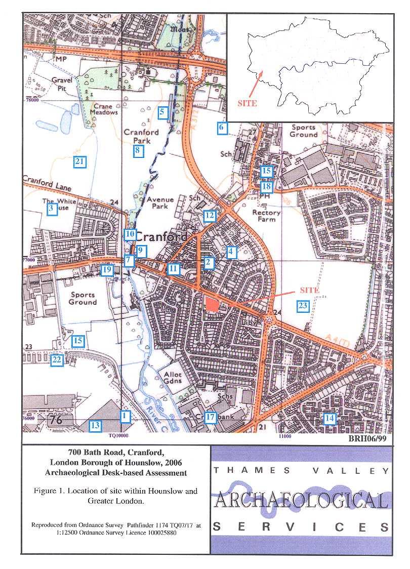
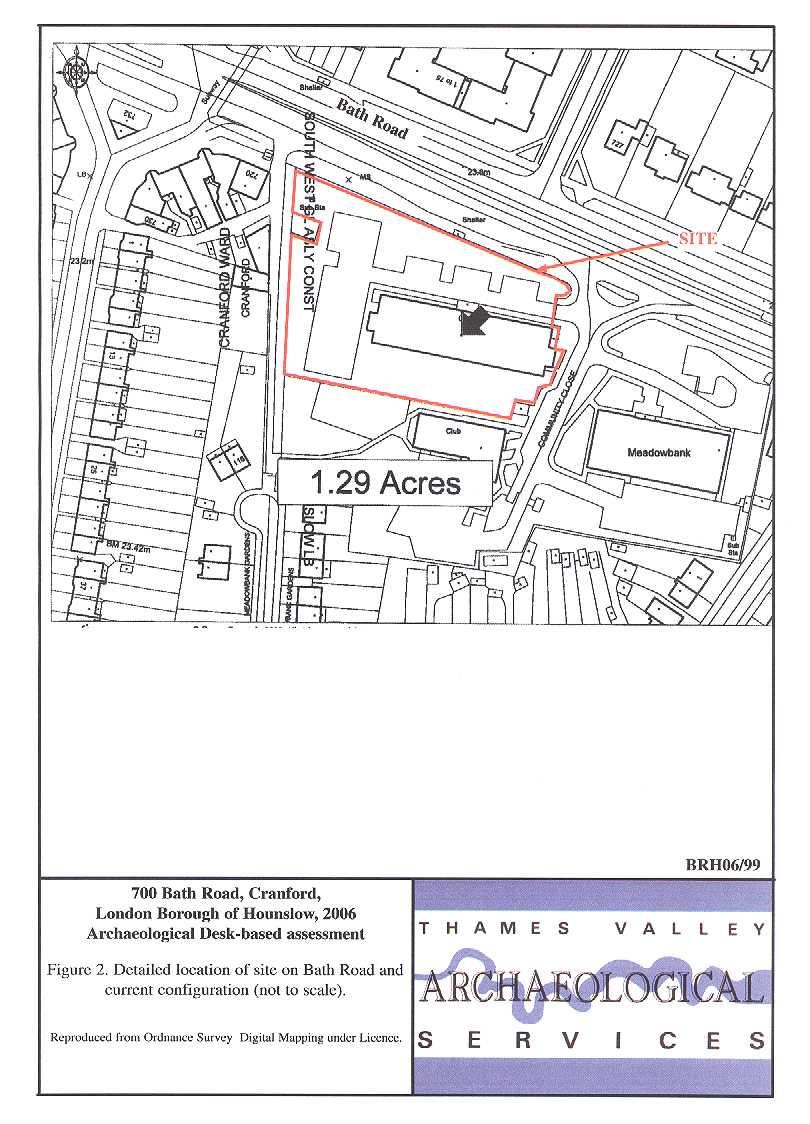
3 700 Bath Road, Cranford, London Borough of Hounslow An Archaeological Desk-Based Assessment by Steve Preston Report 06/99 Introduction This desk-based study is an assessment of the archaeological potential of 0.5ha of land located at 700 Bath Road, Cranford, Hounslow (TQ ) (Fig. 1). The project was commissioned by Mr Michael Tomkins, of Altonwood Project Services Ltd, 2 Hobbs House, Harrovian Business Village, Bessborough Road, Harrow, HA1 3EX on behalf of Janson Properties and comprises the first stage of a process to determine the presence/absence, extent, character, quality and date of any archaeological remains which may be affected by redevelopment of the area. Site description, location and geology The site is a roughly rectangular plot of land covering 0.5 ha on the south side of Bath Road (the A4), north-east of Heathrow, centred on NGR TQ It is bounded by Community Close to the east, Bath Road to the north, a footpath leading to Meadowbank gardens to the west and residential properties to the south (Fig. 2). The site currently consists of a single office block with parking, and numerous mature trees around the fringes. The ground surface is at the same level as surrounding land, so there is no indication that the site has been either built up or levelled down. The site is located on the junction of Taplow gravels with brickearth (BGS 1981a and b) and the River Crane flows southwards towards the Thames, some 400m to the west. It is at a height of approximately 23 m above Ordnance Datum. Planning background and development proposals Planning permission is to be sought for the development of the site as an hotel. Most of the existing trees are to be retained; some are to be felled for safety reasons. Most of the development will occupy the footprint of the existing buildings but there will be additional build to the west (Fig. 8) and ground floor parking. Archaeology and Planning (PPG ) provides guidance relating to archaeology within the planning process. It points out that where a desk-based assessment has shown that there is a strong possibility of significant archaeological deposits in a development area it is reasonable to provide more detailed information 1
4 from a field evaluation so that an appropriate strategy to mitigate the effects of development on archaeology can be devised: Paragraph 21 states: Where early discussions with local planning authorities or the developer s own research indicate that important archaeological remains may exist, it is reasonable for the planning authority to request the prospective developer to arrange for an archaeological field evaluation to be carried out... Should the presence of archaeological deposits be confirmed further guidance is provided. Archaeology and Planning stresses preservation in situ of archaeological deposits as a first consideration as in paragraphs 8 and 18. Paragraph 8 states:...where nationally important archaeological remains, whether scheduled or not, and their settings, are affected by proposed development there should be a presumption in favour of their physical preservation... Paragraph 18 states: The desirability of preserving an ancient monument and its setting is a material consideration in determining planning applications whether that monument is scheduled or unscheduled... However, for archaeological deposits that are not of such significance it is appropriate for them to be preserved by record (i.e., fully excavated and recorded by a competent archaeological contractor) prior to their destruction or damage. Paragraph 25 states: Where planning authorities decide that the physical preservation in situ of archaeological remains is not justified in the circumstances of the development and that development resulting in the destruction of the archaeological remains should proceed, it would be entirely reasonable for the planning authority to satisfy itself... that the developer has made appropriate and satisfactory provision for the excavation and recording of remains. 2
5 The London Borough of Hounslow s Unitary Development Plan (LBH 2003) outlines similar policies. Policy ENV-B.3.1 Ancient Monuments: In its role as the Local Planning Authority, the Council will enhance and preserve the scheduled ancient monuments and their settings in Hounslow and protect them from any developments which would adversely affect them. Policy ENV-B.3.2 Sites of Archaeological Importance The Council will promote the conservation, protection and enhancement of the archaeological heritage of the Borough and its interpretation and presentation to the public. Where development may affect land of archaeological significance or potential, the Council will expect applicants to have properly assessed and planned for the archaeological implications of their proposals. Within the Council s Archaeological Priority Areas (Map ENV-B3) and for other sites of archaeological potential (as identified by archaeological advisors [sic] to the Council): (i) A written assessment of the likely archaeological impact of development (archaeological statement) will be required as part of the documentation needed to complete a planning application. (ii) The Council may require that an on site assessment by trial work (archaeological field evaluation) is carried out before any decision on the planning application is taken. The Council will seek to ensure that the most important archaeological remains and their settings are permanently preserved in situ and if unscheduled and of national importance are given statutory protection. In such cases, if preservation in situ is both desirable and feasible, the Council will require the development design to accommodate this objective. Where the preservation of archaeological remains in situ is not appropriate, the Council will require that no development takes place on a site until archaeological investigations have been carried out by an investigating body to be nominated or approved by the Council and such investigations shall be in accordance with a detailed scheme to be approved in advance by the Council. Where feasible, the Council will negotiate the provision of facilities for public viewing during the period of excavation. Further policies cover Conservation Areas, Listed Buildings and buildings of local townscape character. The proposal site does not lie within an Archaeological Priority Area as defined on the proposals map, although one is defined just to the north-west on the opposite side of Bath Road. The nearby Cranford Village Conservation Area does not extend into this area. Methodology The assessment of the site was carried out by the examination of pre-existing information from a number of sources recommended by the Institute of Field Archaeologists paper Standards in British Archaeology covering desk-based studies. These sources include historic and modern maps, the Greater London Sites and Monuments Record, geological maps and any relevant publications or reports. 3
6 Archaeological background General background Archaeological finds and deposits of all periods on the brickearth and gravel deposits of West London are well known, having come to light during observations carried out over many years during gravel and brick clay extraction (MoLAS 2000), and more recently via aerial photography (e.g., Longley 1976), although the modern urban setting of much of west London does restrict the latter technique. The gravel terraces of the London area also have revealed a largely complete sequence of Pleistocene deposits which is in itself archaeologically significant due to their formation during early human settlement in the British Isles. As a result, some of these terraces contain Palaeolithic archaeological evidence (Wymer 1993). However, neither the Taplow terrace, nor the brickearth (Langley Silt) on which the site is based, is historically associated with prolific finds of Palaeolithic date, and indeed it has been suggested that such finds as are made in these deposits are actually redeposited from the earlier (Lynch Hill) gravels (Gibbard 1985, 128). Wymer (1999, 62) suggests this absence may be the result of a combination of chance factors in terms of recovery, rather than a real absence of the material, but this remains to be established. In areas to both the east and west of suburban London the same gravel terraces have been extensively settled at many times in the more recent past. Some examples of this are provided by large and important sites such as the Neolithic causewayed enclosures at Staines, Middlesex (Robertson-Mackay 1987) and Orsett, Essex (Hedges and Buckley 1978), rich Bronze Age sites such as at Runnymede Bridge, Egham, Surrey (Longley 1980) and Mucking North Rings, Essex (Bond 1988) and early/middle Saxon occupation at Harmondsworth (Andrews 1996) and a much larger site at Mucking (Hamerow 1993). In the West London area, recent (and not so recent) large scale developments especially in the vicinity of Heathrow airport, have revealed extensive deposits of both the prehistoric and historic periods (e.g., Grimes and Close-Brooks 1993; Barrett et al. 2001). However, the recent survey of London s archaeology (MoLAS 2000) records only very sparse activity prior to the Norman Conquest in Hounslow, other than a concentration of Bronze Age ring ditches. It is probable this situation reflects a lack of systematic investigation, given the extent of the archaeology found at Heathrow, for example, but for some periods (e.g., Iron Age and Roman) it must be considered that the gaps could be real, and this has in the past plausibly been suggested to be related to the presence of forest over much of the area. The main road from London to the west has run through Hounslow since Roman times (the Roman road heading for Silchester, later roads for Bath). Margary s route 4a (Margary 1955, 74) has long been noted to be a 4
7 lonely stretch of road, with no branches until Calleva (Silchester), but its line is reasonably well-established within London and the modern Bath Road indeed follows its line quite closely (Margary 1955, 77). Greater London Sites and Monuments Record A search was made on the Greater London Sites and Monuments Record (GLSMR) on 11 August 2006 for a radius of 1000m around the proposal area. This produced some 45 entries (including duplicates), about half of which are for post-medieval, modern or undated features. The entries are summarized as Appendix 1 and their locations plotted on Figure 1. Prehistoric The earliest entries are for two findspots of Neolithic axes, one not closely located [Fig. 1: 1], the other only a short distance north of the site [2]. By themselves, such finds mean little, as stray items can have travelled far from where they were made or used, but in the broader context of this location, it is likely there was Neolithic activity in the area. Indeed, excavations at Cranford Lane [3] have provided evidence for intensive activity in both the Neolithic and Bronze Ages. Provisional results from this unpublished site indicate Neolithic settlement in the form of pits and possibly a post-built structure (which, if confirmed, would be very rare evidence for a Neolithic building), which was succeeded by a settlement, burials and field system of the later Bronze Age. It is understood that definitive publication of this site is imminent (S Anthony, pers. comm.). Closer to the site, to the north, later Bronze Age or Iron Age pottery has been found during a watching brief on a pipeline, including some from pits, which probably indicates another settlement in the vicinity [4], whilst further north again [5], another watching brief recovered similar evidence, Bronze Age and Iron Age pottery, struck flints and a loom weight. This remarkable concentration of evidence along the Crane Valley suggests fluid occupation, with shortlived settlements sites shifting across the landscape over a long period, and highlights the potential of the area to produce more such sites. The absence of Middle and later Iron Age sites, given the number of earlier remains, is also notable. Roman The only Roman evidence from the area comes in the form of a complex stock enclosure system from the excavations at Cranford Lane [3]. This relative scarcity of remains, coupled with the absence of later Iron Age sites, does strengthen the case for seeing this area as progressively more wooded in these periods, and genuinely not settled, rather than simply not sufficiently explored. 5
8 Saxon There is no entry for this period from the search area. Medieval Although there are a number of SMR entries for the medieval period, these in fact amount to little. There is an entry for the documentary references to the village of Cranford [6], and one for the bridge over the Crane, which existed at least by AD1284 and was replaced in 1776 [7]. The whole of Cranford Park [8] is noted to be covered by ridge and furrow, which is the remains of the medieval ploughing regime. More significant is the extant moated site [9] near the bridge, thought to be a sub-manor. Post-medieval The 18th-century bridges over the Crane [7, 10] are Listed Buildings (Grade II). Of some interest is the village lock-up The Round House, which is also listed [11]. It is noted it was used to incarcerate the footpads who bedevilled Hounslow Heath. Stansfield House [12] is also Grade II listed. None of these buildings is close enough to the proposal area to be affected by any development on it. Undated, Negative, Modern The remaining entries include a number of structures on Heathrow Airport which are listed buildings [13], but otherwise, generally record an absence of archaeology. A number of entries record the sites of known modern landfill, which can be expected to have no archaeological potential [14 17]. Two recent evaluations produced negative results [18, 19]. Two entries record ditches visible on an aerial photograph, which could be archaeological [20, 21]. Finally, number of entries record features visible on air photographs which are known to have been destroyed by gravel extraction or development [22 25: two sites are just off Figure 1 to the south]. Scheduled Ancient Monuments There are no Scheduled Ancient Monuments within the vicinity of the site. Cartographic and documentary sources Cranford is first mentioned in Domesday Book (AD 1086) (Williams and Martin, 366) when it was a manor of five hides held by William fitzansculf in the Hundred of Elthorne. The population numbered just eight villans, two cottars and three slaves and the whole was worth 60 shillings. It had previously belonged to Thorsten, one of King Edward s thegns. The placename is Old English (Anglo-Saxon) deriving from cran (crane or heron) and 6
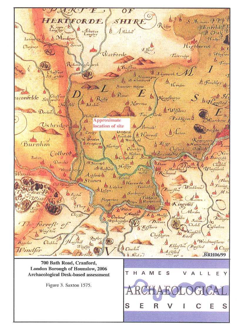
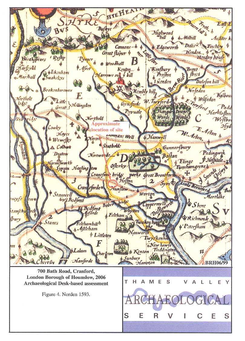
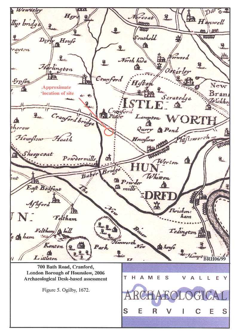
9 ford (ford) (Mills 1998, 100). Names incorporating the -ford element can generally be shown to be among the earliest of the Anglo-Saxon names, suggesting that Cranford was an early Saxon settlement (Cameron 1996, 176). Both the manor and the church were on the west side of the river. There is no direct evidence relating to the presence or location of a medieval manor house until the Moat House is mentioned in Cranford House, built , was demolished just prior to the Second World War and the estate (Cranford Park) sold to the council. Heathrow is another Anglo-Saxon name, although not attested before around AD1410. It means simply a row (of houses) on a heath (Mills 1998, 173). Cranford, now in the parish of Heston, was a parish in its own right until the 1930s when it was successively divided and re-ordered out of existence (VCH 1962, 177). It was always very small, with no significant residential development until the 1930s. In 1801 there were only 27 houses, and still just 117 by The common south of the Bath Road was not developed until There is little other history of note (VCH 1962, 179). Other than the church to the west, very little of historic Cranford survives (Pevsner 1951, 38 9). A range of Ordnance Survey and other historical maps of the area were consulted at Hounslow Record Office in order to ascertain what activity had been taking place throughout the site s later history and whether this may have affected any possible archaeological deposits within the proposal area (see Appendix 2). The earliest map available of the area is Christopher Saxton s map of Kent, Sussex, Surrey and Middlesex (Fig. 3) from No detail is shown for the area although Cranford is marked as is Hounslow (Hou n sley)(saxton s n is often superscript or even omitted). John Norden s map of 1593 shows a little more, including highlighting the importance of what is now the Bath Road and its river crossings (Fig. 4). Ogilby (1672) and Warburton (1749) are typical of 17th- and 18th-century cartographers (Fig. 5). Here the main roads and bridges are again depicted, as are the major country seats of the gentry, notable inns, and sundry other places worthy of note, but this is by no means comprehensive mapping. Cranford Place is shown quite distinct from Cranford Bridge, and Cranford (when the latter is shown at all) is variously shown to the north (Ogilby) or south (Norden) of Cranford Bridge. There is no development noted along the roadside, after Hounslow where the roads westwards diverge. The Hounslow Record Office does not hold the Heston tithe map, but does have the Heston Enclosure map (1841) which covers the area. This shows all the land south of Bath Road as undeveloped. The area of the site is part of plot 516, noted as the rectorial allotment. The entire plot is featureless. It was not possible to reproduce 7
10 this map. Detailed mapping arrives with the first Edition Ordnance Survey map of This shows the site in some detail (Fig. 6). The north-western corner is occupied by a rather indistinct building, perhaps with a well. The rest of the plot is undeveloped, with some trees. The Second Edition (1895) shows the building to the northwest more clearly, there is no suggestion of a well at this time (Fig. 7). The land boundary associated with this house has changed, but there is no other alteration to the site apart from an absence of tress: this might be a stylistic change, however, as the depiction of trees over the entire sheet is much more sparse on the Second Edition. On the 1913 Ordnance Survey map, the site is entirely open ground, with no building anywhere (not illustrated). The 1925 and 1935 revisions are identical to that of Listed buildings There are no Listed buildings on the site. The closest Listed Buildings are described above; none would be affected by any development on the proposal area. Registered Parks and Gardens; Registered Battlefields There are no registered parks and gardens or registered battlefields within close proximity of the site. Historic Hedgerows There are no hedgerows, historic or otherwise, on the site. Aerial Photographs The site areas lies within an urban area which has been developed since before the advent of aerial photography. No photographic collections have therefore been consulted. Discussion In considering the archaeological potential of the study area, various factors must be taken into account, including previously recorded archaeological sites, previous land-use and disturbance and future land-use including the proposed development. The site lies in an area of considerable archaeological potential, especially for the Neolithic and Bronze Ages, as the SMR search results clearly demonstrate. There is a concentration of settlement evidence, 8
11 particularly for the Bronze Age, but also, it appears, for the Neolithic, which is unusual. The site may also be in an area with some medieval potential, located as it is along a main road leading to a bridge, although medieval archaeology has so far not been encountered in the area. It would appear that potential for other periods is limited, but this cannot be ascertained with any great confidence, as investigation west of the Crane and north of the Thames has so far been limited. Other than one small building in the far north-west of the site, depicted on the maps of 1865 and 1895, but neither earlier or later, the only development on the site seems to be the modern buildings currently present. Any truncation of archaeological deposits on the site will thus be restricted to the footprint of the extant building, and the remainder of the site can be expected to be archaeologically intact. The development proposal will occupy almost an identical footprint towards the eastern portion of the site, but with additional build to the west (Fig. 8). On balance therefore it is felt that it will be necessary to provide further information about the potential of the site from field observations in order to draw up a scheme to mitigate the impact of development on any below-ground archaeological deposits if necessary. A scheme for this evaluation will need to be drawn up and approved by the archaeological advisers to the Borough and implemented by a competent archaeological contractor, such as an organization registered with the Institute of Field Archaeologists. Such an evaluation could be implemented as an appropriately worded condition attached to any planning consent gained. References Allen, T J, 1978, Disposition of the terraces of the river Thames in the vicinity of Yiewsley, in D Collins Early man in West Middlesex: The Yiewsley Palaeolithic sites, London Andrews, P, 1996, Prospect Park, Harmondsworth, London Borough of Hillingdon: settlement and burial from the Neolithic to the Early Saxon periods, in P Andrews and A Crockett, Three Excavations Along the Thames and its Tributaries, 1994, Wessex Archaeol Rep 10, Salisbury, 1 50 Barrett, J C, Lewis, J S C and Welsh, K, 2000, Perry Oaks a history of inhabitation Part 2, London Archaeologist, 9, BGS, 1981a, British Geological Survey, 1:50,000 Sheet 269, Drift and Solid Edition, Keyworth BGS, 1981b, British Geological Survey, 1:50,000 Sheet 270, Drift and Solid Edition, Keyworth Bond, D, 1988, Excavations at the North Ring, Mucking, Essex, East Anglian Archaeol 43 Cameron, K, 1996, English Place Names, London Gibbard, P L, 1985, The Pleistocene history of the middle Thames valley, Cambridge Grimes, W F and Close-Brooks, J, 1993, The excavation of Caesar s Camp, Heathrow, Harmondsworth, Middlesex, 1944, Proc Prehist Soc, 59, Hamerow, H, 1993, Excavations at Mucking; Vol. 2: The Anglo-Saxon settlement, Engl Heritage Rep 21, London Hedges, J and Buckley, D, 1978, Excavations at a Neolithic causewayed enclosure, Orsett, Essex, 1975, Proc Prehist Soc, LBH, 2003, London Borough of Hounslow Unitary Development Plan Adopted December 2003 Longley, D, 1976, The implications of gravel extraction in north-west Surrey, Surrey Archaeol Soc Res Vol 3, Guilford, 1 37 Longley, D, 1980, Runnymede Bridge 1976: Excavations on the Site of a Late Bronze Age Settlement, Res Vol Surrey Archaeol Soc 6, Guildford Margary, I D, 1955, Roman Roads in Britain, London 9
12 Mills, A D, 1998, Dictionary of English Place-Names, Oxford MoLAS, 2000, The archaeology of Greater London; an assessment of archaeological evidence for human presence in the area now covered by Greater London, Museum of London Archaeology Service Monogr Pevsner, N, 1951, The Buildings of England: Middlesex, London PPG16, 1990, Dept of the Environment Planning Policy Guidance 16, Archaeology and Planning, HMSO Robertson-Mackay, R, 1987, The Neolithic causewayed enclosure at Staines, Surrey: excavations , Proc Prehist Soc 53, Williams, A and Martin, G H, 2002, Domesday Book, A complete Translation, London Wymer, J, 1993, The Southern Rivers Palaeolithic Project Report No : The South West and South of the Thames, Wessex Archaeology Wymer, J J, 1999, The Lower Palaeolithic occupation of Britain, Salisbury VCH, 1962, Victoria County History of Middlesex Vol. iii, London 10
13 APPENDIX 1: Sites and Monuments Records within a 1000 m search radius of the development site No SMR Ref (MLO) Grid Ref (TQ) Type Period Comment Findspot Neolithic Axe or adze; no details: near Bath Road Findspot Neolithic Tranchet axe (ELO2980) (ELO 2410) (ELO3080) Excavation Neolithic Bronze Age Roman Watching brief Bronze Age/ Iron Age/ Medieval/ Post-medieval/ Undated Watching Brief Bronze Age Iron Age Neolithic pit, Neolithic post-built structure (possibly), Neolithic amber bead, later Bronze Age circular buildings, 4-post granaries, pits and a field system, and 8 Bronze Age cremations, also a Roman stock enclosure complex. Pits with LBA/EIA pottery, probably occupation, also undated ditches see in pipeline route. Not clear if grid reference actually relates to the features. Unstratified medieval and post-medieval pottery and a quernstone (post-medieval). Two Bronze Age pits, topsoil finds of BA and IA pottery, flints, loom weight Documentary Medieval References to village of Cranford Documentary Medieval Site of medieval bridge from before 12874; replaced Listed Building Post-medieval 18th-century brick bridge, Grade II Listed (twice) Monument Medieval Extant ridge and furrow covering whole of Cranford Park Monument Medieval Moated site, extant Listed Building Post-medieval 18th-century brick bridge, Grade II Listed (twice) Listed Building Post-medieval Village lock-up, Grade II. Although given as c. 1838, is supposed to have been used in 18th century Listed Building Post-medieval Stansfield House, Grade II 18th-century houses Listed Building Modern Various 1950s buildings in Heathrow Airport are Listed, Grade II Documentary Modern/Negative Known landfill site, 19th century or later Documentary Modern/Negative Known landfill site, 19th century or later Documentary Modern/Negative Known landfill site, 19th century or later Documentary Modern/Negative Known landfill site, 19th century or later Evaluation Modern/Negative Late 19th century foundations only Evaluation Modern/Negative Only modern features revealed. (ELO518) Documentary Undated Aerial photograph shows linear ditches Documentary Undated Aerial photograph shows several ditches Documentary Undated Aerial photograph shows rectilinear enclosure, since destroyed by gravel extraction Documentary Undated Aerial photographs show a circular feature, possibly a ring ditch, and a complex of linear ditches (destroyed) Documentary Undated Aerial photograph shows a circular feature, possibly a ring ditch (destroyed) Documentary Undated Aerial photograph shows a complex of block marks, possibly pits (destroyed) 11
14 APPENDIX 2: Historic and modern maps consulted 1575 Saxton (Fig. 3) 1593 Norden (Fig. 4) 1672 Ogilby (Fig. 5) 1749 Warburton 1841 Heston Enclosure 1865 Ordnance Survey First Edition 25 inch sheets Middlesex XX.1 and XX.5 (Fig. 6) 1895 Ordnance Survey Second Edition 25 inch sheets XX.1 and XX.5 (Fig. 7) 1913 Ordnance Survey Revision 25 inch sheets XX.1 and XX Ordnance Survey Revision 25 inch sheets XX.1 and XX Ordnance Survey Revision 25 inch sheets XX.1 and XX.5 12
15
16
17
18
19
20
21
22
Garage Site, Foots Cray High Street, Sidcup, Kent, London Borough of Bexley
 Garage Site, Foots Cray High Street, Sidcup, Kent, London Borough of Bexley An Archaeological Evaluation for Mizen Design Build by Andy Taylor Thames Valley Archaeological Services Ltd FOC 07 September
Epsom Water Works, East Street, Epsom, Surrey
 Epsom Water Works, East Street, Epsom, Surrey An Archaeological Desk-Based Assessment for St James Homes Ltd by Steve Ford Thames Valley Archaeological Services Site Code ESE99/85 December 1999 Epsom Water
Meales Farm, Sulhamstead, West Berkshire
 Meales Farm, Sulhamstead, West Berkshire An Archaeological Watching Brief For Mr. Robert Astor by Steve Ford Thames Valley Archaeological Services Ltd Site Code CHH02/29 May 2002 Summary Site name: Meales
New Swimming Pool,West Meon House, West Meon, Hampshire
 New Swimming Pool,West Meon House, West Meon, Hampshire An Archaeological watching brief and building recording for Mr and Mrs Younger by Danielle Milbank Thames Valley Archaeological Services Ltd Site
Northbury Farm, Castle End Road, Ruscombe, Berkshire
 Northbury Farm, Castle End Road, Ruscombe, Berkshire An Archaeological Watching Brief For Sir Colin and Lady Southgate by Danielle Milbank Thames Valley Archaeological Services Ltd Site Code NFR 07/120
Ivol Buildings, Woodcote Road, South Stoke, Oxfordshire
 Ivol Buildings, Woodcote Road, South Stoke, Oxfordshire An Archaeological Watching Brief For Christ Church, Oxford by Pamela Jenkins Thames Valley Archaeological Services Ltd Site Code IBSS 04/03 March
ARCHAEOLOGICAL S E R V I C E S. Hurley Manor, High Street, Hurley, Berkshire. Archaeological Evaluation. by James McNicoll-Norbury
 T H A M E S V A L L E Y ARCHAEOLOGICAL S E R V I C E S Hurley Manor, High Street, Hurley, Berkshire Archaeological Evaluation by James McNicoll-Norbury Site Code: HMH14/51 (SU 8252 8378) Hurley Manor,
Newcombe House & Kensington Church Street
 Newcombe House & Kensington Church Street Archaeological Evaluation September 2017 Summary Site name: Newcombe House, Kensington Church Street, Notting Hill, London Grid reference: TQ 25318 80372 Site
Merrowdene, Earleydene, Sunninghill, Berkshire
 Merrowdene, Earleydene, Sunninghill, Berkshire An Archaeological Watching Brief For Mr and Mrs Jackson by Andy Taylor Thames Valley Archaeological Services Ltd Site Code MES 05/88 January 2006 Summary
Chitty Farmhouse Extension, Wall Lane, Silchester, Hampshire
 Chitty Farmhouse Extension, Wall Lane, Silchester, Hampshire An Archaeological Watching Brief For In Touch by Andrew Mundin Thames Valley Archaeological Services Ltd Site Code CFS 08/52 May 2008 Summary
Appletree, Thames Street, Sonning Berkshire
 Appletree, Thames Street, Sonning Berkshire An Archaeological Watching Brief for Mr and Mrs A Popham by Sian Anthony Thames Valley Archaeological Services Ltd Site Code ATS 02/83 October 2002 Summary Site
ARCHAEOLOGICAL S E R V I C E S. Manor Farm, Launton, Bicester, Oxfordshire. Archaeological Watching Brief. by Aiji Castle. Site Code: LBO13/220
 T H A M E S V A L L E Y ARCHAEOLOGICAL S E R V I C E S Manor Farm, Launton, Bicester, Oxfordshire Archaeological Watching Brief by Aiji Castle Site Code: LBO13/220 (SP 6035 2285) Manor Farm, Launton, Bicester,
Land adjacent to Dingle Dock, Front Street, East Garston
 Land adjacent to Dingle Dock, Front Street, East Garston An Archaeological Watching Brief for Dr J Davies by Jo Pine Thames Valley Archaeological Services Site Code DEG99/82 January 2000 Summary Site name:
Pinnocks Wood Equestrian Centre, Burchett s Green, Maidenhead, Berkshire
 Pinnocks Wood Equestrian Centre, Burchett s Green, Maidenhead, Berkshire An Archaeological Watching Brief For Mr David Eyles by Andrew Mundin Thames Valley Archaeological Services Ltd Site Code POB 08/69
Land at Downsview Avenue, Storrington, West Sussex
 Land at Downsview Avenue, Storrington, West Sussex An Archaeological Evaluation for Bellwinch Homes Limited by Andy Taylor Thames Valley Archaeological Services Ltd Site Code DAS 04/21 March 2004 Summary
Oak Tree Fields, Spine Road, South Cerney, Gloucestershire
 Oak Tree Fields, Spine Road, South Cerney, Gloucestershire An Archaeological Desk-Based Assessment for Hills Minerals & Waste by Steve Ford Thames Valley Archaeological Services Ltd Site Code OTF04/73
New horse training area, Manor Farm, Great Kimble, Buckinghamshire
 New horse training area, Manor Farm, Great Kimble, Buckinghamshire An Archaeological Watching Brief For Redwing Structures (Marlow) Limited by Andy Taylor Thames Valley Archaeological Services Ltd Site
New Media Building, Goldsmiths College, New Cross, London Borough of Lewisham
 New Media Building, Goldsmiths College, New Cross, London Borough of Lewisham An Archaeological Evaluation for Willmott Dixon Construction by Andy Taylor Thames Valley Archaeological Services Ltd Site
ARCHAEOLOGICAL S E R V I C E S. Land north of Orchard Close, Hallow, Worcestershire. Archaeological Evaluation. by Kyle Beaverstock
 T H A M E S V A L L E Y ARCHAEOLOGICAL S E R V I C E S Land north of Orchard Close, Hallow, Worcestershire Archaeological Evaluation by Kyle Beaverstock Site Code: OCW15/224 (SO 8285 5848) Land north of
ARCHAEOLOGICAL S E R V I C E S. Becks, Park Lane, North Newington, Banbury, Oxfordshire. Archaeological Watching Brief.
 T H A M E S V A L L E Y ARCHAEOLOGICAL S E R V I C E S Becks, Park Lane, North Newington, Banbury, Oxfordshire Archaeological Watching Brief by Andy Mundin Site Code: BPN16/105 (SP 4207 3978) Becks, Park
Bridge House, Ham Island, Old Windsor, Berkshire
 Bridge House, Ham Island, Old Windsor, Berkshire An Archaeological Watching Brief for Mr A Chadwick by Alan Ford Thames Valley Archaeological Services Site Code BHHI98/55 August 1998 Bridge House, Ham
Bedwell Park, Essendon, Hatfield, Hertfordshire
 Bedwell Park, Essendon, Hatfield, Hertfordshire An Archaeological Desk-Based Assessment for Millgate Homes by Steve Preston Thames Valley Archaeological Services Ltd Site Code BPE06/34 March 2006 Summary
Archaeological evaluation at Willowdene, Chelmsford Road, Felsted, Essex
 Archaeological evaluation at Willowdene, Chelmsford Road, Felsted, Essex August 2013 report prepared by Ben Holloway on behalf of Mr Anthony McGurren Planning reference: UTT/13/0235 CAT project ref.: 13/07g
30 48 Castle Street, High Wycombe, Buckinghamshire
 30 48 Castle Street, High Wycombe, Buckinghamshire An Archaeological Desk-Based Assessment for George Wimpey (West London) Ltd by Jennifer Lowe Thames Valley Archaeological Services Ltd Site Code CHW07/20
Bridge Road, Maidenhead, Berkshire
 Bridge Road, Maidenhead, Berkshire An Archaeological Desk-Based Assessment for Salmon Harvester Properties Ltd by Steve Ford Thames Valley Archaeological Services Ltd Site Code BRM04/56 June 2004 Summary
Old Town Hall, Market Place, Faringdon, Oxfordshire
 Old Town Hall, Market Place, Faringdon, Oxfordshire Building Recording and Archaeological Watching Brief for Great Faringdon War Memorial Trust by Jamie Preston and Steve Ford Thames Valley Archaeological
Elm Park, Station Road, Ardleigh, Essex, CO7 7RT: archaeological watching brief on installation of new water pipe
 Elm Park, Station Road, Ardleigh, Essex, CO7 7RT: archaeological watching brief on installation of new water pipe November 2015 report prepared by Howard Brooks BA FSA MCIfA on behalf of Partnerships in
Archaeological Evaluation and Assessment of Land at Minnis Beeches, Canterbury Road, Swingfield, Dover, Kent
 Archaeological Evaluation and Assessment of Land at Minnis Beeches, Canterbury Road, Swingfield, Dover, Kent NGR: TQ 6307 1545 Site Code: MB-EV-10 (Planning Consent Y10/0311/SH) Report for Thorndene Ltd.
ARCHAEOLOGICAL S E R V I C E S. Land at The Elms, Thame, Oxfordshire. Desk-based Archaeological Assessment. by Tim Dawson. Site Code: TET 13/100
 T H A M E S V A L L E Y ARCHAEOLOGICAL S E R V I C E S Land at The Elms, Thame, Oxfordshire Desk-based Archaeological Assessment by Tim Dawson Site Code: TET 13/100 (SP 7085 0555) Land at The Elms, Thame,
An Archaeological Evaluation at Granta Cottages, Newmarket Road, Great Chesterford, Essex. August 2015
 An Archaeological Evaluation at Granta Cottages, Newmarket Road, Great Chesterford, Essex August 2015 by Pip Parmenter and Ben Holloway on behalf of Mr G Elmer and Mrs L King CAT project ref.: 15/06a NGR:
Archaeological Investigation in advance of Development at 2 Palace Cottages, Charing Palace, Charing, Kent
 Archaeological Investigation in advance of Development at 2 Palace Cottages, Charing Palace, Charing, Kent Site Code CHAR-EV-14 NGR 95412 49439 Date of Report 18/12/2014 Swale and Thames Archaeological
Archaeological Evaluation and Assessment of Land at Kent Cottage, 19 Chapel Street, Hythe, Kent
 Archaeological Evaluation and Assessment of Land at Kent Cottage, 19 Chapel Street, Hythe, Kent Planning Application Y13/0463/SH Date of Report: 29/04/2015 Report for Marc Carney SWAT. ARCHAEOLOGY Swale
T H A M E S V A L L E Y S E R V I C E S. Flood Compensation Area, Riverside Park, Wallingford, Oxfordshire. Archaeological Watching Brief
 T H A M E S V A L L E Y ARCHAEOLOGICAL S E R V I C E S Flood Compensation Area, Riverside Park, Wallingford, Oxfordshire Archaeological Watching Brief by Jacqueline Pitt Site Code: RPW10/72 (SU 6112 8934)
Historic England Advice Report 26 August 2016
 Case Name: Kingsland Castle Case Number: 1435892 Background Historic England has been asked to review the scheduling for Kingsland Castle. The land on which the monument lies is understood to be for sale.
6A St John s Road, Wallingford Oxfordshire
 6A St John s Road, Wallingford Oxfordshire An Archaeological Evaluation Stage 2 for Spearcliff Estates Ltd by Steve Ford Thames Valley Archaeological Services Ltd Site SJW03/116 January 2004 Summary Site
Malden Green Farm, Worcester Park, Surrey, Royal Borough of Kingston
 Malden Green Farm, Worcester Park, Surrey, Royal Borough of Kingston An Archaeological Evaluation and Desk-Based Assessment for Bewley Homes by Steve Ford Thames Valley Archaeological Services Site Code
Archaeology and Planning in Greater London. A Charter for the Greater London Archaeology Advisory Service
 Archaeology and Planning in Greater London A Charter for the Greater London Archaeology Advisory Service THE PURPOSE OF THE CHARTER This Charter sets out how English Heritage will provide archaeological
Archaeological evaluation: land to the rear of Clare Road, Braintree, Essex
 Archaeological evaluation: land to the rear of 41-45 Clare Road, Braintree, Essex March 2014 commissioned by Mr Mark Plummer report prepared by Ben Holloway and Howard Brooks Planning reference: 13/000585/FUL,
Archaeological trial-trenching evaluation: New Hall School, The Avenue, Boreham, Essex. July 2015
 Archaeological trial-trenching evaluation: New Hall School, The Avenue, Boreham, Essex report prepared by Ben Holloway on behalf of New Hall School Planning reference: 14/01846/FUL CAT project ref.: 15/04i
Downton Manor, Downton, near Lymington, Hampshire
 Downton Manor, Downton, near Lymington, Hampshire An Archaeological Evaluation for New Milton Sand and Gravel by Sian Anthony Thames Valley Archaeological Services Ltd Site Code DMD03/20 May 2003 Summary
Archaeological Monitoring of Land at 29 Royal Pier Road, Gravesend, Kent
 Archaeological Monitoring of Land at 29 Royal Pier Road, Gravesend, Kent Site Code ROY/WB/15 Report for Dr Maxted Date of report 06/10/2015 SWAT ARCHAEOLOGY Swale and Thames Archaeological Survey Company
Archaeological evaluation on land at Mersea Fleet Way, Chelmer Road, Braintree, Essex, CM7 3PZ
 Archaeological evaluation on land at Mersea Fleet Way, Chelmer Road, Braintree, Essex, CM7 3PZ by Laura Pooley figures by Ben Holloway and Emma Holloway fieldwork by Ben Holloway, Robin Mathieson, Nigel
Archaeological evaluation at Stables, Hatch Farm, Fen Lane, Bulphan, Essex, RM14 3RL
 Archaeological evaluation at Stables, Hatch Farm, Fen Lane, Bulphan, Essex, RM14 3RL November-December 2016 by Laura Pooley figures by Ben Holloway and Emma Holloway fieldwork by Ben Holloway and Alec
Greater London. Greater London 6/42 (D.01.M001) TQ
 TQ") Authority 6/42 (D.01.M001) TQ 54207390 ST. JAME'S INVESTMENTS, LOWFIELD STREET AND MARKET STREET, DARTFORD Environmental Statement. Archaeology. Volume 9 of 10 AOC Archaeology Group Twickenham : AOC Archaeology
Authority 6/42 (D.01.M001) TQ 54207390 ST. JAME'S INVESTMENTS, LOWFIELD STREET AND MARKET STREET, DARTFORD Environmental Statement. Archaeology. Volume 9 of 10 AOC Archaeology Group Twickenham : AOC Archaeology
6. Bermondsey 6.1. Bermondsey Area Vision
 6. 6.1. Area Vision 6.1.1. is: An inner-london neighbourhood characterised by modest worker ho associated with the historic Rotherhithe docks and local manufacturing industries such as biscuits, jam, vinegar
ARCHAEOLOGICAL EVALUATION AT THE FORMER WATTON GARDEN CENTRE, NORWICH ROAD, WATTON, NORFOLK OCTOBER 2003 (Accession number WAT)
") NORTHAMPTONSHIRE ARCHAEOLOGY NORTHAMPTONSHIRE COUNTY COUNCIL NOVEMBER 2003 (Planning Application No: 3PL/1997/048/0 ARCHAEOLOGICAL EVALUATION AT THE FORMER WATTON GARDEN CENTRE, NORWICH ROAD, WATTON, NORFOLK
NORTHAMPTONSHIRE ARCHAEOLOGY NORTHAMPTONSHIRE COUNTY COUNCIL NOVEMBER 2003 (Planning Application No: 3PL/1997/048/0 ARCHAEOLOGICAL EVALUATION AT THE FORMER WATTON GARDEN CENTRE, NORWICH ROAD, WATTON, NORFOLK
Stanwick Neighbourhood Plan
 Stanwick Neighbourhood Plan Heritage Audit Stanwick Neighbourhood Plan Steering Group August 2015 Purpose of the Heritage Audit It is a core planning principle within National Planning Policy Framework
Archaeological monitoring at Clintons, Bury Green, Little Hadham, Hertfordshire April 2008
 Archaeological monitoring at Clintons, Bury Green, Little Hadham, Hertfordshire April 2008 report prepared by Ben Holloway on behalf of Charles Britton Equestrian Construction CAT project ref.: 08/3b NGR:
Centre for Archaeological Fieldwork Evaluation/Monitoring Report No Monitoring Report No. 201
 Monitoring Report No. 201 Land adjacent to 58 Drumreagh Road Drumreagh Ballygowan Co. Down LICENCE NO.: AE/10/91E BRIAN SLOAN 1 Site Specific Information Site Name: Land adjacent to 58 Drumreagh Road,
White Cliffs Business Park, Dover, Kent
 White Cliffs Business Park, Dover, Kent Archaeological Desk-Based Assessment Report Project Code: WCBP-DA-15 Planning Ref: Pre-application NGR: 631378 144379 Report No: 2016/4 Archive No: 3671 July 2016
Archaeological evaluation on land at Unit 1, Waltham Hall, Bambers Green Road, Takeley, Essex, CM22 6PF
 Archaeological evaluation on land at Unit 1, Waltham Hall, Bambers Green Road, Takeley, Essex, CM22 6PF by Laura Pooley figures by Ben Holloway and Emma Holloway fieldwork by Ben Holloway with Jane Roberts
13.0 ARCHAEOLOGY AND CULTURAL HERITAGE
 13.0 ARCHAEOLOGY AND CULTURAL HERITAGE Introduction 13.1 This chapter of the ES assesses the likely significant effects of the Overall Development in terms of archaeology and cultural heritage and is supported
High Speed Rail (London- West Midlands)
") High Speed Rail (London- West Midlands) Draft Environmental Minimum Requirements Annex 3: Draft Heritage Memorandum November 2013 ESA 4.4 High Speed Rail (London- West Midlands) Draft Environmental Minimum
High Speed Rail (London- West Midlands) Draft Environmental Minimum Requirements Annex 3: Draft Heritage Memorandum November 2013 ESA 4.4 High Speed Rail (London- West Midlands) Draft Environmental Minimum
Archaeological evaluation at Redbank, Bury Water Lane, Newport, Essex, CB11 3TZ
 Archaeological evaluation at Redbank, Bury Water Lane, Newport, Essex, CB11 3TZ March 2017 by Laura Pooley figures by Ben Holloway and Emma Holloway fieldwork by Ben Holloway with Harvey Furniss and Elliott
Glue Pot Farm, Edwards Lane, Bramfield, Suffolk. BMF 024
 Glue Pot Farm, Edwards Lane, Bramfield, Suffolk. BMF 024 Archaeological Evaluation Report SCCAS Report No. 2013/107 Client: Keith Frost Architectural Design Services Author: Linzi Everett August 2013 SCCAS
Deptford Creekside, Greenwich, London Boroughs of Greenwich and Lewisham
 Deptford Creekside, Greenwich, London Boroughs of Greenwich and Lewisham An Archaeological Desk-Based Assessment for Ampurius NuHomes Investments Ltd by Steve Preston Thames Valley Archaeological Services
EVALUATION REPORT No. 300
 EVALUATION REPORT No. 300 Southwest of 2A Cloughey Road, Portaferry, Co. Down Licence No.: AE/135/85E Sapphire Mussen Report Date: 14 th May 2015 Site Specific Information Site Name: [Southwest of 2a]
Billington Parish Green Infrastructure Plan
 Billington Billington Parish Green Infrastructure Plan Methodology Following a presentation to the Annual Parish Meeting, The Greensand Trust was invited to attend the next Parish Council Meeting. The
Archaeological evaluation at New Hall School, The Avenue, Boreham, Chelmsford, Essex, CM3 3HS
 Archaeological evaluation at New Hall School, The Avenue, Boreham, Chelmsford, Essex, CM3 3HS December 2016 by Laura Pooley with contributions by Stephen Benfield figures by Ben Holloway and Emma Holloway
Proposed Retirement Village Cole Green Way, Hertford. Archaeology Statement
 RETIREMENT LIVING MADE BETTER Proposed Retirement Village Cole Green Way, Hertford Archaeology Statement Woodlands Retirement Village RETIREMENT LIVING MADE BETTER Retirement Living Made Better Archaeology
Plaistow and Ifold Neighbourhood Plan Pre-Submission Consultation Draft
 Mrs Beverley Weddell Clerk to Plaistow And Ifold Parish Council Lock House Lodge Knightons Lane Dunsfold, GU8 4NU. Dear Mrs Weddell, Our ref: Your ref: Telephone Fax HD/P5402/ 01483 252040 18 th October
The Anchor Public House, Bankside, London Borough of Southwark
 The Anchor Public House, Bankside, London Borough of Southwark An Archaeological Desk-Based Assessment for The Spirit Group by Steve Preston Thames Valley Archaeological Services Ltd Site Code ABS07/86
Gryme s Dyke, Stanway Green
 Gryme s Dyke, Stanway Green A short assessment of the archaeological impact of contractor s groundworks at the southern end of the Gryme s Dyke Middle earthwork February 2000 Archive report on behalf of
North East Region TYNE & WEAR 1 /315 (B ) NZ
 NZ") TYNE & WEAR Newcastle Upon Tyne 1 /315 (B.05.6311) NZ 28016514 138 FOSSWAY, WALKER An Archaeological Desk-Based Assessment for a Proposed Development at 138 Fossway, Walker GeoQuest Associates Consett
TYNE & WEAR Newcastle Upon Tyne 1 /315 (B.05.6311) NZ 28016514 138 FOSSWAY, WALKER An Archaeological Desk-Based Assessment for a Proposed Development at 138 Fossway, Walker GeoQuest Associates Consett
Land South-West of Mill Co age, Gidding Road, Sawtry, Cambridgeshire Evalua on Report
 Land South-West of Mill Coage, Gidding Road, Sawtry, Cambridgeshire Evaluaon Report August 2017 Client: CgMs Consulng Issue No: 1 OA East Report No: 2080 NGR: TL 1623 8329 Oxford Archaeology Ltd i 3 August
XSW11, Plumstead Portal worksites, Interim Statement for NLBH. 1 Introduction Site Methodology and fieldwork objectives...4
 Contents 1 Introduction...4 2 Site Methodology and fieldwork objectives...4 2.1 NLBH Methodology... 4 2.2 NLBH Fieldwork Objectives... 5 3 Provisional Results...6 3.1 NLBH various features... 6 3.2 Shelter
Archaeological monitoring and recording at 24 St Peter's Road, West Mersea, Essex, CO5 8LJ
 Archaeological monitoring and recording at 24 St Peter's Road, West Mersea, Essex, CO5 8LJ April 2017 by Dr Elliott Hicks figures by S Carter fieldwork by Adam Wightman on behalf of Brett Lord NGR: TM
Public Consultation. Land at Monks Farm, North Grove. Welcome
 Welcome Welcome to our public exhibition for development on Land at Monks Farm, orth Grove. Gallagher Estates and Gleeson Strategic Land are preparing an outline planning application for new homes, open
Draft Hailey Neighbourhood Plan
 Persimmon Homes (Wessex) Draft Hailey Neighbourhood Plan Representations to West Oxfordshire District Council s Regulation 16 Consultation December 2018 2 Copyright 2018 Persimmon Homes Ltd. All rights
13. London Bridge London Bridge Area Vision
 13. 13.1. Area Vision 13.1.1. is: A globally significant central London business district which is home to international business headquarters; Internationally renowned for its prominent riverfront location
Southall Gas Works: Design Statement by URBED with Capita Symonds, WYG, Lovejoys, Jestico and Whiles and RPSDesign Statement. The Site.
 2 The Site Page 17 2:1. Site context The site Rich habitat The site The site is roughly triangular in shape and runs from just to the west of Southall Railway Station for a mile along the main railway
Interim Statement on Archaeological Evaluation on land immediately to the east of the Manor Lodge, Manor Lane, Sheffield, South Yorkshire
 Archaeological Research & Consultancy at the University of Sheffield Research School of Archaeology West Court 2 Mappin Street Sheffield S1 4DT Phone 0114 2225106 Fax 0114 2797158 Interim Statement 1107.2
Archaeological Watching Brief
 Barrack Block Drainage Hampton Court Palace Archaeological Watching Brief Report May 2012 Client: Historic Royal Palces Issue No: 1 OA Job No: 5329 NGR: TQ 15485 168587 Archaeological Watching Brief Archaeological
Archaeological monitoring and recording at 54 Wellesley Road, Colchester, Essex, CO3 3HF
 Archaeological monitoring and recording at 54 Wellesley Road, Colchester, Essex, CO3 3HF October 2015 by Laura Pooley on behalf of Mr Wright Planning reference: 145409 CAT project ref.: 14/12d NGR: TL
Useful Studio 1st Floor, The Clove Building 4 Maguire Street, Butler s Wharf London SE1 2NQ
 Ms M Barlow Useful Studio 1st Floor, The Clove Building 4 Maguire Street, Butler s Wharf London SE1 2NQ Our ref: PL00049085 By email: michelle.b@usefulstudio.co.uk 12 th December 2016 Dear Ms Barlow, Re:
Replacement Golf Course Facilities and Residential Development, Churston. Environmental Statement Non-Technical Summary
 Replacement Golf Course Facilities and Residential Development, Churston Environmental Statement Non-Technical Summary July 2011 Reproduced from the Ordnance Survey s map with the permission of the Controller
GUILDFORD BOROUGH GREEN BELT AND COUNTRYSIDE STUDY
 GUILDFORD BOROUGH GREEN BELT AND COUNTRYSIDE STUDY Volume II - Addendum On behalf of Guildford Borough Council PPG Ref : BNL.0287 April 2014 COPYRIGHT The conents of this document must not be copied or
Archaeological trial-trenching evaluation: land adjacent to Hillingdon House, Purdis Farm Lane, Ipswich, Suffolk
 Archaeological trial-trenching evaluation: land adjacent to Hillingdon House, Purdis Farm Lane, Ipswich, Suffolk October 2015 report prepared by Ben Holloway with contributions by Howard Brooks, Emma Holloway
MONITORING REPORT: No. 283
 MONITORING REPORT: No. 283 Dunluce Castle Visitor Centre Option Site D Magheracross Co. Antrim AE/14/109E Dermot Redmond List of Contents Site Specific Information 1 Account of the Monitoring 2 Discussion
Our ref: ADMO5939. Heathrow Airport Limited Compass Centre Nelson Road Hounslow TW6 2GW. By
 ` Heathrow Airport Limited Compass Centre Nelson Road Hounslow TW6 2GW Our ref: ADMO5939 By email: expansion.feedback@heathrowconsultation.com 28 March 2018 Dear Sir/Madam 1. Heathrow Airport Expansion
Examination of South Cambridgeshire Local Plan
 Matter SC6A - Policy SS/5 Waterbeach New Town Historic England( formerly English Heritage) 874 Rep Nos 59748, 60250, 60253 Examination of South Cambridgeshire Local Plan Historic England, Hearing Statement
UTT/17/2075/FUL - (BERDEN) (Referred to Committee by Councillor Janice Loughlin. Reason: In the Public Interest)
 (Referred to Committee by Councillor Janice Loughlin. Reason: In the Public Interest)") UTT/17/2075/FUL - (BERDEN) (Referred to Committee by Councillor Janice Loughlin. Reason: In the Public Interest) PROPOSAL: LOCATION: APPLICANT: Amendments to the design of a scheme for a 49.99MW battery
UTT/17/2075/FUL - (BERDEN) (Referred to Committee by Councillor Janice Loughlin. Reason: In the Public Interest) PROPOSAL: LOCATION: APPLICANT: Amendments to the design of a scheme for a 49.99MW battery
Ebbsfleet Development Corporation
 Title of Paper Planning and Housing Delivery Report September 2018 Presented by Sub-Committee Mark Pullin, Chief Planning Officer Planning Committee Purpose of Paper and Executive Summary This paper provides
Barvills Solar Farm Environmental Statement Non-Technical Summary
 Barvills Solar Farm Environmental Statement Non-Technical Summary 13 March 2015 Produced for Prepared by St John s House Queen Street, Manchester M2 5JB Contents Contents... 2 1 Introduction... 3 1.1 Development
EAST OF ENGLAND OFFICE
 Mr Philip Isbell Direct Dial: 01223 582751 Mid Suffolk District Council 131 high Street Our ref: P00524468 Needham Market Ipswich Suffolk IP6 8DL 18 January 2017 Dear Mr Isbell T&CP (Development Management
11. ISLINGTON ROUTE SECTION ENVIRONMENTAL BASELINE AND ASSESSMENT OF IMPACTS OVERVIEW OF ISLINGTON ROUTE SECTION... 2
 11. ISLINGTON ROUTE SECTION ENVIRONMENTAL BASELINE AND ASSESSMENT OF IMPACTS... 2 11.1 OVERVIEW OF ISLINGTON ROUTE SECTION... 2 11.2 POLICIES RELEVANT TO ALL WORKSITES IN ISLINGTON... 3 11.3 FARRINGDON
Evaluation/monitoring Report No. 241 KING S CASTLE NURSING HOME ARDGLASS CO. DOWN AE/12/19 SARAH GORMLEY
 Evaluation/monitoring Report No. 241 KING S CASTLE NURSING HOME ARDGLASS CO. DOWN AE/12/19 SARAH GORMLEY 1 Site Specific Information Site Name: Townland: King s Castle Ardglass SMR No. : DOW 045:024 Status:
Mapping produced by the Bedfordshire and Luton Biodiversity Recording and Monitoring Centre
 Mapping produced by the Bedfordshire and Luton Biodiversity Recording and Monitoring Centre Chalton Parish Green Infrastructure Plan Methodology In April 2007 Chalton Parish Council were approached with
Wessex Archaeology. Land West of Egley Road, Woking, Surrey. Archaeological Desk-based Assessment. Ref:
 Wessex Archaeology Land West of Egley Road, Woking, Surrey Archaeological Ref: 65190.01 March 2007 LAND WEST OF EGLEY ROAD, WOKING, SURREY Archaeological Prepared for Lennon Planning Ltd 4 King Street
9 Archaeology & Cultural Heritage
 High Clachaig Wind Farm Scoping Report Page 56 9 Archaeology & Cultural Heritage 9.1 Introduction Cultural heritage in this context means the above- and below-ground archaeological resources, built heritage,
London Bridge London Bridge Area Vision Map
 Area Vision Map Borough Market Southwark Cathedral NSP54 Hay s Galleria Key: NSP Site Allocations Greenspace Low Line Thames Path Cycle Network Primary Shopping Areas Borough High Street Tube Station NSP51
5. Bankside and The Borough 5.1. Bankside and The Borough Area Vision
 5. 5.1. Area Vision 5.1.1. are: A globally significant central London business district which is home to international business headquarters; At the heart of the commercial and cultural life of the capital
National Character Area 70 Melbourne Parklands
 Summary The are a landscape of rolling farmland, parkland and woodland on the northern flanks of the ridge between Burton upon Trent and Swadlincote. The land slopes down to the River Trent, which borders
Archaeological monitoring and recording at 26 Beaver Close, Colchester, Essex, CO3 9DZ
 Archaeological monitoring and recording at 26 Beaver Close, Colchester, Essex, CO3 9DZ May 2017 by Adam Tuffey and Laura Pooley figures by Sarah Carter, Chris Lister and Adam Tuffey fieldwork by Alec Wade
Brookside Walk Children's Play Area, London, NW4
 LOCATION: Brookside Walk Children's Play Area, London, NW4 REFERENCE: H/05584/13 Received: 26 November 2013 Accepted: 11 December 2013 WARD(S): Hendon Expiry: 05 February 2014 Final Revisions: APPLICANT:
PROJECT INFORMATION. The type of development
 A LETTER OF RECOMMENDATION (WITH CONDITIONS) FOR THE EXEMPTION OF A FULL PHASE 1 ARCHAEOLOGICAL HERITAGE IMPACT ASSESSMENT FOR THE PROPOSED, CONSTRUCTION OF A FILLING STATION AND ASSOCIATED INFRASTRUCTURE
Proposed S.U.E. Drayton Fields Industrial Estate. Royal Oak Industrial Estate. Daventry Town Centre. Long Marsh Industrial Estate.
 local context and amenities Existing Local Facilities Nearby Education Facilities in Daventry Local Retail Welton C of E Primary School Well Lane, Welton. This is a mixed sex rural primary school and has
Windsor Berkshire. Archaeological Watching Brief. King Edward VII Car Park Extension. Archaeological Watching Brief Report
 King Edward VII Car Park Extension Windsor Berkshire Archaeological Watching Brief Report March 202 Client: Royal Borough of Windsor and Maidenhead Issue No: OA Job No: 5242 NGR: SU 972 779 Archaeological
CHESHIRE HISTORIC TOWNS SURVEY
 CHESHIRE HISTORIC TOWNS SURVEY Frodsham Archaeological Strategy 2003 CHESHIRE HISTORIC TOWNS SURVEY Frodsham Archaeological Strategy 2003 Environmental Planning Cheshire County Council Backford Hall Backford
Centre for Archaeological Fieldwork, School of Archaeology and Palaeoecology, Queen s University Belfast.
 Centre for Archaeological Fieldwork, School of Archaeology and Palaeoecology, Queen s University Belfast. Monitoring Report No. 04 Duneight Motte and Bailey, May 2004. On behalf of Monitoring Report: Duneight