Deptford Creekside, Greenwich, London Boroughs of Greenwich and Lewisham
|
|
|
- Morgan Charleen Warren
- 6 years ago
- Views:
Transcription
1 Deptford Creekside, Greenwich, London Boroughs of Greenwich and Lewisham An Archaeological Desk-Based Assessment for Ampurius NuHomes Investments Ltd by Steve Preston Thames Valley Archaeological Services Ltd Site Code DCL05/136 December 2005
2 Summary Site name: Deptford Creekside, Greenwich, London Boroughs of Greenwich and Lewisham Grid reference: TQ Site activity: Desk-based Assessment Project manager: Steve Ford Site supervisor: Steve Preston Site code: DCL05/136 Area of site: c.1ha Summary of results: The site lies within an area of archaeological potential on the Boroughs constraint maps. This potential is derived from its proximity to Deptford Creek which is a topographic location favoured for early occupation. The development proposals will include basement car parking which may impact on the archaeologically relevant levels. A field evaluation is recommend to provide detailed information on the archaeological potential of the site so that a scheme to mitigate the impact of development on any belowground archaeological deposits could be drawn up if appropriate. This report may be copied for bona fide research or planning purposes without the explicit permission of the copyright holder Report edited/checked by: Steve Ford Jo Pine i Thames Valley Archaeological Services Ltd, De Beauvoir Road, Reading RG1 5NR Tel. (0118) ; Fax (0118) ; tvas@tvas.co.uk; website :
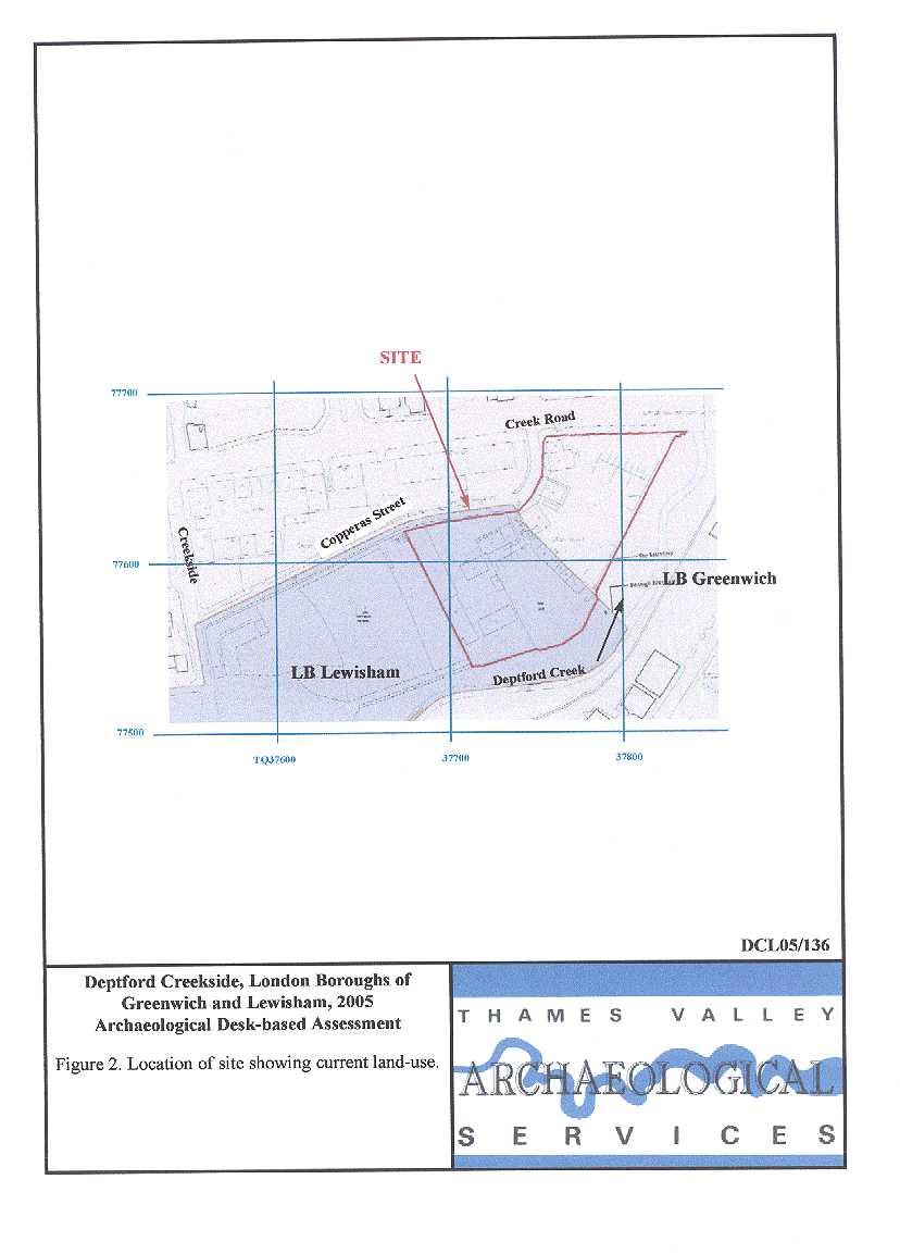
3 Deptford Creekside, Greenwich, London Boroughs of Greenwich and Lewisham An Archaeological Desk-Based Assessment by Steve Preston Report 05/136 Introduction This desk-based study is an assessment of the archaeological potential of a parcel of land on the north side of Deptford Creek, Greenwich, straddling the London Boroughs of Greenwich and Lewisham (TQ ) (Fig. 1). The project was commissioned by Mr Gerry Cassidy of Hepher Dixon, Bridewell Gate, 9 Bridewell place, London, EC4V 6AW on behalf of Ampurius NuHomes Investments Ltd, PO Box 290, Investec House, La Plaiderie, St Peter Port, Guernsey, GY1 3RP. It comprises the first stage of a process to determine the presence/absence, extent, character, quality and date of any archaeological remains, which may be affected by redevelopment of the area. Site Description, Location and Geology The site comprises an irregular parcel of land c. 1 hectare in area, between Creek Road and Copperas Street to the north, and Deptford Creek to the south (Fig. 2). The site lies at a height of approximately 5.5m above Ordnance Datum. According to the British Geological Survey, the site lies on alluvium, which is a part of the drainage network of Deptford Creek, with Upper Chalk beneath (BGS 1981). Deptford Creek flows along the site s southern and eastern boundary to its confluence with the Thames just to the north. A visit revealed that the site is occupied by a cement yard, wharves and numerous small structures, including an electricity sub-station. It is not known if any of the structures contained basements. Planning Background and Development Proposals Planning permission is to be sought for the redevelopment of the site for residential, commercial and cultural use. Initial schemes (Figs. 12 and 13) entail five blocks with variable heights up to ten storeys with commercial/retail accommodation on the ground floor and basement car-parking. The scale of the proposal requires an environmental statement to accompany the application. Archaeology and Planning (PPG ) provides guidance relating to archaeology within the planning process. It points out that, where a desk-based assessment has shown that there is a strong possibility of significant archaeological deposits in a development area, it is reasonable to provide more detailed information 1
4 from a field evaluation so that an appropriate strategy to mitigate the effects of development on archaeology can be devised: Paragraph 21 states: Where early discussions with local planning authorities or the developer s own research indicate that important archaeological remains may exist, it is reasonable for the planning authority to request the prospective developer to arrange for an archaeological field evaluation to be carried out... Should the presence of archaeological deposits be confirmed further guidance is provided. Archaeology and Planning stresses preservation in situ of archaeological deposits as a first consideration as in paragraphs 8 and 18. Paragraph 8 states:...where nationally important archaeological remains, whether scheduled or not, and their settings, are affected by proposed development there should be a presumption in favour of their physical preservation... Paragraph 18 states: The desirability of preserving an ancient monument and its setting is a material consideration in determining planning applications whether that monument is scheduled or unscheduled... However, for archaeological deposits that are not of such significance it is appropriate for them to be preserved by record (i.e. fully excavated and recorded by a competent archaeological contractor) prior to their destruction or damage. Paragraph 25 states: Where planning authorities decide that the physical preservation in situ of archaeological remains is not justified in the circumstances of the development and that development resulting in the destruction of the archaeological remains should proceed, it would be entirely reasonable for the planning authority to satisfy itself... that the developer has made appropriate and satisfactory provision for the excavation and recording of remains. Further guidance is provided by the London Borough of Greenwich Unitary Development Plan (LBGUDP 1994) LB Greenwich Policy D27A: At identified sites of known archaeological remains of national importance, including scheduled monuments, there will be a presumption in favour of the physical preservation of the remains in situ and to allow for public access and display. For sites of lesser importance the council will seek to preserve the remains in situ, but where this is not feasible the remains should be either excavated and removed from the site, or excavated and recorded before destruction. Appropriate conditions/legal agreements may be used to ensure this is satisfied. Policy D27B: The Council will expect applicants to properly assess and plan for the impact of proposed developments on archaeological remains where they fall within Areas of Archaeological Potential as defined on the constraints map 10. In certain instances preliminary archaeological site investigations may be required before proposals are considered. The Council will seek to 2
5 secure the co-operation of developers in the excavation, recording and publication of archaeological finds before development takes place by use of planning conditions/legal agreements as appropriate. The site falls within the Borough s Area of Archaeological Potential (LBGUDP 1994, map 10). Both the wording of the policies and the Area of Archaeological Potential map in the second deposit draft of the forthcoming Unitary Development Plan (April 2004) are unaltered though the policy numbers would now become D29A and D29B respectively. The Borough of Lewisham provides no specific guidance on archaeology within the borough, but has designated Areas of Archaeological Priority (LUDP 1996). The Plan notes English Heritage and DoE policy; presumably implying that a similar stance will be taken by the Borough: 31) Although the Borough does not currently contain any Areas of Archaeological Importance nor Scheduled Ancient Monuments (within the meaning of section 33 of the Ancient Monuments and Archaeological Areas Act, 1979) there are a number of areas in the Borough where important archaeological remains have been found, and where more may yet be found. 32) The Borough contains a rich archaeological resource spanning the full history of human activity in the British Isles. The Council, on the advice of the Museum of London s Archaeology Service and the Kent Archaeological Rescue Unit, has identified a number of Areas of Archaeological Priority. Their location are illustrated on the Proposals Map, and details are set out in Schedule 3. They cover Roman remains found along the lines of the two Roman roads which ran through the Borough, through Anglo-Saxon and settlement sites, mainly beside rivers, to Deptford s strategic role as a shipbuilding centre and later Victorian county houses in what were then green field sites within the Borough. 33) Items of archaeological importance are not always to be found buried underground, but can also include buildings with social and historical significance. The protection, excavation, removal and storage of valuable remains is becoming increasingly difficult given the pace and scale of modern development. There is a mismatch between the rate of discovery and the facilities and financial resources available to remove and store the finds. 34) Accordingly, the current approach of the DoE and English Heritage is to ensure that potentially important sites are identified and evaluated prior to development, and that any significant remains are preserved in situ and not destroyed by the development. In this way their preservation for the future is secured despite being inaccessible for the time being. Where it is not practicable to preserve remains in situ, consideration will be given to their excavation and recording prior to their destruction by development. 35) The potential damage from development can be reduced by appropriate land use policies, and many of the Areas of Archaeological Priority are designated for open space. The site lies within an Archaeological Priority Area (Deptford/Deptford Creek) (LUDP 1996). Methodology The assessment of the site was carried out by the examination of pre-existing information from a number of sources recommended by the Institute of Field Archaeologists paper Standards in British Archaeology 3
6 covering desk-based studies. These sources include historic and modern maps, the Greater London Sites and Monuments Record, geological maps and any relevant publications or reports. Archaeological Background General background The lower stretch of the Thames Valley is rich in finds of many periods (Williams and Brown 1999). Many archaeological deposits, covering extensive tracts of the gravel terraces north of the estuary, have been discovered by aerial photography but the nature and extent of occupation and use of lower-lying areas has only come to light in more recent times. River margins, creeks and inlets, including those of the Thames, were preferred areas of settlement in earlier periods, but study of this use is hampered by subsequent inundation due to a rise in sea level and the deposition of deep alluvium. Fieldwork has, nevertheless, located areas of occupation with good preservation of organic remains typified by the examples of wooden trackways laid down to cross low-lying ground in the Bronze Age and earlier (Meddens 1996). The areas of higher ground (e.g. gravel terrace margins) overlooking lower-lying, seasonally-flooded land are a preferred topographic location for occupation. In this context, it should be noted that the site lies on the alluvial and tidal floodplain of the Ravensbourne River (Deptford Creek), close to its confluence with the Thames. The recent comprehensive survey of the archaeology of greater London (MoLAS 2000) shows remarkably few prehistoric finds from Greenwich or Lewisham as a whole, and none particularly close to the proposal site. Roman finds are more plentiful but still only a background scatter, mainly concentrated along the valley side to the south. At least one building with tessellated pavement, and a cremation burial, are known from just south of the area. The later history of the area is that of the development of Saxon and medieval Deptford on the west side of Deptford Creek, especially the development of the shipbuilding industry. This became of particular prominence with the establishment of Henry VIII s naval dockyard in 1513, Deptford becoming the most important dock on the Thames. In the medieval period as for the north bank of the Thames, a rising sea level caused extensive flooding and much energy was devoted to land reclamation and flood defence works (Steele 1999). Until very recently, very little Saxon archaeology had been recorded in either Greenwich and none in Lewisham (MoLAS 2000). 4
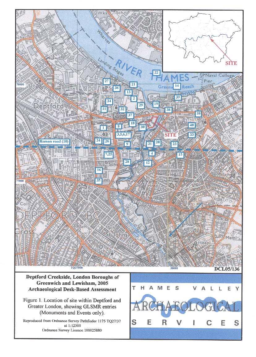
7 Greater London Sites and Monuments Record A search of the Greater London Sites and Monuments Records (GLSMR) was made on 13th December 2005 for a 500m radius of the site This produced 188 entries, 95 of which are for listed buildings. The archaeological entries are summarized in Appendix 1; the locations of these entries are shown on Figure 1. There were no entries for the site itself. There are relatively few entries relating to finds that pre-date the post-medieval period. The listed building information has been summarized below; none of the listed buildings are close to the site and their locations have not been plotted on Figure 1. Prehistoric The earliest entries for the search radius are for a number of Mesolithic stone tools (17 entries, mainly axes) all from the Thames [Fig. 1: 14]. The location given for these is only a generic guide as the actual findspot may be largely irrelevant, many could have been rolled downstream for any distance and they need not indicate particularly rich Mesolithic remains in the area, although, as noted above, other evidence does indicate this may be the case. A single Neolithic polished stone axe [39] is the only dated entry for the rest of prehistory in the search area. Excavations on Deptford Broadway [35] recorded a pit which contained a single flint blade and a fragment of saddle quern; it is possible this indicates prehistoric occupation, but it is hardly conclusive. Roman Roman findspots are more plentiful but there is little positive evidence of occupation in this period. The findspot of a copper-alloy box from the Thames is recorded to the north [39], along with that of a bronze lamp [1], a single coin [2] and part of a military helmet [14]. Two locations are for finds of Roman pottery [22, 23]. One excavation in the area [29] recovered evidence that might indicate Roman occupation, although the finds all seem to have come from a reworked brickearth deposit. The line of the Roman road from Canterbury to London (Watling Street), which roughly follows the line of the A2 [10] is reasonably well known to the east but is lost through the Deptford area, although it might be expected that the bridging point across the creek is close to the historic location of Deptford Bridge just to the south of the study area. Saxon By contrast there are only two entries for the Saxon period. One of these is the general reference to the placename [26]; this entry notes speculation that any early Saxon settlement may have centred on Broadway and later Saxon settlement may have centred on St Nicholas Church. Excavation at Greenwich Reach [29] revealed a Saxon ditch. 5
8 Several entries are for the medieval period. Two for stray finds of medieval pottery [8, 9]. One notes the location of a medieval churchyard at St Alfege Passage [40] (St Alfege s Church itself is just beyond the search radius). Another records speculation that Deptford Green was a late medieval layout [26]. The excavation at Greenwich Reach uncovered what might be a medieval ditch and perhaps a river embankment [29]. Post-medieval Entries for post-medieval monuments and events are abundant. Structural remains dating to the 17th or 18th century were noted on a site thought to have housed a 17th-century kiln [3] and more certain evidence of a 19thcentury kiln on the same site. An evaluation and subsequent watching brief recorded the foundations of the 17thcentury Trinity almshouses [17] and demonstrated considerable post-wwii ground consolidation. Not to be confused with: Excavations at Greenwich Reach traced three phases of foundations for the Trinity House almshouses, known to have existed by the 16th century and plausibly older, although the excavated remains all appear to be later than this [29]. From the same site came a sequence of timber revetments and slipways associated with the Hon. East India Company s dockyards and various finds of this period. One entry [21] is for the docks mapped by Evelyn in 1623 (see below) and another for a gravel pit mapped by Rocque [28]. A churchyard boundary wall possibly dating from the 18th century has been recorded in a watching brief [25]. Later post-medieval structures include the railway bridge over Deptford Creek, closed in 1869 [4], an inn [5], a nonconformist meeting house [6], the Town Hall [7], cottages [9], a cemetery [11] (the SMR entry for this is for actually negative evidence from a site visit but the former presence of a cemetery is also noted), a sewage works and pumping station dating from 1865 [12], the site of the world s first central power station [13] an early 19th-century gasworks [19] and a larger later 19th-century gasworks [20]. At the limit of the search radius to the west is a listing for a cemetery of uncertain origins [24] alongside the location of the former baroque rectory of St Paul s (demolished in 1894). A watching brief at St Nicholas s church [32] also revealed part of a brick vault and human remains. Wall remains and various partial structures from the 17th or 18th centuries were also recorded in an evaluation to the north-west [34] and watching briefs [36, 37]; more substantial 18th- and 19thcentury structures and features were recorded in an evaluation to the south-east [23, 38], including some associated with the railway terminus. Excavations and evaluations have produced stray post-medieval finds from the north-west of the study area [27], from just across the creek [31], and elsewhere [23, 33]. Close to the site, archaeological work has recorded 19th-century backfilling of a possibly 18th-century gravel pit [18], with later building and possibly a burial vault, while evaluation adjacent to the site revealed only 6
9 post-medieval drainage channels, 19th-century building foundations, part of a 20th-century dock-wall, and undated alluvium [30]. Undated, unknown, negative Very few of the SMR entries record undated events or investigations which produced no archaeological remains [11, 16]. These include recent excavations [7] which produced unspecified post-medieval evidence, and the Thames foreshore survey which revealed the extent of (undated) build up of both alluvium and made ground, which might seal and protect archaeological layers [4]. Investigations which produced only 19th century remains are listed under post-medieval above. Historical Background Greenwich was first documented in AD964 as Grenwic (green port or harbour, from the Old English) and is mentioned in Domesday Book (Grenviz) (Mills 1998). It gave its name to the hundred until Edward I s time when the hundred name became Blackheath. At the time of Domesday it was held by the Bishop of Lisieux from the Bishop of Bayeux. It is assessed at 2 sulungs. There is land in demesne for 2 ploughs; 24 villans have 4 ploughs and there are 4 bordars, 1 cottar and 5 slaves. There are 4 mills rendering 70s, 22 acres of meadow, 40 acres of pasture and woodland for 10 pigs. These 2 sulungs at the time of King Edward were two manors one held by Earl Harold and one by Beohtsige but are now one. They were worth 8 and are no worth 12 (Williams and Martin 2002, 16). (The sulung was a peculiarly Kentish unit of assessment; it appears to have been equivalent to two hides.) The settlement was also known as East Greenwich to distinguish it from Deptford west of Deptford Creek. Greenwich was no more than a settlement based on fishing in medieval times and not until post-medieval times did its prosperity rise with the creation of Greenwich Park, the Observatory and the Naval School (Hasted 1801, 372). Deptford is an Old English name first mentioned in AD 1293, and meaning deep ford. It does not appear separately in Domesday Book. Deptford was originally called Mereton or Meretun town in the marsh (Dunkin 1854) and it is impossible to know if it was this Merton or one of many others which was first mentioned in the Anglo-Saxon Chronicle for AD 871 (Swanton 2000, 47; 71). It was a location frequented by the Danes during their incursions in the 9th, 10th and 11th centuries. By the period it was known as Depeford, and was also known as Depeforde Strand alias West Greenwich, the former reflecting fishing activities on the banks of the Thames. Other variations on the name are Depevorde (1395), Detford ( ), Dedford (1648), Depthorde (1673) and Depforde (1554). Deptford was described as a large and populous 7
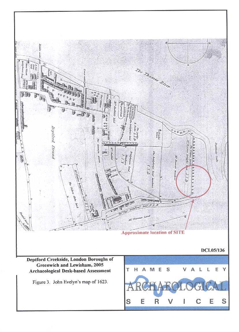
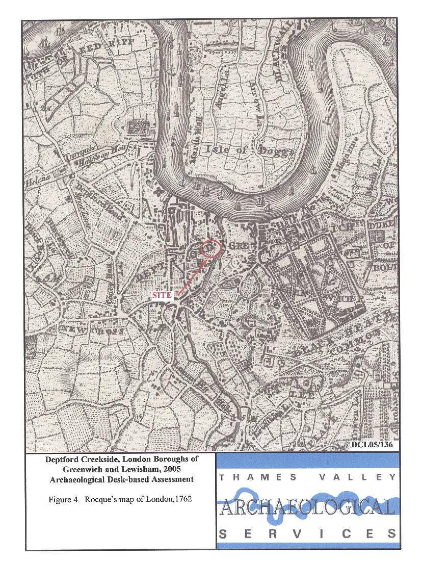
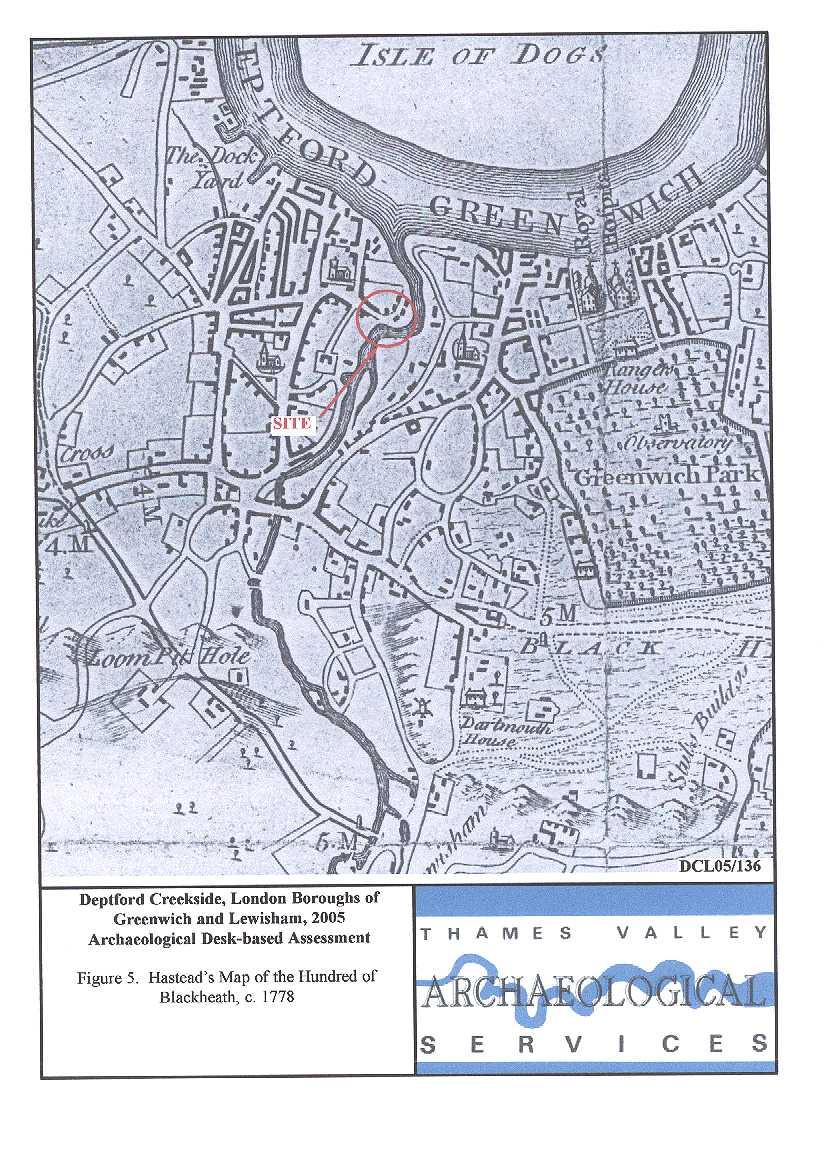
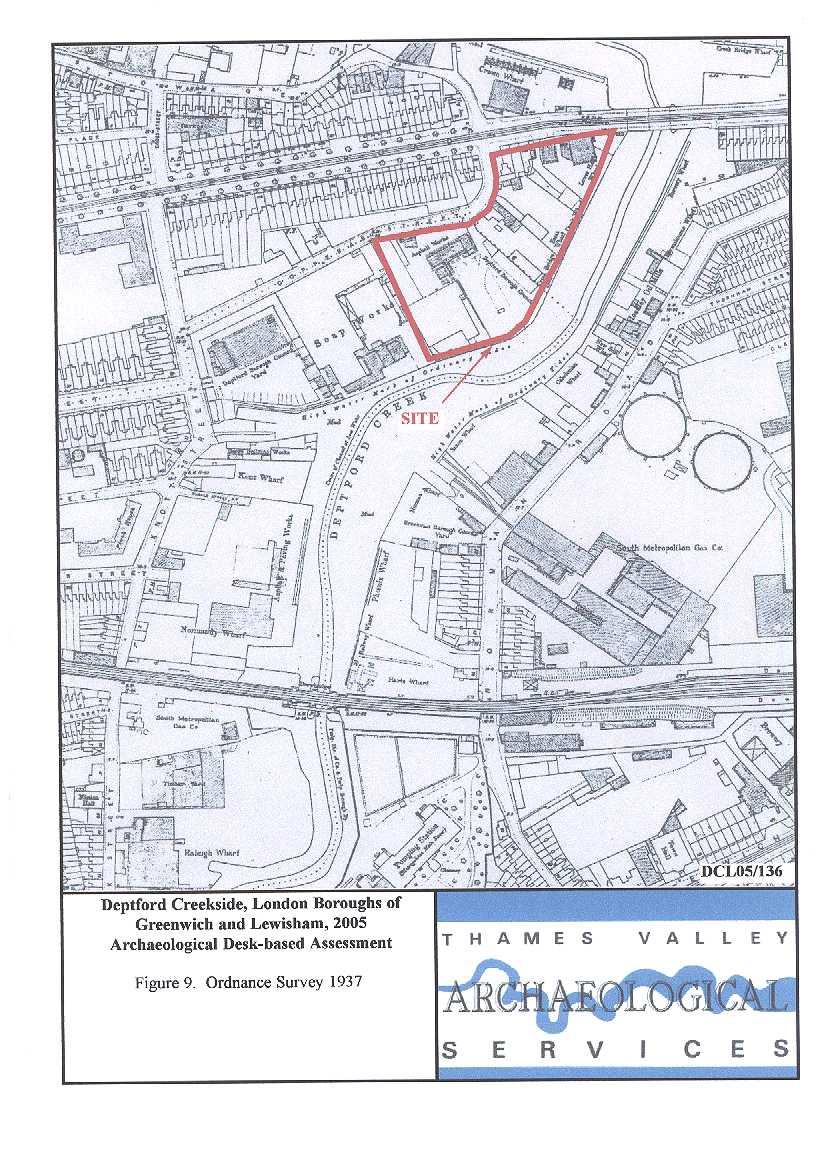
10 town in c. 1778, with 2000 houses despite the lack of a market. The industry was based on shipping and the docks; Henry VIII built a dockyard in The area further up the river Ravensbourne from Deptford Bridge was noted for its corn mills. Creek Road, on the northern flank of the site, is a relatively modern route and the creek bridge was a footbridge in 1804 and a road bridge in The modern swing bridge with control tower was built in 1954 (Spurgeon 1997). A search was made of the historic photographic collection of Greenwich Local Studies Library, including a published source (Sturdee 1895), but no photographs of the site were located. Cartographic and Documentary Sources A range of Ordnance Survey and other historical maps of the area were consulted at Greenwich Heritage Centre in order to ascertain what activity had been taking place throughout the site s later history and whether this may have affected any possible archaeological deposits within the proposal area (Appendix 2). The earliest map consulted was a detailed map of Deptford by John Evelyn dated 1623 (Fig. 3). This only includes a part of the proposal site and is centred on the historic core of Deptford. The site lies at the very edge of the map, to the east of the historic core on what appears to be farmland at the rear of plots fronting Church Street. John Rocque s map of London dated 1762 (Fig. 4) shows Deptford at a small scale. The area of the site can be located relative to the road pattern in Deptford and from the Creek. Creek Road can also be identified with reasonable confidence. However, there is little information shown for the site itself, which was presumably farmland at this time. Hawksmoor s map of 1728 does not show the site but although the line of Creek Road and even a bridge over Deptford Creek are indicated, these seem to be a later addition to this copy of the map. Hastead s Map of the Hundred of Blackheath dated c shows Deptford at a larger scale (Fig. 5) (Hasted , 339ff). The Stowage and Creekside can be identified to locate the area of interest on the map. Creek Road is not yet in place and there is no bridge over the creek at this location. The area of the site itself is shown as partly built up, but clearly still on the edge of the main occupation area centred around the dockyard and church to the west. The cartography on this map is inferior to Rocque s and it is unclear how far it can be trusted in detail. A map of 1800 by Milne shows even less detail for the site which appears to be mudflats but supports Hastead in showing no bridge (not illustrated). A tithe plan for Greenwich in 1838 does not extend to cover the area of the site but does indicate that the bridge had been built by this date and Creek Road (Bridge Street) existed to the east; presumably it extended west of the bridge also. 8
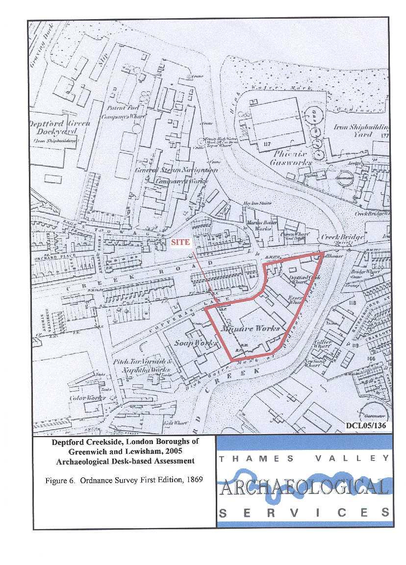
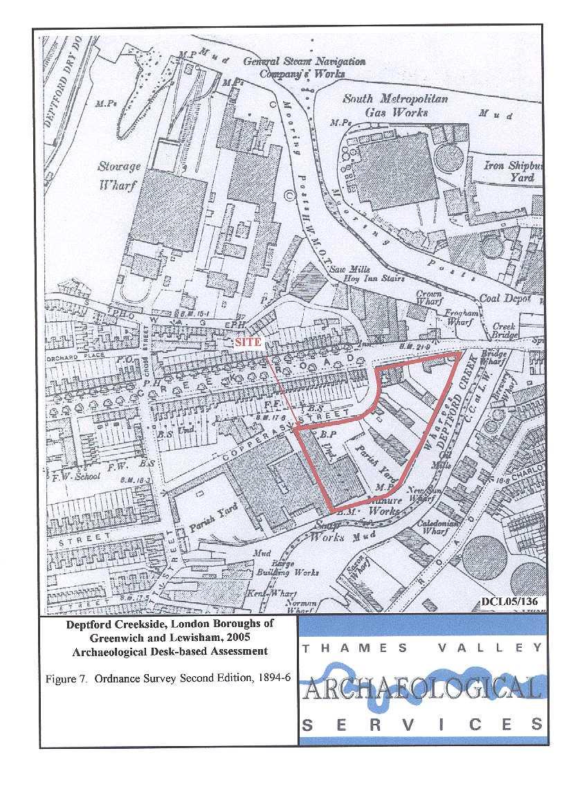
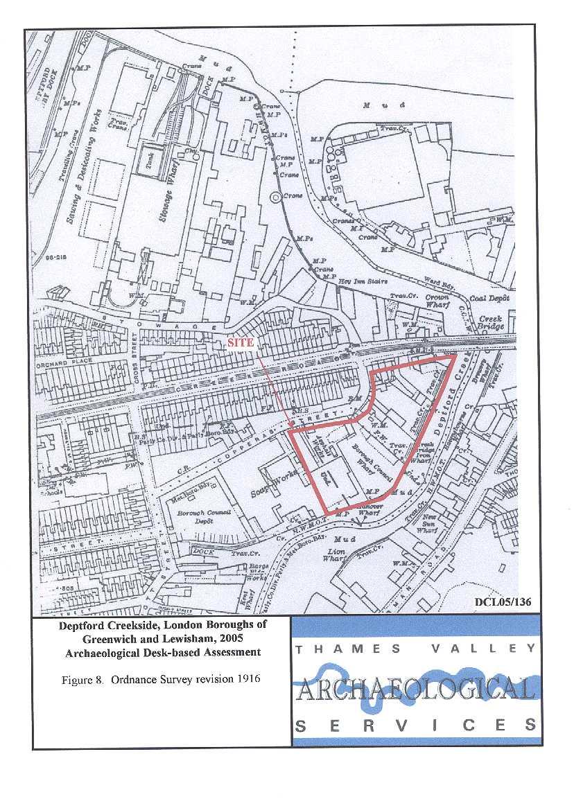
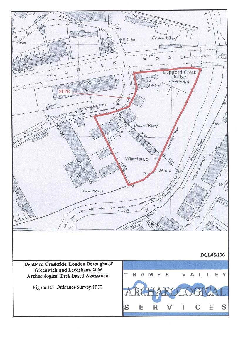
11 As there are no Tithe or Enclosure maps for Deptford, the next map consulted was the First Edition of the Ordnance Survey dated 1869 (Fig. 6). This shows that considerable changes had been made to the area in the intervening period, with Creek Road and Creek Bridge in place, as well as Copperas Street (Lane). There is now considerable urban development with housing fronting Creek Road, and industrial works along the riverfronts. To the south of Copperas Street were factories making soap and varnish (outside the site area), and on the site, a manure works and two further wharves. At the extreme north-east was a toll house for the swivel bridge. It is likely that the whole area would have been built up at this time to facilitate the building of Creek road up to the bridging point and provide a barrier to flooding from the creek. On the Second Edition Ordnance Survey map (1894) there is relatively little change, with some infilling of gaps with terraced houses and a reduction in the size of the area occupied by the manure works (Fig. 7). By 1916 (Fig. 8) there were few changes to the ground plans but the manure works had become an asphalt works and the wharves were serviced by travelling cranes. There is no further change by 1937). There were significant changes to the site after the Second World War and by 1970, all of the terraced housing along Creek Road, including that on the site, had disappeared and been replaced in part by larger industrial buildings and an electricity substation (Fig. 9). Most of the other buildings on the site have also been remodelled or replaced but in largely the same locations. The current map (Fig. 2) shows little change from Listed Buildings There are 95 entries for listed buildings within 500m of the site in the Greater London Sites and Monuments Record, although this includes several listed twice, and some three times. None are on the site itself and the closest is some 200m to the south. It is unlikely that any development on the site could have any effect on a listed building. The listed buildings in the search radius include: all of Albury Street (most 18th century; but 45 now demolished); a public house on Brand Street; , 136 8, 165 7, 187 and Greenwich High Road; the public library, coal sheds, a boiler house, almshouse, telephone box and railway station, all on Greenwich High Road; 1 15 and 71 3 Greenwich South Street; churches at Deptford High Street (18th century) and Deptford Green (16th century in part); the Town Hall on Royal Hill (now offices); a school on Roan Street; discrete stretches of wall at Bardsley Lane, St Alfege Passage, Watergate Street, Deptford High Street, Deptford 9
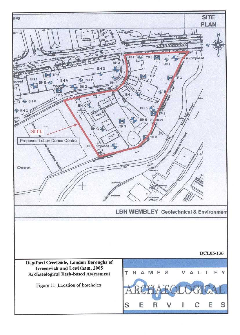
12 Green and Deptford Church Street; the railway viaduct at Norman Road; a memorial to Margaret McMillan on McMillan Street; and, finally, a cast-iron parish boundary marker on Borthwick Street. Almost all of the buildings are grade II listed; Albury Street has a number at grade II* and the charnel house associated with the church at Deptford Green is also II*. The Hawksmoor church on Deptford High Street is grade I listed. All of the listed buildings entries in the SMR give the date of the buildings as pre-1900; this is clearly misleading in a number of cases. Boreholes A series of boreholes and test pits have been dug across the site as a part of a previous development proposal. These are presented in Appendix 3 and their locations shown on Fig. 11. Typically, 2.4m to 3.5m of made ground is present above alluvium (grey clay). Gravel was present at a depth of 1.8m, 3.4m and 4.0m in boreholes off the present site to the west, whereas in others on the site itself (e.g. boreholes F, G) gravel was not encountered at a depth of 5m. Peat deposits also noted in boreholes to the north-west do not appear in any borehole on the site itself. Discussion There are two issues which need consideration in recommending a suitable course of action for this proposal: the likelihood of the presence of archaeological deposits on the proposal site and whether these would have survived later disturbance; and the impact of the proposed new development on relevant archaeological levels. The site comprises a large parcel of land in an urban setting situated within an area of archaeological potential shown on Borough constraint maps. It is east of the historic core of Deptford and was farmland in 1623, and probably continued as such until the 19th century. The archaeological potential, therefore, reflects the possible presence of prehistoric, Roman and Saxon occupation sites, rather than later periods. There is little to suggest truncation of archaeologically relevant levels, unlike an area to the immediate west that appears to have been quarried; rather the area will have been built up successively, probably ever since its first occupation. Archaeologically relevant levels may therefore be buried beneath both made ground and alluvium, which commonly began accumulating in this area from Roman period. The presence of alluvium and waterlogged deposits may lead to better preservation conditions than for dry-land archaeological sites; recent discoveries both to the north (MoLAS 2000, 99) and the south (Hammond forthcoming) of the site have come from below considerable depths of made ground and alluvium. 10
13 The entire proposal area is to have basement car-parking (Figs 12 and 13), which inevitably means total destruction to the basement level, and presumably piling beneath. The borehole logs indicate that the basement level will be mainly or entirely within made ground levels and might not affect any archaeologically relevant horizon. The borehole coverage, however, indicates relatively wide variations in the local depth of the made ground, and it would be prudent to establish the depth of made ground over a larger portion the site as a whole. Natural gravel was not encountered in any borehole on this site, despite most reaching depths of around 5m, but archaeology could also be contained within the alluvial levels which are present to considerable depths. It is recommended that further information about the potential of the site from field evaluation would be appropriate. This would provide detailed information on the archaeological potential of the site so that a scheme to mitigate the impact of development on any below-ground archaeological deposits could be drawn up. A scheme for this evaluation will need to be devised and approved by the Greater London Archaeological Advisory Service, which advises the London Boroughs on archaeology, and secured such as by a condition on any planning consent gained. It would need to be implemented by a competent archaeological contractor, such as an Institute of Field Archaeologists Registered Organisation. References BGS, 1981, British Geological Survey, 1:50,000, Sheet 270, Solid and Drift Edition, Keyworth Dunkin, A J, 1854, A History of Deptford, London Hammond, S, forthcoming, A Bronze Age burnt mound and burial at Deals Gateway, Deptford (Archaeologia Cantiana) Hastead, E, 1801, The Historical and Topographical Survey of the County of Kent, London (reprint 1972) LBGUDP, 1994, London Borough of Greenwich Unitary Development Plan, adopted 1994 Meddens, F M, 1996, Sites from the Thames estuary, England, and their Bronze Age use, Antiquity, 70, Mills, A D, 1998, Dictionary of English Place-Names, Oxford MoLAS, 2000, The archaeology of Greater London; an assessment of archaeological evidence for human presence in the area now covered by Greater London Museum of London Archaeology Service Monogr PPG16, 1990, Department of the Environment Planning Policy Guidance 16, Archaeology and Planning, London Spurgeon, D, 1997, Discover Deptford and Lewisham, Greenwich Steele, J, 1999, Deptford Creek, surviving regeneration, London Sturdee, T, 1895, Reminiscences of Old Deptford, Greenwich Swanton, M, 2000, The Anglo-Saxon Chronicles, London Williams, A and Martin, G H, 2002, Domesday Book, A complete Translation, London Williams, J and Brown, N (eds), 1999, An Archaeological Research Framework for the Greater Thames Estuary, Chelmsford 11
14 APPENDIX 1: Sites and Monuments Record entries No SMR Ref Grid Ref (TQ) Type Period Comment 1 MLO Findspot Roman Bronze lamp May be river find. Found c MLO Findspot Roman Roman coin 3 MLO2025 MLO MLO Documentary reference, excavation Post 4 MLO Building Post MLO75674 ELO176 Documentary evidence for 17th century kiln. Brief investigation in 1969 revealed late 17th/early 18th century brick walls, mortar flooring. Red brick walls, pit lined with bricks, oil jars, chimney pots and tiles. Railway bridge Shut Survey N/a Foreshore survey showed c 2m of made ground, over layers of alluvium and in some cases peat. It concluded overall that there is great potential for archaeology here. Enables the tracing of former creek channels. 5 MLO Building Post Inn, public house, assembly rooms 6 MLO Building Post Nonconformist meeting house 7 MLO , Excavation, Building Post No details on the excavation results. Town hall MLO MLO Findspot Jug 9 MLO11370 MLO Findspot Building to Post pot fragments Late c19th cottages 10 MLO Road Roman Exact route unknown. 11 MLO Cemetery Post Redeveloped MLO71613 ELO Negative evidence Modern Watching brief. Two late c19th walls & Modern dumping 12 MLO Buildings Post Pumping station, sewage works 13 MLO Buildings Post Site of world's first central power station. 14 MLO Findspot Mesolithic 11 Tranchet axes, picks, blades/flakes, 1 axe/adze MLO26733 MLO MLO MLO26832 MLO27020 MLO27038 MLO Findspot Roman Bronze handle from legionary helmet 16 MLO61855 ELO Watching brief Negative evidence 17 MLO62909 MLO64181 MLO64183 ELO , Watching brief Evaluation Post 18 MLO Recording work Post The foundations and gardens of the 17th century Trinity Almshouses. Modern consolidation deposits. 19th century backfilling of large gravel pit, perhaps 18th century; 19th century cellar; possible burial vault, 2 skeletons Gas works 1820s 19 MLO Documentary reference Post 20 MLO Documentary reference Post Gas works 1880 to 1930s. 21 MLO Documentary reference Post Two docks on John Evelyn's map of MLO Findspot Roman Abraded Roman pottery and tile 23 MLO Findspot Roman Fragments of an Arretine cup MLO Findspot Post Fragments of 17th century material from colluvium. 31, MLO75720 late 18th and early 19th century pits. 19th/20th ELO2390 century cellar. Brick footings of the original MLO77823 ELO MLO70523 MLO71959 Greenwich Railway Terminus dating to Evaluation Post medieval Extensive truncation. Brick footings associated with the Greenwich Railway Terminus. Remains of other 19th century cellars Documentary reference Post Cemetery. Also rectory to St Paul's Designed and built in Baroque style by Thomas Archer under supervision of Hawksmoor, demolished in
15 No SMR Ref Grid Ref (TQ) Type Period Comment 25 MLO ELO Footpath, Building Post Watching brief. Footpath footings of the churchyard boundary wall, possibly of c18th date, with rebuilds 26 MLO71960 MLO71963 ELO Documentary reference Saxon, The placename Deptford is Anglo Saxon. Speculation that the Broadway area may have been the focus of settlement in early to mid Saxon period and St Nicholas church area in mid to late Saxon period. Speculation that Deptford Green was a late medieval feature. 27 MLO Rescue excavation Post Large quantity of bone, clay pipes, leather shoes, pottery and glass. No details 28 MLO Documentary reference Post Gravel pit located from Rocque s map. 29 MLO ELO MLO ELO MLO75171 ELO MLO75719 ELO MLO75953 ELO MLO76202 ELO MLO76306 ELO838 ELO MLO MLO Excavation Roman, Saxon,, Postmedieval Evaluation Post Evaluation Post Watching brief Post Excavation Roman pottery dating from AD from a layer of reworked brickearth, possibly a ploughsoil. A 2.3m depth of alluvium, possibly dating to the Roman period. Saxon ditch. Possible medieval ditch and possible medieval river embankments. The remains of three major phases of Trinity House almshouses: two phases in the late 18th century and one from the 17th along with fragmentary remains of another two buildings. A sequence of timber revetments and slipways associated with the East India Co shipbuilding dockyard were recorded, also several dumps of post-medieval industrial debris. pre-18th century alluvium, post-medieval drainage channels and brick foundations for a 19th century boiler house and part of an early 20th century barge dock-wall a compacted deposit of crushed chalk (?a yard surface) was sealed by a 19th century deposit of ashy waste. Heavy disturbance in modern times and ground raising dumps probably associated with 19th century industrial activity. top corner of a red brick vault near the southeast corner of the church and also a human burial. Charnel in all deposits indicated that the ground had been used as a graveyard over a long period Occupation layer Post medieval Late 19th century construction/ demolition trample layers ?Watching brief Post medieval Three red brick wall footings and surface of red floor tiles were found. A curved wall may have been part of a well or soakaway Pit Late A pit produced a fragment of a saddle-quern and a Prehistoric struck flint blade < Postmedieval An 18th century circular brick-lined well A bricklined and clay mortar 18th century cess pit and a 18th century fireplace. A red brick culvert truncated two walls (18th to 19th century). basement or cellar area of a 19th to 20th century building 37 MLO77434 ELO ? Post medieval 18th and 19th century masonry (walls and foundations) and late makeup layers 38 MLO77904 MLO ELO Watching brief Post /Mo dern 19th and 20th century brick and metal structures, Redeposited alluvium. 19th century made ground deposits and revetments. ELO MLO Findspot Neolithic, Ground flint axe and Bronze box MLO26750 Roman 40 MLO Churchyard 13
16 Listed Buildings (Not plotted on Fig. 1) MonumentID Grid ref (TQ) Period Description MLO Post Terraced houses MLO Post Telephone box MLO Post Greenwich Railway station MLO Post Almshouses founded 1576, rebuilt 1819 MLO th Century to Post Church Restored after war damage. C1500 tower is scheduled. Bell-chamber is modern. Foundation of present c17th church excavated. Original west entrance located and foundations of medieval stone tower seen. skeleton and post-med finds recovered. MLO Post School Built 1808 MLO Post Early 18th c house MLO Post Charnel house Scheduled as "watch-house" Probably contemporary with church (1697). MLO Post Terraced House demolished MLO Post Terraced house MLO Post Terraced house MLO Post Terraced house MLO Post Terraced house MLO Post C19th Pottery kiln MLO Post Terraced house MLO Post Late 17thc brick wall with stone gate piers with skull finials. MLO , , Post Terraced houses MLO Post Semi detached house MLO Post House incorporated into railway station. MLO Post Semi detached house MLO , , Post Terraced houses MLO Post Railings, gate MLO Post Terraced house MLO , Post Terraced houses MLO , , , , Post Terraced houses MLO , Post Terraced houses MLO Post Terraced house MLO , Post Terraced house MLO Post graveyard wall MLO Post Railings, wall MLO Post Terraced house MLO Post Street of terraced houses. Laid out MLO Post Terraced house MLO Post Terraced house MLO Post Mid C19th Coal sheds MLO , Post Terraced house MLO Post Terraced house MLO Post Boiler house, engine house Opened 1865 and extended MLO Post Walls date to second half c17th and gate piers to early c19th MLO Post Wall MLO Post Public library MLO Post Cast-iron Parish boundary marker MLO Post Church school, c MLO , , , , , , , , Post Four pairs of houses, MLO Post Memorial to Margaret Mcmillan ( ), probably erected 1937/8 MLO Post Wall to the former Deptford Dockyard. 18th century MLO Post Public house MLO Post Railway viaduct construction authorized 1833; railway opened to Greenwich
17 MonumentID Grid ref (TQ) Period Description MLO , Post Houses , , MLO6603, , Post Terraced house Late 19th c shop extensions on ground floor. MLO MLO , Post House MLO Post Church Constructed
18 APPENDIX 2: Historic and modern maps consulted 1623 John Evelyn, map of Deptford (Fig. 3) 1728 Hawksmoor, Plan of the Manor of Greenwich 1762 John Rocque (Fig. 4) 1778 E Hastead, Map of the Hundred of Blackheath (Fig. 5) 1800 Milne, The Peckham area 1869 First Edition Ordnance Survey, London sheet LVIII 25 (Fig. 6) Second Edition Ordnance Survey, London sheet XCII 25 (Fig. 7) 1916 Third Edition Ordnance Survey, London sheet XI 25 (Fig. 8) 1937 Ordnance Survey, London sheet XII.2I 25 (Fig. 9) 1952 Ordnance Survey, TQ : Ordnance Survey, TQ3777NE 1:1250 (Fig. 10) 1994 Ordnance Survey, TQ 3877NW 1:1250 (Fig. 2) 16
19 APPENDIX 3: Borehole logs provided by LBH Wembley 17
20
21
22
23
24
25
26
27
28
29
30
31
32
33
34
35

36

37
Garage Site, Foots Cray High Street, Sidcup, Kent, London Borough of Bexley
 Garage Site, Foots Cray High Street, Sidcup, Kent, London Borough of Bexley An Archaeological Evaluation for Mizen Design Build by Andy Taylor Thames Valley Archaeological Services Ltd FOC 07 September
Ivol Buildings, Woodcote Road, South Stoke, Oxfordshire
 Ivol Buildings, Woodcote Road, South Stoke, Oxfordshire An Archaeological Watching Brief For Christ Church, Oxford by Pamela Jenkins Thames Valley Archaeological Services Ltd Site Code IBSS 04/03 March
Meales Farm, Sulhamstead, West Berkshire
 Meales Farm, Sulhamstead, West Berkshire An Archaeological Watching Brief For Mr. Robert Astor by Steve Ford Thames Valley Archaeological Services Ltd Site Code CHH02/29 May 2002 Summary Site name: Meales
New Swimming Pool,West Meon House, West Meon, Hampshire
 New Swimming Pool,West Meon House, West Meon, Hampshire An Archaeological watching brief and building recording for Mr and Mrs Younger by Danielle Milbank Thames Valley Archaeological Services Ltd Site
New Media Building, Goldsmiths College, New Cross, London Borough of Lewisham
 New Media Building, Goldsmiths College, New Cross, London Borough of Lewisham An Archaeological Evaluation for Willmott Dixon Construction by Andy Taylor Thames Valley Archaeological Services Ltd Site
Epsom Water Works, East Street, Epsom, Surrey
 Epsom Water Works, East Street, Epsom, Surrey An Archaeological Desk-Based Assessment for St James Homes Ltd by Steve Ford Thames Valley Archaeological Services Site Code ESE99/85 December 1999 Epsom Water
Newcombe House & Kensington Church Street
 Newcombe House & Kensington Church Street Archaeological Evaluation September 2017 Summary Site name: Newcombe House, Kensington Church Street, Notting Hill, London Grid reference: TQ 25318 80372 Site
Northbury Farm, Castle End Road, Ruscombe, Berkshire
 Northbury Farm, Castle End Road, Ruscombe, Berkshire An Archaeological Watching Brief For Sir Colin and Lady Southgate by Danielle Milbank Thames Valley Archaeological Services Ltd Site Code NFR 07/120
Chitty Farmhouse Extension, Wall Lane, Silchester, Hampshire
 Chitty Farmhouse Extension, Wall Lane, Silchester, Hampshire An Archaeological Watching Brief For In Touch by Andrew Mundin Thames Valley Archaeological Services Ltd Site Code CFS 08/52 May 2008 Summary
Land adjacent to Dingle Dock, Front Street, East Garston
 Land adjacent to Dingle Dock, Front Street, East Garston An Archaeological Watching Brief for Dr J Davies by Jo Pine Thames Valley Archaeological Services Site Code DEG99/82 January 2000 Summary Site name:
Appletree, Thames Street, Sonning Berkshire
 Appletree, Thames Street, Sonning Berkshire An Archaeological Watching Brief for Mr and Mrs A Popham by Sian Anthony Thames Valley Archaeological Services Ltd Site Code ATS 02/83 October 2002 Summary Site
Merrowdene, Earleydene, Sunninghill, Berkshire
 Merrowdene, Earleydene, Sunninghill, Berkshire An Archaeological Watching Brief For Mr and Mrs Jackson by Andy Taylor Thames Valley Archaeological Services Ltd Site Code MES 05/88 January 2006 Summary
Land at Downsview Avenue, Storrington, West Sussex
 Land at Downsview Avenue, Storrington, West Sussex An Archaeological Evaluation for Bellwinch Homes Limited by Andy Taylor Thames Valley Archaeological Services Ltd Site Code DAS 04/21 March 2004 Summary
ARCHAEOLOGICAL S E R V I C E S. Hurley Manor, High Street, Hurley, Berkshire. Archaeological Evaluation. by James McNicoll-Norbury
 T H A M E S V A L L E Y ARCHAEOLOGICAL S E R V I C E S Hurley Manor, High Street, Hurley, Berkshire Archaeological Evaluation by James McNicoll-Norbury Site Code: HMH14/51 (SU 8252 8378) Hurley Manor,
Bridge House, Ham Island, Old Windsor, Berkshire
 Bridge House, Ham Island, Old Windsor, Berkshire An Archaeological Watching Brief for Mr A Chadwick by Alan Ford Thames Valley Archaeological Services Site Code BHHI98/55 August 1998 Bridge House, Ham
Pinnocks Wood Equestrian Centre, Burchett s Green, Maidenhead, Berkshire
 Pinnocks Wood Equestrian Centre, Burchett s Green, Maidenhead, Berkshire An Archaeological Watching Brief For Mr David Eyles by Andrew Mundin Thames Valley Archaeological Services Ltd Site Code POB 08/69
ARCHAEOLOGICAL S E R V I C E S. Manor Farm, Launton, Bicester, Oxfordshire. Archaeological Watching Brief. by Aiji Castle. Site Code: LBO13/220
 T H A M E S V A L L E Y ARCHAEOLOGICAL S E R V I C E S Manor Farm, Launton, Bicester, Oxfordshire Archaeological Watching Brief by Aiji Castle Site Code: LBO13/220 (SP 6035 2285) Manor Farm, Launton, Bicester,
New horse training area, Manor Farm, Great Kimble, Buckinghamshire
 New horse training area, Manor Farm, Great Kimble, Buckinghamshire An Archaeological Watching Brief For Redwing Structures (Marlow) Limited by Andy Taylor Thames Valley Archaeological Services Ltd Site
Archaeology and Planning in Greater London. A Charter for the Greater London Archaeology Advisory Service
 Archaeology and Planning in Greater London A Charter for the Greater London Archaeology Advisory Service THE PURPOSE OF THE CHARTER This Charter sets out how English Heritage will provide archaeological
Archaeological Evaluation and Assessment of Land at Kent Cottage, 19 Chapel Street, Hythe, Kent
 Archaeological Evaluation and Assessment of Land at Kent Cottage, 19 Chapel Street, Hythe, Kent Planning Application Y13/0463/SH Date of Report: 29/04/2015 Report for Marc Carney SWAT. ARCHAEOLOGY Swale
Archaeological Investigation in advance of Development at 2 Palace Cottages, Charing Palace, Charing, Kent
 Archaeological Investigation in advance of Development at 2 Palace Cottages, Charing Palace, Charing, Kent Site Code CHAR-EV-14 NGR 95412 49439 Date of Report 18/12/2014 Swale and Thames Archaeological
6A St John s Road, Wallingford Oxfordshire
 6A St John s Road, Wallingford Oxfordshire An Archaeological Evaluation Stage 2 for Spearcliff Estates Ltd by Steve Ford Thames Valley Archaeological Services Ltd Site SJW03/116 January 2004 Summary Site
ARCHAEOLOGICAL S E R V I C E S. Land north of Orchard Close, Hallow, Worcestershire. Archaeological Evaluation. by Kyle Beaverstock
 T H A M E S V A L L E Y ARCHAEOLOGICAL S E R V I C E S Land north of Orchard Close, Hallow, Worcestershire Archaeological Evaluation by Kyle Beaverstock Site Code: OCW15/224 (SO 8285 5848) Land north of
30 48 Castle Street, High Wycombe, Buckinghamshire
 30 48 Castle Street, High Wycombe, Buckinghamshire An Archaeological Desk-Based Assessment for George Wimpey (West London) Ltd by Jennifer Lowe Thames Valley Archaeological Services Ltd Site Code CHW07/20
Old Town Hall, Market Place, Faringdon, Oxfordshire
 Old Town Hall, Market Place, Faringdon, Oxfordshire Building Recording and Archaeological Watching Brief for Great Faringdon War Memorial Trust by Jamie Preston and Steve Ford Thames Valley Archaeological
Archaeological evaluation at Willowdene, Chelmsford Road, Felsted, Essex
 Archaeological evaluation at Willowdene, Chelmsford Road, Felsted, Essex August 2013 report prepared by Ben Holloway on behalf of Mr Anthony McGurren Planning reference: UTT/13/0235 CAT project ref.: 13/07g
Oak Tree Fields, Spine Road, South Cerney, Gloucestershire
 Oak Tree Fields, Spine Road, South Cerney, Gloucestershire An Archaeological Desk-Based Assessment for Hills Minerals & Waste by Steve Ford Thames Valley Archaeological Services Ltd Site Code OTF04/73
Archaeological Evaluation and Assessment of Land at Minnis Beeches, Canterbury Road, Swingfield, Dover, Kent
 Archaeological Evaluation and Assessment of Land at Minnis Beeches, Canterbury Road, Swingfield, Dover, Kent NGR: TQ 6307 1545 Site Code: MB-EV-10 (Planning Consent Y10/0311/SH) Report for Thorndene Ltd.
An Archaeological Evaluation at Granta Cottages, Newmarket Road, Great Chesterford, Essex. August 2015
 An Archaeological Evaluation at Granta Cottages, Newmarket Road, Great Chesterford, Essex August 2015 by Pip Parmenter and Ben Holloway on behalf of Mr G Elmer and Mrs L King CAT project ref.: 15/06a NGR:
ARCHAEOLOGICAL S E R V I C E S. Becks, Park Lane, North Newington, Banbury, Oxfordshire. Archaeological Watching Brief.
 T H A M E S V A L L E Y ARCHAEOLOGICAL S E R V I C E S Becks, Park Lane, North Newington, Banbury, Oxfordshire Archaeological Watching Brief by Andy Mundin Site Code: BPN16/105 (SP 4207 3978) Becks, Park
Archaeological Monitoring of Land at 29 Royal Pier Road, Gravesend, Kent
 Archaeological Monitoring of Land at 29 Royal Pier Road, Gravesend, Kent Site Code ROY/WB/15 Report for Dr Maxted Date of report 06/10/2015 SWAT ARCHAEOLOGY Swale and Thames Archaeological Survey Company
Archaeological trial-trenching evaluation: New Hall School, The Avenue, Boreham, Essex. July 2015
 Archaeological trial-trenching evaluation: New Hall School, The Avenue, Boreham, Essex report prepared by Ben Holloway on behalf of New Hall School Planning reference: 14/01846/FUL CAT project ref.: 15/04i
Bridge Road, Maidenhead, Berkshire
 Bridge Road, Maidenhead, Berkshire An Archaeological Desk-Based Assessment for Salmon Harvester Properties Ltd by Steve Ford Thames Valley Archaeological Services Ltd Site Code BRM04/56 June 2004 Summary
Archaeological evaluation at Stables, Hatch Farm, Fen Lane, Bulphan, Essex, RM14 3RL
 Archaeological evaluation at Stables, Hatch Farm, Fen Lane, Bulphan, Essex, RM14 3RL November-December 2016 by Laura Pooley figures by Ben Holloway and Emma Holloway fieldwork by Ben Holloway and Alec
Historic England Advice Report 26 August 2016
 Case Name: Kingsland Castle Case Number: 1435892 Background Historic England has been asked to review the scheduling for Kingsland Castle. The land on which the monument lies is understood to be for sale.
North East Region TYNE & WEAR 1 /315 (B ) NZ
 NZ") TYNE & WEAR Newcastle Upon Tyne 1 /315 (B.05.6311) NZ 28016514 138 FOSSWAY, WALKER An Archaeological Desk-Based Assessment for a Proposed Development at 138 Fossway, Walker GeoQuest Associates Consett
TYNE & WEAR Newcastle Upon Tyne 1 /315 (B.05.6311) NZ 28016514 138 FOSSWAY, WALKER An Archaeological Desk-Based Assessment for a Proposed Development at 138 Fossway, Walker GeoQuest Associates Consett
Greater London. Greater London 6/42 (D.01.M001) TQ
 TQ") Authority 6/42 (D.01.M001) TQ 54207390 ST. JAME'S INVESTMENTS, LOWFIELD STREET AND MARKET STREET, DARTFORD Environmental Statement. Archaeology. Volume 9 of 10 AOC Archaeology Group Twickenham : AOC Archaeology
Authority 6/42 (D.01.M001) TQ 54207390 ST. JAME'S INVESTMENTS, LOWFIELD STREET AND MARKET STREET, DARTFORD Environmental Statement. Archaeology. Volume 9 of 10 AOC Archaeology Group Twickenham : AOC Archaeology
700 Bath Road, Cranford, London Borough of Hounslow
 700 Bath Road, Cranford, London Borough of Hounslow An Archaeological Desk-Based Assessment for Janson Properties by Steve Preston Thames Valley Archaeological Services Ltd Site Code BRH06/99 September
T H A M E S V A L L E Y S E R V I C E S. Flood Compensation Area, Riverside Park, Wallingford, Oxfordshire. Archaeological Watching Brief
 T H A M E S V A L L E Y ARCHAEOLOGICAL S E R V I C E S Flood Compensation Area, Riverside Park, Wallingford, Oxfordshire Archaeological Watching Brief by Jacqueline Pitt Site Code: RPW10/72 (SU 6112 8934)
Archaeological monitoring at Clintons, Bury Green, Little Hadham, Hertfordshire April 2008
 Archaeological monitoring at Clintons, Bury Green, Little Hadham, Hertfordshire April 2008 report prepared by Ben Holloway on behalf of Charles Britton Equestrian Construction CAT project ref.: 08/3b NGR:
6. Bermondsey 6.1. Bermondsey Area Vision
 6. 6.1. Area Vision 6.1.1. is: An inner-london neighbourhood characterised by modest worker ho associated with the historic Rotherhithe docks and local manufacturing industries such as biscuits, jam, vinegar
Bedwell Park, Essendon, Hatfield, Hertfordshire
 Bedwell Park, Essendon, Hatfield, Hertfordshire An Archaeological Desk-Based Assessment for Millgate Homes by Steve Preston Thames Valley Archaeological Services Ltd Site Code BPE06/34 March 2006 Summary
Archaeological evaluation: land to the rear of Clare Road, Braintree, Essex
 Archaeological evaluation: land to the rear of 41-45 Clare Road, Braintree, Essex March 2014 commissioned by Mr Mark Plummer report prepared by Ben Holloway and Howard Brooks Planning reference: 13/000585/FUL,
Stanwick Neighbourhood Plan
 Stanwick Neighbourhood Plan Heritage Audit Stanwick Neighbourhood Plan Steering Group August 2015 Purpose of the Heritage Audit It is a core planning principle within National Planning Policy Framework
Archaeological evaluation at New Hall School, The Avenue, Boreham, Chelmsford, Essex, CM3 3HS
 Archaeological evaluation at New Hall School, The Avenue, Boreham, Chelmsford, Essex, CM3 3HS December 2016 by Laura Pooley with contributions by Stephen Benfield figures by Ben Holloway and Emma Holloway
Proposed Retirement Village Cole Green Way, Hertford. Archaeology Statement
 RETIREMENT LIVING MADE BETTER Proposed Retirement Village Cole Green Way, Hertford Archaeology Statement Woodlands Retirement Village RETIREMENT LIVING MADE BETTER Retirement Living Made Better Archaeology
Archaeological evaluation on land at Mersea Fleet Way, Chelmer Road, Braintree, Essex, CM7 3PZ
 Archaeological evaluation on land at Mersea Fleet Way, Chelmer Road, Braintree, Essex, CM7 3PZ by Laura Pooley figures by Ben Holloway and Emma Holloway fieldwork by Ben Holloway, Robin Mathieson, Nigel
The Anchor Public House, Bankside, London Borough of Southwark
 The Anchor Public House, Bankside, London Borough of Southwark An Archaeological Desk-Based Assessment for The Spirit Group by Steve Preston Thames Valley Archaeological Services Ltd Site Code ABS07/86
Malden Green Farm, Worcester Park, Surrey, Royal Borough of Kingston
 Malden Green Farm, Worcester Park, Surrey, Royal Borough of Kingston An Archaeological Evaluation and Desk-Based Assessment for Bewley Homes by Steve Ford Thames Valley Archaeological Services Site Code
Windsor Berkshire. Archaeological Watching Brief. King Edward VII Car Park Extension. Archaeological Watching Brief Report
 King Edward VII Car Park Extension Windsor Berkshire Archaeological Watching Brief Report March 202 Client: Royal Borough of Windsor and Maidenhead Issue No: OA Job No: 5242 NGR: SU 972 779 Archaeological
Billington Parish Green Infrastructure Plan
 Billington Billington Parish Green Infrastructure Plan Methodology Following a presentation to the Annual Parish Meeting, The Greensand Trust was invited to attend the next Parish Council Meeting. The
13. London Bridge London Bridge Area Vision
 13. 13.1. Area Vision 13.1.1. is: A globally significant central London business district which is home to international business headquarters; Internationally renowned for its prominent riverfront location
National Character Area 70 Melbourne Parklands
 Summary The are a landscape of rolling farmland, parkland and woodland on the northern flanks of the ridge between Burton upon Trent and Swadlincote. The land slopes down to the River Trent, which borders
Downton Manor, Downton, near Lymington, Hampshire
 Downton Manor, Downton, near Lymington, Hampshire An Archaeological Evaluation for New Milton Sand and Gravel by Sian Anthony Thames Valley Archaeological Services Ltd Site Code DMD03/20 May 2003 Summary
XSW11, Plumstead Portal worksites, Interim Statement for NLBH. 1 Introduction Site Methodology and fieldwork objectives...4
 Contents 1 Introduction...4 2 Site Methodology and fieldwork objectives...4 2.1 NLBH Methodology... 4 2.2 NLBH Fieldwork Objectives... 5 3 Provisional Results...6 3.1 NLBH various features... 6 3.2 Shelter
7.1 Area 1: Haslemere Conservation Area
 7.1 Area 1: Haslemere Conservation Area Detailed map of Haslemere Town Conservation Area as of 2006 Crown copyright and database right 2011 Ordnance Survey LA100025451 27 The Conservation Area is characterised
Elm Park, Station Road, Ardleigh, Essex, CO7 7RT: archaeological watching brief on installation of new water pipe
 Elm Park, Station Road, Ardleigh, Essex, CO7 7RT: archaeological watching brief on installation of new water pipe November 2015 report prepared by Howard Brooks BA FSA MCIfA on behalf of Partnerships in
ARCHAEOLOGICAL S E R V I C E S. Land at The Elms, Thame, Oxfordshire. Desk-based Archaeological Assessment. by Tim Dawson. Site Code: TET 13/100
 T H A M E S V A L L E Y ARCHAEOLOGICAL S E R V I C E S Land at The Elms, Thame, Oxfordshire Desk-based Archaeological Assessment by Tim Dawson Site Code: TET 13/100 (SP 7085 0555) Land at The Elms, Thame,
LYTTELTON GRAVING DOCK PUMPHOUSE (M36/327), CYRUS WILLIAMS QUAY, LYTTELTON: REPORT ON ARCHAEOLOGICAL MONITORING
, CYRUS WILLIAMS QUAY, LYTTELTON: REPORT ON ARCHAEOLOGICAL MONITORING") LYTTELTON GRAVING DOCK PUMPHOUSE (M36/327), CYRUS WILLIAMS QUAY, LYTTELTON: REPORT ON ARCHAEOLOGICAL MONITORING HNZ AUTHORITY 2016/248EQ LUKE TREMLETT AND ANNTHALINA GIBSON UNDERGROUND OVERGROUND ARCHAEOLOGY
LYTTELTON GRAVING DOCK PUMPHOUSE (M36/327), CYRUS WILLIAMS QUAY, LYTTELTON: REPORT ON ARCHAEOLOGICAL MONITORING HNZ AUTHORITY 2016/248EQ LUKE TREMLETT AND ANNTHALINA GIBSON UNDERGROUND OVERGROUND ARCHAEOLOGY
Archaeological evaluation at Redbank, Bury Water Lane, Newport, Essex, CB11 3TZ
 Archaeological evaluation at Redbank, Bury Water Lane, Newport, Essex, CB11 3TZ March 2017 by Laura Pooley figures by Ben Holloway and Emma Holloway fieldwork by Ben Holloway with Harvey Furniss and Elliott
ARCHAEOLOGICAL EVALUATION AT THE FORMER WATTON GARDEN CENTRE, NORWICH ROAD, WATTON, NORFOLK OCTOBER 2003 (Accession number WAT)
") NORTHAMPTONSHIRE ARCHAEOLOGY NORTHAMPTONSHIRE COUNTY COUNCIL NOVEMBER 2003 (Planning Application No: 3PL/1997/048/0 ARCHAEOLOGICAL EVALUATION AT THE FORMER WATTON GARDEN CENTRE, NORWICH ROAD, WATTON, NORFOLK
NORTHAMPTONSHIRE ARCHAEOLOGY NORTHAMPTONSHIRE COUNTY COUNCIL NOVEMBER 2003 (Planning Application No: 3PL/1997/048/0 ARCHAEOLOGICAL EVALUATION AT THE FORMER WATTON GARDEN CENTRE, NORWICH ROAD, WATTON, NORFOLK
Lancaster Conservation Area Appraisal. Character Area 8. Cathedral
 Lancaster Conservation Area Appraisal Character Area 8. Cathedral March 2013 118 3.8 Character Area 8. Cathedral 3.8.1. Definition of Special Interest "This character area is distinctive for the fine group
Gryme s Dyke, Stanway Green
 Gryme s Dyke, Stanway Green A short assessment of the archaeological impact of contractor s groundworks at the southern end of the Gryme s Dyke Middle earthwork February 2000 Archive report on behalf of
Archaeological monitoring and recording at 24 St Peter's Road, West Mersea, Essex, CO5 8LJ
 Archaeological monitoring and recording at 24 St Peter's Road, West Mersea, Essex, CO5 8LJ April 2017 by Dr Elliott Hicks figures by S Carter fieldwork by Adam Wightman on behalf of Brett Lord NGR: TM
GREENFORD HALL & ADJOINING LAND
 GREENFORD HALL & ADJOINING LAND CONTENTS 1. Introduction 1. Introduction 2. Urban Context 2.1 The Site and Surroundings 2.2 Urban Context Map 2.3 Access and Movement 3. Planning Context 3.1 Planning History
Archaeological evaluation on land at Unit 1, Waltham Hall, Bambers Green Road, Takeley, Essex, CM22 6PF
 Archaeological evaluation on land at Unit 1, Waltham Hall, Bambers Green Road, Takeley, Essex, CM22 6PF by Laura Pooley figures by Ben Holloway and Emma Holloway fieldwork by Ben Holloway with Jane Roberts
SOUTH CAMBRIDGESHIRE DISTRICT COUNCIL. Planning and New Communities Director
 SOUTH CAMBRIDGESHIRE DISTRICT COUNCIL REPORT TO: Planning Committee 9 January 2013 AUTHOR/S: Planning and New Communities Director S/2270/12/FL FEN DRAYTON 850m long flood defence embankment ranging in
1. Listed Building and Conservation Area considerations 2. Protection of Known Archaeological Remains 3. Parking
 08/01222/FUL ERECTION OF SINGLE STOREY SIDE EXTENSION TO CHURCH TO PROVIDE FOR PARISH HALL (RESUBMISSION OF 08/00206/FUL) AT St Mary And St Giles Church, Church Street, Stony Stratford FOR Rev R Northing
High Speed Rail (London- West Midlands)
") High Speed Rail (London- West Midlands) Draft Environmental Minimum Requirements Annex 3: Draft Heritage Memorandum November 2013 ESA 4.4 High Speed Rail (London- West Midlands) Draft Environmental Minimum
High Speed Rail (London- West Midlands) Draft Environmental Minimum Requirements Annex 3: Draft Heritage Memorandum November 2013 ESA 4.4 High Speed Rail (London- West Midlands) Draft Environmental Minimum
Archaeological monitoring and recording at 20 St Peter's Road, West Mersea, Essex, CO5 8LJ
 Archaeological monitoring and recording at 20 St Peter's Road, West Mersea, Essex, CO5 8LJ November 2016 by Laura Pooley figures by Ben Holloway and Emma Holloway fieldwork by Ben Holloway on behalf of
5. Bankside and The Borough 5.1. Bankside and The Borough Area Vision
 5. 5.1. Area Vision 5.1.1. are: A globally significant central London business district which is home to international business headquarters; At the heart of the commercial and cultural life of the capital
What is fieldwalking?
 Cambridge Archaeology Field Group May 2012 What is fieldwalking? Archaeological fieldwalking (or Surface Artefact Collection as it is sometimes known) is the systematic recovery and recording of artefacts
INTRODUCTION CURRENT APPLICATION
 05/01805/FUL & 05/01807/LBC ERECTION OF A SINGLE DWELLING HOUSE WITH ANCILLARY ACCOMMODATION AT Flamingo Zoological Gardens, Olney Road, Weston Underwood FOR Mr A J Crowther (as amended by letter dated
Evaluation/monitoring Report No. 241 KING S CASTLE NURSING HOME ARDGLASS CO. DOWN AE/12/19 SARAH GORMLEY
 Evaluation/monitoring Report No. 241 KING S CASTLE NURSING HOME ARDGLASS CO. DOWN AE/12/19 SARAH GORMLEY 1 Site Specific Information Site Name: Townland: King s Castle Ardglass SMR No. : DOW 045:024 Status:
Examination of South Cambridgeshire Local Plan
 Matter SC6A - Policy SS/5 Waterbeach New Town Historic England( formerly English Heritage) 874 Rep Nos 59748, 60250, 60253 Examination of South Cambridgeshire Local Plan Historic England, Hearing Statement
Lincoln Townscape Assessment. Boultham Park Inherited Character Area Statement
 Lincoln Townscape Assessment Boultham Park Inherited Character Area Statement January 2008 Page 2 of 12 Table of Contents Page Overview 2 Historical Development 2 Urban form 3 Views 5 Condition of Buildings
White Cliffs Business Park, Dover, Kent
 White Cliffs Business Park, Dover, Kent Archaeological Desk-Based Assessment Report Project Code: WCBP-DA-15 Planning Ref: Pre-application NGR: 631378 144379 Report No: 2016/4 Archive No: 3671 July 2016
CHESHIRE HISTORIC TOWNS SURVEY
 CHESHIRE HISTORIC TOWNS SURVEY Frodsham Archaeological Strategy 2003 CHESHIRE HISTORIC TOWNS SURVEY Frodsham Archaeological Strategy 2003 Environmental Planning Cheshire County Council Backford Hall Backford
Brookside Walk Children's Play Area, London, NW4
 LOCATION: Brookside Walk Children's Play Area, London, NW4 REFERENCE: H/05584/13 Received: 26 November 2013 Accepted: 11 December 2013 WARD(S): Hendon Expiry: 05 February 2014 Final Revisions: APPLICANT:
Proposed Redevelopment of Hope Wharf
 Welcome to our exhibition Premier Inn Hotel Gym ek Cre d r tfo ep Project Site Lewisham Southwalk College D Lewisham Southwalk College Mumford s Mill d ch i nw ee Gr h Hig a Ro The Site Existing Site Fairview
Interim Statement on Archaeological Evaluation on land immediately to the east of the Manor Lodge, Manor Lane, Sheffield, South Yorkshire
 Archaeological Research & Consultancy at the University of Sheffield Research School of Archaeology West Court 2 Mappin Street Sheffield S1 4DT Phone 0114 2225106 Fax 0114 2797158 Interim Statement 1107.2
Plaistow and Ifold Neighbourhood Plan Pre-Submission Consultation Draft
 Mrs Beverley Weddell Clerk to Plaistow And Ifold Parish Council Lock House Lodge Knightons Lane Dunsfold, GU8 4NU. Dear Mrs Weddell, Our ref: Your ref: Telephone Fax HD/P5402/ 01483 252040 18 th October
UTT/17/2075/FUL - (BERDEN) (Referred to Committee by Councillor Janice Loughlin. Reason: In the Public Interest)
 (Referred to Committee by Councillor Janice Loughlin. Reason: In the Public Interest)") UTT/17/2075/FUL - (BERDEN) (Referred to Committee by Councillor Janice Loughlin. Reason: In the Public Interest) PROPOSAL: LOCATION: APPLICANT: Amendments to the design of a scheme for a 49.99MW battery
UTT/17/2075/FUL - (BERDEN) (Referred to Committee by Councillor Janice Loughlin. Reason: In the Public Interest) PROPOSAL: LOCATION: APPLICANT: Amendments to the design of a scheme for a 49.99MW battery
EVALUATION REPORT No. 300
 EVALUATION REPORT No. 300 Southwest of 2A Cloughey Road, Portaferry, Co. Down Licence No.: AE/135/85E Sapphire Mussen Report Date: 14 th May 2015 Site Specific Information Site Name: [Southwest of 2a]
London Bridge London Bridge Area Vision Map
 Area Vision Map Borough Market Southwark Cathedral NSP54 Hay s Galleria Key: NSP Site Allocations Greenspace Low Line Thames Path Cycle Network Primary Shopping Areas Borough High Street Tube Station NSP51
Land Adj. 63 Sunny Bank Road, Sutton Coldfield, Birmingham, B73 5RJ
 Committee Date: 11/07/2013 Application Number: 2013/03520/PA Accepted: 20/05/2013 Application Type: Full Planning Target Date: 15/07/2013 Ward: Sutton Vesey Land Adj. 63 Sunny Bank Road, Sutton Coldfield,
Appraisal of proposed alterations to the boundary of Helmsley Conservation Area
 Appraisal of proposed alterations to the boundary of Helmsley Conservation Area Elmslac Road: Elmslac Road was constructed in the early 1950s in two or three stages by the Helmsley Rural District Council.
Public Consultation. Land at Monks Farm, North Grove. Welcome
 Welcome Welcome to our public exhibition for development on Land at Monks Farm, orth Grove. Gallagher Estates and Gleeson Strategic Land are preparing an outline planning application for new homes, open
Archaeological Watching Brief
 Barrack Block Drainage Hampton Court Palace Archaeological Watching Brief Report May 2012 Client: Historic Royal Palces Issue No: 1 OA Job No: 5329 NGR: TQ 15485 168587 Archaeological Watching Brief Archaeological
Centre for Archaeological Fieldwork Evaluation/Monitoring Report No Monitoring Report No. 201
 Monitoring Report No. 201 Land adjacent to 58 Drumreagh Road Drumreagh Ballygowan Co. Down LICENCE NO.: AE/10/91E BRIAN SLOAN 1 Site Specific Information Site Name: Land adjacent to 58 Drumreagh Road,
SOUTH CAMBRIDGESHIRE DISTRICT COUNCIL. Executive Director (Operational Services) Corporate Manager (Planning and New Communities)
 Corporate Manager (Planning and New Communities)") SOUTH CAMBRIDGESHIRE DISTRICT COUNCIL REPORT TO: Planning Committee 12 January 2011 AUTHOR/S: Executive Director (Operational Services) Corporate Manager (Planning and New Communities) Notes: S/1848/10
SOUTH CAMBRIDGESHIRE DISTRICT COUNCIL REPORT TO: Planning Committee 12 January 2011 AUTHOR/S: Executive Director (Operational Services) Corporate Manager (Planning and New Communities) Notes: S/1848/10
MONITORING REPORT: No. 289
 MONITORING REPORT: No. 289 21 Ballynarrig Road Ballydarrog Co. Derry AE/14/213E Dermot Redmond Site Specific Information Site Name: 21 Ballynarrig Road, Limavady Townland: Ballydarrog SMR No. : LDY 016:004
HIGH WALL COTTAGE STREATLEY ON THAMES F BERKSHIRE.
 HIGH WALL COTTAGE STREATLEY ON THAMES F BERKSHIRE www.warmingham.com HIGH WALL COTTAGE STREATLEY ON THAMES F BERKSHIRE F Goring & Streatley Station 0.6 miles F Pangbourne 5 miles F Wallingford 6 miles
PROJECT INFORMATION. The type of development
 A LETTER OF RECOMMENDATION (WITH CONDITIONS) FOR THE EXEMPTION OF A FULL PHASE 1 ARCHAEOLOGICAL HERITAGE IMPACT ASSESSMENT FOR THE PROPOSED, CONSTRUCTION OF A FILLING STATION AND ASSOCIATED INFRASTRUCTURE
DCLG Consultation on Basement Developments and the Planning System Historic England Submission
 DCLG Consultation on Basement Developments and the Planning System Historic England Submission Historic England is the Government s statutory adviser on all matters relating to the historic environment
8. Camberwell 8.1. Camberwell Area Vision
 8. 8.1. Area Vision 8.1.1. is: Centred on a medieval village centre which has become a thriving modern town centre surrounded by residential streets laid out in the Georgian era; Linked by rail to central
MONITORING REPORT: No. 283
 MONITORING REPORT: No. 283 Dunluce Castle Visitor Centre Option Site D Magheracross Co. Antrim AE/14/109E Dermot Redmond List of Contents Site Specific Information 1 Account of the Monitoring 2 Discussion
Case Officer: Sarah Kay File No: CHE/14/00515/REM Tel. No: (01246) Plot No: 2/6132 Ctte Date: 15 th September 2014 ITEM 1
 Plot No: 2/6132 Ctte Date: 15 th September 2014 ITEM 1") Case Officer: Sarah Kay File No: CHE/14/00515/REM Tel. No: (01246) 345786 Plot No: 2/6132 Ctte Date: 15 th September 2014 ITEM 1 APPROVAL OF RESERVED MATTERS FROM APPLICATION CHE/12/00234/OUT (1) LAYOUT,
Case Officer: Sarah Kay File No: CHE/14/00515/REM Tel. No: (01246) 345786 Plot No: 2/6132 Ctte Date: 15 th September 2014 ITEM 1 APPROVAL OF RESERVED MATTERS FROM APPLICATION CHE/12/00234/OUT (1) LAYOUT,
Historical Value As evidence of Quaker heritage in Wells extending over three hundred years, the meeting house has high historical value.
 Friends Meeting House, Wells-next-the-Sea Quaker Yard, Church Street, Wells-next-the-Sea, Norfolk, NR23 1HZ National Grid Reference: TF 91978 43092 Statement of Significance The building has high significance
HERITAGE COUNTS 2017 East of England
 HERITAGE COUNTS 2017 East of England Introduction Heritage Counts 2017 is the sixteenth annual survey of the state of England s historic environment. This Regional Report is prepared by Historic England