Marlow Cemetery, Marlow
|
|
|
- Lorin Sharp
- 5 years ago
- Views:
Transcription


1 Understanding Historic Parks and Gardens in Buckinghamshire The Buckinghamshire Gardens Trust Research & Recording Project Marlow Cemetery, Marlow 19 August 2015 Bucks Gardens Trust Association of Gardens Trusts
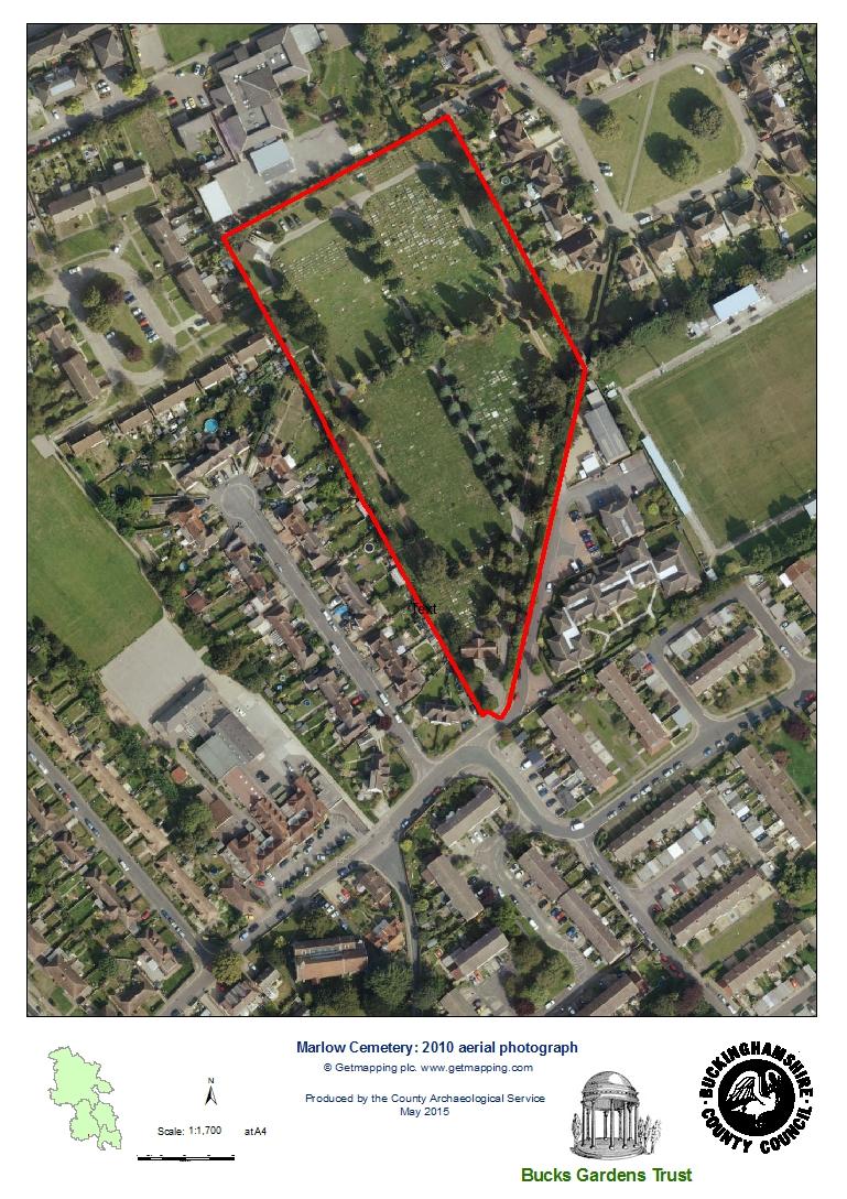
2 HISTORIC SITE BOUNDARY 1
3 2
4 INTRODUCTION Background to the Project This site dossier has been prepared as part of The Buckinghamshire Gardens Trust (BGT) Research and Recording Project, begun in This site is one of several hundred designed landscapes county wide identified by Bucks County Council (BCC) in 1998 (including Milton Keynes District) as potentially retaining evidence of historic interest, as part of the Historic Parks and Gardens Register Review project carried out for English Heritage (BCC Report No. 508). The list is not conclusive and further parks and gardens may be identified as research continues or further information comes to light. Content BGT has taken the Register Review list as a sound basis from which to select sites for appraisal as part of its Research and Recording Project for designed landscapes in the historic county of Bucks (pre 1974 boundaries). For each site a dossier is prepared by volunteers trained on behalf of BGT by experts in appraising designed landscapes who have worked extensively for English Heritage on its Register Upgrade Project. Each dossier includes the following for the site: A site boundary mapped on the current Ordnance Survey to indicate the extent of the main part of the surviving designed landscape, also a current aerial photograph. A statement of historic significance based on the four Interests outlined in the National Policy Planning Framework and including an overview. A written description, derived from documentary research and a site visit, based on the format of the English Heritage Register of Parks & Gardens of special historic interest 2 nd edn. A map showing principle views and features. The area within the site boundary represents the significant coherent remains of the designed landscape. It does not necessarily include all surviving elements of the historical landscape design, which may be fragmented. It takes no account of current ownership. NOTE: Sites are not open to the public unless advertised elsewhere. Supporters and Acknowledgements The project was supported by The Association of Gardens Trusts and funded by BGT with a significant grant from The Heritage Lottery Fund. BCC generously provided current and historic mapping and access to the Historic Environment Record. The Trust would like to thank the volunteers and owners who have participated in this project and given so much time and effort to complete this challenging and rewarding task. Further information is available from: 3
5 COUNTY: BUCKINGHAMSHIRE MARLOW CEMETERY DISTRICT: WYCOMBE PARISH: MARLOW BCC HER OS REF.: SU STATEMENT OF SIGNIFICANCE Overview: A typical early C20 public cemetery with buildings and layout designed by local architect C S Vardy, which survives very largely intact. The surviving planting, advised by local nurseryman Charles Turner, includes mature specimen trees and shrubs typical of late C19 and early C20 cemeteries. Archaeological interest: There is not believed to be any archaeological interest in the site other than the intrinsic interest of the cemetery itself and its burials. Architectural interest: The mortuary chapel, entrance gates and boundary fence are a good group of brick and iron structures by a largely unknown local architect and surveyor Charles Silver Vardy ( ), who may also have designed cemetery and other buildings in and around Maidenhead. There is a wide range of C20 sculpture and headstone designs amongst the cemetery memorials. Artistic interest: The survival of a small urban cemetery almost completely intact is notable. The cemetery retains many elements of the 1910 layout and planting, with the slightly later northern part (1920s) continuing the early design. The town council appears to have clear guidelines in place on the design of monuments and appropriate planting. Historic interest: The cemetery includes British and Commonwealth war graves of personnel killed during World War I and World War II. The documentation relating to its design increases the understanding of its significance. HISTORIC DEVELOPMENT In May 1909 Marlow Urban District Council was informed that the parish churchyard had been closed for burial and that burials were taking place in Holy Trinity churchyard. A Cemetery Sub Committee was established and in November and December 1909 five acres of farmland were purchased from farmer Norman Layton for a cemetery, the architect C S Vardy was appointed and his plans and specifications for the chapel, entrance gates, fencing and cemetery layout approved for a total cost of 1,900. Charles Turner of The Royal Nurseries in Slough was asked to advise on trees and shrubs (CRO). The chapel has a foundation stone dated 4 th July 1910 and construction works and planting appear to have been completed by October The cemetery was consecrated on 8 th December 1910 by the Bishop of Oxford and representatives from Marlow s Free Church Council. There had been 20 interments by the end of March 1911 and a further 61 interments in the following year (CRO). Although the whole site was defined by 1910, historic mapping and aerial 4
6 photos appear to show that only the southern half of the grounds were laid out initially; the northern half of the grounds seem to have been laid out in 1923 or The cemetery is now managed by Marlow Town Council and remains in use for burials (Marlow Town Council cemetery regulations). LOCATION, AREA, BOUNDARIES, LANDFORM SETTING The 2ha cemetery lies at the eastern end of Wethered Road, 900m north of Marlow parish church. In the early C20 the site was a field at the outer edge of the town and was bordered by fields to the north, east and west. The irregular polygonal site adjoins a footpath to Oaktree Road and the access to Marlow Football Club s ground on the east and is bordered by the back gardens of 1930s and post war suburban housing of Oaktree Avenue on the north east, Trinity Avenue and Sandygate Close on the west and with the C20 buildings and grounds of Marlow C of E Infants School on the north. The cemetery is on gently southward sloping ground and the surroundings are mainly residential. Views are contained within the boundaries to the south, east and west, whilst views to the north are restricted by the rising ground and the modern buildings of the infants school. The nearby Holy Trinity Church (designed by Sir George Gilbert Scott and built 1852) and Holy Trinity C o fe Primary School (built 1913) on Wethered Road are significant contemporary surviving buildings forming part of the setting of the cemetery. The cemetery boundaries comprise the original cast iron railing fence with hedges of laurel on the inside. ENTRANCES AND APPROACHES The principal entrance is from Wethered Road, at the narrow southern corner of the boundary. The entrance gates comprise wide double vehicle gates with a pedestrian gate to the west and are cast iron with decorative Arts and Crafts style motifs and a plaque dated The square gate piers are red brick with pyramidal stone caps. A late C20 pedestrian entrance near the northwest corner of the cemetery is reached from Sandygate Close. PRINCIPAL BUILDING The non denominational mortuary chapel by Charles Vardy is built in a simple vernacular style of red brick laid in English bond, with stone dressings and a plain tile roof with decorative ridge tiles and moulded terracotta finials. The building resembles a tithe barn with opposing full height porches and high double board doors, corner buttresses, rectangular side windows and a plain triple lancet east window. The chapel stands close to the south corner of the site, on the west of the central drive 22m from the entrance. The south elevation is prominent in the view from the main entrance. Tarmac and gravel access paths branch off the drive leading to the south and north doors of the building. 5
7 Whilst the chapel is off the main axis of the cemetery layout and occupies a position more usually reserved for a lodge, the dense planting in this part of the cemetery obscures the irregular layout, which maximises the area available for burials. OTHER LAND From the entrance a wide curving drive leads north, past a small car park, to the chapel and continues onwards as the central north south path. The cemetery was laid out as a grid of four rectangular plots divided by straight gravel and grass cross paths and a perimeter path with triangular and diamond beds at path junctions (1920s and 1930s mapping and town council s cemetery plan). The perimeter paths on the south and west sides of the south western quadrant have recently been removed and laid to grass and the other paths are now mostly tarmac. The planting is of specimen evergreen trees and shrubs lining the paths, mainly mature conifers including Cupressus, yews, Stone pines and blue spruce with laurel and laurestina, and is typical of Victorian cemeteries. According to a surviving undated mail order catalogue, Charles Turner s Royal Nurseries specialised in conifers and fruit trees. The nursery was the first to make the locally bred apple Cox s Orange Pippin and Mrs Sinkins pink commercially available, and Charles Turner was also responsible for pioneering early dahlia cultivars. The planting in the later northern half of the cemetery is less dense but there are several mature trees and shrubs. The monuments in this area date from the 1960s onwards. In the northwest corner is a modern pre fabricated groundsman s equipment store and a modern breeze block and tile shed is nearby, next to the west boundary. Mature trees and shrubs limit internal views, however there are views from the highest part of the cemetery across to the denser planting in the lower half of the cemetery. A few WWI and WWII British and Commonwealth war graves are scattered amongst the other graves in the southern half of the cemetery; there appears not to be a section set aside specifically for war graves, nor is there any clear differentiation between the consecrated and non conformist areas. REFERENCES Brennan, Ruth, Check list of Nursery Catalogues from Great Britain in National Botanic Gardens, Glasnevin (Occasional Paper No 9) (1986), 43 (reference to Charles Turner s Royal Nurseries catalogue) Buckinghamshire Historic Environment Record, reference Kelly s Directory of Berkshire (1915), 127, 129 (references to Charles Silver Vardy). Kelly s Directory of Buckinghamshire (1915),186, 326 (references to Charles Turner s Royal Nurseries, Slough). Post Office Directory of Berkshire, Northamptonshire and Oxfordshire with Bedfordshire, Buckinghamshire and Huntingdonshire (1854), 137 (reference to Charles Turner seedsman and nurseryman, Slough). Post Office Directory of Buckinghamshire (1864), 495 (reference to Charles Turner s Royal Nurseries, Slough). Slough History Online webpages Green Fields of Slough: An apple a day and In the pink 6
8 (references to Charles Turner s Royal Nurseries) Victoria County History: Buckinghamshire vol 3 (1925), 301 (reference to The Royal Nurseries, Slough). Maps Marlow Town Council, cemetery plan and regulations (on notice board at cemetery entrance). Ordnance Survey 2 to 1 mile Ordnance Surveyor s Draft surveyed 1812 (British Library) 25 to 1 mile 1 st edition published to 1 mile: 1 st edition published nd edition published 1900 published revised edition published 1930s Emergency edition published 1938 Provisional edition published 1940s NG Provisional Revised edition published 1960 OS 1 to 2,500 NG edition published 1971 OS 1 to 10,000 NG edition published 1977 Archival Material Marlow Urban District Council, Council Minute Book (CBS DC 17/1/7; AR 49/2000) Marlow Urban District Council, Cemeteries Sub Committee Minute Book (CBS DC 17/1/32; AR 49/2000) Census returns (reference to Charles Silver Vardy) Aerial Photographs Aerofilms Ltd 1920, 1924,1937,1952 Black and white obliques: Photo refs EPW000923, EPW012123, EPW052602, EAW RAF 1945 Black and white vertical: Photo ref 106G/UK 832/frame 4007 RAF 1947 Black and white vertical: Photo ref CPE/UK 1936/frame 1105 Julia Wise July 2015, edited August
9 KEY HISTORIC VIEWS AND FEATURES Key to numbered features 1. Main gateway 2. Mortuary chapel 2 Views: 1 From top of cemetery SE to denser planting in lower half From entrance gates past chapel to bend in densely planted driveway. 8


10 KEY IMAGES Julia Wise, 27 th March 2015 Mortuary chapel from entrance drive Mortuary chapel from SE Entrance gates Pedestrian gate with date plaque View across cemetery from north View across NW quadrant of cemetery View of central path from north Cemetery plan at entrance 9
Manor House (Brooke House), Princes Risborough
, Princes Risborough") Understanding Historic Parks and Gardens in Buckinghamshire The Buckinghamshire Gardens Trust Research & Recording Project Manor House (Brooke House), Princes Risborough June 2015 Bucks Gardens Trust Association
Understanding Historic Parks and Gardens in Buckinghamshire The Buckinghamshire Gardens Trust Research & Recording Project Manor House (Brooke House), Princes Risborough June 2015 Bucks Gardens Trust Association
Understanding Historic Parks and Gardens in Buckinghamshire
 Understanding Historic Parks and Gardens in Buckinghamshire The Buckinghamshire Gardens Trust Research & Recording Project Denham Grove (formerly Durdent Court/ Tile House) April 2016 Bucks Gardens Trust
The Kent Compendium of Historic Parks and Gardens for Medway. Parkwood Green Rainham
 The Kent Compendium of Historic Parks and Gardens for Medway Parkwood Green Rainham March 2014 Parkwood Green Rainham TABLE OF CONTENTS LOCATION BRIEF HISTORY SITE DESCRIPTION LISTING STATUS CONCLUSION
Lancaster Conservation Area Appraisal. Character Area 8. Cathedral
 Lancaster Conservation Area Appraisal Character Area 8. Cathedral March 2013 118 3.8 Character Area 8. Cathedral 3.8.1. Definition of Special Interest "This character area is distinctive for the fine group
The Kent Compendium of Historic Parks and Gardens for Medway. Town Hall Gardens, Chatham
 The Kent Compendium of Historic Parks and Gardens for Medway Town Hall Gardens, Chatham September 2014 Town Hall Gardens Chatham, Kent TABLE OF CONTENTS INTRODUCTION STATEMENT OF SIGNIFICANCE SITE DESCRIPTION
Understanding Historic Parks and Gardens in Buckinghamshire. The Buckinghamshire Gardens Trust Research & Recording Project. Orchard House Olney
 Understanding Historic Parks and Gardens in Buckinghamshire The Buckinghamshire Gardens Trust Research & Recording Project Orchard House Olney January 2018 The Stanley Smith (UK) Horticultural Trust Bucks
Historic England Advice Report 26 August 2016
 Case Name: Kingsland Castle Case Number: 1435892 Background Historic England has been asked to review the scheduling for Kingsland Castle. The land on which the monument lies is understood to be for sale.
Leicestershire and Rutland Gardens Trust Walled Kitchen Garden Register
 Leicestershire and Rutland Gardens Trust Walled Kitchen Garden Register Name of House: East Langton Grange Address: East Langton Grange Back Lane East Langton Market Harborough LE16 7TB Ownership: Private
Built in 1984, the meeting house is the third meeting house on a site acquired in 1668 as a burial ground. The building has low heritage significance.
 Friends Meeting House, Reigate 47 Reigate Road, Reigate, Surrey, RH2 0QT National Grid Reference: TQ 26184 50219 Statement of Significance Built in 1984, the meeting house is the third meeting house on
Evidential value The meeting house site is likely to have low archaeological potential and the building has low evidential value.
 Friends Meeting House, Colwyn Bay 21 Erskine Road, Colwyn Bay, LL29 8EU National Grid Reference: SH 85406 78739 Statement of Significance The 1899 meeting house is an attractive late Victorian building
2bPlanning Scheme. Appendix. Conservation - Removal of Structures. Grangegorman
 Appendix 2bPlanning Scheme Grangegorman Conservation - Removal of Structures Innovative Urban Quarter Contemporary Healthcare Facilities Modern Education Hub Accessible Public Spaces Appendix 2b: Purpose
1 THE OLD VICARAGE MANOR ROAD F GORING ON THAMES F OXFORDSHIRE
 1 THE OLD VICARAGE MANOR ROAD F GORING ON THAMES F OXFORDSHIRE 1 THE OLD VICARAGE MANOR ROAD F GORING ON THAMES F OXFORDSHIRE Pangbourne on Thames 5 miles F Reading 10 miles F Newbury 13 miles F Oxford
A PERIOD RIVERSIDE PROPERTY ENJOYING SPLENDID VIEWS
 A PERIOD RIVERSIDE PROPERTY ENJOYING SPLENDID VIEWS Garden Reach Gibralter Lane, Cookham Dean, Berkshire SL6 9TR Freehold Spacious family home with superb gardens and swimming pool Garden Reach Gibralter
DACORUM GOLDEN PARSONAGE Great Gaddesden Brief Description Principal Building: Approach: Stable block other utilitarian buildings: Walled Garden:
 HERTFORDSHIRE GARDENS TRUST LOCAL LIST: DACORUM Present Name of Site GOLDEN PARSONAGE Historic Name (if known) Parish/Town Great Gaddesden National Grid Reference of Principal Building: TL051 125 Present
7.1 Area 1: Haslemere Conservation Area
 7.1 Area 1: Haslemere Conservation Area Detailed map of Haslemere Town Conservation Area as of 2006 Crown copyright and database right 2011 Ordnance Survey LA100025451 27 The Conservation Area is characterised
NORFOLK RURAL SCHOOLS SURVEY
 1 Name of school Photo reference Thelveton Public Elementary School Thelveton 1-6 Grid Reference TM1615 8083 Is the building listed? No School Address The Old School House Norwich Road Thelveton Diss IP21
Leicestershire and Rutland Gardens Trust Walled Kitchen Garden Register
 Leicestershire and Rutland Gardens Trust Walled Kitchen Garden Register Name of House: Address: Brooksby Hall (now Brooksby Melton College) Brooksby, Melton Mowbray Leicestershire LE14 2LJ Ownership: Private
Stanwick Neighbourhood Plan
 Stanwick Neighbourhood Plan Heritage Audit Stanwick Neighbourhood Plan Steering Group August 2015 Purpose of the Heritage Audit It is a core planning principle within National Planning Policy Framework
Friends Meeting House, Broughton. Meeting House Lane, Little Broughton, Cockermouth, CA13 0YQ. National Grid Reference: NY
 Friends Meeting House, Broughton Meeting House Lane, Little Broughton, Cockermouth, CA13 0YQ National Grid Reference: NY 07832 31740 Statement of Significance The modest building has medium significance
Understanding Historic Parks and Gardens in Buckinghamshire. The Buckinghamshire Gardens Trust Research & Recording Project POUNDON HOUSE.
 Understanding Historic Parks and Gardens in Buckinghamshire The Buckinghamshire Gardens Trust Research & Recording Project POUNDON HOUSE June 2016 Bucks Gardens Trust The Stanley Smith (UK) Horticultural
INTRODUCTION CURRENT APPLICATION
 05/01805/FUL & 05/01807/LBC ERECTION OF A SINGLE DWELLING HOUSE WITH ANCILLARY ACCOMMODATION AT Flamingo Zoological Gardens, Olney Road, Weston Underwood FOR Mr A J Crowther (as amended by letter dated
NATIONAL REGISTER OF HISTORIC PLACES MULTIPLE PROPERTY DOCUMENTATION FORM CONTINUATION SHEET ASSOCIATED PROPERTY TYPES
 Section F, Page 1 ASSOCIATED PROPERTY TYPES Six common property types are identified with the 48 cemeteries surveyed in the Town of Southampton. These six property types are identified as being associated
CITY OF MIAMI CEMETERY 1800 N.E. 2 AVENUE
 CITY OF MIAMI CEMETERY 1800 N.E. 2 AVENUE Designation Report City of Miami REPORT OF THE CITY OF MIAMI PLANNING DEPARTMENT TO THE HERITAGE CONSERVATION BOARD ON THE POTENTIAL DESIGNATION OF CITY OF MIAMI
Architectural Inventory Form
 OAHP1403 Rev. 9/98 COLORADO CULTURAL RESOURCE SURVEY Architectural Inventory Form Official eligibility determination (OAHP use only) Date Initials Determined Eligible- NR Determined Not Eligible- NR Determined
The Kent Compendium of Historic Parks and Gardens for Medway. Victoria Gardens, Chatham
 The Kent Compendium of Historic Parks and Gardens for Medway Victoria Gardens, Chatham August 2014 Victoria Gardens Chatham, Kent TABLE OF CONTENTS INTRODUCTION STATEMENT OF SIGNIFICANCE SUMMARY OF THE
HOCKETT END. Hockett Lane, Cookham Dean, Berkshire SL6 9UF
 HOCKETT END Hockett Lane, Cookham Dean, Berkshire SL6 9UF Price on Application - Freehold An outstanding family home in Cookham Dean Beautifully private location adjacent to woodland Landscaped formal
National Character Area 70 Melbourne Parklands
 Summary The are a landscape of rolling farmland, parkland and woodland on the northern flanks of the ridge between Burton upon Trent and Swadlincote. The land slopes down to the River Trent, which borders
Parish Derry Slopes ITM Coordinates ; NG Coordinates C House B1 and farm buildings B2; Registered Garden L061
 Asset Ref No. HB/01/27/018A-C, Ballyarnett & Farm; Registered Historic Garden L061 Heritage Type Location Protection Status Condition Ownership (if known) Built Post-Medieval house & farm OS 6-inch map
26 Park West Exploring Abergavenny
 26 Park West Exploring Abergavenny Cover: Park Avenue 2 park west EXPLORING ABERGAVENNY For several years the Abergavenny and District Civic Society has been studying the streets, spaces and buildings
The meeting house is of low-key design typical of the inter-war period. It has an attractive appearance with a spacious interior and good amenities.
 Friends Meeting House, Preston 189 St George s Road, Preston, PR1 6NQ National Grid Reference: SD 54314 30558 Statement of Significance The meeting house is of low-key design typical of the inter-war period.
10.10 Diamond Harbour Memorial Gardens Cemetery
 10.10 Diamond Harbour Memorial Gardens Cemetery Cemetery Character Diamond Harbour Memorial Gardens Cemetery was officially opened in May 2002. The cemetery is designed in terraces in accordance with the
Supplementary Planning Information
 Supplementary Planning Information HAVANT BOROUGH COUNCIL DEVELOPMENT MANAGEMENT COMMITTEE 18 August 2016 I am now able to enclose, for consideration by the Development Management Committee on 18 August
Land to West of Bessel s Way, Blewbury. Contextual Analysis. fluid
 Land to West of Bessel s Way, Blewbury Contextual Analysis fluid Contents fluid - Overview - Growth pattern - Footpath & Road connections - Landscape Character - Amenities - Agriculture - Characteristic
L 2-1 HERITAGE REPORT: REASONS FOR HERITAGE DESIGNATION. Cheyne Family Cemetery. Main Street South
 L 2-1 HERITAGE REPORT: REASONS FOR HERITAGE DESIGNATION Cheyne Family Cemetery Main Street South October 2013 L 2-2 PROFILE OF SUBJECT PROPERTY: Municipal Address Main Street South (Lot 14, Con 1, EHS)
The Kent Compendium of Historic Parks and Gardens for Medway. Churchfields, Rochester
 The Kent Compendium of Historic Parks and Gardens for Medway Churchfields, Rochester January 2015 Churchfields Rochester, Kent TABLE OF CONTENTS INTRODUCTION STATEMENT OF SIGNIFICANCE SITE DESCRIPTION
Archaeological Investigation in advance of Development at 2 Palace Cottages, Charing Palace, Charing, Kent
 Archaeological Investigation in advance of Development at 2 Palace Cottages, Charing Palace, Charing, Kent Site Code CHAR-EV-14 NGR 95412 49439 Date of Report 18/12/2014 Swale and Thames Archaeological
Archaeological evaluation at Willowdene, Chelmsford Road, Felsted, Essex
 Archaeological evaluation at Willowdene, Chelmsford Road, Felsted, Essex August 2013 report prepared by Ben Holloway on behalf of Mr Anthony McGurren Planning reference: UTT/13/0235 CAT project ref.: 13/07g
Historical Value As evidence of Quaker heritage in Wells extending over three hundred years, the meeting house has high historical value.
 Friends Meeting House, Wells-next-the-Sea Quaker Yard, Church Street, Wells-next-the-Sea, Norfolk, NR23 1HZ National Grid Reference: TF 91978 43092 Statement of Significance The building has high significance
Old Town Hall, Market Place, Faringdon, Oxfordshire
 Old Town Hall, Market Place, Faringdon, Oxfordshire Building Recording and Archaeological Watching Brief for Great Faringdon War Memorial Trust by Jamie Preston and Steve Ford Thames Valley Archaeological
Architecture Terms and Ideas
 Architecture Terms and Ideas Major Architectural Influences Historically, our architecture has been derived from & is derivative of More recently The face of a building, especially the principal face.
Morgan s Subdivision Historic District Character-defining Features
 Morgan s Subdivision Historic District Character-defining Features DISTRICT DESCRIPTION This small addition, designed as a neighborhood for those wishing to move east from Capitol Hill, was predominantly
Appendix 1: Site Inventory Form
 Appendix 1: Site Inventory Form Wapsi Valley Archaeology, Inc. Anamosa, IA 56 X Cemetery Washington 83 24 2 NE X 1 5 approx. 200 approx. 201 unknown unknown Historic Resources Evaluation: 07A: Cemetery
GREENFORD HALL & ADJOINING LAND
 GREENFORD HALL & ADJOINING LAND CONTENTS 1. Introduction 1. Introduction 2. Urban Context 2.1 The Site and Surroundings 2.2 Urban Context Map 2.3 Access and Movement 3. Planning Context 3.1 Planning History
Ivol Buildings, Woodcote Road, South Stoke, Oxfordshire
 Ivol Buildings, Woodcote Road, South Stoke, Oxfordshire An Archaeological Watching Brief For Christ Church, Oxford by Pamela Jenkins Thames Valley Archaeological Services Ltd Site Code IBSS 04/03 March
CALA HO ME S WELCOME
 WELCOME Welcome to this public consultation event for our proposed residential development of 56 high quality homes on land to the north east of Station Road in Earls Colne. Thank you for taking the time
NAA SITE REF: HG2-22 CHURCH STREET, BOSTON SPA LEEDS LDF SITE ALLOCATIONS PLAN PRE-SUBMISSION CHANGES (FEBRUARY 2017) HERITAGE REPRESENTATIONS
 HERITAGE REPRESENTATIONS") NAA LEEDS LDF SITE ALLOCATIONS PLAN PRE-SUBMISSION CHANGES (FEBRUARY 2017) HERITAGE REPRESENTATIONS Northern Archaeological Associates Ltd. Marwood House Harmire Enterprise Park Barnard Castle Co. Durham
NAA LEEDS LDF SITE ALLOCATIONS PLAN PRE-SUBMISSION CHANGES (FEBRUARY 2017) HERITAGE REPRESENTATIONS Northern Archaeological Associates Ltd. Marwood House Harmire Enterprise Park Barnard Castle Co. Durham
SOUTH CAMBRIDGESHIRE DISTRICT COUNCIL. Planning and New Communities Director
 SOUTH CAMBRIDGESHIRE DISTRICT COUNCIL REPORT TO: Planning Committee 5 June 2013 AUTHOR/S: Planning and New Communities Director S/0747/13/FL HISTON Construction of Car Park at Histon Baptist Church, Station
Friends Meeting House, Bardfield. Brook Street, Great Bardfield, Braintree, Essex, CM7 4RQ. National Grid Reference: TL
 Friends Meeting House, Bardfield Brook Street, Great Bardfield, Braintree, Essex, CM7 4RQ National Grid Reference: TL 67593 30562 Statement of Significance The meeting house has high heritage significance
OLD WESTWICK. Guildford = Surrey
 OLD WESTWICK Guildford = Surrey OLD WESTWICK GUILDFORD, SURREY Edwardian splendour Guildford Centre: 0.5 miles (0.8 km), Guildford Station: 1.1 miles (1.7 6 km), A3: 1.8 miles (2.8 km), M25 (J10): 9.4
Surlingham Primary School. Grid Reference TG Is the building listed? no. Walnut Hill Surlingham
 Name of school Surlingham Primary School Photo reference Surlingham 1-5 jpg Grid Reference TG31210648 Is the building listed? no Walnut Hill Surlingham The old (1837) school is incorporated in the village
NORFOLK RURAL SCHOOLS SURVEY
 1 Name of school Hilgay Ten Mile Bank St Mark's CofE School Photo reference Ten_Mile_Bank_St_Mark's_CofE_School_01.- 07jpg Grid Reference TL60309700 Is the building listed? no A small plain school of the
Persimmon Homes Thames Valley Date received: 2 nd April week date(major): 2 nd July 2014 Ward: Nascot
: 2 nd July 2014 Ward: Nascot") PART A Report of: DEVELOPMENT MANAGEMENT SECTION HEAD Date of Committee: 26 th June 2014 Site address: Rounton, 28, Nascot Wood Road Reference Number: 14/00497/REM Description of Development: Reserved
PART A Report of: DEVELOPMENT MANAGEMENT SECTION HEAD Date of Committee: 26 th June 2014 Site address: Rounton, 28, Nascot Wood Road Reference Number: 14/00497/REM Description of Development: Reserved
Lincoln Townscape Assessment. Boultham Park Inherited Character Area Statement
 Lincoln Townscape Assessment Boultham Park Inherited Character Area Statement January 2008 Page 2 of 12 Table of Contents Page Overview 2 Historical Development 2 Urban form 3 Views 5 Condition of Buildings
St Michaels C of E Junior & Infant School, Nantmel Grove, Bartley Green, Birmingham, B32 3JS
 Committee Date: 06/03/2014 Application Number: 2013/08595/PA Accepted: 19/11/2013 Application Type: Full Planning Target Date: 14/01/2014 Ward: Bartley Green St Michaels C of E Junior & Infant School,
Tinkers Barn CHACOMBE OXFORDSHIRE
 Tinkers Barn CHACOMBE OXFORDSHIRE Tinkers Barn CHACOMBE OXFORDSHIRE Approximate distances: Banbury 3 miles (London Marylebone from 52 mins), M40 Motorway (Junction 11) 2 miles, Brackley 9 miles, Oxford
9 VALLEY CLOSE GORING ON THAMES F SOUTH OXFORDSHIRE
 9 VALLEY CLOSE GORING ON THAMES F SOUTH OXFORDSHIRE 9 VALLEY CLOSE GORING ON THAMES F SOUTH OXFORDSHIRE Goring (London Paddington within the hour) F Streatley High Street/River - ½ miles F Reading - 10
Architectural Inventory Form
 COLORADO CULTURAL RESOURCE SURVEY Page 1 of 8 Official Eligibility Determination (OAHP use only) Rev. 9/98 OAHP1403 Date Initials Determined Eligible National Register Determined Not Eligible National
Exploring Abergavenny
 11 Majors Barn36 Ysguborwen Exploring Abergavenny 2 ysguborwen EXPLORING ABERGAVENNY For several years the Abergavenny and District Civic Society has been studying the streets, spaces and buildings of
Salhouse Parish Council, 11 th November Response to Planning Application
 Salhouse Parish Council, 11 th November 2013 Response to Planning Application 20131408 Summary Salhouse Parish Council (SPC) has received via Broadland District Council a Planning Application for a 5MWp
POUND COTTAGE STREAM ROAD F UPTON F OXFORDSHIRE.
 POUND COTTAGE STREAM ROAD F UPTON F OXFORDSHIRE www.warmingham.com POUND COTTAGE STREAM ROAD F UPTON F OXFORDSHIRE Didcot 2 ½ miles (London Paddington 40 minutes) F M4 (Junction 13) 6 miles F Newbury
South of Hillside Road West, Rothbury. Design and Access Statement with Design Code. Outline Planning Application May 2016
 Outline Planning Application May 2016 Design and Access Statement with Design Code Jane Darbyshire and David Kendall Ltd This Design and Access Statement has been produced by Jane Darbyshire and David
429 Lansdowne Road Building or Property Name. Original owner
 HERITAGE SURVEY AND EVALUATION FORM Municipal Address 429 Lansdowne Road Building or Property Name 042280293 Legal Description PLAN 92 PT BLK 13 JUNC GORE;PT LOT 1 RP4R8942 PART 1 Lot Block Plan Date of
HIGH WALL COTTAGE STREATLEY ON THAMES F BERKSHIRE.
 HIGH WALL COTTAGE STREATLEY ON THAMES F BERKSHIRE www.warmingham.com HIGH WALL COTTAGE STREATLEY ON THAMES F BERKSHIRE F Goring & Streatley Station 0.6 miles F Pangbourne 5 miles F Wallingford 6 miles
WELCOME TO THE NEW WILTON PARK
 WELCOME TO THE NEW WILTON PARK VISION HISTORY OF WILTON PARK TOWARDS A PLANNING APPLICATION Our objective is to create a truly outstanding environment at Wilton Park. At the heart of our proposals is a
Historical value The building is a rare example of a small, little altered meeting house of the eighteenth century. It has high historical value.
 Friends Meeting House, Wallingford 13 Castle Street, Wallingford, Oxfordshire, OX10 8DL National Grid Reference: SU 60702 89627 Statement of Significance The meeting house is a small brick building of
Buckley Artist s Brief
 Buckley Artist s Brief Buckley Memorial Public Art Commission Deadline for initial proposal - 22 September 2017 1. Introduction A new ALDI supermarket has been built on land that once held the Royal British
Northbury Farm, Castle End Road, Ruscombe, Berkshire
 Northbury Farm, Castle End Road, Ruscombe, Berkshire An Archaeological Watching Brief For Sir Colin and Lady Southgate by Danielle Milbank Thames Valley Archaeological Services Ltd Site Code NFR 07/120
GREENSPACES MANAGEMENT
 GREENSPACES MANAGEMENT 3-year Strategy Routine Management & Improvement Plan covering the 25 sites owned and/or managed by Stroud Town Council. A three-year plan to run from financial year - 2013/14 THE
DESIGN & ACCESS STATEMENT
 DESIGN & ACCESS STATEMENT Land to the South East of the A495, Bronington Erection of 31 Dwellings (27 dwellings and 4 bungalows including 4 Affordable Dwellings), Realignment and Improvements to A495 (including
TOWN OF MISHICOT CEMETERY RULES
 TOWN OF MISHICOT CEMETERY RULES Progressive Farmers St. John=s Saxonburg German Methodist The cemetery authorities will not be responsible for any damages done to the lots or structures thereon, or for
Derry City and Strabane District Council Planning Committee Report. Plinth restoration to include steam cleaning of ashlar walling and
 Derry City and Strabane District Council Planning Committee Report COMMITTEE DATE: 5 th September 2018 APPLICATION No: APPLICATION TYPE: PROPOSAL: LA11/2018/0477/F Full Application Plinth restoration to
L 4-1. Heritage Report: Reasons for Heritage Designation. Kodors House. 35 Rosedale Avenue West
 L 4-1 Brampton Heritage Board Date: January 17, 2012 Heritage Report: Reasons for Heritage Designation Kodors House 35 Rosedale Avenue West December 2011 1 L 4-2 Profile of Subject Property Municipal Address
Appendix B Figures L1 and L2 - Townscape Analysis
 The Derriford Transport Scheme WEBTag Townscape and Visual Impact Appraisal (WTVA) Appendix B Figures L1 and L2 - Townscape Analysis J:\29210 Plymouth City Modelling\Technical\Landscape\Reports\29210_De
New Swimming Pool,West Meon House, West Meon, Hampshire
 New Swimming Pool,West Meon House, West Meon, Hampshire An Archaeological watching brief and building recording for Mr and Mrs Younger by Danielle Milbank Thames Valley Archaeological Services Ltd Site
Architectural Inventory Form
 COLORADO CULTURAL RESOURCE SURVEY Page 1 of 8 Official Eligibility Determination (OAHP use only) Rev. 9/98 OAHP1403 Date Initials Determined Eligible National Register Determined Not Eligible National
THE GLEBE HOUSE LITTLE KIMBLE BUCKINGHAMSHIRE
 THE GLEBE HOUSE LITTLE KIMBLE BUCKINGHAMSHIRE THE GLEBE HOUSE RISBOROUGH ROAD LITTLE KIMBLE BUCKINGHAMSHIRE Little Kimble Station 0.4 miles (rail service to London Marylebone from 55 mins) Princes Risborough
Introduction. Welcome to this consultation regarding the draft redevelopment proposals for the former CeramTec factory on Sidmouth Road, Colyton.
 Introduction Welcome to this consultation regarding the draft redevelopment proposals for the former CeramTec factory on Sidmouth Road, Colyton. We are currently considering options for the mixed-use redevelopment
Architectural Inventory Form (page 1 of 5)
") OAHP1403 Rev. 9/98 COLORADO CULTURAL RESOURCE SURVEY (page 1 of 5) I. IDENTIFICATION 1. Resource number 5RT-2050 2. Temporary resource number: 145008005 3. County: Routt County 4. City: Steamboat Springs
OAHP1403 Rev. 9/98 COLORADO CULTURAL RESOURCE SURVEY (page 1 of 5) I. IDENTIFICATION 1. Resource number 5RT-2050 2. Temporary resource number: 145008005 3. County: Routt County 4. City: Steamboat Springs
Contents. Summary Introduction Methodology Historical Background Building Description I: The Gates 8
 Archaeological Building Survey: The Gates, Grotto and Ice House, Worsley New Hall. Final Version. Client: Peel Investments (North) Ltd. Technical Report: Vicky Nash, Matt Bishop & Dr Michael Nevell Report
Site ref: AS06 Site Name or Address: Murreys Court, Agates Lane
 Site ref: AS06 Site Name or Address: Murreys Court, Agates Lane Proposed Land Use: Total Site Area (Ha): Housing 1.85 Ha Description: It is understood that the owner has no plans to dispose of the site
Appletree, Thames Street, Sonning Berkshire
 Appletree, Thames Street, Sonning Berkshire An Archaeological Watching Brief for Mr and Mrs A Popham by Sian Anthony Thames Valley Archaeological Services Ltd Site Code ATS 02/83 October 2002 Summary Site
Chitty Farmhouse Extension, Wall Lane, Silchester, Hampshire
 Chitty Farmhouse Extension, Wall Lane, Silchester, Hampshire An Archaeological Watching Brief For In Touch by Andrew Mundin Thames Valley Archaeological Services Ltd Site Code CFS 08/52 May 2008 Summary
1. Listed Building and Conservation Area considerations 2. Protection of Known Archaeological Remains 3. Parking
 08/01222/FUL ERECTION OF SINGLE STOREY SIDE EXTENSION TO CHURCH TO PROVIDE FOR PARISH HALL (RESUBMISSION OF 08/00206/FUL) AT St Mary And St Giles Church, Church Street, Stony Stratford FOR Rev R Northing
THE OLD VICARAGE Barton, Richmond, North Yorkshire
 THE OLD VICARAGE Barton, Richmond, North Yorkshire THE OLD VICARAGE 17 MARYGATE, BARTON, RICHMOND, NORTH YORKSHIRE, DL10 6LD A HANDSOME FIVE BEDROOMED PROPERTY SITTING IN THE MIDDLE OF A SUBSTANTIAL PLOT
Lincoln Townscape Assessment. Sherbrooke Inherited Character Area Statement
 Lincoln Townscape Assessment Sherbrooke Inherited Character Area Statement June 2008 Page 2 of 15 Table of Contents Page Overview 2 Historical Development 3 Urban form 4 Views 8 Condition of Buildings
Epsom Water Works, East Street, Epsom, Surrey
 Epsom Water Works, East Street, Epsom, Surrey An Archaeological Desk-Based Assessment for St James Homes Ltd by Steve Ford Thames Valley Archaeological Services Site Code ESE99/85 December 1999 Epsom Water
PHASE 1 ARCHAEOLOGICAL IMPACT ASSESSMENT PROPOSED DEVELOPMENT ERF 3 ROBERTSON WESTERN CAPE PROVINCE
 PHASE 1 ARCHAEOLOGICAL IMPACT ASSESSMENT PROPOSED DEVELOPMENT ERF 3 ROBERTSON WESTERN CAPE PROVINCE Prepared for BOLAND ENVIRO Att: Mr Nik Wullschleger PO Box 250 Worcester 6849 Fax: (023) 347 0336 By
WELKIN HURST. Winter Hill, Cookham Dean, Berkshire SL6 9TT
 WELKIN HURST Winter Hill, Cookham Dean, Berkshire SL6 9TT A WONDERFUL FAMILY HOME SET IN BEAUTIFUL LANDSCAPED GARDENS OF OVER 3 ACRES, WITH A TENNIS COURT AND SWIMMING POOL. Spacious and well presented
Highcroft BOURTON BUCKINGHAMSHIRE
 Highcroft BOURTON BUCKINGHAMSHIRE HIGHCROFT BOURTON BUCKINGHAMSHIRE Distances approximate: Milton Keynes 13 miles (London Euston from 33 mins), Buckingham 1 miles, Bicester 12 miles (London Marylebone
Public Consultation. Land at Monks Farm, North Grove. Welcome
 Welcome Welcome to our public exhibition for development on Land at Monks Farm, orth Grove. Gallagher Estates and Gleeson Strategic Land are preparing an outline planning application for new homes, open
FERN COTTAGE STREATLEY ON THAMES F BERKSHIRE.
 FERN COTTAGE STREATLEY ON THAMES F BERKSHIRE www.warmingham.com FERN COTTAGE STREATLEY ON THAMES F BERKSHIRE Goring & Streatley Station - 0.6 miles F Pangbourne - 5 miles F Wallingford - 6 miles F Oxford
Bramble Cottage Bicker. Boston, Lincolnshire, PE20 3DP 450,000
 Bramble Cottage Bicker Boston, Lincolnshire, PE20 3DP 450,000 A Grade II Listed detached cottage full of character and on a plot of approximately 0.43 acre, subject to survey. Set in a pleasant village
147 HUNTINGDON ROAD CAMBRIDGE
 147 HUNTINGDON ROAD CAMBRIDGE A well proportioned 1920s detached house with beautifully presented accommodation and a large south-west facing garden of over a third of an acre, incorporating a potential
Understanding Historic Parks and Gardens in Buckinghamshire. The Buckinghamshire Gardens Trust Research & Recording Project ALDERBOURNE MANOR
 Understanding Historic Parks and Gardens in Buckinghamshire The Buckinghamshire Gardens Trust Research & Recording Project ALDERBOURNE MANOR May 2017 Bucks Gardens Trust The Stanley Smith (UK) Horticultural
The Old Rectory Combpyne, Axminster, Devon EX13 8SY
 The Old Rectory The Old Rectory Combpyne, Axminster, Devon EX13 8SY Axminster 5.5 Miles Lyme Regis 4 Miles Exeter 24 Miles Victorian former Rectory with integrated ground floor annexe in stunning landscaped
by Jennifer Tempest BA(Hons) MA PGDip PGCert Cert HE MRTPI IHBC an Inspector appointed by the Secretary of State for Communities and Local Government
 MA PGDip PGCert Cert HE MRTPI IHBC an Inspector appointed by the Secretary of State for Communities and Local Government") Appeal Decisions Site visit made on 19 January 2015 by Jennifer Tempest BA(Hons) MA PGDip PGCert Cert HE MRTPI IHBC an Inspector appointed by the Secretary of State for Communities and Local Government
Appeal Decisions Site visit made on 19 January 2015 by Jennifer Tempest BA(Hons) MA PGDip PGCert Cert HE MRTPI IHBC an Inspector appointed by the Secretary of State for Communities and Local Government
Meales Farm, Sulhamstead, West Berkshire
 Meales Farm, Sulhamstead, West Berkshire An Archaeological Watching Brief For Mr. Robert Astor by Steve Ford Thames Valley Archaeological Services Ltd Site Code CHH02/29 May 2002 Summary Site name: Meales
SITE VISIT OFFICE MEETING TELEPHONE NOTES
 SITE VISIT OFFICE MEETING TELEPHONE NOTES Our Reference: Assigned to HB12 15 012 Date of meeting and site visit: 03/11/2016 Present: Edith Logue: HM Development and Change Branch Terence Reeves Smyth:
UPPER GORDON ROAD TO CHURCH HILL, CAMBERLEY CONSERVATION AREA
 Introduction This leaflet explains the purpose of conservation areas and the implication of their designation for residents, property owners and the Council. It provides you with a plan of the area and
DEFENCE AREA 34 EWSHOT
 DEFENCE AREA 34 EWSHOT 1. Area details: The defence area is 3 miles NW of Farnham and 3½ miles W of Aldershot. County: Hampshire. Parish: Crondall. NGR: centre of area, SU 813505. 1.1 Area Description: