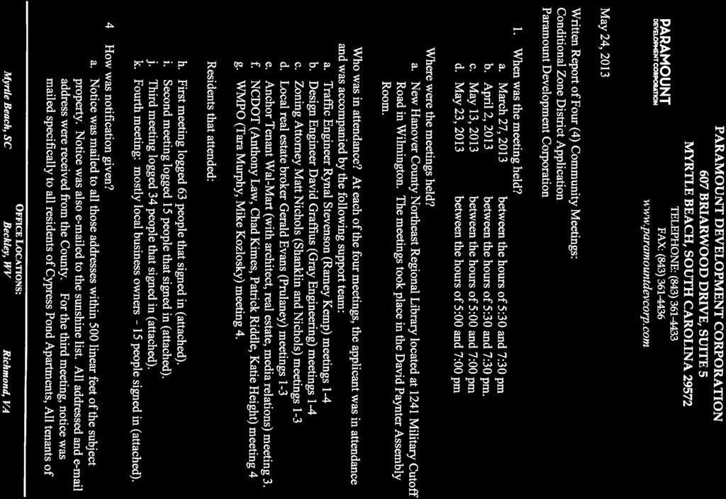
NOTICE OF PUBLIC HEARING
|
|
|
- Rosa Barber
- 5 years ago
- Views:
Transcription

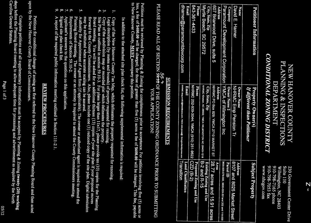
1 NEW HANOVER COUNTY PLANNING & INSPECTIONS DEPARTMENT 230 GOVERNMENT CENTER DRIVE, SUITE 110 WILMINGTON, NORTH CAROLINA TELEPHONE (910) FAX (910) Chris O Keefe, AICP Planning & Inspections Director Dennis Bordeaux Inspections Manager Shawn Ralston Planning Manager NOTICE OF PUBLIC HEARING NEW HANOVER COUNTY PLANNING BOARD JUNE 6, 2013 The New Hanover County Planning Board will hold a public hearing on Thursday, June 6, 2013 beginning at 6:00 p.m. or thereafter at the New Hanover County Historic Courthouse, 24 North Third Street (corner of Third and Princess Streets), Room 301 in Wilmington, NC to consider the following: Approval of May 2013 Planning Board Minutes Item 1: Rezoning Request (Z-926, 06/13) - Request by Paramount Development Corporation on behalf of New Hanover Regional Medical Center Employee Pension Trust and the YMCA of Wilmington, Inc. to rezone acres located at 8025 and 8107 Market Street from B-2 Highway Business and R-15 Residential to CZD (B-2) Conditional Zoning District Highway Business in order to develop a retail center. The subject properties are classified as Transition according to the 2006 CAMA Land Use Plan and are located within the Market Street Corridor Plan and the Porters Neck Small Area Plan. Technical Review Committee Report (May) The Planning Board may consider substantial changes in these petitions as a result of objections, debate, and discussion at the meeting, including rezoning to other classifications. Petitions for the above items may be viewed or inquiries made by contacting the Planning & Inspections Department at , 230 Government Center Drive, Wilmington, NC. All interested citizens are invited to attend.
2
3 CASE: Z-926, 06/13 PETITIONER: David Harner, Paramount Development Corporation on behalf of the YMCA of Wilmington, Inc. and New Hanover Regional Hospital Employee Pension Trust REQUEST: Rezone from B-2 Highway Business and R-15 Residential to CZD (B-2), Conditional Zoning District Highway Business ACREAGE: LOCATION: 8025 and 8107 Market Street (US Highway 17 Business) Parcel ID Numbers: R (New Hanover Regional Hospital) R (YMCA of Wilmington, Inc.) R (New Hanover Regional Hospital) R (New Hanover Regional Hospital) LAND CLASS: Transition STAFF SUMMARY LOCATION OF SUBJECT PARCELS: The subject properties are located near the 8100 block of Market Street. The petition includes four parcels that comprise acres. Three of the parcels have the address 8107 and one has the address The 8107 parcels are currently zoned B-2 Highway Business (see attached map) to a depth of approximately 975 feet. These parcels are largely undeveloped with the exception of a water tower and telecommunications tower that have access through utility easements. A State Employees Credit Union is located on a separate parcel that is surrounded by is currently zoned R-15 Residential. The subject properties are situated near a large existing commercial node located at the Market Street-Porters Neck Road intersection. A variety of services are located within the node that include but are not limited to: restaurants, grocery stores, banks, and a Lowes Home Improvement store. Several medical facilities are also located nearby including a Medac located just north of the subject parcels. Immediately behind the subject properties to the north and west are two residential communities: Country Haven subdivision established in the late 1980 s and Cypress Pond Apartments developed in the 1990 s. To the south of the subject properties is a combination of an undeveloped O&I zoning district that extends approximately 250 back from Market St. and a residential community located off of Sweetwater Drive recorded as the L.D. Webb Division. HISTORY OF ZONING ON SUBJECT PARCELS: The original zoning for the subject properties occurred in 1971 and was rezoned in September, 2000 from R-15 Residential to B-2 Highway Business with a Special Use Permit for an Indoor/Outdoor Recreation Facility that was not constructed. Presently, most of the Z-926, 06/13 Page 1
4 property is vacant with the exception of a water tower constructed in 2006, and a telecommunications tower approved as a Special Use Permit in February There is also an abandoned Duke Energy Progress facility located toward the northern portion of the property that has been in existence since the 1970 s. CHARACTER OF THE AREA: Current Zoning: The purpose of the B-2 Highway Business District is to provide for the proper grouping and development of roadside business uses which will best accommodate the needs of the motoring public and businesses demanding high volume traffic. The purpose of the R-15 Residential District is to insure that residential development will occur at sufficient low densities to insure a healthful environment. Proposed Zoning: The proposed zoning is CZD (B-2) Conditional Zoning Highway Business. The purpose of the CZD procedure is to address situations where a particular land use would be consistent with the New Hanover County Land Use Plan and the objectives of the Zoning Ordinance and where only a specific use or uses is proposed for the project. Although similar to the Conditional Use District, the CZD does not require a companion Special Use Permit and the hearing is not quasi-judicial. However, like the CUD, the CZD requires that a specific site plan accompany the application, that a Traffic Impact Analysis be completed and that a community meeting be held prior to the submittal of an application. The subject project includes a proposal to accommodate a major anchor tenant, in this case Wal-Mart, and a series of retail and office establishments in order to service the need of a growing Porters Neck area. The petitioner s site plan displays a total of nine proposed accessory buildings and the Wal-Mart building. The Wal-Mart is proposed to be 189,544 square feet, and the nine outlots are proposed to be a total of 61,180 square feet. Two of the nine outlots proposed will consist of 22,400 and 19,940 square feet, and smaller accessory buildings will range in size from 4,000 square feet to 5,400 square feet. A list of specific uses has been provided on the site plan for the outlots and will be limited to banks, restaurants, general mercantile, general retail, office, medical, automobile service station/gas station and convenience store. Based on the developer s phasing schedule, construction is slated to begin between October 2013 and October Full build-out is slated for March, Based on the site plan, the following is the square footage of the proposed structures, the accompanying parking spaces that are proposed, and the Ordinance minimum for the proposed uses: Building Type Square Footage Parking Spaces Min. Spaces Required Anchor Tenant (Wal-Mart) 189, Outlots (9) 61, (approx.) Total: 250,724 1, (approx.) Z-926, 06/13 Page 2
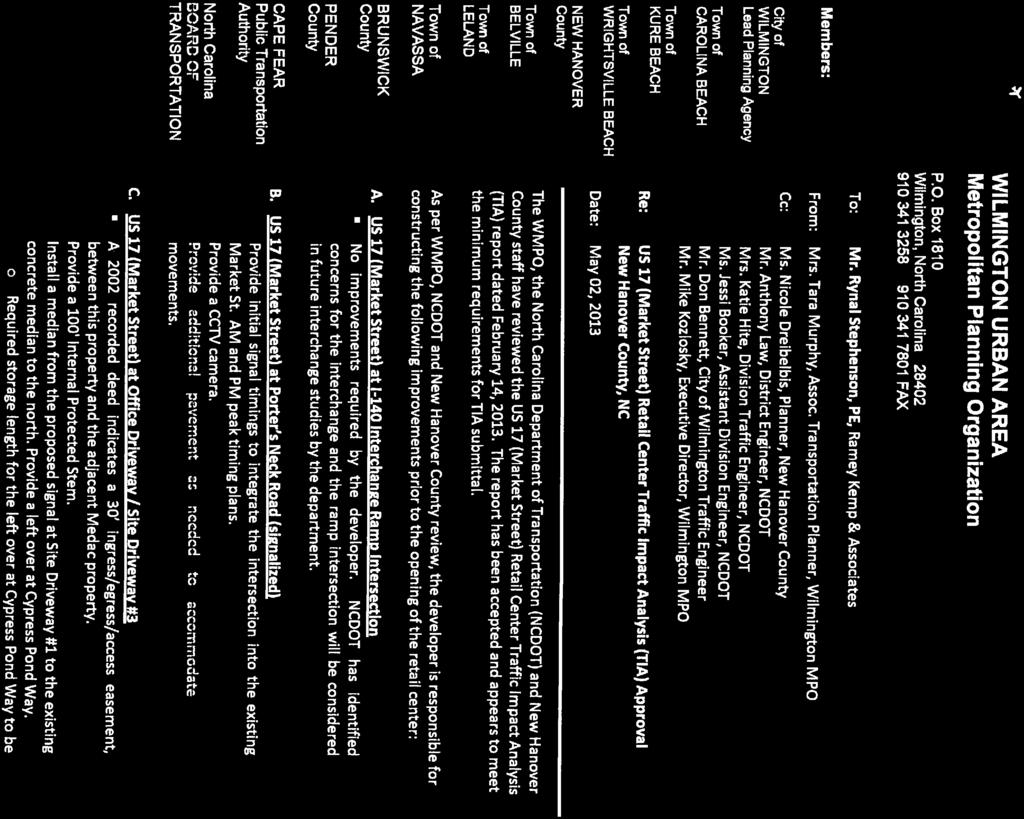
5 Traffic: Market Street is an arterial roadway and principal gateway leading into New Hanover County from Pender County. The average daily trip count near the 8100 block of Market Street in front of the State Employees Credit Union (SECU) was 37,654 vehicles (April, 2013 data). This figure represents an E Level of Service (LOS) meaning that traffic counts are approaching design capacity of the road. The traffic impact worksheet prepared by the petitioner s traffic engineer indicated that the proposed retail center would generate approximately 511 a.m. peak hour trips and 976 p.m. peak hour trips. Therefore a full Traffic Impact Analysis (TIA) was required in accordance with Section 61.4 of the County s Zoning Ordinance. The TIA conducted by Ramey Kamp and Associates estimated that 705 a.m. peak hour trips and 1,568 p.m. peak hour trips would be generated by the proposed retail center. Total primary new trips generated from the site at build-out would be 10,388 (based on 24 hour volume). The TIA has been reviewed by the North Carolina Department of Transportation (NCDOT), Wilmington Metropolitan Organization (WMPO), and County Planning staff. A TIA approval letter was received on May 2, Based on the TIA approval, the developer would be responsible for the following improvements prior to the issuing a certificate of occupancy for the retail center: 1. Market Street at Porters Neck Road (signalized) Provide initial signal timings to integrate the intersection into existing Market Street AM & PM peak timing plans Provide a CCTV camera Provide additional pavement as needed to accommodate u-turn movements 2. Market Street at Office Driveway/Site Driveway # 3 (Medac) A 2002 recorded deed indicates a 30 ingress/egress easement between this property and the adjacent Medac property Provide a 100 internal protected stem Install a median from the proposed signal at Site Driveway # 1 (SECU/WHA intersection) to the existing concrete median to the north. Provide a left over at Cypress Pond Way. Required storage length for the left over at Cypress Pond Way to be determined. Provide additional pavement as needed to accommodate u-turn movements. 3. Market Street at Proposed Site Driveway # 1 (Ingress/Egress from SECU & Wilmington Health.) Construct Site Driveway 1 as a full access intersection with two (2) inbound lanes and five (5) outbound (2 left, 1 thru, 2 right) lanes Provide a 300 internal protected stem for the proposed development and 100 internal protected stem for the existing medical campus (WHA) across Market Street Construct dual northbound left turn lanes with a minimum of 350 of full width storage and appropriate taper Extend southbound Market Street right turn lane to 350 Construct an exclusive westbound left turn lane Z-926, 06/13 Page 3
6 Install a traffic signal there will not be split side signal phasing Provide accommodations to coordinate with the City of Wilmington s traffic signal system to initial timings and equipment to integrate the proposed signal into existing Market Street AM & PM peak timing plans Provide additional pavement as needed to accommodate u-turn movements 4. Market Street at Proposed Site Driveway # 2 (Southwestern Portion of Project) Access shall be limited to right-in and right-out only Provide a 200 right turn lane southbound on Market Street Provide a 100 internal protected stem 5. Market Street at Mendenhall Drive/Marsh Oaks Drive Optimize signal timings Install a median from marsh Oaks Drive to the proposed signal at Site Driveway # 1 Provide storage lengths for southbound lefts into Marsh Oaks and u-turns Provide initial signal timings to integrate the intersection into existing Market Street AM & PM peak timing plans Provide additional pavement as needed to accommodate u-turn movements 6. Market Street/Torchwood Blvd/Bayshore Drive Provide new signal plans with revised phasing and timing plans to integrate the intersection into the existing Market Street AM & PM peak timing plans Provide additional pavement as needed to accommodate u-turn movements The applicant/petitioner will be required to obtain an NCDOT Driveway Permit for access to the State road network. All applicable NCDOT Driveway access technical standards and policies will apply. If changes are made to the proposed site driveways, land use and/or intensity, the traffic study parameters will need to be modified and a revised TIA will be required for review by NCDOT and the WMPO. COMMUNITY SERVICES: Water/Sewer: Water is currently available to serve the site. Presently, there is no sewer capacity available at the Country Haven Pump Station, but the Cape Fear Public Utility Authority (CFPUA) is in the process of upgrading the force main and pump station. According to the CFPUA, a developer agreement is currently being crafted and would allow the project to proceed with conditional sewer permitting and conditional CFPUA building permit approval. Fire Protection: The property will be served by New Hanover County Fire Services. A fire hydrant layout will be required in addition to a sprinkling system. Stormwater and Environmental Considerations: An Authorization to Construct (ATC) will be required for the project to mitigate negative impacts to drainage. The primary outlet under and Z-926, 06/13 Page 4
7 across Market Street will be analyzed for capacity. A Sedimentation and Erosion Control Permit will be required as well. The primary drainage basin is the Pages Creek Watershed, which is classified as SA-HQW (Shellfish - High Quality Waters). The soils maps indicate the presence of Kureb, Leon, Murville, and Rimini soils on the subject properties. Kureb and Rimini sands are classified as Class I soils with suitable to slight limitations. Leon and Murville are classified as Class III soils with severe limitations and are known to require extensive modifications and intensive maintenance. 404 wetlands exist near the southwestern corner of the proposed project. According to the County s Conservation Overlay maps, no conservation areas are located on site. The subject properties also did not indicate the presence of any cemeteries, archaeological sites or floodways. COUNTY S POLICIES FOR GROWTH AND DEVELOPMENT: CAMA Land Use Plan: The subject properties are classified as Transition according to the jointly adopted 2006 City-County CAMA Land Classification Map. The purpose of the Transition class is to provide for future intensive urban development on lands that have been or will be provided with necessary urban services. The location of these areas is based upon land use planning policies requiring optimum efficiency in land utilization and public service delivery. Policy 4.3 of the 2006 CAMA Land Use Plan states the need to maximize effectiveness of commercial uses by assuring that land is available for commercial uses within close proximity to the markets they serve and by ensuring that such commercial uses do not diminish the quality of life in nearby residential areas. Market Street Corridor Plan: The subject properties are located within the Market Street Corridor Plan which was adopted by the Board of Commissioners in June, The plan calls for the integration of pedestrian and bike amenities such as sidewalks and multi-use paths, median treatments such as a cement strip or landscaping to eliminate turning movements in the suicide lane, a preferred access plan creating road inter-connectivity, and provisions for providing quality, cohesive building design for multiple structures to enhance the aesthetics of the area. Porters Neck Small Area Plan: The subject properties are located within the small area plan adopted by the Board of Commissioners in September, Recommendations at the time included storm water controls, adding four lanes to Market Street, the development of bike paths and pedestrian walkways, and the improvement of major intersections such as Porters Neck Road and Market Street. Comprehensive Greenway Plan: The subject properties are located within the recently adopted Comprehensive Greenway Plan. Recommendations include a multi-use path along Market Street for pedestrians and bikers. Z-926, 06/13 Page 5
8 DISCUSSION: This area of the County has witnessed an explosion of population growth over the past twenty years with an increase of 4% to 5% based on census data for that period. This growth has placed a huge demand for services and has resulted in the establishment of two grocery stores, a home improvement facility, medical park, landscape nursery, and pharmacy along with other smaller retail stores located between Marsh Oaks Drive and Porters Neck Road. Increased growth has placed a high demand for water and sewer infrastructure, and produced traffic congestion along Market Street during peak hour periods. Based on the recommended TIA road improvements between Bayshore Drive and Porters Neck Road along Market Street coupled with the proposed construction of Military Cutoff Extension in 2017, traffic congestion is anticipated to be alleviated. A cement median from Marsh Oaks Drive to Porters Neck Road is recommended in the approved TIA. Staff believes that efforts should be made to create and install a landscape median (of various width depending on the turn lanes recommended) that would enhance the gateway leading into Wilmington from Pender County. Long term maintenance would be the responsibility of the anchor tenant through a recorded deed. The project will be accessed through three (3) curb cuts or access points off Market Street. The primary entrance/access with signalization will be located near the SECU facility and extend north and connect with Hays Lane, a platted 50 public right-of-way, (see attached site plan). The second access will be from the existing Medac driveway, and the third access will be near the southeastern portion of the project. Currently, Hays Ln. connects to a private, unimproved road to the rear of the subject property line. The proposal includes for Hays Ln. (on the site plan the road is listed as Hayes Ln., so staff has recommended as a condition that a correction be made to the site plan) to be connected through the proposed project as an 80 right-of-way from Market Street to the rear property line. However, in order for Hays Ln. to set the stage for future extension and connection with the Lowes Home Improvement access and to be compatible with the preferred access plan in the adopted Market Street Corridor Study, it will need to be dedicated, designated, recorded, and built as a public collector road meeting or exceeding minimum NCDOT standards. Once built, the developer would then be charged with petitioning NCDOT to take over the maintenance of the road at a future time. Until NCDOT assumes road maintenance, road maintained will be assured through covenants and restrictions which will be signed by the developer and anchor tenant. The connection of the new segment of Hays Ln. to the existing portion of Hays Ln. will also allow pedestrian and bicycle access from the abutting residential communities to the rear of the subject project. To further encourage pedestrian and bicycle movement into and throughout the project, and to comply with the Market Street Corridor and Comprehensive Greenway Plan, an eight foot multi-use path has been proposed that runs the width of the property frontage for a distance of Z-926, 06/13 Page 6
9 over 800. Additionally internal pedestrian sidewalks have also been provided throughout the development. Proposed building setbacks based on a building height of 23 for the anchor tenant exceed the requirements of Section 60.3 of the Zoning Ordinance. Proposed buffer yards meet the requirements of Section 62 of the Zoning Ordinance by proposing ample screening from the adjacent neighborhoods. The buffer will be comprised of existing natural vegetation and supplemented with additional buffer plantings. A loading dock barrier located to the rear of the anchor tenant is also proposed to baffle noise pollution (see attached renderings). Low level lighting is proposed as well. The original site plan has been refined in response to the stated concerns of adjacent residential landowners. Changes to the site plan included improvements to internal circulation and access, increased setbacks and buffer yards and retaining natural vegetation along with a baffling wall adjacent to the loading dock to mitigate noise. Four community meetings were held between April and May to gather input from surrounding communities. STAFF POSITION: Based on the information submitted, staff concludes that the petitioner s proposal to rezone approximately acres from B-2 Highway Business and R-15 Residential to CZD B-2 Conditional Zoning District Highway Business is compatible with applicable plans including the 2006 CAMA Land Use Plan, and Porters Neck Small Area Plan and is compatible with many of the recommendations of the Market Street Corridor Plan. Staff also concludes that the proposal is reasonable and is in the public s interest. Although staff attempted to impress upon the developer that the Market Street Corridor Plan discourages franchise architecture in order to create a sense of place unique to the area, the proposed anchor clearly identifies itself as Wal-Mart, America s largest retail franchise. Further, proposed parking spaces for the anchor tenant and all of the retail shops (1,107) well exceed the minimum requirements of Section 81-1 of the Zoning Ordinance (approximately 627). The proposal seeks to provide parking for the heaviest anticipated parking demand without the use of structured parking areas or pervious pavement which would help to reduce the size of stormwater facilities necessary to contain runoff. To alleviate these concerns, staff recommends the following conditions: 1) Work with a local architect to identify the unique character of the area in order to create a design for the retail center that looks less like a Wal-Mart franchise and more in tune with the Porters Neck Community; 2) Complete all improvements as recommended in the TIA prior to the issuance of an occupancy permit; 3) Construct and dedicate Hays Ln. as a public collector road meeting or exceeding minimum NCDOT standards; Z-926, 06/13 Page 7
10 4) Receive certification from the Army Corps of Engineers (Corps) for the wetlands onsite prior to development approval, and adapt site plan as necessary to comply with Corps permit requirements; 5) Work with the Cape Fear Public Transportation Authority (WAVE Transit) to secure an easement for the future construction of a bus shelter; 6) Prohibit RV overnight stays in the parking lot; 7) Control or baffle the HVAC systems located on the roof of the anchor tenant to mitigate noise pollution; and 8) Reduce the total number of parking spaces to meet the minimum standards allowed in the County Zoning Ordinance. If the minimum standard cannot be met, reduce the amount of impervious surface by building structured parking decks or utilizing pervious pavement or pavers. 9) Create and install a landscape median in lieu of a cement median as recommended in the TIA. Require that maintenance of the median be the responsibility of the anchor tenant through a recorded deed. 10) Correct the site plan to show Hayes Ln. as Hays Ln. ACTION NEEDED: In accordance with NCGS 153A-341, The Planning Board shall provide a written recommendation to the Board of County Commissioners that addresses plan consistency and other matters as deemed appropriately by the Planning Board 1. Motion to recommend approval that the project as proposed is consistent with the purposes and intent of the Transition classification in the 2006 CAMA Land Use Plan, the Porters Neck Small Area Plan and Market Street Corridor Plan; and it is reasonable and in the public interest to rezone acres from B-2 Highway Business and R-15 Residential to CZD (B-2), Conditional Zoning District Highway Business. 2. Motion to recommend approval with conditions. 3. Offer the petitioner the option to withdraw the petition. 4. Motion to table or continue the item in order to receive additional information or documentation (specify). 5. Motion to recommend denial because the project as proposed is not consistent with the purposes and intent of the Transition classification in the 2006 CAMA Land Use Plan, the Porters Neck Small Area Plan or Market Street Corridor Plan; and/or it is reasonable and not in the public interest to rezone acres from B-2 Highway Business and R-15 Residential to CZD (B-2), Conditional Zoning District Highway Business. Staff Suggested Motion: Motion to recommend approval with the aforementioned conditions, based on that the project as proposed is consistent with the purposes and intent of the Transition classification in the 2006 CAMA Land Use Plan, the Porters Neck Small Area Plan and Market Street Corridor Plan; and it is reasonable and in the public interest. Z-926, 06/13 Page 8
11 Case Z-926 (05/13) Request to rezone approximately acres from B-2 Highway Business and R-15 Residential to CZD (B-2) Conditional Zoning District B-2 Highway Business Petition Summary Data 8025 & 8107 Market Street Owner/Petitioner: Paramount Development Corporation Existing Land Use: The subject properties are located near the 8100 block of Market Street. The petition includes four parcels that comprise acres. Three of the parcels have the address 8107 and one has the address The 8107 parcels are currently zoned B-2 Highway Business (see attached map) to a depth of approximately 975 feet was rezoned in September, 2000 from R-15 Residential to B-2 Highway Business with a Special Use Permit for an Indoor/Outdoor Recreation Facility that was not constructed. These parcels are largely undeveloped with the exception of a water tower and telecommunications tower that have access through utility easements is currently zoned R-15 Residential and is undeveloped. Zoning History: Area 5 (July 6, 1971); Area 8B (July 7, 1972) Land Classification: Transition Water Type: CFPUA Sewer Type: CFPUA Recreation Area: Ogden Park Access & Traffic Volume: The Average Daily Traffic (ADT) near the 8100 block of Market Street (near the State Employee s Credit Union) has a volume of 37,654 vehicle trips per day. The road design capacity is 43,700 along this area of Market Street. The Level of Service is E meaning that the road is approaching design capacity. Fire District: New Hanover County Fire Service District (North) Watershed & Water Quality Classification: Pages Creek (Shellfish-High Quality Water) Aquifer Recharge Area: Primary recharge area for Castle Hayne and Peedee Aquifers Conservation/Historic/Archaeological Resources: No flood or county conservation areas are located on the subject property. Soils: Kureb, Leon, Murville, and Rimini Septic Suitability: Kureb and Rimini sands are classified as Class I soils with suitable to slight limitations. Leon and Murville are classified as Class III soils with severe limitations and are known to require extensive modifications and intensive maintenance. Z-926, 05/13 Page 1 of 2
12 Schools: Ogden Elementary School Capacity 595 Current Enrollment 692 Planning Areas: 2006 Joint City-County CAMA Land Use Plan Market Street Corridor Plan Porters Neck Community Plan Z-926, 05/13 Page 2 of 2

13

14
15 APPLICANT MATERIALS
16

17

18
19
20


21


22

23

24
25 PROPOSED PLAN
26

27
28


29
30


31

32

33

34

35
36

37
38

39
40

41

42


43
44
45


46

47
48


49


50


51


52

53

54

55

56

57

58


59
60

61
62
63

64


65
66

67

68

69


70
71
72


73


74


75
76
77 COMMUNITY COMMENTS
78
79 Williams-Rowland, Jackie From: Sent: To: Cc: Subject: Ralston, Shawn Friday, May 24, :21 AM O'Keefe, Chris; Burgess, Sam Williams-Rowland, Jackie FW: 8107 Market St Rezone/Special Use FYI Walmart comment Shawn Ralston Planning Manager Planning & Inspections - Planning & Zoning New Hanover County 230 Government Center Drive, Suite 110 Wilmington, NC (910) p (910) f From: Greg Butner [mailto:greg5605@yahoo.com] Sent: Thursday, May 23, :44 PM To: greg butner Cc: Ralston, Shawn; White, Woody; Barfield, Jonathan; Wolfe, Tom; bberger@nhcgov.com; Dawson, Beth Subject: Re: 8107 Market St Rezone/Special Use I would like to resend the following with real concerns after hearing from DOT and developer. They are estimating 10,000 car trips per day to the proposed development. Double what I already felt uncomfortable with. I think just adding a median and making u turns is NOT going to solve that. Look at Leland area of Waterford at rush hour. If a wreck does happen there is no where for traffic to get around the wreck without a center turn lane. It takes hours to get traffic moving again. We need a new school and upscale local businesses not Big Box stores. If they want to help with traffic put the walmart in Hampstead or Surf City. It is just going to bring more cars to Wilmington. Property zoning should of been reverted back after the hospital fell through and no way you should rezone residential acreage for Big Box Commercial developed by an out of state out of state income tax developer who will bring out of state contractors to do the construction. Sent from my iphone On Mar 18, 2013, at 3:16 PM, greg butner <greg5605@yahoo.com> wrote: As a resident of northern new hanover county who has to battle traffic everyday, I am very concerned about a large shopping development such as a Walmart being placed at the site of once was to be a future Medical Center. Check when that property was rezoned last, did it get zoning preference thinking that it was going to be the future home of a northern hospital. The traffic plus adding more lights that would be needed would not be conducive to the area. The area is in a desperate need of a school. I was told the county was looking at a site around that area to put the new Porters Neck Elementary School if the bond referendum was passed. I am in favor of adding small upscale shops or smaller not so many car trips per day stores to help the economy but another big box store is just an eyesore to our northern part of the county. There is already a long stretch 1
80 unattractive stretch of car dealers, fast food and big box shops, from middle sound south to princess st. We need another school and smaller upscale nice retail looking shops not more big box in this county. thank you for your concern Greg Butner Total Control Panel Login To: From: Message Score: 1 My Spam Blocking Level: High Block this sender Block yahoo.com High (60): Pass Medium (75): Pass Low (90): Pass This message was delivered because the content filter score did not exceed your filter level. 2

81


82


83

84

85


86
87 TECHNICAL REVIEW COMMITTEE REPORT: MAY, 2013 The County s Technical Review Committee met twice in May and reviewed three (3) projects. Scotts Hill Village (Conceptual Plan) At their May 8, 2013 meeting, the TRC discussed a 226 residential site plan known as Scotts Hill Village. The proposed project is located in the northeastern portion of the County and is classified as Watershed Resource Protection on the County s Land Use Plan. The project is limited to 2.5 units per acre. Total acreage is The project is proposed to have private roads with public water and sewer. Access is limited to Scotts Hill Loop Road in Pender County. During discussion with the developer, the following observations were noted by TRC: 1) Road inter-connectivity via Market Street and Marsh Field Drive is encouraged. 2) A Transportation Impact Analysis (TIA) would be required. 3) Public sewer capacity is limited. Water capacity is available. 4) Pender County Planning Department would review the site plan when formally submitted. 5) A public collector road is suggested running from Market Street to a parcel of New Hanover County property (intended for park use) located along Futches/Foys Creek. There was no time table set for formal submission. Watermark Landing (Performance Extension) At their May 22, 2013 meeting, the TRC reviewed an extension request for a 48 residential complex with acres known as Watermark Landing. The project is located near the 8400 block of River Road, west side and is classified as Conservation on the County s 2006 Land Use Plan. Private water and sewer are proposed along with private roads. The developer for the project requested a one year extension since the last preliminary approval in September, Under the Permit Extension Act, the project is set to expire in September, In a vote of 5-0, the TRC approved the one year preliminary extension to Watermark Landing for 48 lots. Approval of the project came with several conditions: 1) A water letter from DEHNR confirming adequate pressure for fire protection. The letter will be reviewed by County Fire Services. 2) Specific information concerning bridge load capacity is needed for fire protection. The information will be reviewed by County Fire Services. 3) With the designation of private roads to serve the project, no gates or obstructions will be permitted. 4) Additional utility easements may be required by the CFPUA. Waivers were granted on the sidewalk, private streets, and road inter-connectivity requirements. 5) An updated water and sewer letter is needed from Aqua of North Carolina. 6) The Private Road Certificates will be placed on the preliminary and final plat(s). Page 1 of 2
88 Laurenbridge (Performance Extension) Laurenbridge is located between Beacon Woods subdivision to the north and Greenbriar subdivision to the south. The project is also anchored between South College Road to the west and Masonboro Loop Road to the east. The area is classified as Urban on the County 2006 Land Use Plan. The project contains 34 residential lots that will be served by public water and sewer. One private road is proposed connecting to a public road. The developer for the project requested an one year extension to the preliminary validity to the plan. The plan was originally approved in May, 2009 and set to expire in May, 2013 under the Permit Extension Act. In a vote of 5-0, the TRC approved the extension of Laurenbridge subdivision for 34 lots. No specific conditions were imposed on the plan. However, the plan will require that the County s two new Private Certificates be placed on the preliminary plan and final plat(s). Page 2 of 2
89
90


91

92
STAFF SUMMARY FOR S17-02 SPECIAL USE PERMIT APPLICATION
 APPLICATION SUMMARY Case Number: S17-02 Request: STAFF SUMMARY FOR S17-02 SPECIAL USE PERMIT APPLICATION SUP application in order to develop a convenience food store. Applicant: Property Owner(s): Cindee
STAFF SUMMARY FOR S17-02 SPECIAL USE PERMIT APPLICATION
 APPLICATION SUMMARY Case Number: S17-02 Request: STAFF SUMMARY FOR S17-02 SPECIAL USE PERMIT APPLICATION SUP application in order to develop a convenience food store. Applicant: Property Owner(s): Cindee
Application Number: SD Project Name: Walton Farms Preliminary Subdivision (acting as Master Plan)
") STAFF REPORT Town of Clayton Planning Department 111 E. Second Street, Clayton, NC 27520 P.O. Box 879, Clayton, NC 27528 Phone: 919-553-5002 Fax: 919-553-1720 Planning Board May 22, 2017 Application Number:
STAFF REPORT Town of Clayton Planning Department 111 E. Second Street, Clayton, NC 27520 P.O. Box 879, Clayton, NC 27528 Phone: 919-553-5002 Fax: 919-553-1720 Planning Board May 22, 2017 Application Number:
VILLAGE OF CLEMMONS PLANNING BOARD DRAFT STAFF REPORT. Single Family Residential, Townhomes
 VILLAGE OF CLEMMONS PLANNING BOARD DRAFT STAFF REPORT PETITION INFORMATION Docket # C-212 Staff Megan Ledbetter Petitioner(s) Peacehaven Development LLC Owner(s) Larry Jarvis, William Alexander and Peacehaven
VILLAGE OF CLEMMONS PLANNING BOARD DRAFT STAFF REPORT
 VILLAGE OF CLEMMONS PLANNING BOARD DRAFT STAFF REPORT PETITION INFORMATION Docket # C-226 Staff Megan Ledbetter Petitioner(s) JBJH Properties, LLC Owner(s) JBJH Properties, LLC Subject Property 5892-49-1766
PLANNING COMMISSION. Agenda Item # 3.
 PLANNING COMMISSION Agenda Item # 3. CASE SUMMARY Conditional District Rezoning Planning Commission February 4, 2015 CD-9-215 Jeff Walton, 341-3260, jeff.walton@wilmingtonnc.gov Staff recommendation CONDITIONAL
Major Subdivision Sketch Plan Checklist
 This checklist provides specific requirements that are apart of the Sketch process. The entire process is described by the Huntersville Subdivision Review Process which details all the submittal and resubmittal
PART 1: PROJECT SUMMARY. Proposed Land Use: 120 single-family lots. The application is Attachment A. The site plan is Attachment B.
 PART 1: PROJECT SUMMARY Applicant: JBH Development, LLC and Hopper Communities, INC Project Size: +/- 80.48 acres Parcel Number: 01513107, 01513108, 01513109, 01513113, 01513120, 01513121, 01513122, 01513124,
Asbury Chapel Subdivision Sketch Plan
 Asbury Chapel Subdivision Sketch Plan PART 1: PROJECT SUMMARY Applicant: NVR Inc. Project Size: +/- 76.13 acres Parcel Numbers: 02101112,02116101,02116112, 02116113 Current Zoning: Transitional Residential
Mitchell Ranch South MPUD Application for Master Planned Unit Development Approval Project Narrative. Introduction
 Mitchell Ranch South MPUD Application for Master Planned Unit Development Approval Project Narrative Introduction Mitchell Ranch South is a proposed single family (detached) residential development on
Approved: CITY OF ARDEN HILLS, MINNESOTA PLANNING COMMISSION WEDNESDAY, AUGUST 5, :30 P.M. - ARDEN HILLS CITY HALL
 Approved: CITY OF ARDEN HILLS, MINNESOTA PLANNING COMMISSION WEDNESDAY, AUGUST 5, 2015 6:30 P.M. - ARDEN HILLS CITY HALL PLANNING CASES A. Planning Case 15-016; Final Planned Unit Development Arden Plaza;
ARTICLE 17 SITE PLAN REVIEW
 ARTICLE 17 SITE PLAN REVIEW 17.01 INTENT AND PURPOSE The intent of this section is to provide for consultation and cooperation between the applicant and the township planning commission so that the applicant
McDonald s Restaurant - Purcellville Town of Purcellville Special Use Permit Statement of Justification July 24, 2014
 Introduction / Written Statement McDonald s Restaurant - Purcellville McDonald s Corporation is proposing to redevelop the existing McDonald s eating establishment with a drive-through located at 121 N
14 October 10, 2012 Public Hearing APPLICANT: MPB, INC
 14 October 10, 2012 Public Hearing APPLICANT: MPB, INC PROPERTY OWNER: MUNDEN & ASSOCIATES, LP STAFF PLANNER: Karen Prochilo REQUEST: Conditional Change of Zoning (AG-1 & AG-2 to Conditional O-2) ADDRESS
PART 1: PROJECT SUMMARY. The application is Attachment A. The site plan is Attachment B.
 Belleterre Subdivision Sketch Plan Town Board 8.7.17 Belleterre Subdivision Sketch Plan PART 1: PROJECT SUMMARY Applicant: Bowman Development Project Size: +/- 20.85 acres Parcel Number: 01115104 and 01115121
CASE NUMBER: 16SN0701 APPLICANT: Hanky, LLC
 STAFF S ANALYSIS AND RECOMMENDATION Planning Commission (CPC) Public Hearing Date: MAY 17, 2016 CPC Time Remaining: 100 DAYS Applicant s Agent: DANIEL L. CASKIE (804-569-7060) Applicant s Contact: MICHAEL
D1 September 11, 2013 Public Hearing APPLICANT:
 D1 September 11, 2013 Public Hearing APPLICANT: BEACH MUNICIPAL FEDERAL CREDIT UNION PROPERTY OWNER: SISTERS II, LLC STAFF PLANNER: Karen Prochilo REQUEST: Conditional Change of Zoning (AG-2 Agriculture
12 January 12, 2011 Public Hearing APPLICANT: TAILWIND DEVELOPMENT GROUP,LLC PROPERTY OWNER: CITY OF VIRGINIA BEACH
 12 January 12, 2011 Public Hearing APPLICANT: TAILWIND DEVELOPMENT GROUP,LLC PROPERTY OWNER: CITY OF VIRGINIA BEACH STAFF PLANNER: Faith Christie REQUEST: Conditional Change of Zoning (from PD-H1 Planned
Rezoning Transportation Analysis Petition Number: General Location Identifier: , ,
 From: Kelsie Anderson, PE Kelsie.Anderson@charlottenc.gov 704-432-5492 Staff Reviewer: Rick Grochoske, PE rgrochoske@charlottenc.gov 704-432-1556 CDOT s review of this rezoning petition is intended to
8 February 9, 2011 Public Hearing APPLICANT: 7-ELEVEN, INC.
 . 8 February 9, 2011 Public Hearing APPLICANT: REQUEST: Conditional Use Permit for an automobile service station with a convenience store ADDRESS / DESCRIPTION: 2448 Nimmo Parkway PROPERTY OWNER: COURTHOUSE
Gadsden County Planning Commission Agenda Request
 Date of Meeting: November 16, 2017 To: From: Through: Subject: Gadsden County Planning Commission Agenda Request Honorable Chairperson and Members of the Board Jill A. Jeglie, AICP, Senior Planner Clyde
Rezoning Petition Pre-Hearing Staff Analysis October 15, 2018
 Rezoning Petition 2017-137 Pre-Hearing Staff Analysis October 15, 2018 REQUEST Current Zoning: R-3 (single family residential) Proposed Zoning: B-2(CD) (general business, conditional) LOCATION Approximately
Secrest Short Cut and Monroe Expressway Small Area Plan AUGUST 29, 2018
 Secrest Short Cut and Monroe Expressway Small Area Plan AUGUST 29, 2018 Background and Process Monroe Expressway will be open by the end of 2018 Union County and Indian Trail identified a need to revisit
VILLAGE OF CLEMMONS PLANNING BOARD DRAFT STAFF REPORT
 VILLAGE OF CLEMMONS PLANNING BOARD DRAFT STAFF REPORT PETITION INFORMATION Docket # C-214 Staff Megan Ledbetter Petitioner(s) Summit Healthcare Group Owner(s) Wake Forest University Health Services Subject
COLVER ROAD INDUSTRIAL CONCEPT PLAN
 COLVER ROAD INDUSTRIAL CONCEPT PLAN A CONCEPTUAL LAND USE AND TRANSPORTATION PLAN FOR TA-4 AN URBAN RESERVE AREA OF THE CITY TALENT City of Talent Adopted by City Council Resolution No., June, 2015 PART
CITY-COUNTY PLANNING BOARD DRAFT STAFF REPORT
 CITY-COUNTY PLANNING BOARD DRAFT STAFF REPORT PETITION INFORMATION Docket # W-3174 Staff Aaron King Petitioner(s) O Reilly Auto Parts Owner(s) Glenn Crossing Associates, LLC Subject Property Portion of
CASE NUMBER: 16SN0565 (AMENDED) APPLICANT: C.A.H. Investments, LLC
 APPLICANT: C.A.H. Investments, LLC") CASE NUMBER: 16SN0565 (AMENDED) APPLICANT: C.A.H. Investments, LLC STAFF S ANALYSIS AND RECOMMENDATION Board of Supervisors (BOS) Public Hearing Date: JUNE 22, 2016 BOS Time Remaining: 365 DAYS Applicant
CASE NUMBER: 16SN0565 (AMENDED) APPLICANT: C.A.H. Investments, LLC STAFF S ANALYSIS AND RECOMMENDATION Board of Supervisors (BOS) Public Hearing Date: JUNE 22, 2016 BOS Time Remaining: 365 DAYS Applicant
PRELIMINARY CONDITIONAL USE SUBMITTAL CHECKLIST REQUIREMENTS
 This checklist must accompany your submittal as the cover page. CONDITIONAL USE Application Submittal Checklist for PRELIMINARY AND FINAL APPROVAL Per Winter Park Land Development Code Sec. 58-90 PRELIMINARY
Rezoning Petition Pre-Hearing Staff Analysis April 16, 2018
 Rezoning Petition 2017-177 Pre-Hearing Staff Analysis April 16, 2018 REQUEST LOCATION Current Zoning: O-2 (office) and MUDD-O (mixed use development, optional) Proposed Zoning: MUDD-O (mixed use development,
Request for Statement of Interest in Implementation of the Roosevelt Road Redevelopment Plan
 425 Hillside Avenue Request for Statement of Interest in Implementation of the Roosevelt Road Redevelopment Plan I. INTRODUCTION The is seeking the services of a qualified consulting firm to prepare plans
REQUEST Current Zoning: O-15(CD) (office) Proposed Zoning: TOD-M(CD) (transit oriented development mixed-use, conditional)
 (office) Proposed Zoning: TOD-M(CD) (transit oriented development mixed-use, conditional)") Rezoning Petition 2016-117 Zoning Committee Recommendation January 4, 2017 REQUEST Current Zoning: O-15(CD) (office) Proposed Zoning: TOD-M(CD) (transit oriented development mixed-use, conditional) LOCATION
Rezoning Petition 2016-117 Zoning Committee Recommendation January 4, 2017 REQUEST Current Zoning: O-15(CD) (office) Proposed Zoning: TOD-M(CD) (transit oriented development mixed-use, conditional) LOCATION
STORMWATER MANAGEMENT CODES ANALYSIS RICHLAND COUNTY, SC SITE PLANNING ROUNDTABLE
 STORMWATER MANAGEMENT CODES ANALYSIS RICHLAND COUNTY, SC SITE PLANNING ROUNDTABLE Codes analyses for each subcommittee were completed to assist participants of the Richland County Site Planning Roundtable.
Drexel, Barrell & Co.
 Drexel, Barrell & Co. December 21, 2018 Engineers/Surveyors Boulder Colorado Springs Greeley 3 South 7 th Street Colorado Springs, Colorado 80905-1501 719 260-0887 719 260-8352 Fax El Paso County Planning
Request Conditional Use Permit (Car Wash Facility) Staff Recommendation Approval. Staff Planner Jonathan Sanders
 Staff Recommendation Approval. Staff Planner Jonathan Sanders") Applicant Property Owner SunTrust Bank Public Hearing October 10, 2018 City Council Election District Princess Anne Agenda Item 2 Request Conditional Use Permit (Car Wash Facility) Staff Recommendation
Applicant Property Owner SunTrust Bank Public Hearing October 10, 2018 City Council Election District Princess Anne Agenda Item 2 Request Conditional Use Permit (Car Wash Facility) Staff Recommendation
AWH REPORT OF THE PLANNING AND DEVELOPMENT DEPARTMENT FOR APPLICATION FOR REZONING ORDINANCE TO PLANNED UNIT DEVELOPMENT
 AWH REPORT OF THE PLANNING AND DEVELOPMENT DEPARTMENT FOR APPLICATION FOR REZONING ORDINANCE TO PLANNED UNIT DEVELOPMENT MAY 8, 2014 The Planning and Development Department hereby forwards to the Planning
KEIZER STATION PLAN INTRODUCTION
 KEIZER STATION PLAN INTRODUCTION Planning for this area began in 1987 when the Keizer Comprehensive Plan established the Chemawa Activity Center and McNary Activity Center. The first Chemawa Activity Center
CITY PLANNING COMMISSION AGENDA. ITEM NO(s): C.1 C.3 STAFF: STEVE TUCK
: C.1 C.3 STAFF: STEVE TUCK") Page 34 CITY PLANNING COMMISSION AGENDA ITEM NO(s): C.1 C.3 STAFF: STEVE TUCK FILE NOS: CPC ZC 12-00035 QUASI-JUDICIAL CPC NV 12-00036 QUASI-JUDICIAL AR DP 12-00039 QUASI-JUDICIAL PROJECT: APPLICANT: OWNER:
Page 34 CITY PLANNING COMMISSION AGENDA ITEM NO(s): C.1 C.3 STAFF: STEVE TUCK FILE NOS: CPC ZC 12-00035 QUASI-JUDICIAL CPC NV 12-00036 QUASI-JUDICIAL AR DP 12-00039 QUASI-JUDICIAL PROJECT: APPLICANT: OWNER:
The transportation system in a community is an
 7 TRANSPORTATION The transportation system in a community is an important factor contributing to the quality of life of the residents. Without a sound transportation system to bring both goods and patrons
The petition proposes the development of five townhomes on a vacant parcel between Charlotte Latin School and Providence Presbyterian Church.
 Rezoning Petition 2017-202 Final Staff Analysis June 18, 2018 REQUEST LOCATION Current Zoning: R-3 (single family residential) Proposed Zoning: UR-2(CD) (urban residential, conditional) with five-year
CONCEPT PLAN APPLICATION
 CONCEPT PLAN APPLICATION TOWN OF CHAPEL HILL Planning Department 405 Martin Luther King Jr. Blvd phone (919) 968-2728 fa (919) 969-2014 www.townofchapelhill.org Parcel Identifier Number (PIN): 9880267455
KNOXVILLE/KNOX COUNTY METROPOLITAN PLANNING COMMISSION
 KNOXVILLE/KNOX COUNTY METROPOLITAN PLANNING COMMISSION FILE #: 12-A-13-UR AGENDA ITEM #: 33 AGENDA DATE: 12/12/2013 APPLICANT: OWNER(S): METRO KNOXVILLE HMA, LLC Metro Knoxville HMA., LLC TAX ID NUMBER:
CITY OF ZEELAND PLANNING COMMISSION
 APPLICATION FOR SITE PLAN REVIEW AND SPECIAL LAND USE Date City Official App. Filing Fee Rec'd ($350) NOTE TO APPLICANT: Please submit this application for Site Plan Review along with twenty (20) copies
Planning Commission Staff Report June 5, 2008
 Owner/Applicant Taylor Village Sacramento Investments Partners, LP c/o Kim Whitney 1792 Tribute Road #270 Sacramento, CA 95815 Staff Recommendation Planning Commission Staff Report Project: File: Request:
Gold Line Bus Rapid Transit Transit Oriented Development (BRTOD) Helmo Station Area Plan
 Helmo Station Area Plan") Appendix F Gold Line Bus Rapid Transit Transit Oriented Development (BRTOD) Helmo Station Area Plan Introduction and Purpose of the Plan The Gold Line Bus Rapid Transit facility is an eleven-mile dedicated
Appendix F Gold Line Bus Rapid Transit Transit Oriented Development (BRTOD) Helmo Station Area Plan Introduction and Purpose of the Plan The Gold Line Bus Rapid Transit facility is an eleven-mile dedicated
Project phasing plan (if applicable) 12 copies of site plan
 12 copies of site plan") SITE PLAN REVIEW PERMIT APPLICATION City of Grand Haven, 11 N. Sixth Street, Grand Haven, MI 49417 Phone: (616) 847-3490 Fax: (616) 844-2051 Website: www.grandhaven.org 1. Project Information Address/location
SITE PLAN REVIEW PERMIT APPLICATION City of Grand Haven, 11 N. Sixth Street, Grand Haven, MI 49417 Phone: (616) 847-3490 Fax: (616) 844-2051 Website: www.grandhaven.org 1. Project Information Address/location
PLNPCM Carl s Jr. Commercial Parking Lot at Redwood Road and 1700 South
 Staff Report PLANNING DIVISION COMMUNITY & NEIGHBORHOODS To: Salt Lake City Planning Commission From: Casey Stewart; 801-535-6260 Date: November 4, 2016 Re: PLNPCM2015-00874 Carl s Jr. Commercial Parking
Michael D, Harvey, Current Planning Supervisor. This project was originally approved in 2012 by the BOCC and is summarized as follows:
 PLANNING & INSPECTIONS DEPARTMENT Craig N. Benedict, AICP, Director Current Planning (919) 245-2575 (919) 644-3002 (FAX) www.orangecountync.gov 131 W. Margaret Lane Suite 201 P. O. Box 8181 Hillsborough,
Definitions. Average Daily Traffic Demand (ADT): The actual number or projected number of cars that pass a point in a 24-hour period.
: The actual number or projected number of cars that pass a point in a 24-hour period.") Definitions Access Management: A combination of physical techniques and transportation policies used to control the flow of traffic between roads and the surrounding lands. Alternative City Form Scenarios:
Definitions Access Management: A combination of physical techniques and transportation policies used to control the flow of traffic between roads and the surrounding lands. Alternative City Form Scenarios:
Major Development Plan
 Major Development Plan Application number: MDP2016.03 Nixon Road Subdivision Request: The applicant request that the City Council receive the planning board recommendation to approve with conditions a
PRELIMINARY PLAT DESIGN REQUIREMENTS Updated 4/8/2016
 PRELIMINARY PLAT DESIGN REQUIREMENTS Updated 4/8/2016 The following items are required for the preliminary plat. Numbers correspond with those on the example preliminary plat. RENO COUNTY SUBDIVISION REQUIREMENTS
WHEREAS, after consideration of the evidence presented at the public hearing on January 14, 2010, the Prince George's County Planning Board finds:
 R E S O L U T I O N WHEREAS, the Prince George s County Planning Board has reviewed DDS-600 requesting a departure for the location of two loading spaces without driveway access along Toledo Terrace in
REQUEST FOR COUNCIL ACTION 6A AGENDA ITEM
 DATE REQUEST FOR COUNCIL ACTION 6A AGENDA ITEM ORIGINATING DEPT. AGENDA ITEM CITY ADMINISTRATOR APPROVAL Community Development PUD Concept & Development Stage Plan Preliminary Plat & Final Plat PREVIOUS
Request Alternative Compliance to the prescribed criteria of the Oceanfront Resort District Form- Based Code. Staff Recommendation Approval
 Applicant Property Owner Steven H. Murden Public Hearing June 14, 2017 City Council Election District Beach Agenda Item 8 Request Alternative Compliance to the prescribed criteria of the Oceanfront Resort
Drexel, Barrell & Co.
 Drexel, Barrell & Co. June 18, 2018 Engineers/Surveyors Boulder Colorado Springs Greeley 3 South 7 th Street Colorado Springs, Colorado 80905-1501 719 260-0887 719 260-8352 Fax El Paso County Planning
SITE PLAN (REVISED 8/13/18) l. Development Data Table
 l. Development Data Table") SITE PLAN (REVISED 8/13/18) l. Development Data Table a. Site Acreage: 9.25 b. Tax Parcels included in rezoning: #108-081-07 and #108-081-23 c. Existing Zoning (including overlays and vesting): R-3 (see
SITE PLAN (REVISED 8/13/18) l. Development Data Table a. Site Acreage: 9.25 b. Tax Parcels included in rezoning: #108-081-07 and #108-081-23 c. Existing Zoning (including overlays and vesting): R-3 (see
MIDTOWN MIXED-USE VILLAGE. TECHNICAL DATA SHEET COMPONENT C-1 FOR PUBLIC HEARING - PETITION NUMBER Project No RZ1.1. Issued.
 N MIDTOWN MIXED-USE VILLAGE TECHNICAL DATA SHEET COMPONENT C- FOR PUBLIC HEARING - PETITION NUMBER 04-00 Project No. 496 Issued Revised SCALE: " = 0' N 0 0 0 40 RZ. c GENERAL PROVISIONS: a. SITE LOCATION.
Staff Report to the North Ogden City Planning Commission
 Staff Report to the North Ogden City Planning Commission SYNOPSIS / APPLICATION INFORMATION Application Request: Concept review on a legislative application to rezone land located at approximately 1750
Baumgarten MPUD. Exhibit 3 Evaluation Criteria
 Pursuant to LDC subsections 10.02.13 B, 10.02.08 F and Chapter 3 G. of the Administrative Code, staff s analysis and recommendation to the Planning Commission, and the Planning Commission s recommendation
Rezoning Petition Final Staff Analysis June 18, 2018
 Rezoning Petition 2018-028 Final Staff Analysis June 18, 2018 REQUEST Current Zoning: MX-1 LLWPA (mixed use district, Lower Lake Wylie Protected Area), R-3 LLWPA (single family residential, Lower Lake
Request Conditional Rezoning (R-15 Residential to Conditional A-24 Apartment) Staff Recommendation Approval. Staff Planner Jimmy McNamara
 Staff Recommendation Approval. Staff Planner Jimmy McNamara") Applicant Franklin Johnston Group Management & Development, LLC Property Owner Virginia Wesleyan College Public Hearing July 12, 2017 City Council Election District Bayside Agenda Item 3 Request Conditional
Applicant Franklin Johnston Group Management & Development, LLC Property Owner Virginia Wesleyan College Public Hearing July 12, 2017 City Council Election District Bayside Agenda Item 3 Request Conditional
Rezoning Petition Pre-Hearing Staff Analysis April 16, 2018
 Rezoning Petition 2018-015 Pre-Hearing Staff Analysis April 16, 2018 REQUEST LOCATION Current Zoning: R-4 (single family residential) and UR-2(CD) (urban residential, conditional) Proposed Zoning: UR-2(CD)
The petition proposes to rezone the site to allow all uses permitted in the B-1 (neighborhood business) district.
 district.") Rezoning Petition 2018-040 Pre-Hearing Staff Analysis June 18, 2018 REQUEST Current Zoning: R-17MF (multi-family residential) Proposed Zoning: B-1 (neighborhood business) LOCATION Approximately 0.38 acres
Rezoning Petition 2018-040 Pre-Hearing Staff Analysis June 18, 2018 REQUEST Current Zoning: R-17MF (multi-family residential) Proposed Zoning: B-1 (neighborhood business) LOCATION Approximately 0.38 acres
ELECTION DISTRICT: PRINCESS ANNE
 D3 April 10, 2013 Public Hearing APPLICANT: HOLLOMON- BROWN FUNERAL HOME, INC. PROPERTY OWNER: HOLLOMON- BROWN FUNERAL HOME, INC. & TIDEWATER CEMETERY CORP. STAFF PLANNER: Karen Prochilo REQUEST: Conditional
ROAD CLOSURE AND LAND USE AMENDMENT SILVER SPRINGS (WARD 1) NORTHEAST OF NOSEHILL DRIVE NW AND SILVER SPRINGS ROAD NW BYLAWS 2C2018 AND 29D2018
 NORTHEAST OF NOSEHILL DRIVE NW AND SILVER SPRINGS ROAD NW BYLAWS 2C2018 AND 29D2018") Page 1 of 19 EXECUTIVE SUMMARY This application proposes redesignating two parcels in the community of Silver Springs from Special Purpose Future Urban Development (S-FUD) District and undesignated road
Page 1 of 19 EXECUTIVE SUMMARY This application proposes redesignating two parcels in the community of Silver Springs from Special Purpose Future Urban Development (S-FUD) District and undesignated road
CITY OF KEIZER MASTER PLAN APPLICATION & INFORMATION SHEET
 CITY OF KEIZER MASTER PLAN APPLICATION & INFORMATION SHEET PRE-APPLICATION CONFERENCE Prior to the actual filing of a Master Plan application, it is strongly recommended that the applicant contact Planning
CITY PLANNING COMMISSION AGENDA. ITEM NO: 6.a 6.b STAFF: LONNA THELEN
 Page 156 CITY PLANNING COMMISSION AGENDA ITEM NO: 6.a 6.b STAFF: LONNA THELEN FILE NO(S): A. - CPC ZC 08-00069 QUASI-JUDICIAL B. - CPC CU 08-00070 QUASI-JUDICIAL PROJECT: APPLICANT: OWNER: PHIL LONG VALUCAR
ARTICLE VI: SITE PLAN REVIEW
 Section 6.01 - Site Plan Review (All Districts) ARTICLE VI: SITE PLAN REVIEW Site plans give the Planning commission an opportunity to review development proposals in a concise and consistent manner. The
Rezoning Petition Pre-Hearing Staff Analysis May 21, 2018
 Rezoning Petition 2018-028 Pre-Hearing Staff Analysis May 21, 2018 REQUEST Current Zoning: MX-1 LLWPA (mixed use district, Lower Lake Wylie Protected Area), R-3 LLWPA (single family residential, Lower
ARTICLE 13 STREETS General
 ARTICLE 13 STREETS 13.1 General Streets shall be designed to suit their functions. Many streets have purposes other than vehicular traffic. As an alternative to current N.C. Department of Transportation
MONTGOMERY COUNTY PLANNING DEPARTMENT THE MARYLAND-NATIONAL CAPITAL PARK AND PLANNING COMMISSION
 MONTGOMERY COUNTY PLANNING DEPARTMENT THE MARYLAND-NATIONAL CAPITAL PARK AND PLANNING COMMISSION MCPB Item No. Date: 3.10.2016 Site Plan 820160040 Nora School Parker Smith, Planning Technician, Area 1,
RESIDENTIAL PLANNED UNIT DEVELOPMENT / SUBDIVISION AND REZONING CONCEPT AND DEVELOPMENT STAGE PLAN SUBMITTAL NARRATIVE
 RESIDENTIAL PLANNED UNIT DEVELOPMENT / SUBDIVISION AND REZONING CONCEPT AND DEVELOPMENT STAGE PLAN SUBMITTAL NARRATIVE DEVELOPMENT TEAM DONEGAL SOUTH Maple Grove, Minnesota March 27, 2017 Applicant/Developer/Builder:
KASPER. City of Georgetown, Texas PUD Planned Unit Development. December 30, 2015 Revised January 27, 2016
 KASPER City of Georgetown, Texas PUD Planned Unit Development December 30, 2015 Revised January 27, 2016 Applicant: Sentinel Land Company, LLC 4910 Campus Drive Newport Beach, CA Prepared by: SEC Planning
12 February 9, 2011 Public Hearing APPLICANT: WILDLIFE RESPONSE, INC.
 12 February 9, 2011 Public Hearing APPLICANT: WILDLIFE RESPONSE, INC. PROPERTY OWNER: CITY OF VIRGINIA BEACH REQUEST: Conditional Use Permit (Wildlife Rehabilitation Center) STAFF PLANNER: Karen Prochilo
CHAPTER SPECIAL PURPOSE AND OVERLAY ZONING DISTRICTS
 Special Purpose and Overlay Zoning Districts 106.28.010 CHAPTER 106.28 - SPECIAL PURPOSE AND OVERLAY ZONING DISTRICTS SPECIAL PURPOSE AND OVERLAY ZONING DISTRICTS Sections: 106.28.010 - Purpose 106.28.020
4. Shape Transitions. 4. Shape Transitions
 4. Shape Transitions 49 Zoning District Policies Overall Intent: Maintain neighborhood character by creating compatible transitions that minimize land use conflicts. Strategy: Define the character of zoning
TIRZ 17/Redevelopment Authority Capital Improvements Plan Projects
 Gessner Widening: T-1701 What: Widen the road from a six-lane divided boulevard to an eight-lane divided boulevard street section, increase turn lanes, update traffic signal system, improve drainage by
SUBDIVISION, PLANNED UNIT DEVELOPMENT, PLANNING APPROVAL, REZONING & SIDEWALK WAIVER STAFF REPORT Date: February 7, 2013
 SUBDIVISION, PLANNED UNIT DEVELOPMENT, PLANNING APPROVAL, REZONING & SIDEWALK WAIVER STAFF REPORT Date: February 7, 2013 APPLICANT NAME SUBDIVISION NAME DEVELOPMENT NAME LOCATION S. E. Cemeteries of AL
PLANNED DEVELOPMENT (MASTER PLAN & UNIT PLAN)
") Central Permit Center 555 Santa Clara Street Vallejo CA 94590 Business License Building Fire Prevention Planning Public Works 707.648.4310 707.648.4374 707.648.4565 707.648.4326 707.651.7151 PLANNED DEVELOPMENT
Central Permit Center 555 Santa Clara Street Vallejo CA 94590 Business License Building Fire Prevention Planning Public Works 707.648.4310 707.648.4374 707.648.4565 707.648.4326 707.651.7151 PLANNED DEVELOPMENT
MONTGOMERY COUNTY PLANNING DEPARTMENT THE MARYLAND-NATIONAL CAPITAL PARK AND PLANNING COMMISSION
 MONTGOMERY COUNTY PLANNING DEPARTMENT THE MARYLAND-NATIONAL CAPITAL PARK AND PLANNING COMMISSION MCPB Item No. Date: 12-10-15 Leisure World Clubhouse II Addition Fitness Center, Limited Site Plan Amendment
Request Conditional Rezoning (R-10 Residential & I-1 Light Industrial to Conditional I-1 Light Industrial) Staff Recommendation Approval
 Staff Recommendation Approval") Applicant & Property Owner Public Hearing January 9, 2019 City Council Election District Beach Agenda Item 1 Request Conditional Rezoning (R-10 Residential & I-1 Light Industrial to Conditional I-1 Light
Applicant & Property Owner Public Hearing January 9, 2019 City Council Election District Beach Agenda Item 1 Request Conditional Rezoning (R-10 Residential & I-1 Light Industrial to Conditional I-1 Light
Sanford/Lee County Technical Review Committee (TRC) DEADLINES & MEETING DATES
 DEADLINES & MEETING DATES") Sanford/Lee County Technical Review Committee (TRC) DEADLINES & MEETING DATES The following 2019 information is based on the information available to staff at the time of creation. Dates & time may change
Sanford/Lee County Technical Review Committee (TRC) DEADLINES & MEETING DATES The following 2019 information is based on the information available to staff at the time of creation. Dates & time may change
Land Use Amendment in Southwood (Ward 11) at and Elbow Drive SW, LOC
 at and Elbow Drive SW, LOC") 2018 November 15 Page 1 of 10 EXECUTIVE SUMMARY This land use amendment application was submitted by Rick Balbi Architect on 2017 August 31 on behalf of Sable Developments Ltd, and with authorization from
2018 November 15 Page 1 of 10 EXECUTIVE SUMMARY This land use amendment application was submitted by Rick Balbi Architect on 2017 August 31 on behalf of Sable Developments Ltd, and with authorization from
Staff Report. Conditional Use PLANNING DIVISION COMMUNITY & ECONOMIC DEVELOPMENT. Salt Lake City Planning Commission
 Staff Report PLANNING DIVISION COMMUNITY & ECONOMIC DEVELOPMENT To: From: Salt Lake City Planning Commission Maryann Pickering, Principal Planner (801) 535-7660 Date: December 10, 2014 Re: Church of Scientology
Sorted citizen input comments in review of Blount County plans July, August, and September 2007
 Sorted citizen input comments in review of Blount County plans July, August, and September 2007 The following presents sorted citizen input comments from three sessions held in July, August and September
PLANNED UNIT DEVELOPMENT APPLICATION
 PLANNED UNIT DEVELOPMENT APPLICATION CITY OF THE DALLES Community Development Department 313 Court Street The Dalles, OR 97058 (541) 296-5481, ext. 1125 Fax (541) 298-5490 www.ci.the-dalles.or.us Date
D3 January 14, 2015 Public Hearing
 D3 January 14, 2015 Public Hearing APPLICANT: DONALD J. BOUCHER, JR. PROPERTY OWNER: D.J.B. SERVICE CENTER, LLC STAFF PLANNER: Kristine Gay REQUEST: A. Conditional Change of Zoning (I-1 to B-2) B. Conditional
Rezoning Petition Pre-Hearing Staff Analysis September 17, 2018
 Rezoning Petition 2017-043 Pre-Hearing Staff Analysis September 17, 2018 REQUEST Current Zoning: R-3 (single family residential), R-17MF (multi-family residential), and CC (commercial center) Proposed
CITY PLANNING COMMISSION AGENDA ITEM: C STAFF: ROBERT TEGLER FILE NO: CPC PUD QUASI-JUDICIAL
 CPC AGENDA June 8, 2006 Page 37 CITY PLANNING COMMISSION AGENDA ITEM: C STAFF: ROBERT TEGLER FILE NO: CPC PUD 05-294 - QUASI-JUDICIAL PROJECT: APPLICANT: OWNER: PARKWOOD AT WOLF RANCH NASS DESIGN ASSOCIATES
Access Management: An Overview
 Figures 1-5 Below Evolution of development along a highway. In the early stages, land along the road is used for farming with little traffic generated. As time passes, the highway corridor becomes a de
Small Area Plan. South Gateway
 Small Area Plan Adopted May 12, 2008 South Gateway Purpose. The South Gateway Small Area Plan defines the City s expectations for the future of the southern entrance to the City at Interstate 85 and Highway
CHAPTER 21 NC-PUD NEIGHBORHOOD COMMERCIAL PUD DISTRICT
 CHAPTER 21 NC-PUD NEIGHBORHOOD COMMERCIAL PUD DISTRICT Section 21.1. Title and Purpose. The Neighborhood Commercial Planned Unit Development District, designated the, is intended for commercial uses of
PARISH OF ASCENSION OFFICE OF PLANNING AND DEVELOPMENT PLANNING DEPARTMENT. Joint Planning and Zoning Meeting
 1. Call To Order 2. Roll Call of Members 3. Chairman's Comments PARISH OF ASCENSION OFFICE OF PLANNING AND DEVELOPMENT PLANNING DEPARTMENT Joint Planning and Zoning Meeting January 11, 2017 6:00 PM Courthouse
Brian Madigan, RLA, CPESC Director Land Planning & Design
 Brian Madigan, RLA, CPESC Director Land Planning & Design bmadigan@gymodpc.com Architecture, Engineering & Land Surveying, DPC 18969 US Route 11 Watertown, New York 13601 T: (315) 788-3900 F: (315) 788-0668
PLANNED UNIT DEVELOPMENT STAFF REPORT Date: June 2, 2016
 # 9 ZON2016-01032 PLANNED UNIT DEVELOPMENT STAFF REPORT Date: June 2, 2016 DEVELOPMENT NAME JJT Properties LLC LOCATION 1147 & 1151 East I-65 Service Road South and 1180 Sledge Drive (Southeast corner
PLANNED UNIT DEVELOPMENT Date: April 5, 2018
 PLANNED UNIT DEVELOPMENT Date: April 5, 2018 DEVELOPMENT NAME SUBDIVISION NAME LOCATION Robert Myers Robert Myers 2955 and 2989 Dauphin Street (Southeast corner of Dauphin Street and Sage Avenue) CITY
4.1.3 LAND USE CATEGORIES
 4.1.3 LAND USE CATEGORIES a. City Center District The City Center District incorporates the existing character and mix of uses in downtown Belmont to encourage redevelopment and new development in keeping
2.0 AREA PLANS. Lakeside Business District. Lakeside Business District Land Use Categories:
 Lakeside Business District Lakeside Business District Land Use Categories: Campus Commercial Campus Commercial means a mixture of uses which includes corporate offices, office parks, hotels, commercial,
Community Development
 Land Use Petition RZ-16-004, VC-16-004-01 and VC-16-004-02 Date of Staff Recommendation Preparation: October 14, 2016 (KLA) PROJECT LOCATION: DISTRICT/SECTION/LANDLOT(S): ACREAGE EXISTING ZONING: PROPOSED
The open space system should provide connective elements, relate to natural resources, and enhance the suburban character of the landscape..
 The open space system should provide connective elements, relate to natural resources, and enhance the suburban character of the landscape.. Mixed-use and infill development should maintain or enhance
REQUEST FOR COUNCIL ACTION 6A AGENDA ITEM ORIGINATING DEPT. AGENDA ITEM CITY ADMINISTRATOR APPROVAL
 DATE REQUEST FOR COUNCIL ACTION 6A AGENDA ITEM ORIGINATING DEPT. AGENDA ITEM CITY ADMINISTRATOR APPROVAL Community Development Territorial Greens PUD Concept Plan Development Stage Plan Subdivision (Preliminary