R E P O R T Development Services
|
|
|
- Andra Lawson
- 5 years ago
- Views:
Transcription
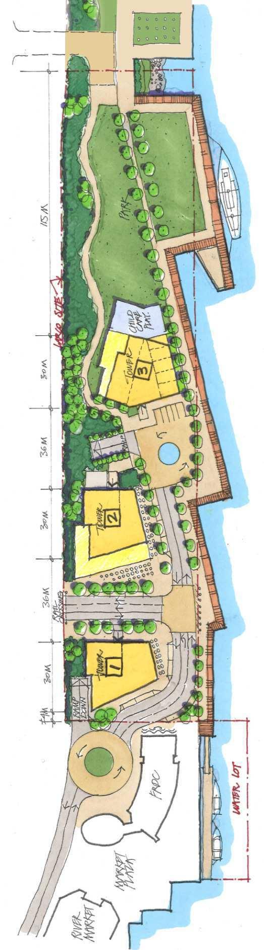
1 4 R E P O R T Development Services To: Land Use and Planning Committee Date: 10/3/2016 From: Beverly Grieve Director of Development Services File: SDP00208 DVP00615 Item #: 66/2016 Subject: 600 to 720 Quayside Drive (Bosa Site, formerly Larco Site): Special Development Permit Application and Development Variance Permit - Preliminary Report RECOMMENDATION THAT the Land Use and Planning Committee recommend that Council direct staff to process the application as outlined in this report. EXECUTIVE SUMMARY Bosa Development has submitted a Special Development Permit (SDP) and Development Variance Permit (DVP) application for the development of a mixed use development with two high rises and one two-storey commercial building at 600 to 720 Quayside Drive. The proposed development would provide approximately two acres of green space to be extended to Westminster Pier Park, complete the missing waterfront esplanade link between the Fraser River Discovery Centre and Westminster Pier Park, provide improved pedestrian and cyclist access to the waterfront via Begbie and Sixth Streets and provide a 40 space childcare facility along with at-grade commercial space near Begbie Street. The majority of parking would be provided below grade in a two storey underground parkade, including 80 publically accessible stalls. The proposed SDP would be accompanied by a DVP, which is a response to a revised site plan. The DVP would allow an increase in building height, a larger tower footprint above the second storey, reduced off-street parking and revised building siting to reflect the proposed site layout. The preliminary site and architectural drawings are attached in Appendix A.
2 City of New Westminster October 3, The applicant s proposed development meets the intent of the site Master Plan that the City and the previous owner, Larco Investment, jointly developed in 2013/2014 through an extensive planning and community consultation process. That site Master Plan is attached in Appendix B. As such, staff is recommending that the application proceed as outlined in this report. From a process perspective, the SDP would be considered by the Director of Development Services, and Council would consider the proposed DVP and revised Development Agreement Bylaw. 1. PURPOSE Bosa Development wishes to proceed with the development and construction of two residential towers and a commercial building on the site. The purpose of this report is to advise the Land Use and Planning Committee of the proposed SDP application and request that the Committee recommend to Council proceeding with processing the applications. 2. POLICY AND REGULATIONS 2.1. Official Community Plan Land Use Designation:The proposal fits the site s Official Community Plan land use designation which is Mixed-Use High Density. The plan describes this designation as: mixed-use (commercial and/or residential) throughout Downtown, outside of Columbia Historic Mixed-Use; retail, office, service or residential; any combination of the above (can be one use or multiple uses) 2.2. Downtown Community Plan: The subject site is within the Waterfront Precinct in the Downtown Community Plan. The intent of the Waterfront Precinct is to promote residential, commercial and park uses along the waterfront, continue to improve linkages, public access and views of the Fraser River, and enhance the waterfront s tourism potential by ensuring that public spaces are animated, welcoming and vibrant. The proposed development is supportive of the intent of the Waterfront Precinct Zoning Bylaw:The zoning for the site is Comprehensive Development District (660 Quayside Drive) (CD-55). Council adopted the rezoning for the project on November 3, The proposed development will require a Development Variance Permit for height, building footprint above the second storey, off-street parking and building siting Development Agreement Bylaw: The development of the site is further regulated by a Development Agreement, as per the New Westminster Redevelopment Act which specifies the City can require owners to enter into a Development Agreement prior to Agenda Item 66/2016
3 City of New Westminster October 3, commencing development within the Downtown neighbourhood. Given the change from three to two towers, Council will need to consider an amendment to the existing Development Agreement Bylaw prior to development being permitted Development Permit Area: The site is within the #1 Downtown Development and Special Development Permit Area. The proposal meets the intent of the Development Permit Area, which seeks to support the Downtown s Regional Town Centre designation in the Regional Growth Strategy. This Development Permit Area outlines objectives and guidelines for: The form and character of commercial, multifamily, institutional and intensive residential development. Protection of the natural environment, its ecosystems and biological diversity. Revitalization of an area in which a commercial use is permitted. Objectives to promote energy and water conservation and reduction of greenhouse gas emissions. In this area, Special Development Permits (SDPs) will be issued as authorized by the New Westminster Redevelopment Act Family Friendly Housing Policy: The project will meet the requirement of 30% twobedroom and three-bedroom units, and 10% of total units having three bedrooms or more, as outlined in the Family Friendly Housing Policy. The proposed mix of units currently indicates approximately 79% are two and three bedroom units and approximately 12% are three bedroom units Waterfront Vision: The proposed development supports the City s Waterfront Vision, which seeks to provide a continuous waterfront network of parks and greenways, provide enhanced connections from all neighbourhoods to the river, and animate the waterfront with a variety of experiences to draw residents, businesses and visitors Consideration of Applications: Typically development applications involving new buildings within the Downtown require Rezoning, SDP and Development Agreement Bylaws. As a rezoning for the site was recently adopted, in this case a rezoning is not required. As such only a SDP, DVP and Development Agreement Bylaw amendment are required. Given the prominence of this project, the Director of Development Services is providing this application to Council for information. As the SDP will be considered for issuance by the Director of Development Services, Council will only need to consider adoption of the DVP and Development Agreement Bylaw, prior to the Director s consideration of the SDP Policy for Evaluation of Proposed Height Variances: Addressing the proposed change to building height through a Development Variance Permit application (vs. a Agenda Item 66/2016
4 City of New Westminster October 3, zoning amendment) is supported by the policy outlined in the Council Report Use of Development Variance Permits and Amenity Contributions, endorsed by Council on October 15, This policy indicates that requests for up to 29% above allowable height under the Zoning Bylaw may be processed as a variance. For requests for 30-50% above allowable height, an application may be processed as a variance, at staff s discretion, particularly if another City priority is being achieved through the project, such as affordable housing, heritage conservation, and/or other social or environmental objectives. Based on the preliminary plans, the west tower would be a 13% increase in height based on building storeys or 15% based on metres. The east tower would be a 48% increase in height based on building storeys or 45% based on metres. The project addresses several City priorities through the provision of child care spaces, additional open space with the development of only two towers, completing the waterfront esplanade, providing public park space, enhancing access to the waterfront and increasing the number of family friendly housing units. As such, staff recommends addressing the proposed height changes for both buildings through a Development Variance Permit application FCM Railway Guidelines: The site is separated from Downtown by the railway lines and development of the site will therefore need to take railway issues into consideration. The Federation of Canadian Municipalities (FCM) and the Railway Association of Canada (RAC) have prepared railway proximity guidelines to help reduce conflicts between rail and urban uses. The applicant is aware of these guidelines and will address them where possible. 3. BACKGROUND 3.1. Site Characteristics and Context: The subject site is currently being used as a private surface parking lot. Westminster Pier Park is to the east, with the Fraser River Discovery Centre and River Market to the west. The Fraser River is to the south. To the north of the site is the rail corridor. And to the north of the rail corridor, is the Front Street Mews project, which is currently under construction along the Front Street frontage road between Begbie and Sixth Streets Previous Applications: The site has been the subject of a rezoning process in 1996 and again in Both were approved by Council and permitted 1,000 residential units in five high rise towers built over an above-grade parking podium. In 2014, the City and Larco Investments worked collaboratively on a new Master Plan and subsequent rezoning in order to establish a Comprehensive Development zoning schedule that took into consideration the new Downtown Community Plan (2010), the change in community values and the implementation of the City s Waterfront Vision. The revised Master Plan included greater provision for open space and views of the Fraser River, the provision of approximately two acres of land for an extension of Agenda Item 66/2016
5 City of New Westminster October 3, Westminster Pier Park, an extended waterfront esplanade, three rather than five high rise towers, and a mix of land uses including residential, commercial, child care, and the provision for a 150 room hotel. 4. PROJECT DESCRIPTION 4.1. Project Description: The proposed development includes two towers located to the east of Begbie Street and a two storey commercial building to the west of Begbie Street. Key aspects of the proposed development include: Family friendly (three bedroom) units would be incorporated into each tower. The east tower also includes five ground level townhouses. The west tower would have commercial uses in the podium, including a 7,000 sq.ft. restaurant. The two storey building would have commercial use on the ground floor and a 40 space childcare facility on the second floor. In total, approximately 20,000 sq.ft. of commercial is proposed. Clustering the towers at the western end of the site allows the eastern portion of the site to be dedicated to the City as an extension of Westminster Pier Park. The park space would be approximately 1/3 of the site and add about 0.8 hectares (two acres) to Westminster Pier Park. The two acres of park space includes the waterfront esplanade extension. The new park would be designed to the same standard as Westminster Pier Park and would include a collaborative design process with City, developer and the community, to occur at a later date. The development would facilitate the completion of the waterfront esplanade between Fraser River Discovery Centre/River Market and Westminster Pier Park. Quayside Drive is proposed to be realigned to create a waterfront drive that connects to Begbie Street. A new residential access street adjacent to the rail corridor would serve residential visitor parking and drop-off, and parkade access for the towers. Begbie Street extends south to meet Quayside Drive, providing direct connection between Columbia Street and the waterfront, and clear views to the river. Significant public open space is provided around the bottom of the Begbie Street and Quayside Drive node. Begbie Street where it intersects the railway lines would be maintained as an atgrade, accessible crossing for vehicles, pedestrians and bicycles while maintaining whistle cessation requirements. A secondary pedestrian crossing on the east side of Begbie is proposed. Agenda Item 66/2016
6 City of New Westminster October 3, The majority of parking, including the residential and 80 publically-accessible parking stalls would be located in an underground parkade accessed both from Quayside Drive and a second ramp between the towers adjacent to the north property line. A limited amount of on-street parking and drop-off zones are proposed adjacent to the retail spaces at the foot of Begbie and turning into Quayside Drive. The area along the north property line is proposed to reference the Front Street mews and would have a minimal number of surface residential visitor parking stalls. An at-grade accessible pedestrian and cyclist crossing and secondary emergency vehicle access is being explored at Sixth Street, subject to the ability to achieve whistle cessation requirements. An overhead accessible pedestrian and cyclist crossing is proposed for Sixth Street, coming off the A deck of the Parkade. The buildings will meet the Flood Control Level established by the City. Construction phasing: Phase 1a: Underground parkade Phase 1b: Two story commercial building and west residential tower Phase 2: East residential tower and the park 4.2. Project Statistics: Note: The applicant is still refining the floor space within the buildings and some changes may occur from that noted below. Permitted Site Size 176,839 sq.ft. (16,430 m) Site Frontage 925 feet (282 m) Floor Space Ratio (total and by land use) Units & Unit Mix Distance Between Buildings Total: 4.52 FSR Previous plan based on approximately 820 units, with a total of 30 family friendly units (townhouse or 3 bedroom apartments) Proposed 118 feet 176 feet Total: 4.52 FSR Residential: 4.40 FSR Commercial: 0.12 FSR Total: 644 units 1BR: 136 units 2BR: 432 units 3BR (apartment): 71 units 3BR Townhouses: 5 units Agenda Item 66/2016
7 City of New Westminster October 3, Building Footprints (Maximum) Building Height Building Footprint above 2 nd Storey (Maximum) Parking Building Siting Tower 1: 8,500 sq.ft. Tower 2: 10,500 sq.ft. Tower 3: 11,000 sq.ft. Building 1: 38 storeys (128m) Building 2: 47 storeys (156m) Building 3: 29 storeys (103m) Building 1: 8,500 sq.ft Building 2: 6,500 sq.ft Building 3: 7,500 sq.ft 918, with no incentives applied Larco Master Plan, see Appendix B Tower 1: 6,736 sq.ft Tower 2: 8,980 sq.ft. Tower 3: 8,980 sq.ft. Building 1: 2 storeys (18m) Building 2: 53 storeys (180m) Building 3: 43 storeys (149m) Building 1: 5,976 sq.ft Building 2: 9,149 sq.ft Building 3: 9,149 sq.ft TBD * the applicant is still working on parking allocation, see section 5.5 iii) Proposed Bosa Site Plan, see Appendix A NOTE: grey rows indicate proposed variances, white rows meet City regulations. 5. DISCUSSION 5.1. Differences between Larco and Bosa Development Scenarios: As noted in section 3.2, this site was rezoned under the previous owner. While the Bosa development plan continues to meet the principles and intent of the original Master Plan and related City policies, there are a few key differences between the two development scenarios. These include: Two towers are currently proposed, both east of Begbie Street, versus three towers in the Larco plan; The two residential towers are further apart from each other with a private garden between them, providing increased building separation and open space; The third building, west of Begbie Street, is proposed as a two storey commercial building (instead of a tower as formerly proposed) which will accommodate the daycare and retail units; The towers are moved further from the railway corridor and closer to the water with an access road between them and the rail tracks. This provides opportunity Agenda Item 66/2016
8 City of New Westminster October 3, for an enhanced public realm along the river and at the bottom of Begbie Street, by moving vehicle activity away from the waterfront; The current plan is configured so that Begbie Street intersects with Quayside Drive in an approximate 90 degree turn A hotel is not proposed in the Bosa plan, where the Larco plan had a potential provision for a 150 room hotel; and The construction is proposed to be completed in two phases rather than three phases Transportation Considerations Street Network An important consideration related to new waterfront development has been the ability of the Downtown street network to accommodate additional local trips generated by new development in the area and anticipated background traffic. Previous modeling done with the Larco development indicated that the existing street network would not be significantly impacted by the proposed development. An updated analysis of the transportation considerations based on the current proposal is being completed by a transportation consultant and will be reviewed and assessed by the City s Engineering Transportation Division. The consultant s review will take the following principles into consideration: Support the City s efforts in whistle cessation at Begbie Street and Sixth Street; Ensure adequate emergency vehicle access to/from the site and the Quayside area in general; Confirm that the proposed street network is able to accommodate vehicles in a safe and efficient manner, including at times when the rail crossing is closed for trains crossing or stopped across the intersection; and Create a high quality public realm that supports active modes of transportation and promotes the waterfront area. In principle, City staff is supportive of the new road alignment in the Bosa proposal, subject to further review of the proposal and the transportation consultants work Whistle Cessation The preliminary review has indicated that the current design supports whistle cessation by eliminating conflicting vehicular movements on Begbie Street and Quayside Drive south of the railway tracks, including through: 1) provision of a median that forces a right in/right out from the residential towers; and, 2) the use of electronic messaging Agenda Item 66/2016
9 City of New Westminster October 3, signs at the roundabout at the west end of the subject site, and at the Quayside Drive and McInnes Street Overpass intersection, which provide advance warning of a rail crossing closure. This electronic messaging system is anticipated to reduce the number of drivers waiting at the crossing. The addition of a secondary pedestrian/cyclist crossing on the east side of Begbie Street over the rails, with appropriate gate/lighting equipment to discourage trespassing, is anticipated to be supported by the rail companies as it provides an additional opportunity for controlled, safe passage over the tracks Emergency Access The preliminary proposal supports emergency vehicle access to the existing Quayside area and the new development to the satisfaction of the City s Fire Department. The street geometry, including the roundabout, would be designed to accommodate emergency service vehicles as well as trucks and buses. The at-grade access at Sixth Street would also act as a secondary emergency access point to the development and Westminster Pier Park Pedestrian/Cyclist Access The proposed street layout works to promote active transportation modes and encourages low vehicle speeds conducive to safely sharing the street between vehicles and cyclists. The waterfront Esplanade would be a minimum of nine metres wide. Access to the waterfront would be enhanced via pedestrian and cycling crossings at Begbie and Sixth Streets. Improvements to McInnes Street Overpass and Hyack Square are also being explored to improve accessibility between the Downtown and the waterfront. 5.3 Servicing: Detailed servicing will be determined as part of the SDP process Development Permit Area Guidelines: The Larco Master Plan was designed in keeping with the Development Permit guidelines outlined in the Downtown Community Plan. The revised Bosa proposal continues to meet the intent of these design guidelines and supports several of the guideline objectives, including: Reflect the context of New Westminster and unique characteristics such as history, views and topography. Provide safe and pleasant streets and public spaces where pedestrians feel comfortable and welcome. Create a positive, people oriented connection between new buildings and the street, between public and private spaces. Agenda Item 66/2016

10 City of New Westminster October 3, Promote excellence in architectural design and creativity in the architectural form, massing and character of new development. Protect important public views, and ensure light and air penetration to the street. Promote a vibrant and diverse local economy through the encouragement of attractive and functional commercial areas. Encourage new habitat and a greened built environment which supports ecological cycles and reconnects people with nature. Promote sustainable modes of transport. The proposal will be assessed utilizing the Downtown Community Plan guidelines once the final architectural plans have been submitted Downtown Building and Public Realm Design Guidelines: Council endorsed these guidelines in 2016, which focus on ensuring the urban design of buildings and the adjacent streetscape and public realm in the Downtown are completed to a high standard. The proposal will also be assessed utilizing these guidelines once the final architectural plans have been submitted Proposed Variances: It is anticipated that the project will require variances for i) building siting, ii) larger tower foot prints above the second storey, iii) increased building height and iv) decreased off street parking, as discussed below: i) Building Siting: The buildings are generally in alignment with the Larco Master Plan, as shown below. The towers in the Bosa plan have been pushed further from the rail corridor (towards the river) and the separation between the two towers has increased. These adjustments support railway proximity considerations and provide for greater open space between the towers. Larco Master Plan Agenda Item 66/2016

11 City of New Westminster October 3, Proposed Bosa Site Plan ii) Tower Footprints Above the Second Storey: This is proposed as part of the iconic architectural design of the proposal, and is in keeping with the City s Iconic Building Principles. The purpose of setting maximum floor plate sizes was to allow for visual connection from the Downtown to the waterfront and this proposal supports that objective through the development of two rather than three towers on the site. iii) Building Height: The request for height variance is in keeping with Use of Development Variance Permits and Amenity Contributions, as outlined in section 2.6 of this report. iv) Off Street Parking: The applicant is currently working on parking space provision, including a report from a professional transportation specialist. If they are unable to achieve the required parking, they will need to provide a rationale from a transportation specialist for the requested variance which would be reviewed by the City s Engineering Department. As per the City s parking cash-in-lieu policy, the applicant would be required to provide a contribution of $25,000/stall, for any variance outside the demand management incentives listed in the Zoning Bylaw. Parking is particularly difficult on this site due to constraints presented by the river and staff will continue to work with the applicant on the provision of parking. 5.6 Childcare Provision: As noted in section 4.1, the development would include a 40 space childcare facility. It is noted that the requirement for this space is 6500 sq.ft. and the preliminary plans show 5976 sq.ft. Staff will continue working with the applicant to achieve the required space allocation. Agenda Item 66/2016
12 City of New Westminster October 3, REVIEW PROCESS The preliminary proposal generally meets the intent of the original Master Plan and would be processed as described below, with the timeline being extended if any stage requires additional evaluation: 1. Staff, applicant and consultants to continue working with external agencies on proposal review (October - November 2016) 2. Staff, applicant and consultants to continue working on City servicing requirements (October November 2016) 3. Report to LUPC (October 3, 2016) 4. Report from LUPC to Council (October 17, 2016) 5. Public Consultation (Mid-Late October 2016) a. Public Open House, Presentation to Downtown Residents Association & Quayside Community Board 6. Presentation to New Westminster Design Panel (October 25, 2016) 7. Sign-off from external agencies on development proposal (Late fall 2016) 8. Report on Special Development Permit and Consideration of Notice for DVP By Council (early November 2016) 9. Consideration of Development Agreement Amendment: 1 st, 2 nd & 3 rd Readings (early November 2016) 10. Opportunity to be Heard for Development Variance Permit (Late November 2016) 11. Adoption of Development Agreement by Council (Late November 2016) 12. Staff and applicant to finalize Works & Service agreement (December 2016) 13. Issuance of SDP by Director of Development Services (December 2016) 7. INTERDEPARTMENTAL LIAISON This project is being worked on by members of Development Services, Engineering Services, Parks and Recreation, and the CAOs Office. 8. OPTIONS There are two options for consideration; they are: 1. That the Land Use and Planning Committee recommend that Council direct staff to process the application as outlined in this report. 2. That the Land Use and Planning Committee provide alternative feedback. Option 1 is recommended. Agenda Item 66/2016
13 City of New Westminster October 3, ATTACHMENTS Appendix A: Preliminary Drawings Appendix B: Larco Master Plan This report has been prepared by: Carolyn Armanini, Planning Analyst This report was reviewed by: Jackie Teed, Manager of Planning Beverly Grieve Director of Development Services Agenda Item 66/2016
14 Attachment A Preliminary Drawings
15 1.3 LANDSCAPE PLAN - MASTERPLAN ELEMENTS PLANTING TO PROVIDE SCREENING FROM RAILWAY 923' 5 3/4" [923' 6"] 30' 0" [30' 0"] EXIT 35' 0" [35' 0"] 13.50' F.F. [4.12M] F.F ' F.F. [5.5M] F.F. D.L. Rem. Pcl. A DROP OFF / TURN AROUND AREA 3979 WATER FEATURE EAST TOWER LOBBY [1993 SF.] LOADING 18.00' F.F. [5.5M] F.F. PLAN LMP NE ZO UP PRIVATE PRIV TE GARDEN PRIVA PARCEL STORAGE PUBLIC PARK 0.8 HECTARES (2 ACRES) 2 STORY ORY TOWNHOUSE STOR ST TOWNHOUSE LOWER WER 1 BR, BR 1 BATH UPPER 2 BR, 2 BATH TYPE B 15.50' F.F. [4.72M] F.F. PLANTER D.L WOOD VIEWING DECK PI 29' 0" [29' 0"] KITCHEN SUITE 103 LAWN WITH GRASS MOUNDS UPPER 942 S.F. LOWER 1040 S.F S.F. TOT TOTAL OTAL AL 1982 S.F. DINING 2 STORY TORY ORY TOWNHOUSE OWNHOUSE WER 1 BR, LOWER BR 1 BAT BATH UPPER 2 BR, BR 2 BATH 2 STORY ORY TOWNHOUSE WER 1 BR, LOWER BR 1 BATH UPPER 2 BR, 2 BATH BEDROOM TYPE B PATIO WOONERF/PEDESTRIAN FRIENDLY SPACE 10' 0" KITCHEN DINING UPPER 899 S.F S. LOWER 924 S.F. S.F S TOTAL OTAL AL 1923 S.F S.F. S PRIVATE GARDEN LIVIN G TYPE B LIVIN G SPECIAL SEATING NODES 0"] 10' 0" [10' 0" PATIO 13' 10 7/16" [13' 10"] 8" 50' 1" [50' 1" 1"] 50' 1" [50' 1" 1"] 13' 8" [13' 8"] 16' 3 7/16" [16' 3"] 50' 0" PL [31' 0"] 31' 0 3/8" 3' 8" [3' 8"] EXTENT OF PARKING STRUCTURE BELOW [45' 11"] 8 1/16" 9' 11 [8"]1/2" [10' 0"] PLANTER 15.50' F.F. [4.72M] F.F. 9' 11 1/2" [10' 0"] PLANTER 15.50' F.F. [4.72M] F.F. 45' 11 1/16" N PATIO DINING FLEX 18.00' F.F. [5.5M] F.F. SUITE ' 0" [29' 0"] PAVING NODES SUITE 104 UPPER 703 S.F S. LOWER 836 S.F. S.F TOTAL 1539 S.F TOTAL S.F. PLANTER CRU 1 [3939 SF] 18.00' F.F. [5.5M] F.F. PL LIVIN G KITCHEN PLANTING TO SEPARATE RESIDENTIAL FROM THE PARK 9' 8" CK REAR LOAD PARCEL STORAGE 1. MAIL MAIL WATER FEATURE FIRE CONTROL ROOM WATER FEATURE FIRE CONTROL ROOM 29' 0" [29' 0"] MAIL 5 PARK PARKING 19' 8 1/4" [19' 8"] 13' 1 1/2" [13' 1"] 2 STORY ORY Y TOWNHOUSE OWNHOUSE LOWER WER 1 BR, BR 1 BATH DINING [4.72M] F.F. 17' 10 15/16" [17' 11"]2" [2"] UPPER 819 S.F S. LOWER 666 S.F. S TOT TOTAL OTAL AL 1485 S.F S.F. S TYPE B OUTDOOR PATIO PLAN LMP SUITE 105 LIVIN G KITCHEN MEETING 15.50' F.F. 57' 4 1/2" [57' 4"] Rem. Pcl. A RESIDENTIAL RECYCLE ROOM UPPER 2 BR, BR 2 BATH DROP OFF 39' 5 9/16" [39' 6"] UPPER 2 BR, 2 BATH TYPE B 10' 6" [10' 6"] [1993 SF.] 18.00' F.F. [5.5M] F.F. MEETING 13.00' F.F. [3.96M] F.F. 2 STORY ORY TOWNHOUSE OWNHOUSE LOWER WER 1 BR, 1 BATH B LIVIN G PLAN LMP DN PE SLO 5% AIR SPACE PLAN LMP WATER FEATURE CONCIERGE SLOPE DN 5% WATER FEATURE WEST TOWER LOBBY SHARED LOADING COMMERCIAL RECYCLE ROOM [308 SF] CONCIERGE 17.50' T.O.S. UPPER 776 S.F. LOWER 1016 S.F. TOTAL OTAL AL 1792 S S.F S.F. COMPACTOR LANDSCAPE LANDSC LANDSCA ANDSCAPE NDSCAPE KITCHEN 40' 0" [40' 0"] SLOPED PLANTER 29' 0" [29' 0"] 192' 5 5/8" [192' 6"] CRU 2 [3475 SF] WATER FEATURE HIDDEN SERVICE ROAD 6M WIDTH STRUCTURE TO WITHSTAND FIRE TRUCK LOADING SUITE 106 HOA OFFICE COMPACTOR RESIDENTIAL RECYCLE ROOM [374 SF] Rem. Pcl. A SERVICE ROAD 2. DINING 37' 6" 18.00' F.F ' F.F. [3.81M] F.F. AIR SPACE Pcl. A 20' 0" [20' 0"] 23' 0" [23' 0"] WATER FEATURE [41' 10"] DAYCAREA &PUBLIC LOBBY 41' 9 5/8" 43' 6" [43' 6"] 29' 0" [29' 0" 0"] DN 49' 8" [49' 8"] SLOPE 5% CRU 3 UP DN COMMERCIAL RECYCLE ROOM [308 SF] PARKING EXIT ENTRY 13' 5 5/16" [13' 5"] 15.50' F.F. [4.72M] F.F. LOADING UP B.O.H. 57' 10 1/4" [57' 10"] 45' 4" [45' 4"] UP 0" DN DN SLOPE DN 15.0% 15.50' F.F. [4.7M] F.F. HOA OFFICE 25' ENTRY 66' 8 15/16" [66' 9"] [29' 0"] 29' 0" [2 R SLOPE DN 5% SLOPE DN 15.0% 3" PL EXIT 3. R 26' 51' 8 3/4" [51' 9"] UP DN UP PL PARKING EXIT DN 2' 9" 18' 3 5/8" [18' 4" 4"] E D R. PIERS 12.00' F.F. [3.66M] F.F. QUAYS ID 174' 10 11/16" [174' 11"] 31' 9" [31' 9"] CONCRETE PAVING WITH METAL BAND COMBINATION OF CANTILIEVERED AND PILE SUPPORTED PEDESTRIAN ESPLANADE ABOVE WEST TOWER 50 STORIES DAYCARE/COMERCIAL 2 STORIES WOOD SEATING WITH PLANTING IN BETWEEN FRASER RIVER EAST TOWER 40 STORIES 4

16 2.1 RIVER VIEW PERSPECTIVE 5

17 2.2 BIRDSEYE PERSPECTIVE 6

18 2.3 VIEW FROM SOUTH SIDE OF SKYTRAIN BRIDGE 7

19 2.4 VIEW FROM QUAYSIDE DRIVE OVERPASS 8

20 2.5 VIEW FROM ROYAL AVENUE AND 6TH STREET 9

21 2.6 ESPLANADE WALK VIEW FROM PARK TO EAST TOWER 10

22 2.7 ESPLANADE WALK VIEW FROM PUBLIC PLAZA LOOKING EAST 11

23 Attachment B Larco Master Plan
24
ELMVALE ACRES SHOPPING CENTRE MASTER PLAN
 ELMVALE ACRES SHOPPING CENTRE MASTER PLAN Contents 1.0 INTRODUCTION... 2 2.0 LOCATION... 2 3.0 EXISTING CONTEXT... 2 4.0 VISION & GUIDING PRINCIPLES... 2 5.0 LAND USE AND BUILT FORM... 4 5.1 St. Laurent
New Westminster Downtown Parking Strategy Public Open House #1 September 13, 2012
 New Westminster Downtown Parking Strategy Public Open House #1 September 13, 2012 The City is preparing a strategy for parking in Downtown New Westminster. The study team and a group of key stakeholders
Queensborough Eastern Neighbourhood Node. Community Open House
 Queensborough Eastern Community Open House The Vision The Queensborough Eastern will become the heart of eastern Queensborough. Through a sensitive mix of viable commercial and residential areas, the neighbourhood
1071 King Street West Zoning Amendment Application - Preliminary Report
 STAFF REPORT ACTION REQUIRED 1071 King Street West Zoning Amendment Application - Preliminary Report Date: August 9, 2012 To: From: Wards: Reference Number: Toronto and East York Community Council Director,
1. POPLAR LANDING + MUNI EVERS PARK
 . POPLAR LANDING + MUNI EVERS PARK WHAT S HAPPENING? PROJECT DESCRIPTION PROJECT TIMELINE Poplar Landing and the future Muni Evers Park site (located at 00 Quayside Drive) is jointly owned by the City
Welcome to the Oakridge Centre Open House
 Welcome to the Oakridge Centre Open House Why is the City hosting this event? This open house is to inform you of a rezoning application submitted to the City of Vancouver to amend the existing CD-1 (Comprehensive
The Master Plan Framework
 The Master Plan Framework The East Harbour Master Plan advances the development of 60 acres of former industrial lands east of the Don River. The Master Plan outlines a vision for a vibrant, transit-oriented
Town Center (part of the Comprehensive Plan)
") Town Center (part of the Comprehensive Plan) Mercer Island Town Center Looking North (2014) In 1994, a year-long process culminated in a set of design guidelines and code requirements for the Town Center
Town Center (part of the Comprehensive Plan) Mercer Island Town Center Looking North (2014) In 1994, a year-long process culminated in a set of design guidelines and code requirements for the Town Center
1296 Kennedy Road - Zoning Amendment Application - Preliminary Report
 STAFF REPORT ACTION REQUIRED 1296 Kennedy Road - Zoning Amendment Application - Preliminary Report Date: January 15, 2016 To: From: Wards: Reference Number: Scarborough Community Council Acting Director,
Bloor St. W. Rezoning - Preliminary Report
 STAFF REPORT ACTION REQUIRED 1638-1644 Bloor St. W. Rezoning - Preliminary Report Date: April 1, 2008 To: From: Wards: Reference Number: Toronto and East York Community Council Acting Director, Community
LAND USE AMENDMENT DOWNTOWN COMMERCIAL CORE (WARD 7) MACLEOD TRAIL SE AND 5 AVENUE SE BYLAW 254D2017
 MACLEOD TRAIL SE AND 5 AVENUE SE BYLAW 254D2017") Page 1 of 10 EXECUTIVE SUMMARY This Land Use Amendment application seeks to redesignate a full downtown block (currently the YWCA site) from a Direct Control based on the CM-2 District (Land Use Bylaw
Page 1 of 10 EXECUTIVE SUMMARY This Land Use Amendment application seeks to redesignate a full downtown block (currently the YWCA site) from a Direct Control based on the CM-2 District (Land Use Bylaw
Community Information Meeting
 Queensborough Eastern Community Information Meeting July 24, 2014 Cameron Chalmers, MCIP, RPP Platform Properties Meeting Format Purpose Format The purpose of the meeting is to invite the community to
Workshop 3. City of Burlington Waterfront Hotel Planning Study. September 14, The Planning Partnership
 Workshop 3 City of Burlington Waterfront Hotel Planning Study September 14, 2017 The Planning Partnership The Waterfront Hotel Planning Study 01 The Brant & Lakeshore Planning Study will establish a Strategic
Regency Developments. Urban Design Brief. Holyrood DC2 Rezoning
 Regency Developments Urban Design Brief Holyrood DC2 Rezoning Stantec Consulting Ltd. 7-31-2017 1. Overview Regency Developments intends to rezone the lands located at 8510 and 8511 93 Avenue, within the
GO Station Mobility Hubs: Draft Precinct Plans. Committee of the Whole July 12, 2018
 GO Station Mobility Hubs: Draft Precinct Plans Committee of the Whole July 12, 2018 Purpose of this Workshop Present Draft Precinct Plans for the 3 GO Station Mobility Hubs Continue the conversations that
Figure 1- Site Plan Concept
 Figure 1- Site Plan Concept Parking will be provided underground on three levels at rate of 1.0 space/ unit; this rate includes all visitors parking. MMM Group has prepared a parking assessment (April,
[PLANNING RATIONALE] For Site Plan Control and Lifting of Holding Zone By-Law 101 Champagne Avenue. May 23, 2014
![[PLANNING RATIONALE] For Site Plan Control and Lifting of Holding Zone By-Law 101 Champagne Avenue. May 23, 2014](/thumbs/75/71599615.jpg "[PLANNING RATIONALE] For Site Plan Control and Lifting of Holding Zone By-Law 101 Champagne Avenue. May 23, 2014") [PLANNING RATIONALE] For Site Plan Control and Lifting of Holding Zone By-Law 101 Champagne Avenue May 23, 2014 Contents 1.0 Introduction... 2 2.0 Site Context... 2 2.1 Adjacent Uses... 2 Figure 1: Site
[PLANNING RATIONALE] For Site Plan Control and Lifting of Holding Zone By-Law 101 Champagne Avenue May 23, 2014 Contents 1.0 Introduction... 2 2.0 Site Context... 2 2.1 Adjacent Uses... 2 Figure 1: Site
1.0 Purpose of a Secondary Plan for the Masonville Transit Village
 Report to Planning and Environment Committee To: Chair and Members Planning & Environment Committee From: John M. Fleming Managing Director, Planning and City Planner Subject: Masonville Transit Village
BROADWAY-ARBUTUS POLICIES. Adopted by City Council on July 7, NOTE: To be considered in combination with applicable guidelines
 50 City of Vancouver Land Use and Development Policies and Guidelines Community Services, 453 W. 12th Ave Vancouver, BC V5Y 1V4 F 873.7344 fax 873.7060 planning@city.vancouver.bc.ca BROADWAY-ARBUTUS POLICIES
Mark-up of the effect of the proposed Bronte Village Growth Area OPA No.18 on the text of section 24, Bronte Village, of the Livable Oakville Plan
 Mark-up of the effect of the proposed Bronte Village Growth Area OPA No.18 on the text of section 24, Bronte Village, of the Livable Oakville Plan Notes: This document is provided for information purposes
Clairtrell Area Context Plan
 Clairtrell Area Context Plan March 2005 Urban Development Services City Planning Contents 1. Introduction... 4 2. Development Structure... 6 2.1 Streets... 7 2.1.1 Sheppard Avenue and Bayview Avenue...
EXISTING COMPREHENSIVE PLAN
 EXISTING COMPREHENSIVE PLAN Town Center Land Use Element: V. LAND USE POLICIES Town Center Mercer Island's business district vision as described in "Your Mercer Island Citizen-Designed Downtown" was an
Welcome. Walk Around. Talk to Us. Write Down Your Comments
 Welcome This is an information meeting introducing the applications for proposed redevelopment of the Yorkdale Shopping Centre site at 3401 Dufferin Street and 1 Yorkdale Road over the next 20+ years,
DAVENPORT VILLAGE SECONDARY PLAN
 27 DAVENPORT VILLAGE SECONDARY PLAN 27. DAVENPORT VILLAGE SECONDARY PLAN 1. VISION FOR THE DAVENPORT VILLAGE SECONDARY PLAN Davenport Village, municipally known as 830, 940, 980 and 1100 Lansdowne Avenue,
appendix and street interface guidelines
 appendix five: building and street interface guidelines appendix 5 building and street interface guidelines BOULEVARDS Boulevards are generally characterized by higher levels of traffic movement at higher
SECTION ONE: INTRODUCTION. introduction
 introduction 1 INTRODUCTION Since it was first established in 1843 as a trading post for the Hudson s Bay Company, Victoria has evolved into a Provincial capital city that is recognized across Canada and
This Review Is Divided Into Two Phases:
 Semiahmoo Town Centre Review The purpose of this review: To review the Semiahmoo Town Centre Concept Plan, originally approved in 1993, to ensure that this centre will continue to serve the needs of South
30 and 44 Zorra Street - Zoning By-law Amendment Application - Preliminary Report
 STAFF REPORT ACTION REQUIRED 30 and 44 Zorra Street - Zoning By-law Amendment Application - Preliminary Report Date: March 14, 2016 To: From: Wards: Reference Number: Etobicoke York Community Council Director,
Bank Street Secondary Plan
 1.1 Introduction The is a guide to the long term design and development of the portion of Bank Street between Riverside Drive and Ledbury Park, and provides direction on land use, built form, design, parking,
POLICY AMENDMENT AND LAND USE AMENDMENT TUXEDO PARK (WARD 9) CENTRE STREET N AND 26 AVENUE NE BYLAWS 36P2017 AND 234D2017
 CENTRE STREET N AND 26 AVENUE NE BYLAWS 36P2017 AND 234D2017") Page 1 of 11 EXECUTIVE SUMMARY This application proposes to redesignate a single parcel of land in the Community of Tuxedo Park from Commercial Corridor 2 (C-COR2 f1h10) District to Mixed Use Active Frontage
Page 1 of 11 EXECUTIVE SUMMARY This application proposes to redesignate a single parcel of land in the Community of Tuxedo Park from Commercial Corridor 2 (C-COR2 f1h10) District to Mixed Use Active Frontage
REPORT TO: Council FOR: Regular Meeting. PRESENTED: April 1, 2008 FILE: , Byl 1932 & 1936
 DISTRICT OF SQUAMISH REPORT TO: Council FOR: Regular Meeting PRESENTED: April 1, 2008 FILE: 2006-08, Byl 1932 & 1936 DEPARTMENT: Planning Department SUBJECT: First and Second Readings for Bylaws 1932 (rezoning)
Welcome. Thank you for attending our first Early Input Opportunity Meeting. The Purpose of this meeting is to: Introduce you to the project team
 Welcome Our proposal at 2050-2070 Marine Drive & 2000 Curling Road represents an exciting opportunity to contribute to the vibrancy of the Lions Gate Village area and our growing community. Thank you for
Edward R. Sajecki Commissioner of Planning and Building
 Corporate Report Clerk s Files Originator s Files CD.03.POR DATE: TO: FROM: SUBJECT: Chair and Members of Planning and Development Committee Meeting Date: February 27, 2012 Edward R. Sajecki Commissioner
PLAN ELEMENTS WORKSHOP. April 5, 2016
 PLAN ELEMENTS WORKSHOP April 5, 2016 needs more housing. But there is no one-size fits-all solution. Every neighborhood has its own character. In some places, density is not only appropriate it is badly
MOUNTAIN VIEW ELEMENTARY SCHOOL SITE REDEVELOPMENT OPEN HOUSE. MacPherson Room, 10 am 5 pm
 MOUNTAIN VIEW ELEMENTARY SCHOOL SITE REDEVELOPMENT OPEN HOUSE MacPherson Room, 10 am 5 pm MOUNTAIN VIEW SCHOOL SITE REDEVELOPMENT 1 WELCOME TO THE OPEN HOUSE FOR THE MOUNTAIN VIEW SCHOOL SITE WHY WE ARE
13 THORNHILL YONGE STREET STUDY IMPLEMENTATION CITY OF VAUGHAN OPA 669 AND TOWN OF MARKHAM OPA 154
 13 THORNHILL YONGE STREET STUDY IMPLEMENTATION CITY OF VAUGHAN OPA 669 AND TOWN OF MARKHAM OPA 154 The Planning and Economic Development Committee recommends the adoption of the recommendations contained
WINDSOR GLEN DESIGN GUIDELINES
 WINDSOR GLEN DESIGN GUIDELINES Adopted by Council, 2006 WINDSOR GLEN REDEVELOPMENT DESIGN GUIDELINES August 2006 1.0 Master Plan Organization For this area of the Coquitlam Town Centre, a mix of high,
Mill Woods Town Centre Proposed Rezoning LDA
 Mill Woods Town Centre Proposed Rezoning LDA15 0649 The City of Edmonton has received an application for rezoning and an amendment to the Mill Woods Station Area Redevelopment Plan (ARP) for the Mill Woods
REGULAR MEETING OF THE LAND USE AND PLANNING COMMITTEE
 REGULAR MEETING OF THE LAND USE AND PLANNING COMMITTEE Notice is hereby given of the following Land Use and Planning Committee: April 10, 2017 at 12:00 p.m. Committee Room 2, City Hall AGENDA ADDITIONS
141 GEORGE STREET PLANNING RATIONALE
 141 GEORGE STREET PLANNING RATIONALE MINOR ZONING BY-LAW AMENDMENT NOVEMBER 2, 2016 PLANNING RATIONALE 223 McLeod Street Ottawa, ON K2P 0Z8 613.730.5709 fotenn.com INTRODUCTION FOTENN Consultants is acting
SUBJECT: Waterfront Hotel Planning Study Update TO: Planning and Development Committee FROM: Department of City Building. Recommendation: Purpose:
 Page 1 of Report PB-23-18 SUBJECT: Waterfront Hotel Planning Study Update TO: Planning and Development Committee FROM: Department of City Building Report Number: PB-23-18 Wards Affected: 2 File Numbers:
Policies and Code Intent Sections Related to Town Center
 Policies and Code Intent Sections Related to Town Center The Town Center Vision is scattered throughout the Comprehensive Plan, development code and the 1994 Town Center Plan. What follows are sections
Staff Report to the North Ogden City Planning Commission
 Staff Report to the North Ogden City Planning Commission SYNOPSIS / APPLICATION INFORMATION Application Request: Concept review on a legislative application to rezone land located at approximately 1750
George Hotel application STAFF REVIEW COMMITTEE OF THE WHOLE JANUARY 14, 2014
 George Hotel application STAFF REVIEW COMMITTEE OF THE WHOLE JANUARY 14, 2014 1 Presentation outline Purpose: to seek Council direction for next steps in the review process Application process to date
ADMINISTRATION RECOMMENDATION(S) 2018 January 25. That Calgary Planning Commission recommend APPROVAL of the proposed Land Use Amendment.
 2018 January 25. That Calgary Planning Commission recommend APPROVAL of the proposed Land Use Amendment.") Page 1 of 9 EXECUTIVE SUMMARY This land use amendment proposes to redesignate a parcel from DC Direct Control District to Multi-Residential Contextual Grade-Oriented (M-CG) District to allow for multi-residential
Page 1 of 9 EXECUTIVE SUMMARY This land use amendment proposes to redesignate a parcel from DC Direct Control District to Multi-Residential Contextual Grade-Oriented (M-CG) District to allow for multi-residential
646 Kingston Road - Official Plan Amendment and Zoning Amendment Applications - Preliminary Report
 STAFF REPORT ACTION REQUIRED 646 Kingston Road - Official Plan Amendment and Zoning Amendment Applications - Preliminary Report Date: December 8, 2014 To: From: Wards: Reference Number: Toronto and East
PORT WHITBY COMMUNITY
 PORT WHITBY COMMUNITY SECONDARY PLAN UPDATE COMMUNITY IMPROVEMENT PLAN URBAN DESIGN GUIDELINES September 2015 DRAFT PROPOSED AMENDMENT NUMBER # to the Whitby Official Plan PURPOSE: The intent of this Amendment
Official Community Plan Bylaw No. 4360, 2004, Amendment Bylaw No. 4897, 2016 (Sewell s Landing)
") District of West Vancouver Official Community Plan Bylaw No. 4360, 2004, Amendment Bylaw No. 4897, 2016 (Sewell s Landing) Effective Date: 1089612v1 District of West Vancouver Official Community Plan Bylaw
District of West Vancouver Official Community Plan Bylaw No. 4360, 2004, Amendment Bylaw No. 4897, 2016 (Sewell s Landing) Effective Date: 1089612v1 District of West Vancouver Official Community Plan Bylaw
Queen Street West - Zoning Amendment Application - Preliminary Report
 STAFF REPORT ACTION REQUIRED 944-952 Queen Street West - Zoning Amendment Application - Preliminary Report Date: February 6, 2013 To: From: Wards: Reference Number: Toronto and East York Community Council
Uptown Rideau Street Secondary Plan [Amendment #166, January 12, 2016]
![Uptown Rideau Street Secondary Plan [Amendment #166, January 12, 2016]](/thumbs/76/73760497.jpg "Uptown Rideau Street Secondary Plan [Amendment #166, January 12, 2016]") [Amendment #166, January 12, 2016] The policies of this Secondary Plan are in effect, save and except for the property at 560 Rideau Street, for which there remains a site specific appeal to this Secondary
[Amendment #166, January 12, 2016] The policies of this Secondary Plan are in effect, save and except for the property at 560 Rideau Street, for which there remains a site specific appeal to this Secondary
DOWNTOWN GEORGETOWN PLANNING STUDY
 DOWNTOWN GEORGETOWN PLANNING STUDY Community Workshop #3 Thursday, May 4, 08 The Planning Partnership OVERVIEW OF STUDY, PROCESS & MILESTONES We are here PURPOSE OF THE STUDY To develop a clear vision
150 Eighth Street Zoning By-law Amendment Application Preliminary Report
 REPORT FOR ACTION 150 Eighth Street Zoning By-law Amendment Application Preliminary Report Date: March 27, 2019 To: Etobicoke York Community Council From: Director, Community Planning, Etobicoke York District
Planning and Growth Management Committee. Chief Planner and Executive Director, City Planning Division. Pg12013 (File No NNY 34 OZ)
") 865 York Mills Road Official Plan Amendment Application Preliminary Report STAFF REPORT ACTION REQUIRED Date: February 28, 2012 To: From: Wards: Reference Number: Planning and Growth Management Committee
865 York Mills Road Official Plan Amendment Application Preliminary Report STAFF REPORT ACTION REQUIRED Date: February 28, 2012 To: From: Wards: Reference Number: Planning and Growth Management Committee
URBAN DESIGN BRIEF. Terms of Reference. Purpose. When is an Urban Design Brief Required
 Purpose An Urban Design Brief (UDB) is intended to describe and illustrate proposed designs for new development projects and demonstrate how the City s Urban Design Guidelines and other City policies have
TABLE OF CONTENTS 1.0 INTRODUCTION... 3
 TABLE OF CONTENTS 1.0 INTRODUCTION... 3 1.1. BACKGROUND... 3 1.2. THE PROPOSAL... 5 2.0 EXISTING POLICY FRAMEWORK... 5 2.1. PROVINCIAL POLICY STATEMENT (PPS)... 5 2.2. CITY OF LONDON OFFICIAL PLAN (OP)...
YONGE STEELES CORRIDOR SECONDARY PLAN. Young + Wright / IBI Group Architects Dillon Consulting Ltd. GHK International (Canada) Ltd.
 Ltd.") PART A: PREAMBLE 1.0 PURPOSE The purpose of this Secondary Plan is to provide a development framework for intensification of the Yonge/ Steeles corridor including the north side of Steeles Avenue West
PART A: PREAMBLE 1.0 PURPOSE The purpose of this Secondary Plan is to provide a development framework for intensification of the Yonge/ Steeles corridor including the north side of Steeles Avenue West
Table 8-4: Road Classification Local Roads, second table, of Chapter 8 Create a Multi-Modal City, be amended by adding the following:
 1 Port Street East Official Plan Amendment APPENDIX 3 Amendments to Mississauga Official Plan Table 8-4: Road Classification Local Roads, second table, of Chapter 8 Create a Multi-Modal City, be amended
CITY CLERK. Parkland Acquisition Strategic Directions Report (All Wards)
") CITY CLERK Clause embodied in Report No. 10 of the, as adopted by the Council of the City of Toronto at its meeting held on November 6, 7 and 8, 2001. 10 Parkland Acquisition Strategic Directions Report
CITY CLERK Clause embodied in Report No. 10 of the, as adopted by the Council of the City of Toronto at its meeting held on November 6, 7 and 8, 2001. 10 Parkland Acquisition Strategic Directions Report
Official Plan Review: Draft Built Form Policies
 PG.30.1 REPORT FOR ACTION Official Plan Review: Draft Built Form Policies Date: May 15, 2018 To: Planning and Growth Management Committee From: Chief Planner and Executive Director, City Planning Division
1-17 Anndale Drive, Bales Avenue and Glendora Avenue Zoning Amendment Application Preliminary Report
 STAFF REPORT ACTION REQUIRED 1-17 Anndale Drive, 31-35 Bales Avenue and 22-70 Glendora Avenue Zoning Amendment Application Preliminary Report Date: August 20, 2007 To: From: Wards: Reference Number: North
URBAN DESIGN BRIEF. 2136&2148 Trafalgar Road. Town of Oakville
 URBAN DESIGN BRIEF 2136&2148 Trafalgar Road Town of Oakville Prepared By: METROPOLITAN CONSULTING INC For 2500674 Ontario Inc November 2016 TABLE OF CONTENTS Page No. 1.0 Introduction/Description of Subject
VICTORIA DOWNTOWN DEVELOPMENT PLANNING
 VICTORIA DOWNTOWN DEVELOPMENT PLANNING A Vision & Guide for the Future Downtown Victoria thrives as a center for the community, offering a great mix of entertainment, culture, business, and recreational
Downtown Streetscape Manual & Built Form Standards
 City of Guelph Downtown Streetscape Manual & Built Form Standards July 2014 Prepared by Brook McIlroy Inc. in association with Unterman McPhail Associates and McCormick Rankin Inc. City of Guelph Downtown
burlington mobility hubs study Downtown Burlington Mobility Hub
 burlington mobility hubs study Downtown Burlington Mobility Hub Draft Precinct Plan Workbook PIC #3, September 7, 2017 downtown mobility hub objectives City staff and their consultants are proposing an
599 Kennedy Road - Official Plan Amendment and Zoning Amendment Application - Preliminary Report
 STAFF REPORT ACTION REQUIRED 599 Kennedy Road - Official Plan Amendment and Zoning Amendment Application - Preliminary Report Date: March 7, 2017 To: From: Wards: Reference Number: Scarborough Community
Cambie Corridor Planning Program Phase Two Draft Plan. Standing Committee on City Services and Budgets May 5, 2011
 Cambie Corridor Planning Program Phase Two Draft Plan Standing Committee on City Services and Budgets May 5, 2011 Cambie Corridor Program Terms of Reference approved July 2009 Land Use Transportation Energy
ROAD CLOSURE AND LAND USE AMENDMENT SILVER SPRINGS (WARD 1) NORTHEAST OF NOSEHILL DRIVE NW AND SILVER SPRINGS ROAD NW BYLAWS 2C2018 AND 29D2018
 NORTHEAST OF NOSEHILL DRIVE NW AND SILVER SPRINGS ROAD NW BYLAWS 2C2018 AND 29D2018") Page 1 of 19 EXECUTIVE SUMMARY This application proposes redesignating two parcels in the community of Silver Springs from Special Purpose Future Urban Development (S-FUD) District and undesignated road
Page 1 of 19 EXECUTIVE SUMMARY This application proposes redesignating two parcels in the community of Silver Springs from Special Purpose Future Urban Development (S-FUD) District and undesignated road
8 Oak Street - Official Plan and Zoning By-law Amendment Application - Preliminary Report
 STAFF REPORT ACTION REQUIRED 8 Oak Street - Official Plan and Zoning By-law Amendment Application - Preliminary Report Date: March 17, 2014 To: From: Wards: Reference Number: Planning and Growth Management
REPORT TO THE CHIEF ADMINISTRATIVE OFFICER FROM THE DEVELOPMENT AND ENGINEERING SERVICES DEPARTMENT
 REPORT TO THE CHIEF ADMINISTRATIVE OFFICER FROM THE DEVELOPMENT AND ENGINEERING SERVICES DEPARTMENT ON DEVELOPMENT PERMIT APPLICATION NO. DPM00592 1393 9TH AVENUE/915 MCMURDO DRIVE OWNER/APPLICANT: 1393
QUEEN-RIVER SECONDARY PLAN
 34 QUEEN-RIVER SECONDARY PLAN 34. QUEEN RIVER SECONDARY PLAN 1. INTRODUCTION The Queen-River area is approximately 6.4 hectares and is located at the eastern edge of the Downtown as shown on Map 34-1.
Stanley Greene District Downsview (80 Carl Hall Road) Zoning By-law Amendment and Draft Plan of Subdivision Applications Request for Direction Report
 Zoning By-law Amendment and Draft Plan of Subdivision Applications Request for Direction Report") STAFF REPORT ACTION REQUIRED Stanley Greene District Downsview (80 Carl Hall Road) Zoning By-law Amendment and Draft Plan of Subdivision Applications Request for Direction Report Date: December 16, 2011
STAFF REPORT ACTION REQUIRED Stanley Greene District Downsview (80 Carl Hall Road) Zoning By-law Amendment and Draft Plan of Subdivision Applications Request for Direction Report Date: December 16, 2011
Redevelopment of Ajax Plaza Area Public Open House Meeting February 19, 2015 Questions and Answers
 Redevelopment of Ajax Plaza Area Public Open House Meeting February 19, 2015 Questions and Answers Redevelopment of Ajax Plaza Area Why is the redevelopment of the Ajax Plaza important to the revitalization
John M. Fleming Managing Director, Planning and City Planner. Old East Village Dundas Street Corridor Secondary Plan Draft Terms of Reference
 Report to Planning and Environment Committee To: From: Subject: Chair and Members Planning & Environment Committee John M. Fleming Managing Director, Planning and City Planner Old East Village Dundas Street
(DC1) Direct Development Control Provision DC1 Area 4
 Direct Development Control Provision DC1 Area 4") . General Purpose (DC) Direct Development Control Provision DC Area 4 The purpose of this Provision is to provide for an area of commercial office employment and residential development in support of the
. General Purpose (DC) Direct Development Control Provision DC Area 4 The purpose of this Provision is to provide for an area of commercial office employment and residential development in support of the
523, 525 and 525A Adelaide Street West - Zoning Amendment Application - Preliminary Report
 STAFF REPORT ACTION REQUIRED 523, 525 and 525A Adelaide Street West - Zoning Amendment Application - Preliminary Report Date: May 12, 2012 To: From: Wards: Reference Number: Toronto and East York Community
South of Eastern Strategic Direction Status Update
 STAFF REPORT ACTION REQUIRED South of Eastern Strategic Direction Status Update Date: July 10, 2014 To: From: Planning and Growth Management Committee Chief Planner and Executive Director, City Planning
From: Director, Community Planning, Scarborough District. Ward 40 Scarborough-Agincourt
 STAFF REPORT ACTION REQUIRED 2967 Sheppard Ave E - Zoning Amendment Application - Preliminary Report Date: July 18, 2014 To: Scarborough Community Council From: Director, Community Planning, Scarborough
Don Mills Crossing Study and Celestica Lands Development Application Community Meeting, Open House, and Breakout Discussions
 Consultation Summary Don Mills Crossing Study and Celestica Lands Development Application Community Meeting, Open House, and Breakout Discussions This report is not intended to provide a verbatim transcript
BESSARION-LESLIE CONTEXT PLAN
 Development in the Bessarion-Leslie area will be consistent with the following urban design guidelines. They provide a framework for development in the area and are to be read in conjunction with the urban
R E P O R T DEVELOPMENT SERVICES DEPARTMENT
 City of New Westminster R E P O R T DEVELOPMENT SERVICES DEPARTMENT To: From: Members of the Advisory Planning Commission Lynn Roxburgh, Planner Rupinder Basi, Senior Planner Date: August 19, 2014 File:
Town of Cobourg Heritage Master Plan. Statutory Public Meeting
 Town of Cobourg Heritage Master Plan Statutory Public Meeting April 25 th 2016 Presentation Overview 1. Introduction 2. Project background and schedule overview 3. Review of strategic direction content
WELCOME and introduction
 1 WELCOME and introduction Mobility Hub Locations within Burlington STUDY OVERVIEW STUDY OBJECTIVES The City of Burlington is developing four Area Specific Plans, one for each of Burlington s Mobility
The Corporation of the TOWN OF MILTON
 Report to: From: Chair & Members of the Administration & Planning Standing Committee W.F. Mann, Director of Planning and Development Date: April 16, 2012 PD 022-12 (Z19/11) Subject: Technical Report Proposed
Town of Oakville Streetscape Strategy
 Town of Oakville Streetscape Strategy Endorsed by PDC on February 10, 2014 (PD-011-14) Town of Oakville Streetscape Strategy [endorsed by PDC February 10, 2014] 0 Town of Oakville Streetscape Strategy
Gold Line Bus Rapid Transit Transit Oriented Development (BRTOD) Helmo Station Area Plan
 Helmo Station Area Plan") Appendix F Gold Line Bus Rapid Transit Transit Oriented Development (BRTOD) Helmo Station Area Plan Introduction and Purpose of the Plan The Gold Line Bus Rapid Transit facility is an eleven-mile dedicated
Appendix F Gold Line Bus Rapid Transit Transit Oriented Development (BRTOD) Helmo Station Area Plan Introduction and Purpose of the Plan The Gold Line Bus Rapid Transit facility is an eleven-mile dedicated
THE GARDEN CITY PLAN. City of St. Catharines Official Plan. City of St. Catharines
 THE GARDEN CITY PLAN City of St. Catharines Official Plan City of St. Catharines August 2010 APPROVAL INFORMATION This Official Plan of the City of St. Catharines Planning Area, known as the Garden City
MEMORANDUM. This memo deals with proposed amendments to previously issued Development Permit No for Park Royal North.
 MEMORANDUM Date: August 28, 2015 Our File: 1010-20-15-062 To: Design Review Committee From: Lisa Berg, Senior Community Planner Re: Amendment to Development Permit for Park Royal North This memo deals
City of Surrey PLANNING & DEVELOPMENT REPORT File:
 City of Surrey PLANNING & DEVELOPMENT REPORT File: 7916-0362-00 Planning Report Date: July 10, 2017 PROPOSAL: Development Permit Development Variance Permit to allow a truck/trailer staging area and to
THAT the attached Terms of Reference for the Thornhill Centre Street Study be approved.
 COMMITTEE OF THE WHOLE AUGUST 18, 2003 THORNHILL CENTRE STREET STUDY PLANNING FILE: 15.92 Recommendation The Commissioner of Planning recommends: THAT the attached Terms of Reference for the Thornhill
Review of Opportunity Area C Draft Comprehensive Plan and Draft BOS Follow-On Motions. Special Working Group Meeting March 4, 2015
 Review of Opportunity Area C Draft Comprehensive Plan and Draft BOS Follow-On Motions Special Working Group Meeting March 4, 2015 The slides that follow identify where the draft Comprehensive Plan has
A Growing Community Rural Settlement Areas
 Town of Huntsville Official Plan Review - POLICY BACKGROUND PAPER A Growing Community Rural Settlement Areas BACKGROUND: In addition to the fully municipally-serviced Urban Settlement Area and the Hidden
CONTENTS 8.0 LAND USE 8.1 GENERAL LAND USE 8.2 RESIDENTIAL 8.3 MIXED USE 8.4 COMMERCIAL 8.5 EMPLOYMENT LANDS
 8-2 Land Use 8.0 LAND USE CONTENTS 8.1 GENERAL LAND USE 8.1.1 Uses provided for in all Land Use Designations 8.1.2 Uses prohibited in Hazardous Lands, Hazardous Sites and Special Policy Areas 8.1.3 Uses
DRAFT Northeast Quadrant of Kipling Avenue and Highway 7 DRAFT AUGUST 29, Goals Land Use. The goals of this Plan are to:
 AUGUST 29, 2017 12.15 Northeast Quadrant of Kipling Avenue and Highway 7 12.15.1 Goals 12.15.2 Land Use The goals of this Plan are to: 12.15.2.1 General Provisions: a) Ensure the development of a compact
Westwind Developments Ltd. PIONEER LANDS AREA STRUCTURE PLAN - PROPOSED AMENDMENT
 FEBRUARY 2013 TABLE OF CONTENTS 1.0 BACKGROUND... 1 1.1 Amendment... 1 2.0 LOCATION & CONTEXT... 2 2.1 Land Ownership... 2 3.0 POLICY CONTEXT... 3 3.1 Municipal Development Plan... 3 3.2 Capital Region
Laird in Focus Community Information Session
 Laird in Focus Community Information Session Tuesday, December 5, 2017 St. Anslem Catholic School, 182 Bessborough Drive Session 1: 5:30 pm - Presentation and Question and Answer Period 6:15 pm - Breakout
Planning Board Briefing
 Planning Board Briefing Why Now? The Sector Plan Implementation Chapter States: Before Stage 1 begins, the following must occur: Approval of the Sectional Map Amendment. Approval of the Greater Lyttonsville
McCowan Precinct Plan Study Background & Deliverables
 1 DRAFT & WITHOUT PREJUDICE McCowan Precinct Plan Study Background & Deliverables In September, 2011, City Planning (Scarborough District) began a study of an area within the Scarborough Centre, identified
Pedestrian and Bike Bridge LOGO
 6.2.2 Pedestrian and Bike Bridge The proposed pedestrian and bike crossing re-envisions the existing bridge at Pismo Creek on Cypress Street. The bridge is currently underutilized by vehicular through
3. Endorse the LRT vision in transforming Surrey into Connected-Complete-Livable communities, and more specifically, the official vision statement:
 CORPORATE REPORT NO: R038 COUNCIL DATE: February 20, 2017 REGULAR COUNCIL TO: Mayor & Council DATE: February 16, 2017 FROM: General Manager, Engineering FILE: 8740-01 SUBJECT: Surrey Light Rail Transit
Agenda. 7 Wright Crescent Urban Design Study. Public Meeting and Urban Design Workshop. 1 INTRODUCTION AND BACKGROUND (City of Kingston)
") Urban Design Study Public Meeting and Urban Design Workshop October 02, 2013 Agenda 1 INTRODUCTION AND BACKGROUND (City of Kingston) 2 URBAN DESIGN STUDY PRESENTATION (Antonio Gomez-Palacio, DIALOG) 3
Urban Design Study Public Meeting and Urban Design Workshop October 02, 2013 Agenda 1 INTRODUCTION AND BACKGROUND (City of Kingston) 2 URBAN DESIGN STUDY PRESENTATION (Antonio Gomez-Palacio, DIALOG) 3