Colin D Meurk, Simon Swaffield, Robert Watts, Shaun Awatere, Robyn Simcock, Jude Wilson. Landcare Research, Lincoln University, GreenVisionNZ
|
|
|
- Sabina Elfrieda Hopkins
- 5 years ago
- Views:
Transcription


1 Colin D Meurk, Simon Swaffield, Robert Watts, Shaun Awatere, Robyn Simcock, Jude Wilson Landcare Research, Lincoln University, GreenVisionNZ NZREAAA Roadshow 14 th -20 th August, 2013 Our thanks to NZTA for the funding which supported this research However the views we express represent our opinions and not necessarily the policies or views of NZTA.
2 Yet NZ is a Global biodiversity hot-spot A Point of Difference

3 State Highways stretch 11,000 km and takes us through a rich mosaic of landscapes, communities and heritage It is well managed as a transport assetbut can it add more value?


4 Earl Bennett FNZILA

5 total reserve


6 Use state highways to reinforce our Clean Green Credentials
7 Ensure conventional values of safety & utility Enhance sustainability & legibility of NZ environment & heritage Engage with iwi and community Redefine context of asset management from carriageway to reserve in the landscape context Multi-values: natural, social, cultural, economic, sustainable

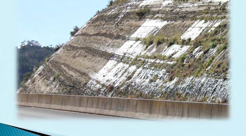
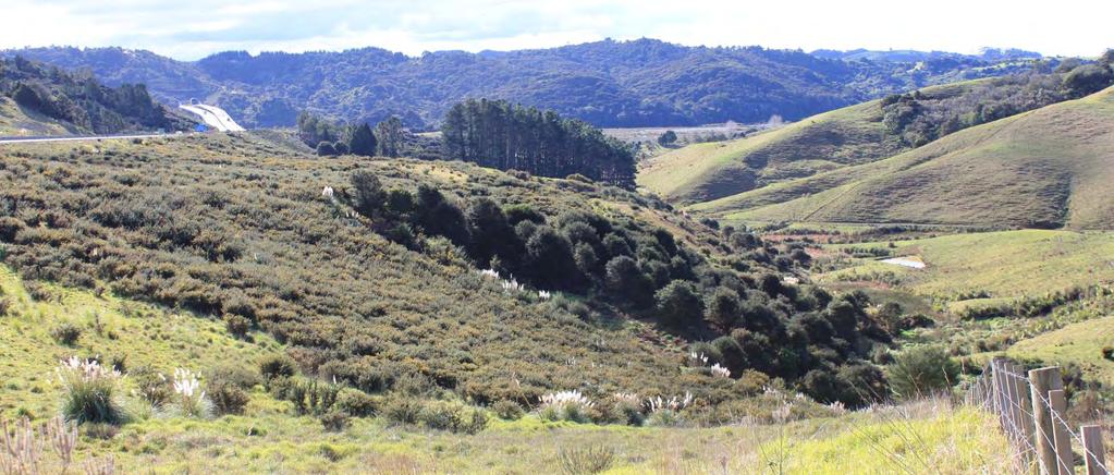
8 What are opportunities to regenerate natural values along the highway corridor? Natural


9 NZ is a country of contrasts. Forest cover 85->22%, >90% wetlands drained, 1 / 3 land birds extinct 1/3 conservation estate 2/3 production landscapes


10 2009 Christchurch Northern Motorway Trial 2010 Natural


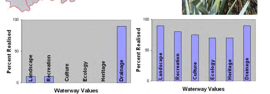
11 Surveys show most people like the mixed native option Natural


12 CHCH Southern Motorway Natural

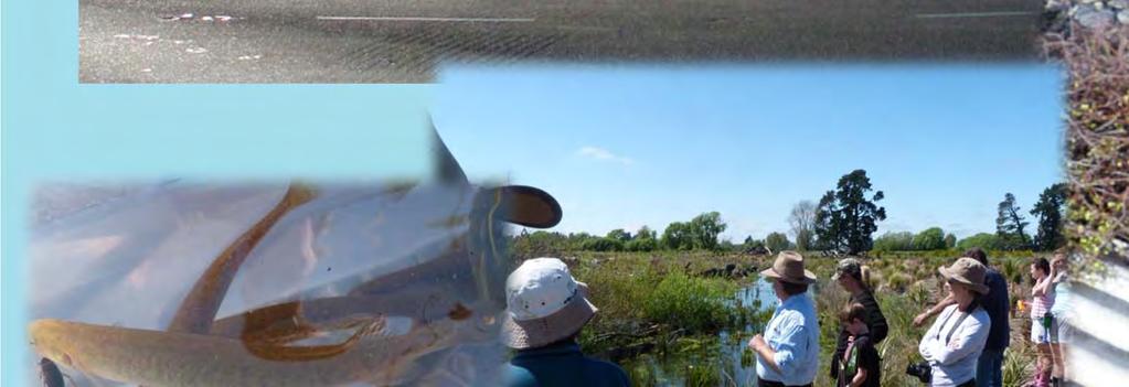
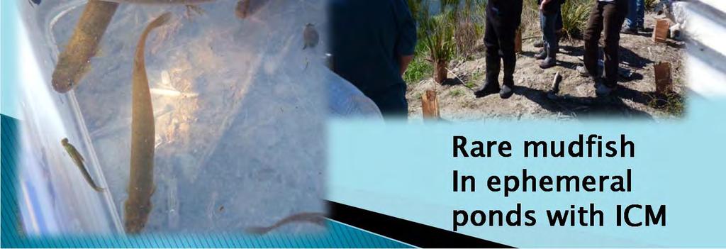
13 Roundabouts for lizards/wetas Rare mudfish In ephemeral ponds with ICM Natural


14 Epiphyte salvage, Auckland West Coast: Salvaged flax and 60 to 80 year-old rata placed with nursery seedlings on mine backfill Natural

15 sediment control, riparian buffering, fauna/flora conservation, wetland reinstatement and landscape mitigation Mine haul road being constructed through tussock wetland, using salvaged sods to lock down sediment on new road batters. Natural

16 Micro-sites Meso-corridors Macro-landscapes and catchments


17 Cultural Mana Kaitiaki Western Urban Planning Co-planning Mana whenua empowered Mātauranga Māori acknowledged as valid Mātauranga Māori informed planning

18 Cultural Whakapapa (cultural identity): Does the project provide a connection to, and/or protect and enhance, the local ecology and iwi/hapū identity and integrity?
: Does the project")

19 Cultural Mana Whenua (authority): Does the project acknowledge, recognise and provide for tangata whenua involvement?
: Does the")

20 Cultural Kaitiakitanga (sustainable resource management): Does the project reduce the discharge of waste and pollution to air, land, and water?

21 Cultural Wairuatanga (spirituality): does the project enhance the spiritual well-being of our natural environment? If the mauri or life force of the natural environment is strong then the people are strong.

22 Cultural Manaakitanga (nurturing relationships): Does the project nurture and care for the natural environment in order to furnish the resources required to provide hospitality to manuhiri, kaumātua and whānau members?

23 Whānaungatanga: (community development): Does the project provide work and business environments where iwi/hapū and manuhiri alike are welcome, encouraged, and proud to be involved? Cultural

24 Cultural Developing positive relationships is vital Developing iwi/hapū capability Access to quality information Innovation and adaptability A Māori evaluation process These values have relevance across all NZ communities


25 Interactive methodsfinding out how people score different features and views Transactive methods finding out how people experience different landscape settings and what they mean for them We used a transactive approach called Q sort Social

26 Social/Historical

27 Context is vital- the value of a particular roadside feature depends on its wider setting People look for cues for care - to confirm that the roadside is being well managed- whether for nature or culture Deep engagement with communities is vital collaborative learning Social

28 A vision of asset management to enhance the wider landscape corridor and the journey Cultural, social and natural values as well as utility Legibility and Interpretation- A learning experience Sustainability & Economics
29 Sustainability & Economics


30 Sustainability
31 Sustainability & Economics


32 Banded sandstone, SH1 Orewa Podzol, Te Kopuru Sustainability & Economics

33 Northern Gateway Sustainability & Economics


34 Waikato expressway Frangible, Butterfly-friendly road edge of planted Muehlenbeckia, Northland Sustainability & Economics


35 Mown kikuyu mitigates sediment-laden runoff from adjacent farmland. Auckland Northern Motorway, Sustainability & Economics

36 Onewa Road, Northern Motorway 2010 : native vegetation to treat stormwater in swales and ponds, salvaged pohutukawa trees, and dotterel management Sustainability & Economics


37 Birch, broom, gorse, agapanthus, wilding conifers, wattle Sustainability & Economics One year s seeding, 7 year s weeding (& paying)


38 1. Need and concept 2 Engagement & inventory 3. Collaborative Visioning 4. Adaptive management
39 NZTA NECAMS Pilot: SH 11 Northland Desktop identification of values: natural character, cultural and landscape Considered use in decision-making On site confirmation and stakeholder consultation.


40 NECAMS concept needs much collaboration Needs Government agencies, regulatory authorities & community to agree on important factors & values


41 NZTA can use its spatial planning tools, to influence decision-making & procurement requirements. NECAMS concept is able to be implemented provided it is simplified to make it manageable, yet still effective.

42 Discussion Thankyou Kia ora
Appendix 1 Structure plan guidelines
 Appendix 1 Structure plan guidelines This appendix forms part of the regional policy statement [rps]. 1.1. Introduction Structure plans are an important method for establishing the pattern of land use
Building Mana Whenua Partnerships for Urban Design Shaun Awatere
 Insights for government, councils and industry Building Mana Whenua Partnerships for Urban Design Shaun Awatere M ori and Local Authorities have made significant strides in developing and fostering positive
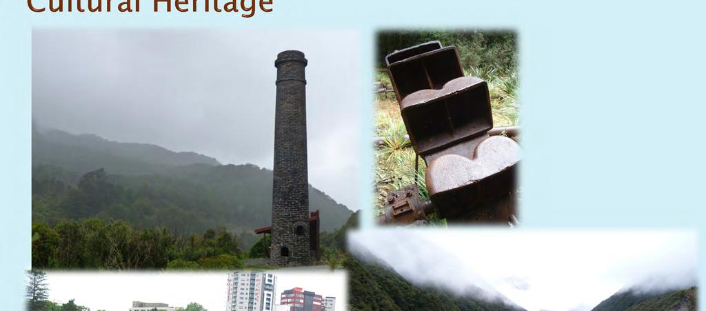
From the ruins: heritage conservation in transport projects
 2017 EIANZ ANNUAL CONFERENCE Tu Kaha: Stand tall Fronting up with wicked solutions From the ruins: heritage conservation in transport projects A. Neill NZ Transport Agency, Private Bag 106602, Auckland
LAND7001 Negotiated Study Exploring Te Aranga Design Principles in Tāmaki Jacqueline Paul Examining the Tamaki Regeneration Project
 LAND7001 Negotiated Study Exploring Te Aranga Design Principles in Tāmaki Jacqueline Paul Examining the Tamaki Regeneration Project 1. Introduction Te Aranga Design Principles is a cultural landscape strategy/approach
I326. Ōrākei 1 Precinct
 I326. Ōrākei 1 recinct I326.1. recinct Description The Ōrākei 1 recinct includes the land identified as hapu reservation (land held for the purposes of a marae, church, urupa and related hapu amenities)
Kopupaka Reserve Wetland Park MĀORI DESIGN CASE STUDY. Image: David St George Photography
 Kopupaka Reserve Wetland Park MĀORI DESIGN CASE STUDY Image: David St George Photography 1 OVERVIEW Kopupaka Reserve is product of a design-led approach drawing together engineering, ecology and cultural
URBAN AND LANDSCAPE DESIGN SECTOR PLAN WARKWORTH SECTOR
 Plan Preparation Discipline Urban Designer (review and verification) Landscape Architect Iwi Advisor for Hōkai Nuku Ecologist Name Stuart Bowden Jeremy Cooke Gena Moses - Te Kani Liza Kabrle Revision Document
Site Option 3: Te Matai
 Site Option 3: Te Matai Location Napier Drain looking south east Description The Te Matai growth option is located between the existing residential boundary (Ruamahanga Crescent) Napier Road (State Highway
B4. Te tiaki taonga tuku iho - Natural heritage
 B4. Te tiaki taonga tuku iho - Natural heritage Tuia I runga, tuia i raro, tuia ki te waonui a Tiriwa Bind the life forces of heaven and earth to the great realm of Tiriwa B4.1. Issues Auckland s distinctive
3. Highway Landscaping Assessment
 Guidelines for Highway Landscaping 3-1 3. Highway Landscaping Assessment 3.1 Introduction This section outlines the steps necessary to assess the highway landscaping component of a state highway construction
5. Initiating a restoration project
 5. Initiating a restoration project CONTRIBUTING TO CONSERVATION In many parts of the country, restoration planting is your last and only option for repairing or rebuilding damaged native communities so
RESTORING BIODIVERSITY ON A REGIONAL LANDSCAPE SCALE
 RESTORING BIODIVERSITY ON A REGIONAL LANDSCAPE SCALE RECONNECTING NORTHLAND RECONNECTING NORTHLAND Moemoea / Vision Whenua ora, wai ora, tangata ora Our land & our people flourishing together Reconnecting
Chapter 3: Natural Environment. Proposed Waikato District Plan Stage 1. (Notified version)
") Chapter 3: Natural Environment Proposed Waikato District Plan Stage 1 Page 2 of 7 Contents Chapter 3: Natural Environment... 3 3.1 Indigenous Vegetation and Habitats... 3 3.1.1 Objective Biodiversity and
Chapter 3: Natural Environment Proposed Waikato District Plan Stage 1 Page 2 of 7 Contents Chapter 3: Natural Environment... 3 3.1 Indigenous Vegetation and Habitats... 3 3.1.1 Objective Biodiversity and
Section 12C Subdivision in the Rural Residential Zone
 Section 12C 12C Subdivision in the Rural Residential Zone The Rural Residential Zone provides part of the range of residential opportunities within the City. Land zoned rural residential is considered
The Proposed Auckland Unitary Plan (notified 30 September 2013)
") 8 Special Purpose zones 8.1 Airport zone The Airport zone applies to the Kaipara Flats Airfield, North Shore Airfield, Auckland International Airport and Ardmore Airport. Auckland International Airport
8 Special Purpose zones 8.1 Airport zone The Airport zone applies to the Kaipara Flats Airfield, North Shore Airfield, Auckland International Airport and Ardmore Airport. Auckland International Airport
Manurewa Takanini and Papakura Integrated Area Plan
 1 Contents Contents... 2 Introduction... 3 Message from Manurewa and Papakura Local Boards... 4 The story of the south... 5 Planning for the future... 6 Focus of this plan... 7 The role of the centres...
Roads of national significance. MacKays to Peka Peka. Assessment of Environmental Effects: Non-Technical Summary
 Roads of national significance MacKays to Peka Peka Assessment of Environmental Effects: Non-Technical Summary March 2012 Table of Contents 1 Executive Summary... 1 1.1 Introduction... 1 1.2 Background
10.0 Open Space and Public Realm
 10.0 Open Space and Public Realm 10.0 Open Space and Public Realm The Public Open Space System is comprised of: outdoor spaces available for public use that are either publicly owned (e.g., parks and
H7 Open Space zones. (a) provide for the needs of the wider community as well as the needs of the community in which they are located;
 provide for the needs of the wider community as well as the needs of the community in which they are located;") H7. Open Space zones H7.1. Background The majority of land zoned as open space is vested in the Council or is owned by the Crown. However some areas zoned open space are privately owned. While the open
H7. Open Space zones H7.1. Background The majority of land zoned as open space is vested in the Council or is owned by the Crown. However some areas zoned open space are privately owned. While the open
Transmission Gully Project - Urban & Landscape Design Framework
 Technical Report 23 Transmission Gully Project - Urban & Landscape Design Framework August 2011 This document was prepared by LANDSCAPE ARCHITECTURE URBAN DESIGN with inputs from Opus, Holmes Consulting,
systems is available on the Colorado Wetland Information Center (CWIC) website.
 website.") Colorado Natural Heritage Program Wetland Program Plan -- Dec 2015 Status Update and Addendum -- The Colorado Natural Heritage Program (CNHP) developed a Wetland Program Plan (WPP) in 2010 for the planning
Colorado Natural Heritage Program Wetland Program Plan -- Dec 2015 Status Update and Addendum -- The Colorado Natural Heritage Program (CNHP) developed a Wetland Program Plan (WPP) in 2010 for the planning
B2B Project Team Responses to Nga Potiki Draft Addendum
 B2B Project Team s to Nga Potiki Draft Addendum Nga Potiki were introduced into the project in December 2012 and formally meet through the Hapū Advisory Group (Nga Potiki, Ngai Tukairangi and Ngati Tapu)
Preliminary Statement Proposed Private Plan Change: Shotover Country Special Zone, Wakatipu Basin
 12 February 2010 Chris Ferguson Environmental Planning Manager Clark Fortune McDonald & Associates P O Box 553 QUEENSTOWN 9348 Tēnā koe Chris Preliminary Statement Proposed Private Plan Change: Shotover
8.2 Sector 2 Kelburn Park
 8.2 Sector 2 Kelburn Park Kelburn Park, near Victoria University 8.2.1 Character and use Kelburn Park is a sector of the Town Belt, of a scale and character more like a suburban park. However, the woodland
Cotswolds AONB Landscape Strategy and Guidelines. June 2016
 Cotswolds AONB Landscape Strategy and Guidelines June 2016 Cotswolds AONB Landscape Strategy and Guidelines Introduction The evolution of the landscape of the Cotswolds AONB is a result of the interaction
TIER ONE - CMI URBAN DESIGN OBJECTIVES
 TIER ONE - CMI URBAN DESIGN OBJECTIVES V I S I O N TO CREATE A MOTORWAY CORRIDOR THAT: makes a positive contribution to city-wide connectivity and the urban fabric of Auckland is visually stimulating and
I432. Puhinui Precinct
 I432. Puhinui Precinct [ENV-2016-AKL-000199: Self Family Trust] Addition sought I432.1. Precinct Description The primary purpose of the Puhinui Precinct is to enable a transition from rural to urban development,
CHAMBERLAIN PARK MASTER PLAN AUGUST 2015
 AUGUST 2015 Jasmax I Chamberlain Park Master Plan I August 2015 I Revision A 1 ST LUKES ROAD SITE LOCATION Western Springs Park Western Springs Gardens STATE HIGHWAY 16 Chamberlain Park Golf Course LINWOOD
INTRODUCTION CHAPTER 1 MONICA PETERS CONTENTS INTRODUCTION. 1 USING THE HANDBOOK 1.1 Handbook structure Handbook sections
 CHAPTER 1 INTRODUCTION MONICA PETERS CONTENTS INTRODUCTION 1 USING THE HANDBOOK 1.1 Handbook structure 1.1.2 Handbook sections 2 CASE STUDIES 2.1 Case study locations CHAPTER ONE INTRODUCTION 1 INTRODUCTION
Ōtaki to north of Levin expressway
 Constraint maps Introduction Roads of national significance Wellington Northern Corridor Ōtaki to north of expressway Seven maps showing areas of constraint have been prepared as background information
Proposed Southland District Plan 2012 Appeal Version October 2016
 S e c t i o n 3. 5 - F i o r d l a n d / R a k i u r a Z o n e The Fiordland/Rakiura Zone encompasses the Fiordland and Rakiura National Parks and part of Mt Aspiring National Park. It also includes areas
RPS Structure
 RPS Structure 2015-03-09 Current New Legend Relocation: Section split and relocation: Indicates a change from the current structure: B1. Issues of regional significance B1. Issues of regional significance
Placemaking Plan. Palmerston North SMALL CITY BENEFITS, BIG CITY AMBITION 2018/21. Te Kaunihera o Papaioea Palmerston North City Council
 Placemaking Plan Palmerston North SMALL CITY BENEFITS, BIG CITY AMBITION 2018/21 Te Kaunihera o Papaioea Palmerston North City Council Palmerston North City Council Placemaking Plan 2 To fulfil the vision
Draft Drury Structure Plan process
 Preliminary report September 2017 Draft Drury Structure Plan process Have your say in shaping Auckland s future together. shapeauckland.co.nz southernstructureplanning@aucklandcouncil.govt.nz 09 301 0101
BEFORE THE AUCKLAND UNITARY PLAN INDEPENDENT HEARINGS PANEL
 1 BEFORE THE AUCKLAND UNITARY PLAN INDEPENDENT HEARINGS PANEL IN THE MATTER of the Resource Management Act 1991 and the Local Government (Auckland Transitional Provisions) Act 2010 AND IN THE MATTER of
Route 347. New York State Department of Transportation Region 10, Long Island. THE GREENING of ROUTE 347
 The GREENING of Route 347 The Greening of Route 347 The Greening of Route 347: History 3 The Greening of Route 347 4 The Greening of Route 347 5 The Greening of Route 347 Smith Haven Mall 6 The Greening
Better Urban Planning Wananga for Maori Practitioners working in the Built Environment: Te Noho Kotahitanga Marae Tamaki Makaurau, 17 June 2016
 Better Urban Planning Wananga for Maori Practitioners working in the Built Environment: Te Noho Kotahitanga Marae Tamaki Makaurau, 17 June 2016 Comments from Hirini Matunga via Papa Pounamu, NZPI 16 June
7. Biodiversity & Conservation Areas
 7. & Conservation Areas 7.1. Objectives The objectives of biodiversity and conservation areas are founded on the need to recognise the importance of biodiversity and acknowledge the need to protect, restore
HS2 Hybrid Bill Petitioning. Summary of SMBC Asks 23/09/13. Background
 Summary of SMBC Asks 23/09/13 Background The Council has a developed a significant number of asks and propositions for consideration by HS2 Ltd and Government throughout further development of the HS2
LANDSCAPE GUIDELINES. Countryside & Coastal Countryside Environments. Landscape, Natural Character & Amenity Values Guide
 Landscape, Natural Character & Amenity Values Guide Copyright WDC 2009 Version A2 18May09 Environmental Services Group Publication Countryside & Coastal Countryside Environments START HERE Quality Land
Welcome to our exhibition
 Welcome to our exhibition housing development A46 Wildmoor Alcester Road Canal Quarter A422 Town Centre housing development Warwickshire-based IM Properties, one of the UK s largest privately owned property
Managing our Landscapes Conversations for Change
 Managing our Landscapes Conversations for Change Frequently Asked Questions The new State Government is committed to a significant reform program that will change the way natural resources are managed.
I541. Te Arai North Precinct
 I541. Te Arai North Precinct I541.1. Precinct Description The Te Arai North Precinct contains approximately 616ha of coastal land north of Te Arai Point, generally known as Mangawhai North Forest. The
German ecological network legal base, scientific foundation and international context
 A future task in good hands German ecological network legal base, scientific foundation and international context Dr. Uwe Riecken Federal Agency for Nature Conservation (BfN) Bonn, Germany 9 th Pan-European
Indigenous biodiversity, restoration and the perfect New Zealand City. Bruce Clarkson, Cilla Wehi & Lars Brabyn
 Indigenous biodiversity, restoration and the perfect New Zealand City Bruce Clarkson, Cilla Wehi & Lars Brabyn Important note to users This power point is as presented at the New Zealand Ecological Society
UNIVERSITY TOWN NEIGHBOURHOODS 5.2 ECO-CORRIDOR MELBOURNE CAMPUS MASTER PLAN 2014
 5.2 ECO-CORRIDOR 37 ECO-CORRIDOR EXISTING CONDITIONS & VISION NEIGHBOURHOOD VISION Investment in the Eco-corridor Neighbourhood will signify the University s commitment to supporting local ecology and
BRE Strategic Ecological Framework LI Technical Information Note 03/2016
 BRE Strategic Ecological Framework Technical Information Note 03/2016 September 2016 Contents 1. Introduction 2. Aims of BRE s Strategic Ecological Framework 3. How SEF is different from previous approaches
FOR NGARARA BRIDGE CERTIFICATION ONLY
 Appendix 2: CONSULTATION, FEEDBACK AND RESPONSES Site Specific Management Plan 010 - [sectors 530-540-580] MacKays to Peka Peka Expressway 06 MARCH 2014 - CERTIFIED VERSION - NGARARA BRIDGE ONLY - REV
D10. Outstanding Natural Features Overlay and Outstanding Natural Landscapes Overlay
 D10. Outstanding Natural Features Overlay and Outstanding Natural Landscapes Overlay D10.1. Background These provisions give effect to Policy 15(a) of the New Zealand Coastal Policy Statement 2010, and
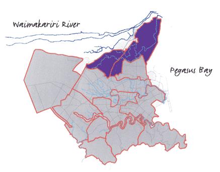
To provide background into Council's involvement with Ngai Tamarawaho with regard to the development of the Kopurererua Valley ('K Valley') Reserve.
 Reserve.") 13 Taurant^aOty Kopurererua Valley Reserve Development DC No: 307 Purpose To provide background into Council's involvement with Ngai Tamarawaho with regard to the development of the Kopurererua Valley
13 Taurant^aOty Kopurererua Valley Reserve Development DC No: 307 Purpose To provide background into Council's involvement with Ngai Tamarawaho with regard to the development of the Kopurererua Valley
D10. Outstanding Natural Features Overlay and Outstanding Natural Landscapes Overlay
 D10. Outstanding Natural Features Overlay and Outstanding Natural Landscapes Overlay D10.1. Background These provisions give effect to Policy 15(a) of the New Zealand Coastal Policy Statement 2010, and
Boffa Miskell Update September 2017
 Welcome to this month s edition of our. Through this monthly alert, we share our recent news, project updates and latest insights. We hope you enjoy the read. SPONSORSHIP: RMLA 2017 keynote address As
E15. Vegetation management and biodiversity
 E15. management and biodiversity E15.1. Background contributes to a range of ecosystem services such as erosion and sediment control, reducing stormwater flows, protecting or enhancing water quality, amenity
Kibworth Harcourt. Introduction. Introduction
 Introduction Introduction Welcome to this public exhibition on the proposals for the delivery of new homes on land at The Kibworths. The purpose of today s exhibition is to give you the opportunity to
Town of Peru Comprehensive Plan Executive Summary
 Town of Peru Comprehensive Plan Executive Communities that plan grow by choice, not by chance. A plan makes growth thoughtful, understandable, and predictable. A plan shows that a community is managing
Tauranga City Centre Spatial Framework
 Tauranga City Centre Spatial Framework Stakeholder Engagement Workshop 15 October 2015 Project Design Team Beca & LandLAB Our team Henry Crothers (LandLab) Landscape Architect/Urban Designer Urban and
THE AOTEAROA-NEW ZEALAND LANDSCAPE CHARTER
 THE AOTEAROA-NEW ZEALAND LANDSCAPE CHARTER NEW ZEALAND INSTITUTE OF LANDSCAPE ARCHITECTS Draft for review and discussion by NZILA members: March 2009 Updated version for NZILA Exec: November 2009 Updated
Design Assessment. Landscape, Visual and Urban. Reviewed By Telephone: Prepared By Opus International Consultants Limited
 New Zealand Transport Agency Christchurch Northern Arterial and QEII Drive Four Laning Scheme Assessment Report Landscape, Visual and Urban Design Assessment Prepared By Opus International Consultants
Northland Regional Landscape Assessment Worksheet
 Northland Regional Landscape Assessment Worksheet Unit name TE POUAHI HEADLAND DESCRIPTION AND CHARACTERISATION Component Land Types (refer to list overleaf) Dune complex Coastal cliffs / escarpment Reefs
Appendix A. Planning Processes. Introduction
 1 Planning Processes Introduction This appendix outlines a number of planning processes which are used in the Auckland Region to support the effective management of development in the region s rural and
Biodiversity Standard
 14 Sustainability Service + This is a controlled document whilst viewed at https://universityofleeds.myeqms.com/login/login.aspx. Once downloaded or printed it becomes an uncontrolled copy. Please check
Urban and Landscape Design Frameworks Highways and Network Operations Guideline
 Urban and Landscape Design Frameworks Highways and Network Operations Guideline The following outlines the process to be followed through the planning, design and construction phases of a state highway
Tāhuhu whakaruruhau ā-taone The sheltering ridge pole
 B2. Tāhuhu whakaruruhau ā-taone - Urban growth and form B2.1. Issues Tāhuhu whakaruruhau ā-taone The sheltering ridge pole Auckland s growing population increases demand for housing, employment, business,
Pupuri tonu ki nga taonga iti me nga taonga tapu o Ngati Whatua Hold fast to the minute and holy treasures of Ngati Whatua
 Te Tari Taiao o Nga l\faunga \nlakahli o Kaipara www.kaiparamoana.com PLAN VARIATION AND QUALIFYING DEVELOPMENT FOR THE WESTGATE JOINT VENTURE, NUICH TRUST, HUGH GREEN LTD LANDOWNER GROUP AND FRED TAYLOR
This presentation has been developed by the Sustainable Sites Initiative for general audiences
 This presentation has been developed by the Sustainable Sites Initiative for general audiences Copyright 2011 by the Sustainable Sites Initiative. All rights reserved. 2011 2010 Sustainable Sites Initiative
christchurch boys high school Te Kura Tuarua O Ngā Tamatāne O Ōtautahi
 christchurch boys high school Te Kura Tuarua O Ngā Tamatāne O Ōtautahi MASTER PLAN // Curriculum Connections JULY 2015-214355 - Revision A CONTENTS Aspirational Brief For Masterplanning 3 Campus Connections
Letcombe Brook Project Officer
 Letcombe Brook Project Officer Job Description Responsible to: Responsible for: Purpose of post: Key Committees: Chairman and Trustees of Letcombe Brook Project. Project volunteers and any relevant personnel
A Short History of Landcare at Absalom Reserve
 A Short History of Landcare at Absalom Reserve This project commenced in 2009 Volunteer hours for this site are 3,720 @ $37 per hour = $137,640 Funding received is $9,542 from NRMA, HCCU and Council s
COMMUNITY ENVIRONMENTAL MANAGEMENT
 COMMUNITY ENVIRONMENTAL MANAGEMENT CEM HANDBOOK FOR COMMUNITY CONSERVATION PLANNING ----- Draft ----- Prepared by the CENTER FOR COMMUNITY ENVIRONMENTAL MANAGEMENT in association with the NEW YORK STATE
Market Place Bythell Place Queen Street Park Riverside Park. Public Spaces. Blenheim CBD Streetscape Final Report 36
 37 39 41 43 Market Place Bythell Place Queen Street Park Riverside Park Final Report 36 Market Place Market Place is a key space for Blenheim s street life, it is a meeting place, retail edge and pedestrian
Christchurch City Council Civic Offices 53 Hereford Street Christchurch. Submission on: The Draft Annual Plan 2014/15
 City Council Civic Offices 53 Hereford Street Submission on: The Draft Annual Plan 2014/15 Response by: Avon-Ōtākaro Network 9 Stable Way Belfast The Avon-Ōtākaro Network [AvON], is a network of individuals
Memorial Business Park Site. Proposed Future Development. Design guidelines. August
 Memorial Business Park Site Proposed Future Development Design guidelines August 2014 www.designenvironment.co.nz 0064 3 358 3040 Contents 1.0 Background 1.1 Introduction 3 1.2 Objectives 4 2.0 Context
NZ Transport Agency Requiring Authority. Statement of rebuttal evidence of Amos Kamo (Cultural Heritage Effects) for the NZ Transport Agency
 for the NZ Transport Agency") Before a Board of Inquiry MacKays to Peka Peka Expressway Proposal under: the Resource Management Act 1991 in the matter of: applicant: Notice of requirement for designation and resource consent applications
Before a Board of Inquiry MacKays to Peka Peka Expressway Proposal under: the Resource Management Act 1991 in the matter of: applicant: Notice of requirement for designation and resource consent applications
ABOUT CALA HOMES CALA HOMES
 WELCOME Welcome to this public consultation event for our proposed development on land to the east of Salisbury Road, in Hungerford. Thank you for taking the time to come along today. Homes and Wates Developments
CITY CENTRE REGENERATION STRATEGY AND INVESTMENT PLAN QUESTIONNAIRE
 CITY CENTRE REGENERATION STRATEGY AND INVESTMENT PLAN QUESTIONNAIRE Q1 Principle of preparing a Regeneration Strategy and Investment Plan a) Please indicate below if you support the principle of preparing
I542. Te Arai South Precinct
 I542. Te Arai South Precinct I542.1. Precinct Description The Te Arai South Precinct contains approximately 750ha of coastal land south of Te Arai Point, known as Mangawhai South Forest. The land within
Taupo Swamp: A wetland of national importance. Taupo Swamp: Protected in perpetuity by a QEII covenant
 Taupo Swamp: A wetland of national importance Taupo Swamp: Protected in perpetuity by a QEII covenant A rare survivor Taupo Swamp has, amazingly, survived more than 150 years of human-induced change. Attempts
LAKESIDE URBAN DESIGN REPORT - JUNE 2017 CLIENT PREPARED BY DOCUMENT ISSUE. Lakeside Developments 2017 Limited. Baxter Design. Paddy Baxter Director
 LAKESIDE, TE KAUWHATA URBAN DESIGN REPORT JUNE 2017 1 LAKESIDE URBAN DESIGN REPORT - JUNE 2017 CLIENT Lakeside Developments 2017 Limited PREPARED BY Baxter Design Paddy Baxter Director Steve Skelton Landscape
Building a green infrastructure concept and process in the Gauteng City Region, South Africa. Kerry Bobbins Researcher GCRO
 Building a green infrastructure concept and process in the Gauteng City Region, South Africa Kerry Bobbins Researcher GCRO kerry.bobbins@gcro.ac.za IGU Regional Conference Krakow, Poland 1 18 22 August
Section 6A 6A Purpose of the Natural Features and Landscapes Provisions
 Section 6A 6A Purpose of the Natural Features and Landscapes Provisions This Chapter addresses the protection and management of natural features and landscapes within the City. The City has a number of
3 Urban Design and the State Highway Network
 NZ Transport Agency Page 1 of 14 Urban Design Professional Services Guide 1 Introduction This is a professional services guide on urban design, which provides direction to the NZ Transport Agency (NZTA)
2A District-wide Policies
 2A Introduction This Chapter contains policies which are relevant to subdivision, use and development activities occurring across all zones and areas of the District. The policies in this Chapter implement
Western City District What we heard
 What we heard Vision to 2056 and Priorities Governance and implementation Infrastructure and funding The protection of the natural landscape including biodiversity and the Metropolitan Rural Area for food
PROPOSED AUCKLAND UNITARY PLAN, PART 2 - REGIONAL AND DISTRICT OBJECTIVES AND POLICIES, CHAPTER F: PRECINCT OBJECTIVES AND POLICIES, 6: SOUTH
 1 PROPOSED AUCKLAND UNITARY PLAN, PART 2 - REGIONAL AND DISTRICT OBJECTIVES AND POLICIES, CHAPTER F: PRECINCT OBJECTIVES AND POLICIES, 6: SOUTH 6.15: Mangere Gateway The objectives and policies of the
NON-TECHNICAL SUMMARY
 Proposed Sand and Gravel Extraction and Associated Processing Operations with Restoration to a Mixture of Agriculture and Nature Conservation including Areas of Shallow Water at Hedgeley, Northumberland
Table 1. Traditional concepts and terms within a modern paradigm
 The role of Māori values in Low-impact Urban Design and Development (LIUDD) Discussion paper Garth Harmsworth, Landcare Research NZ Ltd. Palmerston North HarmsworthG@LandcareResearch.co.nz Introduction
9.1 ISSUES OBJECTIVES RULES - Class B - Heritage Items RULES - Class C - Heritage Items RULES - Old Town Overlay Area 18
 9 HISTORIC HERITAGE 9.1 ISSUES 7 9.2 OBJECTIVES 7 9.3 POLICIES 8 9.4 RULES - Class A - Heritage Items 13 9.5 RULES - Class B - Heritage Items 15 9.6 RULES - Class C - Heritage Items 17 9.7 RULES - Old
MEMORIAL DRIVE DESIGN DEVELOPMENT PLAN
 DESIGN DEVELOPMENT PLAN prepared for The City of Calgary Parks June 2005 cover images: Glenbow Alberta Archives Thomas Mawson Plan for Calgary c. 1914 panoramic view of Calgary from Crescent Heights c.1940
Biodiversity and Urban Streets
 Biodiversity and Urban Streets Urban Street Design for Engineers CPD Session 3 Constituent Elements Engineers Ireland Maryann Harris BSLA MSc Dip Law Past-President, Irish Landscape Institute Parks Services
I207. Learning Precinct
 I207. Learning Precinct I207.1. Precinct description The Learning Precinct is centred on the Symonds Street ridge where the University of Auckland and Auckland University of Technology have the majority
Community Conservation Workshop. Lake Placid
 Community Conservation Workshop Lake Placid 2 Community Conservation Program Welcome! We have designed a Community Conservation Program that listens to the needs of community members. We are conducting
OUR GREATER SYDNEY A metropolis of three cities. OVERVIEW. connecting people. DRAFT Greater Sydney Region Plan
 OUR GREATER SYDNEY 2056. A metropolis of three cities. OVERVIEW. connecting people. DRAFT Greater Sydney Region Plan October 2017 This document is an overview of the draft Greater Sydney Region Plan. To
South District What we heard
 What we heard Vision to 2056 and Priorities Governance and implementation Infrastructure and funding Feedback supported: The vision for a metropolis of three cities, but emphasised the importance of infrastructure
CA.1 Coastal Area. Index. CA.1.1 Description and Expectations
 Index.1.2.3.4 CA.2 CA.2.1 CA.2.2 CA.2.3 CA.3 CA.3.1 CA.3.2 CA.3.1 CA.4 CA.4.1 CA.4.2 CA.4.3 CA.4.4 CA.5 CA.5.1 CA.5.2 Description and Expectations Objectives Policies Guidance Note Landuse Eligibility
QUEENSTOWN LAKES DISTRICT COUNCIL SUBDIVISION DESIGN GUIDELINES
 Attachment C: Draft QLDC Subdivision Design Guidelines QUEENSTOWN LAKES DISTRICT COUNCIL DESIGN GUIDELINES A DESIGN GUIDE FOR AND DEVELOPMENT IN THE URBAN ZONES QUEENSTOWN OFFICE 10 Gorge Road Queenstown
ADDENDUM TO BIOLOGICAL SCOPING SURVEY REPORT, BOTANICAL SURVEY AND WETLAND DELINEATION
 ADDENDUM TO BIOLOGICAL SCOPING SURVEY REPORT, BOTANICAL SURVEY AND WETLAND DELINEATION FOR AVALON INN (APN 069-241-27 & -04) 1201 & 1211 NORTH MAIN STREET FORT BRAGG, CA MENDOCINO COUNTY prepared for:
8.8 Sector 8 Hataitai Park
 8.8 Sector 8 Hataitai Park The recreation hub at Hataitai Park Note Badminton Hall at the top of picture and Velodrome at bottom centre. 8.8.1 Character and use The sector occupies the east face of the
5 th SanctuariesNZ Workshop
 5 th SanctuariesNZ Workshop Riverbend, Hawkes Bay 5 7 August 2009 http://www.sanctuariesnz.org/ Attendees 2009 at 3 August Community sanctuary/trust 38 DoC 13 Regional Council 9 Student 7 Landcare Research
The Gwennap Parish Vision Statement
 QUICK GUIDE What is a Neighbourhood Development Plan? Ultimately it is a document used by developers or anyone wishing to submit a planning application that describes the vision, strategy, plans, regeneration,
Scotland s Landscape Charter
 Scotland s Landscape Charter The Scottish Landscape Forum Foreword Scotland s landscapes, which are renowned throughout the world, show the imprint of countless generations of Scots who have shaped this