Eight Ash Green Park and Ride Proposals Landscape Report
|
|
|
- Karen Park
- 5 years ago
- Views:
Transcription

1 Eight Ash Green Park and Ride Proposals Landscape Report
2
3 Contents 1 Location 2 Designations, Constraints and Policies 3 Landscape Character and Land Use 4 Access and Circulation 5 Views from the site 6 Impact of Proposed Development on Landscape 7 Visual Intrusion on Properties and Rights of Way 8 Objectives of the Proposals 9 Detailed Landscape Proposals Figures Fig 1 Location and Context Fig 2 Designations and Constraints Fig 3 Landscape Character Areas and Types Fig 4 Access and Circulation Fig 5 Views Fig 6 Landscape Structure Fig 7 Sections Appendix 1 Appendix 2
4
 and is sited behind properties in Halstead Road and Spring Lane with vehicular and pedestrian access proposed from Halstead Road.")
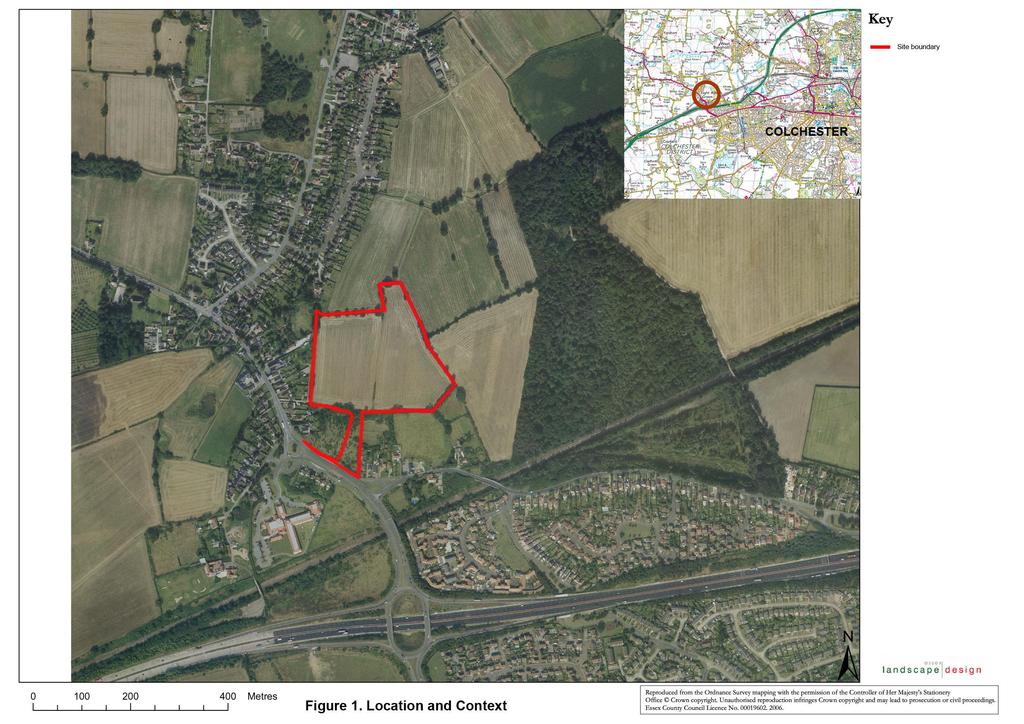
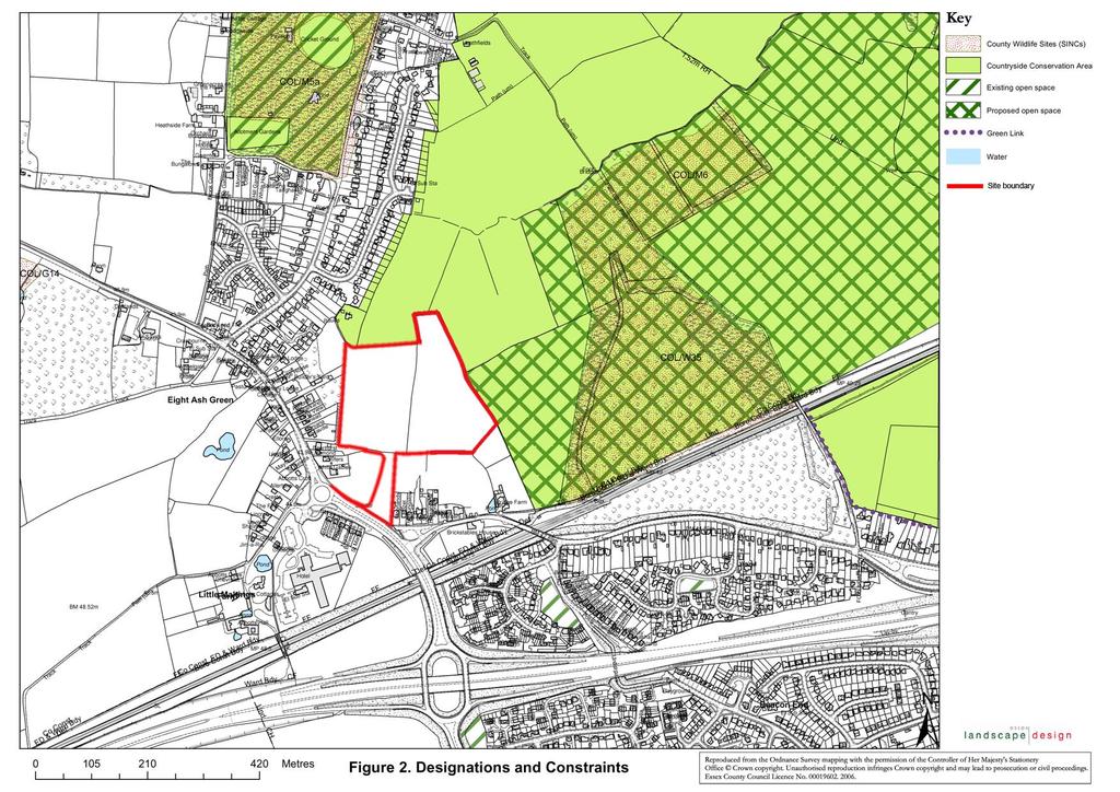
5 1 Location The site for the proposed park and ride facility is located by the hamlet of Eight Ash Green, approx 320 metres from junction 26 on A12 (See Fig 1). It covers an area of approximately 3.9 ha (9.6 acres) and is sited behind properties in Halstead Road and Spring Lane with vehicular and pedestrian access proposed from Halstead Road. 2 Designations, Constraints and Policies There are a number of designations and policies relevant to this development (see Fig 2) biologically through hedgerow trees, hedges and wild flora at the field margins. Two further county wildlife sites, Fordham Heath and Iron Latch lie further from the development site. Policy CO5 states that development and land use changes likely to have an adverse effect on nature conservation sites will generally not be approved. This policy will not be in conflict with this application. (Ref EECOS Preliminary Wildlife Assessment 2006) 2.1 Nature Conservation Sites Eight Ash Green Wood is a county wildlife site, comprising 14.6 ha of woodland on the site of an old pit, located approximately 300 metres to the east of phase 1 application. It is predominantly oak/silver birch woodland with willow in wetter areas and hawthorn and gorse scrub. Several herbaceous ancient woodland species have begun to invade. It is located to the east of the site and is connected

6 2.2 Countryside Conservation Area The area to the north of the site around the River Colne and its slopes is designated a countryside conservation area up to the northern edge of the site in the local plan. The whole area is described as being of high landscape value, with numerous woodlands of nature conservation interest The Borough Council proposes to give special protection to the important natural, social and cultural resources, also to promote public enjoyment of these areas where it can be done without detriment to CCA s resources. The policy CO3 states The Countryside Conservation Areas are defined on the Proposals Map. These areas will be given special protection from any development likely to be prejudicial to their natural, social or cultural resources. The proposals must address this by containing the area the area of development to protect the visual quality of this countryside conservation area, even though this lies beyond the edge of the site. 2.3 Proposed Open Space The area of the county wildlife site and land north of it are shown as proposed open space in the local plan. There is a high use of the woodland by local residents and others for informal recreation. It is well connected by rights of way and close to Eight Ash Green and Beacon End. The proposals must address that the informal use of the woodland and field

7 margins will be encouraged in the future by the designation of this area as public open space. 2.4 Retaining Landscape Features Policy CO4 states that Development schemes should protect existing landscape features such as those listed in the reasoned justification wherever possible. Additional planting may be necessary to maintain and enhance these features. Where this is considered necessary, planting will be carried out with species native to the locality. This has been adhered to by retaining all the existing trees and hedgerows on the site, except where they are cut through by the access road. 2.5 Protection of the Countryside Policy CO1 states There will be a continuing commitment to the protection of the open countryside in the borough for its own sake The response to the countryside conservation area policy will also address this policy, albeit there is loss of countryside from agriculture to the park and ride facility. 3 Landscape Character and Land Use 3.1 The site comprises agricultural land, used for arable crops. It lies on high ground at a level of approx 41.5m and slopes gently down towards the north to a level of approximately 40m at the north edge of the site. The site is bordered by hedgerows and hedgerow trees along field boundaries, but with some gaps in hedging and with evidence of loss of hedgerows which would have effectively separated the fields. There is a prominent ditch along the length of the hedgerow at the south of the site. The hedgerow trees in the area are mainly oak pollards as recoded in the EECOS report.
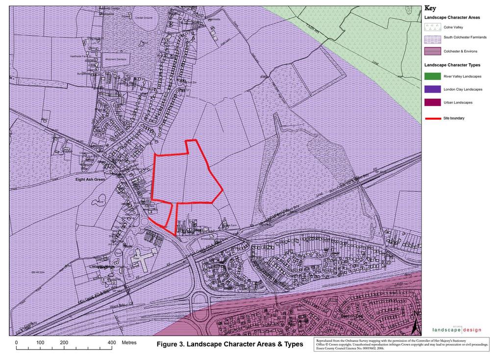
8 Regarding the historic development of the landscape, 1770 mapping (Chapman and Andre) shows an agricultural pattern of landscape with a few farms, houses and related buildings around the junctions of roads. A large area of woodland lies to the east of the proposed site (of which Eight Ash Green Wood is a remnant). The present field pattern remains largely as shown in the first edition OS mapping 1870 s, and the historic maps indicate that this has been a productive landscape for several centuries. 3.2 The landscape character of the general area is described in the Landscape Assessment for Colchester Borough, by Chris Blandford and Associates, 2006, as part of the Colne River Valley Slopes (see Fig 3). The aspects relevant to this site are described below and the full extract for the area is included in Appendix Key Characteristics are: A mosaic of medium to large-sized irregular and regular, predominantly arable fields with medium hedgerows containing semi-mature/ mature hedgerow trees; Some larger semi-enclosed arable fields and concentrations of smaller fields with intact hedge boundaries adjacent to settlements; Settlement pattern consists of small linear village settlements such as Wakes Colne and Eight Ash Green, adjacent to the north-south roads, which cross the River Valley; small hamlets and farmsteads. 3.4 The Overall Character of the area is described as: The v-shaped, relatively steep valley sides enclose the meandering course of the River Colne.Woodland cover consists of a mixture of small patches and large regular blocks of woodland which are spread across the valley slopes.
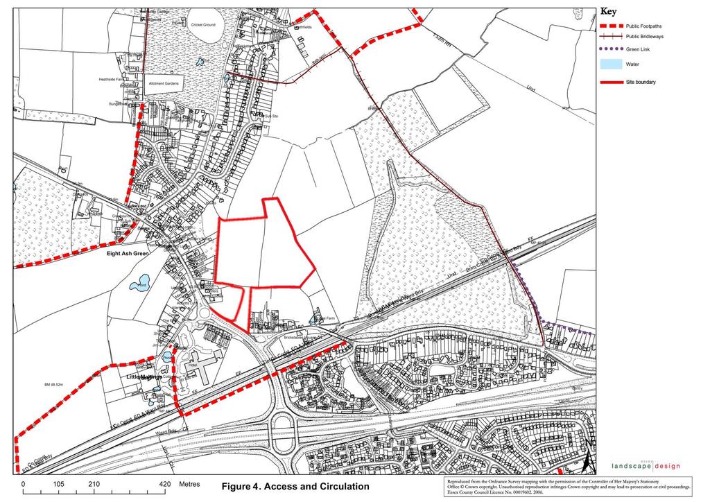
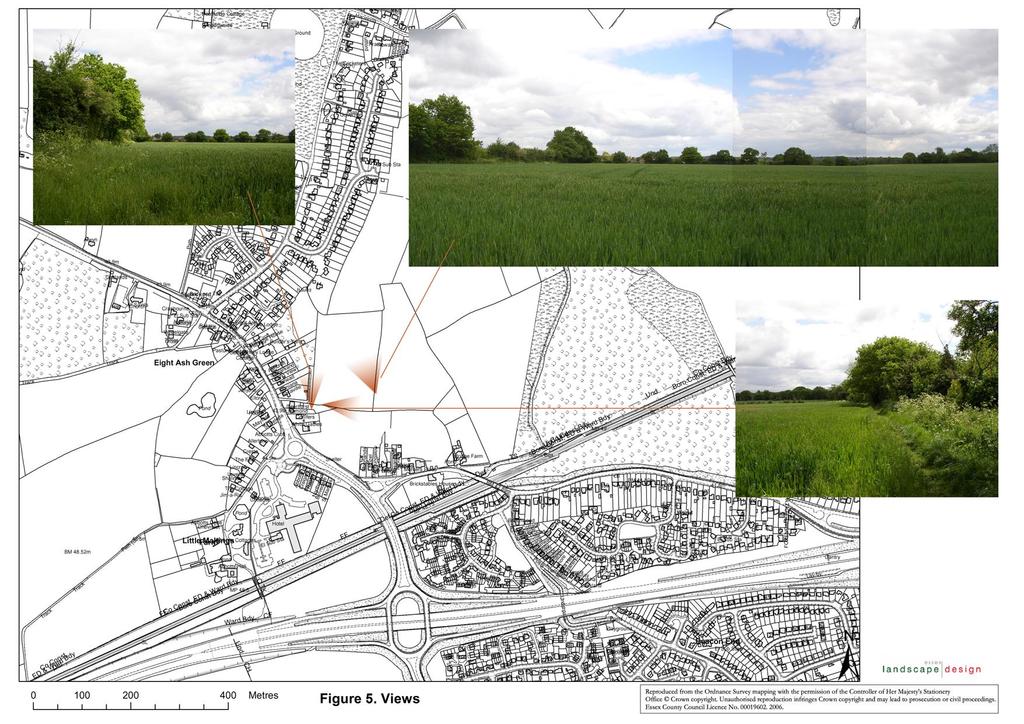
9 Many of the narrow (sometimes sunken) lanes, which traverse the valley slopes in a north-south direction, are enclosed by hedges, which are generally in reasonable condition. Several single mature deciduous trees are also present in field boundaries (for example within fields to the south of Eight Ash Green) Settlement pattern within the area consists of small linear roadside village, such as Wakes Colne and Eight Ash Green, combined with a number of small hamlets and farmsteads, dispersed across the character area. 3.5 Visual Characteristics are described as: Attractive framed and panoramic views of the meandering river channel and associated floodplain from higher points along the valley sides. Views along the river valley corridor. 3.6 Ecological Features are described as The ecological character of these slopes is combined within a woodland, heath and farmland mosaic. The northern slopes are predominantly farmland with a few pockets of woodland of ecological interest. 4 Access and Circulation At present there is informal access around the fields which are proposed for the development of the park and ride. These fields have access from a track off Halstead Road lane and people walk through to surrounding rights of way of Iron Latch Lane (bridleway) no 19, and down to footpaths no 20 and 21. The network connects the nearby Eight Ash Green Wood with Fordham Heath, and is well used by local residents, particularly for dog-walking and informal recreation. (See Fig 4) 5 Views from the site The are good views within the site of the well vegetated southern edge of the fields with old hedgerow trees, and good views down the valley to the north toward the River Colne. To the east, hedgerows lead towards the Eight Ash Green Wood
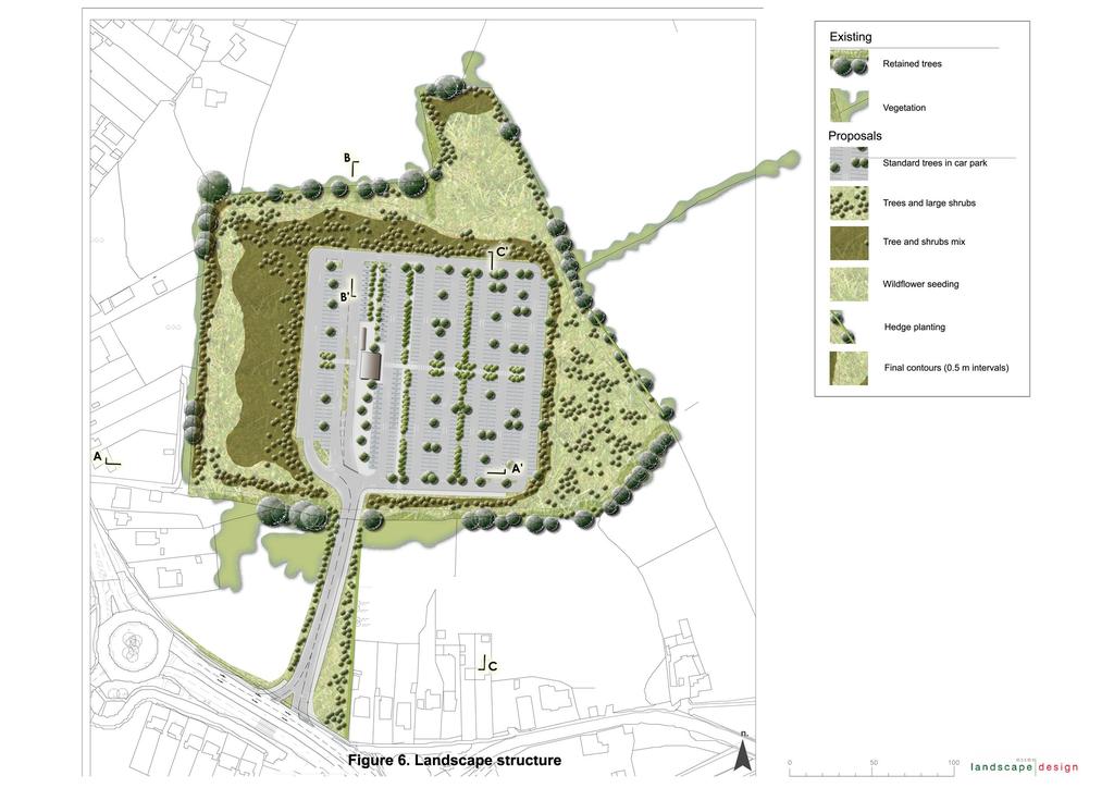
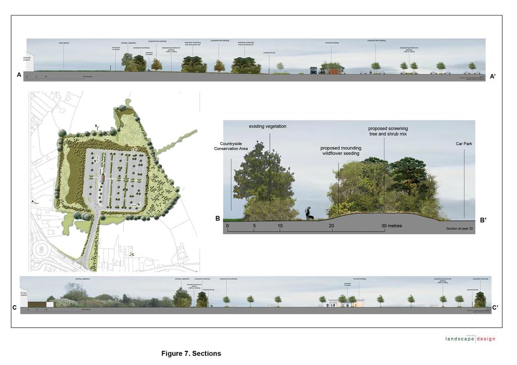
10 which forms a varied skyline and visual containment to the site. (See Fig 5) 6 Impact of Proposed Development on Landscape The change of use from agriculture to car parking is a major potential landscape impact. The scale of the car parking development in relation to the scale of the surrounding residential developments is a major factor. 7 Visual intrusion from properties and rights of way The development has a medium visual impact from the properties on the west and south sides of the site. Whilst the views are often from first floor windows, the nature of the development and its lighting will make this impact substantial for affected properties unless the development is screened. Section AA and CC are from the closest properties showing additional screening to reduce visual intrusiveness. 8 Objectives of the Proposals 8.1 To mitigate the potential impacts of the development, and implement environmental policies in the local plan, the landscape will aim to: Screen development from properties Screen development from rights of way Soften the impact of the development in the landscape Strengthen existing landscape pattern Improve nature conservation in the area Retain public circulation and access through the site Be complimentary to the existing landscape character To comply with local plan policies 8.2 The proposals will also aim to fulfil these landscape management objectives in the Landscape Character Assessment (CBC):
11 Ensure that new woodland planting is designed to enhance existing landscape character and species composition reflects local provenance. Conserve and manage existing hedgerows. Restore hedgerows using hawthorn and plant new hedgerow trees, particularly in areas of arable farmland. 9 Detailed Landscape Proposals 9.1 The proposals create a continuity of native tree, hedge and shrub planting connecting with existing hedges, woodland, ground flora and trees to link habitats across the area. Species are based on those recorded by EECOS in their ecological report and in site records by Essex Landscape Design. Most of the shrub and hedge planting will be mm in height and with trees at a range of sizes up to 3 metres to ensure the planting establishes well and quickly. A detailed planting plan and schedules are submitted with the application showing species, locations, plant sizes upon planting. Information on steps required to protect existing vegetation to be retained during the development is set out in Appendix 2, requiring a tree survey, constraints and protection plan related to BS 5837:2005. A landscape structure plan is included in this report which illustrates the scope of the landscape proposals, without the detailed information. 9.2 Woodland belts Woodland belts are proposed around the site, especially on the west and north boundaries of the site for screening and nature conservation. Species will include those found growing in the area including oak, birch, hawthorn, and ash with pine included to provide all year round screening (the first three of these are typical of the species in the nearby Eight Ash Green Wood which is a county wildlife site). Tree Species Betula pendula Crataegus monogyna Fraxinus excelsior
12 Pinus sylvestris (for all year screening) Quercus robur Shrub Species Acer campestre Corylus avellana Crataegus monogyna Ilex aquifolium 9.3 Native Hedges with trees These are proposed on the east and south boundaries of the site, to link with existing hedgerows bordering the site. Hedge species include hawthorn, blackthorn, dog rose, holly, spindle, dogwood and crab apple with oak and ash as the major hedgerow trees. Hedge Species % Acer campestre 10 Cornus sanguinea 1 Crataegus monogyna 70 Euonymus europaeus 2 Fraxinus excelsior 0.5 feathered (tree within hedgerow) Ilex aquifolium 1 Malus sylvestris 0.5 Prunus spinosa 10 Quercus robur 2 feathered (tree within hedgerow) Rosa canina Native tree planting in car park Tree planting within the car park is designed to blend with the surrounding hedgerow trees through species choice. While being constrained by the car park layout, the proposed tree locations are staggered as well as creating avenues to visually break up this expanse of car parking and help screen cars from views outside the site. Tree species within the car park will include oak, ash and field maple Quercus robur Fraxinus excelsior Acer campestre
13 9.5 Wild Flower seeded areas Area to be seeded will receive a meadow mix of grasses and wild flowers of local provenance to provide nature conservation value to these areas. Mix to include species from those found during the EECOS survey Grasses Creeping Bent-grass False Oat-grass Cock s-foot grass Red Fescue Yorkshire Fog Rough Meadow-grass Flowering Plants Common Centaury Common Mouse-ear Ivy Perforate St John s-wort Creeping buttercup Common sorrel Red campion Lesser stitchwort White clover Vetch Smooth Tare
14
15
16
17
18
19
20
21
22
23
24
25
26
27
28
29 Appendix 1 Landscape Character Assessment of Colchester Borough, Chris Blandford and Associates, Key Characteristics of this area are described as: Relatively steep v-shaped valley slopes facilitate attractive and open views across and along the River corridor; Principal road network consisting of narrow tree-lined (sometimes sunken) lanes traversing the valley sides to the north and south; A mosaic of medium to large-sized irregular and regular, predominantly arable fields with medium hedgerows containing semi-mature/ mature hedgerow trees; Some larger semi-enclosed arable fields to the west of Wakes Colne; and concentrations of smaller fields with intact hedge boundaries adjacent to settlements; Settlement pattern consists of small linear village settlements such as Wakes Colne and Eight Ash Green, adjacent to the north-south roads, which cross the River Valley; small hamlets and farmsteads. Overall Character The v-shaped, relatively steep valley sides enclose the meandering course of the River Colne. The area also includes the lower slopes of the valley at Ballast Quay Farm, to the east of Wivenhoe. Woodland cover consists of a mixture of small patches and large regular blocks of woodland (for example Acorn Wood) which are spread across the valley slopes. Many of the narrow (sometimes sunken) lanes, which traverse the valley slopes in a northsouth direction, are enclosed by hedges, which are generally in reasonable condition. Several single mature deciduous trees are also present in field boundaries (for example within fields to the south of Eight Ash Green). Small to medium-sized arable fields directly align the river whilst a mosaic of large regular arable fields covers the upper parts of the slopes. A patch of very regular (rectangular, subdivided) orchards, to the east of Wakes Colne Green (close to Rose Green) provide variety and assert regularity over the surrounding arable sloping valley sides. Settlement pattern within the area consists of small linear roadside village, such as Wakes Colne and Eight Ash Green, combined with a number of small hamlets and farmsteads, dispersed across the character area.
30 Visual Characteristics Attractive framed and panoramic views of the meandering river channel and associated floodplain from higher points along the valley sides, such as Hill House Farm to the south of Chappel; The church and viaduct at Chapel (within character area A4 Colne Valley Floor) are dominant landmarks in views from both the southern and northern valley sides around Wakes Hall Farm, Old Hall Farm and Wakes Colne; The spire of All Saints Norman church at Wakes Colne is a prominent landmark within the landscape, which is intervisible with the church at Chapel (also with a spire) in views from the east; Views along the river valley corridor. Historic Features Visible remains of defensive WWII features within the landscape, including: Anti-tank blocks and Spigot mortar emplacements and several WWII pillboxes (with a cluster to the south of Fordstreet); Fragmentary remains of a moat at Crepping Hall; West Bergholt Hall Georgian town house; Church of St.Mary at West Bergholt with early 14th century nave, lower chancel, belfry and southern aisle. Ecological Features The ecological character of these slopes is combined within a woodland, heath and farmland mosaic. The northern slopes are predominantly farmland with a few pockets of woodland of ecological interest. Woodland SINCs (six on the northern slopes) include: Acorn and Hillhouse Woods which are both ancient oak-ash Fraxinus excelsior woodland; Spring and Grove Woods which are both ancient oak woodland with inter-planted Scot s pine Pinus sylvestris; Alder carr woodland at West Bergholt; Stitching Wood which has a mixed canopy and open glades of bracken Pteridium aquilinum; and West Bergholt Heath, Fordham Heath and other public open spaces which are managed for wildlife and access (such as Chapel Millennium Green) are situated within the character area.
31 POLICIES Key Planning and Land Management Issues Potential pressure from urban expansions on the edge of West Bergholt, Fordham, Wivenhoe and Colchester; Localised intrusion from modern farm buildings; Potential creation of new woodland in Woodland Trust land to west of Fordham. Landscape Strategy Objective Conserve and Enhance Landscape Planning Guidelines Ensure any new small-scale development in, or on the edges of Fordham, Wivenhoe, West Bergholt and Colchester is of an appropriate scale, form and design and uses materials which respond to historic settlement pattern, landscape setting and locally distinctive building styles and materials. (Development opportunities are limited around Fordham due to the Woodland Trust site); Ensure any new development on valley sides is smallscale, responds to historic settlement pattern, form and building materials; Maintain cross-valley views; Conserve views of the river and floodplain; Ensure that new woodland planting is designed to enhance existing landscape character and species composition reflects local provenance. Land Management Guidelines Conserve and manage existing hedgerows (especially failing elm hedges); Restore hedgerows using hawthorn and plant new hedgerow trees, particularly in areas of arable farmland; Conserve and manage existing valleyside woodlands; Encourage the planting of native alder and willow riverside trees where appropriate.
32
33 Appendix 2 Retention of Trees and Hedgerows Report by Simon Smith, Arboriculturalist 1. Preliminary Tree Assessment There are numerous significant mature hedgerow trees on site, notably oak pollards and ash coppice stools. There must be a tree survey undertaken for the following reasons: To assess the impact of the proposed development (as per section 6 of the Landscape Report). To identify any remedial tree work. This would have to be done before the start of the development. To determine the trees root protection areas in accordance with BS 5837:2005 Trees in relation to construction Recommendations. This information, with an inspection of the trees condition, will then provide information for a Tree Constraints Plan and a Tree Protection Plan in accordance with BS 5837:2005. Protective fencing must be erected before the start of the development. Given the preliminary nature of this assessment, it is not possible to specify the location of protective fencing at this time, however BS 5837:2005 is applicable: 2. Tree Survey A tree survey should be undertaken by an Arboriculturist and should record information about the trees on a site independently of and prior to any specific design for development. [As a subsequent task, and with reference to a design or potential design, the results of the survey should be included in the preparation of a tree constraints plan, which should be used to assist with site layout design. 3. Tree constraints plan This is a design tool which should show the below ground constraints, represented by the root protection area (RPA), and the above ground constraints the trees pose by the virtue of their size and position. The RPA is a layout design tool indicating the area surrounding a tree that contains sufficient rooting volume to ensure the survival of the tree, shown in plan form in m2. The RPA should be calculated as an area equivalent to a circle with a radius 12 times the stem diameter for single stem trees and 10 times the basal diameter for trees with more than one stem arising below 1.5m above ground level. 4. Tree protection plan Once the layout proposals have been finalised a tree protection plan should be prepared containing the following information: a) trees selected for retention. b) trees to be removed. c) the precise location for erection of protective barriers and any other relevant physical protection measures including ground protection, to protect the RPA and marked as a construction exclusion zone on the plan.
34 June 2006 d) Design details of the proposed physical means of protection. e) Areas of structural landscaping to be protected from construction operations to prevent the soil structure being damaged. f) All the details in a)-e) above should be incorporated into subsequent drawings and method statements used for design purposes or issued for use on site, to ensure that all interested parties are fully aware of the areas in which access and works may and may not take place. 5. The construction exclusion zone: barriers and ground protection All trees which are to be retained on site should be protected by barriers and or ground protection. Vertical barriers should be erected and ground protection installed before any materials or machinery are brought on site and before any demolition, development or stripping of soil commences. Areas of new or retained structure planting should be similarly protected, based on the extent of the soft landscaping as shown on the approved drawings. Once erected, barriers and ground protection should be regarded as sacrosanct, and should not be removed or altered without prior recommendation by an Arboriculturist and approval of the local planning authority. Barriers should be fit for the purpose of excluding construction activity and appropriate to the degree and proximity of work taking place around the retained trees. Special attention should be paid to ensuring that barriers remain rigid and complete. In most cases, barriers should consist of a scaffold framework in accordance with Figure 2 (see BS 5837: 2005) comprising a vertical and horizontal framework, well braced to resist impacts, with vertical tubes spaced at 3m intervals. Onto this, weldmesh panels should be securely fixed with wire or scaffold clamps. Weldmesh panels on rubber or concrete feet are not resistant to impact and should not be used. Where it has been agreed during the design stage, and shown on the tree protection plan, that vehicular or pedestrian access for the construction operation may take place within the RPA, the possible effects of construction activity should be addressed by a combination of barriers and ground protection. The position of the barrier may be shown within the RPA at the edge of the agreed working zone but the soil structure beyond the barrier to the edge of the RPA should be protected with ground protection. For pedestrian movements within the RPA the installation of ground protection in the form of a single thickness of scaffold boards on top of a compressible layer laid onto a geotextile, or supported by scaffold, may be acceptable. For wheeled or tracked construction traffic movement within the RPA the ground protection should be designed by an engineer to accommodate the likely loading and may involve the use of proprietary systems or reinforced concrete slabs. For further information, refer to BS5837:2005 For further information, refer to BS5837:2005.
Land at Whiteditch Lane, Newport, Essex
 Land at Whiteditch Lane, Newport, Essex Ecology Report Produced for Sworders Agricultural By March 2013 Document Control: Version Date Version Details Prepared by Checked by Approved by 0.1 01.03.2013
Warwickshire County Council. Upper and Lower Brailes. Landscape Study
 Warwickshire County Council Upper and Lower Brailes Landscape Study Produced by WCC Landscape Architects March 2016 Landscape Assessment of Potential Development Sites within the parish of Brailes 1.0
The analysis of key visual characteristics and attributes that contribute to variations in the
 15.0 CHIGWELL/CHIGWELL ROW 15.1 Overview 15.1.1 Chigwell and Chigwell Row settlements are situated in the south of Epping Forest District, to the south of Abridge and southwest of Stapleford Abbotts. Both
8.0 Design and Form of Development 43/
 42/ 8.0 Design and Form of Development 43/ Rothwells Farm, Golborne/ Development Statement Figure 7. Site Constraints Key 44/ Site Boundary 360 Bus Route/Stops Existing Trees Underground Water Pipe Sensitive
Welcome to our Public Consultation
 About our development This exhibition gives you the chance to view and comment on our emerging plans for a proposed residential development located on land to the West of Alwyn Road, Rugby. Welcome to
Landscape Guidelines. Landscape type: Valley Pasture Character areas: Frome Valley Pasture Stour Valley Pasture. Landscape change
 Landscape type: Valley Pasture Character areas: Frome Valley Pasture Stour Valley Pasture The valley pasture landscape type is found along the lower reaches of the Stour and Frome, formed from alluvial
CHAPTER 18 - Strategy Area: Dundry and River Valleys
 This south-eastern part of the Community Forest is a complex area with a wide variety of different landscapes close together, including the Chew Valley, the southern part of the Avon Valley and the eastern
INTRODUCTION. Land south of Bishopswood Lane, Tadley
 0 INTRODUCTION THE SITE Introduction Gladman Developments Ltd. has successfully invested in communities throughout the UK over the past 0 years, developing high quality and sustainable residential, commercial
Hedgerows Grow West. Surveying a hedgerow Workbook to help explore a hedgerow
 Hedgerows Grow West Surveying a hedgerow Workbook to help explore a hedgerow Hedgerows Grow West is a partnership project across eleven councils in Northern Ireland that aims to restore and enhance hedgerows
Section 6.0: Glencullen Design Guide
 Section 6.0: Glencullen Design Guide The Planning Authority requires that the adherence to each of the above principles will be demonstrated at the Planning Application stage using appropriate visualisation
University Park, Worcester Non Technical Summary December 2011
 University Park, Worcester Non Technical Summary December 2011 Introduction UW Wrenbridge LLP, a Joint Venture Company of the University of Worcester and Wrenbridge Land Ltd (the Applicants ) intend to
Toddington Central Bedfordshire Stage 3 Green Belt Study December 2017
 Toddington Central Bedfordshire Stage 3 Green Belt Study December 2017 Site: ALP086 - Middle Lakes, Toddington Site size (ha): 2.83 Site: ALP086 - Middle Lakes, Toddington Site size (ha): 2.83 Site description
. bank / ditch cross-section. hedge woundwort wood false-brome
 HERCOLOGICAL RECORD SITE NAME & length (m) Biddlesgate & Bratch Copse (1002 m) grid ref. of ends (A) SU 07901.14502 Parish(es) Cranborne / Damerham, Hants (Wilts until 1895) Alderholt / Damerham, Hants
East Harptree Landscape & Character Assessment
 East Harptree Landscape & Character Assessment Produced by East Harptree Parish Council in consultation with local residents September 2014 Contents The Parish of East Harptree: Objective Introduction
Public Consultation. Land at Monks Farm, North Grove. Welcome
 Welcome Welcome to our public exhibition for development on Land at Monks Farm, orth Grove. Gallagher Estates and Gleeson Strategic Land are preparing an outline planning application for new homes, open
B - Coalfield River Corridor Landscape Character Type
 B - Coalfield River Corridor Landscape Character Type Landscape Character Type - Coalfield River Corridor The Coalfield River Corridors Landscape Character Type is located in the two converging valleys
Rolling Wooded Pasture Lulworth Wooded Pasture Rempstone Wooded Pasture
 Landscape type: Character areas: Rolling Wooded Pasture Lulworth Wooded Pasture Rempstone Wooded Pasture The rolling wooded pasture landscape type is found around the margins of the Dorset Heaths. Although
ARBORICULTURAL METHOD STATEMENT FOR CONSTRUCTION OF NEW DWELLING
 YEW TREE AND GARDENS CLIENT: MR B. EMMETT. LAND AT 45 WENNINGTON ROAD, WRAY, LANCASHIRE ARBORICULTURAL METHOD STATEMENT FOR CONSTRUCTION OF NEW DWELLING Prepared by Antony Wood Cert Arb RFS Yew Tree+Gns
Environmental and Landscape Mapping
 Environmental and Landscape Mapping In support of the Calveley Neighbourhood Plan November 2016 Project Name and Number: Calveley Neighbourhood Plan 16-025 Document Name and Revision: Environmental and
Upper Dean Landscape Character Area: A1 Landscape Character Type: River Valley
 Upper Dean Landscape Character Area: A1 Landscape Character Type: River Valley Key characteristics A well wooded river valley landscape Strong human influence with urban development and sections of engineered
ENVIRONMENTAL AND LANDSCAPE MAPPING
 APPENDIX IV : Environmental and Landscape Mapping ENVIRONMENTAL AND LANDSCAPE MAPPING Calveley Neighbourhood Plan November 2016 ENVIRONMENTAL AND LANDSCAPE MAPPING Calveley Neighbourhood Plan Calveley
Test Valley Borough Council Southern Area Planning Committee 8 January 2019
 ITEM 11 APPLICATION NO. 18/02218/FULLS APPLICATION TYPE FULL APPLICATION - SOUTH REGISTERED 23.08.2018 APPLICANT Rugby Football Union SITE The Trojans Club, Stoneham Lane, Eastleigh, SO50 9HT, CHILWORTH
Public Consultation 23 January Peel Hall, Warrington Board 1. A message from Satnam... Site history...
 Board 1 A message from Satnam... Thank you for attending today s public consultation about proposals to develop a new residential neighbourhood at. The display boards show why the development is needed
Land North of Hall Road, Rochford. Rochford District Council. Planning Application Index. Prepared on behalf of Bellway Homes Ltd
 Land North of Hall Road, Rochford Rochford District Council Planning Application Index Prepared on behalf of Bellway Homes Ltd April 2010 Land North of Hall Road, Rochford Rochford District Council Scope
Longhorsley Neighbourhood Plan
 Site Assessment 1. The availability of the site 1.1 Is the land owner willing for their site to be made available for development? 1.2 If yes, do you have any written evidence to back this up? Planning
DESIGN & ACCESS STATEMENT
 DESIGN & ACCESS STATEMENT Land to the South East of the A495, Bronington Erection of 31 Dwellings (27 dwellings and 4 bungalows including 4 Affordable Dwellings), Realignment and Improvements to A495 (including
UTT/17/2075/FUL - (BERDEN) (Referred to Committee by Councillor Janice Loughlin. Reason: In the Public Interest)
 (Referred to Committee by Councillor Janice Loughlin. Reason: In the Public Interest)") UTT/17/2075/FUL - (BERDEN) (Referred to Committee by Councillor Janice Loughlin. Reason: In the Public Interest) PROPOSAL: LOCATION: APPLICANT: Amendments to the design of a scheme for a 49.99MW battery
UTT/17/2075/FUL - (BERDEN) (Referred to Committee by Councillor Janice Loughlin. Reason: In the Public Interest) PROPOSAL: LOCATION: APPLICANT: Amendments to the design of a scheme for a 49.99MW battery
an Inspector appointed by the Secretary of State for Communities and Local Government
 Appeal Decision Site visit made on 6 November 2017 by Rachel Walmsley BSc MSc MA MRTPI an Inspector appointed by the Secretary of State for Communities and Local Government Decision date: 19 th January
LONGDEN VILLAGE DEVELOPMENT STATEMENT
 LONGDEN VILLAGE DEVELOPMENT STATEMENT 2017-2027 1 Longden Development Statement 2017-2027 15/01/18 1. Background 1.1 Longden Village Longden village is a very rural and traditional community first mentioned
Welcome to our public exhibition
 About our development Welcome to our public exhibition This exhibition gives you the chance to view and comment on our proposals for a new residential development of 165 high-quality homes, along with
Slough International Freight Exchange Proposals, Colnbrook+
 Welcome Welcome to this exhibition, which is being held in connection with our proposals for a new freight exchange facility on land to the north of the A4. Please take this opportunity to look at the
SPG 1. * the northern and western sections which are open fields used for pasture and grazing;
 SPG 1 1.0 INTRODUCTION This development brief is based on the allocation of the Priors Hall site for employment and countryside recreational purposes in the Corby Borough Local Plan. The brief is intended
APPENDIX 4. 5 ST AGNES LOCAL LANDSCAPE CHARACTER ASSESSMENT TABLE ST AGNES BEACON
 APPENDIX 4. 5 ST AGNES LOCAL LANDSCAPE CHARACTER ASSESSMENT TABLE ST AGNES BEACON CHARACTER AREA: ST AGNES BEACON DATE OF ASSESSMENT May 2016 Character Attribute Landscape reference guide ST AGNES BEACON
WELCOME. Land North of STEVENAGE. We would like to thank you for attending our public exhibition today.
 WELCOME We would like to thank you for attending our public exhibition today. The purpose of this event is to share our proposals and hear your thoughts on our ideas. Members of the project team are on
Woodford Habitat Survey
 Woodford Habitat Survey South Woodford, Area 9 (surveyed in May, July and August 2016) Area 9 forms the south of the Neighbourhood Area, lying between Old Hall Lane, Wilmslow Road and the River Dean, as
About 10% of the Borough's population lives in the seven rural parishes. Population figures from the 1991 census are given below:-
 8. THE DISTRICT VILLAGES 8.1 Population About 10% of the Borough's population lives in the seven rural parishes. Population figures from the 1991 census are given below:- Village No. of Persons Cottingham
E16: MAINTENANCE OF LANDSCAPED AREAS
 HIGH SPEED TWO INFORMATION PAPER E16: MAINTENANCE OF LANDSCAPED AREAS This paper outlines the proposed approach to the maintenance of landscaped areas created for HS2 Phase One. It will be of particular
To secure a Green Belt around Cambridge whose boundaries are clearly defined and which will endure for the plan period and beyond.
 4. GREEN BELT OBJECTIVES GB/a GB/b GB/c GB/d To secure a Green Belt around Cambridge whose boundaries are clearly defined and which will endure for the plan period and beyond. To maintain the purposes
Land at BROOK STREET PROPERTIES TENCREEK FARM, LISKEARD. Environmental Statement: Non-Technical Summary
 BROOK STREET PROPERTIES TENCREEK FARM, LISKEARD Land at Environmental Statement: Non-Technical Summary Introduction Brook Street Properties is applying to Cornwall Council for outline planning permission
WALTON ROAD QUARRY, HARTLEBURY, WORCESTERSHIRE
 WALTON ROAD QUARRY, HARTLEBURY, WORCESTERSHIRE Biodiversity Enhancement Report to Wienerberger Ltd Project Ref: 2017/130 v1 Worcestershire Wildlife Consultancy Lower Smite Farm Smite Hill Hindlip Worcester
NON-TECHNICAL SUMMARY
 NON-TECHNICAL SUMMARY THE HIDE, BISHOP AUCKLAND PROPOSED ECO CHALET DEVELOPMENT NON-TECHNICAL SUMMARY 1 Introduction 1.1.1 This non-technical summary for the (ES) prepared in relation to the proposed eco-chalet
APPENDIX A 6 CONCEPTUAL PRELIMINARY PLAN GUIDE AND CHECKLIST FOR MAJOR SUBDIVISIONS CARRBORO DEVELOPMENT GUIDE APPENDIX A
 6 CONCEPTUAL PRELIMINARY PLAN GUIDE AND CHECKLIST FOR MAJOR SUBDIVISIONS Conceptual Preliminary Guide/Checklist for Major Subdivisions Page 1 FORM: REVIEW DATE: CONCEPTUAL PLAN REVIEW 2000 REVIEWED BY:
WELCOME. Olney Road, Lavendon INTRODUCTION. The Site. The Application. The Need for Housing. A Sustainable Location LAVENDON TURVEY OLNEY ROAD
 0 WELCOME INTRODUCTION Gladman Developments Ltd have successfully invested in communities throughout the UK over the past 0 years, developing high quality and sustainable residential, commercial and industrial
CAERNARFON DEPENDENCY CATCHMENT AREA
 CAERNARFON DEPENDENCY CATCHMENT AREA GWYNEDD UNITARY DEVELOPMENT PLAN - HOUSING Map not to scale Dependency Catchment Area Location 2 Caernarfon Topic Housing To the rear of Bro Eglwys, Bethel. Grid Ref.
AVENUE ROAD RAMP Outline Design
 CANAL & RIVER TRUST AND ARCADIS CONSULTING (UK) LIMITED AVENUE ROAD RAMP Outline Design February 2018 February 2018 Canal & River Trust and Arcadis Avenue Road Ramp Outline Design Author Susanne Fraedrich
Hill Park. Self-guided Circular Trail
 Staffhurst 2007:Chobham - use this layout 22/9/09 15:49 Page 1 Hill Park to Tatsfield NDW Chestnut Avenue The Avenue 1 2 Key Footpath Clarks Lane 7 6 3 5 4 NDW North Downs Way Self-guided Trail Site size:
Blandford Forum Town Council, Blandford St Mary Parish Council and Bryanston Parish Council
 Blandford Forum Town Council, Blandford St Mary Parish Council and Bryanston Parish Council Blandford + Neighbourhood Plan 2 Pre-Submission Plan Consultation (November 2018) Representations submitted on
It is assumed that there will be no planting to the north of Speke Road because this may be returned to a golf course use.
 APPENDIX 12.4 NOTES ON TREE AND SHRUB PLANTING WIDNES LOOPS JUNCTION Tree and shrub screening for industrial/residential in south A12.4.1 The suggested mixture for this area, which would provide good bird-breeding
Roeshot & Burton SANG. Hinton Admiral Estate
 Who we are? The Hinton Admiral is the home of the Meyrick family and the Estate today is a 300-year old organisation. The Estate enjoys very diverse land types which range from heathland and river valley
Alder View. Introduction. Alder View. Harwell. The Vision. The Team. Taylor Wimpey
 Introduction Welcome to the public exhibition for, a development by Taylor Wimpey on the land south of Grove Road,. This exhibition will provide an overview of the development proposals for the site and
Proposal: Proposed new access road. The application site is Council owned land and the decision level is at Planning and Licensing Committee.
 Reference: 16/01492/FUL Ward: Warley Site: Lion Lodge South The Avenue Warley Essex CM13 3RZ Proposal: Proposed new access road Plan Number(s): 1:1250 LOCATION PLAN; MB.DJA 1 OF 1; Applicant: Mr M Bryan
7.1 Area 1: Haslemere Conservation Area
 7.1 Area 1: Haslemere Conservation Area Detailed map of Haslemere Town Conservation Area as of 2006 Crown copyright and database right 2011 Ordnance Survey LA100025451 27 The Conservation Area is characterised
PART 2 SOUTH DOWNS NATIONAL PARK AUTHORITY SECTION 1 SCHEDULE OF APPLICATION RECOMMENDATIONS
 42 PART 2 SOUTH DOWNS NATIONAL PARK AUTHORITY PLANNING COMMITTEE REPORT OF THE SERVICE MANAGER PLANNING DEVELOPMENT Applications to be determined by the council on behalf of the South Downs National Park
Hedging. Price List Hattens Farm Nurseries Incorporating Tony Horn Forestry Co
 Hattens Farm Nurseries Incorporating Tony Horn Forestry Co Eddie and Julie Krutysza Hattens Farm Nurseries Fressingfield Road, Metfield Harleston. IP20 0LL Tel 01379 586325 Mob 07969578031 hattensfarmnurseries@gmail.com
Droitwich Spa 6. Reasoned Justification
 87 Droitwich Spa 6 Reasoned Justification 6.1 Droitwich Spa is identified in the settlement hierarchy (Policy SWDP1) as a main town being the largest settlement in Wychavon District with an estimated population
WELCOME. A new vehicular access point off Sudbury Road. A proposed secondary vehicular access point off either Tylneys Road and Winston Way.
 0 WELCOME INTRODUCTION Gladman Developments Ltd have successfully invested in communities throughout the UK over the past years, developing high quality and sustainable residential, commercial and industrial
STILL CREEK CD-1 GUIDELINES (BY-LAW NO. 6654) Adopted by City Council April 24, 1990
 Adopted by City Council April 24, 1990") $2 City of Vancouver Land Use and Development Policies and Guidelines Community Services, 453 W. 12th Ave Vancouver, BC V5Y 1V4 F 604.873.7344 fax 873.7060 planning@city.vancouver.bc.ca STILL CREEK CD-1
$2 City of Vancouver Land Use and Development Policies and Guidelines Community Services, 453 W. 12th Ave Vancouver, BC V5Y 1V4 F 604.873.7344 fax 873.7060 planning@city.vancouver.bc.ca STILL CREEK CD-1
Landscape Character Assessment
 Landscape Character Assessment What Is It? Survey of the county landscapes For what purpose? To analyse and define character Says Who? Planning and Development Act 2000 Applications To provide a basis
UPPER GORDON ROAD TO CHURCH HILL, CAMBERLEY CONSERVATION AREA
 Introduction This leaflet explains the purpose of conservation areas and the implication of their designation for residents, property owners and the Council. It provides you with a plan of the area and
Proposed Residential Development at Church Stile Farm in Cradley, Herefordshire. Hazel Dormouse Surveys
 Proposed Residential Development at Church Stile Farm in Cradley, Herefordshire A report to: Terra Strategic BSL Strategic Ltd. 2 The Courtyard 707 Warwick Road Solihull B91 3DA By: Udall-Martin Associates
24 April Mr Charles Judson Planning Officer St. Edmundsbury District Council West Suffolk House Western Way Bury St Edmunds IP33 3YU
 24 April 2017 Mr Charles Judson Planning Officer St. Edmundsbury District Council West Suffolk House Western Way Bury St Edmunds IP33 3YU Dear Mr Judson Re: DC/17/0521/FUL Creation of municipal operational
Survey of proposed new access track, construction traffic and ALV passing places for Reeves Hill wind farm, Knighton, Powys
 Survey of proposed new access track, construction traffic and ALV passing places for Reeves Hill wind farm, Knighton, Powys Phase I walkover with Great Crested Newt habitat assessment and mitigation details
Persimmon Homes Thames Valley Date received: 2 nd April week date(major): 2 nd July 2014 Ward: Nascot
: 2 nd July 2014 Ward: Nascot") PART A Report of: DEVELOPMENT MANAGEMENT SECTION HEAD Date of Committee: 26 th June 2014 Site address: Rounton, 28, Nascot Wood Road Reference Number: 14/00497/REM Description of Development: Reserved
PART A Report of: DEVELOPMENT MANAGEMENT SECTION HEAD Date of Committee: 26 th June 2014 Site address: Rounton, 28, Nascot Wood Road Reference Number: 14/00497/REM Description of Development: Reserved
STATEMENT OF OBJECTION TO THE PROPOSED DEVELOPMENT OF LAND AT CHURCH CLIFF DRIVE FILEY
 STATEMENT OF OBJECTION TO THE PROPOSED DEVELOPMENT OF LAND AT CHURCH CLIFF DRIVE FILEY You will be aware that Scarborough borough council have adopted a new local plan that includes land at Church Cliff
Table of Allocated Housing Sites
 Draft as of 0 November 016 Table of Allocated Housing s Name Green 1 (30, 33, 10, 169, 36/ 100) Barratt s Farm Balsall Common Yes 57 800 Includes existing park. Listed buildings to edge of site. of search
Colchester Northern Gateway Master Plan Vision Review Draft. July 2016
 Colchester Northern Gateway Master Plan Vision Review Draft July 2016 Contents Introduction 4 Context 8 Purpose of the Report 8 Strategic Position 9 Overview of the Process 11 2012 Master Plan Vision 12
LAND OFF TOLLBAR WAY, HEDGE END PUBLIC CONSULTATION. Proposed Residential Development
 LAND OFF TOLLBAR WAY, HEDGE END PUBLC CONSULTATON Proposed Residential Development YOUR VEW MATTERS TO US PROPOSED STE AREA Thank you for taking the time to read this information leaflet regarding a proposed
tributary farmland tributary farmland
 NORFOLK O R F O L K COAST C O A SAONB T A O NIntegrated B I n t elandscape g r a t e d L Guidance a n d s c a p e G u i d a n c e 1 Integrated landscape character MAP 23a - Landscape Character Type - Tributary
PROPOSED RESIDENTIAL DEVELOPMENT LAND AT GREEN LANE, YARM
 PROPOSED RESIDENTIAL DEVELOPMENT LAND AT GREEN LANE, YARM PUBLIC CONSULTATION YOUR VIEW MATTERS TO US LOCATION PLAN Thank you for taking the time to read this information leaflet regarding a proposed residential
Development of land adjacent to Braggs Farm Lane and Rumbush Lane, Dickens Heath. Welcome. Today s exhibition. The proposal site
 Welcome Welcome to this event to discuss the development of land adjacent to Braggs Farm Lane. is currently in the preliminary stages of designing proposals to sensitively develop this site with high-quality
LOGGERHEADS NEIGHBOURHOOD PLAN LOCAL GREEN SPACE DESIGNATION OCTOBER 2016
 DRAFT LOGGERHEADS NEIGHBOURHOOD PLAN LOCAL GREEN SPACE DESIGNATION OCTOBER 2016 1. Introduction For many local communities, green infrastructure in and around their neighbourhood is an important issue,
Welcome. Land adjacent Sandy Lane WALTHAM CHASE THE PROPOSED SITE
 Land adjacent Sandy Lane WALTHAM CHASE Existing Linden Homes developments Welcome Welcome to Linden Homes Southern s ( Linden ) public exhibition about its proposals for a range of high-quality homes for
ALLERTHORPE NEIGHBOURHOOD PLAN
 Allerthorpe s Neighbourhood Plan sets out a vision for the Parish for the next 15 years (2018 2033) that builds on and reflects the opinions and views of parish residents. VISION In 2033 Allerthorpe will
Pill Pond Local Area Brief
 May 2013 Contents Introduction 1 Background 2 Role and Purpose 4 Document Structure 4 Planning Conditions 15 and 18 4 Design Evolution 6 Design Guidance 9 1.0 Vision 10 2.0 Concept 12 3.0 Ecology 14 4.0
EXTENDED PHASE ONE HABITAT SURVEY. Mid Wales Golf Centre Caersws Powys. Grid reference: SO
 Arbor Vitae Environment 1 EXTENDED PHASE ONE HABITAT SURVEY Mid Wales Golf Centre Caersws Powys Grid reference: SO04139044 Arbor Vitae Environment 2 CONTENTS Executive summary 3 1 Introduction 1.1 Background
Watford Local Plan Part 2 Publication Stage Environmental Report. Appendix 3: Consultation Comments
 Watford Local Plan Part 2 Publication Stage Environmental Report Appendix 3: Consultation Comments August 2016 Appendix 3 - Responses to Consultation of the Local Plan Part 2 As required by the SEA Directive,
CORNWALL AND ISLES OF SCILLY LANDSCAPE CHARACTER STUDY
 LCA - East Cornwall and Tamar Moorland Fringe LCA No CA26 JCA Constituent LDUs Total 10: 211, 217U, 233U, 310, 312, 311, 313, 413, 420U, 421U Crown copyright. All rights reserved. Cornwall County Council
Land north of Glanmyddyfi, Pentrefelin, Carmarthenshire Proposed bird free-range unit Landscape Planting Schedule and Outline Specification
 Land north of Glanmyddyfi, Pentrefelin, Carmarthenshire Proposed bird free-range unit Landscape Planting Schedule and Outline Specification Refer to Planting Plan [Plan 11] for locations. A. SOFT LANDSCAPE
EAST OF ENGLAND OFFICE
 Mr Philip Isbell Direct Dial: 01223 582751 Mid Suffolk District Council 131 high Street Our ref: P00524468 Needham Market Ipswich Suffolk IP6 8DL 18 January 2017 Dear Mr Isbell T&CP (Development Management
edge of gas line corridor setback edge of gas line corridor aligned with Schlumberger building 37.0 m AOD 33.0 m AOD max
 7. Heights and Street Frontage: In accordance with the approved heights parameters, heights to along Western Access Road must respond to the existing low density character in this location. Heights are
Departure from the Development Plan. Town Council objection to a major application. DETERMINE
 Item No. 9 APPLICATION NUMBER CB/17/01642/OUT LOCATION Land rear of 43 to 91 Silver Birch Avenue South of Alder Green and Aspen Gardens, Aspen Gardens, Stotfold PROPOSAL Outline application for up to 95
National Character Area 70 Melbourne Parklands
 Summary The are a landscape of rolling farmland, parkland and woodland on the northern flanks of the ridge between Burton upon Trent and Swadlincote. The land slopes down to the River Trent, which borders
Neighbourhood Planning Site Assessment Pro-forma and Guide Version 2
 Neighbourhood Planning Site Assessment Pro-forma and Guide Version 2 September 2014 Site HNP 006 Land East of Stanbridge Road and North of Lower Road 1. Background information Site location and use Site
UTT/17/2050/FUL - (STANSTED MOUNTFITCHET)
") UTT/17/2050/FUL - (STANSTED MOUNTFITCHET) (Referred to the Planning Committee by Cllr Sell. Reason: The loss of trees and introduction of back-land development) PROPOSAL: LOCATION: APPLICANT: AGENT: Erection
UTT/17/2050/FUL - (STANSTED MOUNTFITCHET) (Referred to the Planning Committee by Cllr Sell. Reason: The loss of trees and introduction of back-land development) PROPOSAL: LOCATION: APPLICANT: AGENT: Erection
Land at Porch Farm, Kingsclere Ecology Briefing Paper, April 2016 C_EDP3343_01a
 C_EDP3343_01a Introduction 1.1 This Ecology Briefing Paper has been prepared by The Environmental Dimension Partnership Ltd (EDP) on behalf of Linden Homes. This briefing paper considers the ecological
A737/A738 Trunk Road (Dalry Bypass)
") IN ASSOCIATION WITH DRAWING STATUS A737/A738 Trunk Road (Dalry Bypass) Environmental Statement July 2013 Introduction The A737 trunk road forms a strategic link from the M8 motorway, at Paisley, to Ayrshire.
IN ASSOCIATION WITH DRAWING STATUS A737/A738 Trunk Road (Dalry Bypass) Environmental Statement July 2013 Introduction The A737 trunk road forms a strategic link from the M8 motorway, at Paisley, to Ayrshire.
Billington Parish Green Infrastructure Plan
 Billington Billington Parish Green Infrastructure Plan Methodology Following a presentation to the Annual Parish Meeting, The Greensand Trust was invited to attend the next Parish Council Meeting. The
CALA HO ME S WELCOME
 WELCOME Welcome to this public consultation event for our proposed residential development of 56 high quality homes on land to the north east of Station Road in Earls Colne. Thank you for taking the time
1. Nantwich - Planning for a Sustainable Future
 1. Nantwich - Planning for a Sustainable Future Cheshire East Council is charged with preparing its Development Plan to guide housing and other growth over the period to 2030. The Council intends to publish
Mid Suffolk District Council Planning Control Department 131 High Street Needham Market IP6 8DL
 Mid Suffolk District Council Planning Control Department 131 High Street Needham Market IP6 8DL OUTLINE PLANNING PERMISSION Town and Country Planning Act 1990 THE TOWN AND COUNTRY PLANNING (DEVELOPMENT
DUNSFOLD NEIGHBOURHOOD PLAN Site Selection Policies
 DUNSFOLD NEIGHBOURHOOD PLAN Site Selection Policies The criteria for assessing sites for future housing and business development in Dunsfold are set out below. (Development criteria, covering what it is
18 South of St Pegas Rd including west of Foxcovert Rd, south of Werrington parkway and east to the Car Dyke
 18 South of St Pegas Rd including west of Foxcovert Rd, south of Werrington parkway and east to the Car Dyke Information reviewed Historical background: SAJ ver2 June 2016 Classification Comments NCA 75
Welcome to this exhibition which shows emerging ideas for land owned by University of Bristol at Long Ashton.
 1 Introduction Welcome to this exhibition which shows emerging ideas for land owned by University of Bristol at Long Ashton. The University of Bristol owns a 170 acre site south of Long Ashton village
viii Figure ES1: Recommended changes to Green Belt boundaries in Waverley
 viii Figure ES1: Recommended changes to Green Belt boundaries in Waverley 50 3.4 Elstead (segments W5, W11, W18, W19) 3.4.1 Area of search 51 3.4.2 Assessment against Green Belt criteria Segment W5: land
Appendix B Figures L1 and L2 - Townscape Analysis
 The Derriford Transport Scheme WEBTag Townscape and Visual Impact Appraisal (WTVA) Appendix B Figures L1 and L2 - Townscape Analysis J:\29210 Plymouth City Modelling\Technical\Landscape\Reports\29210_De
Applicant: Mr C Fletcher Agent: Ms B Stala Case Officer: Sally Smith (HBC) Jill Lee (WCC) Ward: Stakes Parish Southwick and Widley
 Jill Lee (WCC) Ward: Stakes Parish Southwick and Widley") Site Address: Berewood Phase 2 Development Site, London Road, Purbrook, Waterlooville Proposal: Reserved Matters Application for landscaping of Phase A of the Town Park (under Condition 6(i)d)), together
Site Address: Berewood Phase 2 Development Site, London Road, Purbrook, Waterlooville Proposal: Reserved Matters Application for landscaping of Phase A of the Town Park (under Condition 6(i)d)), together
Background Information
 Background Information view at site entrance THE LONDON BOROUGH OF SUTTON As the strategic local authority the Council is working with a range of partners to take forward various development sites in Hackbridge.
LETTER OF OBJECTION LAND TO THE SOUTH WEST OF FORGE GARAGE, HIGH STREET, PENSHURST, KENT, TN11 8BU
 Senior Planning Officer Andrew Byrne Sevenoaks District Council Community & Planning Services PO Box 183 Argyle Road Sevenoaks Kent TN13 1GN 04 November 2011 Your Ref: 11/02258/FUL For the attention of
Chapter 5 Urban Design and Public Realm
 5.1 Introduction Public realm is all areas of the urban fabric to which the public have access. It is where physical interaction takes place between people. It therefore, includes buildings and their design,
Tree Survey ROTHERWICK ROAD AND HAMPSTEAD WAY AREA 5. Date of observations: June This report has three elements.
 Tree Survey Hampstead Garden Suburb ROTHERWICK ROAD AND HAMPSTEAD WAY AREA Date of observations: June 2012 This report has three elements. 1. A brief overview account of the trees in the area. 2. An area