Pill Pond Local Area Brief
|
|
|
- Baldric Bailey
- 5 years ago
- Views:
Transcription


1 May 2013


2 Contents Introduction 1 Background 2 Role and Purpose 4 Document Structure 4 Planning Conditions 15 and 18 4 Design Evolution 6 Design Guidance Vision Concept Ecology Building Interface Movement Landscape Design South of Wantage Road North of Wantage Road Landscape, Street Furniture and Public Art Planting Services 28
3 Introduction 1

4 Introduction Background Taylor Wimpey secured outline planning permission for a mixeduse urban extension to the west of Didcot in July Known as Great Western Park, the extension will provide 3,300 new dwellings together with associated local shops and services, leisure, open space and community facilities, along with transport, drainage and utility infrastructure. 1 Local Area Briefs There are a number of conditions and S106 requirements attached to the outline planning permission. Three conditions set out requirements for a greater level of design information and guidance to be submitted to and approved by the Local Authorities prior to the submission of reserved matters applications on individual development parcels, and the three conditions are as follows: Northern Neighbourhood Square Northern Parks District Neighbourhood Square Condition 12, which requires the submission and approval of a Development Strategy for the entire urban extension. This Strategy includes the definition of a number of Framework Plan Areas within the overall development 4 5 Pill Pond Southern Parks Condition 18, which requires design guidance specific to each of the Framework Plan areas identified in the Development Strategy, and the identification of areas for which Local Area Briefs will be prepared Condition 15, which requires detailed design briefs ( Local Area Briefs ) for the areas identified in the relevant Framework Plan Southern Neighbourhood Square In addition, Condition 8 requires the submission of a Phasing Strategy for Great Western Park as a whole. This document is the Local Area Brief (LAB) for the Pill Pond Wildlife Area and its surroundings, and is outlined in the Southern Neighbourhood Framework Plan. 5 The guidance set out in this document supersedes that set out in the outline planning permission and the Framework Plans. 6 Key Area covered by LAB m LAB Locations Plan 2

5 Introduction This LAB should be read in conjunction with the following documents: The Development Strategy for Great Western Park The Phasing Strategy District Neighbourhood Framework Plan Southern Neighbourhood Framework Plan The South Oxfordshire Design Guide KEY Area covered by this document m 3
6 Introduction Role and Purpose Document Structure Planning Conditions 15 and 18 The Pill Pond Wildlife area and the open spaces surrounding it are a unique area of Public Open Space for the following reasons: Pill Pond currently has the highest ecological value of all the land making up GWP - and there is the opportunity to enhance the ecological and educational value They are located alongside Wantage Road, and the retained Right of Way footpath is a key pedestrian access point into the site They interface existing dwellings to be retained on Wantage Road as well as residential development to the east of the boundary This area as a whole is a key character generator, but with sub-areas of differing characters contained within it Different developers and designers will be responsible for the design of the various components of the buildings and spaces, and it is likely that they will be constructed in a series of phases. This Local Area Brief therefore has an important role to play in coordinating development through design guidance, and aims to deliver a coherent narrative within Great Western Park. The guidance contained within this document will create a brief from which the detailed design of the reserved matters planning application for this area will be informed. This LAB also works in conjunction with the following site wide strategies: More detail on the location and provision of leisure and play facilities will be described in the forthcoming Leisure Strategy The Development Strategy illustrates these three parks within the overall open space provision of Great Western Park, in line with S106 requirements The Landscape Strategy also places these parks within the context of a landscape masterplan for the whole site The Phasing Strategy illustrates when this area will be delivered There are opportunities to incorporate public art into these open spaces - this will be described in more detail in the Public Art Strategy This Local Area Brief is structured as follows: Introduction This section, which sets out the background and context for the remainder of the document. Design Guidance This section gives design guidance on: The Pill Pond area as a whole The individual zones within it The design guidance will contain the following: Landscape and urban design concepts Built Form and building interface according to the street types around the open spaces Layout of facilities within the open spaces Movement and Services Landscape strategy, including planting, materials and street furniture proposed within the parks themselves and the streets surrounding them This document structure is based on the requirements of Condition 15, which in turn refers to Condition 18, which sets out 26 requirements. The table opposite shows where these requirements are addressed in the document structure described above. This Local Area Brief therefore provides a comprehensive and clearly organised response to the requirements of Condition 18. 4
7 Introduction Section Introduction Condition 18 Requirements (k) local character and local identity areas (f) the overlap with any adjoining Framework Plan 1.0 The Vision (c) Cross sections and perspectives of key streets, buildings and open spaces (f) the overlap with any adjoining Framework Plan 2.0 Concept (n) access and circulation (h) strategic public open space, structural and advanced planting, links between green space and other landscaping 3.0 Ecology (h) strategic public open space, structural and advanced planting, links between green space and other landscaping (l) housing mix and density (i) parcels and plots (r) car parking (a) location of landmark buildings / features 4.0 Building Interface (b) building heights from proposed and existing levels (q) form and layout of built environment (u) design for the prevention of crime (c) Cross sections and perspectives of key streets, buildings and open spaces (s) boundary treatments (g) design codes for identified parts of the development (n) access and circulation (o) pedestrian, cycleway and bridleway networks 5.0 Movement (r) car parking (h) strategic public open space, structural and advanced planting, links between green space and other landscaping (p) highway/estate road design (c) Cross sections and perspectives of key streets, buildings and open spaces (r) car parking (p) highway/estate road design (s) boundary treatments (t) street furniture 6.0 Landscape Design (j) street patterns and public realm (d) proposed topographical changes (h) strategic public open space, structural and advanced planting, links between green space and other landscaping (y) existing and proposed levels (n) access and circulation (z) design for services in relation to landscape features, street trees (p) highway/estate road design 7.0 Services (v) design for waste and recyclable materials (z) design for services in relation to landscape features, street trees (e) Visual Impact Assessment Not applicable for the purposes of this document (w) layout and design that considers permitted development rights (x) design and location of residential development incorporating renewable energy systems Design Guidance Table showing which sections of this LAB address the elements of Condition 18 5


8 Introduction Design Evolution The proposals for Pill Pond have been evolved from the design and specification provided in the section 106 agreement and Environmental Management Plan, which set out the key objectives for the wildlife area, including aspirations relating to its uses for education and conservation. These principles have been carried through into the proposals contained within the LAB. As proposals for the surrounding context have become more fixed, through the development of the Southern Neighbourhood Framework Plan, the design of the LAB area has become more resolved and options to extend and shorten the boundaries have been explored. This has including looking at options to omit or extend the small residential parcel to the south of Wantage Road. The development proposal for the portion of the overall site to the north of Wantage Road are now more resolved and this has made it possible to get a more accurate assessment of the size and location of services and drainage features, such as infiltration and attenuation basins, which have been used to inform the design. Options were explored for the small residential parcel to the north west of Pill Pond, as illustrated in the Parcel Option Sketches. These options were assessed from the viewpoint of landscape design and ecological benefit, as well as residential development and urban design principles. The original layout was determined as the preferred option, which has been taken forward in this document. Further to the feedback received from residents from the public exhibition and consultation of the Southern Neighbourhood Framework Plan in September 2012, a significant re-plan of the parcel south of the existing bungalows (key A) was undertaken. Whereas previously development was backing onto the boundary of the existing dwellings, a planted green buffer and a shared surface drive was introduced. Current illustrative layout of parcel south of the existing bungalows Original Landscape Strategy Current Landscape Strategy 6
 accessed")

 S106 Landscape Layout Alternative Option 01: This option expands the parcel")


9 Introduction Parcel Layout: This option looks at keeping the development parcel as it is. As in the original outline design report layout, we can fit a maximum of 5 units (large houses with long back gardens) accessed by a private drive. We would also have to incorporate a hammerhead turning at the end as it is no longer a through-route, which contributes to the low density and relative inefficiency of this parcel. (ie. There is a lot of road for the number of dwellings) S106 Landscape Layout Alternative Option 01: This option expands the parcel slightly towards the Pill Pond Wildlife Area (reducing the existing area of rough grass), to enable a green buffer and loop arrangement. This will increase the capacity of dwellings to approximately 10. Alternative Option 02: This option looks at giving this parcel up altogether and giving it to Public Open Space, expanding the green space associated with Pill Pond. To make up for the lost development area, the larger residential parcel to the south will expand northwards. If the dwellings on the southern side move up, this will give better overlooking onto Pill Pond, and will potentially enable a more efficient housing layout than having a small isolated parcel. Current Landscape Layout Parcel Option Sketches 7
10 Introduction 8

11 Northern Parks Local Area Brief 9

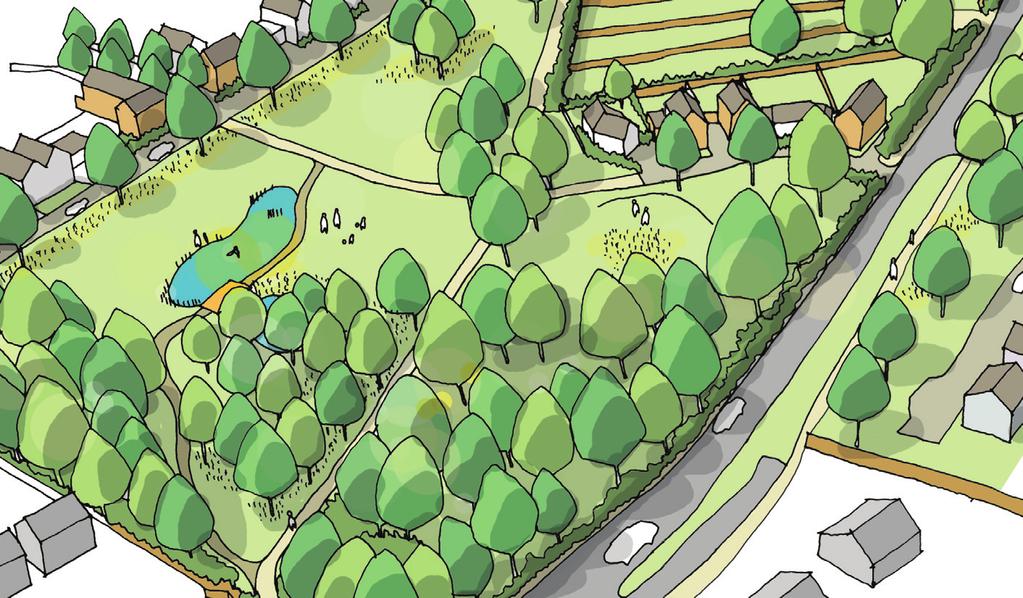
12 1.0 The Vision The vision for Pill Pond and the associated open spaces is illustrated in the illustrative masterplan and birds eye perspective. Pill Pond is located in between the District and the Southern Neighbourhoods, and forms part of a west / east green link across the site. Pill Pond is a Wildlife Area and, as such, has a higher ecological value compared to the other open spaces within the development. It also contains some natural ponds (although some are ephemeral), which is unique to this area of open space. PRIMARY SCHOOL 1 DISTRICT NEIGHBOURHOOD The aspirations for this area are as follows: To preserve the existing ecological value of the site, and to enhance them with considered landscape design and plant selection To integrate the area with the wider green infrastructure and landscape strategy - as part of a series of green spaces and links To create accessible routes to and across the site, and provide clear entrance points - a clear and pleasant route from the primary school should be provided To create a series of sub-areas within the area with differing landscape characters To provide development frontage around the perimeter of the spaces to ensure a safe, well overlooked space To provide development that relates to, and is sensitive to the existing dwellings on Wantage Road to be retained To maintain Wantage Road s green soft character by maintaining and enhancing the existing hedges and trees DISTRICT NEIGHBOURHOOD SQUARE Green corridor links the Pill Pond Wildlife Area to the Local Park SECONDARY SCHOOL LOCAL PARK 01 WANTAGE ROAD PILL POND WILDLIFE AREA Area to be covered in this LAB Green mews provides access to Pill Pond PLAYING FIELDS PRIMARY SCHOOL 2 SOUTHERN NEIGHBOURHOOD SOUTHERN NEIGHBOURHOOD SQUARE KEY Parish boundary m Figure 1.1: Illustrative Masterplan 10
 Formal tree planting to residential development Pedestrian / cycle route to be located within the green strip Gateway Green strip with footpath to retain the soft")
13 Area kept as open as possible to provide maximum overlooking and views through Frontage overlooking the open space on the south to consist of groups of buildings with a degree of symmetry in the built form (see Frontage A guidance) Formal tree planting to residential development Pedestrian / cycle route to be located within the green strip Gateway Green strip with footpath to retain the soft green character / outlook of Wantage Road Pedestrian access through the open spaces Small residential parcel to consist of detached houses and to relate to the existing dwellings on Wantage Road New detention pond District Neighbourhood residential development addressing Wantage Road - set back behind green strip WANTAGE ROAD Existing woodland area to be enhanced and expanded along the eastern boundary Access into Pill Pond and Southern Neighbourhood Figure 1.2: Illustrative bird s eye perspective 11

14 2.0 Concept As this area is within the Overlap Area between two Neighbourhoods, Pill Pond is located both in the edges of the Wantage Road Character Area in the District Neighbourhood, and the Green Core Character Area in the Southern Neighbourhood. There is also the Didcot West Character Area in close proximity to this area. In the Framework Plans, the Green Core Character Area is described as...generally formal to reflect the character of the series of open spaces that form the core of the Neighbourhood and formal and suburban, whereas the Wantage Road character area is described as reflecting the existing rural / suburban character. Pill Pond wildlife area located in overlap area between two Neighbourhoods and Character Areas WANTAGE ROAD PILL POND WILDLIFE AREA Existing houses to be retained Parish boundary KEY District Neighbourhood: District Centre Core Character Area Local Park 01 Wantage Road Character Area Boundary Park East Character Area Southern Neighbourhood Gateway Southern Neighbourhood: Didcot West Character Area Green Core Character Area Sports Pitches Potential future development (subject to separate application Primary School 2 Overlap between Wantage Road and Green Core Character Area m Figure 2.1: Character Areas Plan 12


15 KEY Landscape Concept The area contained within the LAB can be divided into two character areas: north and south of Wantage Road. To the north of Wantage Road, the public open space will be relatively open and well managed, providing relief from the more densely vegetated border to the south. The space will be quite formal in character with large trees planted to create a buffer between the road and the residential properties while still allowing views through to ensure there are still strong connection to the rest of the site. The wildlife area to the south is more natural and informal. This will be made up of three main habitat areas: woodland, which will include both existing and new areas; wildflower meadow in open areas; and wetland areas which will overlap both of the other habitats to create a mosaic of different wildlife environments. Movement through the site will make use of existing public right of way which runs east-west from Wantage Road towards the heart of the southern neighbourhood. New connections will be provided by a north-south route which will link both sides of Wantage Road, giving easy access across the wider site. NOTE: Refer to Urban Design Principles Plan on page 16 for built form concept and principles m Figure 2.2: Landscape Concept Plan Figure 2.3: Landscape character precedents 13


.")


16 3.0 Ecology Ecological Analysis The design of the Pill Pond Wildlife Area has been informed by a series of ecology surveys, including a Phase 1 habitat survey (RPS, 2012), an amphibian survey of the Pill Pond (RPS 2012), and a series of bat surveys (RPS 2002, 2005, 2012) Findings of the habitat survey reported the principal habitats of ecological importance on site to be broad-leaved woodland, hedgerows, broad-leaved trees, semi-improved grassland, and the Pill Pond itself. Findings of the Pill Pond amphibian survey reported the presence of a small population of smooth newts and breeding populations of toads and frogs. During the bat surveys, several species of bat were observed foraging and commuting along areas of woodland edge and hedgerows. Areas of woodland and scrub, hedgerows and trees offered potential nesting sites for breeding birds KEY Area covered by this document m Parish boundary Figure 3.1: Existing Aerial Photo Figure 3.2: Site photographs 14
17 Semi-improved grassland and arable land reverted to species-rich meadow, of value to a diversity of species, including invertebrates, foraging bats and birds Native broad-leaved trees, including oak and ash, planted across open areas of species-rich grassland. Of long-term value to invertebrates, bats and birds m Figure 3.3: Ecology Strategy Plan A line of oak and ash trees in place of the existing hedgerow, to retain foraging and commuting corridor for bats. Planting includes native broad-leaved shrubs. Existing boundary hedgerows retained to maintain habitat resource and connectivity across the site. A limited number of footpaths to divert visitors away from less disturbed areas. Pill Pond enlarged and re-profiled to create a more variable depth. Leaf litter, sediment and fly tipping cleared. Native aquatic planting, management of overhanging trees. A standalone attenuation basin, sown with a wet grassland seed mix. Information boards at access point to inform visitors of the biodiversity value of the area. Areas of dense bramble, ivy and nettle cleared, canopy species selectively thinned, to encourage development of greater diversity of ground flora and regeneration of shrub and tree species. Long-lasting bat roost and bird nest boxes installed on mature trees. Woodland planting to expand woodland resource. Comprising native broad-leaved species, including oak, ash, aspen, field maple, wild service tree and hazel. NOTE: The movement and/or planting of Ash (Fraxinus sp.) is currently restricted and Ash should not be proposed until the ban has been lifted. Ash is an important native tree species has been included in the plant palette so that it may be proposed in the future should restrictions be relaxed. Ecological Design One of the principal objectives behind the design of the Pill Pond Wildlife Area is the enhancement of the area for the benefit of biodiversity. To achieve this, various measures will be undertaken: Areas of semi-improved grassland and arable land will be reverted to species-rich meadow, that will provide shelter and resources for a diversity of species, including invertebrates, and foraging bats and birds Areas of dense bramble, ivy and nettle within the woodland under-storey will be cleared, and where necessary, canopy species will be selectively thinned to enable more sunlight to reach ground-level, which will encourage the development of greater ground flora diversity, the regeneration of shrub and tree species, and further development of retained trees New areas of woodland will be planted with native broad-leaved species, including oak, ash, aspen, field maple, wild service tree and hazel Long-lasting bat roost and bird nest boxes will be installed in suitable locations on mature trees Native broad-leaved trees, including oak and ash, will be planted across the speciesrich grassland. These will provide long-term resources for invertebrates, nesting birds, and foraging bats A line of oak and ash trees will replace the existing hedgerow lining the central footpath. These will ensure the continuance of the existing habitat link between the woodland to the east and surrounding habitats, which is of particular value to foraging and commuting bats The Pill Pond will be enlarged and re-profiled to create a more variable depth. Leaf litter and sediment will be removed to reduce nutrient levels, and fly tipping will be cleared. Native aquatic plants will be planted around the margins and within central areas, and overhanging trees will be managed to limit the future build-up of leaf litter The standalone attenuation basin to be created on site will provide additional wetland habitat. The basin will be sown with a wet grassland seed mix Public access will be managed through the use of a limited number of footpaths which will divert visitors away from less disturbed areas, and through the provision of information boards References: RPS (2002). Great Western Park, Didcot: Bat Survey. RPS Group Plc RPS (2005). Great Western Park, Didcot: Bat Survey. RPS Group Plc RPS (2012). Great Western Park, Didcot: Amphibian Survey South of the Wantage Road. RPS Group Plc RPS (2012). Great Western Park, Didcot: Bat Roost Survey South of the Wantage Road. RPS Group Plc RPS (2012). Great Western Park, Didcot: Phase 1 Habitat Verification Survey South of the Wantage Road. RPS Group Plc 15

18 4.0 Building Interface The character of the built form surrounding Pill Pond and its associated open spaces needs to respond to the landscape character of the spaces interfacing them. The residential parcels and layout ensure that this area is overlooked from as many sides as possible, whilst at the same time providing development that is sensitive to the surrounding existing buildings. The streets on the perimeter of the open spaces are low key and consist mostly of shared surface streets. Most of the frontages described are prominent and address views across the open spaces as well as from Wantage Road. C TO DIDCOT This section describes how the streets and dwellings interface and look onto the open spaces, as well as how this new development relate to that of the retained existing dwellings. C WANTAGE ROAD B Key views from Wantage Road PILL POND WILDLIFE AREA Existing dwellings to be retained KEY E E D A A Pill Pond and associated open spaces to be overlooked by residential development Residential frontage Key residential frontage Key views Green buffer - structural planting to boundaries of the existing dwellings A Key frontages located at gateway should be symmetrical and frame the view into the open space Residential development - lowest density parcel Residential development - medium density parcel To Southern Neighbourhood Gateway Residential development - highest density parcel Residential development - subject to separate planning permission Public Open Space Trees Parish Boundary m Figure 4.1: Urban design principles plan 16


19 Frontage A Frontage B storeys 1-2 storeys Pill Pond Figure 4.2: Frontage A: Section swale shared surface drive service margin buffer dwelling Figure 4.3: Frontage A: An example of a shared surface street with storey detached / semi-detached dwellings overlooking open space. This is a key frontage that should address views across Pill Pond. A degree of formality is achieved through repetitious roof forms and consistent use of materials. Figure 4.4: Frontage B: Section Pill Pond private drive service margin buffer dwelling Character Built Form Character Semi-formal green interface onto a grassed landscape Building Interface Private drive or shared surface access to dwellings - avoid separate carriageway and footways Buildings set back to vary between 1 and 2.5m Front gardens should be green to reflect green character of the park edge, with formal tree planting on the other side Urban boundary treatment to each dwelling - ie. railings, dwarf wall and railing, or low wall. Boundary treatment should be consistent throughout the street Green planted 2m service margin to provide a soft edge In curtilage car parking between or behind dwellings, to minimise visual impact No rear parking courts Crossovers to car parking should be integrated with front paths and grouped in pairs to minimise interruptions to the green planted service strip Formal perimeter tree planting to other side of drive, of a consistent species at regular intervals Create a semi-formal rhythm of building frontages overlooking the park Buildings should consist of detached and / or semi-detached dwellings - vehicular and pedestrian access to the dwellings should be grouped to allow for long planted service margins Ensure building frontage and gap between them is uniform along the entire frontage with a variation allowed for street corner plots Buildings should be organised as symmetrical groups - eg. semi-detached pairs or larger groups composed symmetrically Building height to be between storeys - any variation in height must give formal character and not be random (ie. should be used to emphasise the centres or ends of building groups) Building height of the dwelling on the eastern corner should be maximum 2 storeys Roof forms must be consistent for each group of buildings, except at the ends of building groups or on corner plots Materials and detailing should be consistent between street junctions except on corner plots The corner buildings facing each other forming the gateway must be symmetrical to each other to form a formal gateway and frame the view into the open space This is categorised as a key frontage, as it provides a face to the development from Wantage Road - a low density informal shared surface drive overlooking Pill Pond, reflecting that of the existing dwellings along Wantage Road Buildings should be sensitive to that of the existing dwellings to the west in terms of form, massing, and boundary treatment Building Interface Shared surface private drive or access to dwellings - avoid separate carriageway and footways Variation of building line encouraged and to vary between 2m and 4m Front gardens should be green to reflect green character of the park edge Some tree planting on the other side, but outlook to be kept as open as possible to enable visual connections towards Pill Pond Soft boundary treatment to each dwelling - i.e. hedge, timber fence or no boundary. Boundary treatment should be consistent within each group of houses In curtilage car parking to minimise visual impact - rear parking courts adjoining existing properties on Wantage Road are not permitted No rear parking courts There must be a minimum rear garden depth of 15m to the boundary of the existing dwellings Vehicular turning head to be integrated into the form of development - it cannot determine the shape of the development edge 17


20 Frontage C 2 storeys Figure 4.5: Frontage B: An example of a private drive with informal boundary treatment and varied building line. This frontage should reflect the fragmented and varied building line of the existing dwellings on Wantage Road, and should have long front gardens. Unlike this example, material treatment between individual dwellings may vary. green corridor Figure 4.6: Frontage C: Section private drive buffer dwelling Figure 4.7: Frontage C: An example of a shared surface street with detached houses overlooking open space. The roof form should be consistent, and generous spacing in between buildings should provide a porous edge to the development. Built Form Character Built Form Development should consist of detached dwellings only with entrances at the front Frontage must be discontinuous, and gaps must be created between individual dwellings Materials may vary between dwellings, but a limited palette must be used per individual building (see Southern Neighbourhood Framework Plan guidance) Roof forms and ridge lines may vary Buildings to be 1 to 2 storeys to reflect the building heights of the existing dwellings A semi-formal green edge to the green corridor onto Wantage Road Buildings should be sensitive to that of the existing dwellings to the west in terms of form, massing, and boundary treatment Building Interface Shared surface private drive or access to dwellings - avoid separate carriageway and footways Building line to be consistently set back by 2-3m for each group of dwellings Green front gardens to be provided. Boundary treatment to have a soft character: hedge, timber fence or no boundary to front garden. Boundaries may vary across the character area but must be consistent within each group of dwellings Parking to be in-curtilage between dwellings, to minimise visual impact. No parking in front of dwellings. Rear parking courts adjoining existing properties on Wantage Road are not permitted No rear parking courts Crossovers to car parking should be integrated with front paths to minimise interruptions to the green planted service strip Formal perimeter tree planting to other side of private drive, of a consistent species at regular intervals Development should consist of detached dwellings only Consistent building form, material and detailing must be used for each group of dwellings (ie. between street junctions) - corner buildings may vary Roof forms and ridge lines could vary, but should be consistent for each group of dwellings Buildings to be 2 storeys 18
 dwelling Figure 4.")

21 Frontage D Frontage E 2 storeys 2 storeys carriageway Figure 4.8: Frontage D: Section Character varies min green corridor Soft, informal edge overlooking the green corridor and footpath Building Interface swale footpath hedge (existing) dwelling Figure 4.9: Frontage D: An example of dwellings looking out onto open space, with a green buffer existing dwelling green corridor shared surface drive buffer dwelling and buffer between the public footpath and the dwellings. This should be a front or a side elevation, and must provide overlooking and elevational treatments that address the open space. The main pedestrian Figure 4.10:: Frontage E: Section access should be from this side. Pedestrian access to dwellings to be from the footpath, with vehicular access and car parking from within the development parcel to the side of the plot - access points to the dwellings must be paired where possible to minimise the number of openings to the hedge Rear parking courts adjoining existing properties on Wantage Road are not permitted No rear parking courts Building line to be set back between 2-4m, and to be consistent for the whole frontage A planted verge (containing the existing hedgerow) of a minimum of 2m should be provided between the footpath and the buffer to the dwelling Built Form Development should consist of detached dwellings only Variation of building form to be permitted, but with consistent material and detailing for all dwellings All dwellings to provide windows (and pedestrian access where possible) onto the green corridor to provide overlooking onto this space and to avoid blank walls Buildings to be 2 storeys Character Soft, informal edge overlooking the green buffer Building Interface Shared surface private drive or access to dwellings - avoid separate carriageway and footways Building line to be varied, set back by 1-3m Green front gardens to be provided Boundary treatment to have a soft character: hedge, timber fence or no boundary to front garden. Boundaries should be consistent for the length of the frontage Parking to be in-curtilage, behind or between dwellings, to minimise visual impact. No parking in front of dwellings. Some parking No rear parking courts Crossovers to car parking should be integrated with front paths to minimise interruptions to the green planted service strip Structure planting to other side of the shared surface drive 19

22 Figure 4.11: Frontage E: An example of a shared surface street with detached houses overlooking the green buffer. Please note that unlike this example, development should be 2 storeys. Built Form Development should mainly consist of detached dwellings only Consistent building form, material and detailing must be used for each group of dwellings - corner buildings may vary Roof forms and ridge lines could vary, but should be consistent for each group of dwellings Buildings to be 2 storeys maximum 20

23 5.0 Movement The movement plan shows how the Pill Pond area is accessed, routes through the open space, as well as the streets that enclose the area. Within the open space, there will be a combination of surfaced pedestrian cycle routes as well as more informal mown grass paths. KEY Wantage Road Shared surface route Shared surface green route Claimed Right of Way Route L / green pedestrian cycle route Informal pedestrian route Emergency vehicular access route / green pedestrian cycle route Pedestrian cycle route Residential frontage Key residential frontage Gateway into Pill Pond Existing uncontrolled crossing point (to be retained) Proposed uncontrolled crossing point Residential development - lowest density parcel Residential development - medium density parcel Residential development - highest density parcel Public Open Space Trees m Parish Boundary Figure 5.1: Movement plan 21

24 6.0 Landscape Design The design of the area to the north of Wantage Road is very simple, with a limited palette of landscape features used to create a legible and uncluttered public open space with contrasts strongly with the more complex area to the south of the road. Large trees will be planted at equal spacings to give rhythm along the route and partially screen the residential properties from the road. The existing footpath in this area will be extended to provide a continuous link from the edge of Didcot to the Wantage Road junction. To the south of the road, the design has been informed by surveys which have helped to pin-point existing features which should be retained and enhanced, as well as identifying some elements which may be removed to improve the space and accommodate new ones. Pedestrian / cycle route Bulb planting Parish boundary Swale prevents vehicular access and provides buffer between park and houses, while still providing good surveillance Existing hedgerow retained Mown path Proposed structure planting Existing ephemeral pond Existing woodland vegetation to be retained with selective clearance of under-storey No route through woodland to minimise disturbance to wildlife The key features include the existing woodland, hedgerows, trees and Pill Pond itself. Together with Wantage Road, the public right of way and proposed residential areas, these elements create a frame for the public open space. Pill Pond Existing path surfaced and widened to make suitable for disabled access In addition to the existing Pill Pond a new area of wetland will be created within the base of a shallow detention basin which forms part of the SuDS strategy across the site. The new pond will be approached by a woodland walk through an area of new native structure planting, leading to a timber dipping platform which provides safe access to the water s edge, for educational activities such as pond dipping. One of the key objectives for the wildlife area was to maximise potential for learning and to ensure the different spaces created could be experienced and understood. Routes with stopping points that are accessibility of all provide opportunities for everyone to make contact with wildlife and interpretation boards will be provided throughout the space. WANTAGE ROAD Existing hedge removed to create open park area and replaced by line of trees to provide bat corridor Existing vegetation retained Area managed as Wildflower meadow Wide bridge provides viewing and dipping platform Clearing with seating Swale with marginal planting appears to connect ponds Dipping platform provides access to pond edge Proposed woodland planting Careful consideration has been given to the impact on existing properties along Wantage Road, and a wide strip of open space, with native trees and vegetation, has been included to create a landscape buffer between the new development and the rear garden boundaries. This will screen views between properties and provide an alternative green link to the Pill Pond wildlife area. Good surveillance of park Native tree species provide semiformal edge along park Existing vegetation retained Rough grass with native bulbs Additional vegetation added to boundary where required Existing tree retained Landscaped buffer in between existing dwellings and shared surface drive Existing claimed Right of Way retained Pedestrian connection between Wantage Road and Southern Neighbourhood residential development Detention basin with small permanent pond Mown grass path connects route Existing hedgerow enhanced by new native planting Grass edge slightly banked to prevent parking, possible timber knee Shared surface throughout Shrub planting to private frontages m Figure 6.1: Landscape buffer plan Figure 6.2: Landscape layout plan 22

25 6.1 South of Wantage Road m Grass verge with new tree planting Existing hedgerow enhanced by new native planting Self bound gravel footpath B B A A The larger part of the space will be overlooked by dwellings on one side to ensure there is natural surveillance. A range of habitats are provided across the site, ranging from dense vegetative structure adjacent to the Wantage Road to open wildflower meadow. A shallow detention basin with pond at the base will provide rainwater storage in extreme weather conditions but will only be perceived as part of the natural landform of the area. Large trees, both existing and proposed, will frame the space. As the area narrows it will be overlooked on both sides to provide a safe and attractive route into the heart the southern neighbourhood. The existing hedge will be retained and used to form a buffer between the public open space and new residential areas. dwelling buffer verge 3.2m footpath verge carriageway footway buffer dwelling Figure 6.3: Section B - B Figure 6.5: Key plan existing hedgerow retained proposed tree planting proposed tree planting m proposed formal tree planting Wantage Road areas managed as wildflower meadow area managed as wildflower meadow mown grass footpath footway mown grass footpath 3.2m wide self bound gravel footpath (existing claimed Right of Way) Wantage Road structure planting meadow meadow meadow Permanent pond meadow carriage way buffer dwelling Figure 6.4: Section A - A 23


26 C C Design Guidance 6.2 North of Wantage Road The design of this area is relatively open to provide a contrast from the adjacent builtup areas and dense vegetation. Tree planting provides a vertical element and partially screening of the road while still allowing passive surveillance of the space for adjacent dwellings. Figure 6.6: Precedent Figure 6.8: Key plan m proposed tree planting proposed bulb planting 3.2m dwelling buffer shared surface drive green corridor footpath swale Figure 6.7: Section C - C Wantage Road structure planting 24


27 6.3 Landscape, Street Furniture and Public Art Figure 6.9: Indicative examples of landscape treatment and street furniture Figure 6.10: Indicative examples of public art The design and location of public art and street furniture has been informed by consultation on previous phases of development, the Framework Plan and Public Art Strategy. Street furniture has been selected to ensure it meets the needs of a wide range of people. A number of different seating types will be provided in accordance with guidance by the Fieldfare Trust and the Department of Transport Design Guide Inclusive Mobility to ensure these spaces can be enjoyed by all. In addition to standard seating, informal resting points will be proposed, these may simply be large boulders or logs placed at intervals along the route or could form part of a public art trail. Opportunities for artwork or sculptures to be hidden in the woodland should also be explored to give an extra visual experience and interest. Woodland 4 Woodland pond habitat 5 Meadow with mown path 6 Entrance signs will be included the access points to the Pill Pond wildlife area and interpretation boards will be positioned at key locations providing information about wildlife and habitats to enhance the experience of users. Bat roosting box Interpretation boards Dog waste bin Timber litter bin 9 Timber bench with back and armrests 9 Timber bench Resting points Resting points Resting points Figure 6.11: Key plan 25


 is currently")


28 6.4 Planting 1 Woodland planting NOTE: The movement and/or planting of Ash (Fraxinus sp.) is currently restricted and Ash should not be proposed until the ban has been lifted. Ash is an important native tree species has been included in the plant palette so that it may be proposed in the future should restrictions be relaxed. Acer campestre Fraxinus excelcior Quercus robur Populus tremula Salix alba var. caerulea 2 Understorey planting to woodland area 3 Wetland and water plants Cornus sanguinea Corylus avellana Crataegus monogyna Euonymus europaeus Ranunculus flammula Iris sp. Mentha aquatica Planting matrix Ilex aquifolium Salix viminalis Viburnum opulus Viburnum lantana Juncus articulatus Glyceria maxima Marginal planting Figure 6.12: Planting palette 26


29 4 Native hedge 5 Bulb planting 6 Wildflower meadow The planting palette has been developed in accordance with the Environmental Management Plan. To the south of Wantage Road native tree and shrub planting will be used to create structure and shelter and to frame views. Further structure is provided by existing hedgerows. Where these have been retained, additional planting or management by hedge laying will be used to enhance them. Native marginal and aquatic planting will be used in the new pond and also to improve the habitat of Pill Pond itself and a native wildflower meadow will be developed. To the north of Wantage Road the soft landscape will be more formal with mown grass and large individual trees. This will be seasonally enhanced by swathes of bulb planting along the footpath route. 7 Tree clumps Acer campestre 8 Formal perimeter planting Betula pubescens Prunus avium Sorbus aucuparia NOTE: The movement and/or planting of Ash (Fraxinus sp.) is currently restricted and Ash should not be proposed until the ban has been lifted. Ash is an important native tree species has been included in the plant palette so that it may be proposed in the future should restrictions be relaxed Castanea sativa Fagus sylvatica Quercus robur Figure 6.13:Key plan 27
 integrated with the development wide networks will be provided.")
30 7.0 Services Space for service corridors will be provided on planted service margins to accommodate Electricity, Gas, Telecom and Water supplies. A sustainable surface water drainage system (SuDS) integrated with the development wide networks will be provided. These will include swales adjacent to roads where practicable, ditches and attenuation areas. Ditches and swales improve water quality by filtering particles from the water and thereby help in removing pollution from local watercourses. Foul water sewers will generally be located under the carriageway. The services will be dealt in detail at Reserved Matters stage. Figure 7.1: Services and tracking plan 28
31 29
32
Chapter 2: OUTLINE PLANNING APPLICATION PROPOSALS. A New Garden Neighbourhood Matford Barton 17
 Chapter 2: OUTLINE PLANNING APPLICATION PROPOSALS A New Garden Neighbourhood Matford Barton 17 2.1. SUMMARY AND STATUS OF THE PROPOSALS 2.1.1. The parameter plans and associated wording in this chapter
Welcome to our public exhibition
 About our development Welcome to our public exhibition This exhibition gives you the chance to view and comment on our proposals for a new residential development of 165 high-quality homes, along with
WELCOME. Land North of STEVENAGE. We would like to thank you for attending our public exhibition today.
 WELCOME We would like to thank you for attending our public exhibition today. The purpose of this event is to share our proposals and hear your thoughts on our ideas. Members of the project team are on
Public Consultation. Land at Monks Farm, North Grove. Welcome
 Welcome Welcome to our public exhibition for development on Land at Monks Farm, orth Grove. Gallagher Estates and Gleeson Strategic Land are preparing an outline planning application for new homes, open
8.0 Design and Form of Development 43/
 42/ 8.0 Design and Form of Development 43/ Rothwells Farm, Golborne/ Development Statement Figure 7. Site Constraints Key 44/ Site Boundary 360 Bus Route/Stops Existing Trees Underground Water Pipe Sensitive
vision & process willowburn, tarves community engagement 04/18
 vision & process Historic Conservation area Scotia intend to create a high quality residential development based upon best practice urban design principles. This will include a contemporary reinterpretation
Background Information
 Background Information view at site entrance THE LONDON BOROUGH OF SUTTON As the strategic local authority the Council is working with a range of partners to take forward various development sites in Hackbridge.
Kibworth Harcourt. Introduction. Introduction
 Introduction Introduction Welcome to this public exhibition on the proposals for the delivery of new homes on land at The Kibworths. The purpose of today s exhibition is to give you the opportunity to
Statement of Community Involvement LAND OFF SOUTHDOWN ROAD HORNDEAN, HAMPSHIRE
 LAND OFF SOUTHDOWN ROAD HORNDEAN, HAMPSHIRE CONTENTS Page 1. Introduction 3 2. Pre-application Discussions 4 3. The Consultation Process 5 4. Consultation Feedback 7 5. Responses to Consultation Feedback
Welcome to our Public Consultation
 About our development This exhibition gives you the chance to view and comment on our emerging plans for a proposed residential development located on land to the West of Alwyn Road, Rugby. Welcome to
CALA HO ME S WELCOME
 WELCOME Welcome to this public consultation event for our proposed residential development of 56 high quality homes on land to the north east of Station Road in Earls Colne. Thank you for taking the time
SPG 1. * the northern and western sections which are open fields used for pasture and grazing;
 SPG 1 1.0 INTRODUCTION This development brief is based on the allocation of the Priors Hall site for employment and countryside recreational purposes in the Corby Borough Local Plan. The brief is intended
A new park will be delivered as part of the Elephant Park regeneration.
 A new park will be delivered as part of the Elephant Park regeneration. The exhibition boards presented here introduce the first phase of the new park that is scheduled to open in spring 2017 that has
Welcome to our exhibition
 Welcome to our exhibition The Homes & Communities Agency (HCA) welcomes you to this public exhibition explaining our proposals for the redevelopment of the former Lea Castle Hospital site. About the Homes
Welcome to our public consultation
 About our development Welcome to our public consultation This exhibition gives you the chance to view and comment on our proposals for a residential development of up to 187 high-quality homes, along with
WELCOME. North East Haverhill. The Planning Process
 WELCOME North East The site to the North East of, known as Great Wilsey Park, is identified by St Edmundsbury Borough Council in its Core Strategy as capable of delivering a Sustainable Urban Extension.
3.1 The hybrid planning application proposes the following description of development:
 CHAPTER 3: PROPOSED DEVELOPMENT 3.1 The hybrid planning application proposes the following description of development: Hybrid (part-outline/part-full) planning application for a single composite development
4. MASTERPLAN FRAMEWORK
 6a 6b 4. MASTERPLAN FRAMEWORK 6. Car Parks 6c Car Parks 6a and 6b will provide permanent parking. Area 6a will serve the foodstore with tarmac surfacing within a defined area to the west of the adjacent
Introduction. Welcome to this consultation regarding the draft redevelopment proposals for the former CeramTec factory on Sidmouth Road, Colyton.
 Introduction Welcome to this consultation regarding the draft redevelopment proposals for the former CeramTec factory on Sidmouth Road, Colyton. We are currently considering options for the mixed-use redevelopment
NORTH WEST SECTOR HORLEY, SURREY
 Welcome to our Exhibition We are delighted to present our plans for the first phase of the North-West Sector Horley development. We are holding this exhibition to give you the chance to view and comment
97 Lea Bridge Road, Leyton, E10 7QL London Borough of Waltham Forest December 2015
 97 Lea Bridge Road, Leyton, E10 7QL London Borough of Waltham Forest December 2015 Public Realm and Landscape Proposals LEA BRIDGE ROAD, WALTHAMSTOW Public Realm & Landscape Proposals BDP(90)RPT001 December
paving case study GREAT WESTERN PARK DIDCOT OXFORDSHIRE
 October 2013 Uniclass L534:L217 SuDS Management Train Permeable Paving Master-planning Major Development Shared Surfaces paving case study GREAT WESTERN PARK DIDCOT OXFORDSHIRE www.paving.org.uk Introduction
DESIGN & ACCESS STATEMENT
 DESIGN & ACCESS STATEMENT Land to the South East of the A495, Bronington Erection of 31 Dwellings (27 dwellings and 4 bungalows including 4 Affordable Dwellings), Realignment and Improvements to A495 (including
Urban Design Guidelines
 Urban Design Guidelines These Urban Design Guidelines comprise the Key Design Objectives below, the Roads Design Guidelines overleaf and Neighbourhood Framework Plans. Together with Section 3: Urban Design
Welcome. Land adjacent Sandy Lane WALTHAM CHASE THE PROPOSED SITE
 Land adjacent Sandy Lane WALTHAM CHASE Existing Linden Homes developments Welcome Welcome to Linden Homes Southern s ( Linden ) public exhibition about its proposals for a range of high-quality homes for
PHASE III: Reserved Matters Submission
 Statement of Compliance with the outline approval for the proposed residential development of land at: BURGES LANE, WIVELISCOMBE PHASE III: Reserved Matters Submission Foreword Contents: This Statement
Colchester Northern Gateway Master Plan Vision Review Draft. July 2016
 Colchester Northern Gateway Master Plan Vision Review Draft July 2016 Contents Introduction 4 Context 8 Purpose of the Report 8 Strategic Position 9 Overview of the Process 11 2012 Master Plan Vision 12
Welcome to our public exhibition
 About Our Scheme Welcome to our public exhibition This exhibition gives you the chance to view and comment upon our emerging proposals for a new residential development of 68 new homes on the site of the
Welcome to our exhibition
 Welcome to our exhibition housing development A46 Wildmoor Alcester Road Canal Quarter A422 Town Centre housing development Warwickshire-based IM Properties, one of the UK s largest privately owned property
LILAC Housing: Site Management Plan
 LILAC Housing: Site Management Plan Prepared by: Joe Atkinson. Date: 30/10/2011 Version 1.0 Relevant Legislation & Policy Conservation Regulations 1994, 2007, 2009, 2010 Wildlife & Countryside Act 1981;
Land at Rampton Road. Cottenham
 Land at Rampton Road Cottenham Introduction TEP is preparing an outline planning application for 54 dwellings on 6.9 hectares of land adjacent to Rampton Road, Cottenham on behalf of the owners Cambridgeshire
Schedule of Planning Applications Committee Date: 23 May Reference: 06/17/0726/F Parish: Hemsby Officer: Mr J Beck Expiry Date:
 Schedule of Planning Applications Committee Date: 23 May 2018 Reference: 06/17/0726/F Parish: Hemsby Officer: Mr J Beck Expiry Date: 22-05-2018 Applicant: Proposal: Site: Mr Gillett Change of use to the
Page 1 of 19 URBAN DESIGN FRAMEWORK FOR BOLTON STREET WATERFORD
 Page 1 of 19 URBAN DESIGN FRAMEWORK FOR BOLTON STREET WATERFORD 1.0 Introduction: The relocation of the City Council stores and depot from Bolton Street creates an exciting opportunity for development
DESIGN & ACCESS STATEMENT
 DESIGN & ACCESS STATEMENT January 2016 Contents Introduction section 1 Section 1 - Introduction Section 2 - Assessment Section 3 - Involvement Section 4 - Evaluation Section 5 - Design Section 6 - Layout
PDP DESIGN & ACCESS STATEMENT
 PDP The Planning & Design Partnership Planning.. Architecture.. Interiors.. Landscape The Chicory Barn Studio, The Old Brickyards, Moor Lane, Stamford Bridge York, The East Riding Of Yorkshire, YO41 1HU.
LITTLE FRANCE PARK, EDINBURGH
 LITTLE FRANCE PARK, EDINBURGH INTEGRATING ACTIVE TRAVEL ROUTES WITHIN A MASTERPLAN FROM THE OUTSET Location: Implemented: Edinburgh, Scotland 2016 - ongoing CASE STUDY The Little France Park cycling and
10 Proposed Redevelopment, Tewkesbury Road, Cheltenham SCHEME EVOLUTION STARBUCKS
 SCHEME EVOLUTION STARBUCKS The proposed Starbucks Drive Thru alongside the proposed food store provides an appropriate mix of uses, suitable for this location. The proposed store is bespoke, designed specifically
THANK YOU FOR TAKING THE TIME TO VISIT OUR PUBLIC CONSULTATION WEBSITE.
 PUBLIC CONSULTATION THANK YOU FOR TAKING THE TIME TO VISIT OUR PUBLIC CONSULTATION EBSITE. Orbit Homes are preparing a reserved matters planning application for residential development on an area of land
Alder View. Introduction. Alder View. Harwell. The Vision. The Team. Taylor Wimpey
 Introduction Welcome to the public exhibition for, a development by Taylor Wimpey on the land south of Grove Road,. This exhibition will provide an overview of the development proposals for the site and
Derry City and Strabane District Council Planning Committee Report. Amended layout from approval A/2004/0462/F with reduction from 166 units
 Derry City and Strabane District Council Planning Committee Report COMMITTEE DATE: 1 st February 2017 APPLICATION No: APPLICATION TYPE: PROPOSAL: LOCATION: APPLICANT: AGENT: Full Planning application Amended
A payment of 1080 is due in this instance, for a meeting and follow up written response, and will be made by card over the phone.
 JPPC ref: AG/6002 18 th September 2014 Planning Services Vale of White Horse District Council Benson Lane Crowmarsh Gifford Wallingford OX10 8ED Dear Sir/Madam REQUEST FOR PRE-APPLICATION ADVICE RE: RESIDENTIAL
Basic Habitat Survey Tabernacle Gardens, Pembroke
 Basic Habitat Survey Tabernacle Gardens, Pembroke Produced by The Wildlife Trust of South and West Wales Contact Ecologist: Position: Nathan Walton Wildlife Trust Officer Registered Office: Wildlife Trust
INTRODUCTION. Land south of Bishopswood Lane, Tadley
 0 INTRODUCTION THE SITE Introduction Gladman Developments Ltd. has successfully invested in communities throughout the UK over the past 0 years, developing high quality and sustainable residential, commercial
Welcome to our public exhibition
 About our development Welcome to our public exhibition This public exhibition gives you the opportunity to view and comment on our proposals to create a new residential development on land adjacent to
Subdivision Design Criteria. Penihana North GUIDELINES TO THE RULES
 Created September 2013 Penihana North Subdivision Design Criteria GUIDELINES TO THE RULES This part of the Plan sets out the design criteria for subdivision in Penihana North. The criteria will be considered
University Park, Worcester Non Technical Summary December 2011
 University Park, Worcester Non Technical Summary December 2011 Introduction UW Wrenbridge LLP, a Joint Venture Company of the University of Worcester and Wrenbridge Land Ltd (the Applicants ) intend to
Slough International Freight Exchange Proposals, Colnbrook+
 Welcome Welcome to this exhibition, which is being held in connection with our proposals for a new freight exchange facility on land to the north of the A4. Please take this opportunity to look at the
Section 6.0: Glencullen Design Guide
 Section 6.0: Glencullen Design Guide The Planning Authority requires that the adherence to each of the above principles will be demonstrated at the Planning Application stage using appropriate visualisation
Public Consultation 23 January Peel Hall, Warrington Board 1. A message from Satnam... Site history...
 Board 1 A message from Satnam... Thank you for attending today s public consultation about proposals to develop a new residential neighbourhood at. The display boards show why the development is needed
Welcome to our public exhibition
 About our scheme Welcome to our public exhibition Taylor Wimpey East Anglia intends to submit a detailed planning application for a new residential development of 39 high-quality homes at the B&M Concrete
SOUTH EAST LINCOLNSHIRE LOCAL PLAN: HOUSING PAPER DONINGTON (JUNE 2016)
") SOUTH EAST LINCOLNSHIRE LOCAL PLAN: HOUSING PAPER DONINGTON (JUNE 2016) 1 DONINGTON S PLACE IN THE SPATIAL STRATEGY 1.1 Policy 2 of the South East Lincolnshire Local Plan 2011-2036 Draft for Public Consultation
SOUTH EAST LINCOLNSHIRE LOCAL PLAN: HOUSING PAPER DONINGTON (JUNE 2016) 1 DONINGTON S PLACE IN THE SPATIAL STRATEGY 1.1 Policy 2 of the South East Lincolnshire Local Plan 2011-2036 Draft for Public Consultation
Toddington Central Bedfordshire Stage 3 Green Belt Study December 2017
 Toddington Central Bedfordshire Stage 3 Green Belt Study December 2017 Site: ALP086 - Middle Lakes, Toddington Site size (ha): 2.83 Site: ALP086 - Middle Lakes, Toddington Site size (ha): 2.83 Site description
East Harptree Landscape & Character Assessment
 East Harptree Landscape & Character Assessment Produced by East Harptree Parish Council in consultation with local residents September 2014 Contents The Parish of East Harptree: Objective Introduction
East Grove Public Realm
 H - - MP - Elephant Park Public Realm RO EY DN NEW KENT ROAD E AC PL The public realm has been designed to create an environment which is easy to move through, accessible to all, safe and playful. The
edge of gas line corridor setback edge of gas line corridor aligned with Schlumberger building 37.0 m AOD 33.0 m AOD max
 7. Heights and Street Frontage: In accordance with the approved heights parameters, heights to along Western Access Road must respond to the existing low density character in this location. Heights are
Section Three, Appendix 17C Multiple Unit Housing Design Assessment Criteria
 APPENDIX 17C MULTIPLE UNIT HOUSING DESIGN ASSESSMENT CRITERIA Purpose of Appendix 17C In the Residential 9 Zone the construction and use of multiple household units located within the Multiple Household
NON-TECHNICAL SUMMARY
 NON-TECHNICAL SUMMARY THE HIDE, BISHOP AUCKLAND PROPOSED ECO CHALET DEVELOPMENT NON-TECHNICAL SUMMARY 1 Introduction 1.1.1 This non-technical summary for the (ES) prepared in relation to the proposed eco-chalet
Appendix H: Easement cross sections
 Appendix H: Easement cross sections SHARED PATH 1.5m FOOTPATH NATURE STRIP 7.3m CARRIAGEWAY 2.7m NATURE STRIP EXISTING PIPELINE 150mm DIA 5.0m (approx.) LOCAL ACCESS ROAD EXISTING PIPELINE 500mm DIA 2.7m
Neighbourhood Planning Local Green Spaces
 Neighbourhood Planning Local Green Spaces Introduction... 2 1. Why green space is important... 4 2. Neighbourhood plans and green space... 6 3. Evidence... 8 Statutory designations... 9 Green space audit...
Land at Pirton Fields. South Churchdown, Innsworth Design and Access Statement Addendum
 Land at Pirton Fields South Churchdown, Innsworth Design and Access Statement Addendum February 2017 Revisions Revision Date Description Prepared Approved Document No. 15-45-CR02 - Land at Pirton Fields
FORMER CANADIAN FORCES BASE (CFB) ROCKCLIFFE SECONDARY PLAN. Official Plan Amendment XX to the Official Plan for the City of Ottawa
 ROCKCLIFFE SECONDARY PLAN. Official Plan Amendment XX to the Official Plan for the City of Ottawa") FORMER CANADIAN FORCES BASE (CFB) ROCKCLIFFE SECONDARY PLAN Official Plan Amendment XX to the Official Plan for the City of Ottawa 1 INDEX THE STATEMENT OF COMPONENTS PART A THE PREAMBLE PAGE Purpose...
FORMER CANADIAN FORCES BASE (CFB) ROCKCLIFFE SECONDARY PLAN Official Plan Amendment XX to the Official Plan for the City of Ottawa 1 INDEX THE STATEMENT OF COMPONENTS PART A THE PREAMBLE PAGE Purpose...
doyle + o troithigh landscape - architecture
 doyle + o troithigh landscape - architecture REPORT: PROJECT: LANDSCAPE DESIGN REPORT. STUDENT HOUSING DEVELOPMENT AT WESTWOOD HOTEL SITE. DATE: MAY 2018. www.doyle-otroithigh.com Landscape design report,
Environmental and Landscape Mapping
 Environmental and Landscape Mapping In support of the Calveley Neighbourhood Plan November 2016 Project Name and Number: Calveley Neighbourhood Plan 16-025 Document Name and Revision: Environmental and
LAND AT WEST YELLAND. Environmental Statement Non-Technical Summary Welbeck Strategic Land LLP
 LAND AT WEST YELLAND Environmental Statement Non-Technical Summary Welbeck Strategic Land LLP May 2014 Quality Management Issue/revision Issue 1 Revision 1 Revision 2 Revision 3 Remarks Draft FINAL Date
Queensborough Eastern Neighbourhood Node. Community Open House
 Queensborough Eastern Community Open House The Vision The Queensborough Eastern will become the heart of eastern Queensborough. Through a sensitive mix of viable commercial and residential areas, the neighbourhood
ILLUSTRATIVE MASTERPLAN
 ILLUSTRATIVE MASTERPLAN The Development Dairy Crest (Imperial College) The Proposed Development aims to create a new high quality residential neighbourhood, alongside a new public park for White City.
Site north of Hattersley Road West (east of Fields Farm Road), Hattersley
, Hattersley") Application Number 17/00982/REM Proposal Site Applicant Recommendation Reason for report Application for the approval of reserved matters (means of access, landscaping, layout, scale and appearance) relating
Application Number 17/00982/REM Proposal Site Applicant Recommendation Reason for report Application for the approval of reserved matters (means of access, landscaping, layout, scale and appearance) relating
WHITELEY TOWN COUNCIL NORTH WHITELEY DEVELOPMENT SEPTEMBER 2014
 WHITELEY TOWN COUNCIL NORTH WHITELEY DEVELOPMENT SEPTEMBER 2014 Dear Resident This Special Edition of the Whiteley Voice which has been prepared in conjunction with the North Whiteley Consortium is to
Land at BROOK STREET PROPERTIES TENCREEK FARM, LISKEARD. Environmental Statement: Non-Technical Summary
 BROOK STREET PROPERTIES TENCREEK FARM, LISKEARD Land at Environmental Statement: Non-Technical Summary Introduction Brook Street Properties is applying to Cornwall Council for outline planning permission
Mr & Mrs Connolly per Pump House Designs Pump House Yard The Green SEDLESCOMBE, East Sussex. TN33 0QA
 AGENDA ITEM NO: 5 (c) Report to: PLANNING COMMITTEE Date: 03 June 2015 Report from: Head of Housing and Planning Services Application Address: Proposal: Application No: Recommendation: Ward: File No: Applicant:
Carterton Construction Ltd is bringing forward plans for up to 85 new family homes and extra care facilities on land east of Burford.
 Welcome Carterton Construction Ltd is bringing forward plans for up to 85 new family homes and extra care facilities on land east of. We are at the early stages of designing our proposals and have a number
WELCOME TO THE NEW WILTON PARK
 WELCOME TO THE NEW WILTON PARK VISION HISTORY OF WILTON PARK TOWARDS A PLANNING APPLICATION Our objective is to create a truly outstanding environment at Wilton Park. At the heart of our proposals is a
Newcourt Masterplan. November Exeter Local Development Framework
 Newcourt Masterplan November 2010 Exeter Local Development Framework Background The Exeter Core Strategy Proposed Submission sets out the vision, objectives and strategy for the development of Exeter up
Frequently Asked Questions
 1. Where is Aylesbury Woodlands? Frequently Asked Questions Aylesbury Woodlands lies to the east of Aylesbury. It is bounded to the south by the A41. To the north is the Aylesbury Arm of the Grand Union
Wild about Bolnore. Welcome to Bolnore Village, situated in the beautiful West Sussex countryside. ResIDENTS INFORMATION GUIDE
 Wild about Bolnore Welcome to Bolnore Village, situated in the beautiful West Sussex countryside. Sustainability has been a key factor in the development of the village and considerable effort has been
Housing Development at Balloonagh Tralee Co Kerry
 Design Statement Housing Development at Balloonagh Tralee Co Kerry Area of site 10,400m2 24 houses-12no 3 bed, 12no 2 bed and 4 single bed apartments total residential area of 2411m2 Open space provided
Boundaries and Fencing
 Boundaries and Fencing Introduction 7.1 The purpose of this chapter of the design code is to establish design principles and parameters to guide the development and erection of site boundaries within the
SNEINTON CITY CENTRE LACE MARKET. 800 m : 10 min walk
 PUBLIC REALM CITY CENTRE SNEINTON LACE MARKET 00 m : min walk 0 PUBLIC REALM 1: LANDSCAPE CONTEXT Explaining the landscape and historical context Left / Location Plan The redevelopment area which is the
Land at Whiteditch Lane, Newport, Essex
 Land at Whiteditch Lane, Newport, Essex Ecology Report Produced for Sworders Agricultural By March 2013 Document Control: Version Date Version Details Prepared by Checked by Approved by 0.1 01.03.2013
Next Steps / Development Process. Structure Plan. June submitted to City of Fremantle. Structure Plan. July supported for advertising
 overview What is today about? In July 0, the City of Fremantle resolved that the be advertised for public comment. Today is about: Understanding the history and context of the site Having your say on the
Welcome. Proposals for land at Smug Oak Lane BRICKET WOOD
 Proposals for land at Smug Oak Lane BRICKET WOOD Previous Linden Homes and Wates Developments scheme Welcome Welcome to Linden Homes and Wates Developments public exhibition. Working together as joint
The proposals presented in September drew a large number of comments and feedback and have been grouped together as follows:
 Appendix A Stakeholder presentation + powerpoint slides Planning Context and Emerging Proposals presentation Nick Tyrrell, Alder King, Planning Consultants Alder King began by setting the site context
Memorial Business Park Site. Proposed Future Development. Design guidelines. August
 Memorial Business Park Site Proposed Future Development Design guidelines August 2014 www.designenvironment.co.nz 0064 3 358 3040 Contents 1.0 Background 1.1 Introduction 3 1.2 Objectives 4 2.0 Context
Design Guidance. Introduction, Approach and Design Principles. Mauritius. November Ministry of Housing and Lands. .. a
 sig evelo r D Mauritius s. Utilities.. Individu a s. er itects.to ls chpers.po e Public. T. h rban D Sc U e me Promot e h ners. A Design Guidance o.h Planne rs n w iticians r l useholde National Development
ECOLOGICAL ADVICE SERVICE
 ECOLOGICAL ADVICE SERVICE TO: FROM: Guy Wilson Marie Thibault DATE: 11 th August 2016 SUBJECT: CA/16/01502/FUL / Land adjoining Goose Farm, Canterbury Thank you for requesting advice on this application
LANDSCAPE DESIGN REPORT
 LANDSCAPE DESIGN REPORT Plot 12, Phase 1B (South) Reserved Matters Application Brent Cross South Limited Partnership October 2017 Contacts Brent Cross South Limited Partnership 4 Stable Street London N1C
WELCOME LAND EAST OF TYE LANE, WALBERTON. Above all, it s about people
 WELCOME Welcome to this public exhibition relating to our draft residential proposals for the land east of Tye Lane, Walberton. Today gives you the opportunity to have an active role in shaping these ideas
4.0 URBAN DESIGN FRAMEWORK. The vision for the future development of the plan area is to:
 4.0 The vision for the future development of the plan area is to: Create a new neighbourhood that focuses on the highly valued natural and aesthetic features of the lands and provides good quality homes,
Section 4 - Public Realm & Landscape proposals Landscape Masterplan. Section 4 52
 - Public Realm & Landscape proposals Landscape Masterplan 52 Proposed Masterplan - Green Infrastructure Strategy District Park 4.33 Ha to provide Passive and active recreation with a large play area which
DESIGN & ACCESS STATEMENT
 DESIGN & ACCESS STATEMENT Demolition of Detached Dwellinghouse and Construction of 11 Dwellinghouses with Access Road & Associated Infrastructure, Ystradgynlais, Powys On Behalf of Watree Homes Limited
East Bayshore Road Neighbourhood
 East Bayshore Road Neighbourhood Northridge Property Management Urban Design Brief 3195 East Bayshore Road City of Owen Sound January 2016 East Bayshore Road Neighbourhood Northridge Property Management
Chapter 13 Residential Areas: Appendices APPENDIX 1 Residential Areas
 Chapter 13 Residential Areas: Appendices Page 1 Chapter 13 Residential Areas: Appendices APPENDIX 1 Residential Areas Design Code for Intensive Housing INTRODUCTION DESIGN ELEMENTS A NEIGHBOURHOOD DESIGN
Warren Farm, Ampthill
 1 Welcome The developers of the Warren Farm site, Bloor Homes and Connolly Homes, are holding this exhibition on the emerging Design Codes for the development prior to their formal submission to Central
URBAN DESIGN BRIEF. 2136&2148 Trafalgar Road. Town of Oakville
 URBAN DESIGN BRIEF 2136&2148 Trafalgar Road Town of Oakville Prepared By: METROPOLITAN CONSULTING INC For 2500674 Ontario Inc November 2016 TABLE OF CONTENTS Page No. 1.0 Introduction/Description of Subject
LAND EAST OF HORNDEAN. 1. Welcome. Morrisons supermarket. Keydell Nurseries A3(M)
") 1. Welcome Bloor Homes welcomes you to today s Public Exhibition relating to development proposals for Land to the East of Horndean. Idsworth Close Rowlands Castle Road Roa d Dell Piece East J2 Pyle Farm
1. Welcome Bloor Homes welcomes you to today s Public Exhibition relating to development proposals for Land to the East of Horndean. Idsworth Close Rowlands Castle Road Roa d Dell Piece East J2 Pyle Farm
UTT/16/1466/DFO GREAT DUNMOW MAJOR
 UTT/16/1466/DFO GREAT DUNMOW MAJOR PROPOSAL: LOCATION: APPLICANT: AGENT: Reserved matters approval for the accesses to the site and principal roads within the site including spine road following outline
Nelson Residential Street Frontage Guideline
 DRAFT 22-06-2012 Nelson Residential Street Frontage Guideline June 2012 1317273 Contents and purpose Residential s are important Residential s are much more than corridors which move traffic. Streets allow
ENVIRONMENTAL AND LANDSCAPE MAPPING
 APPENDIX IV : Environmental and Landscape Mapping ENVIRONMENTAL AND LANDSCAPE MAPPING Calveley Neighbourhood Plan November 2016 ENVIRONMENTAL AND LANDSCAPE MAPPING Calveley Neighbourhood Plan Calveley
Applicant: Mr C Fletcher Agent: Ms B Stala Case Officer: Sally Smith (HBC) Jill Lee (WCC) Ward: Stakes Parish Southwick and Widley
 Jill Lee (WCC) Ward: Stakes Parish Southwick and Widley") Site Address: Berewood Phase 2 Development Site, London Road, Purbrook, Waterlooville Proposal: Reserved Matters Application for landscaping of Phase A of the Town Park (under Condition 6(i)d)), together
Site Address: Berewood Phase 2 Development Site, London Road, Purbrook, Waterlooville Proposal: Reserved Matters Application for landscaping of Phase A of the Town Park (under Condition 6(i)d)), together
CALA Homes is preparing a planning application for a development of up to 36 new homes, including a mix of properties to meet local demand.
 WELCOME Welcome to this public consultation event for our proposed development on land to the south of Twelve Leys in Wingrave. Thank you for taking the time to come along today. Homes is preparing a planning