Planning Commission Agenda Bill
|
|
|
- Priscilla Barton
- 5 years ago
- Views:
Transcription

1 Planning Commission Agenda Bill Meeting Date: 5/24/2017 Agenda Item: 5 Subject: Anacortes School District, Temporary Portable(s), CUP Staff Contact: Kevin Cricchio, AICP, Associate Planner Approved for Submittal to Commission by X Don Measamer, Director Action Type X Public Hearing X Discussion X Possible Action Summary & Background: The City of Anacortes Planning, Community, & Economic Development Department received a Conditional Use Permit to permit the temporary placement of a 2,700 square foot portable building on the grass field located at the southeast corner of the intersection of 22 nd Street and J Avenue. The building will be used to house Cap Sante High School. The proposal includes moving the building to this location June of 2017 and removing it fall of In addition to the 2,700 square foot portable building discussed above, the applicant also requests the temporary placement of two optional 1,100 square feet (2,200 square feet total) portables. If the two optional portables are used, they would be in place the summer of 2018 and removed in the fall of An open-record public hearing before the Planning Commission has been scheduled for 6:00 PM on May 24, Please bring your packets with you to the hearing. Recommendation: The Department of Planning, Community, and Economic Development recommends that the Planning Commission make a motion to recommend approval to City Council regarding the subject Conditional Use Permit subject to staff s suggested conditions of approval. Attachments: Staff Report with Draft Planning Commission s Findings of Fact, Conclusions of Law, & Recommendation Exhibit #01, Master Permit Application, Narrative, & CUP Criteria of Approval, Exhibit #02, Assessor s Info & City GIS Map Exhibit #03, Notice of Application & Hearing Exhibit #04, Public Comments Received
2 Exhibit #05, Agency & Department Comments Received Exhibit #06, Site Plan Exhibit #07, Drainage Analysis /Stormwater Plan & Third Party Review

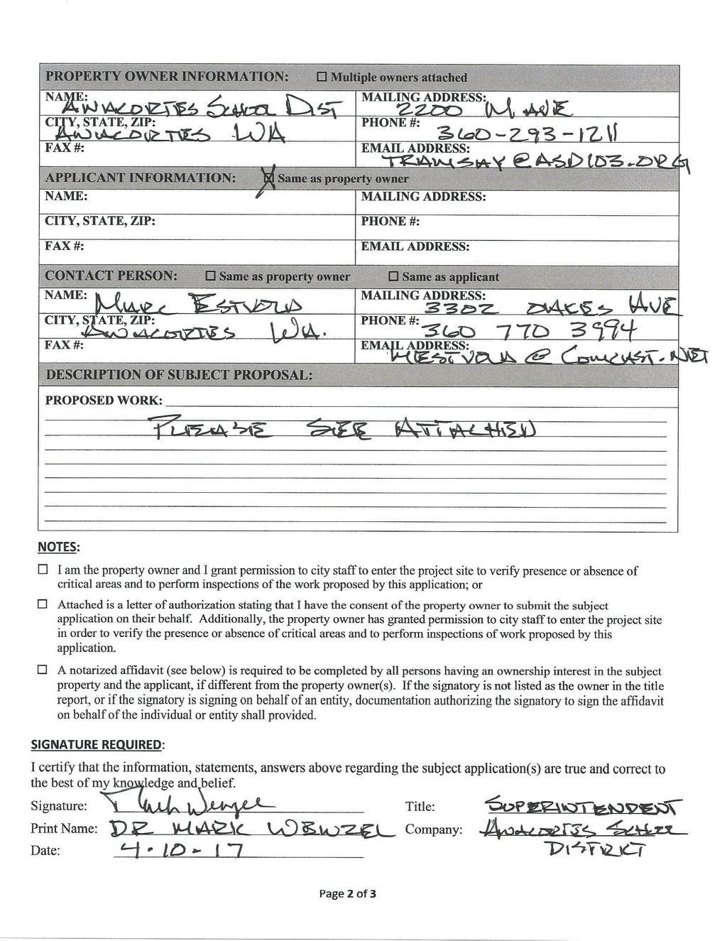
3 STAFF REPORT WITH PLANNING COMMISSION S DRAFT FINDINGS OF FACT, CONCLUSIONS OF LAW, & RECOMMENDATION: OPEN-RECORD PUBLIC HEARING DATE: CLOSED-RECORD PUBLIC HEARING DATE: FILE NUMBER: PROJECT LOCATION: SUBJECT PARCEL #: APPLICANT & LANDOWNER: PROJECT CONTACT: STAFF REPORT PREPARED BY: Wednesday, May 24, 6:00 PM Monday, June 05, 6:00 PM CUP The site is addressed as nd Street, Anacortes, WA. The subject property is located at the southeastern corner of 22 nd Street and J Avenue. The site is located within a portion of Section 24; Township 35 North; Range 01 East; Willamette Meridian. P31801 Anacortes School District 2200 M Avenue Anacortes, WA Marc Estvold, Project Manager 3302 Oakes Avenue Anacortes, WA Kevin Cricchio, AICP Associate Planner City of Anacortes th Street Anacortes, WA 98221
4 SUBJECT PROPOSAL: The applicant has applied for a Conditional Use Permit (CUP) to permit the temporary placement of a 2,700 square foot portable building on the grass field located at the southeast corner of the intersection of 22 nd Street and J Avenue. The building will be used to house Cap Sante High School. The proposal includes moving the building to this location June of 2017 and removing it fall of Additionally, a 1,200 square foot crushed surface parking area with two parking areas is proposed just west of the building and 476 square feet of graveled paths. In addition to the 2,700 square foot portable building discussed above, the applicant also requests the temporary placement of two optional 1,100 square feet (2,200 square feet total) portables, 320 square feet of ramp and deck, and 720 square feet of graveled parking. If the two optional portables are used, they would be in place the summer of 2018 and removed in the fall of EXISTING LAND USE: CURRENT ZONING & COMP. PLAN DESIGNATION: The project site sits vacant with no improvements on it. Anacortes School District student s uses the ball-field for recreational purposes. Public Use (P) Zoning District SURROUNDING ZONING & LAND USES: Direction: Zoning: Present Land-Use: North: Residential Medium Density (R3) 22 nd Street & Single-Family Zoning District Residences South: Public Use (P) Zoning District Island View Elementary School East: Public Use (P) Zoning District School District s Tennis Court West: Residential Medium Density (R3) J Avenue & Fidalgo Pool & Zoning District Fitness Center District SITE ACREAGE: ~2.24 Acres (According to Assessors Records) DRAFT FINDINGS OF FACT: I. GENERAL BACKGROUND: 1. A pre-application conference was conducted at 1:30 PM on April 27, 2017, concerning the proposed development (File #: PRE ). 2. The applicant conducted a neighborhood meeting at the senior center at 6:00 PM on May 3, Staff Report with Planning Commission s Draft Findings of Fact, Conclusions of Law, & Recommendation CUP , ASD Portable 2 OF 8 Anacortes School District
5 3. On April 12, 2017, the applicant submitted the subject Conditional Use Permit to the City of Anacortes Department of Planning, Community, & Economic for review. 4. Following a review of the application material submitted, the Department of Planning, Community, & Economic deemed the application complete effective April 26, Per AMC Table , Conditional Use Permits require a twenty-one (21) day comment period. The twenty-one (21) day comment period ended at 5:00 PM on May 17, 2017, but comments were accepted up until the close of the of the open-record public hearing. II. III. IV. NOTICE OF APPLICATION (NOA) & NOTICE OF HEARING (NOH): 1. A Notice of Application & Hearing was published in the Anacortes American Newspaper on April 19, The Notice of Application & Hearing was posted onsite in two different locations on April 14, Additionally, the notice was posted at the library, city hall, the local USPS, and on the city s website on April 14, The notice was mailed to neighboring landowners located within 300 feet of the subject property on April 14, Agencies and departments of jurisdiction were solicited for comment on April 14, In the morning on Monday, April 17, 2017, PCED received revisions from the applicant. Therefore, re-noticing was required. 6. Accordingly, the revised Notice of Application & Hearing was published in the Anacortes American Newspaper on April 26, The project site was reposted in two different locations with the revised notice on April on April 17, Additionally, the notice was posted at the library, city hall, the local USPS, and on the city s website on April 17, The revised notice was mailed to neighboring landowners located within 300 feet of the subject property on April 17, CRITICAL AREA / ENVIRONMENTALLY SENSITIVE AREA REVIEW: No critical areas are located either on the subject property or within three hundred (300) feet of it. STATE ENVIRONMENTAL POLICY ACT: The subject proposal is exempt from SEPA environmental review per WAC and AMC Staff Report with Planning Commission s Draft Findings of Fact, Conclusions of Law, & Recommendation CUP , ASD Portable 3 OF 8 Anacortes School District
6 V. PUBLIC COMMENT: To date, no public comment has been received (See Exhibit # 04). VI. VII. AGENCY & DEPARTMENT COMMENT: Comments received from both agencies and departments of jurisdiction can be found in Exhibit # 05. ZONING ORDINANCE/CODE: 1. Per AMC (A), Public Schools in the Public Use Zoning District require a Conditional Use Permit. Accordingly, the applicant has submitted a Conditional Use Permit to permit the placement of one or more portables onsite temporarily until the Fall of 2019 while Anacortes High School is being rebuilt. 2. Per AMC , there are no minimum setback requirements in the Public Use Zoning District. 3. Additionally, per AMC there is no maximum land coverage in the Public Use Zoning District 4. Per AMC , the maximum permitted building height in the Public Use Zoning District is thirty-five (35) feet above average original grade. The proposed portables will be well below the maximum permitted height. 5. Per AMC , the minimum number of off-street parking spaces required for public schools is 1 per 4 fixed seats or 10 per 1,000 net square if no fixed seats. Since this is a temporary use, the applicant is proposing the location of one off-street parking space for each classroom /portable along with one handicap stall. Moreover, the applicant contends that the majority of students using the portable(s) will be walking from Anacortes High School. Additionally, there a significant amount of on-street parking alongside J Avenue and 22 nd Street available for students that do drive. 6. Per Ordinance 2991, development shall comply with the Department of Ecology s 2012, Stormwater Management Manual for Western Washington as amended in December Accordingly, the applicant submitted a drainage analysis/ stormwater plan, which was reviewed on behalf of the city by thirdparty review (See Exhibit #07). Revisions to the drainage analysis /stormwater plan were requested by third party review. 7. Per AMC , in order to grant a Conditional Use Permit, the decision maker must find that the use would be consistent with the following criteria as follows: A) The use would comply with any specific requirements for the conditional use specified elsewhere in this code. STAFF ANALYSIS: Staff Report with Planning Commission s Draft Findings of Fact, Conclusions of Law, & Recommendation CUP , ASD Portable 4 OF 8 Anacortes School District
7 Per AMC (A), public schools require a Conditional Use Permit in the Public Use Zoning District. B) Access to this site is appropriate considering the anticipated volume of traffic resulting from the use. STAFF ANALYSIS: Access to the site will be by way of J Avenue and 22 nd Street. C) Off-street parking and loading facilities are adequate in terms of location, amount, and design to service the use. STAFF ANALYSIS: The subject proposal involves the temporary placement of 1-3 portables onsite for use as classrooms while Anacortes High School is undergoing redevelopment. One off-street parking space for each classroom /portable along with one handicap stall is proposed. The applicant contends that the majority of students using the portable(s) will be walking from Anacortes High School. Additional off-street parking is available at Anacortes High School for student using the portable classrooms. Adequate on street parking is also available along both J Avenue and 22 nd Street. D) The amount and location of open space and the provision of screening is such that buffering of incompatible uses is achieved. STAFF ANALYSIS: The proposed temporary placement of 1-3 portable classrooms is the only proposed use onsite. No location of open-space or screening is proposed. The site is separated from other uses by a playfield to the south, a tennis court to the east, and city streets located to the north and west thereof. E) The location and intensity of outdoor lighting is such that it does not cast light on adjacent, adjoining, or neighboring properties. STAFF ANALYSIS: Streetlights are located on the west side of J Avenue. Each of the 1-3 proposed portable classrooms will have a light above the exterior door. If any additional outdoor lighting is proposed, it will be down-shielded as conditioned below. F) Hours and manner of operation of the propose use, including anticipated noise generation, are not inconsistent with the adjacent or nearby uses. Staff Report with Planning Commission s Draft Findings of Fact, Conclusions of Law, & Recommendation CUP , ASD Portable 5 OF 8 Anacortes School District
8 STAFF ANALYSIS: The proposed hours of operation will be 7:00 AM to 3:00 PM, Monday through Friday. There is no school during the months of summer. No generation of noise is expected beyond that of the adjacent school use located to the east and south of the project site. G) Public facilities and utilities are capable of adequately serving the proposed use. STAFF ANALYSIS: Public utilities including but not limited to power, potable water, and sanitary sewer are available at the project site and will be used. H) The physical conditions of the site, including size, shape, topography, and drainage, are suitable for the proposed development. STAFF ANALYSIS: The site is predominantly flat and vegetated with grass as it has been used a ballfield for recreation by the school district. The conditions of the site are conducive for the proposed development. I) Any other factors deemed relevant to the decision maker. STAFF ANALYSIS: As is required per AMC Table , both a pre-application conference and neighborhood meeting were conducted for the subject Conditional Use Permit. The 1-3 proposed portables will be located onsite temporarily until Fall of 2019, while Anacortes High School is being re-developed. The applicant has attempted to minimize as much as possible any impacts to the neighborhood and its residents. 8. The subject proposal is, is not consistent with the above development regulations and the proposed land use is permitted in the underlying zoning districts. VIII. CONCLUSIONS OF LAW: 1. The public notice requirements of the Conditional-Use Permit have, have not been complied with. 2. The project is, is not consistent with the general purposes of the City s Comprehensive Plan, the city s planning standards and specifications of the zoning ordinance, and other ordinances applicable to the proposal. 3. The Planning Commission bases its Findings of Fact, Conclusions of Law & Staff Report with Planning Commission s Draft Findings of Fact, Conclusions of Law, & Recommendation CUP , ASD Portable 6 OF 8 Anacortes School District
9 IX. Recommendation on the entire record, including all testimony and exhibits. Any finding, which would be deemed a Conclusion of Law, and any Conclusion of Law which should be deemed a finding is hereby adopted as such. STAFF RECOMMENDATION: The Department of Planning, Community, and Economic Development recommends that the Planning Commission make a recommendation of approval to City Council regarding the subject Conditional Use Permit subject to staff s suggested conditions of approval listed below. X. RECOMMENDATION: Based on the foregoing information and analysis, the environmental documents submitted by the applicant, and the City regulatory authority to implement the policies, standards, and the regulations of the Anacortes Municipal Code (AMC), the Planning Commission recommends approval, approval with conditions, or denial to City Council concerning the subject Conditional Use Permit subject to staff s suggested conditions of approval listed below. XI. CONDITIONS OF APPROVAL: 1. The applicant shall be responsible for reimbursement to the City for both the cost third party review and for the cost of posting, mailing and publication of the public hearing for this proposal. Payment shall be made prior to building permit application submittal or issuance. 2. All applicable permits shall be secured before any construction activities begin onsite. 3. If any garbage dumpsters are proposed, the applicant is responsible for following the city s dumpster pad specifications. 4. If any garbage dumpsters are used, dumpsters shall be screened by constructing a wood enclosure(s) around them surrounded by landscaping. Both wood enclosures and landscaping shall be in place prior to certificate of occupancy being issued. 5. All exterior lighting shall be down-shielded thus preventing light trespass and impacts to the neighborhood. 6. The location of 1-3 portable classrooms onsite is temporary lasting until the Fall of Thereafter, all portable(s) shall be removed from the subject property and the site shall be restored to its present condition. Notwithstanding, a new Conditional Use Permit will be required to permit the continued location of said portables onsite past fall of Development shall comply with the Department of Ecology s 2012, Stormwater Management Manual for Western Washington as amended in December Staff Report with Planning Commission s Draft Findings of Fact, Conclusions of Law, & Recommendation CUP , ASD Portable 7 OF 8 Anacortes School District
10 These Findings of Fact, Conclusions of Law, and Recommendation were adopted by the City of Anacortes Planning Commission on May 24, CITY OF ANACORTES, WASHINGTON PLANNING COMMISSION By Marty Laumbattus, Planning Commission Chair EXHIBITS: EXHIBIT NUMBER: Exhibit #01 Exhibit #02 Exhibit #03 Exhibit #04 Exhibit #05 Exhibit #06 Exhibit #07 NAME OF EXHIBIT: Master Permit Application, Narrative, & CUP Criteria of Approval Assessor s Info & City GIS Map Notice of Application & Hearing Public Comments Received Agency & Department Comments Received Site Plan Drainage Analysis/ Stormwater Plan & Third Party Review Staff Report with Planning Commission s Draft Findings of Fact, Conclusions of Law, & Recommendation CUP , ASD Portable 8 OF 8 Anacortes School District
11 EXHIBIT #01: MASTER PERMIT APPLICATION, NARRATIVE, & CUP CRITERIA OF APPROVAL

12
13
14
15 April 18, 2017 Mr. Don Measamer Planning, Community & Economic Development Department th Street Anacortes, WA RE: Cap Sante High School Relocation & Future Portable Relocation, Conditional Use Permit Application Mr. Don Measamer, In response to questions/comments receive from the City of Anacortes on April 17, 2017 regarding the above referenced CUP application, please find our response. City comments in purple, our response in italics. A. CUP responses referenced old CUP criteria, need to use title Criteria. A. In order to grant a conditional use permit, the decision maker must find that the use would be consistent with the following criteria: 1. The use would comply with any specific requirements for the conditional use specified elsewhere in this code; The current zoning is Public, the proposed use is that of a school which is a conditional use in Public zoning. 2. Access to the site is appropriate considering the anticipated volume of traffic resulting from the use; Access to the site will be via public streets which are currently in place. 3. Off-street parking and loading facilities are adequate in terms of location, amount, and design to service the use; We have allocated one parking space for each of the classrooms plus one Handicapped space. There is additional off street parking to the north at the High School, to the east at the Middle School and to the south at Island View Elementary. There is also on-street parking available.
16 4. The amount and location of open space and the provision of screening is such that buffering of incompatible uses is achieved; These will be the only uses on the site. The site is separated from other uses by play field to the south, street to the west & north and tennis courts to the east. 5. The location and intensity of outdoor lighting is such that it does not cast light on adjacent, adjoining, or neighboring properties; There are existing street lights on the west side of J Avenue and there are porch lights over the doors to the classrooms. If additional lighting is required, it will be accomplished via a light arm with shoebox cover mounted to the side of the building. The shoebox cover will shield the light from casting light on neighboring properties. 6. Hours and manner of operation of the proposed use, including anticipated noise generation, are not inconsistent with the adjacent or nearby uses; Hours of operation will be normal school time hours 7:00 am to 3:00 pm Monday through Friday with summers off. We are not aware of any noise that will be generated beyond that of the adjacent school uses. 7. Public facilities and utilities are capable of adequately serving the proposed use; Public utilities are available at the site of adequate size to serve the propose use. 8. The physical conditions of the site, including size, shape, topography, and drainage, are suitable for the proposed development; The physical conditions of the site are suitable in all ways for the proposed use. 9. Any other factors deemed relevant to the decision-maker. Neighborhood views are a consideration in the proposal. We have located the portables as far to the north on the site as possible and nestled them as compactly as allowable, in an effort to minimize as much as possible any impact on neighborhood views. B. How many staff & students at peak hour? The enrollment in the Cap Sante High School is currently 65 students. Students typically only attend 3 hours per day, so at any one time it is estimated there will be students in that building. There would typically be two staff members in this building. Hours of instruction are typically 7:00am 4:00pm. Regarding the other two portables that may be placed on site, we are not sure at this point that they will be needed, or not. If we were to consider these as classrooms they would typically hold students each in an instructional setting an one staff member each. Hours of instruction are typically 7:00am 4:00pm.
17 Total Students and Staff at peak = students + 4 Staff = 84 C. Description of how new parking conforms to regulations and how stormwater will be dealt with? Parking: We do not find specific requirements for classroom use parking in the AMC. We have allowed one space for each classroom and one Handicapped stall. There is significant parking available at other District sites within walking distance. Students will likely be walking from the High School which is one block away, for classes. There is also a significant amount of on street parking available along the east side of J Avenue and the south side of 22 nd Street. Stormwater Management: We are in the process of having Materials Testing Inc. do infiltration testing on the site. Once we have the results of that testing we will have an engineer, acceptable to the City of Anacortes design the Stormwater Management System. Hopefully the above information answers your initial questions, please let me know as other questions arise. Thank you, Marc L Estvold, AIA LEED AP Project Manger Anacortes School District
18 EXHIBIT #02: ASSESSOR S INFO & CITY GIS MAP
19

20

21
22 EXHIBIT #03: NOTICE OF APPLICATION & HEARING

23 NOTICE OF APPLICATION & HEARING: Notice Is Hereby Given That An Application Was Made For The Following Proposal: Request: The applicant has applied for a Conditional Use Permit to permit the placement of a 2,700 square foot portable building on the grass field located at the southeast corner of the intersection of 22 nd Street and J Avenue. The building will be used to house Cap Sante High School. The proposal includes moving the building to this location June 2017 and removing it fall of Additionally, a 1,200 square foot crushed surface parking area with two parking areas is proposed just west of the building & 476 square feet of graveled paths. In addition to the 2,700 square foot portable building discussed above, the applicant also requests two optional 1,100 square feet (2,200 square feet total) portables, 320 square feet of ramp and deck, and 720 square feet of graveled parking. If the two optional portables are used, they would be in place the summer of 2018 and removed in the fall of Applicant: Anacortes School District, 2200 M Avenue, Anacortes, WA File Number: CUP Project Location: SE Corner of the intersection of 22 nd Street & J Avenue; Parcel #: P31801 Date of Application: April 12, 2017 Date of Completeness: April 26, 2017 Public Comment Period: Any person may comment on this application by writing to the address below and/or by testifying at the public hearing. Staff will issue a recommendation on the project after the comment period ends on May 17, 2017, at 5:00 pm. Written comments on the proposal should be submitted before the end of the comment period but will be accepted until the close of the Open-Record Public Hearing. Required Project Permits/Approvals: The following may be required in addition to the above: Civil Construction Plan approval & Building Permit Application Approval Preliminary Determination of Consistency: At this time, no determination of consistency with City of Anacortes plans, regulations, or standards has been made. At a minimum, this project will be subject to the following plans and regulations: the Comprehensive Plan; Anacortes Municipal Code (Zoning, etc.), Engineering Design and Building Standards. SEPA Review: SEPA review is not required. Open-Record Public Hearing: An open-record public hearing will be held by the Planning Commission at 6:00 PM on Wednesday, May 24, Closed-Record Public Hearing: A closed-record public hearing to make a decision on the application will be held by the City Council at 6:00 PM on Monday, June 5, Both hearings will be in City Council chambers located at th Street, Anacortes, WA. How to become a party of record: You may become a party of record by submitting written comments, including a (USPS) mailing address, to the City of Anacortes PCED at the address listed below. ed comments must include a return (USPS) mailing address in order for the sender to be considered a party of record. Questions about this proposal, requests to receive future notices of hearings and/or the decision, once made, and/or appeal procedures should be directed to the contact person listed below. The application and complete case file are available for review at the City of Anacortes PCED located at th Street, Anacortes, WA A decision on this application will be made within 120 days from the date of completeness. For Project Information: Kevin Cricchio, AICP, Associate Planner; Phone: (360) ; kevinc@cityofanacortes.org; City of Anacortes, P.O. Box 547, Anacortes, WA Date Issued: April 26, 2017 Publish: April 26, 2017
24 EXHIBIT #04: PUBLIC COMMENTS RECEIVED
25 No public comments have been received to date.
26 EXHIBIT #05: AGENCY & DEPARTMENT COMMENTS RECEIVED
27
28 Cricchio, Kevin From: Sent: To: Subject: Jackie Ferry Thursday, May 11, :29 PM Cricchio, Kevin RE: AHS Portable Building, CUP Hi Kevin, At this time, we have no cultural resources concerns with this project. Thanks, Jackie Jackie Ferry, MA, RPA Cultural Director Tribal Historic Preservation Officer Samish Indian Nation 2918 Commercial Ave Anacortes, WA Monday - Thursday Office: ext. 126 Fax: jferry@samishtribe.nsn.us From: Cricchio, Kevin [mailto:kevinc@cityofanacortes.org] Sent: Friday, April 14, :07 PM To: Development Review Group <DevelopmentReviewGroup@cityofanacortes.org>; 'mcewanr@wsdot.wa.gov' <mcewanr@wsdot.wa.gov>; 'Thompson, Doug S (DFW)' <Doug.Thompson@dfw.wa.gov>; 'Miller, Mark' <mark_miller@fws.gov>; 'Kaehler, Gretchen (DAHP)' <Gretchen.Kaehler@DAHP.wa.gov>; 'brandonb@co.skagit.wa.us' <brandonb@co.skagit.wa.us>; ddigges@skagittransit.org; Larry Campbell <lcampbell@swinomish.nsn.us>; jjefferson@swinomish.nsn.us; 'thyatt@skagitcoop.org' <thyatt@skagitcoop.org>; Todd Woodard <twoodard@samishtribe.nsn.us>; Jackie Ferry <jferry@samishtribe.nsn.us>; 'sschuyler@upperskagit.com' <sschuyler@upperskagit.com>; Sarah Tchang <sarah@portofanacortes.com> Subject: AHS Portable Building, CUP RE: AHS Portable Building, CUP Greetings everyone. Attached hereto is a Conditional Use Permit to permit the placement of a 2,700 square foot portable building on the grass field located at the southeast corner of the intersection of 22 nd Street and J Avenue. The building will be used to house Cap Sante High School. The proposal includes moving the building to this location June 2017 and removing it fall of Additionally, a 1,200 square foot crushed surface parking area with two parking areas is proposed just west of the building. Please provide any conditions /requirements to me by: 5:00 PM on May 10, Thanks. Kevin Cricchio, AICP Associate Planner Planning, Community & Economic Development Department P.O. Box th Street Anacortes, WA (work) kevinc@cityofanacortes.org My incoming and outgoing messages are subject to public disclosure requirements per RCW
29
30 EXHIBIT #06: SITE PLAN
31
32 EXHIBIT #07: DRAINAGE ANALYSIS /STORMWATER PLAN & THIRD PARTY REVIEW
33
34 2 TABLE OF CONTENTS Page SECTION TITLE 2 PROJECT DESCRIPTION 2 EXISTING CONDITIONS 3 DOE Stormwater Management Manual Minimum Requirements 3 Minimum Requirement #1: Prepare a Stormwater Site Plan 4 Minimum Requirement #2: Construction Stormwater Pollution Prevention (SWPP) 6 Minimum Requirement #3: Source Control of Pollution 6 Minimum Requirement #4: Preservation of Natural Drainage Systems and Outfalls 6 Minimum Requirement #5: On-site Stormwater Management 7 Minimum Requirement #6: Runoff Treatment 7 Minimum Requirement #7: Flow Control 8 Minimum Requirement #8: Wetland Protection 8 Minimum Requirement #9: Basin/Watershed Planning ATTACHMENT A Developed Site Conditions ATTACHMENT B Existing Site Conditions ATTACHMENT C Soils report ATTACHMENT D DOE Manual Flow Chart Figure I ATTACHMENT E Soil amendment requirements ATTACHMENT F DOE & DOT BMP Figures ATTACHMENT G DOE Downspout dispersion trench detail PROJECT DESCRIPTION This project is to locate temporary portable buildings on School property at the Southeast corner of 22 nd Street and J Avenue. The site is generally flat with a slight slope down to the east. The proposal is for 4,900 square feet of building area, 1,228 square feet of paths, ramps and decks and 1,790 square feet of parking area. The access will be to 22 nd Street at the same point as an existing access in the northwest corner of the site. The total area proposed to be disturbed is approximately 11,500 square feet or (0.26 acres). See ATTACHMENT A. EXISTING SITE CONDITIONS The 11,500 square foot or 0.26 acre site is all grass. The site slopes down to the east at an average of 1% beyond the 5 foot drop from J Avenue and before the 9 foot drop to the east above the tennis courts. See ATTACHMENT B. This report will address the water quality as well as detention requirements of the proposed improvements to the site meeting the current 2012 (Amended in December 2014). Material Testing and Consulting, Inc. (MTC) completed a targeted soils characterization study to determine the infiltration capability of this site. The report is in ATTACHMENT C. The results of the report are that the site is ineligible for infiltration.
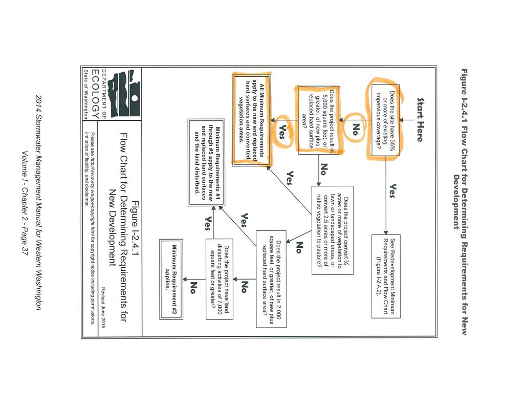
35 3 DOE Stormwater Management Manual Minimum requirements: According to the 2012 DOE manual Volume 1 figure 2.2, page 2-9: Does the site have 35% or more of existing impervious coverage No Does the site add 5000 square feet of new impervious surfaces Yes Does the site convert ¾ acres or more of native vegetation to lawn No Does the project have 2,000 square feet of new impervious surfaces Yes Minimum requirements #1 through #10 apply to this project. This report will work through each of the 10 requirements below. (See flow chart in ATTACHMENT D) Minimum Requirement #1: Prepare a Stormwater Site Plan. Volume 1, Chapter 3 steps (page 3-1). Step 1. Collect and Analyze Information on Existing Conditions. The entire site is grass and slopes at 1% down to the east. J Avenue borders the West boundary and 22 nd Street along the North boundary. Tennis courts lie approximately 88 feet to the east and a large grass area to the south with batting cages approximately 220 feet south. There is an existing 4 pvc drainage pipe and a series of Burlington type catch basins running south from the west side of the property at the toe of the steep slope east of J Avenue. Minimal offsite water will flow onto this site with J Avenue intercepting uphill drainage. A drainage pipe and catch basin are located east of Unit A approximately 55 feet under the southwest corner of a bleacher. A 6 drain pipe continues east from the catch basin but it is unknown where this drain pipe goes. It does clearly drain the basin. A 4 clay pipe extends to the west from the catch basin also. See ATTACHMENT B. Material Testing and Consulting, Inc. (MTC) completed a targeted soils characterization study to determine the infiltration capability of this site. The report is in ATTACHMENT C. The results of the report are that the site is ineligible for infiltration. Step 2. Prepare a Preliminary Development Layout. During construction approximately 0.26 acres will be disturbed. A proposed layout is attached as ATTACHMENT A. Step 3. Perform an offsite analysis: All water from this site sheets to the east to the east toward the tennis courts. A drainage pipe and catch basin are located east of Unit A approximately 55 feet under the southwest corner of a bleacher. A 6 drain pipe continues east from the catch basin but it is unknown where this drain pipe goes. It does clearly drain the basin. A 4 clay pipe extends to the west from the catch basin also. Step 4. Determine and Read Applicable Minimum Requirements. Threshold requirements: See DOE flow chart in ATTACHMENT D. The total impervious area is over 5000 square feet. Minimum requirements 1 through 10 are required. Step 5. Prepare a Permanent Stormwater Control Plan A storm water plan is provided in the developed site plan in Attachment A. The drainage system will be described in minimum requirement #5 below. Step 6. Prepare a Construction Stormwater Pollution Prevention Plan. See minimum requirement #2 below for SWPPP. Step 7. Complete a Stormwater Site Plan:
36 4 The project overview has been provided at the beginning of this report along with an existing conditions description. Maps are included in the attachments. A Soils report is provided in the attachments. Offsite analysis is provided in section step 3 above. Step 8. Check compliance with all applicable minimum requirements: To take place during review and during and after construction. Minimum Requirement #2: Construction Stormwater Pollution Prevention (SWPP) This project must meet the 12 elements of a SWPP because the site exceeds the threshold of 2,000 square feet of new impervious surfacing. 1. Preserve Vegetation/Mark Clearing limits: The site perimeter will be clearly identified with orange construction fencing or orange silt fencing on the down slope side of the project. The 0.26 acres site will be disturbed due to excavation and stock piling of soils. The site is all grass with no trees on site. 2. Establish Construction Access: A construction entrance will be installed at the proposed entry to the site at 22 nd Street and constructed to the WSDOT standard plan I See ATTACHMENT F. 3. Control Flow Rates: During construction a temporary sediment trap (DOE Figure II & Figure II )may be required and if used shall be constructed east of the proposed site. See ATTACHMENT F. 4. Install Sediment controls: In addition to silt fencing (DOE Figure II or DOT stnd plan I ) additional controls may be required for sediment control. Silt fencing will be provided on the east side of the disturbed site along with a small sediment trap as condition dictate. See ATTACHMENT F. 5. Stabilized Soils: Disturbed soils shall be stabilized within two days during the wet season (Oct. 1- April 30) or seven days in the dry season (May 1-Sept 30) with seeding, mulching, plastic covering or hydro seeding. Install crushed rock surfaces as soon as final grades are achieved. Also noted in erosion control notes on plans. 6. Protect Slopes: Cover exposed slopes with mulch and erosion control blankets (WSDOT Stnd Plan I Avoid concentrating runoff in channels. Cover temporary soil stockpiles with plastic tarps. See ATTACHMENT F. 7. Protect Drain Inlets: The catch basin on site as well as down hill from the entry location on 22 nd Street shall be protected with a Silt Fence inlet protection (WSDOT Stnd Plan I ). See ATTACHMENT F. 8. Stabilize Channels and Outlets: There are no channels or outlets on this site. 9. Control Pollutants: All pollutants including waste material and demolition debris will be contained and disposed of off site. Chemicals, liquid products and petroleum products will be kept is locked, covered and secure locations. The contractor shall have a spill containment plan for inadvertent equipment failures with appropriate absorption towels on site at all times. 10. Control De-Watering: Dewatering may be required for trench excavation and foundation excavations. Silt laden dewatering should be directed to the temporary swales and sediment trap. Clean, non-turbid dewatering water may be discharged to downstream drainage system. 11. Maintain BMPs:
37 5 All temporary and permanent Erosion and Sediment Control (ESC) BMPs shall be maintained and repaired as needed to ensure continued performance of their intended function. Maintenance and repair shall be conducted in accordance with each particular BMP specification (see Volume II of the SWMMWW or Chapter 7 of the SWMMEW). Visual monitoring of all BMPs installed at the site will be conducted at least once every calendar week and within 24 hours of any stormwater or non-stormwater discharge from the site. If the site becomes inactive and is temporarily stabilized, the inspection frequency may be reduced to once every calendar month. All temporary ESC BMPs shall be removed within 30 days after final site stabilization is achieved or after the temporary BMPs are no longer needed. Trapped sediment shall be stabilized on-site or removed. Disturbed soil resulting from removal of either BMPs or vegetation shall be permanently stabilized. Additionally, protection must be provided for all BMPs installed for the permanent control of stormwater from sediment and compaction. BMPs that are to remain in place following completion of construction shall be examined and restored to full operating condition. If sediment enters these BMPs during construction, the sediment shall be removed and the facility shall be returned to conditions specified in the construction documents. 12. Manage the Project: The project will be managed based on the following principles: Projects will be phased to the maximum extent practicable and seasonal work limitations will be taken into account. Inspection and monitoring: o Inspection, maintenance and repair of all BMPs will occur as needed to ensure performance of their intended function. o Site inspections and monitoring will be conducted in accordance with Special Condition S4 of the CSWGP. Sampling locations are indicated on the Site Map. Sampling station(s) are located in accordance with applicable requirements of the CSWGP. Maintain an updated SWPPP. o The SWPPP will be updated, maintained, and implemented in accordance with Special Conditions S3, S4, and S9 of the CSWGP. As site work progresses the SWPPP will be modified routinely to reflect changing site conditions. The SWPPP will be reviewed monthly to ensure the content is current. 13. Protect Low Impact Development BMPs: Due to the infeasible infiltration potential of this site, Low impact BMPs will not be utilized. Minimum Requirement #3: Source Control of Pollution During construction the site will be open and subject to erosion. BMP s as described in the erosion control plan must be constructed at the source to limit erosion and sediment laden runoff. The most common erosion source is exposed soils to rain, especially on steep slopes.
38 6 Minimum Requirement #4: Preservation of Natural Drainage Systems and Outfalls This site naturally sheets to the east. No change to this pattern is proposed. Minimum Requirement #5: On-site Stormwater Management As indicated in the MTC soils report infiltration in not feasible and the seasonal high water table is from 6 to 18 in depth. See ATTACHMENT C. BMP T5.13: Post-Construction Soil Quality and Depth, Lawn and landscaping areas: All disturbed site soil will be amended as required by the post construction soil quality and depth requirements and will be implemented at the building permit stage. The design guidelines for the soil requirements are included in ATTACHMENT E. LIST #1 because the site triggered Minimum requirements #1 through #10. ROOFS BMP T5.30: Full Dispersion No native vegetation on site. BMP T5.10A: Downspout full infiltration As noted above the Geotechnical report identified the subsurface as glacial till with cementation and not feasible for infiltration. BMP T5.14A: Rain Gardens Rain gardens and well as Bioretention cells, swales and planter boxes share the same infeasibility criteria and the minimum vertical separation of 1 foot to an impervious layer or glacial till can not be achieved for a drainage area less than 5,000 square feet of PGIS and 10,000 square feet of impervious surface. According to the Geotechnical report that weathered glacial till soil begins a 3.0 feet to 3.2 feet of depth about the same depth as the bottom of a rain garden or Bioretention cell. BMP T7.30: Bioretention Cells, Swales, and Planter Boxes - As noted under rain gardens above. BMP T5.10B: Downspout Dispersion Systems A downspout dispersion system requires a vegetated flowpath of at least 50 feet for splash blocks and 25 feet for trenches to a property line or structure. Downspout dispersion with splash block will be used on the south and eastern side of all buildings. Downspout dispersion trenches used on the north and west side of buildings. See ATTACHMENT G for details. OTHER HARD SURFACES (driveways and patios) BMP T5.30: Full Dispersion Not enough length and native vegetation on site. BMP T5.15: Permeable Pavements As noted above the Geotechnical report indicates that infiltration in not feasible. BMP T5.14A: Rain Gardens - Rain gardens and well as Bioretention cells, swales and planter boxes share the same infeasibility criteria and the minimum vertical separation of 1 foot to an impervious layer or cemented glacial till can not be achieved for a drainage area less than 5,000 square feet of PGIS and 10,000 square feet of impervious surface. According to the Geotechnical report the cemented soil begins a 2.5 feet of depth about the same depth as the bottom of a rain garden or Bioretention cell. BMP T7.30: Bioretention Cells, Swales, and Planter Boxes As noted with Rain Gardens above infiltration is not feasible. BMP T5.12: Sheet Flow Dispersion Sheet flow Dispersion will be used to the east of the parking area with more than 25 feet to the building. BMP T5.11: Concentrated Flow Dispersion There is not enough room (25 minimum) to the proposed building locations or to the right-of-way line for dispersion.
39 7 Minimum Requirement #6: Runoff Treatment Threshold requirements for determining the applicability of runoff treatment. Projects in which the total of pollution-generating hard surface (PGHS) is 5,000 square feet or more in a threshold discharge area of the project, or Projects in which the total of pollution-generative pervious surfaces (PGPS)-not including permeable pavements-is three-quarters (3/4) of an acre or more in a threshold discharge area, and from which there will be a surface discharge in a natural or man-made conveyance system from the site. The total PGHS projected for this site including driveway and parking is 1,790 square feet and less than the 5,000 square foot threshold. The total site is 0.26 acres and less than the ¾ acre PGPS threshold. Treatment is NOT required. Minimum Requirement #7: Flow Control Threshold requirements for determining the applicability of flow control. Projects in which the total effective impervious surface is 10,000 square feet or more in a threshold discharge area The new impervious area of 7,918 square feet is below the threshold discharge area of 10,000 square feet. Flow Control is Not required. Minimum Requirement #8: Wetland Protection There are no wetlands on this site or downstream of this site. The drainage system is enclosed pipes to Fidalgo Bay. Minimum Requirement #9: Operation and Maintenance The drainage system within this project will remain private and the responsibility of the Anacortes School District. The temporary sediment trap will be maintained during construction as well as all erosion control BMPs.
40
41
42 ATTACHMENT C SOILS REPORT
43
44
45
46
47 Mulch Loose soil with visible dark organic matter 8" 4" Loose or fractured subsoil Reprinted from Guidelines and Resources For Implementing Soil Quality and Depth BMP T5.13 in WDOE Stormwater Management Manual for Western Washington, 2010, Washington Organic Recycling Council NOT TO SCALE DEPARTMENT OF ECOLOGY State of Washington Figure V Planting Bed Cross-Section Revised January 2016 Please see for copyright notice including permissions, limitation of liability, and disclaimer.
48 Joints in filter fabric shall be spliced at posts. Use staples, wire rings or equivalent to attach fabric to posts 2"x2" by 14 Ga. wire or equivalent, if standard strength fabric used Minimum 4"x4" trench 6' max Post spacing may be increased to 8' if wire backing is used 2"x2" wood posts, steel fence posts, or equivalent 2"x2" by 14 Ga. wire or equivalent, if standard strength fabric used Filter fabric 2' min Backfill trench with native soil or 3 4" - 1.5" washed gravel Minimum 4"x4" trench 12" min 2"x2" wood posts, steel fence posts, or equivalent NOT TO SCALE DEPARTMENT OF ECOLOGY State of Washington Figure II Silt Fence Revised October 2014 Please see for copyright notice including permissions, limitation of liability, and disclaimer.
49 Typical V-Shaped Channel Cross-Section With Rock Center Grass-Lined Filter Fabric 6" - 9" ( mm) Key in Fabric Typical Parabolic Channel Cross-Section With Rock Center for Base Flow With Channel Liner 6" - 9" ( mm) Key in Fabric Filter Fabric Typical Trapezoidal Channel Cross-Section Design Depth Overcut channel 2" (50mm) to allow bulking during seedbed preparation and growth of vegetation. Filter Fabric With Rock Center for Base Flow NOT TO SCALE DEPARTMENT OF ECOLOGY State of Washington Figure II Typical Grass-Lined Channels Revised June 2015 Please see for copyright notice including permissions, limitation of liability, and disclaimer.
50 Surface area determined at top of weir 1' Min. 4' Min. 1' Min. Overflow 3H : 1V Max. 3.5' - 5' Flat Bottom Note: Trap may be formed by berm or by partial or complete excavation. 1.5' Min. 3 4 " - 1.5" Washed gravel Geotextile 2" - 4" Rock Rip Rap 1' Min. Discharge to stabilized conveyance, outlet, or level spreader NOT TO SCALE DEPARTMENT OF ECOLOGY State of Washington Figure II Cross Section of Sediment Trap Revised November 2015 Please see for copyright notice including permissions, limitation of liability, and disclaimer.
51 6' Min. 1' Min. depth overflow spillway Min. 1' depth 2" - 4" rock Native soil or compacted backfill Geotextile Min. 1' depth 3 4" - 1.5" washed gravel NOT TO SCALE DEPARTMENT OF ECOLOGY State of Washington Figure II Sediment Trap Outlet Revised November 2015 Please see for copyright notice including permissions, limitation of liability, and disclaimer.
52 DRAWN BY: LISA CYFORD NOTES 1. Size the Below Inlet Grate Device (BIGD) for the storm water structure it will service. 2. The BIGD shall have a built-in high-flow relief system (overflow bypass). 3. The retrieval system must allow removal of the BIGD without spilling the collected material. 4. Perform maintenance in accordance with Standard Specification (15). 5" MAX. DRAINAGE GRATE TRIM GRATE FRAME DRAINAGE GRATE ~ RECTANGULAR GRATE SHOWN RETRIEVAL SYSTEM (TYP.) SEDIMENT AND DEBRIS OVERFLOW BYPASS BELOW INLET GRATE DEVICE FILTERED WATER BELOW INLET GRATE DEVICE OVERFLOW BYPASS (TYP.) STATE OF WASHINGTON REGISTERED LANDSCAPE ARCHITECT SECTION VIEW NOT TO SCALE ISOMETRIC VIEW MARK W. MAURER CERTIFICATE NO NOTE: THIS PLAN IS NOT A LEGAL ENGINEERING DOCU- MENT BUT AN ELECTRONIC DUPLICATE. THE ORIGINAL, SIGNED BY THE ENGINEER AND APPROVED FOR PUBLICATION, IS KEPT ON FILE AT THE WASHINGTON STATE DEPART- MENT OF TRANSPORTATION. A COPY MAY BE OBTAINED UPON REQUEST. STORM DRAIN INLET PROTECTION STANDARD PLAN I SHEET 1 OF 1 SHEET APPROVED FOR PUBLICATION Pasco Bakotich III STATE DESIGN ENGINEER DATE Washington State Department of Transportation
53 ANTICIPATED WATER LINE BLANKET MUST EXTEND 36" ABOVE THE ANTICIPATED WATER ELEVATION SHINGLE SPLICE 6" (TYP.>.1 ~ CHANNEL INSTALLATION- SECTION 0 LONGITUDINAL ANCHOR - SEE DETAIL NOTES 1. More than the minimum of one fastener per square yard may be required due to conditions such as blanket composition, soil type, surface uniformity, and flow velocity. 2. Install Check Slots per manufacturer's recommendations. 3. See Standard Specification (3) and (2) 4. Use manufacturer's requirements. When manufacturer's requirements are not provided, use installation requirements shown on Standard Plan. 5. Additional staples may be required for high flow exposure. EROSION CONTROL BLANKET II I I ~I STAPLE- 18" 0. C. MAX. / : : I I LONGITUDINAL ANCHOR DETAIL TAMPED NATIVE SOIL EROSION CONTROL BLANKET NATIVE SOIL PILE FROM TRENCH TAMPED NATIVE SOIL FROM PILE EROSION CONTROL BLANKET J I I I :: : : STAPLES (TYP.) - 4" APART, I I I I STAGGERED, 6" 0. C. CHANNEL TERMINATION - DOUBLE ROW OF STAPLES STAGGERED 6" APART ISOMETRIC VIEW 6" x 6" TRENCH (TYP.) - SEE LONGITUDINAL ANCHOR DETAIL INSTALLATION STEPS: STATE OF WASHINGTON REGISTERED LANDSCAPE ARCHITECT Ill~ I I 1 : : : : STAPLES (TYP.) - 4" APART, I STAGGERED, 6" 0. C. INITIAL ANCHOR- SECTION 0 STAPLE- 6" MAX. CENTERED\ ~ 1\6"MIN. I I I STAPLE- 36" MAX. ~: 11 CENTERED CHECK SLOT - SECTION TAMPED NATIVE SOIL EROSION CONTROL BLANKET II II :\_1 6" MIN. EDGE OR END OVERLAP FLOW 2 ROWS OF STAPLES 4" APART, STAGGERED 6"0. C. SHINGLE SPLICE AT END OF ROLL SECTION 0 1. Prepare smooth slope. 2. Amend soil and seed, as specified. 3. Dig anchor trench. Set aside native soil removed from trench. 4. Secure blanket in anchor trench, staking or stapling blanket as shown. 5. Replace native soil previously removed from trench. 6. Roll blanket parallel to the slope in a controlled manner, taking care to remove excess slack, and taking care not to stretch blanket. 7. Stake or staple blanket as shown so there are no gaps between the blanket and the soil. Staple while unrolling blanket to minimize walking on blanket., ' NOTE: SANDRA L. SALISBURY SANDRA L. SALISBURY LICENSE NO. 860 DATE: 6/6/13 THIS PLAN IS NOT A LEGAL ENGINEERING DOCU MENT BUT AN ELECTRONIC DUPLICATE. THE ORIGINAL. SIGNED BY THE ENGINEER AND APPROVED FOR PUBUCA TION, IS KEPT ON FILE AT THE WASHfNGWN STATE DEPART MENT OF TRANSPORTATION. A COPY MAY BE OBTAINED UPON REQUEST. BIODEGRADABLE EROSION CONTROL BLANKET PLACEMENT FOR DITCHES STANDARD PLAN SHEET 1 OF 1 SHEET APPROVED FOR PUBLICATION Pasco Bakotich Ill STATE DESIGN ENGINEER DATE... Washington State Department of Transportation
54 OUTFLOW CHANNEL IS DRAW N BY: FERN LIDDELL CONSTRUCTED BY EXCAVATION 6-0" MIN. 1 (FT) DEPTH OVERFLOW COMPACTED NATIVE MATERIAL 1 1 CONSTRUCTED BY EXCAVATION 2 2 OR EMBANKMENT SEDIMENT TRAP BOTTOM QUARRY SPALLS ~ 1 (FT) DEPTH SEE STANDARD SPECIFICATION SECTION (5) 25 EXISTING ROAD MIN. (TYP.) 1 (FT) DEPTH OF 3/4" - 1 1/2" COURSE AGGREGATE FOR PORTLAND CEMENT CONCRETE ~ SEE STANDARD SPECIFICATION SECTION (4) PROVIDE GEOTEXTILE FOR SEPARATION ~ SEE STANDARD SPECIFICATION SECTION 9-33 PERMEABLE BALLAST (TYP.) ~ SEE STANDARD SPECIFICATION SECTION (2) SECTION A A AS REQUIRED ~ 100 (FT) MIN., EXCEPT MAY BE REDUCED TO 50 (FT) MIN. FOR SITES WITH LESS THAN ONE ACRE OF EXPOSED SOIL 1 (FT.) MIN. DEPTH (TYP.) QUARRY SPALLS ~ 1 (FT.) DEPTH PLACE CONSTRUCTION GEOTEXTILE FOR SOIL STABILIZATION FROM THE EDGE OF THE EXISTING ROADWAY TO THE CONSTRUCTION ENTRANCE, OR AS DIRECTED BY THE ENGINEER PROVIDE FULL WIDTH OF INGRESS / EGRESS AREA 15 (FT) MINIMUM SETTLING POND DISCHARGE TO STABILIZED CONVEYANCE, OUTLET, OR LEVEL SPREADER OVERFLOW CHANNEL ISOMETRIC VIEW STABILIZED CONSTRUCTION ENTRANCE STABILIZED CONSTRUCTION ENTRANCE SHALL MEET THE REQUIREMENTS OF STANDARD SPECIFICATION SECTION (7). LIMITS OF QUARRY SPALLS ~ (TYP.) COARSE COMPOST X PARTIAL PLAN VIEW OF BERM SHOWN LARGER FOR CLARITY GROUND LINE SETTLING POND 2-0" SETTLING DEPTH 1-6" SEDIMENT STORAGE " MIN " MAX. HT. ~ BERM OR PARTIAL OR COMPLETE EXCAVATION 2X X = 1-0" FOR SLOPES 4H:1V OR FLATTER X = 1-6" FOR SLOPES STEEPER THAN 4H:1V TYPICAL SECTION COMPOST BERM DETAIL STATE OF WASHINGTON REGISTERED LANDSCAPE ARCHITECT JULI DEE HARTWIG LICENSE NO DATE: MISCELLANEOUS EROSION CONTROL DETAILS STANDARD PLAN I NOTE LONGITUDINAL SECTION TEMPORARY SILT FENCE OR COMPOST SOCK SHEET 1 OF 1 SHEET APPROVED FOR PUBLICATION PLACE GEOTEXTILE UNDER THE SPILLWAY AND SIDE SLOPES. PROVIDE A CONTINUOUS LAYER BETWEEN THE GRAVEL/ROCK AND THE NATIVE EARTHEN MATERIAL. TEMPORARY SEDIMENT TRAP STATE DESIGN ENGINEER Washington State Department of Transportation
A and 8-01.3(15). 3. Splices shall never be placed in low spots or sump locations.")
, 120# MIN. TENSILE STRENGTH, UV STABILIZED BURY GEOTEXTILE IN TRENCH NOTE ' I II.")
55 POST - SEE STD. SPEC {9)A NOTES 1. Install the ends of the silt fence to point slightly upslope to prevent sediment from flowing around the ends of the fence. 2. Perform maintenance in accordance with Standard Specifications (9)A and (15). 3. Splices shall never be placed in low spots or sump locations. If splices are located in low or sump areas, the fence may need to be reinstalled unless the Project Engineer approves the installation. BACKFILLED & COMPACTED NATIVE SOIL 4. Install silt fencing parallel to mapped contour lines. SELF-LOCKING TIE-NYLON 6/6 (MIN. GRADE), 120# MIN. TENSILE STRENGTH, UV STABILIZED BURY GEOTEXTILE IN TRENCH NOTE ' I II. ' I I II I J,ll I }~ ~ I '. ' I II I ' I II. I ' 1-r ' ' "' I Ill ' ' ' I ' DURING EXCAVATION, MINIMIZE DISTURBING THE GROUND AROUND TRENCH AS MUCH AS IS FEASIBLE, AND SMOOTH SURFACE FOLLOWING EXCAVATION TO AVOID CONCENT RATING FLOWS. COMPACTION MUST BE ADEQUATE TO PREVENT UNDERCUTTING FLOWS. TYPICAL INSTALLATION DETAIL (STEEL POSTS SHOWN) GEOTEXTILE FOR SILT FENCE- SEE STANDARD SPECIFICATION SECTION {1 ), TABLE 6 POST - WOOD OR STEEL (TYPICAL) FASTEN TO POST EVERY 6" O.C ~ STATE OF WASHINGTON REGISTERED LANDSCAPE ARCHITECT TYPICAL SILT FENCE WITHOUT BACKUP SUPPORT ISOMETRIC (STEEL POSTS SHOWN) FABRIC (GEOTEXTILE) (TYPICAL) SPLICED FENCE SECTIONS SHALL BE CLOSE ENOUGH TOGETHER TO PREVENT SILT LADEN WATER FROM ESCAPING THROUGH THE FENCE AT THE OVERLAP. SPLICE DETAIL (WOOD POSTS SHOWN) ANORA L.SALISBURY CERTIFICATE NO ~-----' NOTE: THIS PLAN IS NOT A LEGAL ENGINEERING DOCU MENT BUT AN ElECTRONIC DUPLICA 1E. THE ORIGINAL, SIGNED BY THE ENGINEER AND APPROVED FOR PUBLfCATION, IS KEPT ON FILE AT THE WASHINGTON STATE DEPART MENT OF TRANSPORTATION. A COPY MAY BE OBTAINED UPON REQUEST. SILT FENCE STANDARD PLAN SHEET 1 OF 1 SHEET APPROVED FOR PUBLICATION Pasco Bakotich Ill STATE DESIGN ENGINEER DATE... Washington State Department of Transportation
56 level outlet 6" min. 18" min. 4" perf. pipe 24" min " - 3 4" washed rock Trench X-Section slope small catch basin or yard drain < 700 sq. ft. 2' x 10' level trenches Type 1 CB > 700 sq. ft. standard dispersion trench w/ notched grade board length 10' per 700 sq. ft. of roof area Plan View of Roof NOT TO SCALE DEPARTMENT OF ECOLOGY State of Washington Figure III Typical Downspout Dispersion Trench Revised November 2015 Please see for copyright notice including permissions, limitation of liability, and disclaimer.

57 Materials Testing & Consulting, Inc. Geotechnical Engineering Materials Testing Special Inspection Environmental Consulting May 4, 2017 Marc Estvold, Project Manager Anacortes School District M Avenue Anacortes, Washington cc: Dale Herrigstad, P.E., P.L.S., Herrigstad Engineering Subject: Stormwater Design Characterization - Cap Sante Temp Classrooms J Avenue & 22 nd Street Anacortes, Washington MTC Project No.: 17B072 Dear Mr. Estvold: At your request, Materials Testing & Consulting, Inc. (MTC) has completed a targeted soil characterization for stormwater design at the above referenced site proposed for development with modular temporary classrooms and parking. Site development will reportedly require stormwater controls per local municipal regulations for new construction. The primary focus of this study was to perform field explorations to assess existing subsurface conditions for stormwater design feasibility and determination of design parameters if suitable infiltration conditions are encountered. MTC understands the client intends to develop the site, currently a vacant grass field, with up to three temporary modular classrooms. The building area will be accompanied by a small gravel parking area and gravel paths accessed via 22 nd Street. For assessment of the site, subsurface characterization was performed via backhoe test pits at three locations distributed across the project area to termination depths ranging from 3.8 feet to 6.5 feet below present grade (BPG). MTC has performed this soil characterization for stormwater design in general accordance with site characterization guidelines presented in the Washington Department of Ecology 2014 Stormwater Management Manual for Western Washington (SMMWW) as required by City of Anacortes Municipal Code. A summary of MTC s findings, interpretations, and recommendations are provided herein for use in civil design and permitting for the proposed development. Corporate 777 Chrysler Drive Burlington, WA Phone Fax SW Region 2118 Black Lake Blvd. S.W. Olympia, WA Phone Fax NW Region 805 Dupont, Suite 5 Bellingham, WA Phone Fax Kitsap Region 5451 N.W. Newberry Hill Road, Suite 101 Silverdale, WA Phone/Fax Visit our website:
58 Cap Sante Temp Classrooms Stormwater Characterization May 4, 2017 Materials Testing & Consulting, Inc. 17B072 Site Exploration and Assessment Methodology: On April 18, 2017, an MTC Licensed Geologist visited the site to observe the excavation of test pits for soils characterization with respect to infiltration feasibility and civil stormwater design. MTC personnel observed the excavation of test pits at three locations selected on site by MTC based on discussions with the stormwater designer for possible stormwater facilities and for optimal coverage. Test pit TP-1 was performed in the northwest portion of the site, adjacent to the area proposed for the gravel parking footprint (Figures 2 & 3). The location of TP-1 was about 63 feet south of the 22 nd Street sidewalk and about 65 feet east of the J Avenue sidewalk. Test pit TP-2 was performed in the area to the south of the proposed location for units B and C in the southwest portion of the site. The location of TP- 2 was about 119 feet south of the 22 nd Street sidewalk and about 65 east of the J Avenue sidewalk. Test pit TP-3 was performed in the northeast portion of the site, east of the proposed location for unit A. The location of TP-3 was about 53 feet south of the 22 nd Street sidewalk and about 177 feet east of the J Avenue sidewalk. Excavator test pits were completed to depths of 4.6, 3.8, and 6.5 feet BPG respectively. Test pits TP-1 and TP-2 were terminated on hard conditions for the client provided equipment, interpreted as restrictive soils. Test pit TP-3 was terminated at the greatest depth achievable for the provided equipment and terminated within uncontrolled fill soils. MTC personnel monitored explorations, examined and classified the soils encountered in accordance with the Unified Soil Classification System (USCS) and ASTM D2487, and observed for indications of groundwater or water seepage. Test pits were backfilled with existing soil tailings after exploration activities were completed. Grab soil samples were collected from representative soil horizons during test pit excavations in the location and depth vicinity of potential infiltration, as depicted on the attached logs. All samples were placed in plastic bags to limit moisture loss, labeled, and transported to MTC s laboratory for analysis and storage. Samples will be retained for a minimum of 90 days from the date of collection. Due to the conditions encountered, laboratory gradation analyses were not performed for this investigation. MTC can perform soil sample analyses if deemed necessary for final design at the request of the client. A location and vicinity map is provided in Figure 1, Appendix A1. An aerial photo showing site conditions and the approximate locations of MTC s test locations is provided in Figure 2, Appendix A2. A provided site plan of the proposed developments with an overlay of MTC s test locations is provided in Figure 3, Appendix A3. Attached in Appendix B are photos of the site conditions and explorations in progress. Exploration logs are presented in Appendix C, with a USCS classification chart provided as Figure 4. 2
59 Cap Sante Temp Classrooms Stormwater Characterization May 4, 2017 Materials Testing & Consulting, Inc. 17B072 Existing Site Conditions: The project site consists of a vacant grass field. The vicinity of the project site is a developed residential neighborhood. To the west of the project site and at slightly higher elevation is J Avenue and various residential and community buildings beyond. To the north of the project site is 22 nd Street and residential homes beyond. The field continues to the south of the site, beyond which is a softball/baseball field and the Island View Elementary School. To the east and downslope from the site are tennis courts and additional sports fields of the Anacortes Middle School. The terrain of Fidalgo Island is characterized by undulating hills of resistant bedrock bordered by upland and lowland areas of glacially derived soils. The project site is located in the relative lowland area of northern Fidalgo Island making up the City of Anacortes. The general topography of the project site slopes gently downhill to the east. The project location is a field, about 185 feet wide east to west and about 300 feet long north to south, although the proposed development extent is confined to only the northern portion. From the west, the site slopes downhill from J Avenue towards the field at a grade of about 15% for roughly 30 feet. At the east end of the field, the terrain slopes downhill toward a set of tennis courts at a gradient of about 35% for around 15 feet. To the north of the field, 22 nd Street slopes downhill to the east at a gradient of about 10%. On the north end of the field, landscaping is sloped slightly toward the field to the west and away from the field to the east to match the grade of 22 nd Street. To the south, the field grade remains relatively constant. According to the school maintenance official responsible for excavating the test pits, mobile units had been placed on the site at some time in the past and some grading alteration of the project location had occurred. The maintenance official was also knowledgeable of some abandoned utilities in the general vicinity of proposed location for unit A. Subsurface Conditions: Subsurface soil conditions were observed and catalogued during test pit excavations. This section summarizes our general understanding of site soil conditions gained from completing field explorations and laboratory analyses. General soil profiles were relatively consistent among the two test locations in the western portion of the site (TP-1 and TP-2), though conditions varied drastically with the test pit in the eastern portion (TP-3). General soil conditions encountered in western test pits TP-1 and TP-2 are summarized in Table 1 below. Conditions encountered in the eastern test pit TP-3 are summarized separately in Table 2. 3
60 Cap Sante Temp Classrooms Stormwater Characterization May 4, 2017 Materials Testing & Consulting, Inc. 17B072 Table 1. Generalized Soil Stratigraphy for TP-1 and TP-2 SOIL UNIT DEPTH (BPG - feet) DESCRIPTION Topsoil (SM-OL) Uncontrolled Fill (CL-ML) Weathered Glacial Till (SM-ML) Unweathered Glacial Till (CL) / / / /2.7+ SILTY SAND, some gravel. Typically loose, moist, with rich organic content including roots and grass surfacing in to upper portion. Dark BROWN. SANDY SILT and CLAY with GRAVEL. Typically medium stiff, moist, and crumbly, with buried organic content including roots. Medium BROWN to GRAY. Variable thickness. Absent in a portion of TP-2. Weathered till soils consisting of SILTY FINE SAND to FINE SANDY SILT, some gravel up to boulder size. Very stiff to hard or dense with depth ( tons/sf), moist. Medium BROWN or Medium GRAY with moderate to heavy mottling. Intact glacial till soils consisting of FINE SANDY CLAY with GRAVEL, moist to locally wet at upper contact, hard below (>4.5 tons/sf). Gravel up to 10 inches. Some faint red/orange mottling at upper contact in TP-1. No mottling in TP-2. Forms restrictive hardpan, difficult excavation reported. Table 2. Generalized Soil Stratigraphy for TP-3 SOIL UNIT DEPTH (BPG - feet) DESCRIPTION Topsoil (SM-OL) Subsoil (ML) Uncontrolled Fill (SM-ML) Relict Topsoil/Subsoil (ML-OL) Uncontrolled Fill (ML-CL) SILTY SAND, some gravel. Typically loose, moist, with rich organic content including roots and grass surfacing in to upper portion. Dark BROWN. SANDY SILT with GRAVEL. Contains some grass roots. Soft to medium stiff, moist. Medium to dark BROWN. Uncontrolled fill soils consisting of SILTY SAND to SANDY SILT with GRAVEL. Stiff or medium dense ( tons/sf), moist. Medium BROWN with varying degrees of mottling. SANDY SILT with GRAVEL containing organics such as grass roots, possible buried relict topsoil/subsoil unit. Gravel up to 12 inches and woody debris. Stiff ( tons/sf), moist. Dark BROWN. Uncontrolled fill soils consisting of SANDY SILT AND CLAY with GRAVEL. Soft to medium stiff and moist, becoming wet with depth. Medium to dark BROWN with some rust colored mottling. Subsurface conditions along the western portion of the site at TP-1 and TP-2 were fairly consistent. Both test pits consisted of surface conditions of grass and topsoil extending to about 0.5 feet BPG. Topsoil consisted of dark brown silty sand and contained some gravel and organic material such as grass roots. 4
61 Cap Sante Temp Classrooms Stormwater Characterization May 4, 2017 Materials Testing & Consulting, Inc. 17B072 Topsoil was in a moist and loose condition. Underlying the topsoil was sandy silt and clay with gravel in a medium brown to gray color interpreted to be uncontrolled fill. Uncontrolled fill soils extended to a depth of about 1.9 feet BPG in TP-1 and varied in TP-2 from absent to extending to about 1.1 feet BPG. Uncontrolled fills were medium stiff and moist with crumbly consistency. Beginning at depths ranging from 0.5 feet BPG where uncontrolled fills are absent to as deep as 1.9 feet BPG were silty fine sand to sandy fine silt with gravel interpreted to be weathered glacial till soils. Weathered glacial till soils were noted by their light to medium brown or gray color and pervasive rust colored mottling. At least one 10 inch diameter boulder was observed within the weathered till unit, however this boulder appears inconsistent with the other instances of this unit and was possibly worked into the unit after being placed with fill soils above. Weathered till soils were typically stiff or medium dense and in a moist condition, becoming very stiff to hard with depth, and about 1.0 to 1.5 feet thick. Beginning at depths of 2.6 and 2.7 feet BPG, at test pits TP-1 and TP-2 respectively, were medium gray sandy clay with gravel soils interpreted as unweathered glacial till hardpan. Hardpan soils were characteristically dry, however one localized location at 3.8 feet depth in TP-1 showed light seepage. This localized event is interpreted to be due to water draining through a fissure in the clay or a small sand lens, though no distinct sand lens was observed. Test pits TP-1 and TP-2 were terminated at 4.6 and 3.8 feet respectively on very difficult digging conditions in hardpan soils. Subsurface conditions at test pit TP-3 on the eastern portion of the site varied greatly from conditions at TP-1 and TP-2. Topsoil at TP-3 was similar to topsoil observed within other test pits and extended to 0.4 feet depth. Underlying the topsoil was a medium to dark brown subsoil unit consisting of sandy silt with gravel with some grass roots. Subsoil was soft to medium stiff and moist. From about 1.0 feet to about 3.1 feet BPG, soils were silty sand to sandy silt with gravel interpreted to be uncontrolled fill based on variable appearance and content. Uncontrolled fill soils at this depth were medium brown with varying degrees of mottling. These soils were moist and generally medium stiff to stiff or medium dense. Dark brown sandy silt with gravel, possible historic topsoil/subsoil horizons, were encountered from 3.1 feet to 4.5 feet BPG. The buried topsoil contained minor organics including grass roots and was moist and medium stiff. Boulders up to 12 inches and woody debris were contained within this unit. Underlying the relict topsoil was additional uncontrolled fill consisting of sandy silt and clay with gravel extending to the termination depth of 6.5 feet BPG. This lower uncontrolled fill was dark brown with some rust colored mottling. These soils were moist becoming wet by depth of about 6.0 feet BPG, however no groundwater seepage was observed. Lower uncontrolled fill soils were variably soft to medium stiff. Test pit TP-3 was terminated in the uncontrolled fill soils at 6.5 feet BPG due to the equipment limit of provided machinery. 5
62 Cap Sante Temp Classrooms Stormwater Characterization May 4, 2017 Materials Testing & Consulting, Inc. 17B072 Subsurface soil conditions across the site appear to have been altered by construction and grading of the field. The western portion of the site appears to have been constructed in a cut condition with native cover soils having been removed for grading and partially replaced with uncontrolled fills and topsoil dressing. The eastern portion of the site presumably had a significantly lower original grade prior to field construction and was apparently constructed in a fill condition. Fills used for field construction and observed within all test pits across the site are interpreted to be uncontrolled in nature, considering the variable contents and consistencies observed. Surface and Subsurface Water Conditions: At the time of our exploration in the early spring, free water seepage was not observed with the exception of TP-1. Seepage occurring at a depth of 3.8 feet within the upper portion of the unweathered till unit at TP-1 was interpreted to be a localized event of trapped transient water and was not observed elsewhere on the project site. Soil moisture conditions in upper soils were typically moist, though moisture levels notably decreased to a dry condition within the hardpan soils where encountered, confirming their nature as a restrictive horizon. Light rust coloration was observed within about the upper 1 to 1.5 feet of the glacial till soils. Oxidization typically indicates wetting and drying cycles. The lack of rust coloration at depth, as well as the lower moisture content observed suggests that water perching on the glacial till may marginally penetrate the upper 1 to 1.5 feet of the unit over the course of the wet season. Uncontrolled fill soils encountered within test pit TP-3 were typically moist throughout, though became wet near the termination depth of 6.5 feet BPG. School department maintenance personnel onsite for test pit excavations stated the field was typically dry, even after prolonged wet weather. Surface conditions across the site were dry, although we observed wetness at the base of the slope to the east of the project site adjacent to the tennis courts. We have interpreted that water may permeate through the uncontrolled fill until it reaches the impervious hardpan layer presumed to underlie the fill past the depth explored. Groundwater then likely travels eastward (original down-gradient) along the contact with basal restricting soils, daylighting at the base of the slope east of the project location. A pervasive groundwater table was not encountered. Groundwater or free water conditions were not observed within any test pit locations to termination depths of 3.8 to 6.5 feet BPG at the time of our site visit. Cursory review of available well data from the project vicinity indicates the regional water table resides at depths well below the realm of scope and concern for this assessment. Based on the season of field work in the early-spring, water levels are expected to represent a seasonally high condition. MTC s scope of investigation did not include observation and determination of seasonal variations, conclusive measurement or monitoring of groundwater elevations at the time of exploration, or determination of groundwater levels past the depths explored. 6
63 Cap Sante Temp Classrooms Stormwater Characterization May 4, 2017 Materials Testing & Consulting, Inc. 17B072 Summary of Geologic Literature: The Washington State Interactive Geologic Map, published by the Washington State Department of Natural Resources (DNR), provides surface mapping on the 1:100,000 scale for the project location. No 1:24,000-scale resource exists at the project site. The DNR resource indicates that subsurface geology of the site is mapped as the unit Qgt(v) Quaternary Vashon Till of the Fraser Glaciation. Vashon Till is typically described as an unsorted and poorly stratified mixture of clay to boulder-size particles deposited on land by an advancing continental glacier. Regionally, till soils are characteristically compacted or overconsolidated due to deposition under thick glacial weight, and may be variably cemented from postdepositional processes. Drainage can be relatively good locally at the upper horizon if weathered material is present, but the underlying intact till typically forms hardpan and impedes water transmission forcing subsurface lateral movement or surface runoff. The NCRS Web Soil Survey maps the entire area of study as the Bow-Urban Land Complex with 0 to 8 percent slopes, composed of about 60 percent Bow and similar soils with 35 percent altered urban land. The depositional landform is hillslopes and terraces, and the soils are derived from a parent material including volcanic ash, glaciolacustrine deposits, and glacial drift. A typical soil profile consists of gravelly ashy loam to 7 inches, very gravelly ashy loam to 17 inches, clay loam to 31 inches, and silty clay below 31 inches. Depth to the seasonal high water table commonly ranges from 6 to 18 inches, and the soil is broadly classified in Hydrologic Soil Group C/D. Capacity of the most limiting layer to transmit water (Ksat) is moderately low to moderately high, ranging from 0.06 to 0.20 inches per hour. Depth to restrictive conditions is listed as typically more than 80 inches. Observed site conditions were somewhat consistent with the mapped soil survey data. Native weathered and unweathered shallow glacial soils are broadly consistent with the soil classifications of the Bow- Urban Land Complex. However, intact native conditions where observed directly were interpreted to consist of restrictive hardpan resembling overconsolidated glacial till, and appear to form a restrictive condition significantly limiting downward water transmission. This interpretation is more consistent with regional geologic mapping of Vashon Till deposits. Uncontrolled fills observed to varying degrees throughout the site are not addressed in either literature source, resulting from prior land alterations presumably for graded field development. Stormwater Design Feasibility Assessment: Based on the results of site explorations and literature review, it is our opinion that on-site infiltration for stormwater management at the project area appears generally infeasible by conventional methods. Subsurface conditions display a combination of prevalent limiting factors including shallow hardpan glacial till soils below thin native cover deposits and variably thick uncontrolled fill soils. Depth to 7
64 Cap Sante Temp Classrooms Stormwater Characterization May 4, 2017 Materials Testing & Consulting, Inc. 17B072 interpreted restrictive hardpan soils was observed on the western portion of the site to be at depths of about 2.6 to 2.7 feet BPG, with the upper 1 to 2 feet of the profile typically consisting of topsoil fill and uncontrolled grade fill. Mottling patterns in the shallow weathered native soil section, where present, suggest winter season perched water or impeded soil saturation could occur commonly to within about 1.0 to 1.5 feet of the surface. Because of the limiting factors of hardpan and interpreted seasonal high saturation levels, the site does not appear to display sufficient vertical separation for infiltration facility use within the remaining predominantly native conditions. Where uncontrolled fill soils are dominant to the east of the building area, the existing soils appear to provide some drainage outlet to mitigating perched water and surface saturation from occurring on the site. However, uncontrolled fill soils are considered ineligible for infiltration per SMMWW section (SSC-6). Although hardpan was not encountered by the termination depth at test pit TP-3, uncontrolled fill was documented to the termination depth of 6.5 feet BPG and is thus ineligible for shallow infiltration features. We assume deeper infiltration galleries are not likely to be considered given the scale of the project. Furthermore, wet soil conditions observed near the termination depth of TP-3 are interpreted to represent groundwater saturation transmitting through the uncontrolled fill soils, likely over the native hardpan soils past the depth explored. These conditions would also preclude deeper facility placement. Surficial stormwater controls appear to be most applicable for the existing site conditions, such as dispersion areas or shallow bioswales/bioretention features intended to control runoff as opposed to directly infiltrate. Although the uncontrolled fill soils are ineligible for stormwater infiltration design, they do appear to promote general drainage of stormwater from the site surface which we consider conducive to use of these types of features. Closing Remarks: MTC may be contacted to review proposed site preparation plans and project specifications, to ensure they are consistent with the intent of the observations and recommendations provided herein. In addition, MTC can be contacted for construction phase testing, observation, and engineering consultation services on an as-needed basis. Such services may include but are not limited to earthwork support consulting, subgrade bearing and infiltration verifications, laboratory materials analysis, and special inspections if required. 8


65 Cap Sante Temp Classrooms Stormwater Characterization May 4, 2017 Materials Testing & Consulting, Inc. 17B072 Mr. Estvold, we trust this report presents the information you require. If you have questions, please do not hesitate to call. Respectfully Submitted; Aaron A. Fitts, L.G. Project Geologist John R. Gillaspy, L.E.G. NW Region Geotechnical Division Manager Attached: Limitations and Use of this Report Appendix A1. Location and Vicinity Map Appendix A2. Aerial Photo with Test Locations Appendix A3. Site Plan with Test Locations Appendix B. Photos of Site Exploration Appendix C. Exploration Logs 9
66 Cap Sante Temp Classrooms Stormwater Characterization May 4, 2017 Materials Testing & Consulting, Inc. 17B072 Limitations and Use of This Report Recommendations contained in this report are based on our understanding of the proposed development and construction activities, our field observations and exploration and our laboratory test results. It is possible that soil and groundwater conditions could vary and differ between or beyond the points explored. If soil or groundwater conditions are encountered during construction that vary or differ from those described herein, MTC shall be notified immediately in order that a review may be made and supplemental recommendations provided. If the scope of the proposed construction, including the proposed loads or structural locations, changes from that described in this report, our recommendations shall also be reviewed. We have prepared this report in substantial accordance with the generally accepted geotechnical engineering practice as it exists in the site area at the time of our study. No warranty, expressed or implied, is made. The recommendations provided in this report are based on the assumption that an adequate program of tests and observations will be conducted by MTC during the construction phase in order to evaluate compliance with our recommendations. Other standards or documents referenced in any given standard cited in this report, or otherwise relied upon by the author of this report, are only mentioned in the given standard; they are not incorporated into it or included by reference, as that latter term is used relative to contracts or other matters of law. This report may be used only by Marc Estvold and Anacortes School District 103 and their design consultants and only for the purposes stated within a reasonable time from its issuance, but in no event later than 18 months from the date of the report. Note that if another firm assumes Geotechnical Engineer of Record responsibilities they need to review this report and either concur with the findings, conclusions, and recommendations or provide alternate findings, conclusions and recommendation under the guidance of a professional engineer registered in the State of Washington. The recommendations of this report are based on the assumption that the Geotechnical Engineer of Record has reviewed and agrees with the findings, conclusion and recommendations of this report. Land or facility use, on- and off-site conditions, regulations, or other factors may change over time, and additional work may be required with the passage of time. Based on the intended use of the report, MTC may recommend that additional work be performed and that an updated report be issued. Noncompliance with any of these requirements by Mr. Estvold and Anacortes School District 103 or anyone else will release MTC from any liability resulting from the use of this report by any unauthorized party and Mr. Estvold and Anacortes School District 103 agrees to defend, indemnify, and hold MTC harmless from any claim or liability associated with such unauthorized use or non-compliance. We recommend that MTC be given the opportunity to review the final project plans and specifications to evaluate if our recommendations have been properly interpreted. We assume no responsibility for misinterpretation of our recommendations. The scope of work for this subsurface exploration and geotechnical report did not include environmental assessments or evaluations regarding the presence or absence of wetlands or hazardous substances in the soil, surface water, or groundwater at this site. 10


67 Cap Sante Temp Classrooms Stormwater Characterization May 4, 2017 Materials Testing & Consulting, Inc. 17B072 Appendix A1. Location and Vicinity Map Project Location Maps Source: Google Imagery 2017 Materials Testing & Consulting, Inc. 777 Chrysler Drive Burlington, WA Regional and Site Vicinity Cap Sante Temp Classrooms 22 nd & J Avenue Anacortes, WA FIGURE 1 11
 Materials Testing & Consulting, Inc.")
68 Cap Sante Temp Classrooms Stormwater Characterization May 4, 2017 Appendix A2. Aerial Photo with Test Locations Materials Testing & Consulting, Inc. 17B072 TP-1 TP-3 TP-2 Test Pit Location (Typical) Materials Testing & Consulting, Inc. 777 Chrysler Drive Burlington, WA Aerial Photo with Test Locations Cap Sante Temp Classrooms 22 nd & J Avenue Anacortes, WA Map Source: Google Earth 2017 Modified by MTC: AF Date: 05/03/17 NOT TO SCALE Shown is approximate * Not for Construction * FIGURE 2 12


69 Cap Sante Temp Classrooms Stormwater Characterization Materials Testing & Consulting, Inc. May 4, B072 Appendix A3. Site Plan with Test Locations TP-1 TP-3 TP-2 Materials Testing & Consulting, Inc. 777 Chrysler Drive Burlington, WA Site Plan with Test Locations Cap Sante Temp Classrooms 22 nd & J Avenue Anacortes, WA Base Map Provided By: Dale Herrigstad Overlay by MTC: AF Date: 05/02/17 NOT TO SCALE Resized from Original * Not for Construction * FIGURE 3 13
70 Cap Sante Temp Classrooms Stormwater Characterization May 4, 2017 Materials Testing & Consulting, Inc. 17B072 Appendix B. Photos of Site Exploration Photo A: Location of TP-1 and site surface conditions. Photo looking north by northeast. Photo B: Detail of weathered native glacial drift soils at TP-1 at about 2.0 feet BPG. Note rust colored mottling, moisture content and fine-grained texture.. 14

71 Cap Sante Temp Classrooms Stormwater Characterization May 4, 2017 Materials Testing & Consulting, Inc. 17B072 Photo C: Location of TP-2. Photo looking north. Topsoil Fill Soils Weathered Glacial Till Unweathered Glacial Till Photo D: South side of excavation at TP-2. Soil units and approximate contacts labeled. 15

72 Cap Sante Temp Classrooms Stormwater Characterization May 4, 2017 Materials Testing & Consulting, Inc. 17B072 Photo E: Location of TP-3. Photo looking southeast, away from building area. Photo F: Excavation of TP-3 at termination depth showing highly variable uncontrolled fills persisting to end depth. 16
73 Cap Sante Temp Classrooms Stormwater Characterization May 4, 2017 Materials Testing & Consulting, Inc. 17B072 Coarse Grained Soils More Than 50% Retained On No. 200 Sieve Appendix C. Exploration Logs Unified Soil Classification System Chart Major Divisions Graph USCS Typical Description Gravel More Than 50% of Coarse Fraction Retained On No. 4 Sieve Clean Gravels Gravels With Fines GW GP GM GC Well-graded Gravels, Gravel-Sand Mixtures Poorly-Graded Gravels, Gravel-Sand Mixtures Silty Gravels, Gravel-Sand-Silt Mixtures Clayey Gravels, Gravel-Sand-Clay Mixtures Sampler Symbol Description Standard Penetration Test (SPT) Shelby Tube Grab or Bulk California (3.0 O.D.) Modified California (2.5 O.D.) Sand More Than 50% of Coarse Fraction Passing No. 4 Sieve Clean Sands Sands With Fines SW SP SM SC Well-graded Sands, Gravelly Sands Poorly-Graded Sands, Gravelly Sands Silty Sands, Sand-Silt Mixtures Clayey Sands, Clay Mixtures Stratigraphic Contact Distinct Stratigraphic Contact Between Soil Strata Gradual Change Between Soil Strata Approximate location of stratagraphic change Fine Grained Soils More Than 50% Passing The No. 200 Sieve Silts & Clays Liquid Limit Less Than 50 ML CL OL Inorganic Silts, rock Flour, Clayey Silts With Low Plasticity Inorganic Clays of Low To Medium Plasticity Organic Silts and Organic Silty Clays of Low Plasticity Groundwater observed at time of exploration Measured groundwater level in exploration, well, or piezometer Perched water observed at time of exploration Silts & Clays Highly Organic Soils Liquid Limit Greater Than 50 MH CH OH PT Inorganic Silts of Moderate Plasticity Inorganic Clays of High Plasticity Organic Clays And Silts of Medium to High Plasticity Peat, Humus, Soils with Predominantly Organic Content Modifiers Description % Trace >5 Some 5-12 With >12 Soil Consistency Granular Soils Density SPT Blowcount Fine-grained Soils Consistency SPT Blowcount Very Loose 0-4 Very Soft 0-2 Loose 4-10 Soft 2-4 Medium Firm 4-8 Dense Dense Stiff 8-15 Very Dense > 50 Very Stiff Hard > 30 Grain Size DESCRIPTION Gravel Sand SIEVE SIZE GRAIN SIZE APPROXIMATE SIZE Boulders > 12 > 12 Larger than a basketball Cobbles Fist to basketball Fines Coarse 3/4-3 3/4-3 Thumb to fist Fine #4-3/ Pea to thumb Coarse #10 - # Rock salt to pea Medium #40 - # Sugar to rock salt Fine #200 - # Flour to Sugar Passing #200 < Flour and smaller Materials Testing & Consulting, Inc. 777 Chrysler Drive Burlington, WA USCS Soil Classification Chart Cap Sante Temp Classrooms 22 nd & J Avenue Anacortes, WA FIGURE 4 17
74 Cap Sante Temp Classrooms Stormwater Characterization May 4, 2017 Materials Testing & Consulting, Inc. 17B072 MATERIALS TESTING & CONSULTING 777 Chrysler Drive, Burlington, WA GEOTECHNICAL SERVICES Log of Test Pit TP-1 Cap Sante Temp Classrooms J Ave & 22nd Street Anacortes, WA MTC Project No. 17B072 Date Started : 04/18/2017 Date Completed : 04/18/2017 Sampling Method : Grab Samples Location : 63' S of 22nd St sidewalk, 65' E of J Ave sidewalk Logged By : A. Fitts Depth in Feet USCS GRAPHIC DESCRIPTION Water Level Sample % Finer than #200 % Moisture 0 SM-OL SILTY SAND, grass roots, moist, loose. Dark BROWN. Topsoil SANDY SILT AND CLAY with GRAVEL, gravel up to 6" diameter, some buried organics, moist, medium stiff, crumbly. Medium BROWN to GRAY. 1 Uncontrolled Fill ML-CL 2 ML FINE SANDY SILT with GRAVEL, moist, stiff to hard with depth. Light to medium GRAY with rust colored mottling. Weathered Glacial Till Soil 3 SANDY CLAY with GRAVEL, dry to locally wet, hard. Medium GRAY with some minor rust colored mottling at upper surface. Unweathered Glacial Till Soil CL Localized light seepage 4 5 T.D. 4.6' BPG Terminated due to difficult digging conditions. Perched groundwater not observed. Localized light seepage observed at 3.8'. Groundwater table not observed
75 Cap Sante Temp Classrooms Stormwater Characterization May 4, 2017 Materials Testing & Consulting, Inc. 17B072 MATERIALS TESTING & CONSULTING 777 Chrysler Drive, Burlington, WA GEOTECHNICAL SERVICES Log of Test Pit TP-2 Cap Sante Temp Classrooms J Ave & 22nd Street Anacortes, WA MTC Project No. 17B072 Date Started : 04/18/2017 Date Completed : 04/18/2017 Sampling Method : Grab Samples Location : 119' S of 22nd St sidewalk, 65' E of J Ave sidewalk Logged By : A. Fitts Depth in Feet USCS GRAPHIC DESCRIPTION Water Level Sample % Finer than #200 % Moisture 0 SM-OL SILTY SAND, some gravel, grass roots, moist, loose. Dark BROWN. Topsoil 1 ML-CL SANDY SILT AND CLAY with GRAVEL, gravel up to 6" diameter, some buried organics, moist, medium stiff ( tns/sf), crumbly. Medium BROWN to GRAY. Variable unit thickness. Unit absent on north side side of test pit. Uncontrolled Fill SILTY FINE SAND to FINE SANDY SILT with GRAVEL, boulder sized gravel to 10" diamter, occasional sand lenses, moist, very stiff to hard or dense ( tns/sf). Medium BROWN with rust colored mottling. 2 SM-ML Weathered Glacial Till Soil SANDY CLAY with GRAVEL, dry, hard. Medium GRAY. No mottling. 3 Unweathered Glacial Till Soil CL 4 T.D. 3.8' BPG Terminated due to difficult digging conditions. Perched groundwater not observed. Groundwater table not observed
76 Cap Sante Temp Classrooms Stormwater Characterization May 4, 2017 Materials Testing & Consulting, Inc. 17B072 MATERIALS TESTING & CONSULTING 777 Chrysler Drive, Burlington, WA GEOTECHNICAL SERVICES Log of Test Pit TP-3 Cap Sante Temp Classrooms J Ave & 22nd Street Anacortes, WA MTC Project No. 17B072 Date Started : 04/18/2017 Date Completed : 04/18/2017 Sampling Method : Grab Samples Location : 53' S of 22nd St Sidewalk, 177' E of J Ave sidewalk Logged By : A. Fitts Depth in Feet USCS GRAPHIC DESCRIPTION Water Level Sample % Finer than #200 % Moisture 0 1 SM-OL ML SILTY SAND, some gravel, grass roots, moist, loose. Dark BROWN. Topsoil SANDY SILT with GRAVEL, some grass roots, moist, soft to medium stiff. Medium to dark BROWN. Subsoil SILTY SAND to SANDY SILT with GRAVEL, moist, stiff or medium dense ( tns/sf). Medium BROWN with varying degrees of mottling. Uncontrolled Fill 2 SM-ML 3 SANDY SILT with GRAVEL, minor organics, moist, medium stiff ( tns/sf). Dark BROWN. Buried Topsoill Material ML 4 Boulders to 12" Woody debris SANDY SILT and CLAY with GRAVEL, moist, becoming wet with depth, soft to medium stiff. Medium to dark BROWN with some rust colored mottling. 5 Uncontrolled Fill ML-CL 6 Becoming wet 7 T.D. 6.5' BPG Terminated due at equipment limit. Perched groundwater not observed. Groundwater table not observed. 20

77 THIRD PARTY REVIEW

78

79

80

81
New Development Stormwater Guidelines
 New Development Stormwater Guidelines CITY OF MOUNTLAKE TERRACE Table of Contents Introduction... 2 Ecology s Minimum Requirements for stormwater management... 2 Description of the 9 Minimum Requirements...
SUPPORTING DOCUMENT STORMWATER POLLUTION PREVENTION PLAN (SWPPP) NARRATIVE
 NARRATIVE") SUPPORTING DOCUMENT STORMWATER POLLUTION PREVENTION PLAN (SWPPP) NARRATIVE Please complete this narrative form and submit with your SWPPP drawings. Refer to Kitsap County Stormwater Design Manual Vol.
SUPPORTING DOCUMENT STORMWATER POLLUTION PREVENTION PLAN (SWPPP) NARRATIVE Please complete this narrative form and submit with your SWPPP drawings. Refer to Kitsap County Stormwater Design Manual Vol.
CHAPTER 9 STORM DRAINAGE. Minimum Requirements for New Development and Redevelopment
 CHAPTER 9 STORM DRAINAGE 9.01 General The standards established by this chapter are intended to represent the minimum standards for the design and construction of storm drainage facilities. 9.02 Design
Chapter 4 - Preparation of Stormwater Site Plans
 Chapter 4 - Preparation of Stormwater Site Plans The Stormwater Site Plan is the comprehensive report containing all of the technical information and analysis necessary for the City to evaluate a proposed
STORMWATER SITE PLAN INSTRUCTIONS AND SUBMITTAL TEMPLATE Medium and Large Projects
 DEPARTMENT OF COMMUNITY DEVELOPMENT 621 Sheridan Street, Port Townsend, WA 98368 Tel: 360.379.4450 Fax: 360.379.4451 Web: www.co.jefferson.wa.us/communitydevelopment E-mail: dcd@co.jefferson.wa.us STORMWATER
CITY OF TUMWATER 555 ISRAEL RD. SW, TUMWATER, WA (360) (360) (FAX)
 (360) (FAX)") CITY OF TUMWATER 555 ISRAEL RD. SW, TUMWATER, WA 98501 (360) 754-4180 (360) 754-4126 (FAX) Email: cdd@ci.tumwater.wa.us APPENDIX II-C SHORT FORM CONSTRUCTION STORMWATER POLLUTION PREVENTION PLAN (SWPPP)
CITY OF TUMWATER 555 ISRAEL RD. SW, TUMWATER, WA 98501 (360) 754-4180 (360) 754-4126 (FAX) Email: cdd@ci.tumwater.wa.us APPENDIX II-C SHORT FORM CONSTRUCTION STORMWATER POLLUTION PREVENTION PLAN (SWPPP)
General Information. Site Conditions. 9b 9b. 9a 1b. Best Management Practices Illustration
 Model Construction SWPPP Planning & Development Services 1800 Continental Place Mount Vernon WA 98273 voice 360-416-1320 inspections 360-416-1330 www.skagitcounty.net/stormwaterpermitting Permit #: General
STORMWATER PERMIT SUBMITTAL REQUIREMENTS
 STORMWATER PERMIT SUBMITTAL REQUIREMENTS Most development within the City of Bellingham that involves disruption of soils, or construction of buildings, streets, parking lots, etc. requires a Stormwater
SECTION 1 CLEARING /GRADING PERMIT APPLICATION:
 PLEASE REFER TO THE CLEARING & GRADING PERMIT CHECKLIST BELOW FOR SUBMITTAL REQUIREMENTS. SECTION 1 CLEARING /GRADING PERMIT APPLICATION: PROJECT ADDRESS (Street, Suite #): Parcel(s) #: Total Site Area
SOP 6: Erosion and Sedimentation Control SOP 6: EROSION AND SEDIMENTATION CONTROL
 Standard Operating Procedures Central Massachusetts Regional Stormwater Coalition SOP 6: Erosion and Sedimentation Control SOP 6: EROSION AND SEDIMENTATION CONTROL Erosion and sedimentation from land-disturbing
Appendix I. Checklists
 Appendix I Checklists Town of Greenwich Drainage Manual Department of Public Works - Engineering Division Town Hall - 101 Field Point Road, Greenwich, CT 06836-2540 Phone 203-622-7767 - Fax 203-622-7747
Huntington Stormwater Utility
 Huntington Stormwater Utility Stormwater Management & Sediment and Erosion Control Requirements for Construction Sites Authorized by Huntington City Code Articles: 971, 970, 930, 935, 955, Revised April
TO BE FILLED OUT BY APPLICANT
 CITY OF BAINBRIDGE ISLAND CLEARING PERMIT APPLICATION FORM MUST BE COMPLETED IN INK, PREFERABLY BLUE. PENCIL WILL NOT BE ACCEPTED. DATE STAMP FOR CITY USE ONLY PROJECT NAME: TAX ASSESSOR S NUMBER(S): TO
Project Applicant Checklist for NPDES Permit Requirements SAN MATEO COUNTYWIDE STORMWATER POLLUTION PREVENTION PROGRAM
 Project Applicant Checklist for NPDES Permit Requirements SAN MATEO COUNTYWIDE STORMWATER POLLUTION PREVENTION PROGRAM I. PROJECT DATA Project Name Bay Meadows Development Phase II Project Address 2600
City of Stoughton Erosion Control Permit Application (effective 2/6/2018)
") City of Stoughton Erosion Control Permit Application (effective 2/6/2018) Incomplete applications will not be accepted Project Name: Address of subject property: Landowner Name(s): Applicant Name: Landowner
City of Stoughton Erosion Control Permit Application (effective 2/6/2018) Incomplete applications will not be accepted Project Name: Address of subject property: Landowner Name(s): Applicant Name: Landowner
APPENDIX A SIMPLIFIED APPROACH TO STORMWATER MANAGEMENT FOR SMALL PROJECTS. In West Sadsbury Township, Chester County, Pennsylvania
 APPENDIX A SIMPLIFIED APPROACH TO STORMWATER MANAGEMENT FOR SMALL PROJECTS In West Sadsbury Township, Chester County, Pennsylvania TABLE OF CONTENTS I. Introduction 3 II. Importance of Stormwater Management
4. CONCEPT PLAN DEVELOPMENT
 4. CONCEPT PLAN DEVELOPMENT Concept Plan Step 1: Identify Site Constraints and Opportunities Review the existing site to identify constraints and opportunities for GI Practices to meet the RRv. Constraints
Alternative Names: Erosion Control Matting, Erosion Control Netting, Rolled Erosion Control Products (RECP)
") 4.5-s EROSION CONTROL BLANKET SYSTEM Alternative Names: Erosion Control Matting, Erosion Control Netting, Rolled Erosion Control Products (RECP) DESCRIPTION Erosion control blanket systems are woven or
4.5-s EROSION CONTROL BLANKET SYSTEM Alternative Names: Erosion Control Matting, Erosion Control Netting, Rolled Erosion Control Products (RECP) DESCRIPTION Erosion control blanket systems are woven or
Public Works Department 104 W. Magnolia Street, Suite 109 Bellingham, WA (360)
") Public Works Department 104 W. Magnolia Street, Suite 109 Bellingham, WA 98225 (360) 778-7900 STORMWATER PERMIT SUBMITTAL REQUIREMENTS Most development within the City of Bellingham that involves disruption
Public Works Department 104 W. Magnolia Street, Suite 109 Bellingham, WA 98225 (360) 778-7900 STORMWATER PERMIT SUBMITTAL REQUIREMENTS Most development within the City of Bellingham that involves disruption
5/22/2012. Low Impact Development through NPDES Permits TAKE AWAY MESSAGES. Municipal Stormwater NPDES Permits
 Low Impact Development through NPDES Permits Ed O Brien eobr461@ecy.wa.gov 360/407-6438 TAKE AWAY MESSAGES Municipal SW permits will require LID on new and redevelopment projects Site LID: necessary but
Project phasing plan (if applicable) 12 copies of site plan
 12 copies of site plan") SITE PLAN REVIEW PERMIT APPLICATION City of Grand Haven, 11 N. Sixth Street, Grand Haven, MI 49417 Phone: (616) 847-3490 Fax: (616) 844-2051 Website: www.grandhaven.org 1. Project Information Address/location
SITE PLAN REVIEW PERMIT APPLICATION City of Grand Haven, 11 N. Sixth Street, Grand Haven, MI 49417 Phone: (616) 847-3490 Fax: (616) 844-2051 Website: www.grandhaven.org 1. Project Information Address/location
ABBREVIATIONS: TABLE OF CONTENTS: REFERENCE MATERIALS: CITY OF SEATTLE COMBINED SEWER OVERFLOW GALLONS PER MINUTE POLYVINYL CHLORIDE SQUARE FEET
 TABLE OF CONTENTS: ABBREVIATIONS: SHEET NO. A SHEET DESCRIPTION REFERENCE SHEETS TITLE SHEET COS CSO GPM PVC SF CITY OF SEATTLE COMBINED SEWER OVERFLOW GALLONS PER MINUTE POLYVINYL CHLORIDE SQUARE FEET
Soil Erosion & Sediment Control Plan Requirements for Submittal to the Cape Atlantic Conservation District
 Soil Erosion & Sediment Control Plan Requirements for Submittal to the Cape Atlantic Conservation District The following is a list of the minimum requirements required on Soil Erosion and Sediment Control
A. INTRODUCTION AND SUMMARY OF FINDINGS B. EXISTING CONDITIONS. Table 10-1 Adjacent Storm Drains
 Chapter 10: Stormwater Management A. INTRODUCTION AND SUMMARY OF FINDINGS This chapter describes existing and proposed stormwater management on the Site. Potential impacts to stormwater infrastructure
DRAFT DESIGN CRITERIA STORMWATER TREATMENT STANDARDS CITY OF OVERLAND PARK
 DRAFT DESIGN CRITERIA STORMWATER TREATMENT STANDARDS CITY OF OVERLAND PARK A. Authority As set forth in the Overland Park Municipal Code (OPMC), Chapter 16.210, the Director of Planning and Development
Stormwater Drainage Assessment For Single Family Residence
 Stormwater Drainage Assessment For Single Family Residence Project Name: SEADER SFD Project Address: 2301 NE Perkins Way, Lake Forest Park, King County WA. Parcel Number(s): Tax Parcel No. 86659-00181
2/10/2017 INSTRUCTORS WESTERN WASHINGTON. REBECCA DUGOPOLSKI, PE Senior Engineer Key project experience: Stormwater monitoring,
 1 Statewide LID INTERMEDIATE LID TOPICS: NPDES PHASE I Training Program AND PHASE II PERMIT REQUIREMENTS WESTERN WASHINGTON 2 INSTRUCTORS REBECCA DUGOPOLSKI, PE Senior Engineer Key project experience:
SUBMITTAL REQUIREMENTS
 WHEN PROCESS TYPE III IS USED References to Process Type III applications are found in several places in the Milton Municipal Code (MMC), indicating that the development, activity, or use, is permitted
6 August 11, 2010 Public Hearing APPLICANT AND PROPERTY OWNER: CAVALIER GOLF AND YACHT CLUB
 6 August 11, 2010 Public Hearing APPLICANT AND PROPERTY OWNER: CAVALIER GOLF AND YACHT CLUB REQUEST: Conditional Use Permit (outdoor recreational facility) STAFF PLANNER: Faith Christie ADDRESS / DESCRIPTION:
2.1.4 Roof Downspout Rain Gardens
 2008 SWMM, 2010 Revision City of Tacoma 2.1.4 Roof Downspout Rain Gardens Purpose and Definition Bioretention areas are shallow stormwater retention facilities designed to mimic forested systems by controlling
Draft Rhode Island Stormwater Design and Installation Standards Manual
 Draft Rhode Island Stormwater Design and Installation Standards Manual Summary The May 2009 Public Review Draft version of the RI Stormwater Design and Installation Standards Manual consists of approximately
WQ-23 MOUNTAINOUS AND STEEP SLOPE SITES
 Greenville County Technical Specification for: WQ-23 MOUNTAINOUS AND STEEP SLOPE SITES 1.0 Mountainous and Steep Slope Sites 1.1 Description The geographic locations of portions of Greenville County are
SMALL PROJECTS SIMPLIFIED APPROACH
 SMALL PROJECT APPLICATION AND STORMWATER MANAGEMENT DESIGN ASSISTANCE MANUAL FOR SMALL PROJECTS IN FULTON TOWNSHIP LANCASTER COUNTY, PENNSYLVANIA SMALL PROJECTS SIMPLIFIED APPROACH Prepared By: Light-Heigel
DECISION CRITICAL AREAS ALTERATION AND DETERMINATION OF NONSIGNIFICANCE (DNS)
") DECISION CRITICAL AREAS ALTERATION AND DETERMINATION OF NONSIGNIFICANCE (DNS) Development Services Department 17301 133rd Avenue NE Woodinville, WA 98072 425-489-2754 www.ci.woodinville.wa.us Project Name:
DECISION CRITICAL AREAS ALTERATION AND DETERMINATION OF NONSIGNIFICANCE (DNS) Development Services Department 17301 133rd Avenue NE Woodinville, WA 98072 425-489-2754 www.ci.woodinville.wa.us Project Name:
A. Install all temporary erosion control measures (in accordance with MNDOT General Conditions 2573) prior to site disturbance.
 prior to site disturbance.") The language provided in these specifications is meant to serve as a reminder and provide a generic example of the type of language that should be provided in final construction documents. This language
The language provided in these specifications is meant to serve as a reminder and provide a generic example of the type of language that should be provided in final construction documents. This language
STORMWATER MANAGEMENT CODES ANALYSIS RICHLAND COUNTY, SC SITE PLANNING ROUNDTABLE
 STORMWATER MANAGEMENT CODES ANALYSIS RICHLAND COUNTY, SC SITE PLANNING ROUNDTABLE Codes analyses for each subcommittee were completed to assist participants of the Richland County Site Planning Roundtable.
STORM WATER MANAGEMENT PLAN APPLICATION Manheim Borough
 STORM WATER MANAGEMENT PLAN APPLICATION Manheim Borough DATE Application is hereby made to Manheim Borough for the issuance of a Storm Water Management Plan approval pursuant to the Manheim Borough Storm
Article 20 Stormwater Management
 Article 20 Section 20.01 Intent Article 20 The purpose of this Article is to protect the health, safety, and general welfare of the citizens by requiring compliance with accepted standards and practices
HEALTH SCIENCES BUILDING REDEVELOPMENT PROJECT
 INTRODUCTION In recent years, the University of Cincinnati (University) has demonstrated a commitment to identifying and implementing sustainable goals and objectives throughout University s Uptown Campuses.
Urban Planning and Land Use
 Urban Planning and Land Use 701 North 7 th Street, Room 423 Phone: (913) 573-5750 Kansas City, Kansas 66101 Fax: (913) 573-5796 Email: planninginfo@wycokck.org www.wycokck.org/planning To: From: City Planning
MANUAL OF DESIGN, INSTALLATION, AND MAINTENANCE REQUIREMENTS FOR STORMWATER MANAGEMENT PLANS
 MANUAL OF DESIGN, INSTALLATION, AND MAINTENANCE REQUIREMENTS FOR STORMWATER MANAGEMENT PLANS May 2007 SECTION 1 Responsibility of Applicant TABLE OF CONTENTS A. Stormwater Management Plan Required Information
Shelbyville, KY Stormwater Best Management Practices. Section 2 EROSION PREVENTION AND SEDIMENT CONTROL PLAN
 Section 2 EROSION PREVENTION AND SEDIMENT CONTROL PLAN 2.1 Requirements The City of Shelbyville, KY will require an Erosion Prevention and Sediment Control (EPSC) Plan for most types of development construction.
Town of Essex Small Site Erosion Control Guide
 Town of Essex Small Site Erosion Control Guide Why do we need to protect against erosion? Water Quality: Erosion and the transport of sediment and pollutants impacts the water quality of nearby streams
Erosion & Sediment Control Plan Application Form & Checklist
 Erosion & Sediment Control Plan Application Form & Checklist GENERAL INFORMATION Application Date: Project Address: Tax Map / Parcel Number(s): PROPERTY OWNER / DEVELOPER Firm Name: Contact Person: Title:
Gloucester County PLAN SUBMITTER'S CHECKLIST
 Page 1 of 9 Gloucester County PLAN SUBMITTER'S CHECKLIST FOR EROSION AND SEDIMENT CONTROL PLANS Please fill in all blanks and please reference the plan sheets/pages where the information may be found,
Project: Developer/Designer: Reviewer: I. Narrative: 1. Project Description: Describes the nature and purpose of the land disturbing activity.
 City of Charlottesville, Virginia Erosion and Sediment Control Plan Review Checklist 610 East Market Street, Charlottesville, VA 22902 Telephone 434-970-3182; Fax 434-970-3359 Project: Developer/Designer:
Wisconsin Contractors Institute Continuing Education
 Wisconsin Contractors Institute Continuing Education Erosion & Sediment Control Course # 12775 2 hours Wisconsin Contractors Institute N27 W23953 Paul Road, Suite 203 Pewaukee, WI 53072 Website: www.wicontractorsinstitute.com
PLANNING COMMISSION S DRAFT FINDINGS OF FACT, CONCLUSIONS OF LAW, & RECOMMENDATION: State Route 20 (SR-20) / Sharpe s Corner Vicinity Improvements
 / Sharpe s Corner Vicinity Improvements") PLANNING COMMISSION S DRAFT FINDINGS OF FACT, CONCLUSIONS OF LAW, & RECOMMENDATION: OPEN-RECORD PUBLIC HEARING DATE: Wednesday, September 27, 2017, @ 6:00 PM CLOSED-RECORD PUBLIC HEARING DATE: Monday,
PLANNING COMMISSION S DRAFT FINDINGS OF FACT, CONCLUSIONS OF LAW, & RECOMMENDATION: OPEN-RECORD PUBLIC HEARING DATE: Wednesday, September 27, 2017, @ 6:00 PM CLOSED-RECORD PUBLIC HEARING DATE: Monday,
Drainage Control Plans
 2016 Drainage Design and Erosion Control Manual - Guide Sheet 1C Drainage Control Plans A Drainage Control Plan is the comprehensive submittal package containing all of the technical information, analysis,
APPLICATION FOR MINOR SITE PLAN REVIEW
 www.appleton.org APPLICATION FOR MINOR SITE PLAN REVIEW Community and Economic Development Department 100 N. Appleton St. PH: 920-832-6468 Appleton, WI 54911 FAX: 920-832-5994 Stamp date received PROPERTY
Project: Mooney Lake Preserve Received: Location: 300 Sixth Ave. N., Orono Complete: Noticed:
 Permit Application No.: 15-445 Rules: Erosion Control, Wetland Protection, & Stormwater Management Applicant: BPS Properties, LLC Project: Mooney Lake Preserve Received: 8-24-15 Location: 300 Sixth Ave.
CITY OF PORTSMOUTH PLANNING DEPARTMENT. MEMORANDUM To: From:
 CITY OF PORTSMOUTH PLANNING DEPARTMENT MEMORANDUM To: From: Subject: Date: Planning Board Juliet T.H. Walker, Planning Director Jillian Harris, Planner 1 Staff Recommendations for the August 23, 2018 Planning
Florence County Small Commercial Land Disturbance Permit Application
 Florence County Small Commercial Land Disturbance Permit Application Florence County Engineering Division 518 South Irby Street Florence, S.C. 29501 Phone (843) 676-8600 Fax (843) 676-8667 Tax Map Number:
EROSION & SEDIMENT CONTROL
 EROSION & SEDIMENT CONTROL Surface Water Protection During Well Site Construction Kelly Kees, PE WVDEP, Office of Oil and Gas SEDIMENT & EROSION CONTROL PLANS Per West Virginia State Code 22-6-6(d) 22-6A-7(c),
SOIL EROSION AND SEDIMENT CONTROL
 SOIL EROSION AND SEDIMENT CONTROL SECTION 1: AUTHORITY, TITLE AND PURPOSE 11. STATUTORY AUTHORIZATION This ordinance is adopted pursuant to the provisions of the Federal Water Pollution Control Act 86
Key elements : Filter Strips must be designed within parameters required by the Fort Wayne s Development Standards/Criteria Manual.
 4.4. Filter Strips Filter Strips are densely vegetated lands that treat sheet flow storm water from adjacent pervious and impervious areas. They function by slowing runoff, trapping sediment and pollutants,
5. LOW IMPACT DEVELOPMENT DESIGN STANDARDS
 5. LOW IMPACT DEVELOPMENT DESIGN STANDARDS Low Impact Development (LID) requires a shift in stormwater management away from conveying runoff to a small number of downstream points through hydraulically
SITE PLAN REVIEW APPLICATION AND CHECKLIST
 SITE PLAN REVIEW APPLICATION AND CHECKLIST PROJECT SUMMARY: Project Name: City/ETA Location: City ETA (Application fee & number of copies needed are based on location) Property Location (Legal Description
Planning the BMP. Region 2000 Planning District Commission Lynchburg, VA December 13, 20013
 Planning the BMP Region 2000 Planning District Commission Lynchburg, VA December 13, 20013 PLANNING THE BMP AGENDA BMP Selection BMP Design SWM Plan Preparation 2 BMP SELECTION Types of BMPs Structural
PLANNING & DEVELOPMENT SERVICES 1800 Continental Place Mount Vernon, WA Inspections Office Fax
 PLANNING & DEVELOPMENT SERVICES 1800 Continental Place Mount Vernon, WA 98273 Inspections 360.336.9306 Office 360.336.9410 Fax 360.336.9416 Application will expire 6 mo from this date: Floodplain Development
Background on LID in Western WA
 Low Impact Development Process (MR #5) Douglas C. Howie, P.E. Department of Ecology Background on LID in Western WA PCHB Requirements from 2007 Permits Two LID Advisory Committees Expanded MR #5 LID Performance
CITY OF SIGNAL HILL Cherry Avenue Signal Hill, CA PROCEDURES RELATIVE TO CITY COUNCIL PUBLIC HEARINGS
 Ordinance Amendment Storm Water / Urban Runoff and Low Impact Development CITY OF SIGNAL HILL 2175 Cherry Avenue Signal Hill, CA90755-3799 PROCEDURES RELATIVE TO CITY COUNCIL PUBLIC HEARINGS 1. At the
DEPARTMENT OF PUBLIC WORKS & UTILITIES
 CITY OF PORT ANGELES DEPARTMENT OF PUBLIC WORKS & UTILITIES URBAN SERVICES STANDARDS AND GUIDELINES January 2017 Craig Fulton, P.E., Director TABLE OF CONTENTS "URBAN SERVICES STANDARDS AND GUIDELINES"
Village of Glenview Plan Commission
 Village of Glenview Plan Commission STAFF REPORT January 22, 2019 TO: Chairman and Plan Commissioners CASE #: P2018-047 FROM: Community Development Department CASE MANAGER: Tony Repp, Senior Planner SUBJECT:
Chapter 2 Roof Downspout Controls
 Chapter 2 Roof Downspout Controls 2.1 Description This section presents the criteria for design and implementation of roof downspout controls. Roof downspout controls are simple pre-engineered designs
Urban Conservation Practice Physical Effects ESTABLISHMENT, GROWTH, AND HARVEST NUTRIENT MANAGEMENT
 NOT WELL 800 - Urban Stormwater Wetlands A constructed system of shallow pools that create growing conditions for wetland plants to lessen the impacts of stormwater quality and quantity in urban areas.
CITY OF ZEELAND PLANNING COMMISSION
 APPLICATION FOR SITE PLAN REVIEW AND SPECIAL LAND USE Date City Official App. Filing Fee Rec'd ($350) NOTE TO APPLICANT: Please submit this application for Site Plan Review along with twenty (20) copies
PRELIMINARY STAFF PLANNING REPORT TO THE WALWORTH COUNTY ZONING AGENCY X CONDITIONAL USE
 This report was prepared prior to the public hearing. This report may be supplemented or amended to reflect the review of additional information presented at the public hearing and written material submitted
APPENDIX G: TOWN ORDINANCE REVIEW
 APPENDIX G: TOWN ORDINANCE REVIEW TYLin (225740) Woodard & Curran SWMP January 2013 Stormwater LID strategies, ranked for Zoning Bylaw and Site Plan Review Standards Dimensional Requirements Permit the
Using the Updated RI Soil Erosion and Sediment Control Handbook. The Introductory Workshop for RIDEM/CRMC Staff January 23, 2015
 Using the Updated RI Soil Erosion and Sediment Control Handbook The Introductory Workshop for RIDEM/CRMC Staff January 23, 2015 URI Cooperative Extension NEMO URI Cooperative Extension NEMO White Oak,
Erosion Control for Home Builders in the. City of Jacksonville
 Erosion Control for Home Builders in the City of Jacksonville Eroding construction sites are a leading cause of water quality problems in Jacksonville. For every acre under construction, about a dump truck
ESD # 122 UNION RIDGE MODULAR CLASSROOM
 page 1 CITY of RIDGEFIELD TYPE I DECISION SITE PLAN REVIEW - (SPR 99-08) ESD # 122 UNION RIDGE MODULAR CLASSROOM TO: Mayor, and Members of the Ridgefield City Council and Planning Commission FROM: ERIC
County of Prince Edward. Stormwater Management Plan. Agreement in lieu of a Stormwater Management Plan
 County of Prince Edward Stormwater Management Program Date: E-Permitting Number: This stormwater management plan (Agreement) is hereby submitted by the Owner to specify the methods that will be implemented
Appendices: Glossary. General Terms. Specific Terms. Low Impact Development Approaches Handbook
 67 67 General Terms Specific Terms 66 Low Impact Development Approaches Handbook The vocabulary of low impact development is evolving, and many terms are used interchangeably and to describe the same or
SILT FENCE MACHINE SLICED ERO-1A STEEL FENCE POST (T-POST), MINIMUM 5' LONG, 6' MAXIMUM SPACING.
, MINIMUM 5' LONG, 6' MAXIMUM SPACING.") STEEL FENCE POST (T-POST), MINIMUM 5' LONG, 6' MAXIMUM SPACING. ATTACH FABRIC TO POSTS WITH MINIMUM 3 ZIP TIES (50 LB. TENSILE) PER POST IN TOP 8" OF FABRIC. MONOFILAMENT GEOTEXTILE FABRIC PER MNDOT TABLE
STEEL FENCE POST (T-POST), MINIMUM 5' LONG, 6' MAXIMUM SPACING. ATTACH FABRIC TO POSTS WITH MINIMUM 3 ZIP TIES (50 LB. TENSILE) PER POST IN TOP 8" OF FABRIC. MONOFILAMENT GEOTEXTILE FABRIC PER MNDOT TABLE
At Your Disposal CUP Amendment, Lot 20, Village Service Commercial, at 128 Bastille Dr. (PLN17-208)
") MEMORANDUM Archuleta County Development Services Planning Department 1122 HWY 84 P. O. Box 1507 Pagosa Springs, Colorado 81147 970-264-1390 Fax 970-264-3338 TO: Archuleta County Planning Commission FROM:
MEMORANDUM Archuleta County Development Services Planning Department 1122 HWY 84 P. O. Box 1507 Pagosa Springs, Colorado 81147 970-264-1390 Fax 970-264-3338 TO: Archuleta County Planning Commission FROM:
PLANNED UNIT DEVELOPMENT & SUBDIVISION STAFF REPORT Date: May 18, 2017
 & PUD-0000102-2017 PLANNED UNIT DEVELOPMENT & SUBDIVISION STAFF REPORT Date: May 18, 2017 NAME SUBDIVISION NAME Dauphin Creek Estates Subdivision Dauphin Creek Estates Subdivision LOCATION CITY COUNCIL
PRELIMINARY DRAINAGE REPORT LATHAM 200 MMSCFD GAS PROCESSING PLANT
 PRELIMINARY DRAINAGE REPORT LATHAM 200 MMSCFD GAS PROCESSING PLANT LOTS B, RECORDED EXEMPTION 1211-2-1, RECX13-0096 LOCATED IN THE NORTH 1/2 OF SECTION 2, TOWNSHIP 3 NORTH, RANGE 66 WEST, 6 TH PRINCIPAL
PLANNED UNIT DEVELOPMENT Date: April 5, 2018
 PLANNED UNIT DEVELOPMENT Date: April 5, 2018 DEVELOPMENT NAME SUBDIVISION NAME LOCATION Robert Myers Robert Myers 2955 and 2989 Dauphin Street (Southeast corner of Dauphin Street and Sage Avenue) CITY
Watertown City Council
 City of Watertown Watertown City Council April 14 th, 2015 Agenda Item: City Comment on Sun Share CUP Application Request for Action: Motion to Approve City Comments regarding CUP Application Department:
Directors Rules for Seattle Municipal Code, Chapters Stormwater Code
 Directors Rules for Seattle Municipal Code, Chapters 22.800 22.808 Stormwater Code Requirements for Green Stormwater Infrastructure to the Maximum Extent Feasible for Single-Family Residential and Parcel-Based
6.1 Bioretention Areas
 SAN MATEO COUNTYWIDE WATER POLLUTION PREVENTION PROGRAM 6.1 Bioretention Areas Figure 6-1. Bioretention Area. Source: City of Brisbane Bioretention areas 1, or rain gardens, are concave landscaped areas
CITY OF CYPRESS 5275 Orange Avenue Cypress, California (714) DESIGN REVIEW COMMITTEE PERMIT PROCESS
 DESIGN REVIEW COMMITTEE PERMIT PROCESS") CITY OF CYPRESS 5275 Orange Avenue Cypress, California 90630 (714) 229-6720 DESIGN REVIEW COMMITTEE PERMIT PROCESS 1. Discuss project with Planning staff to determine zoning regulations, any unusual characteristics
CITY OF CYPRESS 5275 Orange Avenue Cypress, California 90630 (714) 229-6720 DESIGN REVIEW COMMITTEE PERMIT PROCESS 1. Discuss project with Planning staff to determine zoning regulations, any unusual characteristics
EROSION PREVENTION BMP SUGGESTED USES MATRIX
 EROSION PREVENTION SUGGESTED USES MATRIX Processed Based Tools Software Aids Slope Waterway Surface Concentrated Flows Large Flat Stock Pile Borrow Adjacent Property Impacts Erosion Prevention Measures
NON-PRIORITY PROJECT WATER QUALITY PLAN (NPP)
") NON-PRIORITY PROJECT WATER QUALITY PLAN (NPP) For: (Insert Project Name) (Site Address or Tract/Lot Number) Prepared for: (Insert Owner/Developer Name) (Insert Address) (Insert City, State, ZIP) (Insert
NON-PRIORITY PROJECT WATER QUALITY PLAN (NPP) For: (Insert Project Name) (Site Address or Tract/Lot Number) Prepared for: (Insert Owner/Developer Name) (Insert Address) (Insert City, State, ZIP) (Insert
12/7/2007. Christopher B. Burke Engineering West, Ltd Aux Sable Creek Watershed Plan Update 1
 The ABC s of BMP s Aux Sable Watershed Plan St. Charles, IL Why are BMP s Important Best Management Practices (BMPs) developed as a set of practices which help to achieve goals of the Clean Water Act and
Phase II Storm Water Permit Program MS4 Permit
 Phase II Storm Water Permit Program MS4 Permit Karen Katamay Environmental Protection Engineer/CPESC Illinois EPA Des Plaines Regional Office karen.katamay@illinois.gov 847-294-4043 Types of Storm Water
Information for File # JTF
 Information for File # 2013-04665-JTF Applicant Corps Contact Enbridge Energy, Limited Partnership Josh Fitzpatrick Address 1554 Highway 2, Suite 2, Two Harbors, MN 55616 E-Mail joshua.t.fitzpatrick@usace.army.mil
ORDINANCE NO WHEREAS, the City of Kalama has many areas of timberland and open areas inside its City limits adjacent to residential areas;
 ORDINANCE NO. 1342 AN ORDINANCE OF THE CITY OF KALAMA, WASHINGTON ADOPTING A NEW KALAMA MUNICIPAL CODE CHAPTER 17.20 ESTATE LOT FLOATING ZONE TO PROVIDE TRANSITIONAL ZONING OPTIONS FOR RESIDENTIAL DEVELOPMENT
STORMWATER GREEN INFRASTRUCTURE AND PLANNING/ZONING BOARDS
 STORMWATER GREEN INFRASTRUCTURE AND PLANNING/ZONING BOARDS Source: Center for Watershed Protection, 2007 Southern Tier Central Regional Planning & Development Board Chemung County Stormwater Team OUTLINE
ORDINANCE NO LC
 ORDINANCE NO. 07-52-LC AN ORDINANCE OF THE CITY OF DESTIN, FLORIDA RELATING TO EROSION AND SEDIMENT CONTROL; PROVIDING FOR AUTHORITY; PROVIDING FOR FINDINGS OF FACT; PROVIDING FOR THE CREATION OF LAND
HIGHLAND LAKES WATERSHED ORDINANCE WATER QUALITY MANAGEMENT TECHNICAL MANUAL
 Effective July 1, 2007 HIGHLAND LAKES WATERSHED ORDINANCE WATER QUALITY MANAGEMENT TECHNICAL MANUAL EFFECTIVE JULY 1, 2007 FIFTH EDITION Lower Colorado River Authority TABLE OF CONTENTS DESIGN SPREADHEET
Post Construction BMPs
 Post Construction BMPs Why are Post Construction BMPs important? With increased development brings the increase of impervious cover Parking lots, rooftops, driveways Storm water runoff volume increases
Checklists. Project Name: Location: File Number: Date of Submittal: Reviewer: Date: Applicant: Contact Name: Phone Number:
 Applicant: Contact Name: Phone Number: Email: Project Name: Location: File Number: Date of Submittal: Reviewer: Date: Concept Plan Requirements: I. General Project Information 1. Address or parcel number
PLANNED DEVELOPMENT (MASTER PLAN & UNIT PLAN)
") Central Permit Center 555 Santa Clara Street Vallejo CA 94590 Business License Building Fire Prevention Planning Public Works 707.648.4310 707.648.4374 707.648.4565 707.648.4326 707.651.7151 PLANNED DEVELOPMENT
Central Permit Center 555 Santa Clara Street Vallejo CA 94590 Business License Building Fire Prevention Planning Public Works 707.648.4310 707.648.4374 707.648.4565 707.648.4326 707.651.7151 PLANNED DEVELOPMENT
Town of Windham. Planning Department 8 School Road Windham, ME voice fax
 Town of Windham Planning Department 8 School Road Windham, ME 04062 voice 207.864-5960 fax 207.892.1916 MEMO DATE: TO: Staff Review Committee FROM: Amanda Lessard, Planner Cc: Ellen Rathbone, St. Germain
The following general requirements will be met for all planter box installations:
 Greenville County Technical Specification for: WQ-25 PLANTER BOX 1.0 Planter Box 1.1 Description Planter boxes are designed to capture and temporarily store stormwater runoff. Planter Boxes are intended
Title 11 Streets and Sidewalks
 Chapter 11.01 - Definitions Title 11 Streets and Sidewalks Low Impact Development (LID) - A stormwater and land use management strategy that strives to mimic predisturbance hydrologic processes of infiltration,
APPLICATION FOR MINOR SITE PLAN REVIEW
 www.appleton.org APPLICATION FOR MINOR SITE PLAN REVIEW Community and Economic Development Department 100 N. Appleton St. PH: 920-832-6468 Appleton, WI 54911 FAX: 920-832-5994 Stamp date received PROPERTY
CITY OF MANHATTAN BEACH DEPARTMENT OF COMMUNITY DEVELOPMENT. TO: Parking and Public Improvements Commission
 Clay Curtin, Management Analyst (I the same walls at a maximum of 1 foot tall. Section 7.36.150 of the Municipal Code permits BY: Eric Haaland, Associate Planner right-of-way) between walkways leading